Catalunya Experience Magazin
Das Catalunya Experience Magazin stellt die Region Katalonien vor (Dreisprachig: Deutsch, Englisch, Russisch)
Das Catalunya Experience Magazin stellt die Region Katalonien vor (Dreisprachig: Deutsch, Englisch, Russisch)

You also want an ePaper? Increase the reach of your titles
YUMPU automatically turns print PDFs into web optimized ePapers that Google loves.
TERRITORY<br />
GEBIET<br />
РЕГИОН<br />
KIM CASTELLS<br />
Glaciations and snowfalls created the lakes and rivers that characterise the natural<br />
environment of Aigüestortes and filled them with ater. With peaks that reach<br />
3,000 metres, it represents the essence of the high-mountain landscape<br />
1<br />
0,000 years ago the climate<br />
changed and the glaciers of<br />
the Pyrenees melted. But it<br />
left a memory printed on<br />
the walls of the valleys, turning<br />
V-shaped valleys into U-shaped ones.<br />
The ice also left spectacular peaks and<br />
hundreds of lagoons, fie cely dramatic<br />
landscapes, and a lyricism that<br />
almost hurts.<br />
A new vegetation spread out its roots<br />
in the areas that were hidden under<br />
frozen snow tongues for millenniums.<br />
Birch trees and oaks grew and, in higher<br />
levels, black pine. Next to the stumps,<br />
cranberry and rhododendron shrubs<br />
were protected. The hazelnut and<br />
elm trees grew up the river banks.<br />
Raspberries, redcurrants and<br />
strawberries took advantage of the<br />
shade. Also ash trees, linden trees and<br />
alders materialised. And fir and beech<br />
trees. And where trees did not dare,<br />
meadows spread, mottled with<br />
gentians, carnations and dandelions.<br />
The water violet flourished in the fens.<br />
Houseleeks and saxifrages, on the<br />
screes. And where not even flower<br />
were sure, mosses and lichens<br />
grabbed hold.<br />
Three thousand five hundred years<br />
ago, the vegetation was already as it is<br />
now. Shortly afterwards the wind<br />
brought cereal pollen. Agriculture had<br />
arrived. The growth of the walnuts<br />
highlighted the valleys’ population. The<br />
Romans began to drill the walls, in<br />
pursuance of mineral seams. With the<br />
Middle Ages, livestock occupied the<br />
high pastures with flocks of thousands<br />
of sheep. The shepherds only<br />
descended to the plains when the snow<br />
pushed them. Finally, at the beginning<br />
of the XX century, detonations shook<br />
the mountains again. On the backs of<br />
mules, with spikes and blasting,<br />
dozens of lakes were connected. The<br />
water flowed through underlying ducts<br />
to the hydropower stations. It was the<br />
last great involvement. In 1955, with<br />
the designation of National Park,<br />
silence returned.<br />
WHAT IS IT LIKE TODAY<br />
Now the Aigüestortes y Estany de Sant<br />
Maurici National Park has over 40,000<br />
hectares, 14,000 of which are in the<br />
park, and the rest are featured as<br />
SERVEIS EDITORIALS GEORAMA<br />
peripheral protection area. The park can<br />
be divided into two sectors. The<br />
western flows through the Boí valley in<br />
the Noguera de Tor or flows towards<br />
the Val d’Aran. It has peaks reaching<br />
over 3,000 metres high, such as the<br />
narrow crest that links the<br />
Comaloformo with the Besiberris. Also<br />
Punta Alta. From these heights, the<br />
landscape falls down vertically. Under<br />
the walls, lengthy rocky grounds roll. In<br />
summer, small snowdrifts hide in<br />
shaded corners. In winter, all is snow.<br />
As soon as the slope is gentler, a lake<br />
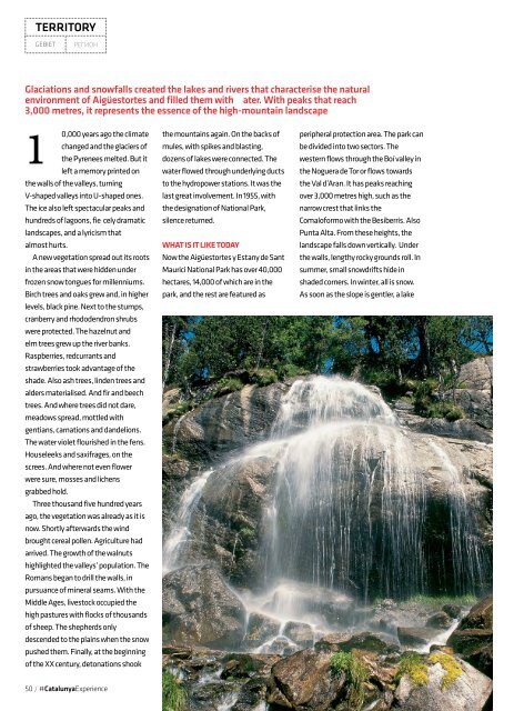
To the left, a<br />
waterfall between<br />
the Lake Ratera<br />
and the Sant<br />
Maurici Lake.<br />
Above, the granite<br />
needles of Amitges.<br />
Links der<br />
Wasserfall<br />
zwischen dem<br />
Ratera-See<br />
und dem Sant<br />
Maurici-See. Oben<br />
die Granitspitzen<br />
des Amitges.<br />
THE AREA HAS PEAKS<br />
REACHING OVER<br />
3,000 METRES HIGH<br />
HIER GIBT ES GIPFEL,<br />
DIE ÜBER 3.000<br />
HOCH SIND.<br />
ГОРНЫЕ ВЕРШИНЫ<br />
В ЭТОМ РЕГИОНЕ<br />
ДОСТИГАЮТ ВЫСОТЫ<br />
3000 МЕТРОВ<br />
Слева: водопад,<br />
соединяющий<br />
озера Ратера и<br />
Сант-Мауриси.<br />
Вверху: гранитные<br />
пики Амитжеса.<br />
Die Gletscher und Schneefälle<br />
haben die Seen und Flüsse gefüllt,<br />
welche die natürliche Umgebung<br />
der Aigüestortes bilden. Mit<br />
Berggipfeln von bis zu 3.000<br />
Metern kann man die Landschaft<br />
als Hochgebirge bezeichnen.<br />
SEIT 10.000 JAHREN hat sich das Klima geändert<br />
und es bildeten sich die Gletscher der Pyrenäen.<br />
Aber es hinterließ eine aufgedruckte Erinnerung<br />
an den Wänden des Tals, indem es V- und U-förmige<br />
Mulden bildete. Das Eis hinterließ auch die<br />
spektakulären Gipfel und Hunderte von Seen,<br />
dramatische Landschaften und eine Lyrik, die fast<br />
weh tut.<br />
Und eine neue Vegetation trieb in den Bereichen<br />
Wurzeln, die für Jahrtausende unter den Eiszungen<br />
verborgen gelegen hatten. Birken, Eichen und,<br />
in höheren Lagen, Schwarzkiefern begannen zu<br />
wachsen. Neben Rebstöcken wuchsen Heidelbeersträuche<br />
und Rhododendren. Haselnusssträucher<br />
und Ulmen besiedelten die Ufer der<br />
Flüsse. Himbeeren, Johannisbeeren und Erdbeeren<br />
gediehen im Schatten. Schließlich erschienen<br />
auch Eschen, Linden und Erlen. Und Tannen und<br />
Buchen. Und wo keine Bäume wuchsen, erstreckten<br />
sich Weiden, gesprenkelt mit Enzian, Nelken<br />
und Löwenzahn. Wasserveilchen blühten auf den<br />
Torfböden. Hauswurz und Steinbrech in den Felsformationen.<br />
Und wo es für die Blumen nicht gut<br />
genug war, bildeten sich Flechten und Moose.<br />
Vor dreitausendfünfhundert Jahren war die<br />
Vegetation bereits so, wie sie jetzt ist. Kurz darauf<br />
kamen durch die Luft Getreidepollen angeflo en.<br />
Der Ackerbau erhielt Einzug. Mit den Walnussbäumen<br />
kamen auch Menschen in die Täler. Die<br />
Römer begannen, die Wände zu durchlöchern auf<br />
der Suche nach Mineraladern. Mit dem Mittelalter<br />
Ледники и снежные лавины<br />
создали и наполнили водой<br />
озера и реки, столь характерные<br />
для пейзажей Айгуэстортеса.<br />
Горные вершины, достигающие<br />
3000 метров, создают идеальный<br />
образец высокогорного пейзажа<br />
10 ТЫСЯЧ ЛЕТ НАЗАД изменение климата<br />
привело к таянию ледников в Пиренеях, но оно<br />
оставило нам отпечаток, изменив рельеф имевших<br />
V-образную форму долин и придав им форму<br />
буквы «U». Лед уступил место прекрасным горным<br />
вершинам, сотням озер, пейзажам, полным драматизма<br />
и лиричности, с которыми мало что<br />
может сравниться.<br />
На земле, которая тысячелетиями была укрыта<br />
толщей льда, стали пускать корни растения.<br />
Выросли березы и дубы, а выше в горах — черные<br />
сосны. У подножий приютились кусты черники<br />
и рододендрона. Орешник и вяз укрыли<br />
берега ручьев. Малина, смородина и земляника<br />
укрылись от солнца в тени. Также появились<br />
ясень, липа и ольха. Выросли ель и бук. А где не<br />
нашлось места деревьям, раскинулись луга,<br />
усыпанные горечавкой, гвоздиками и одуванчиками.<br />
В болотах проросла хоттония. Бессмертники<br />
и камнеломки облюбовали скалы. Там же,<br />
где не смогли вырасти даже цветы, прижились<br />
мхи и лишайники.<br />
Три с половиной тысячелетия назад местная<br />
растительность уже была такой как сегодня.<br />
Спустя некоторое время ветер принес семена<br />
злаков. Пришло время сельского хозяйства.<br />
С появлением орехов долины начали заселяться<br />
людьми. Римляне начали добывать руду в поисках<br />
минералов. С приходом Средневековья<br />
высокогорные пастбища заполнились тысячами<br />
овец. Пастухи спускались в равнины только когда<br />
50 / #<strong>Catalunya</strong><strong>Experience</strong> 51 / #<strong>Catalunya</strong><strong>Experience</strong>