indian notices to mariners - Indian Naval Hydrographic Department
indian notices to mariners - Indian Naval Hydrographic Department
indian notices to mariners - Indian Naval Hydrographic Department
You also want an ePaper? Increase the reach of your titles
YUMPU automatically turns print PDFs into web optimized ePapers that Google loves.
5. 3<br />
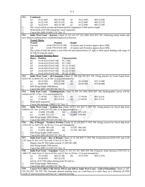
511. Continued.<br />
(e) 16-21.46N 082-29.94E (f) 16-21.44N 082-33.02E<br />
(g) 16-23.18N 082-32.31E (h) 16-25.40N 082-32.31E<br />
(a) 16-22.91N 082-34.70E (j) 16-22.84N 082-35.50E<br />
2. The vessel will be <strong>to</strong>wing sub bot<strong>to</strong>m profiler equipment of 600 metres length.<br />
3. Wide berth of 02 NM around the vessel requested.<br />
4. Cancel this MSG 010001 UTC Dec 12.<br />
512. India West Coast – Karwar. Charts 22 215 216 257 293 2008 2010 INT 705. Following transit marks and<br />
new channel marking buoys established/deployed at Karwar.<br />
Transit Marks<br />
Transit Position Height<br />
Forward 14-46.53N 074-07.49E 10 metres and 16 metres approx above MSL<br />
Aft 14-46.75N 074-07.49E 22 metres and 30 metres approx above MSL<br />
The colour of both the marks is red-white-red and characteristics of light is white quick flashing with range of<br />
05 NM for both the marks.<br />
New Channel Marking Buoys<br />
Buoys Position Characteristics<br />
GI 14-44.41N 074-07.58E FL 5 SEC<br />
R2 14-44.41N 074-07.43E FL 5 SEC<br />
G3 14-45.02N 074-07.58E FL (2) 10 SEC<br />
R4 14-45.02N 074-07.43E FL (2) 10 SEC<br />
G5 14-45.63N 074-07.58E FL (3) 15 SEC<br />
R6 14-45.63N 074-07.43E FL (3) 15 SEC<br />
513. India West Coast – off Umargam. Charts 21 209 254 292 INT 705. Firing practice by Coast Guard from<br />
0230 UTC <strong>to</strong> 0630 UTC on 26 Oct 12 in area bounded by:<br />
(a) 20-18.50N 072-02.50E (b) 20-18.50N 072-15.00E<br />
(c) 20-09.50N 072-12.00E (d) 20-09.50N 072-00.00E<br />
2. Safe flying height 1600 metres.<br />
3. Cancel this MSG 260730 UTC Oct 12.<br />
514. India East Coast – Visakhapatnam. Chart 32 308 354 3002 3035 INT 706. <strong>Hydrographic</strong> survey will be<br />
carried out till 12 Nov 12 in area bounded by:<br />
(a) 17-39.0N 083-15.5 E (b) 17-39.0N 083-23.0 E<br />
(c) 17-44.0N 083-23.0 E (d) 17-44.0N 083-15.5 E<br />
2. Wide berth requested.<br />
3. Cancel this message 130001 UTC Nov 12.<br />
515. India West Coast – Arabian Sea. Charts 22 273 293 INT 71 INT 705. Firing practice by <strong>Naval</strong> ship from<br />
030030 UTC Nov <strong>to</strong> 091230 UTC Nov 12 in area bounded by:<br />
(a) 15-00N 070-40E (b) 15-00N 071-21E<br />
(c) 12-40N 072-21E (d) 12-40N 070-40E<br />
2. Safe flying height 2000 Metres.<br />
3. Cancel this MSG 091330 UTC Nov 12.<br />
516. Bay of Bengal – Northern Portion. Charts 31 32 354 INT 71 INT 706. Firing exercise by <strong>Naval</strong> ship from<br />
1230 UTC <strong>to</strong> 1829 UTC on 06 Nov 12 in area bounded by:<br />
(a) 16-48N 083-15E (b) 15-52N 084-26E<br />
(c) 15-05N 084-00E (d) 15-55N 082-36E<br />
2. Safe flying height 22000 metres.<br />
3. Cancel this MSG 061929 UTC Nov 12.<br />
517. India East Coast – Bay of Bengal. Charts 32 33 356 INT 71 INT 706. Firing between 0230 UTC and 1130<br />
UTC from 01 Nov <strong>to</strong> 07 Nov and 15 Nov <strong>to</strong> 21 Nov 12.<br />
2. Danger zone 05 NM radius around 13-50N 081-40E<br />
3. Safe flying height 3500 metres.<br />
4. Cancel this MSG 211230 UTC Nov 12.<br />
518. India East Coast – Gopalpur. Charts 31 352 353 391 3005 INT 706. Firing by Army between 2330 UTC <strong>to</strong><br />
1800 UTC daily from 31 Oct <strong>to</strong> 10 Nov and 21 Nov <strong>to</strong> 24 Nov 12 in area bounded by:<br />
(a) 19-14.60N 084-53.70E (b) 19-37.05N 085-27.87E<br />
(c) 18-46.05N 085-22.87E<br />
and arc of 41 NM radius joining point (b) and (c).<br />
2. Safe flying height 7000 metres.<br />
3. Cancel this MSG 241900 UTC Nov 12.<br />
519. Cancel NAVAREA VIII 343/12 355/12 and 438/12. India West Coast – Gulf of Khambhat. Charts 21 207<br />
254 292 INT 705 INT 706. Narmada channel marking buoy no 4 and buoy no 6 unlit, buoy no 2 offstation (0.3NM<br />
south) of charted position and buoy no 7 reported missing.


