Artiklen er en pdf-fil på 378 kb - GeologiskNyt
Artiklen er en pdf-fil på 378 kb - GeologiskNyt
Artiklen er en pdf-fil på 378 kb - GeologiskNyt

Create successful ePaper yourself
Turn your PDF publications into a flip-book with our unique Google optimized e-Paper software.
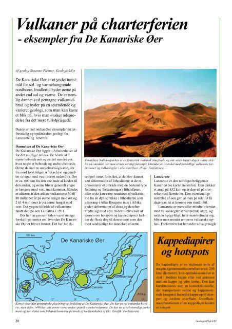
Vulkan<strong>er</strong> <strong>på</strong> chart<strong>er</strong>f<strong>er</strong>i<strong>en</strong><br />
- eksempl<strong>er</strong> fra De Kanariske Ø<strong>er</strong><br />
Af geolog Susanne Plesn<strong>er</strong>, <strong>GeologiskNyt</strong><br />
De Kanariske Ø<strong>er</strong> <strong>er</strong> et yndet turistmål<br />
for sol- og varmehungr<strong>en</strong>de<br />
nordbo<strong>er</strong>e. Imidl<strong>er</strong>tid byd<strong>er</strong> ø<strong>er</strong>ne <strong>på</strong><br />
andet <strong>en</strong>d sol og varme. De <strong>er</strong> nemlig<br />
dannet ved g<strong>en</strong>tagne vulkanudbrud<br />
og byd<strong>er</strong> <strong>på</strong> <strong>en</strong> spænd<strong>en</strong>de og<br />
vari<strong>er</strong>et geologi, som man kan kaste<br />
et blik <strong>på</strong>, hvis man ønsk<strong>er</strong> adspredelse<br />
fra det m<strong>er</strong>e turistprægede.<br />
D<strong>en</strong>ne artikel omhandl<strong>er</strong> eksempl<strong>er</strong> <strong>på</strong> letforståelig<br />
og spektakulær geologi fra<br />
Lanzarote og T<strong>en</strong><strong>er</strong>ife.<br />
Dannels<strong>en</strong> af De Kanariske Ø<strong>er</strong><br />
De Kanariske Ø<strong>er</strong> ligg<strong>er</strong> i Atlant<strong>er</strong>havet ud<br />
for det nordlige Afrika. De består af 7<br />
større beboede ø<strong>er</strong> og <strong>en</strong> del mindre ø<strong>er</strong>,<br />
hvor nogle <strong>er</strong> beboede og andre ubeboede.<br />
Ø<strong>er</strong>ne dann<strong>er</strong> <strong>en</strong> uregelmæssig kæde, d<strong>er</strong><br />
fra nord først følg<strong>er</strong> Afrikas kyst og d<strong>er</strong>eft<strong>er</strong><br />
sving<strong>er</strong> mod vest (kortet ned<strong>en</strong>for). D<strong>er</strong><br />
<strong>er</strong> ca. 600 km fra d<strong>en</strong> <strong>en</strong>e <strong>en</strong>de af kæd<strong>en</strong> til<br />
d<strong>en</strong> and<strong>en</strong>, og ø<strong>er</strong>ne bliv<strong>er</strong> g<strong>en</strong><strong>er</strong>elt yngre<br />
jo læng<strong>er</strong>e mod vest, man komm<strong>er</strong>. Således<br />
<strong>er</strong> ald<strong>er</strong><strong>en</strong> af d<strong>en</strong> ældste vulkanisme 30 til<br />
80 million<strong>er</strong> år <strong>på</strong> ø<strong>er</strong>ne længst mod øst og<br />
2 til 4 million<strong>er</strong> år <strong>på</strong> ø<strong>er</strong>ne længst mod<br />
vest. Det yngste tilfælde af vulkanisme<br />
fandt sted <strong>på</strong> ø<strong>en</strong> La Palma i 1971.<br />
D<strong>er</strong> har op g<strong>en</strong>nem tid<strong>en</strong> været mange<br />
forskellige teori<strong>er</strong> om, hvordan De Kanariske<br />
Ø<strong>er</strong> <strong>er</strong> blevet dannet. Det har for ek-<br />
29˚<br />
28˚<br />
100 km<br />
La Palma<br />
El Hi<strong>er</strong>ro<br />
18˚<br />
4000<br />
La Gom<strong>er</strong>a<br />
17˚<br />
3000<br />
2000<br />
1000<br />
De Kanariske Ø<strong>er</strong><br />
T<strong>en</strong><strong>er</strong>ife<br />
16˚<br />
Timanfaya Nationalpark<strong>en</strong> <strong>er</strong> <strong>en</strong> fantastisk vulkansk skueplads, og når sol<strong>en</strong> kast<strong>er</strong> dag<strong>en</strong> sidste strål<strong>er</strong><br />
<strong>på</strong> området, s<strong>er</strong> man et helt utroligt farvespil. Området <strong>er</strong> ov<strong>er</strong>sået med forskellige vulkanske formation<strong>er</strong><br />
og vulkankegl<strong>er</strong> i alle størrels<strong>er</strong>. (Foto: Forfatt<strong>er</strong><strong>en</strong>)<br />
sempel været foreslået, at de blev dannet<br />
ved deformation af lithosfær<strong>en</strong>; at de repræs<strong>en</strong>t<strong>er</strong><strong>er</strong><br />
et område med <strong>en</strong> bestemt type<br />
foldning og forkastning<strong>er</strong> i lithosfær<strong>en</strong>,<br />
ell<strong>er</strong> at de kan være resultatet af vulkanisme<br />
fra <strong>en</strong> dyb sprække i lithosfær<strong>en</strong> som<br />
udsprang i Atlas Bj<strong>er</strong>g<strong>en</strong>e inde i Afrika<br />
und<strong>er</strong> deformation af disse og d<strong>er</strong>eft<strong>er</strong><br />
bredte sig mod vest. Sid<strong>en</strong> tilblivels<strong>en</strong> af<br />
teori<strong>en</strong> om hotspots og kappediapir<strong>er</strong> hæld<strong>er</strong><br />
de fleste dog til d<strong>en</strong>ne teori som d<strong>en</strong><br />
mest sandsynlige for dannels<strong>en</strong> af ø<strong>er</strong>ne.<br />
Gran Canaria<br />
Fu<strong>er</strong>tev<strong>en</strong>tura<br />
Lanzarote<br />
Lanzarote<br />
Lanzarote <strong>er</strong> d<strong>en</strong> nordligst beligg<strong>en</strong>de<br />
Kanarieø (se kortet ned<strong>en</strong>for). D<strong>en</strong> dækk<strong>er</strong><br />
et areal <strong>på</strong> 852 km 2 og <strong>er</strong> d<strong>er</strong>ved <strong>på</strong> størrelse<br />
med Bornholm. D<strong>en</strong> ov<strong>er</strong>skuelige<br />
størrelse af ø<strong>en</strong> gør, at man <strong>på</strong> relativt få<br />
dage kan nå at komme ø<strong>en</strong> rundt i bil.<br />
Lanzarote <strong>er</strong> m<strong>er</strong>e ell<strong>er</strong> mindre ov<strong>er</strong>sået<br />
med vulkankegl<strong>er</strong> af vari<strong>er</strong><strong>en</strong>de aldre, og<br />
næst<strong>en</strong> ligegyldigt, hvor man befind<strong>er</strong> sig,<br />
bliv<strong>er</strong> man mindet om ø<strong>en</strong>s vulkanske ophav.<br />
Forfatt<strong>er</strong><strong>en</strong> har h<strong>er</strong>und<strong>er</strong> udvalgt nogle<br />
20 <strong>GeologiskNyt</strong> 6/02<br />
Afrika<br />
15˚ 14˚ 13˚<br />
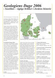
Kortet vis<strong>er</strong> d<strong>en</strong> geografiske plac<strong>er</strong>ing og fordeling af De Kanariske Ø<strong>er</strong>. De har <strong>en</strong> ret omtumlet historie,<br />
m<strong>en</strong> sid<strong>en</strong> 1496 har alle ø<strong>er</strong>ne været und<strong>er</strong> spansk ov<strong>er</strong>h<strong>er</strong>redømme. De har nu et selvstændigt parlam<strong>en</strong>t<br />
og har status som frihandelsområde <strong>på</strong> trods af medlemskabet af EU. (Grafik: Forfatt<strong>er</strong><strong>en</strong>)<br />
Kappediapir<strong>er</strong><br />
og hotspots<br />
En kappediapir <strong>er</strong> <strong>en</strong> stationær søjle af<br />
magma (g<strong>en</strong>nemsnitsstørrels<strong>en</strong> <strong>er</strong> ca. 200<br />
km i diamet<strong>er</strong>), hvis oprindelsessted <strong>er</strong> et<br />
sted i Jord<strong>en</strong>s kappe ell<strong>er</strong> ved græns<strong>en</strong><br />
mellem kappe og ydre k<strong>er</strong>ne. D<strong>en</strong> kan<br />
karakt<strong>er</strong>is<strong>er</strong>es som <strong>en</strong> konvektionscelle,<br />
d<strong>er</strong> transport<strong>er</strong><strong>er</strong> varme og kappemat<strong>er</strong>iale<br />
(magma) fra nedre kappe op til skorp<strong>en</strong><br />
og Jord<strong>en</strong>s ov<strong>er</strong>flade. Ov<strong>er</strong>flademanifestation<strong>en</strong><br />
af <strong>en</strong> kappediapir kaldes<br />
et hotspot.
Et blik ind i Volcán del Cu<strong>er</strong>vo. Man kan fornemme d<strong>en</strong> næst<strong>en</strong> cirkulære<br />
bund omkranset af de høje krat<strong>er</strong>vægge. Kegl<strong>en</strong> <strong>er</strong> opbygget af lavastrømme<br />
og scorieaflejring<strong>er</strong> (vesikulært vulkansk mat<strong>er</strong>iale). Et eksempel <strong>på</strong> sidstnævnte<br />
ses ved topp<strong>en</strong> af krat<strong>er</strong>vægg<strong>en</strong>. (Foto: Forfatt<strong>er</strong><strong>en</strong>).<br />
spektakulære eksempl<strong>er</strong> <strong>på</strong> d<strong>en</strong> vulkanske<br />
aktivitet, m<strong>en</strong> folk opfordres i høj grad til<br />
også selv at tage <strong>på</strong> opdagelse.<br />
Timanfaya Nationalpark<strong>en</strong><br />
I p<strong>er</strong>iod<strong>en</strong> fra 1730 til 1736 h<strong>er</strong>skede vulkansk<br />
aktivitet <strong>på</strong> d<strong>en</strong> nordvestlige del af<br />
Lanzarote (kortet ned<strong>en</strong>for), og <strong>en</strong> stor del<br />
af ø<strong>en</strong> blev dækket af lavastrømme og<br />
vulkankegl<strong>er</strong>. Lavastrømm<strong>en</strong>e begravede<br />
11 landsby<strong>er</strong> med i alt 420 huse, m<strong>en</strong> ing<strong>en</strong><br />
m<strong>en</strong>nesk<strong>er</strong> kom noget til und<strong>er</strong> udbrudd<strong>en</strong>e.<br />
Timanfaya Nationalpark<strong>en</strong> dækk<strong>er</strong> et<br />
areal <strong>på</strong> 50 km 2 hvilket kun <strong>er</strong> <strong>en</strong> del af det<br />
b<strong>er</strong>ørte område. Det spanske navn for området<br />
<strong>er</strong> Montañas del Fuego, hvilket betyd<strong>er</strong><br />
Ildbj<strong>er</strong>g<strong>en</strong>e. Navnet h<strong>en</strong>tyd<strong>er</strong> ikke, som<br />
man skulle tro, til d<strong>en</strong> vulkanske aktivitet,<br />
m<strong>en</strong> d<strong>er</strong>imod til de mange forskellige farv<strong>er</strong><br />
aske, sand og lapilli (fragm<strong>en</strong>t<strong>er</strong> <strong>på</strong> 4-<br />
32 mm af pyroklastisk mat<strong>er</strong>iale) i området,<br />
d<strong>er</strong> fremstår ganske spektakulært, når<br />
lyset fra d<strong>en</strong> nedgå<strong>en</strong>de sol fald<strong>er</strong> <strong>på</strong> dem<br />
(billedet øv<strong>er</strong>st <strong>på</strong> modstå<strong>en</strong>de side). Det <strong>er</strong><br />
forbudt selv at køre rundt <strong>på</strong> vej<strong>en</strong>e i det<br />
meste af nationalpark<strong>en</strong>, m<strong>en</strong> indgangsbillett<strong>en</strong><br />
giv<strong>er</strong> adgang til <strong>en</strong> arrang<strong>er</strong>et bustur<br />
<strong>på</strong> ca. 14 km, d<strong>er</strong> vis<strong>er</strong> folk specielle<br />
lavaformation<strong>er</strong>, og man kør<strong>er</strong> ligeledes<br />
ig<strong>en</strong>nem <strong>en</strong> åb<strong>en</strong> lavatunnel. D<strong>en</strong>ne bustur<br />
<strong>er</strong> et absolut must, og selv d<strong>en</strong> mindre<br />
geologiint<strong>er</strong>essede vil med garanti blive<br />
fascin<strong>er</strong>et ov<strong>er</strong> d<strong>en</strong>ne natur<strong>en</strong>s skueplads.<br />
Det kan anbefales at indlede besøget i<br />
Timanfaya Nationalpark<strong>en</strong> <strong>på</strong> besøgsc<strong>en</strong>tret<br />
nær d<strong>en</strong> østlige indgang til park<strong>en</strong>,<br />
hvor man kan finde information<strong>er</strong> om områdets<br />
dannelse samt dyre- og planteliv.<br />
D<strong>er</strong> findes også <strong>en</strong> seismograf, d<strong>er</strong> registr<strong>er</strong><strong>er</strong><br />
rystels<strong>er</strong> i jord<strong>en</strong> und<strong>er</strong> Lanzarote,<br />
så man kan danne sig et indtryk af, hvorvidt<br />
et muligt und<strong>er</strong>ligg<strong>en</strong>de magma <strong>er</strong> i<br />
bevægelse og evt. d<strong>er</strong>for kan result<strong>er</strong>e i<br />
vulkanudbrud.<br />
Volcán del Cu<strong>er</strong>vo<br />
På d<strong>en</strong> c<strong>en</strong>trale del af Lanzarote findes et<br />
spektakulært landskab med mange vulkan-<br />
<strong>GeologiskNyt</strong> 6/02<br />
kegl<strong>er</strong> g<strong>en</strong><strong>er</strong>øst spredt ud ov<strong>er</strong> området.<br />
Man kan selvfølgelig udforske dem <strong>på</strong> nærm<strong>er</strong>e<br />
hold én for én, m<strong>en</strong> kør<strong>er</strong> man mod<br />
nord <strong>på</strong> vej<strong>en</strong> fra d<strong>en</strong> c<strong>en</strong>trale hovedvej fra<br />
nord til syd <strong>på</strong> ø<strong>en</strong> mod by<strong>en</strong> Mancha<br />
Blanca, komm<strong>er</strong> man forbi <strong>en</strong> yd<strong>er</strong>st “brug<strong>er</strong>v<strong>en</strong>lig”<br />
af slags<strong>en</strong>, Volcán del Cu<strong>er</strong>vo<br />
(de to fotos ov<strong>en</strong>for). Eft<strong>er</strong> ca. 20 minutt<strong>er</strong>s<br />
gang ad <strong>en</strong> primitiv grusvej komm<strong>er</strong> man<br />
ind til kegl<strong>en</strong>, og vej<strong>en</strong> led<strong>er</strong> én rundt om<br />
d<strong>en</strong> til “indgang<strong>en</strong>”. H<strong>er</strong> før<strong>er</strong> <strong>en</strong> sti op<br />
ov<strong>er</strong> det laveste sted i krat<strong>er</strong>vægg<strong>en</strong>, og<br />
man kan gå ned til krat<strong>er</strong>bund<strong>en</strong> og besigtige<br />
<strong>en</strong> vaskeægte (udslukt) vulkan indefra.<br />
Udov<strong>er</strong> oplevels<strong>en</strong> ved at stå inde midt i <strong>en</strong><br />
vulkan kan man desud<strong>en</strong> finde adskillige<br />
løsblokke med op til fl<strong>er</strong>e c<strong>en</strong>timet<strong>er</strong> store<br />
olivinkumulat<strong>er</strong>.<br />
D<strong>en</strong> Grønne Grotte<br />
På d<strong>en</strong> nordlige del af ø<strong>en</strong> findes Cueva de<br />
los V<strong>er</strong>des – D<strong>en</strong> Grønne Grotte (fotoet<br />
ned<strong>er</strong>st til v<strong>en</strong>stre næste side). D<strong>en</strong> <strong>er</strong> <strong>en</strong><br />
Kort ov<strong>er</strong> Lanzarote d<strong>er</strong><br />
vis<strong>er</strong> de vigtigste veje og<br />
by<strong>er</strong> samt plac<strong>er</strong>ing<strong>en</strong> af<br />
de forskellige lokalitet<strong>er</strong>,<br />
d<strong>er</strong> <strong>er</strong> beskrevet i d<strong>en</strong>ne<br />
artikel. Navne <strong>på</strong> de i<br />
artikl<strong>en</strong> nævnte sted<strong>er</strong><br />
står med fed kursiv.<br />
(Grafik: Forfatt<strong>er</strong><strong>en</strong>)<br />
Volcán del Cu<strong>er</strong>vo findes <strong>på</strong> d<strong>en</strong> c<strong>en</strong>trale del af Lanzarote. Kør<strong>er</strong> man ad<br />
d<strong>en</strong> i artikl<strong>en</strong> foreslåede vej, find<strong>er</strong> man d<strong>en</strong> <strong>på</strong> v<strong>en</strong>stre side af vej<strong>en</strong> kort tid<br />
eft<strong>er</strong>, at man har pass<strong>er</strong>et Montaña Negra (Det Sorte Bj<strong>er</strong>g) <strong>på</strong> højre side af<br />
vej<strong>en</strong>. (Foto: Forfatt<strong>er</strong><strong>en</strong>)<br />
Lanzarote<br />
N<br />
0 2 4 6 8 10 km<br />
del af <strong>en</strong> 7 km lang lavatunnel, som strækk<strong>er</strong><br />
sig h<strong>er</strong>fra og et stykke ud i Atlant<strong>er</strong>havet<br />
og d<strong>er</strong>ved udgør <strong>en</strong> af de længste lavatunnel<strong>er</strong><br />
<strong>på</strong> Jord<strong>en</strong>. Tunnel<strong>en</strong> <strong>er</strong> eft<strong>er</strong> sig<strong>en</strong>de<br />
dannet i forbindelse med aktivitet fra<br />
vulkan<strong>en</strong> La Corona for 3.000 til 5.000 år<br />
sid<strong>en</strong>. D<strong>er</strong> udvindes store mængd<strong>er</strong> kostbare<br />
min<strong>er</strong>al<strong>er</strong> fra tunnel<strong>en</strong>.<br />
Lavatunnel<strong>er</strong> dannes g<strong>en</strong><strong>er</strong>elt ved, at det<br />
yd<strong>er</strong>ste (top, bund og sid<strong>er</strong>) af <strong>en</strong> lavastrøm<br />
størkn<strong>er</strong>, m<strong>en</strong>s d<strong>en</strong> stadigt flyd<strong>en</strong>de del flyd<strong>er</strong><br />
vid<strong>er</strong>e og d<strong>er</strong>ved eft<strong>er</strong>lad<strong>er</strong> sig et hulrum.<br />
Publikum har kun adgang til ca. 1 km af<br />
tunnel<strong>en</strong>, m<strong>en</strong> h<strong>er</strong> bliv<strong>er</strong> man præs<strong>en</strong>t<strong>er</strong>et<br />
for <strong>en</strong> mangfoldighed af form<strong>er</strong> og farv<strong>er</strong>.<br />
Charco de los Clicos<br />
H<strong>er</strong> find<strong>er</strong> man <strong>en</strong> smaragdgrøn sø og bagved<br />
d<strong>en</strong> ind<strong>er</strong>sid<strong>en</strong> af <strong>en</strong> vulkankegle (fotoet<br />
ned<strong>er</strong>st til højre næste side), som står i<br />
stærk kontrast til det blå hav. Foran sø<strong>en</strong><br />
ligg<strong>er</strong> <strong>en</strong> strand med sort lavasand, d<strong>er</strong> <strong>er</strong><br />
rigt <strong>på</strong> olivinkorn. Man kan godt finde<br />
La Santa<br />
Caleta del Sebo<br />
Caleta<br />
La Graciosa<br />
Haría<br />
Høje lavaklipp<strong>er</strong><br />
Orzola<br />
Mirador del Rio<br />
D<strong>en</strong> Grønne Grotte<br />
Arrieta<br />
Tinajo<br />
Teguise<br />
Timanfaya<br />
Nationalpark Mancha Blanca<br />
El Golfo<br />
San Bartolomé<br />
Volcán del Cu<strong>er</strong>vo<br />
Tahiche<br />
Charco de los Clicos<br />
Bodega La G<strong>er</strong>ia<br />
Yaiza<br />
Tias<br />
Uga<br />
Mach<strong>er</strong><br />
Arrecife<br />
LEGENDE<br />
Pu<strong>er</strong>to del Carm<strong>en</strong><br />
By<br />
Hovedvej<br />
Bivej<br />
Bj<strong>er</strong>gmassiv<br />
Playa Blanca<br />
Beskrevet lokalitet<br />
21
nogle fine eksemplar<strong>er</strong>, m<strong>en</strong> olivinkumulat<strong>er</strong>ne,<br />
som sælges i by<strong>en</strong> El Golfo lidt<br />
læng<strong>er</strong>e mod nord, <strong>er</strong> det vist mest de lokale,<br />
d<strong>er</strong> ved, hvor man find<strong>er</strong>.<br />
Af andre geologisk ori<strong>en</strong>t<strong>er</strong>ede udflugtsmål<br />
kunne for eksempel nævnes de stejle<br />
klippevægge <strong>på</strong> nordkyst<strong>en</strong> ved by<strong>en</strong><br />
Orzola, d<strong>er</strong> består af et utal af lavastrømme;<br />
udsigt<strong>en</strong> fra Mirador del Rio <strong>på</strong> nordvestkyst<strong>en</strong><br />
til d<strong>en</strong> lille ø La Graciosa, d<strong>er</strong><br />
også består af vulkan<strong>er</strong>; hvide strande langs<br />
nordøstkyst<strong>en</strong> af Lanzarote, d<strong>er</strong> består af<br />
findelte korall<strong>er</strong> og vidn<strong>er</strong> om d<strong>en</strong> tidlig<strong>er</strong>e<br />
(og muligvis nuvær<strong>en</strong>de) tilstedeværelse af<br />
et koralrev øst for ø<strong>en</strong>. På d<strong>en</strong> c<strong>en</strong>trale del<br />
af Lanzarote dyrk<strong>er</strong> man vin. På “Bodega<br />
La G<strong>er</strong>ia” (kortet ned<strong>er</strong>st <strong>på</strong> foregå<strong>en</strong>de<br />
side og foto øv<strong>er</strong>st næste side) kan man<br />
nyde smagsprøv<strong>er</strong> og samtidigt nyde udsigt<strong>en</strong><br />
til adskillige vulkankegl<strong>er</strong> i området.<br />
T<strong>en</strong><strong>er</strong>ife<br />
T<strong>en</strong><strong>er</strong>ife <strong>er</strong> med sine 2.058 km 2 (svar<strong>er</strong> til<br />
Lolland, Falst<strong>er</strong> og Møn tilsamm<strong>en</strong>) d<strong>en</strong><br />
største af De Kanariske Ø<strong>er</strong> og plac<strong>er</strong>et<br />
c<strong>en</strong>tralt i øgrupp<strong>en</strong>. På grund af ø<strong>en</strong>s størrelse<br />
og de ekstremt snoede veje (man<br />
komm<strong>er</strong> sjæld<strong>en</strong>t ov<strong>er</strong> 50 km/t andre sted<strong>er</strong><br />
<strong>en</strong>d <strong>på</strong> motorvej<strong>en</strong>) tag<strong>er</strong> det noget læng<strong>er</strong>e<br />
tid at udforske T<strong>en</strong><strong>er</strong>ife <strong>en</strong>d Lanzarote. Det<br />
skal dog ikke afholde folk fra at gøre det!<br />
D<strong>en</strong> c<strong>en</strong>trale og nordlige del af T<strong>en</strong><strong>er</strong>ife<br />
<strong>er</strong> meget bj<strong>er</strong>grig, og ø<strong>en</strong> udvis<strong>er</strong> store variation<strong>er</strong><br />
i klimaet afhængigt af, hvor <strong>på</strong><br />
ø<strong>en</strong> man befind<strong>er</strong> sig. Mod syd (hvor de<br />
fleste turist<strong>er</strong> <strong>er</strong>) <strong>er</strong> d<strong>er</strong> tørt og varmt, m<strong>en</strong>s<br />
d<strong>er</strong> bliv<strong>er</strong> m<strong>er</strong>e og m<strong>er</strong>e frodigt og <strong>en</strong><br />
anelse kølig<strong>er</strong>e, jo læng<strong>er</strong>e mod nord man<br />
komm<strong>er</strong>. Det skyldes, at de fremh<strong>er</strong>sk<strong>en</strong>de<br />
vinde komm<strong>er</strong> ind fra <strong>en</strong> nordlig retning<br />
med mass<strong>er</strong> af fugt, som afgives i form af<br />
regn, når luft<strong>en</strong> stig<strong>er</strong> op langs bj<strong>er</strong>g<strong>en</strong>e.<br />
D<strong>en</strong> sydlige del af ø<strong>en</strong> ligg<strong>er</strong> d<strong>er</strong>for i “læ”<br />
af bj<strong>er</strong>g<strong>en</strong>e.<br />
På hotspot-ø<strong>er</strong> som De Kanariske Ø<strong>er</strong> <strong>er</strong><br />
det almindeligt, at d<strong>er</strong> dannes riftzon<strong>er</strong> i<br />
fl<strong>er</strong>e retning<strong>er</strong> i jordskorp<strong>en</strong> i forbindelse<br />
Bu<strong>en</strong>avista<br />
del Norte<br />
Santiago del Teide<br />
Tamaimo<br />
Los Gigantes<br />
Pu<strong>er</strong>to de<br />
Santiago<br />
T<strong>en</strong><strong>er</strong>ife<br />
N<br />
0 4 8 12 16 20 km<br />
San Juan<br />
Garachico<br />
T<strong>en</strong>o-bj<strong>er</strong>g<strong>en</strong>e<br />
Ruigómez<br />
Guia de Isora<br />
Las Américas<br />
Los Cristianos<br />
D<strong>en</strong> Grønne Grotte byd<strong>er</strong> <strong>på</strong> <strong>en</strong> mangfoldig af form<strong>er</strong> og farv<strong>er</strong>. Nogle sted<strong>er</strong><br />
<strong>er</strong> d<strong>er</strong> adskillige met<strong>er</strong> fra gulv til loft. D<strong>er</strong> findes også <strong>en</strong> ca. 20 cm dyb<br />
sø d<strong>er</strong>, når vandet <strong>er</strong> spejlblankt, giv<strong>er</strong> indtryk af, at man kigg<strong>er</strong> ind i et meget<br />
dybt hul. (Foto: Forfatt<strong>er</strong><strong>en</strong>)<br />
Pu<strong>er</strong>to de<br />
la Cruz<br />
La Orotava<br />
La Guancha<br />
Realejo<br />
Icod de<br />
Aguamansa<br />
los Vinos<br />
Pico Viejo Teide<br />
med d<strong>en</strong> vulkanske aktivitet. Ideelt vil d<strong>er</strong><br />
dannes tre riftzon<strong>er</strong> med ca. 120 grad<strong>er</strong><br />
imellem – de såkaldte “M<strong>er</strong>cedes-Starriftzon<strong>er</strong>”.<br />
Oftest vil blot to af riftzon<strong>er</strong>ne<br />
dog være domin<strong>er</strong><strong>en</strong>de. På T<strong>en</strong><strong>er</strong>ife <strong>er</strong> to<br />
riftzon<strong>er</strong> med sikk<strong>er</strong>hed blevet udviklet.<br />
T<strong>en</strong>o-bj<strong>er</strong>g<strong>en</strong>e <strong>på</strong> d<strong>en</strong> nordvestlige del af<br />
ø<strong>en</strong> repræs<strong>en</strong>t<strong>er</strong><strong>er</strong> således d<strong>en</strong> <strong>en</strong>e riftzone<br />
(kortet ov<strong>en</strong>for), m<strong>en</strong>s d<strong>en</strong> langstrakte,<br />
nordlige del af T<strong>en</strong><strong>er</strong>ife repræs<strong>en</strong>t<strong>er</strong><strong>er</strong> d<strong>en</strong><br />
and<strong>en</strong>. Riftzon<strong>er</strong>ne <strong>er</strong> forbundne g<strong>en</strong>nem<br />
Las Cañadas-cald<strong>er</strong>a<strong>en</strong> <strong>på</strong> d<strong>en</strong> c<strong>en</strong>trale del<br />
af ø<strong>en</strong>. D<strong>en</strong> vestlige del af T<strong>en</strong>o-bj<strong>er</strong>g<strong>en</strong>e<br />
samt Anagahalvø<strong>en</strong> (nordøstlige del af<br />
T<strong>en</strong><strong>er</strong>ife) <strong>er</strong> af s<strong>en</strong> t<strong>er</strong>tiær ald<strong>er</strong> og repræs<strong>en</strong>t<strong>er</strong><strong>er</strong><br />
h<strong>er</strong>med de ældste blottede bj<strong>er</strong>gart<strong>er</strong><br />
<strong>på</strong> ø<strong>en</strong>. Dele af d<strong>en</strong> sydlige del af ø<strong>en</strong><br />
Mirador Cruz del Carm<strong>en</strong><br />
Taganana<br />
Bajamar<br />
Tejina<br />
Mirador Pico del Inglés<br />
Igueste<br />
Las Cant<strong>er</strong>as<br />
Las Mecedes<br />
La Laguna San Andrés<br />
Tacoronte<br />
Playa de las T<strong>er</strong>esitas<br />
Agua Garcia<br />
Santa Cruz<br />
La Esp<strong>er</strong>anza<br />
de T<strong>en</strong><strong>er</strong>ife<br />
El Tabl<strong>er</strong>o<br />
Candelaria<br />
udgøres af <strong>en</strong> skjoldvulkan-struktur, Las<br />
Cañadas-vulkanbygning<strong>en</strong> og altså ikke af<br />
vulkanske produkt<strong>er</strong> fra <strong>en</strong> mulig tredje<br />
riftzone.<br />
Da d<strong>en</strong> c<strong>en</strong>trale del af T<strong>en</strong><strong>er</strong>ife <strong>er</strong> det<br />
umiddelbart lettest tilgængelige geologisk<br />
og r<strong>en</strong>t fysisk (man kan køre d<strong>er</strong>til i bil og<br />
behøv<strong>er</strong> ikke begive sig ud <strong>på</strong> anstr<strong>en</strong>g<strong>en</strong>de<br />
vandreture for at se noget int<strong>er</strong>essant), vil<br />
de følg<strong>en</strong>de beskrivels<strong>er</strong> dreje sig om dette.<br />
Nationalpark<strong>en</strong> Las Cañadas del Teide<br />
G<strong>en</strong>nem tid<strong>en</strong> har d<strong>er</strong> været foreslået mange<br />
sandsynlige og lige så mange usandsynlige<br />
sc<strong>en</strong>ari<strong>er</strong> for dannels<strong>en</strong> af Las Cañadascald<strong>er</strong>a<strong>en</strong><br />
<strong>på</strong> d<strong>en</strong> c<strong>en</strong>trale del af T<strong>en</strong><strong>er</strong>ife<br />
(og de formation<strong>er</strong> man find<strong>er</strong> inde i d<strong>en</strong>).<br />
22 <strong>GeologiskNyt</strong> 6/02<br />
Adeje<br />
Vilaflor<br />
S. Miguel<br />
El Portillo<br />
Los Roques de Garcia<br />
Chimiche<br />
Icor<br />
Arafo<br />
Güimar<br />
Anaga-bj<strong>er</strong>g<strong>en</strong>e<br />
LEGENDE<br />
Bj<strong>er</strong>gtop/vulkan<br />
Beskrevet lokalitet<br />
Cald<strong>er</strong>akant<br />
Nationalparkgrænse<br />
Riftzone<br />
Motorvej<br />
Hovedvej<br />
Bivej<br />
3000-3500 m<br />
2500-3000 m<br />
2000-2500 m<br />
1500-2000 m<br />
1000-1500 m<br />
500-1000 m<br />
0-500 m<br />
Kortet ov<strong>er</strong> T<strong>en</strong><strong>er</strong>ife vis<strong>er</strong> de største veje samt nogle af by<strong>er</strong>ne. Sted<strong>er</strong> d<strong>er</strong> <strong>er</strong> specifikt omtalt i artikl<strong>en</strong><br />
står med fed kursiv. (Grafik: Forfatt<strong>er</strong><strong>en</strong>)<br />
Et impon<strong>er</strong><strong>en</strong>de tværsnit af <strong>en</strong> vulkan dann<strong>er</strong> baglandet for <strong>en</strong> smaragdgrøn<br />
sø og strand<strong>en</strong> med de mange olivin<strong>er</strong>. De særprægede <strong>er</strong>osionsform<strong>er</strong> <strong>er</strong><br />
almindelige i løs<strong>er</strong>e aflejrede vulkanske produkt<strong>er</strong> som akse og tuff. (Foto:<br />
Forfatt<strong>er</strong><strong>en</strong>)
Vinstokk<strong>en</strong>e dyrkes i fordybning<strong>er</strong> i jord<strong>en</strong> (lapilliaflejring<strong>er</strong>), d<strong>er</strong> afskærmes for vind<strong>en</strong> af halvcirkelformede,<br />
håndbyggede mure. Det <strong>er</strong> fortrinsvis de flade areal<strong>er</strong>, d<strong>er</strong> bruges, m<strong>en</strong> mange sted<strong>er</strong> <strong>er</strong> man<br />
også begyndt at anlægge disse specielle vinmark<strong>er</strong> <strong>på</strong> sid<strong>er</strong>ne af vulkankegl<strong>er</strong>ne. (Foto: Forfatt<strong>er</strong><strong>en</strong>)<br />
I dag <strong>er</strong> før<strong>en</strong>de geolog<strong>er</strong>, d<strong>er</strong> har beskæftiget<br />
sig med De Kanariske Ø<strong>er</strong> i<br />
mange år, i store træk <strong>en</strong>ige om dannels<strong>en</strong>,<br />
bortset fra de nøjagtige process<strong>er</strong>, om<br />
hvilke d<strong>er</strong> stadig h<strong>er</strong>sk<strong>er</strong> u<strong>en</strong>ighed. Forfatt<strong>er</strong><strong>en</strong><br />
vil i det følg<strong>en</strong>de forsøge at undgå at<br />
komme ind <strong>på</strong> disse nøjagtige process<strong>er</strong>,<br />
m<strong>en</strong> blot give læs<strong>er</strong><strong>en</strong> et ov<strong>er</strong>ordnet blik<br />
ov<strong>er</strong> dannels<strong>en</strong> af cald<strong>er</strong>a<strong>en</strong>.<br />
Las Cañadas cald<strong>er</strong>a<strong>en</strong> <strong>er</strong> <strong>en</strong> 16 x 9 km<br />
stor, oval struktur, d<strong>er</strong> udgør d<strong>en</strong> øv<strong>er</strong>ste<br />
del af Las Cañadas vulkanbygning<strong>en</strong>, d<strong>er</strong><br />
m<strong>en</strong>es at være dannet ov<strong>er</strong> de sidste ca. 3,5<br />
mio. år. Nationalpark<strong>en</strong> Las Cañadas del<br />
Teide omfatt<strong>er</strong> d<strong>en</strong>ne cald<strong>er</strong>a. Ligegyldigt<br />
om man komm<strong>er</strong> ind i cald<strong>er</strong>a<strong>en</strong> ad vej<strong>en</strong><br />
fra vest, syd ell<strong>er</strong> nord (se kortet <strong>på</strong> modstå<strong>en</strong>de<br />
side) vil man i sydlige og vestlige<br />
retning<strong>er</strong> se kant<strong>en</strong> af cald<strong>er</strong>a<strong>en</strong>, d<strong>er</strong> rejs<strong>er</strong><br />
<strong>GeologiskNyt</strong> 6/02<br />
sig majestætisk ca. 600 met<strong>er</strong> (ca. 2.000 m<br />
ov<strong>er</strong> havniveau) ov<strong>er</strong> cald<strong>er</strong>a-bund<strong>en</strong>, som<br />
man kør<strong>er</strong> <strong>på</strong>.<br />
Las Cañadas vulkanbygning<strong>en</strong> m<strong>en</strong>es at<br />
være dannet i tre hovedudbrudsp<strong>er</strong>iod<strong>er</strong>,<br />
d<strong>er</strong> hv<strong>er</strong> m<strong>en</strong>es at have <strong>en</strong> varighed <strong>på</strong><br />
omkring 1 million<strong>er</strong> år. Dette <strong>er</strong> tid nok til,<br />
at vulkankegl<strong>er</strong> kan vokse sig så store, at<br />
de bliv<strong>er</strong> ustabile, og hv<strong>er</strong> p<strong>er</strong>iode sluttede<br />
da også med storskala-flankekollaps i nordlig<br />
retning, hvorved d<strong>en</strong> nuvær<strong>en</strong>de form af<br />
cald<strong>er</strong>a<strong>en</strong> i store træk blev dannet. Beviset<br />
for adskillige flankekollaps findes i form af<br />
debris avalanches (aflejring<strong>er</strong> eft<strong>er</strong> kaotiske<br />
og voldsomme jordskred) både <strong>på</strong> land<br />
og <strong>på</strong> havbund<strong>en</strong> nord for T<strong>en</strong><strong>er</strong>ife. Las<br />
Cañadas cald<strong>er</strong>a<strong>en</strong> <strong>er</strong> i dag delvist fyldt ud<br />
med vulkanske produkt<strong>er</strong> fra <strong>en</strong> yngre vulkanisme<br />
med vulkan<strong>er</strong>ne Teide og Pico<br />
Fotoet vis<strong>er</strong> topp<strong>en</strong>e Teide (3.718 m) til højre og Pico Viejo (3.103 m) til v<strong>en</strong>stre. De <strong>er</strong> begge produkt<strong>er</strong><br />
af d<strong>en</strong> vulkanske aktivitet, d<strong>er</strong> foregik eft<strong>er</strong> at Las Cañadas struktur<strong>en</strong> var dannet. I forgrund<strong>en</strong> ses<br />
<strong>en</strong> af de utallige vidtstrakte lavastrømme fra Teide. (Foto: Forfatt<strong>er</strong><strong>en</strong>)<br />
Phan<strong>er</strong>ozoikum<br />
Kænozoikum<br />
Mesozoikum<br />
Palæozoikum<br />
Geologisk<br />
Tidsskala<br />
System<br />
Kvartær<br />
T<strong>er</strong>tiær<br />
Kridt<br />
Jura<br />
Trias<br />
P<strong>er</strong>m<br />
Karbon<br />
Devon<br />
Silur<br />
Ordovicium<br />
Kambrium<br />
mio.<br />
år<br />
1,8<br />
Neog<strong>en</strong><br />
24<br />
Palæog<strong>en</strong><br />
65<br />
135<br />
203<br />
250<br />
295<br />
355<br />
410<br />
435<br />
500<br />
540<br />
S<strong>er</strong>ie<br />
Holocæn<br />
Pleistocæn<br />
Pliocæn<br />
Miocæn<br />
Oligocæn<br />
Eocæn<br />
Paleocæn<br />
Øvre<br />
Nedre<br />
Øvre<br />
Mellem<br />
Nedre<br />
Øvre<br />
Mellem<br />
Nedre<br />
Lopingi<strong>en</strong><br />
Guadalupi<strong>en</strong><br />
Cisurali<strong>en</strong><br />
P<strong>en</strong>nsylvani<strong>en</strong><br />
Mississippi<strong>en</strong><br />
Øvre<br />
Mellem<br />
Nedre<br />
Prídolí<br />
Ludlow<br />
W<strong>en</strong>lock<br />
Llandov<strong>er</strong>y<br />
Øvre<br />
Mellem<br />
Nedre<br />
Øvre<br />
Mellem<br />
Nedre<br />
Prot<strong>er</strong>ozoikum<br />
2500<br />
Archæikum<br />
(Prækambrium)<br />
23
Los Roques de Garcia <strong>er</strong> <strong>en</strong> ca. 1 km lang “kæde” af klipp<strong>er</strong> for fod<strong>en</strong> af Teide (ses i baggrund<strong>en</strong> til<br />
højre <strong>på</strong> billedet). Fra udsigtsplads<strong>en</strong> til v<strong>en</strong>stre i billedet <strong>er</strong> d<strong>er</strong> <strong>en</strong> pragtfuld udsigt ov<strong>er</strong> d<strong>en</strong> vestlige<br />
del af Las Cañadas-cald<strong>er</strong>a<strong>en</strong>. D<strong>er</strong> <strong>er</strong> anlagt <strong>en</strong> ca. 3 km lang sti rundt om klipp<strong>er</strong>ne, som det kan anbefales<br />
at tage, da man h<strong>er</strong> kan komme til at betragte de forskellige klipp<strong>er</strong> og d<strong>er</strong>es specielle form<strong>er</strong> <strong>på</strong><br />
tæt hold. På <strong>en</strong> varm, solrig dag <strong>er</strong> d<strong>er</strong> ing<strong>en</strong> skygge, så folk, d<strong>er</strong> <strong>er</strong> i dårlig form ell<strong>er</strong> ikke <strong>er</strong> vant til<br />
at vandre, anbefales at medbringe <strong>en</strong> hat og rigeligt vand. Et par gode sko ell<strong>er</strong> støvl<strong>er</strong> kan også anbefales.<br />
På fotoet til højre ses“Katedral<strong>en</strong>”, d<strong>er</strong> <strong>er</strong> <strong>en</strong> del at Los Roques de Garcia. (Foto: Forfatt<strong>er</strong><strong>en</strong>)<br />
Viejo (billedet ned<strong>er</strong>st <strong>på</strong> foregå<strong>en</strong>de side)<br />
og d<strong>er</strong>es produkt<strong>er</strong> som de væs<strong>en</strong>tligste.<br />
Flank<strong>er</strong>ne <strong>på</strong> begge vulkan<strong>er</strong> <strong>er</strong> dækket af<br />
utallige lavastrømme, hvoraf mange strækk<strong>er</strong><br />
sig helt ned til d<strong>en</strong> nuvær<strong>en</strong>de cald<strong>er</strong>abund.<br />
D<strong>er</strong> findes både aa- og pahoehoelava,<br />
d<strong>er</strong> vidn<strong>er</strong> om h<strong>en</strong>holdsvis relativt<br />
hurtigtflyd<strong>en</strong>de lavastrømme og relativt<br />
langsomtflyd<strong>en</strong>de lavastrømme.<br />
Los Roques de Garcia<br />
D<strong>en</strong> nuvær<strong>en</strong>de Las Cañadas cald<strong>er</strong>a <strong>er</strong><br />
fysisk delt i to dele af klippeformation<strong>er</strong>ne<br />
Los Roques de Garcia (billedet ov<strong>en</strong>for).<br />
D<strong>en</strong> vestlige cald<strong>er</strong>abund ligg<strong>er</strong> 150 met<strong>er</strong><br />
lav<strong>er</strong>e <strong>en</strong>d d<strong>en</strong> østlige. Los Roques de<br />
Garcia-klipp<strong>er</strong>ne består af pyroklastiske<br />
aflejring<strong>er</strong>, d<strong>er</strong> <strong>er</strong> intrud<strong>er</strong>et af fonolitiske<br />
(meget udviklet og siliciumrig bj<strong>er</strong>gart)<br />
gange. Man m<strong>en</strong><strong>er</strong>, at klipp<strong>er</strong>ne udgør rest<strong>er</strong>ne<br />
af <strong>en</strong> af de tidlig<strong>er</strong>e nævnte kollapsede<br />
vulkanbygning<strong>er</strong>, d<strong>er</strong> <strong>er</strong> med til at opbygge<br />
Las Cañadas-cald<strong>er</strong>a<strong>en</strong>.<br />
Los Roques de Garcia <strong>er</strong> blot et af<br />
mange anbefalelsesværdige “stoppested<strong>er</strong>”<br />
i Las Cañadas del Teide-nationalpark<strong>en</strong>.<br />
Mange sted<strong>er</strong> <strong>er</strong> d<strong>er</strong> etabl<strong>er</strong>ede udsigtspunkt<strong>er</strong>,<br />
og andre sted<strong>er</strong> <strong>er</strong> d<strong>er</strong> blot plads<br />
til, at man kan holde ind til sid<strong>en</strong> for at betragte<br />
d<strong>en</strong> smukke natur. D<strong>er</strong> går <strong>en</strong> svævebane<br />
næst<strong>en</strong> op til topp<strong>en</strong> af Teide, m<strong>en</strong><br />
kø<strong>en</strong> <strong>er</strong> som regel meget lang. D<strong>er</strong> skulle<br />
eft<strong>er</strong> sig<strong>en</strong>de i klart vejr være <strong>en</strong> ganske<br />
fantastisk udsigt ov<strong>er</strong> hele Las Cañadascald<strong>er</strong>a<strong>en</strong>,<br />
det meste af T<strong>en</strong><strong>er</strong>ife, samt udsigt<br />
til fl<strong>er</strong>e af de andre kanariske ø<strong>er</strong>.<br />
Tur<strong>en</strong> til Las Cañadas del Teide-nationalpark<strong>en</strong><br />
fra d<strong>en</strong> vestlige del af ø<strong>en</strong> ell<strong>er</strong><br />
fra Pu<strong>er</strong>to de la Cruz <strong>på</strong> nordkyst<strong>en</strong> (kortet<br />
ov<strong>er</strong> T<strong>en</strong><strong>er</strong>ife) <strong>er</strong> snoede, m<strong>en</strong> gode bj<strong>er</strong>gveje,<br />
og når man komm<strong>er</strong> op i højd<strong>er</strong>ne,<br />
pass<strong>er</strong><strong>er</strong> man g<strong>en</strong>nem store, skyggefulde<br />
pinjeskove, hvor vej<strong>en</strong>e ov<strong>en</strong> i købet <strong>er</strong><br />
brede. Vej<strong>en</strong> fra syd via Vilaflor (se kortet<br />
ov<strong>er</strong> T<strong>en</strong><strong>er</strong>ife) <strong>er</strong> small<strong>er</strong>e, m<strong>en</strong> ell<strong>er</strong>s god.<br />
Komm<strong>er</strong> man d<strong>en</strong>ne vej, kan det i øvrigt<br />
anbefales at gøre holdt ved Vilaflor, hvor<br />
nogle særprægede skulptur<strong>er</strong> i pimpst<strong>en</strong> <strong>er</strong><br />
formet af natur<strong>en</strong>.<br />
Langs d<strong>en</strong> gamle hovedvej mellem syd<br />
og nord langs østkyst<strong>en</strong> af T<strong>en</strong><strong>er</strong>ife (gul vej<br />
<strong>på</strong> kortet) ses et væld af gode vejblotning<strong>er</strong><br />
af hovedsageligt pyroklastiske aflejring<strong>er</strong>.<br />
D<strong>er</strong> <strong>er</strong> også <strong>på</strong> d<strong>en</strong>ne vej etabl<strong>er</strong>et udsigtspunkt<strong>er</strong>,<br />
hvorfra vulkankegl<strong>er</strong> fra d<strong>en</strong><br />
yngre vulkanske aktivitet kan ses. Kigg<strong>er</strong><br />
man ind mod midt<strong>en</strong> af ø<strong>en</strong>, s<strong>er</strong> man det<br />
meste af vej<strong>en</strong> yd<strong>er</strong>sid<strong>en</strong> af Las Cañadascald<strong>er</strong>a<strong>en</strong>s<br />
flank<strong>er</strong>.<br />
Anaga-halvø<strong>en</strong> mod nord byd<strong>er</strong> <strong>på</strong> tætte<br />
laurbærskove og frodige landskab<strong>er</strong>. Ind i<br />
mellem <strong>er</strong> d<strong>er</strong> anlagt udsigtspunkt<strong>er</strong> (fx<br />
Mirador Cruz del Carm<strong>en</strong> og Mirador Pico<br />
del Inglés) med de dejligste udsigt<strong>er</strong> mod<br />
alle v<strong>er</strong>d<strong>en</strong>shjørn<strong>er</strong>. Lige nord for Santa<br />
Cruz de T<strong>en</strong><strong>er</strong>ife find<strong>er</strong> man v<strong>er</strong>d<strong>en</strong>s største<br />
kunstigt anlagte strand, Playa de las<br />
T<strong>er</strong>esitas, d<strong>er</strong> <strong>er</strong> anlagt med 40 mio. sække<br />
sand fra Sahara. Et godt sted at få vasket<br />
dag<strong>en</strong>s vulkansnavs af kropp<strong>en</strong>!<br />
Fra Los Gigantes <strong>på</strong> vestkyst<strong>en</strong> (se kortet<br />
ov<strong>er</strong> T<strong>en</strong><strong>er</strong>ife) og nord<strong>på</strong> samt mange<br />
sted<strong>er</strong> langs T<strong>en</strong><strong>er</strong>ifes nordkyst går de<br />
stejle lavaklipp<strong>er</strong> helt ud i havet. Dette <strong>er</strong><br />
også et ganske impon<strong>er</strong><strong>en</strong>de syn.<br />
Forfatt<strong>er</strong><strong>en</strong> håb<strong>er</strong> med d<strong>en</strong>ne artikel at<br />
have bragt et spænd<strong>en</strong>de geologisk aspekt<br />
ind i chart<strong>er</strong>f<strong>er</strong>i<strong>en</strong>. Rigtigt god tur!<br />
Tak til vore<br />
sponsor<strong>er</strong>:<br />
og<br />
og støtteabonn<strong>en</strong>t<strong>er</strong>:<br />
24 <strong>GeologiskNyt</strong> 6/02