Ehrwalder Almbahn Prospekt 08.indd - Traneving
Ehrwalder Almbahn Prospekt 08.indd - Traneving
Ehrwalder Almbahn Prospekt 08.indd - Traneving

Erfolgreiche ePaper selbst erstellen
Machen Sie aus Ihren PDF Publikationen ein blätterbares Flipbook mit unserer einzigartigen Google optimierten e-Paper Software.
14<br />
15<br />
Seebenbach<br />
Seebensee<br />
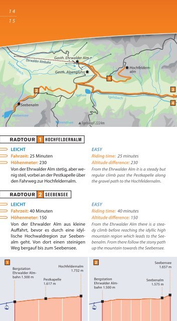
RADTOUR<br />
1<br />
LEICHT<br />
Fahrzeit: 25 Minuten<br />
Höhenmeter: 230<br />
Von der <strong>Ehrwalder</strong> Alm stetig, aber wenig<br />
steil, vorbei an der Pestkapelle über<br />
den Fahrweg zur Hochfeldernalm.<br />
RADTOUR<br />
<strong>Ehrwalder</strong> <strong>Almbahn</strong><br />
2<br />
Seebenalm<br />
2<br />
Gasth. <strong>Ehrwalder</strong> Alm<br />
Gasth. Alpenglühn<br />
Brendlsee<br />
HOCHFELDERNALM<br />
SEEBENSEE<br />
Igelsee<br />
LEICHT<br />
Fahrzeit: 40 Minuten<br />
Höhenmeter: 150<br />
Von der <strong>Ehrwalder</strong> Alm aus kleine<br />
Auff ahrt, bevor es durch eine idyllische<br />
Hochwaldregion zur Seebenalm<br />
geht. Von dort einen steinigen<br />
Weg bergauf bis zum Seebensee.<br />
Igelskopf 2224m<br />
1<br />
Igelsbach<br />
Hochfeldern-<br />
H<br />
alm<br />
EASY<br />
Riding time: 25 minutes<br />
Altitude diff erence: 230<br />
From the <strong>Ehrwalder</strong> Alm it is a steady but<br />
regular climb past the Pestkapelle along<br />
the gravel path to the Hochfeldernalm.<br />
EASY<br />
Riding time: 40 minutes<br />
Altitude diff erence: 150<br />
From the <strong>Ehrwalder</strong> Alm there is a steady<br />
climb before reaching the idyllic high<br />
mountain region which leads to the Seebenalm.<br />
From there follow the stony path<br />
up the mountain towards the Seebensee.<br />
3<br />
4<br />
RADTOUR 3 UM DEN WETTERSTEIN<br />
SCHWIERIG<br />
Fahrzeit: 7 bis 8 Stunden<br />
Länge: 85 km<br />
Von der <strong>Ehrwalder</strong> Alm nach einer<br />
kleinen Auff ahrt eine lange Abfahrt<br />
durchs Gaistal bis nach Leutasch. Weiter<br />
geht es in Richtung Mittenwald<br />
über Schloss Elmau und Wamberg<br />
zum Skistadion Garmisch-Partenkirchen.<br />
Von dort in Richtung Eibsee<br />
hinauf zum Eibsee-Blick (Schiebestrecke)<br />
und über die Hochthörlehütte<br />
hinunter nach Ehrwald.<br />
RADTOUR 4 UM DIE MIEMINGER KETTE<br />
SCHWIERIG<br />
Fahrzeit: 6,5 Stunden<br />
Länge: 72 km<br />
Von der <strong>Ehrwalder</strong> Alm nach einer<br />
kleinen Auff ahrt eine lange Abfahrt<br />
durchs Gaistal bis nach Leutasch. Über<br />
Birkenberg und Telfs zum Mieminger<br />
Plateau. Dort über den Sonnenplateau-Rundweg<br />
bis nach Arzkasten.<br />
Vom Marienberggraben nach Nassereith<br />
und den alten Fernpassweg<br />
hinauf zur Fernpasshöhe, wo der<br />
Römerweg zum Weißensee und der<br />
Panoramaweg wieder zurück nach<br />
Ehrwald leitet.<br />
MOUNTAINBIKE-TIPPS<br />
M O U N T A I N B I K E T I P S<br />
Bike-Tipps ab Bergstation <strong>Ehrwalder</strong> <strong>Almbahn</strong> / Bike-Tips from the mountain station <strong>Ehrwalder</strong> Alm<br />
DIFFICULT<br />
Riding time: 7 - 8 hours<br />
Distance: 85 km<br />
There is a small climb from the <strong>Ehrwalder</strong><br />
Alm followed by a long downhill run<br />
through the Gaistal to Leutasch. Continue<br />
in the direction of Mittenwald via<br />
Elmau Castle and Wamberg to Garmisch<br />
Partenkirchen Ski Stadium. From there<br />
travel in the direction of the Eibsee and up<br />
to the Eibsee Blick, (you will need to get off<br />
and push your bike at this point) on past<br />
the Hochthörle Hütte and back down towards<br />
Ehrwald.<br />
DIFFICULT<br />
Riding time: 6½ hours<br />
Distance: 72 km<br />
There is a small climb from the <strong>Ehrwalder</strong><br />
Alm followed by a long downhill<br />
run through the Gaistal to Leutasch. The<br />
ride continues via Birkenberg and Telfs to<br />
the Mieminger Plateau. Continue along<br />
the Sonnenplateau Circular path until<br />
you reach Arzkasten. From the Mareinberggraben<br />
ride towards Nassereith and<br />
along the old Fernpass pathway up to the<br />
Fernpass and the Weissensee, then along<br />
the Panorama Pathway back towards<br />
Ehrwald.<br />
1<br />
Bergstation<br />
<strong>Ehrwalder</strong> <strong>Almbahn</strong><br />
1.500 m<br />
Hochfeldernalm<br />
1.732 m<br />
Pestkapelle<br />
1.617 m<br />
2<br />
Bergstation<br />
<strong>Ehrwalder</strong> <strong>Almbahn</strong><br />
1.500 m<br />
Seebensee<br />
1.657 m<br />
Seebenalm<br />
1.575 m<br />
3 Mittenwald<br />
1010 m<br />
Bergstation<br />
<strong>Ehrwalder</strong> <strong>Almbahn</strong><br />
1.500 m<br />
Ehrwald<br />
1000 m<br />
Wamberg<br />
1176 m<br />
Grenze D/A<br />
1487 m<br />
4<br />
Buchen<br />
Ehrwald<br />
1246 m<br />
1000 m<br />
Bergstation<br />
Marienbergjoch<br />
<strong>Ehrwalder</strong> Alm-<br />
1818 m<br />
bahn 1.500 m<br />
Alplhaus<br />
Moos<br />
1508 m<br />
668 m<br />
1068 m<br />
1000 m 1047 m 902 m