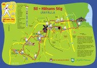
Ehrwalder Almbahn Prospekt 08.indd - Traneving
Ehrwalder Almbahn Prospekt 08.indd - Traneving
Ehrwalder Almbahn Prospekt 08.indd - Traneving

Sie wollen auch ein ePaper? Erhöhen Sie die Reichweite Ihrer Titel.
YUMPU macht aus Druck-PDFs automatisch weboptimierte ePaper, die Google liebt.
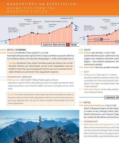
WANDERTIPPS AB BERGSTATION<br />
H I K I N G T I P S F R O M T H E<br />
M O U N T A I N S T A T I O N<br />
Brandjoch<br />
2.120 m Feldernjoch<br />
Feldernjoch<br />
Hochfeldernalm 2041 2.041 m<br />
1.732 m<br />
Gatterl<br />
Bergstation<br />
2.024 m<br />
<strong>Ehrwalder</strong> <strong>Almbahn</strong><br />
1.500 m<br />
Knorrhütte<br />
2.052 m<br />
Zugspitze 2.962 m<br />
Talstation Gletscherbahn 2.576 m<br />
MITTEL / SCHWIERIG<br />
Gehzeit (mit Wander-Ticket „Gatterl“): ca. 6 Std.<br />
Hochalpine Bergwanderung! Durch ihre Länge und Höhe anspruchsvolle Tour<br />
für konditionsstarke und trittsichere Bergsteiger (1 Stelle drahtseilgesichert).<br />
Top-Tipp: Das Wander-Ticket „Gatterl“ beinhaltet jeweils die einfache Fahrt mit der<br />
<strong>Ehrwalder</strong> <strong>Almbahn</strong>, der Gletscherbahn und der Tiroler Zugspitzbahn sowie die<br />
Rückfahrt mit dem Bus zum Ausgangspunkt. Die Tour kann man sowohl bei der <strong>Ehrwalder</strong><br />
<strong>Almbahn</strong> als auch bei der Tiroler Zugspitzbahn beginnen.<br />
INTERMEDIATE / DIFFICULT<br />
Walking time: (with ‘Gatterl ‘ Hiking Ticket): approx. 6 hours<br />
High alpine mountain hike! A demanding tour due to its length and altitude which<br />
requires good fi tness and a head for heights (one point is passable only via metal<br />
wires)<br />
Top-Tip: The ‘Gatterl’ Hiking ticket includes single trips with the <strong>Ehrwalder</strong> Alm cable car,<br />
the glacier cable car and the Tiroler Zugspitzbahn cable car as well as the return bus journey<br />
to your departure point. The tour can either be started in the <strong>Ehrwalder</strong> Alm or the<br />
Tiroler Zugspitzbahn.<br />
Bergstation<br />
<strong>Ehrwalder</strong> <strong>Almbahn</strong><br />
1.500 m<br />
Seebensee<br />
1.657 m<br />
Coburger Hütte<br />
1.917 m<br />
Seebenalm<br />
1.575 m<br />
Tajatörl<br />
2259 2.259 m<br />
Brendlsee<br />
1.903 m<br />
Bergstation<br />
<strong>Ehrwalder</strong> <strong>Almbahn</strong><br />
1.500 m<br />
TOUR 2 4<br />
TOUR 3 TOUR 5<br />
ZUGSPITZE ÜBER GATTERL 1 TOUR<br />
SEEBENSEE 2 TOUR<br />
HOCHFELDERNALM 4 TOUR<br />
LEICHT<br />
Gehzeit (pro Strecke): 1,5 bis 2 Std.<br />
Leichte Wanderung für Jedermann (Senioren, Kinder, geländegängige Kinderwagen)<br />
zum vielleicht schönsten und bekanntesten Ziel und Fotomotiv in der<br />
Region – dem idyllisch gelegenen Seebensee, in dem sich so oft das Wettersteinmassiv<br />
spiegelt.<br />
Alternative: über den parallel verlaufenden Fahrweg (Achtung: Mountainbiker)<br />
EASY<br />
Walking time: (one way): 1½ - 2 hours<br />
Easy hike suitable for everyone (senior citizens, children and stronger children’s buggies)<br />
to possibly one of the most beautiful, best known and most frequently photographed<br />
places in the region, the idyllic Seeben Lake, in which the Wetterstein mountain range<br />
is often refl ected.<br />
Alternative Route: via the wider, parallel running gravel roadway.<br />
(Care: Mountain bikers)<br />
COBURGER HÜTTE - TAJATÖRL - BRENDLISEE 3 TOUR<br />
MITTEL<br />
Gehzeit ab Seebensee: 2 bis 2,5 Std.<br />
Gleich 3 Bergseen liegen auf dem Weg der Bergsteiger. Vom Seebensee (s. Tour<br />
2) vorbei an der Coburger Hütte, über dem Drachensee gelegen, hinauf zum<br />
Tajatörl (Abstecher zum hinteren Tajakopf möglich) und hinunter ins Brendlikar,<br />
vorbei am Brendlisee und zurück zur <strong>Ehrwalder</strong> Alm.<br />
INTERMEDIATE<br />
Walking time from the Seebensee: 2 - 2½ hours<br />
Hikers will see three beautiful mountain lakes during this tour. Starting at the Seebensee<br />
(see Tour 2) past the Coburger Hütte, the path continues above the Drachensee to the Tajatörl<br />
(at this point there is the opportunity to climb to the hinteren Tajakopf) and down<br />
into the Brendlikar, past the Brendlisee and back towards the <strong>Ehrwalder</strong> Alm.<br />
Pestkapelle<br />
1.617 m<br />
Bergstation<br />
<strong>Ehrwalder</strong><br />
<strong>Almbahn</strong><br />
1.500 m<br />
Brandjoch<br />
2.120 m<br />
Hochfeldernalm<br />
1.732 m<br />
Feldernjoch<br />
2.041 m<br />
Wannigjöchl<br />
2.186 m<br />
Steinernes Hüttl<br />
1.930 m<br />
Tillfussalm<br />
1.382 m<br />
Igelsee<br />
1.555 m<br />
STEINERNES HÜTTL - GAISTAL<br />
Bergstation<br />
<strong>Ehrwalder</strong><br />
<strong>Almbahn</strong><br />
1.500 m<br />
LEICHT<br />
Gehzeit: 45 min.<br />
Spaziertour mit wenig Steigung zur Hochfeldernalm. Der Weg teilt sich an der<br />
Pestkapelle in Max-Klotz-Steig (Fußgänger) und Fahrweg (Mountainbiker, Kinderwagen),<br />
die beide direkt zur Alm führen.<br />
7/8<br />
9<br />
EASY<br />
Walking time: 45 minutes<br />
A tour with gentle inclines to the Hochfeldernalm. The path divides at the Pestkapelle,<br />
with the Max-Klotz-Steig for walkers and the gravel roadway for mountain bikers and<br />
families with buggies, both paths leading directly to the Hochfeldernalm.<br />
5 TOUR<br />
MITTEL<br />
Gehzeit ab Hochfeldernalm: 3,5 Std.<br />
Von der Hochfeldernalm (s. Tour 4), oberhalb der Baumgrenze, vorbei an Murmeltierwiesen<br />
zum Steinernen Hüttl. Für den Rückweg bietet sich der Abstieg<br />
nach Süden ins Gaistal an. Von der Talsohle bachaufwärts vorbei am Igelsee<br />
zurück zur <strong>Ehrwalder</strong> Alm.<br />
INTERMEDIATE<br />
Walking time from the Hochfeldernalm: 3½ hours<br />
From the Hochfeldernalm (see Tour 4) up above the tree line, past the Marmot fi elds to<br />
the Steinernen Hüttl. For the return journey take the path south towards the Gaistal. At<br />
the valley base follow the stream past the Igelsee back towards the <strong>Ehrwalder</strong> Alm.