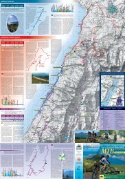
Perrères 1844 m 772 m E Monte Pancherot 2616 m 2h20’ � 8, 107, 7 When you get to the hamlet of Perrères, leave the car in the car park and take the country road (trail sign 8) which crosses the Marmore stream. Cross it, and ignoring the sloping path going up to the pastures, take trail 107 on the right that goes up to meet the country road that you left beforehand and continue along it for a few hundred metres until you get to Olucs. From here, the trail rises in long diagonal slopes, and goes through Grillon, Tsa de Grillon and until you reach the Col Finestra di Cignana. Now follow route 7 on the left (sections of which are rather exposed), which goes up the steep grassy slopes of the western side, and leads to the highest peak of Mont Pancherot, near which you will also find the Giuseppe Osella forest bivouac. This route begins as you leave the village of Crétaz, a short way from Pâquier (main centre of the municipality of Valtournenche), and is a part of the Alta Via n. 1 trail. The mule track climbs through a dense wood of larch trees and broad-leaved trees until it meets the road from the left which connects Muranche with Falinère. You go across it and climb up to the Promindoz pasture (1,850 m), located on a grassy panoramic plateau. Continuing uphill through the larch wood you come to the Cheneil hollow. � � Dieser Weg beginnt am Ausgang der Siedlung Crétaz, eines Ortsteils in der Nähe von Pâquier (dem Hauptort der Gemeinde Valtournenche), und stellt einen Abschnitt des Höhenweges Nr. 1 dar. Der Saumpfad steigt durch einen dichten Lärchen- und <strong>La</strong>ubwald an und trifft auf die von links kommende Straße, die Muranche mit Falinère verbindet. Man überquert diese und steigt bergan bis zur Alm Promindoz (1850 m), die auf eine grasigen Hochebene mit schöner Rundsicht liegt. Indem man weiter durch den Lärchenwald bergan geht, erreicht man die Senke von Cheneil. � Starting point • Ausgangspunkt Arrival • Ankunftspunkt Gradient • Höhenunterschied Ascending time • Gehzeiten Trail sign • Wegnummer T E DIFFICuLTY - SCHWIERIGKEITSGRAD Tourist trekking route: mainly on footpaths or bridle ways. Leichter Wanderweg/Spazierweg bedeutet: es handelt sich um ausgebaute Fußwege und gut begehbare Wanderwege. Trekking excursion route without technical difficulty : mainly on mule tracks or footpaths leading up to refuges or connecting neighbouring valleys. Wanderweg ohne Schwierigkeiten: es handelt sich um Mauleselpfade, Zugangswege zu Berghütten oder Verbindungswege zwischen Tälern. Nachdem man sein Auto am Parkplatz des Dörfchens Perrères abgestellt hat, begibt man sich auf den Gutsweg Nr. 8, der den Bergbach Marmore überquert. Man ignoriert die bergauf zu den Almhütten führende Route und schlägt rechts den Weg Nr. 107 ein, der erneut den zuvor ausgelassenen Gutsweg kreuzt und dem jetzt für einige hundert Meter bis nach Olucs gefolgt wird. Hier steigt der Weg durch lange Schräglinien an den Ortschaften Grillon und Tsa de Grillon vorbei bis auf den Pass Colle Finestra di Cignana bergan. Man folgt sodann dem links abgehenden Wanderweg Nr. 7 (einige Streckenabschnitte sind einigermaßen offen), der entlang der steilen grasbewachsenen Westhänge verläuft und zum höchsten Gipfel des Monte Pancherot führt. Crétaz 1520 m 585 m E Cheneil 2105 m 2h30’ � AV1 � loc. Veillen Easy walk on a country road winding up across pine woods and along a canal called “Ru Veuillen”. From <strong>La</strong> <strong>Magdeleine</strong> keep driving to the village of Fioc. After the sharp turn on the right follow the trail n.107 on the left. The almost even footpath goes through pastures to reach <strong>Chamois</strong>, a nice typical mountain village that can be reached only by cable-car. Mognod 1741 m 1500 m 71 m 174 m At the last right-hand bend before the municipal seat of Torgnon, take route 13 on the left, which leads to Maisonnettes, then Col <strong>Saint</strong>-Pantaléon. At the church, take route 2 on the left which rises gently to the sanctuary of <strong>Saint</strong>-Évence. Panoramic itinerary with wide view over the Valtournenche Valley. The Blue <strong>La</strong>ke is about half an hour’s walk from <strong>Breuil</strong>-<strong>Cervinia</strong>. The path sets out from Piazzale Breithorn, at the side of the tunnel on the left, crosses the whole of the <strong>Breuil</strong> picnic area and follows a predominantly flat path, suitable also for children and the elderly, through the woods round the edge of the adventure park. A small stretch that links the paths is on tarmac road. The Blue <strong>La</strong>ke is a small expanse of water surrounded by centuries-old larch trees; because it is fed by spring water, it is always crystal clear and offers splendid reflections of the Matterhorn on the surface. Not far from here lie the three little lakes of <strong>La</strong>yet, with spring water of a different colour, and the green fields of the <strong>La</strong>yet Pasture. Refreshments are available close by. T E <strong>Chamois</strong> 1812 m 1h 107 � Diese Strecke führt vorwiegend über einen Kiesweg, der sich dem Ru Veuillen (Bewässerungsgraben) entlang durch schattige Nadelwälder windet. Nachdem man den Hauptort <strong>La</strong> <strong>Magdeleine</strong> hinter sich gelassen hat und auf der Straße in Richtung Ortsteil Fioc befindet, begibt man sich bis zur ersten nach rechts führenden Kehre, von welcher links der Wanderweg Nr. 107 abzweigt. Dieser fast vollständig eben verlaufende Weg führt bis zu den Weiden vor <strong>Chamois</strong>, einem zauberhaften Dörfchen, das nur mit der Seilbahn erreicht werden kann. <strong>Saint</strong>-Evence 1674 m 1h35 Auf der Höhe der letzten Rechtskehre vor dem Hauptort Torgnon geht es links auf den Wanderweg Nr. 13, der nach Maisonnettes und daraufhin zum Pass Col <strong>Saint</strong>-Pantaléon führt. Hier, in der Nähe der Kirche, folgt man dem Wanderweg Nr. 2, der sanft bis zur Wallfahrtskirche <strong>Saint</strong>-Évence ansteigt. Ausblickreiche Route mit wundervoller Aussicht auf das Valtournenche Tal. <strong>Breuil</strong>-<strong>Cervinia</strong> 2050 m 183 m T Alpe <strong>La</strong>yet 2233 m 40’ � 107 (Grande Balconata) Der Blu-See liegt etwa eine halbe Stunde Fußweg von <strong>Breuil</strong>-<strong>Cervinia</strong> entfernt. Der Pfad nimmt vom Piazzale Breithorn neben dem Tunnel links seinen Ausgang, durchquert das gesamte Picknickgelände von <strong>Breuil</strong> und führt auf einem ebenen Weg im Wald, der sich auch für Kinder und ältere Personen eignet, am Abenteuerpark entlang. Ein kleines Verbindungsstück zwischen den Pfaden folgt einer Asphaltstraße. Der Blu-See ist ein kleiner, von hundertjährigen Lärchen umgebener See, der von klarem Quellwasser versorgt wird, sodass das Matterhorn sich in ihm spiegeln kann. Nicht weit entfernt liegen die 3 kleinen <strong>La</strong>yet-Seen mit Quellwasser unterschiedlicher Farbe und die grünen Weiden der Alm <strong>La</strong>yet. In der umgebung gibt es Rastmöglichkeiten. � 13 2
2 1 6 5 4 3 9 8 7