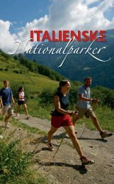
Antey-Saint-André Breuil-Cervinia Chamois La Magdeleine ... - Enit
Antey-Saint-André Breuil-Cervinia Chamois La Magdeleine ... - Enit
Antey-Saint-André Breuil-Cervinia Chamois La Magdeleine ... - Enit

Sie wollen auch ein ePaper? Erhöhen Sie die Reichweite Ihrer Titel.
YUMPU macht aus Druck-PDFs automatisch weboptimierte ePaper, die Google liebt.
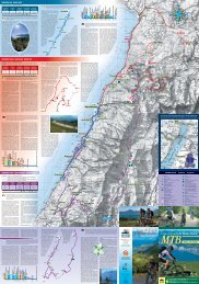
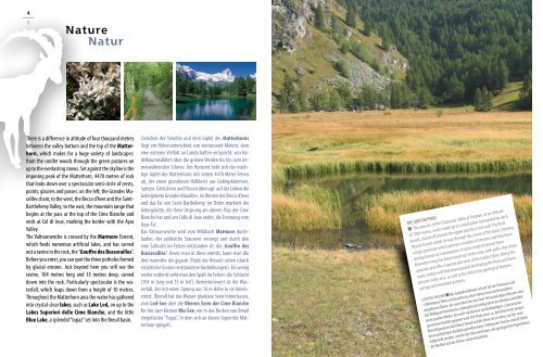
There is a difference in altitude of four thousand metres<br />
between the valley bottom and the top of the Matterhorn,<br />
which makes for a huge variety of landscapes:<br />
from the conifer woods through the green pastures on<br />
up to the everlasting snows. Set against the skyline is the<br />
imposing peak of the Matterhorn, 4478 metres of rock<br />
that looks down over a spectacular semi-circle of crests,<br />
points, glaciers and passes: on the left, the Grandes Murailles<br />
chain; to the west, the Becca d’Aver and the <strong>Saint</strong>-<br />
Barthélemy Valley; to the east, the mountain range that<br />
begins at the pass at the top of the Cime Bianche and<br />
ends at Col di Joux, marking the border with the Ayas<br />
Valley.<br />
The Valtournenche is crossed by the Marmore Torrent,<br />
which feeds numerous artificial lakes, and has carved<br />
out a ravine in the rock, the “Gouffre des Busserailles”.<br />
Before you enter, you can spot the three potholes formed<br />
by glacial erosion. Just beyond here you will see the<br />
ravine, 104 metres long and 35 metres deep, carved<br />
down into the rock. Particularly spectacular is the waterfall,<br />
which leaps down from a height of 10 metres.<br />
Throughout the Matterhorn area the water has gathered<br />
into crystal-clear lakes, such as <strong>La</strong>ke Lod, on up to the<br />
<strong>La</strong>kes Superiori delle Cime Bianche, and the little<br />
Blue <strong>La</strong>ke, a splendid “topaz” set into the <strong>Breuil</strong> basin.<br />
Zwischen der Talsohle und dem Gipfel des Matterhorns<br />
liegt ein Höhenunterschied von viertausend Metern, dem<br />
eine extreme Vielfalt an <strong>La</strong>ndschaften entspricht: von Nadelbaumwäldern<br />
über die grünen Weiden bis hin zum immerwährenden<br />
Schnee. Am Horizont hebt sich der mächtige<br />
Gipfel des Matterhorns mit seinen 4478 Meter Felsen<br />
ab, der einen grandiosen Halbkreis aus Gebirgskämmen,<br />
Spitzen, Gletschern und Pässen überragt: auf der Linken die<br />
Gebirgskette Grandes Murailles, im Westen der Becca d’Aver<br />
und das Tal von <strong>Saint</strong>-Barthélemy; im Osten markiert die<br />
Gebirgskette, die ihren ursprung am oberen Pass der Cime<br />
Bianche hat und am Colle di Joux endet, die Trennung vom<br />
Ayas-Tal.<br />
Das Valtournenche wird vom Wildbach Marmore durchlaufen,<br />
der zahlreiche Stauseen versorgt und durch den<br />
eine Schlucht im Felsen entstanden ist: die „Gouffre des<br />
Busserailles“. Bevor man in diese eintritt, kann man die<br />
drei marmitte dei giganti (Töpfe der Riesen) sehen (durch<br />
eiszeitliche Erosion entstandene Aushöhlungen). Ein wenig<br />
weiter entfernt sieht man den Spalt im Felsen: die Schlucht<br />
(104 m lang und 35 m tief). Bemerkenswert ist der Wasserfall,<br />
der mit einen Sprung aus 10 m Höhe in sie hineinstürzt.<br />
Überall hat das Wasser glasklare Seen hinterlassen,<br />
vom Lod-See über die Oberen Seen der Cime Bianche<br />
bis hin zum kleinen Blu-See, ein in das Becken von <strong>Breuil</strong><br />
eingefasster “Topas”, in dem sich an klaren Tagen der Matterhorn<br />
spiegelt.<br />
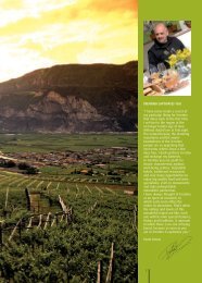
THE LODITOR POND<br />
■ This area lies in the Chavacour Valley at Torgnon, at an altitude<br />
of 1900 metres, and is made up of a small plain surrounded by larch<br />
woods, closed off towards the upper part by a rock wall. The Petit<br />
Monde Torrent winds its way through the centre of this basin, forming<br />
a large pond into which also run a number of streams and limestone<br />
springs known as ‘cratoneurion’. A visitor route of almost three<br />
kilometres long has been traced out in the area, with paths that climb<br />
upwards and offer a spectacular view of the Loditor plain. Along the<br />
route, visitors will find eleven panels illustrating the flora and fauna<br />
present in the area, as well as the distinctive geological features,<br />
springs and mountain pastures.<br />
LODITOR-WEIHER ■ Das Gelände befindet sich im Tal von Chavacour auf<br />
1.900 Metern Höhe und besteht aus einer kleinen von Lärchenwäldern<br />
umgebenen Ebene, die nach oben hin von einer Felswand abgeschlossen wird.<br />
Der Wildbach Petit Monde schlängelt sich mittig durch das Becken und bildet<br />
einen großen Weiher, der auch von Bächen und kalkhaltigen, ‚Cratoneurion‘<br />
genannten Quellen gespeist wird. Die Pfade einer ca. drei Kilomerter langen<br />
Besichtigungsstrecke führen hinauf auf die Ebene des Loditor, von der man<br />
einen großartigen Ausblick genießen kann. Entlang der Strecke sind elf Tafeln<br />
aufgestellt worden, welche die Flora und Fauna, die geologischen Eigenheiten,<br />
die Quellen und die Almen veranschaulichen.