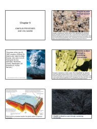
Eocene-Mid Miocene sedimentary rocks and Olympic Mountains
Eocene-Mid Miocene sedimentary rocks and Olympic Mountains
Eocene-Mid Miocene sedimentary rocks and Olympic Mountains

You also want an ePaper? Increase the reach of your titles
YUMPU automatically turns print PDFs into web optimized ePapers that Google loves.
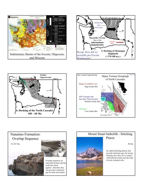
Sedimentary Basins of the <strong>Eocene</strong>, Oligocene,<br />
<strong>and</strong> <strong>Miocene</strong><br />
Tape<br />
here<br />
Wrangellia<br />
Seattle<br />
Portl<strong>and</strong><br />
Tape<br />
here<br />
Insular<br />
Superterrane<br />
Spokane<br />
6. Docking of the North Cascades<br />
100 – 60 Ma<br />
Nanaimo Formation:<br />
Overlap Sequence<br />
54–42? Ma<br />
Page 5<br />
Overlap sequences sit<br />
atop both terranes <strong>and</strong> the<br />
<strong>rocks</strong> they dock<br />
against—therefore they<br />
can provide a minimum<br />
age for both rock bodies<br />
Tape<br />
here<br />
Seattle<br />
Quesnellia Terrane<br />
Part of the<br />
Intermontane<br />
Superterrane<br />
Portl<strong>and</strong><br />
Subduction<br />
zone<br />
backsteps<br />
Recap: How did we<br />
assemble pre-<strong>Eocene</strong><br />
Washington?<br />
Aka: Insular Superterrane<br />
Skagit Crystalline Core<br />
High Grade Met.<br />
NW Cascades <strong>and</strong><br />
San Juan Thrust System<br />
Medium Grade Met.<br />
Melanges<br />
Low Grade Met.<br />
Farallon<br />
Plate<br />
Tape<br />
here<br />
Spokane<br />
5. Docking of Okanogan<br />
Highl<strong>and</strong>s<br />
(~170-180 m.y.)<br />
Page 4<br />
Cut<br />
along<br />
dotted<br />
line<br />
C-7 & C5<br />
Major Terrane Groupings<br />
of North Cascades<br />
Mount Stuart batholith - Stitching<br />
Pluton<br />
90 Ma<br />
So called Stitching plutons also<br />
provide minimum ages for terrane<br />
docking since they are in contact<br />
with both the terrane <strong>and</strong> the body<br />
of rock it docked with.
Plutons shown in<br />
red—note Mount<br />
Stuart stitching<br />
pluton at lower<br />
right<br />
Pickett Range<br />
Seattle<br />
Portl<strong>and</strong><br />
Spokane<br />
7. <strong>Eocene</strong> to <strong>Miocene</strong> S<strong>and</strong>stones <strong>and</strong><br />
Volcanics<br />
(55 to 20 m.y.)<br />
Page 6
<strong>Eocene</strong> Palm fossils in the<br />
Chuckanut S<strong>and</strong>stone near<br />
Bellingham show a warmer climate<br />
prevailed ~50 Ma<br />
Northcraft<br />
Formation volcanic<br />
<strong>rocks</strong>, early<br />
evidence of<br />
Cascades<br />
Volcanism ~37Ma<br />
Skookumchuck<br />
Formation: view to south<br />
in Centralia Coal Mine<br />
Photo donated by Larry McMIllan<br />
http://www.ci.tenino.wa.us/TeninoQuarry1_small.jpg<br />
<strong>Eocene</strong> McIntosh Formation:<br />
Tenino S<strong>and</strong>stone—quartz<br />
s<strong>and</strong>stones, but no evidence<br />
of Cascades volcanism yet!<br />
Pe Ell volcanic <strong>rocks</strong> near Rock Creek<br />
Metasequoia fossil
Coal seam in the<br />
Centralia Coal Mine:<br />
Carina Henderson<br />
points to a tonstein,<br />
decomposed volcanic<br />
ash<br />
Outcrop of Lincoln Creek Formation at Galvin<br />
Siletzia<br />
Terrane<br />
Tape<br />
here<br />
Cut<br />
alon<br />
g<br />
dotte<br />
d<br />
line<br />
Seattle<br />
Portl<strong>and</strong><br />
8. Docking of <strong>Olympic</strong><br />
Peninsula<br />
(25 to 30 m.y.)<br />
<strong>Olympic</strong> Subduction<br />
Zone<br />
Spokane<br />
Bivalve from outcrop on<br />
Gold St. in Centralia<br />
<strong>Eocene</strong> bivalve<br />
Geology Map<br />
http://www.ess.washington.edu/SEIS/PNSN/H<br />
AZARDS/CASCADIA/turbidite_record.html<br />
http://geology.wr.usgs.gov<br />
/parks/olym/geolmap.html<br />
http://www.geol.umd.edu/~jmerck/geol100/images<br />
/32/turbidite.gif<br />
20 my old Hoh Formation turbidite deposits (overturned) at<br />
Beach #4<br />
Hoh Formation turbidite deposits (looking down on overturned beds) <strong>Miocene</strong> <strong>rocks</strong> at Ruby Beach
Metasediments from the core of the <strong>Olympic</strong>s at Ruby Beach<br />
Youngest Oldest<br />
Peripheral Rocks:<br />
Mostly the Crescent Fm<br />
Core Rocks<br />
Age:<br />
Mostly <strong>Eocene</strong> (58–45 Myrs)<br />
Rocks<br />
Pillow Basalts<br />
Some Vesicular Basalts<br />
15-30 km thick<br />
Limestone(Red)<br />
w/deep water forams<br />
E-4<br />
E-4<br />
Age:<br />
<strong>Eocene</strong>-<strong>Miocene</strong> (40-20 Myrs)<br />
Metamorphosed 14-12 Myrs<br />
Rocks<br />
S<strong>and</strong>stones<br />
w/graded beds<br />
Shale<br />
Metamorphism<br />
East - Low Grade<br />
(11 km burial)<br />
West - Not Met.<br />
Major Rock Units of the <strong>Olympic</strong>s<br />
1. Peripheral Rocks<br />
2. Core Rocks<br />
Separated by reverse faults<br />
Crescent Formation<br />
Basalt of the Crescent Formation on Klahhane Ridge above Port<br />
Angeles; from http://geology.wr.usgs.gov/parks/olym/olym5.html<br />
E-4<br />
<strong>Olympic</strong> Structures<br />
Core Rocks<br />
Peripheral Rocks<br />
Note faults place older rock over younger rock<br />
Modern Analogy for Crescent<br />
basalts - Icel<strong>and</strong><br />
http://www.answers.com/topic/geo<br />
graphy-of-icel<strong>and</strong><br />
E-3<br />
http://www.calstatela.edu/dept/geol<br />
ogy/HotSpots.htm<br />
Plate Reconstruction: 55 Myrs<br />
D-2<br />
Interpretation: Peripheral Rocks E-4<br />
Basalt Chemistry = Hot Spot & Divergent Zone<br />
Terrane (fault bounded)<br />
Hot Spot Isl<strong>and</strong> (Yellowstone?)<br />
Possible <strong>Eocene</strong> Reconstruction<br />
55 Myrs<br />
Supporting Evidence:<br />
Rock Age<br />
35 Myrs<br />
E-1<br />
E-3
Interpretation: Core Rocks<br />
<strong>Olympic</strong><br />
History<br />
Western Core <strong>rocks</strong><br />
accreted first &<br />
were buried deepest<br />
(explains why they<br />
are oldest <strong>and</strong> most<br />
metamorphosed)<br />
Accretionary Wedge<br />
Trench Sediments<br />
But Why is the North “Wedge”<br />
(<strong>Olympic</strong>s) so much larger than the<br />
South “Wedge” (Willapa Hills/Oregon<br />
Coast Range)?<br />
2. There is a bend in the<br />
Juan de Fuca Plate<br />
under the <strong>Olympic</strong>s<br />
<strong>Olympic</strong>s<br />
Cross Section<br />
North ------ South<br />
N. America<br />
Juan de Fuca<br />
E-4<br />
E-4<br />
<strong>Olympic</strong> Accretionary Wedge<br />
But Why is the North “Wedge”<br />
(<strong>Olympic</strong>s) so much larger than the<br />
South “Wedge” (Willapa Hills/Oregon<br />
Coast Range)?<br />
1. Shoved in the Corner<br />
Insular ST<br />
<strong>Olympic</strong>s<br />
Coast<br />
Range<br />
Evidence for the Bend<br />
1. NW Volcanoes<br />
Steep Subduction Shallow Subduction<br />
100 Depth<br />
Washington<br />
Oregon<br />
QuickTime <strong>and</strong> a<br />
TIFF (Uncompressed) decompressor<br />
are needed to see this picture.
Why is there a Bend at all?<br />
Basin & Range Extention to the South<br />
Big blocks are rotating - north-seeking magnetic<br />
directions captured when Coast Range lavas<br />
cooled now point eastward.<br />
N<br />
v<br />
Coast Range basalt - similar to Hawaiian Isl<strong>and</strong>s - was<br />
52 million-year million year-old old submarine<br />
accreted to the continent about 50 million years ago;<br />
pillow basalt, Trask River<br />
then rotated clockwise.<br />
v<br />
Northwest Block<br />
model for long-term<br />
motion<br />
• Sierra Nevada dragged<br />
northward by Pacific<br />
Plate<br />
• Oregon (pink) pivots<br />
clockwise to get out of<br />
the way<br />
• Washington (green) gets<br />
squeezed against Canadahence<br />
all the earthquakes<br />
<strong>and</strong> faults.<br />
• SE Oregon <strong>and</strong> Nevada<br />
Stretch to fill in the gap<br />
behind rotating block<br />
Volcanoes, faults <strong>and</strong> EQ outline big blocks<br />
OC<br />
SN<br />
From Wells et al., 1998, after Magill<br />
et al., 1981, 1982; Guffanti <strong>and</strong><br />
Weaver, 1988; Sherrod <strong>and</strong> Smith,<br />
1990<br />
W. Oregon has been<br />
rotating clockwise for<br />
millions of years.<br />
• Rotation rate of 1.2° per Million<br />
years for at least 50 million years,<br />
based on paleomagnetic study.<br />
• Rotations are less to N, S, <strong>and</strong> E..<br />
(pie-shaped wedges are uncertainties<br />
about mean rotation from expected<br />
north seeking direction; modified<br />
from Gromme et al., 1986)<br />
PBO GPS receivers installed in PNW (green dots) -<br />
what are they going to measure?<br />
• Plate <strong>and</strong> block<br />
motions<br />
• Deformation of crust<br />
(its change in shape)<br />
along plate<br />
boundaries -<br />
especially above the<br />
Cascadia megathrust
GPS velocities 1995-2005<br />
McCaffrey, Qamar, King,<br />
Wells, et al, s GJI, 2007<br />
• Velocities rotate<br />
clockwise (block<br />
rotation)<br />
• decrease away from<br />
coast (compression<br />
above SZ)<br />
– Blue are campaign<br />
sites, red are<br />
continuous sites<br />
(PBO)<br />
– Many institutions:<br />
RPI, UW, GSC,<br />
USGS, OSU, NGS,<br />
PANGA, PBO