Eocene-Mid Miocene sedimentary rocks and Olympic Mountains
Eocene-Mid Miocene sedimentary rocks and Olympic Mountains
Eocene-Mid Miocene sedimentary rocks and Olympic Mountains

Create successful ePaper yourself
Turn your PDF publications into a flip-book with our unique Google optimized e-Paper software.
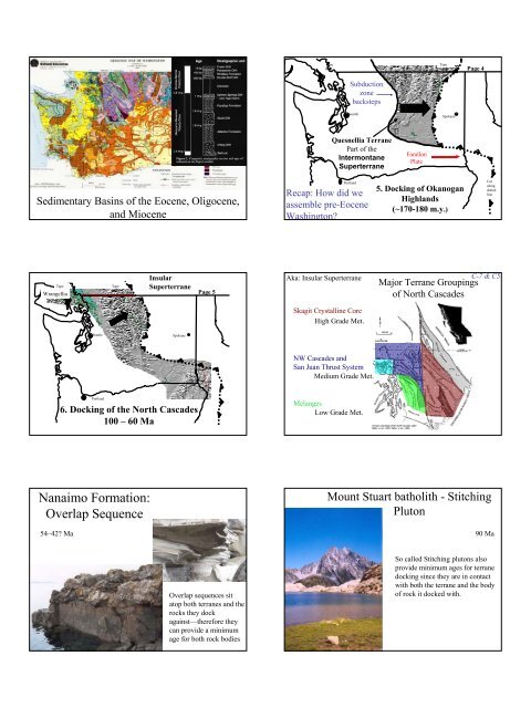
Sedimentary Basins of the <strong>Eocene</strong>, Oligocene,<br />
<strong>and</strong> <strong>Miocene</strong><br />
Tape<br />
here<br />
Wrangellia<br />
Seattle<br />
Portl<strong>and</strong><br />
Tape<br />
here<br />
Insular<br />
Superterrane<br />
Spokane<br />
6. Docking of the North Cascades<br />
100 – 60 Ma<br />
Nanaimo Formation:<br />
Overlap Sequence<br />
54–42? Ma<br />
Page 5<br />
Overlap sequences sit<br />
atop both terranes <strong>and</strong> the<br />
<strong>rocks</strong> they dock<br />
against—therefore they<br />
can provide a minimum<br />
age for both rock bodies<br />
Tape<br />
here<br />
Seattle<br />
Quesnellia Terrane<br />
Part of the<br />
Intermontane<br />
Superterrane<br />
Portl<strong>and</strong><br />
Subduction<br />
zone<br />
backsteps<br />
Recap: How did we<br />
assemble pre-<strong>Eocene</strong><br />
Washington?<br />
Aka: Insular Superterrane<br />
Skagit Crystalline Core<br />
High Grade Met.<br />
NW Cascades <strong>and</strong><br />
San Juan Thrust System<br />
Medium Grade Met.<br />
Melanges<br />
Low Grade Met.<br />
Farallon<br />
Plate<br />
Tape<br />
here<br />
Spokane<br />
5. Docking of Okanogan<br />
Highl<strong>and</strong>s<br />
(~170-180 m.y.)<br />
Page 4<br />
Cut<br />
along<br />
dotted<br />
line<br />
C-7 & C5<br />
Major Terrane Groupings<br />
of North Cascades<br />
Mount Stuart batholith - Stitching<br />
Pluton<br />
90 Ma<br />
So called Stitching plutons also<br />
provide minimum ages for terrane<br />
docking since they are in contact<br />
with both the terrane <strong>and</strong> the body<br />
of rock it docked with.
Plutons shown in<br />
red—note Mount<br />
Stuart stitching<br />
pluton at lower<br />
right<br />
Pickett Range<br />
Seattle<br />
Portl<strong>and</strong><br />
Spokane<br />
7. <strong>Eocene</strong> to <strong>Miocene</strong> S<strong>and</strong>stones <strong>and</strong><br />
Volcanics<br />
(55 to 20 m.y.)<br />
Page 6
<strong>Eocene</strong> Palm fossils in the<br />
Chuckanut S<strong>and</strong>stone near<br />
Bellingham show a warmer climate<br />
prevailed ~50 Ma<br />
Northcraft<br />
Formation volcanic<br />
<strong>rocks</strong>, early<br />
evidence of<br />
Cascades<br />
Volcanism ~37Ma<br />
Skookumchuck<br />
Formation: view to south<br />
in Centralia Coal Mine<br />
Photo donated by Larry McMIllan<br />
http://www.ci.tenino.wa.us/TeninoQuarry1_small.jpg<br />
<strong>Eocene</strong> McIntosh Formation:<br />
Tenino S<strong>and</strong>stone—quartz<br />
s<strong>and</strong>stones, but no evidence<br />
of Cascades volcanism yet!<br />
Pe Ell volcanic <strong>rocks</strong> near Rock Creek<br />
Metasequoia fossil
Coal seam in the<br />
Centralia Coal Mine:<br />
Carina Henderson<br />
points to a tonstein,<br />
decomposed volcanic<br />
ash<br />
Outcrop of Lincoln Creek Formation at Galvin<br />
Siletzia<br />
Terrane<br />
Tape<br />
here<br />
Cut<br />
alon<br />
g<br />
dotte<br />
d<br />
line<br />
Seattle<br />
Portl<strong>and</strong><br />
8. Docking of <strong>Olympic</strong><br />
Peninsula<br />
(25 to 30 m.y.)<br />
<strong>Olympic</strong> Subduction<br />
Zone<br />
Spokane<br />
Bivalve from outcrop on<br />
Gold St. in Centralia<br />
<strong>Eocene</strong> bivalve<br />
Geology Map<br />
http://www.ess.washington.edu/SEIS/PNSN/H<br />
AZARDS/CASCADIA/turbidite_record.html<br />
http://geology.wr.usgs.gov<br />
/parks/olym/geolmap.html<br />
http://www.geol.umd.edu/~jmerck/geol100/images<br />
/32/turbidite.gif<br />
20 my old Hoh Formation turbidite deposits (overturned) at<br />
Beach #4<br />
Hoh Formation turbidite deposits (looking down on overturned beds) <strong>Miocene</strong> <strong>rocks</strong> at Ruby Beach
Metasediments from the core of the <strong>Olympic</strong>s at Ruby Beach<br />
Youngest Oldest<br />
Peripheral Rocks:<br />
Mostly the Crescent Fm<br />
Core Rocks<br />
Age:<br />
Mostly <strong>Eocene</strong> (58–45 Myrs)<br />
Rocks<br />
Pillow Basalts<br />
Some Vesicular Basalts<br />
15-30 km thick<br />
Limestone(Red)<br />
w/deep water forams<br />
E-4<br />
E-4<br />
Age:<br />
<strong>Eocene</strong>-<strong>Miocene</strong> (40-20 Myrs)<br />
Metamorphosed 14-12 Myrs<br />
Rocks<br />
S<strong>and</strong>stones<br />
w/graded beds<br />
Shale<br />
Metamorphism<br />
East - Low Grade<br />
(11 km burial)<br />
West - Not Met.<br />
Major Rock Units of the <strong>Olympic</strong>s<br />
1. Peripheral Rocks<br />
2. Core Rocks<br />
Separated by reverse faults<br />
Crescent Formation<br />
Basalt of the Crescent Formation on Klahhane Ridge above Port<br />
Angeles; from http://geology.wr.usgs.gov/parks/olym/olym5.html<br />
E-4<br />
<strong>Olympic</strong> Structures<br />
Core Rocks<br />
Peripheral Rocks<br />
Note faults place older rock over younger rock<br />
Modern Analogy for Crescent<br />
basalts - Icel<strong>and</strong><br />
http://www.answers.com/topic/geo<br />
graphy-of-icel<strong>and</strong><br />
E-3<br />
http://www.calstatela.edu/dept/geol<br />
ogy/HotSpots.htm<br />
Plate Reconstruction: 55 Myrs<br />
D-2<br />
Interpretation: Peripheral Rocks E-4<br />
Basalt Chemistry = Hot Spot & Divergent Zone<br />
Terrane (fault bounded)<br />
Hot Spot Isl<strong>and</strong> (Yellowstone?)<br />
Possible <strong>Eocene</strong> Reconstruction<br />
55 Myrs<br />
Supporting Evidence:<br />
Rock Age<br />
35 Myrs<br />
E-1<br />
E-3
Interpretation: Core Rocks<br />
<strong>Olympic</strong><br />
History<br />
Western Core <strong>rocks</strong><br />
accreted first &<br />
were buried deepest<br />
(explains why they<br />
are oldest <strong>and</strong> most<br />
metamorphosed)<br />
Accretionary Wedge<br />
Trench Sediments<br />
But Why is the North “Wedge”<br />
(<strong>Olympic</strong>s) so much larger than the<br />
South “Wedge” (Willapa Hills/Oregon<br />
Coast Range)?<br />
2. There is a bend in the<br />
Juan de Fuca Plate<br />
under the <strong>Olympic</strong>s<br />
<strong>Olympic</strong>s<br />
Cross Section<br />
North ------ South<br />
N. America<br />
Juan de Fuca<br />
E-4<br />
E-4<br />
<strong>Olympic</strong> Accretionary Wedge<br />
But Why is the North “Wedge”<br />
(<strong>Olympic</strong>s) so much larger than the<br />
South “Wedge” (Willapa Hills/Oregon<br />
Coast Range)?<br />
1. Shoved in the Corner<br />
Insular ST<br />
<strong>Olympic</strong>s<br />
Coast<br />
Range<br />
Evidence for the Bend<br />
1. NW Volcanoes<br />
Steep Subduction Shallow Subduction<br />
100 Depth<br />
Washington<br />
Oregon<br />
QuickTime <strong>and</strong> a<br />
TIFF (Uncompressed) decompressor<br />
are needed to see this picture.
Why is there a Bend at all?<br />
Basin & Range Extention to the South<br />
Big blocks are rotating - north-seeking magnetic<br />
directions captured when Coast Range lavas<br />
cooled now point eastward.<br />
N<br />
v<br />
Coast Range basalt - similar to Hawaiian Isl<strong>and</strong>s - was<br />
52 million-year million year-old old submarine<br />
accreted to the continent about 50 million years ago;<br />
pillow basalt, Trask River<br />
then rotated clockwise.<br />
v<br />
Northwest Block<br />
model for long-term<br />
motion<br />
• Sierra Nevada dragged<br />
northward by Pacific<br />
Plate<br />
• Oregon (pink) pivots<br />
clockwise to get out of<br />
the way<br />
• Washington (green) gets<br />
squeezed against Canadahence<br />
all the earthquakes<br />
<strong>and</strong> faults.<br />
• SE Oregon <strong>and</strong> Nevada<br />
Stretch to fill in the gap<br />
behind rotating block<br />
Volcanoes, faults <strong>and</strong> EQ outline big blocks<br />
OC<br />
SN<br />
From Wells et al., 1998, after Magill<br />
et al., 1981, 1982; Guffanti <strong>and</strong><br />
Weaver, 1988; Sherrod <strong>and</strong> Smith,<br />
1990<br />
W. Oregon has been<br />
rotating clockwise for<br />
millions of years.<br />
• Rotation rate of 1.2° per Million<br />
years for at least 50 million years,<br />
based on paleomagnetic study.<br />
• Rotations are less to N, S, <strong>and</strong> E..<br />
(pie-shaped wedges are uncertainties<br />
about mean rotation from expected<br />
north seeking direction; modified<br />
from Gromme et al., 1986)<br />
PBO GPS receivers installed in PNW (green dots) -<br />
what are they going to measure?<br />
• Plate <strong>and</strong> block<br />
motions<br />
• Deformation of crust<br />
(its change in shape)<br />
along plate<br />
boundaries -<br />
especially above the<br />
Cascadia megathrust
GPS velocities 1995-2005<br />
McCaffrey, Qamar, King,<br />
Wells, et al, s GJI, 2007<br />
• Velocities rotate<br />
clockwise (block<br />
rotation)<br />
• decrease away from<br />
coast (compression<br />
above SZ)<br />
– Blue are campaign<br />
sites, red are<br />
continuous sites<br />
(PBO)<br />
– Many institutions:<br />
RPI, UW, GSC,<br />
USGS, OSU, NGS,<br />
PANGA, PBO