

Pacific Island Mangroves in a Changing Climate and Rising Sea
Pacific Island Mangroves in a Changing Climate and Rising Sea
Pacific Island Mangroves in a Changing Climate and Rising Sea

You also want an ePaper? Increase the reach of your titles
YUMPU automatically turns print PDFs into web optimized ePapers that Google loves.
22<br />
<strong>Mangroves</strong> <strong>in</strong> a Chang<strong>in</strong>g <strong>Climate</strong> <strong>and</strong> Ris<strong>in</strong>g <strong>Sea</strong><br />
Analysis of tide gauge data for trends <strong>in</strong> mean sea level <strong>and</strong> extreme high water events<br />
A m<strong>in</strong>imum of a 20-year local tide gauge record is required to obta<strong>in</strong> an accurate trend <strong>in</strong> relative sea level<br />
(Hunter, 2002, Church et al., 2004a). Many <strong>Pacific</strong> <strong>Isl<strong>and</strong></strong>s are located <strong>in</strong> tectonic sett<strong>in</strong>gs that cause<br />
differences <strong>in</strong> local relative sea level from the global eustatic sea level trends. In addition to vertical l<strong>and</strong>-level<br />
changes from tectonics, change <strong>in</strong> relative mean sea level over time as measured by a tide gauge can result<br />
from glacial rebound, subsidence from extraction of subsurface groundwater or oil, oceanographic processes<br />
such as El Niño phases <strong>and</strong> changes <strong>in</strong> offshore currents, long-term changes <strong>in</strong> regional temperature,<br />
sediment consolidation, as well as from global sea level change (Komar, 1998; Church et al., 2001). The<br />
closer the tide gauge is to the mangrove site, the more likely these forces caus<strong>in</strong>g the change <strong>in</strong> mean sea<br />
level as measured by the tide gauge will be the same strength for the mangrove <strong>and</strong> the observed trend <strong>in</strong><br />
relative mean sea level as measured by the tide gauge will apply to that mangrove site. However, for sites<br />
with a local tide gauge record of < 20 years or that are located far from the nearest tide gauge, sea level<br />
trends can be calculated from the near global coverage of TOPEX/Poseidon satellite altimetry data comb<strong>in</strong>ed<br />
with historical global tide gauge records employ<strong>in</strong>g a method by Church et al. (2004a). <strong>Pacific</strong> <strong>Isl<strong>and</strong></strong><br />
countries <strong>and</strong> territories also need the technical capacity to analyze available tide gauge data to determ<strong>in</strong>e<br />
projected trends <strong>in</strong> mean sea level <strong>and</strong> extreme high water events, <strong>and</strong> <strong>in</strong>corporate this <strong>in</strong>formation <strong>in</strong>to l<strong>and</strong>use<br />
plann<strong>in</strong>g.<br />
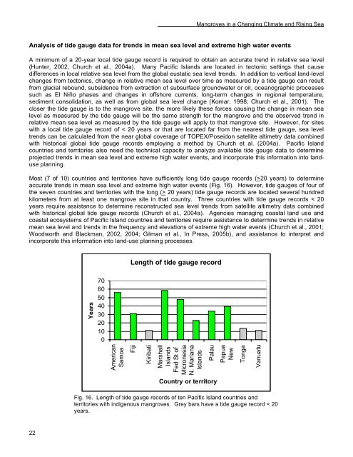
Most (7 of 10) countries <strong>and</strong> territories have sufficiently long tide gauge records (>20 years) to determ<strong>in</strong>e<br />
accurate trends <strong>in</strong> mean sea level <strong>and</strong> extreme high water events (Fig. 16). However, tide gauges of four of<br />
the seven countries <strong>and</strong> territories with the long (> 20 years) tide gauge records are located several hundred<br />
kilometers from at least one mangrove site <strong>in</strong> that country. Three countries with tide gauge records < 20<br />
years require assistance to determ<strong>in</strong>e reconstructed sea level trends from satellite altimetry data comb<strong>in</strong>ed<br />
with historical global tide gauge records (Church et al., 2004a). Agencies manag<strong>in</strong>g coastal l<strong>and</strong> use <strong>and</strong><br />
coastal ecosystems of <strong>Pacific</strong> <strong>Isl<strong>and</strong></strong> countries <strong>and</strong> territories require assistance to determ<strong>in</strong>e trends <strong>in</strong> relative<br />
mean sea level <strong>and</strong> trends <strong>in</strong> the frequency <strong>and</strong> elevations of extreme high water events (Church et al., 2001;<br />
Woodworth <strong>and</strong> Blackman, 2002, 2004; Gilman et al., In Press, 2005b), <strong>and</strong> assistance to <strong>in</strong>terpret <strong>and</strong><br />
<strong>in</strong>corporate this <strong>in</strong>formation <strong>in</strong>to l<strong>and</strong>-use plann<strong>in</strong>g processes.<br />
Years<br />
70<br />
60<br />
50<br />
40<br />
30<br />
20<br />
10<br />
0<br />
American<br />
Samoa<br />
Length of tide gauge record<br />
Fiji<br />
Kiribati<br />
Marshall<br />
<strong>Isl<strong>and</strong></strong>s<br />
Fed St of<br />
Micronesia<br />
N. Mariana<br />
<strong>Isl<strong>and</strong></strong>s<br />
Palau<br />
Country or territory<br />
Papua<br />
New<br />
Fig. 16. Length of tide gauge records of ten <strong>Pacific</strong> <strong>Isl<strong>and</strong></strong> countries <strong>and</strong><br />
territories with <strong>in</strong>digenous mangroves. Grey bars have a tide gauge record < 20<br />
years.<br />
Tonga<br />
Vanuatu


