

Pacific Island Mangroves in a Changing Climate and Rising Sea
Pacific Island Mangroves in a Changing Climate and Rising Sea
Pacific Island Mangroves in a Changing Climate and Rising Sea

Create successful ePaper yourself
Turn your PDF publications into a flip-book with our unique Google optimized e-Paper software.
24<br />
Age (years)<br />
70<br />
60<br />
50<br />
40<br />
30<br />
20<br />
10<br />
0<br />
American<br />
Samoa<br />
Mangrove boundary del<strong>in</strong>eation<br />
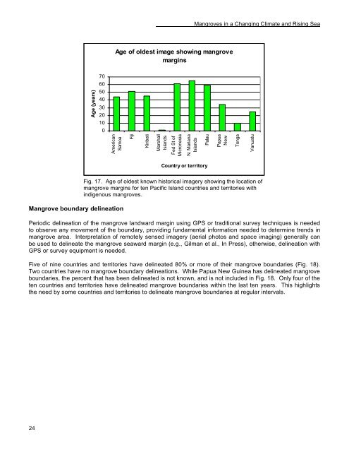
Age of oldest image show<strong>in</strong>g mangrove<br />
marg<strong>in</strong>s<br />
Fiji<br />
Kiribati<br />
Marshall<br />
<strong>Isl<strong>and</strong></strong>s<br />
Fed St of<br />
Micronesia<br />
N. Mariana<br />
<strong>Isl<strong>and</strong></strong>s<br />
<strong>Mangroves</strong> <strong>in</strong> a Chang<strong>in</strong>g <strong>Climate</strong> <strong>and</strong> Ris<strong>in</strong>g <strong>Sea</strong><br />
Palau<br />
Country or territory<br />
Papua<br />
New<br />
Fig. 17. Age of oldest known historical imagery show<strong>in</strong>g the location of<br />
mangrove marg<strong>in</strong>s for ten <strong>Pacific</strong> <strong>Isl<strong>and</strong></strong> countries <strong>and</strong> territories with<br />
<strong>in</strong>digenous mangroves.<br />
Periodic del<strong>in</strong>eation of the mangrove l<strong>and</strong>ward marg<strong>in</strong> us<strong>in</strong>g GPS or traditional survey techniques is needed<br />
to observe any movement of the boundary, provid<strong>in</strong>g fundamental <strong>in</strong>formation needed to determ<strong>in</strong>e trends <strong>in</strong><br />
mangrove area. Interpretation of remotely sensed imagery (aerial photos <strong>and</strong> space imag<strong>in</strong>g) generally can<br />
be used to del<strong>in</strong>eate the mangrove seaward marg<strong>in</strong> (e.g., Gilman et al., In Press), otherwise, del<strong>in</strong>eation with<br />
GPS or survey equipment is needed.<br />
Five of n<strong>in</strong>e countries <strong>and</strong> territories have del<strong>in</strong>eated 80% or more of their mangrove boundaries (Fig. 18).<br />
Two countries have no mangrove boundary del<strong>in</strong>eations. While Papua New Gu<strong>in</strong>ea has del<strong>in</strong>eated mangrove<br />
boundaries, the percent that has been del<strong>in</strong>eated is not known, <strong>and</strong> is not <strong>in</strong>cluded <strong>in</strong> Fig. 18. Only four of the<br />
ten countries <strong>and</strong> territories have del<strong>in</strong>eated mangrove boundaries with<strong>in</strong> the last ten years. This highlights<br />
the need by some countries <strong>and</strong> territories to del<strong>in</strong>eate mangrove boundaries at regular <strong>in</strong>tervals.<br />
Tonga<br />
Vanuatu


