Flora survey for Hamersley Drive recreation - Environmental ...
Flora survey for Hamersley Drive recreation - Environmental ...
Flora survey for Hamersley Drive recreation - Environmental ...

You also want an ePaper? Increase the reach of your titles
YUMPU automatically turns print PDFs into web optimized ePapers that Google loves.
FRNP Improvement Project: Culham Inlet to <strong>Hamersley</strong> Inlet GF Craig– July 2010<br />
Threatened Ecological Communities<br />
No listed Threatened or Priority Ecological Communities were found during the field <strong>survey</strong>, although a<br />
community of ecological significance is located on the wave-cut bench that extends south of East Mt<br />
Barren.<br />
Significant Ecological Community<br />
The perched micro-wetlands on the wave-cut bench are considered to be a rare community on the south<br />
coast (A. Chapman 2009; S.Comer, pers.comm.). These sedge-dominated communities occur within the<br />
Banksia speciosa vegetation unit and have permanently wet soil fed by freshwater from further upslope -<br />
they were too subtle to map individually. A number of small, freshwater pools were present. According<br />
to Chapman (2009) they are significant because “they maintain small patches of mesic environment in<br />
an otherwise very fire prone and possibly drying environment”.<br />
Currently, <strong>Hamersley</strong> <strong>Drive</strong> cuts through these micro-wetlands, but the porosity of the road base does<br />
not appear to be impeding water flow. It is imperative that any upgrade does not prevent natural water<br />
flow downslope of the road, nor cause unnatural ponding of water on the upside.<br />
Vegetation Condition Assessment<br />
The vegetation was generally in excellent health, although small patches of weeds were observed at<br />
some campsites and <strong>recreation</strong> nodes. These are described in more detail below.<br />
Fire<br />
In 1989, much of the <strong>survey</strong> area was burnt during a wildfire started by lightning strikes. Now, twenty<br />
years later, most of the plant communities have re-established with the majority of plants being sexually<br />
mature (producing fruits and seeds).<br />
An escaped prescribed burn in October 2006 burnt most of an area between West Beach Road and the<br />
western slopes of East Mt Barren area <strong>for</strong> a second time. Resuckering species are up to 1 m tall, with<br />
many having flowers and/or fruits, while obligate seeder species are still establishing. Sandier soils have<br />
some relatively bare patches, although overall the original pre-burn suite of plants appears to be<br />
establishing successfully. Notes were taken during the <strong>survey</strong> of the method of regeneration of plants, ie<br />
resuckering from rootstock or obligate seeders (see Appendix 5).<br />
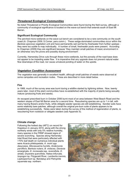
Climate change<br />
Following the hottest day (48 o C) on record <strong>for</strong><br />
Hopetoun in January 2010, along with the strong<br />
northerly winds with only 5% relative humidity,<br />
many species in the FRNP showed signs of<br />
severe scorching. Species along <strong>Hamersley</strong><br />
Inlet Road that were particularly affected with<br />
>70% leaf death on numerous individual plants<br />
were Acacia phlebopetala, A. moirii spp.<br />
dasycarpa, Allocasuarina humilis, Andersonia<br />
parviflora, Banksia nutans, B. violacea, Daviesia<br />
emarginata, D. incrassata ssp. reversifolia, D.<br />
striata, Dryandra quercifolia, Hakea trifurcata,<br />
Isopogon sp. Fitzgerald River, Lambertia inermis,<br />
Leptospermum sp. Bandalup and Petrophile<br />
squamata ssp. northern.<br />
23
![[Project Title] - Environmental Protection Authority - The Western ...](https://img.yumpu.com/29001740/1/184x260/project-title-environmental-protection-authority-the-western-.jpg?quality=85)