Flora survey for Hamersley Drive recreation - Environmental ...
Flora survey for Hamersley Drive recreation - Environmental ...
Flora survey for Hamersley Drive recreation - Environmental ...

Create successful ePaper yourself
Turn your PDF publications into a flip-book with our unique Google optimized e-Paper software.
FRNP Improvement Project: Culham Inlet to <strong>Hamersley</strong> Inlet GF Craig– July 2010<br />
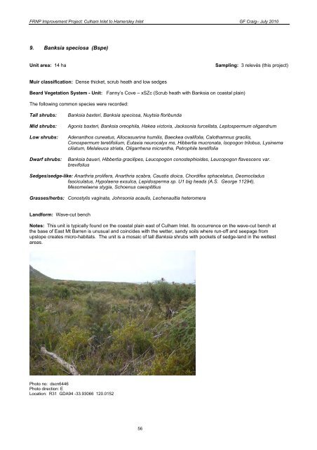
9. Banksia speciosa (Bspe)<br />
Unit area: 14 ha Sampling: 3 relevés (this project)<br />
Muir classification: Dense thicket, scrub heath and low sedges<br />
Beard Vegetation System - Unit: Fanny’s Cove – xSZc (Scrub heath with Banksia on coastal plain)<br />
The following common species were recorded:<br />
Tall shrubs: Banksia baxteri, Banksia speciosa, Nuytsia floribunda<br />
Mid shrubs: Agonis baxteri, Banksia oreophila, Hakea victoria, Jacksonia furcellata, Leptospermum oligandrum<br />
Low shrubs: Adenanthos cuneatus, Allocasuarina humilis, Baeckea ovalifolia, Calothamnus gracilis,<br />
Conospermum teretifolium, Eutaxia neurocalyx ms, Hibbertia mucronata, Isopogon trilobus, Lysinema<br />
ciliatum, Melaleuca striata, Oligarrhena micrantha, Petrophile teretifolia<br />
Dwarf shrubs: Banksia baueri, Hibbertia gracilipes, Leucopogon conostephioides, Leucopogon flavescens var.<br />
brevifolius<br />
Sedges/sedge-like: Anarthria prolifera, Anarthria scabra, Caustis dioica, Chordifex sphacelatus, Desmocladus<br />
fasciculatus, Hypolaena exsulca, Lepidosperma sp. U1 big heads (A.S. George 11294),<br />
Mesomelaena stygia, Schoenus caespititius<br />
Grasses/herbs: Conostylis vaginata, Johnsonia acaulis, Lechenaultia heteromera<br />
Land<strong>for</strong>m: Wave-cut bench<br />
Notes: This unit is typically found on the coastal plain east of Culham Inlet. Its occurrence on the wave-cut bench at<br />
the base of East Mt Barren is unusual and coincides with the wetter, sandy soils where run-off and seepage from<br />
upslope creates micro-habitats. The unit is a mosaic of tall Banksia shrubs with pockets of sedge-land in the wettest<br />
areas.<br />
Photo no: dscn6446<br />
Photo direction: E<br />
Location: R31 GDA94 -33.93066 120.0152<br />
56
![[Project Title] - Environmental Protection Authority - The Western ...](https://img.yumpu.com/29001740/1/184x260/project-title-environmental-protection-authority-the-western-.jpg?quality=85)