Tomales Bay Abbotts Lagoon Bombing Range ... - Corpsfuds.org
Tomales Bay Abbotts Lagoon Bombing Range ... - Corpsfuds.org
Tomales Bay Abbotts Lagoon Bombing Range ... - Corpsfuds.org

You also want an ePaper? Increase the reach of your titles
YUMPU automatically turns print PDFs into web optimized ePapers that Google loves.
SITE NAMES:<br />
<strong>Tomales</strong> <strong>Bay</strong> <strong>Bombing</strong>: Target<br />
SITE SURVEY SUMMARY SHEET<br />
FOR<br />
DEW-FUDS SITE NO. J09CA7292<br />
TOMAlLES BAYiABBOTT'S LAGOON BOMBING RANGE<br />
Some of the names that have been used for the <strong>Tomales</strong> <strong>Bay</strong> site are the <strong>Tomales</strong> <strong>Bay</strong><br />
<strong>Bombing</strong> Target Near Hog Island, <strong>Tomales</strong> <strong>Bay</strong>, the <strong>Tomales</strong> <strong>Bay</strong> Target Area, and "<strong>Bombing</strong><br />
Target Number One". The site will be referred to as the <strong>Tomales</strong> <strong>Bay</strong> <strong>Bombing</strong> Target for the<br />
remainder of this report.<br />
Abbott's <strong>Lagoon</strong> <strong>Bombing</strong> Target<br />
The site located in Abbott's <strong>Lagoon</strong> also had several different names, including Abbott's<br />
<strong>Lagoon</strong> <strong>Bombing</strong> Target, Abbott's <strong>Lagoon</strong>, Abbott's <strong>Lagoon</strong> Target Area, Abbott's <strong>Lagoon</strong><br />
<strong>Bombing</strong> <strong>Range</strong>, and "<strong>Bombing</strong> Target Number Two". For the remainder of this report, the site<br />
will be referred to as Abbott's <strong>Lagoon</strong> <strong>Bombing</strong> Target.<br />
<strong>Tomales</strong> Point Aerial Mine Laying <strong>Range</strong><br />
There was also an area west of <strong>Tomales</strong> Point, known as the <strong>Tomales</strong> Point Aerial Mine<br />
Laying <strong>Range</strong>, which is the name that will be used to describe the site for the remainder of this<br />
report.<br />
LOCATION: .<br />
All of the sites are located within the Point Reyes National Seashore, in Marin County,<br />
California, approximately 30 miles north of San Francisco. The <strong>Tomales</strong> <strong>Bay</strong> target is located just<br />
north of Hog Island in <strong>Tomales</strong> <strong>Bay</strong>. Abbott's <strong>Lagoon</strong> is located between Pierce Point Road and<br />
the Pacific Ocean. A short hiking trail provides access to the road east of the lagoon, and a sand<br />
bar separates the lagoon from the Pacific Ocean to the west. The <strong>Tomales</strong> Point Aerial Mine -<br />
Laying <strong>Range</strong> is located due west of <strong>Tomales</strong> Point, in the Pacific Ocean (See Figure I).
IYPR, <strong>Tomales</strong> <strong>Bay</strong> <strong>Bombing</strong> Target<br />
SITE HISTORY:<br />
During and after World War 11,Point Reyes hosted training in skip bombing, dive bombing,<br />
landing barge practice, and air sea rescue. Dive bombers operating from Hamilton Army Air Field<br />
(AAF), Santa Rosa AAF, and Naval Air Station (NAS) Alameda practiced in the waters of Drakes<br />
<strong>Bay</strong>, Abbott's <strong>Lagoon</strong>, and <strong>Tomales</strong> <strong>Bay</strong>. The pilots also frred at towed and fixed targets on the<br />
high seas west of <strong>Tomales</strong> Point.<br />
<strong>Tomales</strong> <strong>Bay</strong> <strong>Bombing</strong>; Tarpet:<br />
A bombing target was located very near or on Hog Island in <strong>Tomales</strong> <strong>Bay</strong>. The water-borne<br />
target was constructed in <strong>Tomales</strong> <strong>Bay</strong> (Lat. 38' 12' 20.839" North, Long. 122' 56' 10.349" West)<br />
under Contract Noy 4165. The danger zone for this target was 750 yards in radius and was located<br />
2,000 yards, 129 degrees true from the southwesterly extremity of Tom Point. See Figure 2 for the<br />
layout of <strong>Tomales</strong> Point/<strong>Abbotts</strong> <strong>Lagoon</strong> and the neighboring areas (Techlaw Inc., Preliminary<br />
Assessment Report, Drakes <strong>Bay</strong>, 31 July 1998).<br />
Navy aircraft used two types of practice bombs at this range. The first type was a miniature<br />
(three to five pound) bomb with a marker charge similar to a shotgun shell. The second was a<br />
water bomb consisting of a light metal shell filled with water. No explosives were used. A U.S.<br />
Army corps of Engineers(USACE) representative concluded that missiles' dropped in the bay<br />
would have sunk into the mud to a depth sufficient to preclude endangering any small craft<br />
navigating the area. It was determined that no further precautionary measures were necessary<br />
(Techlaw Inc., Preliminary Assessment Report, Drakes <strong>Bay</strong>, 31 July 1998).<br />
In 1952, when the Crows Landing, California target ranges were to be activated, the<br />
Government initiated action to cancel the lease for the ground rights to the <strong>Tomales</strong> <strong>Bay</strong> <strong>Bombing</strong><br />
Target (Baker One). A storm sank the target at <strong>Tomales</strong> <strong>Bay</strong>, so no restoration was anticipated.<br />
On 21 May 1952 the Air Space Subcornmittee(Bureau of Aeronautics), Western District canceled<br />
the air space danger areas covering the <strong>Tomales</strong> <strong>Bay</strong> <strong>Bombing</strong> Target. Since no hazardous<br />
exposure pathway exists, no Department of Defense Action is Indicated (NDAI) for this area.<br />
2
IPJPR, <strong>Tomales</strong> <strong>Bay</strong> <strong>Bombing</strong> Target<br />
Abbott's <strong>Lagoon</strong> <strong>Bombing</strong> Target:<br />
On 19 March 1941, the commanding officer at NAS Alameda requested that a permit be<br />
granted by the State Lands Commission (SLC) authorizing the Navy to use the southern portion of<br />
Abbott's <strong>Lagoon</strong> for dive bombing practice. On 4 April 1941, the SLC consented to the use of<br />
Abbott's <strong>Lagoon</strong> for dive bombing practice by the United States. Revocable Permit No. 40 took<br />
effect on 4 April 1941 and ended 4 April 1946, giving the United States the legal right to use the<br />
southern portion of the lagoon. The target area was approximately one half mile in diameter.<br />
NAS Alameda referred to the bombing target in the southern finger of <strong>Abbotts</strong> <strong>Lagoon</strong> as<br />
"<strong>Bombing</strong> Target Number Two." According to U.S. Navy records, the State of California<br />
permitted the Navy the use of this portion of <strong>Abbotts</strong> <strong>Lagoon</strong> for the construction and maintenance<br />
of target facilities in connection with bombing activities at NAS Alameda under permit number<br />
Noy(R)-54848 (Techlaw Inc., Preliminary Assessment Report, Drakes <strong>Bay</strong>, 31 July 1998).<br />
Pilots from the U.S. Army and U.S. Navy dropped practice bombs at this pyramid shaped<br />
target. The sides of the target were approximately 25 feet long, and it was anchored in the middle<br />
of the southern portion of the lagoon. Practice bombs that struck the target left white stains that<br />
washed away when it rained (Techlaw Inc., Preliminary Assessment Report, Drakes <strong>Bay</strong>, 3 1 July<br />
1998). During the 1940s, Mr. Charlie Zetterquist, a longtime resident of the area whose father<br />
worked at the Point Reyes Lighthouse in the 1930s and 40s, found practice bombs approximately<br />
one foot long that were used at this range. The bombs had hollow wooden bodies, lead tips, and<br />
tin fins. Mr. Zetterquist also found hollow metal bombs approximately two feet long. These<br />
practice bombs were found on Point Reyes Beach and on the sandy bottom of the lagoon after it<br />
had drained. The water level in <strong>Abbotts</strong> <strong>Lagoon</strong> drops significantly when storms break down the<br />
sand bar that encloses the lagoon.<br />
On 13April 1946, a resolution was adopted by the SLC authorizing the issuance to the U.S.<br />
Navy of a five year permit with no renewal privilege, thus extending the use of the <strong>Abbotts</strong> <strong>Lagoon</strong><br />
<strong>Bombing</strong> Target through 3 April 195 1. In 195 1, the permit was once again extended for five years<br />
' through 3 April 1956. In 1952, when the Crows Landing Target <strong>Range</strong>s were to be activated, the<br />
Government initiated the cancellation of the lease for the ground rights to the Abbott's <strong>Lagoon</strong><br />
<strong>Bombing</strong> Target. On 21 May 1952, the Air Space Subcommittee(Bureau of Aeronautics), Western<br />
District canceled the air space danger areas covering the Abbott's <strong>Lagoon</strong> <strong>Bombing</strong> Target. It<br />
3
INPR, <strong>Tomales</strong> <strong>Bay</strong> <strong>Bombing</strong> Target<br />
appears that the Abbott's <strong>Lagoon</strong> <strong>Bombing</strong> Target was not used after that date. Since no<br />
hazardous exposure pathway exists, no Department of Defense Action is Indicated (NDAI) for this<br />
area.<br />
<strong>Tomales</strong> Point Aerial Mine Laving - <strong>Range</strong>: -<br />
On 16 October 1956, <strong>Tomales</strong> Point Aerial Mine Laying <strong>Range</strong> was established west of<br />
<strong>Tomales</strong> Point. It covered an area approximately 28,000 feet long and varied from 7,000 to 12,000<br />
feet in width and was located more than 100 yards from the shoreline. No explosives were to be<br />
used. During mine laying exercises, wooden markers three inches in diameter, 14 inches long, and<br />
weighing approximately five pounds were dropped into the Pacific Ocean. The wooden markers<br />
contained a small quantity of chemicals that produced smoke upon contact with salt water.<br />
Prior to March 1957, three rake stations were established to observe the exercises at the<br />
<strong>Tomales</strong> Point Aerial Mine Laying <strong>Range</strong>. They were to be known as Monuments Dave, Goat,<br />
and John (NAS Alameda, 15 March 1957). To date no leases permitting Government use of these<br />
properties have been located.<br />
The <strong>Tomales</strong> Point Aerial Mine Laying <strong>Range</strong> is not eligible for DERP-FUDS funding.<br />
Since the range is beyond 100 yards of the mean high tide, it is an ineligible property under the<br />
DERP-FUDS Manual, July 1996, Section 3.2b(l), "clean-up of off-shore ordnance properties,<br />
beyond 100 yards of mean high tide, will not be eligible, except in special cases where a public<br />
exposure pathway exists." Since no such pathway exists for the <strong>Tomales</strong> Point Aerial Mine Laying<br />
<strong>Range</strong>, the property is ineligible.<br />
SIm VISIT:<br />
Two site visits were conducted at each site. The first occurred on 8 April 1998 when<br />
TechLaw Inc. (TechLaw) was contracted by the USACE to prepare a Preliminary Assessment<br />
Report (PAR) for the sites. The second visit occurred on 29 April 1999 when USACE<br />
representatives visited the site.<br />
TechLaw<br />
4
INPR, <strong>Tomales</strong> <strong>Bay</strong> <strong>Bombing</strong>; Target 5<br />
Messrs. Gene Barber and Steven Clonts of TechLaw began the site visit on the east side of<br />
<strong>Tomales</strong> <strong>Bay</strong>. TechLaw then proceeded to the area just east of Hog Island and viewed the area<br />
near the location of the <strong>Tomales</strong> <strong>Bay</strong> <strong>Bombing</strong> Target. <strong>Tomales</strong> <strong>Bay</strong> is a very shallow body of<br />
water, and TechLaw observed that at low tide several fishing boats were left in the mud. The<br />
southern end of the bay is the most shallow. Oyster farms are located in this area. There are<br />
motels, a few small marinas, and a yacht club on the western side of the bay. TechLaw finished<br />
the site visit at <strong>Abbotts</strong> <strong>Lagoon</strong>. The trail to <strong>Abbotts</strong> <strong>Lagoon</strong> is bordered by a cattle ranch and<br />
appears to be less frequently traveled than the trails on the headlands.<br />
As a result of the site visit, Techlaw developed the following conclusions:<br />
The Point Reyes National Seashore is widely used by the public for recreational<br />
purposes, and the historic cattle ranches and dairies are still in operation over most of<br />
the site.<br />
The trails on the Point Reyes headlands are heavily traveled by park visitors.<br />
All of the bombing targets referenced in this report have been removed.<br />
Several of the structures historically utilized by the Government still stand on the<br />
Point Reyes National Seashore.<br />
No evidence was discovered of live ordnance at any of the aerial bombing target areas<br />
investigated (TechLaw Inc., 1998).<br />
USACE. Environmental Design Section (EDS):<br />
The site visit for the USACE was conducted on 29 April 1999, by Ms. Tracie Billington and<br />
Mr. Scott Duen of the USACE, and Mr. Clinton Huckins, USACE Unexploded Ordnance (UXO)<br />
Safety Specialist from Fort Ord, California.<br />
The USACE representatives arrived at Pierce Point Ranch, and then hiked up <strong>Tomales</strong> Point<br />
trail to the north, to get a better view of the <strong>Tomales</strong> <strong>Bay</strong> <strong>Bombing</strong> Target location. From the top<br />
of the hill just east of the trail, Hog Island and all of <strong>Tomales</strong> <strong>Bay</strong> could easily be seen to the east,<br />
and the general area where Tornales Point Aerial Mine Laying <strong>Range</strong> existed could be seen to the<br />
west. Two photos were taken of Hogs Island and the bay (Photograghs 1&2). A Global<br />
Positioning System (GPS) instrument was used to obtain the coordinates of the location on top of<br />
the hill overlooking the bay. The reading that was recorded at this location was Lat. 38" 11'North
INPR, <strong>Tomales</strong> <strong>Bay</strong> <strong>Bombing</strong> Target<br />
and Long. 122' 57'West. The coordinates listed by the NAB, 12' Naval Dist., for the <strong>Tomales</strong><br />
<strong>Bay</strong> <strong>Bombing</strong> Target (Target No. 1) was Lat. 38" 12'North and Long. 122' 56'West. The batteries<br />
were running low on the instrument, so the coordinates were not accurate down to the seconds and<br />
the elevation could not be determined.<br />
Abbott's <strong>Lagoon</strong> is located off of Pierce Point Road. The USACE team hiked the quarter<br />
mile trail out to the lagoon from the road. No GPS reading was obtained due to low batteries. A<br />
random visual and geophysical survey of the area was performed by Mr. Huckins using a<br />
Schonstedt Model GA-52Cx fluxgate magnetometer, but no ferrous anomalies were found.<br />
CATEGORY OF HAZARD: NDAI<br />
AVAILABLE STUDIES AND REPORTS:<br />
1. Techlaw Inc., Lakewood, Colorado. Preliminary Assessment Report, Drakes <strong>Bay</strong>, dated July<br />
3 1, 1998. Contract No. DACW05-95-D-0004, Task Order No. 0009, prepared for the<br />
Department of the Army, Corps of Engineers, Sacramento District, Sacramento, California.<br />
PA POC: Mr. William Mullery, CESPK-ED-EB, U.S. Army Corps of Engineers, Sacramento<br />
District, (916) 557-6944.<br />
RAC FORM: Attached<br />
DISTRICT POC: Mr. William Mullery, CESPK-ED-EB, U.S. Army Corps of Engineers,<br />
Sacramento District, (916) 557-6944.<br />
6
DEFENSE ENVIRONMENTAL RESTORATION PROGRAM<br />
FORMERLY USED DEFENSE SITES<br />
FINDINGS AND DETERMINATIONS OF ELIGIBILITY<br />
TOMALES BAY BOMBING TARGETIABBOTT'S LAGOON BOMBING TARGET<br />
MARIN COUNTY, CALIFORNIA<br />
SITE NO. J09CA7292<br />
FINDINGS OF FACT<br />
1. <strong>Tomales</strong> <strong>Bay</strong> <strong>Bombing</strong> Target was located in Marin County at a Latitude of 38' 12'N d d a<br />
Longitude of 122'56'W near or one Hog Island. A water-borne target was constructed in<br />
<strong>Tomales</strong> <strong>Bay</strong> under Contract Noy 4165. On 16 October 1956, <strong>Tomales</strong> Point Aerial Mine Laying<br />
<strong>Range</strong> was establtshed west of <strong>Tomales</strong> Point. It covered an area approximately 28,000 feet long<br />
and varied from 7,000 to 12,000 feet in width and was located more than 100 yards from the<br />
shoreline. Abbott7s <strong>Lagoon</strong> <strong>Bombing</strong> Target was also located in Marin County in the southern<br />
portion of Abbott's <strong>Lagoon</strong>. Revocable Permit No. 40 was granted by the State Lands<br />
Commission and took effect on 4 April 1941, granting the U.S. the legal right to use the southern<br />
portion of Abbott's <strong>Lagoon</strong>.<br />
2. At the <strong>Tomales</strong> <strong>Bay</strong> <strong>Bombing</strong> Target Navy Aircraft used two types of practice bombs at this<br />
range. The first type was a miniature bomb with a marker charge similar to a shotgun shell. The<br />
second was a water bomb consisting of a light metal shell filled with water. No explosives were<br />
used. A public notice by the United States Engineer Office, San Francisco, dated June 4, 1941<br />
declared <strong>Tomales</strong> <strong>Bay</strong> <strong>Bombing</strong> Target a danger zone. The danger zone had a 750-yard radius<br />
and was located 2,000 yards, 129 degrees true from the southwesterly extremity of <strong>Tomales</strong><br />
Point. At <strong>Tomales</strong> Point Aerial Mine Laying <strong>Range</strong> wooden markers three inches in diameter, 14<br />
inches long, and weighing approximately five pounds were dropped into the Pacific Ocean.<br />
Abbott's <strong>Lagoon</strong> <strong>Bombing</strong> Target was also a practice bombing target where U.S. Army and Navy<br />
pilots would drop practice bombs at a pyramid shaped target with sides that were approximately<br />
25 feet long.. This target was anchored in the middle of the southern portion of the lagoon.<br />
When the practice bombs struck the target they left white stains that washed away when it rained.<br />
3. A memorandum from Commander Fleet Air, Alarneda to Commander Naval Air bases,<br />
Twelfth Naval District lists <strong>Tomales</strong> and ~bbott's'~a~oon as targets for Permanent Retention.
DEFENSE ENVIRONMENTAL RESTORATION PROGRAM<br />
FORMERLY USED DEFENSE SITES<br />
FINDINGS AND DETERMINATION OF ELIGIBILITY<br />
TOMALES BAY BOMBING TARGETIABBOTT'S LAGOON BOMBING<br />
TARGET<br />
MARIN COUNTY, CALIFORNIA<br />
SITE NO. J09CA729200<br />
FINDINGS OF FACT<br />
However, a memorandum form the Commander Fleet Ax Alameda, dated 4 March 1952,<br />
stated that when the target ranges at Crows Landing were activated, the government<br />
would initiate action to cancel the leases for the ground rights to the <strong>Tomales</strong> <strong>Bay</strong><br />
<strong>Bombing</strong> Target and the Abbott's <strong>Lagoon</strong> <strong>Bombing</strong> Target. On 21 May 1952, the Air<br />
Space Subcommittee, a division of the Bureau of Aeronautics canceled the air space<br />
danger areas covering the two target areas. No leases have been located pertaining to<br />
these three bombing targets.<br />
DETERMINATION<br />
Based on the foregoing findings of fact, <strong>Tomales</strong> <strong>Bay</strong> <strong>Bombing</strong> Target and Abbott's<br />
<strong>Lagoon</strong> <strong>Bombing</strong> Target have been determined to be formerly used by the Department of<br />
Defense @OD). Therefore these portions of the <strong>Tomales</strong> ~a~l~b'bott's <strong>Lagoon</strong> <strong>Bombing</strong><br />
Target are eligible for the Defense Environmental Restoration Program for Formerly<br />
Used Defense Sites established under 10 U.S.C. 2701 et Seq.<br />
/ Commanding
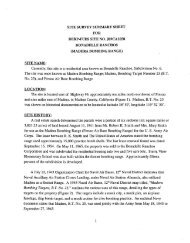
\EDPUBLIC\ENV~RONMENTAL\EDS\PROJECTS\K-ROSE\~ODEKRO 1.DWG. 06/22/99. 1 :1. (1/1 XP)<br />
;I<br />
I<br />
.IFealdsburg ,<br />
SITELOCATION I<br />
NOTES:<br />
REF: TECHLAW, INC.<br />
TASK ORDER NO. 0009<br />
i
lax<br />
All Locations Arc Approximntc<br />
1. Old Point Rcycs Lifcsaving Station nnd Auxiliary Lnnding<br />
2. U.S. Coast Gunrd Lifeboat Station<br />
3. U.S. Coast Gunrd Dwclling<br />
4. U.S. Const Gunrd Lookout<br />
5. Rake St a I'~ons<br />
6. "A" Rnnch Barrncks. DPF.Radar, Water Towcr, and Pnint Racks<br />
Ga. Point Rcycs Lighthouse<br />
7. "I3" Rnnch I3nrrncks<br />
8. Rnder<br />
9. RCA Radio Stnlion nnd Barracks<br />
10. Drnkcs <strong>Bay</strong> Divc <strong>Bombing</strong> Rnngc nnd Proposed Aerinl Minc Lnying Arca<br />
1 I. Cnmp I Iydlc Skip nnd Divc <strong>Bombing</strong> Rnngc<br />
12. Cnmp I Iydlc<br />
13. Cnnlp Mydlc Tnrgct Prncticc Arcn<br />
14. Wildcat Militety Rescrvnlion<br />
15. Tomnlcs Bny <strong>Bombing</strong> Tnrget Near Hog Island<br />
I G. Proposed Dillon Bcach <strong>Bombing</strong> Tnrget<br />
17. Tomalcs Point Acrinl Minc Laying Rnngc<br />
18. Abbotls Lngoon <strong>Bombing</strong> Tnrgct<br />
Figure 2<br />
MAP DEPICTING GOVERNMENT<br />
FACILITIES AT DRAKES BAY