

Reconnaissance of landslides and preliminary landslide hazard
Reconnaissance of landslides and preliminary landslide hazard
Reconnaissance of landslides and preliminary landslide hazard

You also want an ePaper? Increase the reach of your titles
YUMPU automatically turns print PDFs into web optimized ePapers that Google loves.
RECONNAISSANCE OF LANDSLIDES AND PRELIMINARY<br />
LANDSLIDE HAZARD ASSESSMENT ALONG A PORTION<br />
OF BROWNS PARK ROAD, DAGGETT COUNTY, UTAH<br />
by Gregg Beukelman <strong>and</strong> Ben Erickson<br />
REPORT OF INVESTIGATION 271<br />
UTAH GEOLOGICAL SURVEY<br />
a division <strong>of</strong><br />
UTAH DEPARTMENT OF NATURAL RESOURCES<br />
2012
RECONNAISSANCE OF LANDSLIDES AND PRELIMINARY<br />
LANDSLIDE HAZARD ASSESSMENT ALONG A PORTION OF<br />
BROWNS PARK ROAD, DAGGETT COUNTY, UTAH<br />
by Gregg Beukelman <strong>and</strong> Ben Erickson<br />
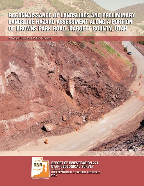
Cover Photo: View <strong>of</strong> Browns Park Road damaged from one <strong>of</strong> five <strong>l<strong>and</strong>slides</strong> in lower Jesse Ewing Canyon,<br />
Daggett County, Utah<br />
REPORT OF INVESTIGATION 271<br />
UTAH GEOLOGICAL SURVEY<br />
a division <strong>of</strong><br />
UTAH DEPARTMENT OF NATURAL RESOURCES<br />
2012
STATE OF UTAH<br />
Gary R. Herbert, Governor<br />
DEPARTMENT OF NATURAL RESOURCES<br />
Michael Styler, Executive Director<br />
UTAH GEOLOGICAL SURVEY<br />
Richard G. Allis, Director<br />
PUBLICATIONS<br />
contact<br />
Natural Resources Map & Bookstore<br />
1594 W. North Temple<br />
Salt Lake City, UT 84116<br />
telephone: 801-537-3320<br />
toll-free: 1-888-UTAH MAP<br />
Website: mapstore.utah.gov<br />
email: geostore@utah.gov<br />
UTAH GEOLOGICAL SURVEY<br />
contact<br />
1594 W. North Temple, Suite 3110<br />
Salt Lake City, UT 84116<br />
telephone: 801-537-3300<br />
Website: geology.utah.gov<br />
Although this product represents the work <strong>of</strong> pr<strong>of</strong>essional scientists, the Utah Department <strong>of</strong> Natural Resources,<br />
Utah Geological Survey, makes no warranty, expressed or implied, regarding its suitability for a particular use.<br />
The Utah Department <strong>of</strong> Natural Resources, Utah Geological Survey, shall not be liable under any circumstances<br />
for any direct, indirect, special, incidental, or consequential damages with respect to claims by users <strong>of</strong> this product.
CONTENTS<br />
ABSTRACT ............................................................................................................................................................................................................................................. 1<br />
INTRODUCTION.................................................................................................................................................................................................................................. 1<br />
Purpose <strong>and</strong> Scope ................................................................................................................................................................................................................... 3<br />
Sources <strong>of</strong> Information ........................................................................................................................................................................................................... 3<br />
GEOLOGIC SETTING .......................................................................................................................................................................................................................... 4<br />
LANDSLIDE EVENTS OF SPRING 2011..................................................................................................................................................................................... 5<br />
L<strong>and</strong>slide A .................................................................................................................................................................................................................................. 5<br />
L<strong>and</strong>slide B .................................................................................................................................................................................................................................. 6<br />
L<strong>and</strong>slide C .................................................................................................................................................................................................................................. 8<br />
L<strong>and</strong>slide D .................................................................................................................................................................................................................................. 8<br />
L<strong>and</strong>slide E .................................................................................................................................................................................................................................. 9<br />
PROBABLE LANDSLIDE CAUSES .............................................................................................................................................................................................. 11<br />
CONCLUSIONS AND RECOMMENDATIONS ......................................................................................................................................................................... 13<br />
ACKNOWLEDGMENTS .................................................................................................................................................................................................................. 14<br />
REFERENCES .................................................................................................................................................................................................................................... 14<br />
FIGURES<br />
Figure 1. Location <strong>of</strong> Browns Park Road <strong>l<strong>and</strong>slides</strong> in Daggett County, Utah .......................................................................................................... 2<br />
Figure 2. L<strong>and</strong>slides along Browns Park Road investigated in this reconnaissance ............................................................................................ 2<br />
Figure 3. Browns Park Road looking south ............................................................................................................................................................................ 3<br />
Figure 4. Western cut slope <strong>of</strong> roadway through cut showing L<strong>and</strong>slide B .............................................................................................................. 4<br />
Figure 5. Map <strong>of</strong> preexisting l<strong>and</strong>slide, L<strong>and</strong>slide A scarp, <strong>and</strong> waste pile ............................................................................................................... 5<br />
Figure 6. Contact between L<strong>and</strong>slide B <strong>and</strong> preexisting l<strong>and</strong>slide debris ................................................................................................................ 6<br />
Figure 7. Oblique view, looking south, <strong>of</strong> preexisting l<strong>and</strong>slide <strong>and</strong> waste pile ..................................................................................................... 7<br />
Figure 8. Geologic cross section <strong>of</strong> preexisting l<strong>and</strong>slide ................................................................................................................................................. 7<br />
Figure 9. Locations <strong>of</strong> L<strong>and</strong>slides C <strong>and</strong> D ............................................................................................................................................................................... 8<br />
Figure 10. L<strong>and</strong>slide C main scarp <strong>and</strong> deposits on road cut slope ............................................................................................................................. 9<br />
Figure 11. L<strong>and</strong>slide D main scarp <strong>and</strong> a part <strong>of</strong> its deposits on road cut slope .................................................................................................... 9<br />
Figure 12. Location <strong>of</strong> L<strong>and</strong>slide E .......................................................................................................................................................................................... 10<br />
Figure 13. L<strong>and</strong>slide E on upper part <strong>of</strong> road cut slope. ................................................................................................................................................ 10<br />
Figure 14. Monthly precipitation totals recorded at Jarvie Ranch weather station ........................................................................................... 11<br />
Figure 15. Daily precipitation data for May <strong>and</strong> early June 2011 .............................................................................................................................. 12
RECONNAISSANCE OF LANDSLIDES AND PRELIMINARY<br />
LANDSLIDE HAZARD ASSESSMENT ALONG A PORTION<br />
OF BROWNS PARK ROAD, DAGGETT COUNTY, UTAH<br />
by Gregg Beukelman <strong>and</strong> Ben Erickson<br />
ABSTRACT<br />
In June 2011, the Utah Geological Survey performed a<br />
reconnaissance investigation <strong>of</strong> five <strong>l<strong>and</strong>slides</strong> that had<br />
recently occurred in lower Jesse Ewing Canyon, Daggett<br />
County, Utah, along a section <strong>of</strong> Browns Park Road that<br />
was realigned in 2009. One l<strong>and</strong>slide (L<strong>and</strong>slide A) was<br />
a partial reactivation <strong>of</strong> a preexisting rotational rockslide,<br />
<strong>and</strong> four <strong>l<strong>and</strong>slides</strong> (L<strong>and</strong>slides B through E) were translational<br />
rockslides that involved cut slopes above the realigned<br />
roadway. The <strong>l<strong>and</strong>slides</strong> are all underlain by shale<br />
<strong>and</strong> silty s<strong>and</strong>stone containing lenses <strong>of</strong> silicic conglomerate.<br />
With the exception <strong>of</strong> the conglomerate, these materials<br />
exhibit intense fracturing <strong>and</strong> deep <strong>and</strong> rapid weathering<br />
upon exposure at the surface. The <strong>l<strong>and</strong>slides</strong> impacted<br />
the roadway to varying degrees, from L<strong>and</strong>slide B that<br />
blocked the southbound lane <strong>and</strong> part <strong>of</strong> the northbound<br />
lane, to L<strong>and</strong>slide D that partially covered only a guardrail<br />
<strong>and</strong> filled a small roadside ditch.<br />
The two <strong>l<strong>and</strong>slides</strong> that pose the greatest immediate<br />
<strong>hazard</strong> to the public are L<strong>and</strong>slides A <strong>and</strong> B, both near<br />
a through cut about 18.2 miles along Browns Park Road<br />
from its intersection with U.S. Highway 191. L<strong>and</strong>slide<br />
A is a partial reactivation <strong>of</strong> a preexisting l<strong>and</strong>slide, <strong>and</strong><br />
has developed an arcuate scarp that, at its apex, extends<br />
above the road <strong>and</strong> intersects it near both ends, resulting<br />
in pavement distress where the scarp crosses the roadway.<br />
Just downhill <strong>of</strong> the roadway <strong>and</strong> the recently developed<br />
scarp is a waste pile <strong>of</strong> material excavated during the roadway<br />
realignment that was placed on a nearly level surface<br />
formed by rotational movement <strong>of</strong> the preexisting l<strong>and</strong>slide.<br />
Although data from this reconnaissance do not permit<br />
a precise explanation for the cause <strong>of</strong> this partial reactivation,<br />
a combination <strong>of</strong> added weight <strong>of</strong> the waste pile<br />
<strong>and</strong> an increase in pore water pressure along the rupture<br />
surface resulting from extreme recent precipitation likely<br />
contributed to slope instability.<br />
L<strong>and</strong>slide B is a translational rockslide that occurred early<br />
in the week <strong>of</strong> June 5, 2011, <strong>and</strong> affected the western side<br />
<strong>of</strong> the through cut. Conditions that may have contributed to<br />
L<strong>and</strong>slide B movement include very weak geologic materials,<br />
<strong>and</strong> the relation between the orientation <strong>of</strong> bedrock<br />
bedding planes <strong>and</strong> surface slope angles. Above-normal<br />
precipitation, including a very wet winter <strong>and</strong> spring <strong>and</strong><br />
several intense rain events in the latter part <strong>of</strong> May 2011,<br />
may have been a factor in triggering l<strong>and</strong>slide movement.<br />
The three other small translational rockslides (L<strong>and</strong>slides<br />
C through E) involved bedrock failure along bedding<br />
planes exposed in road cut slopes. Although geologic<br />
materials were similar to those observed at L<strong>and</strong>slide B,<br />
bedding planes do not dip out <strong>of</strong> the slope at any <strong>of</strong> these<br />
rockslides, which likely limited their downhill extent. The<br />
exact timing <strong>of</strong> these three <strong>l<strong>and</strong>slides</strong> is unknown, but<br />
recent precipitation may have been a factor in triggering<br />
these <strong>l<strong>and</strong>slides</strong> as well.<br />
INTRODUCTION<br />
In the spring <strong>of</strong> 2011, l<strong>and</strong>sliding occurred along part<br />
<strong>of</strong> Browns Park Road (Daggett County Highway 1364)<br />
in lower Jesse Ewing Canyon. This l<strong>and</strong>sliding affected<br />
cut slopes <strong>and</strong> pavement along a section <strong>of</strong> the road that<br />
had been realigned in 2009 (figures 1 <strong>and</strong> 2). This reconnaissance<br />
investigation focused on five <strong>l<strong>and</strong>slides</strong> along<br />
a length <strong>of</strong> the realignment between 18.2 <strong>and</strong> 18.8 miles<br />
east <strong>of</strong> the intersection <strong>of</strong> Browns Park Road <strong>and</strong> U.S. Highway<br />
191 (figures 1 <strong>and</strong> 2). Four <strong>l<strong>and</strong>slides</strong> were new rockslides<br />
involving weak bedrock, <strong>and</strong> one was a partial reactivation<br />
<strong>of</strong> an existing rotational rockslide. One <strong>of</strong> the new<br />
rockslides, reported to have occurred early in the week <strong>of</strong><br />
June 5 in an east-facing slope <strong>of</strong> a through cut, blocked the<br />
entire southbound lane <strong>and</strong> part <strong>of</strong> the northbound lane<br />
(figure 3). For this reconnaissance, we designated the<br />
<strong>l<strong>and</strong>slides</strong> as L<strong>and</strong>slides A through E, based on their relative<br />
position from north to south along the road (figure 2).<br />
On the afternoon <strong>of</strong> June 21, 2011, we met with Daggett<br />
County Commissioner Jerry Steglich, Stanley Crawforth <strong>of</strong><br />
American Geotechnics, James Olsen <strong>of</strong> the Daggett County<br />
Road Department, <strong>and</strong> representatives <strong>of</strong> Questar Gas<br />
on Browns Park Road to discuss L<strong>and</strong>slides A <strong>and</strong> B. Our<br />
field reconnaissance began at that time <strong>and</strong> continued<br />
through June 23, 2011. An unpublished Utah Geological<br />
Survey (UGS) letter report (Beukelman, 2011) provided to<br />
Daggett County on June 30, 2011, included observations<br />
<strong>and</strong> initial conclusions <strong>and</strong> recommendations from our<br />
reconnaissance investigation. In addition to our findings,
2<br />
Utah Geological Survey<br />
Figure 1. Location <strong>of</strong> Browns Park Road <strong>l<strong>and</strong>slides</strong> in Daggett County, Utah. Base map imagery from Micros<strong>of</strong>t Bing Maps accessed<br />
through ArcGIS s<strong>of</strong>tware on October 29, 2011.<br />
Figure 2. L<strong>and</strong>slides along Browns Park Road investigated in this reconnaissance. Regional faults shown in black (bar <strong>and</strong> ball<br />
on down-dropped side, dotted where concealed). Geologic units include Browns Park piedmont alluvium (Qab1 [youngest] <strong>and</strong><br />
Qab3 [older]); Browns Park Formation s<strong>and</strong>stone, with siltstone, conglomerate, <strong>and</strong> rhyolitic air-fall tuff (Tbp); Upper Jesse<br />
Ewing Canyon Formation shale interbedded with quartzose <strong>and</strong> lithic s<strong>and</strong>stone (Zuju); <strong>and</strong> Red Creek Quartzite containing three<br />
rock types: amphibolite (YXra), metaquartzite (XWrq), <strong>and</strong> mica schist (XWrm). Geology from Sprinkel (2006), base from 2009<br />
National Agriculture Imagery Program.
<strong>Reconnaissance</strong> <strong>of</strong> <strong>l<strong>and</strong>slides</strong> <strong>and</strong> <strong>preliminary</strong> l<strong>and</strong>slide <strong>hazard</strong> assessment along a portion <strong>of</strong> Browns Park Road, Daggett County, Utah 3<br />
the Utah Department <strong>of</strong> Transportation (2011) on June 20,<br />
2011, provided Daggett County with a memor<strong>and</strong>um report<br />
presenting <strong>preliminary</strong> conclusions <strong>and</strong> recommendations<br />
regarding the <strong>l<strong>and</strong>slides</strong> based on observations<br />
during their site visit on June 9, 2011.<br />
Purpose <strong>and</strong> Scope<br />
The purpose <strong>of</strong> this reconnaissance investigation is to<br />
determine the geologic characteristics <strong>and</strong> causes <strong>of</strong> the<br />
spring 2011 Browns Park Road <strong>l<strong>and</strong>slides</strong>, <strong>and</strong> to make<br />
a <strong>preliminary</strong> assessment <strong>of</strong> the likelihood <strong>and</strong> extent <strong>of</strong><br />
<strong>hazard</strong> from future <strong>l<strong>and</strong>slides</strong>. This report is intended to<br />
provide supplemental information to the June 30, 2011,<br />
UGS letter report, <strong>and</strong> make the findings <strong>of</strong> our reconnaissance<br />
investigation more broadly available. This report<br />
summarizes our observations <strong>and</strong> conclusions, discusses<br />
future l<strong>and</strong>slide <strong>hazard</strong>, <strong>and</strong> provides recommendations<br />
for consideration by Daggett County <strong>of</strong>ficials in managing<br />
l<strong>and</strong>slide risk.<br />
The project scope was mostly limited to the interpretation<br />
<strong>of</strong> existing data to characterize l<strong>and</strong>slide <strong>hazard</strong> in a<br />
general manner. Except for our reconnaissance-level field<br />
observations, no additional fieldwork, subsurface exploration,<br />
or laboratory testing was conducted or other data<br />
collected as part <strong>of</strong> this investigation. As part <strong>of</strong> our field<br />
reconnaissance, we characterized bedrock conditions by<br />
observation <strong>and</strong> measured bedding-plane orientations<br />
<strong>and</strong> cut-slope angles using a Brunton compass. Mapping<br />
<strong>of</strong> l<strong>and</strong>slide boundaries <strong>and</strong> features was completed using<br />
a Global Navigation Satellite System (GNSS) h<strong>and</strong>-held<br />
Trimble GeoXT instrument. In addition to our field reconnaissance,<br />
we analyzed local conditions, including slope<br />
angles, that existed prior to construction <strong>of</strong> the Browns<br />
Park Road realignment using aerial photographs <strong>and</strong> geographic<br />
information system (GIS) methods.<br />
Sources <strong>of</strong> Information<br />
We reviewed relevant geologic maps, literature, <strong>and</strong> aerial<br />
photographs including UGS 1:100,000-scale geologic <strong>and</strong><br />
l<strong>and</strong>slide maps <strong>of</strong> the Dutch John 30' x 60' quadrangle<br />
(Sprinkel, 2006, <strong>and</strong> Elliott <strong>and</strong> Harty, 2010, respectively);<br />
the U.S. Geological Survey 1:24,000-scale geologic map <strong>of</strong><br />
the Clay Basin quadrangle (Hansen, 1957); 1938 aerial<br />
photographs (Soil Conservation Service, 1938); <strong>and</strong> 2009<br />
National Agriculture Imagery Program (NAIP) orthophotography<br />
at various scales (Utah Automated Geographic<br />
Reference Center, 2009). We used a 5-meter-resolution<br />
digital elevation model (DEM) (Utah Automated Geographic<br />
Reference Center, 2007) to construct a threedimensional<br />
model <strong>of</strong> a portion <strong>of</strong> the area surrounding<br />
Browns Park Road <strong>and</strong> to calculate slope angles that existed<br />
prior to roadway construction.<br />
We conducted interviews with Daggett County personnel,<br />
including county commissioner Jerry Steglich <strong>and</strong> James<br />
Figure 3. Browns Park Road looking south. L<strong>and</strong>slide A, a partial reactivation <strong>of</strong> a preexisting l<strong>and</strong>slide, is shown in the foreground<br />
(yellow line marks l<strong>and</strong>slide scarp <strong>and</strong> arrows show approximate direction <strong>of</strong> movement). At right is debris from L<strong>and</strong>slide B, a<br />
translational rockslide that blocked the southbound (downhill) lane <strong>of</strong> the roadway. Behind the debris is intact shale <strong>and</strong> silty<br />
s<strong>and</strong>stone bedrock showing bedding planes (one bedding plane highlighted by dashed yellow line) that are dipping out <strong>of</strong> the<br />
slope. The slope angle <strong>of</strong> the western road cut was measured as 45 degrees (1H:1V) in the upper part <strong>of</strong> the slope <strong>and</strong> about 65<br />
degrees (1/2H:1V) near its base. Photo taken on June 21, 2011.
4<br />
Olsen <strong>of</strong> the Daggett County Road Department, <strong>and</strong> with<br />
others knowledgeable about the construction <strong>of</strong> the road<br />
realignment <strong>and</strong> the 2011 <strong>l<strong>and</strong>slides</strong>. We also discussed<br />
the original geotechnical investigation <strong>and</strong> design <strong>of</strong> the<br />
realignment with Stanley Crawforth <strong>of</strong> American Geotechnics,<br />
who was involved in both the original geotechnical<br />
investigation <strong>and</strong> subsequent design.<br />
GEOLOGIC SETTING<br />
Bedrock in the immediate vicinity <strong>of</strong> the <strong>l<strong>and</strong>slides</strong> is<br />
mapped by Hansen (1957) <strong>and</strong> Sprinkel (2006) as the<br />
Upper Jesse Ewing Canyon Formation <strong>of</strong> the Neoproterozoic<br />
Uinta Mountain Group (figure 2). Geologic materials<br />
involved in l<strong>and</strong>sliding <strong>and</strong> exposed in road cuts consist <strong>of</strong><br />
intensely fractured, dark- to medium-red-brown shale <strong>and</strong><br />
silty s<strong>and</strong>stone, <strong>and</strong> medium- to thick-bedded conglomerate<br />
(figure 3). In the area <strong>of</strong> our reconnaissance, regionalscale,<br />
steeply dipping, down-to-the-south, normal faults<br />
bound the Upper Jesse Ewing Canyon Formation to the<br />
north <strong>and</strong> south. The northern fault is exposed in a road<br />
cut about 800 feet north <strong>of</strong> L<strong>and</strong>slide A. The southern<br />
fault acts as the northern basin-bounding fault for Browns<br />
Park, <strong>and</strong> is approximately 900 feet south <strong>of</strong> L<strong>and</strong>slides C<br />
through E. In addition to these regional-scale faults, road<br />
cuts near L<strong>and</strong>slides A <strong>and</strong> B expose many smaller, steeply<br />
dipping, normal faults that intensely fracture all <strong>of</strong> the exposed<br />
rock (figure 4). Sprinkel (2006) reported bedding<br />
Utah Geological Survey<br />
within this unit dips generally to the south at about 25°<br />
to 60°; locally, we measured southeast to northeast dips<br />
<strong>of</strong> 15° to 56°. Bedrock weathering has resulted in locally<br />
rounded topography <strong>and</strong> few bedrock outcrops, with the<br />
exception <strong>of</strong> the silicified conglomerate layers, which are<br />
more resistant <strong>and</strong> show little affect <strong>of</strong> weathering.<br />
Geologic mapping during our reconnaissance, <strong>and</strong> analysis<br />
<strong>of</strong> aerial photos, revealed a large, preexisting, rotational<br />
rockslide that involved movement on an east-facing<br />
slope in the vicinity <strong>of</strong> L<strong>and</strong>slides A <strong>and</strong> B (figure 5). The<br />
main scarp <strong>of</strong> this preexisting l<strong>and</strong>slide is near the crest <strong>of</strong><br />
the ridge above Browns Park Road, <strong>and</strong> the l<strong>and</strong>slide mass<br />
extends to the bottom <strong>of</strong> the slope near the stream that<br />
drains Jesse Ewing Canyon. The l<strong>and</strong>slide flanks are difficult<br />
to identify due to erosion <strong>and</strong> cut-slope modification<br />
during roadway realignment. However, the l<strong>and</strong>slide’s left<br />
<strong>and</strong> right flanks are exposed in road cuts where l<strong>and</strong>slide<br />
debris is juxtaposed against in-place bedrock. On the l<strong>and</strong>slide’s<br />
right (southern) flank, this contact is marked by a<br />
light-colored zone that may reflect groundwater bleaching,<br />
or mineral precipitation that resulted from preferential<br />
groundwater movement along the flank (figure 6).<br />
Similar light-colored materials were also observed along<br />
many <strong>of</strong> the normal faults exposed in the cut slopes, which<br />
also may provide paths for preferential groundwater flow.<br />
Based on the cut-slope exposures <strong>of</strong> the l<strong>and</strong>slide margins,<br />
other l<strong>and</strong>slide features identified during our reconnaissance,<br />
<strong>and</strong> aerial photo interpretation, we estimate the<br />
Figure 4. Western cut slope <strong>of</strong> roadway through cut showing L<strong>and</strong>slide B. Browns Park Road with one lane blocked in the<br />
foreground. Bedrock is Upper Jesse Ewing Canyon Formation shale <strong>and</strong> silty s<strong>and</strong>stone. Numerous steeply dipping normal faults<br />
are marked by <strong>of</strong>fset <strong>of</strong> light-colored beds in left part <strong>of</strong> photo. Photo taken on June 21, 2011.
<strong>Reconnaissance</strong> <strong>of</strong> <strong>l<strong>and</strong>slides</strong> <strong>and</strong> <strong>preliminary</strong> l<strong>and</strong>slide <strong>hazard</strong> assessment along a portion <strong>of</strong> Browns Park Road, Daggett County, Utah 5<br />
preexisting rockslide to be approximately 550 feet wide at<br />
the road <strong>and</strong> to extend about 700 feet downslope from its<br />
main scarp, about 200 feet above the road, to the stream<br />
at the bottom <strong>of</strong> the slope (figure 5). About 250 feet below<br />
the road, we observed a prominent back-tilted surface,<br />
formed during rotational movement <strong>of</strong> the rockslide (figure<br />
7).<br />
LANDSLIDE EVENTS OF SPRING 2011<br />
Although other <strong>l<strong>and</strong>slides</strong> exist in the area, this reconnaissance<br />
addresses five <strong>l<strong>and</strong>slides</strong> that occurred during 2011<br />
in slopes modified during the 2009 realignment <strong>of</strong> Browns<br />
Park Road in lower Jesse Ewing Canyon (figure 2). L<strong>and</strong>slide<br />
activity along the Browns Park Road realignment<br />
began in 2010, but became more pronounced in the spring<br />
<strong>of</strong> 2011 (James Olsen, Daggett County Road Department<br />
supervisor, verbal communication, 2011).<br />
L<strong>and</strong>slide A<br />
About 18.2 miles east <strong>of</strong> the Browns Park Road intersection<br />
with U.S. 191, we observed distress <strong>of</strong> the asphaltic<br />
concrete roadway pavement <strong>and</strong> a cut slope during our<br />
reconnaissance (figures 3 <strong>and</strong> 5). The distress included<br />
an approximately 195-foot-long, arcuate-shaped l<strong>and</strong>slide<br />
scarp <strong>and</strong> abundant pavement cracking. Vertical <strong>of</strong>fset<br />
across the scarp consisted <strong>of</strong> warping <strong>of</strong> the pavement<br />
at the scarp’s northern end <strong>and</strong> pavement cracking on its<br />
southern end (figure 3). Vertical <strong>of</strong>fset <strong>of</strong> the pavement<br />
was about 9 inches on the north <strong>and</strong> 6 inches on the south.<br />
Maximum deformation near the apex <strong>of</strong> the scarp, which<br />
extended approximately 29 feet west <strong>of</strong> the roadway into<br />
its cut slope, produced less than one foot <strong>of</strong> vertical <strong>of</strong>fset<br />
<strong>of</strong> older l<strong>and</strong>slide debris.<br />
Adjacent to, <strong>and</strong> below the roadway, is a waste pile <strong>of</strong> materials<br />
excavated during 2009 road realignment (figures<br />
Figure 5. Map <strong>of</strong> preexisting l<strong>and</strong>slide, L<strong>and</strong>slide A scarp, <strong>and</strong> waste pile. Geologic cross section A–A’ is shown on figure 8. Geologic<br />
units include l<strong>and</strong>slide debris (Qms) <strong>and</strong> Upper Jesse Ewing Canyon Formation shale interbedded with quartzose <strong>and</strong> lithic<br />
s<strong>and</strong>stone (Zuju). Bedrock geology from Sprinkel (2006) <strong>and</strong> l<strong>and</strong>slide <strong>and</strong> waste pile extents from this reconnaissance. Base from<br />
2009 National Agriculture Imagery Program.
6<br />
5, 7, <strong>and</strong> 8) activities. The waste pile has dimensions <strong>of</strong><br />
about 300 feet north to south, 200 feet east to west, <strong>and</strong><br />
is up to 30 feet thick. Waste material was placed on top<br />
<strong>of</strong> a rotated surface developed by prior movement <strong>of</strong> the<br />
large preexisting l<strong>and</strong>slide discussed above. In addition<br />
to the recent pavement distress related to scarp formation<br />
in the vicinity <strong>of</strong> the waste pile (figure 3), longitudinal<br />
pavement cracking with very slight vertical <strong>of</strong>fset extended<br />
approximately 260 feet north from the waste pile.<br />
With the exception <strong>of</strong> a small ground crack near a small<br />
drainage that bounds the l<strong>and</strong>slide to the south below the<br />
waste pile (figure 5) that may be related to this l<strong>and</strong>slide,<br />
no l<strong>and</strong>slide flank or toe features were observed. The observed<br />
features suggest an incipient partial reactivation<br />
<strong>of</strong> the preexisting l<strong>and</strong>slide that has not developed to the<br />
point <strong>of</strong> full failure.<br />
Examples <strong>of</strong> reactivation <strong>of</strong> large, generally old l<strong>and</strong>slide<br />
deposits are abundant in Utah <strong>and</strong> include a 1983 reactivation<br />
<strong>of</strong> the Thistle l<strong>and</strong>slide (Duncan <strong>and</strong> others, 1986),<br />
the 2005 reactivation <strong>of</strong> a 1983 l<strong>and</strong>slide in Cedar Hills<br />
Figure 6. Contact between L<strong>and</strong>slide B <strong>and</strong> preexisting<br />
l<strong>and</strong>slide debris. Exposure in western road cut slope along<br />
Browns Park Road. Inset shows discoloration <strong>of</strong> material along<br />
right flank shear plane <strong>of</strong> preexisting l<strong>and</strong>slide low on cut<br />
slope. Photo taken on June 21, 2011.<br />
Utah Geological Survey<br />
(Ashl<strong>and</strong> <strong>and</strong> McDonald, 2005), the 1985–86 movement<br />
<strong>of</strong> part <strong>of</strong> the Pine Ridge l<strong>and</strong>slide in Timber Lakes Estates<br />
east <strong>of</strong> Heber City (Ashl<strong>and</strong> <strong>and</strong> Hyll<strong>and</strong>, 1997; Biek <strong>and</strong><br />
others, 2003), the 1997 Shurtz Lake l<strong>and</strong>slide (Ashl<strong>and</strong>,<br />
1997), <strong>and</strong> the 2005 Horse Ranch l<strong>and</strong>slide in the Sherwood<br />
Hills l<strong>and</strong>slide complex in Provo (Ashl<strong>and</strong>, 2006).<br />
Human modifications to these <strong>l<strong>and</strong>slides</strong> contributed to<br />
some <strong>of</strong> the reactivations, but all illustrate the susceptibility<br />
<strong>of</strong> existing <strong>l<strong>and</strong>slides</strong> to renewed movement.<br />
L<strong>and</strong>slide B<br />
L<strong>and</strong>slide B is a translational rockslide that occurred adjacent<br />
to, <strong>and</strong> southwest <strong>of</strong>, L<strong>and</strong>slide A. This slide extends<br />
from the roadway to the top <strong>of</strong> the road cut slope;<br />
it is about 150 feet wide at the road elevation, <strong>and</strong> 50 feet<br />
wide at the crest <strong>of</strong> the cut slope (figures 4 <strong>and</strong> 5). During<br />
our reconnaissance, debris from this l<strong>and</strong>slide blocked the<br />
southbound lane <strong>of</strong> Browns Park Road, limiting traffic to<br />
one lane. James Olsen, Daggett County Road Department,<br />
stated that l<strong>and</strong>slide movement began in 2010, became<br />
much more significant in spring <strong>of</strong> 2011, <strong>and</strong> finally resulted<br />
in failure <strong>of</strong> nearly the entire height <strong>of</strong> the slope during<br />
the early part <strong>of</strong> the first week <strong>of</strong> June 2011 (figures 3, 4,<br />
<strong>and</strong> 6). Rockslide materials consist <strong>of</strong> dark red-brown silty<br />
s<strong>and</strong>stone <strong>and</strong> shale with interbedded silicified conglomerate.<br />
Based on road-cut exposures south <strong>of</strong> the rockslide,<br />
abundant near-vertical faults cut these materials (figure 4)<br />
resulting in intensely fractured bedrock that weathers to<br />
gravel-sized fragments. Daggett County Road Department<br />
personnel reported that fresh bedrock cobble-sized blocks<br />
that fall from the road cut typically weather to a soil-like<br />
material within a month. During the rockslide, a resistant<br />
s<strong>and</strong>stone bed approximately halfway up the slope slid<br />
downslope 5 to 15 feet while breaking into blocks more<br />
than 6 feet long on all sides with fresh, unweathered surfaces<br />
(figure 4).<br />
Bedding planes are discontinuities or divisional planes<br />
that separate adjacent rock strata, <strong>and</strong> may have a large<br />
influence on the mechanical behavior <strong>of</strong> the rock mass.<br />
We measured bedding plane orientations (strike <strong>and</strong><br />
dip) in nearby intact bedrock; strike ranges from N15°E<br />
to N30°W <strong>and</strong> dip ranges from 15°SE to 56°NE. The slope<br />
angles <strong>of</strong> the cut-slope surface that failed ranged from<br />
about 45° (1 Horizontal [H]:1 Vertical [V]) in the upper<br />
two-thirds <strong>of</strong> the slope to approximately 65° (1/2H:1V)<br />
in the lower one-third (figure 3). Relations between the<br />
surface-slope <strong>and</strong> bedding-plane angles result in bedding<br />
planes that locally dip out <strong>of</strong> the slope. Out-<strong>of</strong>-the-slope<br />
bedding dip conditions occur where bedding planes dip in<br />
the same general direction but at a shallower angle than<br />
the slope <strong>of</strong> the ground surface, <strong>and</strong> can promote translational<br />
l<strong>and</strong>sliding due to low resisting forces. Observations<br />
<strong>of</strong> surface-<strong>of</strong>-rupture exposures suggest that l<strong>and</strong>slide<br />
movement occurred along bedding planes.
<strong>Reconnaissance</strong> <strong>of</strong> <strong>l<strong>and</strong>slides</strong> <strong>and</strong> <strong>preliminary</strong> l<strong>and</strong>slide <strong>hazard</strong> assessment along a portion <strong>of</strong> Browns Park Road, Daggett County, Utah 7<br />
The northern extent (left flank) <strong>of</strong> L<strong>and</strong>slide B appears to<br />
be limited by the presence <strong>of</strong> preexisting l<strong>and</strong>slide debris,<br />
as L<strong>and</strong>slide B extends only to the southern margin <strong>of</strong> the<br />
preexisting l<strong>and</strong>slide (figure 6). This configuration may be<br />
a result <strong>of</strong> the type <strong>of</strong> movement in L<strong>and</strong>slide B. L<strong>and</strong>slide<br />
B is a translational rockslide that occurred along bedding<br />
planes <strong>and</strong> continuous bedding planes were not observed<br />
within the l<strong>and</strong>slide debris <strong>of</strong> the preexisting l<strong>and</strong>slide.<br />
Figure 7. Oblique view, looking south, <strong>of</strong> preexisting l<strong>and</strong>slide <strong>and</strong> waste pile. Waste pile was constructed on top <strong>of</strong> a back-tilted<br />
surface created during previous l<strong>and</strong>slide movement. Google Earth image from 2009 National Agriculture Imagery Program.<br />
Figure 8. Geologic cross section <strong>of</strong> preexisting l<strong>and</strong>slide. Surface pr<strong>of</strong>ile based on DEM <strong>of</strong> the pre-road realignment l<strong>and</strong>scape.<br />
Bounds <strong>of</strong> preexisting l<strong>and</strong>slide (Qms) <strong>and</strong> waste pile are from geologic mapping conducted during this reconnaissance. L<strong>and</strong>slide<br />
(Qms) overlies intensely fractured <strong>and</strong> weathered shale, s<strong>and</strong>stone, <strong>and</strong> siltstone with minor lenses <strong>of</strong> silicic conglomerate (Zuju).<br />
See figure 5 for cross section line location.
8<br />
L<strong>and</strong>slide C<br />
In addition to L<strong>and</strong>slides A <strong>and</strong> B, we investigated three<br />
south-facing cut-slope failures during our reconnaissance.<br />
L<strong>and</strong>slides C <strong>and</strong> D are on a cut slope about 18.6 miles<br />
from U.S. 191 (figures 2, 9, 10 <strong>and</strong> 11). The slope extends<br />
about 250 feet above the roadway at an angle <strong>of</strong> about 34°<br />
[1.5H:1V]. L<strong>and</strong>slide C is a translational rockslide near<br />
the middle <strong>of</strong> the slope that extends about 120 feet from<br />
its main scarp down slope to a well-developed toe thrust<br />
about 40 feet above the roadway (figure 10). The width <strong>of</strong><br />
this rockslide ranges from about 68 feet at the main scarp<br />
to about 90 feet near the toe. The main scarp is about 13<br />
feet high <strong>and</strong> exposes dark red-brown silty s<strong>and</strong>stone <strong>and</strong><br />
silicified conglomerate with bedding-plane strike <strong>and</strong> dip<br />
<strong>of</strong> about N55°E, 65°SE. At the time <strong>of</strong> our reconnaissance,<br />
L<strong>and</strong>slide C had not affected the roadway. Although much<br />
Utah Geological Survey<br />
<strong>of</strong> this road cut is underlain by intensely fractured <strong>and</strong><br />
weathered bedrock, in the immediate vicinity <strong>of</strong> L<strong>and</strong>slides<br />
C <strong>and</strong> D less intense fracturing was observed, <strong>and</strong><br />
l<strong>and</strong>slide movement occurred along bedding planes.<br />
L<strong>and</strong>slide D<br />
L<strong>and</strong>slide D is also a translational rockslide on the same<br />
cut slope as L<strong>and</strong>slide C, about 110 feet farther to the<br />
southwest <strong>and</strong> 40 vertical feet lower (figure 9). L<strong>and</strong>slide<br />
D extends downslope a maximum <strong>of</strong> about 70 feet from its<br />
main scarp <strong>and</strong> ranges in width from about 76 feet at its<br />
main scarp to about 120 feet near its toe (figure 11). The<br />
main scarp is about 3 feet high <strong>and</strong> exposes the same dark<br />
red-brown silty s<strong>and</strong>stone as we observed in L<strong>and</strong>slide C.<br />
We measured a bedding plane at the main scarp having a<br />
strike <strong>and</strong> dip <strong>of</strong> N55°W, 42°SW. The toe <strong>of</strong> the l<strong>and</strong>slide<br />
filled the road drainage ditch <strong>and</strong> impacted the guardrail.<br />
Figure 9. Locations <strong>of</strong> L<strong>and</strong>slides C <strong>and</strong> D. Both <strong>l<strong>and</strong>slides</strong> are translational rockslides on a 34° (1.5H:1V) cut slope above Browns<br />
Park Road. L<strong>and</strong>slide D impacted a guardrail <strong>and</strong> filled the small roadside drainage ditch. Base from 2009 National Agriculture<br />
Imagery Program.
<strong>Reconnaissance</strong> <strong>of</strong> <strong>l<strong>and</strong>slides</strong> <strong>and</strong> <strong>preliminary</strong> l<strong>and</strong>slide <strong>hazard</strong> assessment along a portion <strong>of</strong> Browns Park Road, Daggett County, Utah 9<br />
L<strong>and</strong>slide E<br />
L<strong>and</strong>slide E is a rockslide, located about 18.8 miles along<br />
Browns Park Road from its intersection with U.S. 191, that<br />
occurred on a 65-foot-high cut slope with a slope angle <strong>of</strong><br />
approximately 34° (1.5H:1V) (figures 2, 12 <strong>and</strong> 13). The<br />
rockslide occupies a large portion <strong>of</strong> the cut slope, <strong>and</strong> has<br />
a well-developed main scarp <strong>and</strong> associated graben extending<br />
about 140 feet across the slope face (figure 12).<br />
The rockslide extends downslope approximately 75 feet to<br />
a small toe thrust about 45 feet above the roadway (figure<br />
13). The main scarp is a maximum <strong>of</strong> 5 feet high <strong>and</strong> exposes<br />
intensely fractured <strong>and</strong> weathered silty s<strong>and</strong>stone<br />
<strong>and</strong> silicified conglomerate. Movement appears to have<br />
occurred along bedding planes. Although no discontinuity<br />
data were collected at this l<strong>and</strong>slide, observations suggest<br />
that bedding planes dip slightly steeper than the slope itself<br />
<strong>and</strong> strike near perpendicular to the direction <strong>of</strong> the<br />
maximum slope angle. This relation resulted in a limited<br />
downslope extent <strong>of</strong> l<strong>and</strong>slide movement. The dimensions<br />
<strong>of</strong> the rockslide deposits are approximately 140 feet wide,<br />
30 feet long, <strong>and</strong> an average <strong>of</strong> about 3 feet deep.<br />
Figure 10. L<strong>and</strong>slide C main scarp <strong>and</strong> deposits on road cut slope. Hachured yellow line marks main scarp <strong>and</strong> dashed yellow line<br />
shows approximate boundary <strong>of</strong> l<strong>and</strong>slide deposits. Photo taken on June 22, 2011.<br />
Figure 11. L<strong>and</strong>slide D main scarp <strong>and</strong> a part <strong>of</strong> its deposits on road cut slope. L<strong>and</strong>slide deposits filled a small roadside ditch<br />
<strong>and</strong> covered a portion <strong>of</strong> a guardrail. Hachured yellow line marks main scarp <strong>and</strong> dashed line shows approximate boundary <strong>of</strong><br />
l<strong>and</strong>slide deposits. Photo taken on June 22, 2011.
10<br />
Utah Geological Survey<br />
Figure 12. Location <strong>of</strong> L<strong>and</strong>slide E. L<strong>and</strong>slide E is a translational rockslide that failed along bedding planes <strong>and</strong> affected a road<br />
cut slope above Browns Park Road. Base from 2009 National Agriculture Imagery Program.<br />
Figure 13. L<strong>and</strong>slide E on upper part <strong>of</strong> road cut slope. Yellow hachured line marks main scarp <strong>and</strong> dashed line shows approximate<br />
boundary <strong>of</strong> l<strong>and</strong>slide deposits. Photo taken on June 22, 2011.
<strong>Reconnaissance</strong> <strong>of</strong> <strong>l<strong>and</strong>slides</strong> <strong>and</strong> <strong>preliminary</strong> l<strong>and</strong>slide <strong>hazard</strong> assessment along a portion <strong>of</strong> Browns Park Road, Daggett County, Utah 11<br />
PROBABLE LANDSLIDE CAUSES<br />
L<strong>and</strong>slides may have many causes, including those related<br />
to geological, morphological, physical, <strong>and</strong> human-caused<br />
conditions; however, <strong>l<strong>and</strong>slides</strong> typically also have a discrete<br />
trigger such as intense rainfall, earthquake shaking,<br />
or rapid stream erosion that causes a near-immediate lowering<br />
<strong>of</strong> slope stability by rapidly increasing the stresses<br />
or reducing the strength <strong>of</strong> slope materials (Varnes, 1978;<br />
Cruden <strong>and</strong> Varnes, 1996; Wieczorek, 1996). However, in<br />
some cases, <strong>l<strong>and</strong>slides</strong> may occur with no discernable trigger<br />
because <strong>of</strong> the cumulative effects <strong>of</strong> ongoing processes,<br />
such as physical <strong>and</strong> chemical weathering, that bring<br />
the slope to failure.<br />
As elsewhere in Utah, the fall, winter, <strong>and</strong> spring <strong>of</strong> 2010–<br />
11 were unusually wet in the vicinity <strong>of</strong> the <strong>l<strong>and</strong>slides</strong>.<br />
Between August 2010 <strong>and</strong> June 2011, the Jarvie Ranch<br />
weather station operated by the National Weather Service,<br />
approximately 2.5 miles southwest <strong>of</strong> the <strong>l<strong>and</strong>slides</strong>, received<br />
6.24 inches <strong>of</strong> precipitation, which is 148% <strong>of</strong> normal<br />
(Utah Climate Center, 2011) (figure 14). In addition to<br />
the wet seasonal conditions, Utah Climate Center (2011)<br />
data record two intense rain events that moved through<br />
the area in the latter part <strong>of</strong> May 2011 (figure 15). From<br />
May 15 to May 21, 1.91 inches <strong>of</strong> rain was recorded <strong>and</strong><br />
from May 29 to May 31, 0.90 inches <strong>of</strong> rain fell.<br />
Storms that produce moderate to intense rainfall over<br />
several days are a common l<strong>and</strong>slide trigger (Wieczorek,<br />
1996). Shallow <strong>l<strong>and</strong>slides</strong> are <strong>of</strong>ten generated on steep<br />
slopes during the most intense part <strong>of</strong> a storm as pore<br />
water pressures increase as a result <strong>of</strong> rapid infiltration<br />
<strong>of</strong> water into near-surface soils <strong>and</strong> weathered bedrock<br />
(Campbell, 1975; Ellen <strong>and</strong> others, 1988). The increased<br />
soil moisture results in an increase in local pore water<br />
pressure along discontinuities in bedrock <strong>and</strong> in unconsolidated<br />
surficial materials overlying the bedrock. Precipitation<br />
from a wetter than normal winter combined<br />
with storms that produced intense rains just before the<br />
reported date <strong>of</strong> the main movement <strong>of</strong> L<strong>and</strong>slide B (figures<br />
14 <strong>and</strong> 15) suggest that precipitation was a significant<br />
contributing factor in the recent movement <strong>of</strong> all the<br />
observed <strong>l<strong>and</strong>slides</strong>.<br />
L<strong>and</strong>slide A is a partial reactivation <strong>of</strong> a preexisting, deepseated,<br />
rotational rockslide. Conditions that may have led<br />
to reactivation include the assumed reduction <strong>of</strong> material<br />
strength along the surface <strong>of</strong> rupture during previous<br />
movements <strong>and</strong> increased pore water pressure along that<br />
surface. Evidence for groundwater movement along the<br />
rupture surface was observed along the southern margin<br />
<strong>of</strong> the preexisting l<strong>and</strong>slide where its flank is marked by a<br />
light-colored, 4- to 6-inch-wide zone just above the marginal<br />
shear boundary <strong>of</strong> the slide that may reflect preferential<br />
groundwater movement that resulted in bleaching<br />
or mineral precipitation.<br />
Anthropogenic activities that may have contributed to the<br />
movement <strong>of</strong> L<strong>and</strong>slide A include placement <strong>of</strong> the waste<br />
pile on a back-tilted surface developed during earlier<br />
movement <strong>of</strong> the preexisting l<strong>and</strong>slide, <strong>and</strong> modification<br />
<strong>of</strong> the upper portion <strong>of</strong> the l<strong>and</strong>slide slope during the road<br />
realignment. Based on topographic data collected during<br />
Figure 14. Monthly precipitation totals recorded at Jarvie Ranch weather station. Recent precipitation data are from August<br />
2010 through June 2011 (Utah Climate Center, 2011). Normal precipitation is the monthly average from 1962 to 2001 (Western<br />
Regional Climate Center, 2011).
12<br />
our reconnaissance <strong>and</strong> available digital data (5-meter<br />
DEM [Utah Automated Geographic Reference Center,<br />
2007]), we calculated the approximate volume <strong>of</strong> the preexisting<br />
l<strong>and</strong>slide <strong>and</strong> the additional volume <strong>of</strong> material<br />
added to the l<strong>and</strong>slide by construction <strong>of</strong> the waste pile.<br />
The preexisting l<strong>and</strong>slide has a volume <strong>of</strong> approximately<br />
560,000 cubic yards, <strong>and</strong> the volume <strong>of</strong> the waste pile is<br />
about 36,600 cubic yards. It is reasonable to conclude that<br />
the addition <strong>of</strong> the waste pile on top <strong>of</strong> an already marginally<br />
stable l<strong>and</strong>slide could cause partial reactivation <strong>of</strong> the<br />
preexisting l<strong>and</strong>slide. Evidence that the waste pile contributed<br />
to instability <strong>of</strong> the preexisting l<strong>and</strong>slide includes the<br />
newly formed scarp that extends only to the margins <strong>of</strong><br />
the waste pile (figure 5). However, although longitudinal<br />
cracks in the pavement extend nearly the full width <strong>of</strong> the<br />
preexisting l<strong>and</strong>slide, those outside the limits <strong>of</strong> the waste<br />
pile do not show significant vertical <strong>of</strong>fset, <strong>and</strong> while they<br />
may be the result <strong>of</strong> l<strong>and</strong>slide activity, they also may reflect<br />
settlement <strong>of</strong> poorly compacted roadway subgrade or<br />
base fill materials unrelated to l<strong>and</strong>sliding.<br />
GIS analysis <strong>of</strong> the surface topography that existed prior to<br />
road construction suggests the base <strong>of</strong> the main scarp <strong>of</strong><br />
the preexisting l<strong>and</strong>slide was about at the current base <strong>of</strong><br />
the cut slope (figure 5). Such a configuration would allow<br />
surface water run<strong>of</strong>f from both the cut slope <strong>and</strong> roadway<br />
to intercept the surface <strong>of</strong> rupture <strong>of</strong> the preexisting l<strong>and</strong>-<br />
Utah Geological Survey<br />
slide. Groundwater transported to <strong>and</strong> along the surface<br />
<strong>of</strong> rupture could locally increase pore water pressure,<br />
promote weathering, <strong>and</strong> thereby produce a subsequent<br />
reduction in material strength which may contribute to<br />
l<strong>and</strong>slide instability.<br />
L<strong>and</strong>slide B is a rockslide in the east-facing slope <strong>of</strong> a<br />
through cut excavated as part <strong>of</strong> the road realignment. The<br />
weak nature <strong>of</strong> geologic materials, including the presence<br />
<strong>of</strong> east-dipping, faulted, intensely fractured, <strong>and</strong> deeply<br />
weathered shale <strong>and</strong> silty s<strong>and</strong>stone likely contributed to<br />
l<strong>and</strong>sliding. Local bedding-plane orientation <strong>and</strong> its relation<br />
to cut-slope angles produced out-<strong>of</strong>-the-slope bedding<br />
dip conditions (figure 3) in the vicinity <strong>of</strong> L<strong>and</strong>slide B.<br />
Although the triggering mechanism is unknown, elevated<br />
pore water pressure along bedding planes in the shallow<br />
subsurface resulting from a wet winter <strong>and</strong> spring <strong>and</strong> recent<br />
moderately intense rain events are likely contributing<br />
factors. Evidence for failure along bedding planes includes<br />
exposures along the southern margin <strong>of</strong> the rockslide<br />
where the angle <strong>of</strong> the surface <strong>of</strong> rupture coincides with<br />
the dip <strong>of</strong> the bedding planes.<br />
L<strong>and</strong>slides C through E are translational rockslides that<br />
originated in exposures <strong>of</strong> bedrock within road cut slopes<br />
excavated at an angle <strong>of</strong> about 34 degrees (1.5H:1V). Similar<br />
to L<strong>and</strong>slide B, geologic materials underlying these<br />
Figure 15. Daily precipitation data for May <strong>and</strong> early June 2011. Data from the Jarvie Ranch weather station (Utah Climate<br />
Center, 2011).
<strong>Reconnaissance</strong> <strong>of</strong> <strong>l<strong>and</strong>slides</strong> <strong>and</strong> <strong>preliminary</strong> l<strong>and</strong>slide <strong>hazard</strong> assessment along a portion <strong>of</strong> Browns Park Road, Daggett County, Utah 13<br />
slopes are faulted, intensely fractured, <strong>and</strong> deeply weathered<br />
shale <strong>and</strong> silty s<strong>and</strong>stone. Each rockslide appears to<br />
have failed along bedding planes, <strong>and</strong> extends a maximum<br />
<strong>of</strong> about 125 feet downslope from its main scarp with very<br />
little, if any, run-out <strong>of</strong> debris overriding the original slope<br />
surface. On all <strong>of</strong> these slopes, bedding plane angles are<br />
slightly steeper than slope angles. This relation may act to<br />
limit the downslope extent <strong>of</strong> l<strong>and</strong>slide movement as resisting<br />
forces along a single bedding plane increase with<br />
increasing distance downhill. The <strong>l<strong>and</strong>slides</strong> are wider<br />
(across the slope) than they are long (down the slope).<br />
Weathering <strong>of</strong> newly exposed bedrock after excavation <strong>of</strong><br />
the cut slopes, <strong>and</strong> possible local increases in pore water<br />
pressure along bedding planes as a wetting front migrated<br />
downward from the surface following a wet winter <strong>and</strong><br />
spring <strong>and</strong> recent moderately intense rain events, may<br />
have triggered these rockslides.<br />
CONCLUSIONS AND RECOMMENDATIONS<br />
In the spring <strong>of</strong> 2011, several <strong>l<strong>and</strong>slides</strong> occurred in lower<br />
Jesse Ewing Canyon along a portion <strong>of</strong> Browns Park Road<br />
that had been realigned in 2009. One l<strong>and</strong>slide was a<br />
partial reactivation <strong>of</strong> a preexisting rotational rockslide<br />
(L<strong>and</strong>slide A). Four <strong>of</strong> the <strong>l<strong>and</strong>slides</strong> were translational<br />
rockslides (L<strong>and</strong>slides B through E) involving intensely<br />
fractured <strong>and</strong> weathered shale <strong>and</strong> silty s<strong>and</strong>stone containing<br />
lenses <strong>of</strong> silicic conglomerate <strong>of</strong> the Upper Jesse<br />
Ewing Canyon Formation <strong>of</strong> the Neoproterozic Uinta<br />
Mountain Group. Although three <strong>of</strong> the four rockslides did<br />
not significantly impact the roadway, L<strong>and</strong>slide B closed<br />
the entire southbound lane <strong>and</strong> a part <strong>of</strong> the northbound<br />
lane at a through cut about 18.2 miles along Browns Park<br />
Road from its intersection with U.S. Highway 191.<br />
The partial reactivation <strong>of</strong> a preexisting rotational rockslide<br />
(L<strong>and</strong>slide A) may have been related to construction<br />
<strong>of</strong> the road. Realignment activities included modification<br />
<strong>of</strong> the rockslide head, <strong>and</strong> placement <strong>of</strong> a waste pile on a<br />
relatively level surface formed by back-tilting <strong>of</strong> the preexisting<br />
l<strong>and</strong>slide. Partial reactivation <strong>of</strong> the rockslide may<br />
have been triggered by a very wet winter <strong>and</strong> spring <strong>and</strong><br />
several moderately intense spring rainfall events (figures<br />
14 <strong>and</strong> 15). Without knowing the exact time <strong>of</strong> movement<br />
<strong>of</strong> L<strong>and</strong>slide A, it is not possible to conclude whether intense<br />
rainfall was the triggering event.<br />
To fully underst<strong>and</strong> the preexisting rockslide <strong>and</strong> its relation<br />
to L<strong>and</strong>slide A, the UGS recommends a more detailed<br />
investigation by a Utah-licensed engineering geologist<br />
<strong>and</strong>/or geotechnical engineer with significant experience<br />
in l<strong>and</strong>slide investigation <strong>and</strong> mitigation. This investigation<br />
should address, at a minimum, the surface <strong>and</strong> subsurface<br />
geology; delineate ground-movement areas; define<br />
the surface <strong>of</strong> rupture; determine <strong>and</strong> monitor groundwa-<br />
ter depths <strong>and</strong> sources; determine expansion <strong>and</strong> weathering<br />
characteristics that may lead to a subsequent reduction<br />
in material strengths; <strong>and</strong> provide recommendations<br />
for appropriate mitigation measures. Over time, if the preexisting<br />
l<strong>and</strong>slide is not stabilized, future l<strong>and</strong>sliding may<br />
cause extensive damage to the roadway resulting in a subsequent<br />
<strong>hazard</strong> to the public <strong>and</strong> increased maintenance<br />
<strong>and</strong> possible liability costs.<br />
L<strong>and</strong>slide B movement appears to have occurred on bedding<br />
planes that locally dip out <strong>of</strong> the slope. In addition,<br />
bedrock conditions, including intense fracturing <strong>and</strong> deep<br />
weathering, locally produce material that behaves more<br />
like soil or very weak rock than intact bedrock <strong>and</strong> is unstable<br />
on steep slopes. Possible methods <strong>of</strong> stabilizing<br />
this rockslide include reducing the road cut slope angle or<br />
using mechanical stabilization. Mitigation design should<br />
include an analysis <strong>of</strong> materials comprising the slope <strong>and</strong><br />
their strength, discontinuity, <strong>and</strong> weathering parameters.<br />
L<strong>and</strong>slides C through E involve material similar to that at<br />
L<strong>and</strong>slide B. However, the relations between the orientation<br />
<strong>of</strong> bedrock bedding planes <strong>and</strong> slope angles differ, <strong>and</strong><br />
thus do not result in the same out-<strong>of</strong>-the-slope bedding<br />
dip conditions observed at L<strong>and</strong>slide B. The lack <strong>of</strong> out<strong>of</strong>-the-slope<br />
bedding dip conditions may have limited the<br />
downhill extent <strong>of</strong> these relatively small rockslides that<br />
have not, or have only marginally, impacted the roadway.<br />
L<strong>and</strong>slides C through E occurred on south-facing slopes as<br />
bedding-plane failures <strong>of</strong> more competent rock. Once mobilized,<br />
movement extended into more weathered materials<br />
downslope. Depending on conditions <strong>of</strong> the bedrock involved,<br />
their position on the slope, <strong>and</strong> climatic conditions,<br />
these <strong>l<strong>and</strong>slides</strong> may impact the roadway in the future.<br />
Continued raveling <strong>of</strong> material above the <strong>l<strong>and</strong>slides</strong> will<br />
result in headward expansion, but given the relation between<br />
surface cut-slope angles <strong>of</strong> about 34° (1.5H:1V) <strong>and</strong><br />
the dip <strong>of</strong> bedding planes (42° to 65° [1H:1V to 1/2H:1V]),<br />
large-scale failure <strong>of</strong> the entire slope is not anticipated<br />
under the current conditions. However, as exposed materials<br />
continue to weather <strong>and</strong> with a reoccurrence <strong>of</strong> extreme<br />
precipitation events, future large-scale l<strong>and</strong>sliding<br />
cannot be ruled out. Under current conditions, <strong>and</strong> at the<br />
discretion <strong>of</strong> Daggett County, mitigation <strong>of</strong> existing <strong>and</strong> future<br />
failures <strong>of</strong> these slopes may likely be limited to ongoing<br />
slope <strong>and</strong> road maintenance.<br />
Guidelines have been developed by the UGS to assist in the<br />
performance <strong>of</strong> l<strong>and</strong>slide-<strong>hazard</strong> studies (Hyll<strong>and</strong>, 1996)<br />
<strong>and</strong> are available online (http://ugspub.nr.utah.gov/publications/circular/C-92.pdf).<br />
Additional geologic-<strong>hazard</strong><br />
resources for consultants <strong>and</strong> design pr<strong>of</strong>essionals are<br />
available from the UGS to assist those involved with geotechnical,<br />
geologic-<strong>hazard</strong>s, <strong>and</strong> other l<strong>and</strong>-use investigations<br />
in Utah (http://geology.utah.gov/ghp/consultants/<br />
index.htm).
14<br />
ACKNOWLEDGMENTS<br />
Technical review comments were provided by William<br />
Lund, Steve Bowman, <strong>and</strong> Rich Giraud <strong>of</strong> the UGS.<br />
Daggett County Commissioner Jerry Steglich <strong>and</strong> James<br />
Olsen <strong>of</strong> the Daggett County Road Department provided<br />
background information related to the chronology <strong>of</strong> the<br />
l<strong>and</strong>sliding. Stanley Crawforth <strong>of</strong> American Geotechnics<br />
provided details related to design <strong>and</strong> construction <strong>of</strong> the<br />
2009 Browns Park Road realignment.<br />
REFERENCES<br />
Ashl<strong>and</strong>, F.X., 1997, <strong>Reconnaissance</strong> <strong>of</strong> the Shurtz Lake<br />
l<strong>and</strong>slide, Utah County, Utah: Utah Geological <strong>and</strong><br />
Mineral Survey Report <strong>of</strong> Investigation 234, 22 p.<br />
Ashl<strong>and</strong>, F.X., 2006, L<strong>and</strong>slides at a horse ranch near the<br />
East Lawn Memorial Hills Cemetery, Provo, Utah, in Elliott,<br />
A.H., compiler, Technical Reports for 2002–2009,<br />
Geologic Hazards Program: Utah Geological Survey<br />
Report <strong>of</strong> Investigation 269, p. 106–117.<br />
Ashl<strong>and</strong>, F.X., <strong>and</strong> Hyll<strong>and</strong>, M.D., 1997, Preliminary geotechnical-engineering<br />
slope-stability investigation<br />
<strong>of</strong> the Pine Ridge l<strong>and</strong>slide, Timber Lakes Estates,<br />
Wasatch County, Utah: Utah Geological Survey Report<br />
<strong>of</strong> Investigation 232, 29 p.<br />
Ashl<strong>and</strong>, F.X., <strong>and</strong> McDonald, G.N., 2005, The Sage Vista<br />
Lane l<strong>and</strong>slide, Cedar Hills, Utah, in Elliott, A.H., compiler,<br />
Technical Reports for 2002–2009, Geologic Hazards<br />
Program: Utah Geological Survey Report <strong>of</strong> Investigation<br />
269, p. 83–105.<br />
Beukelman, G., 2011, L<strong>and</strong>slide reconnaissance <strong>of</strong> Browns<br />
Park Road—Jesse Ewing Canyon: Utah Geological Survey<br />
unpublished final letter report to Jerry Steglich,<br />
Daggett County Commissioner, June 30, 2011, 11 p.<br />
Biek, R.F., Hyll<strong>and</strong>, M.D., Welsh, J.E., <strong>and</strong> Lowe, M., 2003,<br />
Geologic map <strong>of</strong> the Center Creek quadrangle, Wasatch<br />
County, Utah: Utah Geological Survey Map 192, scale<br />
1:24,000.<br />
Campbell, R.H., 1975, Soil slips, debris flows, <strong>and</strong> rainstorms<br />
in the Santa Monica Mountains <strong>and</strong> vicinity,<br />
southern California: U.S. Geological Survey Pr<strong>of</strong>essional<br />
Paper 851, 52 p.<br />
Cruden, D.M., <strong>and</strong> Varnes, D.J., 1996, L<strong>and</strong>slide types <strong>and</strong><br />
processes, in Turner, A.K., <strong>and</strong> Schuster, R.L., editors,<br />
L<strong>and</strong>slides—investigation <strong>and</strong> mitigation: Transportation<br />
Research Board, National Research Council<br />
Special Report 247, p. 36–75.<br />
Duncan, J.M., Fleming, R.W., <strong>and</strong> Patton, F.D., 1986, Report<br />
<strong>of</strong> the Thistle Slide Committee to the State <strong>of</strong> Utah<br />
Department <strong>of</strong> Natural Resources Division <strong>of</strong> Water<br />
Rights: U.S. Geological Survey Open-File Report 86-<br />
505, 95 p.<br />
Utah Geological Survey<br />
Ellen, S.D., Wieczorek, G.F., Brown III, W.M., <strong>and</strong> Herd, D.G.,<br />
1988, Introduction, in Ellen, S.D., <strong>and</strong> Wieczorek, G.F.,<br />
editors, L<strong>and</strong>slides, floods, <strong>and</strong> marine effects <strong>of</strong> the<br />
storm <strong>of</strong> January 3–5, 1982, in the San Francisco Bay<br />
region, California: U.S. Geological Survey Pr<strong>of</strong>essional<br />
Paper 1434, p. 1–5.<br />
Elliott, A.H., <strong>and</strong> Harty, K.M., 2010, L<strong>and</strong>slide map <strong>of</strong> Dutch<br />
John 30' x 60' quadrangle, in L<strong>and</strong>slide maps <strong>of</strong> Utah:<br />
Utah Geological Survey Map 246DM, scale 1:100,000,<br />
DVD.<br />
Hansen, W.R., 1957, Geology <strong>of</strong> the Clay Basin quadrangle,<br />
Utah: U.S. Geological Survey Geologic Quadrangle Map<br />
GQ-101, scale 1:24,000.<br />
Hyll<strong>and</strong>, M.D., 1996, Guidelines for evaluating l<strong>and</strong>slide<br />
<strong>hazard</strong>s in Utah: Utah Geological Survey Circular 92,<br />
16 p., online at http://ugspub.nr.utah.gov/publications/circular/C-92.pdf.<br />
Soil Conservation Service, 1938, Aerial photography, Project<br />
ALJ, frames 5239 through 5241, black <strong>and</strong> white,<br />
approximate scale 1:31,680.<br />
Sprinkel, D.A., 2006, Interim geologic map <strong>of</strong> the Dutch<br />
John 30'x 60' quadrangle, Daggett <strong>and</strong> Uintah Counties,<br />
Utah, M<strong>of</strong>fat County, Colorado, <strong>and</strong> Sweetwater<br />
County, Wyoming: Utah Geological Survey Open-File<br />
Report 491DM, scale 1:100,000.<br />
Utah Automated Geographic Reference Center, 2007,<br />
5-meter elevation model (DEM): Online, http://gis.<br />
utah.gov/elevation-terrain-data/5-meter-auto-correlated-elevation-model-dem,<br />
accessed July 5, 2011.<br />
Utah Automated Geographic Reference Center, 2009, National<br />
Agriculture Imagery Program aerial photos: Online,http://gis.utah.gov/aerial-photography/2009naip-1-meter-orthophotography,<br />
accessed July 5,<br />
2011.<br />
Utah Climate Center, 2011, Daily precipitation for Jarvie<br />
Ranch 424321: Online, http://climate.usurf.usu.edu/<br />
mapGUI/mapGUI.php, accessed August 13, 2011.<br />
Utah Department <strong>of</strong> Transportation, 2011, Site visit June<br />
9, 2011, Browns Park Road—Jesse Ewing Canyon,<br />
Federal Aid Project STP-1364(4)15: Unpublished<br />
memor<strong>and</strong>um for Daggett County, 5 p.<br />
Varnes, D.J., 1978, Slope movement types <strong>and</strong> processes,<br />
in Schuster R.L., <strong>and</strong> Krizek, R.J., editors, L<strong>and</strong>slides—<br />
analysis <strong>and</strong> control: Transportation Research Board,<br />
National Research Council Special Report 176, National<br />
Academy <strong>of</strong> Sciences, p. 11–33.<br />
Western Regional Climate Center, 2011, Monthly average<br />
precipitation for Allen’s Ranch: Online, http://www.<br />
wrcc.dri.edu/htmlfiles/ut/ut.ppt.html, accessed October<br />
28, 2011.<br />
Wieczorek, G.F., 1996, L<strong>and</strong>slide triggering mechanisms,<br />
in Turner, A.K. <strong>and</strong> Schuster, R.L., editors, L<strong>and</strong>slides—investigation<br />
<strong>and</strong> mitigation: Transportation<br />
Research Board, National Research Council Special<br />
Report 247, p. 76–90.


