

Interim Geologic Map of the West Part of - Utah Geological Survey
Interim Geologic Map of the West Part of - Utah Geological Survey
Interim Geologic Map of the West Part of - Utah Geological Survey

Create successful ePaper yourself
Turn your PDF publications into a flip-book with our unique Google optimized e-Paper software.
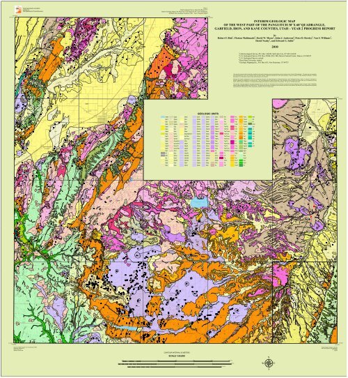
! !! !!! ! ! !! ! ! ! !! ! !! !! ! ! ! ! !! ! ! ! ! ! ! ! ! ! !! ! ! !! ! ! ! ! ! !!! ! !! ! ! ! ! !! ! ! ! ! ! ! ! ! ! ! ! ! ! ! ! ! ! ! ! ! ! ! !! ! ! ! ! !! ! !! ! !! ! ! ! !! !! ! ! !!! !!! ! !! !! !! !! ! ! ! !! ! ! !!! !! ! !! ! !! ! ! ! ! ! !! !! ! ! ! ! ! !! ! ! ! ! !!! ! ! ! !! !! ! !! !! ! ! !! ! ! ! ! ! ! ! ! ! !! ! ! ! !! ! ! !! !! ! ! !! !! ! ! ! ! ! ! ! !!! ! ! ! ! ! ! ! ! ! ! ! !!! ! ! ! ! ! ! !!! ! ! ! !! !!! ! ! ! ! !! !! ! ! !!! ! ! ! ! ! !! ! ! !! ! ! !!!! !! !! !! ! !! ! ! !!! ! ! ! ! !! !! !!! !! ! ! ! !! ! !! ! ! ! ! ! ! ! ! ! ! ! !! ! ! ! ! !!! ! ! ! ! ! ! ! ! ! ! ! ! ! ! !! !! !! ! ! ! ! !!!! ! ! !!! ! !! ! ! ! !!! !! !!!! ! !!! ! !! !!! ! ! ! !! !! !! ! !!! !! !! !! ! !! ! ! ! ! ! ! ! ! ! !! !! ! !!! !! ! !!!! !!! ! ! !! ! ! ! !!! ! ! ! !! ! ! !!! ! ! !! ! ! ! !! !! ! !!! !! ! !! ! ! ! ! !! ! ! ! ! ! ! ! ! ! ! !! ! ! ! ! !!! !! ! ! !! ! !!!!!! ! ! !!! ! ! ! ! ! ! ! ! ! ! ! !! ! !! !! ! ! !! ! !! ! ! ! ! !! !! ! !! ! !!! ! ! ! ! !! ! ! ! ! ! ! !!! ! !! ! ! ! !! ! ! ! ! ! ! ! ! ! ! ! ! ! ! ! ! !! ! ! ! ! ! !! ! ! ! ! ! ! ! ! ! ! ! ! ! !! ! ! ! ! ! ! ! ! ! !! ! ! ! ! ! ! ! !! ! ! !! !! !! ! ! ! ! ! ! ! ! ! ! ! !! ! ! ! ! ! ! ! ! ! ! ! !!! ! ! ! ! ! ! ! ! ! ! ! ! ! ! ! ! ! ! ! ! ! ! ! ! ! !! ! ! ! ! ! ! ! ! ! ! ! ! ! ! ! ! ! ! ! ! ! ! ! ! ! ! ! ! ! ! ! ! ! ! ! ! ! ! ! ! !! ! ! ! ! ! ! ! ! ! ! ! !! ! ! !! !! !! ! ! !! !! !! ! ! !!! ! ! ! ! ! ! ! ! ! ! ! ! ! ! ! ! ! ! ! ! !! ! ! ! ! ! !! ! ! ! ! ! ! ! !! !! ! ! ! ! ! ! !!! ! !! ! ! ! !! !! ! ! ! !! ! ! ! ! !! !! ! !! ! ! ! ! ! ! !! ! ! ! ! ! ! ! ! ! ! ! ! ! ! ! ! ! ! ! ! ! ! ! ! ! ! ! ! ! ! ! ! ! ! ! ! ! ! ! ! ! ! ! ! ! ! !! ! ! ! ! !! ! ! ! ! ! ! ! ! ! ! ! ! ! ! ! ! ! ! ! ! ! ! ! ! ! ! ! ! ! ! ! ! ! ! ! !! ! ! ! ! ! ! ! ! ! ! ! ! ! ! ! ! ! ! ! ! ! ! ! ! ! ! ! ! ! ! ! ! ! ! ! ! ! ! ! ! ! ! ! ! ! ! ! ! ! ! ! ! ! ! ! ! ! ! ! ! ! ! ! ! ! ! ! ! ! ! ! ! ! ! ! ! ! ! ! ! ! ! ! ! ! ! ! ! ! ! ! ! ! ! ! ! !! ! ! ! ! ! ! ! ! ! ! ! ! ! ! ! ! ! ! ! ! ! ! ! ! ! ! ! ! ! ! ! ! ! ! ! ! ! ! ! ! ! ! ! ! ! ! ! !! ! ! ! ! ! !! ! !! ! !! ! ! ! ! !! ! !! ! ! !!+++?????? ????????####!!! ! ! !##! !!! !! ! ! ! ! ! ! ! ! ! ! ! ! ! ! ! ! ! ! ! ! ! ! ! ! ! ! ! ! ! ! !? ????! ! ! !!!! !! ! ! ! ! ! ! ! ! ! ! ! ! ! ! ! ! ! ! ! ! ! ! ! ! ! !! ! !! ! ! ! ! ! ! ! ! ! ! ! ! ! ! ! ! !! !!!!! ! ! ! ! !! !! !! !! !! !! !! ! ! ! !! !! !! ! ! ! !! ! ! !!! !! !! ! ! !! ! ! ! ! ! ! ! !! ! ! ! ! ! !! ! ! !! ! ! !! !! ! ! !! ! !! ! ! ! ! ! !! ! ! !! ! ! !! ! ! !! ! ! ! ! !! ! ! ! !! ! ! ! !!! ! !! ! ! ! ! ! ! ! ! ! ! ! ! !! ! !! ! !! ! ! ! !! ! ! ! ! ! ! ! ! ! ! ! !! ! ! ! ! ! ! ! ! ! ! ! !! ! ! ! ! ! ! ! ! ! ! ! ! ! ! ! ! ! ! ! ! !! ! ! ! ! ! ! ! ! ! ! ! ! !! ! ! ! ! ! ! ! ! !! ! ! ! ! ! ! ! ! !! ! ! ! ! ! ! ! ! ! ! ! ! ! ! ! !! ! ! ! ! ! ! ! ! !! ! ! !! !! ! ! !! ! ! ! ! ! ! !! ! ! !! ! ! ! ! ! !! !! !! ! ! ! ! ! !! ! ! ! ! ! ! !! !! !! ! !! !!!! ! !! ! !! !! ! ! ! ! ! ! !! !! ! ! ! ! !! ! ! ! ! ! !! ! ! ! ! !!! ! ! ! ! ! ! ! !!! ! !! ! !! ! ! ! ! ! ! ! ! ! ! ! ! ! ! ! !! ! ! ! !! !! ! ! !!! ! ! ! ! ! ! ! ! ! ! ! ! ! ! ! ! !! ! ! ! !! ! ! !! ! ! ! ! ! ! ! !! ! ! !! ! ! !! ! ! ! ! ! ! ! ! ! ! ! ! ! ! !! ! ! ! ! ! ! !! ! ! ! !! ! ! !! ! !! !! !! !! ! ! ! ! ! ! ! ! ! ! ! !! ! !! ! ! ! !! ! ! ! ! ! ! ! ! ! ! ! ! ! ! ! ! ! ! ! ! !! !! ! ! ! ! !! ! ! ! ! ! ! ! ! ! ! ! ! ! ! ! ! ! ! ! ! !! ! !!! ! ! ! ! ! ! !! ! ! !! ! ! ! ! ! ! ! ! ! ! ! ! ! ! ! ! ! ! !! ! ! ! !! ! ! ! ! ! ! ! ! ! !! ! ! !!! !! ! ! ! ! ! ! ! ! ! ! !! !!! ! !! ! ! ! ! ! ! ! ! ! ! ! ! ! ! !! ! ! ! ! ! !! !! ! ! ! ! ! ! ! ! ! ! ! ! ! ! ! ! !! ! ! ! ! ! ! ! ! ! ! ! ! ! ! ! ! ! ! !! !! ! ! ! ! ! ! ! ! !! ! ! ! ! !! ! ! ! ! ! !! ! ! ! ! !! ! ! ! !!! ! ! !! !! ! ! ! ! !! !!! ! ! ! ! ! ! ! ! ! ! ! !??!!!!! !! ! !! ! !! ! ! !! ! !!! !!!!! ! !!! ! !!! !! !! !!! !!! ! !!!! !!!!! !! ! !! !!! ! ! !! !!! !!!!! ! ! !! ! ! ! ! ! !! !! !!!! ! ! ! ! !! ! !! ! !! !! !! !! !! ! ! !!! !!! ! ! !! ! ! ! ! ! !!! !! !!!!! !! ! !! ! ! ! ! ! ! ! ! ! !!! ! ! ! ! ! ! ! ! ! !! ! !! ! ! !! ! ! !! ! ! ! ! ! !! ! ! ! ! !! !!!!!! ! !! !! ! ! ! !!!!! ! ! !!! ! !!! !! ! ! !! !! ! ! !! !!!! !! !!! !! !!! !!!!!!!! !! !!!!!! ! !!!!! !! ! ! ! !!! !!! ! ! !!! !! ! !!!!! !!!! ! ! !!! !!!!!! !! ! ! !!!! !!!!!!! !! !!!! !!!! !! !! ! ! !! ! ! ! !! !! ! !! !!! ! !!! !! ! ! !! ! ! !!!! !! ! ! !! ! ! ! ! !! ! ! !! !! !!! !! ! !! ! ! ! !! !! !!! ! ! ! !!! !! ! ! !! ! ! ! !! !!!!!! ! ! ! ! ! ! !! !! ! !! !! ! !! !! !! !! !! ! ! ! ! ! ! ! ! ! !! !!! ! ! ! ! !!!!! ! !! ! ! ! !! !! !!!!!! !! !! ! !! ! !!! !! ! !! ! !! ! ! ! !! ! !!! ! !! ! ! ! ! ! ! ! ! ! !! !! !!!!! ! ! ! ! ! ! ! ! ! ! ! ! !! ! ! !! ! ! ! !! ! !! ! ! !! ! ! !! !! !!! !! ! !!! ! ! ! ! ! ! ! ! ! ! !! ! ! ! ! ! ! ! ! ! ! ! ! ! ! ! ! ! ! ! !! ! ! ! ! ! ! ! ! ! ! ! ! ! ! ! ! ! ! ! ! ! ! ! ! ! ! ! ! ! ! ! ! ! ! ! ! ! ! ! ! ! !! ! ! !!!!!! ! !! ! !!! ! !! !!! !! !! ! ! ! !!!!! !! !!!! !!!! ! ! ! !! ! !!!! !! ! ! ! ! ! ! ! !! ! ! !!! ! !! ! ! ! !! ! ! ! ! ! ! ! !! ! !! ! ! ! ! ! !! ! ! ! ! ! ! ! ! ! ! ! !! ! ! ! ! !! ! ! ! ! ! ! ! ! ! ! !! ! ! !! ! ! ! ! ! ! ! ! ! ! ! ! !! ! ! !! ! ! ! ! ! ! ! ! ! ! ! ! ! ! ! ! ! !!! ! !! !! ! ! ! ! ! ! ! ! ! ! ! ! ! !! ! ! ! ! ! ! ! !! !!! ! ! ! ! ! ! ! ! ! ! ! ! ! !! ! ! ! !!! ! ! ! ! !! ! ! ! ! ! !! ! ! ! ! ! ! ! ! ! ! ! ! ! ! !! ! ! ! ! ! ! ! ! ! ! ! ! !!! !! ! !! ! ! ! ! !! ! !! !!!!!! !! !! ! !! ! ! ! ! ! ! ! ! ! ! ! ! ! !! !! !!! ! ! ! ! ! ! !! ! ! ! ! !! !! ! ! ! !! !! ! ! ! ! ! ! ! ! !! ! ! ! !!! ! ! ! !!! !!! ! ! ! ! !! !! !!!! ! ! ! ! ! ! !! ! ! ! ! ! ! ! ! ! !! ! ! ! ! ! ! ! ! ! ! ! ! ! !! ! ! ! !! ! ! ! ! ! ! ! !! ! ! ! !! !! ! ! ! ! !! ! ! !! ! !! ! !!! ! ! ! ! ! ! ! !! ! ! !! ! !! !! ! ! !! ! ! ! !! ! ! ! ! ! !! ! !! ! ! ! ! ! ! ! ! ! ! ! ! ! ! !! ! ! ! ! !! ! ! ! ! ! ! ! ! ! ! ! ! ! ! ! ! ! ! !! ! ! ! ! ! !!! ! ! ! !!! ! ! !! !! ! ! ! ! ! !! ! !! ! ! ! ! ! ! !! !! ! ! ! ! ! ! ! ! ! ! ! ! ! ! ! ! ! ! ! !! ! ! ! ! ! ! ! ! ! ! ! ! ! ! ! ! ! ! ! ! ! ! !! ! ! !! ! ! ! ! ! ! ! ! ! ! ! ! ! ! ! ! ! ! !! ! !! ! ! ! ! ! ! ! ! ! ! ! ! ! !! ! ! !! ! ! !! !!! ! !! ! ! !! ! ! ! ! ! ! ! !! ! ! ! !! !!! !!! !! !! !! ! ! !! ! ! ! !! ! ! ! !! ! !! ! ! ! ! ! ! ! !! ! ! ! ! ! ! ! ! ! ! ! ! ! ! ! ! ! ! ! ! ! ! ! ! ! ! ! ! ! ! ! ! ! ! ! ! ! ! ! ! ! !! ! ! ! ! ! ! !! ! ! !! ! ! ! ! ! ! ! !! !! ! ! ! ! ! ! ! ! ! ! ! ! ! ! ! ! ! ! ! ! ! ! ! ! ! ! ! ! !! ! !! ! !! ! ! ! ! ! ! ! ! ! ! ! ! ! ! !! ! ! ! ! ! ! ! ! ! !! ! ! ! ! !! ! ! !! ! !! ! ! !! ! ! ! !! ! ! ! ! ! ! ! ! ! ! ! !! ! ! ! ! ! ! ! !! ! ! ! ! ! ! ! ! ! ! ! ! ! ! ! ! ! ! ! ! ! ! ! ! ! ! ! ! ! ! ! !! ! ! ! ! ! ! ! ! !! ! ! ! !! ! ! ! ! ! !! ! !! ! ! ! ! ! ! ! ! ! ! ! ! ! ! ! ! ! ! ! ! ! ! ! ! ! ! ! ! ! ! ! ! ! ! ! ! ! ! ! ! ! !! ! ! ! ! ! !! ! ! ! !! ! ! ! ! ! ! ! ! ! ! ! !! ! ! ! ! ! ! ! ! ! ! ! ! ! ! ! ! ! ! ! ! ! ! ! ! ! ! ! ! ! ! ! ! ! ! ! ! ! ! ! ! ! ! ! ! ! ! ! ! ! ! ! ! ! ! ! ! ! ! ! ! ! ! ! ! ! ! ! ! ! ! ! ! ! ! ! !! ! ! !! !! ! !! ! ! ! ! ! ! !! ! ! !! ! ! ! ! !! ! ! ! ! !! ! ! ! !!! ! ! ! ! !! ! ! ! ! ! !! ! ! ! ! ! ! ! ! !! ! ! ! ! ! ! ! ! ! !! ! ! ! ! !!! !!! !! ! ! ! ! ! ! !!! !! ! ! ! ! ! !! ! ! ! ! ! !!! ! !! ! ! ! !! ! !! ! ! ! ! ! ! !! ! ! ! ! ! ! ! !!! ! ! ! !! !! ! !! ! ! ! ! ! ! !! ! ! ! ! ! !! ! ! ! ! ! ! ! ! ! ! ! !! ! !! ! ! ! ! ! ! ! ! ! ! ! ! ! ! ! ! ! ! ! ! ! ! ! ! ! ! ! ! ! !! ! ! ! ! ! ! ! ! ! ! ! ! ! ! ! ! ! ! ! ! ! ! ! ! ! ! ! ! ! ! !!! ! ! !! ! ! ! ! !! ! ! !! ! !! ! ! ! ! ! ! ! ! !! ! ! ! ! ! ! ! ! ! ! ! ! ! ! ! ! ! ! ! ! ! ! ! ! ! ! ! ! ! ! ! ! !! ! ! !! ! ! !! ! ! ! ! ! ! ! ! ! ! ! ! !! !! ! ! ! ! ! ! ! ! ! ! ! ! ! ! ! ! ! ! ! ! ! ! ! ! ! ! ! ! ! ! ! ! ! ! ! !! ! !! ! ! ! !! !! ! ! ! ! !! ! ! !! ! ! ! ! ! ! ! ! !! ! ! ! ! ! ! ! ! ! ! ! ! ! ! ! ! ! ! !! ! ! !! ! ! !! ! ! !!! ! ! !! ! ! ! !! ! !! !! ! !! ! ! !! ! ! ! !! !! ! ! ! ! ! ! ! ! ! ! !! ! ! ! ! ! ! !! !! ! ! ! ! ! ! !! ! ! ! ! ! ! !! ! !! !! ! ! ! ! ! ! ! ! ! ! ! ! ! ! ! ! ! ! ! ! ! ! ! !! ! ! ! ! !! !! !! ! ! ! ! ! ! ! ! ! ! !! !! !!!! ! ! ! ! ! ! ! ! !! ! ! ! ! !! ! ! !!! ! ! !! ! ! ! ! ! ! ! ! ! ! ! ! ! ! ! ! ! ! ! ! ! ! ! ! ! ! ! ! ! !! ! !! ! ! ! ! ! !! ! ! ! ! ! ! ! ! !!!!! ! ! ! ! ! ! ! !!! ! !! ! ! ! ! !! ! ! ! ! ! ! !! ! ! ! ! ! ! ! ! ! !! ! ! ! ! ! ! ! ! ! ! !! ! ! ! ! ! ! ! ! ! ! ! ! ! ! ! ! ! ! ! ! ! ! ! ! ! ! ! ! ! ! ! ! ! ! ! ! ! ! ! ! ! ! ! !! ! ! ! ! ! ! ! ! ! ! ! ! ! ! ! ! ! ! ! !! ! ! ! ! ! ! ! ! ! ! ! ! ! ! ! ! ! ! ! !! ! ! ! ! ! ! ! ! ! ! ! ! ! ! ! ! ! ! !! ! ! ! ! ! ! ! ! ! ! ! ! ! ! ! ! ! ! ! ! ! ! ! ! ! ! ! !! ! ! ! ! ! ! !! ! ! ! ! ! ! ! ! ! ! ! ! !! ! ! ! ! ! ! ! ! ! ! ! ! ! ! ! ! ! ! ! ! ! !! ! ! ! ! !! ! ! ! ! ! !! ! ! ! !! ! ! !! ! ! ! ! ! ! ! ! ! ! ! ! ! !! ! ! ! ! ! ! ! ! ! ! ! ! ! ! ! !! ! ! ! ! ! ! ! ! ! ! ! ! ! ! ! ! !! ! ! ! ! ! ! ! !!!! !! ! ! ! ! !! !! ! ! ! ! ! ! ! !! !! !! ! ! !!! ! ! ! ! !! ! ! !! ! !!! ! !! ! ! ! ! ! ! ! !! ! ! !! ! ! ! ! ! ! ! ! !! ! ! ! ! ! ! ! ! !! ! ! !! ! ! ! ! ! ! ! ! ! ! ! !! ! ! ! ! ! ! ! ! ! ! ! ! ! ! ! ! ! ! ! !! ! ! ! ! ! ! ! ! ! ! ! ! ! ! ! ! ! ! ! !! ! ! ! ! ! ! ! ! ! ! ! ! ! !! ! ! ! !! ! ! ! ! ! !! ! ! ! ! !! ! ! ! ! ! ! ! ! ! ! ! ! ! ! ! ! !! ! ! ! ! ! !! ! ! ! ! ! ! ! ! ! ! ! ! ! ! ! ! ! ! ! ! ! ! ! ! ! ! ! ! ! ! ! ! ! ! ! ! ! ! ! !! ! ! ! ! !! ! ! ! ! ! ! ! ! !! ! ! ! ! !!! ! ! ! !! ! !! ! ! !! ! ! ! !!! ! ! ! ! ! ! ! ! ! ! ! ! ! ! ! ! ! ! ! ! ! ! ! ! ! ! ! ! ! ! ! ! ! ! ! ! ! ! ! ! ! ! ! ! ! ! ! ! ! ! ! ! ! ! ! ! ! !! ! ! ! !! !! ! ! ! ! ! ! ! ! ! ! ! ! ! ! ! ! ! ! !! ! ! ! ! ! !! ! ! ! ! ! ! ! ! ! !! ! !! !! ! !! !! ! ! ! ! ! ! ! ! !! ! !! !! ! ! ! !! ! ! ! ! ! ! !! ! ! ! ! ! ! ! ! ! ! ! ! ! ! !! ! ! ! !! ! !! ! ! ! ! !! ! ! !! ! ! !! ! ! ! ! !! ! ! ! ! !! ! ! ! ! ! ! ! ! ! ! ! ! ! ! ! !! ! ! ! ! ! ! ! ! ! ! !! ! !! ! ! ! ! ! ! ! ! ! ! ! !! ! ! ! ! ! ! ! !! ! ! ! !! ! ! ! ! ! ! ! ! ! !!! ! ! ! ! ! ! ! ! ! ! ! ! !! ! ! ! ! !! ! !!! ! ! ! ! ! ! ! ! ! ! ! ! ! ! ! ! ! ! ! ! ! ! ! ! ! ! ! ! ! ! ! ! !!!!! ! !!! ! ! ! ! ! ! ! ! ! !! ! ! ! ! ! !! ! ! ! ! ! ! ! ! ! ! !! ! ! !! ! !! !! ! ! !! ! ! ! !! ! ! ! ! ! ! ! ! ! ! ! ! ! ! ! !! ! ! ! !! ! ! ! ! !! ! ! ! ! !! ! ! ! ! ! ! ! !! !!! ! !!! ! ! ! ! ! ! ! ! ! ! ! ! ! ! ! ! ! ! ! !! ! ! ! ! ! ! ! ! ! ! ! ! ! ! ! ! ! ! ! ! ! ! ! ! ! ! !! ! ! ! ! ! ! ! ! ! ! ! ! ! ! ! ! ! ! ! ! ! ! ! ! ! ! ! ! ! ! ! ! ! ! ! ! ! ! ! ! !! ! ! ! ! ! ! ! !! !! !! ! ! ! !! ! ! !! !! ! !! ! ! ! ! !!! !! !! !! ! ! ! ! ! ! ! ! ! ! ! !!!! !! ! ! !!! !! ! ! ! ! ! ! ! ! ! ! ! ! ! ! ! !! ! ! ! !! ! ! ! ! ! ! ! ! ! !! ! ! ! ! !! ! ! ! ! ! ! ! ! ! ! ! ! !! ! ! ! ! ! ! ! ! !! !! ! ! ! ! ! !!! ! ! ! ! ! ! ! !! ! ! ! !! ! ! ! !! ! ! ! ! ! ! ! ! ! ! !! ! ! ! ! ! ! ! ! ! ! ! ! ! ! ! ! ! ! ! ! ! ! ! ! ! ! ! ! ! ! !! ! ! ! ! ! ! ! ! ! ! ! ! ! ! ! ! ! ! ! ! ! ! ! ! !! ! ! ! ! ! ! ! ! ! ! ! ! ! ! ! ! ! ! ! ! ! ! ! ! ! !! ! ! ! ! ! ! ! ! ! ! ! ! ! ! ! ! ! ! ! ! ! ! ! ! ! ! ! ! ! ! ! ! ! ! ! ! ! ! ! ! ! ! ! ! ! ! ! ! ! ! ! !! ! ! ! ! ! ! ! ! ! ! ! ! ! ! ! ! ! ! ! ! ! ! ! ! ! ! ! ! ! ! ! ! ! ! ! ! ! ! ! ! ! ! ! ! ! ! ! ! !! ! ! ! ! ! ! ! ! ! ! ! ! ! ! ! ! ! ! ! ! ! ! ! ! ! ! ! ! ! ! !! ! ! ! ! ! ! ! ! ! ! ! ! ! ! ! ! ! ! ! ! ! ! ! ! ! ! ! ! ! ! ! ! ! ! ! ! ! ! ! ! ! ! ! ! ! ! ! ! ! ! ! ! ! ! ! !! !! ! ! ! ! ! ! ! ! ! !! ! !! ! ! !! !!!!! ! ! ! ! ! ! ! ! ! ! ! ! ! ! !! ! ! ! ! ! !! !!! ! !! ! !! ! !!! !! !! ! ! ! ! ! ! ! ! ! ! ! ! ! ! ! ! ! ! ! ! ! !! ! ! ! ! ! ! ! ! !! ! ! ! !! ! ! !! ! !! ! ! !! !! !! ! ! ! ! !! ! ! ! ! ! ! ! !! ! ! ! ! ! ! ! ! !! ! ! ! ! ! ! ! ! ! ! ! ! ! ! ! ! ! ! !! ! !! ! ! !!! ! !! ! ! !!! ! !! ! ! !! ! ! ! !! !! !!! ! ! ! !!! ! ! !! ! ! ! ! ! ! ! ! !! ! ! ! ! ! ! ! ! ! ! ! ! ! ! !! ! ! ! ! ! !!! !! !! ! ! !! ! !! ! !! !!! ! ! ! ! ! ! ! ! ! ! ! !!! ! ! ! ! !!!! ! ! !! ! ! ! !! !! ! !! !!! ! !! !! ! ! ! ! ! ! ! ! ! ! !! ! ! ! !! ! ! ! ! ! ! ! ! ! ! !! ! ! ! ! !! ! ! ! !! ! ! !! ! ! ! ! ! ! ! !! ! ! ! !! ! !! !! !!! ! ! ! !! !!!! ! !!!! !! !! ! ! !!!! ! ! ! ! ! ! ! ! ! !! ! ! ! ! ! ! ! ! ! !! ! ! ! ! ! !! ! ! ! ! ! ! !! ! ! ! ! !! ! ! !! ! ! ! ! !! ! !! ! ! ! ! ! ! ! ! ! ! !! ! !! ! ! !! ! ! ! !! ! ! !! ! ! ! !! ! !! ! ! ! !!! ! ! ! ! ! !! ! ! ! ! ! ! ! ! ! ! ! ! ! ! ! ! ! ! ! ! ! !! !! ! ! ! !! ! ! ! ! ! ! ! ! ! ! ! !! ! !! ! ! ! ! ! !!! !!!!!! ! ! !! ! ! ! ! !! !! ! ! ! ! ! ! ! ! ! ! ! !! ! ! ! ! ! !! !! ! ! !! ! ! ! ! ! ! ! ! ! !! ! ! ! ! !! ! ! ! ! ! !! ! ! !! ! ! ! ! ! !! ! ! ! ! ! !!! ! ! ! ! ! ! ! ! ! ! ! ! ! ! ! !! !! ! ! ! ! !! ! !! ! !!! ! ! ! ! ! ! ! ! !! ! !! ! ! !! !! !! ! ! ! ! ! !! ! ! ! ! ! ! ! ! ! ! ! ! ! ! ! ! ! ! ! ! ! ! ! ! ! ! ! ! !! ! ! !!! !! ! ! ! !! ! ! ! ! ! ! ! !! ! ! ! ! ! ! ! ! !! ! !! ! ! ! ! ! ! ! ! ! ! ! ! ! ! !!! ! ! ! !! !!!!! ! ! ! ! ! ! !! ! ! ! ! ! !! ! !! ! ! ! !! ! ! ! !! !! ! !! !! !! !! !!! ! ! !! ! ! ! ! ! ! !! ! ! !! ! !! ! !! ! ! ! !! ! !! !! ! ! ! ! ! ! ! !!! ! ! ! ! !!! !! ! ! ! ! ! ! ! ! ! ! ! ! ! ! ! ! !!! ! ! ! !!! ! ! ! ! !! !! !! !! !! !! ! ! ! ! ! ! ! ! ! ! ! ! ! ! ! ! ! ! ! ! ! ! ! ! !! !! ! ! ! ! !! ! ! ! !! !! ! ! !! ! ! ! !! ! !! ! ! ! !! ! !! ! ! ! ! ! ! !! ! ! ! ! !! ! ! ! ! !! ! ! ! !!!! !! ! ! !! ! ! ! ! ! ! ! ! ! ! ! ! ! ! ! ! ! ! ! ! ! ! ! ! ! ! ! ! ! ! ! ! ! ! !! !! !! ! ! ! ! ! ! ! ! ! !!! ! !! !!! ! ! !! ! !! !! ! ! ! ! ! ! ! ! !! !! ! ! ! ! ! ! ! ! ! ! ! ! ! ! ! ! ! ! ! !! ! ! ! ! ! ! ! ! ! ! ! ! ! ! ! ! ! ! ! ! ! ! ! !! ! ! ! ! ! ! ! ! !! ! ! ! ! ! ! ! ! ! !! ! ! ! ! !! ! ! ! ! ! ! !! ! ! !! ! ! ! ! ! ! ! ! ! ! ! ! ! ! ! ! ! ! !! ! ! !! ! ! ! ! !! ! ! ! ! !!! ! ! !!! ! !! ! ! ! !! ! ! !! ! !! !! ! ! ! !! ! ! ! ! ! !! ! ! ! ! !! !! ! ! ! ! ! ! !! ! !!! ! ! !! !! ! ! ! !!!!! !!! !! !! ! ! ! ! ! ! ! !! !! ! ! !!! ! ! !! ! ! ! ! ! ! ! ! ! ! !! ! ! !! ! ! ! ! ! ! ! !! ! !!! ! !! ! !! ! ! ! ! ! ! ! ! ! ! !! ! ! ! ! ! ! ! ! ! !! ! !! !! ! ! ! ! ! ! ! !! ! ! ! ! ! !! ! !!! ! !! ! ! !! ! ! ! ! ! ! ! ! ! ! ! ! ! ! ! ! ! ! !! ! ! !! ! ! !! ! ! ! !! ! ! !! ! ! ! ! ! ! !! ! ! ! ! ! ! ! ! ! ! ! ! !! ! ! ! ! ! ! ! ! ! !! ! ! ! ! ! ! ! !! ! ! ! ! ! !! !!! !! ! ! ! ! ! ! ! ! ! !! ! ! !!! ! ! ! ! ! ! ! ! ! ! !! ! ! ! ! ! ! ! !! !! ! !!! !!!! ! ! ! ! ! !! ! ! ! ! ! ! ! !! ! ! ! ! ! !! ! ! ! ! ! ! ! ! !! !! ! ! ! ! ! ! ! ! ! ! ! ! ! ! ! ! ! !! ! ! ! ! !!! ! ! ! ! ! ! ! !! ! ! ! ! !! ! ! !! ! ! ! ! ! ! ! ! ! ! ! !! !! !! ! !! ! ! ! ! ! ! ! !! ! ! !! ! !! ! ! ! ! !! ! !! ! !! ! ! ! ! ! ! ! !! ! ! ! ! !! !! !! ! ! ! !! ! ! ! ! ! ! ! ! ! ! ! ! ! ! ! ! ! ! ! ! ! ! ! ! !! ! ! ! !! ! ! ! !!! ! ! ! ! ! ! ! ! ! !! ! ! ! ! ! ! ! ! !! ! ! ! ! ! ! ! ! ! ! ! ! ! ! ! !! ! ! ! ! ! ! !! ! ! !!! !! ! ! !! ! ! ! ! ! ! ! ! ! ! !! ! ! ! ! ! ! ! ! ! ! !! ! ! ! ! ! ! ! ! ! ! ! !! ! ! ! ! ! ! ! !! !! ! ! ! !! ! ! ! ! ! !! ! ! ! ! ! ! ! ! ! ! ! ! ! ! ! !! ! ! ! ! ! ! ! !! !! !! !! !! ! ! ! ! !! ! ! ! ! ! !! !! ! !! ! ! ! ! !! ! ! ! ! ! !! !! ! !! !! ! !! ! ! ! ! ! ! ! ! ! ! ! ! ! ! ! ! ! ! ! ! ! ! ! ! ! ! ! ! ! ! ! ! ! ! !! ! ! ! ! ! ! ! ! ! ! ! ! ! ! ! !! ! ! ! ! ! ! ! ! ! ! ! ! !! ! ! !! ! ! ! !! ! ! ! ! ! ! !! ! ! ! ! ! ! !! ! ! ! !! ! ! ! ! !! ! ! !! ! ! ! ! ! ! ! ! ! ! ! !! ! ! ! ! !! ! ! ! ! ! ! ! ! ! ! ! ! ! ! !! ! ! ! ! ! !! ! ! ! ! ! ! ! ! ! ! ! ! ! ! ! ! ! ! ! ! ! ! ! ! !! ! ! !! ! ! ! ! ! ! ! ! ! ! ! ! ! ! ! ! ! ! ! ! ! ! ! ! ! ! ! !! !!! ! !! ! ! ! ! ! ! ! ! ! ! ! ! ! ! ! ! ! ! ! ! ! ! ! ! ! !! ! !! ! ! ! ! ! ! ! ! !! ! ! ! ! ! ! ! !! !! ! ! ! !! !! ! ! ! ! ! ! ! ! ! ! ! ! ! ! ! ! ! ! ! ! ! ! ! ! ! ! ! ! ! ! ! ! ! ! ! ! ! ! ! ! ! ! ! ! ! ! ! ! ! ! ! ! ! ! ! ! ! ! ! !! ! ! ! ! ! ! ! ! ! ! ! ! ! ! ! ! ! !! ! ! ! ! ! ! ! ! ! ! ! ! ! ! ! ! ! ! ! ! ! ! ! !! ! ! ! ! ! ! ! ! ! ! ! ! ! ! ! !! ! ! ! ! ! ! !! ! ! ! ! ! ! ! ! !! ! !! ! ! ! ! ! ! ! ! ! ! ! ! ! ! ! ! ! ! ! ! ! ! ! ! ! ! ! ! ! ! ! ! ! ! ! ! ! ! !! ! ! ! ! ! ! ! ! ! ! ! ! ! ! !! ! ! ! ! !! ! ! ! ! ! ! ! !! ! ! ! ! ! ! ! ! ! ! ! ! ! ! ! ! ! ! ! ! ! ! ! ! ! !! ! ! ! !! ! ! ! ! ! ! ! !! ! ! ! ! ! ! !! ! ! ! !! ! ! ! ! ! ! ! ! !! ! ! ! ! !! ! ! ! ! ! ! ! ! ! ! ! ! ! ! ! ! ! ! ! ! ! ! ! ! ! ! ! ! ! ! ! ! ! ! ! ! ! ! ! ! ! ! ! ! ! ! ! ! ! ! ! ! ! ! ! ! ! ! ! ! ! ! ! ! ! ! ! ! ! ! ! ! ! ! ! ! ! ! ! ! ! ! ! ! ! ! ! ! ! ! ! ! ! ! ! ! ! ! ! ! ! ! !! ! ! ! ! ! ! !! ! ! ! ! ! ! ! ! ! ! ! ! ! ! !! ! ! ! ! !! ! ! ! ! !! ! ! !! ! !! ! ! ! ! ! ! ! ! ! ! ! ! ! ! ! ! ! ! ! ! ! ! !! ! ! ! !! ! ! !! ! ! ! !! !! ! ! ! ! ! ! ! ! ! ! !! ! ! ! ! !! ! ! ! ! ! ! !! ! ! ! ! ! !! ! ! ! ! ! ! ! ! ! !! ! ! ! ! ! ! ! ! ! ! ! ! ! ! ! ! ! ! ! ! ! ! ! ! ! ! ! ! ! ! !!! ! ! ! ! ! !! ! ! ! ! ! !! ! ! ! !! ! !! ! ! ! ! !! ! ! !! ! ! ! ! ! ! ! ! ! !! ! ! ! ! ! ! ! ! ! ! ! ! ! ! ! ! ! !! ! ! ! ! ! ! ! ! ! ! ! ! !! !! ! ! !! ! ! ! ! ! ! ! ! !! ! ! ! ! ! ! ! ! !! ! ! ! ! ! ! !! ! ! !! ! ! !! ! ! !! ! ! !! ! ! ! ! ! ! ! ! ! ! !! ! ! ! ! ! ! !! ! ! ! ! !! !! ! ! ! ! ! !! ! ! ! !! ! ! ! ! ! ! !!!! ! !! !! ! ! ! !! ! ! ! ! ! ! ! ! ! !! ! ! ! !!!!! ! ! ! !! ! ! ! ! ! ! ! ! ! ! ! ! ! !! !! ! ! ! ! !! ! !! ! ! ! ! ! ! ! ! ! ! ! ! ! ! ! !! ! ! ! ! !! ! ! ! ! !! ! ! ! ! ! ! !! ! ! ! ! ! ! ! ! ! ! ! ! ! !!! !! ! ! !!! ! ! ! ! ! !! ! ! ! ! ! ! ! ! ! ! ! ! ! ! ! ! ! ! !! ! ! ! ! ! ! ! !! ! ! ! ! ! !! ! ! ! ! ! ! !! ! ! ! ! ! ! ! ! ! ! ! ! ! ! ! ! ! ! ! ! ! !! ! ! ! ! ! ! ! ! ! ! ! ! ! ! ! ! ! ! ! ! ! ! ! ! ! ! ! ! ! ! ! ! ! ! ! !! ! ! ! ! ! ! ! ! ! ! ! ! ! ! ! !! ! ! ! ! ! ! ! ! ! !!! !! ! ! !! ! ! ! ! ! ! ! ! ! ! ! ! ! ! ! ! ! ! ! ! ! ! ! ! !? ?! !?! ! ! ! !?!! ! ! ! !! ! ! !! ! ! ! ! ! ! ! ! ! ! !! ! ! ! ! ! !??! !?! ! ! ! ! ! !?! ! ! ! ! ! ! ! ! ! ! ! ! ! ! ! ! ! !? ? ! ! !?! ! ! !?! ! ! ! ! ! ! ! ! !! ! ! ! ! ! ! ! ! ! !! ! ! ! ! !!! ! ! !! ! ! ! ! ! ! ! ! ! ! !?? ?! ! ! !! ! ! ! ! ! ! ! ! !! ! ! ! ! ! ! ! ! ! ! ! ! ! !! ! ! ! ! ! ! ! ! ! ! ! ! ! ! !! ! ! ! ! ! !! ! ! ! ! !! ! ! !! ! !! !! !! !! ! !! !!! ! ! ! ! ! ! ! ! ! ! ! ! !! ! ! ! ! !! ! ! ! ! ! ! ! ! ! ! ! ! ! ! ! ! ! ! ! ! ! ! ! ! ! ! ! ! ! ! ! ! ! ! ! ! ! ! ! !! ! ! ! ! !??????? ??! ! ! ! ! ! ! ! ! ! ! ! ! ! ! ! ! ! ! ! ! ! ! ! ! ! ! ! ! ! ! ! ! ! ! ! ! ! ! ! ! ! ! ! ! ! ! ! ! ! ! ! ! ! ! ! ! ! ! ! ! ! ! ! ! ! ! ! ! ! ! ! ! ! ! ! ! ! ! ! ! ! ! ! ! ! ! ! ! ! ! ! ! ! ! ! ! ! ! ! ! !! ! ! ! ! ! ! ! ! ! ! ! ! ! ! ! ! ! ! ! ! ! ! ! ! ! ! ! ! ! ! ! ! ! ! ! ! ! ! ! ! ! ! ! ! ! ! ! ! ! ! ! ! ! ! ! ! ! ! ! ! ! ! ! ! ! ! ! ! ! ! ! ! ! ! ! ! ! ! ! ! ! ! ! ! ! ! ! ! ! ! ! !? ? ? ? ? ?? ? ? ? ? ?! ! ! ! ! !?! ! ! ! ! !! ! ! !?! ! ! ! ! ! ! ! ! ! ! !?! ! ! ! ! !! ! ! ! !! ! ! ! ! ! !?! ! ! ! ! !?! !! ! ! ! ! ! ! ! ! ! !! ! ! !! ! ! ! !! ! ! ! ! ! ! ! ! !!! ! ! ! ! !! ! ! ! !! ! ! ! ! ! !! !! ! ! ! !! ! ! ! ! ! ! !! ! ! !! ! ! ! ! ! ! ! ! ! ! !! ! ! ! ! ! ! ! ! ! ! ! ! ! ! ! ! ! ! ! ! ! !!!! ! ! !!! ! ! ! ! ! ! !!! ! ! ! ! ! ! ! !! ! ! !! ! ! ! ! !! ! !! ! !! ! ! ! ! ! ! ! ! ! ! ! ! ! ! ! ! ! ! ! ! ! !! !!! ! ! ! ! ! ! ! ! ! ! ! ! ! ! !! ! !! ! ! ! ! ! ! !! !! ! ! ! ! !!! !! ! !!! ! ! ! ! ! !! ! !!!! ! ! ! ! ! !! ! !! ! ! ! ! ! ! ! !! ! ! ! ! ! ! ! ! ! ! ! ! ! ! ! !! ! ! ! ! ! ! ! ! ! !! ! ! ! ! ! ! ! ! ! !! ! ! ! ! ! ! ! ! ! !! !! ! !! !! ! ! ! ! ! ! ! ! ! ! ! ! ! ! ! !! ! ! ! !! ! !! ! ! ! !! !! !!!!!! !! ! ! ! ! ! ! ! ! ! ! ! ! ! ! ! !! ! !!! ! ! ! !! !!!! !! ! ! !! !!! ! ! !! ! ! !! ! !!! !! ! !! ! !! ! ! ! ! ! ! ! !! ! ! ! ! ! ! ! ! ! ! ! !! !! !! ! !! ! ! ! ! ! ! ! ! ! ! ! ! !! ! ! ! ! !! ! ! !! !! !! !! ! !! ! !! ! !!! !! !!!! ! ! !!!!! ! ! ! ! ! ! !! ! !! !! ! !! ! ! ! ! ! !! ! ! !! ! ! ! ! ! ! ! !! ! ! ! ! ! ! ! ! ! ! ! ! ! ! ! !! !! ! !! ! ! !! !!!!! ! ! !! !! ! !!! !!! !!! ! ! ! ! ! ! ! ! ! ! ! ! ! !! ! ! ! ! ! ! ! !! ! ! !! !! ! !! ! ! ! ! ! ! ! !! ! ! !! ! !! !! ! ! ! ! ! ! ! ! ! ! ! ! ! ! ! ! !!! ! ! ! !! ! ! ! ! ! ! ! ! ! ! ! ! ! !!! !!! ! !! ! ! !! ! !! ! ! ! ! ! !! ! !! ! !! !!! ! !! ! !!!! ! !! ! !! ! ! ! ! ! !! !! ! !! !! !! ! ! ! ! ! ! ! ! ! ! ! ! ! !! ! ! ! !!! ! ! ! !! !! ! ! ! ! ! ! ! ! ! ! !! ! !! ! ! ! ! ! ! ! ! ! ! ! ! ! !! !! ! ! ! ! !! ! ! ! ! ! ! ! ! ! ! ! ! ! ! ! ! ! ! ! ! ! !! ! ! ! ! ! ! ! ! !! !! ! ! ! ! ! ! ! ! ! ! ! ! !! ! ! ! ! ! ! !! ! !! ! ! !! ! ! ! ! !! ! ! ! ! ! ! ! ! ! ! !! ! ! ! ! ! ! ! !! ! ! ! ! ! ! ! ! ! ! ! ! ! ! ! ! ! ! ! ! ! ! ! ! ! ! ! ! ! ! ! ! ! ! ! ! ! ! ! ! ! ! ! ! ! ! ! ! ! ! ! ! ! ! ! ! !!! !! ! ! ! ! ! ! ! !! ! ! !! ! !! ! ! ! !! ! ! !! !!! ! !! ! ! ! ! ! !! ! !! ! !! ! ! ! ! ! ! ! ! ! !! ! ! ! ! ! ! ! ! ! ! ! ! ! ! ! !! ! ! !! !! ! ! ! ! !!! ! ! ! ! ! ! ! ! ! ! !! ! !! ! ! ! ! ! ! !! ! ! !! ! !! ! ! ! ! ! !!! ! !! ! !! ! ! ! !!! !! ! !! ! ! ! ! ! ! ! ! ! ! !! ! ! !! ! ! ! ! ! ! ! ! ! ! ! !! !! ! ! ! ! !! ! ! ! ! ! !! ! ! !! !! ! ! ! ! ! ! ! ! !! !! ! ! ! ! ! ! ! ! ! ! ! ! ! ! !!! ! ! ! ! ! ! ! ! !! ! !! ! ! ! ! ! ! !! ! !! ! ! ! ! !! ! ! ! ! ! ! !! ! ! ! ! ! ! ! ! ! ! ! ! ! ! ! ! ! ! ! ! ! ! ! ! ! !! ! !!!! !! !! ! !!! ! ! ! ! ! ! ! ! ! ! ! ! ! !! ! ! ! ! ! ! ! !! ! ! ! ! ! ! ! ! ! ! ! ! ! ! ! ! ! ! ! ! ! ! ! ! ! ! ! ! ! ! ! ! ! ! ! ! ! ! !!! ! ! ! !!! ! ! !! ! ! !! !! ! ! ! ! ! ! ! ! ! !! !! ! ! ! ! ! ! ! !! ! ! ! !! ! !! ! ! ! ! !! !! ! ! !! ! ! ! ! ! ! !! ! ! ! ! ! ! ! ! ! ! ! ! ! !! ! ! !! !!!! ! ! !!! ! !! ! !! !!!! !!!!!!!! !! ! !! ! ! ! ! ! ! ! ! ! ! ! ! ! !! ! ! ! ! ! !! ! ! ! ! ! ! ! ! ! ! ! ! ! ! ! ! ! ! ! ! ! ! ! !! ! ! ! ! ! ! ! ! ! ! ! ! !! ! ! ! ! ! ! ! ! ! ! ! ! ! !! ! !! ! !! ! ! ! ! ! ! ! ! ! ! ! ! ! ! ! !! !! ! ! ! ! ! ! ! !!! ! ! ! ! ! ! ! ! !! !! !! ! ! !! ! ! !! ! !! ! ! ! ! ! ! !!! ! ! !! ! ! ! ! ! !! !! ! ! ! !! ! !! ! !! ! !! !! ! ! ! ! ! ! ! ! ! ! ! ! ! ! ! ! ! ! !! ! ! !! ! !! ! ! ! ! ! ! ! ! ! ! ! !! ! ! ! ! ! ! ! ! ! ! ! ! ! ! ! ! ! ! ! ! ! ! ! ! ! ! ! ! ! ! ! ! ! !! ! ! ! ! ! ! ! ! ! ! ! ! ! ! ! ! ! !! ! ! ! ! ! ! ! ! ! ! ! ! ! !! ! ! ! ! ! ! ! ! ! ! ! ! ! ! ! ! ! ! ! ! ! ! ! ! ! ! ! ! !! ! !! !! !! ! ! ! ! ! ! ! !! ! ! ! ! ! ! ! !! ! ! !!! ! ! !! ! ! ! !!! ! ! ! ! ! ! ! ! ! ! ! ! ! !! ! ! ! ! ! ! ! ! ! ! ! ! ! ! ! !! ! ! ! ! ! ! ! ! !! ! ! ! ! ! ! !! ! ! ! ! ! ! ! ! ! ! ! ! ! ! !! ! ! ! ! ! ! ! ! ! !! ! ! ! ! ! ! ! ! ! ! ! ! ! !! !! ! ! !! ! ! ! ! ! ! ! ! !! !! ! ! ! ! ! ! ! ! ! ! !! ! ! ! !! ! ! ! ! ! ! ! ! !! !! !! ! !! ! ! ! ! ! ! ! !! ! ! ! ! ! ! ! ! ! ! ! ! ! ! ! ! ! ! ! ! ! ! ! ! ! ! ! ! !! ! ! ! !! ! ! ! ! !! ! ! ! ! ! ! ! ! ! !! ! ! ! !! ! ! !! ! ! ! ! ! ! ! ! ! ! ! ! !!! !!! ! ! ! ! ! !! ! !!! ! ! !! ! ! ! ! ! ! ! ! ! ! !! ! ! ! !! ! ! !! !! !! ! !! ! ! !! ! !! ! ! ! ! ! ! !!! !! ! !! !!! ! ! !## ### # ## #! ! !!! ! !! !!! ! ! ! ! ! ! !! ! ! ! !! ! ! ! ! ! !! ! ! ! !!! ! ! ! ! ! ! ! ! !!! !! ! ! ! ! ! !! ! ! !! ! ! ! !! ! ! ! ! ! ! ! ! ! ! ! !! !! ! ! ! ! ! ! ! ! !! ! ! ! !! ! ! ! ! ! !! ! ! ! !! ! ! !! ! ! !! ! !! !! ! ! ! ! ! ! ! !! !! !! !! !!!!!!!!!!!!!!!!!!!!! !! ! ! ! ! ! ! ! ! ! ! ! ! ! ! ! ! ! ! ! ! ! ! ! ! ! ! ! ! ! ! ! ! ! ! ! ! ! ! ! ! ! ! ! ! ! ! ! ! ! ! ! ! ! ! ! ! ! ! ! ! ! ! ! ! ! ! ! ! ! ! ! ! ! ! ! !! ! !! ! ! ! ! ! ! ! ! ! ! ! ! !! ! !!! !! ! !! ! !!! !! ! ! !! ! ! !! ! ! ! !! ! ! !! ! !! !! ! ! ! ! !! ! ! !!! ! ! !! !! !! ! !! !! ! ! ! !! !! ! ! !! !!! ! ! ! ! ! ! !! ! ! ! !! ! ! !! !! ! ! ! !! ! ! ! ! !! !! ! ! ! ! !!! ! ! ! ! ! ! !! !! !! ! !! ! ! !! ! ! ! !! ! ! ! !! ! !! ! !!! !! ! ! ! ! ! ! ! ! ! ! ! ! ! ! ! ! ! ! ! ! ! ! ! ! ! ! ! !! ! ! !! ! ! ! ! !! ! ! ! ! ! ! ! ! ! ! !! ! ! ! ! ! ! ! ! ! ! ! ! ! ! ! ! ! ! ! !! ! !!! !! ! !! ! ! !!!! !! ! !! !! ! ! ! ! !! ! ! !! ! ! ! ! ! ! ! ! !! ! !! ! ! ! ! ! ! ! ! ! ! ! ! ! ! ! ! ! ! !! ! ! ! ! ! ! ! ! ! ! ! ! ! !! ! ! ! ! ! ! ! ! ! ! ! ! ! ! ! ! ! ! ! ! ! ! ! ! ! ! ! ! ! ! !! ! ! ! ! ! ! ! ! !! ! ! ! ! ! ! ! ! ! ! ! ! ! ! ! ! ! ! ! ! ! ! ! ! ! ! ! ! ! !! ! ! ! !! ! ! !!! ! ! ! ! ! ! ! ! ! ! ! ! ! ! ! ! !! ! ! ! ! ! ! ! ! ! ! ! ! ! ! ! ! ! ! ! ! ! ! ! ! ! ! ! ! ! ! ! ! ! ! ! ! ! ! ! ! ! !! ! ! ! ! ! !! ! ! ! ! ! ! ! ! ! ! ! ! ! ! ! ! ! ! ! ! ! ! ! !! ! ! ! ! ! ! ! ! ! ! ! !!! ! !!!!! ! ! ! !! ! ! ! ! ! ! ! ! ! ! ! ! ! ! ! !! ! ! !! ! ! ! ! ! ! ! ! ! !! ! ! ! ! ! ! ! ! ! ! ! ! ! ! ! ! ! ! !# # # ##### #### ## # # #! ! ! ! ! ! ! ! ! ! !! !! ! ! !! ! ! ! ! ! ! ! !! !! !!! !! ! !! ! ! ! ! ! ! ! ! ! ! !! !! ! ! ! !! ! !! ! ! ! ! !! ! ! ! ! !! ! ! ! ! ! ! ! ! ! ! ! !! !! ! ! ! ! ! ! !! ! ! ! ! ! ! ! ! ! ! ! ! ! ! ! !! ! ! ! ! !! ! ! ! ! ! ! ! ! ! !! ! !!! !! !! !! !!! ! !! ! ! !! ! ! ! ! ! ! ! ! ! ! ! ! ! ! ! ! ! ! ! ! ! ! ! ! ! !! ! ! ! ! ! ! ! ! ! ! ! ! ! ! ! ! ! !! ! ! ! ! ! ! ! ! ! ! !!! ! !! ! ! !! !! ! ! ! !! ! ! ! !! ! !! ! !!! ! ! ! ! ! ! ! ! ! ! ! ! ! ! ! ! ! ! ! ! ! ! !! ! ! ! ! ! !! ! ! !! ! ! ! ! ! ! ! ! !! ! ! ! !! ! ! ! ! ! ! !! ! ! !! ! !!!!! ! !! !! ! !! ! ! ! ! ! ! ! ! ! ! ! !! !! ! ! ! ! ! !! ! ! ! ! !! !! ! ! ! ! !! !! ! !!! ! !!! !!! ! ! ! ! ! ! ! ! ! !! ! !! ! !! !!! !! ! ! ! ! ! ! ! ! !! ! ! ! ! ! ! ! ! ! ! ! !! ! ! ! !! !! ! ! ! ! ! !! ! ! ! ! ! ! ! ! ! ! ! ! ! ! ! ! ! ! ! ! ! ! ! ! !! ! ! ! ! ! !! !!! ! ! ! ! !! ! !! ! ! ! !! ! ! ! !?! ! ! !??? ? ?!!! !! !!!! !! !! !! !?++!! !! ! !! !!! ! ! ! ! ! ! ! !! ! ! ! ! ! ! ! ! ! ! ! !! ! ! ! ! ! ! ! ! ! !! ! ! !! ! ! ! ! ! ! ! ! ! ! ! ! ! !! ! ! ! ! ! ! ! ! ! ! ! ! ! ! ! ! ! ! ! ! ! ! ! ! ! ! ! ! ! ! ! ! ! !! ! ! ! ! ! ! ! ! ! ! ! ! ! ! !! ! ! ! ! ! ! ! ! !! ! ! ! !! ! !! ! ! ! ! ! ! ! ! !! ! ! ! ! ! ! !! ! !! ! ! !! ! ! ! ! ! ! !! ! ! ! ! !! ! ! !! ! ! ! ! ! ! !! ! ! ! ! ! ! ! ! ! ! ! ! ! !! ! ! ! ! ! ! ! ! ! ! ! ! ! ! ! ! ! ! ! ! !! ! ! ! ! ! ! !!! ! ! ! ! ! ! ! ! ! ! ! ! ! ! ! ! ! ! ! ! ! ! ! ! !! ! ! ! !! !! ! ! ! !! ! ! ! !!! ! ! ! ! ! ! !! ! ! ! ! ! !!! ! ! ! ! ! ! ! ! ! ! !! ! ! ! !! ! ! ! ! ! ! ! !! ! ! !!!! ! ! !! ! ! ! ! ! ! ! ! !! ! ! ! ! ! ! ! ! ! ! !! ! ! ! ! ! ! ! ! ! ! ! ! ! ! ! ! ! ! ! ! ! ! ! ! ! ! !! ! !! ! ! ! ! ! ! ! ! ! !! ! ! ! !! ! ! !! !!! ! ! ! ! ! ! !! ! ! !! ! ! !! !!! ! !!! ! ! ! ! !! ! !! ! !! !!! ! ! ! !! ! ! ! ! ! ! ! ! !! !! ! !! ! !! ! ! ! ! ! ! ! ! ! ! !! ! ! ! ! ! ! ! ! ! ! ! ! ! ! ! ! ! !! ! ! ! ! ! ! ! ! ! ! ! ! ! ! ! ! ! ! ! ! ! ! ! !! ! ! ! ! ! ! ! !!! ! !! ! ! !! ! !! ! ! ! ! !! ! ! ! ! !! ! ! ! ! !! ! ! ! ! !!! !! ! ! ! !! ! !!!! !! !! !! !!!! !! ! ! ! !!!! !! ! !! ! !!! ! !! ! ! ! !! ! ! ! ! ! !! ! ! ! !! ! ! !! ! ! ! ! ! !! ! !! !! ! ! !! ! ! ! ! !! !! ! ! !! ! ! ! ! ! ! ! ! !!! ! !!! ! ! !! ! !! ! !! ! ! ! ! ! ! ! ! ! ! ! ! !! ! ! !! ! ! ! ! ! !! ! ! ! ! ! ! !! ! ! !! ! ! ! ! ! ! ! ! ! !! ! ! ! ! !! !!! !! ! ! !# # # # # # # # # # # # # # #! ! ! ! ! ! ! ! ! ! ! ! ! ! ! ! ! ! ! ! ! ! ! ! ! ! ! ! ! !! ! ! !! ! ! ! ! ! !#!# ## #! ! ! ! !! ! ! !! ! ! ! ! !! ! ! !! ! ! ! !! !! ! ! ! ! ! ! ! ! ! ! ! ! ! ! ! !! ! !! ! !!!!! ! ! !! ! ! ! ! ! ! ! ! ! ! !!!! ! ! ! !! ! ! !! !!! !! ! !! ! !! ! !! ! ! ! ! ! ! !! ! ! !! ! !! ! ! ! ! !!! ! ! ! !!! ! ! ! ! ! !!! !! ! ! ! ! ! !! ! !! ! ! ! ! !! !! ! !! !! ! ! ! !! ! ! !! ! ! ! ! ! ! ! ! ! ! ! ! ! ! ! !! !! ! ! !!! ! ! ! !! ! ! ! ! ! ! ! ! !! ! ! ! ! !! ! ! ! ! ! ! ! ! ! ! ! ! ! ! ! ! ! ! ! ! ! !! !! ! ! ! ! ! ! ! ! ! ! ! ! ! ! ! ! ! ! ! ! ! !! ! ! ! ! !!! !! ! !! ! ! !! ! ! !! ! !! ! !! ! ! ! ! !!!! !!!! ! ! !! !!! !!!!! !! !! ! ! ! ! ! ! !! ! !! ! ! !! ! ! ! ! !! ! !! !!! !! !! ! !!!!!! ! !! ! ! !! ! ! ! ! ! ! ! ! ! ! ! ! ! !!!!! !!! !! ! ! ! ! ! !! !!!!!!!!! ! ! ! ! ! ! !! ! ! ! !! ! ! ! ! ! ! !! ! ! ! ! ! ! ! ! ! ! ! ! ! !! ! ! ! !! ! !! ! ! ! !! ! ! ! ! ! ! ! ! ! ! ! !! ! !! ! !! ! ! ! ! ! ! ! ! ! ! ! ! ! ! ! ! ! !! ! ! ! ! ! ! ! ! ! !!!!! ! !! ! !! ! ! ! !!!! ! !! ! ! !!! ! ! !! !!! !! ! !! ! ! !! !! ! ! ! ! !!! ! ! ! ! ! ! ! !! ! !! ! !! ! ! ! ! ! ! !!! !! ! ! ! ! ! ! ! ! ! ! ! !!! ! !! !! ! ! ! ! ! ! ! ! ! !! ! ! !!! !! ! !! !! !! ! ! ! ! ! ! ! ! ! ! ! ! ! ! !! !! ! !! ! ! !! ! ! !! ! ! ! ! ! ! ! ! ! ! ! ! ! ! !! !! ! ! ! ! ! !! ! ! ! ! !! ! ! ! !! ! ! ! !! ! ! ! ! ! ! ! ! ! !! ! ! !! ! !! ! ! ! !! !! ! ! ! !!! ! ! ! !! ! ! ! ! ! ! ! ! ! ! ! ! ! ! ! !! ! ! ! ! ! ! ! ! ! !! ! !!! !! ! !!! ! ! !!! ! !! ! ! ! !!! ! ! ! ! ! ! ! ! ! ! ! ! ! ! ! ! ! ! ! ! ! ! ! ! ! ! ! ! ! ! ! ! ! ! ! ! ! ! ! ! ! ! ! ! ! ! ! ! ! !! ! ! ! ! ! ! !! ! !!! ! !! ! ! ! !! !! ! !! ! ! ! ! ! ! !! ! !!! !!! ! !! ! ! ! !! !! !! ! ! !! ! ! ! ! ! ! ! ! ! ! ! ! ! ! ! !! ! !! ! ! ! !! ! ! !!! ! ! ! !! !! !! ! ! ! ! !! ! ! ! !!! ! !!! ! ! ! ! ! ! ! ! ! ! ! !! ! !! ! ! ! ! ! ! ! ! !!!! ! !! !! !! ! ! ! ! ! ! !! ! ! !! ! ! ! !! !! ! ! ! !! !! ! ! !! !! !! ! ! ! !! ! !! ! !!!!!! !! ! ! ! !! !! !! ! !! ! ! ! ! ! ! !! ! ! !! !! ! ! ! ! !! ! ! ! !! ! ! ! ! ! ! ! !! ! ! ! ! ! ! ! ! ! ! ! ! ! ! !! ! ! ! ! ! ! ! ! ! ! ! ! ! ! ! ! ! ! ! ! ! ! ! ! ! ! ! ! ! ! ! ! ! ! ! ! ! ! ! ! ! !! ! ! ! ! ! ! ! ! ! !! !! ! ! ! !! !!!!! ! ! ! !! ! !! !! ! !! ! ! ! ! ! ! ! !! ! ! ! ! !! ! ! ! ! ! ! ! ! !!! ! ! ! ! ! ! ! !! ! ! !! ! ! ! ! ! ! ! !! !! ! ! ! ! ! ! ! !!! ! ! !! ! ! ! ! ! ! !!! ! ! ! ! ! ! ! ! ! ! ! ! ! ! ! ! ! ! ! ! ! ! ! ! ! ! ! ! ! ! ! ! ! ! ! ! ! ! ! ! ! ! ! ! ! !! ! ! ! ! ! ! ! ! ! ! ! ! ! ! ! ! ! ! ! ! ! ! ! ! ! ! ! ! ! ! ! ! ! ! ! ! ! ! ! ! ! ! ! ! ! ! ! ! ! ! ! ! ! ! ! ! ! ! ! ! ! ! !! ! ! ! ! ! ! ! ! ! ! ! ! ! ! ! ! ! ! ! ! ! ! ! ! !! ! ! ! ! ! ! ! ! ! ! ! ! ! ! ! ! ! ! ! ! ! ! ! !! !! ! !! ! !!! ! ! ! ! ! ! ! ! !! ! ! !!! ! ! ! ! ! ! ! ! ! ! ! !! ! ! ! ! ! ! !! ! ! !! ! ! ! !! !!! !! ! ! ! ! ! ! ! ! ! ! ! ! ! ! !! ! ! !!! ! !! ! ! ! ! ! ! ! ! ! ! !! !! ! ! ! ! ! ! ! ! ! ! !! !! ! !! ! ! ! ! ! ! ! ! ! !! ! ! ! ! ! ! ! ! ! ! ! !! ! !! ! ! ! ! !! ! !! ! !!!!! ! ! ! ! ! ! ! ! !! ! !!!! !! ! ! ! ! ! ! !! ! ! ! ! !! ! !! !! ! ! ! !! ! ! ! ! ! ! ! ! ! ! ! ! ! ! ! ! ! ! ! !! !! ! ! ! ! ! ! ! ! ! !! ! ! ! ! ! ! ! ! ! ! ! ! ! ! ! !! ! ! ! !! ! ! ! ! ! ! ! ! !! ! ! ! ! ! ! !! ! ! !! ! ! ! ! ! ! ! ! ! ! ! ! ! ! ! ! ! ! ! ! ! !! ! ! ! ! ! ! ! ! !! ! ! ! ! ! ! ! !! ! ! ! ! ! !! ! ! ! ! ! ! ! ! ! !! ! ! ! ! ! !! ! ! ! ! ! ! ! ! ! ! ! ! ! !! ! ! !! ! ! ! ! ! ! ! ! ! ! ! ! ! ! ! ! !! ! ! ! ! ! ! ! ! ! ! ! !! ! !! !! ! ! ! ! !! !! ! ! !!! ! ! ! ! ! !! ! ! ! !! ! !! ! !! ! ! ! ! ! ! !! ! !! !! ! ! ! ! ! !! ! !! ! ! ! ! ! !! ! ! ! ! ! ! ! ! ! ! ! ! ! ! ! ! !!! ! ! !! !! ! ! ! ! !! ! ! ! ! !! ! !! !! ! ! ! ! ! ! ! ! !! ! ! ! !! ! ! ! !! ! !! ! ! ! ! ! ! ! ! ! ! ! !! ! !! ! ! ! ! ! ! !! ! !! ! ! ! ! ! ! ! ! ! ! !! ! ! ! ! ! !! ! ! !! ! ! ! ! ! ! ! !! ! !! ! ! !! ! ! !#!#!!!#####!#!##!!!! !##### #!!!!##! !!!! ! ! ! ! ! ! ! ! ! ! ! ! ! ! ! ! ! ! ! ! ! ! ! !!! ! ! ! ! !! ! ! ! ! ! ! ! ! ! ! ! ! ! ! ! ! ! ! ! !! ! ! ! !! ! ! ! ! ! ! ! ! ! ! ! ! ! ! ! ! ! ! ! ! ! ! ! ! ! ! ! ! ! ! ! ! ! ! ! ! ! ! ! ! ! ! ! ! ! ! ! ! ! ! ! ! ! ! ! ! ! ! ! ! ! !! !! ! ! ! ! ! ! ! ! ! ! ! ! ! ! ! ! ! ! ! ! ! ! ! ! ! ! ! ! ! ! ! ! ! ! ! ! ! ! ! ! ! ! ! ! ! ! ! ! ! ! ! ! ! ! ! ! ! ! ! ! ! ! ! ! ! !! !!! ! ! !! ! ! ! !! ! ! ! ! ! ! ! ! ! ! ! ! ! ! ! ! ! ! ! ! ! ! ! ! ! ! ! !! ! ! ! ! ! ! ! ! ! ! ! ! ! ! ! ! ! ! ! ! ! ! ! !! ! ! ! !! !!! ! ! ! ! ! ! ! ! ! ! ! ! ! !! ! ! ! ! ! ! ! !! ! ! ! ! ! !! ! ! ! ! ! ! ! !! ! ! ! ! ! ! ! !! ! ! ! ! ! ! ! ! ! ! ! ! ! ! !! ! ! !! ! ! !! ! ! !! ! !! ! ! !! ! ! !! ! !! ! !! ! ! ! ! ! ! !!! ! ! ! ! !! ! ! !!! ! !! ! ! ! !! ! ! ! !! ! ! ! ! ! ! ! !!!! !! ! ! ! ! ! ! ! !! ! ! ! !!! ! ! !! ! ! !! !! !! !! ! ! ! !! ! ! ! ! ! !! ! ! !! !! !! ! ! !! !!! ! ! ! ! !! ! ! ! ! ! ! ! ! ! !! ! ! ! ! ! ! ! !! ! !!! !! ! !! ! !! ! !! ! ! ! ! ! ! ! ! ! ! ! ! !! !! ! ! !! ! ! ! ! ! ! !! ! ! ! ! ! ! ! !! ! ! !! ! !! !! ! ! ! ! ! ! !! ! ! !! ! ! ! ! ! ! ! ! ! ! ! ! ! ! ! !! ! ! ! !! ! ! ! ! ! ! !! ! ! !! ! ! ! ! !! ! ! ! !! ! ! ! ! !? ?????!! ! ! ! ! ! ! !! !! !! !!! !!!!! ! !!! !!!!!!!!!!!! !!!!!! ! ! ! ! ! !! !!! !! ! ! ! ! ! ! ! !!!! !! ! !! !! ! ! ! !! ! ! ! ! ! ! ! ! ! !! !! ! ! ! ! !! !! !! ! ! !!! ! ! ! !! ! ! ! ! ! ! !! ! ! !!! ! ! ! ! ! ! !! ! ! ! ! ! ! ! ! ! ! ! ! ! ! ! ! ! ! ! ! ! ! ! ! ! ! ! ! ! ! ! ! ! ! ! ! ! ! ! ! ! ! ! ! ! ! ! ! ! ! ! ! ! ! ! ! ! ! ! ! ! ! ! ! !! ! ! ! ! ! ! !! ! ! ! !! ! ! ! ! ! ! ! !! !!! !! !! ! !! ! !! !!!!! !!!! ! ! ! !!!!!!! ! !!!!! ! !! ! ! ! ! ! ! ! !! ! ! !! ! ! ! ! ! ! ! ! ! ! ! ! ! ! ! ! ! ! ! ! ! ! !! ! ! ! ! ! ! ! ! ! ! ! ! ! ! ! ! ! ! ! ! ! ! ! ! ! ! ! ! ! ! ! ! ! ! !! ! ! ! ! !! ! ! !! !! ! !!! !! ! ! ! ! !! ! ! ! ! ! ! ! ! !! ! !! ! ! !! ! ! ! ! ! ! !! ! !! ! ! ! ! ! !! ! ! !! ! ! !! ! ! ! ! ! ! ! ! ! ! ! !! ! !! ! !! ! ! ! !! ! !# ##### #! ! !! ! ! ! !! ! ! !! ! ! ! ! ! ! ! ! ! ! ! ! ! ! ! ! ! !! ! ! !! ! ! ! !! ! ! ! ! ! ! ! ! ! ! !! ! ! ! ! ! ! !! ! !! ! ! !! ! !! ! ! ! ! !! ! ! ! ! ! ! ! ! ! ! ! ! ! ! ! ! ! ! ! ! ! ! ! ! ! !! ! ! ! ! !! ! ! ! ! ! ! ! ! ! ! ! ! !!! !! ! ! ! !! ! !! ! ! ! ! ! !! !! ! ! ! ! ! ! ! ! ! ! !! !! ! ! !! ! ! ! !! ! ! ! ! !? ? ????? ! ! !? ? ! !??! ! ! ! ! ! ! ! ! ! ! ! ! !! !??! ! ! ! ! !! ! ! ! ! ! ! ! ! ! ! ! ! ! ! ! ! ! ! ! ! ! ! ! !! ! ! ! !? ?! ! !! ! ! ! ! ! ! ! ! ! ! ! ! ! ! ! ! ! ! ! ! !! ! ! ! ! ! ! ! ! ! ! ! ! ! !?? ??! ! ! ! !! ! ! ! ! ! !?!! ! ! ! ! ! !! ! !????! ! ! ! !! ! ! !! ! ! ! ! ! ! ! ! !! ! !! !! !! ! ! !! ! ! !! ! ! ! !???!!! !!! !! !! !!!#! ! !!! !! ! ! ! ! ! ! ! ! ! ! ! ! ! !!!!!!75255277082421261222332532221322233322132101010 5 433322235307210238676055586301312414825535822172234045251435124535201091571832503455104714861498121430102063377872209118104945 4040304035422153040503530303518103510152555128101010153010271522253065353535103230852555592224Calico bed?Calico bed?113°00'00''37°30'00''38°00'00''113°00'00''37°30'00''112°37'30''112°22'30''112°22'30''37°52'30''38°00'00''QafcTcrKsuTafQbhkQmsTdTcrTafKsuQbrdTcrTcrTafTafKsuQlpTdQafyTiTafTcrKsuTafTafKsuTqlTcrKsuTlTafQmsTcwuKsuTcrTcrTcrQbnlQafyKsuQafyQafyTm(Ti)TcrQaf2QgtpQafyQTbxQbakTcrTiTbrcQafyQalyTmQafyKsuTcrQalyTafTlQafoQafyQafoQafoQmsTcrTbdhKiTmQbmk2QmsTafQafoTbhvQbbkKsuTdTcrTcrTcrTlQbrhTiQbhp2KstTcrTcrTcrTcrTmQafyQafoTlTafTdQafyTcrTcrKgcmTcrTdTbdhTmQmsKiQbwfTcrTcrKw?TbvTcrKsuTcrKstQafoKw?QbalQgtouQafyTbbmKtdQcQalyTcrQalyQmsQmsTipKw?TcrTcwmTafTbhvQmsTiTlTcrQafyQafoKsuQafyQmsKw?QblfTdTiQafoTm(Ti)QThQmsQmsTlTlTcrQafyTafTbvbQbckQacfoTdKw?QafcQmsTKgcuQafoQacfoTcrQThQmsTm(Ti)TqlTcrQafoQmsTafTcrKw?TiKw?TcrTcrTiQafyQacfQTrTcrQbpl3TiQmsTcrTmQafoKiQalyTqlQafQafoTcrQafyQbhp1QafyQafQalyQacfTlQbskTcrQbubTafQafoQalyQmsKsuTvfTbhvKsuQmsTcrKstJnQmsQafoTcrQlmTmTcrQTbxQafoQmscTmKstKw?QcQTapTcwuTmQafyQmsTafQmsTmTcrTafQal1TcwlTiTcrTcrTbvQbwTm?QafoQlmQafyTdKstTcwuTcrTqlQTapQcQmsTcwmTcwmlKw?TcrQafoQaf2QThTcrTcrTmTcrTcwuTafTafQafyTiKw?TcwuQlmTm(Td)TqlTcrQalyQmsQafoQalyTiQafyQc/TbhQmtcTcrQafoQbpl1QbhoTcrTiTiQafoTcrTbhvQmsTcrQmtcQmsQafoTbhvKsuQlmQmsTiTcrTdQcQbubQafoTiQafyTcrQafoTcrTlQmscTiTafTqlTcrQcTcrTiQbdcTcrQafoTbhvTiTbvQcTcrQaf1QTbxQesQafoTbvbQms?TcrQatKgcmTcrQmsTcrTcrQTbTiKstKsuTcrTlQafoTafTdTm(Tbhv)QafoKw?QgtuQmtcTcrQafoTqlQbmcTmQmsQafoTcrQafyTcwlQafoTcrQTapTcwmQlaTiTcwtQafoTcrTcrTcrQafyTcrQalyQbbmQmscQms?QcTcrTiTcrTcrTcrQacfQmtcTcrQacQafoQTapTiQafyTbvTiQafyQbdvTcwt?QafoQacTcrKsuKstTiQacfQafoQcaQThQafyKiQacfTlKw?KsuKsuQafoTmTcrQacfTafQbefTcrKw?TiQmsQlmTafQmsQmsQafoQmsQTapKstTcrTcrTiTcrQThTbhvTmQmsQesTcrTbhvTcrTdTbvTiTbvbTlTmTiTiTbhvQafyQcQafoQafoTm(Ti)QacTcQafoTcrTlTiTcrQafoTlTcrQcTmTcrTbvQgtuTcrTiQmsTcrQbsQafoQafoTbhvQmtcQTapTcrQbpl2TafQcTcrKtdTbhvTafQmsQms?TiTbhvQgtouQafoTiTcrTdKiQafyTcrKw?TcrKiTiTcwlKiTdTcrQafyQafoQmtcQafoQmtcQcTdQcTcwmKiQafoQalyTcrTcrTdTcrQbdcQmsQatTcwlTcwtKsuQmtcQmsTiTcrTipQacfQafoTbvbQmsQlaQalyTbhmQms?TcrQcTvfTdQcQThTqlTdTlTbspKiQbsTlTcwuTcrKgclTcrQmtcTiTafTiKtdTiTqlTbhvTbhvKsu?TcwlQafoTafTafQTbxQacfKtdQatQmsTiTiTcrQafoQafTlQmsTiTcrTiTiQaf2QacfTlQmtcTcrQcQmsTiTcrTbvbQafyQeaQafoKsuTqlQcaQcTiTiTiTmQmsQms?TdTcrQbsTmQTapTd?KtdTiTm(Ta)TiTafTbhvQafoQgtouKiQmtTbvTlQaf2TafTcrKtdTcrTafTbrc?TcwuTcrTbhvKsuQmsTafQmsTm(Ti)QafyQafyTcrQafyTqcbQcQmtcQmsTbhvKtdQafoTlQcTcwuQafoTlQbckQaecQafyTiQcQmsQmsTbrccTbvTiTcrKstQafyTqlQafoQmsTiTbhvTiTiTlQmtcQbhpcQapQacfKgcmQmsQmsTKgcuQmsQmsTcwt?QmsQmsTcrQcQmscQcQmtQafyTcrKsuQacQcQms?KtdQcTcrTcrTiTcwuKtdTiTbdhTqlTbvbQafoQcQcTcrTnTbvTafTqlTcrTcrQcQmsTiTiTcrQcTlKiTlQbrhTcrQmsQmsQcQmsTdKiQafyTcwTdQmsQmsQcTiKw?TcwuTiTiQThTqlQmtcQmsTnTqlQacoTdTcrQacfQcQcQcQcTcrTcrQapTcrTnQcTcrQafyTcrTiQgtpQafoQafoQafyQafyQafoQcTcrTcwmlQesTcrTbhvTvfQcTmQafyQafQcKstTcrQafyTafTafQafoQcTcrQafoTqlQcaQcTipQafyQcQThKw?TcrQbhp1TvfTafTcrTiTlTiQacfTqinTcrQacKsuTcrTcrQcoTqlKtdTcrQcTiQcQcTqlQcQcTbvKiQmsTcrQmsQacfoTmQcQmsQafoQms?TcrQcQcKsuQcTiQafyTbhvQacfoQmsQcQcJnQmsQcTbhvKsuQatQacQatQafoTmQmscQcQcQcTiTafKiQapTcrKsuTcrQcQapTbhvQatKsuQbpl3QbeQcQcTcrQcQbdeTcrTcrJcQmsQcQcTafTcrQcTdTcrQcTcrTcrTdQafQcQcQcQmtcQmsTmTiQaloQbubcTafQcTdQcQafyTlQcQcQbsQcTvfQcQbefTlQcTcrQafTcrQbefTcrTqlQcTcwmlTiQacfTbhvQmsQmsTcrQbhkQacQTapTbhvQafoTd?KsuQcKtdKw?TmTnwTbhvQbhkcKw?KiKw?QafyQTapQatQacQcQmsTdQbscKtdTcrQmtcTmTbhvTcwmQblfcQbsTcrKgclTdTafTiQcTcrTnKgcmTbvTdQcTbvbQmsQmsQafyQafyQcQmsKtdQcQmtcQatTcrTqlQms?TbhvQamQmsQcTm(Ti)TcrQmsQacfoQafyQmsQacTcrQmsQcaKw?TqlTiQalyQafoTcrQatQmtTcrTcrQafoTcrTqlTqlTcrQmsQmsTafTbvbQafoQcTcrQgtuKw?Tbrc?QafoQmsQbeQcQcQms?TbspQafoTnQbubTcrQmtQbeQcQcQmsKsuQmsQmtKw?QcQcQcTiTiTdQafQmsQcQbhkcTcwlQacQmsQTapKw?TqlKw?QbsQafyQcQcKw?QmsTm(Ti)KsuKw?QmsQacQTapKw?QmsTdQmsQceKstKsuKstQesTbhvQmsTbhvKsuQcQcQmtcQcQmsQafoQcQmtQThTcrTafQmscJcnQafoQafyQcQfdQmsQmsQafTafQmsQatQmsQmscQbrdQacoQmsQmscQcQafyQThQatQatQacTKuQmsQcQmsKtdTdQmsQmsQmsQatKdQmsTcrQmsTiTiQms?TbhvTcwlTnKsuQcTcrQcQcQcTiQacfQmsQafoQacQafoQmsQafQaeQbwfcQbalcQmtcQbwkcQmtcTcrQcQbhkQacTcrTiQacfoQTbxQcQbbkcQmsQbakcQcQafyQmsQcQbsQmtQafyQafyTnlQmtTbhvQmtcTbhvTbvQacQcQmsTcrTafQms?QcQmtcTqlQaf1QafyTnTlQmsTmTlQacfQmscTqlQms?QmsQbubTcrQmtQlaoTbhvQmsTbvbTcwuQmtTcwuTcwQafoTbspQaf2QafoQafQmsQacfTmQafoTi?TnwQmsQmsQmscQacQafoQafoTnQmtcTm?KgclQal1TcwlQal1QalyQalyQal1TcwlTcwmQacTcwlQafTbhvKgcmQalyTcwlTbhvQalyTcwuTlTcwlKgclQalyTqlTKuQafyTcwmTvfTm(Tbhv)Qal1TKgcuQcTiTbhvQalyTiKgcmTbhvTcwmQacfTcwmQalyTm(Ti)QalyTbhvQalyQmtcTcwuQafyKstTqlTcwlTbhvKstTKgcuTcrTlTvfKiQalyQalyTm(Tbhv)QafoQacfQafoTlQalyTiQacfQTapTnwQal1QacfTbTKgcuTKuTKuQmtcKstTiQmtcTqlTm(Td)QTapQalyKsuTiQcTcrTbhvTcrTiTcwmTiQafyTnQalyTbhvTcwuQmsTafQacQacfQcQacfKgclQacfTbhvTKgcuTKgcuQacQms(Tm)TqlTbrc?TbhvTiQacTiQacTbhvQTapTafQcTiQalyQafyQalyQacfTcrQalyQms(Kd)TiTlTnlQcaTcrQalyQcQmscQacfQacQceQcTcrTdTnQafyQafoQalyQcaQlaTm(Tbhv)TbhvTcwuKstQacQacTqlTbhvQgtouQalyQacTlTiQcQcTiJcQbwQafyQcQalyQmtcQcQalyQesQaoQal1QafoTbhvQcKsuQmtKgcmTKgcuQcTnlQcTcrQcKgcmTcrTiTKuKsuKstQcTcrQalyTcrTcwQafyTcwlTbhvQcQacfQcQlmKgclTafTcrTafTcrQafyQacfQacQacTcwmTKgcuKtdTcrTi?QmtcTcrQatQmtcKgclQacKgcmKst?TcrQmsTnlQafyQcTiQacKgclQcQbmk3QalyTiQatKw?TqlTcwlTqlQalyTqlQacQacKw?QafyTcrQacQalyKw?QcaQbmk1QacTiTcwlKstQms?KtTbhvQacQesQatKtdKgclQacfTbhvQTapKtdKtQacQms?TKuQcQcQalyKiKsuKsuTcwlTcwuTcwmQcTnlQTapTcrQcTiTKuKw?TiKsuTafTKgcuQcTcrKgclQThQcTnwTafQcKw?JcpTbvQacfTcwlQatTcrQacTiQacQcKsuKgclKgclQatQacTnwTcrTcrQcQmsKiQalyKgcmTbdhQmsQafoTqlQcQafoKiQatTqhQmtQacQacQacTcwlJcwTafTcrQmtcQalyTqlQcKsuTafQacfQafyTdliTcwmQafyKgclTcrTbhvQalyTqlQTapQTapQmtTqlQacQaf2TdQacTnlQalyTbhmKsuQacQalyTcrTbhvQacQcTm(Ti)Qal1TKuTbhvQlgQmsTafQbhkQmtQalyKsuTbhvQmsTcrQaoQafyTbhvQmsTcrQmtTcrQafyQacTcwlQacfKsuTKgcuTKuTcwlQbakQatTbvbTcrTbrc?QacQmsQTapQacQmtcTcrTKuKsuTm(Ti)QacTafQacfTiQmtcQaf2TlQcTcrQacfQcQmscQaeKiQafoQmsQacQalyTcwtTKuQalyTcrQcQacTcrQmsQalyTcrTcwmQcaQbeTcwtTcwuTdTbhvKsuTcwuTmQalyTcrTcwtQatQmtTcrTcr?QTapQafoQalyKgclQcTcwt?TnwTcwmlQafoTcrKgclTcrQalyQafoTcwuQalyTcrTm(Ti)TbhvQafoQafoQal1QcTbhvKgclQacfQTafQacfKsuTbhtQmscQatQalyQafyQafoQThTKgcuTnlKw?TbvTcrQafyJcxQatTafQatQThQalyTbhvQatQacTbdhTmQafyQatQThTafQacQmsKgclTcwtQafoKdTafQcQaf2Tm(Ti)QacQmscKgcmTqlQafoQmshQacQafoTbhvQaf2QTapQafoKiQbwkQmsQacKsuTbvKw?QcQThQacfTiQcQcaQbakTbrcTiTcwmQalyTbhvQmtQalyQacJcpQacQaloKgclTcwuQacfQacQmtcQcQcKw?TbhvTiTcrTm(Ta)TbdhQacQcQatTKuTbhvQmsQafoQafoTcrTiTcrTcwlQalyTbrc?QmsTvfQTapKtdQmsKgcmQmsTcrQcQafyQacTqlTm(Ta)QatQacTcwuQaf2TcrQaf2QatQmtQmtQatKtdTm(Ti)Tm(Tbhv)KsuQcKw?TKuQTapQalyTcrQcQcTbvQacKgclQmsQacKtdTcrTm(Tbhv)QafoQacfoQesTbhvTbhvTcwlTcrQatTbhvQbdcKsuQmsQcTbvQatTbrc?QafoTcrKgclKiQcaQacQacQafyTaQmtcQafoTafQcQatQcKtdQafyQafoQafoQlmTm(Tnw)QTbxQafQalyTafTbhvQmtcQafoQatQms?QmsQacQacKsuTcwl?QacKsuTdTcwlQafoQms?KsuTcrQaloTcrQmtcQalyQafoJccQafoTbhvQmtcTcrKw?TbvbQcTbhvTnTbrc?QatQcTnlTcwmQacfQms?QmsQmsQalyQatQacTafQafoQmsTnlTm(Ti)QTapQcTlTcrTnwQafyTcrKsuQacfKstTcwQcKsuQatQafoQTapQbhkcKgcmlQmtQafoQacfTbbmQmtQblfQcQcQacQmsQcQacQatQatTbhvQacfQcTKgcuQafoQafoQacTm(Ti)TlTm(Ti)QcTcwlQalyTcrTbvQbhp2Ti?QafoQedQcaTm(Ti)QacfTKuQcQacfTKgcQafoQTapTcrQaecTKgcuQacQmtcTcwmQalyQmsQmscQmtTcrTcrQms?QmsQalyTnwTcwlTbhvQbwcTKgcuTcr?QmtTm(Tbhv)TcrTKgcuTlQacKsuQatJcwTbhvTmQcQmsQalyQafyTKgcuQafoKgcmQcTKuQafyTbhvQmsQalyQbhp1TcrQacQalyQcQmsTbhvKw?QacfKsuQafoQcoQafoTcrQbhkcTcwmTcwl?TvfQalyTcrQacfoQacTafQmtQalyKsuTqlQmtcQafoQalyKgclQalyQacQbhkcQacQcQacfQmtTbhvQcTnwTlTcrQatQacQalyKsuTmTcwlQbmkcTcrTKgcuTcrQacQaecQmtTbhvQacQlao/Qbmk3QTapQalyQafoTqlQaloQcQmsTKuTafKsuTcrQmtcTbhv?QalyQacQaf2QafoQms?TcrTcrTnwTbhvTcwuQacTcrQmsTcrKgcmQafoQafoTcwmTafQatKgclKw?KgclQms?QafoQafoTqlQmtcQacfQalyTbhvQmtTcwuTcwmKw?Kw?TcwmTbrc?QatKgcmTKuTcrQafoTbhvKw?TnwQmtcQmsTbhvQmtcTqlQc/TbhQmsQafoTcwlTcrQacTbhvQacTbvbQatQbrdcQacQacQacQacQmtcQcKw?TbvTKgcuTcwu?TbhvQTapQblhcTrhmTbhv?QbnlQafyTcwmTbdhcQalyQafoTKuTcrTKuQacfQacfQafyQcaQacQafyQcQTapQaloQalyJcwQafoQalyQapQacTbhvQbhkcTcrQafoKsuQafyQalyQcQcKsuTbdhQTapKtdTm(Td)QafyQacQfdQacfoQatKgclQThJcwTbhvTcwuTbhvQacTbhvQacQalyQcQmtcQapTbhvQcTbdhQmtQThQmtcTbrcQgtuQbmccKgclQmsQcaTafQatKw?QacfTKuQafoQbsQafoTbhvQafoQcQapTbhvTcwQalyQms?QafyTnlQacQms?QmsQafoQacfoQcTcrKw?QmsTnwQmtcQblfcTqlQafoQbhp1TbhvQatQmtQaf2TKgcuQmsQacQalyTafQafoQmtcTcwu?KsuKw?QacfQamTbhvTm(Ti)QacoQaf2QalyQbwkQmtQmtcQTapQaecTbhvTbdhQcQaf2QapQmtQafoTbhvQacfQacQmscTcwmQThKsuTcrQalyQafoTKuQaf2QcTmTbdhTKgcuTcwlQalyTbvbQcoTcwu?TcwuTcrQafyQaf2QbwkTcwlQmtcTKuQafyQmtKsuQmsQalyQapQmtQafoTmTKgcuTafQmtQcQmtcQbsQafoQmscTcwmlTm(Ti)QacQbsQatTKuQacQatTcrQmtcTcrQbhkcKsuTcr?QacQalyQmsTm(Ti)Tbhv?QatQacTbhvQacKw?TnwQatTi?TKgcuQTbxQcQatQafoQcQafoQafoQafoQafyQmtcQafoQapQbubQafyQbrhcTcwm?QafyTm(Td)QcKw?QalyTbhvQalyTcwlQacKgclQacoQcQmtcKgcmTqlQaloQacQTapTbvQacTKgcuQalyQacfQacoQmsQapQafoTcwlQafoQcJcpTcrQTapQmsQmtQmsQatQcQalyQmsTKgcuQcQacfQacQmsTdTbvbTcwmQacfQafoQalyQacTqlQmtKsuQatQcQapTrhmQmsTcwmQcTbhvTcwlTcwlQacQmsQThQafyTcwlKgclQacoTbdhQmsTm(Tdm)QcaQafoQacQalyQalyQacfQmsQmtTbhvQlaoQmshKgclKtdTqlQmsQafyTbhvQalyTcwmQafoQacfQafoQmsTqcbQcTbdhcTcrQmtcQaloQacfoTqlQmsQacTbvQms(Ti)QacfQafoTcrTm(Ti)TcrQalyQafyTbhvTcwt?TcwmQmsQaloQmsQacfoQalyTcwuTcwuTbvTnwQacfoQafoTcwtTcwlQalyQacQaoQTapTcwKw?QbhkcKgclQaecQafyQbefcQms?KgcmQTapQacfTql?KgcmQcQmsTbhvTcwlTbhvTbdhQcTnwQThTcrQacKgcmQalyTbhvQbskcQmtQmtcQafoQmsQafyQacfTbvbQacKsuQcTcwuTcwuQacTnTbdhQmscTcwmlQmsQmsQlaoQalyTcrQbhpcQafyTbrcQmtTbvQmtcTbbmQblfcQbrhQgtpKsuQmtTnQmtcQmtQafoQmtTcrQgtouTcwmTKuQacfQmtQmtKgcmTcrQcTm(Ti)Tm(Td)TmQalyQmtQcQmtTKgcuQafcoQafoQmsKgclQacQmtcQcaQgtouQafyTKuQcQalyQcaTbhvTcwlKw?TbhvTbhvTbhvJccQmscKsuTcwuQacfQmsTbhvKgcmQmsQmtQbefQmsQafyQmscTvfQafyQmtQatQTapTqhQcQacTcwtQafoTcrQafoQacTKgcuQcQatTcrQmsTbrc?Td?TcrQmscKw?TbhvTqlQbrhQmsQafoQmsQbmk2TbhvQTbxTcwlQmsQbhp1QalyQafoQacfQmsQgtuTm(Tbhv)QacQcQmtQmtTbbm?Qms?QafoKstQacfoQbefQalyQcQmsQmtcTm(Ti)TbhvTbhvQafyTcwmQalyQatQcQmtcQTapTbhvQTapTcwmQalyQmtcQalyTbhvQbrhQafoQmsTbhvQmtcTbhvQafoQacTKuQalyQmsQmsTKuQafQafoTbhvQmsQTapQacfoTqlTcwt?TKgcuKw?QmsKsuTafQapTcwmTKuTqcbTqlQmsTbdhQmsKw?QafyQms?QacfQafoQaloKsuQmscTcrQmsQalyTm(Ti)QafyTqcbQafoQacfoQafoTcwuQalyTm(Ti)QalyTbhvQTapQTbxQafoQms?QacoTnwQmsTqlTcwuQbckcTm(Tl)QacTbdhQms?TcwlTbhvQbwkQmsQacTKuKgcmlQafoTqlQafyTcwm?TcwlTnlTKgcuQedQafyQmsTcwuTKgcuQafo?QafoQmsQbmk2QbakQbhkcQmtTqlKsuQbnlcJcwQafoTKgcuQacoQafoTbhv?QacQafoTcwmQmtQatQbhkcTcwlTm(Ti)TcwuQmsTbvbTbhvQmsTm(Ta)QalyTm(Ti)TbhvQacTbhvQafQmtcTbdhQacTKgcuQTbxQafyQafoTm(Td)TcwtQms(Ti)QafoQTapTKgcuQacTcwlTcwlQacoQmscQmsTKuQacoQacTbrc?QacoTbvQms?JcxQbhkcKgclQafyTnwQms(Ti)Tm(Ti)QmscQmshQacQmtTbbmcQmsKsuQTapQc/TcwuQmsQmsQafoQacTcwmTKuQacfQTapQafyKw?QacoQatQacQms(Ti)QafyTcwuQacTbhvQafQgtouQmshTcwlQmsTcwt?KgclQacfoQafyTbdhTKuQacfoTKgcKw?QmsQacQafoQgtouQafoQbrhKgcmQatTbvTKuQacfTbhvQacQalyQmtcQbwkQmscQmsQacfQTapQafoQms(Kd)Qbmk3TcwmTKgcuKsuTbrcTcwmQafyKw?QbwkTbhvQacQbrhcQafyTKgcuTKgcuTbhmTcwmTcwmQmsKw?QacfoTcwlQacoQafoTqcbQcaTm(Ti)QafyTKuQafoTKgcuTKgcuTqcbQaf1JcwQbdcTcwmlQacfoQafoQmtcQmsTcwlQmtQbhp1QmtQafoQmtcTm(Tbvs)QmtcTm(Td)TbhvTcwuTcwm?QacfoQbhp1Kw?QmtcTcwm?Qaf2Tm(Ti)QTapQTbxTqcbTbhvTKgcuQafyQbhkTbhvTm(Ti)Qaf2QafoQbskcTcwmQacQafyQacTbhvTcwu?QacTm(Ti)TbhvTm(Ti)Qms(Tql)TcwuTKgcuKgclQaf2QacTbhvQmtcQmscTcwu?TcwuQacoTcwlQmsTKgcuQms(Ti)TbhvTm(Ti)TcwlQmsTm(Tdm)QafoQamTbhvQmsTm(Ti)QafoQbhocTKgcuQmshQafyQafoTbhvQmsTbhvQamTKgcTcwmQTapQacoQafoQTapQacfQmsTKgcTcwuQafoQTbxQacoTbhmQmsQms(Ti)TKgcuKgcmTcwuQaf2TbhvQafoQbefTm(Ti)QmsQafoQafyQms(Ti)TbhvTbhvQafyQmsQacfoQmshTbdhTcwuKgcmlQmtcQmsTbhvTbhvTKgcuQbhkcQaf1QmtcQacoTbdhTKgcKgcmlQbhkcQmtcTbhvKgcmTm(Ti)KgcmTKgcuTcwuQgopTm(Tbhv)Tbhv?TcwmTKgcTcwmTm(Tbhv)QacoTm(Tl)Tm(Ti)QacfoQmshTm(Tbvs)Qms(Kd)QmscTm(Tl)Qms(Ti)Tcwu?Tcwu?KgcmlTKgcuTcwm?Tm(Tbvs)Tm(Tql)Tm(Tdm)Qms(Ti)Qms(Tql)Tm(Tnw)Tm(Tbvs)Tm(Tnw)TlQafKwKsjQafKsjKsjQacfTcrTcwuQafoTlTlKwTlQafTlQafoKsjKwQafQalyTcrTcrKwTcrQafQafTlTlKwKwQafQacQacQafQafQcTcrQafQcQafTcrQmsQacfQacQafQaf1TcrQafoKwQafoTcrQaf2QafoQafQafKsjQafyQafQalyTcwuQafoQaf2TcwuQacfQalyTcrQalyQacfQafQafyQafoQafoTcrQafQafoQafQafyKwQafoQafoQafQafoQafoQafoQacfQafyTcwmQaf2TcrQafQafKwTcrTcwmTcrQafoQat2TcwmQalyQat4TlQafoQacfTcwmQaf2QafyQafyTcrQbhkQafoQacQafyQafoQacfQacfQacfTcwmQafTlTafQcQafoQacQafQaf2QcQmsQafyQafQafyQat4QcQcQafoQaf1QmsQalyQafoQafKsdQat5TafTlKsjQal1KsdKsdQacKsdQalyQafKsdTcwtQcQacfQalyTcwuTcwmQafoKsdQaf2TcwtQaf2KwQalyQalyQacTcwmQalyQalyQacfTcwmTcwmQcTcwmKsdQalyQalyQacQafQalyQacQmtQcQal1TcwmQafyQacQafoQalyTcwlQalyQalyTcwmTcwuQalyQcQafoTcwuTcwtQafQcQalyQacfKwKsjQacTcwmTcrQcTcwtQcQafoTcwmTcrQalyQmsQalyTcwuQat3QacfTcrTcwlQaf1TcwmQalyQacfTcrKwQafyQacQafQacQmtcQalyQaf2Tl?QcQaf1QafTl?Ksd?QalyTcwlTcwlQafyQalyQcQafoQalyQat2QafQaf2QcQcQaf2QacQcKsj?Qaf2QacfoKw?KsjTcwlQafyQafyKsdQcQaf2QcQcQaf1Qms?Qaf2Qaf2TcwlKw?QcQacQacQacfQacQathQmtcTcwlQcTcwuKsjQacQat2QmtcQafQacQacfQalyQafQat2QalyQaf2TcwuQafoQat2QalyQacQmtcQacfTcwmQacQacoKsdQafoQms?Qat3TcwmQmtcQat3QafoQathQacfQacQat2QmtcQat3Qaf2Qat3QafoQaf1TcwtQathKsdQmsQalyQms?QacQmtcQafoQat2KsdQafyTcwmQaf2QafoQaf2QafoQcoQat2Qaf2Qaf2QacQacQaf2QalyTcwlQalyTcwlQafoQafoQalyQathQacfQmtcQms?Qal1Qaf1Qaf2TcwmµGEOLOGIC UNITSwaterQal1QatQalyQaloQaoQamQapQaf1Qaf2QafyQafoQafo?QafcQafQfQfdQcQcoQedQesQgtpQgopQgtuQgtouQlgQlpQlmQmsQms?QmshQms(Kd)Qms(Tm)Qms(Ti)Qms(Tql)QmtQacQacoQacfQacfoQaeQeaQaecQcaQceQmtcQmscQlaQlaoQlao/Qbmk3Qc/TbhQc/TcwuQTbQbpl1Qbpl2Qbpl3QbdvQbmk1Qbmk2Qbmk3QbmkcQbnlQbnlcQbrdQbrdcQbhkQbhkcQbmcQbmccQbdeQbdecQbhoQbhocQbdcQbskQbskcQblhcQbefQbefcQbwQbwcQbbkQbbkcQbakQbakcQbcmQbckQbckcQbwfQbwfcQbalQbalcQblfQblfcQbwkQbwkcQbubQbubcQbbmQbhp1Qbhp2QbhpcQbcQbtpQbsQbscQbeQbrhQbrhcTbbmTbbm?TbbmcTbhmTbdhTbdhcTbrcTbrc?TbrccTbspTbQTrQTbxQTafQTapQThTaTafTvfTmTm?Tm(Ta)Tm(Td)Tm(Trhm)Tm(Tql)Tm(Tbvs)Tm(Tbvt)Tm(Tl)Tm(Tdm)Tm(Ti)Tm(Tnw)Tm(Tbhv)TlTl?TipTrhmTdTd?TbvTbvbTqhTqcbTqlTql?TdliTinTiTi?TnTnlTnwTbhvTbhv?TbhtTcTcwTcw?TcwtTcwt?TcwuTcwu?TcwmlTcwmTcwm?TcwlTcwl?TcrTcr?TKuTKgcTKgcuKgcmlKgcmKgclKw?KsuKsu?KstKst?KtKtdKdKiKcmJcnJcJcwJcpJcxJccJctJnJn?Plate 1<strong>Utah</strong> <strong>Geologic</strong>al <strong>Survey</strong> Open-File Report 577<strong>Interim</strong> <strong>Geologic</strong> <strong>Map</strong> <strong>of</strong> <strong>the</strong> <strong>West</strong> <strong>Part</strong> <strong>of</strong> <strong>the</strong> Panguitch 30’ x 60’ Quadrangle,Garfield, Iron, and Kane Counties, <strong>Utah</strong> – Year 2 Progress ReportBase from USGS Panguitch 30 x 60 Quadrangle (1980)Projection: UTM Zone 12Datum: NAD 1927Spheroid: Clarke 1886Project Manager: Douglas A. SprinkelGIS and Cartography: Basia MatyjasikLori DouglasJay HillUTAH GEOLOGICAL SURVEYa division <strong>of</strong><strong>Utah</strong> Department <strong>of</strong> Natural ResourcesThis open-file release makes information available to <strong>the</strong> public during <strong>the</strong> review and production period necessary for a formal UGS publication. The map may be incomplete,and inconsistencies, errors, and omissions have not been resolved. While <strong>the</strong> document is in <strong>the</strong> review process, it may not conform to UGS standards; <strong>the</strong>refore, it may bepremature for an individual or group to take actions based on its contents.Although this product represents <strong>the</strong> work <strong>of</strong> pr<strong>of</strong>essional scientists, <strong>the</strong> <strong>Utah</strong> Department <strong>of</strong> Natural Resources, <strong>Utah</strong> <strong>Geologic</strong>al <strong>Survey</strong>, makes no warranty, expressed orimplied, regarding its suitability for a particular use. The <strong>Utah</strong> Department <strong>of</strong> Natural Resources, <strong>Utah</strong> <strong>Geologic</strong>al <strong>Survey</strong>, shall not be liable under any circumstances for anydirect, indirect, special, incidental, or consequential damages with respect to claims by users <strong>of</strong> this product. For use at 1:100,000 scale only.This geologic map was funded by <strong>the</strong> <strong>Utah</strong> <strong>Geologic</strong>al <strong>Survey</strong> and <strong>the</strong> U.S. <strong>Geologic</strong>al <strong>Survey</strong>, National Cooperative <strong>Geologic</strong> <strong>Map</strong>ping Program through USGS STATEMAPaward numbers 08HQAG0096 and G09AC00152. The views and conclusions contained in this document are those <strong>of</strong> <strong>the</strong> authors and should not be interpreted as necessarilyrepresenting <strong>the</strong> <strong>of</strong>ficial policies, ei<strong>the</strong>r expressed or implied, <strong>of</strong> <strong>the</strong> U.S. Government.INTERIM GEOLOGIC MAPOF THE WEST PART OF THE PANGUITCH 30’ X 60’ QUADRANGLE,GARFIELD, IRON, AND KANE COUNTIES, UTAH – YEAR 2 PROGRESS REPORTbyRobert F. Biek 1 , Florian Maldonado 2 , David W. Moore 3 , John J. Anderson 4 , Peter D. Rowley 5 , Van S. Williams 3 ,David Nealey 3 , and Edward G. Sable 320101 <strong>Utah</strong> <strong>Geologic</strong>al <strong>Survey</strong>, P.O. Box 146100, Salt Lake City, UT 84114-61002 U.S. <strong>Geologic</strong>al <strong>Survey</strong>, P.O. Box 25046, M.S. 980, Denver Federal Center, Denver, CO 802253 U.S. <strong>Geologic</strong>al <strong>Survey</strong>, retired4 Kent State University, retired5 <strong>Geologic</strong> <strong>Map</strong>ping Inc., P.O. Box 651, New Harmony, UT 84757CONTOUR INTERVAL 50 METERSSCALE 1:65,0004 0 4 8 12 Kilometers10000 0 10000 20000 30000 40000 50000 Feet2 0 2 4 6 8 10 Miles
INTERIM GEOLOGIC MAP OF THE WEST PART OFTHE PANGUITCH 30' X 60' QUADRANGLE, GARFIELD,IRON, AND KANE COUNTIES, UTAH—YEAR 2 PROGRESS REPORTbyRobert F. Biek 1 , Florian Maldonado 2 , David W. Moore 3 , John J. Anderson 4 , Peter D. Rowley 5 ,Van S. Williams 2 , L. David Nealey 3 , and Edward G. Sable 31 <strong>Utah</strong> <strong>Geologic</strong>al <strong>Survey</strong>, P.O. Box 146100, Salt Lake City, UT 84114-61002 U.S. <strong>Geologic</strong>al <strong>Survey</strong>, P.O. Box 25046, M.S. 980, Denver Federal Center, Denver, CO 802253 U.S. <strong>Geologic</strong>al <strong>Survey</strong>, retired4 Kent State University, retired5 <strong>Geologic</strong> <strong>Map</strong>ping Inc., P.O. Box 651, New Harmony, UT 84757DisclaimerThis open-file release makes information available to <strong>the</strong> public during <strong>the</strong> review and production period necessary for aformal UGS publication. The map may be incomplete, and inconsistencies, errors, and omissions have not been resolved.While <strong>the</strong> document is in <strong>the</strong> review process, it may not conform to UGS standards; <strong>the</strong>refore, it may be premature for anindividual or group to take actions based on its contents. Although this product represents <strong>the</strong> work <strong>of</strong> pr<strong>of</strong>essional scientists,<strong>the</strong> <strong>Utah</strong> Department <strong>of</strong> Natural Resources, <strong>Utah</strong> <strong>Geologic</strong>al <strong>Survey</strong>, makes no warranty, expressed or implied, regarding itssuitability for a particular use. The <strong>Utah</strong> Department <strong>of</strong> Natural Resources, <strong>Utah</strong> <strong>Geologic</strong>al <strong>Survey</strong>, shall not be liable underany circumstances for any direct, indirect, special, incidental, or consequential damages with respect to claims by users <strong>of</strong>this product. For use at 1:100,000 scale only.This geologic map was funded by <strong>the</strong> <strong>Utah</strong> <strong>Geologic</strong>al <strong>Survey</strong> and <strong>the</strong> U.S. <strong>Geologic</strong>al <strong>Survey</strong>, National Cooperative<strong>Geologic</strong> <strong>Map</strong>ping Program through USGS STATEMAP award numbers 08HQAG0096 and G09AC00152. The views andconclusions contained in this document are those <strong>of</strong> <strong>the</strong> authors and should not be interpreted as necessarily representing <strong>the</strong><strong>of</strong>ficial policies, ei<strong>the</strong>r expressed or implied, <strong>of</strong> <strong>the</strong> U.S. Government.OPEN-FILE REPORT 577UTAH GEOLOGICAL SURVEYa division <strong>of</strong><strong>Utah</strong> Department <strong>of</strong> Natural Resourcesin cooperation with <strong>the</strong> U.S. <strong>Geologic</strong>al <strong>Survey</strong>2011
MAP UNIT DESCRIPTIONSQUATERNARYAlluvial depositsQal 1 Stream alluvium (Holocene) − Moderately sorted sand, silt, clay, and pebble toboulder gravel deposited in active stream channels and floodplains <strong>of</strong> <strong>the</strong> SevierRiver and major tributaries; locally includes minor stream-terrace alluvium asmuch as about 10 feet (3 m) above current base level; probably less than 30 feet(
Lake are 40 to 60 feet (12-18 m) thick, and those underlying <strong>the</strong> Cooper Knolllava flow are as much as 120 feet (35 m) thick.QamQapQaf 1Qaf 2QafyQafoMarsh alluvium (Holocene and upper Pleistocene) − Dark-yellowish-brown clay,silt, sand, and minor gravel lenses deposited in closed depressions on landslidesand glacial moraines in <strong>the</strong> Lowder Creek area east <strong>of</strong> Brian Head peak; formssmall marshy areas characterized by cattails and o<strong>the</strong>r hydrophilic vegetation;typically less than 10 feet (3 m) thick, but marsh alluvium <strong>of</strong> Lowder Creek bog isat least 21 feet (7 m) thick (Mulvey and o<strong>the</strong>rs, 1984).Pediment alluvium (Holocene and Pleistocene) – Poorly sorted, subangular torounded sand and gravel that forms a locally resistant cap that overlies erodedbedrock surfaces or locally overlies old fan alluvium (Taf, Qafo) in <strong>the</strong> SevierValley near Panguitch; deposited principally as debris flows, debris floods, and inephemeral stream channels; probably less than 20 feet (
Qafc Coalesced fan alluvium <strong>of</strong> Parowan Valley (Holocene and Pleistocene) –Similar to younger fan alluvium but forms large, coalesced fans <strong>of</strong> ParowanValley; typically exhibits a lower overall slope than younger fan alluvium (Qafy),which we mapped as smaller fans close to <strong>the</strong> range front; forms unfaulted, activesurfaces deposited principally as debris flows and debris floods; thin planar bedswith small snails exposed in arroyo walls immediately east <strong>of</strong> Winn Gap (at <strong>the</strong>south end <strong>of</strong> <strong>the</strong> Red Hills) may represent deposits <strong>of</strong> a shallow lake or playa(Biek, Maldonado and Sable, in preparation), but it is unclear what may haveblocked <strong>the</strong> outlet at Winn Gap (alternatively, <strong>the</strong>se deposits may simply be distalfan alluvium); thickness uncertain, but Hurlow (2002) showed that Quaternaryand Neogene basin fill is in excess <strong>of</strong> 2000 feet (600 m) thick in sou<strong>the</strong>rnParowan Valley west <strong>of</strong> Parowan and that this basin fill thickens to <strong>the</strong> nor<strong>the</strong>ast;only <strong>the</strong> uppermost part <strong>of</strong> this basin-fill is included in map unit Qafc, which weassume to be in excess <strong>of</strong> several tens <strong>of</strong> feet thick.QafOldest fan alluvium (Pleistocene) – Similar to older fan alluvium, but formsdeeply dissected surfaces with little or no remaining fan morphology; preserved in<strong>the</strong> footwall <strong>of</strong> inferred faults in sou<strong>the</strong>rn Sevier Valley; also used for depositsthat enclose <strong>the</strong> 1.0 Ma Summit lava flow and overlie <strong>the</strong> 1.3 Ma Red Hills lavaflow at <strong>the</strong> south end <strong>of</strong> <strong>the</strong> Red Hills; maximum exposed thickness is about 150feet (45 m).Artificial depositsQf Artificial fill (Historical) − Engineered fill used to construct <strong>the</strong> dam at NavajoLake; fill <strong>of</strong> variable thickness and composition should be anticipated in alldeveloped or disturbed areas; typically less than 20 feet (6 m) thick.QfdDisturbed land (Historical) − Area in Castle Valley (about 5 miles [ 9 km]southwest <strong>of</strong> Panguitch Lake) mapped because it obscures extent <strong>of</strong> glacialdeposits and landforms; also used for large sand and gravel operation sou<strong>the</strong>ast <strong>of</strong>Panguitch.Colluvial depositsQc Colluvium (Holocene and upper Pleistocene) − Poorly to moderately sorted,angular, clay- to boulder-size, locally derived sediment deposited by slope washand soil creep on moderate slopes and in shallow depressions; locally gradesdownslope into deposits <strong>of</strong> mixed alluvial and colluvial origin; mapped onlywhere it conceals contacts or fills broad depressions; <strong>the</strong> Claron and Brian HeadFormations and Upper Cretaceous strata shed enormous amounts <strong>of</strong> colluvium,such that an apron <strong>of</strong> heavily vegetated colluvium (unmapped because it forms aveneer having poor geomorphic expression) typically envelops at least <strong>the</strong> lowerpart <strong>of</strong> steep slopes along <strong>the</strong>ir outcrop belt; typically less than 20 feet (6 m) thick.4
Eolian depositsQed Eolian dune sand (Holocene) − Grayish-pink to pale-red, well-sorted silt andfine-grained sand largely stabilized by vegetation; most <strong>of</strong> <strong>the</strong> sand consists <strong>of</strong>tiny clay pellets eroded from <strong>the</strong> Claron Formation and carried eastward by strongwinds and updrafts where it was deposited in <strong>the</strong> lee <strong>of</strong> <strong>the</strong> Cedar Breaksescarpment; typically less than 15 feet (5 m) thick.QesEolian sand (Holocene) − Yellowish-brown to reddish-brown, moderately wellsorted sand and silt derived from deflation <strong>of</strong> Little Salt Lake playa depositslocated to <strong>the</strong> south and west; forms thin sheets and poorly developed dunespartly covered by sparse vegetation; generally more saline than underlyingalluvium and so allows greasewood to flourish at <strong>the</strong> expense <strong>of</strong> sagebrush;description modified from Maldonado and Williams (1993b); typically less than 6feet (2 m) thick.Glacial depositsGlacial till and outwash are present east <strong>of</strong> Brian Head peak in <strong>the</strong> Castle Creek andLowder Creek drainages and in <strong>the</strong> greater Castle Valley area. These deposits are <strong>of</strong> <strong>the</strong>Pinedale alpine glacial advance and an older glaciation <strong>of</strong> unknown Quaternary age(possibly <strong>the</strong> Bull Lake alpine glacial advance). Pinedale deposits in <strong>the</strong>ir type area in<strong>the</strong> Wind River Range <strong>of</strong> Wyoming are about 12 to 24 ka (Imbrie and o<strong>the</strong>rs, 1984) (withglacial maxima about 16 to 23 ka based on cosmogenic 26 Al and 10 Be dating; Gosse ando<strong>the</strong>rs, 1995), and are roughly coeval with <strong>the</strong> late Wisconsin glaciation, Last GlacialMaximum (LGM), and marine oxygen isotope stage 2 (MIS 2). Early Wisconsin glacialmoraines (MIS 4, about 59 to 71 ka; Imbrie and o<strong>the</strong>rs, 1984) are not known in <strong>Utah</strong>(Laabs and Carson, 2005). Deposits <strong>of</strong> <strong>the</strong> Bull Lake alpine glacial advance in <strong>the</strong>ir typearea in <strong>the</strong> Wind River Range <strong>of</strong> Wyoming are about 128 to 186 ka (Imbrie and o<strong>the</strong>rs,1984) (with glacial maxima about 140 to 160 ka; Gosse and Phillips, 2001; Sharp ando<strong>the</strong>rs, 2003), and are roughly coeval with <strong>the</strong> Illinoian glaciation or MIS 6.Qgtp Glacial till <strong>of</strong> Pinedale age (upper Pleistocene) – Non-stratified, poorly sorted,sandy pebble to boulder gravel in a matrix <strong>of</strong> sand, silt, and minor clay; clasts arematrix supported, subangular to subrounded, and were derived from <strong>the</strong> LeachCanyon, Isom, and Brian Head Formations and <strong>the</strong> Markagunt megabrecciaexposed in <strong>the</strong> headwaters <strong>of</strong> <strong>the</strong> Castle Creek and Lowder Creek drainage basins;terminal moraine at <strong>the</strong> west end <strong>of</strong> Castle Valley is at an elevation <strong>of</strong> about 9750feet (2973 m), whereas <strong>the</strong> terminal moraine <strong>of</strong> <strong>the</strong> smaller Lowder Creek basin isat Long Flat at an elevation <strong>of</strong> about 10,100 feet (3080 m); recessional and lateralmoraines and hummocky, stagnant ice topography are locally well developed, butsculpted bedrock is absent or inconspicuous, probably owing to <strong>the</strong> relativelysmall size and suspected short duration <strong>of</strong> <strong>the</strong> glaciers (Mulvey and o<strong>the</strong>rs, 1984);well-developed terminal and recessional moraines are as much as 120 feet (37 m)thick, but till is much thinner elsewhere and locally consists only <strong>of</strong> scatteredboulders or a veneer <strong>of</strong> meltout till on bedrock.The Brian Head-Sidney Peaks area marks <strong>the</strong> sou<strong>the</strong>rnmost occurrence <strong>of</strong>late Pleistocene glaciation in <strong>Utah</strong> (Mulvey and o<strong>the</strong>rs, 1984), which was firstbriefly described by Gregory (1950); Agenbroad and o<strong>the</strong>rs (1996) interpreted5
glacial deposits and features that <strong>the</strong>y attributed to <strong>the</strong>ir “Mammoth Summitglacier” at <strong>the</strong> southwest side <strong>of</strong> Brian Head peak and nor<strong>the</strong>rn edge <strong>of</strong> CedarBreaks National Monument, but that we interpret as landslide deposits and inplaceBrian Head Formation, <strong>the</strong> latter partly covered by a lag <strong>of</strong> large blocks <strong>of</strong><strong>the</strong> Isom Formation.Till is Pinedale age based on distinct, well-preserved morainalmorphology and relatively unwea<strong>the</strong>red clasts, and minimum limiting age <strong>of</strong>14,400 ± 850 14 C yr B.P. from marsh deposits <strong>of</strong> <strong>the</strong> Lowder Creek bog thatoverlies <strong>the</strong> till (Mulvey and o<strong>the</strong>rs, 1984; Currey and o<strong>the</strong>rs, 1986; see alsoAnderson and o<strong>the</strong>rs, 1999); Madsen and o<strong>the</strong>rs (2002) identified <strong>the</strong> 14,300 14 Cyr B.P. Wilson Creek #3 ash (erupted from Mono Craters in California) in <strong>the</strong>Lowder Creek bog; Marchetti and o<strong>the</strong>rs (2005, 2007) reported 3 He cosmogenicages <strong>of</strong> 20.0 ± 1.4 to 23.1 ± 1.3 ka on basaltic andesite boulders on moraines <strong>of</strong><strong>the</strong> main Pinedale advance on Boulder Mountain approximately 80 miles (130km) to <strong>the</strong> nor<strong>the</strong>ast; Weaver and o<strong>the</strong>rs (2006) reported 3 He cosmogenic ages <strong>of</strong>21.1 ± 2.1 to 23.2 ± 3.7 ka on andesite boulders on moraines <strong>of</strong> <strong>the</strong> main Pinedaleadvance on <strong>the</strong> Fish Lake Plateau just northwest <strong>of</strong> Boulder Mountain; <strong>the</strong>se agescoincide with <strong>the</strong> global LGM (21 ± 2 ka) and thus likely are <strong>the</strong> age <strong>of</strong> <strong>the</strong> mainPinedale moraines on <strong>the</strong> Markagunt Plateau; Marchetti and o<strong>the</strong>rs (2005) alsoreported a smaller advance at 15.2 ± 0.5 to 16.8 ± 0.5 ka in <strong>the</strong> Fish Creekdrainage on Boulder Mountain.Qgop Glacial outwash <strong>of</strong> Pinedale age (upper Pleistocene) – Moderately to wellsorted,generally subrounded, clast-supported, pebble to boulder sand and gravel;clasts are typically little wea<strong>the</strong>red and <strong>of</strong> <strong>the</strong> same provenance as glacial till(Qgtp); mapped on <strong>the</strong> east side <strong>of</strong> Castle Valley where <strong>the</strong> deposits likelyrepresent <strong>the</strong> waning stages <strong>of</strong> Pinedale glaciation; probably about 20 to 30 feet(6-9 m) thick.Qgtu Older glacial till <strong>of</strong> uncertain pre-Pinedale age (middle? Pleistocene) – Similarto glacial till <strong>of</strong> Pinedale age, but glacial landforms are poorly preserved orabsent; forms a low-relief, rubble-covered, locally hummocky surface bothnor<strong>the</strong>ast and southwest <strong>of</strong> <strong>the</strong> Long Flat cinder cone (peak 10,392, <strong>the</strong>sou<strong>the</strong>rnmost map unit Qblfc); <strong>the</strong> nor<strong>the</strong>ast flank <strong>of</strong> <strong>the</strong> cinder cone isconspicuously truncated, perhaps by this glacial advance; also forms low hillssouth <strong>of</strong> Castle Valley, in <strong>the</strong> southwest part <strong>of</strong> <strong>the</strong> Panguitch Lake 7.5’quadrangle, that are composed almost entirely <strong>of</strong> large blocks <strong>of</strong> Leach CanyonFormation, with minor blocks <strong>of</strong> Isom Formation and chalcedony, that we infer tobe deeply eroded remains <strong>of</strong> a medial or recessional moraine; Mulvey and o<strong>the</strong>rs(1984) and Currey and o<strong>the</strong>rs (1986) first suggested that glacial till older thanPinedale age may be present in <strong>the</strong> Brian Head quadrangle, west <strong>of</strong> Castle Valley;we sampled a sandy till exposed in a bluff northwest <strong>of</strong> <strong>the</strong> confluence <strong>of</strong>Mammoth and Crystal Creeks (map unit Qgtou) that yielded an OpticallyStimulated Luminescence (OSL) age <strong>of</strong> 48.95 ± 19.24 ka, suggesting that <strong>the</strong>deposits may correspond to <strong>the</strong> MIS 3-4 advance; however, given <strong>the</strong> widespreadextent and degree <strong>of</strong> incision <strong>of</strong> Qgtou deposits, we interpret <strong>the</strong>se glacial deposits6
to be older, more likely <strong>of</strong> Bull Lake age; probably about 10 to 30 feet (3-10 m)thick.Qgtou Older glacial till and outwash, undivided (upper to middle? Pleistocene) –Similar to older glacial till <strong>of</strong> uncertain pre-Pinedale age, but forms broad, open,boulder-strewn and sage-brush-covered, eastward-sloping surfaces <strong>of</strong> <strong>the</strong> CastleCreek and Mammoth Creek areas; exposures just north <strong>of</strong> <strong>the</strong> junction <strong>of</strong> CrystalCreek and Mammoth Creek suggest that most <strong>of</strong> this surface is underlain by tillnow deeply incised at its eastern end; glacial outwash deposits, especially thosegraded to <strong>the</strong> Pinedale terminal moraines, are presumed to be present locally onthis till plain, but are not readily differentiated at this map scale; Mulvey ando<strong>the</strong>rs (1984) and Currey and o<strong>the</strong>rs (1986) briefly reported on possible ice wedgepolygons as evidence for periglacial features on <strong>the</strong> southwest side <strong>of</strong> CastleValley; glacial till is as much as 60 feet (18 m) thick where exposed near <strong>the</strong>confluence <strong>of</strong> Castle and Mammoth Creeks.Lacustrine and playa depositsQlg Coarse-grained lacustrine sediment (Holocene and upper Pleistocene) – Sandand gravel deposited at <strong>the</strong> east end <strong>of</strong> Navajo Lake, which formed behind a lavadam created by <strong>the</strong> Henrie Knolls lava flows; probably 10 to 15 feet (3-5 m) thick.QlpLittle Salt Lake playa deposits (Holocene) – Calcareous, saline, and gypsiferousgray clay, silt, and fine-grained sand deposited on <strong>the</strong> flat playa floor <strong>of</strong> Little SaltLake in <strong>the</strong> southwest part <strong>of</strong> Parowan Valley; locally includes small dunes <strong>of</strong>eolian silt; playa formed in response to relative uplift <strong>of</strong> <strong>the</strong> Red Hills structuralblock (Threet, 1952; Maldonado and Williams, 1993a, b); <strong>the</strong> playa reflectsponded drainage and represents <strong>the</strong> latest stage in <strong>the</strong> history <strong>of</strong> antecedentdrainage through Parowan Gap; description modified from Maldonado andWilliams (1993b); we infer that a playa has occupied this area intermittentlythroughout <strong>the</strong> Pleistocene, but near-surface deposits are doubtless Holocene inage; at least 25 feet (8 m) thick.Qlm Little Salt Lake playa-margin deposits (Holocene and upper Pleistocene) –Calcareous, saline, and gypsiferous gray clay, silt, sand, and local volcanic andquartzite pebbles, deposited on gentle slopes around <strong>the</strong> margin <strong>of</strong> Little Salt Lakeplaya; periodically flooded during high lake levels; includes small alluvial fans,eolian sand and silt, and alluvium; less than 12 feet (4 m) thick.Mass-movement depositsQms, Qmsh, Qms?, Qms(Kd), Qms(Ti), Qms(Tql)Landslides (Historical? and upper? Pleistocene) − Very poorly sorted, locallyderived material deposited by rotational and translational movement; composed <strong>of</strong>clay- to boulder-size debris as well as large, partly intact, bedrock blocks;characterized by hummocky topography, numerous internal scarps, chaoticbedding attitudes, and common small ponds, marshy depressions, and meadows;<strong>the</strong> largest landslide complexes involve tuffaceous strata <strong>of</strong> <strong>the</strong> Brian Head7
(Tbhv) and Dakota (Kd and Ktd) Formations, and to a lesser extent <strong>the</strong> LimerockCanyon Formation (Tl), and are several square miles in size; undivided as toinferred age because new research shows that even landslides having subduedmorphology (suggesting that <strong>the</strong>y are older, wea<strong>the</strong>red, and have not experiencedrecent large-scale movement) may continue to exhibit slow creep or are capable<strong>of</strong> renewed movement if stability thresholds are exceeded (Ashland, 2003); Lundand o<strong>the</strong>rs (2009) reported on a rock fall associated with <strong>the</strong> large landslide inCedar Canyon where State Highway 14 crosses <strong>the</strong> upper part <strong>of</strong> <strong>the</strong> DakotaFormation; Qmsh denotes landslides known to be active in historical time, but anylandslide deposit may have been historically active even if not so identified; largerotational slump blocks <strong>of</strong> Isom Formation (Qms[Ti]) and Leach CanyonFormation (Qms[Tql]) are mapped in <strong>the</strong> Yankee Meadows graben and in <strong>the</strong>lower part <strong>of</strong> <strong>the</strong> Lowder Creek basin, and slump blocks <strong>of</strong> Dakota Formation(Qms[Kd]) are mapped in Cedar Canyon; query indicates areas <strong>of</strong> unusualmorphology that may be due to landsliding; thickness highly variable, buttypically several tens <strong>of</strong> feet or more thick and <strong>the</strong> largest landslides, for exampleat Yankee Meadows graben, may be as much as 600 feet (200 m) thick(Maldonado and o<strong>the</strong>rs, 1997).Dense forests and widespread colluvium may conceal unmappedlandslides, and more detailed imaging techniques such as LiDAR may show thatmany slopes, particularly those developed on <strong>the</strong> Brian Head (Tbhv), Bear Valley(Tbv), and Limekiln Knoll (Tl) Formations and on Upper Cretaceous strata hostsurficial deposits that reveal evidence <strong>of</strong> creep or shallow landsliding.Understanding <strong>the</strong> location, age, and stability <strong>of</strong> landslides, and <strong>of</strong> slopes that mayhost as-yet unrecognized landslides, requires detailed geotechnical investigations.QmtTalus (Holocene and upper Pleistocene) − Poorly sorted, angular cobbles andboulders and finer-grained interstitial sediment deposited principally by rock fallon or at <strong>the</strong> base <strong>of</strong> steep slopes; talus that is part <strong>of</strong> large landslide complexes isnot mapped separately; talus is common at <strong>the</strong> base <strong>of</strong> steep slopes across <strong>the</strong> maparea, but is only mapped where it conceals contacts or forms broad aprons belowcliffs <strong>of</strong> resistant bedrock units; typically less than 30 feet (9 m) thick.Mixed-environment depositsQac Alluvium and colluvium (Holocene and upper Pleistocene) − Poorly tomoderately sorted, generally poorly stratified, clay- to boulder-size, locallyderived sediment deposited in swales and small drainages by fluvial, slope-wash,and creep processes; generally less than 20 feet (6 m) thick.Qaco Older alluvium and colluvium (upper Pleistocene?) − Similar to mixed alluviumand colluvium (Qac), but forms incised, isolated remnants, typically in <strong>the</strong> upperreaches <strong>of</strong> streams that drain <strong>the</strong> map area; probably about 20 to 30 feet (6-9 m)thick.QacfColluvium and fan alluvium (Holocene and upper Pleistocene?) − Poorly tomoderately sorted, non-stratified, clay- to boulder-size sediment deposited8
principally by debris flows, debris floods, and slope wash at <strong>the</strong> mouths <strong>of</strong> activedrainages and <strong>the</strong> base <strong>of</strong> steep slopes; locally reworked by small, ephemeralstreams; forms coalescing apron <strong>of</strong> fan alluvium and colluvium that cannot bemapped separately at this scale; typically 10 to 40 feet (3-12 m) thick.Qacfo Older colluvium and fan alluvium (Pleistocene) − <strong>Map</strong>ped below <strong>the</strong> west edge<strong>of</strong> <strong>the</strong> Markagunt Plateau, where it consists <strong>of</strong> poorly sorted, boulder- to clay-sizesediment mostly derived from <strong>the</strong> Claron, Brian Head, and Isom Formations;deposited principally by debris flows, debris floods, and slope wash; typicallyforms a resistant cap on isolated hill tops and ridges underlain by UpperCretaceous strata, remnants <strong>of</strong> a once larger apron <strong>of</strong> sediment shed <strong>of</strong>f <strong>the</strong>plateau and now preserved as deeply dissected inverted valleys; also forms broadbench, preserved in <strong>the</strong> Iron Peak graben, west <strong>of</strong> <strong>the</strong> town <strong>of</strong> Brian Head, whereit is locally exposed in <strong>the</strong> main scarp <strong>of</strong> a large landslide complex sou<strong>the</strong>ast <strong>of</strong>Sugarloaf Mountain (T. 36 S., R. 9 W., SE1/4SW1/4 section 8); also formsincised, isolated remnants south <strong>of</strong> Haycock Mountain, in <strong>the</strong> upper reaches <strong>of</strong> <strong>the</strong>Clear Creek drainage, and a single deposit sou<strong>the</strong>ast <strong>of</strong> Brian Head peak; typicallyabout 20 to 30 feet (6-9 m) thick but larger deposits may locally exceed 50 feet(15 m) thick.QaeQeaAlluvium and eolian sand (Holocene and upper Pleistocene) − Moderately towell sorted, mostly light-reddish-brown silt and sand deposited by sheetwash andephemeral streams in small drainages and swales on <strong>the</strong> Henrie Knolls lava flowin <strong>the</strong> west-central part <strong>of</strong> <strong>the</strong> Henrie Knolls quadrangle; probably less than 10feet (3 m) thick.Eolian sand and alluvium (Holocene and upper Pleistocene) − Moderately towell sorted, yellowish-brown sand deposited by wind and locally reworked byephemeral streams; includes sand, silt, clay, and pebble to boulder gravel <strong>of</strong>stream channels; mapped in <strong>the</strong> sou<strong>the</strong>rn Red Hills; probably less than 20 feet (6m) thick.Qaec Alluvium, eolian sand, and colluvium (Holocene and upper Pleistocene) −Moderately sorted, light-reddish-brown and moderate- to dark-yellowish-brownsilt and sand and locally gravelly lenses deposited in swales and small drainageson and adjacent to <strong>the</strong> Henrie Knolls lava flow (Qbhk); <strong>the</strong> margins <strong>of</strong> <strong>the</strong>deposits include significant colluvium derived from adjacent hillslopes developedon <strong>the</strong> Claron Formation and basaltic lava flows; soils developed on this unit havean argillic horizon 1 to 1.5 feet (0.3-0.5 m) thick <strong>of</strong> moderate-reddish-brownsandy clay and clayey fine-grained sand; typically less than 10 feet (3 m) thick,although deposits in <strong>the</strong> Cow Lake area, south <strong>of</strong> <strong>the</strong> Henrie Knolls flows, arelikely as much as 20 feet (6 m) thick.QcaColluvium and alluvium (Holocene to middle Pleistocene) − Poorly tomoderately sorted, angular, clay- to pebble-size, locally derived sedimentdeposited principally by slope wash and locally reworked by alluvial processes;9
typically mapped where lava flows dammed local washes causing ponding <strong>of</strong>mixed colluvial and alluvial sediment; distal, finer-grained parts form broad, openmeadows; thickness uncertain, but likely less than about 20 feet (6 m) thick.QceColluvium and eolian sand (Holocene to upper Pleistocene) − Poorly tomoderately sorted, angular, clay- to boulder-size, locally derived sediment ―partly covered by a veneer <strong>of</strong> eolian sand ― deposited by slope wash on moderateslopes and in shallow depressions in <strong>the</strong> Red Hills graben south <strong>of</strong> Parowan Gap;colluvial debris is derived from <strong>the</strong> Red Hills lava flow and underlying NavajoSandstone; probably less than 20 feet (6 m) thick.Qmtc Talus and colluvium (Holocene and upper Pleistocene) – Poorly sorted, angularto subangular, cobble- to boulder-size and finer-grained interstitial sedimentdeposited principally by rock fall and slope wash on steep slopes throughout <strong>the</strong>quadrangle; includes minor alluvial sediment at <strong>the</strong> bottom <strong>of</strong> washes; generallyless than 30 feet (9 m) thick.Qmsc Landslides and colluvium (Holocene and upper Pleistocene) – Landslides andcolluvium impractical to differentiate at this scale; typically mapped below <strong>the</strong>west rim <strong>of</strong> <strong>the</strong> Markagunt Plateau, where Upper Cretaceous strata, locallycovered by basalt talus and colluvium, reveal evidence <strong>of</strong> slumping and soilcreep; as much as several tens <strong>of</strong> feet thick.QlaQlaoLacustrine sediment and alluvium (Holocene) − Not exposed, but forms <strong>the</strong>meadow <strong>of</strong> Blue Spring Valley about 2 miles (3 km) southwest <strong>of</strong> PanguitchLake, which we interpret to be moderately to well-sorted, thinly bedded, lightgrayand light-brown, fine-grained sand, silt, and clay derived principally fromBrian Head strata in <strong>the</strong> Bunker and Deer Creek drainages; upper surface ismarked by numerous small stream channels and meander cut<strong>of</strong>fs; also mappednear <strong>the</strong> east end <strong>of</strong> Navajo Lake, where it consists <strong>of</strong> fine-grained sedimenteroded from <strong>the</strong> red member <strong>of</strong> <strong>the</strong> Claron Formation.Blue Spring Valley was flooded to form a shallow reservoir followingcompletion <strong>of</strong> <strong>the</strong> Blue Spring Valley dam in <strong>the</strong> late 1800s or early 1900s; <strong>the</strong>small dam was breached by 1917 (Ipson and Ipson, 2008). The valley is nowdrained at its north end by Spring Creek, which may have formed in response to<strong>the</strong> Miller Knoll lava flows that blocked <strong>the</strong> original outlet at <strong>the</strong> sou<strong>the</strong>ast end <strong>of</strong><strong>the</strong> valley possibly as late as middle Holocene time. Lacustrine sediment andalluvium is likely several tens <strong>of</strong> feet thick in Blue Spring Valley, and may overliestream deposits <strong>of</strong> ancestral Bunker Creek, which may have exited <strong>the</strong> sou<strong>the</strong>astside <strong>of</strong> <strong>the</strong> valley prior to being blocked by <strong>the</strong> Miller Knoll lava flows.Older lacustrine sediment and alluvium (Holocene and upper Pleistocene) −Similar to lacustrine sediment and alluvium (Qla), but forms incised surfaces 5 to10 feet (2-3 m) above <strong>the</strong> meadows <strong>of</strong> Blue Spring Valley; likely several tens <strong>of</strong>feet thick.10
Stacked unit depositsStacked unit deposits are used to indicate a discontinuous veneer <strong>of</strong> Quaternary depositsthat mostly conceal underlying bedrock units. Although most bedrock in <strong>the</strong> quadrangleis partly covered by colluvium or o<strong>the</strong>r surficial deposits, we use stacked units to indicatethose areas where bedrock is almost wholly obscured by surficial deposits that arederived from more than just residual wea<strong>the</strong>ring <strong>of</strong> underlying bedrock.Qlao/Qbmk 3Older lacustrine sediment and alluvium over <strong>the</strong> Miller Knoll lava flow(Holocene and upper Pleistocene/Holocene to upper Pleistocene) − <strong>Map</strong>ped along<strong>the</strong> sou<strong>the</strong>ast edge <strong>of</strong> Blue Spring Valley (about 2 miles [3 km] southwest <strong>of</strong>Panguitch Lake) where <strong>the</strong> oldest Miller Knoll lava flow (Qbmk 3 ) is partlyconcealed by a veneer <strong>of</strong> sediment interpreted to be a mixture <strong>of</strong> lacustrine andalluvial, and possibly eolian, sand and silt; Blue Spring Valley likely drainedthrough Black Rock Valley prior to being blocked by <strong>the</strong> Miller Knoll lava flows,with lacustrine and alluvial sediment accumulating in <strong>the</strong> basin upstream <strong>of</strong> <strong>the</strong>flows; surficial cover is likely less than 6 feet (2 m) thick.Qc/TbhColluvium over <strong>the</strong> Brian Head Formation (Holocene to Pleistocene/Oligoceneto Eocene) – <strong>Map</strong>ped on <strong>the</strong> west flank <strong>of</strong> Houston Mountain (6 miles [10 km]east <strong>of</strong> Cedar Breaks National Monument) and south <strong>of</strong> <strong>the</strong> town <strong>of</strong> Brian Head,where colluvium, residual deposits, and possibly landslide deposits conceal <strong>the</strong>underlying Brian Head Formation; at Houston Mountain, colluvium includes largeblocks <strong>of</strong> <strong>the</strong> Houston Mountain lava flow enclosed in a matrix <strong>of</strong> colluviumderived from wea<strong>the</strong>red, tuffaceous Brian Head strata; surficial cover may exceed20 feet (6 m) thick.Qc/TcwuColluvium over <strong>the</strong> upper limestone unit <strong>of</strong> <strong>the</strong> white member <strong>of</strong> <strong>the</strong> ClaronFormation (Holocene and upper Pleistocene/Eocene) – <strong>Map</strong>ped on <strong>the</strong> southwestside <strong>of</strong> Houston Mountain (6 miles [10 km] east <strong>of</strong> Cedar Breaks NationalMonument) where colluvium conceals <strong>the</strong> underlying upper limestone unit <strong>of</strong> <strong>the</strong>white member <strong>of</strong> <strong>the</strong> Claron Formation; colluvium includes large blocks <strong>of</strong> <strong>the</strong>Houston Mountain lava flow enclosed in a matrix <strong>of</strong> colluvium derived fromwea<strong>the</strong>red, tuffaceous Brian Head strata and <strong>the</strong> upper limestone unit <strong>of</strong> <strong>the</strong> whitemember <strong>of</strong> <strong>the</strong> Claron Formation; surficial cover may exceed 10 feet (3 m) thick.QUATERNARY-TERTIARYHolocene(?) to Late Tertiary lava flowsBasaltic and andesitic lava flows in <strong>the</strong> Panguitch 30’ x 60’ quadrangle are at <strong>the</strong>nor<strong>the</strong>rn edge <strong>of</strong> <strong>the</strong> <strong>West</strong>ern Grand Canyon basaltic field, which extends across <strong>the</strong>southwest part <strong>of</strong> <strong>the</strong> Colorado Plateau and adjacent transition zone with <strong>the</strong> Basin andRange Province in southwest <strong>Utah</strong>, nor<strong>the</strong>ast Arizona, and adjacent Nevada (Hamblin,1963, 1970, 1987; Best and Brimhall, 1970, 1974; Best and o<strong>the</strong>rs, 1980; Smith ando<strong>the</strong>rs, 1999; Johnson and o<strong>the</strong>rs, 2010). This volcanic field contains hundreds <strong>of</strong>relatively small-volume, widely scattered, mostly basaltic lava flows and cinder cones11
that range in age from Miocene to Holocene. In southwestern <strong>Utah</strong>, basalts aresynchronous with basin-range deformation and are part <strong>of</strong> mostly small, bimodal (basaltand high-silica rhyolite) eruptive centers (Christiansen and Lipman, 1972; Rowley andDixon, 2001). The oldest basalts in southwestern <strong>Utah</strong> are about 17 Ma (basalt <strong>of</strong>Harrison Peak; Biek and o<strong>the</strong>rs, 2009). The youngest dated lava flow in southwest <strong>Utah</strong>is <strong>the</strong> 32,000-year-old Santa Clara basaltic lava flow (Willis and o<strong>the</strong>rs, 2006; Biek ando<strong>the</strong>rs, 2009), but <strong>the</strong> Miller Knoll, Dry Valley, and Panguitch Lake lava flows south <strong>of</strong>Panguitch Lake may be younger still. Red-hot lava flows, an integral part <strong>of</strong> <strong>the</strong>Sou<strong>the</strong>rn Paiute legend “How <strong>the</strong> whistler [bird] and badger got <strong>the</strong>ir homes,” may relateto <strong>the</strong> Panguitch Lake-area lava flows (Palmer, 1957; Sou<strong>the</strong>rn Paiutes lived in southwest<strong>Utah</strong> beginning about A.D. 1100 [Canaday, 2001]). Schulman (1956) briefly reported on850- to 950-year-old juniper (Juniperus scopulorum) trees growing on young lava flows,thus showing that <strong>the</strong> lava flows are at least that old but still could be many thousands <strong>of</strong>years old; <strong>the</strong>se lava flows are apparently near Panguitch Lake although definitive samplelocations are unavailable (samples BRY 2104 and BRY 2110, table “Overage droughtconifers,” p. 32). Apart from <strong>the</strong> mafic block and ash flow that is apparently part <strong>of</strong> <strong>the</strong>20 Ma Markagunt megabreccia, <strong>the</strong> oldest basaltic lava flows in <strong>the</strong> map area are <strong>the</strong>Houston Mountain flow (Tbhm), for which we report a new 40 Ar/ 39 Ar plateau age <strong>of</strong> 5.27± 0.14 Ma, and <strong>the</strong> 5.3 Ma Dickinson Hill and Rock Canyon flows; Stowell (2006)reported an 40 Ar/ 39 Ar plateau age <strong>of</strong> 2.78 ± 0.16 Ma for what is likely <strong>the</strong> Blue SpringMountain lava flow, and an 40 Ar/ 39 Ar maximum isochron age <strong>of</strong> 0.60 ± 0.25 Ma for whatis likely <strong>the</strong> Long Flat lava flow.Lava flows in <strong>the</strong> map area typically have a rubbly base, a dense, jointed middlepart, and – if not eroded away – a vesicular upper part that has a rough aa (a Hawaiianterm for a blocky, jagged flow) or, rarely, a poorly developed pahoehoe (a Hawaiian termfor a smooth or ropy flow) surface. Several lava flows, including <strong>the</strong> Duck Creek andBowers Knoll lava flows, contain open lava tubes; <strong>the</strong> best known is Mammoth Cave (6miles [10 km] nor<strong>the</strong>ast <strong>of</strong> Duck Creek Village). The flows commonly overlie streamgraveland o<strong>the</strong>r surficial deposits. Older lava flows are partly covered by eolian sandand calcic soil (caliche) not shown on this map. Most lava flows are dark gray and finegrained, and contain small olivine phenocrysts and common crystal clusters <strong>of</strong> olivine,plagioclase, and clinopyroxene. With few exceptions, <strong>the</strong>se lava flows are difficult todistinguish by hand sample alone. They are distinguished for this geologic map bydetailed geologic mapping, trace-element geochemistry, and radiometric ages.The lava flows in <strong>the</strong> map area provide a “snapshot” <strong>of</strong> <strong>the</strong> local landscape as itexisted when <strong>the</strong> flow erupted. Each flow was emplaced in a “geological instant” (mostsmall basaltic volcano vents produce only one eruptive cycle that may last less than ayear or as much as a few tens <strong>of</strong> years in duration), flowed several miles across <strong>the</strong>landscape, and is resistant to erosion. Because lava flows blocked drainages, streamswere shunted to <strong>the</strong> side where <strong>the</strong>y preferentially eroded adjacent, less resistantsedimentary strata, ultimately leaving <strong>the</strong> resistant lava flows stranded as elevated,sinuous ridges (called inverted valleys) that mark <strong>the</strong> location <strong>of</strong> former channels.Southwest <strong>Utah</strong> is famous for its classic examples <strong>of</strong> inverted topography, such asWashington and Middleton Black Ridges near St. George, as first described in detail byHamblin (1963, 1970, 1987) and Hamblin and o<strong>the</strong>rs (1981). Classic, if lesser known,inverted valleys are present on <strong>the</strong> east-tilted Markagunt Plateau as well, as at <strong>the</strong> distal12
ends <strong>of</strong> <strong>the</strong> Asay Knoll (Qbak), Bowers Knoll (Qbbk), and Coopers Knoll (Qbck) lavaflows.Several lava flows cross and are cut by range-bounding normal faults, including<strong>the</strong> Water Canyon (Qbw), Summit (Qbs), and Red Hills (Qbrh) flows. For example, <strong>the</strong>0.44 Ma Water Canyon flow crosses a relay ramp between two en echelon sections <strong>of</strong> <strong>the</strong>Parowan-Paragonah fault zone; at <strong>the</strong> mouth <strong>of</strong> Water Canyon, <strong>the</strong> flow reveals about250 feet (75 m) <strong>of</strong> displacement, yielding a long-term slip rate <strong>of</strong> about 0.17 mm/yr(about 0.007 in/yr or 550 feet/Ma) for <strong>the</strong> eastern fault strand.Basaltic magmas are partial melts derived from <strong>the</strong> compositionallyheterogeneous lithospheric mantle, and this, coupled with fractional crystallization, mayaccount for most <strong>of</strong> <strong>the</strong> geochemical variability between individual lava flows (Lowder,1973; Best and Brimhall, 1974; Leeman, 1974; Nealey and o<strong>the</strong>rs, 1995, 1997; Nelsonand Tingey, 1997; Nusbaum and o<strong>the</strong>rs, 1997; Smith and o<strong>the</strong>rs, 1999; Downing, 2000;Johnson and o<strong>the</strong>rs, 2010). Nb/La ratios for virtually all samples <strong>of</strong> basaltic and andesiticlava flows from <strong>the</strong> map area are less than 1.0, thus suggesting a lithospheric mantlesource (Fritton and o<strong>the</strong>rs, 1991). Rock names are from LeBas and o<strong>the</strong>rs (1986).QTb Basaltic lava flow, undivided (Pleistocene? to Miocene?) – Medium- to darkgraybasalt lava flow that caps a ridge north <strong>of</strong> Wilson Creek, a sou<strong>the</strong>rn tributary<strong>of</strong> Mammoth Creek, in <strong>the</strong> Asay Bench quadrangle; correlation is uncertain, butmajor- and trace-element geochemistry shows affinities to <strong>the</strong> 5.3 Ma HoustonMountain lava flow, although its degree <strong>of</strong> topographic inversion suggests that itis not that old; about 20 to 30 feet (6-9 m) thick.Qbpl 1, Qbpl 2, Qbpl 3Panguitch Lake lava flows (middle Holocene to upper Pleistocene) – <strong>Map</strong>ped asthree separate lava flows, with Qbpl 1 being <strong>the</strong> youngest; all three flows aremostly unvegetated, blocky, and exhibit steep flow fronts 100 to 200 feet (30-60m) high: Qbpl 1 is dark-gray to black latite (potassium-rich trachyandesite)containing small (1 mm), stubby plagioclase phenocrysts in a glassy to aphanaticgroundmass; Qbpl 2 and Qbpl 3 are dark-gray latite containing small stubbyplagioclase and abundant acicular hornblende phenocrysts in a fine-grainedgroundmass; <strong>the</strong> Qbpl 1 lava flow lacks collapsed lava tubes and exhibits blockyflow lines similar to those <strong>of</strong> <strong>the</strong> Dry Valley lava flow (Qbdv); <strong>the</strong> smaller Qbpl 2lava flow has collapsed lava tubes and partly buries <strong>the</strong> Qbpl 3 lava flow; <strong>the</strong> Qbpl 3flow, which has abundant collapsed lava tubes and branching distributary lobes,erupted from a vent apparently now concealed by <strong>the</strong> younger vents <strong>of</strong> <strong>the</strong> Qbpl 1and Qbpl 2 lava flows (immediately nor<strong>the</strong>ast <strong>of</strong> Miller Knoll, <strong>the</strong> large cindercone about 3 miles [5 km] south <strong>of</strong> Panguitch Lake) and flowed northward about3 miles (5 km) nearly to Panguitch Lake; this is <strong>the</strong> “nor<strong>the</strong>rn Panguitch flow” <strong>of</strong>Stowell (2006); age uncertain, but may be as young as middle Holocene;individual lava flows are typically about 200 feet (60 m) thick.Qbdv Dry Valley lava flow (middle Holocene to upper Pleistocene) – Dark-gray latite(potassium-rich trachyandesite) that contains olivine and abundant hornblendephenocrysts in an aphanatic to fine-grained groundmass; forms a thick, blocky,laterally restricted flow west <strong>of</strong> Black Rock Valley that exhibits high, steep flow13
fronts (except at Dry Valley, immediately west <strong>of</strong> <strong>the</strong> vent, where a slightly oldermore fluid phase is present); upper surface shows prominent arcuate ridges thatreveal flow directions, but vent area lacks scoria or cinders and <strong>the</strong>re is no “tuffring” as stated by Stowell (2006); nor<strong>the</strong>rn flank <strong>of</strong> flow is partly vegetated, butupper surface and south-facing slopes are not vegetated; age uncertain, butoverlies and is younger than <strong>the</strong> Miller Knoll lava flow (Qbmk 2 – <strong>the</strong> “arcuateandesite flow” <strong>of</strong> Stowell, 2006); lava flow is typically 100 to 120 feet (30-35 m)thick.Qbmk 1, Qbmk 2 , Qbmk 3 , QbmkcMiller Knoll lava flows and cinder cone (middle Holocene to upper Pleistocene)– <strong>Map</strong>ped as three separate lava flows in <strong>the</strong> Black Rock Valley area south <strong>of</strong>Panguitch Lake, with Qbmk 1 being <strong>the</strong> youngest flow: Qbmk 1 is dark-gray toblack andesite that contains small (1 mm), stubby plagioclase phenocrysts in aglassy to aphanatic groundmass; Qbmk 2 and Qbmk 3 are dark- to medium-graybasaltic trachyandesite containing clusters <strong>of</strong> olivine, plagioclase, andclinopyroxene phenocrysts in an aphanatic to fine-grained groundmass andincludes both sodium-rich (mugearite) and potassium-rich (shoshonite) rocktypes, locally containing small, thin plagioclase phenocrysts; <strong>the</strong> Qbmk 1 lava flowerupted from a vent near <strong>the</strong> top <strong>of</strong> <strong>the</strong> Miller Knoll cinder cone (Qbmkc, at <strong>the</strong>northwest end <strong>of</strong> Black Rock Valley) and forms a blocky, mostly unvegetatedflow that looks morphologically similar to, and may be chemically transitionalwith, latite <strong>of</strong> <strong>the</strong> Panguitch Lake lava flows (Qbpl); <strong>the</strong> much larger Qbmk 2 lavaflow erupted from vents on <strong>the</strong> south side <strong>of</strong> <strong>the</strong> Miller Knoll cinder cone andflowed about 4 miles (6 km) sou<strong>the</strong>ast through Black Rock Valley to MammothCreek, forming a young-looking, blocky, poorly vegetated flow that has abundantcollapsed lava tubes and branching distributary lobes; <strong>the</strong> Qbmk 3 lava flowerupted from a vent now concealed by <strong>the</strong> Miller Knoll cinder cone; <strong>the</strong> Qbmk 3lava flow is mostly well vegetated and was <strong>the</strong> first flow to block Blue SpringValley – <strong>the</strong> western part <strong>of</strong> this flow is partly covered by old mixed lacustrineand alluvial deposits (Qlao) that we interpret as having accumulated upstream <strong>of</strong><strong>the</strong> lava-flow dam; <strong>the</strong> sou<strong>the</strong>rn extent <strong>of</strong> <strong>the</strong> Qbmk 2 lava flow (in <strong>the</strong> northwestcorner <strong>of</strong> <strong>the</strong> Asay Bench quadrangle) was clearly limited by pre-existingtopography <strong>of</strong> <strong>the</strong> red member <strong>of</strong> <strong>the</strong> Claron Formation, but <strong>the</strong> flow now lies at<strong>the</strong> modern base level <strong>of</strong> Mammoth Creek, suggesting that <strong>the</strong> lava flow blockedMammoth Creek, which has since eroded <strong>the</strong> adjacent, less-resistant Claron strata(lacustrine sediments are absent upstream <strong>of</strong> <strong>the</strong> lava flow along Mammoth Creek,but stream terraces <strong>the</strong>re may record partial infilling and subsequent exhumation<strong>of</strong> <strong>the</strong> valley); this is <strong>the</strong> “sou<strong>the</strong>rn Panguitch flow” <strong>of</strong> Stowell (2006); <strong>the</strong> Qbmk 2lava flow yielded preliminary cosmogenic exposure ages <strong>of</strong> about 37,000 years(Dave Marchetti, <strong>West</strong>ern State College <strong>of</strong> Colorado, written communication,August 4, 2009) – <strong>the</strong> Qbmk 2 and Qbmk 3 flows are thus likely late Pleistocene inage; <strong>the</strong> Qbmk 1 flow unit may be as young as middle Holocene; lava flows aretypically 30 to 100 feet (10-30 m) thick, but may be thicker where <strong>the</strong>y fillpaleotopography.14
Qbnl, QbnlcNavajo Lake lava flows and cinder cone (upper? Pleistocene) – Medium- todark-gray mugearite (sodium-rich basaltic trachyandesite) containing clusters <strong>of</strong>olivine and clinopyroxene phenocrysts in an aphanitic to fine-grainedgroundmass; some lava flows contain common small plagioclase phenocrysts;lava flows (Qbnl) erupted from vents at a cinder cone (Qbnlc) about 3 miles (5km) north <strong>of</strong> Navajo Lake (Moore and o<strong>the</strong>rs, 2004) and coalesced into flowcomplexes not mapped separately; margins <strong>of</strong> flows typically form steep, blockyflow fronts 10 to 30 feet (3-9 m) high; cinder cone is well vegetated; lava flowsare locally well vegetated, but more commonly barren and characterized by arough, blocky surface; vegetated areas collect wind-blown sediment that forms asparse soil cover on parts <strong>of</strong> <strong>the</strong> flow; age unknown, but likely late Pleistocenebased on degree <strong>of</strong> incision and wea<strong>the</strong>ring, although Moore and o<strong>the</strong>rs (2004)considered <strong>the</strong> lava flow as probably Holocene; lava flows are typically severaltens <strong>of</strong> feet thick, but thicker where <strong>the</strong>y fill paleotopography.Qbrd, QbrdcRed Desert lava flows and cinder cone (upper? Pleistocene) – Medium- to darkgraybasalt and basaltic andesite that contains clusters <strong>of</strong> olivine andclinopyroxene phenocrysts in an aphanitic to fine-grained groundmass; some lavaflows contain common small plagioclase phenocrysts; lava flows (Qbrd) eruptedfrom vents at a cinder cone (Qbrdc) north <strong>of</strong> Navajo Lake quadrangle (Moore ando<strong>the</strong>rs, 2004), and from a small vent in <strong>the</strong> adjacent Henrie Knolls quadrangle,and coalesced into flow complexes not mapped separately; margins <strong>of</strong> flowstypically form steep, blocky flow fronts 10 to 30 feet (3-9 m) high; cinder cone iswell vegetated; lava flows are locally well vegetated, but more commonly arebarren and have a rough, blocky surface; vegetated areas collect wind-blownsediment that forms a sparse soil on parts <strong>of</strong> <strong>the</strong> flow; age unknown, but lavaflows are likely late Pleistocene based on degree <strong>of</strong> incision and wea<strong>the</strong>ring,although Moore and o<strong>the</strong>rs (2004) considered <strong>the</strong> lava flow as probablyHolocene; lava flows are typically several tens <strong>of</strong> feet thick, but thicker where<strong>the</strong>y fill paleotopography.Qbhk, QbhkcHenrie Knolls lava flows and cinder cones (upper Pleistocene) – Medium- todark-gray basalt that contains clusters <strong>of</strong> olivine and clinopyroxene phenocrysts inan aphanitic to fine-grained groundmass; some lava flows, particularly thosebetween Duck Creek Sinks and Dry Camp Valley Spring, also contain commonplagioclase phenocrysts and have a slightly coarser groundmass; lava flows thaterupted from <strong>the</strong> nor<strong>the</strong>asternmost group <strong>of</strong> cinder cones tend to be <strong>of</strong> basalticandesite composition; forms coalescing lava flows (Qbhk) that erupted from atleast 20 separate vents marked by cinder cones (Qbhkc), including <strong>the</strong> largest twocones at Henrie Knolls, in <strong>the</strong> nor<strong>the</strong>ast part <strong>of</strong> <strong>the</strong> Henrie Knolls quadrangle; <strong>the</strong>wide chemical variation reflects <strong>the</strong> fact that <strong>the</strong>se flows erupted from multiplevents and coalesced into flow complexes not mapped separately; cinder cones arestrikingly aligned along a nor<strong>the</strong>ast trend, subparallel to mapped normal faults in15
<strong>the</strong> quadrangle; no fault that postdates eruption <strong>of</strong> <strong>the</strong> Henrie Knolls lava flowshas been identified along this trend, but a concealed fault likely controls <strong>the</strong>alignment <strong>of</strong> vents; margins <strong>of</strong> flows typically form steep, blocky flow fronts 10to 30 feet (3-9 m) high; cinder cones are well vegetated; lava flows are locallywell vegetated but more commonly barren, exhibiting a rough, blocky surface; <strong>the</strong>sou<strong>the</strong>rnmost <strong>of</strong> <strong>the</strong> Henrie Knolls lava flows blocked <strong>the</strong> Navajo Lake and DryValley drainages, forming Navajo Lake and intermittent Cow Lake; age unknown,but probably late Pleistocene because <strong>the</strong> north end <strong>of</strong> flow complex is incised byTommy Creek and capped by level 4 stream-terrace deposits (Biek and o<strong>the</strong>rs,2007, here mapped as Qat) assumed to be <strong>of</strong> late Pleistocene age; sampleHK092106-1 near Henrie Knolls yielded a low-precision 40 Ar/ 39 Ar age <strong>of</strong> 0.058 ±0.035 Ma (UGS and NMGRL, 2009); vegetated areas collect wind-blownsediment that forms a sparse soil cover on parts <strong>of</strong> <strong>the</strong> flow; lava flows aretypically several tens <strong>of</strong> feet thick, but likely exceed 200 feet (60 m) thick where<strong>the</strong>y fill paleotopography.Qbmc, QbmccMidway Creek lava flow and cinder cones (Pleistocene) – Medium- to darkgraybasalt that contains clusters <strong>of</strong> olivine and clinopyroxene phenocrysts in anaphanitic to fine-grained groundmass; lava flow (Qbmc) erupted from a vent at acinder cone (Qbmcc) and is partly covered by <strong>the</strong> Navajo Lake lava flow (Qbnl)(Moore and o<strong>the</strong>rs, 2004); this cinder cone may be <strong>the</strong> source <strong>of</strong> <strong>the</strong> Duck Creeklava flow (Qbdc); lava flow is typically several tens <strong>of</strong> feet thick, but thickerwhere it fills paleotopography.Qbde, QbdecDeer Valley lava flow and cinder cone (Pleistocene) – Medium- to dark-graybasalt that contains clusters <strong>of</strong> olivine and clinopyroxene phenocrysts in anaphanitic to fine-grained groundmass; small lava flow (Qbde) erupted from a ventat a cinder cone (Qbdec) 1.5 miles (2.5 km) north <strong>of</strong> Navajo Lake; lava flow istypically several tens <strong>of</strong> feet thick, but thicker where it fills paleotopography.Qbho, QbhocHorse Pasture lava flow and cinder cone (Pleistocene) – Medium- to dark-graybasalt and hawaiite (sodium-rich trachybasalt) containing clusters <strong>of</strong> olivine andclinopyroxene phenocrysts in an aphanitic to fine-grained groundmass; lava flow(Qbho) erupted from a vent at a cinder cone (Qbhoc) 4 miles (6 km) north <strong>of</strong>Navajo Lake; this cinder cone may be <strong>the</strong> source <strong>of</strong> <strong>the</strong> Duck Creek lava flow(Qbdc); lava flow is typically several tens <strong>of</strong> feet thick, but thicker where it fillspaleotopography.Qbdc Duck Creek lava flow (Pleistocene) – Medium-gray basalt that contains clusters<strong>of</strong> olivine and clinopyroxene phenocrysts and abundant small plagioclasephenocrysts in a fine-grained groundmass; location <strong>of</strong> vent unknown, but it maybe concealed by <strong>the</strong> Henrie Knolls (Qbhk) or Navajo Lake (Qbnl) lava flows;alternatively, geochemical data suggest that <strong>the</strong> Duck Creek lava flow may be <strong>the</strong>16
distal part <strong>of</strong> ei<strong>the</strong>r <strong>the</strong> Midway Creek or Horse Pasture lava flows; <strong>the</strong> lavaflowed from west to east down <strong>the</strong> ancestral Duck Creek drainage and continuednor<strong>the</strong>astward to at least <strong>the</strong> Bowers Flat area at <strong>the</strong> west edge <strong>of</strong> <strong>the</strong> Asay Benchquadrangle; contains a long, open lava tube near Aspen Mirror Lake, just west <strong>of</strong>Duck Creek village (U.S. Forest Service restricts access); lava flow is typicallypartly concealed by a veneer <strong>of</strong> unmapped surficial deposits <strong>of</strong> alluvial, colluvial,and eolian origin; age unknown, but it locally covers <strong>the</strong> Bowers Knoll lava flow(Qbbk) and in turn is locally covered by <strong>the</strong> Henrie Knolls lava flow (Qbhk), thusis probably late to middle Pleistocene; however, Johnson and o<strong>the</strong>rs (2010)suggested that <strong>the</strong> distal end <strong>of</strong> <strong>the</strong> Bowers Knoll flow as mapped here, including<strong>the</strong> part that contains Mammoth Cave, may be <strong>the</strong> Duck Creek flow―if so,incision <strong>the</strong>re suggests that <strong>the</strong> Duck Creek flow is about 500,000 years old, farolder than <strong>the</strong> degree <strong>of</strong> incision suggests along <strong>the</strong> upstream part <strong>of</strong> <strong>the</strong> flow;maximum exposed thickness is about 15 feet (5 m) near Aspen Mirror Lake, butlikely several tens <strong>of</strong> feet thick where it fills paleotopography in <strong>the</strong> Duck Creekdrainage.Qbsk, QbskcStrawberry Knolls lava flows and cinder cones (Pleistocene) – Medium- todark-gray potassic trachybasalt that contains clusters <strong>of</strong> olivine and clinopyroxenephenocrysts in an aphanitic to fine-grained groundmass; lava flows (Qbsk)erupted from Strawberry Knolls (Qbskc), two cinder cones located about 2 miles(3 km) east <strong>of</strong> Duck Creek village, and flowed mostly nor<strong>the</strong>ast along StrawberryCreek to Uinta Flat; age unknown, but cinder cones are well vegetated and flow isincised by Strawberry Creek as much as 40 feet (12 m) at its downstream end andso is probably middle Pleistocene; lava flows are typically 20 to 30 feet (6-9 m)thick, but doubtless many tens <strong>of</strong> feet thick near vent areas.Qblhc Lake Hollow cinder cone (Pleistocene) – Forms a small, partly eroded cindercone about 1.5 miles (3 km) north <strong>of</strong> Mammoth Creek and east <strong>of</strong> Black RockValley, with a small lava flow (not differentiated on this map) at <strong>the</strong> base <strong>of</strong> <strong>the</strong>cone <strong>of</strong> medium- to dark-gray hawaiite (sodium-rich trachybasalt) that containsclusters <strong>of</strong> olivine and clinopyroxene phenocrysts in an aphanitic to fine-grainedgroundmass; vent is on-trend with <strong>the</strong> Henrie Knolls lava flows, to which it maybe related; age unknown, but likely late to middle Pleistocene based on position inlandscape; lava flow is less than about 20 feet (6 m) thick.Qbef, QbefcEast Fork Deep Creek lava flow and cinder cone (Pleistocene) – Medium- todark-gray, fine-grained olivine basalt lava flow (Qbef) west <strong>of</strong> Navajo Lake;cinder cone (Qbefc) is deeply eroded due to its location just below <strong>the</strong> westernescarpment <strong>of</strong> <strong>the</strong> Markagunt Plateau, just west <strong>of</strong> Navajo Lake; <strong>the</strong> distalsou<strong>the</strong>rn end <strong>of</strong> this flow was called <strong>the</strong> Three Creeks lava flow by Biek andHylland (2007), which <strong>the</strong>y estimated to be less than 300,000 years old based ondegree <strong>of</strong> incision and comparison with nearby dated lava flows; lava flow isprobably 20 to 40 feet (6-12 m) thick.17
Qbw, QbwcWater Canyon lava flow and cinder cone (middle Pleistocene) – Dark-graypotassic trachybasalt and shoshonite (potassium-rich basaltic trachyandesite) thatcontains clusters <strong>of</strong> olivine and clinopyroxene phenocrysts in an aphanitic to finegrainedgroundmass; quartz xenocrysts common; lava flow (Qbw) erupted fromcinder cone (Qbwc) in Water Canyon about 3 miles (5 km) sou<strong>the</strong>ast <strong>of</strong>Paragonah (Maldonado and Moore, 1995); Fleck and o<strong>the</strong>rs (1975) reported a K-Ar age <strong>of</strong> 0.44 ± 0.04 Ma for this flow; lava flow is as much as 200 feet (60 m)thick where it partly fills Water Canyon.Qbbk, QbbkcBowers Knoll lava flow and cinder cones (middle Pleistocene) – Medium-graymugearite (sodium-rich basaltic trachyandesite) containing abundant clusters <strong>of</strong>olivine, plagioclase, and clinopyroxene phenocrysts in a fine-grained groundmass;lava flow erupted from Bowers Knoll, a cinder cone (Qbbkc) about 3 miles (5km) nor<strong>the</strong>ast <strong>of</strong> Duck Creek village; forms rugged, heavily vegetated, blockysurface having steep flow fronts 40 feet (12 m) or more high; as mapped, containsMammoth and Bower caves, large open lava tubes, but this part <strong>of</strong> <strong>the</strong> flow maybelong to <strong>the</strong> Duck Creek flow (Johnson and o<strong>the</strong>rs, 2010); age unknown, butlocally underlies <strong>the</strong> Duck Creek lava flow (Qbdc), so is probably middlePleistocene; Best and o<strong>the</strong>rs (1980) reported a K-Ar age <strong>of</strong> 0.52 ± 0.05 Ma for <strong>the</strong>nearby Asay Knoll lava flow (Qbak), which exhibits a similar degree <strong>of</strong> incisionand wea<strong>the</strong>ring; typically 40 feet (12 m) or more thick near flow margins, butmay exceed 100 feet (30 m) thick near <strong>the</strong> central part <strong>of</strong> <strong>the</strong> flow.Qbak, QbakcAsay Knoll lava flow and cinder cone (middle Pleistocene) – Medium- to darkgraypotassic trachybasalt and shoshonite (potassium-rich basaltic trachyandesite)that contains clusters <strong>of</strong> olivine and clinopyroxene phenocrysts in an aphanitic t<strong>of</strong>ine-grained groundmass; lava flow (Qbak) erupted from Asay Knoll cinder cone(Qbakc) and covers Asay Bench; Best and o<strong>the</strong>rs (1980) reported a K-Ar age <strong>of</strong>0.52 ± 0.05 Ma for this flow; lava flow is typically 20 to 30 feet (6-9 m) thick, butis doubtless many tens <strong>of</strong> feet thick near vent area.Qbck, QbckcCooper Knoll lava flow and cinder cone (middle Pleistocene) – Medium-graybasalt that contains clusters <strong>of</strong> olivine, plagioclase, and clinopyroxenephenocrysts in a fine-grained groundmass; lava flow (Qbck) erupted from a ventat a cinder cone (Qbckc) on <strong>the</strong> south flank <strong>of</strong> Cooper Knoll, about 1 mile (1.6km) sou<strong>the</strong>ast <strong>of</strong> Panguitch Lake; overlies stream gravels containing roundedpebbles and cobbles <strong>of</strong> <strong>the</strong> Isom Formation, mafic and intermediate volcanicrocks <strong>of</strong> <strong>the</strong> Mount Dutton Formation, chalcedony, and minor quartzite; ageuncertain, but may be about 500,000 years old based on comparison with <strong>the</strong>similarly incised Asay Bench lava flow (Qbak) for which Best and o<strong>the</strong>rs (1980)18
eported a K-Ar age <strong>of</strong> 0.52 ± 0.05 Ma; lava flow is about 20 to 40 feet (6-12 m)thick.Qbwf, QbwfcWebster Flat lava flow and cinder cone (middle Pleistocene) – Medium-gray,fine-grained olivine basalt with small plagioclase phenocrysts; lava flow (Qbwf)erupted from vent at cinder cone (Qbwfc) about 1 mile (1.6 km) east <strong>of</strong> BlackMountain in <strong>the</strong> Webster Flat quadrangle and flowed mostly south down <strong>the</strong>Kolob Terrace; age uncertain, but probably about 500,000 years old based oncomparison with nearby dated flows and its position in <strong>the</strong> landscape; lava flow istypically several tens <strong>of</strong> feet thick.Qbal, QbalcAspen Lake lava flow and cinder cone (middle Pleistocene) – Medium-gray,fine-grained olivine basalt with small plagioclase phenocrysts; lava flow (Qbal)erupted from vent at cinder cone (Qbalc) about 1 mile (1.6 km) south <strong>of</strong> BlackMountain in <strong>the</strong> Webster Flat quadrangle and flowed mostly south down <strong>the</strong>Kolob Terrace; age uncertain, but probably about 500,000 years old based oncomparison with nearby dated flows and its position in <strong>the</strong> landscape; lava flow istypically several tens <strong>of</strong> feet thick.Qblf, QblfcLong Flat lava flow (middle Pleistocene) – Medium-gray basalt to hawaiite(sodium-rich trachybasalt) that contains clusters <strong>of</strong> olivine and clinopyroxenephenocrysts; lava flow (Qblf) erupted from hills 10,392 and 10,352 (Brian Head7.5’ topographic map), two cinder cones (Qblfc) near Long Flat about 3 miles (5km) east <strong>of</strong> Brian Head peak; Stowell (2006) reported an 40 Ar/ 39 Ar maximumisochron age <strong>of</strong> 0.60 ± 0.25 Ma for sample LEA71SS2, which is likely from <strong>the</strong>Long Flat lava flow, but minor- and trace-element signatures <strong>of</strong> <strong>the</strong> Long Flat andnearby Hancock Peak flows are similar and Stowell’s sample location lacksprecision to be properly located, thus age is uncertain; parts <strong>of</strong> <strong>the</strong> lava flow arecovered by Pinedale-age glacial till and glacial outwash, and <strong>the</strong> cinder conesappear to be more heavily eroded than <strong>the</strong> nearby Hancock Peak cinder cone(Qbhpc); <strong>the</strong> nor<strong>the</strong>ast flank <strong>of</strong> hill 10,392 is conspicuously truncated and it mayhave been eroded by an earlier glacial advance (if so, likely <strong>the</strong> Bull Lake[Illinoian or MIS 6] advance); lava flow is several tens <strong>of</strong> feet thick.Qbwk, QbwkcWood Knoll lava flow and cinder cone (middle Pleistocene) – Medium- to darkgray,fine-grained olivine basalt; lava flow (Qbwk) erupted from vent at WoodKnoll, a cinder cone (Qbwkc) about 2 miles (3 km) southwest <strong>of</strong> Cedar BreaksNational Monument and flowed northwest into Long Hollow; a remnant <strong>of</strong> <strong>the</strong>flow, perched 1100 feet (335 m) above <strong>the</strong> junction <strong>of</strong> Ashdown Creek and CoalCreek yielded an 40 Ar/ 39 Ar age <strong>of</strong> 0.63 ± 0.10 Ma and a long-term down cuttingrate <strong>of</strong> 0.53 mm/yr (about 21 inches per thousand years or 1700 ft/Ma), inferred tobe a minimum rate <strong>of</strong> relative uplift on <strong>the</strong> Hurricane fault to <strong>the</strong> west (Lund and19
o<strong>the</strong>rs, 2007); lava flow is typically several tens <strong>of</strong> feet thick, but is as much asabout 300 feet (90 m) thick where it fills <strong>the</strong> ancestral Coal Creek channel.Qbub, QbubcUpper Bear Springs lava flows and cinder cones (middle to lower Pleistocene)– Medium- to dark-gray, fine-grained olivine basalt; lava flows (Qbub) eruptedfrom vents at cinder cones (Qbubc) about 2 miles (3 km) southwest <strong>of</strong> NavajoLake and flowed mostly south onto <strong>the</strong> Kolob Terrace; probably about 750,000years old because <strong>the</strong>y appear to be <strong>the</strong> same lava flows as those at Horse Knoll(Sable and Hereford, 2004; Doelling, 2008), which yielded a K-Ar age <strong>of</strong> 0.81 ±0.05 Ma and an 40 Ar/ 39 Ar age <strong>of</strong> 0.73 ± 0.02 Ma (Biek and Hylland, 2007; UGSand NMGRL, 2008); lava flows are several tens <strong>of</strong> feet thick.Qbbm Black Mountain lava flow (middle to lower Pleistocene) – Medium-gray, finegrainedolivine basalt with small plagioclase and pyroxene phenocrysts; lava flowcaps <strong>the</strong> northwest sloping surface <strong>of</strong> Black Mountain in <strong>the</strong> Webster Flatquadrangle; vent unknown but may be concealed by nearby younger lava flows orsurficial deposits to <strong>the</strong> sou<strong>the</strong>ast; yielded K-Ar ages <strong>of</strong> 0.80 ± 0.24 and 0.87 ±0.24 Ma (Anderson and Mehnert, 1979; Best and o<strong>the</strong>rs, 1980); lava flow istypically several tens <strong>of</strong> feet thick.Qbhp 1 , Qbhp 2 , QbhpcHancock Peak lava flows and cinder cone (middle to lower Pleistocene) –Medium-gray basalt that contains clusters <strong>of</strong> olivine and clinopyroxenephenocrysts in a fine-grained groundmass; based on chemistry and morphology<strong>the</strong> map unit is divided into two flows, both <strong>of</strong> which are well vegetated; eruptedfrom Hancock Peak, a large, well-preserved cinder cone (Qbhpc) sou<strong>the</strong>ast <strong>of</strong>Brian Head peak; Qbhp 1 appears to overlie Qbhp 2 and extends far<strong>the</strong>rdownstream where it caps an inverted valley about 600 feet (180 m) aboveMammoth Creek just north <strong>of</strong> <strong>the</strong> community <strong>of</strong> Mammoth Creek; age unknown,but estimated to be middle to early Pleistocene based on comparison with <strong>the</strong>600,000-year-old Long Flat lava flow (Qblf) and <strong>the</strong> 2.8 Ma Blue SpringMountain lava flow (Tbbm); lava flows are typically several tens <strong>of</strong> feet thick, butlikely exceed 100 feet (30 m) thick where <strong>the</strong>y fill paleotopography.QbcFirst Left Hand Canyon vent area (middle to lower Pleistocene?) – Lower partcontains abundant angular blocks <strong>of</strong> Claron Formation and mafic volcanic rocksand minor rounded quartzite pebbles and cobbles; <strong>the</strong> whole is cut by severalbasaltic dikes; some blocks are as large as 12 feet (4 m) in size, but most arepebble to small cobble size; unbedded; appears to be a volcanic mudflow deposit.Upper part is mostly basaltic blocks and lesser Claron blocks, welded intoscoriaceous matrix. Unconformably overlies <strong>the</strong> lower conglomerate and middlesandstone members <strong>of</strong> <strong>the</strong> Grand Castle Formation on <strong>the</strong> northwest side <strong>of</strong>Henderson Hill in First Left Hand Canyon; forms deeply eroded vent area about600 feet (180 m) above modern drainage, and may be associated with adjacentbasaltic dikes; about 400 feet (120 m) thick.20
Qbtp The Pass lava flow (Pleistocene?) – Medium- to dark-gray basalt that containsclusters <strong>of</strong> olivine and clinopyroxene phenocrysts in a fine-grained groundmass;caps small knob just south <strong>of</strong> The Pass east <strong>of</strong> Panguitch Lake that Wagner (1984)interpreted as a small gabbroic intrusion, but that appears to be a flow remnantpartly involved in a landslide; chemically similar to <strong>the</strong> 5.3 Ma Houston Mountainlava flow (Tbhm), but source is uncertain; lava flow may be about 50 feet (15 m)thick.Qbs, QbscSummit lava flow and cinder cone (lower Pleistocene) – Medium- to dark-gray,fine-grained olivine basalt that Maldonado and o<strong>the</strong>rs (1997) referred to as <strong>the</strong>Cinder Hill cone and flow; lava flow (Qbs) erupted from vent at cinder cone(Qbsc) at <strong>the</strong> base <strong>of</strong> <strong>the</strong> Hurricane Cliffs, about 2 miles (3 km) southwest <strong>of</strong>Summit; lava flow also crops out at <strong>the</strong> sou<strong>the</strong>ast margin <strong>of</strong> <strong>the</strong> Red Hills and ispresumed to underlie <strong>the</strong> sou<strong>the</strong>rn part <strong>of</strong> <strong>the</strong> Parowan Valley graben, where it isdisplaced by graben-bounding faults; yielded K-Ar ages <strong>of</strong> 1.00 ± 0.16 Ma and0.94 ± 0.14 Ma (Anderson and Mehnert, 1979); lava flow is typically several tens<strong>of</strong> feet thick.QbeElliker Basin lava flow (lower Pleistocene) – Medium- to dark-gray, fine-grainedolivine basaltic trachyandesite; vent area unknown, but minor scoria and blockyflow breccia is present on <strong>the</strong> north rim <strong>of</strong> Elliker Basin, suggesting that <strong>the</strong> ventcould underlie <strong>the</strong> basin, which is southwest <strong>of</strong> Summit; yielded K-Ar ages <strong>of</strong>1.00 ± 0.16 Ma and 1.11 ± 0.11 Ma (Anderson and Mehnert, 1979); lava flow istypically several tens <strong>of</strong> feet thick.Qbrh, QbrhcRed Hills lava flows and cinder cones (lower Pleistocene) – Medium- to darkgray,fine-grained basaltic andesite with small olivine and plagioclasephenocrysts; lava flows (Qbrh) erupted from vents at three cinder cones (Qbrhc)in <strong>the</strong> northwest corner <strong>of</strong> <strong>the</strong> Summit quadrangle and adjacent Enoch quadrangle(Rowley and Threet, 1976); lava flows are mostly covered by eolian sand and silt,and locally by small areas <strong>of</strong> fan alluvium, but only larger such areas are mappeddue to map scale; lava flow is cut by faults associated with <strong>the</strong> Red Hills horst andgraben; yielded K-Ar ages <strong>of</strong> 1.28 ± 0.4 Ma (Anderson and Mehnert, 1979) and1.30 ± 0.3 Ma (Best and o<strong>the</strong>rs, 1980); lava flow is typically several tens <strong>of</strong> feetthick.Tbbm, TbbmcBlue Spring Mountain lava flow and cinder cone (Pliocene) – Medium-grayhawaiite and mugearite (sodium-rich trachybasalt and basaltic trachyandesite,respectively) lava flow (Tbbm) that contains clusters <strong>of</strong> olivine and clinopyroxenephenocrysts in an aphanitic to fine-grained groundmass; erupted from vents at acinder cone (Tbbmc) on Blue Spring Mountain and flowed east and south, mostlytoward <strong>the</strong> ancestral Mammoth Creek drainage; an erosional outlier caps21
Mahogany Hill, about 500 feet (150 m) above Mammoth Creek east <strong>of</strong> itsintersection with Black Rock Valley; <strong>the</strong> cinder cone is heavily eroded and <strong>the</strong>lava flow is well vegetated; between Blue Spring Mountain and Blue SpringValley, <strong>the</strong> flow is involved in a large landslide complex, which slid on <strong>the</strong>underlying Brian Head Formation; Stowell (2006) reported an 40 Ar/ 39 Ar plateauage <strong>of</strong> 2.78 ± 0.16 Ma for what is likely <strong>the</strong> Blue Spring Mountain lava flow, butStowell’s sample location lacks precision to be properly located, thus age isuncertain; based on <strong>the</strong>ir similar chemistry, <strong>the</strong> map unit includes a nor<strong>the</strong>asttrendingdike at <strong>the</strong> north end <strong>of</strong> Blue Spring Valley and a small flow remnant afew tens <strong>of</strong> feet above Blue Spring Creek (Biek and Sable, in preparation); if <strong>the</strong>Blue Spring Creek remnant is indeed part <strong>of</strong> <strong>the</strong> 2.8-million-year-old Blue SpringMountain lava flow, it means that <strong>the</strong> Blue Spring Valley area has been atopographic low for nearly <strong>the</strong> past 3 million years, an unlikely scenario; lavaflow is typically several tens <strong>of</strong> feet thick, but is doubtless thicker near <strong>the</strong> ventarea and where it fills paleotopographic lows.Tbhm Houston Mountain lava flow (lower Pliocene to upper Miocene) – Medium-graybasalt containing clusters <strong>of</strong> olivine and clinopyroxene phenocrysts in a finegrainedgroundmass; unconformably overlies <strong>the</strong> Brian Head Formation (Tbhv)and Leach Canyon Formation (Tql) along <strong>the</strong> west edge <strong>of</strong> Blue Spring Mountain;an erosional outlier on <strong>the</strong> south side <strong>of</strong> Clear Creek contains abundant 1- to 2-mm-long plagioclase phenocrysts, but is o<strong>the</strong>rwise chemically similar to <strong>the</strong>Houston Mountain flow; also caps Houston Mountain (about 6 miles [10 km] east<strong>of</strong> Cedar Breaks National Monument) and o<strong>the</strong>r hills <strong>of</strong> lower elevation to <strong>the</strong>south (about 3 miles [5 km] nor<strong>the</strong>ast <strong>of</strong> Navajo Lake), where it is typically platywea<strong>the</strong>ring; source vent unknown and margins <strong>of</strong> lava flow are entirely erodedaway, but elevation <strong>of</strong> remnants suggests flow was derived from <strong>the</strong> west in <strong>the</strong>Brian Head quadrangle, likely at a vent now eroded and concealed by youngerdeposits; sample HK092006-3 yielded an 40 Ar/ 39 Ar age <strong>of</strong> 5.27 ± 0.14 Ma (UGSand NMGRL, 2009); maximum thickness is about 140 feet (43 m) at HoustonMountain.Tbdh, TbdhcDickinson Hill lava flows and cinder cones (lower Pliocene to upper Miocene) –Medium-gray basalt containing clusters <strong>of</strong> olivine and clinopyroxene phenocrystsin a fine-grained groundmass; interbedded with upper Tertiary fan alluvium (Taf);lava flows (Tbdh) erupted from vents at mostly eroded cinder cones (Tbdhc)southwest <strong>of</strong> Panguitch; Anderson and Christenson (1989) reported a K-Ar age <strong>of</strong>5.3 ± 0.5 Ma for one <strong>of</strong> <strong>the</strong>se lava flows; major- and trace-element chemistry andage are similar to that <strong>of</strong> <strong>the</strong> nearby Rock Canyon lava flow, makingdifferentiation <strong>of</strong> <strong>the</strong> two lava flows uncertain in <strong>the</strong> DD Hollow and GraveyardHollow area; exposed thickness <strong>of</strong> lava flows is as much as 65 feet (20 m), andcinder deposits are 3 to 10 feet (1-3 m) thick.Tbrc, Tbrcc22
Rock Canyon lava flow and cinder cone (lower Pliocene to upper Miocene) –Medium-gray potassic trachybasalt that contains clusters <strong>of</strong> olivine andclinopyroxene and small plagioclase phenocrysts in a fine-grained groundmass;lava flow (Tbrc) is interbedded with upper Tertiary fan alluvium (Taf); eruptedfrom a cinder cone (Tbrcc) about 4 miles (6 km) northwest <strong>of</strong> Hatch; apparentage, and major- and trace-element chemistry, is similar to <strong>the</strong> nearby 5.3 MaDickinson Hill lava flow (Tbdh); query indicates our uncertainty in correlating<strong>the</strong>se two flows in <strong>the</strong>ir area <strong>of</strong> possible overlap; maximum exposed thickness isabout 100 feet (30 m).Based on limited geochemistry, <strong>the</strong> Rock Canyon lava flow may be <strong>the</strong>same lava flow exposed in <strong>the</strong> footwall and hanging wall <strong>of</strong> <strong>the</strong> Sevier fault justsouth <strong>of</strong> State Route 12 and Red Canyon; Lund and o<strong>the</strong>rs (2008) reported40 Ar/ 39 Ar ages on <strong>the</strong> Red Canyon flow <strong>of</strong> 4.94 ± 0.03 (footwall outcrop) and 4.98± 0.03 (hanging wall outcrop). If this correlation is correct, it implies that SevierValley and <strong>the</strong> footwall <strong>of</strong> <strong>the</strong> Sevier fault zone did not exist as topographicbarriers to eastward movement <strong>of</strong> <strong>the</strong> Rock Canyon lava flow in early Pliocenetime, about 5 million years ago; it fur<strong>the</strong>r implies that <strong>the</strong> Rock Canyon lava flowunderlies parts <strong>of</strong> Sevier Valley.Tbsp Sidney Peaks lava flow (lower Pliocene to upper Miocene) – Medium-graybasalt containing clusters <strong>of</strong> olivine and clinopyroxene phenocrysts as much as ¼inch (5 mm) in diameter in a fine-grained groundmass; forms deeply dissectedflow and flow breccia that unconformably overlies <strong>the</strong> Markagunt megabreccia;deposit just nor<strong>the</strong>ast <strong>of</strong> Sidney Peaks, which unconformably overlies <strong>the</strong> LeachCanyon Formation, consists <strong>of</strong> lava blocks in a cinder matrix, is locally cut bybasaltic dikes, and may be a deeply eroded vent area; as much as 80 feet (25 m)thick.QUATERNARY-TERTIARYQTr Residuum (Holocene to Pliocene) − <strong>Map</strong>ped about 4 miles (7 km) nor<strong>the</strong>ast <strong>of</strong>Navajo Lake where blocky remnants <strong>of</strong> <strong>the</strong> Houston Mountain lava flow (Tbhm)have been let down by erosion <strong>of</strong> underlying beds; angular to subangular blocks<strong>of</strong> <strong>the</strong> lava flow, typically 3 feet (1 m) or less in diameter but locally as large asabout 12 feet (4 m), tend to accumulate in swales, on ridge crests, and at and near<strong>the</strong> base <strong>of</strong> steep slopes; locally, <strong>the</strong> blocks form a basaltic pavement on <strong>the</strong> whitemember <strong>of</strong> <strong>the</strong> Claron Formation, but typically <strong>the</strong>y are widely scattered; o<strong>the</strong>rthan uncommon small fragments <strong>of</strong> chalcedony (itself likely <strong>the</strong> remains <strong>of</strong> <strong>the</strong>Brian Head Formation that was once buried by <strong>the</strong> Houston Mountain lava flow),no o<strong>the</strong>r exotic rock types are present; probably formed as former basalt-cappedhilltops succumbed to chemical wea<strong>the</strong>ring <strong>of</strong> carbonate beds in <strong>the</strong> underlyingClaron Formation and concomitant hillslope erosion, undermining <strong>the</strong> lava flowand scattering resistant basalt blocks over <strong>the</strong> bedrock; unmapped colluviumderived from this unit blankets much <strong>of</strong> <strong>the</strong> nearby Claron Formation; typicallyless than a few feet thick. Also mapped on <strong>the</strong> south side <strong>of</strong> Blue SpringMountain (about 5 miles [8 km] southwest <strong>of</strong> Panguitch Lake) where <strong>the</strong> depositis <strong>of</strong> likely Quaternary age and consists <strong>of</strong> blocks <strong>of</strong> <strong>the</strong> Blue Spring Mountain23
lava flow (Tbbm) that conceal <strong>the</strong> upper part <strong>of</strong> <strong>the</strong> white member <strong>of</strong> <strong>the</strong> ClaronFormation and possibly <strong>the</strong> lower part <strong>of</strong> <strong>the</strong> Brian Head Formation.QTbx Regolithic breccia deposits (Holocene to Pliocene?) – <strong>Map</strong>ped south <strong>of</strong> <strong>the</strong>outcrop belt <strong>of</strong> <strong>the</strong> Markagunt megabreccia (Tm), from <strong>the</strong> west rim <strong>of</strong> <strong>the</strong>Markagunt Plateau eastward to <strong>the</strong> Haycock Mountain area; typically consistsmostly <strong>of</strong> rubble <strong>of</strong> <strong>the</strong> Isom Formation, locally with minor blocks <strong>of</strong> chalcedonyfrom <strong>the</strong> Brian Head Formation; near <strong>the</strong> north end <strong>of</strong> Cedar Breaks NationalMonument, consists <strong>of</strong> large blocks <strong>of</strong> Isom Formation as much as severalhundred feet in extent that rest on lowermost Brian Head strata; many <strong>of</strong> <strong>the</strong> largeIsom blocks are internally brecciated on a fine scale, <strong>the</strong>n rehealed bysilicification, presumably by devitrification <strong>of</strong> <strong>the</strong> ash flow itself (<strong>the</strong> brecciationis a direct result <strong>of</strong> formation <strong>of</strong> <strong>the</strong> Markagunt megabreccia, discussed below);deposits are unconsolidated and blocks are subangular and commonly as much as10 feet (3 m) or more in size, but deposits near <strong>the</strong> north end <strong>of</strong> Cedar Breakscontain rafted Isom blocks that are at least as large as a city block; as describedbelow, and like <strong>the</strong> interpretations <strong>of</strong> Moore (1992) and Sable and Maldonado(1997a), lead-author Biek interprets <strong>the</strong>se deposits to be a remobilized product <strong>of</strong><strong>the</strong> Miocene Markagunt megabreccia, emplaced after <strong>the</strong> megabreccia in laterTertiary through modern time; maximum thickness about 120 feet (40 m) atBlowhard Mountain immediately south <strong>of</strong> Cedar Breaks National Monument, butmost deposits are 5 to 30 feet (2-9 m) thick.Between Blowhard Mountain and Long Valley Creek, <strong>the</strong>se deposits forman extensive, hummocky surface draped over <strong>the</strong> Claron Formation that leadauthorBiek interprets as landslide debris, residuum, and colluvium derived from<strong>the</strong> Markagunt megabreccia following Moore (1992), not as Brian Head strata asdid Moore and o<strong>the</strong>rs (2004); Moore and Nealey (1993) considered <strong>the</strong> unit to bean unconsolidated mantle <strong>of</strong> Pleistocene to late Tertiary age but were uncertain <strong>of</strong>its origin, whereas Hatfield and o<strong>the</strong>rs (2003) interpreted <strong>the</strong> unit to be Markaguntmegabreccia, as discussed below. These deposits are exposed only on <strong>the</strong> westside <strong>of</strong> Blowhard Mountain, revealing large fractured blocks <strong>of</strong> Brian Headtuffaceous mudstone, sandstone, micritic limestone, and chalcedony; some blocksare as large as 100 feet (30 m) across. The base <strong>of</strong> this deposit overlies alluvialboulder gravel that consists mostly <strong>of</strong> subrounded Isom Formation clasts andminor quartzite clasts, but much <strong>of</strong> <strong>the</strong> west side <strong>of</strong> this outcrop belt at BlowhardMountain is involved in landslides, many with historical movement, and so it isuncertain if <strong>the</strong> gravel is part <strong>of</strong> <strong>the</strong> megabreccia residuum or part <strong>of</strong> anunderlying channel. Elsewhere, <strong>the</strong> deposit at Blowhard Mountain and areas to<strong>the</strong> east and south is characterized by abundant large, angular Isom boulders thatlitter <strong>the</strong> surface. The hummocky surface is due to dissolution and collapse <strong>of</strong>underlying Claron limestone, which created numerous sinkholes in this area(Hatfield and o<strong>the</strong>rs, 2003; Moore and o<strong>the</strong>rs, 2004; Spangler, in preparation), butis also likely due to ongoing slumping and slope creep that results from admixedtuffaceous Brian Head strata (Moore, 1992).The large blocks <strong>of</strong> Isom near <strong>the</strong> north end <strong>of</strong> Cedar Breaks NationalMonument rest unconformably on Brian Head and Claron strata, whereas not far24
to <strong>the</strong> north, <strong>the</strong> main mass <strong>of</strong> <strong>the</strong> Markagunt megabreccia rests on Leach CanyonFormation. Because <strong>the</strong> sou<strong>the</strong>rn margin <strong>of</strong> <strong>the</strong> megabreccia (and underlyingregional ash-flow tuffs) is erosional in nature, we do not know <strong>the</strong>ir sou<strong>the</strong>rndepositional limit. However, because debris from <strong>the</strong> Leach Canyon Formation ismissing in areas mapped as QTbx in <strong>the</strong> nor<strong>the</strong>rn part <strong>of</strong> Cedar Breaks NationalMonument and at and near Blowhard Mountain, it seems likely that <strong>the</strong> LeachCanyon did not extend much fur<strong>the</strong>r south than its present-day outcrop. Because<strong>the</strong>re is no evidence for a post-Leach Canyon (but pre-Markagunt megabreccia)unconformity that cuts out strata southward across <strong>the</strong> west edge <strong>of</strong> <strong>the</strong>Markagunt Plateau, lead-author Biek interprets <strong>the</strong>se large Isom blocks to belandslide remnants that are at a lower structural level than <strong>the</strong> main mass <strong>of</strong> <strong>the</strong>Markagunt megabreccia, inferring that <strong>the</strong> blocks reflect late Tertiary andQuaternary northward retreat <strong>of</strong> <strong>the</strong> erosional escarpment that stretches fromBrian Head peak eastward to Haycock Mountain. Thus in this view, similar tothat suggested by Moore (1992) and Sable and Maldonado (1997a), <strong>the</strong> blocks areremobilized parts <strong>of</strong> <strong>the</strong> Markagunt megabreccia, <strong>the</strong> sou<strong>the</strong>rn extent <strong>of</strong> whichwas emplaced on a paleohigh <strong>of</strong> Brian Head strata that served to constrain <strong>the</strong>sou<strong>the</strong>rn limit <strong>of</strong> <strong>the</strong> Isom and Leach regional ash-flow tuffs; <strong>the</strong> megabreccia hassince been let down to its present position principally by landsliding in lateTertiary and Quaternary time, with smectitic clays <strong>of</strong> <strong>the</strong> Brian Head Formationproviding <strong>the</strong> weak shear surface for downslope movement <strong>of</strong> <strong>the</strong> blocks.Hatfield and o<strong>the</strong>rs (2003), Moore and o<strong>the</strong>rs (2004), and Rowley and o<strong>the</strong>rs (inpreparation), however, interpreted <strong>the</strong> blocks as a bona fide part <strong>of</strong> <strong>the</strong> MioceneMarkagunt megabreccia, which thus must have been emplaced as far south asBlowhard Mountain over a significant Miocene unconformity; subsequentwea<strong>the</strong>ring and sapping <strong>of</strong> <strong>the</strong> megabreccia and underlying Claron Formation <strong>the</strong>nspread debris southward to <strong>the</strong> area beyond State Route 14. Our differences ininterpretation reflect this uncertainty.QTaf High-level fan alluvium (Pleistocene and Pliocene?) – Poorly to moderatelysorted, non-stratified, subangular to subrounded, boulder- to clay-size sediment;mapped in <strong>the</strong> Sevier Valley sou<strong>the</strong>ast <strong>of</strong> Panguitch, where it forms deeplydissected surfaces; deposited principally as debris flows and debris floods;exposed thickness is about 100 feet (30 m).QTap High-level pediment alluvium (Pleistocene and Pliocene?) – Moderately sorted,subrounded to rounded pebble to boulder gravel and sand that forms a gently eastdipping,locally resistant cap over <strong>the</strong> Limerock Canyon Formation (Tl) and upperTertiary fan alluvium (Taf) near <strong>the</strong> east margin <strong>of</strong> <strong>the</strong> Markagunt Plateau; surface<strong>of</strong> deposit typically covered by veneer <strong>of</strong> pebble and cobble residuum; divisibleinto two different levels (Moore and Straub, 1995), but undivided here due to mapscale; deposited principally as debris flows, debris floods, and in ephemeralstream channels; probably less than 20 feet (
TERTIARYpreserved in down-dropped blocks on <strong>the</strong> west side <strong>of</strong> <strong>the</strong> Red Hills; nor<strong>the</strong>rnexposures consist predominantly <strong>of</strong> volcanic clasts, some as much as 3 feet (1 m)in diameter; sou<strong>the</strong>rn exposures contain abundant quartzite cobbles in a reddishbrowncalcareous matrix; original depositional form is not preserved; interpretedto represent deeply eroded basin-fill deposits deposited principally as debris flowsand debris floods on large alluvial fans; Maldonado and Williams (1993a)mapped kilometer-scale blocks <strong>of</strong> Oligocene and Miocene ash flow tuffs withinthis basin-fill unit that <strong>the</strong>y interpreted to be gravity-slide blocks <strong>of</strong> Pliocene orPleistocene age; lead author Biek reinterprets <strong>the</strong>se blocks simply asautochthonous normal-fault-bounded blocks partly covered by basin-fill deposits;exposed thickness as much as about 300 feet (90 m).TafUpper Tertiary fan alluvium (Pliocene to Miocene) – Moderately to poorlyconsolidated, brown and grayish-brown sandstone, siltstone, pebbly sandstone,and conglomerate that forms incised, east-tilted surface <strong>of</strong> low, rounded hillsalong <strong>the</strong> west side <strong>of</strong> Sevier Valley; clasts are <strong>of</strong> various volcanic rocks (95%)and about 5% quartzite and sandstone (Kurlich and Anderson, 1997); clasts werederived from <strong>the</strong> west and north from <strong>the</strong> Mount Dutton Formation and regionalash-flow tuffs and deposited as agrading alluvial fans in a structurally closedbasin later incised by through-going drainage <strong>of</strong> <strong>the</strong> Sevier River (Moore andStraub, 1995; Kurlich and Anderson, 1997); includes uncommon, thin, ash-falltuff beds; interbedded with upper Tertiary basaltic lava flows (including <strong>the</strong> RockCanyon lava flows [Tbrc] and <strong>the</strong> 5.3 Ma Dickinson Hill lava flows [Tbdh]) anduncommon, thin, lenticular beds <strong>of</strong> lacustrine limestone; east part <strong>of</strong> <strong>the</strong> outcropbelt locally includes upper Tertiary stream alluvium representing an axial valleystream; unconformably overlies Claron, Brian Head, Isom, and Limekiln Knollstrata and locally capped by pediment deposits (QTap); as much as 760 feet (230m) thick in <strong>the</strong> Hatch quadrangle (Kurlich and Anderson, 1997) and at least 1000feet (300 m) thick in <strong>the</strong> Panguitch quadrangle (Moore and Straub, 1995).Previously referred to as <strong>the</strong> Sevier River Formation, which was named byCallaghan (1938) for partly consolidated basin-fill deposits near Sevier, <strong>Utah</strong>, on<strong>the</strong> north side <strong>of</strong> <strong>the</strong> Marysvale volcanic complex (see, for example, Andersonand Rowley, 1975; Anderson and o<strong>the</strong>rs, 1990a; Moore and o<strong>the</strong>rs, 1994; Rowleyand o<strong>the</strong>rs, 1994a), a name that formerly had value in reconnaissance-scalestudies in <strong>the</strong> High Plateaus. In later, more detailed mapping in <strong>the</strong> HighPlateaus, <strong>the</strong> name Sevier River Formation was restricted to its type area for olderbasin-fill sediments deposited in post-20 Ma basins that preceded development <strong>of</strong><strong>the</strong> present topography (Rowley and o<strong>the</strong>rs, 2002) (later basin-fill deposits <strong>of</strong> <strong>the</strong>main phase <strong>of</strong> basin-range deformation in <strong>the</strong> nor<strong>the</strong>rn Marysvale area werereferred to as “sedimentary basin-fill deposits [QTs]”; Rowley and o<strong>the</strong>rs, 2002).J.J. Anderson (verbal communication, November 16, 2004) referred to <strong>the</strong>sedeposits as <strong>the</strong> Panguitch gravels. Rowley and o<strong>the</strong>rs (1981) used K-Ar ages <strong>of</strong>mapped volcanic rocks in <strong>the</strong> Sevier Plateau to <strong>the</strong> north to constrain <strong>the</strong> mainphase <strong>of</strong> basin-range faulting to between 8 and 5 Ma, during which time <strong>the</strong>26
Sevier Plateau was uplifted along <strong>the</strong> Sevier fault zone at least 6000 feet (2000m). Anderson (1987) provided evidence that basin-fill deposits once filled <strong>the</strong>ancestral Sevier Valley to a depth at least 1000 feet (300 m) above <strong>the</strong> modernriver where it cuts through Circleville Canyon, immediately north <strong>of</strong> <strong>the</strong> map area,showing that Circleville Canyon was cut by superposition <strong>of</strong> <strong>the</strong> Sevier Riveracross <strong>the</strong> resistant Spry intrusion and vent-facies rocks <strong>of</strong> <strong>the</strong> Mount DuttonFormation.TvfUpper Tertiary fine-grained basin fill (Miocene) – Light-brown, pinkish-gray,and white tuffaceous mudstone, siltstone, fine-grained sandstone, and localdiatomite; moderately to poorly consolidated; laminated to thick beds, locallywith small gastropods; contains few thin beds <strong>of</strong> peloidal micritic limestone;exposed along Sevier Valley sou<strong>the</strong>ast <strong>of</strong> Panguitch; likely deposited in smalllake basins and floodplains (Moore and Straub, 1995); exposed thickness about100 feet (30 m).unconformityMarkagunt megabreccia (lower Miocene) – Structurally chaotic assemblage <strong>of</strong>Miocene and Oligocene regional ash-flow tuff, local volcanic rock, and lessersedimentary strata that covers much <strong>of</strong> <strong>the</strong> central and nor<strong>the</strong>rn Markagunt Plateau;mapping and stratigraphic studies during <strong>the</strong> 1970s to 1990s show how understanding <strong>of</strong>this complex unit has evolved and continues to be controversial, as summarized byMaldonado and o<strong>the</strong>rs (1992), Anderson (1993), Moore and Nealey (1993), Sable andMaldonado (1997a), Hatfield and o<strong>the</strong>rs (2003, 2004), Moore and o<strong>the</strong>rs (2004), andRowley and o<strong>the</strong>rs (in preparation). Sable and Maldonado (1997a) noted that fourseparate rock units have been termed <strong>the</strong> megabreccia, including (1) primary volcanicmudflow deposits, (2) megabreccia that resulted from collapse <strong>of</strong> high-angle fault scarps,(3) megabreccia associated with <strong>the</strong> Red Hills shear zone (Maldonado and o<strong>the</strong>rs, 1989,1992; Maldonado, 1995), and (4) <strong>the</strong> principal mass <strong>of</strong> <strong>the</strong> Markagunt megabreccia thatcovers much <strong>of</strong> <strong>the</strong> central and nor<strong>the</strong>rn Markagunt Plateau; to this we add a fifth unit,namely unconsolidated megabreccia rubble. Sable and Maldonado (1997a) restricted <strong>the</strong>term to unit (4), with which we concur, noting that unit 1 consists <strong>of</strong> primary volcanosedimentarybreccia, likely <strong>the</strong> alluvial facies <strong>of</strong> <strong>the</strong> 22-32 Ma Mount Dutton Formation;that unit 2 is now known to be a large, modern landslide complex below Black Ledge(Maldonado and o<strong>the</strong>rs, 1997; Rowley and o<strong>the</strong>rs, in preparation); and that unit 3 isgeographically separate from, but may be a dismembered part <strong>of</strong>, <strong>the</strong> main mass <strong>of</strong> <strong>the</strong>Markagunt megabreccia. We interpret <strong>the</strong> unconsolidated rubble breccia (<strong>the</strong> fifth unit),located south <strong>of</strong> <strong>the</strong> main mass <strong>of</strong> <strong>the</strong> Markagunt megabreccia, to be simply <strong>the</strong>wea<strong>the</strong>ring product <strong>of</strong> <strong>the</strong> Markagunt megabreccia – residuum, colluvium, landslide andcollapse material, and alluvium, here collectively mapped as QTbx – that is commonlypresent at a lower structural level along its distal sou<strong>the</strong>rn margin (such rubble is alsopresent on <strong>the</strong> main mass <strong>of</strong> megabreccia, but it is not practical to differentiate such lateTertiary and Quaternary wea<strong>the</strong>ring products where <strong>the</strong>y overlie <strong>the</strong> rubble <strong>of</strong> <strong>the</strong>Miocene megabreccia itself). Hatfield and o<strong>the</strong>rs (2003, 2004), Moore and o<strong>the</strong>rs (2004),27
and Rowley and o<strong>the</strong>rs (in preparation) mapped or called this rubble (here mapped asQTbx) “Markagunt megabreccia,” although <strong>the</strong>y noted its unconsolidated nature.Most reports describe <strong>the</strong> megabreccia as consisting <strong>of</strong> house-size to city-blocksizeblocks, or even blocks that are as much as one square mile (2.5 km 2 ) in size, but inthis map area (which covers only <strong>the</strong> sou<strong>the</strong>rn part <strong>of</strong> <strong>the</strong> megabreccia outcrop belt), wesee <strong>the</strong> megabreccia principally as a large sheet, tens <strong>of</strong> square miles in extent, <strong>of</strong> mostlyintact Isom Formation and comparatively minor amounts <strong>of</strong> thin underlying Wah WahSprings and Brian Head Formations and overlying mafic block and ash-flow tuff, BearValley Formation, and Mount Dutton Formation that has moved more or less as acoherent mass and remained in proper stratigraphic order. Exposures <strong>of</strong> <strong>the</strong> megabrecciaare limited so it is difficult to ascertain attitudes <strong>of</strong> individual units, but outcrop patternssuggest that most <strong>of</strong> <strong>the</strong> strata within <strong>the</strong> megabreccia, and <strong>the</strong> megabreccia as a whole,dips gently east following <strong>the</strong> regional dip <strong>of</strong> <strong>the</strong> plateau. Only in a few locations in <strong>the</strong>map area, as northwest <strong>of</strong> Castle Valley and north <strong>of</strong> Bunker Creek in <strong>the</strong> SW1/4 section35, T. 35 S., R. 8 W., are strata seen to dip moderately 20° to 25° nor<strong>the</strong>ast. Clearly <strong>the</strong>remust be faults within <strong>the</strong> megabreccia that bound isolated tilted blocks such as <strong>the</strong>se, but<strong>the</strong>y are not readily discernable on aerial photographs and are thus impractical to map at1:100,000 scale.The basal slip surface <strong>of</strong> <strong>the</strong> Markagunt megabreccia generally dips gently east(mimicking <strong>the</strong> regional dip <strong>of</strong> <strong>the</strong> plateau because it was tilted with underlying stratafollowing its emplacement) and south (because <strong>the</strong> inferred source <strong>of</strong> <strong>the</strong> megabrecciawas to <strong>the</strong> north; Sable and Maldonado, 1997a; Anderson, 2001), but at HaycockMountain <strong>the</strong> basal slip surface dips north. The northward-dipping Isom Formation (caprock <strong>of</strong> Haycock Mountain) was interpreted by Anderson (1993) and Sable andMaldonado (1997a) as autochthonous, and <strong>the</strong>y also interpreted autochthonous IsomFormation at <strong>the</strong> type area <strong>of</strong> <strong>the</strong> megabreccia along Highway 143 east <strong>of</strong> PanguitchLake. However, we identified a previously unreported basal conglomerate and associatedclastic dikes exposed at <strong>the</strong> base <strong>of</strong> <strong>the</strong> megabreccia on <strong>the</strong> south side <strong>of</strong> HaycockMountain (figures 1a, 1b; 2a, 2b, and 2c). These exposures show that <strong>the</strong> entire Isomsection is likely part <strong>of</strong> <strong>the</strong> gravity slide. If true, <strong>the</strong> northward dip likely reflectsthrusting and folding in <strong>the</strong> toe <strong>of</strong> <strong>the</strong> gravity slide, not post-megabreccia tilting andfolding. Moderately nor<strong>the</strong>ast-dipping blocks near Castle Valley and Bunker Creek,described above, may also reflect thrusting and folding in <strong>the</strong> toe area <strong>of</strong> <strong>the</strong> Markaguntmegabreccia gravity slide. Just south <strong>of</strong> Panguitch Lake, Claron and Brian Head stratadip moderately to <strong>the</strong> northwest, and this may reflect folding above a structurally deeperlevel <strong>of</strong> <strong>the</strong> gravity slide. Several previous workers reported slickenlines on <strong>the</strong> basal slipsurface <strong>of</strong> <strong>the</strong> megabreccia, as well as roche-moutonnée-like features and tilted beds, thatcollectively suggest southward transport. Slickenlines at <strong>the</strong> base <strong>of</strong> <strong>the</strong> megabrecciaexposed on <strong>the</strong> south side <strong>of</strong> Haycock Mountain, as well as clastic dikes, alsodemonstrate south-sou<strong>the</strong>ast transport, as well as catastrophic emplacement by gravitysliding.Among <strong>the</strong> authors <strong>of</strong> this map, <strong>the</strong>re remains disagreement as to <strong>the</strong> age <strong>of</strong>emplacement <strong>of</strong> <strong>the</strong> Markagunt megabreccia; Anderson (2001) described <strong>the</strong> key points<strong>of</strong> this disagreement, and an additional complication is described below. The resolution<strong>of</strong> this problem involves, among o<strong>the</strong>r issues, <strong>the</strong> Haycock Mountain Tuff in <strong>the</strong> type area<strong>of</strong> <strong>the</strong> Markagunt megabreccia, first described in detail by Anderson (1993). He reasoned28
that <strong>the</strong> Haycock Mountain Tuff (22.75 ± 0.12 Ma, Ed Sable, U.S. <strong>Geologic</strong>al <strong>Survey</strong>,unpublished data, 1996) and underlying alluvial gravels are unconformable on and thuspostdate <strong>the</strong> Markagunt megabreccia. Sable and Maldonado (1997a) interpreted <strong>the</strong>Haycock Mountain Tuff to be part <strong>of</strong> <strong>the</strong> upper plate <strong>of</strong> <strong>the</strong> Markagunt megabreccia, as adistal facies <strong>of</strong> <strong>the</strong> Leach Canyon Formation. <strong>Map</strong>ping in <strong>the</strong> Panguitch Lakequadrangle, described below (see description <strong>of</strong> <strong>the</strong> Leach Canyon Formation), however,now confirms that <strong>the</strong> 23.8 Ma Leach Canyon Formation and 22.8 Ma HaycockMountain Tuff are different units <strong>of</strong> slightly different age. Thus, <strong>the</strong> interpretation <strong>of</strong>Anderson (1993, 2001) that <strong>the</strong> Haycock Mountain Tuff represents a post-Markaguntmegabrecciatuff that partly filled a stream channel eroded into <strong>the</strong> megabreccia appearseminently reasonable. The fact that <strong>the</strong> Haycock Mountain Tuff at its type location isundeformed was used by Anderson (1993) as evidence that it postdates emplacement <strong>of</strong><strong>the</strong> megabreccia. However, it should be noted that <strong>the</strong> caprock <strong>of</strong> Haycock Mountain,although composed <strong>of</strong> resistant Isom Formation that is part <strong>of</strong> <strong>the</strong> megabreccia, alsoappears undeformed as little as 30 feet (10 m) above <strong>the</strong> basal gravity-slide plane.Fur<strong>the</strong>rmore, on <strong>the</strong> south side <strong>of</strong> Haycock Mountain, <strong>the</strong> basal slip surface <strong>of</strong> <strong>the</strong>megabreccia is in strata we tentatively identify as <strong>the</strong> 20 to 21 Ma Limerock CanyonFormation (it is possible that <strong>the</strong>se beds are in <strong>the</strong> pre-30 Ma Brian Head Formation, or in<strong>the</strong> 24 Ma Bear Valley Formation, or that <strong>the</strong> Limerock Canyon has a wider age rangethan we can now demonstrate; this awaits fur<strong>the</strong>r geochemical and radiometric agecontrol). One final complication involves exposures in Parowan Canyon that wereinterpreted by Maldonado and Moore (1995) as Harmony Hills Tuff in normal faultcontact against Isom Formation, but that lead-author Biek reinterprets as Isom Formationthat is part <strong>of</strong> <strong>the</strong> Markagunt megabreccia that unconformably overlies <strong>the</strong> 22.03 MaHarmony Hills Tuff (i.e., <strong>the</strong> two units are separated by a gently sou<strong>the</strong>ast-dippinggravity-slide fault, not a steeply west-dipping normal fault). If this interpretation iscorrect, it suggests that <strong>the</strong> Markagunt megabreccia was emplaced sometime after 22.03Ma. To summarize, all workers agree that catastrophic emplacement <strong>of</strong> <strong>the</strong> Markaguntmegabreccia postdates <strong>the</strong> 23.8 Ma Leach Canyon Formation; most <strong>of</strong> us now agree thatit also postdates <strong>the</strong> 22.8 Ma Haycock Mountain Tuff. Lead-author Biek tentativelyinterprets <strong>the</strong> megabreccia as post-dating <strong>the</strong> 22.03 Ma Harmony Hills Tuff, suggestingthat it may be somewhat younger than most workers previously envisioned; ongoingmapping and pending 40 Ar/ 39 Ar age analyses may resolve timing <strong>of</strong> Markaguntmegabreccia emplacement.The Markagunt megabreccia was interpreted by Maldonado (1995) and Sable andMaldonado (1997a) to have formed by ei<strong>the</strong>r gravity sliding <strong>of</strong>f <strong>the</strong> Iron Peak laccolithand associated large shallow intrusive bodies or by low-angle, thinned-skinned thrustingaway from <strong>the</strong> intrusions about 20 to 22 million years ago. Anderson (2001), however,noted that <strong>the</strong> 20 to 21 Ma Iron Peak laccolith may be too young and too small to producea dome large enough to produce <strong>the</strong> megabreccia. Ra<strong>the</strong>r, Anderson (2001) suggestedthat <strong>the</strong> megabreccia originated from southward failure <strong>of</strong>f <strong>the</strong> backslope <strong>of</strong> westnorthwest-strikingMiocene fault blocks.Interestingly, on-trend with <strong>the</strong> south margin <strong>of</strong> <strong>the</strong> Markagunt megabreccia in <strong>the</strong>Bryce Canyon area, south-vergent thrust faults involving Upper Cretaceous andPaleocene-Eocene Claron Formation strata are well documented. These thrust faults havebeen interpreted to represent gravitational loading and collapse <strong>of</strong> <strong>the</strong> Marysvale volcanic29
field (or possibly coeval batholithic emplacement) (Davis and Krantz, 1986; Lundin,1989; Davis and Rowley, 1993; Merle and o<strong>the</strong>rs, 1993; Davis, 1999). In <strong>the</strong> “twotiered”model <strong>of</strong> Davis (1999), <strong>the</strong> Markagunt megabreccia is but one – a surficial part –<strong>of</strong> a second, deeper series <strong>of</strong> Tertiary thrusts directed outward from <strong>the</strong> Marysvalevolcanic field, which spread and collapsed under its own weight, resulting in southwarddirectedthrust faults rooted in gypsiferous strata <strong>of</strong> <strong>the</strong> Middle Jurassic CarmelFormation.Figure 1a. Base <strong>of</strong> Markagunt megabreccia (exposed just south <strong>of</strong> Haycock Mountain on<strong>the</strong> southwest side <strong>of</strong> hill 8652, NW1/4SE1/4 section 5, T. 36 S., R. 6 W.). Note planarslip surface (strike N. 10° W., dip 6° NE.) and underlying thin basal conglomerate, whichin turn unconformably overlies similarly dipping volcaniclastic pebbly sandstone,tentatively assigned to <strong>the</strong> Limerock Canyon Formation (Tl). Basal conglomerate islight-reddish-brown and consists <strong>of</strong> both angular (Isom) and rounded (intermediatevolcanics and quartzite) clasts floating in a well-cemented sandy matrix; <strong>the</strong>conglomerate is texturally similar to concrete and is inferred to have been derived frompulverized Isom and underlying strata immediately above and below <strong>the</strong> detachmentsurface. This conglomerate is injected as dikes into <strong>the</strong> basal part <strong>of</strong> <strong>the</strong> megabreccia,which here consists <strong>of</strong> pulverized and recemented Isom Formation (Tm[Ti]). PulverizedIsom Formation forms a cliff 15 to 30 feet (5-10 m) high and grades abruptly upward int<strong>of</strong>ractured but o<strong>the</strong>rwise undisturbed Isom Formation.30
Figure 1b. Close-up <strong>of</strong> area near pack in figure 1a. Note clastic dikes injected into base<strong>of</strong> megabreccia.Figure 2a. Base <strong>of</strong> Markagunt megabreccia (exposed just south <strong>of</strong> Haycock Mountain on<strong>the</strong> sou<strong>the</strong>ast side <strong>of</strong> an unnamed hill at <strong>the</strong> head <strong>of</strong> Little Coal Wash, NE1/4 section 6, T.36 S., R. 6 W.). The basal part <strong>of</strong> <strong>the</strong> megabreccia consists <strong>of</strong> about 30 feet (10 m) <strong>of</strong>brecciated, pulverized, and resilicified Isom Formation (Tm[Ti]), which grades abruptlyupward into fractured but o<strong>the</strong>rwise undisturbed Isom Formation. Basal conglomerate is31
hidden by shadow; we tentatively assign underlying volcaniclastc sandstone to <strong>the</strong>Limerock Canyon Formation (Tl).Figure 2b. Close-up <strong>of</strong> brecciated and pulverized Isom Formation shown in figure 2a;Brunton compass for scale.Figure 2c. Close-up <strong>of</strong> slickenlinesexposed at <strong>the</strong> west side <strong>of</strong> figure2a. Slickenlines trend 20° NW. andplunge 30° on <strong>the</strong> base <strong>of</strong> <strong>the</strong>megabreccia, which forms a planarsurface that strikes N. 50° W. anddips 15° NE. Note basalconglomerate at base <strong>of</strong>megabreccia.32
TmMarkagunt megabreccia, undivided – The Markagunt megabreccia (restrictedusage following Sable and Maldonado, 1997a) is undivided where exposures areinsufficient to delineate bedrock units, and in <strong>the</strong> remote northwest part <strong>of</strong> <strong>the</strong>Flanigan Arch quadrangle; most areas mapped as Tm consist predominantly <strong>of</strong><strong>the</strong> Isom Formation (which is typically pervasively and finely fractured so thatit wea<strong>the</strong>rs to grussy soils and rounded hills), but locally includes Wah WahSprings and Brian Head strata, and, north <strong>of</strong> Panguitch Lake, large amounts <strong>of</strong>mafic block and ash-flow tuff, volcaniclastic sandstone, and pebblyconglomerate; on top <strong>of</strong> <strong>the</strong> Markagunt Plateau, north <strong>of</strong> <strong>the</strong> latitude <strong>of</strong>Panguitch Lake, Tm is unconformable on <strong>the</strong> resistant, planar, gently eastdippingsurface <strong>of</strong> <strong>the</strong> Isom Formation, but between Brian Head peak and ClearCreek, it unconformably overlies <strong>the</strong> Leach Canyon Formation; at <strong>the</strong> west edge<strong>of</strong> <strong>the</strong> plateau, south <strong>of</strong> Iron Peak, it unconformably overlies Brian Head strata;maximum thickness exceeds 500 feet (150 m).Tm(Ta) Markagunt megabreccia – middle Tertiary alluvium component –Volcaniclastic conglomerate and pebbly sandstone on <strong>the</strong> north flank <strong>of</strong>Haycock Mountain that may be a coarse alluvial facies <strong>of</strong> <strong>the</strong> Mount DuttonFormation; contains quartzite cobbles and small boulders in <strong>the</strong> basal part <strong>of</strong> <strong>the</strong>deposits; typically forms cobble-covered hillsides, but is locally wellconsolidatedin exposures on <strong>the</strong> southwest side <strong>of</strong> Haycock Mountain; thismiddle Tertiary alluvium that locally caps Haycock Mountain is likely olderthan similar alluvium under <strong>the</strong> Haycock Mountain Tuff described by Anderson(1993); as mapped here, <strong>the</strong> alluvium (Tm[Ta]) at Haycock Mountain overliesand is in turn locally overlain by Isom Formation (Tm[Ti]), all interpreted to bepart <strong>of</strong> <strong>the</strong> upper plate <strong>of</strong> <strong>the</strong> Markagunt megabreccia; additionally, thisalluvium is as much as 800 feet (250 m) above Panguitch Creek and <strong>the</strong> typesection <strong>of</strong> Haycock Mountain Tuff (thus to have postdated emplacement <strong>of</strong> <strong>the</strong>megabreccia, <strong>the</strong> alluvium we map as [Tm(Ta)]would have had to completelyfill <strong>the</strong> ancestral Panguitch Creek drainage and <strong>the</strong>n been exhumed, but we seeno compelling evidence for this interpretation); maximum thickness in this areais probably about 100 feet (30 m).Tm(Td) Markagunt megabreccia – Mount Dutton Formation component – Massiveblock and ash-flow tuff <strong>of</strong> mafic and intermediate composition, volcaniclasticpebble to boulder conglomerate, and minor tuffaceous sandstone; characterizedby brown or locally reddish-brown hues; mapped northwest <strong>of</strong> HaycockMountain; tentatively interpreted to be part <strong>of</strong> <strong>the</strong> Markagunt megabreccia, butmay contain strata that postdate emplacement <strong>of</strong> megabreccia (ongoing mappingin areas to <strong>the</strong> north may resolve this uncertainty); maximum thickness in thisarea is probably about 300 feet (100 m).Tm(Thm) Markagunt megabreccia – Haycock Mountain Tuff component – Consists<strong>of</strong> two cooling units: lower unit is white to very light pink, unwelded, crystalpoorrhyolite tuff that is overlain by light-pink, poorly welded, moderately33
esistant crystal-poor rhyolite tuff; both contain common pumice fragments andlithic fragments <strong>of</strong> black, aphanatic, mafic volcanic rock; forms gently eastdippingledge that at its type section overlies apparently undeformedvolcaniclastic conglomerate and elsewhere overlies deformed Bear ValleyFormation sandstone; petrographically and chemically similar to <strong>the</strong> LeachCanyon Formation (see <strong>the</strong> Leach Canyon Formation unit description fordetails); yielded 40 Ar/ 39 Ar age <strong>of</strong> 22.75 ± 0.12 Ma (Ed Sable, U.S. <strong>Geologic</strong>al<strong>Survey</strong>, unpublished data, 1996); Anderson (1993) interpreted <strong>the</strong> HaycockMountain Tuff to postdate emplacement <strong>of</strong> <strong>the</strong> Markagunt megabreccia, butlead-author Biek tentatively interprets <strong>the</strong> tuff as riding largely undisturbed in<strong>the</strong> upper plate <strong>of</strong> <strong>the</strong> megabreccia; mapped north <strong>of</strong> Haycock Mountain; about35 feet (11 m) thick.Tm(Tbvs) Markagunt megabreccia – Bear Valley volcaniclastic strata component –White to light-gray, moderately to well-sorted, fine- to medium-grainedvolcaniclastic sandstone having high-angle cross-beds, and similarly coloredtuffaceous mudstone and siltstone; typically pervasively deformed by faults andfolds indicative <strong>of</strong> deformation as part <strong>of</strong> <strong>the</strong> Markagunt megabreccia; mappednorth <strong>of</strong> Haycock Mountain; exposed thickness as much as 120 feet (35 m).Tm(Tbvt) Markagunt megabreccia – Bear Valley ash-flow tuff component – White,unwelded, massive, likely rhyolitic ash-flow tuff that contains common pebblesizelithic fragments <strong>of</strong> intermediate volcanic rocks and rounded quartzitepebbles; mapped north <strong>of</strong> Haycock Mountain; exposed thickness as much as100 feet (30 m).Tm(Tl) Markagunt megabreccia – Limerock Canyon Formation component –White and light-gray, locally tuffaceous, volcaniclastic sandstone, pebblysandstone, mudstone, minor tuffaceous limestone, and local multi-huedchalcedony; mapped on <strong>the</strong> sou<strong>the</strong>ast side <strong>of</strong> Haycock Mountain, where it isfaulted and folded, indicative <strong>of</strong> deformation as part <strong>of</strong> <strong>the</strong> Markaguntmegabreccia; we are uncertain <strong>of</strong> <strong>the</strong> identification <strong>of</strong> <strong>the</strong> Limerock CanyonFormation at Haycock Mountain (it is possible that <strong>the</strong>se beds are in <strong>the</strong> pre-30Ma Brian Head Formation, or are part <strong>of</strong> <strong>the</strong> 24 Ma Bear Valley Formation, orthat <strong>the</strong> Limerock Canyon has a wider age range than <strong>the</strong> 20 to 21 Ma age wecan now demonstrate), and this awaits fur<strong>the</strong>r geochemical and radiometric agecontrol; exposed thickness as much as 150 feet (45 m).Tm(Tdm) Markagunt megabreccia – Mafic block and ash-flow tuff <strong>of</strong> <strong>the</strong> MountDutton Formation component – Dark-gray, vesicular, basaltic andesite andbasalt present as angular cobble- to boulder-size blocks floating in a light-graysandy matrix <strong>of</strong> <strong>the</strong> same composition; monolithic; minor basaltic scoria, likelya rafted block, is present north <strong>of</strong> Bunker Creek in <strong>the</strong> NE1/4NE1/4 section 12,T. 36 S., R. 8 W.; mapped between Panguitch Lake and Sidney Peaks where itunconformably overlies 24 Ma Leach Canyon Formation (Tql); in <strong>the</strong> BunkerCreek drainage west <strong>of</strong> Panguitch Lake, <strong>the</strong> map unit is overlain by Isom34
Formation or locally by Wah Wah Springs Formation, each as part <strong>of</strong> <strong>the</strong>Markagunt megabreccia; exposures north <strong>of</strong> Bunker Creek (in <strong>the</strong> north-centralpart <strong>of</strong> section 12, T. 36 S., R. 8 W.) show 30 feet (9 m) <strong>of</strong> paleotopography cutinto <strong>the</strong> upper surface <strong>of</strong> <strong>the</strong> Leach Canyon, with blocks <strong>of</strong> <strong>the</strong> rhyolite tuffincorporated into <strong>the</strong> base <strong>of</strong> <strong>the</strong> overlying mafic block and ash flow; similarmafic block and ash-flow tuff is present north <strong>of</strong> Panguitch Lake, where it isclearly part <strong>of</strong> <strong>the</strong> Markagunt megabreccia and so mapped as Tm(Tdm) andlumped as Tm in hill 8980 to <strong>the</strong> north; it is unclear if <strong>the</strong> deposits betweenPanguitch Lake and Sidney Peaks partly underlie or are everywhere part <strong>of</strong> <strong>the</strong>megabreccia; maximum thickness is about 80 feet (24 m).Tm(Ti) Markagunt megabreccia – Isom Formation component – Medium-gray,crystal-poor, densely welded, trachydacitic ash-flow tuff; small (1-3 mm)euhedral crystals constitute 15 to 20 % <strong>of</strong> <strong>the</strong> rock and are mostly plagioclase(90%) and minor pyroxene, magnetite, and quartz set in a devitrified glassygroundmass; most outcrops and blocks wea<strong>the</strong>r to grussy soils and roundedhills; except at Haycock Mountain, rarely forms cliffs as is typical <strong>of</strong> <strong>the</strong>autochthonous Isom Formation; although generally poorly exposed, constitutes<strong>the</strong> great bulk <strong>of</strong> <strong>the</strong> megabreccia mapped between Panguitch Lake and BrianHead; may locally include areas <strong>of</strong> Brian Head Formation, Wah Wah SpringsFormation, and mafic block and ash-flow tuff that are difficult to delineategiven extensive forest cover and inconspicuous outcrop habit; generallyunconformably overlies <strong>the</strong> Leach Canyon Formation west <strong>of</strong> Panguitch Lake(but also locally overlies Wah Wah Springs Formation and Brian HeadFormation in this area), whereas east <strong>of</strong> Panguitch Lake, unconformablyoverlies what we tentatively map as Limerock Canyon Formation; maximumthickness as much as about 400 feet (120 m).Tm(Tnw) Markagunt megabreccia – Wah Wah Springs Formation component –Pale-red, grayish-orange-pink, and pale-red-purple, crystal-rich, moderatelywelded, dacitic ash-flow tuff; phenocrysts <strong>of</strong> plagioclase, hornblende, biotite,and quartz (with minor Fe-Ti oxides and sanidine) comprise about 40% <strong>of</strong> <strong>the</strong>rock; forms a single cooling unit; mapped nor<strong>the</strong>ast <strong>of</strong> Castle Valley, where itrests on displaced Brian Head strata (Tm[Tbhv]) and in <strong>the</strong> upper reaches <strong>of</strong>Bunker Creek, where it rests on displaced Isom Formation (Tm[Ti]) ordisplaced mafic block and ash-flow tuff (Tm[Tdm]); about 40 feet (12 m) thick.Tm(Tbhv)Markagunt megabreccia – Brian Head Formation component – Poorlyexposed, but distinctive white to light-gray volcaniclastic mudstone, pebblysandstone, micritic limestone, and chalcedony are present as colluvium, thusbetraying <strong>the</strong> formation’s presence nor<strong>the</strong>ast <strong>of</strong> Castle Valley where it rests out<strong>of</strong>-sequenceon <strong>the</strong> Leach Canyon Formation; on <strong>the</strong> ridge at <strong>the</strong> commonborder <strong>of</strong> sections 9 and 16, T. 36 S., R. 8 W., pebbly volcaniclastic sandstone<strong>of</strong> <strong>the</strong> Brian Head Formation, well exposed at <strong>the</strong> head <strong>of</strong> a landslide, dips about25° nor<strong>the</strong>ast and is overlain by similarly dipping Wah Wah Springs Formation;on <strong>the</strong> hill to <strong>the</strong> south, however, Brian Head strata appear to be subhorizontal;35
thickness uncertain but outcrop patterns suggest that displaced Brian Head stratalikely exceed 100 feet (30 m) thick.TlTipLimerock Canyon Formation (lower Miocene) – White, light-gray, and pale- toolive-green, locally tuffaceous, volcaniclastic sandstone, pebbly sandstone,gritstone, pebbly conglomerate, mudstone, and minor tuffaceous limestone; maycontain minor multi-hued chalcedony in areas north and west <strong>of</strong> <strong>the</strong> type sectionnear Hatch, but as described below, we are as yet uncertain in differentiatingBrian Head strata (which contain abundant chalcedony), Bear Valley Formation,and Limerock Canyon Formation; includes at least 10 thin beds <strong>of</strong> ash-fall tuff;commonly bioturbated; clasts are about 90% volcanic but include as much as 10%quartzite and sandstone; Kurlich and Anderson (1997) stated that <strong>the</strong> formationlacks Needles Range, Isom, Bear Valley, and Mount Dutton clasts, but most clastsappear to lead-author Biek to be Isom; mapped on <strong>the</strong> east part <strong>of</strong> <strong>the</strong> MarkaguntPlateau north and west <strong>of</strong> Hatch, where it appears to cut out much <strong>of</strong> <strong>the</strong> BrianHead Formation, although this interpretation is uncertain as described below;unconformably overlain by upper Tertiary unconsolidated fan alluvium (Taf);query indicates uncertain identification; deposited in fluvial and minor lacustrineenvironments; two ash-fall tuff beds, about 100 feet (30 m) and 200 feet (60 m)above <strong>the</strong> base <strong>of</strong> <strong>the</strong> formation at <strong>the</strong> type section west <strong>of</strong> Hatch, respectively,yielded K-Ar ages <strong>of</strong> 21.5 ± 0.6 Ma (biotite) and 21.0 ± 1.0 Ma (sanidine), and20.2 ± 1.4 Ma (biotite) and 19.8 ± 0.8 Ma (sanidine) (Sable and Maldonado,1997b); Sable and Maldonado (1997b) also reported an 40 Ar/ 39 Ar age <strong>of</strong> 20.48 ±0.8 Ma (biotite) and 21.0 ± 1.0 Ma (sanidine); as much as 290 feet (88 m) thick ina composite type section west <strong>of</strong> Hatch (Kurlich, 1990; Kurlich and Anderson,1997).Sable and Maldonado (1997b) described <strong>the</strong> difficulty <strong>of</strong> differentiatingsimilar volcaniclastic strata <strong>of</strong> <strong>the</strong> Limerock Canyon, Bear Valley, and BrianHead Formations. The type section <strong>of</strong> <strong>the</strong> Limerock Canyon Formation (west <strong>of</strong>Hatch) contains a few tens <strong>of</strong> feet <strong>of</strong> strata that we tentatively reassign to <strong>the</strong>Brian Head Formation, and we interpret that <strong>the</strong> limestone that Kurlich andAnderson (1997) assigned to <strong>the</strong> Brian Head Formation at <strong>the</strong> base <strong>of</strong> this typesection is in fact <strong>the</strong> upper white member <strong>of</strong> <strong>the</strong> Claron Formation as originallydescribed by Kurlich (1990). Relationships <strong>of</strong> strata that we assign to <strong>the</strong> BrianHead and Limerock Canyon Formations are much clearer in <strong>the</strong> sou<strong>the</strong>ast corner<strong>of</strong> <strong>the</strong> Haycock Mountain quadrangle, 1 to 2 miles (1.5-3 km) west <strong>of</strong> <strong>the</strong> typesection. There, and along <strong>the</strong> flanks <strong>of</strong> Hatch Mountain and Haycock Mountain,we place <strong>the</strong> contact between <strong>the</strong> two formations at <strong>the</strong> top <strong>of</strong> a massivemultihued chalcedony bed that is typically 3 to 6 feet (1-2 m) thick. Strataunderlying this chalcedony are typical <strong>of</strong> Brian Head strata as <strong>the</strong>y are exposed atBrian Head peak; overlying strata are typically sandier and locally, as on <strong>the</strong> southflank <strong>of</strong> Hatch Mountain, contain significant pebble conglomerate.Iron Peak laccolith (early Miocene) – Medium-gray gabbro-diorite porphyrycomposed almost entirely <strong>of</strong> augite and plagioclase (calcic labradorite) and about8% opaque oxide minerals, mostly magnetite, with diorite <strong>the</strong> dominant phase36
(Anderson, 1965; Spurney (1984); magnetite veins are present throughout <strong>the</strong>intrusion and are as much as 10 feet (3 m) in width, but most are less than oneinch (2.5 cm) wide (Spurney, 1984); base <strong>of</strong> laccolith is well exposed in <strong>the</strong> northcanyon wall <strong>of</strong> Little Creek, which has incised through <strong>the</strong> laccolith to revealnumerous feeder dikes; originally referred to as <strong>the</strong> Iron Point laccolith byAnderson (1965) and Anderson and Rowley (1975), as <strong>the</strong> namesake peak was<strong>the</strong>n known, but <strong>the</strong> peak was renamed and is now referred to as Iron Peak;intruded at <strong>the</strong> stratigraphic level <strong>of</strong> Brian Head Formation and is preserved in agraben at <strong>the</strong> west edge <strong>of</strong> <strong>the</strong> Markagunt Plateau, about 5 miles (8 km) nor<strong>the</strong>ast<strong>of</strong> Paragonah; ro<strong>of</strong> rocks are not preserved; yielded K-Ar whole-rock age <strong>of</strong> 19.7± 0.5 Ma (Fleck and o<strong>the</strong>rs, 1975); exposed thickness is as much as about 800 feet(240 m).Forms <strong>the</strong> easternmost laccolith <strong>of</strong> <strong>the</strong> Iron Axis, a nor<strong>the</strong>ast-trending belt<strong>of</strong> early Miocene calc-alkaline laccoliths and concordant stocks that rose at about22 to 20 Ma above <strong>the</strong> ro<strong>of</strong> <strong>of</strong> an inferred large batholith (Blank and Mackin,1967; Cook and Hardman, 1967; Rowley, 1998; Rowley and o<strong>the</strong>rs, 1998); IronPeak is <strong>the</strong> second youngest and most mafic <strong>of</strong> <strong>the</strong> Iron Axis intrusions; most <strong>of</strong><strong>the</strong> central quartz monzonite plutons appear to be partly controlled by nor<strong>the</strong>aststriking,sou<strong>the</strong>ast-verging Sevier-age thrust faults and were emplaced at shallowdepths, mostly within about 1.2 miles (2 km) <strong>of</strong> <strong>the</strong> surface (Mackin and o<strong>the</strong>rs,1976; Van Kooten, 1988; Hacker and o<strong>the</strong>rs, 2002, 2007; Rowley and o<strong>the</strong>rs,2006), but <strong>the</strong> Iron Peak laccolith exhibits no such structural control; like <strong>the</strong>o<strong>the</strong>r laccoliths in <strong>the</strong> belt, <strong>the</strong> Iron Peak laccolith probably formed rapidlyfollowing a two-stage emplacement process – injection <strong>of</strong> a sill immediatelyfollowed by inflation – at shallow crustal depth <strong>of</strong> less than 4000 feet (1.2 km)based on stratigraphic reconstructions (Spurney, 1984; see also Hacker and o<strong>the</strong>rs,2002, 2007; Willis, 2002); rapid inflation <strong>of</strong> <strong>the</strong> laccoliths commonly led to partialunro<strong>of</strong>ing by gravity sliding, immediately followed by volcanic eruptions(Mackin, 1960; Blank and Mackin, 1967; Hacker and o<strong>the</strong>rs, 1996, 2002, 2007;Hacker, 1998; Willis, 2002), although it is unclear if <strong>the</strong> Iron Peak laccoli<strong>the</strong>xperienced a similar history; Spurney (1984) interpreted exposures immediatelyeast <strong>of</strong> <strong>the</strong> Iron Peak laccolith as a peripheral breccia complex and describedvolcanic rocks <strong>of</strong> similar composition to <strong>the</strong> south in <strong>the</strong> adjacent Red CreekReservoir quadrangle that suggest that <strong>the</strong> intrusion erupted and produced lavaflows or block and ash flow breccias; Maldonado and o<strong>the</strong>rs (in preparation),however, interpreted <strong>the</strong> eastern exposures as older Bear Valley breccia; ongoingmapping in <strong>the</strong> Red Creek Reservoir and Cottonwood Mountain quadrangles mayfur<strong>the</strong>r elucidate <strong>the</strong> emplacement history <strong>of</strong> <strong>the</strong> Iron Peak laccolith.Emplacement <strong>of</strong> <strong>the</strong> Iron Peak laccolith was suggested as one possiblesource <strong>of</strong> <strong>the</strong> Markagunt megabreccia (Sable and Maldonado, 1997a), butAnderson (1993, 2001) suggested that <strong>the</strong> intrusion was too small to haveproduced such a large gravity slide; however, because <strong>the</strong> laccolith is onlyexposed in a graben, we do not know its original extent, particularly how far westit may hhave once reached; we mapped megabreccia deposits (here lumped with<strong>the</strong> Markagunt megabreccia for lack <strong>of</strong> suitable criteria for differentiation) on <strong>the</strong>37
divide between Red Creek and Little Creek canyons, and <strong>the</strong>se deposits may be aresult <strong>of</strong> local gravity sliding <strong>of</strong>f <strong>the</strong> south flank <strong>of</strong> <strong>the</strong> laccolith.Spurney (1982, 1984) suggested that magnetite veins formed late in <strong>the</strong>laccolith’s emplacement, a result <strong>of</strong> alteration <strong>of</strong> augite phenocrysts; whilemagnetite veins are common, <strong>the</strong>y are apparently <strong>of</strong> insufficient number to havebeen <strong>of</strong> economic importance, unlike <strong>the</strong> nearby Iron Springs mining district west<strong>of</strong> Cedar City, <strong>the</strong> largest iron-producing district in <strong>the</strong> western U.S. (Mackin,1947, 1954, 1960, 1968; Blank and Mackin, 1967; Bullock, 1970; Mackin ando<strong>the</strong>rs, 1976; Mackin and Rowley, 1976; Rowley and Barker, 1978; Barker, 1995;Rowley and o<strong>the</strong>rs, 2006).TipdFeeder dikes <strong>of</strong> Iron Peak laccolith (lower Miocene) – Mafic dikes exposed in<strong>the</strong> north canyon wall <strong>of</strong> Little Creek, immediately south <strong>of</strong> <strong>the</strong> Iron Peaklaccolith; <strong>of</strong> <strong>the</strong> same composition as <strong>the</strong> adjacent laccolith, and so are interpretedto be its feeder dikes (Anderson, 1965; Spurney, 1984; Hacker and o<strong>the</strong>rs, 2007);dikes intrude altered Brian Head Formation, which early workers <strong>the</strong>n called <strong>the</strong>upper part <strong>of</strong> <strong>the</strong> Claron Formation, and are resistant and so stand as tall fins;most dikes trend nor<strong>the</strong>ast, dip moderately to steeply west, and most are about 6feet (2 m) wide but range from about 0.8 to 25 feet (0.25-8 m) wide.Timd Mafic dikes at <strong>the</strong> west edge <strong>of</strong> <strong>the</strong> Markagunt Plateau (lower Miocene) –Highly altered, greenish-gray to brownish-gray, aphanitic to fine-grained maficdikes that trend both north-northwest and nor<strong>the</strong>ast in <strong>the</strong> Cottonwood Mountainquadrangle; some dikes contain small plagioclase phenocrysts; typically deeplywea<strong>the</strong>red and so poorly exposed, but most dikes fill joints and smalldisplacementfaults, which are especially well developed in a horst <strong>of</strong> gentlynorthwest-tilted Claron strata at <strong>the</strong> west edge <strong>of</strong> <strong>the</strong> plateau, west <strong>of</strong> Iron Peak;Maldonado and o<strong>the</strong>rs (1997a; in preparation) suggested that <strong>the</strong> dikes may berelated to an older phase <strong>of</strong> <strong>the</strong> Iron Peak intrusion or to dikes <strong>of</strong> Mount Dutton; asample from one <strong>of</strong> <strong>the</strong> northwest-trending dikes west <strong>of</strong> <strong>the</strong> Iron Peak laccolithyielded a K-Ar age <strong>of</strong> about 20 Ma (H.H. Mehnert and R.E. Anderson, writtencommunication to F. Maldonado, 1988); dikes range from about 1 to 20 feet (0.3-6 m) wide.Td Mount Dutton Formation, alluvial facies (lower Miocene to Oligocene) –Light- to dark-gray and brown, andesitic to dacitic volcanic mudflow breccia andlesser interbedded volcaniclastic conglomerate and tuffaceous sandstone; alsocontains subordinate lava flows, flow breccia, and minor felsic tuff; Anderson andRowley (1975) defined <strong>the</strong> Mount Dutton Formation as consisting <strong>of</strong> most <strong>of</strong> <strong>the</strong>rocks exposed on <strong>the</strong> south flank <strong>of</strong> <strong>the</strong> Marysvale volcanic pile, and divided itinto complexly interfingering and cross-cutting vent and alluvial facies derivedfrom clustered stratovolcanoes and dikes that form most <strong>of</strong> <strong>the</strong> sou<strong>the</strong>rnMarysvale volcanic field; most <strong>of</strong> <strong>the</strong> formation consists <strong>of</strong> intermediatecompositionvolcanic rocks <strong>of</strong> <strong>the</strong> alluvial facies, with comparatively thin,intercalated formally named members; on <strong>the</strong> nor<strong>the</strong>rn Markagunt Plateau, <strong>the</strong>formation overlies <strong>the</strong> Bear Valley Formation; makes up <strong>the</strong> youngest (in <strong>the</strong>38
Panguitch quadrangle) <strong>of</strong> several voluminous calc-alkaline, subduction-relatedvolcanic centers and underlying source plutons that characterized <strong>the</strong> <strong>West</strong> fromOligocene to Miocene time at this latitude (Lipman and o<strong>the</strong>rs, 1972; Rowley andDixon, 2001); Fleck and o<strong>the</strong>rs (1975) and Rowley and o<strong>the</strong>rs (1994a) reportedseveral K-Ar ages <strong>of</strong> 21 to 30 Ma on rocks <strong>of</strong> <strong>the</strong> coeval vent facies; at least 1000feet (300 m) thick in <strong>the</strong> map area in <strong>the</strong> nor<strong>the</strong>rn Markagunt Plateau (Andersonand Rowley, 1987) (and at least 6000 feet [2000 m] thick far<strong>the</strong>r north; Rowleyand o<strong>the</strong>rs, 2005), but pinches out radially from an east-trending string <strong>of</strong>stratovolcanoes along <strong>the</strong> sou<strong>the</strong>rn part <strong>of</strong> <strong>the</strong> Marysvale volcanic pile.TbvBear Valley Formation, undivided (lower Miocene to upper Oligocene) – Whiteto light-gray, yellowish-gray, and olive-gray, moderately to well-sorted, fine- tomedium-grained volcaniclastic sandstone; sand is about 60% quartz, and <strong>the</strong>remainder is feldspar, biotite, hornblende, augite, and relict pumice replaced byzeolite; cement is mostly zeolite (clinoptilolite) (Anderson, 1971); sandstone ischaracterized by high-angle cross-beds indicative <strong>of</strong> eolian deposition; thickeolian sand was derived from <strong>the</strong> south and west and accumulated in a low-reliefbasin bounded on <strong>the</strong> north by an east-trending fault scarp possibly associatedwith <strong>the</strong> 25 Ma Spry intrusion (Anderson, 1971; Anderson and o<strong>the</strong>rs, 1990a);also contains lesser interbedded lava flows, volcanic mudflow breccia,conglomerate, and ash-fall and ash-flow tuff beds, especially in <strong>the</strong> upper part <strong>of</strong><strong>the</strong> formation; where mapped as part <strong>of</strong> <strong>the</strong> Markagunt megabreccia, sandstonefacies (Tbvs) and ash-flow tuff facies (Tbvt) are mapped separately; Fleck ando<strong>the</strong>rs (1975) reported two K-Ar ages <strong>of</strong> 24.0 ± 0.4 Ma and 23.9 ± 0.5 Ma from<strong>the</strong> upper part <strong>of</strong> <strong>the</strong> formation; an incomplete section <strong>of</strong> Bear Valley strata isonly 100 feet (30 m) thick in <strong>the</strong> Panguitch quadrangle (Moore and Straub, 1995)and about 400 feet (120 m) thick in <strong>the</strong> Cottonwood Mountain quadrangle, but <strong>the</strong>formation is in excess <strong>of</strong> 1000 feet (300 m) thick on <strong>the</strong> nor<strong>the</strong>rn MarkaguntPlateau (Anderson, 1971); <strong>the</strong> unit is as much as about 260 feet (80 m) thick in<strong>the</strong> Red Hills (Maldonado and Williams, 1993b).Tbvb Bear Valley Formation mudflow breccia (lower Miocene to upper Oligocene) –Pale-yellowish-brown breccia composed <strong>of</strong> pebble- to cobble-size clasts, mostly<strong>of</strong> intermediate composition volcanic rocks and lesser amounts <strong>of</strong> tuff andtuffaceous sandstone; as much as about 800 feet (245 m) thick in <strong>the</strong> CottonwoodMountain quadrangle.Quichapa Group (lower Miocene to upper Oligocene) – Regionally consists <strong>of</strong> threedistinctive ash-flow tuffs: in ascending order, <strong>the</strong> Leach Canyon Formation, CondorCanyon Formation, and Harmony Hills Tuff (Mackin, 1960; Williams, 1967; Andersonand Rowley, 1975; Rowley and o<strong>the</strong>rs, 1995); <strong>the</strong> lower two formations erupted from <strong>the</strong>Caliente caldera complex, but <strong>the</strong> Harmony Hills Tuff likely erupted from <strong>the</strong> easternBull Valley Mountains (Rowley and o<strong>the</strong>rs, 1995).Tqh Harmony Hills Tuff (lower Miocene) – Resistant, pale-pink to grayish-orangepink,crystal-rich, moderately welded, dacitic ash-flow tuff; contains about 50%phenocrysts <strong>of</strong> plagioclase (63%), biotite (16%), horneblende (9%), quartz (7%),39
pyroxene (5%), and sanidine (trace) (Williams, 1967); exposed in ParowanCanyon where it overlies <strong>the</strong> Bauers Tuff Member <strong>of</strong> Condor Canyon Formationand reinterpreted by lead-author Biek to underlie <strong>the</strong> Isom Formation that is part<strong>of</strong> <strong>the</strong> Markagunt megabreccia; source <strong>of</strong> Harmony Hills Tuff unknown butisopachs are centered on Bull Valley (Williams, 1967), suggesting that it wasderived from <strong>the</strong> east Bull Valley Mountains, probably from an early, much morevoluminous eruptive phase <strong>of</strong> <strong>the</strong> Bull Valley/Hardscrabble Hollow/Big Mountainintrusive arch, as suggested by Blank (1959), Williams (1967), and Rowley ando<strong>the</strong>rs (1995); consistent with this interpretation is <strong>the</strong> fact that <strong>the</strong> 40 Ar/ 39 Arplateau age <strong>of</strong> <strong>the</strong> Harmony Hills is 22.03 ± 0.15 Ma (Cornell and o<strong>the</strong>rs, 2001),nearly identical to that <strong>of</strong> those intrusions; as much as 50 feet (15 m) thick.Tqcb Bauers Tuff Member <strong>of</strong> Condor Canyon Formation (lower Miocene) –Resistant, light-brownish-gray to pinkish-gray, densely welded, rhyolitic ash-flowtuff; contains about 10 to 20% phenocrysts <strong>of</strong> plagioclase (40-70%), sanidine (25-50%), biotite (2-10%), Fe-Ti oxides (1-8%), and pyroxene (
unwelded, white, rhyolite tuff that is overlain by a 10-foot-thick (3 m) moderateorange-pinkrhyolite tuff that has sparse reddish-brown lithic clasts, whichbecomes slightly more indurated in <strong>the</strong> upper part <strong>of</strong> <strong>the</strong> unit. This is overlain bya massive, 12-foot-thick (4 m) black vitrophyre, which is in turn overlain by a 25-foot-thick (8 m) resistant, pale-red, moderately welded rhyolite tuff that containspale-lavender flattened pumice lenticules and as much as 1% distinctive, small,reddish-brown lithic clasts <strong>of</strong> flow rock torn from <strong>the</strong> vent walls; this resistantupper unit forms <strong>the</strong> cap rock <strong>of</strong> Black Ledge northward to beyond <strong>the</strong> SidneyPeaks area.To <strong>the</strong> east, west <strong>of</strong> Panguitch Lake, <strong>the</strong> Leach Canyon Formationunconformably overlies <strong>the</strong> Brian Head Formation or locally stream gravelcontaining clasts <strong>of</strong> Isom Formation welded tuff (for example, on <strong>the</strong> sou<strong>the</strong>astside <strong>of</strong> Prince Mountain at sample location PL061708-3); pumice makes up about10% <strong>of</strong> <strong>the</strong> tuff and is typically less than 0.5 inch (1 cm) in length, but somewhatlarger near <strong>the</strong> top <strong>of</strong> <strong>the</strong> cooling unit; a nonresistant, moderate-orange-pink ashfalltuff identical to that at Brian Head peak is present at <strong>the</strong> base <strong>of</strong> <strong>the</strong> unit; <strong>the</strong>main part <strong>of</strong> <strong>the</strong> cooling unit contains only rare, small, reddish-brown lithicfragments.Previously, <strong>the</strong>re was considerable confusion over <strong>the</strong> distribution <strong>of</strong> <strong>the</strong>petrographically and chemically similar Leach Canyon Formation and <strong>the</strong>Haycock Mountain Tuff in <strong>the</strong> map area (<strong>the</strong> two units are not reliablydistinguishable based on <strong>the</strong>ir major- and trace-element chemistry, but <strong>the</strong>Haycock Mountain Tuff is typically less welded than <strong>the</strong> Leach Canyon andcontains conspicuous black lithic fragments, unlike <strong>the</strong> reddish-brown lithicfragments <strong>of</strong> <strong>the</strong> Leach Canyon). Detailed mapping <strong>of</strong> <strong>the</strong> Panguitch Lakequadrangle (Biek and Sable, in preparation) has resolved this problem. The LeachCanyon Formation can be traced in continuous outcrop from Brian Head peaknorthward to <strong>the</strong> head <strong>of</strong> Bunker Creek and <strong>the</strong>n east to <strong>the</strong> east end <strong>of</strong> PrinceMountain just west <strong>of</strong> Panguitch Lake; it is unconformably overlain by <strong>the</strong>Markagunt megabreccia, which consists mostly <strong>of</strong> <strong>the</strong> Isom Formation. Samplesfrom <strong>the</strong> south side <strong>of</strong> Prince Mountain yielded K-Ar ages <strong>of</strong> 22.8 ± 1.1 Ma(biotite) and 24.8 ± 1.0 Ma (sanidine) (Rowley and o<strong>the</strong>rs, 1994a, sample 89USa-1a) and a duplicate K-Ar age <strong>of</strong> 24.3 ± 1.0 Ma (sanidine) as well as an 40 Ar/ 39 Arage <strong>of</strong> 23.86 ± 0.26 Ma (biotite) (Sable and Maldonado, 1997a, on <strong>the</strong> samesample 89USa-1a). The Leach Canyon Formation is widely agreed to be about23.8 Ma (Best and o<strong>the</strong>rs, 1993; Rowley and o<strong>the</strong>rs, 1995). However, bothRowley and o<strong>the</strong>rs (1994a) and Sable and Maldonado (1997a) interpreted this tuffto be <strong>the</strong> Haycock Mountain Tuff, which yielded a slightly younger 40 Ar/ 39 Ar age<strong>of</strong> 22.75 ± 0.12 Ma (sanidine) at its type section one mile (1.6 km) nor<strong>the</strong>ast <strong>of</strong>Panguitch Lake (Sable, unpublished data, 1996). The facts that <strong>the</strong> tuff at PrinceMountain yielded an age analytically indistinguishable from <strong>the</strong> Leach CanyonFormation, that it can be traced continuously to outcrops at Brian Head peak, andthat it is unconformably overlain by <strong>the</strong> Markagunt megabreccia, are irrefutableevidence that it is <strong>the</strong> Leach Canyon Formation and not <strong>the</strong> Haycock MountainTuff.41
unconformityThe Leach Canyon Formation unconformably overlies <strong>the</strong> Isom Formationat Brian Head peak and <strong>the</strong> sou<strong>the</strong>rn part <strong>of</strong> Black Ledge. North <strong>of</strong> Castle Valleyand at Prince Mountain, however, <strong>the</strong> Leach Canyon unconformably overliesBrian Head strata. This distribution suggests that <strong>the</strong> Prince Mountain-CastleValley area was a paleohigh <strong>of</strong> Brian Head strata during Isom time, and that, once<strong>the</strong> resistant Isom was in place, this paleohigh was preferentially eroded to form abroad, east-trending stream valley in which <strong>the</strong> Leach Canyon accumulated; <strong>the</strong>Leach Canyon is not present north <strong>of</strong> Clear Creek in <strong>the</strong> map area. We speculatethat northwest-trending Clear Creek may conceal a pre-Isom down-to-<strong>the</strong>-northnormal fault that helped control distribution <strong>of</strong> <strong>the</strong> Isom Formation.TiIsom Formation (upper Oligocene) – Medium-gray, crystal-poor, denselywelded, trachydacitic ash-flow tuff, locally having distinctive rheomorphicfeatures including flow folds, elongated vesicles, and flow breccia; small (1-3mm) euhedral crystals constitute 10 to 15% or less <strong>of</strong> <strong>the</strong> rock and are mostlyplagioclase (90%) and minor pyroxene and Fe-Ti oxides set in a devitrified-glassgroundmass; exhibits pronounced platy outcrop habit and is thus accompanied byextensive talus deposits; rarely, a black basal vitrophyre is exposed, and locallyfracture surfaces and elongated vesicles (lenticules, described below) are darkreddish brown to dusky red; query indicates uncertain correlation in <strong>the</strong> upperreaches <strong>of</strong> <strong>the</strong> Clear Creek drainageThe best and most extensive exposures <strong>of</strong> <strong>the</strong> Isom Formation are at BrianHead peak and to <strong>the</strong> nor<strong>the</strong>ast along Black Ledge where at least three coolingunits are locally present; at Brian Head peak, <strong>the</strong> lower part <strong>of</strong> <strong>the</strong> formation isclassic tufflava about 80 feet (24 m) thick, whereas <strong>the</strong> upper part is a flowbreccia 60 to 90 feet (18-27 m) thick; along Black Ledge, about 7 miles (11 km)nor<strong>the</strong>ast <strong>of</strong> Brian Head peak, <strong>the</strong> flow breccia is absent and <strong>the</strong> Isom <strong>the</strong>reappears to consist <strong>of</strong> a single cooling unit about 350 feet (100 m) thick; <strong>the</strong> Isomalso forms prominent cliffs north <strong>of</strong> Clear Creek and Panguitch Lake.Regionally, many outcrops <strong>of</strong> all cooling units in <strong>the</strong> Isom Formationreveal secondary flow characteristics, including flow breccias, contorted flowlayering, and linear vesicles such that <strong>the</strong> unit was considered a lava flow untilMackin (1960) mapped its widespread distribution (300 cubic miles [1300 km 3 ]today spread over an area <strong>of</strong> 9500 square miles [25,000 km 2 ]; Best and o<strong>the</strong>rs,1989a) and found evidence <strong>of</strong> glass shards, thus showing its true ash-flow tuffnature; for that reason it is commonly referred to as a tufflava, and is also called arheomorphic ignimbrite, an ash-flow tuff that was sufficiently hot to move withlaminar flow as a coherent ductile mass – see, for example, Anderson and Rowley(1975) and Andrews and Branney (2005); exhibits pronounced subhorizontallamination or platiness, which Mackin (1960) called “lenticules”; Fryman (1986,1987), Anderson and o<strong>the</strong>rs (1990b), and Anderson (2002) described <strong>the</strong> lightgray,pancake-shaped lenticules, which are typically spaced 4 to 8 inches (10-20cm) apart and that may extend for 30 feet (10 m) or more, and which are locallycontorted, suggesting turbulence in <strong>the</strong> flow as it moved over uneven topography;42
Fryman (1986, 1987) also described fumaroles in <strong>the</strong> Isom <strong>of</strong> <strong>the</strong> nor<strong>the</strong>rnMarkagunt Plateau, a result <strong>of</strong> degassing <strong>of</strong> <strong>the</strong> flow as it came to a rest.The source is unknown, but isopach maps and pumice distribution suggestthat <strong>the</strong> Isom Formation was derived from late-stage eruptions <strong>of</strong> <strong>the</strong> 27-32 MaIndian Peak caldera complex that straddles <strong>the</strong> <strong>Utah</strong>-Nevada border, possibly inan area now concealed by <strong>the</strong> western Escalante Desert (Rowley and o<strong>the</strong>rs, 1979;Best and o<strong>the</strong>rs, 1989a, 1989b); estimated crystallization temperature andpressure <strong>of</strong> phenocrysts <strong>of</strong> <strong>the</strong> Isom is 950°C and < 2 kbar (Best and o<strong>the</strong>rs,1993), and this relatively high temperature is supported by its degree <strong>of</strong> weldingand secondary flow features; at its type area in <strong>the</strong> Iron Springs district southwest<strong>of</strong> <strong>the</strong> map area, Mackin (1960) defined three members, a lower unnamedmember, <strong>the</strong> Baldhills Tuff Member, and <strong>the</strong> upper Hole-in-<strong>the</strong>-Wall TuffMember; Rowley and o<strong>the</strong>rs (1975) redefined <strong>the</strong> Baldhills Tuff Member toinclude Mackin’s lower unnamed member, and noted that <strong>the</strong> Baldhills consists <strong>of</strong>at least six cooling units; Maldonado and Williams (1993a, b) described nineapparent cooling units in <strong>the</strong> nor<strong>the</strong>rn Red Hills at <strong>the</strong> west edge <strong>of</strong> <strong>the</strong> map area;in <strong>the</strong> nor<strong>the</strong>rn Markagunt Plateau, Anderson and Rowley (1975) defined <strong>the</strong> BlueMeadows Tuff Member, which underlies <strong>the</strong> Baldhills Tuff Member, but it ispossible that <strong>the</strong> Blue Meadows Tuff is part <strong>of</strong> <strong>the</strong> Mount Dutton Formation, andthus a local tuff <strong>of</strong> <strong>the</strong> Marysvale volcanic field (Rowley and o<strong>the</strong>rs, 1994a); insome places in <strong>the</strong> Panguitch 30’ x 60’ quadrangle, autochthonous IsomFormation may include <strong>the</strong> Baldhills Tuff Member, but this member was notrecognized in <strong>the</strong> sou<strong>the</strong>rn part <strong>of</strong> its outcrop belt in <strong>the</strong> map area; <strong>the</strong> IsomFormation is about 26 to 27 Ma on <strong>the</strong> basis <strong>of</strong> many 40 Ar/ 39 Ar and K-Ar ages(Best and o<strong>the</strong>rs, 1989b; Rowley and o<strong>the</strong>rs, 1994 a); maximum exposedthickness is about 350 feet (110 m) at Black Ledge and about 250 feet (75 m)along Ipson Creek.<strong>Map</strong>ped as <strong>the</strong> Blue Meadows Tuff Member <strong>of</strong> <strong>the</strong> Isom Formation at <strong>the</strong>east edge <strong>of</strong> <strong>the</strong> Cottonwood Mountain quadrangle (Maldonado and o<strong>the</strong>rs, inpreparation), but refered to simply as Isom Formation undivided here pendingongoing mapping in areas to <strong>the</strong> east.TnTnlNeedles Range Group, undivided (lower Oligocene) – Lund Formation andWah Wah Springs Formation undivided in <strong>the</strong> Red Hills due to map scale.Lund Formation (lower Oligocene) – Grayish-orange-pink, moderately welded,crystal-rich, dacitic ash-flow tuff exposed in <strong>the</strong> Red Hills; similar to underlyingWah Wah Springs Formation, but with generally smaller mafic phenocrysts and alighter-colored matrix; locally contains spheroidal masses <strong>of</strong> tuff as large as 1 foot(0.3 m) in diameter near <strong>the</strong> top <strong>of</strong> <strong>the</strong> unit; base <strong>of</strong> <strong>the</strong> formation includes about12 feet (4 m) <strong>of</strong> pale-greenish-yellow tuffaceous sandstone and lesser pebblyvolcaniclastic conglomerate; exhibits normal magnetic polarity (Best and Grant,1987); derived from <strong>the</strong> White Rock caldera, <strong>the</strong> southwest part <strong>of</strong> <strong>the</strong> olderIndian Peak caldera, and is <strong>of</strong> similar volume to <strong>the</strong> underlying Wah Wah SpringsFormation (Best and Grant, 1987; Best and o<strong>the</strong>rs, 1989a, b); preferred age is 27.943
unconformityMa (Best and o<strong>the</strong>rs, 1989a); as much as about 200 feet (60 m) thick; unitdescription modified from Maldonado and Williams (1993a).TnwWah Wah Springs Formation (lower Oligocene) – Pale-red to grayish-orangepink,moderately welded, crystal-rich, dacitic ash-flow tuff that rests on BrianHead strata and is overlain by <strong>the</strong> Isom Formation; phenocrysts <strong>of</strong> plagioclase,hornblende, biotite, and quartz (plus minor Fe-Ti oxides and sanidine) constituteabout 40% <strong>of</strong> <strong>the</strong> rock; elongate collapsed pumice is common; exposed west <strong>of</strong>Cottonwood Mountain and west <strong>of</strong> Bear Valley in <strong>the</strong> Cottonwood Mountainquadrangle, at <strong>the</strong> head <strong>of</strong> Bunker Creek in <strong>the</strong> Brian Head quadrangle, and in <strong>the</strong>Red Hills; exhibits reversed magnetic polarity (Best and Grant, 1987); derivedfrom <strong>the</strong> 27-32 Ma Indian Peak caldera complex that straddles <strong>the</strong> <strong>Utah</strong>-Nevadaborder (Best and o<strong>the</strong>rs, 1989a, 1989b); today, Wah Wah Springs covers at least8500 square miles (22,000 km 2 ) with an estimated volume as much as about 720cubic miles (3000 km 3 ) (Best and o<strong>the</strong>rs, 1989a); about 30 Ma based on many K-Ar and 40 Ar/ 39 Ar age determinations (Best and Grant, 1987; Best and o<strong>the</strong>rs,1989a, b; Rowley and o<strong>the</strong>rs, 1994a); about 40 feet (12 m) thick near <strong>the</strong> westedge <strong>of</strong> <strong>the</strong> Markagunt Plateau, but as much as 400 feet (120 m) thick in <strong>the</strong> RedHills (Maldonado and Williams, 1993a, b).A small exposure on Lowder Creek (east <strong>of</strong> Brian Head peak) is deeplywea<strong>the</strong>red, nonresistant, white, crystal-rich ash-flow tuff about 6 feet (2 m) thick;phenocrysts <strong>of</strong> plagioclase, hornblende, biotite, and quartz (plus minor Fe-Tioxides and sanidine) make up about 30 to 40% <strong>of</strong> <strong>the</strong> rock; color and degree <strong>of</strong>welding contrast sharply with typical Wah Wah Springs, leading Rowley ando<strong>the</strong>rs (in preparation) to suggest that <strong>the</strong> tuff at Lowder Creek was deposited in alake; <strong>the</strong> Lowder Creek exposure is overlain by 3 to 6 feet (1-2 m) <strong>of</strong> volcanicmudflow breccia, which is in turn overlain by 10 to 15 feet (3-5 m) <strong>of</strong> deeplywea<strong>the</strong>red, nonresistant, crystal-poor ash-flow tuff(?) <strong>of</strong> uncertain provenance,which is itself overlain by autochthonous Isom Formation.unconformityBrian Head Formation (lower Oligocene to uppermost Eocene) – The Brian HeadFormation is <strong>the</strong> oldest widespread Tertiary volcaniclastic unit in <strong>the</strong> region; itdisconformably overlies <strong>the</strong> uppermost mudstone, siltstone, and sandstone interval(Tcwt) and <strong>the</strong> upper white limestone interval (Tcwu) <strong>of</strong> <strong>the</strong> white member <strong>of</strong> <strong>the</strong> ClaronFormation on <strong>the</strong> Markagunt Plateau (in <strong>the</strong> nor<strong>the</strong>rn Markagunt Plateau and Red Hills,where <strong>the</strong> white member appears to be missing, Brian Head strata overlie <strong>the</strong> red member<strong>of</strong> <strong>the</strong> Claron Formation). Sable and Maldonado (1997b) divided <strong>the</strong> Brian HeadFormation into three informal units, ascending: (1) nontuffaceous sandstone andconglomerate, (2) a volcaniclastic unit that has minor but conspicuous limestone andchalcedony, and (3) a volcanic unit, locally present, characterized by volcanic mudflowbreccia, mafic lava flows, volcaniclastic sandstone and conglomerate, and ash-flow tuff;we include <strong>the</strong> basal nontuffaceous sandstone and conglomerate as a new uppermost part44
<strong>of</strong> <strong>the</strong> Claron Formation (Tcwt), so that only <strong>the</strong>ir middle volcaniclastic unit is present in<strong>the</strong> map area; in <strong>the</strong> map area, Brian Head strata are unconformably overlain by <strong>the</strong> 30Ma Wah Wah Springs Formation (Tnw), or locally by <strong>the</strong> 26 to 27 Ma Isom Formation(Ti), and so is early Oligocene to latest Eocene (Sable and Maldonado, 1997b).Maldonado and Moore (1995) reported 40 Ar/ 39 Ar ages <strong>of</strong> 33.00 ± 0.13 Ma (plagioclase)and 33.70 ± 0.14 Ma (biotite) on an ash-flow tuff in <strong>the</strong> nor<strong>the</strong>rn Red Hills that lies in <strong>the</strong>upper part <strong>of</strong> <strong>the</strong> formation. We obtained a U-Pb age on zircon from an airfall tuff at <strong>the</strong>base <strong>of</strong> <strong>the</strong> formation at Cedar Breaks National Monument <strong>of</strong> 35.77 ± 0.28 Ma.Tbhv Middle volcaniclastic unit – White to light-gray volcaniclastic mudstone,siltstone, silty sandstone, sandstone, conglomerate, volcanic ash, micriticlimestone, and multi-hued chalcedony; near Mineral Canyon and northwest <strong>of</strong>Little Salt Lake (hill 7292), conglomerate consists <strong>of</strong> pebble- to boulder-size,rounded clasts <strong>of</strong> intermediate volcanic rocks <strong>of</strong> unknown affinity and quartzitepebbles and cobbles; Maldonado and Williams (1993a) reported clasts <strong>of</strong> ash-flowtuff that resemble some overlying rocks (for example <strong>the</strong> Bauers Tuff), andadditional work is underway to investigate this possibility; sandstone iscommonly bioturbated with pencil-size root or burrow casts that wea<strong>the</strong>r out inrelief; s<strong>of</strong>t-sediment slump features are locally common; chalcedony is variousshades <strong>of</strong> white, gray, yellow, red, black, and brown, typically has a whitewea<strong>the</strong>ring rind, is commonly highly brecciated and resilicified, typically occursin beds 1 to 3 feet (0.3-1 m) thick but locally as much as 8 feet (2.5 m) thick, islocally stained by manganese oxides, and may have resulted from silicification <strong>of</strong>limestone beds (Maldonado, 1995; Sable and Maldonado, 1997b) or possiblyvolcanic ash beds (Bakewell, 2001); chalcedony is almost always highlyfractured, but some is useful for lapidary purposes (Strong, 1984); <strong>the</strong> formationis typically nonresistant, poorly exposed, and extensively covered by colluvium,but locally well exposed near Panguitch Lake and on <strong>the</strong> southwest side <strong>of</strong> BrianHead peak; because <strong>of</strong> abundant bentonitic clay derived from wea<strong>the</strong>red volcanicash, this unit wea<strong>the</strong>rs to strongly swelling soils (unlike underlying ClaronFormation) and forms large landslide complexes; deposited in low-relief fluvial,floodplain, and lacustrine environments in which large amounts <strong>of</strong> volcanic ashaccumulated; thickness uncertain, but maximum exposed thickness, at Brian Headpeak, is about 500 feet (150 m).TbhtRhyolitic tuff <strong>of</strong> middle volcaniclastic unit – Pinkish-brown, unwelded rhyolitetuff in <strong>the</strong> upper part <strong>of</strong> <strong>the</strong> formation in <strong>the</strong> nor<strong>the</strong>rn Red Hills, on <strong>the</strong> west flank<strong>of</strong> Jackrabbit Mountain; yielded K-Ar ages <strong>of</strong> 34.2 ± 2.1 Ma (plagioclase) and36.3 ± 1.3 Ma (biotite), and 40 Ar/ 39 Ar ages <strong>of</strong> 33.00 ± 0.13 Ma (plagioclase) and33.70 ± 0.14 Ma (biotite) (Maldonado and Williams, 1993b); as much as about200 feet (60 m) thick.unconformityClaron Formation (Eocene to Paleocene) – <strong>Map</strong>ped as five informal lithostratigraphicunits described below: an upper white member (which is itself divided into an uppermostmudstone interval, an upper limestone interval, a middle mudstone and sandstone45
interval, and a lower limestone interval) and <strong>the</strong> lower red member. This map is <strong>the</strong> firstpublication with <strong>the</strong> several lithologic facies <strong>of</strong> <strong>the</strong> white member <strong>of</strong> <strong>the</strong> Claron mappedseparately, which has proven useful to better understand faulting at <strong>the</strong> west edge <strong>of</strong> <strong>the</strong>Markagunt Plateau, <strong>the</strong> distribution <strong>of</strong> overlying volcaniclastic units <strong>of</strong> <strong>the</strong> Brian Headand Limerock Canyon Formations, and <strong>the</strong> sou<strong>the</strong>rn depositional limit <strong>of</strong> <strong>the</strong> Markaguntmegabreccia and location <strong>of</strong> inferred toe thrusts. The Claron Formation consists <strong>of</strong>mudstone, siltstone, sandstone, limestone, and minor conglomerate deposited in fluvial,floodplain, and lacustrine environments <strong>of</strong> an intermontaine basin bounded by Laramideuplifts (Schneider, 1967; Goldstrand, 1990, 1991, 1992; Taylor, 1993; Ott, 1999). Much<strong>of</strong> <strong>the</strong> red member, and clastic parts <strong>of</strong> <strong>the</strong> white member, were greatly modified bybioturbation and pedogenic processes, creating a stacked series <strong>of</strong> paleosols (Mullett ando<strong>the</strong>rs, 1988a, b; Mullett, 1989; Mullett and Wells, 1990; see also Bown and o<strong>the</strong>rs,1997). The Claron Formation is typically forested and covered by colluvium, but it forms<strong>the</strong> Pink Cliffs, <strong>the</strong> uppermost riser <strong>of</strong> <strong>the</strong> Grand Staircase, and is spectacularly exposedat Cedar Breaks National Monument and Bryce Canyon National Park. It is mostlynonfossiliferous and its age is poorly constrained as Eocene to Paleocene (Goldstrand,1994; Feist and o<strong>the</strong>rs, 1997).Tcw White member, undivided (Eocene) – Used for areas south <strong>of</strong> Blue SpringMountain and west <strong>of</strong> <strong>the</strong> Brian Head resort where incomplete and isolatedexposures preclude subdivision; query indicates uncertain correlation in <strong>the</strong>northwest corner <strong>of</strong> <strong>the</strong> Brian Head quadrangle. The entire white member isabout 340 feet (100 m) thick in Rock Canyon; Hatfield and o<strong>the</strong>rs (2003) reportedthat it is 360 feet (110 m) thick at Cedar Breaks National Monument, but if <strong>the</strong>lower sandstone and conglomerate unit <strong>of</strong> Sable and Maldonado (1997b) isincluded as part <strong>of</strong> <strong>the</strong> white member, as suggested here, <strong>the</strong> thickness is 440 feet(135 m) (regardless, <strong>the</strong> white member is truncated south <strong>of</strong> Cedar BreaksNational Monument by late Tertiary and Quaternary erosion associated withdevelopment <strong>of</strong> <strong>the</strong> Markagunt Plateau); Moore and o<strong>the</strong>rs (1994) reportedsignificant facies changes in <strong>the</strong> white member in <strong>the</strong> Asay Bench quadrangle, but<strong>the</strong>re, in aggregate, it is 448 feet (137 m) thick. Sinkholes are common in <strong>the</strong>white member in <strong>the</strong> central Markagunt Plateau (Hatfield and o<strong>the</strong>rs, 2003; Mooreand o<strong>the</strong>rs, 2004; Biek and o<strong>the</strong>rs, 2007; Rowley and o<strong>the</strong>rs, in preparation); largesinkholes visible on 1:20,000-scale aerial photographs are plotted on <strong>the</strong> geologicmap, and doubtless many smaller sinkholes are present; <strong>the</strong>se sinkholes capturelocal run<strong>of</strong>f and serve to shunt shallow ground water rapidly down dip where itemerges as springs, including <strong>the</strong> large Mammoth and Asay Springs (Wilson andThomas, 1964; Spangler, in preparation).Tcwt Uppermost mudstone, siltstone, and sandstone interval <strong>of</strong> white member(upper and middle Eocene) – Varicolored and commonly mottled, pale-reddishorange,reddish-brown, moderate-orange-pink, dark-yellowish-orange, grayishpink,and similarly hued calcareous mudstone and siltstone, locally with minorfine-grained silty sandstone and micritic limestone; indistinguishable in lithologyand color from <strong>the</strong> middle white (Tcwm) and red members (Tcr) <strong>of</strong> <strong>the</strong> ClaronFormation; forms a brightly colored slope on top <strong>of</strong> <strong>the</strong> upper white member <strong>of</strong><strong>the</strong> Claron Formation in <strong>the</strong> nor<strong>the</strong>rn part <strong>of</strong> Cedar Breaks National Monument46
(figure 3); best exposed near <strong>the</strong> North View overlook, where it is 109 feet (33 m)(Schneider, 1967) <strong>of</strong> mudstone and siltstone capped by a thin calcareoussandstone and pebbly conglomerate; this capping bed is 1 to 10 feet (0.3-3 m)thick and has chert, quartzite, and Claron limestone clasts but apparently novolcanic clasts; <strong>the</strong> sandstone and pebbly conglomerate are overlain by graybentonitic mudstone <strong>of</strong> <strong>the</strong> Brian Head Formation (Tbhv); also exposedimmediately south <strong>of</strong> Panguitch Lake, where it is about 50 feet (15 m) thick, andin <strong>the</strong> upper reaches <strong>of</strong> Rock Canyon, but is apparently absent elsewhere on <strong>the</strong>Markagunt Plateau; queried near Winn Gap at <strong>the</strong> south end <strong>of</strong> <strong>the</strong> Red Hills,where, based on similar four-part limestone-clastic-limestone-clastic sectionabove <strong>the</strong> red member, we infer that <strong>the</strong> white member may be present; alsoqueried near Mineral Canyon nor<strong>the</strong>ast <strong>of</strong> Paragonah, where as much as a fewhundred feet <strong>of</strong> Claron redbeds lie above what may be <strong>the</strong> upper limestoneinterval.Schneider (1967) reported biotite in some <strong>of</strong> <strong>the</strong>se beds, and while somebeds exhibit slightly expansive soils, we found no biotite – even so, it is <strong>the</strong>apparent presence <strong>of</strong> biotite-bearing strata, and possible correlation to variegatedstrata on <strong>the</strong> sou<strong>the</strong>rn Sevier Plateau (see Feist and o<strong>the</strong>rs, 1997), that led Sableand Maldonado (1997b) to provisionally include <strong>the</strong>se strata as part <strong>of</strong> <strong>the</strong>ir BrianHead Formation. However, <strong>the</strong>se same exposures strongly suggest to us that <strong>the</strong>nontuffaceous sandstone and conglomerate as defined by Sable and Maldonado(1997b) is simply <strong>the</strong> uppermost facies <strong>of</strong> <strong>the</strong> Claron Formation; <strong>the</strong>y reasonedthat because Brian Head volcaniclastic strata overlie different parts <strong>of</strong> <strong>the</strong> ClaronFormation on <strong>the</strong> Markagunt Plateau, a disconformity separates <strong>the</strong> tw<strong>of</strong>ormations; although we agree that an unconformity exists, we place <strong>the</strong>unconformity at <strong>the</strong> base <strong>of</strong> <strong>the</strong> thin sandstone and conglomerate (not at <strong>the</strong> top <strong>of</strong><strong>the</strong> limestone ledge <strong>of</strong> <strong>the</strong> white member), <strong>the</strong>reby including <strong>the</strong> Claron-like redbeds as a new upper unit <strong>of</strong> <strong>the</strong> white member. Sable and Maldonado (1997b) andFeist and o<strong>the</strong>rs (1997) reported on sparse late to middle Eocene vertebrate fossilsand charophytes in strata on <strong>the</strong> sou<strong>the</strong>rn Sevier Plateau that may be equivalent tothis map unit.47
Figure 3. View northwest to North View overlook at Cedar Breaks National Monumentshowing contact between Claron and Brian Head strata (<strong>the</strong> North Overlook is on basalstrata <strong>of</strong> <strong>the</strong> gray volcaniclastic unit <strong>of</strong> <strong>the</strong> Brian Head Formation, Tbhv). Sable andMaldonado (1997b) assigned variegated, nontuffaceous mudstone, siltstone, and minorsandstone and pebble conglomerate (here labeled Tcwt, 109 feet [33 m] thick) to <strong>the</strong>irlower Brian Head Formation. However, <strong>the</strong>se strata appear identical to strata <strong>of</strong> <strong>the</strong>middle white unit (Tcwm); <strong>the</strong>y are nontuffaceous and appear simply to be an uppermostfacies <strong>of</strong> <strong>the</strong> white member <strong>of</strong> <strong>the</strong> Claron Formation, to which we assign <strong>the</strong>m. The top <strong>of</strong><strong>the</strong> Claron, as defined here, is marked by a thin, calcareous, pebbly sandstone that hasrounded clasts <strong>of</strong> chert, quartzite, and Claron limestone but apparently no volcanicclasts.Tcwu Upper limestone interval <strong>of</strong> white member (Eocene) – White, pale-yellowishgray,pinkish-gray, and very pale orange micritic limestone and uncommonpelmicritic limestone, locally containing intraformational rip-up clasts; locallycontains sparse charophytes and planispiraled snails; typically poorly bedded andknobby wea<strong>the</strong>ring; locally vuggy with calcite spar and commonly cut by calciteveinlets; resistant and so forms prominent ledge and flat ridge tops; upperconformable contact with Tcwt corresponds to a pronounced color change fromwhite to very pale orange micritic limestone below to brightly colored reddishorangemudstone and siltstone above; queried at <strong>the</strong> south end <strong>of</strong> <strong>the</strong> Red Hills,and near Mineral Canyon nor<strong>the</strong>ast <strong>of</strong> Paragonah; thins to <strong>the</strong> west from 80 to 100feet (24-30 m) thick in <strong>the</strong> southwest quarter <strong>of</strong> <strong>the</strong> Haycock Mountain48
quadrangle, 80 to 165 feet (24-50 m) thick in <strong>the</strong> Asay Bench quadrangle (Mooreand o<strong>the</strong>rs, 1994), about 150 to 180 feet (45-55 m) thick in <strong>the</strong> Henrie Knollsquadrangle (Biek and o<strong>the</strong>rs, 2007), but only 45 to 60 feet (14-18 m) thick atCedar Breaks (Schneider, 1967; Moore and o<strong>the</strong>rs, 2004; Rowley and o<strong>the</strong>rs, inpreparation) and about 30 feet (10 m) thick in <strong>the</strong> sou<strong>the</strong>rn Red Hills (Threet,1952).Tcwml Lower limestone interval and middle mudstone, siltstone, and sandstoneinterval <strong>of</strong> white member, undivided (Eocene) – Locally undivided at CedarBreaks National Monument due to map scale, and in <strong>the</strong> northwest part <strong>of</strong> <strong>the</strong>Henrie Knolls quadrangle due to poor exposure; as mapped, less than about 250feet (75 m) thick.Tcwm Middle mudstone, siltstone, and sandstone interval <strong>of</strong> white member (Eocene)– Varicolored and commonly mottled, pale-reddish-orange, reddish-brown,moderate-orange-pink, yellowish-gray, dark-yellowish-orange, and grayish-pinkcalcareous mudstone and siltstone, and minor fine-grained calcareous sandstoneand chert-pebble conglomerate that wea<strong>the</strong>rs to a poorly exposed slope; upperconformable contact corresponds to a pronounced color change from brightlycolored reddish-orange mudstone and siltstone below to white to very pale orangemicritic limestone above; queried at <strong>the</strong> south end <strong>of</strong> <strong>the</strong> Red Hills, and nearWillow Creek nor<strong>the</strong>ast <strong>of</strong> Paragonah; about 120 feet (36 m) thick near CameronTroughs south <strong>of</strong> Panguitch Lake, but appears to thin abruptly to about 50 feet (15m) thick about one mile (1 km) to <strong>the</strong> north; at Cedar Breaks National Monument,Schneider (1967) measured 227 feet (69 m) <strong>of</strong> strata we assign to Tcwm, butRowley and o<strong>the</strong>rs (in preparation) reported that this interval is 310 feet (94 m)thick in this same area; Moore and o<strong>the</strong>rs (1994) reported that <strong>the</strong>ir middle sandyunit is 175 to at least 220 feet (54-67 m) thick in <strong>the</strong> Asay Bench quadrangle.Tcwl Lower limestone interval <strong>of</strong> white member (Eocene) – Micritic limestonesimilar to <strong>the</strong> upper white limestone interval (Tcwu); forms cliff or steep, ledgy,white slope above more colorful but typically subdued slopes <strong>of</strong> <strong>the</strong> red member(Tcr); contains sparse charophytes; upper conformable contact corresponds to apronounced color change from white to very pale orange micritic limestone belowto brightly colored reddish-orange mudstone and siltstone above; query indicatesuncertain identification on Navajo Ridge, at <strong>the</strong> south end <strong>of</strong> <strong>the</strong> Red Hills, andnear Willow Creek nor<strong>the</strong>ast <strong>of</strong> Paragonah; about 100 to 120 feet (30-35 m) thickin <strong>the</strong> upper reaches <strong>of</strong> Rock Canyon; Moore and o<strong>the</strong>rs (1994) reported that <strong>the</strong>irlower white limestone is generally 85 to 120 feet (26-36 m) thick, but as much as180 feet (55 m) thick, in <strong>the</strong> Asay Bench quadrangle; only about 47 feet (14 m)thick at Cedar Breaks National Monument, where it is informally called <strong>the</strong>“lower white limestone” (Schneider, 1967; Rowley and o<strong>the</strong>rs, in preparation),and about 30 feet (10 m) thick in <strong>the</strong> sou<strong>the</strong>rn Red Hills (Threet, 1952).TcrRed member (Eocene and Paleocene) − Alternating beds <strong>of</strong> varicolored andcommonly mottled, pale-reddish-orange, reddish-brown, moderate-orange-pink,49
dark-yellowish-orange, grayish-pink, and similarly hued sandy and micriticlimestone, calcite-cemented sandstone, calcareous mudstone, and minor pebblyconglomerate that wea<strong>the</strong>rs to colluvium-covered slopes. Limestone is poorlybedded, microcrystalline, generally sandy with 2 to 20% fine-grained quartz sand,and is locally argillaceous; contains common calcite veinlets, calcite spar-filledvugs, calcite spar- and micrite-filled burrows, and stylolites; also contains sparsesmall bivalves and planispiral gastropods; many <strong>of</strong> <strong>the</strong>se limestone beds may becalcic paleosols (Mullett and o<strong>the</strong>rs, 1988a, b; Mullett, 1989; Mullett and Wells,1990). Sandstone is thick-bedded, fine- to coarse-grained, calcareous, locallycross-bedded quartz arenite that typically wea<strong>the</strong>rs to sculpted or fluted ledgesthat pinch out laterally; sandstone locally contains pebble stringers. Mudstone isgenerally moderate reddish orange, silty, calcareous, contains calcareous nodules,and wea<strong>the</strong>rs to earthy, steep slopes between ledges <strong>of</strong> sandstone and limestone.Pebbly conglomerate forms lenticular beds 5 to 15 feet (2-5 m) thick withrounded quartzite, limestone, and chert pebbles, cobbles, and, locally, smallboulders; conglomerate is uncommon on <strong>the</strong> Markagunt Plateau south <strong>of</strong> ParowanCanyon, but lower red member strata are abundantly conglomeratic in <strong>the</strong> RedHills and at <strong>the</strong> northwest edge <strong>of</strong> <strong>the</strong> Markagunt Plateau north <strong>of</strong> Parowan; atSugarloaf Mountain west <strong>of</strong> Brian Head, several tens <strong>of</strong> feet <strong>of</strong> conglomerate (orseveral thinner beds within this interval) overlie <strong>the</strong> basal Claron limestone.Upper, conformable contact corresponds to a pronounced color and lithologicchange from brightly colored reddish-orange mudstone and siltstone below to awhite to very pale orange micritic limestone above; mostly nonfossiliferous andits age is poorly constrained as Eocene to Paleocene(?) (Goldstrand, 1994), butNichols (1997) reported Late Cretaceous (Santonian?) pollen from gradationallyunderlying strata here mapped as TKu south and west <strong>of</strong> Blowhard Mountain,thus suggesting that <strong>the</strong> Claron Formation may be older than previously thought;measurements from <strong>the</strong> map suggest that <strong>the</strong> red member is about 1000 feet (300m) thick at Cedar Breaks National Monument, similar to <strong>the</strong> measured thickness<strong>of</strong> Schneider (1967), who reported that <strong>the</strong> red member <strong>the</strong>re was 993 feet (303m) thick (<strong>the</strong> lower 56 feet [17 m] <strong>of</strong> his section includes beds we assign to TKu,thus <strong>the</strong> red member <strong>the</strong>re is 937 feet [286 m] thick), considerably less than <strong>the</strong>1300 feet (400 m) reported in Sable and Maldonado (1997b); strata that weinclude in <strong>the</strong> red member are likely <strong>of</strong> similar thickness in more structurallycomplicated outcrops <strong>of</strong> <strong>the</strong> Red Hills (Threet, 1952, 1963).TERTIARY-CRETACEOUSTKu Tertiary-Cretaceous strata, undivided (Paleocene? to Upper Cretaceous?) –Yellowish-brown, commonly stained dark-reddish-brown, fine-grained sandstoneand lesser interbedded, similarly colored mudstone and siltstone; bedding is thinto very thick and appears tabular from a distance; wea<strong>the</strong>rs to ledgy slope or cliff;outcrop habit and surficial color make it look like <strong>the</strong> red member <strong>of</strong> <strong>the</strong> ClaronFormation from a distance (figure 4); not yet mapped in Parowan Canyon andareas to <strong>the</strong> north, where basal Claron strata are conglomeratic and identification<strong>of</strong> this interval, if present, is problematic; upper contact placed at <strong>the</strong> base <strong>of</strong> <strong>the</strong>first sandy limestone bed (calcic paleosol) <strong>of</strong> <strong>the</strong> red member <strong>of</strong> <strong>the</strong> Claron50
Formation, following Moore and Straub (2001); appears to represent fluvial andfloodplain environments gradationally overlain by <strong>the</strong> Claron Formation; likeMoore and Straub (2001), we recognize no significant erosion beneath <strong>the</strong> ClaronFormation at <strong>the</strong> west edge <strong>of</strong> <strong>the</strong> Markagunt Plateau, leading to uncertainty as to<strong>the</strong> age <strong>of</strong> this interval and <strong>the</strong> age <strong>of</strong> basal Claron strata; Nichols (1997) reportedLate Cretaceous (Santonian?) pollen from strata we map as TKu south and west<strong>of</strong> Blowhard Mountain, but <strong>the</strong> apparently gradationally overlying red member <strong>of</strong><strong>the</strong> Claron Formation is widely believed to be Paleocene(?) to Eocene(Goldstrand, 1994) and Goldstrand (1991) reported late Paleocene palynomorphsfrom basal Claron strata in <strong>the</strong> Pine Valley Mountains; about 200 feet (60 m)thick near State Highway 14 at <strong>the</strong> west edge <strong>of</strong> <strong>the</strong> Markagunt Plateau, butapparently thins to <strong>the</strong> north where it may be about 60 feet (20 m) thick inParowan Canyon.Figure 4. View east to Brian Head peak from High Mountain. Note sandstone cliff(TKu), stained dark-reddish-brown from run<strong>of</strong>f from overlying red member <strong>of</strong> <strong>the</strong> ClaronFormation (Tcr). In most areas south <strong>of</strong> Parowan Canyon, <strong>the</strong> base <strong>of</strong> TKu correspondsto <strong>the</strong> top <strong>of</strong> a thin conglomerate with rounded quartzite and limestone clasts (TKgcu),although in some areas, as here, <strong>the</strong> conglomerate appears to be missing. Underlyingyellowish-brown mudstone, siltstone, and sandstone are tentatively assigned to <strong>the</strong>Wahweap Formation (Kw?). The base <strong>of</strong> <strong>the</strong> Claron Formation corresponds to <strong>the</strong> base<strong>of</strong> <strong>the</strong> first limestone bed, likely a calcic paleosol.51
TKgc Grand Castle Formation, undivided (Paleocene? to Upper Cretaceous) – In itstype area <strong>of</strong> Parowan Canyon, divided into an upper light-gray and light-red,massive, cliff-forming conglomerate, a middle light-gray to white slope-formingsandstone, and a lower, cliff-forming, light-gray conglomerate that wea<strong>the</strong>rs t<strong>of</strong>orm hoodoos (commonly shaped like old-fashioned beehives [bee skeps]);undivided along <strong>the</strong> northwest flank <strong>of</strong> <strong>the</strong> Markagunt Plateau between Red Creekand Little Creek where <strong>the</strong> three members are too thin to map separately at thisscale; about 200 feet (60 m) thick.TKgcu Upper conglomerate <strong>of</strong> <strong>the</strong> Grand Castle Formation (Paleocene? to UpperCretaceous) – Light-gray and light-red, massive, cliff-forming conglomerate;clasts are well-rounded, pebble- to boulder-size quartzite, limestone, sandstone,and chert; like <strong>the</strong> lower conglomerate member (Kgcl), locally wea<strong>the</strong>rs to formhoodoos (commonly shaped like old-fashioned beehives [bee skeps]); uppercontact with strata here mapped as TKu on <strong>the</strong> Markagunt Plateau, and as basalred member <strong>of</strong> <strong>the</strong> Claron Formation in <strong>the</strong> Red Hills and northwesternMarkagunt Plateau, appears gradational; on <strong>the</strong> Markagunt Plateau south <strong>of</strong>Parowan, <strong>the</strong> upper contact corresponds to <strong>the</strong> base <strong>of</strong> ledge- and cliff-forming,tabular bedded sandstone stained dark-reddish-brown from overlying Claronstrata (figure 4); elsewhere, upper contact generally corresponds to <strong>the</strong> top <strong>of</strong> <strong>the</strong>cliff-forming conglomerate, above which is interbedded reddish-brown siltstone,sandstone, mudstone, and sandy limestone <strong>of</strong> <strong>the</strong> Claron Formation; deposited ina braided fluvial environment with pale<strong>of</strong>low direction principally to <strong>the</strong> east tosouth-sou<strong>the</strong>ast, suggesting source areas in <strong>the</strong> Wah Wah, Blue Mountain, andIron Springs thrust sheets <strong>of</strong> southwest <strong>Utah</strong> (Goldstrand and Mullett, 1997); asmuch as about 200 feet (60 m) (Threet, 1952, 1963) to 300 feet (90 m)(Maldonado and Williams, 1993a) thick near Parowan Gap; on <strong>the</strong> MarkaguntPlateau, thins abruptly to <strong>the</strong> south from 183 feet (56 m) thick at <strong>the</strong> type area inFirst Left Hand Canyon sou<strong>the</strong>ast <strong>of</strong> Parowan (Goldstrand and Mullet, 1997) and<strong>the</strong> conglomerate may locally be absent south <strong>of</strong> Navajo Ridge (where it was notrecognized in <strong>the</strong> measured sections <strong>of</strong> Goldstrand, 1991), but this interval istypically mantled in talus and colluvium that may obscure its presence; however,based on mapping <strong>of</strong> Upper Cretaceous strata between Parowan and CedarCanyons, we believe it is present at Sugarloaf Mountain, in <strong>the</strong> upper reaches <strong>of</strong>Spring Creek Canyon, west <strong>of</strong> Blowhard Mountain, and west <strong>of</strong> Navajo Lakewhere it is no more than a few feet thick, and in Last Chance Canyon where it isabout 25 feet (8 m) thick; mapped as <strong>the</strong> conglomerate <strong>of</strong> Parowan Gap byMaldonado and Williams (1993a) but, following Goldstrand and Mullet (1997)inferred to be <strong>the</strong> upper conglomerate <strong>of</strong> <strong>the</strong> Grand Castle Formation because it isgradationally overlain by <strong>the</strong> red member <strong>of</strong> <strong>the</strong> Claron Formation and <strong>the</strong>underlying middle Grand Castle sandstone is absent; a debris-flow deposit within<strong>the</strong> upper part <strong>of</strong> <strong>the</strong> unit in its type section yielded Late Cretaceous (Santonian?)pollen that Goldstrand and Mullett (1997) interpreted as recycled from olderstrata; however, Nichols (1997) reported Late Cretaceous (Santonian?) pollenfrom beds here mapped as TKu west and south <strong>of</strong> Blowhard Mountain, suggesting52
that <strong>the</strong> entire Grand Castle Formation is Late Cretaceous; Goldstrand and Mullett(1997) inferred a Paleocene age for <strong>the</strong> entire Grand Castle Formation based ondistant correlations with Canaan Peak and Pine Hollow Formations on <strong>the</strong> TableCliff Plateau, but we found evidence that <strong>the</strong> lower two members are LateCretaceous (described below) and that <strong>the</strong> upper conglomerate may be LateCretaceous or early Paleocene.Anderson and Dinter (2010) reported a 10- to 15-foot-thick (3-5 m) poorlysorted, matrix supported conglomerate at <strong>the</strong> base <strong>of</strong> <strong>the</strong> Grand Castle that <strong>the</strong>yinformally called <strong>the</strong> conglomerate <strong>of</strong> Parowan Gap. They described this unit,which is restricted to <strong>the</strong> hanging wall <strong>of</strong> <strong>the</strong> Iron Springs thrust, as distinct fromoverlying Grand Castle conglomerate, but lead-author Biek found mostly clastsupportedconglomerate identical to <strong>the</strong> Grand Castle conglomerate at this horizonin his remapping <strong>of</strong> <strong>the</strong> Parowan Gap area. The basal few feet <strong>of</strong> Grand CastleConglomerate are locally iron stained throughout <strong>the</strong> Parowan Gap area, likely aresult <strong>of</strong> a strong permeability contrast between underlying Upper Cretaceousstrata and <strong>the</strong> overlying Grand Castle conglomerate.CRETACEOUSKgcml Middle sandstone and lower conglomerate <strong>of</strong> <strong>the</strong> Grand Castle Formation,undivided (Upper Cretaceous) – <strong>Map</strong>ped north <strong>of</strong> Red Creek where <strong>the</strong> lowertwo members are too thin to map separately at this scale.Kgcm Middle sandstone <strong>of</strong> <strong>the</strong> Grand Castle Formation (Upper Cretaceous) – Lightgrayto white, fine- to medium-grained sandstone composed <strong>of</strong> well rounded andcommonly frosted quartz grains (apparently recycled from <strong>the</strong> Navajo Sandstone);thin to medium bedded, cross stratified or horizontally stratified, and locallycontains carbonized or petrified plant debris, small mudstone rip-up clasts, ironconcretions, and s<strong>of</strong>t-sediment deformation features; locally contains thinmudstone intervals, especially in <strong>the</strong> lower part <strong>of</strong> <strong>the</strong> member; typically formspoorly exposed slope, but well exposed about 2 miles (km) southwest <strong>of</strong> Parowan,at <strong>the</strong> mouth <strong>of</strong> Summit Creek canyon, at <strong>the</strong> type area in First Left Hand Canyon,and in a State Highway 14 road cut west <strong>of</strong> Blowhard Mountain; deposited in abraided fluvial environment with a pale<strong>of</strong>low direction principally to <strong>the</strong> east tosouth-sou<strong>the</strong>ast, suggesting source areas in Navajo Sandstone exposed in <strong>the</strong>upper plate <strong>of</strong> <strong>the</strong> Iron Springs thrust, now exposed in <strong>the</strong> Red Hills (Goldstrandand Mullett, 1997; Lawton and o<strong>the</strong>rs, 2003); appears to interfinger southwardwith strata tentatively assigned to <strong>the</strong> Wahweap Formation (Kw?), and, except at<strong>the</strong> southwest edge <strong>of</strong> Blowhard Mountain, we include it as <strong>the</strong> upper part <strong>of</strong> thatformation south <strong>of</strong> <strong>the</strong> Summit and Parowan quadrangles where exposures aretypically inadequate to map at this scale; our mapping confirms <strong>the</strong> finding <strong>of</strong>Goldstrand and Mullet (1997), who first correlated <strong>the</strong> sandstone at <strong>the</strong> WebstersFlat turn<strong>of</strong>f with <strong>the</strong> middle sandstone member <strong>of</strong> <strong>the</strong> Grand Castle Formation,and this interval may be equivalent to <strong>the</strong> capping sandstone member <strong>of</strong> <strong>the</strong>Wahweap Formation as suggested by Lawton and o<strong>the</strong>rs (2003); detrital zirconanalyses are planned that may help constrain age and provenance <strong>of</strong> this interval;we discovered Campanian to Santonian palynomorphs and a <strong>the</strong>ropod dinosaur53
track (<strong>the</strong> latter found by Eric Roberts, formerly with Sou<strong>the</strong>rn <strong>Utah</strong> Universityand now at James Cook University, Australia) in <strong>the</strong> lower part <strong>of</strong> <strong>the</strong> interval inan unnamed canyon about 2 miles (3 km) southwest <strong>of</strong> Parowan, confirming oursuspicion <strong>of</strong> a Late Cretaceous age for this member; 277 feet (85 m) thick at itstype section in First Left Hand Canyon sou<strong>the</strong>ast <strong>of</strong> Parowan, about 100 feet (30m) thick in last Chance Canyon, and about 200 feet (60 m) thick at <strong>the</strong> southwestside <strong>of</strong> Blowhard Mountain; collectively, <strong>the</strong> middle sandstone and queriedWahweap Formation thickens southward from 277 feet (85 m) in ParowanCanyon (where only <strong>the</strong> middle sandstone is present) to about 900 feet (275 m) inCedar Canyon where both units are present.Kgcl Lower conglomerate <strong>of</strong> <strong>the</strong> Grand Castle Formation (Upper Cretaceous) –Similar to <strong>the</strong> upper Grand Castle Conglomerate; locally wea<strong>the</strong>rs to formhoodoos (commonly shaped like old-fashioned beehives [bee skeps]), but formsresistant ledge in <strong>the</strong> upper reaches <strong>of</strong> Summit Creek canyon and <strong>the</strong> upperreaches <strong>of</strong> Pickering Creek canyon; 135 feet (41 m) thick at <strong>the</strong> type section inFirst Left Hand Canyon sou<strong>the</strong>ast <strong>of</strong> Parowan (Goldstrand and Mullet, 1997), and<strong>of</strong> similar thickness southward to Sugarloaf Mountain; south <strong>of</strong> this area,however, <strong>the</strong> lower conglomerate thins irregularly southward, ranging from a fewfeet thick to nearly 100 feet (30 m) thick, and locally appears as two conglomerateintervals separated by a few feet to a few tens <strong>of</strong> feet <strong>of</strong> yellowish-brown, finegrainedsandstone or variegated mudstone; pebbly sandstone and conglomerate at<strong>the</strong> top <strong>of</strong> <strong>the</strong> “S” curve switchback on <strong>the</strong> north side <strong>of</strong> State Highway 14 isamong <strong>the</strong> thinnest exposures <strong>of</strong> this conglomerate, but it is several tens <strong>of</strong> feetthick immediately south <strong>of</strong> <strong>the</strong> highway and is nearly 100 feet (30 m) thick on <strong>the</strong>north side <strong>of</strong> Black Mountain; suggested by Eaton and o<strong>the</strong>rs (2001), Moore andStraub (2001), Lawton and o<strong>the</strong>rs (2003), and Eaton (2006) to possibly beequivalent to <strong>the</strong> Drip Tank Member <strong>of</strong> <strong>the</strong> Straight Cliffs Formation, which islate Santonian or early Campanian at its type section on <strong>the</strong> Kaiparowits Plateau,possibly somewhat younger than <strong>the</strong> conglomerate here; typically overlies stackedor amalgamated sandstone beds (as at <strong>the</strong> State Highway 14 and Black Mountainexposures) but locally overlies variegated mudstone (as at Ashdown Creek);inferred by Goldstrand and Mullett (1997) to be Paleocene, but as describedabove is Late Cretaceous (Campanian or Santonian).Upper Cretaceous strata undergo significant west-to-east and north-to-south facieschanges on <strong>the</strong> Markagunt Plateau, thus presenting significant challenges to correlationand mapping as described by Eaton and o<strong>the</strong>rs (2001), Moore and Straub (2001), Mooreand o<strong>the</strong>rs (2004), and Rowley and o<strong>the</strong>rs (in preparation). These strata consist <strong>of</strong> coastalplain, marginal marine, and a westward-thinning wedge <strong>of</strong> marine strata deposited in aforeland basin east <strong>of</strong> <strong>the</strong> Sevier orogenic belt. Collectively, this sedimentary package,represented by <strong>the</strong> Dakota, Tropic, and Straight Cliffs Formations, was deposited during<strong>the</strong> Greenhorn Marine Cycle, a large-scale sea-level rise and fall recognized world-wideand that here corresponds to <strong>the</strong> maximum transgression <strong>of</strong> <strong>the</strong> <strong>West</strong>ern Interior Seaway(figure 5). They are overlain by river and floodplain strata that we tentatively assign to<strong>the</strong> Wahweap Formation, but that may be an exceptionally thick section <strong>of</strong> <strong>the</strong> underlying54
John Henry Member <strong>of</strong> <strong>the</strong> Straight Cliffs Formation. Ongoing stratigraphic studies at<strong>the</strong> west edge <strong>of</strong> <strong>the</strong> Markagunt Plateau may fur<strong>the</strong>r elucidate relationships among <strong>the</strong>seforedeep basin strata.Figure 5. Strata <strong>of</strong> <strong>the</strong> Greenhorn Cycle, showing maximum flooding surfacerepresented by <strong>the</strong> open-marine strata <strong>of</strong> <strong>the</strong> Tropic Shale and intermediate floodingsurfaces represented by coal zones (4 to 9) that accumulated in brackish, estuarineenvironments near <strong>the</strong> margin <strong>of</strong> <strong>the</strong> <strong>West</strong>ern Interior Sea. Note numerous smaller cyclessuperimposed on <strong>the</strong> larger Greenhorn Cycle, which are due to changes in subsidence,compaction, and climate. Note also <strong>the</strong> diachronous nature <strong>of</strong> <strong>the</strong> strata, meaning that<strong>the</strong> same facies differ in age from place to place. The upper Dakota Formation isequivalent in age to <strong>the</strong> lower part <strong>of</strong> <strong>the</strong> Tropic Shale exposed far<strong>the</strong>r east ― that is,<strong>the</strong>y are <strong>the</strong> time-correlative coastal-plain and estuarine facies <strong>of</strong> <strong>the</strong> deeper water,<strong>of</strong>fshore mud deposits <strong>of</strong> <strong>the</strong> Tropic Shale. Similarly, <strong>the</strong> Tibbet Canyon Member <strong>of</strong> <strong>the</strong>Straight Cliffs Formation is older in western exposures; it respresents eastwardprograding shoreline deposits that also are time-correlative with <strong>of</strong>fshore Tropic muds.The Iron Springs Formation was deposited principally in braided-stream and floodplainenvironments <strong>of</strong> a coastal plain and is considered correlative with <strong>the</strong> Straight CliffsFormation, Tropic Shale, and Dakota Formation. Simplified from Tibert and o<strong>the</strong>rs(2003).Kw? Wahweap Formation(?) (Upper Cretaceous, Campanian? or Santonian?) –Varicolored and mottled mudstone <strong>of</strong> brown, gray, reddish-brown, and pinkishhues, and lesser interbedded yellowish-brown fine-grained sandstone and siltysandstone; upper part <strong>of</strong> formation contains more sandstone than mudstone, also55
noted by Moore and Straub (2001) and Moore and o<strong>the</strong>rs (2004); deposited inbraided river and floodplain environments <strong>of</strong> a coastal plain by nor<strong>the</strong>ast-flowingrivers longitudinal to <strong>the</strong> foreland basin that tapped sources in <strong>the</strong> Cordilleranmagmatic arc and Mogollon Highlands (Pollock, 1999; Lawton and o<strong>the</strong>rs, 2003;Eaton, 2006); Eaton and o<strong>the</strong>rs (1999a) and Eaton (2006) reported enigmaticfossil mammals from near <strong>the</strong> base and top <strong>of</strong> <strong>the</strong> formation in Cedar Canyon thatmay be Campanian, and Lawton and o<strong>the</strong>rs (2003) reported middle Campanianpollen from <strong>the</strong> upper part <strong>of</strong> <strong>the</strong> formation near Webster Flat (we also recoveredSantonian to Campanian pollen near Webster Flat); Jinnah and o<strong>the</strong>rs (2009) andLarsen and o<strong>the</strong>rs (2010) reported an 40 Ar/ 39 Ar age <strong>of</strong> 80.6 ± 0.3 Ma (Campanian)on lower Wahweap strata on <strong>the</strong> Kaiparowits Plateau; measurements from <strong>the</strong>map show that <strong>the</strong> Wahweap(?) Formation is about 800 feet (245 m) thick belowCedar Breaks National Monument and south <strong>of</strong> Blowhard Mountain; Moore andStraub (2001) measured 760 feet (230 m) <strong>of</strong> strata in Cedar Canyon that we assignto Wahweap(?). If <strong>the</strong> lower conglomerate <strong>of</strong> <strong>the</strong> Grand Castle Formation is notequivalent to <strong>the</strong> Drip Tank Member <strong>of</strong> <strong>the</strong> Straight Cliffs Formation, strata heremapped as Wahweap(?) may simply be <strong>the</strong> upper part <strong>of</strong> <strong>the</strong> Straight CliffsFormation (John Henry Member equivalent); ongoing stratigraphic studies mayhelp assess <strong>the</strong> validity <strong>of</strong> our tentative correlation to early to middle CampanianWahweap strata on <strong>the</strong> Kaiparowits Plateau, a correlation initially proposed byEaton and o<strong>the</strong>rs (1999a) and Moore and Straub (2001).KsuStraight Cliffs Formation, upper unit (Upper Cretaceous, Santonian[?] toTuronian) – Consists <strong>of</strong> strata widely interpreted as equivalent to <strong>the</strong> SmokyHollow and John Henry Members <strong>of</strong> <strong>the</strong> Straight Cliffs Formation on <strong>the</strong>Kaiparowits Plateau, which form an overall regressive sequence following <strong>the</strong> lastmarine incursion <strong>of</strong> <strong>the</strong> <strong>West</strong>ern Interior Seaway (see, for example, Eaton ando<strong>the</strong>rs, 2001; Moore and Straub, 2001; Tibert and o<strong>the</strong>rs, 2003). Lower, SmokyHollow-equivalent strata are slope-forming, brown and gray mudstone, shale, andinterbedded yellowish-brown fine-grained sandstone; lower part contains a fewthin coal beds, common carbonaceous shale, and several thin oyster coquina beds;on <strong>the</strong> Kaiparowits Plateau, upper contact corresponds to <strong>the</strong> top <strong>of</strong> <strong>the</strong> Calicobed, which Moore and Straub (2001, <strong>the</strong>ir subunit 4 <strong>of</strong> interval A) suggested maybe present in Cedar Canyon about 285 feet (87 m) above <strong>the</strong> base <strong>of</strong> <strong>the</strong>formation; this sandstone is about 30 feet (9 m) thick and is not distinctive – itlacks pebbles and we were unable to use this bed as a marker horizon; however,we did locally map a thin pebble conglomerate about 330 feet (100 m) above <strong>the</strong>base <strong>of</strong> <strong>the</strong> formation in <strong>the</strong> sou<strong>the</strong>rn part <strong>of</strong> <strong>the</strong> Webster Flat quadrangle, whichmay be <strong>the</strong> Calico bed; Smoky Hollow strata are middle to upper Turonian basedon a diverse assemblage <strong>of</strong> mollusks, benthic foraminifera, and ostracods fromCedar Canyon exposures (Eaton and o<strong>the</strong>rs, 2001; Tiebert and o<strong>the</strong>rs, 2003);Eaton and o<strong>the</strong>rs (2001) measured 364 feet (110 m) <strong>of</strong> strata that likely belong to<strong>the</strong> Smoky Hollow Member, <strong>the</strong> lower 167 feet (54 m) <strong>of</strong> which are brackish andan order <strong>of</strong> magnitude thicker than equivalent brackish strata on <strong>the</strong> KaiparowitsPlateau, reflecting greater subsidence rates in <strong>the</strong> western part <strong>of</strong> <strong>the</strong> foredeep56
asin; Moore and Straub (2001) assigned 313 feet (95 m) <strong>of</strong> strata in CedarCanyon as likely equivalent to <strong>the</strong> Smoky Hollow Member.Upper, John Henry-equivalent strata are slope-forming, variegated, gray,brown, and reddish-brown mudstone and thin- to thick-bedded, grayish-orange toyellowish-brown, fine-grained subarkosic sandstone; stacked or amalgamatedsandstone beds make up most <strong>of</strong> <strong>the</strong> upper part <strong>of</strong> <strong>the</strong> unit; upper contactcorresponds to <strong>the</strong> base <strong>of</strong> <strong>the</strong> lower conglomerate <strong>of</strong> <strong>the</strong> Grand Castle Formation(which may be <strong>the</strong> Drip Tank Member <strong>of</strong> <strong>the</strong> Straight Cliffs Formation asdescribed above); deposited in fluvial and floodplain environments <strong>of</strong> a coastalplain (Eaton and o<strong>the</strong>rs, 2001); biotite from an ash bed about 800 feet (245 m)above <strong>the</strong> base <strong>of</strong> <strong>the</strong> upper unit in Cedar Canyon yielded an 40 Ar/ 39 Ar age <strong>of</strong>86.72 ± 0.58 Ma (early Coniacian) (Eaton, 1999; Eaton and o<strong>the</strong>rs, 1999b);probably about 900 to 1000 feet (275-300 m) thick in Cedar Canyon (Moore andStraub, 2001).We tentatively assign strata previously mapped as <strong>the</strong> Iron SpringsFormation in Parowan Canyon and in <strong>the</strong> Summit quadrangle to <strong>the</strong> StraightCliffs Formation; <strong>the</strong>se strata consist <strong>of</strong> ledge-forming, calcareous, cross-bedded,fine- to medium-grained sandstone and less-resistant, slope-forming mudstone;<strong>the</strong> formation here is variously colored grayish orange, pale yellowish orange,dark yellowish orange, white, pale reddish brown, and greenish gray and is locallystained by iron-manganese oxides; Liesegang banding is locally common in <strong>the</strong>sandstone beds; thin coal seams and oyster coquinas are present in <strong>the</strong> lower part<strong>of</strong> <strong>the</strong> section in both areas, suggesting correlation to <strong>the</strong> brackish deposits <strong>of</strong> <strong>the</strong>Smoky Hollow Member; incomplete section is about 1100 feet (335 m) thick inParowan Canyon (Maldonado and Moore, 1995).The striking difference in facies and outcrop habit <strong>of</strong> correlative stratabetween Cedar and Parowan Canyons has long been noted (see, for example,Eaton and o<strong>the</strong>rs, 2001). However, only about <strong>the</strong> upper 1000 feet (300 m) <strong>of</strong>strata previously assigned to <strong>the</strong> Iron Springs Formation is exposed in ParowanCanyon, where it is characterized by repetitive ledge-forming tabular sandstonebeds and interbedded, slope-forming mudstone. Equivalent strata to <strong>the</strong> south inCedar Canyon, widely correlated to <strong>the</strong> John Henry Member <strong>of</strong> <strong>the</strong> Straight CliffsFormation, are characterized by generally poorly exposed, typically slopeforming,stacked or amalgamated sandstone and relatively little mudstone;mudstone, however, dominates <strong>the</strong> lower part <strong>of</strong> <strong>the</strong> John Henry in Cedar Canyon.KstTibbet Canyon Member (Upper Cretaceous, Turonian) − Grayish-orange toyellowish-brown, generally medium- to thick-bedded, planar-bedded, fine- tomedium-grained quartzose sandstone and minor interbedded, grayish-orange togray mudstone and siltstone; locally contains pelecypods, gastropods, and thin tothick beds <strong>of</strong> oyster coquina; forms bold cliffs in Cedar Canyon and in <strong>the</strong> <strong>West</strong>and East Forks <strong>of</strong> Braffits Creek south <strong>of</strong> Summit; upper contact corresponds to apronounced break in slope and is placed at <strong>the</strong> top <strong>of</strong> a coquinoid oyster bed andbase <strong>of</strong> overlying thin coal and carbonaceous shale interval that caps <strong>the</strong> member;forms <strong>the</strong> riser <strong>of</strong> <strong>the</strong> Gray Cliffs part <strong>of</strong> <strong>the</strong> Grand Staircase; represents initialprogradational (overall regressive) strata <strong>of</strong> <strong>the</strong> Greenhorn Cycle deposited in57
shoreface, beach, lagoonal, and estuarine environments adjacent to a coastal plain(Laurin and Sageman, 2001; Tibert and o<strong>the</strong>rs, 2003); about 650 to 800 feet (200-245 m) thick.KtTropic Shale (Upper Cretaceous, Turonian to Cenomanian) − Dark-gray andyellowish-brown sandy mudstone, silty fine-grained sandstone, and minor shale;best developed at <strong>the</strong> south edge <strong>of</strong> <strong>the</strong> Kolob Terrace in <strong>the</strong> Webster Flatquadrangle, where <strong>the</strong> basal mudstone is locally characterized by a lag <strong>of</strong>septarian nodules; locally contains Inoceramus sp. fossils indicative <strong>of</strong> openshallow-marine environment (see, for example, Eaton and o<strong>the</strong>rs, 2001); verypoorly exposed, but forms subtle, vegetated slope at <strong>the</strong> base <strong>of</strong> <strong>the</strong> Straight CliffsFormation and above <strong>the</strong> prominent “sugarledge sandstone” (Cashion, 1961) at<strong>the</strong> top <strong>of</strong> <strong>the</strong> Dakota Formation; upper contact placed at <strong>the</strong> base <strong>of</strong> <strong>the</strong> cliffforming,planar beds <strong>of</strong> <strong>the</strong> Straight Cliffs Formation (figure 6); deposited inshallow-marine environment dominated by fine-grained clastic sediment (Tibertand o<strong>the</strong>rs, 2003); thins north westward across <strong>the</strong> map area, from about 40 feet(12 m) thick in <strong>the</strong> southwest part <strong>of</strong> <strong>the</strong> Webster Flat quadrangle to a few feetthick in Cedar Canyon.Figure 6. View north into <strong>Map</strong>le Canyon, tributary to Cedar Canyon at <strong>the</strong> west edge <strong>of</strong><strong>the</strong> Markagunt Plateau; State Highway 14 is in <strong>the</strong> foreground. The Tropic Shale isrepresented by a thin, dark-gray mudstone and siltstone that forms a slope between ledgeand cliff-forming sandstone <strong>of</strong> <strong>the</strong> Dakota Formation (Kd) and <strong>the</strong> Tibbet Canyon58
Member <strong>of</strong> <strong>the</strong> Straight Cliffs Formation (Kst). The thin slope <strong>of</strong> Tropic represents <strong>the</strong>maximum incursion <strong>of</strong> <strong>the</strong> <strong>West</strong>ern Interior Seaway in Late Cretaceous (early Turonian)time. Underlying Dakota strata – deposited as an overall regressive unit <strong>of</strong> floodplain,estuarine, lagoonal, and swamp environments <strong>of</strong> a coastal plain – record <strong>the</strong>encroachment <strong>of</strong> that seaway, whereas overlying Tibbet Canyon strata were deposited inan overall progradational sequence <strong>of</strong> marginal-marine and beach environmentsfollowing retreat <strong>of</strong> <strong>the</strong> <strong>West</strong>ern Interior Sea.Several normal faults cut strata <strong>of</strong> <strong>Map</strong>le Canyon, which partly follows <strong>the</strong> sou<strong>the</strong>nd <strong>of</strong> <strong>the</strong> Summit Mountain graben. Tcr (red member) and Tcw (white member) <strong>of</strong> <strong>the</strong>Claron Formation; regional ash-flow tuffs <strong>of</strong> <strong>the</strong> Leach Canyon Formation (Tql) andIsom Formation (Ti), which overlie <strong>the</strong> vegetated Brian Head Formation (Tbhv), areunconformably overlain by <strong>the</strong> Markagunt megabreccia (Tm).KtdKdTropic Shale and Dakota Formation, undivided (Upper Cretaceous, Turonianto Cenomanian) − Undivided in Cedar Canyon where <strong>the</strong> Tropic Shale is a fewfeet to at most a few tens <strong>of</strong> feet thick.Dakota Formation (Upper Cretaceous, Cenomanian) − Interbedded, slope- andledge-forming sandstone, siltstone, mudstone, claystone, carbonaceous shale,coal, and marl; sandstone is yellowish brown or locally white, thin to very thickbedded, fine to medium grained; includes several prominent cliff-formingsandstone beds each several tens <strong>of</strong> feet thick in <strong>the</strong> upper part <strong>of</strong> <strong>the</strong> formation,<strong>the</strong> upper one <strong>of</strong> which may correspond to <strong>the</strong> “sugarledge sandstone” <strong>of</strong> Cashion(1961); mudstone and claystone are gray to yellowish brown and commonlysmectitic; oyster coquina beds, clams, and gastropods, including large Craginiasp., are common, especially in <strong>the</strong> upper part <strong>of</strong> <strong>the</strong> section; thin marl beds above<strong>the</strong> “sugarledge sandstone” locally contain small, distinctive gastropods withbeaded edge (Admetopsis n. sp. indicative <strong>of</strong> a latest Cenomanian brackishenvironment [Eaton and o<strong>the</strong>rs, 2001]); Dakota strata are typically poorly exposedand involved in large landslides in <strong>the</strong> Cedar Canyon area; most workers divide<strong>the</strong> Dakota Formation into three members, <strong>the</strong> lower one <strong>of</strong> which we re-assign to<strong>the</strong> Cedar Mountain Formation and <strong>the</strong> upper two <strong>of</strong> which we combine given <strong>the</strong>difficulty <strong>of</strong> mapping <strong>the</strong>ir mutual contact; upper contact placed at <strong>the</strong> top <strong>of</strong> <strong>the</strong>thin marl beds overlying <strong>the</strong> “sugarledge sandstone;” represents an overallregressive sequence, <strong>the</strong> lower part <strong>of</strong> which was deposited in floodplain and riverenvironments, whereas <strong>the</strong> upper part represents estuarine, lagoonal, and swampenvironments <strong>of</strong> a coastal plain (Gustason, 1989; Eaton and o<strong>the</strong>rs, 2001; Laurinand Sageman, 2001; Tibert and o<strong>the</strong>rs, 2003); Gustavson (1989), based in part onstudy <strong>of</strong> Cedar Canyon exposures, was <strong>the</strong> first to correlate fluvial packages <strong>of</strong> <strong>the</strong>Dakota with orbital cycles <strong>of</strong> marine sedimentation <strong>of</strong> <strong>the</strong> deeper parts <strong>of</strong> <strong>the</strong><strong>West</strong>ern Interior Sea; Laurin and Sageman (2001) expanded on that work,constructing a high resolution temporal and stratigraphic framework <strong>of</strong> middleCretaceous marginal-marine deposits – <strong>the</strong>y documented changes in shorelineposition and also linked <strong>the</strong>se changes to rhythmic, Milankovitch-drivendeposition <strong>of</strong> marine limestone <strong>of</strong> <strong>the</strong> <strong>West</strong>ern Interior Seaway; invertebrate andpalynomorph fossil assemblages indicate shallow-marine, brackish, and fresh-59
water deposits <strong>of</strong> Cenomanian age (Nichols, 1997); based on map measurements,about 1300 to 1400 feet (400-425 m) thick at <strong>the</strong> south end <strong>of</strong> Jones Hill west <strong>of</strong><strong>Map</strong>le Canyon.KiKcmIron Springs Formation, undivided (Upper Cretaceous, Santonian or lowerCampanian to Cenomanian) – Interbedded, ledge-forming, calcareous, crossbedded,fine- to medium-grained sandstone and less-resistant, poorly exposedsandstone, siltstone, and mudstone present in <strong>the</strong> Red Hills at <strong>the</strong> west edge <strong>of</strong> <strong>the</strong>map area; <strong>the</strong> formation is variously colored grayish orange, pale yellowishorange, dark yellowish orange, white, pale reddish brown, and greenish gray andis locally stained by iron-manganese oxides; Liesegang banding is common in <strong>the</strong>sandstone beds; sandstone beds range from quartz arenite to litharenite (Fillmore,1991; Goldstrand, 1992); <strong>the</strong> entire formation wea<strong>the</strong>rs to repetitive, thick tabularsandstone beds and thinner interbedded mudstone; lower part (in <strong>the</strong> upper plate<strong>of</strong> <strong>the</strong> Iron Springs thrust) contains numerous oyster coquina beds commonly 1 to3 feet (0.3-1 m) thick; upper contact with <strong>the</strong> upper conglomerate <strong>of</strong> <strong>the</strong> GrandCastle Formation is difficult to map on <strong>the</strong> east and south sides <strong>of</strong> <strong>the</strong> Red Hillsdue to abundant TKgcu-derived colluvium and faults; deposited principally inbraided-stream and floodplain environments <strong>of</strong> a coastal plain (Johnson, 1984;Fillmore, 1991; Eaton and o<strong>the</strong>rs, 2001; Milner and o<strong>the</strong>rs, 2006); mapped in <strong>the</strong>Red Hills where it is correlated to <strong>the</strong> Dakota Formation, Tropic Shale, andStraight Cliffs Formation (Eaton, 1999; Eaton and o<strong>the</strong>rs, 2001); age fromGoldstrand (1994) and an ash that is 712 feet (217 m) below <strong>the</strong> top <strong>of</strong> <strong>the</strong>formation in Parowan Canyon (here reassigned to <strong>the</strong> upper part <strong>of</strong> <strong>the</strong> StraightCliffs Formation), which yielded an 40 Ar/ 39 Ar age <strong>of</strong> 83.0 ± 1.1 Ma (Eaton ando<strong>the</strong>rs, 1999b); lower Iron Springs strata (in <strong>the</strong> upper plate <strong>of</strong> <strong>the</strong> Iron Springsthrust) may be associated with <strong>the</strong> maximum transgression <strong>of</strong> <strong>the</strong> Greenhorn Sea<strong>of</strong> late Cenomanian or early Turonian age (Eaton and o<strong>the</strong>rs, 1997; Eaton, 1999);Milner and o<strong>the</strong>rs (2006) reported on dinosaur tracks in upper Iron Springs stratanear Parowan Gap, and also noted a diverse assemblage <strong>of</strong> plant fossils, bivalves,gastropods, turtles, fish, and trace fossils suggestive <strong>of</strong> upper Santonian to earlyCampanian age (Milner and Spears [2007] mistakenly reported an early Turonianage for <strong>the</strong>se same beds); incomplete sections are about 2500 feet (750 m) thick in<strong>the</strong> Red Hills (Maldonado and Williams, 1993a) and about 1100 feet (335 m)thick in Parowan Canyon (Maldonado and Moore, 1995), but <strong>the</strong> entire formationis about 3500 to 4000 feet (1070-1220 m) thick in <strong>the</strong> Pine Valley Mountains(Cook, 1960).Cedar Mountain Formation (Cretaceous, Cenomanian to Albian) − Consists <strong>of</strong>a basal pebble conglomerate overlain by brightly colored variegated mudstone inCedar Canyon. Mudstone is variegated gray, purplish-red, and reddish-brown,distinctly different from <strong>the</strong> gray and yellowish-brown hues <strong>of</strong> overlying Dakotastrata; clay is smectitic and wea<strong>the</strong>rs to “popcorn-like” soils; includes minor lightgrayto dark-yellowish-brown, fine- to medium-grained channel sandstone. Basalconglomerate is grayish brown and typically poorly cemented and non-resistant;clasts are subrounded to rounded, pebble- to small-cobble-size quartzite, chert,60
and limestone; red quartzite clasts are common; ranges from less than one foot(0.3 m) to about 10 feet (3 m) thick.Except for thin conglomerate ledge at base, wea<strong>the</strong>rs to generally poorlyexposed slopes covered with debris from <strong>the</strong> overlying Dakota Formation; uppercontact is poorly exposed and corresponds to a color and lithologic change, fromcomparatively brightly colored smectitic mudstone below to gray and lightyellowish-brownmudstone and fine-grained sandstone above (figures 7 and 8);regionally, <strong>the</strong> Cedar Mountain Formation is unconformably overlain by <strong>the</strong>Dakota Formation (see, for example, Kirkland and o<strong>the</strong>rs, 1997); volcanic ashfrom correlative strata on <strong>the</strong> Kolob Plateau yielded a single-crystal 40 Ar/ 39 Ar age<strong>of</strong> 97.9 + 0.5 Ma on sanidine (Biek and Hylland, 2007), and pollen analysesindicate an Albian or older age (Doelling and Davis, 1989; Hylland, 2010);Dyman and o<strong>the</strong>rs (2002) obtained an 40 Ar/ 39 Ar age <strong>of</strong> 101.7 + 0.42 Ma (latestAlbian) on equivalent strata near Gunlock; additionally, palynomorphs from athin mudstone interval, including rare occurrences <strong>of</strong> Trilobosporites humilis andpossibly Pseudoceratium regium, collected immediately to <strong>the</strong> west in <strong>the</strong> CedarCity quadrangle (NW1/4 NW1/4 SE1/4 section 17, T. 36 S., R. 10 W.) suggest alate Albian age for this horizon (Michael D. Hylland, unpublished data,November 9, 2001); deposited in floodplain environment <strong>of</strong> a broad coastal plain(Tschudy and o<strong>the</strong>rs, 1984; Kirkland and o<strong>the</strong>rs, 1997; Cifelli and o<strong>the</strong>rs 1997;Kirkland and Madsen, 2007); previously mapped as <strong>the</strong> lower part <strong>of</strong> <strong>the</strong> DakotaFormation, but <strong>the</strong> lithology, age, and stratigraphic position <strong>of</strong> <strong>the</strong>se beds suggestcorrelation to <strong>the</strong> Cedar Mountain Formation (Biek and o<strong>the</strong>rs, 2009);specifically, <strong>the</strong> mudstone interval appears to be time-correlative with <strong>the</strong>Mussentuchit Member <strong>of</strong> <strong>the</strong> Cedar Mountain Formation <strong>of</strong> central and eastern<strong>Utah</strong>; ongoing detrital zircon studies may help resolve <strong>the</strong> provenance andcorrelation <strong>of</strong> <strong>the</strong> underlying conglomeratic unit; about 60 feet (18 m) thick inCedar Canyon.61
62Figure 7. Cedar Mountain Formationexposed in Cedar Canyon near <strong>the</strong>west edge <strong>of</strong> <strong>the</strong> map area. Base <strong>of</strong>Cedar Mountain Formation (Kcm) ismarked by a thin pebble conglomerateand overlying dark-gray bentoniticash; note thin, lenticular channelsandstone near base <strong>of</strong> CedarMountain strata and bleached upperpart <strong>of</strong> Winsor Member <strong>of</strong> <strong>the</strong> CarmelFormation (Jcw). Coop CreekLimestone Member <strong>of</strong> <strong>the</strong> CarmelFormation (Jcc) is exposed at roadlevel; Crystal Creek strata are hiddenfrom view; Paria River Member (Jcp).View west down Cedar Canyon;outcrop is in <strong>the</strong> SW1/4NE1/4NW1/4section 21, T. 36 S., R. 10 W.
Figure 8. View north to <strong>the</strong> CedarMountain Formation (Kcm) in <strong>the</strong>SW1/4SE1/4SW1/4 section 16, T. 36S., R. 10 W. Swelling mudstone <strong>of</strong>light-gray, reddish-brown, andpurplish hues contrast sharply withyellowish-brown and olive-graymudstone <strong>of</strong> overlying DakotaFormation (Kd). About 40 feet (12m) above <strong>the</strong> base <strong>of</strong> <strong>the</strong> DakotaFormation <strong>the</strong>re is a ledge-forming20-foot-thick (6 m) pebbly sandstoneand conglomerate with roundedquartzite and black chert clasts, andit is this bed that may have beenmistaken in <strong>the</strong> past for <strong>the</strong> basalCretaceous unconformity. Jcw =Winsor Member <strong>of</strong> CarmelFormation.unconformity (K) No rocks <strong>of</strong> late Middle Jurassic to middle Early Cretaceous age arepreserved in southwest <strong>Utah</strong>. This is because during this time, <strong>the</strong> back-bulge basin thatdeveloped in front <strong>of</strong> <strong>the</strong> Sevier orogenic belt had migrated eastward, and much <strong>of</strong> <strong>Utah</strong>was a forebulge high, a broad, gentle uplift that was high enough to undergo a prolongedperiod <strong>of</strong> modest erosion (see, for example, Willis, 1999). In this area, this 60-millionyear-longgap in <strong>the</strong> rock record is marked by a bleached zone at <strong>the</strong> top <strong>of</strong> <strong>the</strong> WinsorMember <strong>of</strong> <strong>the</strong> Carmel Formation (figure 7). The Cretaceous unconformity cuts downsection to <strong>the</strong> west, where, on <strong>the</strong> south flank <strong>of</strong> <strong>the</strong> Pine Valley Mountains, first Winsor,<strong>the</strong>n Paria River, and finally Crystal Creek strata are completely eroded away, so that atGunlock <strong>the</strong> Cedar Mountain Formation rests upon <strong>the</strong> Co-op Creek Limestone, <strong>the</strong>lower member <strong>of</strong> <strong>the</strong> Carmel Formation (Biek and o<strong>the</strong>rs, 2009).JURASSICCarmel Formation (Middle Jurassic)Nomenclature follows that <strong>of</strong> Doelling and Davis (1989); deposited in a shallow inlandsea <strong>of</strong> a back-bulge basin, toge<strong>the</strong>r with <strong>the</strong> underlying Temple Cap Formation, <strong>the</strong> firstclear record <strong>of</strong> <strong>the</strong> effects <strong>of</strong> <strong>the</strong> Sevier orogeny in southwestern <strong>Utah</strong>; age from Imlay(1980); measured thicknesses in Cedar Canyon are from Doug Sprinkel, <strong>Utah</strong> <strong>Geologic</strong>al<strong>Survey</strong>, written communication, June 22, 2010).JcwWinsor Member (Middle Jurassic, Callovian to Bathonian) – Light-reddishbrown,fine- to medium-grained sandstone and siltstone; uppermost beds typically63
leached white under <strong>the</strong> Cretaceous unconformity; poorly cemented and sowea<strong>the</strong>rs to vegetated slopes, or, locally, badland topography; upper contact is at<strong>the</strong> base <strong>of</strong> a pebble conglomerate, which marks <strong>the</strong> Cretaceous unconformity;deposited on a broad, sandy mudflat (Imlay, 1980; Blakey and o<strong>the</strong>rs, 1983); 250feet (75 m) thick in Cedar Canyon.JcpJcxJccParia River Member (Middle Jurassic, Bathonian) – Consists <strong>of</strong> three parts notmapped separately: (1) upper part is about 50 feet (15 m) <strong>of</strong> cliff-forming, olivegray,micritic and argillaceous limestone and calcareous mudstone; laminated invery thick beds; locally contains small pelecypod fossils; (2) middle part is about20 feet (6 m) <strong>of</strong> reddish-brown and greenish-gray shale that forms slope; and (3)lower part is gypsum and minor interbedded shale as much as 80 feet (25 m) thickin nodular, highly fractured and contorted beds and as thin, laminated beds.Upper contact is sharp and planar; deposited in shallow-marine and coastalsabkhaenvironments (Imlay, 1980; Blakey and o<strong>the</strong>rs, 1983); 173 feet (53 m)thick in Cedar Canyon.Crystal Creek Member (Middle Jurassic, Bathonian) – Thin- to mediumbedded,reddish-brown siltstone, mudstone, and fine to medium-grainedsandstone; commonly gypsiferous and contains local contorted pods <strong>of</strong> gypsum;forms vegetated, poorly exposed slopes; upper contact is sharp and broadly wavyand corresponds to <strong>the</strong> base <strong>of</strong> <strong>the</strong> thick Paria River gypsum bed; Kowallis ando<strong>the</strong>rs (2001) reported two 40 Ar/ 39 Ar ages <strong>of</strong> 167 to 166 million years old foraltered volcanic ash beds within <strong>the</strong> member near Gunlock that were likelyderived from a magmatic arc in what is now sou<strong>the</strong>rn California and westernNevada; deposited in coastal-sabkha and tidal-flat environments (Imlay, 1980;Blakey and o<strong>the</strong>rs, 1983); 294 feet (90 m) thick in Cedar Canyon.Co-op Creek Limestone Member (Middle Jurassic, Bajocian) − Thin- tomedium-bedded, light-gray micritic limestone and calcareous shale; locallycontains Isocrinus sp. columnals, pelecypods, and gastropods; forms sparselyvegetated, ledgy slopes and cliffs; Kowallis and o<strong>the</strong>rs (2001) reported several40 Ar/ 39 Ar ages <strong>of</strong> 168 to 167 million years old for altered volcanic ash beds within<strong>the</strong> lower part <strong>of</strong> <strong>the</strong> member in southwest <strong>Utah</strong> that were likely derived from amagmatic arc in what is now sou<strong>the</strong>rn California and western Nevada; depositedin a shallow-marine environment (Imlay, 1980; Blakey and o<strong>the</strong>rs, 1983);probably about 400 feet (120 m) thick, but may be about 300 feet (90 m) thick if<strong>the</strong> lower gypsiferous part is <strong>the</strong> Temple Cap Formation; <strong>the</strong> member is as muchas about 350 feet (105 m) thick on <strong>the</strong> Kolob Terrace north <strong>of</strong> Zion National Park(Biek and Hylland, 2007).unconformity (J-2?) (Pipiringos and O’Sullivan, 1978); formed about 169 to 168 millionyears ago in southwest <strong>Utah</strong> (Kowallis and o<strong>the</strong>rs, 2001). New research suggests that <strong>the</strong>Temple Cap Formation, lower part <strong>of</strong> <strong>the</strong> Page Sandstone (Harris Wash Tongue <strong>of</strong> southcentral<strong>Utah</strong>), and Gypsum Springs Member <strong>of</strong> <strong>the</strong> Twin Creek Limestone (<strong>of</strong> central andnor<strong>the</strong>rn <strong>Utah</strong>) are time equivalent (Dickinson and Gehrels, 2009a, b; Dickinson and64
o<strong>the</strong>rs, 2009; Sprinkel and o<strong>the</strong>rs, 2009). Thus, whereas <strong>the</strong> J-2 unconformity locallymarks a significant change in depositional environments, recording encroachment <strong>of</strong> ashallow inland sea, it may not represent a significant gap in <strong>the</strong> rock record as envisionedby Pipiringos and O’Sullivan (1978).JctCarmel and Temple Cap Formations, undivided (Middle Jurassic, Bajocian toAalenian) – Poorly exposed in fault blocks near Parowan Gap where it consists <strong>of</strong>light-gray micritic limestone and calcareous shale (Co-op Creek LimestoneMember <strong>of</strong> <strong>the</strong> Carmel Formation) and reddish-brown mudstone and siltstone(Temple Cap Formation); Sprinkel and o<strong>the</strong>rs (2009) reported that <strong>the</strong> TempleCap Formation is 177.8 to 171.4 ± 1.5 Ma based on several 40 Ar/ 39 Ar and U-Pbzircon ages; deposited in coastal-sabkha and tidal-flat environments (Blakey,1994; Peterson, 1994); incomplete section about 30 feet (10 m) thick nearParowan Gap (Maldonado and Williams, 1993a).Reddish-brown mudstone and siltstone, and gypsum, <strong>of</strong> <strong>the</strong> Temple CapFormation may be exposed immediately west <strong>of</strong> <strong>the</strong> map area in Cedar Canyon(Doug Sprinkel, <strong>Utah</strong> <strong>Geologic</strong>al <strong>Survey</strong>, verbal communication, December 7,2009), although it is unclear if <strong>the</strong>se beds belong to <strong>the</strong> Sinawava Member ornewly recognized red beds previously included at <strong>the</strong> base <strong>of</strong> <strong>the</strong> Co-op CreekLimestone Member <strong>of</strong> <strong>the</strong> Carmel Formation.unconformity (J-1)JnNavajo Sandstone (Lower Jurassic) − Massively cross-bedded, poorly tomoderately well-cemented, light-gray or white sandstone that consists <strong>of</strong> wellrounded,fine- to medium-grained, frosted quartz; upper, unconformable contact issharp and planar and regionally corresponds to a prominent break in slope, withcliff-forming, cross-bedded sandstone below and reddish-brown mudstone above;deposited in a vast coastal and inland dune field with prevailing winds principallyfrom <strong>the</strong> north (Blakey, 1994, Peterson, 1994); correlative in part with <strong>the</strong> NuggetSandstone <strong>of</strong> nor<strong>the</strong>rn <strong>Utah</strong> and Wyoming and <strong>the</strong> Aztec Sandstone <strong>of</strong> sou<strong>the</strong>rnNevada and adjacent areas (see, for example, Kocurek and Dott, 1983; Riggs ando<strong>the</strong>rs, 1993; Sprinkel, 2009); much <strong>of</strong> <strong>the</strong> sand may originally have beentransported to areas north and northwest <strong>of</strong> <strong>Utah</strong> via a transcontinental river systemthat tapped Grenvillian-age (about 1.0 to 1.3 billion-year-old) crust involved inAppalachian orogenesis <strong>of</strong> eastern North America (Dickinson and Gehrels, 2003;Rahl and o<strong>the</strong>rs, 2003; Reiners and o<strong>the</strong>rs, 2005); incomplete thickness exposed atParowan Gap may be as much as 1300 feet (400 m) thick; <strong>the</strong> entire formation isabout 2100 to 2200 feet (640-670 m) thick in <strong>the</strong> Zion area (Biek and o<strong>the</strong>rs,2009).65
ACKNOWLEDGMENTSThis geologic map is a compilation modified from 1:24,000-scale geologic maps shownon plate 1, combined with original field mapping <strong>of</strong> <strong>the</strong> Flanigan Arch, George Mountain,Haycock Mountain, Panguitch Lake, Summit, and Webster Flat 7.5’ quadrangles. As <strong>the</strong>acknowledgments <strong>of</strong> those individual map authors attest, we are indebted to a great manypeople for <strong>the</strong>ir help over <strong>the</strong> years. We thank Jeff Eaton (Weber State University), JimKirkland (UGS), and Eric Roberts (James Cook University, Australia) for sharing <strong>the</strong>irknowledge <strong>of</strong> Cretaceous and Tertiary sedimentary strata <strong>of</strong> southwest <strong>Utah</strong>. DougSprinkel (UGS) and Hellmut Doelling (UGS, retired) provided measured sections <strong>of</strong>Carmel strata in Cedar Canyon. David Dinter (University <strong>of</strong> <strong>Utah</strong>) discovered previouslyunreported structural complications in <strong>the</strong> Parowan Gap area, which lead author Biekworked to elucidate. We appreciate <strong>the</strong> help <strong>of</strong> Terry Spell (University <strong>of</strong> Nevada – LasVegas) and Bill McIntosh and Lisa Peters (New Mexico Geochronology ResearchLaboratory) for 39 Ar/ 40 Ar analyses. Colleagues Robert Ressetar, Doug Sprinkel, andGrant Willis (UGS) provided preliminary reviews <strong>of</strong> <strong>the</strong> manuscript and we are gratefulfor <strong>the</strong>ir collective wisdom. Basia Matyjasik (UGS) vectorized many <strong>of</strong> <strong>the</strong> publishedgeologic maps from which this compilation was created, managed <strong>the</strong> VR-One files withwhich we created <strong>the</strong> map, and produced GIS files for this map. Finally, we thank LoriDouglas (UGS) for drafting <strong>the</strong> plate 2 figures and vectorizing several <strong>of</strong> <strong>the</strong> originalgeologic source maps, and Jay Hill (UGS) who also vectorized source maps used in thiscompilation. This geologic map was funded by <strong>the</strong> <strong>Utah</strong> <strong>Geologic</strong>al <strong>Survey</strong> and U.S.<strong>Geologic</strong>al <strong>Survey</strong>, National Cooperative <strong>Geologic</strong> <strong>Map</strong>ping Program, through USGSSTATEMAP award numbers 08HQAG0096 and G09AC00152.REFERENCESAgenbroad, L.D., Brunelle, A., and Ort, M., 1996, The Mammoth Summit glacier, IronCounty, <strong>Utah</strong> [abs.]: American Quaternary Association, Program and Abstracts<strong>of</strong> <strong>the</strong> 14 th Biennial Meeting – Global warming, interglacials, interstadials,climatic optima, and o<strong>the</strong>r events, p. 146.Anderson, J.J., 1965, Geology <strong>of</strong> <strong>the</strong> nor<strong>the</strong>rn Markagunt Plateau, <strong>Utah</strong>: The University<strong>of</strong> Texas at Austin, Ph.D. dissertation, 2 plates, scale 1:62,500, 194 p.Anderson, J.J., 1971, Geology <strong>of</strong> <strong>the</strong> southwestern High Plateaus <strong>of</strong> <strong>Utah</strong> – Bear ValleyFormation, an Oligocene-Miocene volcanic arenite: <strong>Geologic</strong>al Society <strong>of</strong>America Bulletin, v. 82, p. 1179-1206.Anderson, J.J., 1987, Late Cenozoic drainage history <strong>of</strong> <strong>the</strong> nor<strong>the</strong>rn Markagunt Plateau,<strong>Utah</strong>, in Kopp, K.S., and Cohenour, R.E., editors, Cenozoic geology <strong>of</strong> western<strong>Utah</strong>: <strong>Utah</strong> <strong>Geologic</strong>al Association Publication 16, p. 271-278.66
Anderson, J.J., 1993, The Markagunt megabreccia – large Miocene gravity slidesmantling <strong>the</strong> nor<strong>the</strong>rn Markagunt Plateau, southwestern <strong>Utah</strong>: <strong>Utah</strong> <strong>Geologic</strong>al<strong>Survey</strong> Miscellaneous Publication 93-2, 37 p.Anderson, J.J., 2001, Late Oligocene-early Miocene normal faulting along westnorthweststrikes, nor<strong>the</strong>rn Markagunt Plateau, <strong>Utah</strong>, in Erskine, M.C., Faulds,J.E., Bartley, J.M., and Rowley, P.D., editors, The geologic transition, HighPlateaus to Great Basin –a symposium and field guide (The Mackin Volume):<strong>Utah</strong> <strong>Geologic</strong>al Association and Pacific Section <strong>of</strong> <strong>the</strong> American Association <strong>of</strong>Petroleum Geologists, <strong>Utah</strong> <strong>Geologic</strong>al Association Publication 30, p. 97-111.Anderson, J.J., 2002, The Oligocene Isom Formation, <strong>Utah</strong> and Nevada – a regional ashflowtuff sheet containing fluidal features <strong>of</strong> a lava flow: <strong>Geologic</strong>al Society <strong>of</strong>America Abstracts with Programs, v. 34, no. 4, p. 9.Anderson, J.J., and Grant, T.C., 1986, <strong>Geologic</strong> map <strong>of</strong> <strong>the</strong> Fremont Pass quadrangle,Iron and Garfield Counties, <strong>Utah</strong>: <strong>Utah</strong> <strong>Geologic</strong>al and Mineral <strong>Survey</strong> <strong>Map</strong> 81,6 p., 2 plates, scale 1:24,000.Anderson, J.J., Iivari, T.A., and Rowley, P.D., 1987, <strong>Geologic</strong> map <strong>of</strong> <strong>the</strong> Little CreekPeak quadrangle, Garfield and Iron Counties, <strong>Utah</strong>: <strong>Utah</strong> <strong>Geologic</strong>al and Mineral<strong>Survey</strong> <strong>Map</strong> 104, 11 p., 2 plates, scale 1:24,000.Anderson, J.J., and Rowley, P.D., 1975, Cenozoic stratigraphy <strong>of</strong> southwestern highplateaus <strong>of</strong> <strong>Utah</strong>, in Anderson, J.J., Rowley, P.D., Fleck, R.J., and Nairn, A.E.M.,editors, Cenozoic geology <strong>of</strong> southwestern high plateaus <strong>of</strong> <strong>Utah</strong>: <strong>Geologic</strong>alSociety <strong>of</strong> America Special Paper 160, p. 1-51.Anderson, J.J., and Rowley, P.D., 1987, <strong>Geologic</strong> map <strong>of</strong> <strong>the</strong> Panguitch NW quadrangle,Iron and Garfield Counties, <strong>Utah</strong>: <strong>Utah</strong> <strong>Geologic</strong>al and Mineral <strong>Survey</strong> <strong>Map</strong> 103,8 p., 2 plates, scale 1:24,000.Anderson, J.J., Rowley, P.D., Blackman, J.T., Mehnert, H.H., and Grant, T.C., 1990a,<strong>Geologic</strong> map <strong>of</strong> <strong>the</strong> Circleville Canyon area, sou<strong>the</strong>rn Tushar Mountains andnor<strong>the</strong>rn Markagunt Plateau, Beaver, Garfield, Iron, and Piute Counties, <strong>Utah</strong>:U.S. <strong>Geologic</strong>al <strong>Survey</strong> Miscellaneous Investigations Series <strong>Map</strong> I-2000, scale1:50,000.Anderson, J.J., Thomas, K.M., and Fryman, M.D., 1990b, The welded tuffs <strong>of</strong> <strong>the</strong> IsomFormation (Oligocene) <strong>of</strong> <strong>Utah</strong> and Nevada – ash-flows, lava flows, or both?:<strong>Geologic</strong>al Society <strong>of</strong> America Abstracts with Programs, v. 22, no. 3, p. 2.Anderson, L.P., and Dinter, D.A., 2010, Deformation and sedimentation in <strong>the</strong> sou<strong>the</strong>rnSevier Foreland, Red Hills, southwestern <strong>Utah</strong>, in Carney, S.M., Tabet, D.E., andJohnson, C.L., editors, Geology <strong>of</strong> south-central <strong>Utah</strong>: <strong>Utah</strong> <strong>Geologic</strong>alAssociation Publication 39, p. 338-366.67
Anderson, R.E., and Christenson, G.E., 1989, Quaternary faults, folds, and selectedvolcanic features in <strong>the</strong> Cedar City 1 ○ x 2 ○ quadrangle, <strong>Utah</strong>: <strong>Utah</strong> <strong>Geologic</strong>al andMineral <strong>Survey</strong> Miscellaneous Publication 89-6, 29 p., scale 1:250,000.Anderson, R.S., Hasbargen, J., Koehler, P.A., and Feiler, E.J., 1999, Late Wisconsin andHolocene subalpine forests <strong>of</strong> <strong>the</strong> Markagunt Plateau <strong>of</strong> <strong>Utah</strong>, southwesternColorado Plateau, U.S.A.: Arctic, Antarctic, and Alpine Research, v. 31, no. 4, p.366-378.Anderson, R.E., and Mehnert, H.H., 1979, Reinterpretation <strong>of</strong> <strong>the</strong> history <strong>of</strong> <strong>the</strong>Hurricane fault in <strong>Utah</strong>, in Newman, G.W., and Goode, H.D., editors, 1979 Basinand Range Symposium: Rocky Mountain Association <strong>of</strong> Geologists and <strong>Utah</strong><strong>Geologic</strong>al Association, p. 145-165.Andrews, G.D.M., and Branney, M.J., 2005, Folds, fabrics, and kinematic criteria inrheomorphic ignimbrites <strong>of</strong> <strong>the</strong> Snake River Plain, Idaho – insights intoemplacement and flow, in Pederson, J., and Dehler, C.M., editors, Interior<strong>West</strong>ern United States: <strong>Geologic</strong>al Society <strong>of</strong> America Field Guide 6, p. 311-327.Ashland, F.X., 2003, Characteristics, causes, and implications <strong>of</strong> <strong>the</strong> 1998 Wasatch Frontlandslides, <strong>Utah</strong>: <strong>Utah</strong> <strong>Geologic</strong>al <strong>Survey</strong> Special Study 105, 49 p.Averitt, P., 1962, Geology and coal resources <strong>of</strong> <strong>the</strong> Cedar Mountain quadrangle, IronCounty, <strong>Utah</strong>: U.S. <strong>Geologic</strong>al <strong>Survey</strong> Pr<strong>of</strong>essional Paper 389, 71 p., 3 plates,scale 1:24,000.Averitt, P., and Threet, R.L., 1973, <strong>Geologic</strong> map <strong>of</strong> <strong>the</strong> Cedar City quadrangle, IronCounty, <strong>Utah</strong>: U.S. <strong>Geologic</strong>al <strong>Survey</strong> <strong>Geologic</strong> Quadrangle <strong>Map</strong> GQ-1120, scale1:24,000.Bakewell, E.F., 2001, Petrographic analysis <strong>of</strong> Brian Head chert, in Canaday, T.W.,High-altitude archaeological investigations at Cedar Breaks National Monument,<strong>Utah</strong>: National Park Service, Intermountain region, Cultural Resource SelectionsNo. 17, p. 161-167.Barker, D.S., 1995, Crystallization and alteration <strong>of</strong> quartz monzonite, Iron Springsmining district, <strong>Utah</strong> – relation to associated iron deposits: Economic Geology, v.90, p. 2197-2217.Best, M.G., and Brimhall, W.H., 1970, Late Cenozoic basalt types in <strong>the</strong> western GrandCanyon region, in Hamblin, W.K., and Best, M.G., editors, The western GrandCanyon district: <strong>Utah</strong> <strong>Geologic</strong>al Society Guidebook to <strong>the</strong> Geology <strong>of</strong> <strong>Utah</strong>, no.23, p. 57-74.68
Best, M.G., and Brimhall, W.H., 1974, Late Cenozoic alkalic basaltic magmas in <strong>the</strong>western Colorado Plateaus and <strong>the</strong> Basin and Range transition zone, U.S.A., and<strong>the</strong>ir bearing on mantle dynamics: <strong>Geologic</strong>al Society <strong>of</strong> America Bulletin, v. 85,no. 11, p. 1677-1690.Best, M.G., Christiansen, E.H., and Blank, R.H., Jr., 1989a, Oligocene caldera complexand calc-alkaline tuffs and lavas <strong>of</strong> <strong>the</strong> Indian Peak volcanic field, Nevada and<strong>Utah</strong>: <strong>Geologic</strong>al Society <strong>of</strong> America Bulletin, v. 101, p. 1076-1090.Best, M.G., Christiansen, E.H., Deino, A.L., Grommé, C.S., McKee, E.H., and Noble,D.C., 1989b, Excursion 3A – Eocene through Miocene volcanism in <strong>the</strong> GreatBasin <strong>of</strong> <strong>the</strong> western United States, in Chapin, C.E., and Zidek, J., editors, Fieldexcursions to volcanic terranes in <strong>the</strong> <strong>West</strong>ern United States, Volume II, Cascadesand Intermountain <strong>West</strong>: New Mexico Bureau <strong>of</strong> Mines and Mineral ResourcesMemoir 47, p. 91-133.Best, M.G., and Grant, S.K., 1987, Stratigraphy <strong>of</strong> <strong>the</strong> volcanic Oligocene Needles RangeGroup in southwestern <strong>Utah</strong> and eastern Nevada: U.S. <strong>Geologic</strong>al <strong>Survey</strong>Pr<strong>of</strong>essional Paper 1433A, p. 1-28.Best, M.G., McKee, E.H., and Damon, P.E., 1980, Space-time-composition patterns <strong>of</strong> lateCenozoic mafic volcanism, southwestern <strong>Utah</strong> and adjoining areas: American Journal<strong>of</strong> Science, v. 280, p. 1035-1050.Best, M.G., Scott, R.B., Rowley, P.D., Swadley, WC, Anderson, R.E., Grommé, C.S.,Harding, A.E., Deino, A.L., Christiansen, E.H., Tingey, D.G., and Sullivan, K.R.,1993, Oligocene-Miocene caldera complexes, ash-flow sheets, and tectonism in<strong>the</strong> central and sou<strong>the</strong>astern Great Basin, in Lahren, M.M., Trexler, J.H., Jr., andSpinosa, C., editors, Crustal evolution <strong>of</strong> <strong>the</strong> Great Basin and Sierra Nevada:<strong>Geologic</strong>al Society <strong>of</strong> America, Cordilleran-Rocky Mountain Section Guidebook,p. 285-311.Biek, R.F., 2007, <strong>Geologic</strong> map <strong>of</strong> <strong>the</strong> Kolob Reservoir quadrangle, Washington and IronCounties, <strong>Utah</strong>: <strong>Utah</strong> <strong>Geologic</strong>al <strong>Survey</strong> <strong>Map</strong> 220, 2 plates, scale 1:24,000.Biek, R.F., and Hylland, M.D., 2007, <strong>Geologic</strong> map <strong>of</strong> <strong>the</strong> Cogswell Point quadrangle,Washington, Kane, and Iron Counties, <strong>Utah</strong>: <strong>Utah</strong> <strong>Geologic</strong>al <strong>Survey</strong> <strong>Map</strong> 221, 2plates, scale 1:24,000.Biek, R.F., Maldonado, F., and Sable, E.G., in preparation, <strong>Interim</strong> geologic map <strong>of</strong> <strong>the</strong>Summit quadrangle, Iron County, <strong>Utah</strong>: <strong>Utah</strong> <strong>Geologic</strong>al <strong>Survey</strong> Open-filereport, 1 plate, scale 1:24,000.Biek, R.F., Moore, D.W., and Nealey, L.D., 2007, <strong>Interim</strong> geologic map <strong>of</strong> <strong>the</strong> HenrieKnolls quadrangle, Garfield, Kane, and Iron Counties, <strong>Utah</strong>: <strong>Utah</strong> <strong>Geologic</strong>al<strong>Survey</strong> Open-File Report 502, 2 plates, scale 1:24,000.69
Biek, R.F., Rowley, P.D., Hayden, J.M., Hacker, D.B., Willis, G.C., Hintze, L.F.,Anderson, R.E., and Brown, K.D., 2009, <strong>Geologic</strong> map <strong>of</strong> <strong>the</strong> St. George and eastpart <strong>of</strong> <strong>the</strong> Clover Mountains 30' x 60' quadrangles, Washington and IronCounties, <strong>Utah</strong>: <strong>Utah</strong> <strong>Geologic</strong>al <strong>Survey</strong> <strong>Map</strong> 242, 2 plates, 101 p., scale1:100,000.Biek, R.F., and Sable, E.G., in preparation, <strong>Interim</strong> geologic map <strong>of</strong> <strong>the</strong> Panguitch Lakequadrangle, Iron and Garfield Counties, <strong>Utah</strong>: <strong>Utah</strong> <strong>Geologic</strong>al <strong>Survey</strong> Open-FileReport, scale 1:24,000.Black, B.D., and Hecker, S., compilers, 1999, Fault number 2533, Parowan Valley faults,in Quaternary fault and fold database <strong>of</strong> <strong>the</strong> United States: U.S. <strong>Geologic</strong>al<strong>Survey</strong> Web site, http://earthquakes.usgs.gov/regional/qfaults, accessed04/26/2010 02:15 PM.Blakey, R.C., 1994, Paleogeographic and tectonic controls on some Lower and MiddleJurassic erg deposits, Colorado Plateau, in Caputo, M.V., Peterson, J.A., andFranczyk, K.J., editors, Mesozoic systems <strong>of</strong> <strong>the</strong> Rocky Mountain region, USA:Denver, Colorado, Rocky Mountain Section <strong>of</strong> <strong>the</strong> Society for SedimentaryGeology, p. 273-298.Blakey, R.C., Peterson, F., Caputo, M.V., Geesman, R.C., and Voorhees, B.J., 1983,Paleogeography <strong>of</strong> Middle Jurassic continental, shoreline, and shallow marinesedimentation, sou<strong>the</strong>rn <strong>Utah</strong>, in Reynolds, M.W., and Dolley, E.D., editors,Mesozoic paleogeography <strong>of</strong> west-central United States: Denver, Colorado,Rocky Mountain Section <strong>of</strong> Society <strong>of</strong> Economic Paleontologists andMineralogists, p. 77-100.Blank, H.R., Jr., 1959, Geology <strong>of</strong> <strong>the</strong> Bull Valley district, Washington County, <strong>Utah</strong>:Seattle, University <strong>of</strong> Washington, Ph.D. dissertation, 177 p.Blank, H.R., Jr., and Mackin, J.H., 1967, <strong>Geologic</strong> interpretation <strong>of</strong> an aeromagneticsurvey <strong>of</strong> <strong>the</strong> Iron Springs district, <strong>Utah</strong>: U.S. <strong>Geologic</strong>al <strong>Survey</strong> Pr<strong>of</strong>essionalPaper 516-B, 14 p.Bowers, W.E., 1973, <strong>Geologic</strong> map and coal resources <strong>of</strong> <strong>the</strong> Pine Lake quadrangle,Garfield County, <strong>Utah</strong>: U.S. <strong>Geologic</strong>al <strong>Survey</strong> Coal Investigations <strong>Map</strong> C-66, 2plates, scale 1:24,000.Bowers, W.E., 1975, <strong>Geologic</strong> map and coal resources <strong>of</strong> <strong>the</strong> Henrieville quadrangle,Garfield and Kane Counties, <strong>Utah</strong>: U.S. <strong>Geologic</strong>al <strong>Survey</strong> Coal Investigations<strong>Map</strong> C-74, 1 plate, scale 1:24,000.70
Bowers, W.E., 1990, <strong>Geologic</strong> map <strong>of</strong> Bryce Canyon National Park and vicinity,southwestern <strong>Utah</strong>: U.S. <strong>Geologic</strong>al <strong>Survey</strong> Miscellaneous Investigations Series<strong>Map</strong> I-2108, 15 p., 1 plate, scale 1:24,000.Bown, T.M., Hasiotis, S.T., Genise, J.F., Maldonado, F., and Bowers, E.M., 1997, Tracefossils <strong>of</strong> Hymenoptera and o<strong>the</strong>r insects, and paleoenvironments <strong>of</strong> <strong>the</strong> ClaronFormation (Paleocene and Eocene), southwestern <strong>Utah</strong>, in Maldonado, F., andNealey, L.D., editors, <strong>Geologic</strong> studies in <strong>the</strong> Basin and Range-Colorado Plateautransition zone in sou<strong>the</strong>astern Nevada, southwestern <strong>Utah</strong>, and northwesternArizona, 1995: U.S. <strong>Geologic</strong>al <strong>Survey</strong> Bulletin 2153, p. 43-58.Bullock, K.C., 1970, Iron deposits <strong>of</strong> <strong>Utah</strong>: <strong>Utah</strong> <strong>Geologic</strong>al and Mineralogical <strong>Survey</strong>Bulletin 88, 101 p.Callaghan, E., 1938, Preliminary report on <strong>the</strong> alunite deposits <strong>of</strong> <strong>the</strong> Marysvale region,<strong>Utah</strong>: U.S. <strong>Geologic</strong>al <strong>Survey</strong> Bulletin 886-D, p. 91-131.Canaday, T.W., 2001, High-altitude archaeological investigations at Cedar BreaksNational Monument, <strong>Utah</strong>, with contributions by Bakewell, E.F., Chengyu W.,Corson, P.L., Ferris, D.E., Elias, S.A., Funkhouser, G.S., Hughes, R.E., Jackson,S.T., Madsen, D.B., Perry, L., Sarna-Wojciki, A., and Thompson, R.S.: NationalPark Service, Intermountain region, Cultural Resource Selections No. 17, 203 p.Cashion, W.B., 1961, Geology and fuels resources <strong>of</strong> <strong>the</strong> Orderville-Glendale area, KaneCounty, <strong>Utah</strong>: U.S. <strong>Geologic</strong>al <strong>Survey</strong> Coal Investigations <strong>Map</strong> C-49, scale 1:62,500.Christiansen, R.L., and Lipman, P.W., 1972, Cenozoic volcanism and plate tectonicevolution <strong>of</strong> <strong>the</strong> western United States – II. Late Cenozoic: Royal Society <strong>of</strong>London Philosophical Transactions (A), v. 271, p. 249-284.Cifelli, R.L., Kirkland, J.I., Weil, A., Deinos, A.R., and Kowallis, B.J., 1997, Highprecision40 Ar/ 39 Ar geochronology and <strong>the</strong> advent <strong>of</strong> North America’s LateCretaceous terrestrial fauna: Proceedings National Academy <strong>of</strong> Science USA, v.94, p. 11163-11167.Cook, E.F., 1960, <strong>Geologic</strong> atlas <strong>of</strong> <strong>Utah</strong>, Washington County: <strong>Utah</strong> <strong>Geologic</strong>al andMineralogical <strong>Survey</strong> Bulletin 70, 119 p., scale 1:125,000.Cook, K.L., and Hardman, E., 1967, Regional gravity survey <strong>of</strong> <strong>the</strong> Hurricane fault areaand Iron Springs district, <strong>Utah</strong>: <strong>Geologic</strong>al Society <strong>of</strong> America Bulletin, v. 78, p.1063-1076.Cornell, D., Butler, T., Holm, D., Hacker, D., and Spell, T., 2001, Stratigraphy and Ar/Arages <strong>of</strong> volcanic rocks <strong>of</strong> <strong>the</strong> Pinto quadrangle, Colorado Plateau transition zone,SW <strong>Utah</strong> [abs.], in Erskine, M.C., Faulds, J.E., Bartley, J.M., and Rowley, P.D.,editors, The geologic transition, High Plateaus to Great Basin—A symposium and71
field guide (The Mackin Volume): <strong>Utah</strong> <strong>Geologic</strong>al Association and PacificSection <strong>of</strong> <strong>the</strong> American Association <strong>of</strong> Petroleum Geologists: <strong>Utah</strong> <strong>Geologic</strong>alAssociation Publication 30, p. 420-421.Currey, D.R., Mulvey, W.E., and Lindsay, L.M.W., 1986, Markagunt Plateau, <strong>Utah</strong> –sou<strong>the</strong>rn margin <strong>of</strong> late Wisconsinan montane glaciation in <strong>the</strong> great Basin [abs.]:American Quaternary Association Program and Abstracts, v. 35, no 9, p. 126.Davis, G.H., 1999, Structural geology <strong>of</strong> <strong>the</strong> Colorado Plateau region <strong>of</strong> sou<strong>the</strong>rn <strong>Utah</strong>,with special emphasis on deformation bands: <strong>Geologic</strong>al Society <strong>of</strong> AmericaSpecial Paper 342, 157 p.Davis, G.H., and Krantz, R.W., 1986, Post-Laramide thrust faults in <strong>the</strong> ClaronFormation, Bryce Canyon National Park, <strong>Utah</strong> [abs.]: <strong>Geologic</strong>al Society <strong>of</strong>America Abstracts with programs, v. 18, p. 98.Davis, G.H., and Rowley, P.D., 1993, Miocene thrusting, gravity sliding, and nearsurfacebatholithic emplacement, Marysvale volcanic field, southwestern <strong>Utah</strong>[abs.]: Eos (Transactions, American Geophysical Union), v. 74, no. 43, p. 647.Dickinson, W.R., and Gehrels, G.E., 2003, U-Pb ages <strong>of</strong> detrital zircons from Permianand Jurassic eolian sandstones <strong>of</strong> <strong>the</strong> Colorado Plateau, USA—paleogeographicimplications: Sedimentary Geology, v. 163, issues 1-2, p. 29-66.Dickinson, W.R., and Gehrels, G.E., 2009a, U-Pb ages <strong>of</strong> detrital zircons in Jurassiceolian and associated sandstones <strong>of</strong> <strong>the</strong> Colorado Plateau – evidence fortranscontinental dispersal and intraregional recycling <strong>of</strong> sediment: <strong>Geologic</strong>alSociety <strong>of</strong> America Bulletin, v. 121, nos. 3 and 4, p. 408-433.Dickinson, W.R., and Gehrels, G.E., 2009b, Insights into North Americanpaleogeography and paleotectonics from U-Pb ages <strong>of</strong> detrital zircons inMesozoic strata <strong>of</strong> <strong>the</strong> Colorado Plateau USA: International Journal EarthScience, DOI 10.1007/s00531-009-0462-0, 19 p.Dickinson, W.R., Stair, K.N., Gehrels, G.E., Peters, L., Kowallis, B.J., Blakey, R.C.,Amar, J.R., and Greenhalgh, B.W., 2009, U-Pb and 40 Ar/ 39 Ar ages for a tephralens in <strong>the</strong> Middle Jurassic Page Sandstone – first direct isotopic dating <strong>of</strong> aMesozoic eolianite on <strong>the</strong> Colorado Plateau: The Journal <strong>of</strong> Geology, v. 118, p.215-221.Doelling, H.H., 2008, <strong>Geologic</strong> map <strong>of</strong> <strong>the</strong> Kanab 30’x60’ quadrangle, Kane andWashington Counties, <strong>Utah</strong>, and Coconino and Mohave Counties, Arizona: <strong>Utah</strong><strong>Geologic</strong>al <strong>Survey</strong> Miscellaneous Publication MP-08-2DM, scale 1:100,000.Doelling, H.H., and Davis, F.D., 1989, The geology <strong>of</strong> Kane County, <strong>Utah</strong> – geology,mineral resources, geologic hazards: <strong>Utah</strong> <strong>Geologic</strong>al and Mineral <strong>Survey</strong>72
Bulletin 124, 192 p., 10 plates, scale 1:100,000.Doelling, H.H., and Graham, R.L., 1972, Southwestern <strong>Utah</strong> coal fields – Alton,Kaiparowits Plateau, and Kolob-Harmony: <strong>Utah</strong> <strong>Geologic</strong>al and Mineral <strong>Survey</strong>Monograph Series 1, 333 p.Doelling, H.H., and Willis, G.C., 1999, <strong>Interim</strong> geologic map <strong>of</strong> <strong>the</strong> SE part <strong>of</strong> <strong>the</strong>Panguitch 30’ x 60’ quadrangle, Garfield and Kane Counties, <strong>Utah</strong>: <strong>Utah</strong><strong>Geologic</strong>al <strong>Survey</strong> Open-File Report 367, 10 p., 1 plate, scale 1:100,000.Doelling, H.H., and Willis, G.C., 2006, <strong>Geologic</strong> map <strong>of</strong> <strong>the</strong> Smoky Mountain 30’ x 60’quadrangle, Kane and San Juan Counties, <strong>Utah</strong> and Coconino County, Arizona:<strong>Utah</strong> <strong>Geologic</strong>al <strong>Survey</strong> <strong>Map</strong> 213, 2 plates, scale 1:100,000.Downing, R.F., 2000, Imaging <strong>the</strong> mantle in southwestern <strong>Utah</strong> using geochemistry andgeographic information systems: Las Vegas, University <strong>of</strong> Nevada, M.S. <strong>the</strong>sis,128 p.Dyman, T.S., Cobban, W.A., Titus, A., Obradovich, J.D., Davis, L.E., Eves, R.L.,Pollock, G.L., Takahashi, K.I., and Hester, T.C., 2002, New biostratigraphic andradiometric ages for Albian-Turonian Dakota Formation and Tropic Shale atGrand Staircase-Escalante National Monument and Iron Springs Formation nearCedar City, Parowan, and Gunlock, <strong>Utah</strong>: <strong>Geologic</strong>al Society <strong>of</strong> AmericaAbstracts with Programs, v. 34, no. 4, p. A-13.Eaton, J.G., 1999, Vertebrate paleontology <strong>of</strong> <strong>the</strong> Iron Springs Formation, UpperCretaceous, southwestern <strong>Utah</strong>, in Gillette, D.D., editor, Vertebrate paleontologyin <strong>Utah</strong>: <strong>Utah</strong> <strong>Geologic</strong>al <strong>Survey</strong> Miscellaneous Publication 99-1, p. 339-343.Eaton, J.G., 2006, Late Cretaceous mammals from Cedar Canyon, southwestern <strong>Utah</strong>, inLucas, S.G., and Sullivan, R.M., editors, Late Cretaceous vertebrates from <strong>the</strong><strong>West</strong>ern Interior: New Mexico Museum <strong>of</strong> Natural History and Science Bulletin35, p. 373-402.Eaton, J.G., Diem, S., Archibald, J.D., Schierup, C., and Munk, H., 1999a, Vertebratepaleontology <strong>of</strong> <strong>the</strong> Upper Cretaceous rocks <strong>of</strong> <strong>the</strong> Markagunt Plateau,southwestern <strong>Utah</strong>, in Gillette, D.D., editor, Vertebrate paleontology in <strong>Utah</strong>:<strong>Utah</strong> <strong>Geologic</strong>al <strong>Survey</strong> Miscellaneous Publication 99-1, p. 323-333.Eaton, J.G., Maldonado, F., and McIntosh, W.C., 1999b, New radiometric dates fromUpper Cretaceous rocks <strong>of</strong> <strong>the</strong> Markagunt Plateau, southwestern <strong>Utah</strong>, and <strong>the</strong>irbearing on subsidence histories: <strong>Geologic</strong>al Society <strong>of</strong> America Abstracts withPrograms, v. 31, no. 4, p. A-11.Eaton, J.G., Laurin, J., Kirkland, J.I., Tibert, N.E., Leckie, R.M., Sageman, B.B.,Goldstrand, P.M., Moore, D.W., Straub, A.W., Cobban, W.A., and Dalebout, J.D.,73
2001, Cretaceous and early Tertiary geology <strong>of</strong> Cedar and Parowan Canyons,western Markagunt Plateau, <strong>Utah</strong>, in Erskine, M.C., Faulds, J.E., Bartley, J.M.,and Rowley, P.D., editors, The geologic transition, High Plateaus to Great Basin –a symposium and field guide (The Mackin Volume): <strong>Utah</strong> <strong>Geologic</strong>alAssociation and Pacific Section <strong>of</strong> <strong>the</strong> American Association <strong>of</strong> PetroleumGeologists, <strong>Utah</strong> <strong>Geologic</strong>al Association Publication 30, p. 337-363.Feist, M., Eaton, J.G., Brouwers, E.M., and Maldonado, F., 1997, Significance <strong>of</strong>Charophytes from <strong>the</strong> lower Tertiary variegated and volcaniclastic units, BrianHead Formation, Casto Canyon area, sou<strong>the</strong>rn Sevier Plateau, southwestern <strong>Utah</strong>,in, Maldonado, F., and Nealey, L.D., editors, <strong>Geologic</strong> studies in <strong>the</strong> Basin andRange – Colorado Plateau transition in sou<strong>the</strong>astern Nevada, southwestern <strong>Utah</strong>,and northwestern Arizona, 1995: U.S. <strong>Geologic</strong>al <strong>Survey</strong> Bulletin 2153, p. 27-42.Fillmore, R.P., 1991, Tectonic influence on sedimentation in <strong>the</strong> sou<strong>the</strong>rn Sevierforeland, Iron Springs Formation (Upper Cretaceous), southwestern <strong>Utah</strong>, inNations, J.D., and Eaton, J.G., editors, Stratigraphy, depositional environments,and sedimentary tectonics <strong>of</strong> <strong>the</strong> western margin, Cretaceous <strong>West</strong>ern InteriorSeaway: <strong>Geologic</strong>al Society <strong>of</strong> America Special Paper 260, p. 9-25.Fleck, R.J., Anderson, J.J., and Rowley, P.D., 1975, Chronology <strong>of</strong> mid-Tertiaryvolcanism in High Plateaus region <strong>of</strong> <strong>Utah</strong>, in Anderson, J.J., Rowley, P.D.,Fleck, R.J., and Nairn, A.E.M., editors, Cenozoic geology <strong>of</strong> southwestern HighPlateaus <strong>of</strong> <strong>Utah</strong>: <strong>Geologic</strong>al Society <strong>of</strong> America Special Paper 160, p. 53-61.Fritton, J.G., James, D., and Leeman, W.P., 1991, Basic magmatism associated with lateCenozoic extension in <strong>the</strong> western United States – compositional variations inspace and time: Journal <strong>of</strong> Geophysical Research, v. 96, no. B8, p. 13,363-13,711.Fryman, M.D., 1986, Primary structures <strong>of</strong> <strong>the</strong> Baldhills Tuff Member <strong>of</strong> <strong>the</strong> IsomFormation, an Oligocene tufflava, southwestern <strong>Utah</strong> [abs.]: <strong>Geologic</strong>al Society<strong>of</strong> America Abstracts with Programs, v. 18, no. 4, p. 289.Fryman, M.D., 1987, The Isom Formation on <strong>the</strong> Markagunt Plateau in southwestern<strong>Utah</strong>: Kent, Ohio, Kent State University, M.S. <strong>the</strong>sis, 86 p.Giraud, R.E., and Lund, W.R., 2006, The June 3, 2005, Black Mountain debris flow, IronCounty, <strong>Utah</strong>: <strong>Utah</strong> <strong>Geologic</strong>al <strong>Survey</strong> Technical Report 06-05, 18 p.Goldstrand, P.M., 1990, Stratigraphy and paleogeography <strong>of</strong> Late Cretaceous and EarlyTertiary rocks <strong>of</strong> southwest <strong>Utah</strong>: <strong>Utah</strong> <strong>Geologic</strong>al <strong>Survey</strong> MiscellaneousPublication 90-2, 58 p.74
Goldstrand, P.M., 1991, Tectonostratigraphy, petrology, and paleogeography <strong>of</strong> <strong>the</strong>Upper Cretaceous to Eocene rocks <strong>of</strong> southwest <strong>Utah</strong>: Reno, University <strong>of</strong>Nevada, Ph.D. dissertation, 205 p.Goldstrand, P.M., 1992, Evolution <strong>of</strong> Late Cretaceous and early Tertiary basins <strong>of</strong>southwest <strong>Utah</strong> based on clastic petrology: Journal <strong>of</strong> Sedimentary Petrology, v.62, no. 3, p. 495-507.Goldstrand, P.M., 1994, Tectonic development <strong>of</strong> Upper Cretaceous to Eocene strata <strong>of</strong>southwestern <strong>Utah</strong>: <strong>Geologic</strong>al Society <strong>of</strong> America Bulletin, v. 106, p. 145-154.Goldstrand, P.M., and Mullett, D.J., 1997, The Paleocene Grand Castle Formation – anew formation on <strong>the</strong> Markagunt Plateau <strong>of</strong> southwestern <strong>Utah</strong>, in Maldonado, F.,and Nealey, L.D., editors, <strong>Geologic</strong> studies in <strong>the</strong> Basin and Range-ColoradoPlateau transition zone in sou<strong>the</strong>astern Nevada, southwestern <strong>Utah</strong>, andnorthwestern Arizona, 1995: U.S. <strong>Geologic</strong>al <strong>Survey</strong> Bulletin 2153, p. 59-78.Gosse, J.C., Klein, J., Evenson, E.B., Lawn, B., and Middleton, R., 1995, Beryllium-10dating <strong>of</strong> <strong>the</strong> duration and retreat <strong>of</strong> <strong>the</strong> last Pinedale glacial sequence: Science, v.268, p. 1329-1333.Gosse, J.C., and Phillips, F.M., 2001, Terrestrial in situ cosmogenic nuclides – <strong>the</strong>ory andapplication: Quaternary Science Reviews, v. 20, p. 1475-1560.Gregory, H.E., 1950, Geology <strong>of</strong> eastern Iron County, <strong>Utah</strong>: <strong>Utah</strong> <strong>Geologic</strong>al andMineralogical <strong>Survey</strong> Bulletin 37, 153 p., 1 plate, scale 1:63,360.Gustason, E.R., 1989, Stratigraphy and sedimentology <strong>of</strong> <strong>the</strong> middle Cretaceous (Albian-Cenomanian) Dakota Formation, southwestern <strong>Utah</strong>: Boulder, University <strong>of</strong>Colorado, Ph.D. dissertation, 376 p.Hacker, D.B., 1998, Catastrophic gravity sliding and volcanism associated with <strong>the</strong>growth <strong>of</strong> laccoliths – examples from early Miocene hypabyssal intrusions <strong>of</strong> <strong>the</strong>Iron Axis magmatic province, Pine Valley Mountains, southwestern <strong>Utah</strong>: Kent,Ohio, Kent State University, Ph.D. dissertation, 5 plates, 258 p.Hacker, D.B., Holm, D.K., Rowley, P.D., and Blank, H.R., 2002, Associated Miocenelaccoliths, gravity slides, and volcanic rocks, Pine Valley Mountains and IronAxis region, southwestern <strong>Utah</strong>, in Lund, W.R., editor, Field guide to geologicexcursions in southwestern <strong>Utah</strong> and adjacent areas <strong>of</strong> Arizona and Nevada: U.S.<strong>Geologic</strong>al <strong>Survey</strong> Open-File Report OF 02-0172, p. 235-283.Hacker, D.B., Petronis, M.S., Holm, D.K., and Geissman, J.W., 2007, Shallowemplacement mechanisms <strong>of</strong> <strong>the</strong> Miocene Iron Axis laccolith group, southwest<strong>Utah</strong>, in Lund, W.R., editor, Field guide to geologic excursions in sou<strong>the</strong>rn <strong>Utah</strong>:<strong>Utah</strong> <strong>Geologic</strong>al Association Publication 35, 49 p., compact disk.75
Hacker, D.B., Rowley, P.D., Blank, H.R., and Snee, L.W., 1996, Deformationalstructures related to <strong>the</strong> emplacement and growth <strong>of</strong> <strong>the</strong> Pine Valley laccolith,sou<strong>the</strong>rn Iron Axis region, Washington County, <strong>Utah</strong> [abs.]: Eos Transactions,American Geophysical Union, v. 76, no. 46, p. 625.Hamblin, W.K., 1963, Late Cenozoic basalts <strong>of</strong> <strong>the</strong> St. George basin, <strong>Utah</strong>, in Heylmun,E.B., editor, Guidebook to <strong>the</strong> geology <strong>of</strong> southwestern <strong>Utah</strong> − Transitionbetween <strong>the</strong> Basin-Range and Colorado Plateau provinces: Salt Lake City,Intermountain Association <strong>of</strong> Petroleum Geologists 12 th Annual Field Conference,p. 84-89.Hamblin, W.K., 1970, Late Cenozoic basalt flows <strong>of</strong> <strong>the</strong> western Grand Canyon, inHamblin, W.K., and Best, M.G., editors, The western Grand Canyon district: <strong>Utah</strong><strong>Geologic</strong>al Society Guidebook to <strong>the</strong> Geology <strong>of</strong> <strong>Utah</strong>, no. 23, p. 21-38.Hamblin, W.K., 1987, Late Cenozoic volcanism in <strong>the</strong> St. George basin, <strong>Utah</strong>, in Beus,S.S., editor, <strong>Geologic</strong>al Society <strong>of</strong> America Centennial Field Guide – Volume 2,Rocky Mountain Section: <strong>Geologic</strong>al Society <strong>of</strong> America, p. 291-294.Hamblin, W.K., Damon, P.E., and Bull, W.B., 1981, Estimates <strong>of</strong> vertical crustal strainrates along <strong>the</strong> western margins <strong>of</strong> <strong>the</strong> Colorado Plateau: Geology, v. 9, p. 293-298.Hatfield, S.C., Rowley, P.D., Sable, E.D., Maxwell, D.J., Cox, B.V., McKell, M.D., andKiel, D.E., 2003, Geology <strong>of</strong> Cedar Breaks National Monument, <strong>Utah</strong>, inSprinkel, D.A., Chidsey, T.C., Jr., and Anderson, P.B., editors, Geology <strong>of</strong> <strong>Utah</strong>’sparks and monuments: <strong>Utah</strong> <strong>Geologic</strong>al Association and Bryce Canyon NaturalHistory Association, <strong>Utah</strong> <strong>Geologic</strong>al Association Publication 28, Second Edition,p. 139-154.Hatfield, S.C., Rowley, P.D., Sable, E.D., Maxwell, D.J., Cox, B.V., McKell, M.D., andKiel, D.E., 2004, <strong>Geologic</strong> road log <strong>of</strong> Cedar Breaks National Monument, <strong>Utah</strong>,in Anderson, P.B., and Sprinkel, D.A., editors, <strong>Geologic</strong> road, trail, and lakeguides to <strong>Utah</strong>’s parks and monuments: <strong>Utah</strong> <strong>Geologic</strong>al Association Publication29, Second Edition, p. 1-9, on CD.Hereford, R., 1988, <strong>Interim</strong> geologic map <strong>of</strong> <strong>the</strong> Cannonville quadrangle, Kane andGarfield Counties, <strong>Utah</strong>: <strong>Utah</strong> <strong>Geologic</strong>al <strong>Survey</strong> Open-File Report 142, 17 p., 1plate, scale 1:24,000.Hurlow, H.A., 2002, The geology <strong>of</strong> Cedar Valley, Iron County, <strong>Utah</strong>, and its relation toground-water conditions: <strong>Utah</strong> <strong>Geologic</strong>al <strong>Survey</strong> Special Study 103, 74 p., 2plates.76
Hylland, M.D., 2010, <strong>Geologic</strong> map <strong>of</strong> <strong>the</strong> Clear Creek Mountain quadrangle, KaneCounty, <strong>Utah</strong>: <strong>Utah</strong> <strong>Geologic</strong>al <strong>Survey</strong> <strong>Map</strong> 245, 2 plates, scale 1:24,000.Imbrie, J., Hays, J.D., Martinson, D.G., McIntyre, A., Mix, A.C., Morley, J.J., Pisias,N.G., Prell, W.L., and Shackleton, N.J., 1984, The orbital <strong>the</strong>ory <strong>of</strong> Pleistoceneclimate – support from a revised chronology <strong>of</strong> <strong>the</strong> marine 18 O record, in Berger,A., Imbrie, J., Hays. J., Kukla, G., and Saltzman, B., editors, Milankovitch andclimate part 1: Dordrecht, Holland, Reidel, p. 269-306.Imlay, R.W., 1980, Jurassic paleobiogeography <strong>of</strong> <strong>the</strong> conterminous United States in itscontinental setting: U.S. <strong>Geologic</strong>al <strong>Survey</strong> Pr<strong>of</strong>essional Paper 1062, 134 p.Ipson, D., and Ipson, K., 2008, Remembering Panguitch Lake: Provo, Brigham YoungUniversity Print Services, 109 p.Johnson, B.T., 1984, Depositional environments <strong>of</strong> <strong>the</strong> Iron Springs Formation, Gunlock,<strong>Utah</strong>: Brigham Young University Geology Studies, v. 31, pt. 1, p. 29-46.Johnson, R.L., Smith, E.I., and Biek, R.F., 2010, Subalkaline volcanism in <strong>the</strong> BlackRock Desert and Markagunt Plateau volcanic fields <strong>of</strong> south-central <strong>Utah</strong>, inCarney, S.M., Tabet, D.E., and Johnson, C.L., editors, Geology and geologicresources <strong>of</strong> south-central <strong>Utah</strong>: <strong>Utah</strong> <strong>Geologic</strong>al Association Guidebook 39, p.109-150.Kirkland, J.I., Britt, B., Burge, D.L., Carpenter, K., Cifelli, R., Decourten, F., Eaton, J.,Hasiotis, S., and Lawton, T., 1997, Lower to middle Cretaceous dinosaur faunas<strong>of</strong> <strong>the</strong> central Colorado Plateau – a key to understanding 35 million years <strong>of</strong>tectonics, sedimentology, evolution and biogeography, in Link, P.K., andKowallis, B.J., editors, Mesozoic to recent geology <strong>of</strong> <strong>Utah</strong>: Brigham YoungUniversity Geology Studies, v. 42, part 2, p. 69-103.Kirkland, J.I., and Madsen, S.K., 2007, The Lower Cretaceous Cedar MountainFormation, eastern <strong>Utah</strong> – <strong>the</strong> view up an always interesting learning curve, inLund, W.R., editor, Field guide to geological excursions in sou<strong>the</strong>rn <strong>Utah</strong>: <strong>Utah</strong><strong>Geologic</strong>al Association Publication 35, p. 1-108, on CD.Kocurek, G., and Dott, R.H., Jr., 1983, Jurassic paleogeography and paleoclimate <strong>of</strong> <strong>the</strong>central and sou<strong>the</strong>rn Rocky Mountains region, in Reynolds, M.W., and Dolley,E.D., editors, Mesozoic paleogeography <strong>of</strong> <strong>the</strong> west-central United States:Denver, Rocky Mountain Section Society <strong>of</strong> Economic Paleontologists andMineralogists, p. 101-116.Kowallis, B.J., Christiansen, E.H., Deino, A.L., Zhang, C., and Everitt, B.H., 2001, Therecord <strong>of</strong> Middle Jurassic volcanism in <strong>the</strong> Carmel and Temple Cap Formations <strong>of</strong>southwestern <strong>Utah</strong>: <strong>Geologic</strong>al Society <strong>of</strong> America Bulletin, v. 113, no. 3, p. 373-387.77
Kurlich, R.A., III, 1990, Geology <strong>of</strong> <strong>the</strong> Hatch 7.5 minute quadrangle, Garfield County,southwestern <strong>Utah</strong>: Kent, Ohio, Kent State University, M.S. <strong>the</strong>sis, 104 p., 2plates, scale 1:24,000.Kurlich, R.A., III, and Anderson, J.J., 1997, <strong>Geologic</strong> map <strong>of</strong> <strong>the</strong> Hatch quadrangle,Garfield County, <strong>Utah</strong>: <strong>Utah</strong> <strong>Geologic</strong>al <strong>Survey</strong> Miscellaneous Publication 97-5,17 p., 2 plates, scale 1:24,000.Laabs, B.J.C., and Carson, E.C., 2005, Glacial geology <strong>of</strong> <strong>the</strong> sou<strong>the</strong>rn Uinta Mountains,in Dehler, C.M., Pederson, J.L., Sprinkel, D.A., and Kowallis, B.J., editors, UintaMountain geology: <strong>Utah</strong> <strong>Geologic</strong>al Association Publication 33, p. 235-253.Laurin, J., and Sageman, B.B., 2001, Cenomanian-Turonian coastal record in SW <strong>Utah</strong>,U.S.A. – orbital-scale transgressive-regressive events during oceanic anoxic eventII: Journal <strong>of</strong> Sedimentary Research, v. 77, p. 731-756.Lawton, T.F., Pollock, S.L., and Robinson, R.A.J., 2003, Integrating sandstone petrologyand nonmarine sequence stratigraphy – application to <strong>the</strong> Late Cretaceous fluvialsystems <strong>of</strong> southwestern <strong>Utah</strong>, U.S.A.: Journal <strong>of</strong> Sedimentary Research, v. 73,no. 3, p. 389-406.LeBas, M.J., LeMaitre, R.W., Streckeisen, A., and Zanettin, B., 1986, A chemicalclassification <strong>of</strong> volcanic rocks based on <strong>the</strong> total alkali-silica diagram: Journal <strong>of</strong>Petrology, v. 27, p. 745-750.Leeman, W.P., 1974, Late Cenozoic alkali-rich basalt from <strong>the</strong> western Grand Canyonarea, <strong>Utah</strong> and Arizona – isotopic composition <strong>of</strong> strontium: <strong>Geologic</strong>al Society<strong>of</strong> America Bulletin, v. 85, p. 1691-1696.Lipman, P.W., Prostka, H.J., and Christiansen, R.L., 1972, Cenozoic volcanism andplate-tectonic evolution <strong>of</strong> <strong>the</strong> <strong>West</strong>ern United States – I. Early and middleCenozoic: Philosophical Transactions <strong>of</strong> <strong>the</strong> Royal Society <strong>of</strong> London, v. A271,p. 217-248.Lowder, G.G., 1973, Late Cenozoic transitional alkali olivine-thoeleiitic basalt andandesite from <strong>the</strong> margin <strong>of</strong> <strong>the</strong> Great Basin, southwest <strong>Utah</strong>: <strong>Geologic</strong>al Society<strong>of</strong> America Bulletin, v. 84, p. 2293-3012.Lund, W.R., Hozik, M.J., and Hatfield, S.C., 2007, Paleoseismic investigation and longtermslip history <strong>of</strong> <strong>the</strong> Hurricane fault in southwestern <strong>Utah</strong>: <strong>Utah</strong> <strong>Geologic</strong>al<strong>Survey</strong> Special Study 119, Paleoseismology <strong>of</strong> <strong>Utah</strong>, volume 14, 81 p., compactdisk.78
Lund, W.R., Knudsen, T.R., and Vice, G.S., 2008, Paleoseismic reconnaissance <strong>of</strong> <strong>the</strong>Sevier fault, Kane and Garfield Counties, <strong>Utah</strong>: <strong>Utah</strong> <strong>Geologic</strong>al <strong>Survey</strong> SpecialStudy 122, Paleoseismology <strong>of</strong> <strong>Utah</strong>, volume 16, 31 p.Lund, W.R., Knudsen, T.R., and Brown, K.E., 2009, Large rock fall closes highway nearCedar City, <strong>Utah</strong>: <strong>Utah</strong> <strong>Geologic</strong>al <strong>Survey</strong>, <strong>Survey</strong> Notes, v. 41, no. 3, p. 8-9.Lundin, E.R., 1989, Thrusting <strong>of</strong> <strong>the</strong> Claron Formation, <strong>the</strong> Bryce Canyon region, <strong>Utah</strong>:<strong>Geologic</strong>al Society <strong>of</strong> America Bulletin, v. 101, p. 1038-1050.Mackin, J.H., 1947, Some structural features <strong>of</strong> <strong>the</strong> intrusions in <strong>the</strong> Iron Springs district:<strong>Utah</strong> <strong>Geologic</strong>al Society Guidebook 2, 62 p.Mackin, J.H., 1954, Geology and iron deposits <strong>of</strong> <strong>the</strong> Granite Mountain area, IronCounty, <strong>Utah</strong>: U.S. <strong>Geologic</strong>al <strong>Survey</strong> Mineral Investigations Field Studies <strong>Map</strong>MF-14, scale 1:12,000.Mackin, J.H., 1960, Structural significance <strong>of</strong> Tertiary volcanic rocks in southwestern<strong>Utah</strong>: American Journal <strong>of</strong> Science, v. 258, no. 2, p. 81-131.Mackin, J.H., 1968, Iron ore deposits <strong>of</strong> <strong>the</strong> Iron Springs district, southwestern <strong>Utah</strong>, inRidge, J.D., editor, Ore deposits <strong>of</strong> <strong>the</strong> United States, 1933-1967 (Graton-Salesvolume): New York, American Institute <strong>of</strong> Mining and Metallurgical PetroleumEngineers, v. 2, p. 992-1019.Mackin, J.H., and Rowley, P.D., 1976, <strong>Geologic</strong> map <strong>of</strong> The Three Peaks quadrangle,Iron County, <strong>Utah</strong>: U.S. <strong>Geologic</strong>al <strong>Survey</strong> <strong>Geologic</strong> Quadrangle <strong>Map</strong> GQ-1297,scale 1:24,000.Mackin, J.H., Nelson, W.H., and Rowley, P.D., 1976, <strong>Geologic</strong> map <strong>of</strong> <strong>the</strong> Cedar CityNW quadrangle, Iron County, <strong>Utah</strong>: U.S. <strong>Geologic</strong>al <strong>Survey</strong> <strong>Geologic</strong>Quadrangle <strong>Map</strong> GQ-1295, scale 1:24,000.Madsen, D.B., Sarna-Wojcicki, A.M., and Thompson, R.S., 2002, A late Pleistocenetephra layer in <strong>the</strong> sou<strong>the</strong>rn Great Basin and Colorado Plateau derived from MonoCraters, California: Quaternary Research, v. 57, p. 382-390.Maldonado, F., 1995, Decoupling <strong>of</strong> mid-Tertiary rocks, Red Hills-western MarkaguntPlateau, southwestern <strong>Utah</strong>, in Scott, R.B., and Swadley, W C, editors, <strong>Geologic</strong>studies in <strong>the</strong> Basin and Range-Colorado Plateau transition in sou<strong>the</strong>asternNevada, southwestern <strong>Utah</strong>, and northwestern Arizona, 1992: U.S. <strong>Geologic</strong>al<strong>Survey</strong> Bulletin 2056, p. 233-254.Maldonado, F., Anderson, J.J., Biek, R.F., Anderson, R.E., in preparation, <strong>Interim</strong>geologic map <strong>of</strong> <strong>the</strong> Cottonwood Mountain quadrangle, Iron County, <strong>Utah</strong>: <strong>Utah</strong><strong>Geologic</strong>al <strong>Survey</strong> Open-file report, 1 plate, scale 1:24,000.79
Maldonado, F., and Moore, R.C., 1995, <strong>Geologic</strong> map <strong>of</strong> <strong>the</strong> Parowan quadrangle, IronCounty, <strong>Utah</strong>: U.S. <strong>Geologic</strong>al <strong>Survey</strong> <strong>Geologic</strong> Quadrangle <strong>Map</strong> 1762, 1 plate,scale 1:24,000.Maldonado, F., Sable, E.G., and Anderson, J.J., 1989, Evidence for shallow detachmentfaulting <strong>of</strong> mid-Tertiary rocks, Red Hills (Basin and Range) with implications fora more extensive detachment zone in <strong>the</strong> adjacent Markagunt Plateau, ColoradoPlateau, southwest <strong>Utah</strong> [abs.]: Eos, v. 70, no. 43, p. 1336.Maldonado, F., Sable, E.G., and Anderson, J.J., 1992, Evidence for a Tertiary low-angleshear zone with implications for a regional zone in <strong>the</strong> adjacent Colorado Plateau,in Harty, K.M., editor, Engineering and environmental geology <strong>of</strong> southwestern<strong>Utah</strong>: <strong>Utah</strong> <strong>Geologic</strong>al Association Publication 21, p. 315-323.Maldonado, F., Sable, E.G., and Nealey, D.L., 1997, Cenozoic low-angle faults, thrustfaults, and anatomosing high-angle faults, western Markagunt Plateau,southwesten <strong>Utah</strong>, in Maldonado, F. and Nealey, L.D., editors, <strong>Geologic</strong> studiesin <strong>the</strong> Basin and Range-Colorado Plateau transition zone in sou<strong>the</strong>astern Nevada,southwestern <strong>Utah</strong>, and northwestern Arizona, 1995: U.S. <strong>Geologic</strong>al <strong>Survey</strong>Bulletin 2153, p. 151-176.Maldonado, F., and Williams, V.S., 1993a, <strong>Geologic</strong> map <strong>of</strong> <strong>the</strong> Parowan Gapquadrangle, Iron County, <strong>Utah</strong>: U.S. <strong>Geologic</strong>al <strong>Survey</strong> <strong>Geologic</strong> Quadrangle<strong>Map</strong> 1712, 1 plate, scale 1:24,000.Maldonado, F., and Williams, V.S., 1993b, <strong>Geologic</strong> map <strong>of</strong> <strong>the</strong> Paragonah quadrangle,Iron County, <strong>Utah</strong>: U.S. <strong>Geologic</strong>al <strong>Survey</strong> <strong>Geologic</strong> Quadrangle <strong>Map</strong> 1713, 1plate, scale 1:24,000.Marchetti, D.W., Cerling, T.E., Dohrenwend, J.C., and Gallin, W., 2007, Ages andsignificance <strong>of</strong> glacial and mass movement deposits on <strong>the</strong> west side <strong>of</strong> BoulderMountain, <strong>Utah</strong>, USA: Palaeogeography, Palaeoclimatology, and Palaeoecology,v. 252, p. 503-513.Marchetti, D.W., Cerling, T.E., and Lips, E.W., 2005, A glacial chronology for <strong>the</strong> FishCreek drainage <strong>of</strong> Boulder Mountain, <strong>Utah</strong>, USA: Quaternary Research, v. 64, p.263-271.Merle, O.R., Davis, G.H., Nickelsen, R.P., and Gourlay, P.A., 1993, Relation <strong>of</strong> thinskinnedthrusting <strong>of</strong> Colorado Plateau strata in southwestern <strong>Utah</strong> to Cenozoicmagmatism: <strong>Geologic</strong>al Society <strong>of</strong> America Bulletin, v. 105, p. 387-398.Milner, A.R.C., Vice, G.S., Harris, J.D., and Lockley, M.G., 2006, Dinsoaur tracks from<strong>the</strong> Upper Cretaceous Iron Springs Formation, Iron County, <strong>Utah</strong>, in Lucas, S.G.,and Sullivan, R.M., editors, Late Cretaceous vertebrates from <strong>the</strong> <strong>West</strong>ern80
Interior: New Mexico Museum <strong>of</strong> Natural History and Science Bulletin 35, p.105-113.Milner, A.R.C., and Spears, S.Z., 2007, Mesozoic and Cenozoic paleoichnology <strong>of</strong>southwestern <strong>Utah</strong>, in Lund, W.R., editor, Field guide to geologic excursions insou<strong>the</strong>rn <strong>Utah</strong>: <strong>Utah</strong> <strong>Geologic</strong>al Association Publication 35, 85 p. on CD.Moore, D.W., 1992, Origin <strong>of</strong> breccia <strong>of</strong> <strong>the</strong> Isom Formation near Cedar Breaks NationalMonument, Markagunt Plateau, southwestern <strong>Utah</strong> [abs.]: <strong>Geologic</strong>al Society <strong>of</strong>America Abstracts with Programs, v. 24, no. 6, p. 54.Moore, D.W., and Nealey, L.D., 1993, Preliminary geologic map <strong>of</strong> <strong>the</strong> Navajo Lakequadrangle, Kane and Iron Counties, <strong>Utah</strong>: U.S. <strong>Geologic</strong>al <strong>Survey</strong> Open-FileReport 93-190, 20 p., 1 plate, scale 1:24,000.Moore, D.W., Nealey, L.D., Rowley, P.D., Hatfield, S.C., Maxwell, D.J., and Mitchell,E., 2004, <strong>Geologic</strong> map <strong>of</strong> <strong>the</strong> Navajo Lake quadrangle, Kane and Iron Counties,<strong>Utah</strong>: <strong>Utah</strong> <strong>Geologic</strong>al <strong>Survey</strong> <strong>Map</strong> 199, 2 plates, scale 1:24,000.Moore, D.W., Nealey, L.D., and Sable, E.G., 1994, Preliminary report, measuredsections, and map <strong>of</strong> <strong>the</strong> geology <strong>of</strong> <strong>the</strong> Asay Bench quadrangle, Garfield andKane Counties, <strong>Utah</strong>: U.S. <strong>Geologic</strong>al <strong>Survey</strong> Open-File Report 94-10, 26 p., 1plate, scale 1:24,000.Moore, D.W., and Straub, A.W., 1995, Preliminary geologic map <strong>of</strong> <strong>the</strong> Panguitchquadrangle, Garfield County, <strong>Utah</strong>: U.S. <strong>Geologic</strong>al <strong>Survey</strong> Open-File Report95-9, 13 p., 1 plate, scale 1:24,000.Moore, D.W., and Straub, A.W., 2001, Correlation <strong>of</strong> Upper Cretaceous andPaleogene(?) rocks beneath <strong>the</strong> Claron Formation, Crow Creek, westernMarkagunt Plateau, southwest <strong>Utah</strong>, in Erskine, M.C., Faulds, J.E., Bartley, J.M.,and Rowley, P.D., editors, The geologic transition, High Plateaus to Great Basin –a symposium and field guide (The Mackin Volume): <strong>Utah</strong> <strong>Geologic</strong>alAssociation and Pacific Section <strong>of</strong> <strong>the</strong> American Association <strong>of</strong> PetroleumGeologists, <strong>Utah</strong> <strong>Geologic</strong>al Association Publication 30, p. 75-95.Mullett, D.J., 1989, Interpreting <strong>the</strong> early Tertiary Claron Formation <strong>of</strong> sou<strong>the</strong>rn <strong>Utah</strong>[abs.]: <strong>Geologic</strong>al Society <strong>of</strong> America Abstracts with Programs, v. 21, no. 5, p.120.Mullett, D.J., and Wells, N.A., 1990, Soil fabrics and horizontal cracking in <strong>the</strong>Paleogene Claron Formation <strong>of</strong> sou<strong>the</strong>rn <strong>Utah</strong> [abs.]: <strong>Geologic</strong>al Society <strong>of</strong>America Abstracts with Programs, v. 22, no. 7, p. 335.Mullett, D.J., Wells, N.A., and Anderson, J.J., 1988a, Early Cenozoic deposition in <strong>the</strong>Cedar-Bryce depocenter – certainties, uncertainties, and comparisons with o<strong>the</strong>r81
Flagstaff-Green River basins [abs.]: <strong>Geologic</strong>al Society <strong>of</strong> America Abstractswith Programs, v. 20, no. 3, p. 217.Mullett, D.J., Wells, N.A., and Anderson, J.J., 1988b, Unusually intense pedogenicmodification <strong>of</strong> <strong>the</strong> Paleocene-Eocene Claron Formation <strong>of</strong> southwestern <strong>Utah</strong>[abs.]: <strong>Geologic</strong>al Society <strong>of</strong> America Abstracts with Programs, v. 20, no. 5, p.382.Mulvey, W.E., Currey, D.R., and Lindsay, L.M.W., 1984, Sou<strong>the</strong>rnmost occurrence <strong>of</strong>later Pleistocene glaciations in <strong>Utah</strong> – Brian Head-Signey [sic] Peaks area,Markagunt Plateau: Encyclia, v. 61, p. 97-104.Nealey, L.D., Budahn, J.R., Maldonado, F., and Unruh, D.M., 1997, Geochemistry andpetrogenesis <strong>of</strong> Quaternary basaltic rocks from <strong>the</strong> Red Hills and westernMarkagunt Plateau, southwestern <strong>Utah</strong>, in Maldonado, F., and Nealey, L.D.,editors, <strong>Geologic</strong> studies in <strong>the</strong> Basin and Range-Colorado Plateau transition insou<strong>the</strong>astern Nevada, southwestern <strong>Utah</strong>, and northwestern Arizona, 1995: U.S.<strong>Geologic</strong>al <strong>Survey</strong> Bulletin 2153-I, p. 177-198.Nealey, L.D., Unruh, D.M., Ludwig, K.R., and Maldonado, F., 1995, Three-dimensionalanalysis <strong>of</strong> Sr-Nd-Pb isotopic data for upper Cenozoic volcanic rocks, ColoradoPlateau-Basin and Range transition zone [abs.]: EOS, Transactions, AmericanGeophysical Union, v. 76, no. 46, p. 687.Nelson, S.T., and Tingey, D.G., 1997, Time-transgressive and extension-related basalticvolcanism in southwest <strong>Utah</strong> and vicinity: <strong>Geologic</strong>al Society <strong>of</strong> AmericaBulletin, v. 109, no. 10, p. 1249-1265.Nichols, D.J., 1997, Palynology and ages <strong>of</strong> some Upper Cretaceous formations in <strong>the</strong>Markagunt and northwestern Kaiparowits Plateaus, southwestern <strong>Utah</strong>, inMaldonado, F., and Nealey, L.D., editors, <strong>Geologic</strong> studies in <strong>the</strong> Basin andRange-Colorado Plateau transition zone in sou<strong>the</strong>astern Nevada, southwestern<strong>Utah</strong>, and northwestern Arizona, 1995: U.S. <strong>Geologic</strong>al <strong>Survey</strong> Bulletin 2153-E,p. 81-95.Nusbaum, R.L., Unruh, D.M., and Millings, V.E., III, 1997, The role <strong>of</strong> lithosphere andas<strong>the</strong>nosphere in <strong>the</strong> genesis <strong>of</strong> late Cenozoic volcanism at Diamond Valley andVeyo volcano, southwest <strong>Utah</strong>, in Maldonado, F., and Nealey, L.D., editors,<strong>Geologic</strong> studies in <strong>the</strong> Basin and Range-Colorado Plateau transition insou<strong>the</strong>astern Nevada, southwestern <strong>Utah</strong>, and northwestern Arizona, 1995: U.S.<strong>Geologic</strong>al <strong>Survey</strong> Bulletin 2153-K, p. 229-239.Ott, A.L., 1999, Detailed stratigraphy and stable isotope analysis <strong>of</strong> <strong>the</strong> ClaronFormation, Bryce Canyon National Park, southwestern <strong>Utah</strong>: Pullman,Washington State University, M.S. <strong>the</strong>sis, 130 p.82
Palmer, W.R., 1957, Why <strong>the</strong> North Star stands still and o<strong>the</strong>r Indian legends:Englewood Cliffs, New Jersey, Prentice-Hall, Inc., 118 p.Peterson, F., 1994, Sand dunes, sabkhas, streams, and shallow seas – Jurassicpaleogeography in <strong>the</strong> sou<strong>the</strong>rn part <strong>of</strong> <strong>the</strong> <strong>West</strong>ern Interior basin, in Caputo, M.V.,Peterson, J.A., and Franczyk, K.J., editors, Mesozoic systems <strong>of</strong> <strong>the</strong> RockyMountain region, USA: Denver, Colorado, Rocky Mountain Section <strong>of</strong> <strong>the</strong> Societyfor Sedimentary Geology, p. 233-272.Pipiringos, G.N., and O’Sullivan, R.B., 1978, Principal unconformities in Triassic andJurassic rocks, <strong>West</strong>ern Interior United States – a preliminary survey: U.S.<strong>Geologic</strong>al <strong>Survey</strong> Pr<strong>of</strong>essional Paper 1035-A, 29 p.Pollock, S.L., 1999, Provenance, geometry, lith<strong>of</strong>acies, and age <strong>of</strong> <strong>the</strong> Upper CretaceousWahweap Formation, Cordilleran foreland basin, sou<strong>the</strong>rn <strong>Utah</strong>: Las Cruces,New Mexico State University, 117 p.Rahl, J.M., Reiners, P.W., Campbell, I.H., Nicolescu, S., and Allen, C.M., 2003,Combined single-grain (U-Th)/He and U-Pb dating <strong>of</strong> detrital zircons from <strong>the</strong>Navajo Sandstone, <strong>Utah</strong>: Geology, v. 31, no. 9, p. 761-764.Reiners, P.W., Campbell, I.H., Nicolescu, S., Allen, C.M., Hourigan, J.K., Garver, J.I.,Mattinson, J.M., and Cowan, D.S., 2005, (U-Th)/(He-Pb) double-dating <strong>of</strong> detritalzircons: American Journal <strong>of</strong> Science, v. 305, p. 259-311.Riggs, N.R., Mattinson, J.M., and Busby, C.J., 1993, Correlation <strong>of</strong> Jurassic eolian stratabetween <strong>the</strong> magmatic arc and <strong>the</strong> Colorado Plateau – new U-Pb geochronologicdata from sou<strong>the</strong>rn Arizona: <strong>Geologic</strong>al Society <strong>of</strong> America Bulletin, v. 105, p.1231-1246.Rowley, P.D., 1998, Cenozoic transverse zones and igneous belts in <strong>the</strong> Great Basin,western United States – <strong>the</strong>ir tectonic and economic implications, in Faulds, J.E.,and Stewart, J.H., editors, Accommodation zones and transfer zones − <strong>the</strong>regional segmentation <strong>of</strong> <strong>the</strong> Basin and Range Province: <strong>Geologic</strong>al Society <strong>of</strong>America Special Paper 323, p. 195-228.Rowley, P.D., Anderson, J.J., and Williams, P.L., 1975, A summary <strong>of</strong> Tertiary volcanicstratigraphy <strong>of</strong> <strong>the</strong> southwestern High Plateaus and adjacent Great Basin, <strong>Utah</strong>:U.S. <strong>Geologic</strong>al <strong>Survey</strong> Bulletin, 1405-B, 20 p.Rowley, P.D., and Barker, D.S., 1978, Geology <strong>of</strong> <strong>the</strong> Iron Springs mining district, <strong>Utah</strong>,in Shawe, D.R., and Rowley, P.D., editors, Guidebook to mineral deposits <strong>of</strong>southwestern <strong>Utah</strong>: <strong>Utah</strong> <strong>Geologic</strong>al Association Publication 7, p. 49-58.Rowley, P.D., Cunningham, C.G., Steven, T.A., Mehnert, H.H., and Naeser, C.W., 1998,Cenozoic igneous and tectonic setting <strong>of</strong> <strong>the</strong> Marysvale volcanic field, and its83
elation to o<strong>the</strong>r igneous centers in <strong>Utah</strong> and Nevada, in Friedman, J.D., andHuffman, A.C., Jr., coordinators, Laccolith complexes <strong>of</strong> sou<strong>the</strong>astern <strong>Utah</strong> –time <strong>of</strong> emplacement and tectonic setting – workshop proceedings: U.S.<strong>Geologic</strong>al <strong>Survey</strong> Bulletin 2158, p. 167-202.Rowley, P.D., Cunningham, C.G., Steven, T.A., Workman, J.B., Anderson, J.J., andTheissen, K.M., 2002, <strong>Geologic</strong> map <strong>of</strong> <strong>the</strong> central Marysvale volcanic field,southwestern <strong>Utah</strong>: U.S. <strong>Geologic</strong>al <strong>Survey</strong> <strong>Geologic</strong> Investigations Series <strong>Map</strong>I-2645-A, scale 1:100,000.Rowley, P.D., and Dixon, G.L., 2001, The Cenozoic evolution <strong>of</strong> <strong>the</strong> Great Basin area,U.S.A. – new interpretations based on regional geologic mapping, in Erskine,M.C., Faulds, J.E., Bartley, J.M., and Rowley, P.D., editors, The geologictransition, High Plateaus to Great Basin – a symposium and field guide (TheMackin Volume): <strong>Utah</strong> <strong>Geologic</strong>al Association and Pacific Section <strong>of</strong> <strong>the</strong>American Association <strong>of</strong> Petroleum Geologists, <strong>Utah</strong> <strong>Geologic</strong>al AssociationPublication 30, p. 169-188.Rowley, P.D., Hereford, R., and Williams, V.S., 1987, <strong>Geologic</strong> map <strong>of</strong> <strong>the</strong> AdamsHead-Johns Valley area, sou<strong>the</strong>rn Sevier Plateau, Garfield County, <strong>Utah</strong>: U.S.<strong>Geologic</strong>al <strong>Survey</strong> Miscellaneous Investigations Series <strong>Map</strong> I-1798, 1 plate, scale1:50,000.Rowley, P.D., Mehnert, H.H., Naeser, C.W., Snee, L.W., Cunningham, C.G., Steven,T.A., Anderson, J.J., Sable, E.G., and Anderson, R.E., 1994a, Isotopic ages andstratigraphy <strong>of</strong> Cenozoic rocks <strong>of</strong> <strong>the</strong> Marysvale volcanic field and adjacent areas,west-central <strong>Utah</strong>: U.S. <strong>Geologic</strong>al <strong>Survey</strong> Bulletin 2071, 35 p.Rowley, P.D., Nealey, L.D., Unruh, D.M., Snee, L.W., Mehnert, H.H., Anderson, R.E.,and Gromme, C.S., 1995, Stratigraphy <strong>of</strong> Miocene ash-flow tuffs in and near <strong>the</strong>Caliente caldera complex, sou<strong>the</strong>astern Nevada and southwestern <strong>Utah</strong>, in Scott,R.B., and Swadley, W C, editors, <strong>Geologic</strong> studies in <strong>the</strong> Basin and Range –Colorado Plateau transition in sou<strong>the</strong>astern Nevada, southwestern <strong>Utah</strong>, andnorthwestern Arizona, 1992: U.S. <strong>Geologic</strong>al <strong>Survey</strong> Bulletin 2056, p. 43-88.Rowley, P.D., Sable, E.G., Boswell, J.T., Vice, G.S., Hatfield, S.C., Maxwell, D.J., Lund,W.R., Anderson, J.J., and Biek, R.F., in preparation, <strong>Interim</strong> geologic map <strong>of</strong> <strong>the</strong>Brian Head quadrangle, Iron County, <strong>Utah</strong>: <strong>Utah</strong> <strong>Geologic</strong>al <strong>Survey</strong> Open-FileReport , xx p., 1 plate, scale 1:24,000.Rowley, P.D., Shroba, R.R., Simonds, F.W., Burke, K.J., Axen, G.J., and Olmore, S.D.,1994b, <strong>Geologic</strong> map <strong>of</strong> <strong>the</strong> Chief Mountain quadrangle, Lincoln County,Nevada: U.S. <strong>Geologic</strong>al <strong>Survey</strong> <strong>Geologic</strong> Quadrangle <strong>Map</strong> GQ-1731, scale1:24,000.84
Rowley, P.D., Steven, T.A., Anderson, J.J., and Cunningham, C.G., 1979, Cenozoicstratigraphic and structural framework <strong>of</strong> southwestern <strong>Utah</strong>: U.S. <strong>Geologic</strong>al<strong>Survey</strong> Pr<strong>of</strong>essional paper 1149, 22 p.Rowley, P.D., Steven, T.A., and Mehnert, H.H., 1981, Origin and structural implications<strong>of</strong> upper Miocene rhyolites in Kingston Canyon, Piute County, <strong>Utah</strong>: <strong>Geologic</strong>alSociety <strong>of</strong> America Bulletin, <strong>Part</strong> I, v. 92, p. 590-602.Rowley, P.D., and Threet, R.L., 1976, <strong>Geologic</strong> map <strong>of</strong> <strong>the</strong> Enoch quadrangle, IronCounty, <strong>Utah</strong>: U.S. <strong>Geologic</strong>al <strong>Survey</strong> <strong>Geologic</strong> Quadrangle <strong>Map</strong> GQ-1296,scale 1:24,000; modified by P.D. Rowley, 2003.Rowley, P.D., Vice, G.S., McDonald, R.E., Anderson, J.J., Machette, M.N., Maxwell,D.J., Ekren, E.B., Cunningham, C.G., Steven, T.A., and Wardlaw, B.R., 2005,<strong>Interim</strong> geologic map <strong>of</strong> <strong>the</strong> Beaver 30'x60' quadrangle, Beaver, Piute, Iron, andGarfield Counties, <strong>Utah</strong>: <strong>Utah</strong> <strong>Geologic</strong>al <strong>Survey</strong> Open-File Report 454, 27 p., 1plate, scale 1:100,000.Rowley, P.D., Williams, V.S., Vice, G.S., Maxwell, D.J., Hacker, D.B., Snee, L.W., andMackin, J.H., 2006, <strong>Interim</strong> geologic map <strong>of</strong> <strong>the</strong> Cedar City 30' x 60' quadrangle,Iron and Washington Counties, <strong>Utah</strong>: <strong>Utah</strong> <strong>Geologic</strong>al <strong>Survey</strong> Open-File Report476DM, scale 1:100,000.Sable, E.G., and Hereford, R., 2004, <strong>Geologic</strong> map <strong>of</strong> <strong>the</strong> Kanab 30'x60' quadrangle,<strong>Utah</strong> and Arizona: U.S. <strong>Geologic</strong>al <strong>Survey</strong> <strong>Geologic</strong> Investigations Series I-2655, scale 1:100,000.Sable, E.G., and Maldonado, F., 1997a, Breccias and megabreccias, Markagunt Plateau,southwestern <strong>Utah</strong> – origin, age, and transport directions, in Maldonado, F., andNealey, L.D., editors, <strong>Geologic</strong> studies in <strong>the</strong> Basin and Range-Colorado Plateautransition zone in sou<strong>the</strong>astern Nevada, southwestern <strong>Utah</strong>, and northwesternArizona, 1995: U.S. <strong>Geologic</strong>al <strong>Survey</strong> Bulletin 2153, p. 151-176.Sable, E.G., and Maldonado, F., 1997b, The Brian Head Formation (revised) and selectedTertiary sedimentary rock units, Markagunt Plateau and adjacent areas,southwestern <strong>Utah</strong>, in Maldonado, F., and Nealey, L.D., editors, <strong>Geologic</strong> studiesin <strong>the</strong> Basin and Range-Colorado Plateau transition zone in sou<strong>the</strong>astern Nevada,southwestern <strong>Utah</strong>, and northwestern Arizona, 1995: U.S. <strong>Geologic</strong>al <strong>Survey</strong>Bulletin 2153, p. 7-26.Sargent, K.A., and Hansen, D.E., 1982, Bedrock geologic map <strong>of</strong> <strong>the</strong> Kaiparowits coalbasinarea, <strong>Utah</strong>: U.S. <strong>Geologic</strong>al <strong>Survey</strong> Miscellaneous Investigations Series<strong>Map</strong> I-1033-I, 1 plate, scale 1:125,000.Schneider, M.C., 1967, Early Tertiary continental sediments <strong>of</strong> central and south-central<strong>Utah</strong>: Brigham Young University Geology Studies, v. 14, p. 143-194.85
Schulman, E., 1956, Dendroclimatic changes in semiarid America: Tucson, University <strong>of</strong>Arizona Press, 142 p.Sharp, W.D., Ludwig, K.R., Chadwick, O.A., Amundson, R., and Glaser, L.L., 2003,Dating fluvial terraces by 230 Th/U on pedogenic carbonate, Wind River Basin,Wyoming: Quaternary Research, v. 59, p. 139-150.Smith, E.I., Sanchez, A., Walker, J.D., and Wang, K., 1999, Geochemistry <strong>of</strong> maficmagmas in <strong>the</strong> Hurricane volcanic field, <strong>Utah</strong> – implications for small- and largescalechemical variability <strong>of</strong> <strong>the</strong> lithospheric mantle: The Journal <strong>of</strong> Geology, v.107, p. 433-448.Spangler, L.E., in preparation, Geology and hydrology <strong>of</strong> a vulcanokarstic terrain on <strong>the</strong>Markagunt Plateau, southwestern <strong>Utah</strong>, in Carney, S., Tabet, D., and Johnson, C.,editors, Geology and geologic resources <strong>of</strong> south-central <strong>Utah</strong>: <strong>Utah</strong> <strong>Geologic</strong>alAssociation Guidebook 39.Sprinkel, D.A., 2009, <strong>Interim</strong> geologic map <strong>of</strong> <strong>the</strong> Seep Ridge 30' x 60' quadrangle,Uinta, Duchesne, and Carbon Counties, <strong>Utah</strong>, and Rio Blanco and GarfieldCounties, Colorado: <strong>Utah</strong> <strong>Geologic</strong>al <strong>Survey</strong> Open-File Report 549DM, 3 plates,scale 1:100,000.Sprinkel, D.A., Kowallis, B.J., Waanders, G., Doelling, H.H., and Kuehne, P.A., 2009,The Middle Jurassic Temple Cap Formation, sou<strong>the</strong>rn <strong>Utah</strong> – radiometric age,palynology, and correlation with <strong>the</strong> Gypsum Spring Member <strong>of</strong> <strong>the</strong> Twin CreekLimestone and Harris Wash Member <strong>of</strong> <strong>the</strong> Page Sandstone: <strong>Geologic</strong>al Society<strong>of</strong> America Abstracts with Programs, v. 41, no. 7, p. 690.Spurney, J.C., 1982, The origin and characteristics <strong>of</strong> magnetite in <strong>the</strong> Iron Peaklaccolith, Markagunt Plateau, <strong>Utah</strong>: <strong>Geologic</strong>al Society <strong>of</strong> America Abstractswith Programs, v.14, no.6, p.350.Spurney, J.C., 1984, Geology <strong>of</strong> <strong>the</strong> Iron Peak intrusion, Iron County, <strong>Utah</strong>: Kent, Ohio,Kent State University, M.S. <strong>the</strong>sis, 84 p., 8 plates, scale 1:16,500.Steven, T.A., Cunningham, C.G., Naeser, C.W., and Mehnert, H.H., 1979, Revisedstratigraphy and radiometric ages <strong>of</strong> volcanic rocks and mineral deposits in <strong>the</strong>Marysvale area, west-central <strong>Utah</strong>: U.S. <strong>Geologic</strong>al <strong>Survey</strong> Bulletin 1469, 40 p.Stowell, S.L., 2006, Volcanology and petrogenesis <strong>of</strong> <strong>the</strong> Navajo Lake volcanic field:Las Vegas, University <strong>of</strong> Nevada, M.S. <strong>the</strong>sis, 87 p.Strong, M.F., 1984, Brianhead agate at Cedar Breaks: Jewelry Making Gems &Minerals, v. 562, p. 10-11.86
Taylor, W.J., 1993, Stratigraphic and lithologic analysis <strong>of</strong> <strong>the</strong> Claron Formation insouthwestern <strong>Utah</strong>: <strong>Utah</strong> <strong>Geologic</strong>al <strong>Survey</strong> Miscellaneous Publication 93-1, 52p.Threet, R.L., 1952, Geology <strong>of</strong> <strong>the</strong> Red Hills area, Iron County, <strong>Utah</strong>: Seattle, University<strong>of</strong> Washington, Ph.D. dissertation, 1 plate, scale 1:62,500, 107 p.Threet, R.L., 1963, Geology <strong>of</strong> <strong>the</strong> Parowan Gap area, Iron County, <strong>Utah</strong>, in Heylmun,E.B., editor, Guidebook to <strong>the</strong> geology <strong>of</strong> southwestern <strong>Utah</strong> – transition between<strong>the</strong> Basin-Range and Colorado Plateau Provinces: Salt Lake City, <strong>Utah</strong>,Intermountain Association <strong>of</strong> Petroleum Geologists, Twelfth Annual FieldConference, p. 136-145.Tibert, N.E., Leckie, R.M., Eaton, J.G., Kirkland, J.I., Colin, J.P., Leithold, E.L., andMcCormic, M.E., 2003, Recognition <strong>of</strong> relative sea-level change in UpperCretaceous coal-bearing strata – a paleoecological approach using agglutinatedforaminifera and ostracods to detect key stratigraphic surfaces, in Olson, H.C.,and Leckie, R.M., editors, Micropaleontological proxies for sea-level change andstratigraphic discontinuities: Society <strong>of</strong> Economic Paleontologists andMineralogists Special Publication no. 75, p. 263-299.Tilton, T.L., 2001a, <strong>Geologic</strong> map <strong>of</strong> <strong>the</strong> Alton quadrangle, Kane County, <strong>Utah</strong>: <strong>Utah</strong><strong>Geologic</strong>al <strong>Survey</strong> Miscellaneous Publication 01-4, 22 p., 2 plates, scale 1:24,000.Tilton, T.L., 2001b, <strong>Geologic</strong> map <strong>of</strong> <strong>the</strong> Podunk Creek quadrangle, Kane County, <strong>Utah</strong>:<strong>Utah</strong> <strong>Geologic</strong>al <strong>Survey</strong> Miscellaneous Publication 01-3, 18 p., 2 plates, scale1:24,000.Tschudy, R.H., Tschudy, B.D., and Craig, L.C., 1984, Palynological evaluation <strong>of</strong> CedarMountain and Burro Canyon Formations, Colorado Plateau: U.S. <strong>Geologic</strong>al<strong>Survey</strong> Pr<strong>of</strong>essional Paper 1281, 24 p., 9 plates.<strong>Utah</strong> <strong>Geologic</strong>al <strong>Survey</strong> and New Mexico Geochronology Research Laboratory (UGSand NMGRL), 2008, 40 Ar/ 39 Ar geochronology results from <strong>the</strong> Cogswell Point,Dog Valley Peak, Little Drum Pass, Red Ridge, Rex Reservoir, Sage Valley, andSmelter Knolls <strong>West</strong> quadrangles, <strong>Utah</strong>: <strong>Utah</strong> <strong>Geologic</strong>al <strong>Survey</strong> Open-FileReport 522, variously paginated, also available online,http://geology.utah.gov/online/<strong>of</strong>r/<strong>of</strong>r-522.pdf.<strong>Utah</strong> <strong>Geologic</strong>al <strong>Survey</strong> and New Mexico Geochronology Research Laboratory (UGSand NMGRL), 2009, 40 Ar/ 39 Ar geochronology results for <strong>the</strong> Blind Lake, DeerCreek Lake, Flat Top, Henrie Knolls, Tabbys Peak, Tabbys Peak SW, WigMountain, and Wig Mountain NE quadrangles, <strong>Utah</strong>: <strong>Utah</strong> <strong>Geologic</strong>al <strong>Survey</strong>Open-File Report 547, variously paginated, also available online,http://geology.utah.gov/online/<strong>of</strong>r/<strong>of</strong>r-547.pdf.87
Van Kooten, G.K., 1988, Structure and hydrocarbon potential beneath <strong>the</strong> Iron Springslaccolith, southwestern <strong>Utah</strong>: <strong>Geologic</strong>al Society <strong>of</strong> America Bulletin, v. 100, p.1533-1540.Wagner, J.J., 1984, Geology <strong>of</strong> <strong>the</strong> Haycock Mountain 7.5-minute quadrangle, westernGarfield County, <strong>Utah</strong>: Kent, Ohio, Kent State University, M.S. <strong>the</strong>sis, 68 p., 1plate, scale 1:24,000.Weaver, W.J., IV, Marchetti, D.W., Stoll, D.K., Harris, M.S., and Bailey, C.M., 2006,3 He exposure ages for glacial deposits, Fish Lake Plateau, <strong>Utah</strong>: <strong>Geologic</strong>alSociety <strong>of</strong> America Abstracts with Programs, v. 38, no. 6, p. 30.Williams, P.L., 1967, Stratigraphy and petrography <strong>of</strong> <strong>the</strong> Quichapa Group, southwestern<strong>Utah</strong> and sou<strong>the</strong>astern Nevada: Seattle, University <strong>of</strong> Washington, Ph.D.dissertation, 141 p.Williams, V.S., 1985, Surficial geologic map <strong>of</strong> <strong>the</strong> Kaiparowits coal-basin area. <strong>Utah</strong>:U.S. <strong>Geologic</strong>al <strong>Survey</strong> Miscellaneous Investigations <strong>Map</strong> I-1033-L, 1 plate,scale 1:125,000.Willis, G.C., 1999, The <strong>Utah</strong> thrust system – an overview, in Spangler, L.E., and Allen,C.J., editors, Geology <strong>of</strong> nor<strong>the</strong>rn <strong>Utah</strong> and vicinity: <strong>Utah</strong> <strong>Geologic</strong>al AssociationPublication 27, p. 1-9.Willis, G.C., 2002, Massive gravity slides show <strong>the</strong> value <strong>of</strong> detailed mapping: <strong>Utah</strong><strong>Geologic</strong>al <strong>Survey</strong>, <strong>Survey</strong> Notes, v. 34, no. 3, p. 1-3.Willis, G.C., Biek, R.F., and Hayden, J.M., 2006, New age <strong>of</strong> <strong>the</strong> Santa Clara (SnowCanyon State Park) basalt flow: <strong>Utah</strong> <strong>Geologic</strong>al <strong>Survey</strong>, <strong>Survey</strong> Notes, v. 38,no. 3, p. 4-5.Wilson, M.T., and Thomas, H.E., 1964, Hydrology and hydrogeology <strong>of</strong> Navajo Lake,Kane County, <strong>Utah</strong>: U.S. <strong>Geologic</strong>al <strong>Survey</strong> Pr<strong>of</strong>essional Paper 417-C, 26 p.88
I R O N C O U N T Y113°00'Anderson andGrant (1986)112°00'Baboon PeakDry WillowPeakJack HenryKnollBuckhornFlatBurnt PeakFremont PassBull RushPeakMt. DuttonDeep CreekAntimony38°00'Enoch NEMaldonado andWilliams (1993a)Parowan GapMaldonado andWilliams (1993b)ParagonahAnderson andMaldonado(unpublishedmapping)CottonwoodMtn.Anderson ando<strong>the</strong>rs (1987)Rowley and o<strong>the</strong>rs (2005)Little CreekPeakAnderson andRowley (1987)Panguitch NWBlind SpringMtn.Rowley ando<strong>the</strong>rs (1987)Adams HeadRowley ando<strong>the</strong>rs (1987)Cow CreekSargent andHansen (1982)Williams (1985)Grass Lakes38°00'Rowley andThreet (1976)EnochAveritt andThreet (1973)Cedar CityRowley and o<strong>the</strong>rs (2006)Biek ando<strong>the</strong>rs (unpublishedmapping)SummitSable (unpublishedmapping)Doelling andGraham (1972)Flanigan ArchMaldonado andMoore (1995)ParowanRowley ando<strong>the</strong>rs (in prep.)Brian HeadRed CreekReservoirBiek and Sable(in prep.)PanguitchLakeWagner (1984)Anderson(in prep.)FivemileRidgeHaycockMountainMoore andStraub (1995)PanguitchKurlich andAnderson (1997)HatchCasto CanyonWilson PeakRowley ando<strong>the</strong>rs (1987)Flake Mtn.<strong>West</strong>P A N G U I T C H 3 0' X 6 0' Q U A D R A N G L EBryce CanyonRowley ando<strong>the</strong>rs (1987)Flake Mtn.EastTropic CanyonDoellingand Willis(1999)Doelling and Willis (1999)Sargent andHansen (1982)Williams (1985)SweetwaterCreekPine LakeBowers(1973)Averitt (1962)Cedar Mtn.Webster FlatMoore ando<strong>the</strong>rs (2004)Navajo LakeBiek ando<strong>the</strong>rs(2007)Henrie KnollsMoore ando<strong>the</strong>rs (1994)Asay BenchG A R F I E L D C O U N T YGeorge Mtn.TropicReserviorBowers(1990)Bryce PointHereford(1988)CannonvilleBowers(1975)Henrieville37°30'Biek (2007)KolobReservoirBiek andHylland (2007)CogswellPointW A S H I N G T O N C O U N T Y113°00'StraightCanyonStrawberryPointU. S. <strong>Geologic</strong>al <strong>Survey</strong> 7.5' quadrangles and principal sources <strong>of</strong> geologic mapping used in this compilation.K A N E C O U N T YSable and Herford (2004)Doelling (2008)Tilton (2001a) Tilton (2001b)Long ValleyJunctionAltonPodunkCreekRainbowPointBull ValleyGorge112°00'Doelling andWillis (2006)SlickrockBenchN37°30'0 5Miles
113°00'112°00'15BV20R i v e rCCNPLATEA00 5KilometersMiles5BRMRMCP38°00'56Hurricane fault130CedarCityCCPG14R e d H i l l sRedHillsParagonahP a r o w a n V a l l e yParowanLSLWFfaultfaultCedarBreaksNationalMonument148143H u r r i c a n eBHParowanCVfaultParagonahC l i f f sIPM a r k a g u n t P l a t e a uI R O N C O U N T YPLUBVHMLBV143G A R F I E L D C O U N T YS e v i e rPanguitchHatch89Sevier ValleyPC12u p p e r S e v i e r V a l l e yfaultRCE a s tS u n s e t C l i f f sTRPaunsaugunt PlateauAHSevier PlateauF o r kBryceCanyonNationalParkS e v i erTropicR i v e rCannonvilleJohns ValleyGrandStaircase-EscalanteNationalMonument38°00'37°30'NLK A N E C O U N T Y14Sevier37°30'ZionNationalParkK o l o b T e r r a c eW A S H I N G T O NC O U N T YKR89AltonPariaGrand Staircase-EscalanteNationalMonumentRiver113°00'Index map showing major geographic features in <strong>the</strong> Panguitch 30´ x 60´ quadrangle. AH, Adams Head; BH, Brian Head peak; BV, Buckskin Valley; CC (near Cedar City),Cedar Canyon; CC (on Sevier River), Circleville Canyon; CV, Castle Valley; HM, Haycock Mountain; IP, Iron Peak; KR, Kolob Reservoir; LBV, Lower Bear Valley; LSL, Little SaltLake; NL, Navajo Lake; PC, Paunsaugunt Cliffs; PG, Parowan Gap; PL, Panguitch Lake; RC, Red Canyon; TR, Tropic Reservoir; UBV, Upper Bear Valley; WF, Webster Flat.112°00'
Ma.0122.65.311.6AGESystem Series and StageQUATERNARYHolocenePleistocenePlioceneuppermiddlevarioussurficialdepositsand lavaflowsredisuum?PLATEMAP UNIT MAP SYMBOLTHICKNESSTECTONIC DEPOSITIONAL ENVIRONMENT DOMINANT ROCK TYPE AND WEATHERING PROFILE NOTESfeet (meters)SETTINGhigh-levelpediment alluvium?high-levelfan alluviumLong Hillbasin fillLate Tertiaryfan alluviumregolithic brecca? ? ?Q_Qb_Tb_QTrQTapTafQTafQThQTbxvariable3 (1) 20(6)STRATIGRAPHIC COLUMN100+(30+) 300+(90+)1000+(300+)0-60(0-18)Onset <strong>of</strong> basin-range extenstion andcollapse <strong>of</strong> western margin <strong>of</strong> ColoradoPlateau beginning about 17 Mabasin fill in faultboundedParowan andSevier Valleys, but erosiondominant on MarkaguntPlateau; basaltic andandesitic volcanismsand and gravel;basaltic and andesiticlava flows; regolithicbreccia is wea<strong>the</strong>ringproduct <strong>of</strong> MarkaguntmegabrecciaNote: Stacking order <strong>of</strong> Tertiary volcanic andvolcaniclastic units is approximate because <strong>of</strong>age overlap and age uncertainty; not all unitsare in contact as shown. Lithology <strong>of</strong> some unitsnot shown.16.023.028.433.9TERTIARYOligoceneMiocenelowerupperlowerbasin fillNeedles Range GroupMarkaguntmegabrecciaHarmony Hills TuffHaycockMountainTuffLimerockCanyonFormationBauersTuffMbr <strong>of</strong>CondorCanyonFm.Leach Canyon Fm.Quichapa GroupBear Valley Formation, undivided (breccia, tuff)Lund Formationrhyolitic tuffBrian Head Formation(middle volcaniclastic unit)Mount Dutton Formation, alluvial facies (mafic block and ash flow)Wah Wah Springs FormationTvfTnTbhtTm (Ta)Tm (Td)Tm (Tbvs)Tm (Tbvt)Tm (Tl)Tm (Tdm)Tm (Ti)Tm (Tnw)Tm (Tbhv)TqhTrhm Tqcb TqTqlTlTbhvTmTnlTnwTbv (Tbvb, Tbvt)Td (Tdm)100+(30+)35 (11)290 (88)50 (15)100 (30)15-100(15-30)Isom Formation Ti 140-350 (42-110)0-200 (0-60)1000+(300+)0-40 (0-12) east400 (120) west (Red Hills)0-200 (0-60)100 (30)300 (100)120 (35)100 (30)150 (45)150 (45)400 (120)40 (12)100 (30)500 (150)1000+(300+)Development <strong>of</strong> intermontaine basins (Paleocene-Eocene) and uplift <strong>of</strong> western US (Eocene-Oligocene): uplift continues to present dayExplosive, calc-alkaline volcanism and caldera development insou<strong>the</strong>ast Nevada and adjacent <strong>Utah</strong> from about 30-14 Ma; onMarkagunt Plateau, local volcanism and formation <strong>of</strong> megabrecciafine grained basin filleastern BullValley MtnsCalientecalderacomplex(Trhm fromMarkaguntPlateau?)IndianPeakcalderacomplexTm - catastrophicgravity slidelocalvolcanic rockssource <strong>of</strong> ash-flow tufflocal volcanicrocks depositedin low-reliefriver and lakebasinsvolcanic highlands and intermontaine basinsTm - mostly Isom tufflava andminor strata <strong>of</strong> Brian Head,Wah Wah Springs, andmafic block and ash-flowtuff that forms anallochthonous yet mostlyintact sheetlocal volcaniclasticstrata and rhyolitic ashmoderately welded daciticash-flow tuffTrhm - unwelded rhyoliteash-flow tuffTqcb - welded rhyolite ashflowtuffunweldedrhyolite ash-flowtuffdensely welded trachydaciticash-flow tuff;(tufflava or rheomorphicash-flow tuff)moderately welded daciticash-flow tuffmoderately welded daciticash-flow tuffvolcaniclastic mudstone,siltstone, sandstone;micritic limestone;volcanic ash;chalcedonyTm - about 20 Ma (possibly 23 Ma ifTrhm postdates megabreccia)Iron Peak laccolith (Tip) 19.7 Maand associated dikes (Tipd, Timd)20 - 21 Ma22.03 MaTqcb 22.7 MaTrhm 22.8 Ma; not part <strong>of</strong> Quichapa Group23.8 Ma26 - 27 Ma27.9 Ma30 Maupper part is conglomeratic in Red Hills andnor<strong>the</strong>rn Markagunt Plateauchalcedonyforms large landslidesuppermost intervalTcwt109 (33)mudstonethin conglomerate lacks volcanic clastslower Brian Head Fm. <strong>of</strong> Sable and Maldonado (1997b)Eocenewhite memberupper limestonemiddle intervallower limestoneTcwTcwmlTcwuTcwmTcwl440 (135)


