

Reconnaissance of landslides and preliminary landslide hazard
Reconnaissance of landslides and preliminary landslide hazard
Reconnaissance of landslides and preliminary landslide hazard

Create successful ePaper yourself
Turn your PDF publications into a flip-book with our unique Google optimized e-Paper software.
<strong>Reconnaissance</strong> <strong>of</strong> <strong>l<strong>and</strong>slides</strong> <strong>and</strong> <strong>preliminary</strong> l<strong>and</strong>slide <strong>hazard</strong> assessment along a portion <strong>of</strong> Browns Park Road, Daggett County, Utah 7<br />
The northern extent (left flank) <strong>of</strong> L<strong>and</strong>slide B appears to<br />
be limited by the presence <strong>of</strong> preexisting l<strong>and</strong>slide debris,<br />
as L<strong>and</strong>slide B extends only to the southern margin <strong>of</strong> the<br />
preexisting l<strong>and</strong>slide (figure 6). This configuration may be<br />
a result <strong>of</strong> the type <strong>of</strong> movement in L<strong>and</strong>slide B. L<strong>and</strong>slide<br />
B is a translational rockslide that occurred along bedding<br />
planes <strong>and</strong> continuous bedding planes were not observed<br />
within the l<strong>and</strong>slide debris <strong>of</strong> the preexisting l<strong>and</strong>slide.<br />
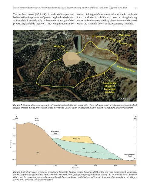
Figure 7. Oblique view, looking south, <strong>of</strong> preexisting l<strong>and</strong>slide <strong>and</strong> waste pile. Waste pile was constructed on top <strong>of</strong> a back-tilted<br />
surface created during previous l<strong>and</strong>slide movement. Google Earth image from 2009 National Agriculture Imagery Program.<br />
Figure 8. Geologic cross section <strong>of</strong> preexisting l<strong>and</strong>slide. Surface pr<strong>of</strong>ile based on DEM <strong>of</strong> the pre-road realignment l<strong>and</strong>scape.<br />
Bounds <strong>of</strong> preexisting l<strong>and</strong>slide (Qms) <strong>and</strong> waste pile are from geologic mapping conducted during this reconnaissance. L<strong>and</strong>slide<br />
(Qms) overlies intensely fractured <strong>and</strong> weathered shale, s<strong>and</strong>stone, <strong>and</strong> siltstone with minor lenses <strong>of</strong> silicic conglomerate (Zuju).<br />
See figure 5 for cross section line location.


