- Page 1 and 2: co 'a £? m&m i » .'£ ¥> I VVy^:
- Page 3 and 4: Cornell University Library QE 262.F
- Page 5 and 6: MEMOIRS OP THE GEOLOGICAL SURVEY. E
- Page 7: MEMOIRS OF THE GEOLOGICAL SURVEY. =
- Page 10 and 11: Vale of Eden. In both these tracts
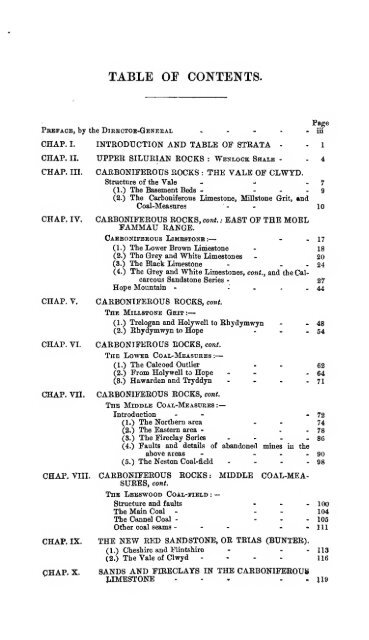
- Page 14 and 15: V1U Page CHAP. XI. SUPERFICIAL DEPO
- Page 17 and 18: THE GEOLOGY OP THE NEIGHBOURHOODS O
- Page 19 and 20: TABLE OF STBATA. 3 The various rock
- Page 21 and 22: . Machno WENLOCK SHALE, 5 the dip r
- Page 23 and 24: — VALM OF CLWYD. CHAPTER III. CAR
- Page 25 and 26: VALE OF CLWTD. In the description o
- Page 27 and 28: VALE OF OLWYD. 11 infiltrated with
- Page 29 and 30: VALE OF CLWYD. 13 distance, at the
- Page 31 and 32: . YALE OF CliWTD.. > 15 to the Toll
- Page 33 and 34: CARBONIFEROUS LIMESTONE. 17 CHAPTER
- Page 35 and 36: CARBONIFEROUS LIMESTONE. 19 These s
- Page 37 and 38: CARBONIFEROUS LTMESTONE. 21 to the
- Page 40 and 41: 24 CARBONIlfEBOUS KOCKS. (3.) The B
- Page 42 and 43: 26 CARBONIFEROUS ROCKS. these overl
- Page 44 and 45: 28 fJffAi't >-N ~ iffi L, ; - ? .'
- Page 46 and 47: 30 CARBONIFEKOtJS ROCKS. the crown
- Page 48 and 49: 32 CARBONIFEROUS ROOKS. Alyn, where
- Page 50 and 51: 34 CARBOHTFEBOUS EOCKS. Pradwctus.
- Page 52 and 53: $6 CAEBONIFEEOTTS ROCKS. The Bwlch-
- Page 54 and 55: Fig. 7. Comparative Sections of the
- Page 56 and 57: 40 CABBONIFEBOUS ROCKS. i Ki *g Co
- Page 58 and 59: -12 CARBONIFEROUS ROCKS. more find
- Page 60 and 61: 44 CARBONIFEROUS ROCKS. character a
- Page 62 and 63:
46 CABBOXIFEBOUS BOCKS. part of the
- Page 64 and 65:
48 CARBONIFEROUS ROCKS. replacement
- Page 66 and 67:
50 CABBOKirEKOUS KOCKS. shafts. Sou
- Page 68 and 69:
— 52 CARBONIFEROUS ROCKS. The Mil
- Page 70 and 71:
— 54 CARBONIFEROUS ROCKS. (2.) Bh
- Page 72 and 73:
56 CARBONIFEROUS ROCKS. It was not
- Page 74 and 75:
58 CAKBONIFEKOUS BOCKS. thin brittl
- Page 76 and 77:
60 CARBONIFEROUS HOCKS. ness, and n
- Page 78 and 79:
62 CARBONIFEROUS ROCK?, CHAPTER VI.
- Page 80 and 81:
64 CARBONIFEROUS ROOKS. as Dyffryn
- Page 82 and 83:
66 -CARBONIFEROUS ROCKS. Rectory, a
- Page 84 and 85:
68 CARBONIFEROUS ROCKS. We now reac
- Page 86 and 87:
70 .CARBONIFEROUS ROCKS. tp be expl
- Page 88 and 89:
72 CARBONIFEROUS ROCKS. CHAPTER VII
- Page 90 and 91:
74 GAjR-BQlUESROUS EOCBB. , . North
- Page 92 and 93:
76 CARBONIFEROUS ROCKS. sections at
- Page 94 and 95:
78 CARBONIFEROUS BOCKS. overlying c
- Page 96 and 97:
— 80 CARBONIFEROUS ROCKS. white r
- Page 98 and 99:
Feet.
- Page 100 and 101:
— 84 CARBONIFEROUS ROCKS. in thes
- Page 102 and 103:
** 6 T3ARBONTFEROU6 ROCK&' The dark
- Page 104 and 105:
88 CARBONIFEROUS ROCKS. At Buckley
- Page 106 and 107:
90 CAKBON1FEKOUS EOCKS. Mount Pleas
- Page 108 and 109:
CARBONIFEROUS ROCKS. called the " N
- Page 110 and 111:
94 CARBONIFEROUS ROCKS. Main Coal a
- Page 112 and 113:
96 CARBONIFEROUS ROCKS. W - ti * .B
- Page 114 and 115:
98 CARBONIFEROUS ROCKS. ecquently w
- Page 116 and 117:
100 CABBONIFEROUS KOCKS. CHAPTER VI
- Page 118 and 119:
102 CARBONIFEROUS BOCKS. The The gr
- Page 120 and 121:
104 CARBONIFEROUS ROCKS. Measures.
- Page 122 and 123:
106 G&3B0NIFEK0US ROCKS. within a l
- Page 124 and 125:
108 "CARBONIFEROUS ROCKS. The speci
- Page 126 and 127:
110 CAKBOKIF-EKOTJS fiOGKS. A small
- Page 128:
112; CARBONIFEROUS ROCKS. One of th
- Page 132 and 133:
THE NEW BED SANDSTONE. CHAPTER IX.
- Page 134 and 135:
THE NEW BED SANDSTONE. 115 is scarc
- Page 136 and 137:
VALE OF CLWYD. 117 than half the Ca
- Page 138 and 139:
SANDS AND FIKECLA.YS IN THE LIMESTO
- Page 140 and 141:
SANDS AND FIRECLAYS IN THE LIMESTON
- Page 142 and 143:
SANDS AND FIRECLAYS IN THE LIMESTON
- Page 144 and 145:
SANDS AND FIRECLAYS IN THE LIMESTON
- Page 146 and 147:
GLACIAL DRIFT. 127 under the Boulde
- Page 148 and 149:
GLACIAL DKIFT. 129 (1.) The Vale of
- Page 150 and 151:
GLACIAL DEIFT. 131 (3.) The Upper V
- Page 152 and 153:
GLACIAL DRIFT. 133 the gravel, abou
- Page 154 and 155:
. GLACIAW DRIFT. 1'35 generally on
- Page 156 and 157:
GLACIAL DEIFT. 137 that of the lowe
- Page 158 and 159:
— GLACIAL DRIFT. 139 plateau, sti
- Page 160 and 161:
GLACIAL DRIFT. 141 Measure sandston
- Page 162 and 163:
GLACIAL DEI FT. 143 and containing
- Page 164 and 165:
GLACIAL STBLX. 145 Fig. 17. Diagram
- Page 166 and 167:
BOULDERS. 147 well-known boulder ma
- Page 168 and 169:
K1VEE TERRACES. 149 CHAPTER XII. SU
- Page 170 and 171:
ESTUARY OF THE DEE» 15 L Tufa occu
- Page 172 and 173:
• ft - ? ESTUABY OF THE DEE. 153
- Page 174 and 175:
ESTUART OF THE DEE. J 55 buried und
- Page 176 and 177:
ESTUARY OF THE DEE. maintained by t
- Page 179:
Oeotoptrab Survey of£nglastd/ S Wa
- Page 182 and 183:
160 METALLIFEROUS MINES. of hills e
- Page 184 and 185:
162 METALLIFEROUS MINES. from a var
- Page 186 and 187:
164 LEAD AND ZINC MINES. stratum be
- Page 188 and 189:
166 LEAD AND ZINC MINES the western
- Page 190 and 191:
168 LEAR AXD ZINC MINES. crossed th
- Page 192 and 193:
17-0 LEAD AND ZINC MINES. They seem
- Page 194 and 195:
172 LEAD AND ZINC MINES. ing wall,
- Page 196 and 197:
lT4t LEAD AND ZINC MINES. 1 The —
- Page 198 and 199:
— 176 LEAD AND ZINC MINES. The fi
- Page 200 and 201:
178 LEAD AND ZINC MINES. The chert
- Page 202 and 203:
180 LEAD AND ZINC MINES. direction
- Page 204 and 205:
*82 . LEAD AND ZINC MINEri. thereby
- Page 206 and 207:
1°4 — LEAD AND ZINC MINES. syste
- Page 208 and 209:
186 LEAD AND ZINO MINES. Near the t
- Page 210:
188 LEAD AND ZINC MINES. A second c
- Page 214 and 215:
KHYDYMWYN TO GWEKX-Y-MYNYDK? 189 co
- Page 216 and 217:
UWJSBN-Y-MYNYDD TO MAES-Y-SAFN. 191
- Page 218 and 219:
GWKBN-Y-MYNYDD TO MAES-Y-SAFN. 193
- Page 220 and 221:
MAES-Y-8AFN TO NEAR LLANARMON. 195
- Page 222 and 223:
MAES-T-SAFN TO KEA.R LLANABMON. 197
- Page 224 and 225:
COLLIfcEIES AND liOKEHOLES. 199 APP
- Page 226 and 227:
Grey shale Hard stone Grey shale Bl
- Page 228 and 229:
Measures Bbassv Coal Measures Coal
- Page 230 and 231:
Soil — COLLIERIES AND BOEEHOLE8.
- Page 232 and 233:
COLLIE KIES AND BOREHOLES. 207
- Page 234 and 235:
z?:?/Z COLLIERIES "AND BOREHOLES. 2
- Page 236 and 237:
: rk Measures Bine Goal - Measures
- Page 238 and 239:
Measures Hollin Coal Measures Main
- Page 240 and 241:
BOKINGS IN THE ESTUABT OF THE DEE.
- Page 242 and 243:
— BOEINGS IN THE ESTTJABY OF THE
- Page 244 and 245:
BOEINGS IN THE ESTUARY OF THE DEE.
- Page 246 and 247:
WELLS NEABC THE WELSH BOEDER. 221:
- Page 248 and 249:
ECONOMIC GEOLOGY. 223 AwdytU^of the
- Page 250 and 251:
ECONOMIC GEOLOGY. 225 Chwarel Pen-y
- Page 252 and 253:
— CARBONIFEROUS. 227 TABLE II. Ca
- Page 254 and 255:
cabbojtifebouss, 211 3 2g . £g ED
- Page 256 and 257:
_^— CARBONIFEROUS. 231
- Page 258 and 259:
Aberdine, 36, 41, 192. " Aberdo" li
- Page 260 and 261:
Chwarel-las Veins, 177. Chwarel Pen
- Page 262 and 263:
Greenfield, Drift at, 140; tides at
- Page 264 and 265:
. ; Morton, Mr. 6. H., on the limes
- Page 266 and 267:
River Dee Company, 156. River Terra
- Page 268 and 269:
Missing Page
- Page 273:
?!^a^( J ' ' wwfvrPftww Ifiua i'-S'


