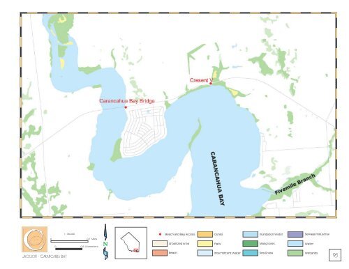
Jackson - Carancahua <strong>Bay</strong> 1 : 36,000 0 0.7 Miles 0 0.8 Kilometers N <strong>Beach</strong> <strong>and</strong> <strong>Bay</strong> <strong>Access</strong> Urbanized Area <strong>Beach</strong> Dunes Flats Intermittent Water Inundation Water Mangroves Sea Grass Sewage/Industrial Water Wetl<strong>and</strong>s 95
96 Coastal Bend Saltwater <strong>Bay</strong>s: 674,000 surface acres <strong>Bay</strong>s: Alazan, Aransas, Baffin, Copano, Corpus Christi, Laguna Madre, Mission, Nueces, <strong>and</strong> St. Charles <strong>Bay</strong>s ARANSAS COUNTY Population: 22,497 Area: 527 square miles Recreation: Fishing, hunting, bird sanctuaries. Settlement of this area began in 1829 by the Irish <strong>and</strong> Mexicans. Its name is derived from Rio Nuestra Senora de Aranzazu, a Spanish palace. Aransas County was created in 1871. Aransas County has coastal plains, s<strong>and</strong>y loam, <strong>and</strong> coastal clays. The local economy is based primarily on tourism, oil <strong>and</strong> gas production, <strong>and</strong> commercial fishing. KENEDY COUNTY Population: 414 Area: 1,945 square miles Recreation: Hunting, fishing. Kenedy County was created in 1921 <strong>and</strong> named after a pioneer steamboat operator <strong>and</strong> cattleman, Captain Mifflin Kenedy. This area’s physical features are defined by flat, s<strong>and</strong>y terrain with some loam soils <strong>and</strong> live oaks. The largest industries in 1999 were mining, state <strong>and</strong> local government, <strong>and</strong> farming. There are no public access sites along the bay shoreline of Kenedy County. The county’s Gulf beaches are part of the Padre Isl<strong>and</strong> National Seashore. KLEBERG COUNTY Population: 31,549 Area: 1,090 square miles Recreation: Gulf beaches, fishing, hunting, water sports, wildlife sanctuaries. The county was established in 1913 <strong>and</strong> named after San Jacinto military veteran <strong>and</strong> rancher, Robert Kleberg. The county is largely defined by coastal plains, <strong>and</strong> s<strong>and</strong>y, loam, <strong>and</strong> clay soils. This area’s economy is based on a naval air station, a ranch operation, chemicals <strong>and</strong> plastics, <strong>and</strong> the <strong>Texas</strong> A&M University at Kingsville. NUECES COUNTY Population: 313,645 Area: 1,166 square miles Recreation: Gulf beaches, fishing, water sports, wildlife viewing, state park. The county was formed in 1846. The county name is derived from the Spanish word for "nuts." Nueces County has flat, rich soils. It is broken by bays <strong>and</strong> includes Mustang Isl<strong>and</strong>. The local economy is based on petroleum processing, deepwater port facilities, agriculture, tourism, conventions, coastal shipping, <strong>and</strong> manufacturing.
- Page 2 and 3:
The Texas Gulf Coast The Texas Gulf
- Page 4 and 5:
Introduction It’s no wonder that
- Page 7 and 8:
Beach and Bay Public Access Sites 5
- Page 9 and 10:
8 JEFFERSON COUNTY Site/Area Locati
- Page 11 and 12:
10 Jefferson - Beaumont 1 : 36,000
- Page 13 and 14:
12 Jefferson - Taylor Bayou 1 : 36,
- Page 15 and 16:
14 Jefferson - Sabine Pass 1 : 36,0
- Page 17 and 18:
16 Site/Area Location (Includes nea
- Page 19 and 20:
18 Orange - Orange Area 1 : 36,000
- Page 21 and 22:
20 Orange - Humble Island 1 : 36,00
- Page 23 and 24:
HARRIS COUNTY Population: 3,400,578
- Page 25 and 26:
24 Site/Area Location (Includes nea
- Page 27 and 28:
26 Brazoria 1 : 318,093 0 6 Miles 0
- Page 29 and 30:
28 Brazoria - Bastrop Bayou 1 : 36,
- Page 31 and 32:
30 Brazoria - Swan lake Beach 1 : 4
- Page 33 and 34:
32 Brazoria - Oyster Creek 1 : 40,0
- Page 35 and 36:
34 Brazoria - Holiday shores 1 : 40
- Page 37 and 38:
36 Chambers 1 : 272,069 0 2 Miles 0
- Page 39 and 40:
38 Chambers - fort Anahuac 1 : 36,0
- Page 41 and 42:
40 Chambers - Smith Point 1 : 36,00
- Page 43 and 44:
42 Site/Area Location (Includes nea
- Page 45 and 46: 44 Site/Area Location (Includes nea
- Page 47 and 48: 46 Site/Area Location (Includes nea
- Page 49 and 50: 48 Galveston - Clear Lake 1 : 36,00
- Page 51 and 52: 50 Galveston - Dickinson Bay 1 : 36
- Page 53 and 54: 52 Galveston - Jones Bay 1 : 36,000
- Page 55 and 56: 54 Galveston - Rollover Pass 1 : 36
- Page 57 and 58: 56 Galveston - OceanShore 1 : 36,00
- Page 59 and 60: 58 Galveston - East Beach 1 : 36,00
- Page 61 and 62: 60 Galveston - Lake Como 1 : 36,000
- Page 63 and 64: 62 Galveston - San Luis Pass 1 : 36
- Page 65 and 66: 64 Site/Area Location (Includes nea
- Page 67 and 68: 66 Harris -Lynchburg 1 : 36,000 0 0
- Page 69 and 70: 68 Harris - Morgans Point 1 : 36,00
- Page 71 and 72: 70 Harris - clear Lake 1 : 36,000 0
- Page 73 and 74: 72 Matagorda COUNTY Site/Area Locat
- Page 75 and 76: 74 Matagorda - Parkers Cut 1 : 36,0
- Page 77 and 78: 76 Matagorda - Matagorda 1 : 36,000
- Page 79 and 80: 78 1 : 36,000 Matagorda - Carancahu
- Page 81 and 82: 80 Calhoun COUNTY Site/Area Locatio
- Page 83 and 84: 82 Calhoun 1 : 240,334 0 4 Miles 0
- Page 85 and 86: 84 Calhoun - Point Comfort 1 : 40,0
- Page 87 and 88: 86 Calhoun - Port lavaca 1 : 40,000
- Page 89 and 90: 88 Calhoun - Powderhorn Lake 1 : 36
- Page 91 and 92: 90 Calhoun - Seadrift 1 : 36,000 0
- Page 93 and 94: 92 Site/Area Location (Includes nea
- Page 95: 94 Jackson - Red Bluff 1 : 45,000 0
- Page 99 and 100: 98 Aransas COUNTY Site/Area Locatio
- Page 101 and 102: 100 Aransas - Goose Island 1 : 36,0
- Page 103 and 104: 102 Aransas - Palm Harbor 1 : 36,00
- Page 105 and 106: 104 Site/Area Location (Includes ne
- Page 107 and 108: 106 Kleberg - Arana Creek 1 : 50,00
- Page 109 and 110: 108 Site/Area Location (Includes ne
- Page 111 and 112: 110 Nueces 1 : 310,491 0 3 Miles 0
- Page 113 and 114: 112 Nueces - Aransas pass 1 : 36,00
- Page 115 and 116: 114 Nueces - Ropes Park 1 : 36,000
- Page 117 and 118: 116 Nueces - Waldron 1 : 36,000 0 0
- Page 119 and 120: 118 Refugio COUNTY Site/Area Locati
- Page 121 and 122: 120 Refugio - Bayside 1 : 36,000 0
- Page 123 and 124: 122 Refugio - austwell 1 : 36,000 0
- Page 125 and 126: 124 San patricio 1 : 310,491 0 3 Mi
- Page 127 and 128: 126 San patricio - Redfish Bay 1 :
- Page 129 and 130: Lower Rio Grande Valley Saltwater B
- Page 131 and 132: 130 Site/Area Location (Includes ne
- Page 133 and 134: 132 1 : 36,000 0 0.7 Miles Cameron
- Page 135 and 136: 134 Cameron - Port Isabel 1 : 36,00
- Page 137 and 138: 136 Willacy 1 : 273,963 0 3 Miles 0
- Page 139 and 140: National Wildlife Refuges 139
- Page 141 and 142: Wildlife Management Areas 143
- Page 143 and 144: Chambers of Commerce and Visitor Ce
- Page 145 and 146: Palacios Chamber of Commerce 312 Ma
- Page 147 and 148:
The Texas General Land Office does