The Walkbook - Simsbury Land Trust
The Walkbook - Simsbury Land Trust
The Walkbook - Simsbury Land Trust

You also want an ePaper? Increase the reach of your titles
YUMPU automatically turns print PDFs into web optimized ePapers that Google loves.
60<br />
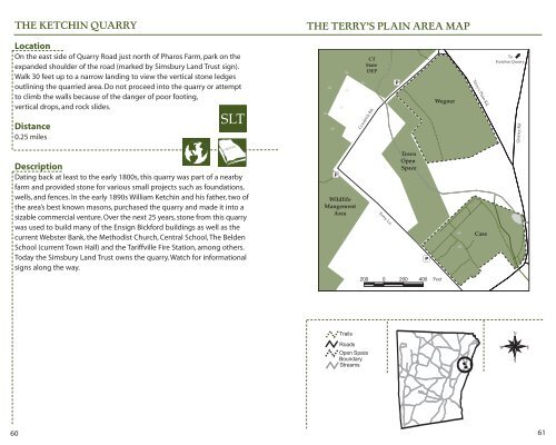
THE KETCHIN QUARRY<br />
Location<br />
On the east side of Quarry Road just north of Pharos Farm, park on the<br />
expanded shoulder of the road (marked by <strong>Simsbury</strong> <strong>Land</strong> <strong>Trust</strong> sign).<br />
Walk 30 feet up to a narrow landing to view the vertical stone ledges<br />
outlining the quarried area. Do not proceed into the quarry or attempt<br />
to climb the walls because of the danger of poor footing,<br />
vertical drops, and rock slides.<br />
Distance<br />
0.25 miles<br />
SLT<br />
Description<br />
Dating back at least to the early 1800s, this quarry was part of a nearby<br />
farm and provided stone for various small projects such as foundations,<br />
wells, and fences. In the early 1890s William Ketchin and his father, two of<br />
the area’s best known masons, purchased the quarry and made it into a<br />
sizable commercial venture. Over the next 25 years, stone from this quarry<br />
was used to build many of the Ensign Bickford buildings as well as the<br />
current Webster Bank, the Methodist Church, Central School, <strong>The</strong> Belden<br />
School (current Town Hall) and the Tariffville Fire Station, among others.<br />
Today the <strong>Simsbury</strong> <strong>Land</strong> <strong>Trust</strong> owns the quarry. Watch for informational<br />
signs along the way.<br />
THE TERRY’S PLAIN AREA MAP<br />
CT<br />
State<br />
DEP<br />
Goodrich Rd.<br />
Wildlife<br />
Mangement<br />
Area Ferry Ln.<br />
Town<br />
Open<br />
Space<br />
Wegner<br />
Feet<br />
Terry's Plain Rd.<br />
Case<br />
To<br />
Ketchin Quarry<br />
Quarry Rd.<br />
61