The Walkbook - Simsbury Land Trust
The Walkbook - Simsbury Land Trust
The Walkbook - Simsbury Land Trust

You also want an ePaper? Increase the reach of your titles
YUMPU automatically turns print PDFs into web optimized ePapers that Google loves.
70<br />
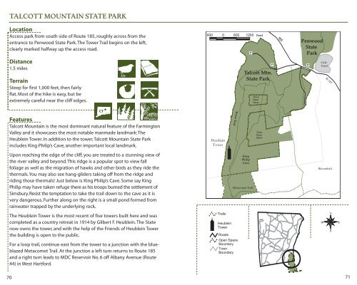
TALCOTT MOUNTAIN STATE PARK<br />
Location<br />
Access park from south side of Route 185, roughly across from the<br />
entrance to Penwood State Park. <strong>The</strong> Tower Trail begins on the left,<br />
clearly marked halfway up the access road.<br />
Distance<br />
1.5 miles<br />
Terrain<br />
Steep for first 1,000 feet, then fairly<br />
flat. Most of the hike is easy, but be<br />
extremely careful near the cliff edges.<br />
Features<br />
Talcott Mountain is the most dominant natural feature of the Farmington<br />
Valley and it showcases the most notable manmade landmark: <strong>The</strong><br />
Heublein Tower. In addition to the tower, Talcott Mountain State Park<br />
includes King Philip’s Cave, another important local landmark.<br />
Upon reaching the edge of the cliff, you are treated to a stunning view of<br />
the river valley and beyond. This ridge is a popular spot to view fall<br />
foliage as well as the migration of hawks and other birds as they ride the<br />
thermals. You may also see hang-gliders taking off from the ridge and<br />
riding those thermals! Just below is King Philip’s Cave. Some say King<br />
Philip may have taken refuge there as his troops burned the settlement of<br />
<strong>Simsbury</strong>. Resist the temptation to take the trail down to the cave as it is<br />
very dangerous. Further along on the right is a small pond formed from<br />
rainwater trapped by the underlying rock.<br />
<strong>The</strong> Heublein Tower is the most recent of five towers built here and was<br />
completed as a country retreat in 1914 by Gilbert F. Heublein. <strong>The</strong> State<br />
now owns the tower, and with the help of the Friends of Heublein Tower<br />
the building is open to the public.<br />
For a loop trail, continue east from the tower to a junction with the blueblazed<br />
Metacomet Trail. At the junction a left turn returns to Route 185<br />
and a right turn leads to MDC Reservoir No. 6 off Albany Avenue (Route<br />
44) in West Hartford.<br />
CT<br />
Tower Trail<br />
Feet<br />
Talcott Mtn.<br />
State Park<br />
King<br />
Philip<br />
Cave<br />
Metacomet Trail<br />
Town<br />
Open<br />
Space<br />
Town<br />
Open<br />
Space<br />
Penwood<br />
State<br />
Park<br />
Gale<br />
Pond<br />
Rt.185<br />
Bloomfield<br />
71