Slieve Mish Mountains cSAC Site Code 2185 Co. Kerry
Slieve Mish Mountains cSAC Site Code 2185 Co. Kerry
Slieve Mish Mountains cSAC Site Code 2185 Co. Kerry

You also want an ePaper? Increase the reach of your titles
YUMPU automatically turns print PDFs into web optimized ePapers that Google loves.
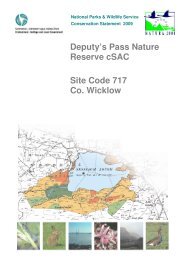
National Parks & Wildlife Service<br />
<strong>Co</strong>nservation Statement 2009<br />
<strong>Slieve</strong> <strong>Mish</strong> <strong>Mountains</strong><br />
<strong>cSAC</strong><br />
<strong>Site</strong> <strong><strong>Co</strong>de</strong> <strong>2185</strong><br />
<strong>Co</strong>. <strong>Kerry</strong>
SUMMARY<br />
Introduction<br />
<strong>Slieve</strong> <strong>Mish</strong> <strong>Mountains</strong> <strong>cSAC</strong> has been designated as a candidate Special Area of <strong>Co</strong>nservation<br />
under the EU Habitats Directive The site has been designated due to the presence of four Annex I<br />
habitats listed under EU Habitats Directive, which comprises three types of heath habitat (Northern<br />
Atlantic wet heaths, Alpine and Boreal heaths, European dry heaths) and vegetated cliff areas<br />
(Siliceous rocky slopes with chasmophytic vegetation). In simple terms, the latter are areas of peaty<br />
soils and scree with heathers and related plants and communities of other plants adapted to low<br />
nutrients and extremes of temperature. The site has also been designated for Killarney Fern, a<br />
species listed under Annex II of the EU Habitats Directive.<br />
Nature conservation value of <strong>Slieve</strong> <strong>Mish</strong> <strong>Mountains</strong> <strong>cSAC</strong><br />
The site supports four Annex I habitats listed under the EU Habitats Directive and one species, the<br />
Killarney Fern, which is listed on Annex II of the same Directive.<br />
With regard to Northern Atlantic wet heath, much of the wet heath occurs within a mosaic of other<br />
habitats, particularly dry heath, upland grassland and blanket bog. Where wet heath is relatively<br />
undamaged, it is bryophyte-rich with a high diversity of species. In damaged areas (due to<br />
overgrazing), the heath is being invaded by atypical plants such as <strong>Co</strong>mmon Gorse, rushes and Mat<br />
Grass. However, the habitat mosaics containing wet heath are reasonably extensive and a<br />
reasonable quantity of relatively undamaged wet heath remains.<br />
The European dry heath present on the site is rich in bryophytes including many moss species, with<br />
a diverse moss component, and many liverworts. The areas of dry heath are dominated by<br />
characteristic species of woody sub-shrubs e.g. Ling Heather and Bell Heather and retain a good<br />
structure, although grazing levels has served to degrade the quality of some of this habitat within<br />
the site.<br />
Alpine and Boreal heath consists of a dwarf shrub heath and due to natural erosion, has a natural<br />
open nature. It includes rare species such as Dwarf Willow (Webb et al., 1996). Within Ireland,<br />
Alpine and Boreal heath is generally poorly represented with only some of the typical elements<br />
represented. Alpine and Boreal heath on this site, although needing further investigation, is at least<br />
of reasonable quality with a number of characteristic species present.<br />
The main cliff areas (i.e. siliceous rocky slope habitat) occur on the northern side between<br />
Knockbrack and Knockauncorragh. Species diversity is enhanced by the presence of dry cliff tops<br />
and lower wetter cliff areas. Saxifrages and liverworts are common. Uncommon species present<br />
include Irish Saxifrage and Dwarf Willow. Overall, the site provides good examples of<br />
chasmophyptic vegetation types, sheltering relict arctic-alpine flora and important bryophyte and<br />
lichen assemblages.<br />
Dept. of Environment, Heritage and Local Government 1 CS Version 1.01 2009
2 <strong>Co</strong>nservation Statement <strong>Slieve</strong> <strong>Mish</strong> <strong>Mountains</strong> <strong>cSAC</strong> — <strong>Site</strong> <strong><strong>Co</strong>de</strong> <strong>2185</strong><br />
The single recorded population of the Killarney Fern is a good-sized one and represents<br />
approximately 2.3% of the known national population. It is in a typical location on a vertical rock<br />
face by a small waterfall. It is relatively undisturbed. At present, there are no obviously damaging<br />
activities affecting the population and its habitat.<br />
Description of <strong>Slieve</strong> <strong>Mish</strong> <strong>Mountains</strong> <strong>cSAC</strong><br />
The <strong>Slieve</strong> <strong>Mish</strong> <strong>Mountains</strong> <strong>cSAC</strong> is situated on the Dingle Peninsula, <strong>Co</strong>. <strong>Kerry</strong>. The mountains<br />
stretch from the outskirts of Tralee town in the east to the villages of Camp and Inch in the west.<br />
The principal habitat present on the site is heath, with dry, wet and alpine sub-categories occurring.<br />
The dominant plant species include Ling Heather, Bell Heather, Bilberry, Cross-leaved Heath,<br />
Purple Moor-grass, Autumn Gorse, <strong>Co</strong>mmon <strong>Co</strong>tton-grass, Deer-grass and various mosses, lichens<br />
and liverworts. Scree and exposed rock are other notable habitats supporting various saxifrages,<br />
Harebell, Roseroot, Dwarf Willow, Alpine Scurvy-grass and a number of mosses and liverworts.<br />
Other habitats present include oligotrophic lakes, blanket bog, upland grassland on peaty soil, dry<br />
broad-leaved, semi-natural woodland, streams, fens/flushes, cutaway bog and a small quarried area.<br />
Notable (rare/uncommon) plant species occur including Killarney Fern, Betony, <strong>Co</strong>rnish<br />
Moneywort, Dwarf Willow, Irish Saxifrage, Ivy-leaved Bellflower, Lemon-scented Fern and a<br />
number of bryophytes. Peregrine Falcon (breeding) and Chough are present within the site, both of<br />
which are listed under Annex I of the EU Birds Directive.<br />
The principal land use is extensive sheep and cattle grazing with occasional small-scale turf<br />
cutting. Overgrazing is the major management issue to be addressed.<br />
Main conservation objectives<br />
• To maintain the Annex I habitats for which the <strong>cSAC</strong> has been selected at favourable<br />
conservation status; Northern Atlantic wet heaths with Erica tetralix (20% area of the site),<br />
European dry heaths (40% area of the site), Alpine and Boreal heaths (7% area of the site), and<br />
Siliceous rocky slopes with chasmophytic vegetation (1% area of the site)<br />
• To maintain the Annex II species for which the <strong>cSAC</strong> has been selected at favourable<br />
conservation status; Killarney Fern (Trichomanes speciosum)<br />
• To maintain the extent, species richness and biodiversity of the entire site<br />
• To establish effective liaison and co-operation with landowners, legal users and relevant<br />
authorities.<br />
Main management issues<br />
• Burning<br />
• Grazing<br />
• Ownership and resources<br />
• Tracks<br />
• Turf cutting<br />
Dept. of Environment, Heritage and Local Government CS Version 1.01 2009
Summary<br />
Scientific monitoring and inspection<br />
Monitoring of <strong>Slieve</strong> <strong>Mish</strong> <strong>Mountains</strong> <strong>cSAC</strong> will be carried out by the Monitoring Section of the<br />
NPWS to determine if the Annex I habitats are being maintained at favourable conservation status.<br />
Regular inspection of the site by regional NPWS staff will identify any major changes that occur.<br />
Dept. of Environment, Heritage and Local Government CS Version 1.01 2009<br />
3
TABLE OF CONTENTS<br />
Summary .......................................................................................................................................................1<br />
Reader’s Guide .......................................................................................................................................................6<br />
Legal Background....................................................................................................................................................7<br />
Nature <strong>Co</strong>nservation Legislation .........................................................................................................................7<br />
Roles of Government Departments and Agencies..............................................................................................8<br />
Implications of <strong>Site</strong> Designation for Landowners and other <strong>Site</strong> Users ............................................................10<br />
Nature <strong>Co</strong>nservation Value of <strong>Slieve</strong> <strong>Mish</strong> <strong>Mountains</strong> <strong>cSAC</strong> ................................................................................11<br />
Reason for Designation of <strong>Slieve</strong> <strong>Mish</strong> <strong>Mountains</strong> <strong>cSAC</strong> .................................................................................11<br />
<strong>Co</strong>nservation Value of <strong>Slieve</strong> <strong>Mish</strong> <strong>Mountains</strong> <strong>cSAC</strong>........................................................................................12<br />
<strong>Co</strong>nservation Objectives ...................................................................................................................................13<br />
<strong>Site</strong> Description .....................................................................................................................................................14<br />
Location Including <strong>Site</strong> Boundaries...................................................................................................................14<br />
Legal Status.......................................................................................................................................................15<br />
Physical Features..............................................................................................................................................15<br />
Biological Features............................................................................................................................................17<br />
Land Use ...........................................................................................................................................................24<br />
Management Issues ..........................................................................................................................................26<br />
Scientific Monitoring & Inspection..........................................................................................................................28<br />
Dept. of Environment, Heritage and Local Government 4 CS Version 1.01 2009
Table of <strong>Co</strong>ntents<br />
APPENDICES<br />
Appendix I: Glossary..............................................................................................................................................29<br />
Appendix II: Reference Material ............................................................................................................................36<br />
Appendix III: Climate..............................................................................................................................................38<br />
Appendix IV: List of Townlands .............................................................................................................................39<br />
Appendix V: <strong>Co</strong>mpensation Procedures................................................................................................................40<br />
Appendix VI: Notifiable Actions .............................................................................................................................41<br />
Appendix VII: Farming <strong>Co</strong>nditions under REPS....................................................................................................60<br />
Appendix VIII: National Parks and Wildlife <strong>Co</strong>ntact Details...................................................................................63<br />
MAPS<br />
Map 1 <strong>Site</strong> Location and Boundary Map (Ver. 1.01)<br />
Map 2 <strong>Site</strong> Ownership Map<br />
Map 3 Indicative Habitat Map<br />
Dept. of Environment, Heritage and Local Government CS Version 1.01 2009<br />
5
READER’S GUIDE<br />
The National Parks and Wildlife Service (NPWS) of the Department of the Environment, Heritage<br />
and Local Government (DEHLG) has produced this document to provide ecological information<br />
about <strong>Slieve</strong> <strong>Mish</strong> <strong>Mountains</strong> <strong>cSAC</strong> and to outline the main objectives for the conservation of the<br />
special features of the site.<br />
The Legal background section outlines the legislative and policy drivers for the site’s designation<br />
and identifies the relevant authorities with responsibilities in relation to the site.<br />
The Nature <strong>Co</strong>nservation Value section describes the reasons for the site designation and lists<br />
the site specific <strong>Co</strong>nsevation Objectives.<br />
The <strong>Site</strong> Description section contains general information on the site’s boundaries and ownership<br />
and on the statutory bodies with responsibility for its conservation. It also contains sections on the<br />
physical aspects of the site such as the geology and hydrology as well as the biological features,<br />
in particular, the habitats and species found there. Land use and cultural features are also<br />
described.<br />
The Scientific Monitoring and Inspection section outlines the methodologies used for monitoring<br />
the conservation status of the site and identifying any changes that occur.<br />
The appendices include a glossary where scientific and technical terms are explained, reference<br />
material consulted in the preparation of the statement and a list of notifiable actions relevant to<br />
each habitat within the site.<br />
Dept. of Environment, Heritage and Local Government 6 CS Version 1.01 2009
LEGAL BACKGROUND<br />
Nature <strong>Co</strong>nservation Legislation<br />
The legal basis for selection and designation of Special Areas of <strong>Co</strong>nservation (SACs) is the EU<br />
Habitats Directive, which was adopted in 1992. Focusing on the conservation of natural and seminatural<br />
habitats and species of flora and fauna, the Habitats Directive seeks to establish “Natura<br />
2000”, a network of protected areas throughout the European <strong>Co</strong>mmunity. The Habitats Directive<br />
includes a list of habitats that require SAC designation and specific conservation measures. This<br />
list is known as Annex I and the habitats are referred to as Annex I habitats. On this list, habitats<br />
that require special attention because they are in danger of disappearance, are termed ‘priority<br />
habitats’. A second list, Annex II in the Habitats Directive comprises species that must be afforded<br />
special protection.<br />
In Ireland, the habitats and species that must be afforded protection under the Habitats Directive<br />
include:<br />
16 Annex I priority habitats that require particular attention – including raised bogs, active blanket<br />
bogs, turloughs and machair,<br />
45 other Annex I habitats – such as certain types of heaths, lakes and woodlands,<br />
25 Annex II species – including Otter, Freshwater Pearl Mussel and Killarney Fern.<br />
It is the responsibility of each member state to designate SACs to protect the Annex I habitats and<br />
Annex II species. These sites, together with the Special Protection Areas (SPAs) designated under<br />
the EU Birds Directive (1979), form the European “Natura 2000” network.<br />
The Birds Directive contains annexes, which are lists of birds that require particular conservation<br />
measures (Annex I), and also species that may be hunted, and species that may be sold. There are<br />
28 Annex I species regularly occurring in Ireland including Whooper Swan, Greenland Whitefronted<br />
Goose, Peregrine Falcon, <strong>Co</strong>rncrake and Terns. Member states are also required to protect<br />
wetlands and their associated water birds and sites that are important for migratory species such as<br />
ducks, geese and waders<br />
The Habitats Directive was transposed into Irish law through the European <strong>Co</strong>mmunities<br />
(Natural Habitats) Regulations 1997. The Wildlife Act 1976 is the main statute governing the<br />
protection of wildlife in Ireland and was amended in 2000 to take account of European law,<br />
particularly the Habitats and Birds Directives. The Wildlife (Amendment) Act 2000 also makes<br />
legal provision for the designation and protection of a national network of Natural Heritage Areas<br />
(NHAs). Over 1,100 proposed NHAs were published in 1995 and almost 400 of these are also<br />
selected as candidate SACs.<br />
Dept. of Environment, Heritage and Local Government 7 CS Version 1.01 2009
8 <strong>Co</strong>nservation Statement <strong>Slieve</strong> <strong>Mish</strong> <strong>Mountains</strong> <strong>cSAC</strong> — <strong>Site</strong> <strong><strong>Co</strong>de</strong> <strong>2185</strong><br />
The European <strong>Co</strong>mmunities (Natural Habitats) Regulations 1997 include the following points:<br />
The Minister for the Environment, Heritage and Local Government must transmit a candidate list<br />
of sites to the European <strong>Co</strong>mmission for consideration.<br />
Following adoption of this list by the <strong>Co</strong>mmission, the Minister will formally designate the sites as<br />
SACs.<br />
<strong>Site</strong>s are legally protected once they are publicly advertised.<br />
Landowners and other users with a legal entitlement should be notified of designation, and the<br />
Minister must make all reasonable efforts to do so. Notification also includes a list of activities<br />
that may alter, damage, destroy or interfere with the integrity of the site. A person who illegally<br />
damages a site may be prosecuted or required to repair damage.<br />
Landowners and other users with a legal entitlement may appeal the designation of lands on<br />
scientific grounds, within three months of the designation notification.<br />
Landowners and other users with a legal entitlement will be compensated for actual loss of<br />
income arising from restrictions imposed as a result of designation.<br />
Roles of Government Departments and<br />
Agencies<br />
Department of the<br />
Environment, Heritage and<br />
Local Government<br />
(DEHLG)<br />
National Parks & Wildlife<br />
Service (NPWS)<br />
DEHLG is the government department with responsibility for the<br />
designation and protection of wildlife habitats, species and areas of<br />
conservation interest. As part of their responsibility in relation to<br />
biodiversity and wildlife under the Wildlife Acts (1976 and 2000), the<br />
Minister’s brief extends far beyond the habitats and species listed in the<br />
annexes of the Habitats and Birds Directives.<br />
NPWS is the section of the DEHLG responsible for maintaining the<br />
nature conservation value of the site. Periodic inspection of the site is<br />
carried out by the local <strong>Co</strong>nservation Ranger.<br />
Regional staff also participate in research and survey projects by<br />
collecting data on the site, provide advice to planning authorities on the<br />
impacts of development applications and provide an education and<br />
advisory service to the public. See Appendix VIII for NPWS contact<br />
details.<br />
<strong>Kerry</strong> <strong>Co</strong>unty <strong>Co</strong>uncil <strong>Kerry</strong> <strong>Co</strong>unty <strong>Co</strong>uncil is the planning authority for the site. As such it is<br />
obliged to ensure appropriate assessment of the implications of<br />
developments requiring planning permission that may have an impact,<br />
either individually or in combination with other developments on the<br />
designated area.<br />
Environmental Protection<br />
Agency (EPA)<br />
The EPA is an independent state sponsored body with a wide range of<br />
statutory duties including monitoring environmental quality and<br />
overseeing the performance by local authorities of their statutory<br />
environmental protection functions.<br />
Dept. of Environment, Heritage and Local Government CS Version 1.01 2009
Legal Background<br />
Department of Agriculture,<br />
Fisheries and Food (DAFF)<br />
DAFF is the government department responsible for the development and<br />
regulation of agriculture, fisheries, forestry and the food industry,<br />
including the administration of schemes such as the Rural Environment<br />
Protection Scheme (REPS), the Native Woodland Scheme (NWS), and<br />
<strong>Co</strong>mmonage Framework Plans (CFPs). In 2007 the Department assumed<br />
the additional responsibility for sea fisheries, aquaculture, marine<br />
research, marine engineering and pier and harbour development (non<br />
commercial) and associated agencies such as Bord Iascaigh Mhara (BIM)<br />
and the Marine Institute.<br />
Under Regulation 31 of the EC (Natural Habitats) Regulations, DAFF<br />
have responsibility for ensuring that activities it regulates do not<br />
adversely affect <strong>cSAC</strong>s. Monitoring functions are carried out by<br />
individual divisions or executive agencies of the department.<br />
The Forest Service The Forest Service is the statutory body responsible for ensuring the<br />
development of forestry within Ireland in a manner and to a scale that<br />
maximises its contribution to national socio-economic well-being on a<br />
sustainable basis that is compatible with the protection of the<br />
environment.<br />
The Department of<br />
<strong>Co</strong>mmunications, Energy<br />
and Natural Resources<br />
(DCENR)<br />
The Central Fisheries<br />
Board<br />
Southern Regional Fisheries<br />
Board<br />
DCENR is the government agency with responsibility for<br />
<strong>Co</strong>mmunications, Energy and Natural Resources, including the Inland<br />
Fisheries Division. It holds corporate governance of the Central and<br />
Regional Fisheries Boards and the Loughs Agency.<br />
The Central Fisheries Board is the statutory body is responsible for the<br />
co-ordination and support of the seven regional fisheries boards. Its<br />
responsibilities also include the control of commercial salmon licensing.<br />
The Southern Regional Fisheries Board is responsible for maintaining<br />
and improving environmental quality and developing and protecting the<br />
fisheries resource in their region. The Boards responsibilities cover both<br />
inland waterways and out to the twelve-mile limit off the coast.<br />
Local Authority Policy in Relation to the <strong>Site</strong><br />
The <strong>Kerry</strong> <strong>Co</strong>unty (Draft) Development Plan 2009-2015 (Chapter 11, Natural Environment) states<br />
objectives in relation to EU and National Designations;<br />
EN 11-21 Ensure that development likely to have serious adverse effects on the areas listed will not<br />
normally be permitted. The designation of sites does not imply a total restriction on all<br />
development. Applicants must demonstrate that the proposed development will not have a negative<br />
impact on the fauna, flora or habitat being protected.<br />
EN 11-22 Ensure that any development proposal in the vicinity of or affecting in any way a<br />
designated SAC, SPA or NHA provides sufficient information showing how its proposals will<br />
impact on the designated site. Appropriate mitigation measures must be indicated.<br />
The objective (EN 11-23) in relation to Special Areas of <strong>Co</strong>nservation is to ‘Maintain the<br />
conservation value of those sites identified by The National Parks and Wildlife Service of the<br />
Department of Environment, Heritage & Local Government, as Special Areas of <strong>Co</strong>nservation as<br />
well as any other sites that may be so identified during the lifetime of this plan.’<br />
Dept. of Environment, Heritage and Local Government CS Version 1.01 2009<br />
9
10 <strong>Co</strong>nservation Statement <strong>Slieve</strong> <strong>Mish</strong> <strong>Mountains</strong> <strong>cSAC</strong> — <strong>Site</strong> <strong><strong>Co</strong>de</strong> <strong>2185</strong><br />
Implications of <strong>Site</strong> Designation for<br />
Landowners and other <strong>Site</strong> Users<br />
In most areas designated as <strong>cSAC</strong>s, current practices will not have to change significantly.<br />
In cases where users with a legal entitlement are required to change practices or restrict activities to<br />
protect the wildlife interest of the site, compensation will be payable based on actual loss of<br />
income. See Appendix V for further details.<br />
If a user with a legal entitlement wishes to carry out certain activities, not covered by licence or<br />
consent from another statutory body, within the designated area, they must consult with, and get<br />
consent from, the Minister for the Environment, Heritage and Local Government. These activities<br />
are listed as “Notifiable Actions” for each habitat (see Appendix VI).<br />
Dept. of Environment, Heritage and Local Government CS Version 1.01 2009
NATURE CONSERVATION VALUE<br />
OF SLIEVE MISH MOUNTAINS<br />
CSAC<br />
Reason for Designation of <strong>Slieve</strong> <strong>Mish</strong><br />
<strong>Mountains</strong> <strong>cSAC</strong><br />
This section outlines the habitats and species occurring within the site that are the basis for the<br />
designation of the site because of their relative importance, both at a national and <strong>Co</strong>mmunity<br />
level.<br />
HABITATS LISTED IN ANNEX I OF<br />
THE EU HABITATS DIRECTIVE<br />
• Northern Atlantic wet heaths with<br />
Erica tetralix (EU Habitat <strong><strong>Co</strong>de</strong> 4010)<br />
• European dry heaths (EU Habitat<br />
<strong><strong>Co</strong>de</strong> 4030)<br />
• Alpine and Boreal heaths (EU<br />
Habitat <strong><strong>Co</strong>de</strong> 4060)<br />
• Siliceous rocky slopes with<br />
chasmophytic vegetation (EU<br />
Habitat <strong><strong>Co</strong>de</strong> 8220)<br />
SPECIES LISTED IN ANNEX II OF<br />
THE EU HABITATS DIRECTIVE<br />
• Killarney Fern<br />
(Trichomanes speciosum)<br />
Dept. of Environment, Heritage and Local Government 11 CS Version 1.01 2009
12 <strong>Co</strong>nservation Statement <strong>Slieve</strong> <strong>Mish</strong> <strong>Mountains</strong> <strong>cSAC</strong> — <strong>Site</strong> <strong><strong>Co</strong>de</strong> <strong>2185</strong><br />
<strong>Co</strong>nservation Value of <strong>Slieve</strong> <strong>Mish</strong><br />
<strong>Mountains</strong> <strong>cSAC</strong><br />
The site supports four Annex I habitats listed under the EU Habitats Directive and one species, the<br />
Killarney Fern, which is listed on Annex II of the same Directive.<br />
With regard to Northern Atlantic wet heath with Erica tetralix, much of the wet heath occurs<br />
within a mosaic of other habitats, particularly dry heath, upland grassland and blanket bog. Where<br />
wet heath is relatively undamaged, it is bryophyte-rich with a high diversity of species. In damaged<br />
areas (due to overgrazing), the heath is being invaded by atypical plants such as <strong>Co</strong>mmon Gorse,<br />
rushes and Mat Grass. However, the habitat mosaics containing wet heath are reasonably extensive<br />
and a reasonable quantity of relatively undamaged wet heath remains.<br />
The European dry heath present on the site is of the sub-montane Vaccinium-Calluna heath<br />
category. It is rich in bryophytes including many moss species, with a diverse Sphagnum<br />
component, and many liverworts. The areas of dry heath are dominated by characteristic species of<br />
woody sub-shrubs e.g. Ling Heather and Bell Heather and retain a good structure, although grazing<br />
levels has served to degrade the quality of some of this habitat within the site.<br />
Alpine and Boreal heath consists of a dwarf shrub heath and due to natural erosion, has a natural<br />
open nature. It includes rare species such as Dwarf Willow (Webb et al., 1996). Within Ireland,<br />
Alpine and Boreal heath is generally poorly represented with only some of the typical elements<br />
represented. Alpine and Boreal heath on this site, although needing further investigation, is at least<br />
of reasonable quality with a number of characteristic species present.<br />
The main cliff areas (i.e. siliceous rocky slope habitat) occur on the northern side between<br />
Knockbrack and Knockauncorragh. Species diversity is enhanced by the presence of dry cliff tops<br />
and lower wetter cliff areas. Saxifrages and liverworts are common. Uncommon species present<br />
include Irish Saxifrage and Dwarf Willow. Overall, the site provides good examples of<br />
chasmophyptic vegetation types, sheltering relict arctic-alpine flora and important bryophyte and<br />
lichen assemblages.<br />
The single recorded population of the Killarney Fern, is a good-sized one and represents<br />
approximately 2.3% of the known national population. It is in a typical location on a vertical rock<br />
face by a small waterfall. It is relatively undisturbed. At present, there are no obviously damaging<br />
activities affecting the population and its habitat.<br />
Dept. of Environment, Heritage and Local Government CS Version 1.01 2009
Nature <strong>Co</strong>nservation Value of <strong>Slieve</strong> <strong>Mish</strong> <strong>Mountains</strong> <strong>cSAC</strong><br />
<strong>Co</strong>nservation Objectives<br />
European and national legislation places a collective obligation on Ireland and its citizens to<br />
maintain at favourable conservation status areas designated as candidate Special Areas of<br />
<strong>Co</strong>nservation. The Government and its agencies are responsible for the implementation and<br />
enforcement of regulations that will ensure the ecological integrity of these sites.<br />
According to the EU Habitats Directive, favourable conservation status of a habitat is achieved<br />
when:<br />
• its natural range, and area it covers within that range, is stable or increasing, and<br />
• the ecological factors that are necessary for its long-term maintenance exist and are likely to<br />
continue to exist for the foreseeable future, and<br />
• the conservation status of its typical species is favourable as defined below.<br />
The favourable conservation status of a species is achieved when:<br />
• population data on the species concerned indicate that it is maintaining itself, and<br />
• the natural range of the species is neither being reduced or likely to be reduced for the<br />
foreseeable future, and<br />
• there is, and will probably continue to be, a sufficiently large habitat to maintain its populations<br />
on a long-term basis.<br />
Objective 1: To maintain the Annex I habitats for which the <strong>cSAC</strong> has been selected at<br />
favourable conservation status; Northern Atlantic wet heaths with Erica<br />
tetralix (20%), European dry heaths (40% of site), Alpine and Boreal<br />
heaths (7%), and Siliceous rocky slopes with chasmophytic vegetation<br />
(1%).<br />
Objective 2: To maintain the Annex II species for which the <strong>cSAC</strong> has been selected<br />
at favourable conservation status; Killarney Fern (Trichomanes<br />
speciosum).<br />
Objective 3: To maintain the extent, species richness and biodiversity of the entire site.<br />
Objective 4: To establish effective liaison and co-operation with landowners, legal<br />
users and relevant authorities.<br />
Dept. of Environment, Heritage and Local Government CS Version 1.01 2009<br />
13
SITE DESCRIPTION<br />
Location Including <strong>Site</strong> Boundaries<br />
The <strong>Slieve</strong> <strong>Mish</strong> Mountain range forms the backbone of the eastern half of the Dingle Peninsula<br />
from the outskirts of Tralee town in the east to the villages of Camp and Inch in the west (Map 1).<br />
The highest peak is Baurtregaum (851 m).<br />
Grid Ref.: Q 75 07<br />
Latitude: N 52º12’00”<br />
Longitude: W 09º49’00”<br />
Area: 9791 ha<br />
Altitude Range: 20 m to 851 m<br />
Townlands: See Appendix IV<br />
<strong>Site</strong> Boundaries<br />
Agricultural or grazing lands bound the majority of the site, with some forestry present to the east<br />
and west.<br />
<strong>Site</strong> Infrastructure<br />
The main Tralee-Dingle road is located to the north of the site, with the main Castlemaine/Tralee to<br />
Dingle road to the south. Two local roads traverse the site in a north-south direction and several<br />
informal tracks occur across the site. The way marked walking route, The Dingle Way, is located to<br />
the north and west of the site, and in some locations forms part of the site.<br />
Dept. of Environment, Heritage and Local Government 14 CS Version 1.01 2009
<strong>Site</strong> Description<br />
Legal Status<br />
Ownership<br />
Most of the site is owned in common i.e. commonage, with the remainder of the site in multiple<br />
private ownership (Map 2).<br />
Designations of the <strong>Site</strong><br />
candidate Special<br />
Area of <strong>Co</strong>nservation<br />
proposed Natural<br />
Heritage Area<br />
Rights Pertaining to the <strong>Site</strong><br />
<strong>Site</strong>code IE000<strong>2185</strong> Published on 1 st July 1999.<br />
<strong>Site</strong>code <strong>2185</strong> Published in 1995.<br />
Grazing <strong>Co</strong>mmonage land is subject to individual grazing rights.<br />
Turbary <strong>Co</strong>mmonage land is subject to individual turbary rights.<br />
Physical Features<br />
Climate<br />
The closest synoptic weather station to the site is the Valentia Observatory, and 30-year average<br />
information was obtained from the Met Eireann website (for full details see Appendix III). In<br />
summary, the mean daily air temperature at the station is 10.4 o C, ranging from an average low of<br />
3.9 o C in February to an average high of 14.8 o C in July. The average annual rainfall is 1430.1 mm,<br />
and the average daily duration of sunshine is 3.39 hours per day. Winds are predominantly from the<br />
south, with an average wind speed of 10.9 knots. There is an annual average of 5.6 days with snow<br />
or sleet recorded, and only 0.8 days where snow is still lying on the ground by 9am.<br />
Geology & Geomorphology<br />
The <strong>Slieve</strong> <strong>Mish</strong> mountain range comprises a ridge of predominantly Old Red Sandstone, which<br />
abuts the Dingle Beds sandstones in the north-west. Silurian and Ordovician rocks form a high<br />
ridge to the north-east of Inch, and the mountains are flanked by Lower Avonian Shales and the<br />
Kiltorcan Beds (of Old Red Sandstone) to the north, east and south (Geological Map of Ireland, 3rd<br />
Edition, 1962). Geologically, the rocks are termed the <strong>Slieve</strong> <strong>Mish</strong> Group. It also includes the<br />
terrestrial Cappagh Sandstone formation and the Lower Carboniferous Lack Sandstone formation.<br />
Deposition of the <strong>Slieve</strong> <strong>Mish</strong> Group probably began in latest Devonian times.<br />
The site is intersected, particularly on its northern flank, by several steep-sided, glaciated river<br />
valleys e.g. Derrymore Glen, at the head of which a classical corrie lake, surrounded by steep cliffs,<br />
features. Steep cliffs and high rocky ridges are aspects of the site, above 650 m e.g. the<br />
Caherconree/Baurtregaum (851 m) /Gormagh ridge. Low plateau occur in the eastern portion of the<br />
site, to the north of Knockawaddra, while etch plains can be found to the north-west i.e. south-west<br />
of Camp village.<br />
Dept. of Environment, Heritage and Local Government CS Version 1.01 2009<br />
15
16 <strong>Co</strong>nservation Statement <strong>Slieve</strong> <strong>Mish</strong> <strong>Mountains</strong> <strong>cSAC</strong> — <strong>Site</strong> <strong><strong>Co</strong>de</strong> <strong>2185</strong><br />
Soils & Soil Processes<br />
The soil is predominantly Peaty Podzols (c. 75%) with associated Climatic Peat (c.10% - i.e.<br />
blanket bog/wet heath) and Lithosols (c. 15%) on a parent material of Old Red Sandstone<br />
(Gardiner, 1980; Gardiner and Ryan, 1969).<br />
Hydrology & Water Quality<br />
The principal rivers rising within the site are the Curraheen, Derrymore, Derryquay and Finglas<br />
rivers flowing north, and the Emlagh and Langoon rivers flowing south. Water quality has been<br />
analysed in two rivers flowing within and/or adjacent to the site i.e. the Finglas and Emlagh rivers.<br />
All of the channel lengths analysed for both rivers have been classed as unpolluted (McGarrigle et<br />
al., 2002).<br />
Dept. of Environment, Heritage and Local Government CS Version 1.01 2009
<strong>Site</strong> Description<br />
Biological Features<br />
Habitats and Vegetation<br />
Note: Throughout the conservation statement, habitats are named and described under two<br />
different systems: the Annex I habitats are as listed in the EU Habitats Interpretation Manual<br />
Version EUR 27 (2007), while all other habitats are as listed according to the classification<br />
system of ‘A Guide to Habitats in Ireland’ (Fossitt, 2000).<br />
The following table lists the habitats within the site. The Annex I habitats of the Habitats Directive<br />
for which the site was selected are listed, with the relevant Guide to Habitats category also shown.<br />
The Indicative Habitat map for the site is presented in Map 3. The percentage area presented for<br />
each habitat type is based on the approximate geographic area of each habitat, as shown in Map 3.<br />
Habitats Found within <strong>Slieve</strong> <strong>Mish</strong> <strong>Mountains</strong> <strong>cSAC</strong><br />
HABITAT<br />
ANNEX I HABITAT TYPE<br />
CATEGORY<br />
Northern Atlantic wet heaths with Erica<br />
tetralix (EU <strong><strong>Co</strong>de</strong> 4010)<br />
Wet heath (HH3)<br />
European dry heaths (EU <strong><strong>Co</strong>de</strong> 4030) Dry siliceous heath (HH1)<br />
Alpine and Boreal heaths (EU <strong><strong>Co</strong>de</strong><br />
4060)<br />
Siliceous rocky slopes with chasmophytic<br />
vegetation (EU <strong><strong>Co</strong>de</strong> 8220)<br />
Montane Heath (HH4)<br />
Exposed siliceous rock (ER1)<br />
Siliceous scree and loose rock<br />
(ER3)<br />
- Dry-humid acid grassland (GS3)<br />
% AREA<br />
14<br />
(mapped in mosaic with PB3<br />
18<br />
(mapped with 4030)<br />
Dept. of Environment, Heritage and Local Government CS Version 1.01 2009<br />
17<br />
65<br />
(mapped in mosaic with 4060/ GS3/<br />
ER3)<br />
(also mapped with 4010)<br />
(mapped in mosaic with 4030/<br />
GS3/ ER3)<br />
2<br />
(mapped in mosaic with ER3)<br />
(mapped with 8220)<br />
(also mapped with 4030/ 4060/<br />
GS3)<br />
(mapped in mosaic with 4060/<br />
4030/ ER3)<br />
- Lowland blanket bog (PB3) (mapped in mosaic with 4010)<br />
- Oak-birch-holly woodland (WN1)
18 <strong>Co</strong>nservation Statement <strong>Slieve</strong> <strong>Mish</strong> <strong>Mountains</strong> <strong>cSAC</strong> — <strong>Site</strong> <strong><strong>Co</strong>de</strong> <strong>2185</strong><br />
Annex I Habitats:<br />
The dominant habitat within the site is heath. Wet / dry heath and acid grassland occur in mosaics<br />
on lower slopes of the mountains. In the upper, steeper slopes dry heath tends to dominate, but<br />
again mosaics occur with alpine heath and scree/exposed rock.<br />
Northern Atlantic wet<br />
heaths with Erica<br />
tetralix (EU code 4010)<br />
(20% of total site area<br />
or 1960 ha)<br />
Much of the wet heath occurs within a mosaic of other habitats,<br />
particularly dry heath, upland grassland and blanket bog. Wet heath<br />
encircles the lower slopes of the <strong>Slieve</strong> <strong>Mish</strong> <strong>Mountains</strong> and also occurs<br />
to some degree at higher altitudes e.g. Upper Derrymore Glen. On the<br />
lower slopes, Purple Moor-grass (Molinia caerulea), Cross-leaved Heath<br />
(Erica tetralix) and Autumn Gorse (Ulex gallii) dominate. Other typical<br />
species occur such as Ling Heather (Calluna vulgaris), <strong>Co</strong>mmon <strong>Co</strong>ttongrass<br />
(Eriophorum angustifolium), Deer-grass (Trichophorum<br />
caespitosum), Carnation Sedge (Carex panicea), Lousewort (Pedicularis<br />
sylvatica) and Sphagnum mosses (e.g. S. capillifolium, S. subnitens).<br />
Where the wet heath is relatively undamaged (e.g. Derrymore Glen),<br />
there is a rich and diverse bryophyte component (e.g. Hypnum<br />
cupressiforme, Pleurozium scheberi, Aulacomium palustre, Pleurozia<br />
purpurea and Calypogeia spp.). On damaged areas in the lower mountain<br />
slopes, plants atypical of natural wet heath habitats are invading i.e.<br />
<strong>Co</strong>mmon Gorse (Ulex europaeus), Soft Rush (Juncus effusus) and Mat<br />
Grass (Nardus stricta).<br />
Deer Sedge (Trichophorum caespitosum). Photo M. Dromey<br />
Dept. of Environment, Heritage and Local Government CS Version 1.01 2009
<strong>Site</strong> Description<br />
European dry heaths<br />
(EU code 4030) (40%<br />
of total site area or<br />
3918 ha)<br />
Alpine and Boreal<br />
heaths (EU code 4060)<br />
(7% of total site area or<br />
685 ha)<br />
Siliceous rocky slopes<br />
with chasmophytic<br />
vegetation (EU code<br />
8220) (1% of total site<br />
area or 98 ha)<br />
The European dry heath present on the site is of the sub-montane<br />
Vaccinium-Calluna heath category.<br />
One of the most significant and least damaged semi-natural habitats of<br />
the <strong>cSAC</strong> is dry heath. The dominant species of these heath areas are<br />
Ling Heather, Bell Heather (Erica cinerea), Tormentil (Potentilla erecta)<br />
and Green-ribbed Sedge (Carex binervis), with sparse Bilberry<br />
(Vaccinium myrtillus), and grasses such as <strong>Co</strong>mmon Bent (Agrostis<br />
tenuis), Velvet Bent (A. canina) and Sheep’s Fescue (Festuca ovina). The<br />
heaths are bryophyte-rich including many Sphagnum and other moss<br />
species (e.g. Sphagnum capillifolium. S. tenellum, S. subnitens, Hypnum<br />
cupressiforme, Thuidium tamariscum, Dicranum scoparium,<br />
Aulacomnum palustre, Pseudoscleropodium purum, Polytrichum<br />
commune, Polytrichum formosum, Pleurozium schreberi) and liverworts<br />
(e.g. Pleurozia purpurpea, Mylia spp. and Calypoegia spp.).<br />
The Alpine and Boreal heath is of the Lydopodio alpini – Racomitrium<br />
lanuginosum category.<br />
Alpine heath occurs within the site as a ridge community, above an<br />
altitude of c. 650 m. It is documented as occurring on the Caherconree,<br />
Baurtregaum, Gormagh ridge, but may also occur in other high parts of<br />
the site. It is consists of a dwarf shrub heath with a low vegetation cover,<br />
over a stony substrate. Characteristically, there is a short turf of Woolly<br />
Hair-moss (Racomitrium lanuginosum), Polytrichum moss species,<br />
Bilberry, Dwarf Willow (Salix herbacea) and Heath Rush (Juncus<br />
squarrosus). Other characteristic species present include Stiff Sedge<br />
(Carex bigelowii), lichens (e.g. Cladonia rangiferina), and on the highest<br />
ridges a number of locally scarce species including Crowberry<br />
(Empetrum nigrum).<br />
The main cliff areas occur on the northern side of the highest terrain,<br />
between Knockbrack and Knockauncorragh. The cliff faces can be<br />
divided into two types; dry shaded cliff tops and lower cliff areas with<br />
gullies, rills and wet ledges. The first type supports an abundance of St.<br />
Patrick’s Cabbage (Saxifraga spathularis), Kidney Saxifrage (S. hirsuta)<br />
and liverworts (Scapania spp.). In some places, these are accompanied by<br />
Harebell (Campanula rotundifolia), Roseroot (Rhodiola rosea), Heath<br />
Bedstraw (Galium saxatile) and Dwarf Willow.<br />
However, the lower, wetter cliff areas are more species-rich and support<br />
communities with Starry Saxifrage (Saxifraga stellaris), Blinks (Montia<br />
fontana spp. fontana) and the moss Philonotis fontana (Philontodo<br />
fontanae – Saxofraga stellaris community), as well as Creeping Bent<br />
(Agrostis stolonifera), Starry Saxifrage, Irish Saxifrage (Saxifraga<br />
rosacea), and Alpine Scurvygrass (<strong>Co</strong>chlearia officinalis subsp. alpina) -<br />
(Saxifragetum azoides community).<br />
Other species recorded include Alpine Hair-grass (Deschampsia<br />
caespitosa subsp. Alpina), Brittle Bladder-fern (Cystopteris fragilis) as<br />
well as the bryophytes Acrobolbus wilsonnii, Lejeunea flava, L. holtii and<br />
Sematophyllum micans.<br />
Dept. of Environment, Heritage and Local Government CS Version 1.01 2009<br />
19
20 <strong>Co</strong>nservation Statement <strong>Slieve</strong> <strong>Mish</strong> <strong>Mountains</strong> <strong>cSAC</strong> — <strong>Site</strong> <strong><strong>Co</strong>de</strong> <strong>2185</strong><br />
Other Habitats:<br />
Acid oligotrophic<br />
lakes (FL2)<br />
Active quarries and<br />
mines (ED4)<br />
Most lakes within the site are of the corrie type, occurring at cliff bases<br />
and impounded by glacial moraines, and artificial dams.<br />
A classic corrie lake occurs at the head of Derrymore Glen, i.e.<br />
Derrymore Lough. Although these oligotrophic (nutrient-poor) lakes are<br />
typically species-poor, within this site they are even more noticeably so,<br />
with Bulbous Rush (Juncus bulbosus) being the only characteristic<br />
species present. The most abundant aquatic species in Derrymore Lake is<br />
<strong>Co</strong>mmon Water-starwort (Callitriche stagnalis), which is an atypical<br />
species of natural oligotrophic lakes.<br />
There is one small boulder clay quarry with a small pond recorded for the<br />
site (NHA database). The pond environs support Lesser Celandine<br />
(Ranunculus ficaria), Lesser Spearwort (Ranunculus flammula),<br />
Branched Bur-reed (Sparganium erectum), Broad-leaved Pondweed<br />
(Potamogeton natans), Eared Willow (Salix aurita) and rushes.<br />
Cutover bog (PB4) These are areas of former blanket bog currently or previously cut for peat.<br />
These areas still retain species characteristic of blanket bog and wet<br />
heath, although some areas have degraded to upland grassland. In areas of<br />
current turbary, there is bare ground, while re-vegetated peat banks are a<br />
feature of old peat cuttings.<br />
Dry humid acid<br />
grassland (GS3)<br />
Eroding/upland rivers<br />
(FW1)<br />
Exposed siliceous rock<br />
(ER1)<br />
Siliceous scree and<br />
loose rock (ER3)<br />
Heath (mostly dry heath) commonly contains elements of upland<br />
grassland. Often these grassy areas were former true heath. Species<br />
recorded include Creeping Bent, <strong>Co</strong>mmon Bent, Cross-leaved Heath,<br />
Autumn Gorse, <strong>Co</strong>mmon Gorse, Heath Rush, Sheep’s Sorrel (Rumex<br />
acetosella), Ling Heather, Vivipareous Fescue (Festuca vivipara), Broad<br />
Buckler Fern (Dryopteris dilatata), Heath Bedstraw (Galium saxatile),<br />
Heath Milkwort (Polygala serpyllifolia), Bilberry, Soft Rush, Wood Rush<br />
(Luzula sylvatica), and Wilson’s Filmy Fern (Hymemophyllum wilsonii -<br />
on rocks). Along the roadside, north-east of Knockbrack, Betony (Stachys<br />
officinalis) and Blue-eyed-grass (Sisyrinchium bermudiana) have been<br />
recorded (NHA database - M. Wyse-Jackson, 1996).<br />
Damp streams beds support Bog Stitchwort (Stellaria uliginosa), while<br />
fast-flowing mountain streams have a diverse bryophyte flora including<br />
the moss Fontinalis antipyretica. Hanging rocks, on stream waterfalls,<br />
host species such as the Kidney Saxifrage, Wood Sage (Teucrium<br />
scorodonia), Male Fern (Dryopteris felix-mas), Lemon-scented Fern<br />
(Orepteris limposperma), Bog Pimpernel (Anagallis tenella), Procumbent<br />
Pearlwort (Sagina procumbens) and Ivy-leaved Bellflower<br />
(Wahlenbergia hederacea). Along Curraheen stream (3 miles south-west<br />
of Tralee), the Red Data Book species <strong>Co</strong>rnish Moneywort (Sibthorpia<br />
europaea) has been recorded.<br />
Exposed rock occurs in a mosaic with siliceous rocky slopes with<br />
chasmophytic vegetation, scree, heath and upland grassland.<br />
Scree and loose rock occurs in mosaic with areas of dry heath, grassland<br />
and siliceous rocky slopes.<br />
Dept. of Environment, Heritage and Local Government CS Version 1.01 2009
<strong>Site</strong> Description<br />
Lowland blanket bog<br />
(PB3)<br />
Oak-birch-holly<br />
woodland (WN1)<br />
Poor fen and flush<br />
(PF2)<br />
Notable Flora:<br />
Lower Plants<br />
The principal areas of extensive blanket bog within the site are located on<br />
the lower slopes of Knockawaddra to the extreme east of the site, and in<br />
the vicinity of <strong>Slieve</strong> East located at the extreme north-west of the site.<br />
There are also pockets of blanket bog along the ridge of the range. Little<br />
information is available on this habitat within the site, but this habitat is<br />
almost always found in a mosaic with wet-heath vegetation of areas of<br />
peat depth
22 <strong>Co</strong>nservation Statement <strong>Slieve</strong> <strong>Mish</strong> <strong>Mountains</strong> <strong>cSAC</strong> — <strong>Site</strong> <strong><strong>Co</strong>de</strong> <strong>2185</strong><br />
Higher Plants<br />
The site contains at least one good population of Killarney Fern, a species listed under Annex II of<br />
the EU Habitats Directive. The population consists of several clumps of approximately 500 fronds,<br />
covering an area of approximately 3 m 2 (NHA database - recorded M. Wyse-Jackson, 1997).<br />
Lemon-scented Fern (Oreopteris limbosperma) is another notable fern recorded (NHA database -<br />
T. Hodd, 1997), and is described as rather rare nationally (Webb et al., 1996).<br />
Killarney Fern (Trichomanes speciosum). Photo N. Kingston.<br />
In addition to the Killarney Fern, two other plants listed as rare in the Irish Red Data Book occur,<br />
namely Betony and <strong>Co</strong>rnish Moneywort (NHA database - BSBI Monitoring Scheme records).<br />
Betony is listed for protection under the Flora Protection Order (1999). In Ireland, <strong>Co</strong>rnish<br />
Moneywort is confined to the Dingle Peninsula, with its most easterly known station located within<br />
the site at a number of locations near the margins of this <strong>cSAC</strong>.<br />
Four other notable plant species were recorded from the site. Ivy-leaved Bellflower (Wahlenbergia<br />
hederacea) was found at a number of locations in 1997 (Wyse-Jackson and Lockhart, pers. comm.)<br />
and is described as rare by Webb et al. (1996). Dwarf Willow (Salix herbacea) is found in the<br />
upper reaches of the site and is considered widespread, but rare (Webb et al., 1996). Irish Saxifrage<br />
(Saxifraga herbacea) that occurs on cliffs within the <strong>cSAC</strong>, only occurs occasionally in the<br />
mountains of <strong>Kerry</strong> and only very locally elsewhere (Webb et al., 1996).<br />
Fauna:<br />
Invertebrates<br />
There is an unconfirmed record (1998) of the <strong>Kerry</strong> Slug (Geomalacus maculosus) within the site<br />
(M. Wyse-Jackson, pers. comm.). This species is listed under Annex II of the EU Habitats<br />
Directive.<br />
Fish<br />
Trout (Salmo trutta ) occur in streams within the site.<br />
Dept. of Environment, Heritage and Local Government CS Version 1.01 2009
<strong>Site</strong> Description<br />
Amphibians<br />
The <strong>Co</strong>mmon Frog (Rana temporaria) occurs. This is listed under Annex V of the EU Habitats<br />
Directive and is a Red Data Book species.<br />
Birds<br />
Peregrine Falcon (Falco peregrinus) are known to breed within the site at Glanbrack (Peregrine<br />
Survey, 1997, NPWS files; P. Foley, pers. comm.). Chough (Pyrrhocorax pyrrhocorax) feed within<br />
the <strong>Slieve</strong> <strong>Mish</strong> <strong>Mountains</strong>. Although cliffs providing apparently suitable breeding habitat occur,<br />
Choughs are not known to breed within the <strong>cSAC</strong>. Both these species are listed under Annex I of<br />
the EU Birds Directive.<br />
Peregrine Falcon (Falco peregrinus)<br />
Other birds recorded include Raven (<strong>Co</strong>rvus corax), Kestrel (Falco tinnunculus) breeding at<br />
Knockbrack (P. Foley, pers. comm.), Grouse (Lagopus lagopus hibernicus) and Wheatear<br />
(Oenanthe oenanthe).<br />
Mammals<br />
The Irish Hare (Lepus timidus hibernicus), an internationally important Red Data Book species and<br />
listed under Annex V of the EU Habitats Directive, is present. Other mammal species include Fox<br />
(Vulpes vulpes) and the Red Data Book species Badger (Meles meles). Feral Goat (Capra hircus)<br />
are also present (P. Foley, pers. comm.).<br />
Dept. of Environment, Heritage and Local Government CS Version 1.01 2009<br />
23
24 <strong>Co</strong>nservation Statement <strong>Slieve</strong> <strong>Mish</strong> <strong>Mountains</strong> <strong>cSAC</strong> — <strong>Site</strong> <strong><strong>Co</strong>de</strong> <strong>2185</strong><br />
Land Use<br />
Land use on the site<br />
Agriculture Most of the site is used as extensive, rough grazing pasture for sheep and<br />
some cattle. Livestock are sometimes out-wintered, with supplementary<br />
feeding of animals occurring at a number of locations within the site.<br />
Parts of the site are periodically burned to encourage more palatable<br />
grazing for livestock. The impacts of grazing in commonage areas have<br />
been assessed under the <strong>Co</strong>mmonage Framework Planning Project (KE7<br />
and KE8 (1999)).<br />
Turf cutting Most of the blanket bog present has been extensively cut for turf, with<br />
some areas still actively cut. However, this activity is small-scale and<br />
diminishing (P. Foley, pers. comm.). Active machine cutting still occurs<br />
to the east of the <strong>cSAC</strong> on the western slopes of Knockawadra, and to the<br />
west on the lower (northern) slopes of Knockmore.<br />
Walking The western end of the <strong>cSAC</strong> is utilised by walkers, mostly on an ascent<br />
to Caherconree.<br />
Motorbike scrambling Occasionally, scrambling bikes traverse the mountain lands.<br />
Quarrying Some very small-scale quarrying has occurred, mostly extracting gravel<br />
for mountain tracks e.g. Knockbrack area. This activity occurs from time<br />
to time.<br />
Telecommunications/<br />
TV<br />
A telecommunication mast is present within the site on the ridge east of<br />
Knockmoyle.<br />
Shooting range The area of Ballydunlea is used as a shooting range by the Department of<br />
Defence. Some of this is within the <strong>cSAC</strong>.<br />
Land use adjacent to the site<br />
Forestry Some coniferous forestry plantations occur adjacent to the site e.g.<br />
Knockmichael Mountain and Ballygamboon to the east, and Knockbrack<br />
and Emlagh to the west.<br />
Agriculture Sheep and cattle grazing are the major land uses adjacent to the site.<br />
Quarrying Small-scale quarrying to supply gravel for tracks occur throughout the<br />
area. Stone is quarried on a larger scale at Fybough on the lower slopes<br />
of Castle Hill, west of Boolteens.<br />
Telecommunications There are a number of telecommunication masts on the ridge east of<br />
Knockmoyle.<br />
Military shooting<br />
range<br />
Residential and<br />
infrastructure<br />
The area of Ballydunlea is used as a shooting range by the Department of<br />
Defence.<br />
Single houses are found around the margins of the site. The main Tralee -<br />
Dingle and Castlemaine /Killarney - Dingle roads run to the north and<br />
south of the site, respectively.<br />
Recreational shooting Recreational shooting occurs for game birds (P. Foley, pers. comm.,<br />
2003).<br />
Water abstraction There is a Group Water Scheme that derives its water from the<br />
Ballyarkane River at Gortaleen (P. Foley, pers. comm., 2003).<br />
Dept. of Environment, Heritage and Local Government CS Version 1.01 2009
<strong>Site</strong> Description<br />
Past human use<br />
The past use of the site was primarily sheep and cattle grazing.<br />
Water was abstracted in the past from the Curraheen River east of Derrymore Glen. Much of the<br />
water came from the Derrymore Glen catchment, as pipes ran from the Derrymore and Derryquay<br />
rivers to the waterworks at Curraheen. This serviced the whole town of Tralee until 20 years ago<br />
(G. Riordan, Tralee UDC, pers. comm.). The intake was on two streams here, with weirs, barges<br />
and reservoirs still present.<br />
Archaeology<br />
Monuments scheduled for inclusion in the Record of Monuments and Places as established under<br />
the section 12 of the National Monuments (Amendment) Act (1994).<br />
MONUMENT<br />
NO.<br />
DESCRIPTION<br />
NAT. GRID TOWNLAND<br />
KE037 - 030 Field bank(s) 7784 11104 Curraheen<br />
KE037 - 048 Promontory fort 7279 10674 Beheenagh<br />
KE037 - 058 Enclosure (possible) 7825 11108 Curraheen<br />
KE037 - 066 Standing stone (possible) 7815 10944 Curraheen<br />
KE037 - 072 Enclosure(s) 7503 10733 Derrymore East<br />
KE037 - 075 Enclosure (possible) 7454 10843 Derrymore East<br />
KE037 - 076 Hut site 7636 11055 Derrymore East<br />
KE037 - 077 Hut site 7684 11053 Curraheen<br />
KE037 - 078 Hut site 7825 10979 Curraheen<br />
KE037 - 079 Hut site 7583 10785 Derrymore East<br />
KE037 - 080 Enclosure 7597 10788 Derrymore East<br />
KE038 - 047 Burial 8361 10983 Clahane<br />
KE038 - 070 Enclosure 8238 10903 Ballydunlea<br />
KE038 - 071 Hut site complex 8294 10813 Farna<br />
KE038 - 072 Hut site 8334 10816 Clahane<br />
KE045 - 069 Holy well 6832 10235 Caherpierce<br />
KE046 - 003 Promontory fort 7274 10664 Beheenagh<br />
KE047 - 001 Enclosure 8002 10610 Boolteens West<br />
Eighteen monuments are recorded from the site, including a burial site and several hut sites.<br />
Dept. of Environment, Heritage and Local Government CS Version 1.01 2009<br />
25
26 <strong>Co</strong>nservation Statement <strong>Slieve</strong> <strong>Mish</strong> <strong>Mountains</strong> <strong>cSAC</strong> — <strong>Site</strong> <strong><strong>Co</strong>de</strong> <strong>2185</strong><br />
Management Issues<br />
The following issues have been identified for this site. They are listed in alphabetical order.<br />
• Burning<br />
• Grazing<br />
• Ownership and resources<br />
• Tracks<br />
• Turf cutting<br />
Burning<br />
Uncontrolled burning occurs to some degree and is detrimental to the ecological quality of heath<br />
and blanket bog habitats. NPWS can monitor the site for uncontrolled burning. This is a Notifiable<br />
Action under SAC regulations (Appendix VI).<br />
Grazing<br />
On parts of the site, overgrazing has led to some habitat degradation, particularly of the heath<br />
covering the lower slopes. The out-wintering of livestock and associated supplementary feeding in<br />
places has contributed further to this degradation e.g. within Knockbrack townland to the east of<br />
the site. High stocking densities sometimes results in the invasion of non-characteristic species<br />
such as <strong>Co</strong>mmon Gorse and Soft Rush. Other areas of current and former heath have also been<br />
degraded. It also appears that most of the lower blanket bog areas of the site are considerably<br />
damaged by over-grazing, while the blanket bog pockets on the ridge suffer from severe gully<br />
erosion. Overgrazing has been assessed on commonage land, the results of which recommends destocking<br />
levels of between 0 - 65% depending on the agricultural unit (<strong>Co</strong>mmonage Framework<br />
Plans KE7 and KE8 (1999) apply). The individual CFPs should be consulted for further details.<br />
Overgrazing is being addressed on commonages by the implementation of <strong>Co</strong>mmonage Framework<br />
Plans, co-ordinated by NPWS and the Dept. of Agriculture. On non-commonage land, REPS and<br />
NPWS plans can be utilised to address this problem.<br />
Trespassing animals on commonage land exacerbates overgrazing. NPWS can liaise with<br />
landowners and the Department of Agriculture regarding the implementation of “Good Farming<br />
Practices”.<br />
Ownership and resources<br />
All of the site lands are privately owned or held in common. There are limited resources and staff<br />
to patrol the site and liaise with the landowners and other interest groups and to raise public<br />
awareness about the conservation value of the site. Liaison with landowners can occur. Increased<br />
resources can be sought to patrol the site.<br />
Tracks<br />
There are a number of rough tracks entering the site. These serve to degrade habitat in their direct<br />
vicinity and open up new areas for turf cutting. They sometimes facilitate dumping that has been<br />
recorded in a number of locations. The opening of tracks can be prevented via <strong>Co</strong>mmonage<br />
Framework, REPS and NPWS plans. Dumped material can be removed under REPS and NPWS<br />
plans.<br />
Dept. of Environment, Heritage and Local Government CS Version 1.01 2009
<strong>Site</strong> Description<br />
Turf cutting<br />
Past turf cutting has reduced the area and quality of blanket bog, especially on the lower altitude<br />
areas. Some turf cutting is still active e.g. to the east (south of Blennerville, on the western slopes<br />
of Knockawadra) and north-west of the site (south of Camp).<br />
Current levels of turf cutting are low. NPWS can ensure that turf is extracted only where cutting is<br />
currently practiced for home (“chimney”) consumption only.<br />
Dept. of Environment, Heritage and Local Government CS Version 1.01 2009<br />
27
SCIENTIFIC MONITORING &<br />
INSPECTION<br />
The inspection and monitoring regime for the site will comprise:<br />
Water quality<br />
monitoring<br />
Water quality is monitored at regular intervals by the EPA and/or local<br />
authorities.<br />
Under the Water Framework Directive local authorities are obliged to<br />
establish River Basin District plans covering all inland and coastal waters<br />
that will lead to the identification and implementation of effective<br />
measures for improved water management.<br />
NPWS will liaise with the EPA, the local authorities and other relevant<br />
statutory agencies and research organisations to:<br />
• determine the quality and quantity of waters associated with water<br />
dependent habitats<br />
• establish reference conditions necessary for monitoring the status of<br />
the habitats and species and to<br />
• ensure that the sampling regime is adequate to detect changes in their<br />
conservation status<br />
Scientific monitoring Monitoring of the conservation status of the Annex I habitats (Northern<br />
Atlantic wet heaths, European dry heaths, Alpine and Boreal heaths and<br />
Siliceous rocky slopes with chasmophytic vegetation) and the Annex II<br />
species, Killarney Fern (Trichomanes speciosum), will be done by, or on<br />
behalf of, the staff of the Monitoring Section of the NPWS or staff<br />
working to NPWS in accordance with the procedures laid down by that<br />
section.<br />
Protocols for monitoring <strong>Slieve</strong> <strong>Mish</strong> <strong>Mountains</strong> <strong>cSAC</strong> will be<br />
developed, in consultation with other agencies where appropriate, to<br />
determine if the site is being maintained at favourable conservation<br />
status.<br />
<strong>Site</strong> surveillance Regular inspection of the site by the NPWS staff, with special attention to<br />
the qualifying interests will identify any major changes, damaging<br />
operations, or threats should they arise.<br />
Dept. of Environment, Heritage and Local Government 28 CS Version 1.01 2009
APPENDIX I: GLOSSARY<br />
ABIOTIC FACTORS – A collective term for components of the physical environment (i.e. nonliving<br />
factors such as geology and climate).<br />
ABSTRACTION - The process of taking water from a river, stream, spring, pond, lake or ground<br />
water. This process is “abstracting” water or making an “abstraction”.<br />
ACIDIC - When applied to soils, refers to soils which are of a low pH i.e. below 7. The term is<br />
often used in relation to the plant communities that an acid soil may support e.g. acidic grassland.<br />
ALGAE - Simple plants that are not differentiated into roots, stems and leaves and have no true<br />
vascular system. They can be microscopic, or very large and are capable of photosynthesis. They<br />
can be found in most habitats but the majority occurs in freshwater or marine environments.<br />
ALKALINE - When applied to soils it refers to soils of a calcareous nature and of a high pH, i.e.<br />
above 7. The term is often used to describe plant communities associated with such soils e.g.<br />
Alkaline Fens.<br />
ALTITUDE - Vertical height above sea level.<br />
AMPHIBIANS – A vertebrate group whose members spend part of their life cycle in water and<br />
part on land e.g. Frog.<br />
ANGIOSPERMS - Flowering plants. Strictly, those seed bearing plants that develop their seeds<br />
from ovules within a closed cavity, the ovary.<br />
ANNEX I - of the EU Birds Directive, lists birds that are strictly protected so that they cannot be<br />
killed, captured, disturbed or traded.<br />
ANNEX I - of the EU Habitats Directive, lists habitats including priority habitats for which SACs<br />
have to be designated.<br />
ANTHROPOGENIC - Produced or caused by humans.<br />
AQUATIC ENVIRONMENT – Rivers, streams, lakes, ponds, springs and features that depend on<br />
natural waters e.g. marsh, bogs and wetlands.<br />
ASSEMBLAGE - A collection of organisms.<br />
AVIFAUNA – Birds<br />
BIODIVERSITY – A general term used to describe all aspects of biological diversity, including:<br />
the number of species present in a given environment; the genetic diversity present within a<br />
species; the number of different ecosystems present within a given environment.<br />
BIOTIC – Pertaining to the living components of a habitat or ecosystem<br />
BIOTIC FACTORS – Factors limiting the distribution of a species due to the effects of other<br />
organisms present.<br />
BIOTOPE - An environmental region, defined by particular environmental conditions and therefore<br />
a characteristic assemblage of organisms.<br />
Dept. of Environment, Heritage and Local Government 29 CS Version 1.01 2009
30 <strong>Co</strong>nservation Statement <strong>Slieve</strong> <strong>Mish</strong> <strong>Mountains</strong> <strong>cSAC</strong> — <strong>Site</strong> <strong><strong>Co</strong>de</strong> <strong>2185</strong><br />
BIRDS DIRECTIVE (<strong>Co</strong>uncil Directive 79/ 409/ 2nd April 1979) - Under this Directive Ireland is<br />
required to conserve the habitats of two categories of wild birds: 1) Listed rare and vulnerable<br />
species and 2) Regularly occurring migratory species. The Directive also obliges Ireland to<br />
conserve wetlands, especially those of international importance and regulates the hunting and<br />
trading of wildbirds. It was transposed into Irish legislation by the EU (Natural Habitats)<br />
Regulations, 1997.<br />
BLANKET BOG - Bogs which carpet the landscape, following the underlying topography. They<br />
can cover extensive areas along the west coast and on uplands throughout the country.<br />
BOD – Biological Oxygen Demand. A measure of the amount of oxygen consumed in the<br />
biological processes that break down organic matter in water. BOD is used as an indirect measure<br />
of the concentration of biologically degradable material present. It is used as an indicator of levels<br />
of organic pollution, where the greater the BOD, the greater the degree of pollution.<br />
BRYOLOGY - The branch of botany that deals with mosses and liverworts.<br />
BRYOPHYTES - A group of simple non-vascular spore-bearing green plants comprising the<br />
mosses, liverworts and hornworts.<br />
CAIRN - A mound of stones erected as a memorial or marker, some of which are of historical<br />
significance.<br />
CANOPY LAYER - The tallest tree layer in a wood.<br />
CATCHMENT - An area of land draining to a defined point. The term river catchment refers to the<br />
area of land that drains into a particular river system.<br />
CENSUS - An official periodic count of a population.<br />
CHASMOPHYTIC VEGETATION - <strong>Co</strong>nsists of plant communities that colonise the cracks and<br />
fissures of rock faces. The type of plant community that develops is largely determined by the<br />
base-status of the rock face. Calcareous sub-types develop on lime-rich rocks such as limestone and<br />
calcareous schists, whereas siliceous communities develop on acid rocks.<br />
COMMONAGE – An area of land which is undivided but owned by more than one person / or the<br />
rights to use the land are owned by more than one person.<br />
COMMUNITY - a well-defined assemblage of plants and/or animals, clearly distinguishable from<br />
other such assemblages.<br />
CONSERVATION STATUS - The sum of the influences acting on a habitat and its typical species<br />
that may affect its long term distribution, structure and functions. Also refers to the long-term<br />
survival of its typical species within the European territory of the Member States.<br />
CORRIE - A circular hollow on a hillside formed by glacial scouring.<br />
CUTOVER BOG – Areas of bog which have been previously cut, although not down to the marl<br />
layer or bedrock. Cut-over areas are normally a mosaic of cut areas, face banks, pools, drainage<br />
ditches, uncut areas of peat, scrub, grassland etc.<br />
DAFF– The Department of Agriculture, Fisheries and Food<br />
DEHLG - Department of Environment, Heritage and Local Government<br />
DEVELOPMENT PLANS - Local Authorities (<strong>Co</strong>. <strong>Co</strong>uncils & <strong>Co</strong>rporations) are obliged under<br />
statute to produce a document which sets out the planned development of their areas for a given<br />
number of years. In the future Local Authorities will be asked to incorporate designated NHAs,<br />
SACs and SPAs classifications into their development plans.<br />
DIVERSITY - see biodiversity.<br />
DOMESTIC PURPOSES - Used in relation to the cutting of peat. Peat that is cut for domestic<br />
purposes is not for commercial sale and is cut at the rate of one year’s supply for a household per<br />
year.<br />
Dept. of Environment, Heritage and Local Government CS Version 1.01 2009
Appendix I: Glossary<br />
ECOLOGY - The study of the interactions between organisms, and their physical, chemical and<br />
biological environment.<br />
ECOSYSTEM – A functional ecological unit in which the biological, physical and chemical<br />
components of the environment interact.<br />
ECOTOPE – Term used to describe the full range of niche and habitat factors that affect a species.<br />
ELEVATION - The height of something above a given place, usually above sea level.<br />
ENVIRONMENT – The biological and physical conditions in which an organism lives.<br />
EPA – Environmental Protection Agency<br />
EROSION - The processes whereby the materials of the Earth’s crust are dissolved, or worn away<br />
and simultaneously moved from one place to another by natural agencies which include<br />
weathering, solution, corrosion and transportation.<br />
EUROPEAN BIRDS DIRECTIVE (79/ 409/ 2nd April 1979) - See Birds Directive.<br />
EVALUATION - A considered or measured assessment of available information leading to a<br />
ranking or valuing.<br />
FAUNA - Animal life.<br />
FAVOURABLE CONSERVATION STATUS - The conservation status of a natural habitat will be<br />
taken as “favourable” when: its natural range and areas it covers within that range are stable or<br />
increasing, and the specific structure and functions which are necessary for its long term<br />
maintenance exist and are likely to continue to exist for the foreseeable future, and the conservation<br />
status of its typical species is favourable.<br />
FEN – A peat-forming wetland system that is fed by groundwater or moving surface waters.<br />
FINFISH - The collective term used to describe fish such as salmon, trout, arctic char, eels and<br />
turbot.<br />
FLORA - Plant life.<br />
FLORA PROTECTION ORDER - under the 1976 Wildlife Act, particular plants can be protected<br />
under a Flora Protection Order. Under such an order it is an offence to cut, uproot or damage these<br />
plants unless under licence from the Minister. The same order prohibits damage to the habitats of<br />
these species.<br />
FORMATION – A geological term for a body of rocks having easily recognised boundaries that<br />
can be traced in the field, and large enough to be represented on a geological map as a practical and<br />
convenient unit for mapping and description.<br />
FRAGILITY - Refers to how robust a site/habitat/species is.<br />
GAME FISH - Salmonid fish, i.e. trout and salmon.<br />
GEOMORPHOLOGY – The study of the form and structure of the landscape, which is shaped by<br />
the underlying geology.<br />
GLACIOFLUVIAL - Deposits laid down by glacial meltwater.<br />
HABITAT - Refers to the environment defined by specific abiotic and biotic factors, in which a<br />
species lives at any stage of its biological cycle. In general terms it is a species home. In the<br />
Habitats Directive this term is used more loosely to mean plant communities and areas to be given<br />
protection.<br />
HABITATS DIRECTIVE - (<strong>Co</strong>uncil Directive 92/43/EEC). The Directive on the conservation of<br />
Natural Habitats and of Wild Flora and Fauna. This Directive seeks to legally protect wildlife and<br />
its habitats. It was transposed into Irish legislation by the EU (Natural Habitats) Regulations, 1997.<br />
HAND CUTTING OF PEAT - Refers to traditional cutting of peat using a slean or spade.<br />
Dept. of Environment, Heritage and Local Government CS Version 1.01 2009<br />
31
32 <strong>Co</strong>nservation Statement <strong>Slieve</strong> <strong>Mish</strong> <strong>Mountains</strong> <strong>cSAC</strong> — <strong>Site</strong> <strong><strong>Co</strong>de</strong> <strong>2185</strong><br />
HEPATIC – a non-flowering plant in the botanical class Hepaticae (liverworts), closely related to<br />
mosses.<br />
HUMMOCK - A small hillock/mound. Often used to describe the surface of active bogs where the<br />
ground forms a pattern of mounds, hollows and pools. Such hummocks commonly comprise bog<br />
mosses.<br />
HYDROLOGY - The movement of water through a catchment area including freshwater and<br />
seawater inputs, water level changes and drainage mechanisms which are all influenced by the<br />
underlying geology.<br />
HYDROSERE – The succession of vegetation from open water via fen, to forest or bog.<br />
INVERTEBRATES - Animals without backbones.<br />
LATITUDE – The angular distance measured in degrees north or south of the equator.<br />
LIAISON COMMITTEE - This is a special group set up to discuss the contents of a conservation<br />
management plan and the implementation of the plan. The committee includes representation of<br />
landowners, right-holders and other interest groups. It is the function of the committee to advise<br />
NPWS managers on the interaction between site conservation management and local interests. The<br />
Liaison <strong>Co</strong>mmittee nominates a member to the official Appeals Board which considers appeals<br />
against site designation and other issues. The Liaison <strong>Co</strong>mmittee is independent from the NPWS.<br />
LICHEN – An organism that consists of a fungus growing in close association (symbiosis) with an<br />
alga.<br />
LIFE – An EU budget line that provides funding for nature conservation projects on Natura 2000<br />
sites throughout Europe.<br />
LITHOLOGY - The physical character of a rock; the rock type.<br />
MACRO INVERTEBRATES – A collective term generally used to describe invertebrates that are<br />
visible to the naked eye- these may include insects, snails and worms.<br />
MANAGEMENT AGREEMENTS - The Wildlife Act, 1976, enables DEHLG to enter into<br />
voluntary management agreements with private landowners. Under these agreements landowners<br />
will manage their lands to ensure that desirable wildlife habitats and species are protected. Payment<br />
for such responsible management may be agreed. However, the number and type of such<br />
agreements will vary depending on the resources available to the National Parks and Wildlife<br />
Service at the time.<br />
MITIGATE - To make or become less severe or harsh / moderate.<br />
MONITORING – A repeat or repeats of a survey using the same methodology. Designed to look<br />
for or measure specific changes and the rate or extent of change. Used to check the “health”<br />
quantity or quality of a habitat or species.<br />
MOSAIC - Used to describe habitats that occur together and cannot easily be mapped separately.<br />
MULTIPLE PRIVATE OWNERSHIP- Lands that are divided into areas which are privately<br />
owned. There must be more than one private landowner under this heading. (Lands in commonage<br />
are not described under this heading).<br />
NATIONAL PARKS AND WILDLIFE SERVICE – NPWS is part of the Department of the<br />
Environment, Heritage & Local Government (DEHLG) that manages the Irish State's nature<br />
conservation responsibilities under National and European law.<br />
NATIVE WOODLAND SCHEME – An initiative aimed at protecting and expanding Ireland’s<br />
native woodland resource. There are two elements in the scheme: native woodland conservation<br />
and native woodland establishment, each with its own grant and premium levels. The scheme is<br />
administered by the Forest Service, under the auspices of the Department of Agriculture, Fisheries<br />
and Food.<br />
Dept. of Environment, Heritage and Local Government CS Version 1.01 2009
Appendix I: Glossary<br />
NATURA 2000 - A network of sites across the European <strong>Co</strong>mmunity, selected for the purpose of<br />
conserving natural habitats and species of plants and animals which are rare, endangered or<br />
vulnerable in the European <strong>Co</strong>mmunity. SACs and SPAs form the Natura 2000 network.<br />
NATURAL HERITAGE AREA – Designated areas that are important for wildlife conservation.<br />
Some of these sites are small, such as roosting areas for rare bats; others can be large such as a<br />
blanket bog or a sand dune system.<br />
NHA - Natural Heritage Area.<br />
NOTABLE SPECIES - Plants or animals which are worthy of mentioning either because they are<br />
particularly typical of a habitat, or because they are rare/ scarce/ atypical.<br />
NOTIFIABLE ACTIONS - Actions specified under the SAC regulations and are listed in the<br />
appendices of a conservation plan. These are actions which could cause damage to the site, and for<br />
which prior approval is required before they can be carried out.<br />
NPWS - National Parks and Wildlife Service<br />
NWS – Native Woodland Scheme<br />
OLIGO – Prefix denoting few or little<br />
OLIGOTROPHIC - Applied to waters that are relatively low in nutrients, as in lakes which are low<br />
in dissolved minerals and which can only support limited plant growth.<br />
ORGANISM - Any living thing.<br />
OS – Ordnance Survey.<br />
PERIPHERY - Distant from the centre, on the fringe/edge.<br />
pH - A quantitative expression for the acidity or alkalinity of a solution or soil. The scale ranges<br />
from 0-14: pH 7 is neutral, less than 7 is acidic and greater than 7 is alkaline.<br />
PLATEAU - A wide, mainly level area of elevated land.<br />
POACHING - Damage caused to vegetation and soil by trampling of large grazers.<br />
PODZOL – An acid soil, characteristically with a thin organic layer above a highly leached mineral<br />
layer.<br />
PRECIPITATION - Water moving from the atmosphere to the ground in the form of rain, fog,<br />
mist, snow or hail.<br />
PRIORITY HABITAT - A subset of the habitats listed in Annex I of the EU Habitats Directive.<br />
These are habitats which are in danger of disappearance and whose natural range mainly falls<br />
within the territory of the European Union. These habitats are of the highest conservation status and<br />
require measures to ensure that their favourable conservation status is maintained.<br />
PRIVATE OWNERSHIP - Land which is owned by one private landowner.<br />
QUALIFYING INTERESTS – The habitat(s) and/or species for which an SAC or SPA is<br />
designated.<br />
Q-VALUE – A biological index of river water quality ranging from Q5 (good water quality) to Q1<br />
(bad water quality).<br />
RARE - An ecological term applied to distribution of species when assessed on a national grid<br />
reference system. The assessment is made on the basis of the number of occupied 10 km National<br />
Grid squares. A species is described as rare if has been recorded in to 3-10, 10 km squares.<br />
RARITY - Refers to how common or scarce a site/habitat/species is.<br />
RED DATA BOOK – A register of threatened species that includes definitions of degrees of threat.<br />
RED DATA BOOK (lower plants) - This Red Data Book deals with Stoneworts which are<br />
recognised as a separate class, Characea, of the Green Algae Chlorophyta). Many of these species<br />
are threatened by loss of habitat or pollution.<br />
Dept. of Environment, Heritage and Local Government CS Version 1.01 2009<br />
33
34 <strong>Co</strong>nservation Statement <strong>Slieve</strong> <strong>Mish</strong> <strong>Mountains</strong> <strong>cSAC</strong> — <strong>Site</strong> <strong><strong>Co</strong>de</strong> <strong>2185</strong><br />
RED DATA BOOK 1 (vascular plants) This Red Data Book deals with rare and threatened<br />
flowering plants and ferns of Ireland with an account of their present distributions and conservation<br />
status.<br />
RED DATA BOOK 2 (mammals, birds, amphibians and fish) - identifies those species threatened<br />
in Ireland or those species whose populations are considered to be of international importance,<br />
though not necessarily threatened in Ireland. It details the current state of Irish vertebrates and<br />
provides a concise summary of the various legislation for each species.<br />
REPS - Rural Environment Protection Scheme. This is an Agri-Environmental programme which<br />
seeks to draw up agreements with farmers, according to the type of farming, landscape and features<br />
on the land. The overall objectives of REPS are to achieve: the use of farming practices which<br />
reduce the polluting effects of agriculture by minimising nutrient loss- an environmentally<br />
favourable extensification of crop farming, and sheep farming and cattle farming; - ways of using<br />
agricultural land which are compatible with protection and improvement of the environment, the<br />
countryside, the landscape, natural resources the soil and genetic diversity; - long-term set-aside of<br />
agricultural land for reasons connected with the environment; - land management for public<br />
access;- education and training for farmers in types of farming compatible with the requirements of<br />
environmental protection and upkeep of the countryside.<br />
SAC – Special Area of <strong>Co</strong>nservation<br />
SCARCE - This is an ecological term, which is applied to distribution of species when assessed on<br />
a national grid reference system. The assessment is made on the basis of the number of occupied 10<br />
km National Grid squares. Scarce applies to 11-25, 10 km squares in this context.<br />
SCHIST – Well foliated metamorphic rock with a schistosity (cleavage resulting from the growth<br />
of new platy minerals such as mica)<br />
SCIENTIFIC MONITORING - this is carried out by the monitoring section of the NPWS, whose<br />
function here is to ensure that the favourable conservation status of the site is maintained and where<br />
possible improved.<br />
SHALE - Fine-grained sedimentary rock, like mudstone but with an irregular parting.<br />
SPA- Special Protection Area<br />
SPECIAL AREA OF CONSERVATION – Areas designated for nature conservation at a European<br />
level. SACs have been selected from the prime examples of wildlife conservation areas in Ireland.<br />
Their legal basis from which selection is derived is The Habitats Directive (92/43/EEC of the 21st<br />
May 1992).<br />
SPECIAL PROTECTION AREA - Areas which have been designated to ensure the conservation<br />
of certain categories of wild bird under the European Birds Directive (<strong>Co</strong>uncil Directive 79/ 409/<br />
2nd April 1979).<br />
SPECIES - the lowest unit of classification normally used for plants and animals.<br />
STRATEGY - A course of action or a broad approach towards achieving an objective. It is the<br />
general thrust of management towards achieving an objective. It is a description of how the<br />
objective is to be achieved.<br />
STRATIFICATION - Arrangement in layers: differentiation of horizontal layers in soils.<br />
SUCCESSION – Directional change/sequential development of vegetation e.g. from open water to<br />
fen to woodland.<br />
SUPPLEMENTARY FEEDING - The practice of providing livestock with additional food, usually<br />
carried out in winter. This term is most often used when hay, silage or other foods are brought into<br />
a site to supply cattle or sheep with food during times when growing conditions are poor.<br />
SURVEY - a) Study/visit to produce an inventory of what is present / record a situation.- b)<br />
Establishing a baseline (study).<br />
Dept. of Environment, Heritage and Local Government CS Version 1.01 2009
Appendix I: Glossary<br />
SUSTAINABLE - The highest rate at which a renewable resource can be used without reducing its<br />
supply (without causing damage to the resource).<br />
TAXON – Any grouping within the classification of organisms (plural = taxa)<br />
TERRAIN - A piece of ground which is usually described by its physical character, i.e. rocky<br />
terrain.<br />
TERRESTRIAL - A term used to refer to living on land. The opposite of aquatic.<br />
TOPOGRAPHY - the study or detailed description of the surface features of a region.<br />
TRADITIONAL MANAGEMENT PRACTICES Land management practices which were carried<br />
out prior to the 1950s. These practices were often less intensified than today’s management<br />
practices. In REPS prescriptions traditional means an activity which has been carried out for a<br />
specified number of years on a site (usually 10 years).<br />
TURBARY – Refers to the right to harvest turf.<br />
VERTEBRATES - Animals with backbones.<br />
WEATHERING - The process by which rocks are broken down and decomposed by the action of<br />
wind, rain temperature changes, plants and bacteria. See also chemical and mechanical weathering.<br />
WETLAND - An area habitually saturated with water, and which may be partially or wholly<br />
covered permanently, occasionally, or periodically by fresh or salt water up to a depth of 6 m, and<br />
which includes bogs, fens, marsh, shallow ponds, river estuaries, and intertidal mud flats.<br />
Dept. of Environment, Heritage and Local Government CS Version 1.01 2009<br />
35
APPENDIX II: REFERENCE<br />
MATERIAL<br />
Map References:<br />
O.S. 1/2 inch (1:126,720) map: 20<br />
Databases:<br />
O.S. Discovery (1:50,000) map: 71<br />
O.S. 6 inch (1: 10,560) map: KE 037, 038, 045, 046 and 047<br />
NHA database, NPWS, The Department of Environment, Heritage and Local Government, 7 Ely<br />
Place, Dublin 2.<br />
Natura 2000 database, NPWS, The Department of Environment, Heritage and Local Government, 7<br />
Ely Place, Dublin 2.<br />
Environmental Protection Agency (EPA) ENVision interactive environmental data map<br />
viewer: http://maps.epa.ie/InternetMapViewer/MapViewer.aspx<br />
Photographic <strong>Co</strong>verage:<br />
Aerial photo No. 4267-4275, Flight Line 12. Date: 2000. NPWS, The Department of Environment,<br />
Heritage and Local Government, 7 Ely Place, Dublin 2.<br />
Relevant Legislation:<br />
S.I. No. 39 of 1976: Wildlife Act 1976<br />
S.I. No. 38 of 2000: Wildlife (Amendment) Act 2000<br />
S.I. No. 94/1997: European <strong>Co</strong>mmunities (Natural Habitats) Regulations 1997.<br />
Local Government (Planning and Development) Acts 1963-2002.<br />
Bibliography:<br />
Atlas. 2000. BSBI field cards from 1984 to 1998.<br />
Berrow, S.D., Mackie, K.L., O’Sullivan, O., Shepherd, K.B., Mellon, C. & <strong>Co</strong>veney, J.A. 1993.<br />
The Second International Chough Survey in Ireland, 1992. Irish Birds, 5:1-10.<br />
Curtis, T.G.F. & McGough, H.N. 1988. The Irish Red Data Book: 1 Vascular Plants. Wildlife<br />
Service, Dublin.<br />
Department of Agriculture and Food. 2004. The Rural Environmental Protection Scheme (REPS) –<br />
Specification for REPS Planners in the Preparation of REPS 3 Plans.<br />
http://www.agriculture.gov.ie/areasofi/reps3/reps3planner_spec_30june.doc<br />
Dúchas, The Heritage Service. Undated. Nature on the Farm 1. Environmentally Friendly Farming<br />
Series.<br />
European <strong>Co</strong>mmission. 2007. Interpretation Manual of European Habitats EUR 27.<br />
Fossitt, J.A. 2000. A Guide to Habitats in Ireland. The Heritage <strong>Co</strong>uncil, Kilkenny.<br />
Gardiner, M.J. 1980. General soil map of Ireland. An Foras Taluntais.<br />
Dept. of Environment, Heritage and Local Government 36 CS Version 1.01 2009
Appendix II: Reference Material<br />
Gardiner, M.J. & Ryan, P. 1969. A new generalised soil map of Ireland and its land-use<br />
interpretation. Ir. J. Agric. Res., 8: 95-109. An Foras Taluntais, Wexford.<br />
Goodwillie, R. 1972. A preliminary report on areas of ecological and geological interest in <strong>Co</strong>.<br />
<strong>Kerry</strong>. An Foras Forbartha, Dublin.<br />
Hart, H.C. 1882. Notes on Mountain Plants in <strong>Kerry</strong>. Journal of Botany, 20:174-176.<br />
<strong>Kerry</strong> <strong>Co</strong>unty <strong>Co</strong>uncil. 2009. <strong>Kerry</strong> <strong>Co</strong>unty <strong>Co</strong>uncil - Draft <strong>Co</strong>unty Development Plan 2009-2015.<br />
McGarrigle, M., Bowman, J., Clabby, K., Lucey, J., Cunningham, P., MacCarthaigh, M., Keegan,<br />
M., Cantrell, B., Lehane, P., Clenaghan C. and Toner, P. 2002. Water quality in Ireland 1998 -<br />
2000. Environmental Protection Agency.<br />
Rohan, P. K. 1986. The Climate of Ireland. Meteorological Service.<br />
Scully, R.W. 1916. Flora of <strong>Co</strong>unty <strong>Kerry</strong>. Hodges Figgis & <strong>Co</strong>., Dublin.<br />
Scully, R. W. 1889. Further Notes on the <strong>Kerry</strong> Flora. Journal of Botany, 27: 85-92.<br />
Stewart, N. (c.1993). Bryophyte Report. Unpublished report to NPWS, Dublin.<br />
Webb, D.A., Parnell, J. & Doogue, D. 1996. An Irish Flora. Dundalgan Press, Dundalk.<br />
Whilde, A. 1993. Threatened mammals, birds, amphibians and fish in Ireland. Irish Red Data Book<br />
2: Vertebrates. HMSO, Belfast.<br />
Dept. of Environment, Heritage and Local Government CS Version 1.012009<br />
37
APPENDIX III: CLIMATE<br />
VALENTIA OBSERVATORY<br />
Monthly and annual mean and extreme values<br />
1961-1990<br />
TEMPERATURE (degrees Celsius) jan feb marapr mayjun jul aug sep oct nov dec year<br />
Mean daily max. 9.3 9.3 10.5 12.2 14.3 16.4 17.9 18 16.6 14.3 11.4 10.1 13.4<br />
Mean daily min. 4.2 3.9 4.6 5.5 7.5 10.1 11.7 11.6 10.3 8.6 6 5 7.4<br />
Mean 6.8 6.6 7.6 8.9 10.9 13.3 14.8 14.8 13.5 11.5 8.7 7.6 10.4<br />
Absolute max. 13.6 15.1 20.3 24 26.9 25.7 29.7 28.4 25.9 22.5 19.8 15.3 29.7<br />
Absolute min. -5.9 -7.3 -5.1 -1.6 0.5 2.8 5.3 3.3 2.8 -1.4 -4 -5.3 -7.3<br />
Mean no. of days with air frost 3.4 3.3 2.2 0.6 0 0 0 0 0 0.1 1.3 3 13.9<br />
Mean no. of days with ground frost 7.5 7.1 6.1 4.3 1.1 0.1 0 0 0.2 1.1 4.5 6.8 38.7<br />
RELATIVE HUMIDITY (%)<br />
Mean at 0900UTC 84 83 83 79 78 81 84 85 85 86 84 85 83<br />
Mean at 1500UTC 80 77 75 73 73 77 79 79 78 80 79 81 78<br />
SUNSHINE (hours)<br />
Mean daily duration 1.41 2.16 3.05 5 5.81 5.12 4.53 4.5 3.61 2.53 1.72 1.17 3.39<br />
Greatest daily duration 7.5 9 11.1 13.5 15.1 15.8 15.6 14.4 12.1 9.6 8.1 6.4 15.8<br />
Mean no. of days with no sun 11 7 6 3 2 4 4 4 4 7 9 13 75<br />
RAINFALL (mm)<br />
Mean monthly total 166.6 123 122.9 76.2 89.6 79.2 74 110.8 123.8 156.4 148.3 159.2 1430.1<br />
Greatest daily total 45.6 46.2 37.1 52.7 37.5 58.3 32.4 85.6 55.6 64.6 86.6 62 86.6<br />
Mean no. of days with >= 0.2mm 23 19 21 17 18 17 17 19 19 22 22 24 239<br />
Mean no. of days with >= 1.0mm 20 16 16 12 14 13 12 15 15 19 18 19 187<br />
Mean no. of days with >= 5.0mm 11 8 8 5 7 5 5 7 8 11 10 10 95<br />
WIND (knots)<br />
Mean monthly speed 13.1 12.6 12.1 10.1 10.3 9.1 8.5 8.9 10 11.4 11.8 12.6 10.9<br />
max. gust 87 79 67 63 61 58 53 60 88 75 70 82 88<br />
max. mean 10-minute speed 54 49 40 38 39 40 31 36 58 49 45 47 58<br />
mean no. of days with gales 2.5 2 1.3 0.3 0.4 0 0 0.1 0.5 0.8 1.5 1.8 11.2<br />
WEATHER (mean no. of days with...)<br />
snow or sleet 1.5 1.7 1.1 0.3 0.1 0 0 0 0 0 0.1 0.8 5.6<br />
snow lying at 0900UTC 0.2 0.4 0 0 0 0 0 0 0 0 0 0.1 0.8<br />
hail 5.1 4.2 4.6 2.5 1.1 0.1 0 0.1 0.3 0.9 2.9 3.6 25.5<br />
thunder 1.2 0.8 0.6 0.2 0.3 0.3 0.6 0.4 0.5 0.7 0.8 0.7 7.1<br />
fog 0.4 0.4 0.2 0.9 0.9 1.2 1.5 1.2 0.7 0.6 0.4 0.4 8.9<br />
Source: Met Éireann<br />
Dept. of Environment, Heritage and Local Government 38 CS Version 1.01 2009
APPENDIX IV: LIST OF<br />
TOWNLANDS<br />
Townlands within the <strong>Site</strong><br />
Annagh (Ed Blennerville) Fybagh<br />
Ardatedaun Garraun<br />
Aughils Glandine<br />
Ballinagroun Glanmore (Ed Kilgobban)<br />
Ballyarkane Eighter Gortaleen-Mountain<br />
Ballyarkane Oughter Gortaneden<br />
Ballycullane (Ed Lack) Gransha Upper<br />
Ballydunlea Inch East (Ed Inch)<br />
Ballygamboon Upper Killeenafinnane<br />
Ballynamona Upper Killeenagh<br />
Ballyraymeen Upper Killelton (Ed Knockglass)<br />
Beheenagh (Ed Kilgobban) Kilteenbane<br />
Boolteens East Knockbrack (Ed Kilnanare)<br />
Boolteens West Knockglass Beg<br />
Caheracruttera Knockglass More<br />
Caherfealane Lack<br />
Caherleheen (Ratass) Laharan (Ed Kiltallagh)<br />
Caherpierce Lassaboy<br />
Clahane Lissardboola<br />
<strong>Co</strong>mmons (Ed Kilgobban) Poulawaddra<br />
Curracullenagh Shanahill<br />
Curraduff Shanahill East<br />
Curragraigue (Tralee) Shanakeal<br />
Curraheen (Ed Baurtregaum) Skahanagh<br />
Derrymore East <strong>Slieve</strong> East<br />
Derrymore West <strong>Slieve</strong> West<br />
Emlagh (Ed Inch) Tonavane<br />
Farna<br />
Dept. of Environment, Heritage and Local Government 39 CS Version 1.01 2009
APPENDIX V: COMPENSATION<br />
PROCEDURES<br />
The Government is committed, as part of the social partnership process, to the payment of a fair<br />
and proper level of compensation to landowners who have lands proposed as part of an SAC or<br />
SPA and to other users who have a legal entitlement in the site.<br />
A landowner or user with a legal entitlement may seek compensation for actual losses incurred due<br />
to restrictions imposed as a result of designation. Eligible persons should submit to NPWS details<br />
of the losses incurred as a result of the inclusion of lands in an SAC/SPA and outlining the basis for<br />
the calculations. Documentary evidence of past earnings and the activities that produced these<br />
should be included with the claim. Should the applicant be dissatisfied with a compensation offer,<br />
the case may be referred to an independent arbitrator who will review the matter and make a final<br />
decision.<br />
Where a landowner or user with a legal entitlement is restricted in carrying out an activity on their<br />
land or licensed area, the compensation due will exclude any payments that have been attracted<br />
under grant schemes.<br />
For farmers, there are two options available for receiving compensation for possible restrictions to<br />
their farming practices. Farmers may also receive payments for carrying out actions that enhance a<br />
nature conservation area.<br />
Rural Environment Protection Scheme (REPS)<br />
Lands within SACs, SPAs, NHAs or commonages are defined as ‘Target Areas’ under this scheme.<br />
A REPS plan usually covers an entire farm, but a farmer with land in a target area receives a higher<br />
payment for that area. Farmers with small areas of land in a designated area can get REPS<br />
payments for that part of their farm. In either case, the farmer is subject to certain conditions<br />
regarding farming and land use practices, set out in the REPS plan for the farm. REPS is<br />
administered by the Department of Agriculture, Fisheries and Food.<br />
NPWS Farm Plan Scheme<br />
Where a farmer chooses not to participate in REPS, and NPWS seeks to change the farm operation<br />
in some way or to restrict a particular activity, NPWS will pay for preparation of a farm plan. This<br />
scheme also applies to land within SACs, SPAs, NHAs and commonages.<br />
An NPWS farm plan will normally be confined just to the designated land and will address the<br />
conservation requirements, as well as any costs arising. Payment may also be made for work<br />
carried out that enhances the nature conservation value of the designated area. The farmer will have<br />
a substantial input into the plan.<br />
A list of trained and approved farm planners is available for farmers to choose from. For further<br />
information, contact NPWS.<br />
Dept. of Environment, Heritage and Local Government 40 CS Version 1.01 2009
APPENDIX VI: NOTIFIABLE<br />
ACTIONS<br />
The notifiable actions relating to the habitats that occur within the site are listed below:<br />
• Notifiable Action 2.1 - Upland grassland, scree, and inland cliff<br />
• Notifiable Action 3.1 – Blanket bog<br />
• Notifiable Action 3.2 – Heath (including Juniper scrub)<br />
• Notifiable Action 4.1 - Raised bog, cutaway bog and bog woodland<br />
• Notifiable Action 4.2 – Fens, transition mires, petrifying springs<br />
• Notifiable Action 5.1 - Woodlands<br />
• Notifiable Action 6.1 – Rivers or streams<br />
• Notifiable Action 6.2 – Lakes, ponds and canals<br />
• Notifiable Action 7.1 - Ditches, hedges, cereals and intensive grasslands, walls, buildings, waste<br />
ground, bare soil, parkland grassland, bracken, caves, or quarries<br />
Dept. of Environment, Heritage and Local Government 41 CS Version 1.01 2009
42 NPWS <strong>Co</strong>nservation Statement <strong>Slieve</strong> <strong>Mish</strong> <strong>Mountains</strong> <strong>cSAC</strong> — <strong>Site</strong> <strong><strong>Co</strong>de</strong> <strong>2185</strong><br />
HABITAT TYPE 2.1<br />
UPLAND GRASSLAND, SCREE, AND INLAND CLIFF<br />
Under STATUTORY INSTRUMENT 94 of 1997, made under the EUROPEAN COMMUNITIES<br />
ACT 1972 and in accordance with the obligations inherent in the COUNCIL DIRECTIVE<br />
92/43/EEC of 21 May 1992 (the Habitats Directive) on the conservation of the natural habitats and<br />
species of wild fauna and flora, all persons must obtain the written consent, (in circumstances<br />
prescribed at section A and B below) of the Minister for The Environment, Heritage and Local<br />
Government before performing any of the operations on, or affecting, the following habitats where<br />
they occur on lands / waters within the candidate Special Area of <strong>Co</strong>nservation.<br />
Please note that where a landowner has a current approved plan under the Rural Environmental<br />
Protection Scheme or any scheme which the Minister considers to be equivalent s/he need only<br />
notify the Minister of activities not covered in the plan.<br />
SECTION A<br />
Please note that the activities listed in Section A<br />
overleaf are required to be notified to the Minister<br />
for The Environment, Heritage and Local<br />
Government and should not be undertaken before<br />
consent.<br />
SECTION B<br />
Please note that the activities listed in Section B<br />
overleaf may, and in most cases do, require a<br />
license or consent from another statutory authority<br />
(e.g. the local planning authority, the Minister for<br />
the Marine and Natural Resources, or the Minister<br />
for Agriculture and Food).<br />
If so, these notifiable actions do not apply.<br />
However, if such activities are not regulated by<br />
another statutory authority, the said activities are<br />
required to be notified to the Minister for The<br />
Environment, Heritage and Local Government.<br />
Dept. of Environment, Heritage and Local Government CS Version 1.01 2009
Appendix VI: Notifiable Actions<br />
HABITAT TYPE 2.1<br />
UPLAND GRASSLAND, SCREE, AND INLAND CLIFF<br />
Section A<br />
THE MINISTER FOR THE ENVIRONMENT,<br />
HERITAGE AND LOCAL GOVERNMENT IS<br />
REQUIRED TO BE NOTIFIED IN RELATION<br />
TO THE FOLLOWING ACTIVITIES AND<br />
SUCH ACTIVITIES SHOULD NOT PROCEED<br />
WITHOUT PRIOR CONSENT<br />
grazing of livestock above a sustainable density (as<br />
defined in approved farm plans)/grazing by<br />
livestock treated within the previous week with a<br />
pesticide which leaves persistent residues in the<br />
dung<br />
changing of traditional use from hay meadow (to<br />
either grazing or silage making), or from grazing to<br />
silage cutting/adding lime<br />
adding fertiliser of any sort to areas not previously<br />
fertilised applying fertiliser which would increase<br />
the level of nitrogen in the soil/<br />
applying fertiliser which would increase the level<br />
of phosphorous in the soil applying phosphorous to<br />
soils which already have in excess of the REPS<br />
index 2 levels<br />
using fertiliser on slopes over 25 degrees<br />
creation of new tracks or paths<br />
burning of vegetation<br />
reclamation, infilling, ploughing or land drainage<br />
reseeding, planting of trees or any other species<br />
rock removal/use of any pesticide or herbicide<br />
dumping, burning or storing any materials<br />
alteration of the banks, bed or flow of<br />
watercourses<br />
operation of commercial recreation facilities (e.g.<br />
pony trekking)/ introduction (or re-introduction)<br />
into the wild of plants or animals of species not<br />
currently found in the area<br />
any other activity of which notice may be given by<br />
the Minister from time to time<br />
Section B<br />
(NO REQUIREMENT TO NOTIFY IF<br />
ALREADY LICENSED BY ANOTHER<br />
MINISTER/BODY)<br />
developing leisure facilities including golf courses,<br />
sports pitches, caravan or camping facilities.<br />
removal of soil, mud, gravel, sand or minerals<br />
developing roads or car parks<br />
construction of fences, buildings or embankments<br />
afforestation<br />
commercial turf cutting<br />
erecting or operating a windfarm<br />
In a very limited number of cases it may be necessary for the Minister for The Environment,<br />
Heritage and Local Government to restrict existing activities. In these cases compensation will be<br />
payable for actual losses arising out of any such restriction. In the event of restrictions being<br />
imposed by the Minister for The Environment, Heritage and Local Government, an appropriate<br />
appeals procedure will be put in place.<br />
Dept. of Environment, Heritage and Local Government CS Version 1.01 2009<br />
43
44 NPWS <strong>Co</strong>nservation Statement <strong>Slieve</strong> <strong>Mish</strong> <strong>Mountains</strong> <strong>cSAC</strong> — <strong>Site</strong> <strong><strong>Co</strong>de</strong> <strong>2185</strong><br />
HABITAT TYPE 3.1<br />
BLANKET BOG<br />
Under STATUTORY INSTRUMENT 94 of 1997, made under the EUROPEAN COMMUNITIES<br />
ACT 1972 and in accordance with the obligations inherent in the COUNCIL DIRECTIVE<br />
92/43/EEC of 21 May 1992 (the Habitats Directive) on the conservation of the natural habitats and<br />
species of wild fauna and flora, all persons must obtain the written consent, (in circumstances<br />
prescribed at section A and B below) of the Minister for The Environment, Heritage and Local<br />
Government before performing any of the operations on, or affecting, the following habitats where<br />
they occur on lands / waters within the candidate Special Area of <strong>Co</strong>nservation.<br />
Please note that where a landowner has a current approved plan under the Rural Environmental<br />
Protection Scheme or any scheme which the Minister considers to be equivalent s/he need only<br />
notify the Minister of activities not covered in the plan.<br />
SECTION A<br />
Please note that the activities listed in Section A<br />
overleaf are required to be notified to the Minister<br />
for The Environment, Heritage and Local<br />
Government and should not be undertaken before<br />
consent.<br />
SECTION B<br />
Please note that the activities listed in Section B<br />
overleaf may, and in most cases do, require a<br />
license or consent from another statutory authority<br />
(e.g. the local planning authority, the Minister for<br />
the Marine and Natural Resources, or the Minister<br />
for Agriculture and Food).<br />
If so, these notifiable actions do not apply.<br />
However, if such activities are not regulated by<br />
another statutory authority, the said activities are<br />
required to be notified to the Minister for The<br />
Environment, Heritage and Local Government.<br />
Dept. of Environment, Heritage and Local Government CS Version 1.01 2009
Appendix VI: Notifiable Actions<br />
HABITAT TYPE 3.1<br />
BLANKET BOG<br />
Section A<br />
THE MINISTER FOR THE ENVIRONMENT,<br />
HERITAGE AND LOCAL GOVERNMENT IS<br />
REQUIRED TO BE NOTIFIED IN RELATION<br />
TO THE FOLLOWING ACTIVITIES AND<br />
SUCH ACTIVITIES SHOULD NOT PROCEED<br />
WITHOUT PRIOR CONSENT<br />
grazing of livestock above a sustainable density or<br />
type of stock (as defined in approved farm plans)<br />
grazing by livestock treated within the previous<br />
week with a pesticide which leaves persistent<br />
residues in the dung<br />
supplementary feeding of stock, except as defined<br />
in REPS guidelines/ introduction of stock to<br />
formerly ungrazed areas<br />
adding lime/adding fertiliser of any sort<br />
creation of new tracks or paths/burning of<br />
vegetation/ reclamation, infilling, ploughing or land<br />
drainage<br />
reseeding, planting of trees or any other species<br />
rock removal/cutting turf except from existing<br />
banks; no cutting from intact (uncut) areas<br />
commercial peat moss or turf extraction<br />
use of any pesticide or herbicide, including sheep<br />
dip/ dumping, burning or storing any materials<br />
alteration of the banks, bed or flow of watercourses<br />
operation of commercial recreation facilities (e.g.<br />
pony trekking)<br />
introduction (or re-introduction) into the wild of<br />
plants or animals of species not currently found in<br />
the area<br />
any other activity of which notice may be given by<br />
the Minister from time to time<br />
Section B<br />
(NO REQUIREMENT TO NOTIFY IF<br />
ALREADY LICENSED BY ANOTHER<br />
MINISTER/BODY)<br />
developing leisure facilities including golf courses,<br />
sports pitches, caravan or camping facilities.<br />
removal of soil, mud, gravel, sand or minerals<br />
developing roads or car parks<br />
construction of fences, buildings or<br />
embankments<br />
afforestation<br />
erecting or operating a windfarm<br />
In a very limited number of cases it may be necessary for the Minister for The Environment,<br />
Heritage and Local Government to restrict existing activities. In these cases compensation will be<br />
payable for actual losses arising out of any such restriction. In the event of restrictions being<br />
imposed by the Minister for The Environment, Heritage and Local Government, an appropriate<br />
appeals procedure will be put in place.<br />
Dept. of Environment, Heritage and Local Government CS Version 1.01 2009<br />
45
46 NPWS <strong>Co</strong>nservation Statement <strong>Slieve</strong> <strong>Mish</strong> <strong>Mountains</strong> <strong>cSAC</strong> — <strong>Site</strong> <strong><strong>Co</strong>de</strong> <strong>2185</strong><br />
HABITAT TYPE 3.2<br />
HEATH (INCLUDING JUNIPER SCRUB)<br />
Under STATUTORY INSTRUMENT 94 of 1997, made under the EUROPEAN COMMUNITIES<br />
ACT 1972 and in accordance with the obligations inherent in the COUNCIL DIRECTIVE<br />
92/43/EEC of 21 May 1992 (the Habitats Directive) on the conservation of the natural habitats and<br />
species of wild fauna and flora, all persons must obtain the written consent, (in circumstances<br />
prescribed at section A and B below) of the Minister for The Environment, Heritage and Local<br />
Government before performing any of the operations on, or affecting, the following habitats where<br />
they occur on lands / waters within the candidate Special Area of <strong>Co</strong>nservation.<br />
Please note that where a landowner has a current approved plan under the Rural Environmental<br />
Protection Scheme or any scheme which the Minister considers to be equivalent s/he need only<br />
notify the Minister of activities not covered in the plan.<br />
SECTION A<br />
Please note that the activities listed in Section A<br />
overleaf are required to be notified to the Minister<br />
for The Environment, Heritage and Local<br />
Government and should not be undertaken before<br />
consent.<br />
SECTION B<br />
Please note that the activities listed in Section B<br />
overleaf may, and in most cases do, require a<br />
license or consent from another statutory authority<br />
(e.g. the local planning authority, the Minister for<br />
the Marine and Natural Resources, or the Minister<br />
for Agriculture and Food).<br />
If so, these notifiable actions do not apply.<br />
However, if such activities are not regulated by<br />
another statutory authority, the said activities are<br />
required to be notified to the Minister for The<br />
Environment, Heritage and Local Government.<br />
Dept. of Environment, Heritage and Local Government CS Version 1.01 2009
Appendix VI: Notifiable Actions<br />
HABITAT TYPE 3.2<br />
HEATH (INCLUDING JUNIPER SCRUB)<br />
Section A<br />
THE MINISTER FOR THE ENVIRONMENT,<br />
HERITAGE AND LOCAL GOVERNMENT IS<br />
REQUIRED TO BE NOTIFIED IN RELATION<br />
TO THE FOLLOWING ACTIVITIES AND<br />
SUCH ACTIVITIES SHOULD NOT PROCEED<br />
WITHOUT PRIOR CONSENT<br />
grazing of livestock above a sustainable density or<br />
type of stock (as defined in approved farm<br />
plans)/grazing by livestock treated within the<br />
previous week with a pesticide which leaves<br />
persistent residues in the dung<br />
supplementary feeding of stock, except as defined<br />
in REPS guidelines<br />
introduction of stock to formerly ungrazed areas<br />
adding lime/ adding fertiliser of any sort<br />
Creation of new tracks or paths<br />
burning areas of vegetation over 5 ha, or burning<br />
any area more often than once every 15 years<br />
reclamation, infilling, ploughing or land drainage<br />
reseeding, planting of trees or any other species<br />
rock removal/cutting turf except from existing<br />
banks; no cutting from intact (uncut) areas<br />
commercial peat moss or turf extraction<br />
use of any pesticide or herbicide, including sheep<br />
dip<br />
dumping, burning or storing any materials<br />
alteration of the banks, bed or flow of watercourses<br />
operation of commercial recreation facilities (e.g.<br />
pony trekking)<br />
introduction (or re-introduction) into the wild of<br />
plants or animals of species not currently found in<br />
the area/any other activity of which notice may be<br />
given by the Minister from time to time<br />
Section B<br />
(NO REQUIREMENT TO NOTIFY IF<br />
ALREADY LICENSED BY ANOTHER<br />
MINISTER/BODY)<br />
developing leisure facilities including golf courses,<br />
sports pitches, caravan or camping facilities.<br />
removal of soil, mud, gravel, sand or minerals<br />
developing roads or car parks<br />
construction of fences, buildings or<br />
embankments<br />
afforestation<br />
erecting or operating a windfarm<br />
In a very limited number of cases it may be necessary for the Minister for The Environment,<br />
Heritage and Local Government to restrict existing activities. In these cases compensation will be<br />
payable for actual losses arising out of any such restriction. In the event of restrictions being<br />
imposed by the Minister for The Environment, Heritage and Local Government, an appropriate<br />
appeals procedure will be put in place.<br />
Dept. of Environment, Heritage and Local Government CS Version 1.01 2009<br />
47
48 NPWS <strong>Co</strong>nservation Statement <strong>Slieve</strong> <strong>Mish</strong> <strong>Mountains</strong> <strong>cSAC</strong> — <strong>Site</strong> <strong><strong>Co</strong>de</strong> <strong>2185</strong><br />
HABITAT TYPE 4.1<br />
RAISED BOG, CUTAWAY BOG AND BOG WOODLAND<br />
Under STATUTORY INSTRUMENT 94 of 1997, made under the EUROPEAN COMMUNITIES<br />
ACT 1972 and in accordance with the obligations inherent in the COUNCIL DIRECTIVE<br />
92/43/EEC of 21 May 1992 (the Habitats Directive) on the conservation of the natural habitats and<br />
species of wild fauna and flora, all persons must obtain the written consent, (in circumstances<br />
prescribed at section A and B below) of the Minister for The Environment, Heritage and Local<br />
Government before performing any of the operations on, or affecting, the following habitats where<br />
they occur on lands / waters within the candidate Special Area of <strong>Co</strong>nservation.<br />
Please note that where a landowner has a current approved plan under the Rural Environmental<br />
Protection Scheme or any scheme which the Minister considers to be equivalent s/he need only<br />
notify the Minister of activities not covered in the plan.<br />
SECTION A<br />
Please note that the activities listed in Section A<br />
overleaf are required to be notified to the Minister<br />
for The Environment, Heritage and Local<br />
Government and should not be undertaken before<br />
consent.<br />
SECTION B<br />
Please note that the activities listed in Section B<br />
overleaf may, and in most cases do, require a<br />
license or consent from another statutory authority<br />
(e.g. the local planning authority, the Minister for<br />
the Marine and Natural Resources, or the Minister<br />
for Agriculture and Food).<br />
If so, these notifiable actions do not apply.<br />
However, if such activities are not regulated by<br />
another statutory authority, the said activities are<br />
required to be notified to the Minister for The<br />
Environment, Heritage and Local Government.<br />
Dept. of Environment, Heritage and Local Government CS Version 1.01 2009
Appendix VI: Notifiable Actions<br />
HABITAT TYPE 4.1<br />
RAISED BOG, CUTAWAY BOG AND BOG WOODLAND<br />
Section A<br />
THE MINISTER FOR THE ENVIRONMENT,<br />
HERITAGE AND LOCAL GOVERNMENT IS<br />
REQUIRED TO BE NOTIFIED IN RELATION<br />
TO THE FOLLOWING ACTIVITIES AND<br />
SUCH ACTIVITIES SHOULD NOT PROCEED<br />
WITHOUT PRIOR CONSENT<br />
grazing of livestock/grazing by livestock treated<br />
within the previous week with a pesticide which<br />
leaves persistent residues in the dung<br />
adding lime/adding fertiliser of any sort<br />
creation of new tracks or paths<br />
burning areas of vegetation reclamation, infilling,<br />
or ploughing /reseeding, planting of trees or any<br />
other species/cutting trees or removing timber<br />
drainage works on the bog or within the local water<br />
catchment area<br />
cutting turf or peat moss extraction<br />
use of any pesticide or herbicide, including sheep<br />
dip<br />
dumping, burning or storing any materials<br />
alteration of the banks, bed or flow of watercourses<br />
operation of commercial recreation facilities (e.g.<br />
botanical tours)<br />
introduction (or re-introduction) into the wild of<br />
plants or animals of species not currently found in<br />
the area<br />
any other activity of which notice may be given by<br />
the Minister from time to time<br />
Section B<br />
(NO REQUIREMENT TO NOTIFY IF<br />
ALREADY LICENSED BY ANOTHER<br />
MINISTER/BODY)<br />
developing leisure facilities including golf courses,<br />
sports pitches, caravan or camping facilities.<br />
removal of soil, mud, gravel, sand or minerals<br />
developing roads or car parks<br />
construction of fences, buildings or<br />
embankments<br />
afforestation<br />
erecting or operating a windfarm<br />
In a very limited number of cases it may be necessary for the Minister for The Environment,<br />
Heritage and Local Government to restrict existing activities. In these cases compensation will be<br />
payable for actual losses arising out of any such restriction. In the event of restrictions being<br />
imposed by the Minister for The Environment, Heritage and Local Government, an appropriate<br />
appeals procedure will be put in place.<br />
Dept. of Environment, Heritage and Local Government CS Version 1.01 2009<br />
49
50 NPWS <strong>Co</strong>nservation Statement <strong>Slieve</strong> <strong>Mish</strong> <strong>Mountains</strong> <strong>cSAC</strong> — <strong>Site</strong> <strong><strong>Co</strong>de</strong> <strong>2185</strong><br />
HABITAT TYPE 4.2<br />
FENS, TRANSITION MIRES, PETRIFYING SPRINGS<br />
Under STATUTORY INSTRUMENT 94 of 1997, made under the EUROPEAN COMMUNITIES<br />
ACT 1972 and in accordance with the obligations inherent in the COUNCIL DIRECTIVE<br />
92/43/EEC of 21 May 1992 (the Habitats Directive) on the conservation of the natural habitats and<br />
species of wild fauna and flora, all persons must obtain the written consent, (in circumstances<br />
prescribed at section A and B below) of the Minister for The Environment, Heritage and Local<br />
Government before performing any of the operations on, or affecting, the following habitats where<br />
they occur on lands / waters within the candidate Special Area of <strong>Co</strong>nservation.<br />
Please note that where a landowner has a current approved plan under the Rural Environmental<br />
Protection Scheme or any scheme which the Minister considers to be equivalent s/he need only<br />
notify the Minister of activities not covered in the plan.<br />
SECTION A<br />
Please note that the activities listed in Section A<br />
beloware required to be notified to the Minister for<br />
The Environment, Heritage and Local Government<br />
and should not be undertaken before consent.<br />
SECTION B<br />
Please note that the activities listed in Section B<br />
overleaf may, and in most cases do, require a<br />
license or consent from another statutory authority<br />
(e.g. the local planning authority, the Minister for<br />
the Marine and Natural Resources, or the Minister<br />
for Agriculture and Food).<br />
If so, these notifiable actions do not apply.<br />
However, if such activities are not regulated by<br />
another statutory authority, the said activities are<br />
required to be notified to the Minister for The<br />
Environment, Heritage and Local Government.<br />
Dept. of Environment, Heritage and Local Government CS Version 1.01 2009
Appendix VI: Notifiable Actions<br />
HABITAT TYPE 4.2<br />
FENS, TRANSITION MIRES, PETRIFYING SPRINGS<br />
Section A<br />
THE MINISTER FOR THE ENVIRONMENT,<br />
HERITAGE AND LOCAL GOVERNMENT IS<br />
REQUIRED TO BE NOTIFIED IN RELATION TO<br />
THE FOLLOWING ACTIVITIES AND SUCH<br />
ACTIVITIES SHOULD NOT PROCEED WITHOUT<br />
PRIOR CONSENT<br />
grazing of livestock above a sustainable density (as<br />
defined in approved farm plans)<br />
grazing by livestock treated within the previous week<br />
with a pesticide which leaves persistent residues in the<br />
dung<br />
changing of traditional use from hay meadow (to either<br />
grazing or silage making), or from grazing to silage<br />
cutting<br />
adding lime within 50m of the fen or a water course<br />
running into it<br />
adding fertiliser of any sort within 50m or a water course<br />
running into it<br />
extracting water for irrigation or other purposes<br />
mowing grass before the 30th June (Note; if you have<br />
been notified that your lands hold breeding corncrakes,<br />
or certain rare meadows, special provisions will apply)<br />
supplementary feeding of stock<br />
operation of boat angling or shore angling business<br />
restocking with fish.<br />
reclamation, infilling, ploughing or land drainage within<br />
50m of the fen<br />
reseeding, planting of trees or any other species within<br />
50m of the fen<br />
use of any pesticide or herbicide within 50m of fen<br />
dumping, burning or storing any materials within 50m of<br />
the fen<br />
alteration of the banks, bed or flow of watercourses<br />
within the fen or running into or out of it<br />
harvesting reed or willow<br />
operation of commercial recreation facilities (e.g. bird<br />
watching tours)<br />
introduction (or re-introduction) into the wild of plants<br />
or animals of species not currently found in the area any<br />
other activity of which notice may be given by the<br />
Minister from time to time<br />
Section B<br />
(NO REQUIREMENT TO NOTIFY IF<br />
ALREADY LICENSED BY ANOTHER<br />
MINISTER/BODY)<br />
developing leisure facilities including golf<br />
courses, sports pitches, caravan or camping<br />
facilities.<br />
any activity which might cause pollution of<br />
the fen<br />
removal of soil, mud, gravel, sand or minerals<br />
developing roads or car parks<br />
construction of fences, buildings or<br />
embankments<br />
afforestation<br />
In a very limited number of cases it may be necessary for the Minister for The Environment, Heritage and<br />
Local Government to restrict existing activities. In these cases compensation will be payable for actual losses<br />
arising out of any such restriction. In the event of restrictions being imposed by the Minister for The<br />
Environment, Heritage and Local Government, an appropriate appeals procedure will be put in place.<br />
Dept. of Environment, Heritage and Local Government CS Version 1.01 2009<br />
51
52 NPWS <strong>Co</strong>nservation Statement <strong>Slieve</strong> <strong>Mish</strong> <strong>Mountains</strong> <strong>cSAC</strong> — <strong>Site</strong> <strong><strong>Co</strong>de</strong> <strong>2185</strong><br />
HABITAT TYPE 5.1<br />
WOODLANDS<br />
Under STATUTORY INSTRUMENT 94 of 1997, made under the EUROPEAN COMMUNITIES<br />
ACT 1972 and in accordance with the obligations inherent in the COUNCIL DIRECTIVE<br />
92/43/EEC of 21 May 1992 (the Habitats Directive) on the conservation of the natural habitats and<br />
species of wild fauna and flora, all persons must obtain the written consent, (in circumstances<br />
prescribed at section A and B below) of the Minister for The Environment, Heritage and Local<br />
Government before performing any of the operations on, or affecting, the following habitats where<br />
they occur on lands / waters within the candidate Special Area of <strong>Co</strong>nservation.<br />
Please note that where a landowner has a current approved plan under the Rural Environmental<br />
Protection Scheme or any scheme which the Minister considers to be equivalent s/he need only<br />
notify the Minister of activities not covered in the plan.<br />
SECTION A<br />
Please note that the activities listed in Section A<br />
overleaf are required to be notified to the Minister<br />
for The Environment, Heritage and Local<br />
Government and should not be undertaken before<br />
consent.<br />
SECTION B<br />
Please note that the activities listed in Section B<br />
overleaf may, and in most cases do, require a<br />
licence or consent from another statutory authority<br />
(e.g. the local planning authority, the Minister for<br />
the Marine and Natural Resources, or the Minister<br />
for Agriculture and Food).<br />
If so, these notifiable actions do not apply.<br />
However, if such activities are not regulated by<br />
another statutory authority, the said activities are<br />
required to be notified to the Minister for The<br />
Environment, Heritage and Local Government.<br />
Dept. of Environment, Heritage and Local Government CS Version 1.01 2009
Appendix VI: Notifiable Actions<br />
HABITAT TYPE 5.1<br />
WOODLANDS<br />
Section A<br />
THE MINISTER FOR THE ENVIRONMENT,<br />
HERITAGE AND LOCAL GOVERNMENT IS<br />
REQUIRED TO BE NOTIFIED IN RELATION<br />
TO THE FOLLOWING ACTIVITIES AND<br />
SUCH ACTIVITIES SHOULD NOT PROCEED<br />
WITHOUT PRIOR CONSENT<br />
grazing by livestock<br />
adding lime<br />
adding fertiliser of any sort<br />
reclamation, infilling, ploughing or land drainage<br />
reseeding, planting of trees or any other species<br />
felling of trees, removal of timber<br />
removal of foliage, moss or other materials<br />
killing ivy<br />
use of any pesticide or herbicide<br />
dumping, burning or storing any materials<br />
alteration of the banks, bed or flow of watercourses<br />
operation of commercial recreation facilities (e.g.<br />
bird watching tours)<br />
introduction (or re-introduction) into the wild of<br />
plants or animals of species not currently found in<br />
the area<br />
any other activity of which notice may be given by<br />
the Minister from time to time<br />
Section B<br />
(NO REQUIREMENT TO NOTIFY IF<br />
ALREADY LICENSED BY ANOTHER<br />
MINISTER/BODY)<br />
developing leisure facilities including golf courses,<br />
sports pitches, caravan or camping facilities.<br />
any activity which may cause pollution of the<br />
woodland<br />
removal of soil, mud, gravel, sand or minerals<br />
developing roads or car parks<br />
construction of fences, buildings or<br />
embankments<br />
felling trees or reafforestation<br />
In a very limited number of cases it may be necessary for the Minister for The Environment,<br />
Heritage and Local Government to restrict existing activities. In these cases compensation will be<br />
payable for actual losses arising out of any such restriction. In the event of restrictions being<br />
imposed by the Minister for The Environment, Heritage and Local Government, an appropriate<br />
appeals procedure will be put in place.<br />
Dept. of Environment, Heritage and Local Government CS Version 1.01 2009<br />
53
54 NPWS <strong>Co</strong>nservation Statement <strong>Slieve</strong> <strong>Mish</strong> <strong>Mountains</strong> <strong>cSAC</strong> — <strong>Site</strong> <strong><strong>Co</strong>de</strong> <strong>2185</strong><br />
HABITAT TYPE 6.1<br />
RIVERS OR STREAMS<br />
Under STATUTORY INSTRUMENT 94 of 1997, made under the EUROPEAN COMMUNITIES<br />
ACT 1972 and in accordance with the obligations inherent in the COUNCIL DIRECTIVE<br />
92/43/EEC of 21 May 1992 (the Habitats Directive) on the conservation of the natural habitats and<br />
species of wild fauna and flora, all persons must obtain the written consent, (in circumstances<br />
prescribed at section A and B below) of the Minister for The Environment, Heritage and Local<br />
Government before performing any of the operations on, or affecting, the following habitats where<br />
they occur on lands / waters within the candidate Special Area of <strong>Co</strong>nservation.<br />
Please note that where a landowner has a current approved plan under the Rural Environmental<br />
Protection Scheme or any scheme which the Minister considers to be equivalent s/he need only<br />
notify the Minister of activities not covered in the plan.<br />
SECTION A<br />
Please note that the activities listed in Section A<br />
overleaf are required to be notified to the Minister<br />
for The Environment, Heritage and Local<br />
Government and should not be undertaken before<br />
consent.<br />
SECTION B<br />
Please note that the activities listed in Section B<br />
overleaf may, and in most cases do, require a<br />
license or consent from another statutory authority<br />
(e.g. the local planning authority, the Minister for<br />
the Marine and Natural Resources, or the Minister<br />
for Agriculture and Food).<br />
If so, these notifiable actions do not apply.<br />
However, if such activities are not regulated by<br />
another statutory authority, the said activities are<br />
required to be notified to the Minister for The<br />
Environment, Heritage and Local Government.<br />
Dept. of Environment, Heritage and Local Government CS Version 1.01 2009
Appendix VI: Notifiable Actions<br />
HABITAT TYPE 6.1<br />
RIVERS OR STREAMS<br />
Section A<br />
THE MINISTER FOR THE ENVIRONMENT,<br />
HERITAGE AND LOCAL GOVERNMENT IS<br />
REQUIRED TO BE NOTIFIED IN RELATION<br />
TO THE FOLLOWING ACTIVITIES AND<br />
SUCH ACTIVITIES SHOULD NOT PROCEED<br />
WITHOUT PRIOR CONSENT<br />
grazing of livestock above a sustainable density<br />
(as defined in approved farm plans) within 30m of<br />
the river or stream/grazing by livestock treated<br />
within the previous week with a pesticide which<br />
leaves persistent residues in the dung within 30m of<br />
the river or stream<br />
supplementary feeding of stock within 30m of the<br />
river or stream/adding lime within 30m of the river<br />
or stream/adding fertiliser of any sort within 30m<br />
of the river or stream<br />
extracting water for irrigation or other purposes<br />
operation of boat angling or shore angling business/<br />
restocking with fish<br />
reclamation, infilling, ploughing or land drainage<br />
within 30m of the river or stream/ reseeding,<br />
planting of trees or any other species within 30m of<br />
the river or stream/ removal of trees or any aquatic<br />
vegetation within 30m of the river/stream/ use of<br />
any pesticide or herbicide in the river or stream or<br />
within 30m of the river or stream<br />
dumping rubbish or other materials or disposing of<br />
any chemicals or wastes in streams/rivers or into<br />
water-courses running into them<br />
dumping, burning or storing any materials within<br />
30m of the river/stream including the land<br />
spreading of used pesticides (e.g. sheep<br />
dip)./alteration of the banks, channel, bed or flow<br />
of the river or stream<br />
harvesting or burning of reed or willow.<br />
causing siltation/ operation of commercial<br />
recreation facilities (e.g. bird watching tours)<br />
introduction (or re-introduction) into the wild of<br />
plants or animals of species not currently found in<br />
the area<br />
any other activity of which notice may be given by<br />
the Minister from time to time<br />
Section B<br />
(NO REQUIREMENT TO NOTIFY IF<br />
ALREADY LICENSED BY ANOTHER<br />
MINISTER/BODY)<br />
developing leisure facilities including golf courses,<br />
sports pitches, caravan or camping facilities.<br />
any activity which might cause pollution of the<br />
river or stream<br />
removal of soil, mud, gravel, sand or minerals<br />
developing roads or car parks<br />
construction of fences, buildings or embankments<br />
construction or operation of an aquaculture facility.<br />
fishing for eels or salmon<br />
bank maintenance and grading<br />
creation of weirs and dams<br />
In a very limited number of cases it may be necessary for the Minister for The Environment,<br />
Heritage and Local Government to restrict existing activities. In these cases compensation will be<br />
payable for actual losses arising out of any such restriction. In the event of restrictions being<br />
imposed by the Minister for The Environment, Heritage and Local Government, an appropriate<br />
appeals procedure will be put in place.<br />
Dept. of Environment, Heritage and Local Government CS Version 1.01 2009<br />
55
56 NPWS <strong>Co</strong>nservation Statement <strong>Slieve</strong> <strong>Mish</strong> <strong>Mountains</strong> <strong>cSAC</strong> — <strong>Site</strong> <strong><strong>Co</strong>de</strong> <strong>2185</strong><br />
HABITAT TYPE 6.2<br />
LAKES, PONDS AND CANALS<br />
Under STATUTORY INSTRUMENT 94 of 1997, made under the EUROPEAN COMMUNITIES<br />
ACT 1972 and in accordance with the obligations inherent in the COUNCIL DIRECTIVE<br />
92/43/EEC of 21 May 1992 (the Habitats Directive) on the conservation of the natural habitats and<br />
species of wild fauna and flora, all persons must obtain the written consent, (in circumstances<br />
prescribed at section A and B below) of the Minister for The Environment, Heritage and Local<br />
Government before performing any of the operations on, or affecting, the following habitats where<br />
they occur on lands / waters within the candidate Special Area of <strong>Co</strong>nservation.<br />
Please note that where a landowner has a current approved plan under the Rural Environmental<br />
Protection Scheme or any scheme which the Minister considers to be equivalent s/he need only<br />
notify the Minister of activities not covered in the plan.<br />
SECTION A<br />
Please note that the activities listed in Section A<br />
overleaf are required to be notified to the Minister<br />
for The Environment, Heritage and Local<br />
Government and should not be undertaken before<br />
consent.<br />
SECTION B<br />
Please note that the activities listed in Section B<br />
overleaf may, and in most cases do, require a<br />
license or consent from another statutory authority<br />
(e.g. the local planning authority, the Minister for<br />
the Marine and Natural Resources, or the Minister<br />
for Agriculture and Food).<br />
If so, these notifiable actions do not apply.<br />
However, if such activities are not regulated by<br />
another statutory authority, the said activities are<br />
required to be notified to the Minister for The<br />
Environment, Heritage and Local Government.<br />
Dept. of Environment, Heritage and Local Government CS Version 1.01 2009
Appendix VI: Notifiable Actions<br />
HABITAT TYPE 6.2<br />
LAKES, PONDS AND CANALS<br />
Section A<br />
THE MINISTER FOR THE ENVIRONMENT,<br />
HERITAGE AND LOCAL GOVERNMENT IS<br />
REQUIRED TO BE NOTIFIED IN RELATION TO THE<br />
FOLLOWING ACTIVITIES AND SUCH ACTIVITIES<br />
SHOULD NOT PROCEED WITHOUT PRIOR<br />
CONSENT<br />
grazing of livestock above a sustainable density as defined<br />
in approved farm plans) within 50m of the lake, pond or<br />
canal<br />
grazing by livestock treated within the previous week with<br />
a pesticide which leaves persistent residues in the dung<br />
supplementary feeding of stock within 50m of the lake,<br />
pond or canal<br />
adding lime within 50m of the lake, pond or canal /adding<br />
fertiliser of any sort within 50m of the lake, pond or canal<br />
extracting water for irrigation or other purposes<br />
operation of boat angling or shore angling business/<br />
restocking with fish.<br />
within 50m of the lake, pond or canal: reclamation,<br />
infilling, ploughing or land drainage<br />
reseeding, planting of trees or any other species /removal<br />
of trees or any aquatic vegetation/use of any pesticide or<br />
herbicide in the lake, pond or canal or within 50m of the<br />
lake, pond or canal<br />
dumping rubbish or other materials or disposing of any<br />
chemicals or wastes in streams/rivers or into watercourses<br />
running into them.<br />
dumping, burning or storing any materials within 50m of<br />
the lake pond or canal including the land spreading of<br />
used pesticides (e.g. sheep dip).<br />
alteration of the banks, channel, bed or flow of the lake,<br />
pond or canal or of watercourses running into or out of it<br />
harvesting or burning of reed or willow.<br />
causing siltation<br />
operation of commercial recreation facilities<br />
(e.g. bird watching tours)<br />
introduction (or re-introduction) into the wild of plants or<br />
animals of species not currently found in the area<br />
any other activity of which notice may be given by the<br />
Minister from time to time<br />
Section B<br />
(NO REQUIREMENT TO NOTIFY IF<br />
ALREADY LICENSED BY ANOTHER<br />
MINISTER/BODY)<br />
developing leisure facilities including golf<br />
courses, sports pitches, caravan or camping<br />
facilities.<br />
any activity which might cause pollution of<br />
the lake, pond or canal<br />
removal of soil, mud, gravel, sand or<br />
minerals<br />
developing roads or car parks<br />
construction of fences, buildings or<br />
embankments<br />
construction or operation of an aquaculture<br />
Facility.<br />
fishing for eels or salmon<br />
bank maintenance and grading<br />
creation of weirs and dams<br />
In a very limited number of cases it may be necessary for the Minister for The Environment,<br />
Heritage and Local Government to restrict existing activities. In these cases compensation will be<br />
payable for actual losses arising out of any such restriction. In the event of restrictions being<br />
imposed by the Minister for The Environment, Heritage and Local Government, an appropriate<br />
appeals procedure will be put in place.<br />
Dept. of Environment, Heritage and Local Government CS Version 1.01 2009<br />
57
58 NPWS <strong>Co</strong>nservation Statement <strong>Slieve</strong> <strong>Mish</strong> <strong>Mountains</strong> <strong>cSAC</strong> — <strong>Site</strong> <strong><strong>Co</strong>de</strong> <strong>2185</strong><br />
HABITAT TYPE 7.1<br />
DITCHES, HEDGES, CEREALS AND INTENSIVE GRASSLANDS, WALLS,<br />
BUILDINGS, WASTE GROUND, BARE SOIL, PARKLAND GRASSLAND, BRACKEN,<br />
CAVES, OR QUARRIES<br />
Under STATUTORY INSTRUMENT 94 of 1997, made under the EUROPEAN COMMUNITIES<br />
ACT 1972 and in accordance with the obligations inherent in the COUNCIL DIRECTIVE<br />
92/43/EEC of 21 May 1992 (the Habitats Directive) on the conservation of the natural habitats and<br />
species of wild fauna and flora, all persons must obtain the written consent, (in circumstances<br />
prescribed at section A and B below) of the Minister for The Environment, Heritage and Local<br />
Government before performing any of the operations on, or affecting, the following habitats where<br />
they occur on lands / waters within the candidate Special Area of <strong>Co</strong>nservation.<br />
Please note that where a landowner has a current approved plan under the Rural Environmental<br />
Protection Scheme or any scheme which the Minister considers to be equivalent s/he need only<br />
notify the Minister of activities not covered in the plan.<br />
SECTION A<br />
Please note that the activities listed in Section A<br />
overleaf are required to be notified to the Minister<br />
for The Environment, Heritage and Local<br />
Government and should not be undertaken before<br />
consent.<br />
SECTION B<br />
Please note that the activities listed in Section B<br />
overleaf may, and in most cases do, require a<br />
licence or consent from another statutory authority<br />
(e.g. the local planning authority, the Minister for<br />
the Marine and Natural Resources, or the Minister<br />
for Agriculture and Food).<br />
If so, these notifiable actions do not apply.<br />
However, if such activities are not regulated by<br />
another statutory authority, the said activities are<br />
required to be notified to the Minister for The<br />
Environment, Heritage and Local Government.<br />
Dept. of Environment, Heritage and Local Government CS Version 1.01 2009
Appendix VI: Notifiable Actions<br />
HABITAT TYPE 7.1<br />
DITCHES, HEDGES, CEREALS AND INTENSIVE GRASSLANDS, WALLS,<br />
BUILDINGS, WASTE GROUND, BARE SOIL, PARKLAND GRASSLAND, BRACKEN,<br />
CAVES, OR QUARRIES<br />
Section A<br />
THE MINISTER FOR THE ENVIRONMENT,<br />
HERITAGE AND LOCAL GOVERNMENT IS<br />
REQUIRED TO BE NOTIFIED IN RELATION<br />
TO THE FOLLOWING ACTIVITIES AND<br />
SUCH ACTIVITIES SHOULD NOT PROCEED<br />
WITHOUT PRIOR CONSENT<br />
disturbance of bats<br />
operation of commercial recreation facilities (e.g.<br />
bird watching tours)<br />
introduction (or re-introduction) into the wild of<br />
plants or animals of species not currently found in<br />
the area<br />
any other activity of which notice may be given by<br />
the Minister from time to time<br />
Section B<br />
(NO REQUIREMENT TO NOTIFY IF<br />
ALREADY LICENSED BY ANOTHER<br />
MINISTER/BODY)<br />
developing leisure facilities including sports<br />
pitches, caravan or camping facilities.<br />
developing roads or car parks<br />
construction of fences, buildings and embankments<br />
afforestation<br />
In a very limited number of cases it may be necessary for the Minister for The Environment,<br />
Heritage and Local Government to restrict existing activities. In these cases compensation will be<br />
payable for actual losses arising out of any such restriction. In the event of restrictions being<br />
imposed by the Minister for The Environment, Heritage and Local Government, an appropriate<br />
appeals procedure will be put in place.<br />
Dept. of Environment, Heritage and Local Government CS Version 1.01 2009<br />
59
APPENDIX VII: FARMING<br />
CONDITIONS UNDER REPS<br />
These are the agreed Farming <strong>Co</strong>nditions under REPS (The Rural Environment Protection Scheme<br />
(REPS) – Specification for REPS planners in the preparation of REPS 4 plans, Department of<br />
Agriculture and Food, 2007).<br />
<strong>Co</strong>nditions for the conservation of blanket bogs,<br />
heaths and upland grasslands to be applied under<br />
REPS<br />
General Provisions<br />
These conditions for specific habitat types are supplementary to the agri-environmental plan<br />
requirements of the general REPS programmes. The conditions for the target areas under Natura<br />
2000/NHA/<strong>Co</strong>mmonage sites apply. Planners may seek a derogation from the Regional Inspector<br />
to vary these conditions in individual cases. All REPS plans in respect of NHAs must be approved<br />
and signed by the Planning Agency’s environmentalist/ecologist.<br />
Detailed <strong>Co</strong>nditions<br />
The conditions applicable to Natura 2000/NHA/<strong>Co</strong>mmonage sites apply; the guidelines set out<br />
below are complementary to these conditions.<br />
Stocking density<br />
In all cases an environmentally sustainable plan must be prepared and adhered to for the total area<br />
of the farm. Sustainable optimum stocking rates must be set down by the REPS planner following<br />
careful assessment of the environmental conservation needs of the lands.<br />
Where the stocking levels set down by the planner require a reduction in stock this must be<br />
achieved within one year of the commencement of the plan.<br />
There can be no increase in stocking levels, no introduction of stock to new areas and no changes<br />
in stock type during the period of the REPS plan without the prior approval of the Department of<br />
Agriculture, Fisheries and Food.<br />
The maximum number of sheep that may be kept on the farm as a whole must be set down in the<br />
REPS plan. The conditions set out for Natura 2000/NHA/<strong>Co</strong>mmonage areas must be followed.<br />
The following parameters apply:<br />
• Where there is no damage the current stocking levels are acceptable.<br />
Dept. of Environment, Heritage and Local Government 60 CS Version 1.01 2009
Appendix VII: Farming <strong>Co</strong>nditions under REPS<br />
• If the level of damage is moderate a stocking reduction must be prescribed by the planner at a<br />
level related to the damage and sufficient for the vegetation to recover.<br />
• If the level of damage is severe, a stocking reduction of between 70% and 100% of ewe<br />
numbers on the damaged area must be prescribed for a specified period.<br />
• At the review of the REPS plan, the conservation status of the areas will be reviewed. A change<br />
in the stocking levels (increase or decrease) may be appropriate depending on progress.<br />
Stocking levels apply to Scottish Blackface sheep or similar medium sized sheep breeds. Stocking<br />
levels for cattle or other stock should be at livestock unit applicable rates taking account of<br />
Department of Agriculture, Fisheries and Food conversion rates for the various stock types. The<br />
stocking levels recommended in this document are maximum sustainable rates for year round<br />
grazing. If shorter periods of grazing are used the number of animals may be increased, though not<br />
necessarily pro rata.<br />
Supplementary feeding<br />
Supplementary feeding is permitted only on areas where it is currently practised. Locations of<br />
feeding points must be specified. To reduce heavy grazing, trampling, poaching and erosion<br />
problems, “feeding points” should be moved every 3 weeks and sited on ground with least habitat<br />
and wildlife value, preferably on grassland well away from stands of heather. Feeding on steep<br />
slopes and on peaty soils should be avoided where possible. The total amount of feed used must<br />
not be increased.<br />
Use of fertilisers and herbicides<br />
Neither organic nor inorganic fertilisers or lime can be applied on bogs, heaths or upland grasslands<br />
where they have not been used before. Fertilisers must not be used as a means of regenerating<br />
eroded areas. In the case of upland grasslands fertilisers can only be applied on the basis of the<br />
results of a soil test. Where fertilisers are being applied, the initial soil sampling should be<br />
relatively intensive with at least one sample per 2-4 ha. Target soil phosphate levels must not<br />
exceed the Index 2 level set out in this specification<br />
Spraying or broadcast application of herbicides must be avoided. Spot application and wipe-on<br />
treatments to eradicate docks, thistles, ragwort and similar noxious weeds may be used.<br />
Rhododendron may be removed by cutting and herbicide treatment. Bracken control may be by<br />
rolling, cutting and/or by controlled cattle trampling in early summer. In exceptional circumstances<br />
control of bracken by herbicides may be permitted.<br />
Water pollution<br />
The greatest care should be taken to observe the statutory requirements on water pollution. The<br />
hydrology of bogland areas is characterised by extremely nutrient poor surface waters which<br />
contain flora and fauna adapted to these conditions. These species would be adversely affected by<br />
nutrient enrichment. New sheep dip sites must be listed and located away from streams and flushes<br />
to reduce the possibility of water pollution and damage to flora and fauna.<br />
Restricted and prohibited practices<br />
The following practices must not be carried out on Blanket Bogs, Heaths or Upland Grasslands:<br />
• The areas must not be drained, ploughed, cultivated or reseeded.<br />
• There must be no infilling or rock removal.<br />
• Turf cutting on unexploited bogs is not permitted. Turf cutting for domestic use is permitted<br />
on existing banks.<br />
• Planting of trees or other crops is not permitted.<br />
Dept. of Environment, Heritage and Local Government CS Version 1.01 2009<br />
61
62 NPWS <strong>Co</strong>nservation Statement <strong>Slieve</strong> <strong>Mish</strong> <strong>Mountains</strong> <strong>cSAC</strong> — <strong>Site</strong> <strong><strong>Co</strong>de</strong> <strong>2185</strong><br />
• No new tracks or paths can be created.<br />
• Burning is only allowed as a planned management practice.<br />
• Gorse may be controlled by cutting, spot spraying or exceptionally by burning outside of the<br />
bird nesting season (March 1 st . to August 31 st ).<br />
<strong>Co</strong>mplementary action<br />
Measures to prevent damage by non REPS participants<br />
The Department should take measures to ensure that the environmental benefits achieved in<br />
degraded areas under REPS are not negated or diminished by non-participants in the Scheme.<br />
Evaluation and monitoring<br />
Monitoring and evaluating the effects of REPS on blanket bogs, heaths and upland and unimproved<br />
grassland is essential in determining the environmental impact of REPS on these habitats so that<br />
appropriate modifications can be identified and effected where necessary. The effect of the<br />
grazing regime on the vegetation and wildlife should be monitored to assess recovery as well as<br />
any damage being caused by animals. To this end the Department of Agriculture, Fisheries and<br />
Food and the National Parks and Wildlife Service of the Department of Environment, Heritage and<br />
Local Government, in consultation with Teagasc and private planners, will monitor the<br />
environmental impact of REPS on these habitats on an ongoing basis. Progress in this regard will<br />
be reported to the <strong>Co</strong>nsultative <strong>Co</strong>mmittee on REPS.<br />
Farmer education / advice<br />
A REPS promotional campaign will be undertaken as soon as is practicable to inform farmers of<br />
the conservation needs of these areas and of the provisions of REPS. This campaign will be<br />
undertaken by the Department of Agriculture, Fisheries and Food. Farming and environmental<br />
organisations will also be invited to assist in this promotional campaign.<br />
Seminars for planners<br />
Seminars for REPS Planners shall be held to advise on the interpretation of these conditions at<br />
ground level.<br />
Demonstration farms<br />
A number of REPS participant demonstration farms will be set up in selected areas. Research<br />
work could also be carried out at these farms to assess the ability / rate of recovery of an area under<br />
different stocking conditions.<br />
Quota rights<br />
Any REPS participant farmer is guaranteed that their quota rights are protected and in the event of<br />
a possibility of increasing numbers arising such farmers would be allowed to do so, subject to the<br />
environmental condition of the participant farm.<br />
Scheme extension<br />
The application of REPS in the target areas will apply for periods of five years renewable for 15<br />
years.<br />
Local co-ordination<br />
The Department of Agriculture, Fisheries and Food will encourage co-ordination, at local level, of<br />
efforts to rejuvenate damaged areas.<br />
Dept. of Environment, Heritage and Local Government CS Version 1.01 2009
APPENDIX VIII: NATIONAL<br />
PARKS AND WILDLIFE CONTACT<br />
DETAILS<br />
National Parks and Wildlife Service<br />
The Department of the Environment, Heritage and Local Government<br />
7 Ely Place,<br />
Dublin 2<br />
Phone Lo Call 1890 202021, (01) 8882000<br />
Fax (01) 8883272<br />
www.npws.ie<br />
Dept. of Environment, Heritage and Local Government 63 CS Version 1.01 2009
0 1,000 2,000 4,000 M eters<br />
¯<br />
Scale: 1:80,000<br />
CEANTAR SPEISIALTA CAOMHNAITHE<br />
CANDIDATE SPECIAL AREA OF CONSERVATION<br />
SLIEVE MISH MOUNTAINS 00<strong>2185</strong><br />
Boundary Version 1.01<br />
Date: June 2009<br />
O .S. halfinch sheets: sh020.<br />
The m apped boundaries are of an indicative and general nature only. Boundaries of designated areas are<br />
subject to revision. R eproduced from O rdnance Survey m aterial by perm ission of the Governm ent<br />
(Perm it num ber E N 0059208).<br />
N íl sna teorainneacha ar na léarscá ileanna ach nod garshuiom hach gineará lta. F éadfar athbhreithnithe<br />
a déanam h ar theorainneacha na gceantar com harthaithe. M acasam hail d’á bhar na<br />
Suirbhéarachta O rdoná is le chead ón R ialtas (Ceadunas U im h. E N 0059208)<br />
UV<br />
UV<br />
<strong>Co</strong>. K erry<br />
MAP 1:<br />
SITE LOCATION AND BOUNDARY
CE AN TAR SPE ISIALTA CAO M HN AITHE<br />
CAN DIDATE SPE CIAL AR E A O F CO N SE R VATIO N<br />
The m apped boundaries are of an indicative and general nature only. Boundaries of designated areas are subject to revision. R eproduced from O rdnance<br />
Survey material by perm ission of the Governm ent (Perm it num ber E N 0059208).<br />
N íl sna teorainneacha ar na léarscá ileanna ach nod garshuiomhach gineará lta. F éadfar athbhreithnithe a déanam h ar theorainneacha na gceantar<br />
com harthaithe. M acasamhail d’á bhar na Suirbhéarachta O rdoná is le chead ón R ialtas (Ceadunas U im h. E N 0059208)<br />
SLIEVE MISH<br />
CO U N TY K E R R Y<br />
0 750 1,500 3,000<br />
M eters<br />
Scale: 1:65,000<br />
MAP 2: OWNERSHIP MAP<br />
M ap to be read in conjunction with N PW S <strong>Co</strong>nservation Statem ent<br />
version 1.01 ¯<br />
O .S. Discovery series 1:50,000 background m apping<br />
Legend<br />
<strong>Co</strong>m m onage<br />
Private<br />
coast<br />
contours<br />
SITE CODE<br />
<strong>cSAC</strong> 00<strong>2185</strong><br />
Version 1.01<br />
Date:<br />
June 2009
CE AN TAR SPE ISIAL TA CAO M HN AITHE<br />
CAN DIDATE SPE CIAL AR E A O F CO N SE R VATIO N<br />
The m apped boundaries are of an indicative and general nature only. Boundaries of designated areas are subject to revision. R eproduced from O rdnance<br />
Survey material by perm ission of the Governm ent (Perm it num ber E N 0059208).<br />
N íl sna teorainneacha ar na léarscá ileanna ach nod garshuiomhach gineará lta. F éadfar athbhreithnithe a déanam h ar theorainneacha na gceantar<br />
com harthaithe. M acasamhail d’á bhar na Suirbhéarachta O rdoná is le chead ón R ialtas (Ceadunas U im h. E N 0059208)<br />
SLIEVE MISH MAP 3:<br />
CO U N TY K E R R Y<br />
INDICATIVE HABITAT MAP<br />
0 500 1,000 2,000 3,000<br />
M eters<br />
Scale : 1:65,000<br />
Legend<br />
4010 / 4030 N orthern Atlantic wet heaths with E rica tetralix / E uropean dry heaths<br />
4010 / PB3 N orthern Atlantic wet heaths with E rica tetralix / L owland blanket bog<br />
8220 / E R 3 Siliceous rocky slopes with chasm ophytic vegetation / S iliceous scree and loose rock<br />
4030 / 4060 / GS3 / E R 1 (N ote: This m osaic is dom inated by Dry Heath) E uropean dry heaths /<br />
Alpine and Boreal heaths / Dry-hum id acid grassland / S iliceous scree and loose rock<br />
4030 / 4060 / GS3 / E R 3 E uropean dry heaths / Alpine and Boreal heaths /<br />
Dry-hum id acid grassland / S iliceous scree and loose rock<br />
F L 2 Acid oligotrophic lakes<br />
W N 1 O ak-birch-holy woodland<br />
F W 1 E roding/upland rivers<br />
contours<br />
coast<br />
M ap to be read in conjunction with N PW S <strong>Co</strong>nservation Statem ent<br />
version 1.01<br />
O .S. Discovery series 1:50,000 background m apping<br />
¯<br />
SITE CODE<br />
<strong>cSAC</strong> 00<strong>2185</strong><br />
Version 1.01<br />
Date:<br />
June 2009