Details - CALS Networking Lab - University of Arizona
Details - CALS Networking Lab - University of Arizona
Details - CALS Networking Lab - University of Arizona

Create successful ePaper yourself
Turn your PDF publications into a flip-book with our unique Google optimized e-Paper software.
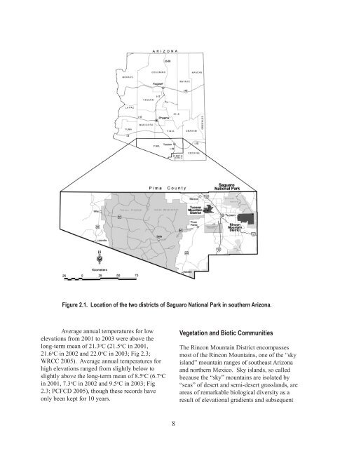
Figure 2.1. Location <strong>of</strong> the two districts <strong>of</strong> Saguaro National Park in southern <strong>Arizona</strong>.<br />
Average annual temperatures for low<br />
elevations from 2001 to 2003 were above the<br />
long-term mean <strong>of</strong> 21.3 o C (21.5 o C in 2001,<br />
21.6 o C in 2002 and 22.0 o C in 2003; Fig 2.3;<br />
WRCC 2005). Average annual temperatures for<br />
high elevations ranged from slightly below to<br />
slightly above the long-term mean <strong>of</strong> 8.5 o C (6. o C<br />
in 2001, .3 o C in 2002 and 9.5 o C in 2003; Fig<br />
2.3; PCFCD 2005), though these records have<br />
only been kept for 10 years.<br />
8<br />
Vegetation and Biotic Communities<br />
The Rincon Mountain District encompasses<br />
most <strong>of</strong> the Rincon Mountains, one <strong>of</strong> the “sky<br />
island” mountain ranges <strong>of</strong> southeast <strong>Arizona</strong><br />
and northern Mexico. Sky islands, so called<br />
because the “sky” mountains are isolated by<br />
“seas” <strong>of</strong> desert and semi-desert grasslands, are<br />
areas <strong>of</strong> remarkable biological diversity as a<br />
result <strong>of</strong> elevational gradients and subsequent