82 Land Use and Land Cover Changes Along the Shoreline
82 Land Use and Land Cover Changes Along the Shoreline
82 Land Use and Land Cover Changes Along the Shoreline

Create successful ePaper yourself
Turn your PDF publications into a flip-book with our unique Google optimized e-Paper software.
<strong>L<strong>and</strong></strong> <strong>Use</strong> <strong>and</strong> <strong>L<strong>and</strong></strong> <strong>Cover</strong><br />
<strong>Changes</strong> <strong>Along</strong> <strong>the</strong> <strong>Shoreline</strong><br />
Late 19th century mariners sailing along Southwest<br />
Florida’s shore encountered few settlements. Population<br />
was sparse on <strong>the</strong> barrier isl<strong>and</strong>s, <strong>the</strong> eastern shore of<br />
Charlotte Harbor, Estero Bay, <strong>and</strong> Naples Bay <strong>and</strong> in <strong>the</strong><br />
Caloosahatchee valley. Prior to <strong>the</strong> arrival of <strong>the</strong> railroad<br />
in Punta Gorda (1886) <strong>and</strong> <strong>the</strong> Big Freeze of 1892, only<br />
a few dozen persons lived on <strong>the</strong> isl<strong>and</strong>s <strong>and</strong> along <strong>the</strong><br />
shore in this region.<br />
Range cattle roamed freely over wide areas from <strong>the</strong><br />
Myakka River south. During <strong>the</strong> Civil War, Southwest<br />
Florida was a prime source of beef for <strong>the</strong> Confederate<br />
army. Afterwards, <strong>and</strong> until about 1878, <strong>the</strong> primary<br />
market was Cuba. Cattle were shipped from Punta Gorda<br />
<strong>and</strong> Punta Rassa.<br />
During <strong>the</strong> pre–development period, bay <strong>and</strong> Gulf<br />
fishing was in <strong>the</strong> h<strong>and</strong>s of Cubans who often employed<br />
Native Americans as deckh<strong>and</strong>s <strong>and</strong> established seasonal<br />
fish camps on isl<strong>and</strong>s all along this stretch of <strong>the</strong> Gulf<br />
coast: Lacosta, Mondongo, Pelau, Punta Blanca, <strong>Use</strong>ppa,<br />
Captiva, Sanibel, Estero, Mound, Black, Little Hickory,<br />
<strong>and</strong> Marco. Cuban fishermen dried <strong>and</strong> salted mullet for<br />
<strong>the</strong> Cuban market, living in “ranchos” or palmettothatched<br />
houses. These fishing stations existed for more<br />
than three centuries, beginning in <strong>the</strong> late 1600s. The<br />
arrival of <strong>the</strong> railroad at Punta Gorda in 1886 <strong>and</strong> establishment<br />
of an ice factory <strong>the</strong>re in 1893 opened up <strong>the</strong><br />
domestic United States fresh fish market to local fishermen.<br />
More than 20 icehouses, from Charlotte Harbor to<br />
Estero Bay, were built to hold <strong>the</strong> day’s fresh catch, which<br />
was collected by run boats <strong>and</strong> transported to Punta Gorda<br />
for shipment north. The local fisher-folk culture gradually<br />
changed as Cubans ei<strong>the</strong>r assimilated into local Florida<br />
families or returned permanently to Cuba.<br />
Production of naval stores <strong>and</strong> logging were o<strong>the</strong>r important<br />
local industries that followed <strong>the</strong> railroads into<br />
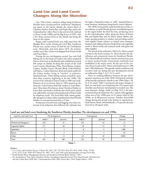
<strong>L<strong>and</strong></strong> use <strong>and</strong> l<strong>and</strong> cover bordering <strong>the</strong> Southwest Florida shoreline: Pre–development era <strong>and</strong> 1990s.<br />
L <strong>and</strong><br />
<strong>Use</strong><br />
<strong>and</strong><br />
<strong>L<strong>and</strong></strong><br />
<strong>Cover</strong><br />
Pre-development+ Contemporary Change<br />
( miles)<br />
*<br />
( percent)<br />
( miles)<br />
* *<br />
( percent)<br />
( percent)<br />
Wetl<strong>and</strong> <strong>and</strong><br />
Mangroves<br />
129 51 135 53 + 4<br />
Vegetated Upl<strong>and</strong><br />
117 46 28 11 -76<br />
Agriculture 2 1 6 2 + 200<br />
Barren 4 2 3 1 -25<br />
Urban 1 0 81 32 + 8100<br />
Total 253 100 253 99<br />
Table 1.<br />
Sources:<br />
* U.S. Coast <strong>and</strong> Geodetic Survey, T-Sheets No. 693, 738, 739, 853, 854, 855, 856, 1048, 1554a, 1554b,<br />
2122, 2123, 2126, 4289, H/T-Sheets No. 5067, 5072, <strong>and</strong> 1944 aerial photography covering Estero Bay.<br />
** South Florida Water Management District <strong>and</strong> Southwest Florida Water District, 1995.<br />
+ Pre–development Time Span: Charlotte Harbor (including Gasparilla Sound, Pine Isl<strong>and</strong> Sound, Matlacha Pass<br />
<strong>and</strong> San Carlos Bay):1858-1867, Caloosahatchee:18<strong>82</strong>-1883, Estero Bay: 1944, Naples-Marco: 1930.<br />
<strong>82</strong><br />
<strong>the</strong> region. Turpentine camps, or “stills,” operated from remote<br />
locations, oftentimes using forced, convict laborers.<br />
The 1890s witnessed <strong>the</strong> rapid introduction of <strong>the</strong> citrus<br />
industry as north Florida growers reestablished groves<br />
in <strong>the</strong> region below <strong>the</strong> frost-free line, producing citrus<br />
in <strong>the</strong> Caloosahatchee valley, along <strong>the</strong> shores of Estero<br />
Bay <strong>and</strong> Naples Bay, <strong>and</strong> on Marco Isl<strong>and</strong>. Before railroads,<br />
getting products to market <strong>and</strong> providing settlers<br />
with supplies meant reliance on inl<strong>and</strong> water transport.<br />
Steamers <strong>and</strong> sailing schooners hauled fruit <strong>and</strong> vegetables<br />
north to Punta Gorda <strong>and</strong> returned south with grain <strong>and</strong><br />
o<strong>the</strong>r supplies.<br />
The arrival of <strong>the</strong> railroad in 1904 at Ft. Myers caused<br />
a boom in <strong>the</strong> local economy. Ft. Myers became <strong>the</strong> distribution<br />
<strong>and</strong> commercial center for Southwest Florida.<br />
The railroad offered nor<strong>the</strong>rn tourists unrestricted access<br />
to winter vacation locales. Guest homes <strong>and</strong> hotels were<br />
established in <strong>the</strong> major towns. By <strong>the</strong> turn of <strong>the</strong> century,<br />
Punta Gorda <strong>and</strong> Ft. Myers each had between 1,200<br />
<strong>and</strong> 1,500 inhabitants. The sparsely settled conditions <strong>and</strong><br />
extensive l<strong>and</strong> use during this pre–development period<br />
are reflected in Map 1–A, C, E, G, <strong>and</strong> I.<br />
There is a striking difference between <strong>the</strong> pre–development<br />
waterfront use of <strong>the</strong> 1858-1944 period <strong>and</strong> that<br />
of <strong>the</strong> bayside <strong>and</strong> barrier isl<strong>and</strong>s in <strong>the</strong> 1990s (Map 1–B,<br />
D, F, H, <strong>and</strong> J). Table 1 summarizes <strong>the</strong> major changes in<br />
l<strong>and</strong> use <strong>and</strong> l<strong>and</strong> cover bordering this 253-square-mile<br />
shoreline area from pre–development to modern eras. The<br />
most dramatic change visible on Map 1A-J is <strong>the</strong> phenomenal<br />
urban development: <strong>the</strong> 1-square-mile aggregate<br />
urban area of <strong>the</strong> 1890s grew to 81 square miles by <strong>the</strong><br />
1990s, an 8,100-percent increase. Ano<strong>the</strong>r discernible<br />
change during this period is <strong>the</strong> decline in vegetated upl<strong>and</strong>s<br />
(forest, shrub, <strong>and</strong> brushl<strong>and</strong>), a 76-percent decrease<br />
from 46 to 28 square miles.
Southwest Florida once<br />
shared a heritage of<br />
natural resources as<br />
bountiful <strong>and</strong> aweinspiring<br />
as any region of<br />
America. Its heritage<br />
reflects <strong>the</strong> geological<br />
history, geographic<br />
location <strong>and</strong> biological<br />
evolution of <strong>the</strong> United<br />
States’ only humid <strong>and</strong><br />
sub-tropical peninsula.<br />
Coastal waters abounded<br />
with fish, rumored to<br />
impede <strong>the</strong> progress of<br />
sailing ships <strong>and</strong><br />
rowboats. Birds were so<br />
numerous as to eclipse <strong>the</strong><br />
sun when <strong>the</strong>ir flocks took<br />
wing. Naval stores of<br />
pine, cypress <strong>and</strong> oak<br />
seemed without limit.<br />
Not that <strong>the</strong> region was a<br />
benign Eden. Mosquitoes<br />
swarmed after sudden<br />
rains in numbers<br />
sufficient to kill livestock.<br />
Wild cats, venomous<br />
snakes, alligators, bears,<br />
sharks <strong>and</strong> o<strong>the</strong>r wildlife<br />
were elements of everyday<br />
life for explorers<br />
<strong>and</strong> settlers.<br />
Clam factory of Marco Isl<strong>and</strong>, circa 1910.<br />
Gr<strong>and</strong>e Bayou, Boca Gr<strong>and</strong>e in <strong>the</strong> early 1900s.<br />
The Caloosahatchee before development.<br />
83
Boca<br />
Nueva<br />
Boca<br />
Gasparilla<br />
Gasparilla Isl<strong>and</strong><br />
Boca<br />
Gr<strong>and</strong>e<br />
4<br />
1<br />
Gaspari la Sound<br />
3<br />
Lacosta Isl<strong>and</strong><br />
Gasparilla<br />
Village<br />
Punta<br />
Blanca<br />
Isl<strong>and</strong><br />
6<br />
Cayo<br />
Pelau<br />
Mondongo<br />
Isl<strong>and</strong><br />
5<br />
2<br />
<strong>Use</strong>ppa<br />
Isl<strong>and</strong><br />
Palmetto<br />
Isl<strong>and</strong><br />
Bull<br />
Bay<br />
Charlotte Harbor<br />
Barras<br />
Isl<strong>and</strong>s<br />
84<br />
1. Placida is <strong>the</strong> Spanish word for “placid,” an apt term to describe Placida Harbor, located at <strong>the</strong> mouth of Coral<br />
Creek <strong>and</strong> at <strong>the</strong> north end of Gasparilla Sound, with access to <strong>the</strong> Gulf through Gasparilla Pass. The town originated<br />
with a bunkhouse of <strong>the</strong> Charlotte Harbor & Nor<strong>the</strong>rn Railroad — locals called it <strong>the</strong> “Cold, Hungry <strong>and</strong><br />
Naked” line — later supplemented by relocation of <strong>the</strong> Gasparilla fishing village. It has been a major commercial<br />
fishing center for decades. Today, with <strong>the</strong> impact of <strong>the</strong> commercial fishing gill net ban in 1995, most of <strong>the</strong> fishing<br />
activities in <strong>the</strong> area have been curtailed <strong>and</strong> many of <strong>the</strong> stores closed, although some shops <strong>and</strong> a restaurant are still<br />
in operation.<br />
2. Cayo Pelau is a 140-acre isl<strong>and</strong> west of Bull Bay <strong>and</strong> fronting Charlotte Harbor. The isl<strong>and</strong>’s settlement dates<br />
to <strong>the</strong> Calusa Indian period. It was occupied by Cuban fishermen during <strong>the</strong> 19th century. An 1832 expedition<br />
describes a Spanish-speaking (Cuban) settlement “…from 60 to 70 inhabitants who keep an<br />
abundance of hogs, dogs innumerable.” The term “Pelau” is West Indian Spanish jargon for<br />
“bald spot,” aptly describing <strong>the</strong> center of <strong>the</strong> isl<strong>and</strong>’s wet–dry marsh, surrounded by gumbo<br />
limbo <strong>and</strong> mangrove trees.<br />
3. Gasparilla Isl<strong>and</strong> is bounded on <strong>the</strong> north by Gasparilla Pass, on<br />
<strong>the</strong> east by Gasparilla Sound, on <strong>the</strong> south by Boca Gr<strong>and</strong>e (Pass) <strong>and</strong><br />
on <strong>the</strong> west by <strong>the</strong> Gulf of Mexico. The isl<strong>and</strong> was sparsely settled by<br />
fishing families until <strong>the</strong> late 19th century. The federal<br />
government in 1848 established a military reservation<br />
at Boca Gr<strong>and</strong>e, including both <strong>the</strong> sou<strong>the</strong>rn<br />
end of Gasparilla Isl<strong>and</strong> <strong>and</strong> <strong>the</strong> nor<strong>the</strong>rn end of<br />
Lacosta Isl<strong>and</strong>. A lighthouse was built <strong>and</strong> placed in<br />
operation in 1890.<br />
Construction began on a port facility <strong>and</strong> railroad<br />
spur to receive <strong>and</strong> ship phosphate ore mined<br />
in <strong>the</strong> Peace River Valley in 1905. The railroad provided<br />
access to <strong>the</strong> outside world. Fish houses were<br />
established along <strong>the</strong> rail line, which brought in ice<br />
from <strong>the</strong> mainl<strong>and</strong> (Punta Gorda) <strong>and</strong> shipped out<br />
fresh fish. The fish house at <strong>the</strong> north end of <strong>the</strong><br />
isl<strong>and</strong> developed into Gasparilla Village. The railroad<br />
also attracted l<strong>and</strong> investors. The Gasparilla Inn<br />
opened in 1911 as a resort hotel, <strong>and</strong> Boca Gr<strong>and</strong>e<br />
was on its way to become an upscale community catering<br />
to affluent winter visitors <strong>and</strong> sports fishermen.<br />
Homes on Gilchrist <strong>and</strong> Park Avenues date back<br />
to this early development period. Storm-induced<br />
beach recession in <strong>the</strong> 1920s required <strong>the</strong> railroad to<br />
be shifted eastward. Fill dredged from <strong>the</strong> bay bottom<br />
along <strong>the</strong> east shore created Loomis Key. Boaters<br />
now use <strong>the</strong> dredged channel when transiting<br />
north from Gr<strong>and</strong>e Bayou to Gasparilla Sound. The<br />
Boca Gr<strong>and</strong>e Causeway, providing road connection<br />
to Placida, was built in 1958. In <strong>the</strong> late 1970s, <strong>the</strong><br />
Port Boca Gr<strong>and</strong>e docks <strong>and</strong> storage facilities were<br />
found in need of extensive repairs <strong>and</strong> were ab<strong>and</strong>oned<br />
in favor of shipping ore from <strong>the</strong> Peace River<br />
mines directly by rail to Tampa. The Boca Gr<strong>and</strong>e<br />
rail spur right of way became a bicycle path, <strong>and</strong> Port<br />
Boca Gr<strong>and</strong>e became an oil storage depot.<br />
The lighthouse was retired from service in 1966<br />
when automated channel navigation lights were installed.<br />
The old lighthouse became a site on <strong>the</strong> National<br />
Register of Historic Places in 1980. The U.S.<br />
Coast Guard recommissioned <strong>the</strong> light in 1986, <strong>and</strong><br />
<strong>the</strong> Florida Department of Environmental Protection<br />
manages <strong>the</strong> park facilities. The lighthouse is<br />
now <strong>the</strong> location of a historical museum.
Captiva<br />
Pass<br />
Captiva Isl<strong>and</strong><br />
<strong>L<strong>and</strong></strong> <strong>Use</strong>/<strong>L<strong>and</strong></strong> <strong>Cover</strong><br />
Urban & Built—Up<br />
Agriculture<br />
Shrub, Brushl<strong>and</strong>, Rangel<strong>and</strong><br />
Upl<strong>and</strong> Forest<br />
Water<br />
Wetl<strong>and</strong>s<br />
Mangrove<br />
Barren <strong>L<strong>and</strong></strong><br />
8<br />
Captiva Isl<strong>and</strong><br />
2.0 0<br />
2.0 4.0<br />
Miles<br />
Blind<br />
Pass<br />
(Boca<br />
Ciega)<br />
Pine Isl<strong>and</strong> Sound<br />
Chino<br />
Isl<strong>and</strong><br />
9<br />
Regla<br />
Isl<strong>and</strong><br />
Sanibel Isl<strong>and</strong><br />
Map 1-A.<br />
Pre–development conditions along <strong>the</strong> barrier isl<strong>and</strong>s.<br />
7<br />
Pine Isl<strong>and</strong><br />
PRE–DEVELOPMENT<br />
PRE-DEVELOPMENT<br />
Middle<br />
Point<br />
Point<br />
Ybel<br />
85
<strong>Use</strong>ppa Isl<strong>and</strong> was<br />
<strong>the</strong> first l<strong>and</strong> purchased<br />
in Southwest Florida<br />
by New York<br />
advertising millionaire<br />
Barron Collier.<br />
Later, he was to purchase<br />
more Florida l<strong>and</strong> than<br />
any o<strong>the</strong>r one person,<br />
including much<br />
of Lee County.<br />
<strong>Use</strong>ppa Isl<strong>and</strong>, looking south towards <strong>the</strong> barrier isl<strong>and</strong>s.<br />
4. Lacosta Isl<strong>and</strong> (Cayo Costa) is a barrier isl<strong>and</strong> situated<br />
south of Boca Gr<strong>and</strong>e <strong>and</strong> north of Captiva Pass.<br />
The number of Indian shell mounds on <strong>the</strong> isl<strong>and</strong> indicate<br />
human habitation dates far back in <strong>the</strong> pre-Discovery<br />
period. The isl<strong>and</strong> was used periodically by Cubans<br />
during <strong>the</strong> 19th century as a base for fishing in Charlotte<br />
Harbor <strong>and</strong> nearby Gulf waters. In 1880, <strong>the</strong> original<br />
(1848) l<strong>and</strong> parcel acquired as a military reservation by<br />
<strong>the</strong> federal government (see Gasparilla Isl<strong>and</strong> note above)<br />
was modified, <strong>and</strong> a limited area along <strong>the</strong> Boca Gr<strong>and</strong>e<br />
shore was set aside for military purposes, a pilot station,<br />
<strong>and</strong> a marine hospital. The federal government relinquished<br />
control of this property in 1938. Lacosta Isl<strong>and</strong><br />
retained a quasi-cl<strong>and</strong>estine reputation, even when ostensibly<br />
under federal control. It was a base for smuggling<br />
operations, especially rum from Cuba during <strong>the</strong><br />
Prohibition, <strong>and</strong> is reported to have had a house of ill<br />
fame frequented by fishermen <strong>and</strong> sailors from <strong>the</strong> many<br />
Cuban fishing smacks that frequented <strong>the</strong> harbor at <strong>the</strong><br />
turn of <strong>the</strong> century.<br />
The feral hogs on <strong>the</strong> isl<strong>and</strong> were vestige of <strong>the</strong> isl<strong>and</strong>’s<br />
past <strong>and</strong> accounted for <strong>the</strong> numerous trails through <strong>the</strong><br />
impenetrable cabbage-palm forest. A number of residences<br />
remain on <strong>the</strong> isl<strong>and</strong>: some are in an ab<strong>and</strong>oned<br />
state, o<strong>the</strong>rs are maintained as fishing retreats. Lee County,<br />
in 1959, established a park on <strong>the</strong> nor<strong>the</strong>rn 640 acre parcel.<br />
This park was turned over to <strong>the</strong> Florida Department<br />
of Environmental Protection in <strong>the</strong> early 1980s.<br />
86<br />
5. <strong>Use</strong>ppa Isl<strong>and</strong> was settled by <strong>the</strong> ancestors of Calusa<br />
Indians thous<strong>and</strong>s of years ago. Fort Casey was established<br />
here during <strong>the</strong> Seminole Wars, but was short-lived. A<br />
fishing community, called “Guiseppe,” later developed<br />
on <strong>the</strong> isl<strong>and</strong>. During <strong>the</strong> Civil War, a Union naval station<br />
garrisoned here to protect refugees <strong>and</strong> curtail <strong>the</strong><br />
smuggling of provisions to <strong>the</strong> Confederacy. <strong>Use</strong>ppa’s<br />
modern post-19th century history stems from its purchase<br />
by John Roach, president of <strong>the</strong> Chicago Street<br />
Railway Company, who built a home <strong>and</strong> small hotel,<br />
<strong>the</strong> <strong>Use</strong>ppa Inn, where he entertained friends <strong>and</strong> business<br />
associates Henry Ford <strong>and</strong> Thomas Edison by fishing<br />
for tarpon during <strong>the</strong> winter months. Barron Collier<br />
bought <strong>the</strong> property in 1911 for his Florida residence.<br />
Today, <strong>the</strong> former Collier Mansion is <strong>the</strong> site of <strong>the</strong><br />
<strong>Use</strong>ppa Isl<strong>and</strong> Club <strong>and</strong> <strong>the</strong> isl<strong>and</strong> has been developed<br />
into an exclusive residential community.<br />
6. Cabbage Key This isl<strong>and</strong> in Pine Isl<strong>and</strong> Sound, just<br />
west of <strong>Use</strong>ppa, is 100 acres upon which is a resort, marina<br />
<strong>and</strong> restaurant. The resort is built atop a 38-foothigh<br />
Native American shell mound. The isl<strong>and</strong> is easy to<br />
locate because of <strong>the</strong> tall water tower, which provides visitors<br />
<strong>and</strong> guests a panoramic view of <strong>the</strong> bays <strong>and</strong> Gulf of<br />
Mexico. The resort was once <strong>the</strong> home of novelist Mary<br />
Roberts Rinehart. Contemporary novelist R<strong>and</strong>y Wayne<br />
White describes Cabbage Key as having “an oasis feel to<br />
it, sitting out <strong>the</strong>re all by itself, like it could have been<br />
Abaco or Tangiers or Caicos, soaking up <strong>the</strong> sun through<br />
<strong>the</strong> decades while travelers tromped up <strong>the</strong> shell path to<br />
<strong>the</strong> old house on <strong>the</strong> mound.”<br />
Gasparilla Pass with causeway to Placida in foreground, looking south,<br />
down Gasparilla Isl<strong>and</strong> to Boca Gr<strong>and</strong>e, Lacosta Isl<strong>and</strong> (Cayo Costa) at<br />
upper right <strong>and</strong> Pine Isl<strong>and</strong> at upper left.
Gaspar <strong>the</strong> Pirate:<br />
Fact or Fiction?<br />
Legend <strong>and</strong> myth<br />
surround <strong>the</strong> name<br />
<strong>and</strong> a claim that a<br />
supposed pirate “Jose<br />
Gaspar” maintained a<br />
lair in <strong>the</strong>se waters<br />
during <strong>the</strong> 18th <strong>and</strong><br />
early 19th centuries.<br />
Some say <strong>the</strong> myths<br />
were invented about<br />
1900 by a fishing<br />
guide, Juan Gomez,<br />
to entertain customers.<br />
Historians suspect <strong>the</strong><br />
name refers to a<br />
‘Friar Gaspar.’ Boca<br />
Gasparilla (Inlet)<br />
appears on<br />
a late 18th century<br />
chart of <strong>the</strong> region.<br />
South Pine Isl<strong>and</strong>, looking nor<strong>the</strong>ast, St. James City<br />
in foreground.<br />
Safety Harbor on North Captiva Isl<strong>and</strong>, looking south,<br />
towards Redfish Pass in midground.<br />
7. Pine Isl<strong>and</strong> consists of three settlements. At <strong>the</strong><br />
north tip of <strong>the</strong> isl<strong>and</strong> is Bokeelia, on <strong>the</strong> south shore of<br />
Charlotte Harbor; Pinel<strong>and</strong> is to <strong>the</strong> south on <strong>the</strong> east<br />
shore of Pine Isl<strong>and</strong> Sound; <strong>and</strong> St. James City at <strong>the</strong><br />
sou<strong>the</strong>rn tip of <strong>the</strong> isl<strong>and</strong> abuts San Carlos Bay. Pinel<strong>and</strong><br />
is home to <strong>the</strong> R<strong>and</strong>ell Research Center — devoted to<br />
learning <strong>and</strong> teaching <strong>the</strong> archaeology, history, <strong>and</strong> ecology<br />
of Southwest Florida — owes this distinction in part<br />
to Calusa Indian shell mounds or middens (ancient Indian<br />
garbage dumps) located along <strong>the</strong> isl<strong>and</strong>’s shore overlooking<br />
Pine Isl<strong>and</strong> Sound. There are remnants of an aboriginal<br />
canoe canal, dug by <strong>the</strong> Calusa or <strong>the</strong>ir ancestors,<br />
probably 500 to 1,000 years ago. The “haul-over”<br />
canal had its western terminus at Pinel<strong>and</strong> <strong>and</strong> extended<br />
eastward to Matlacha Pass, ending at Indian Field. In<br />
1912, when Army Engineers visited <strong>the</strong> region, Pinel<strong>and</strong><br />
town consisted of a post office <strong>and</strong> three or four houses,<br />
but no streets or roads. The early 20th century settlement<br />
developed from turpentine stills <strong>and</strong> sawmills on north<br />
Pine Isl<strong>and</strong>. Today, all three communities provide recreational,<br />
sport fishing, eco-tourism, agricultural, <strong>and</strong> residential<br />
services.<br />
8. North Captiva <strong>and</strong> Captiva Isl<strong>and</strong>s were one isl<strong>and</strong><br />
prior to <strong>the</strong> 1921 hurricane <strong>and</strong> <strong>the</strong> creation of Redfish<br />
Pass. Major storms in <strong>the</strong> 1920s, ’30s, <strong>and</strong> ’40s overtopped<br />
<strong>the</strong> low, narrow sou<strong>the</strong>rn end of North Captiva.<br />
Safety Harbor, <strong>the</strong> small embayment inside Captiva Pass,<br />
was a fish camp during <strong>the</strong> pre–development period. A<br />
surge of vacation-home construction, beginning in <strong>the</strong><br />
1960s, along with finger-canal construction, has occurred<br />
on North Captiva Isl<strong>and</strong>. The State of Florida in 1975<br />
acquired about half of <strong>the</strong> isl<strong>and</strong>, which has been designated<br />
a Barrier Isl<strong>and</strong> Preserve. South Seas, a destination<br />
marina <strong>and</strong> golfing resort, is at <strong>the</strong> north end of Captiva<br />
Isl<strong>and</strong>. The town of Captiva is at <strong>the</strong> center, adjacent to<br />
Roosevelt Channel, a present-day popular anchorage <strong>and</strong><br />
relict inlet channel to Blind Pass. It is hard to imagine<br />
that <strong>the</strong> town claimed only 45 inhabitants just prior to<br />
World War II.<br />
87