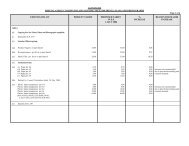
Page 1 of 3 UNDERSTANDING SURVEY DIAGRAMS ... - Durban
Page 1 of 3 UNDERSTANDING SURVEY DIAGRAMS ... - Durban
Page 1 of 3 UNDERSTANDING SURVEY DIAGRAMS ... - Durban

You also want an ePaper? Increase the reach of your titles
YUMPU automatically turns print PDFs into web optimized ePapers that Google loves.
coordinate system) are measured from the equator and increase positively southward from this line<br />
and are therefore always positive.<br />
Please note that if a local coordinate system has been used then the comments above are not<br />
relevant.<br />
Sometimes there are only a few or no coordinates listed and bearings may be replaced by the<br />
internal angles <strong>of</strong> the figure.<br />
Units <strong>of</strong> measure<br />
The first surveys in the <strong>Durban</strong> area were undertaken in the 1840’s and the units <strong>of</strong> distance and<br />
area have changed over the years. The earliest diagrams show distances measured in Chains & Links<br />
with the corresponding areas given in Acres, Roods & Perches. From the late 1920’s distances were<br />
measured in English Feet with areas given in Acres & Square Feet. Finally, with metrication in the<br />
late 1960’s, distances are now measured in metres and corresponding areas in Hectares & Square<br />
Metres.<br />
Coordinate systems<br />
Initially there was no National Coordinate system so surveys were based on local systems. In the<br />
<strong>Durban</strong> area the National Coordinate System was known as lo31° but this changed to wg31° in<br />
January 1999. Please note that the values <strong>of</strong> the two systems differ by a large amount. The<br />
coordinate system used for the survey is noted above the coordinate values and can be either<br />
“local”, lo31°,lo31° approx, wg31° or wg31° approx.<br />
Servitudes<br />
Some diagrams indicate and describe either existing or new servitudes<br />
Servitudes confer rights <strong>of</strong> individuals or other properties over the property in question. In our<br />
example, there are two servitude notes. Firstly , a Sewer & Drain Servitude and secondly a Drainage<br />
Servitude. Both these servitudes are intended to protect council sewers and drains.<br />
Other types <strong>of</strong> servitudes (not shown on our diagram) would cover other features including water<br />
pipelines, electric powerlines and underground cables, rights <strong>of</strong> way (roads) etc<br />
The figure<br />
The figure on the diagram represents the boundaries <strong>of</strong> the property and is lettered (see the figure<br />
and the description below it). In our example, all boundaries consist <strong>of</strong> straight lines but sometimes<br />
rivers and coastal reserves define boundaries by irregular lines which can sometimes move in<br />
accordance with the provision <strong>of</strong> various laws.<br />
Beacon information<br />
In all but the earliest <strong>of</strong> diagrams, beacons that have been placed are represented by small circles –<br />
in our example at A,B,C,D,E,F & G. The description <strong>of</strong> these beacons in our example is given just<br />
below the figure.<br />
<strong>Page</strong> 2 <strong>of</strong> 3
![INK Environmental Sustainability Booklet [19 MB] - Durban](https://img.yumpu.com/22025104/1/190x136/ink-environmental-sustainability-booklet-19-mb-durban.jpg?quality=85)