

Geology of the Shenandoah National Park Region - Csmres Jmu ...
Geology of the Shenandoah National Park Region - Csmres Jmu ...
Geology of the Shenandoah National Park Region - Csmres Jmu ...

Create successful ePaper yourself
Turn your PDF publications into a flip-book with our unique Google optimized e-Paper software.
A.<br />
C.<br />
D.<br />
s<br />
lope p o<br />
r file<br />
B<br />
B<br />
scale<br />
E<br />
R I DG OW<br />
F U<br />
R<br />
R<br />
B<br />
A<br />
A<br />
A<br />
E.<br />
UNDISTURBED<br />
BLOCK FIELD<br />
SURFACE<br />
27<br />
1<br />
B.<br />
2<br />
25<br />
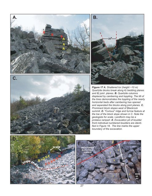
Figure 17 A. Shattered tor (height ~10 m)<br />
Quartzite blocks break along A) bedding planes<br />
and B) joint planes. B. Quartzite columns<br />
displaced by cambering and toppling. The tilt <strong>of</strong><br />
<strong>the</strong> lines demonstrates <strong>the</strong> toppling <strong>of</strong> <strong>the</strong> nearly<br />
horizontal beds after cambering has opened<br />
and separated <strong>the</strong> blocks along joint planes. C.<br />
Prominent block slopes west <strong>of</strong> Blackrock<br />
summit. D. "Curious" ridge and furrow feature at<br />
<strong>the</strong> toe <strong>of</strong> <strong>the</strong> block slope shown in C. Note <strong>the</strong><br />
geologists for scale. Landform may be a<br />
protalus rampart. E. Excavation pit <strong>of</strong> boulder<br />
front individual numbered boulders are identified<br />
in Figure 18. The line marks <strong>the</strong> upper<br />
boundary <strong>of</strong> <strong>the</strong> excavation.<br />
3<br />
7<br />
4<br />
5<br />
PIT<br />
FACE<br />
6<br />
BASE<br />
OF<br />
PIT