- Page 1 and 2: THE CRETACEOUS FOSSILS OF NEW JERSE
- Page 3 and 4: PAIBONTOMMYk4BRIEB ' Bureau of Qeol
- Page 5 and 6: CO-AUTHORS U. S. Geological Survey
- Page 7 and 8: Ma. THEODORE J. LANQAN, Director Di
- Page 9 and 10: It was originally planned to publis
- Page 11 and 12: 2 CRETACEOUS FOSSILS It is impossib
- Page 13 and 14: 4 CRETACEOUS FOSSILS. . %, 3 a Roge
- Page 15 and 16: 6 CRETACEOUS FOSSILS In considering
- Page 17 and 18: NEW JERSEY GEOLOGICAL SURVEY
- Page 19 and 20: PREVIOUS WORK ON CRETACEOUS INVERTE
- Page 21 and 22: Raritan Tusealoosa Tuscaloosa Woodb
- Page 23 and 24: CRETACEOUS FORMATIONS Fossil plants
- Page 25 and 26: CRETACEOUS FORMATIONS The Wenonah f
- Page 27: Tinton-and may be regarded as a dee
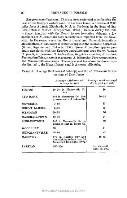
- Page 31 and 32: FOSSIL LOCALITIES 23 unaltered shel
- Page 33 and 34: FOSSIL LOCALITIES 25 42. Marlboro,
- Page 35 and 36: INTRODUCTION TO SPSTEAIATIC SECTION
- Page 37 and 38: CRETACEOUS PORIFERA OF NEW JERSEY b
- Page 39 and 40: PORIFERA 31 surface covered with lo
- Page 41 and 42: 34 CRETACEOUS FOSSILS diameter rati
- Page 43 and 44: 36 CRETACEOUS FOSSILS denticulate c
- Page 45 and 46: 38 CRETACEOUS FOSSILS plane: there
- Page 47 and 48: CRETACEOUS FOSSILS Range in New Jer
- Page 49 and 50: CBETACEOUS FOSSILS Description.-Onl
- Page 51 and 52: 44 CRETACEOUS FOSSILS The specimen
- Page 53 and 54: 46 CRETACEOUS FOSSILS Pygurz~s geom
- Page 55 and 56: 48 CRETACEOUS FOSSILS upper surface
- Page 57 and 58: 50 CRETACEOUS FOSSILS . . laneeolat
- Page 59 and 60: 52 CRETACEOUS FOSSILS Hemiaster ung
- Page 61 and 62: 54 CRETACEOUS FOSSILS Hentiaster (1
- Page 63 and 64: 56 CRETACEOUS FOSSILS Terebratulina
- Page 65 and 66: 58 CRETACEOUS FOSSILS Range in New
- Page 67 and 68: 60 CRETACEOUS FOSSILS than the Nucu
- Page 69 and 70: 62 CRETACEOUS FOSSILS row of teeth,
- Page 71 and 72: CRETACEOUS FOSSILS Type.-Beers Hill
- Page 73 and 74: 66 CRETACEOUS FOSSILS Range in New
- Page 75 and 76: 68 CRETACEOUS FOSSILS Yoldia gabban
- Page 77 and 78: 70 CRETACEOUS FOSSILS Description.-
- Page 79 and 80:
72 CRETACEOUS FOSSILS Nemodon conro
- Page 81 and 82:
74 CRETACEOUS FOSSILS perhaps a lit
- Page 83 and 84:
76 CRETACEOUS FOSSILS margin; poste
- Page 85 and 86:
78 CRETACEOUS FOSSILS NAVESINK: 37,
- Page 87 and 88:
80 CRETACEOUS FOSSILS ldonearca bla
- Page 89 and 90:
82 CRETACEOUS FOSSILS T,ype.-Snow H
- Page 91 and 92:
84 CRETACEOUS FOSSILS Hinge plate r
- Page 93 and 94:
86 CRETACEOUS FOSSILS from the beak
- Page 95 and 96:
88 CRETACEOUS FOSSILS a little less
- Page 97 and 98:
90. CRETACEOUS FOSSILS bounded on t
- Page 99 and 100:
92 CRETACEOUS FOSSILS instead of in
- Page 101 and 102:
CRETACEOUS FOSSILS Family Pedalioni
- Page 103 and 104:
96 CRETACEOUS FOSSILS by more or le
- Page 105 and 106:
98 CRETACEOUS FOSSILS Remarks.-The
- Page 107 and 108:
100 CRETACEOUS FOSSILS Family Pteri
- Page 109 and 110:
102 CRETACEOUS FOSSILS Pteria navic
- Page 111 and 112:
CRETACEOUS FOSSILS Family Pulviniti
- Page 113 and 114:
CRETACEOUS FOSSILS dimensions of a
- Page 115 and 116:
CRETACEOTJS FOSSILS rugose from con
- Page 117 and 118:
110 CRETACEOUS FOSSILS plicate alon
- Page 119 and 120:
CRETACEOUS FOSSILS Hinge variable i
- Page 121 and 122:
CRETACEOUS FOSSILS tensions usually
- Page 123 and 124:
CRETACEOUS FOSSILS beakone-half to
- Page 125 and 126:
118 CRETACEOUS FOSSILS beak around
- Page 127 and 128:
120 CRETACEOTJS FOSSILS Ezogyra cos
- Page 129 and 130:
122 CRETACEOUS FOSSILS 'Prigoqda fh
- Page 131 and 132:
124 CRETACEOUS FOSSILS really the m
- Page 133 and 134:
126 CRETACEOUS FOSSILS The ribs of
- Page 135 and 136:
128 CRETACEOUS FOSSILS ribs. It has
- Page 137 and 138:
130 CRETACEOUS FOSSILS Pecten argil
- Page 139 and 140:
132 CRETACEOUS FOSSILS Pecten quinq
- Page 141 and 142:
134 CRETACEOUS FOSSILS Remarks.-Thi
- Page 143 and 144:
136 CRETACEOUS FOSSILS Pecten quinq
- Page 145 and 146:
138 CRETACEOUS FOSSILS Range outsid
- Page 147 and 148:
140 CRETACEOUS FOSSILS Spond,ylus g
- Page 149 and 150:
CRETACEOUS FOSSILS parallel. The up
- Page 151 and 152:
144 CRETACEOUS FOSSILS ovate in out
- Page 153 and 154:
146 CRETACEOUS FOSSILS Range in New
- Page 155 and 156:
148 CRETACEOUS FOSSILS Anomia telli
- Page 157 and 158:
150 CRETACEOUS FOSSILS Paranomia sc
- Page 159 and 160:
152 CRETACEOUS FOSSILS Mytilus obli
- Page 161 and 162:
154 CRETACEOUS FOSSILS the Merchant
- Page 163 and 164:
156 CRETACEOUS FOSSILS Range outsid
- Page 165 and 166:
158 CRETACEOUS FOSSILS Width (in th
- Page 167 and 168:
160 CRETACEOUS FOSSILS in outline,
- Page 169 and 170:
162 CRETACEOUS FOSSILS Cercomya pec
- Page 171 and 172:
164 CRETACEOUS FOSSILS valve from b
- Page 173 and 174:
166 CRETACEOUS FOSSILS more conspic
- Page 175 and 176:
168 CRETACEOUS FOSSILS More periect
- Page 177 and 178:
CRETACEOUS FOSSILS Cymella bella te
- Page 179 and 180:
172 CRETACEOUS FOSSILS Family Cuspi
- Page 181 and 182:
CRETACEOUS FOSSILS margin obliquely
- Page 183 and 184:
176 CRETACEOUS FOSSILS angular, pos
- Page 185 and 186:
178 CRETACEOUS FOSSILS Remarks.-The
- Page 187 and 188:
180 CRETACEOUS FOSSILS the surface
- Page 189 and 190:
182 CRETACEOUS FOSSILS an angular j
- Page 191 and 192:
184 CRETACEOUS FOSSILS Vetericardia
- Page 193 and 194:
186 CRETACEOUS FOSSILS Description.
- Page 195 and 196:
188 CRETACEOUS FOSSILS Crassallites
- Page 197 and 198:
190 CRETACEOUS FOSSILS pedal scar v
- Page 199 and 200:
192 CRETACEOUS FOSSILS Range in New
- Page 201 and 202:
194 CRETACEOUS FOSSILS posterior en
- Page 203 and 204:
196 CRETACEOUS FOSSILS circular or
- Page 205 and 206:
198 CRETACEOUS FOSSILS Description.
- Page 207 and 208:
NEW JERSEY GEOLOGICAL SURVEY
- Page 209 and 210:
202 CRETACEOUS FOSSILS FCardium lon
- Page 211 and 212:
204 CRETACEOUS FOSSILS of the hinge
- Page 213 and 214:
line rather short, arched, extendin
- Page 215 and 216:
208- CRETACEOUS FOSSILS distinct su
- Page 217 and 218:
210 CRETACEOUS FOSSILS Lions of the
- Page 219 and 220:
212 CRETACEOUS FOSSILS figs. 10-12,
- Page 221 and 222:
CRETACEOUS FOSSILS Cardium sayri Ri
- Page 223 and 224:
216 CRETACEOUS FOSSILS and very fin
- Page 225 and 226:
218 CRETACEOUS FOSSILS Range in New
- Page 227 and 228:
220 CRETACEOUS FOSSILS Type.-(T. pi
- Page 229 and 230:
CRETACEOUS FOSSILS convex, the left
- Page 231 and 232:
CRETACEOUS FOSSILS Description.-"Sh
- Page 233 and 234:
226 CRETACEOUS FOSSILS Aphrodina eu
- Page 235 and 236:
228 CRETACEOUS FOSSILS Legumen plan
- Page 237 and 238:
230 CRETACEOUS FOSSILS reaching the
- Page 239 and 240:
CRETACEOUS FOSSILS regularly convex
- Page 241 and 242:
234 CRETACEOUS FOSSILS Range in New
- Page 243 and 244:
236 CRETACEOUS FOSSILS Acnona eufaz
- Page 245 and 246:
238 CRETACEOUS FOSSILS Solyma ellip
- Page 247 and 248:
240 CRETACEOUS FOSSILS Lepfosolen ?
- Page 249 and 250:
CRETACEOUS FOSSILS I~asal margin; p
- Page 251 and 252:
244 CRETACEOUS FOSSILS rophore is r
- Page 253 and 254:
246 CRETACEOUS FOSSILS Cymbophora t
- Page 255 and 256:
248 CRETACEOUS FOSSILS above; post-
- Page 257 and 258:
PELECYPODA Corbula lorillardensis W
- Page 259 and 260:
252 CRETACEOUS FOSSILS Desc,iptioit
- Page 261 and 262:
CRETACEOUS FOSSILS convex ; postero
- Page 263 and 264:
CRETACEOUS FOSSILS ternal mold of a
- Page 265 and 266:
256 CRETACEOUS FOSSILS margin where
- Page 267 and 268:
260 CRETACEOUS FOSSILS XThitfield a
- Page 269 and 270:
CRETACEOUS FOSSILS stria: towards t
- Page 271 and 272:
264 CRETACEOUS FOSSILS Ma~esia cret
- Page 273 and 274:
266 CRETACEOUS FOSSILS The New Jers
- Page 275 and 276:
PLATE 1 Figure Page 1. Cliona creta
- Page 277 and 278:
PLATE 2 Figure Page 1-3. Corynella
- Page 279 and 280:
PLATE 3 Figure rage 1. Micrabacia c
- Page 281 and 282:
PLATE 4 Figure Page 1. Serpula circ
- Page 283 and 284:
PLATE 5 Figure Page 1. Hamulus squa
- Page 285 and 286:
PLATE 6 Figure Page 1-3. Faujasia g
- Page 287 and 288:
PLATE 7 Figure Page 1-3. Cardiaster
- Page 289 and 290:
PLATE 8 Figure Page 1-4. Hemiaster
- Page 291 and 292:
PLATE 9 Figure Page 1,2. Cho~istoth
- Page 293 and 294:
PLATE 10 Figure Page 1. Nucula perc
- Page 295 and 296:
PLATE 1 1 Figure Page 1. Nuculana s
- Page 297 and 298:
PLATE 12 Figure Page 1. Cucullaea a
- Page 299 and 300:
PLATE 13 Figure Page 1. Cucul2aea n
- Page 301 and 302:
PLATE 14 Figure Page 1. Arca uniops
- Page 303 and 304:
PLATE 15 Figure Page 1,2. Pinna laq
- Page 305 and 306:
PLATE 16 Figure Page 1. Inoceramzis
- Page 307 and 308:
PLATE 17 Figure Page 1. Nucula whit
- Page 309 and 310:
PLATE 1 8 Figure Page 1. Pteria lar
- Page 311 and 312:
PLATE 19 Figure Page 1. Ostrea monm
- Page 313 and 314:
PLATE 20 Figure Page 1. Exogyra cos
- Page 315 and 316:
PLATE 21 Figure Page 1. Exogyra can
- Page 317 and 318:
PLATE 22 Figure Page 1. Trigonia eu
- Page 319 and 320:
PLATE 23 Figure Page 1. Pecten venu
- Page 321 and 322:
PLATE 24' Figure Page 1. Pecten cra
- Page 323 and 324:
PLATE 25 Figz~re Page 1. Paranomia
- Page 325 and 326:
PLATE 26 Figure Page 1. Volseltu bu
- Page 327 and 328:
PLATE 27 Figure Page 1. Anatina cli
- Page 329 and 330:
PLATE 28 Figure Page 1. Cuspidaria
- Page 331 and 332:
PLATE 29 Figure Page 1. Eriphyla de
- Page 333 and 334:
PLATE 30 Figure Page 1. Crassatelli
- Page 335 and 336:
PLATE 31 Figure Page 1. Etea delawa
- Page 337 and 338:
PLATE 32 Figure Page 1. Cardium wen
- Page 339 and 340:
PLATE 33 Figure Pnge 1. Cardiz~m ez
- Page 341 and 342:
PLATE 34 Figure Page 1. Cyprimeria
- Page 343 and 344:
PLATE 35 Figure Page 1. Legumen con
- Page 345 and 346:
PLATE 36 Figure Page 1. Legumen con
- Page 347 and 348:
PLATE 37 Figure I'cige 1. Leptosole
- Page 349 and 350:
PLATE 38 Figure Page 1. Corbula fou
- Page 351 and 352:
PLATE 39 E'igure Page 1-3. Corbula
- Page 353 and 354:
PLATE 40 Figure Page 1. Ambonlcardi
- Page 355 and 356:
PLATE 4 1 Figure Page 1,2. Martesia
- Page 357 and 358:
PLATE 42 Figure Page 1. Barb~ia ? c
- Page 359 and 360:
,/' PLATE 43 Figure Page 1. Geloina
- Page 361 and 362:
PLATE 44 Figure Page 1. Inoceramus
- Page 363 and 364:
PLATE 45 Figure Page 1. Cliona reti
- Page 365 and 366:
PLATE 46 Figure Page 1. Hardouina e
- Page 367 and 368:
NEW JERSEY GEOLOGICAL SURVEY
- Page 369 and 370:
Page Plate Cibota obesa Whitfield .
- Page 371 and 372:
Page Legumen planulatum Conrad ....
- Page 373:
................ .............. ...


