N9/N10 Kilcullen to Waterford Scheme - National Roads Authority
N9/N10 Kilcullen to Waterford Scheme - National Roads Authority
N9/N10 Kilcullen to Waterford Scheme - National Roads Authority

You also want an ePaper? Increase the reach of your titles
YUMPU automatically turns print PDFs into web optimized ePapers that Google loves.
1<br />
2<br />
3<br />
4<br />
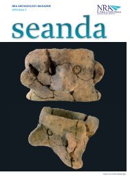
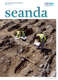
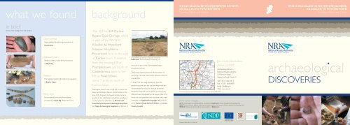
what we found background<br />
in brief:<br />
Some of the findings from the scheme.<br />
1. S<strong>to</strong>ne axehead<br />
S<strong>to</strong>ne axehead found during excavations at<br />
Russells<strong>to</strong>wn.<br />
2. Medieval pottery<br />
Medieval pottery found during excavations<br />
at Moyle Big.<br />
3. Skele<strong>to</strong>n<br />
Post-medieval skele<strong>to</strong>n found during excavations<br />
at Ballybar Upper.<br />
4. Bone comb<br />
Early medieval bone comb found during<br />
excavations at Moyle Big. (Pho<strong>to</strong> ArchCon)<br />
The 18.5 km <strong>N9</strong> Carlow<br />
Bypass Dual-Carriage, which<br />
is part of the <strong>N9</strong>/<strong>N10</strong><br />
<strong>Kilcullen</strong> <strong>to</strong> <strong>Waterford</strong><br />
<strong>Scheme</strong>: <strong>Kilcullen</strong> <strong>to</strong><br />
Power<strong>to</strong>wn runs <strong>to</strong> the east<br />
of Carlow <strong>to</strong>wn. It extends<br />
from the existing <strong>N9</strong> at<br />
Prumples<strong>to</strong>wn, just south of<br />
Castledermot, back <strong>to</strong> the<br />
<strong>N9</strong> at Powers<strong>to</strong>wn,<br />
some 7 <strong>to</strong> 8 km south of<br />
Carlow <strong>to</strong>wn.<br />
Initial paper research was carried out <strong>to</strong> ensure that<br />
known archaeological features and landscapes in the<br />
area of the proposed route were avoided as far as<br />
possible by the road designers. Extensive geophysical<br />
surveys were also undertaken by Bartlett-Clark<br />
Consultancy, Earthsound Archaeological Geophysics<br />
and Target Archaeological Geophysics on sections of<br />
Ecclesiastical road and late 17th-century house at<br />
Bushers<strong>to</strong>wn. (Pho<strong>to</strong> Headland Archaeology Ltd).<br />
the route as part of the Environmental Impact<br />
Assessment process.<br />
These were closely followed by the excavation of<br />
centerline and offset test-trenches between June and<br />
August 2005.<br />
A <strong>to</strong>tal of 64 sites were identified by both the<br />
geophysical survey and the test-trenching works and<br />
recommended for resolution through excavation.<br />
Resolution excavation works started in early January<br />
2006 and were completed by mid-August 2006. All of<br />
the on-site test excavation and resolution works were<br />
undertaken by Headland Archaeology Ltd on behalf<br />
of the <strong>National</strong> <strong>Roads</strong> <strong>Authority</strong>, Kildare and Carlow<br />
County Councils.<br />
<strong>N9</strong>/<strong>N10</strong> KILCULLEN TO WATERFORD SCHEME:<br />
KILCULLEN TO POWERSTOWN<br />
Counties Kildare and Carlow<br />
© Ordnance Survey Ireland & Government of Ireland permit number EN0045206.<br />
front cover images<br />
For more information<br />
please contact:<br />
Archaeology Section<br />
<strong>National</strong> <strong>Roads</strong> <strong>Authority</strong><br />
St. Martins House<br />
Waterloo Road, Dublin 4<br />
Tel: +353 1 660 2511<br />
Fax: +353 1 668 0009<br />
Email: info@nra.ie<br />
Web: www.nra.ie<br />
LEFT: Archaeologists excavating skele<strong>to</strong>n uncovered at Cloghristick. (Pho<strong>to</strong> Headland Archaeology Ltd)<br />
RIGHT: Post-excavation analysis underway on bones found on the scheme. (Pho<strong>to</strong> Headland Archaeology Ltd)<br />
MIDDLE: Medieval brooch found during excavations at Ballybannon.<br />
Published 2006. 80659-15/10.06/3K<br />
<strong>N9</strong>/<strong>N10</strong> KILCULLEN TO WATERFORD SCHEME:<br />
KILCULLEN TO POWERSTOWN<br />
Counties Kildare and Carlow<br />
archaeological<br />
DISCOVERIES
prehis<strong>to</strong>ric prehis<strong>to</strong>ric early medieval medieval<br />
Elevated view of Neolithic enclosure and house at<br />
Russells<strong>to</strong>wn.<br />
Settlement<br />
Carlow’s first Neolithic house was uncovered while<br />
excavating at Russells<strong>to</strong>wn and is therefore the<br />
county’s earliest house known <strong>to</strong> date. It was set<br />
within a large subrectangular enclosure measuring<br />
80 by 60 m.The house was built of large split timbers,<br />
set upright in a deep foundation trench and<br />
strengthened by packing s<strong>to</strong>nes.The roof was<br />
supported by large internal posts. Early Neolithic<br />
pottery was recovered from the trench fill.<br />
Excavation evidence showed that the house burnt<br />
down.The enclosure apparently stayed as a feature on<br />
the landscape until relatively recently. Evidence from<br />
the First Edition Ordnance Survey map seems <strong>to</strong><br />
show that it was modified <strong>to</strong> form an 18th century<br />
landscaped tree-ring within the grounds of<br />
Russells<strong>to</strong>wn Park House.<br />
Other subrectangular, early prehis<strong>to</strong>ric houses were<br />
recovered at Bur<strong>to</strong>nhall Demesne and Bushers<strong>to</strong>wn<br />
<strong>to</strong>wnlands - also consisting of linear foundation<br />
trenches, with post-holes <strong>to</strong> accommodate large<br />
upright timber posts.<br />
The Bur<strong>to</strong>nhall Demesne house yielded early<br />
prehis<strong>to</strong>ric pottery and flints, along with a broken<br />
s<strong>to</strong>ne axehead from the fill of a corner post-hole.The<br />
prehis<strong>to</strong>ric habitation at Bushers<strong>to</strong>wn was surrounded<br />
by a 30 m diameter circular perimeter enclosure.<br />
Large post-holes provided evidence of four possible<br />
wooden round houses, probably dating <strong>to</strong> the Bronze<br />
Age - two were uncovered in Rathcrogue <strong>to</strong>wnland<br />
and the other two in Tinryland.<br />
Many fulachta fiadh - commonly found sites generally<br />
regarded as cooking places belonging <strong>to</strong> the Bronze<br />
Age - were uncovered along the scheme, but a few of<br />
them were significantly different from the norm. At<br />
Ballyburn Lower, a large funnel-shaped depression<br />
incorporated a double ring of stake-holes along the<br />
slope, indicating that it was roofed with a tent or<br />
canopy structure and may have been used as a<br />
sweat-house.<br />
A site at Ballybar Lower contained a sluice feature for<br />
regulating water flow and may have been used in<br />
medieval times and associated with a nearby moated<br />
site. Artefacts from here included scraps of leather,<br />
worked antler, an alder shovel; but also a tanged<br />
arrowhead, a javelin head and a large flint scraper.<br />
At Bushers<strong>to</strong>wn, another large, water-filled, funnel-like<br />
depression incorporated a wooden platform supported<br />
by stakes, probably for ease of access <strong>to</strong> the water.<br />
Ritual<br />
Numerous prehis<strong>to</strong>ric ritual and burial features were<br />
discovered along the route probably dating from the<br />
early Neolithic <strong>to</strong> the Bronze Age. At Ballybannon,five<br />
ring-barrows were uncovered, some incorporating<br />
cremation deposits and pits, with others devoid of<br />
such features. Dotted around and outside the ringditches<br />
were other cremations, one of which was<br />
contained within a complete pottery vessel.<br />
A small ring-ditch with a central cremation from<br />
Bushers<strong>to</strong>wn is likely <strong>to</strong> date <strong>to</strong> the Bronze Age.<br />
Archaeologist excavating a Neolithic cremation at Ballybar<br />
Lower. (Pho<strong>to</strong> Headland Archaeology Ltd)<br />
Other cremation pits were discovered in Russells<strong>to</strong>wn,<br />
Ballyhade, Bushers<strong>to</strong>wn, Moyle Big, Ballybar Upper<br />
and Ballybar Lower.<br />
One of the pits at Russells<strong>to</strong>wn contained a portion of<br />
a polished s<strong>to</strong>ne axehead, while the cremation at<br />
Ballybar Lower contained two miniature arrowheads.<br />
Two of the pits at Ballyhade contained 65 and<br />
15 sherds of prehis<strong>to</strong>ric pottery, respectively.<br />
Archaeologists excavating a ring-ditch uncovered at<br />
Bushers<strong>to</strong>wn. (Pho<strong>to</strong> Headland Archaeology Ltd)<br />
Bronze Age house uncovered at Bushers<strong>to</strong>wn.<br />
(Pho<strong>to</strong> Headland Archaeology Ltd)<br />
At Bushers<strong>to</strong>wn, a curving ecclesiastical boundary ditch was excavated,<br />
which was related <strong>to</strong> an adjacent church, graveyard and bullaun s<strong>to</strong>ne.The<br />
ditch was cut in<strong>to</strong> the solid underlying granite bedrock. Extending from<br />
this boundary were two parallel rock-cut ditches, which defined the edges<br />
of a probable early medieval/medieval roadway that led <strong>to</strong> the church<br />
site.This road is evident on the First Edition Ordnance Survey mapping<br />
from the 1830s, but was subsequently removed, probably through land<br />
reclamation and quarrying. A previously unknown ringfort of the early<br />
medieval period was discovered at Ballybannon. It had a diameter of<br />
about 30 m and only half of the site extended in<strong>to</strong> the area of the<br />
roadtake. It was defined by a deep ditch. Outside the roadtake, the<br />
perimeter was evident as a green semi-circle in a field of ripe corn - a<br />
crop-mark resulting from the prolonged dry-spell of the 2006 summer.<br />
Rock-cut ecclesiastical enclosure ditch<br />
excavated at Bushers<strong>to</strong>wn. (Pho<strong>to</strong><br />
Headland Archaeology Ltd)<br />
Elevated view of ringfort at Ballybannon with cropmark visible outside line of road. (Pho<strong>to</strong> Headland Archaeology Ltd)<br />
A medieval castle originally s<strong>to</strong>od outside the line of<br />
the road in Moyle Big <strong>to</strong>wnland. Features probably<br />
relating <strong>to</strong> the occupation of that castle were located<br />
inside the line of the road, including a lime kiln, linear<br />
enclosure and field ditches, refuse pits, corn-drying<br />
kilns, smelting furnaces and charcoal production pits.<br />
Artefacts recovered included two bone combs, a<br />
rotary quern-s<strong>to</strong>ne, a spud-s<strong>to</strong>ne or s<strong>to</strong>ne lamp,<br />
medieval pottery including imported wares; but also a<br />
Neolithic s<strong>to</strong>ne axehead and an arrowhead.<br />
At Ballybannon, numerous prehis<strong>to</strong>ric and medieval<br />
features were excavated, with some of the latter<br />
being possibly related <strong>to</strong> a nearby moated site.<br />
common occurrences along the scheme.<br />
post-medieval<br />
Post-medieval features excavated included a culverted stream at Bur<strong>to</strong>nhall Demesne, a landscaped avenue at<br />
Johns<strong>to</strong>wn, granite quarrying at Bur<strong>to</strong>nhall Demesne and Bushers<strong>to</strong>wn and linear ditches and a possible<br />
roadway at Russells<strong>to</strong>wn. Isolated inhumations were located at Ballybar Upper and Cloghristick, also probably<br />
post-medieval.<br />
Ongoing work<br />
Medieval lime kiln uncovered at Moyle Big.<br />
(Pho<strong>to</strong> Headland Archaeology Ltd)<br />
These included a possible trackway that may have led <strong>to</strong> the moated site, a portion of a sub-circular enclosure,<br />
a corn-drying kiln and some pits. A tiny bronze medieval brooch was recovered from one of the pits, while the<br />
kiln was filled with charred grain. Metal production areas, corn-drying kilns and charcoal production pits were<br />
Specialist examination and study of the excavation archive is on-going, including artefact and environmental<br />
analysis, radiocarbon dating and the study of both human and animal remains; along with processing of site<br />
plans, mapping, pho<strong>to</strong>graphy and written documentation of the sites.This will result in the compilation of<br />
preliminary and final excavation reports which in turn will lead <strong>to</strong> full publication of the excavation.