

Geology of Greenland Survey Bulletin 187, 2000, 07-19 - Geus
Geology of Greenland Survey Bulletin 187, 2000, 07-19 - Geus
Geology of Greenland Survey Bulletin 187, 2000, 07-19 - Geus

You also want an ePaper? Increase the reach of your titles
YUMPU automatically turns print PDFs into web optimized ePapers that Google loves.
Tectono-stratigraphic history <strong>of</strong> northern Amdrup Land,<br />
eastern North <strong>Greenland</strong>: implications for the<br />
northernmost East <strong>Greenland</strong> shelf<br />
Lars Stemmerik, Birgitte D. Larsen and Finn Dalh<strong>of</strong>f<br />
The NW–SE-oriented Sommerterrasserne fault in Amdrup Land marks the southern limit <strong>of</strong><br />
Mesozoic compression related to the transform plate boundary between North <strong>Greenland</strong> and<br />
Svalbard. Structural style in Amdrup Land changes across the fault; Carboniferous, Permian and<br />
Jurassic sediments in northern Amdrup Land north-east <strong>of</strong> the fault are gently folded, with NE–<br />
SW-trending fold axes, whereas they are gently dipping south <strong>of</strong> the fault. The Sommerterrasserne<br />
fault is regarded as the south-eastern extension <strong>of</strong> the Trolle Land fault zone <strong>of</strong> eastern<br />
Peary Land. Upper Moscovian carbonates <strong>of</strong> the Foldedal Formation rest unconformably on<br />
isoclinally folded Upper Proterozoic sediments <strong>of</strong> the Independence Fjord Group in northern<br />
Amdrup Land and are conformably overlain by chert-rich limestones <strong>of</strong> the Permian Kim Fjelde<br />
and Midnatfjeld Formations. Locally, up to 70 m <strong>of</strong> Jurassic sandstone and siltstone are preserved<br />
in the axes <strong>of</strong> the synclines, resting conformably on Permian limestones; the folding thus<br />
post-dates their deposition. The folding <strong>of</strong> the sediments to the north-east <strong>of</strong> the Sommerterrasserne<br />
fault most likely took place during the latest Cretaceous; it is post-dated by a post-<br />
Paleocene extensional event.<br />
L.S. & F.D., Geological <strong>Survey</strong> <strong>of</strong> Denmark and <strong>Greenland</strong>, Thoravej 8, DK-2400 Copenhagen<br />
NV, Denmark. E-mail: ls@geus.dk<br />
B.D.L., Geological Institute, University <strong>of</strong> Aarhus, DK-8000 Århus C, Denmark.<br />
Keywords: Carboniferous–Jurassic, North <strong>Greenland</strong>, structural geology, Wandel Sea Basin<br />
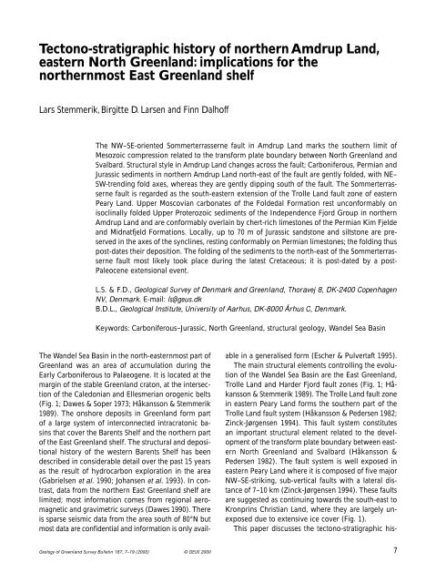
The Wandel Sea Basin in the north-easternmost part <strong>of</strong><br />
<strong>Greenland</strong> was an area <strong>of</strong> accumulation during the<br />
Early Carboniferous to Palaeogene. It is located at the<br />
margin <strong>of</strong> the stable <strong>Greenland</strong> craton, at the intersection<br />
<strong>of</strong> the Caledonian and Ellesmerian orogenic belts<br />
(Fig. 1; Dawes & Soper <strong>19</strong>73; Håkansson & Stemmerik<br />
<strong>19</strong>89). The onshore deposits in <strong>Greenland</strong> form part<br />
<strong>of</strong> a large system <strong>of</strong> interconnected intracratonic basins<br />
that cover the Barents Shelf and the northern part<br />
<strong>of</strong> the East <strong>Greenland</strong> shelf. The structural and depositional<br />
history <strong>of</strong> the western Barents Shelf has been<br />
described in considerable detail over the past 15 years<br />
as the result <strong>of</strong> hydrocarbon exploration in the area<br />
(Gabrielsen et al. <strong>19</strong>90; Johansen et al. <strong>19</strong>93). In contrast,<br />
data from the northern East <strong>Greenland</strong> shelf are<br />
limited; most information comes from regional aeromagnetic<br />
and gravimetric surveys (Dawes <strong>19</strong>90). There<br />
is sparse seismic data from the area south <strong>of</strong> 80°N but<br />
most data are confidential and information is only avail-<br />
<strong>Geology</strong> <strong>of</strong> <strong>Greenland</strong> <strong>Survey</strong> <strong>Bulletin</strong> <strong>187</strong>, 7–<strong>19</strong> (<strong>2000</strong>) © GEUS <strong>2000</strong><br />
able in a generalised form (Escher & Pulvertaft <strong>19</strong>95).<br />
The main structural elements controlling the evolution<br />
<strong>of</strong> the Wandel Sea Basin are the East <strong>Greenland</strong>,<br />
Trolle Land and Harder Fjord fault zones (Fig. 1; Håkansson<br />
& Stemmerik <strong>19</strong>89). The Trolle Land fault zone<br />
in eastern Peary Land forms the southern part <strong>of</strong> the<br />
Trolle Land fault system (Håkansson & Pedersen <strong>19</strong>82;<br />
Zinck-Jørgensen <strong>19</strong>94). This fault system constitutes<br />
an important structural element related to the development<br />
<strong>of</strong> the transform plate boundary between eastern<br />
North <strong>Greenland</strong> and Svalbard (Håkansson &<br />
Pedersen <strong>19</strong>82). The fault system is well exposed in<br />
eastern Peary Land where it is composed <strong>of</strong> five major<br />
NW–SE-striking, sub-vertical faults with a lateral distance<br />
<strong>of</strong> 7–10 km (Zinck-Jørgensen <strong>19</strong>94). These faults<br />
are suggested as continuing towards the south-east to<br />
Kronprins Christian Land, where they are largely unexposed<br />
due to extensive ice cover (Fig. 1).<br />
This paper discusses the tectono-stratigraphic his-<br />
7
Fig. 1. Map <strong>of</strong> the eastern part <strong>of</strong> the Wandel Sea Basin showing<br />
the major structural lineaments. The blank area on northern<br />
Kronprins Christian Land is ice. Modified from Håkansson &<br />
Stemmerik (<strong>19</strong>89).<br />
tory <strong>of</strong> northern Amdrup Land and its implications for<br />
the East <strong>Greenland</strong> shelf areas based on new structural,<br />
biostratigraphic and sedimentological observations.<br />
The Sommerterrasserne fault in northern Amdrup<br />
Land forms the easternmost extent <strong>of</strong> the Trolle Land<br />
fault zone. It divides structurally deformed Carboniferous<br />
and younger deposits from flat-lying undeformed<br />
Upper Palaeozoic sediments. The depositional record<br />
and structural style <strong>of</strong> northern Amdrup Land differ<br />
significantly from that recognised at Kilen and Prinsesse<br />
Ingeborg Halvø further to the north in the Trolle<br />
Land fault system in Kronprins Christian Land (Håkansson<br />
et al. <strong>19</strong>89, <strong>19</strong>92, <strong>19</strong>93). The preserved Upper Palaeozoic<br />
succession is much thinner than that recorded<br />
from northern Prinsesse Ingeborg Halvø by Håkansson<br />
et al. (<strong>19</strong>89); it resembles that <strong>of</strong> Holm Land and<br />
southern Amdrup Land (Fig. 2; Stemmerik unpublished<br />
data). Also, the Mesozoic succession is thinner and<br />
stratigraphically condensed compared to Kilen (Håkansson<br />
et al. <strong>19</strong>91). Northern Amdrup Land thus forms<br />
a unique area within the Wandel Sea Basin where the<br />
Upper Palaeozoic depositional evolution is related to<br />
the Holm Land – Amdrup Land segment <strong>of</strong> the basin<br />
and the structural style to the Trolle Land fault system.<br />
This may have some important implications for the<br />
petroleum potential <strong>of</strong> the adjacent shelf areas and for<br />
the structural evolution <strong>of</strong> the region.<br />
8<br />
Ellesmerian<br />
35°<br />
KCTZ<br />
HFFZ<br />
Caledonian<br />
Ellesmerian<br />
Inland<br />
Ice<br />
Peary Land<br />
25°<br />
TLFZ<br />
15°<br />
Peary Land<br />
HFFZ<br />
Palaeogene<br />
Mesozoic<br />
Upper Palaeozoic<br />
Lower Palaeozoic and older<br />
HFFZ Harder Fjord fault zone<br />
TLFZ Trolle Land fault zone<br />
SF Sommerterrasserne fault<br />
EGFZ East <strong>Greenland</strong> fault zone<br />
Wandel Sea<br />
Prinsesse Ingeborg<br />
Halvø<br />
Kronprins Christian Land<br />
EGFZ<br />
Inland Ice<br />
Caledonian<br />
100 km<br />
Kilen<br />
82°<br />
81°<br />
Amdrup<br />
Land<br />
SF<br />
Holm<br />
Land<br />
80°<br />
79°<br />
Geological framework<br />
The post-Caledonian Wandel Sea Basin is located in a<br />
narrow fringe along the margins <strong>of</strong> the stable <strong>Greenland</strong><br />
craton. The depositional area is delineated by the<br />
Harder Fjord, Trolle Land and East <strong>Greenland</strong> fault zones<br />
(Fig. 1; Håkansson & Stemmerik <strong>19</strong>89). The Wandel<br />
Sea Basin deposits rest with a regional unconformity<br />
on Precambrian to Silurian rocks, which were deformed<br />
during the Caledonian and Ellesmerian orogenies.<br />
Two main epochs <strong>of</strong> basin evolution have been recognised<br />
during previous studies <strong>of</strong> the basin fill; the<br />
earlier, Late Palaeozoic epoch is characterised by a fairly<br />
simple system <strong>of</strong> grabens and half-grabens (Stemmerik<br />
& Håkansson <strong>19</strong>89; Stemmerik <strong>19</strong>96) whereas the<br />
later, Mesozoic epoch is dominated by strike-slip movements<br />
and deposition in isolated pull-apart basins (Håkansson<br />
et al. <strong>19</strong>91). The Mesozoic structural events<br />
only influenced the northern part <strong>of</strong> the basin, north<br />
<strong>of</strong> the Trolle Land fault zone and its eastward continuation<br />
(Fig. 1).<br />
The Wandel Sea Basin deposits in northern Amdrup<br />
Land are located north <strong>of</strong> the Trolle Land fault zone<br />
and are affected by post-Jurassic structural events. They<br />
were deposited east <strong>of</strong> the East <strong>Greenland</strong> fault zone<br />
near the northern limit <strong>of</strong> a depositional area that connects<br />
southwards to the sedimentary basins <strong>of</strong> East<br />
<strong>Greenland</strong> and is dominated by east–west extension<br />
along Caledonian lineaments. The area is separated by<br />
a NW–SE-trending fault, the Sommerterrasserne fault<br />
(see Fig. 3), from the areas to the south that are unaffected<br />
by Mesozoic compression related to the transform<br />
plate boundary between eastern North <strong>Greenland</strong><br />
and Svalbard. The Kilen and Prinsesse Ingeborg Halvø<br />
areas further to the north in the Trolle Land fault system<br />
have been affected by four tectonic pulses <strong>of</strong> mid-<br />
Jurassic to post-Paleocene age (Håkansson et al. <strong>19</strong>89,<br />
<strong>19</strong>92, <strong>19</strong>93). These events are also documented in the<br />
Trolle Land fault system further to the west in eastern<br />
Peary Land (Zinck-Jørgensen <strong>19</strong>94). They include the<br />
mid-Jurassic Ingeborg event, the mid-Cretaceous Kilen<br />
event, a latest Cretaceous strike-slip event and post-<br />
Paleocene extension (Håkansson et al. <strong>19</strong>89, <strong>19</strong>92,<br />
<strong>19</strong>93).<br />
Fig. 2. Lithostratigraphy and thickness <strong>of</strong> Upper Palaeozoic and<br />
Mesozoic sediments on Holm Land, Amdrup Land, Prinsesse<br />
Ingeborg Halvø and eastern Peary Land. Data from Håkansson<br />
et al. (<strong>19</strong>89) and Stemmerik et al. (<strong>19</strong>96).
TRIASSIC JURASSIC<br />
CARBONIFEROUS PERMIAN<br />
V S B M K G Asselian Sakmarian Artinskian K/U Kz T<br />
S. Holm<br />
Land<br />
260 m<br />
300 m<br />
SB<br />
1000 m<br />
KJ<br />
N. Holm<br />
Land<br />
260 m<br />
S. Amdrup<br />
Land<br />
350 m<br />
KJ<br />
350 m<br />
?<br />
N. Amdrup<br />
Land<br />
<strong>19</strong>0 m<br />
Pr. Ingeborg<br />
Halvø<br />
E. Peary Land E. Peary Land<br />
NE<br />
SW<br />
La Ladegårdsåen Formation<br />
La<br />
D/P Dunken and Parish Bjerg Formations 70 m<br />
150 m<br />
Mi Midnatfjeld Formation<br />
KF Kim Fjelde Formation<br />
F Foldedal Formation<br />
KJ Kap Jungersen Formation<br />
SB Sortebakker Formation<br />
IFG Independence Fjord Group<br />
Carbonate<br />
Marine sandstone<br />
Mixed sandstone and limestone<br />
Marine shale<br />
Gypsum/anhydrite<br />
Chert-rich limestone<br />
Fluvial sandstone and shale<br />
Lower Palaeozoic sediments<br />
Isoclinally folded,<br />
Proterozoic sediments<br />
Precambrian basement<br />
T<br />
Kz<br />
K/U<br />
Tatarian<br />
Kazanian<br />
Kungurian/Ufimian<br />
940 m<br />
D/P<br />
G Gzelian<br />
K Kasimovian<br />
M<br />
B<br />
S<br />
V<br />
Moscovian<br />
Bashkirian<br />
Serpukhovian<br />
Viséan<br />
350 m<br />
70 m<br />
Mi<br />
1200 m<br />
200 m<br />
Mi<br />
30 m<br />
KF<br />
KF KF<br />
?<br />
KF<br />
380 m<br />
30 m<br />
KF<br />
200 m<br />
IFG<br />
200 m<br />
150 m<br />
F F<br />
F F<br />
F<br />
?<br />
450 m 30 m<br />
F<br />
9
;; ;<br />
a<br />
10<br />
;;<br />
; ;<br />
4<br />
12<br />
;;;;;;;;;;<br />
;;;;;;;;;;<br />
;;;;;;;;;;<br />
;;;;;;;;;;<br />
; y ;y<br />
;;;;;;;;;;<br />
;;;;;;;;;;<br />
; y ;;;;;;;;;;<br />
;;;;;;;;;;<br />
;;;;;;;;;;<br />
12<br />
10<br />
<strong>19</strong><br />
Y<br />
Jurassic<br />
10<br />
Fig. 3. See facing page for caption.<br />
15º<br />
430 77<br />
;y<br />
;; yy<br />
14<br />
18<br />
18<br />
7<br />
455<br />
12<br />
15<br />
5<br />
9<br />
7<br />
413<br />
Sommerterrasserne fault<br />
15º<br />
Kim Fjelde and Midnatfjeld Formations<br />
(upper Artinskian – Kazanian)<br />
Foldedal Formation<br />
(upper Moscovian – Gzelian)<br />
80<br />
4<br />
14<br />
14<br />
North Amdrup<br />
Land fault<br />
;;<br />
14 Dip and strike<br />
X<br />
5<br />
308<br />
yy ;<br />
890<br />
367<br />
5 km<br />
8<br />
70<br />
12<br />
80<br />
Fig. 4<br />
Basal shale unit (Moscovian)<br />
;Independence Fjord Group<br />
(Proterozoic)<br />
Antarctic Bugt<br />
;y Antarctic Bugt fault<br />
; ;<br />
;<br />
;;<br />
8<br />
40<br />
59<br />
455<br />
10<br />
34<br />
6<br />
80º55<br />
80º50′<br />
Dværgfjorden<br />
10<br />
10<br />
38<br />
6<br />
6<br />
10<br />
;; ;<br />
;<br />
N = 4<br />
;N = 6<br />
Fault with block on downthrow<br />
side<br />
Syncline<br />
Anticline<br />
Spot height (m)
North Amdrup<br />
Land fault<br />
Sommerterrasserne<br />
fault<br />
Antarctic Bugt<br />
Antarctic Bugt<br />
fault<br />
Dværgfjorden<br />
Fig. 3. a: Geological map <strong>of</strong> northern Amdrup Land showing sediment outcrops and major structural elements. Based on field<br />
observations and photogrammetric interpretations. X and Y refer to localities mentioned in the text. The rose diagram shows the<br />
directions <strong>of</strong> fold axes in the area between the Sommerterrasserne and north Amdrup Land faults (black) and between the north<br />
Amdrup Land and Antarctic Bugt faults (stippled). Spot heights in metres. b: Aerial photograph <strong>of</strong> northern Amdrup Land at the<br />
same scale as the map showing the topographic expression <strong>of</strong> the main structural elements. Photo: 876L 2864 (with parts <strong>of</strong> 876K<br />
11<br />
1831, 1834), August <strong>19</strong>78, National <strong>Survey</strong> and Cadastre, Copenhagen, Denmark.<br />
5 km
Stratigraphy<br />
In northern Amdrup Land, the Wandel Sea Basin deposits<br />
rest unconformably on strongly deformed Proterozoic<br />
sediments and volcanics <strong>of</strong> the Independence<br />
Fjord Group (Figs 2–4). The Proterozoic rocks are<br />
isoclinally folded with axes plunging 10° towards WNW<br />
(285°–315°). They crop out mainly in the northern part<br />
<strong>of</strong> the study area and on the wide coastal plain along<br />
Antarctic Bugt (Fig. 3).<br />
The oldest post-Caledonian sediments are black<br />
shales with thin beds <strong>of</strong> resedimented carbonates.<br />
These, so far undated sediments crop out locally along<br />
a NNW–SSE-trending topographic lineament that possibly<br />
corresponds to a major fault, the Antarctic Bugt<br />
fault (Figs 3, 4). They are laterally confined to this<br />
zone; elsewhere shallow marine carbonates or locally<br />
12<br />
SE NW<br />
IF<br />
IF<br />
P<br />
Q<br />
UM<br />
J<br />
Fig. 4. Upper Moscovian carbonates<br />
(UM) onlapping Independence Fjord<br />
Group strata (IF) immediately south-west<br />
<strong>of</strong> the Antarctic Bugt fault. Note the<br />
topographic scarp defined by the fault;<br />
for location, see Fig. 3. The cliff is<br />
approximately 200 m high.<br />
sandstones rest on the irregular basement surface. The<br />
oldest carbonates are dated as late Moscovian and they<br />
can be correlated to the lower part <strong>of</strong> the Foldedal<br />
Formation in southern Amdrup Land (Fig. 2). Lower<br />
Moscovian deposits, equivalent to the Kap Jungersen<br />
Formation in southern Amdrup Land and southern Holm<br />
Land, are not present in northern Amdrup Land. The<br />
upper Moscovian – Gzelian succession attains a maximum<br />
thickness <strong>of</strong> about <strong>19</strong>0 m compared to more than<br />
350 m at Kap Jungersen in southern Amdrup Land (Fig.<br />
2). These sediments dominate the outcrops north-east<br />
<strong>of</strong> the north Amdrup Land fault (Fig. 3). They are faulted<br />
against younger Carboniferous, Gzelian carbonates <strong>of</strong><br />
the upper Foldedal Formation in the southern part <strong>of</strong><br />
the study area (locality X in Fig. 3a).<br />
Mid- to Upper Permian limestones, cherty limestones<br />
and cherty shales <strong>of</strong> the Kim Fjelde and Midnatfjeld<br />
Q<br />
Fig. 5. Upper Jurassic sandstone (J)<br />
conformably overlying Upper Permian<br />
limestone (P). The sediments form the<br />
northern flank <strong>of</strong> a synform, locality Y in<br />
Fig. 3. Q: Quaternary sediments. The<br />
outcrop is approximately 30 m high.
Fig. 6. a: The basal part <strong>of</strong> the Wandel<br />
Sea Basin succession in northern Amdrup<br />
Land. Black shales are conformably<br />
overlain by upper Moscovian carbonates<br />
(UM). Note the gentle folding <strong>of</strong> the<br />
sediments in the distant outcrops that are<br />
approximately 200 m high. b: Detail <strong>of</strong><br />
upper right corner <strong>of</strong> Fig. 6a showing<br />
domal folding <strong>of</strong> the Carboniferous<br />
carbonates. Width <strong>of</strong> ridged ground in<br />
the middle distance is about 200 m.<br />
Formations are widely exposed in the down-faulted<br />
area between the Sommerterrasserne and north Amdrup<br />
Land faults. North-east <strong>of</strong> the north Amdrup Land fault,<br />
sediments <strong>of</strong> Middle to Late Permian age are confined<br />
to a narrow zone north-west <strong>of</strong> Dværgfjorden (Fig. 3).<br />
Sediments belonging to the Kim Fjelde Formation are<br />
widespread in southern Amdrup Land whereas the<br />
Midnatfjeld Formation is unknown from Holm Land<br />
and southern Amdrup Land (Fig. 2). The latter formation<br />
is present in eastern Peary Land but only in the<br />
north-eastern exposures (Håkansson <strong>19</strong>79; Stemmerik<br />
et al. <strong>19</strong>96).<br />
Sediments <strong>of</strong> Triassic – Middle Jurassic age are not<br />
known from Amdrup Land. Upper Jurassic sediments<br />
occur locally in the cores <strong>of</strong> two synforms in the south-<br />
ern and eastern parts <strong>of</strong> the study area where they rest<br />
conformably on Permian carbonates (Figs 3, 5). The<br />
Jurassic succession attains a maximum thickness <strong>of</strong><br />
70 m in the southernmost outcrops where the sediments<br />
are unconformably overlain by Quaternary fluvial<br />
deposits. The sediments are dated as Oxfordian<br />
based on the finds <strong>of</strong> two ammonites (J.H. Callomon,<br />
personal communication <strong>19</strong>96) and they correspond<br />
in age to the basal part <strong>of</strong> the Ladegårdsåen Formation<br />
<strong>of</strong> eastern Peary Land. There is no evidence <strong>of</strong> younger<br />
Mesozoic or Palaeogene sediments in Amdrup Land<br />
although there are more than <strong>2000</strong> m <strong>of</strong> Cretaceous<br />
sediments at Kilen immediately to the north (Håkansson<br />
et al. <strong>19</strong>91). Post-Permian sediments are not known<br />
from the areas south <strong>of</strong> the Sommerterrasserne fault.<br />
13
Structural geology<br />
Northern Amdrup Land is relatively poorly exposed<br />
and the present structural study <strong>of</strong> the Wandel Sea Basin<br />
sediments therefore focused on major lineaments and<br />
folds. It is based on a combination <strong>of</strong> photogrammetric<br />
analysis <strong>of</strong> aerial photographs at a scale <strong>of</strong> 1:50 000<br />
and field observations (Larsen <strong>19</strong>96). The study forms<br />
an integrated part <strong>of</strong> the regional mapping between<br />
78°N and 81°N at a scale <strong>of</strong> 1:500 000 (Henriksen <strong>19</strong>95,<br />
<strong>19</strong>96) where another GEUS mapping team was responsible<br />
for mapping <strong>of</strong> the pre-Wandel Sea Basin rocks<br />
(Hull & Friderichsen <strong>19</strong>95).<br />
The structural style in Amdrup Land changes across<br />
the NW–SE-oriented Sommerterrasserne fault (Fig. 3).<br />
South-west <strong>of</strong> this fault sediments have not seen compressional<br />
deformation; they are dipping gently (< 4°)<br />
towards the east and south-east with some disturbance<br />
along minor N–S-trending faults. In contrast, the Wandel<br />
Sea Basin sediments are gently folded with NE–SW<br />
fold axes north-east <strong>of</strong> the fault (Figs 3, 6). The Sommerterrasserne<br />
fault, defining the southern limit <strong>of</strong> the<br />
Trolle Land fault system in Kronprins Christian Land,<br />
is poorly exposed and the fault has not been observed<br />
in the field. Outcrops south-west <strong>of</strong> the fault consist <strong>of</strong><br />
eastwards dipping carbonates <strong>of</strong> the Upper Carboniferous<br />
Foldedal Formation whereas folded Permian sediments<br />
<strong>of</strong> the Kim Fjelde and Midnatsfjeld Formations<br />
are exposed north-east <strong>of</strong> the fault (Fig. 3). This indicates<br />
a downthrow <strong>of</strong> the area to the north-east <strong>of</strong> at<br />
least 120 m. The NW–SE-striking north Amdrup Land<br />
fault, 7–8 km further to the north defines the northern<br />
E UM<br />
W<br />
14<br />
IF<br />
IF<br />
UM<br />
BS<br />
limits <strong>of</strong> a narrow graben where outcrops are dominated<br />
by folded Permian and Jurassic sediments. The<br />
fault is exposed in a creek on the eastern coastal plain<br />
(locality X in Fig. 3a) where it strikes 150° and dips<br />
70° towards the south-west. At this locality, Gzelian<br />
sediments are down-thrown at least 60 m compared to<br />
older Carboniferous sediments north-east <strong>of</strong> the fault.<br />
A possible third fault, the Antarctic Bugt fault, is suggested<br />
in the northern part <strong>of</strong> the study area (Fig. 3).<br />
On the coastal plain north <strong>of</strong> this lineament, isoclinally<br />
folded sediments <strong>of</strong> the Proterozoic Independence<br />
Fjord Group are faulted against upper Moscovian sediments<br />
by a normal fault striking 44° and dipping 50°<br />
to the north-west (Fig. 7). The throw on this fault exceeds<br />
50 m. Immediately to the east <strong>of</strong> this fault, the<br />
basal black shales <strong>of</strong> the Wandel Sea Basin are thrust<br />
over younger Moscovian carbonates along a fault plane<br />
striking 178° and dipping 66° to the west (Fig. 7).<br />
In the graben area between the Sommerterrasserne<br />
fault and the north Amdrup Land fault, the succession<br />
dips gently towards the south-east. The Permian and<br />
Jurassic strata are folded in gentle, en echelon domal<br />
folds with an amplitude <strong>of</strong> approximately 100 m, a wave<br />
length <strong>of</strong> 1–1.5 km and a lateral extent <strong>of</strong> 4–4.5 km<br />
(Figs 3, 8). Fold axes strike north-east with some local<br />
variations. North-east <strong>of</strong> the north Amdrup Land fault,<br />
the Moscovian sediments are folded in somewhat larger<br />
domal folds following a more easterly trend, and a<br />
larger domal synform with an amplitude <strong>of</strong> 250–300 m,<br />
a wave length <strong>of</strong> 3.5 km and a lateral extent <strong>of</strong> 7.3 km<br />
exposes Carboniferous, Permian and Jurassic sediments<br />
near Dværgfjorden (Figs 3, 8).<br />
UM<br />
Fig. 7. Faulted contact between the<br />
Independence Fjord Group (IF) and<br />
Moscovian carbonates (UM). Immediately<br />
to the south <strong>of</strong> this view, the basal<br />
Moscovian shales (BS) are thrust over<br />
younger carbonates. The foreground<br />
exposures are approximately 30 m high.
Fig. 8. Synthetic structural map <strong>of</strong> the base<br />
<strong>of</strong> the Kim Fjelde Formation based on<br />
constructed cross-sections. Note the large<br />
domal folds and the overall southeastwards<br />
dip <strong>of</strong> the strata. The map area<br />
corresponds roughly to that <strong>of</strong> Fig. 3a.<br />
The main faults are marked and the<br />
depression towards the south-east<br />
corresponds to the Dværgfjorden syncline<br />
in Fig. 3a.<br />
Discussion<br />
80º50′N<br />
Sommerte rasserne fault<br />
The change <strong>of</strong> structural style across the Sommerterrasserne<br />
fault shows that this fault defines the southern<br />
limit <strong>of</strong> deformation related to the plate movements<br />
between <strong>Greenland</strong> and Spitsbergen in Amdrup Land,<br />
and therefore forms the easternmost landward part <strong>of</strong><br />
the Trolle Land fault zone.<br />
The conformal structural relationships between the<br />
Upper Permian strata and the Upper Jurassic sediments<br />
in northern Amdrup Land suggest minor tectonic activity<br />
during the Early Mesozoic. This is different from<br />
the pattern seen at Kilen and Prinsesse Ingeborg Halvø<br />
in northern Kronprins Christian Land and in eastern<br />
Peary Land where a major tectonic event, the Ingeborg<br />
event, has been recognised. In eastern Peary Land,<br />
the Upper Jurassic Ladegårdsåen Formation rests unconformably<br />
on tectonically disturbed Carboniferous<br />
– Middle Triassic strata (Håkansson <strong>19</strong>79; Zinck-Jørgensen<br />
<strong>19</strong>94).<br />
The folding <strong>of</strong> the Wandel Sea Basin deposits northeast<br />
<strong>of</strong> the Sommerterrasserne fault took place after<br />
deposition <strong>of</strong> the Upper Jurassic sediments. It should<br />
therefore be correlated to either the mid-Cretaceous<br />
Kilen event or the latest Cretaceous strike-slip event <strong>of</strong><br />
Pedersen (<strong>19</strong>88). The mid-Cretaceous Kilen event is<br />
described as a dextral extensional event along the<br />
400<br />
450<br />
350<br />
300<br />
350<br />
250<br />
300<br />
250<br />
250<br />
500<br />
250<br />
200<br />
250<br />
150<br />
550<br />
600<br />
400<br />
250<br />
600<br />
350<br />
400<br />
500<br />
250<br />
200<br />
100<br />
150<br />
200<br />
150<br />
100<br />
50<br />
100<br />
650<br />
300<br />
650<br />
350<br />
600<br />
400<br />
North Amdrup Land fault<br />
-50<br />
0<br />
100<br />
0<br />
50<br />
550<br />
500<br />
450<br />
400<br />
500<br />
-50<br />
15ºW<br />
600<br />
400<br />
15ºW<br />
450<br />
400<br />
550<br />
450<br />
200<br />
150<br />
100<br />
50<br />
500<br />
450<br />
450<br />
450<br />
400<br />
350<br />
350<br />
350<br />
400<br />
400<br />
400<br />
350<br />
300<br />
250<br />
200<br />
150<br />
200<br />
Antarctic Bugt fault<br />
–250–0 m 0–250 m 250–500 m 500–700 m<br />
250<br />
150<br />
300<br />
100<br />
300<br />
450<br />
50<br />
350<br />
400<br />
450<br />
100<br />
400<br />
450<br />
NNW–SSE-trending faults in the Trolle Land fault system<br />
(Håkansson & Pedersen <strong>19</strong>82). Several pull-apart<br />
basins, including the Kilen basin that has more than<br />
1500 m <strong>of</strong> Upper Cretaceous sediments, were formed<br />
during this event. Thermal maturity data from the<br />
Jurassic sediments in northern Amdrup Land indicate<br />
a maximum overburden <strong>of</strong> 200–300 m (Stemmerik et<br />
al. <strong>19</strong>98), and evidently the Kilen event did not lead to<br />
major subsidence <strong>of</strong> northern Amdrup Land. The NE–<br />
SW-trending fault that separates the Wandel Sea Basin<br />
sediments from the Proterozoic basement north-east<br />
<strong>of</strong> the Antarctic Bugt fault (locality Y in Fig. 3a) may be<br />
related to dextral extensional movements during the<br />
Kilen event.<br />
The folding <strong>of</strong> the Wandel Sea Basin sediments in<br />
northern Amdrup Land most likely took place during<br />
the latest Cretaceous strike-slip event. This event is<br />
described as a dextral compressional event that in the<br />
Trolle Land fault system mainly led to E–W-trending<br />
domal folds and N–S-oriented thrusts (Håkansson et<br />
al. <strong>19</strong>89). The observed ESE–WNW to ENE–WSW en<br />
echelon orientation <strong>of</strong> the folds corresponds to a dextral<br />
sense <strong>of</strong> displacement along the Sommerterrasserne,<br />
north Amdrup Land and Antarctic Bugt faults. From<br />
the structural map (Fig. 8) it is evident that the north<br />
Amdrup Land and Sommerterrasserne faults were active<br />
during this event. The north-easterly orientation<br />
350<br />
600<br />
550<br />
500<br />
450<br />
300<br />
250<br />
400<br />
350<br />
300<br />
200<br />
300<br />
200<br />
400<br />
450<br />
350<br />
400<br />
450<br />
-100<br />
-150<br />
-200<br />
-250<br />
350<br />
150<br />
100<br />
50<br />
0<br />
-50<br />
50<br />
<br />
100<br />
5 km<br />
350<br />
100<br />
300<br />
250<br />
200<br />
50<br />
100<br />
80º50′N<br />
15
<strong>of</strong> the fold axes in the graben area between the Sommerterrasserne<br />
and north Amdrup Land faults compared<br />
to the more easterly directions north-east <strong>of</strong> the<br />
north Amdrup Land fault may imply that the graben<br />
area saw the highest strike-slip intensity. However, the<br />
structural deformation <strong>of</strong> northern Amdrup Land is<br />
much less intense than seen further to the north in<br />
Kronprins Christian Land where the domal folds are<br />
associated with deformed thrust complexes (Håkansson<br />
et al. <strong>19</strong>89, <strong>19</strong>92, <strong>19</strong>93).<br />
The latest structural event in the area is extension<br />
along the Sommerterrasserne and north Amdrup Land<br />
faults. This event post-dates folding and led to formation<br />
<strong>of</strong> a graben between these faults. It is suggested<br />
that it correlates with a post-Paleocene extensional<br />
event described from other parts <strong>of</strong> the Trolle Land<br />
fault system (Håkansson et al. <strong>19</strong>91).<br />
Tectono-stratigraphic evolution<br />
Deposition in northern Amdrup Land started during<br />
the mid-Moscovian. This is later than in southern<br />
Amdrup Land and southern Holm Land where it started<br />
during the early Moscovian but synchronous with the<br />
onset <strong>of</strong> sedimentation in northern Holm Land and<br />
eastern Peary Land (Fig. 2; Stemmerik & Håkansson<br />
<strong>19</strong>89, <strong>19</strong>91; Stemmerik et al. <strong>19</strong>96). The depositional<br />
patterns led Stemmerik & Håkansson (<strong>19</strong>89, <strong>19</strong>91) to<br />
suggest deposition on isolated fault blocks separated<br />
by NW–SE-trending lineaments (Fig. 1). Possibly, the<br />
Sommerterrasserne or north Amdrup Land faults, or<br />
both, were active during the late Carboniferous, forming<br />
the southern limits <strong>of</strong> a narrow block with a condensed<br />
late Carboniferous succession (<strong>19</strong>0 m compared<br />
to > 350 m in southern Amdrup Land). Condensation<br />
is also seen on the southernmost fault block <strong>of</strong> the<br />
Trolle Land fault system in eastern Peary Land where<br />
Gzelian carbonates rest directly on Lower Palaeozoic<br />
rocks (Fig. 2; Stemmerik et al. <strong>19</strong>96). The northern<br />
limits <strong>of</strong> the block most likely were defined by the<br />
Antarctic Bugt fault. This could explain the distribution<br />
<strong>of</strong> the basal shale unit, which is confined to the<br />
down-dip northern parts <strong>of</strong> the fault block whereas<br />
more coarse-grained sandy sediments occur up-dip<br />
along the north Amdrup Land fault.<br />
The Early Permian event <strong>of</strong> non-deposition and prolonged<br />
subaerial exposure recorded elsewhere in the<br />
basin (Stemmerik et al. <strong>19</strong>96) also affected northern<br />
Amdrup Land. Deposition started again during the mid-<br />
Permian and during Late Permian times, deeper shelf<br />
16<br />
carbonates and cherty shales were deposited. There is<br />
no direct evidence <strong>of</strong> Triassic or Lower Jurassic sediments<br />
in the area. However, comparing thermal maturity<br />
<strong>of</strong> the Upper Permian and the immediately overlying<br />
Upper Jurassic (Oxfordian) sediments suggests deposition<br />
and removal <strong>of</strong> nearly <strong>2000</strong> m <strong>of</strong> post-Permian<br />
sediments prior to deposition <strong>of</strong> the Oxfordian sediments<br />
(Stemmerik et al. <strong>19</strong>98). This is taken as indirect<br />
evidence <strong>of</strong> tectonic uplift and erosion during the mid-<br />
Jurassic Ingeborg event. The Upper Jurassic sandstones<br />
and siltstones were deposited in shallow marine environments.<br />
They form the youngest deposits in northern<br />
Amdrup Land and there is no evidence <strong>of</strong> extensive<br />
sedimentation in post-Oxfordian times.<br />
The mid-Cretaceous Kilen event only affected the<br />
areas north-east <strong>of</strong> the Antarctic Bugt fault whereas strikeslip<br />
movements along the three major faults led to folding<br />
<strong>of</strong> the sediments <strong>of</strong> the Wandel Sea Basin possibly<br />
during the latest Cretaceous. Later, post-Paleocene<br />
movements led to formation <strong>of</strong> a graben between the<br />
Sommerterrasserne and north Amdrup Land faults.<br />
Implications for the East <strong>Greenland</strong><br />
shelf<br />
The shelf areas east <strong>of</strong> Amdrup Land are regarded as<br />
the northernmost parts <strong>of</strong> the N–S-elongated Kronprins<br />
Christian Land basin (Haimila et al. <strong>19</strong>90). Geophysical<br />
information from this northern part <strong>of</strong> the shelf is<br />
limited due to the ice conditions and consists mainly<br />
<strong>of</strong> regional aeromagnetic and gravimetric surveys with<br />
some additional refraction seismic data (Dawes <strong>19</strong>90).<br />
Geophysical data from the shelf areas south <strong>of</strong> 80°N<br />
indicate that a series <strong>of</strong> N–S-oriented basins dominate<br />
this part <strong>of</strong> the shelf (Larsen <strong>19</strong>90; Hinz et al. <strong>19</strong>91;<br />
Escher & Pulvertaft <strong>19</strong>95). Unpublished gravity data<br />
combined with the structural style <strong>of</strong> unpublished seismic<br />
lines acquired by Nunaoil A/S allowed Escher &<br />
Pulvertaft (<strong>19</strong>95) to outline a large salt basin between<br />
c. 76°30´N and 79°N; the northern limit is uncertain<br />
due to lack <strong>of</strong> data (Fig. 9). The absence <strong>of</strong> detailed<br />
geophysical information means that at present the geological<br />
understanding <strong>of</strong> the northernmost parts <strong>of</strong> the<br />
East <strong>Greenland</strong> shelf is based on onshore data.<br />
The structural study <strong>of</strong> northern Amdrup Land shows<br />
that the Sommerterrasserne fault forms a continuation<br />
<strong>of</strong> the Trolle Land fault zone and that this lineament<br />
marks the southern limit <strong>of</strong> Late Mesozoic structural<br />
deformation. In eastern Peary Land it marks the boundary<br />
between the stable <strong>Greenland</strong> craton to the south
82°<br />
80°<br />
Peary Land<br />
27° 21° 15° 9°<br />
GREENLAND<br />
100 km<br />
TLFZ<br />
FORMER TRANSFORM PLATE BOUNDARY<br />
Amdrup Land<br />
R o > 7<br />
R o 1.5–2.5<br />
R o
and <strong>of</strong> limited economic interest in the northernmost<br />
parts <strong>of</strong> the shelf. In contrast, the sediments east <strong>of</strong><br />
northern Amdrup Land and Antarctic Bugt are assumed<br />
to have lower thermal maturity based on data from the<br />
onshore areas. There, the Permian sediments are early<br />
mature with respect to hydrocarbon generation whereas<br />
the Upper Jurassic sediments are immature (Stemmerik<br />
et al. <strong>19</strong>98). We therefore suggest that there is a<br />
prospective zone parallel to and immediately north <strong>of</strong><br />
the Trolle Land fault zone with large domal structures<br />
and adequate thermal maturity (Fig. 9). South <strong>of</strong> this<br />
zone a very different structural style dominated by<br />
extensional structures is to be expected.<br />
Acknowledgements<br />
This paper is a contribution to the project ‘Resources<br />
<strong>of</strong> the sedimentary basins <strong>of</strong> North and East <strong>Greenland</strong>’<br />
that is supported by the Danish Research Councils.<br />
B.D.L.’s field work was supported by the Energy<br />
Research Programme (EFP-94 1313/94-0006).<br />
References<br />
Christiansen, F.G., Piasecki, S. & Stemmerik, L. <strong>19</strong>91: Petroleum<br />
resources, North <strong>Greenland</strong>. In: Trettin, H.P. (ed.): <strong>Geology</strong><br />
<strong>of</strong> the Innuitian Orogen and Arctic Platform <strong>of</strong> Canada and<br />
<strong>Greenland</strong>. <strong>Geology</strong> <strong>of</strong> Canada 3, 525–529. Ottawa: Geological<br />
<strong>Survey</strong> <strong>of</strong> Canada (also The geology <strong>of</strong> North America<br />
E, Geological Society <strong>of</strong> America).<br />
Dawes, P.R. <strong>19</strong>90: The North <strong>Greenland</strong> continental margin. In:<br />
Grantz, A., Johnson, L. & Sweeney, J.F. (eds): The Arctic<br />
region. The geology <strong>of</strong> North America L, 211–226. Boulder:<br />
Geological Society <strong>of</strong> America.<br />
Dawes, P.R. & Soper, N.J. <strong>19</strong>73: Pre-Quaternary history <strong>of</strong> North<br />
<strong>Greenland</strong>. In: Pitcher, M.G. (ed.): Arctic geology. American<br />
Association <strong>of</strong> Petroleum Geologists Memoir <strong>19</strong>, 117–134.<br />
Escher, J.C. & Pulvertaft, T.C.R. <strong>19</strong>95: Geological map <strong>of</strong> <strong>Greenland</strong>,<br />
1: 2 500 000. Copenhagen: Geological <strong>Survey</strong> <strong>of</strong> <strong>Greenland</strong>.<br />
Gabrielsen, R.H., Færseth, R.B., Jensen, L.N., Kalheim, J.E. &<br />
Riis, F. <strong>19</strong>90: Structural elements <strong>of</strong> the Norwegian continental<br />
shelf – Part I: The Barents Sea Region. Norwegian Petroleum<br />
Directorate <strong>Bulletin</strong> 6, 33 pp.<br />
Haimila, N.E., Kirschner, C.E., Nassichuk, W.W., Ulmichek, G.<br />
& Procter, R.M. <strong>19</strong>90: Sedimentary basins and petroleum resource<br />
potential <strong>of</strong> the Arctic Ocean region. In: Grantz, A.,<br />
Johnson, L. & Sweeney, J.F. (eds): The Arctic region. The<br />
geology <strong>of</strong> North America L, 503–538. Boulder: Geological<br />
Society <strong>of</strong> America.<br />
Håkansson, E. <strong>19</strong>79: Carboniferous to Tertiary development <strong>of</strong><br />
the Wandel Sea Basin, eastern North <strong>Greenland</strong>. Rapport<br />
Grønlands Geologiske Undersøgelse 88, 73–84.<br />
18<br />
Håkansson, E. & Pedersen, S.A.S. <strong>19</strong>82: Late Paleozoic to Tertiary<br />
tectonic evolution <strong>of</strong> the continental margin in North<br />
<strong>Greenland</strong>. In: Embry, A.F. & Balkwill, H.R. (eds): Arctic<br />
geology and geophysics. Canadian Society <strong>of</strong> Petroleum<br />
Geologists Memoir 8, 331–348.<br />
Håkansson, E. & Stemmerik, L. <strong>19</strong>84: Wandel Sea Basin – The<br />
North <strong>Greenland</strong> equivalent to Svalbard and the Barents Shelf.<br />
In: Spencer, A.M. et al. (eds): Petroleum geology <strong>of</strong> the north<br />
European margin, 97–1<strong>07</strong>. London: Graham & Trotman for<br />
the Norwegian Petroleum Society.<br />
Håkansson, E. & Stemmerik, L. <strong>19</strong>89: Wandel Sea basin – A new<br />
synthesis <strong>of</strong> the late Paleozoic to Tertiary accumulation in<br />
North <strong>Greenland</strong>. <strong>Geology</strong> 17, 683–686.<br />
Håkansson, E., Madsen, L. & Pedersen, S.A.S. <strong>19</strong>89: Geological<br />
investigations <strong>of</strong> Prinsesse Ingeborg Halvø, eastern North<br />
<strong>Greenland</strong>. Rapport Grønlands Geologiske Undersøgelse 145,<br />
113–118.<br />
Håkansson, E., Heinberg, C. & Stemmerik, L. <strong>19</strong>91: Mesozoic<br />
and Cenozoic history <strong>of</strong> the Wandel Sea Basin area, North<br />
<strong>Greenland</strong>. In: Peel, J.S. & Sønderholm, M. (eds): Sedimentary<br />
basins <strong>of</strong> North <strong>Greenland</strong>. <strong>Bulletin</strong> Grønlands Geologiske<br />
Undersøgelse 160, 153–164.<br />
Håkansson, E., Pedersen, S.A.S. & Zinck-Jørgensen, K. <strong>19</strong>92:<br />
Structural styles <strong>of</strong> the Wandel Hav strike-slip mobile belt,<br />
North <strong>Greenland</strong>. International conference on arctic margins,<br />
Anchorage, September <strong>19</strong>92, 1 p. (unpaginated).<br />
Håkansson, E., Birkelund, T., Heinberg, C., Hjort, C., Mølgaard,<br />
P. & Pedersen, S.A.S. <strong>19</strong>93: The Kilen Expedition <strong>19</strong>85. <strong>Bulletin</strong><br />
<strong>of</strong> the Geological Society <strong>of</strong> Denmark 40, 9–32.<br />
Håkansson, E., Piasecki, S., Konnerup-Madsen, J., Springer, N.<br />
& Thomsen, E. <strong>19</strong>94: A late, thermal event in the Wandel Sea<br />
Basin; eastern North <strong>Greenland</strong>. In: Håkansson, E. (ed.):<br />
Wandel Sea Basin: basin analysis. Technical & scientific reports<br />
22, 13 pp. Unpublished report, University <strong>of</strong> Copenhagen,<br />
Denmark.<br />
Henriksen, N. <strong>19</strong>95: Eastern North <strong>Greenland</strong> <strong>19</strong>94, the 1:500<br />
000 mapping project. Rapport Grønlands Geologiske Undersøgelse<br />
165, 53–58.<br />
Henriksen, N. <strong>19</strong>96: Conclusion <strong>of</strong> the 1:500 000 field mapping<br />
in eastern North <strong>Greenland</strong>. <strong>Bulletin</strong> Grønlands Geologiske<br />
Undersøgelse 172, 42–48.<br />
Hinz, K., Meyer, H. & Miller, H. <strong>19</strong>91: North-east <strong>Greenland</strong><br />
shelf north <strong>of</strong> 79°N: results <strong>of</strong> a reflection seismic experiment<br />
in sea ice. Marine and Petroleum <strong>Geology</strong> 8, 461–467.<br />
Hull, J.M. & Friderichsen, J.D. <strong>19</strong>95: <strong>Geology</strong> <strong>of</strong> basement rocks<br />
in northern North-East and eastern North <strong>Greenland</strong>. In:<br />
Higgins, A.K. (ed.): Express report: eastern North <strong>Greenland</strong><br />
and North-East <strong>Greenland</strong>, 11–21. Unpublished report, Geological<br />
<strong>Survey</strong> <strong>of</strong> <strong>Greenland</strong>, Copenhagen, Denmark.<br />
Johansen, S.E., Ostisty, B.K., Birkeland, Ø., Federovsky, Y.F.,<br />
Martirosjan, V.N., Christensen, O.B., Cheredeev, S.I.,<br />
Ignatenko, E.A. & Margulis, L.S. <strong>19</strong>93: Hydrocarbon potential<br />
in the Barents Sea region: play distribution and potential.<br />
In: Vorren, T.O. et al. (eds): Arctic geology and petroleum<br />
potential. Norwegian Petroleum Society (NPF) Special<br />
Publication 2, 273–320. Amsterdam: Elsevier.
Larsen, B.D. <strong>19</strong>96: Strukturel udvikling af det nordlige Amdrup<br />
Land, Nordøst Grønland, 83 pp. Unpublished cand. scient.<br />
thesis, Aarhus Universitet, Danmark.<br />
Larsen, H.C. <strong>19</strong>90: The East <strong>Greenland</strong> shelf. In: Grantz, A.,<br />
Johnson, L. & Sweeney, J.F. (eds): The Arctic region. The<br />
geology <strong>of</strong> North America L, 185–210. Boulder: Geological<br />
Society <strong>of</strong> America.<br />
Pedersen, S.A.S. <strong>19</strong>88: Model <strong>of</strong> structural events in the Late<br />
Mesozoic platform break up between <strong>Greenland</strong> and Svalbard.<br />
Rapport Norsk Polarinstitut 46, 99–100.<br />
Stemmerik, L. <strong>19</strong>96: High frequency sequence stratigraphy <strong>of</strong> a<br />
siliciclastic influenced carbonate platform, lower Moscovian,<br />
Amdrup Land, North <strong>Greenland</strong>. In: Howell, J.A. & Aitken,<br />
J.F. (eds): High resolution sequence stratigraphy: innovations<br />
and applications. Geological Society Special Publication (London)<br />
104, 347–365.<br />
Stemmerik, L. & Håkansson, E. <strong>19</strong>89: Stratigraphy and depositional<br />
history <strong>of</strong> the Upper Palaeozoic and Triassic sediments<br />
in the Wandel Sea Basin, eastern and central North <strong>Greenland</strong>.<br />
Rapport Grønlands Geologiske Undersøgelse 143, 21–<br />
44.<br />
Stemmerik, L. & Håkansson, E. <strong>19</strong>91: Carboniferous and Permian<br />
history <strong>of</strong> the Wandel Sea Basin, eastern North <strong>Greenland</strong>.<br />
In: Peel, J.S. & Sønderholm, M. (eds): Sedimentary basins <strong>of</strong><br />
North <strong>Greenland</strong>. <strong>Bulletin</strong> Grønlands Geologiske Undersøgelse<br />
160, 141–151.<br />
Stemmerik, L. & Worsley, D. <strong>19</strong>89: Late Palaeozoic sequence<br />
correlations, North <strong>Greenland</strong>, Svalbard and the Barents Shelf.<br />
In: Collinson, J.D. (ed.): Correlation in hydrocarbon exploration,<br />
99–111. London: Graham & Trotman for the Norwegian<br />
Petroleum Society.<br />
Stemmerik, L. & Worsley, D. <strong>19</strong>95: Permian history <strong>of</strong> the Barents<br />
Shelf area. In: Scholle, P.A., Peryt, T.M. & Ulmer-Scholle,<br />
D.S. (eds): The Permian <strong>of</strong> northern Pangea. Sedimentary<br />
basins and economic resources 2, 81–97. Berlin: Springer<br />
Verlag.<br />
Stemmerik, L., Håkansson, E., Madsen, L., Nilsson, I., Piasecki,<br />
S., Pinard, S. & Rasmussen, J.A. <strong>19</strong>96: Stratigraphy and depositional<br />
evolution <strong>of</strong> the Upper Palaeozoic sedimentary succession<br />
in eastern Peary Land, North <strong>Greenland</strong>. <strong>Bulletin</strong><br />
Grønlands Geologiske Undersøgelse 171, 45–71.<br />
Stemmerik, L., Dalh<strong>of</strong>f, F., Larsen, B.D., Lyck, J., Mathiesen, A.<br />
& Nilsson, I. <strong>19</strong>98: Wandel Sea Basin, eastern North <strong>Greenland</strong>.<br />
<strong>Geology</strong> <strong>of</strong> <strong>Greenland</strong> <strong>Survey</strong> <strong>Bulletin</strong> 180, 55–62.<br />
Zinck-Jørgensen, K. <strong>19</strong>94: The Trolle Land fault system, Kim<br />
Fjelde, eastern Peary Land. In: Håkansson, E. (ed.): Wandel<br />
Sea Basin: basin analysis. Technical & scientific reports 18,<br />
17 pp. Unpublished report, University <strong>of</strong> Copenhagen, Denmark.<br />
<strong>19</strong>


