
Create successful ePaper yourself
Turn your PDF publications into a flip-book with our unique Google optimized e-Paper software.
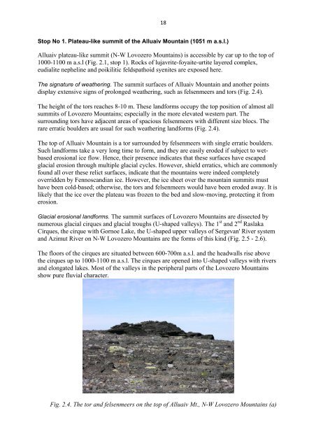
Stop No 1. Plateau-like summit of the Alluaiv Mountain (1051 m a.s.l.)<br />
Alluaiv plateau-like summit (N-W Lovozero Mountains) is accessible by car up to the top of<br />
1000-1100 m a.s.l (Fig. 2.1, stop 1). Rocks of lujavrite-foyaite-urtite layered complex,<br />
eudialite nepheline and poikilitic feldspathoid syenites are exposed here.<br />
The signature of weathering. The summit surfaces of Alluaiv Mountain and another points<br />
display extensive signs of prolonged weathering, such as felsenmeers and tors (Fig. 2.4).<br />
The height of the tors reaches 8-10 m. These landforms occupy the top position of almost all<br />
summits of Lovozero Mountains; especially in the more elevated western part. The<br />
surrounding tors have adjacent areas of spacious felsenmeers with different size blocs. The<br />
rare erratic boulders are usual for such weathering landforms (Fig. 2.4).<br />
The top of Alluaiv Mountain is a tor surrounded by felsenmeers with single erratic boulders.<br />
Such landforms take a very long time to form, and they are easily eroded if subject to wetbased<br />
erosional ice flow. Hence, their presence indicates that these surfaces have escaped<br />
glacial erosion through multiple glacial cycles. However, shield erratics, which are commonly<br />
found all over these relict surfaces, indicate that the mountains were indeed completely<br />
overridden by Fennoscandian ice. However, the ice sheet over the mountain summits must<br />
have been cold-based; otherwise, the tors and felsenmeers would have been eroded away. It is<br />
likely that the ice over the plateau was frozen to the bed and slow-moving, protecting it from<br />
erosion.<br />
Glacial erosional landforms. The summit surfaces of Lovozero Mountains are dissected by<br />
st nd<br />
numerous glacial cirques and glacial troughs (U-shaped valleys). The 1 and 2 Raslaka<br />
Cirques, the cirque with Gornoe Lake, the U-shaped upper valleys of Sergevan' River system<br />
and Azimut River on N-W Lovozero Mountains are the forms of this kind (Fig. 2.5 - 2.6).<br />
The floors of the cirques are situated between 600-700m a.s.l. and the headwalls rise above<br />
the cirques up to 1000-1100 m a.s.l. The cirques are opened into U-shaped valleys with rivers<br />
and elongated lakes. Most of the valleys in the peripheral parts of the Lovozero Mountains<br />
show pure fluvial character.<br />
18<br />
Fig. 2.4. The tor and felsenmeers on the top of Alluaiv Mt., N-W Lovozero Mountains (a)