Waterways (Brochure) - Hernando County
Waterways (Brochure) - Hernando County
Waterways (Brochure) - Hernando County

Create successful ePaper yourself
Turn your PDF publications into a flip-book with our unique Google optimized e-Paper software.
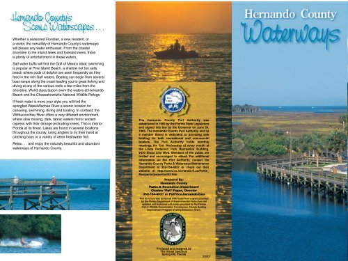
<strong>Hernando</strong> <strong>County</strong>’s<br />
Scenic Waterscapes . . .<br />
Whether a seasoned Floridian, a new resident, or<br />
a visitor, the versatility of <strong>Hernando</strong> <strong>County</strong>’s waterways<br />
will please any water enthusiast. From the coastal<br />
shoreline to the inland lakes and forested rivers, there<br />
is plenty of entertainment in these waters,<br />
Salt water buffs will find the Gulf of Mexico ideal; swimming<br />
is popular at Pine Island Beach, a shallow not too salty<br />
beach where pods of dolphin are seen frequently as they<br />
feed in the rich Gulf waters. Boating can begin from several<br />
boat ramps along the coast leading you to great fishing and<br />
diving at any of the various reefs a few miles from the<br />
shoreline. World class tarpon swim the waters at <strong>Hernando</strong><br />
Beach and the Chassahowitzka National Wildlife Refuge.<br />
If fresh water is more your style you will find the<br />
springfed WeekiWachee River a scenic location for<br />
canoeing, swimming, diving and boating. In contrast, the<br />
Withlacoochee River offers a very different environment,<br />
where slow moving, dark, tannic waters mirror ancient<br />
cypress with their strange protruding knees. This is interior<br />
Florida at its finest. Lakes are found in several locations<br />
throughout the county, luring anglers to try their hand at<br />
catching bass or a variety of other freshwater fish.<br />
Relax . . . and enjoy the naturally beautiful and abundant<br />
waterways of <strong>Hernando</strong> <strong>County</strong>.<br />
The <strong>Hernando</strong> <strong>County</strong> Port Authority was<br />
established in 1965 by the Florida State Legislature<br />
and signed into law by the Governor on June 24,<br />
1965. The <strong>Hernando</strong> <strong>County</strong> Port Authority and its<br />
5 member Board is dedicated to providing safe<br />
boating for both recreational and commercial<br />
boaters. The Port Authority holds monthly<br />
meetings the first Wednesday of every month at<br />
the Linda Pedersen Park Recreation Building,<br />
6430 Shoal Line Blvd. Members of the public are<br />
invited and encouraged to attend. For additional<br />
information on the Port Authority, contact the<br />
<strong>Hernando</strong> <strong>County</strong> Parks & <strong>Waterways</strong> Maintenance<br />
Department at 352-754-4027 or check out their<br />
website at http://www.co.hernando.fl.us/Parks_<br />
Rec/parks/pa/portauth2.htm<br />
Prepared By:<br />
<strong>Hernando</strong> <strong>County</strong><br />
Parks & Recreation Department<br />
Charles “Pat” Fagan, Director<br />
352-754-4027 or PatF@co.hernando.fl.us<br />
This brochure was produced with funds from a grant provided<br />
by the Florida Department of Environmental Protection and<br />
updated and re-printed with funds provided by the Florida<br />
Fish & Wildlife Conservation Commission, Florida Boating<br />
Improvement Program Boating Education Grant.<br />
Produced and designed by<br />
The Visual Spectrum<br />
Spring Hill, Florida<br />
3/2007
Boating Safety<br />
Safety Equipment<br />
It is recommended that all vessels<br />
obtain an equipment safety check<br />
at least once a year from either<br />
the Coast Guard Auxiliary, Florida<br />
Fish & Wildlife, or <strong>Hernando</strong> <strong>County</strong><br />
Sheriff’s Marine Unit. The minimum<br />
required safety equipment varies<br />
depending on the size and<br />
configuration of a vessel. As a<br />
minimum, all vessels must have<br />
one Coast Guard approved life<br />
jacket for each person on board<br />
and a sound producing device.<br />
Children under 6 years old must<br />
wear a life jacket on vessels less<br />
than 26 feet at all times while<br />
underway on Florida waters.<br />
While outside the 9-mile state<br />
limit in the Gulf of Mexico,<br />
children under 13 years old<br />
must wear a life jacket<br />
according to federal law.<br />
You may also be required to<br />
carry an approved throwable<br />
flotation device, and approved<br />
visual distress signals.<br />
The Coast Guard Auxiliary offers<br />
safe boating courses that meet<br />
the requirements for the Florida<br />
Safe Boating ID Card. Contact<br />
the Coast Guard Auxiliary for<br />
additional information.<br />
Operation of Vessel<br />
The rules governing the<br />
operation of a vessel are governed<br />
by both the State of Florida and<br />
the U.S. Coast Guard, through the<br />
COLREGS. All vessels are required<br />
to comply with these rules.<br />
Emergencies<br />
Emergencies should be reported<br />
to either the U.S. Coast Guard,<br />
Florida Fish & Wildlife, or the<br />
<strong>Hernando</strong> <strong>County</strong> Sheriff’s Marine<br />
Unit. When calling for help on<br />
your radio, the use of the term<br />
“MAYDAY” is reserved only for<br />
life threatening situations. Should<br />
you have a VHF Marine Radio,<br />
you can call for help on Channel<br />
16. Remember, Channel 16 is<br />
used for emergencies and as a<br />
calling channel. It is not to be<br />
used for conversing. As a pleasure<br />
boater, you can use channels 14,<br />
20, 68, 69, 71, 72, 73, 74 & 78<br />
for ship to ship conversations.<br />
Important Phone Numbers<br />
• U.S. Coast Guard<br />
352-447-6900<br />
• Coast Guard Auxiliary<br />
352-596-6737<br />
• FL Fish & Wildlife<br />
888-404-FWCC (3922)<br />
• <strong>Hernando</strong> <strong>County</strong> Sheriff<br />
352-754-6830<br />
• <strong>Hernando</strong> <strong>County</strong><br />
Parks & <strong>Waterways</strong><br />
352-754-4027<br />
(www.co.hernando.fl.us)<br />
Important Rules<br />
Responsibility For Wake<br />
Vessel operators are responsible<br />
for damage to any other vessel,<br />
dock, property, or injury caused<br />
by their vessel’s wake due to<br />
operator negligence.<br />
Overtaking Another Vessel<br />
If you pass a boat from behind,<br />
you are overtaking and bear<br />
the responsibility for making a<br />
safe pass. The vessel you are<br />
overtaking is the stand-on vessel,<br />
and you need to give-way to it.<br />
Passing Another Vessel<br />
When two boats are<br />
approaching each other in a<br />
head on, or nearly head on<br />
situation, each vessel is to alter<br />
their course to starboard.<br />
Sailing Vessels<br />
When you approach a vessel<br />
that is less maneuverable than<br />
you (such as a sail boat or a<br />
large vessel in a narrow channel),<br />
you are usually required to<br />
give-way to the other vessel.<br />
Anchoring<br />
Except in the event of an<br />
emergency, it is unlawful to tie<br />
a vessel to a lawfully placed<br />
navigation aid or to create<br />
a navigational hazard by<br />
interfering with the navigation<br />
of other vessels.
Bayport boat ramp and dock.<br />
<strong>Hernando</strong> Beach ramp, dock and main canal that leads<br />
directly to the <strong>Hernando</strong> Beach channel and the Gulf.<br />
The small fishing village Aripeka is <strong>Hernando</strong> <strong>County</strong>’s<br />
southern most port.<br />
<strong>Hernando</strong> <strong>County</strong> Boat Boa Ramps<br />
Bayport<br />
Pine Island<br />
Rogers Park<br />
Jenkins Creek<br />
<strong>Hernando</strong> Beach<br />
Hunters Lake<br />
Lake Lindsey<br />
Gainesville<br />
<strong>Hernando</strong> <strong>County</strong> —<br />
Mountain Lake<br />
Lake Townsen<br />
Regional Park<br />
Nobleton<br />
For Additional Information Contact: <strong>Hernando</strong> <strong>County</strong> Tourist Development . . . . . . . (352) 754-4405 or 1-800-601-4580 (www.co.hernando.fl.us./tourdev)<br />
<strong>Hernando</strong> <strong>County</strong> Parks and Recreation . . . . . (352) 754-4027 (www.co.hernando.fl.us./parks)<br />
Tampa<br />
Orlando<br />
Byster Lake<br />
Exit 301<br />
Silver Lake<br />
CROOM RITAL RD.<br />
Ramps at Lake Lindsey (left)<br />
and the Withlacoochee River<br />
at Nobleton (below) provide<br />
scenic boating and fishing on<br />
the county’s east side.<br />
Rogers Park on the Weeki Wachee River is one of<br />
the county’s favorite “swimmin’ holes” with its white<br />
sand beach in addition to boat ramp and playground.<br />
Bayport<br />
Lighted Fishing Pier<br />
3 Handicap Accessible Boat Ramps<br />
with direct access to the Gulf<br />
of Mexico<br />
Restroom Facilities<br />
Covered Picnic Area<br />
Boaters should not have trouble<br />
navigating this channel except during<br />
periods of extreme low tides.<br />
Directions<br />
US 19 to SR 550. West to end.<br />
Jenkins Creek/Linda Pedersen Park<br />
Boat Ramp (boats 16’ and under)<br />
2 Lighted Fishing Piers<br />
Restroom Facilities<br />
Good Parking<br />
Elderly/Handicap Fishing Facility<br />
Swimming Area With Beach<br />
Boardwalk and Comfort Station<br />
Fishing Area<br />
Picnic Area<br />
Playground<br />
Observation Tower<br />
Canoe Ramp<br />
Directions<br />
US 19 to SR 550. West to SR 597,<br />
turn left (South) 2 miles to Jenkins<br />
Creek Fishing Pier. 1 block past<br />
Jenkins Creek on left side is public<br />
handicap pier.<br />
<strong>Hernando</strong> Beach Boat Ramp<br />
Boat Ramp with access to<br />
Gulf Of Mexico<br />
Restroom Facilities<br />
Directions<br />
US 19 to SR 550. West to SR 597,<br />
turn left (South) go to <strong>Hernando</strong><br />
Beach turn right on Calienta Street.<br />
Ramp is on left, parking is on right.<br />
Once the <strong>Hernando</strong> Beach Channel<br />
Dredge is completed, boaters<br />
should not have trouble navigating<br />
this channel.<br />
Rogers Park (Weeki Wachee River)<br />
Beach<br />
Boat Ramp<br />
Canoe/Kayak Ramp<br />
Fishing Dock<br />
Restroom Facilities<br />
Park and Playground Facilities<br />
Parking Facilities (nominal charge)<br />
Lighted<br />
The ramp allows access to the Weeki<br />
Wachee River and connects to the<br />
Bayport Channel at its western end for<br />
access to the Gulf.<br />
Directions<br />
US 19 to SR 550. West to SR 597,<br />
turn left (South) 1.5 miles, turn left on<br />
Patterson Street.<br />
Byster Lake<br />
Dirt Ramp with access to a small lake<br />
No restrooms or amenities available at<br />
this location<br />
Directions<br />
SR 50 East, turn left on Clayton Road<br />
continue to boat ramp.<br />
Hunters Lake<br />
Boat Ramp<br />
Good Parking<br />
Lighted<br />
Directions<br />
U.S. 19 to Spring Hill Drive. East on<br />
Spring Hill Drive to Kenlake Ave. turn<br />
on Ken Lake Ave., follow signs to lake.<br />
Lake Lindsey<br />
Boat Ramp<br />
Small Parking Area<br />
Lighted<br />
Directions<br />
SR 50 East to US 41, turn north to<br />
481 (Snow Memorial Highway) to<br />
Lake Lindsey Rd. follow boat<br />
ramp signs.<br />
Mountain Lake<br />
Boat Ramp<br />
Good Parking<br />
Directions<br />
SR 50 east to 541 (Spring Lake<br />
Highway) to Mountain Lake Rd.<br />
to ramp.<br />
Silver Lake<br />
State Maintained Park<br />
2 Boat ramps<br />
Good Parking<br />
Fee - Camping<br />
Directions<br />
SR 50 east to Croom Road (1 mile<br />
east of I-75). Turn left on Croom<br />
Rital Road to Silver Lake Park.<br />
(Approximately 5 miles)<br />
Withlacoochee / Nobleton<br />
(Lake Townsen Regional Park)<br />
Boat Ramp<br />
Fishing Pier adjacent to<br />
Withlacoochee State Trail<br />
Picnic Facilities<br />
Good Parking<br />
Restroom Facilities<br />
Directions<br />
SR 50 East to US 41, go north, turn<br />
right on Lake Lindsey Road (476) to<br />
Nobleton Ramp, follow signs.<br />
*When water levels are low, access to the boat ramps may be limited.
M<br />
N<br />
< 182T<br />
002T ><br />
6’ or less<br />
< 203T 5.0 NM 023T ><br />
< 275T<br />
095T><br />
< 243T<br />
063T><br />
N<br />
L<br />
K<br />
Every effort has been made to maintain the accuracy of<br />
this chart but the publisher does not warrant or guarantee<br />
the accuracy of this chart for navigational purposes. To<br />
ensure safety, the publisher suggests that the user refers<br />
to the most recent NOAA publications and update these<br />
publications regularly for the Local Notice to Mariners.<br />
The prudent mariner will not rely solely on any single aid<br />
to navigation, particularly on floating aids. See U.S. Coast<br />
Guard Light List and U.S. Coast Guard Pilot for details.<br />
NOT INTENDED FOR USE IN NAVIGATION. Publisher<br />
assumes no liability for any damages arising from errors<br />
or omissions contained in this chart.<br />
exposed<br />
at low tide<br />
Navigational Markers, Rocks/Obstructions<br />
A. Bill Watts Tripod (<strong>Hernando</strong> Beach Channel)<br />
Location: 28’31.135 N 82’42.471 W<br />
Identification: 16’ high aluminum tripod.<br />
5 mile visibility. Flashing white quick flash.<br />
Marked: “<strong>Hernando</strong> Beach Bill Watts Tripod”<br />
B. <strong>Hernando</strong> Beach Turn Light<br />
Location: 28’30.872 N 82’44.073 W<br />
Identification: 16’ high single pole.<br />
Flashing white 3 seconds.<br />
Marked: “HB”<br />
C. Billy Steele South Rack<br />
Location: 28’30.415 N 82’46.488 W<br />
Identification: 16’ high aluminum tripod.<br />
Danger, submerged ruins.<br />
Flashing OC white 4 seconds.<br />
D. Middle Rock<br />
Location: 28’31.700 N 82’46.600 W<br />
Identification: 4’ X 4’ sign “Danger Rocks”<br />
Marked: “Middle Rocks”<br />
E. Bayport North Rack<br />
Location: 28’33.895 N 82’46.851 W<br />
Identification: 16’ high aluminum tripod.<br />
Danger, submerged ruins.<br />
Flashing white ISO 6 seconds.<br />
Marked: “North Rack”<br />
< 258T 10.6 NM 078T ><br />
marsh<br />
< 255T 11.4 NM 075T ><br />
< 286T 9.0 NM 106T ><br />
< 298T 12.2 NM 118T ><br />
< 279T 7.7 NM 099T ><br />
< 282T 12.6 NM 102T ><br />
F. Bayport Channel Entrance Light<br />
Location: 28’32.850 N 82’42.570 W<br />
Identification: 16’ high aluminum tripod.<br />
Flashing white 5 seconds.<br />
Marked: “Bayport”<br />
G. Gomez Rocks<br />
Location: North Piling 28’29.840 N 82’43.680 W<br />
South Piling 28’29.689 N 82’43.682 W<br />
Identification: 2 poles 100 yards apart on a north -<br />
south line. 4’ X 4’ sign “Danger Rocks”<br />
Marked: “Gomez Rock”<br />
H. Chassahowitzka Channel Entrance<br />
Location: 28’39.500 N 82’44.100 W<br />
Identification: 16’ high aluminum tripod.<br />
Flashing white quick flash.<br />
Marked: “Chassahowitzka”<br />
I. Cutter Rock<br />
Location: 28’30.979 N 82’49.934 W<br />
Identification: 16’ pole. 4’ X 4’ sign “Danger Rocks”<br />
Flashing white 6 seconds.<br />
Marked: “Cutter Rock”<br />
J. Aripeka Channel Entrance Light<br />
Location: 28’27.04 N 82’44.57 W<br />
Identification: 16’ high aluminum tripod.<br />
Flashing white 6 seconds.<br />
Marked: “Aripeka”<br />
I<br />
E<br />
D<br />
C<br />
< 205T 6.0 NM 025T ><br />
< 305T 4.8 NM 125T ><br />
< 320T 4.0 NM 140T ><br />
< 256T 076T ><br />
2.4 NM<br />
< 332T 3.6 NM 152T ><br />
J<br />
< 192T 3.8 NM 012T ><br />
H<br />
< 182T 8.2 NM 002T ><br />
< 168T 6.7 NM 348T ><br />
< 290T 4.0 NM 110T><br />
B<br />
< 258T<br />
078T ><br />
G<br />
Artificial Reefs -<br />
Skin & Scuba Diving<br />
K. Fish Haven - A.H. Richardson Reef<br />
LORAN Coordinates: 14325.8 45109.5<br />
Location: 28’31.484 N 82’55.144 W<br />
Identification: Yellow buoy marked<br />
“Fish Haven - Richardson Reef”<br />
Composition: Culverts and concrete bridge<br />
material, depths to 20’<br />
L. Fish Haven - Jim Champion Reef<br />
LORAN Coordinates: 14337.4 45159.2<br />
Location: 28’36.430 N 82’56.400 W<br />
Identification: Yellow buoy marked<br />
“Fish Haven - Champion Reef”<br />
Composition: Culverts and barge, depths to 20’<br />
M. Bendickson Tank Reef<br />
LORAN Coordinates: 14320.3 45139.8<br />
Location: 28’31.761 N 82’58.362 W<br />
Identification: Yellow buoy marked<br />
“Bendickson Tank Reef”<br />
Composition: 10 Army tanks in a 1/4 mile radius,<br />
depths to 25’<br />
N. Reef Ball Reef<br />
LORAN Coordinates: 14312.9 45116.1<br />
Location: 28’30.007 N 82’58.408 W<br />
Identification: White buoy marked “Reef Balls”<br />
Composition: 180 concrete reef balls in a 1/4 mile<br />
radius, depths to 29’<br />
A<br />
F<br />
Pine Island<br />
Bayport<br />
595<br />
Aripeka<br />
597<br />
Chassahowitzka<br />
<strong>Hernando</strong><br />
Beach<br />
Rogers Park<br />
Jenkins Creek<br />
Fresh Water Dives<br />
Weeki Wachee River<br />
Drift 20’<br />
Hospital Hole<br />
Vertical drop with sulfur layer at 80’<br />
Adv Cave 140’<br />
Joe & Mary’s Sinks<br />
Shallow craterlike surface, cavern<br />
natural light to 30’<br />
Salt Spring<br />
Private property, vertical crevasse 70’<br />
Saw Grass Spring<br />
In salt estuary west of Mary’s Fish Camp 20’<br />
Eagle’s Nest, DiPoler, Twin D’s & Wards<br />
Adv. Cave Deep Technical Sink Hole<br />
Cave Systems at 230’<br />
Contact local dive shops for locations.<br />
Bayport<br />
Pine Island<br />
597<br />
Lake Townsen<br />
Regional Park<br />
476<br />
Canoeing & Kayaking<br />
Weeki Wachee River<br />
Put in at Rogers Park on 597,<br />
6 miles upriver to main spring.<br />
Downriver to Bayport and Mud<br />
River. Clear water and year<br />
around pods of Manatees. A<br />
scenic river that needs protection<br />
from further development and<br />
abuse. The river’s left bank from<br />
Rogers Park to 3 miles upriver<br />
is preserved.<br />
Mud River<br />
Rogers Park<br />
Jenkins Creek<br />
&<br />
Linda Pedersen Park<br />
Nobleton<br />
Withlacooche State Forest<br />
Croom Tract<br />
50<br />
I-75<br />
Bayport<br />
West on 550. Paddle estuary,<br />
up river, up the coast to Pine<br />
Island or down the coast<br />
to <strong>Hernando</strong> Beach and Aripeka.<br />
Jenkins Creek<br />
Put in at Linda Pedersen Park<br />
on 597. Paddle the estuary<br />
and coast.<br />
Pine Island<br />
High tide north to<br />
Chassahowitzka estuary.<br />
Be on the lookout for<br />
unexpected rocks and oyster<br />
beds. Chassahowitzka is a<br />
National Wildlife Refuge.<br />
550<br />
Weeki Wachee River<br />
Withlacoochee River<br />
Exit 301<br />
Silver Lake<br />
Croom Rital Road<br />
Withlacoochee River<br />
From <strong>Hernando</strong> <strong>County</strong> to<br />
the Gulf of Mexico. Put in at<br />
Lacoochee Park to 301 to SR<br />
50 to Silver Lake to Nobleton.<br />
Outside of Nobleton you enter<br />
Citrus <strong>County</strong>. Much of the river<br />
flows inside the boundary of the<br />
Withlacoochee State Forest<br />
and surrounding SWFWMD<br />
protected land.<br />
Weeki Wachee Preserve<br />
SWFWMD protected wetland.<br />
Several old mining pits. Great<br />
confined water kayaking.<br />
Visit: www.FloridaGreenwaysandTrails.com<br />
For more information on the Florida Circumnavigational<br />
Saltwater Paddling Trail<br />
Weeki Wachee Spring<br />
19