Cuckoo Trail Pevensey Levels - Sustrans
Cuckoo Trail Pevensey Levels - Sustrans
Cuckoo Trail Pevensey Levels - Sustrans

You also want an ePaper? Increase the reach of your titles
YUMPU automatically turns print PDFs into web optimized ePapers that Google loves.
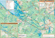
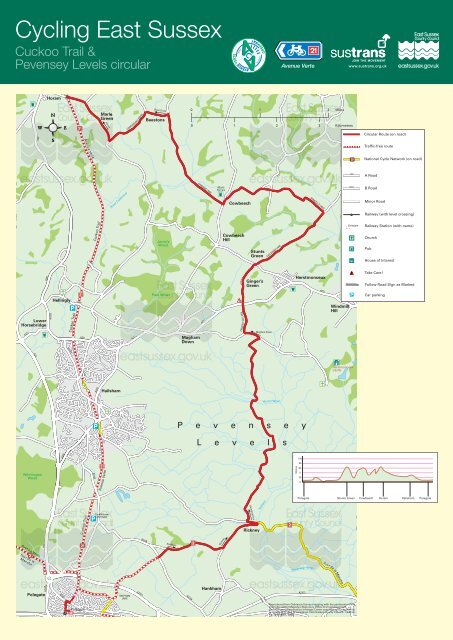
Cycling East Sussex<br />
<strong>Cuckoo</strong> <strong>Trail</strong> &<br />
<strong>Pevensey</strong> <strong>Levels</strong> circular Avenue Verte www.sustrans.org.uk<br />
A271<br />
A22<br />
A267 A267<br />
A22 A222<br />
A267<br />
Lower<br />
Horsebridge<br />
Wilmington<br />
Wood<br />
Avenue Av A enuee Verte Ve V rttte te<br />
Tour Tou TT T rde dela la<br />
Manche Manch chee<br />
A2<br />
Polegate<br />
Horam<br />
B2104<br />
Hellingly<br />
A295<br />
B2247<br />
<strong>Cuckoo</strong> <strong>Trail</strong><br />
B2104<br />
A271<br />
Polegate<br />
Avenue Verte<br />
VVe enue Av A<br />
<strong>Cuckoo</strong> Cu k o <strong>Trail</strong> T il il<br />
VV rte<br />
<strong>Cuckoo</strong> <strong>Trail</strong><br />
B2104<br />
A295<br />
MMarle<br />
rl e<br />
Gr Green eeenn<br />
Horam am<br />
River Cuckmere<br />
Hailsham<br />
Avenue Verte<br />
The<br />
Old OOld<br />
O Loom<br />
m<br />
Mill Mil ll l (cafe)<br />
)<br />
SHEPHAM<br />
LANE<br />
COWDENHALL ROAD<br />
A271 A271<br />
A27(T)<br />
B2104<br />
Vines Cross<br />
Beestons<br />
Jarvis’s<br />
Wood<br />
Park k Wood Woo od<br />
Hankham<br />
Magham<br />
Down Dow<br />
B2104<br />
0 1 2 Miles MMile<br />
0 1 2 3 Kilometres<br />
Kilo<br />
HAMMER LANE<br />
A271 AA2771<br />
Merrie<br />
Harriers<br />
Hankham<br />
Rickney<br />
Cowbeech<br />
Cowbeech<br />
Hill<br />
CRICKETI NG LANE<br />
Stunts<br />
Green<br />
Ginger’s<br />
Green<br />
Herstmonceux<br />
Rickney kn<br />
Magham Down<br />
CHILSHAM LANE<br />
Hurst Haven<br />
P e v e n s e y<br />
L e v e l s<br />
Yotham<br />
A27(T)<br />
BEMZELLS LANE<br />
Herstmonceux<br />
Metres<br />
100<br />
80<br />
60<br />
0<br />
20<br />
0<br />
<strong>Pevensey</strong> Haven<br />
Peevvee<br />
aveen<br />
A271<br />
Windmill<br />
Hill<br />
Herstmonceux<br />
Castle<br />
Tour de la Manche<br />
Reproduced from Ordnance Survey mapping with the permission of the<br />
controller of Her Majesty’s Stationery Office © Crown Copyright.<br />
Unauthorised reproduction infringes Crown copyright and may lead to<br />
prosecution or civil proceedings. East Sussex County Council. Licence<br />
no: 100019601, 2008<br />
To<br />
TT ur de ll<br />
h<br />
A259<br />
B2244<br />
LC<br />
Polegate<br />
Herstmonceux
This circular ride offers a much gentler excursion<br />
than those exploring the High Weald further north;<br />
indeed the parts of the route crossing the <strong>Pevensey</strong><br />
<strong>Levels</strong> are as fl at as anything you will fi nd in the<br />
whole country. Starting from Polegate you turn east,<br />
soon entering the <strong>Pevensey</strong> <strong>Levels</strong>, a landscape of<br />
deep and dark drainage channels, tall reeds and<br />
rushes, with contented cows munching the lush<br />
grass in the rich pastures. The horizon looks like<br />
the rim of a saucer, just rising above the fl at fi elds<br />
crossed on the ride. To the east are the buildings<br />
and domes surrounding Herstmonceux Castle.<br />
The main hill of the ride comes at the north edge of<br />
the <strong>Levels</strong>, climbing 60 metres as you cross the<br />
A271 to Ginger’s Green and on to Stunts Green.<br />
Refreshment stops have been in short supply since<br />
leaving Hailsham but this is remedied in Cowbeech.<br />
Several crossings of the tributaries of the Cuckmere<br />
River mean a series of ups and downs on your<br />
way through Beestons and Marle Green to Horam,<br />
where you join the <strong>Cuckoo</strong> <strong>Trail</strong>.<br />
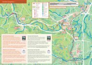
<strong>Pevensey</strong> <strong>Levels</strong><br />
David Selman Ian Chamberlain Ian Chamberlain<br />
David Sellman<br />
<strong>Pevensey</strong> <strong>Levels</strong><br />
Year-on-year the trail becomes a more interesting<br />
ride as new sculptures are built and new<br />
interpretation boards give you background<br />
information about all that lies around you. Woodland<br />
management opens up new views and creates<br />
habitats for a variety of fl ora and fauna.<br />
Glide gently downhill through mature woodland and<br />
admire the wonderful metal sculpture either side of<br />
Cattle Creep bridge depicting trains, bikes, horses,<br />
walkers, dogs and wild animals. Children will love<br />
the Wildlife Art <strong>Trail</strong> - a series of carved wooden<br />
tableaux depicting creatures such as hedgehogs<br />
and squirrels. The <strong>Cuckoo</strong> <strong>Trail</strong> takes you right back<br />
to Polegate.<br />
Hellingly Church The church of St. Peter and St.<br />
Paul has a rare circular churchyard of Saxon origin<br />
known as a cric. Standing seven feet above the<br />
surrounding houses it is held in place by tall brick<br />
walls; its circular form is believed to represent the<br />
Celtic symbol for immortality and was raised above<br />
ground level to keep the dead dry.<br />
David Sellman<br />
<strong>Pevensey</strong> <strong>Levels</strong><br />
Hellingly<br />
<strong>Pevensey</strong> <strong>Levels</strong> The area was formed by a<br />
build-up of shingle across <strong>Pevensey</strong> Bay, which was<br />
reclaimed in the Middle Ages to create a broad plain<br />
of pasture land with dykes and isolated farms. It is<br />
now an internationally important wetland for wildlife.<br />
Herstmonceux Castle Location of a fairytale<br />
castle, the Science Centre and former royal<br />
observatory telescopes. It was from the<br />
observatory’s atomic clocks at Herstmonceux that<br />
the familiar ‘six-pips’ were sent by land-line to the<br />
BBC for broadcast.<br />
<strong>Cuckoo</strong> <strong>Trail</strong> The original railway line was the<br />
Polegate to Eridge railway, carrying milk, livestock<br />
and animal feed as well as passengers. It was<br />
named the <strong>Cuckoo</strong> Line after the tradition that the<br />
fi rst cuckoo of spring was released at Heathfi eld<br />
Fair. It was closed due to the cuts made by<br />
Beeching in 1968 and became a leisure route used<br />
by walkers, cyclists and horseriders in 1990. The<br />
trail is 13 miles long, from Heathfi eld in the north<br />
to Hampden Park, Eastbourne, in the south, and<br />
forms part of the National Cycle Network Route 21<br />
and The Avenue Verte London - Paris.<br />
David Young<br />
Cattle Creep Bridge<br />
<strong>Cuckoo</strong> <strong>Trail</strong>