

Norfolk health, heritage and biodiversity walks - Enjoying the Norfolk ...
Norfolk health, heritage and biodiversity walks - Enjoying the Norfolk ...
Norfolk health, heritage and biodiversity walks - Enjoying the Norfolk ...

Create successful ePaper yourself
Turn your PDF publications into a flip-book with our unique Google optimized e-Paper software.
Walk<br />
3 Watton/<br />
Merton<br />
Start point War Memorial (Memorial Way, Watton)<br />
Grid reference TF917006 • Postcode IP25 6BS<br />
Parking Free parking on Thetford Road by <strong>the</strong> War Memorial/<br />
various town centre car parks<br />
Distance 3.7 miles (or shorter walk 2.7 miles)<br />
Details Minor gradients, long walk 25% soft, short walk 30% soft<br />
Walk instructions<br />
1. Starting at <strong>the</strong> war memorial, bear right along Merton Road. Pass all<br />
<strong>the</strong> houses <strong>and</strong> <strong>the</strong> High School <strong>and</strong> follow Merton Road out in to <strong>the</strong><br />
countryside.<br />
2. For <strong>the</strong> longer walk stay on Merton Road until reaching Merton<br />
Green. Turn first right before <strong>the</strong> village shelter on to Tottington<br />
Terrace <strong>and</strong> <strong>the</strong>n bear right at <strong>the</strong> T-junction on to The Green leading<br />
to Home Farm Lane.<br />
3. Follow <strong>the</strong> road past Merton Village Hall to <strong>the</strong> junction <strong>and</strong> turn right;<br />
<strong>the</strong> hard surface gives way to a farm track. Follow <strong>the</strong> restricted byway<br />
to <strong>the</strong> end (now follow instruction 5 below).<br />
4. For <strong>the</strong> short walk (continued from instruction 1): approximately<br />
500 yards after passing <strong>the</strong> last of <strong>the</strong> houses on Merton Road, turn<br />
right on to <strong>the</strong> public footpath opposite <strong>the</strong> wood (Rabbit Plantation).<br />
Follow <strong>the</strong> path around <strong>the</strong> edge of <strong>the</strong> field, keeping <strong>the</strong> hedge on<br />
your right. At <strong>the</strong> end, turn right to cross a footbridge (now follow<br />
instruction 5 below).<br />
5. Cross <strong>the</strong> footbridge over <strong>the</strong> stream <strong>and</strong> bear left along <strong>the</strong> track<br />
called Long Bridle Road. After approximately a third of a mile, look<br />
out for a row of houses on your right. Turn right on to <strong>the</strong> hard<br />
surface path leading into <strong>the</strong> housing estate; <strong>the</strong>n bear left on to Stokes<br />
Avenue. Pass Bridle Road on your right <strong>and</strong> keep walking to <strong>the</strong> end of<br />
Stokes Avenue.<br />
14<br />
6. Turn right at <strong>the</strong> T-junction on to Br<strong>and</strong>on Road. Continue ahead over<br />
<strong>the</strong> roundabout onto <strong>the</strong> High Street. Walk all <strong>the</strong> way along <strong>the</strong> High<br />
Street <strong>and</strong> <strong>the</strong>n just before you reach <strong>the</strong> traffic light junction, turn right<br />
on to Thetford Road <strong>and</strong> walk back to your start point beside <strong>the</strong> war<br />
memorial.<br />
Flints <br />
An abundance of flint in<br />
nearby fields indicates<br />
that buildings such as<br />
<strong>the</strong>se cottages will have<br />
been constructed using<br />
local materials.<br />
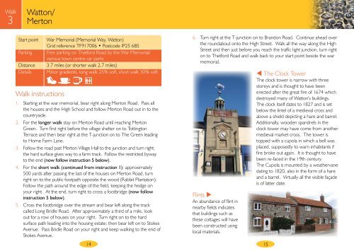
The Clock Tower<br />
The clock tower is narrow with three<br />
storeys <strong>and</strong> is thought to have been<br />
erected after <strong>the</strong> great fire of 1674 which<br />
destroyed many of Watton’s buildings.<br />
The clock itself dates to 1827 <strong>and</strong> is set<br />
below <strong>the</strong> lintel of a medieval cross <strong>and</strong><br />
above a shield depicting a hare <strong>and</strong> barrel.<br />
Additionally, wooden sp<strong>and</strong>rels in <strong>the</strong><br />
clock tower may have come from ano<strong>the</strong>r<br />
medieval market cross. The tower is<br />
topped with a cupola in which a bell was<br />
placed, supposedly to warn inhabitants if<br />
fire broke out again. It is thought to have<br />
been re-faced in <strong>the</strong> 19th century.<br />
The Cupola is mounted by a wea<strong>the</strong>rvane<br />
dating to 1820, also in <strong>the</strong> form of a hare<br />
<strong>and</strong> a barrel. Virtually all <strong>the</strong> visible façade<br />
is of latter date.<br />
15