Munuscong Bay - Michigan Department of Natural Resources
Munuscong Bay - Michigan Department of Natural Resources
Munuscong Bay - Michigan Department of Natural Resources

You also want an ePaper? Increase the reach of your titles
YUMPU automatically turns print PDFs into web optimized ePapers that Google loves.
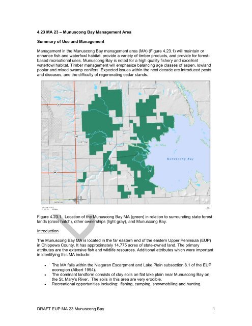
4.23 MA 23 – <strong>Munuscong</strong> <strong>Bay</strong> Management Area<br />
Summary <strong>of</strong> Use and Management<br />
Management in the <strong>Munuscong</strong> <strong>Bay</strong> management area (MA) (Figure 4.23.1) will maintain or<br />
enhance fish and waterfowl habitat, provide a variety <strong>of</strong> timber products, and provide for forestbased<br />
recreational uses. <strong>Munuscong</strong> <strong>Bay</strong> is noted for a high quality fishery and excellent<br />
waterfowl habitat. Timber management will emphasize balancing age classes <strong>of</strong> aspen, lowland<br />
poplar and mixed swamp conifers. Expected issues within the next decade are introduced pests<br />
and diseases, and the difficulty <strong>of</strong> regenerating cedar stands.<br />
Figure 4.23.1. Location <strong>of</strong> the <strong>Munuscong</strong> <strong>Bay</strong> MA (green) in relation to surrounding state forest<br />
lands (cross hatch), other ownerships (light gray), and <strong>Munuscong</strong> <strong>Bay</strong>.<br />
Introduction<br />
The <strong>Munuscong</strong> <strong>Bay</strong> MA is located in the far eastern end <strong>of</strong> the eastern Upper Peninsula (EUP)<br />
in Chippewa County. It has approximately 14,775 acres <strong>of</strong> state-owned land. The primary<br />
attributes are the extensive fish and wildlife resources. Additional attributes which were important<br />
in identifying this MA include:<br />
The MA falls within the Niagaran Escarpment and Lake Plain subsection 8.1 <strong>of</strong> the EUP<br />
ecoregion (Albert 1994).<br />
The dominant landform consists <strong>of</strong> clay soils on flat lake plain near <strong>Munuscong</strong> <strong>Bay</strong> on<br />
the St. Mary’s River. The soils in this area are very erodible.<br />
Recreational opportunities including: fishing, camping, snowmobiling and hunting.<br />
DRAFT EUP MA 23 <strong>Munuscong</strong> <strong>Bay</strong> 1
There are special conservation area (SCA) deer wintering areas, including the Keldon<br />
deer yard, and Great Lakes marsh and poor fen ecological reference areas (ERAs) within<br />
the MA.<br />
There are several known archeological sites within the MA, including old homesteads and<br />
a fossil bed.<br />
This MA is within the <strong>Munuscong</strong> River Watershed, which is primarily a warm and cool water<br />
system. It has historically supported a strong walleye run, but is currently adversely affected by<br />
agricultural run<strong>of</strong>f. <strong>Munuscong</strong> <strong>Bay</strong> supports an outstanding walleye fishery.<br />
This MA is also the <strong>Munuscong</strong> State Wildlife Management Area. Waterfowl management has<br />
been a priority both along <strong>Munuscong</strong> <strong>Bay</strong> and in interior grassland habitat where a number <strong>of</strong><br />
man-made pot holes were constructed in the low areas. DNR and volunteer crews worked<br />
together to create these ponds. Some ponds have also been created on private property through<br />
cooperative agreements. Much <strong>of</strong> this MA is a wildlife flooding dependent upon natural water<br />
level fluctuations. The wetland and grassland habitats in the MA provide habitat for waterfowl and<br />
grassland species alike.<br />
The state land in this MA is fairly concentrated, with some private land throughout. The<br />
<strong>Munuscong</strong> <strong>Bay</strong> MA is within the Sault Forest Management Unit (FMU). The current predominant<br />
cover types, acreages and projected harvest acres for the MA are shown in Table 4.23.1.<br />
Table 4.23.1. Current cover types, acreages, projected harvest acres and projected ten-year cover type acreage for<br />
the <strong>Munuscong</strong> <strong>Bay</strong> MA, EUP ecoregion (2012 DNR inventory data).<br />
Hard Factor<br />
Projected<br />
Current Limited Manageable 10 Year Projected Harvest (Acres) Acreage in 10 Desired Future Harvest (Acres)<br />
Cover Type Cover % Acreage Acres Acres<br />
Final Harvest Partial Harvest Years Final Harvest Partial Harvest<br />
Lowland Deciduous 22% 3,216 510 2,706 149 0 3,216 301 0<br />
Lowland Open/Semi‐Open Lands 20% 2,890 0 2,890 0 0 2,890 0 0<br />
Cedar 16% 2,371 26 2,345 20 0 2,371 147 0<br />
Lowland Aspen/Balsam Poplar 9% 1,345 463 882 159 0 1,345 159 0<br />
Upland Open/Semi‐Open Lands 7% 987 0 987 0 0 987 0 0<br />
Lowland Conifers 6% 830 73 757 268 0 830 84 0<br />
Aspen 5% 806 56 750 109 0 806 125 0<br />
Tamarack 5% 746 212 534 148 0 746 76 0<br />
Misc Other (Water, Local, Urban) 5% 698 0 698 0 0 698 0 0<br />
Others 6% 886 68 818 63 154 886 45 228<br />
Total 100% 14,775 1,408 13,367 916 154 14,775 937 228<br />
Others include: northern hardwood, lowland spruce/fir, red pine, upland spruce/fir, lowland mixed forest, paper birch, mixed upland<br />
deciduous, and oak.<br />
4.23.1 Forest Cover Type Management Direction<br />
The following sections contain information on vegetation management direction in the form <strong>of</strong><br />
Desired Future Conditions, 10-Year Management Objectives and Long-Term Management<br />
Objectives for each <strong>of</strong> the major cover types or forest communities within the MA. This<br />
information applies to those portions <strong>of</strong> the forest where active management (i.e. timber harvest,<br />
prescribed fire, planting, mowing) will be conducted. In other portions <strong>of</strong> the state forest, passive<br />
management resulting in natural succession will achieve ecological objectives. While most stands<br />
have a variety <strong>of</strong> tree species and other vegetation, they are classified by the predominant<br />
species.<br />
All <strong>of</strong> the following cover types are valued commercially for their timber products; ecologically as<br />
sources <strong>of</strong> habitat for numerous species; and for the variety <strong>of</strong> recreational opportunities they<br />
provide. Harvesting these cover types will provide for a continuous flow <strong>of</strong> these products and<br />
values.<br />
DRAFT EUP MA 23 <strong>Munuscong</strong> <strong>Bay</strong> 2
Section 4.23.1.1 Forest Cover Type Management – Lowland Deciduous<br />
Current Condition<br />
Lowland deciduous stands occur on 3,216 acres (22%) <strong>of</strong> the MA (Table 4.23.1). Lowland<br />
deciduous stands in this MA are <strong>of</strong>ten found in association with the creeks and drainages, making<br />
access difficult. Almost 20% <strong>of</strong> the lowland deciduous stands have been listed as uneven-aged<br />
(Figure 4.23.2). This is generally due to natural processes resulting in a range <strong>of</strong> size and age<br />
classes within the inaccessible stands. <strong>Natural</strong> regeneration has been effective after past<br />
harvesting. Many <strong>of</strong> the stands in this area contain ash trees. Follow the emerald ash borer (EAB)<br />
management guidelines to salvage ash.<br />
Currently there are no acres <strong>of</strong> lowland deciduous with a final harvest prescribed. There are 71<br />
acres <strong>of</strong> other cover types that are expected to convert to lowland deciduous after harvest. This<br />
may slightly change the total lowland deciduous acres. There are 510 acres <strong>of</strong> lowland deciduous<br />
that have site conditions limiting their harvest this entry period. These hard factor limited acres<br />
have been removed from the total number <strong>of</strong> manageable acres available for harvest<br />
calculations.<br />
Acres<br />
700<br />
600<br />
500<br />
400<br />
300<br />
200<br />
100<br />
0<br />
Regen Rx's<br />
0‐9<br />
10‐19<br />
Figure 4.23.2. Age-class distribution <strong>of</strong> lowland deciduous in the <strong>Munuscong</strong> <strong>Bay</strong> MA (2012 DNR<br />
inventory data).<br />
Desired Future Condition<br />
20‐29<br />
Lowland deciduous stands will be maintained on operable sites generally through even-aged<br />
management with acres balanced between 0-89 years <strong>of</strong> age to provide for regulated harvest,<br />
wildlife habitat and recreational opportunities.<br />
10-Year Management Objectives<br />
30‐39<br />
<strong>Munuscong</strong> <strong>Bay</strong><br />
Lowland Deciduous Covertype Analysis<br />
40‐49<br />
50‐59<br />
A regulated harvest would allow approximately 301 acres <strong>of</strong> lowland deciduous to be final<br />
harvested per decade.<br />
60‐69<br />
DRAFT EUP MA 23 <strong>Munuscong</strong> <strong>Bay</strong> 3<br />
70‐79<br />
Age Class<br />
Hard Factor Limit Acres Regeneration Prescriptions (Rx's) Available Managable Acres<br />
Partial Harvest Acres Final Harvest Acres Age Class Regulation 80<br />
80‐89<br />
90‐99<br />
100‐109<br />
110‐119<br />
120‐129<br />
130‐139<br />
140‐149<br />
150+<br />
Unevenaged
The ten-year projected final harvest <strong>of</strong> lowland deciduous is 149 acres. <strong>Natural</strong> regeneration<br />
consisting <strong>of</strong> species currently on site is expected. The decrease from the regulated amount is<br />
due to the current age-class structure, where most <strong>of</strong> the stands over rotation age have site<br />
conditions limiting harvest at this time.<br />
Long-Term Management Objectives<br />
Balance the age-class structure <strong>of</strong> available stands. Lowland deciduous stands in inaccessible<br />
areas will be subject to natural processes (fire, windthrow, insect defoliation, and beaver flooding)<br />
resulting in a range <strong>of</strong> successional stages. Follow EAB Management Guidelines in stands with a<br />
component <strong>of</strong> ash.<br />
Section 4.23.1.2 Forest Cover Type Management – Lowland Open/Semi-Open Lands<br />
Current Condition<br />
Lowland open/semi-open lands occur on approximately 2,890 acres (20%) (Table 4.23.1). This<br />
category is a combination <strong>of</strong> lowland shrub (1,785 acres), marsh (1,085 acres), bog (15 acres),<br />
and treed bog (five acres). Many <strong>of</strong> these stands lie along the St. Mary’s River corridor and are<br />
subject to water level fluctuations. These cover types are valued ecologically as sources <strong>of</strong><br />
habitat for numerous species <strong>of</strong> wildlife. Most <strong>of</strong> these stands are found in association with<br />
streams and rivers, and contribute to access issues. Some <strong>of</strong> these stands contain man-made<br />
potholes constructed for waterfowl habitat.<br />
Desired Future Condition<br />
Lowland open/semi-open lands will be retained in their current state to ensure an adequate level<br />
<strong>of</strong> wildlife habitat and recreational opportunity.<br />
10-Year Management Objectives<br />
Maintain "emergent-marsh" wetlands to enhance grasslands for species dependent on grasslandwetland<br />
complexes. Outside <strong>of</strong> the waterfowl management areas, lowland shrub and marsh<br />
stands will generally be maintained without active management.<br />
Long-Term Management Objectives<br />
Without intervention, natural succession toward woody vegetation may decrease the size <strong>of</strong> the<br />
openings.<br />
Section 4.23.1.3 Forest Cover Type Management - Cedar<br />
Current Condition<br />
Cedar occurs on approximately 2,371 acres (16%) <strong>of</strong> the MA (Table 4.23.1). There has been<br />
some harvesting and regeneration <strong>of</strong> cedar in the past, but none in recent years (Figure 4.23.3).<br />
Many <strong>of</strong> the cedar stands in this MA are found within the Keldon deer yard, which is a SCA deer<br />
wintering area. Within the deer wintering area, cedar stands will be managed to maintain winter<br />
habitat for deer and to retain this forest type in the landscape. Maintaining a closed canopy<br />
structure provides important cover for deer, reducing snow depths within the stands. Outside <strong>of</strong><br />
the deer wintering area, harvesting may occur where winter deer habitat is not impacted and<br />
cedar regeneration is expected.<br />
DRAFT EUP MA 23 <strong>Munuscong</strong> <strong>Bay</strong> 4
Currently there are 47 acres <strong>of</strong> cedar with a final harvest method <strong>of</strong> cut (MOC) prescribed. There<br />
are 26 acres <strong>of</strong> cedar that have site conditions limiting their harvest this entry period. These hard<br />
factor limited acres have been removed from the total number <strong>of</strong> manageable acres available for<br />
harvest calculations.<br />
Acres<br />
1200<br />
1000<br />
800<br />
600<br />
400<br />
200<br />
0<br />
Regen Rx's<br />
Figure 4.23.3. Age-class distribution <strong>of</strong> cedar in the <strong>Munuscong</strong> <strong>Bay</strong> MA (2012 DNR inventory<br />
data).<br />
Desired Future Condition<br />
Cedar trees are very long lived and generally provide excellent closed canopy habitat for wildlife.<br />
In areas where deer browse is a concern, these stands may not be actively harvested at this time.<br />
10-Year Management Objectives<br />
A regulated harvest, balancing the acres from 0-159 years <strong>of</strong> age, would allow approximately 147<br />
acres to be harvested each decade.<br />
The ten-year projected final harvest <strong>of</strong> cedar is 20 acres. The reduction from the regulated<br />
amount is due to the deer wintering area. However, harvest <strong>of</strong> this type, if it occurs, may vary<br />
widely from the projected harvest in order to meet the long term management objectives. Ensure<br />
that cedar and/or hemlock recruitment/regeneration is reliable if harvesting in this cover type.<br />
Long-Term Management Objectives<br />
Within the deer wintering areas, focus cedar management on winter habitat for deer. Outside <strong>of</strong><br />
the deer wintering areas, conduct regeneration harvests to diversify the age classes <strong>of</strong> cedar.<br />
Cedar stands in areas inaccessible for harvest will be subject to natural processes, resulting in a<br />
range <strong>of</strong> successional stages.<br />
Section 4.23.1.4 Forest Cover Type Management – Lowland Aspen/Balsam Poplar<br />
Current Condition<br />
0‐9<br />
10‐19<br />
20‐29<br />
30‐39<br />
<strong>Munuscong</strong> <strong>Bay</strong><br />
Cedar Covertype Analysis<br />
40‐49<br />
50‐59<br />
60‐69<br />
DRAFT EUP MA 23 <strong>Munuscong</strong> <strong>Bay</strong> 5<br />
70‐79<br />
Acres<br />
Hard Factor Limit Acres Regeneration Prescriptions (Rx's) Available Managable Acres<br />
Partial Harvest Acres Final Harvest Acres Age Class Regulation 150+<br />
80‐89<br />
90‐99<br />
100‐109<br />
110‐119<br />
120‐129<br />
130‐139<br />
140‐149<br />
150+<br />
Unevenaged
Lowland aspen/balsam poplar occurs on 1,345 acres (9%) <strong>of</strong> the MA (Table 4.23.1). Many <strong>of</strong><br />
these stands are inaccessible due to creeks and their associated wetland soils. Accessible stands<br />
have been harvested and successfully regenerated with natural regeneration (Figure 4.23.4).<br />
Currently there are no acres <strong>of</strong> lowland aspen/balsam poplar with a stand replacement harvest<br />
prescribed. There are 463 acres <strong>of</strong> lowland aspen/balsam poplar that have site conditions limiting<br />
their harvest at this time. These hard factor limited acres have been removed from the total<br />
number <strong>of</strong> manageable acres available for harvest calculations.<br />
Acres<br />
500<br />
400<br />
300<br />
200<br />
100<br />
0<br />
Regen Rx's<br />
Figure 4.23.4. Age-class distribution <strong>of</strong> lowland aspen/balsam poplar in the <strong>Munuscong</strong> <strong>Bay</strong> MA<br />
(2012 DNR inventory data).<br />
Desired Future Condition<br />
Lowland aspen/balsam poplar stands will be maintained on operable sites through even-aged<br />
management with acres balanced between 0-59 years <strong>of</strong> age to provide for regulated harvest,<br />
wildlife habitat and recreational opportunities.<br />
10-Year Management Objectives<br />
A regulated harvest would allow approximately 159 acres <strong>of</strong> lowland aspen/balsam poplar to be<br />
harvested per decade.<br />
The ten-year projected final harvest <strong>of</strong> lowland aspen/balsam poplar is 159 acres.<br />
Long-Term Management Objectives<br />
Balance the age class <strong>of</strong> accessible lowland aspen/balsam poplar. Inaccessible stands <strong>of</strong> lowland<br />
aspen/balsam poplar will eventually succeed to late successional species.<br />
Section 4.23.1.5 Forest Cover Type Management – Upland Open/Semi-Open Lands<br />
Current Condition<br />
0‐9<br />
10‐19<br />
20‐29<br />
30‐39<br />
<strong>Munuscong</strong> <strong>Bay</strong><br />
Lowland Aspen/Balsam Poplar Covertype Analysis<br />
40‐49<br />
50‐59<br />
60‐69<br />
DRAFT EUP MA 23 <strong>Munuscong</strong> <strong>Bay</strong> 6<br />
70‐79<br />
Age Class<br />
Hard Factor Limit Acres Regeneration Prescriptions (Rx's) Available Managable Acres<br />
Partial Harvest Acres Final Harvest Acres Age Class Regulation 50<br />
80‐89<br />
90‐99<br />
100‐109<br />
110‐119<br />
120‐129<br />
130‐139<br />
140‐149<br />
150+<br />
Unevenaged
Upland open/semi-open lands occur on approximately 987 acres (7%) <strong>of</strong> the MA (Table 4.23.1).<br />
This category is a combination <strong>of</strong> the following non-forested land cover types: herbaceous<br />
openland (967 acres), upland shrub (four acres), low-density trees (zero acres), and<br />
bare/sparsely vegetated (16 acres). These cover types are valued ecologically as sources <strong>of</strong><br />
open land habitat for numerous species <strong>of</strong> wildlife.<br />
Desired Future Condition<br />
Upland open/semi-open lands will be retained to ensure an adequate level <strong>of</strong> wildlife habitat and<br />
recreational opportunity.<br />
Long-Term Management Objectives<br />
Herbaceous openland communities may be maintained through timber sales and forest treatment<br />
proposals using mechanical means or prescribed fire.<br />
Section 4.23.1.6 Forest Cover Type Management – Lowland Conifers<br />
Current Condition<br />
Lowland conifers occur on approximately 830 (6%) <strong>of</strong> the MA (Table 4.23.1). Many <strong>of</strong> these<br />
stands are in low, wet areas with limited access. Lowland conifer stands have been successfully<br />
harvested and regenerated using natural regeneration (Figure 4.23.5).<br />
Currently there are no acres <strong>of</strong> lowland conifers with a final harvest prescribed. There are 73<br />
acres <strong>of</strong> lowland conifers that have site conditions limiting their harvest this entry period. These<br />
hard factor limited acres have been removed from the total number <strong>of</strong> manageable acres<br />
available for harvest calculations.<br />
Acres<br />
300<br />
250<br />
200<br />
150<br />
100<br />
50<br />
0<br />
Regen Rx's<br />
0‐9<br />
10‐19<br />
Figure 4.23.5. Age class distribution <strong>of</strong> lowland conifer in the <strong>Munuscong</strong> <strong>Bay</strong> MA (2012 DNR<br />
inventory data).<br />
Desired Future Condition<br />
20‐29<br />
<strong>Munuscong</strong> <strong>Bay</strong><br />
Lowland Conifers Covertype Analysis<br />
30‐39<br />
40‐49<br />
50‐59<br />
60‐69<br />
DRAFT EUP MA 23 <strong>Munuscong</strong> <strong>Bay</strong> 7<br />
70‐79<br />
Age Class<br />
Hard Factor Limit Acres Regeneration Prescriptions (Rx's) Available Managable Acres<br />
Partial Harvest Acres Final Harvest Acres Age Class Regulation 80<br />
80‐89<br />
90‐99<br />
100‐109<br />
110‐119<br />
120‐129<br />
130‐139<br />
140‐149<br />
150+<br />
Unevenaged
Lowland conifer stands will be maintained on operable sites through even-aged management with<br />
acres balanced between 0-89 years <strong>of</strong> age, to provide for continual harvest, wildlife habitat and<br />
recreational opportunities.<br />
10-Year Management Objectives<br />
A regulated harvest would allow approximately 84 acres to be harvested per decade.<br />
The ten year projected final harvest <strong>of</strong> lowland conifers is 268 acres. <strong>Natural</strong> regeneration <strong>of</strong><br />
species currently on site is expected. The increase from the regulated amount is due to the low<br />
number <strong>of</strong> acres in the 0-9 and 10-19 year-old age classes.<br />
Long-Term Management Objectives<br />
Balance the age-class distribution <strong>of</strong> lowland conifers. Lowland conifer stands in inaccessible<br />
areas will be subject to natural processes (fire, windthrow, insect defoliation and beaver flooding)<br />
resulting in a broad range <strong>of</strong> successional stages.<br />
Section 4.23.1.7 Forest Cover Type Management – Aspen<br />
Current Condition<br />
Aspen occurs on approximately 806 acres (5%) <strong>of</strong> the MA (Table 4.23.1). Aspen stands in this<br />
MA are found on sandy or loamy soils, with Kotar habitat types <strong>of</strong> PArV, PArVAa, ATFD and<br />
AFPo (see appendix E). Aspen stands have been successfully harvested and regenerated in this<br />
MA (Figure 4.23.6).<br />
Currently, 58 acres <strong>of</strong> aspen have a final harvest prescription. There are 23 acres <strong>of</strong> other cover<br />
types are expected to convert to aspen after harvest. This may slightly increase the amount <strong>of</strong><br />
aspen in the MA this decade. There are 56 acres <strong>of</strong> aspen that have site conditions limiting their<br />
harvest at this time. These hard factor limited acres have been removed from the total number <strong>of</strong><br />
manageable acres available for harvest calculations.<br />
Acres<br />
300<br />
250<br />
200<br />
150<br />
100<br />
50<br />
0<br />
Regen Rx's<br />
<strong>Munuscong</strong> <strong>Bay</strong><br />
Aspen Covertype Analysis<br />
0‐9<br />
10‐19<br />
20‐29<br />
30‐39<br />
40‐49<br />
50‐59<br />
60‐69<br />
DRAFT EUP MA 23 <strong>Munuscong</strong> <strong>Bay</strong> 8<br />
70‐79<br />
Age Class<br />
Hard Factor Limit Acres Regeneration Prescriptions (Rx's) Available Managable Acres<br />
Partial Harvest Acres Final Harvest Acres Age Class Regulation 50<br />
80‐89<br />
90‐99<br />
100‐109<br />
110‐119<br />
120‐129<br />
130‐139<br />
140‐149<br />
150+<br />
Unevenaged
Figure 4.23.6. Age-class distribution <strong>of</strong> aspen in the <strong>Munuscong</strong> <strong>Bay</strong> MA (2012 DNR inventory<br />
data).<br />
Desired Future Condition<br />
Aspen will be maintained on operable sites through even-aged management with acres balanced<br />
between 0-59 years <strong>of</strong> age to provide for regulated harvest, wildlife habitat and recreational<br />
opportunities.<br />
10-Year Management Objectives<br />
A regulated harvest would allow approximately 125 acres <strong>of</strong> aspen to be final harvested per<br />
decade.<br />
The projected ten-year final harvest <strong>of</strong> aspen is 109 acres. The decrease from the regulated<br />
amount is due to the large number <strong>of</strong> acres in the 0-9 age class.<br />
Long-Term Management Objectives<br />
Balance the age-class structure <strong>of</strong> available aspen. Inaccessible aspen will eventually succeed to<br />
late successional species.<br />
Section 4.23.1.8 Forest Cover Type Management – Tamarack<br />
Current Condition<br />
Tamarack stands occur on 746 acres (5%) <strong>of</strong> the MA (Table 4.23.1). Many <strong>of</strong> these stands are<br />
inaccessible due to creeks and their associated wetland soils. Accessible stands have been<br />
harvested and successfully regenerated with natural regeneration, providing some variety in the<br />
age classes (Figure 4.23.7).<br />
Currently there are no acres <strong>of</strong> tamarack that have a harvest prescription. There are 212 acres <strong>of</strong><br />
tamarack that have site conditions limiting their harvest this entry. These hard factor limited acres<br />
have been removed from the total number <strong>of</strong> manageable acres available for harvest<br />
calculations.<br />
DRAFT EUP MA 23 <strong>Munuscong</strong> <strong>Bay</strong> 9
Acres<br />
250<br />
200<br />
150<br />
100<br />
50<br />
0<br />
Figure 4.23.7. Age-class distribution <strong>of</strong> tamarack in the <strong>Munuscong</strong> <strong>Bay</strong> MA (2012 DNR inventory<br />
data).<br />
Desired Future Condition<br />
Tamarack will be maintained on operable sites through even-aged management with acres<br />
balanced between 0-69 years <strong>of</strong> age to provide for regulated harvest, wildlife habitat and<br />
recreational opportunities.<br />
10-Year Management Objectives<br />
A regulated harvest would allow approximately 76 acres <strong>of</strong> tamarack to be harvested per decade.<br />
The ten-year projected final harvest <strong>of</strong> tamarack is 148 acres. The increase from the regulated<br />
amount is due to the current age class structure with low acres in the 0-9 and 10-19 year-old age<br />
classes. <strong>Natural</strong> regeneration <strong>of</strong> species currently on site is expected.<br />
Long-Term Management Objectives<br />
Balance the age classes <strong>of</strong> tamarack in accessible stands. Tamarack stands that are inaccessible<br />
will be subject to natural processes, resulting in a range <strong>of</strong> successional stages.<br />
Section 4.23.1.9 Forest Cover Type Management – Other Types<br />
Current Condition<br />
Regen Rx's<br />
0‐9<br />
<strong>Munuscong</strong> <strong>Bay</strong><br />
Tamarack Covertype Analysis<br />
10‐19<br />
20‐29<br />
30‐39<br />
40‐49<br />
50‐59<br />
60‐69<br />
There are a number <strong>of</strong> other cover types spread across the MA that have less than 5% <strong>of</strong> the<br />
total MA acres (Table 4.23.1). Other types totals 886 acres (6%) and includes: northern<br />
hardwood (427 acres), lowland spruce/fir (138 acres), red pine (42 acres), upland spruce/fir (39<br />
acres), paper birch (29 acres), mixed upland deciduous (25 acres) and oak (19 acres). Most <strong>of</strong><br />
these cover types, with the exception <strong>of</strong> northern hardwoods and red pine, will be managed as<br />
even-aged stands, using natural regeneration after harvest. Inaccessible stands may never be<br />
harvested, and will be subject to successional processes.<br />
DRAFT EUP MA 23 <strong>Munuscong</strong> <strong>Bay</strong> 10<br />
70‐79<br />
Age Class<br />
Hard Factor Limit Acres Regeneration Prescriptions (Rx's) Available Managable Acres<br />
Partial Harvest Acres Final Harvest Acres Age Class Regulation 60<br />
80‐89<br />
90‐99<br />
100‐109<br />
110‐119<br />
120‐129<br />
130‐139<br />
140‐149<br />
150+<br />
Unevenaged
There are 68 acres <strong>of</strong> these other minor cover types have site conditions limiting their harvest at<br />
this time. These hard factor limited acres have been removed from the total number <strong>of</strong><br />
manageable acres available for harvest.<br />
Miscellaneous other stands (698 acres or 5%) include water, roads and sand/soil.<br />
Desired Future Condition<br />
These cover types may be managed on operable sites, contributing to the compositional diversity<br />
<strong>of</strong> the landscape while providing for continual harvest, available wildlife habitat and recreation<br />
opportunity.<br />
10-Year Management Objectives<br />
Following general timber management guidelines, look for opportunities to perform regeneration<br />
harvests in even-aged forested cover types, attempting to balance age classes where possible.<br />
Schedule selection harvests in northern hardwoods and red pine as needed.<br />
The projected ten-year final harvest <strong>of</strong> other types is 63 acres.<br />
The projected ten-year partial harvest <strong>of</strong> other types is 154 acres.<br />
Long-Term Management Objectives<br />
Where there is sufficient acreage, balance the age classes <strong>of</strong> these cover types on operable<br />
sites. Stands that are inaccessible for harvesting will be subject to natural succession. While<br />
beech are a minor component <strong>of</strong> northern hardwood stands in this area, BBD is abundant.<br />
Continue salvage harvests <strong>of</strong> beech affected by BBD using Beech Bark Disease Management<br />
Guidelines. In northern hardwood stands, delay further selection harvesting due to resultant lower<br />
than normal residual BA in post-salvage harvest stands.<br />
4.23.2- Featured Wildlife Species<br />
Within this MA is the <strong>Munuscong</strong> Wildlife Management Area. The primary management goals are<br />
for this area are waterfowl and marsh bird management. A significant amount <strong>of</strong> wildlife based<br />
recreation occurs here including waterfowl and deer hunting and bird watching. Other wildlife<br />
habitat priorities include managing the aspen resource for aspen dependent species and<br />
maintaining the open grassland features in the MA.<br />
American Bittern<br />
The state wide goal for American bittern is to meet the Upper Mississippi Region Great Lakes<br />
Region Joint Venture population level as observed by the North American Breeding Bird Survey<br />
for <strong>Michigan</strong>. Management should focus on priority MAs with suitable shallow water marsh (hemimarsh).<br />
Wildlife habitat specifications:<br />
1. Manage priority wetlands in a hemi-marsh condition, with open water surrounded by<br />
emergent vegetation. Optimal hemi-marsh sites for bittern are > 10 acres with the<br />
emergent vegetation portions having average water depths <strong>of</strong> 4” and a 4:1 ratio <strong>of</strong><br />
adjacent grassland to hemi-marsh.<br />
2. Maintain wetland/upland complexes <strong>of</strong> > 50 acres.<br />
DRAFT EUP MA 23 <strong>Munuscong</strong> <strong>Bay</strong> 11
3. Buffer management activities at the edges <strong>of</strong> wetlands to protect marsh hydrology and<br />
limit the spread <strong>of</strong> invasive plant species.<br />
American Woodcock<br />
The goal for woodcock in the EUP is to increase abundance to 1970s levels as observed by the<br />
American Woodcock Singing-Ground Survey for <strong>Michigan</strong> and as indexed by the hunter harvest<br />
survey. Management should address the maintenance <strong>of</strong> adequate early successional habitat to<br />
provide feeding, nesting, and brood-rearing habitat and opportunity for hunting.<br />
Wildlife habitat specifications:<br />
Mallard<br />
1. Balance aspen age-class distribution within the MA.<br />
2. Use silvicultural practices that encourage the aspen component in mixed stands<br />
associated with alder, riparian zones or forested wetlands.<br />
3. Maintain or increase the aspen cover type within the MA where associated with alder,<br />
riparian zones or forested wetlands.<br />
4. Maintain rough openings associated with alder, riparian zones or forested wetlands.<br />
The goal is to maintain 420,000 breeding mallards in <strong>Michigan</strong>, when Great Lakes water levels<br />
are near their long-term average. Management should focus on priority management areas with<br />
suitable shallow marsh (hemi-marsh).<br />
Wildlife habitat specifications:<br />
1. Maintain priority wetlands in hemi-marsh condition, seeking a 50/50 open water to<br />
emergent marsh, for both breeding and non-breeding habitat.<br />
2. Buffer small wetlands.<br />
White-tailed Deer<br />
The EUP goals for white-tailed deer are to: 1) Maintain existing deer wintering complexes, and 2)<br />
Expand the extent <strong>of</strong> areas suitable as winter deer habitat, especially in the medium and high<br />
snowfall zones. Management should focus on maintaining habitat quality in priority wintering<br />
complexes. DNR <strong>Department</strong> procedure 32.22-07 states “Coniferous swamps are important as<br />
winter deeryards and shall be managed primarily for deer. The objective shall be to maintain them<br />
for this purpose and through commercial cuttings and silvicultural practices, improve these areas<br />
to provide winter cover and food for deer.” There is a complex relationship between deer<br />
abundance, available summer and winter habitat, timber management, and regeneration tree<br />
species, particularly white cedar and hemlock. It is recognized that meeting both timber<br />
management and deer goals presents challenges for the <strong>Department</strong> and our stakeholders.<br />
Information on deer wintering complexes is currently being updated and new management<br />
guidelines are being developed. When completed, these will provide additional direction for<br />
managing these critical areas for white-tailed deer.<br />
Wildlife habitat specifications for deer wintering complexes:<br />
1. Strive to maintain > 50% <strong>of</strong> the land area within deer wintering complexes in mixed or<br />
pure stands <strong>of</strong> cedar, hemlock, white and black spruce, white and natural red pine,<br />
balsam fir, mixed swamp conifer and mixed upland conifer-hardwood.<br />
DRAFT EUP MA 23 <strong>Munuscong</strong> <strong>Bay</strong> 12
2. In northern white cedar and hemlock cover types that are commonly occupied by<br />
deer during severe winters, especially in medium and high snowfall zones, maintain<br />
canopy closure <strong>of</strong> >65%.<br />
3. In deer wintering complexes in low snowfall areas, and within ¼ mile <strong>of</strong> severe-winter<br />
cover in the higher snowfall zones, write prescriptions that strive to maintain canopy<br />
closure <strong>of</strong> 40-65%, favoring cedar, hemlock, white spruce, black spruce, balsam fir<br />
and white pine.<br />
4. Provide winter forage in deer wintering complexes through stands <strong>of</strong> regenerating<br />
hardwood or brush, including preferred species <strong>of</strong> red maple, sugar maple, aspen,<br />
yellow birch, ashes, oaks, dogwood, crabapple, elderberry, high-bush cranberry,<br />
sumac and hazel.<br />
5. Enhance accessibility to winter browse within deer wintering complexes by<br />
maintaining mature mesic conifer components within upland hardwood stands or by<br />
maintaining or enhancing sheltered travel corridors between areas <strong>of</strong> conifer cover<br />
and browse.<br />
6. Provide spring break out areas by maintaining open hardwood stands on southern<br />
exposures and herbaceous openings adjacent to deer wintering complexes.<br />
7. When possible, timber harvests within deer wintering complexes should be carried<br />
out only during winter months and tops should be left. Chipping <strong>of</strong> non-bole wood and<br />
whole-tree harvesting in the deer wintering complexes should be avoided, but will be<br />
discussed on a case-by-case basis through the compartment review process.<br />
8. Harvests <strong>of</strong> cedar and hemlock may only be conducted when:<br />
a. There is reasonable confidence <strong>of</strong> successful recruitment/regeneration <strong>of</strong> the<br />
cover types; or<br />
b. There is a forest health issue (e.g. hemlock wooly adelgid); or<br />
c. Part <strong>of</strong> an approved research project; or<br />
d. Removal <strong>of</strong> selected trees will facilitate a reduction <strong>of</strong> harvest trails, landings, etc.<br />
to minimize soil sedimentation and possible soil compaction issues.<br />
9. Provide fall foods in the form <strong>of</strong> hard and s<strong>of</strong>t mast, and provide dense escape cover<br />
or bedding areas in the form <strong>of</strong> early successional forests, brush, and warm-season<br />
grasses that will encourage fall deer use in areas open to public hunting. Where<br />
habitat types are appropriate, increase diversity <strong>of</strong> hard mast by planting oak.<br />
4.23.3 – Rare Species and Special Conservation Area Management<br />
All forest operations must be reviewed for potential conflicts between rare species and proposed<br />
forest operations, following the guidance in “DNR’s Approach to the Protection <strong>of</strong> Rare Species<br />
on State Forest Lands” (IC4172). This is especially important when listed species are present or<br />
past surveys have indicated a possibility <strong>of</strong> their presence.<br />
Past surveys have noted the following state <strong>of</strong> <strong>Michigan</strong> listed species:<br />
Ashey whitlow grass (Draba cana)<br />
American bittern (Botaurus lentiginosus)<br />
Bald eagle (Haliaeetus leucocephalus)<br />
Osprey (Pandion haliaetus)<br />
Yellow rail (Coturnicops noveboracensis)<br />
DRAFT EUP MA 23 <strong>Munuscong</strong> <strong>Bay</strong> 13
Least bittern (Ixobrychus exilis)<br />
Grasshopper sparrow (Ammodramus savannarum)<br />
Great blue heron heronry<br />
Marsh wren (Cistothorus palustris)<br />
Sharp-tailed grouse (Tympanuchus phasianellus)<br />
Red-shouldered hawk (Buteo lineatus)<br />
When listed species are present or past surveys have indicated their presence, management will<br />
follow established species management guidelines where they are available.<br />
The MA contains Great Lakes marsh and poor fen ERAs. ERAs will be managed to enhance and<br />
protect their natural vegetative and associated wildlife communities, as directed by Section 5 <strong>of</strong><br />
this plan and by site-specific management plans.<br />
HCVAs include a coastal environmental area, and the <strong>Munuscong</strong> State Wildlife Management<br />
Area, which is a dedicated management area.<br />
SCAs include deer wintering areas, and the <strong>Munuscong</strong> <strong>Bay</strong> State Wildlife Management Area<br />
that covers the whole MA.<br />
4.23.4 – Forest Health Management<br />
Although forest health issues span the entire landscape, some specific threats are more<br />
important in this management area due to the species composition, site quality or other factors.<br />
Some <strong>of</strong> the more important forest health pests in this MA by major cover type include:<br />
Aspen and lowland aspen/balsam poplar: white trunk rot and Hypoxylon canker<br />
Lowland deciduous: emerald ash borer (EAB)<br />
Lowland conifers: spruce budworm<br />
For further information on forest health, refer to Section 3.<br />
Invasive Species<br />
Invasive exotic species, specifically plants, may pose a significant forest health threat to forested<br />
and non-forested areas throughout the MA. The statewide database <strong>of</strong> invasive plant species<br />
does not yet document any known species or locations within or surrounding the MA. Absence <strong>of</strong><br />
data is likely due to lack <strong>of</strong> surveys, and it should not be assumed there are no species present.<br />
Monitoring efforts should specifically look for new populations <strong>of</strong> the 10 priority invasive plant<br />
species identified in Section 3 <strong>of</strong> this plan. Prescribe eradication treatments to any new<br />
populations <strong>of</strong> priority invasive plant species found in the MA.<br />
4.23.5 – Fire Management<br />
Fire would have been a periodic disturbance in these coastal areas during periods <strong>of</strong> low water.<br />
Prescribed fire may be used to maintain the open nature <strong>of</strong> these natural communities.<br />
Fire suppression tactics should take into account the sensitive nature <strong>of</strong> some <strong>of</strong> the<br />
natural communities in this management area.<br />
DRAFT EUP MA 23 <strong>Munuscong</strong> <strong>Bay</strong> 14
4.23.6 – Public Access<br />
Access for management and recreation is good where county roads are adjacent to state lands;<br />
however, some portions <strong>of</strong> the management area can only be accessed through private lands.<br />
4.23.7 - Recreation<br />
Recreational facilities in the MA include: <strong>Munuscong</strong> River State Forest Campground and boat<br />
access site, and a snowmobile trail.<br />
Fishing and hunting are popular activities, especially waterfowl hunting. Bird watching is an<br />
increasingly popular pursuit.<br />
4.23.8 - Fisheries<br />
The primary concern <strong>of</strong> forest operations from a fisheries and water quality perspective is to<br />
ensure the integrity <strong>of</strong> streams and lakes. This is generally accomplished by observing best<br />
management practices (BMPs).<br />
Fisheries Division will review proposed forest management activities during the compartment<br />
review process. Recommendations will be made on a case-by-case basis by management unit<br />
biologists using Fisheries Division and <strong>Department</strong> guidance documents including, but not limited<br />
to: Fisheries Division Policy and Procedures 02.01.002 (Dams and Barriers), 02.01.007 (Stream<br />
Crossings (Bridges, Culverts, and Pipelines)), 02.02.005 (Fish Passage), and 02.02.011 (Riparian<br />
Vegetation Protection); Fisheries Orders 200.11 (Statewide Trout, Salmon, Whitefish and Lake<br />
Herring Regulations- lake section) and 210.10 (Designated Trout Streams for <strong>Michigan</strong>); Valley<br />
Segment Ecological Classification.<br />
Manage forested stands adjacent to designated high priority trout streams in accordance with and<br />
DNR Policy 39:21-20 - Beaver Management. Designated high priority trout streams are identified<br />
in Section 5.1.4.<br />
Remove or discourage beavers on designated high priority trout streams.<br />
A more complete overview <strong>of</strong> aquatic resources is included in Section 3.<br />
4.23.9 – Minerals<br />
Surface sediments consist <strong>of</strong> coarse-textured till, lacustrine (lake) sand, gravel, clay and silt, peat<br />
and muck and coarse-textured till. The glacial drift thickness varies between 100 and 200 feet.<br />
Sand and gravel pits are located in the general area and there is potential on the uplands.<br />
The Ordovician Stonington Formation, Utica and Collingwood Shales and Trenton and Black<br />
River Formations subcrop below the glacial drift. The Trenton and Black River are quarried for<br />
stone/dolostone in the U.P.<br />
Exploration and development for oil and gas has been limited to a few wells drilled in the U.P. (14<br />
in Chippewa County). No economic oil and gas production has been found in the U.P.<br />
Metallic mineral production is not supported by the geology given the depth to known metallic<br />
bearing formations.<br />
DRAFT EUP MA 23 <strong>Munuscong</strong> <strong>Bay</strong> 15