DMU 044
DMU 044
DMU 044

Create successful ePaper yourself
Turn your PDF publications into a flip-book with our unique Google optimized e-Paper software.
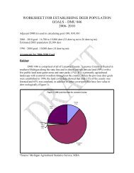
WORKSHEET FOR ESTABLISHING DEER POPULATION<br />
GOALS – <strong>DMU</strong> <strong>044</strong>, Lapeer County 2006- 2010<br />
Adjacent <strong>DMU</strong>(s) used in calculating goal Genesee, Oakland, and St Clair<br />
2006 - 2010 goal: County estimate (620 sq. mi) 13,000- 17,000 (21-27 deer per sq. mile)<br />
Estimated 2005 Population 44,000 deer<br />
1996 - 2004 goal: 11,000 (18 deer/sq mi):<br />
Arguments for 2006-2010 Goal:<br />
The land has been characterized by Denny Albert, in the publication Regional Landscape<br />
Ecosystem of Michigan…A Working Map and Classification, as being in the Southern<br />
Lower Peninsula Ecosystem. A significant part of the deer management unit (<strong>DMU</strong>) lies<br />
within the Maumee Lake Plain sub-sub-section, the Ann Arbor Moraines sub-sub-section,<br />
and the Jackson Interlobate portion. Current land use, especially in the developed areas,<br />
has no particular association with land types. They more follow main traffic corridors<br />
and city/town locations.<br />
Existing habitat conditions for deer outside the urban area are fairly good. Part of this is<br />
due to decreasing interest in agricultural operations, resulting in increasing idle lands,<br />
which are reverting to the early successional brush stages. Reasons farming is decreasing<br />
in these areas are the cost of farming with uncertain returns, increased social pressure as<br />
subdivisions are developed nearby, and the increasing value of the land that developers<br />
offer. As these lands revert, there is a smaller habitat base where deer will tend to<br />
concentrate on what is left and periodically move in and out of these areas, sometimes<br />
into the more suburban communities<br />
Lapeer County has population of 87,904 according to the 2000 census. 2001 IFMAP data<br />
shows Lapeer County is 53% agriculture, 3% urban, 27% forested and 1% water. The<br />
counties earliest settlers were the Chippewa Indians then white families arrived in around<br />
1828. County growth began a couple years later. History shows that hardships faced<br />
these early residents due to lack of food and an abundance of wolves. The lumbering era<br />
in the mid to late 1800’s bolstered the county growth, since lumber was floated down the<br />
Flint River to sawmills in Flint, Saginaw and Bay City. The fires in the late 1800’s<br />
cleared much of the land, and made way for agriculture. At one time Lapeer had the<br />
largest concentration of dairy cattle in Michigan. In the 70’s the population of Lapeer<br />
increased 34% as we saw the beginning of urban sprawl. Auto workers began to move<br />
out to these country areas, that were still close enough to be able commute in to work in<br />
Flint and Pontiac. Farming is still important in Lapeer, but only half as many farms exist<br />
today as in 1904. Small industry in the city of Lapeer includes metal working, boat<br />
building, and sand and gravel. Population growth in Lapeer County increased by 18%<br />
from 1990-2000. 4% of the county is public land which includes 1 state game area and 2<br />
state recreation areas. The County has 159 lakes which provide recreational activity for<br />
fisherman, swimmers and boaters.
Deer management in Lapeer County is as much a social issue as biological one.<br />
Biological carrying capacity is defined as the number of deer that can be maintained by<br />
the existing habitat. Cultural carrying capacity defines the number of animals that<br />
provide recreation and enjoyment to people while minimizing the social costs of deer<br />
including disease outbreaks, degraded ecosystems, crop and horticultural damage, and<br />
deer-vehicle collisions. The goal for each <strong>DMU</strong> is to maintain a quality deer herd to<br />
provide diverse, quality recreational experiences (both consumptive such as hunting and<br />
non-consumptive such as viewing) that meet the social, economic, and recreational<br />
demands of the public while also considering carrying capacity of the range, native plant<br />
communities, agriculture, horticulture, silviculture, and public safety.<br />
Deer populations are estimated based on the use of various methods. The mail survey<br />
provides the antlerless and buck harvest estimates, which can be used an index of the<br />
overall population. Check station data is used to provide age, sex, beam diameter, antler<br />
points on bucks etc, which is used in population models SAK (Sex-Age-Kill) to estimate<br />
the population. Life table calculations are then used to estimate the projected population<br />
going into next hunting season. We also calculate the population by looking at firearm<br />
data alone vs. all season data, combine multiple years of data and/or combine check<br />
station data from neighboring counties, to try to better take away the “noise” from these<br />
figures due to low sample sizes of check station data at the county level. The 2005 SAK<br />
calculated population of 44,000 deer is believed to be higher than what the actual<br />
population may be.<br />
Car-deer crashes are used as an index of the population. By examining the change in cardeer<br />
crashes for an area from one year to the next, an independent measure of the change<br />
in population can be determined. This does not tell us any actual number of deer, but can<br />
give an indication of whether the numbers have increased or decreased. This index is<br />
provided by the State Police and is reported as the number of crashes by county per<br />
million miles driven.<br />
Crop damage complaints by farmers, along with hunter concerns, reports of impacts to<br />
native vegetation, and residential landowner complaints, are all indicators on whether<br />
deer numbers are either up of down. Meteorological conditions, such as winter severity<br />
(snow depth and temperatures) are not used in this area, since winters are normally mild,<br />
and have minimal effects on deer.<br />
Unfortunately, using models to predict the populations on a county level often leads to<br />
much bias and variability. In addition, the amount of urban sprawl and urbanization<br />
throughout the entire Southeast Management Unit, including Lapeer County, make it<br />
even more difficult to predict populations since deer are not evenly distributed.<br />
Therefore, coming up with a number of deer within this <strong>DMU</strong> is challenging, and the<br />
population estimate for this county is therefore subject to much error. But, all these<br />
indicators combined, do provide an indication on the current status of the deer herd in this<br />
county, on whether the population is up, down, or status quo, and therefore more, less, or<br />
the same number of antlerless deer licenses need to be issued to meet its objectives.<br />
The deer population goal given for this county was carefully considered after recognizing<br />
that much of this county is agricultural (53%) ,some is urban (3%) and some is open<br />
water (1%) according to 2001 IFMAP data. Obviously crop damage is a main concern
with deer numbers in this county. This estimates the approximate square miles of deer<br />
habitat to be 598 Sq Miles. Non-deer habitat is considered to be the concentrated urban<br />
area (mainly the city of Lapeer) and open water. There is a population goal of 0 for these<br />
areas. Deer hunting is a popular recreation activity in this county, and many farmers are<br />
willing to tolerate a larger number of deer, compared to the more urbanized Oakland and<br />
Macomb Counties. Therefore the population for Lapeer County was based on the amount<br />
of deer habitat with an average of 21-28 deer per sq. mile. This gave a population<br />
estimate of 13,000-17,000 deer for this county, which overall for the county averages 21-<br />
27 deer per sq/mile.<br />
Unfortunately many areas of this county are becoming more developed. This intense<br />
development around the city of Lapeer seems to be expanding every year. Recognizing<br />
that the goal of zero in the concentrated urban area may not be achievable, either<br />
biologically or socially, therefore, the 0– 5 range is suggested.<br />
Proposed deer management strategies:<br />
One has to remember that in the 1960’s and early 1970’s, deer were rare or not<br />
commonly seen in the Southeast Michigan area. It is only in recent history where deer<br />
numbers have grown and adapted to these somewhat urban populations. As stated<br />
earlier, our goal has been to keep the population low and not allow for uncontrolled<br />
growth. The prime tool used to control deer has been through the hunting seasons.<br />
In this <strong>DMU</strong>, only 4% of the land lies in state ownership, therefore deer management lies<br />
in the hands of the private landowners. Liberal antlerless permits are therefore provided<br />
to try to encourage private landowners to take more antlerless deer in areas where deer<br />
can be hunted. Most hunters that live in the county, also hunt in this county, since most<br />
residents have enough land to be able to hunt, compared to the more urbanized Oakland<br />
and Macomb counties. In the past there has been “unlimited” (more available than<br />
hunters request) antlerless permits available in this area, and still not seen any major<br />
impact to the deer herd. Most of the hunters still put their emphasis into buck hunting,<br />
and don’t shoot enough does, which is needed to control the population. Landowners<br />
have been encouraged landowners to utilize the Deer Management Assistant Permits in<br />
season to achieve their deer objectives. These DMAP permits sometimes prove to be<br />
more efficient tools for farmers, who have trouble getting crops off in time, or getting<br />
hunters to shoot does. Deer Damage Control Permits are issued, outside of the hunting<br />
season framework, to farmers to alleviate damage. For the most part, hunters have<br />
understood this strategy and we receive only a few complaints or objections to this<br />
management strategy.<br />
Vehicle-deer accident numbers, while currently at a stable level, still are too high, and<br />
need to be reduced. For the most part, efforts in this area have not been very successful.<br />
As development keeps consuming habitat, deer are pressed into smaller areas, so even at<br />
low levels of deer, they are subject to vehicle accidents. In 2003 there were 1,469 car<br />
deer accidents, the highest on record, and in 2004 there were 1,376 accidents, third<br />
highest.<br />
In every way possible, we have encouraged hunting as the controlling agent. We have<br />
worked with some local units of government, through their parks systems, to encourage<br />
them to be stakeholders and do active deer management to the extent that they can in
terms of controlling deer numbers. The late antlerless deer season is also an option to try<br />
to take more antlerless deer and seems especially effective for farmers who find deer are<br />
often not on their property during the regular firearm season. In areas where firearm<br />
discharge is prohibited, archery hunting is our only effective management tool.<br />
Goal relative to land ownership patterns, habitat, and deer distribution:<br />
You could generally characterize this <strong>DMU</strong> into three broad land use associations. Areas<br />
of highly developed urban communities with significant industrial-related development<br />
areas that are primarily agriculture/horticulture/or idle lands, and areas that interfaces<br />
between these two areas. Urban areas are highly developed with few scattered areas of<br />
low development, and for the most part, have rules and regulations or local ordinances<br />
that preclude certain forms of recreational hunting on their lands. The interface areas<br />
have elements of suburbia, scattered industrial/ commercial in and around agriculture and<br />
horticulture lands. In the interface area, there are typically small ownerships (often 1-5,<br />
but rarely exceeding 40 acres), significant safety zone areas, fragmented habitats, small<br />
idle fields and woodlots and wetlands, offer enough habitat to support deer populations.<br />
The interface area is an ideal place for deer to do well in that, in addition to the<br />
fragmented habitat, you often find parkland owned by local units of government. These<br />
often have a larger habitat base and have restrictions on hunting that allow deer numbers<br />
to be at significantly higher numbers than surrounding areas.<br />
According to the 2004 Deer Harvest Survey information, there were 12,000 registered<br />
deer hunters who live on Lapeer County and most of these hunters also hunt in this<br />
county. This number seems low for such a rural county and is about 14% of the county<br />
population. Only 4% of the land is in public (state) ownership. Though deer hunting at<br />
Lapeer State Game area is extremely popular, and the game area draws in large numbers<br />
of hunters on the first few days of opening firearm season, this is still not a large impact<br />
on the deer herd in this <strong>DMU</strong>. Lapeer State Game Area offers fantastic deer habitat, and<br />
has a high deer population. Deer hunting is also allowed at both state recreation areas,<br />
Metamora-Hadley and Ortonville State Recreation area. Metamora Hadley is only 700<br />
acres, so does not offer as much opportunity, but Ortonville Rec Area, is over 5,000 acres<br />
and extending into Oakland County. Ortonville offers great habitat and is a very popular<br />
public hunting area. With so little public land in this area, this means that deer<br />
management is in the hands of the private residents who live in this county. With only<br />
12,000 resident hunters, each hunter needs to have a conscious effort in harvesting does,<br />
to keep the population under control.<br />
Goal in relation to adjacent <strong>DMU</strong>’s within Management Unit:<br />
Population goals for Lapeer are similar to St. Clair due to comparable habitat. The<br />
adjacent Genesee County is more urbanized and has a lower population goal.
Draft<br />
Final Draft<br />
Biologist Julie Oakes Julie Oakes<br />
Management Unit Supervisor Tim Payne Tim Payne<br />
Field Operations Supervisor<br />
_______________<br />
Wildlife Division Chief<br />
_______________