Cultural History of Charlie Vettiner Park - Louisville Metro Government
Cultural History of Charlie Vettiner Park - Louisville Metro Government
Cultural History of Charlie Vettiner Park - Louisville Metro Government

You also want an ePaper? Increase the reach of your titles
YUMPU automatically turns print PDFs into web optimized ePapers that Google loves.
<strong>Cultural</strong> <strong>History</strong> <strong>of</strong> <strong>Charlie</strong> <strong>Vettiner</strong> <strong>Park</strong><br />
tools, and greater use <strong>of</strong> retouch and expedient-use tools. Middle Archaic lithic assemblages fit<br />
this model.<br />
Subsistence patterns also changed during this period <strong>of</strong> climate change. Across the Eastern<br />
North American Woodlands, Middle Archaic populations can be identified by their extensive<br />
exploitation <strong>of</strong> shellfish. Shell mounds and shell-laden horizons, in addition to the appearance <strong>of</strong><br />
netsinkers and fishhooks in the Middle Archaic toolkit, document this change to riverine<br />
resources. In addition, mortars and pestles document the processing <strong>of</strong> mast resources such as<br />
walnuts and hickory.<br />
Diagnostic projectile point types <strong>of</strong> the Middle Archaic period include Kirk Stemmed, White<br />
Springs, Stanly, and Morrow Mountain. Additional items in a Middle Archaic assemblage might<br />
include woven fabrics, atlatls, bone and antler tools, awls, red ocher, marine shell, and copper.<br />
Burials <strong>of</strong> canine companions have been documented (Lewis and Kneberg 1958).<br />
Middle Archaic site locations are expected in rockshelters and lowlands in tributaries and main<br />
stream valleys. According to Fenton and Huser (1994), Middle Archaic sites also occur in surficial<br />
deposits along ridgetops. Based on evidence from tributaries <strong>of</strong> Floyd‘s Fork, a clustering <strong>of</strong><br />
occupations within the same drainage is also expected. Sites containing a Middle Archaic<br />
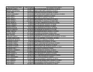
component in Jefferson County are listed in Table 4.<br />
Table 4. Sites with Middle Archaic Component in Southern Jefferson County, Kentucky<br />
Site Site Type Watershed Diagnostics Reference<br />
15JF143<br />
15JF214<br />
Miles<br />
Rockshelter<br />
(15JF671)<br />
McNeeley Lake<br />
(15JF200)<br />
Durrett Cave<br />
(15JF201)<br />
Rosenberger<br />
(15JF18)<br />
Villiers<br />
(15JF110)<br />
Spadie<br />
(15JF14)<br />
open<br />
habitation<br />
open<br />
habitation<br />
rockshelter Cedar Creek<br />
rockshelter<br />
rockshelter<br />
open<br />
habitation<br />
open<br />
habitation<br />
open<br />
habitation<br />
Pennsylvania<br />
Run<br />
Pennsylvania<br />
Run<br />
Big Sandy Granger and DiBlasi 1975<br />
Big Sandy Granger and DiBlasi 1975<br />
Matanzas<br />
Big Sandy II<br />
Big Sandy Merom<br />
Brewerton<br />
Salt River SN<br />
Salt River SN<br />
Big Sandy<br />
Bader et al. n.d.<br />
Granger 1985<br />
Granger 1985<br />
Ohio River Jefferies 1990<br />
Ohio River Jefferies 1990<br />
Ohio River Jefferies 1990<br />
Late Archaic (3000 to 900 B.C.). During this period, populations increased, maintained<br />
even more permanent settlements, and developed new technologies. In the Southeastern<br />
United States, the first evidence <strong>of</strong> pottery, a fiber-tempered ware, can be attributed to Late<br />
Archaic groups. In the Falls <strong>of</strong> the Ohio region, diagnostic projectile point/knives include<br />
McWhinney, Karnak, Merom, Bottleneck, and Ledbetter. Raw materials used for these are<br />
usually poor-quality, local materials. A variety <strong>of</strong> groundstone tools have been recovered,<br />
including three-quarter grooved axes. Bone and antler tools are well represented from Late<br />
14 | P a g e