Cultural History of Charlie Vettiner Park - Louisville Metro Government
Cultural History of Charlie Vettiner Park - Louisville Metro Government
Cultural History of Charlie Vettiner Park - Louisville Metro Government

You also want an ePaper? Increase the reach of your titles
YUMPU automatically turns print PDFs into web optimized ePapers that Google loves.
<strong>Cultural</strong> <strong>History</strong> <strong>of</strong> <strong>Charlie</strong> <strong>Vettiner</strong> <strong>Park</strong><br />
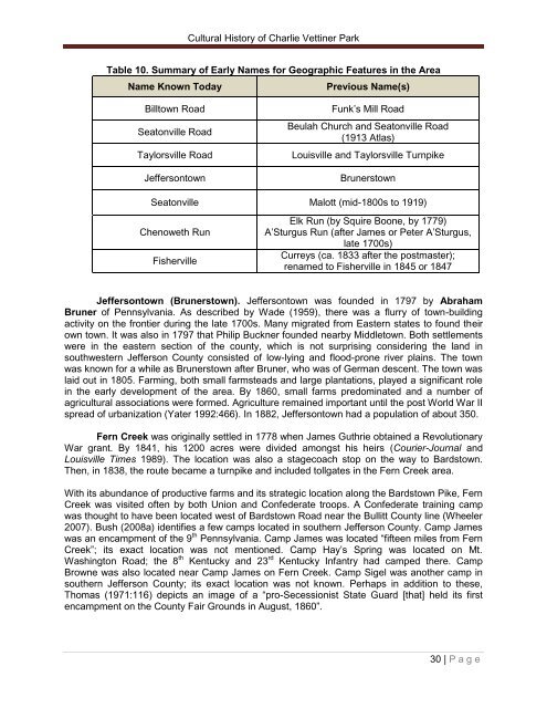
Table 10. Summary <strong>of</strong> Early Names for Geographic Features in the Area<br />
Name Known Today Previous Name(s)<br />
Billtown Road Funk‘s Mill Road<br />
Seatonville Road<br />
Beulah Church and Seatonville Road<br />
(1913 Atlas)<br />
Taylorsville Road <strong>Louisville</strong> and Taylorsville Turnpike<br />
Jeffersontown Brunerstown<br />
Seatonville Malott (mid-1800s to 1919)<br />
Chenoweth Run<br />
Fisherville<br />
Elk Run (by Squire Boone, by 1779)<br />
A‘Sturgus Run (after James or Peter A‘Sturgus,<br />
late 1700s)<br />
Curreys (ca. 1833 after the postmaster);<br />
renamed to Fisherville in 1845 or 1847<br />
Jeffersontown (Brunerstown). Jeffersontown was founded in 1797 by Abraham<br />
Bruner <strong>of</strong> Pennsylvania. As described by Wade (1959), there was a flurry <strong>of</strong> town-building<br />
activity on the frontier during the late 1700s. Many migrated from Eastern states to found their<br />
own town. It was also in 1797 that Philip Buckner founded nearby Middletown. Both settlements<br />
were in the eastern section <strong>of</strong> the county, which is not surprising considering the land in<br />
southwestern Jefferson County consisted <strong>of</strong> low-lying and flood-prone river plains. The town<br />
was known for a while as Brunerstown after Bruner, who was <strong>of</strong> German descent. The town was<br />
laid out in 1805. Farming, both small farmsteads and large plantations, played a significant role<br />
in the early development <strong>of</strong> the area. By 1860, small farms predominated and a number <strong>of</strong><br />
agricultural associations were formed. Agriculture remained important until the post World War II<br />
spread <strong>of</strong> urbanization (Yater 1992:466). In 1882, Jeffersontown had a population <strong>of</strong> about 350.<br />
Fern Creek was originally settled in 1778 when James Guthrie obtained a Revolutionary<br />
War grant. By 1841, his 1200 acres were divided amongst his heirs (Courier-Journal and<br />
<strong>Louisville</strong> Times 1989). The location was also a stagecoach stop on the way to Bardstown.<br />
Then, in 1838, the route became a turnpike and included tollgates in the Fern Creek area.<br />
With its abundance <strong>of</strong> productive farms and its strategic location along the Bardstown Pike, Fern<br />
Creek was visited <strong>of</strong>ten by both Union and Confederate troops. A Confederate training camp<br />
was thought to have been located west <strong>of</strong> Bardstown Road near the Bullitt County line (Wheeler<br />
2007). Bush (2008a) identifies a few camps located in southern Jefferson County. Camp James<br />
was an encampment <strong>of</strong> the 9 th Pennsylvania. Camp James was located ―fifteen miles from Fern<br />
Creek‖; its exact location was not mentioned. Camp Hay‘s Spring was located on Mt.<br />
Washington Road; the 8 th Kentucky and 23 rd Kentucky Infantry had camped there. Camp<br />
Browne was also located near Camp James on Fern Creek. Camp Sigel was another camp in<br />
southern Jefferson County; its exact location was not known. Perhaps in addition to these,<br />
Thomas (1971:116) depicts an image <strong>of</strong> a ―pro-Secessionist State Guard [that] held its first<br />
encampment on the County Fair Grounds in August, 1860‖.<br />
30 | P a g e