

Appendix 1 - Victorian Environmental Assessment Council
Appendix 1 - Victorian Environmental Assessment Council
Appendix 1 - Victorian Environmental Assessment Council

You also want an ePaper? Increase the reach of your titles
YUMPU automatically turns print PDFs into web optimized ePapers that Google loves.
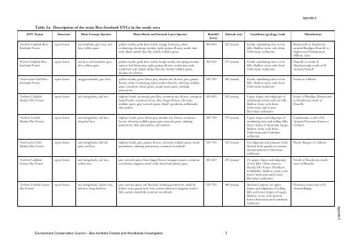
Table 2a: Description of the main Box-Ironbark EVCs in the study area<br />
EVC Name Structure Main Canopy Species Main Shrub and Ground Layer Species Rainfall<br />
(mm)<br />
Northern Goldfields Box-<br />
Ironbark Forest<br />
Western Goldfields Box-<br />
Ironbark Forest<br />
North-eastern Hills Box-<br />
Ironbark Forest<br />
Northern Goldfields<br />
Heathy Dry Forest<br />
Northern Foothills<br />
Heathy Dry Forest<br />
North-eastern Hills<br />
Heathy Dry Forest<br />
Northern Goldfields<br />
Grassy Dry Forest<br />
Northern Foothills Grassy<br />
Dry Forest<br />
open-forest red ironbark, grey box, red<br />
box, yellow gum<br />
open-forest red box, red ironbark, grey<br />
box, yellow gum<br />
golden wattle, gold-dust wattle, twiggy bush-pea, shiny<br />
everlasting, drooping cassinia, spiky guinea-flower, wattle matrush,<br />
black-anther flax-lily, bristly wallaby-grass<br />
golden wattle, gold-dust wattle, hedge wattle, drooping cassinia,<br />
narrow-leaf bitter-pea, spiky guinea-flower, wattle mat-rush,<br />
small mat-rush, black-anther flax-lily, bristly wallaby-grass,<br />
slender rice-flower<br />
open-forest mugga ironbark, grey box golden wattle, gorse bitter-pea, slender rice-flower, grey guineaflower,<br />
shiny everlasting, black-anther flax-lily, silvertop wallabygrass,<br />
common wheat-grass, rough spear-grass, stinking<br />
pennywort<br />
open-forest red stringybark, red box daphne heath, mountain grevillea, common rice-flower, common<br />
beard-heath, common hovea, blue finger-flower, silvertop<br />
wallaby-grass, grey tussock-grass, black’s goodenia, milkmaids,<br />
tall sundew<br />
open-forest red stringybark, red box,<br />
long-leaf box<br />
open-forest red stringybark, hill red<br />
gum, red box<br />
open-forest red stringybark, red box,<br />
yellow box<br />
open-forest red stringybark, yellow box,<br />
red box, long-leaf box<br />
daphne heath, gorse bitter-pea, slender rice-flower, common<br />
hovea, silvertop wallaby-grass, grey tussock-grass, stinking<br />
pennywort, blue pincushion, tall sundew<br />
daphne heath, grey guinea-flower, silvertop wallaby-grass, small<br />
poranthera, stinking pennywort, common woodrush<br />
grey tussock-grass, blue finger-flower, kangaroo grass, common<br />
woodrush, magenta stork’s-bill, short-hair plume-grass<br />
grey tussock-grass, tall bluebell, stinking pennywort, small St.<br />
John’s wort, green rock-fern, cotton fireweed, magenta stork’sbill,<br />
austral cranesbill, common woodrush<br />
Environment Conservation <strong>Council</strong> – Box-Ironbark Forests and Woodlands Investigation 3<br />
<strong>Appendix</strong> 2<br />
Altitude (m) Landform/geology/soils Distribution<br />
400-600 220 (mean) Gently undulating rises to low<br />
hills. Shallow stony soils from<br />
Ordovician sediments<br />
450-650 270 (mean) Gently undulating rises to low<br />
hills. Shallow stony soils from<br />
Ordovician sediments<br />
550-700 200 (mean) Gently undulating rises to low<br />
hills. Shallow stony soils from<br />
Ordovician sediments<br />
450-650 250 (mean) Upper slopes and ridgetops of<br />
undulating terrain and low hills.<br />
Shallow stony soils from<br />
Ordovician and Lower<br />
Devonian sediments<br />
500-700 370 (mean) Upper slopes and ridgetops of<br />
undulating rises and rolling hills;<br />
lower slopes of mountain ranges.<br />
Shallow stony soils from<br />
Ordovician and Cambrian<br />
sediments<br />
550-700 320 (mean) On ridgetops and plateaus. Soils<br />
derived from granite or contact<br />
metamorphosed Ordovician<br />
sediments<br />
450-650 295 (mean) On upper slopes and ridgetops<br />
of low hills. Often close to<br />
Heathy Dry Forest (Northern<br />
Goldfields). Shallow, stony soils<br />
from Ordovician and Lower<br />
Devonian sediments<br />
550-700 440 (mean) Sheltered aspects on upper<br />
slopes and ridgetops of rolling<br />
hills and lower slopes of ranges.<br />
Shallow, stony soils derived<br />
from Ordovician and Cambrian<br />
sediments<br />
Rushworth to Heathcote;<br />
around Bendigo; Dunolly to<br />
Inglewood; Puckapunyal<br />
Military Area<br />
Dunolly to south of<br />
Maryborough; south of St<br />
Arnaud; Stawell<br />
Euroa to Chiltern<br />
South of Bendigo; Rushworth<br />
to Heathcote; north of<br />
Dunolly<br />
Castlemaine; south of St<br />
Arnaud; Pyrenees; Euroa to<br />
Chiltern<br />
Warby Ranges to Chiltern<br />
North of Heathcote; northwest<br />
of Dunolly<br />
Pyrenees; south end of St<br />
Arnaud Range<br />
<strong>Appendix</strong> 2


