

Appendix 1 - Victorian Environmental Assessment Council
Appendix 1 - Victorian Environmental Assessment Council
Appendix 1 - Victorian Environmental Assessment Council

Create successful ePaper yourself
Turn your PDF publications into a flip-book with our unique Google optimized e-Paper software.
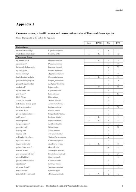
<strong>Appendix</strong> 1<br />
Common names, scientific names and conservation status of flora and fauna species<br />
Note: The legend is at the end of this <strong>Appendix</strong>.<br />
<strong>Appendix</strong> 1<br />
Aust EPBC Vic FFG<br />
Extinct fauna<br />
eastern hare wallaby1 Lagorchestes leporides x X x 13<br />
white-footed rabbit-rat 1 Conilurus albipes x X x 13<br />
Threatened fauna<br />
spot-tailed quoll Dasyurus maculatus V e 15<br />
eastern quoll 1 Dasyurus viverrinus x 14<br />
brush-tailed phascogale Phascogale tapoatafa v 79<br />
squirrel glider Petaurus norfolcensis e L<br />
rufous bettong 1 Aepyprymnus rufescens x 14<br />
bridled nailtail wallaby 1 Onychogalea fraenata e E x 14<br />
grey-headed flying-fox Pteropus poliocephalus v R<br />
greater long-eared bat Nyctophilus timoriensis v L<br />
malleefowl 2 Leipoa ocellata v V e 59<br />
square-tailed kite 2 Lophoictinia isura e L<br />
grey falcon 2 Falco hypoleucos ce 83<br />
black falcon Falco subniger e<br />
Australian bustard 1 Ardeotis australis ce L<br />
red-chested button-quail Turnix pyrrhothorax v<br />
bush stone-curlew 2 Burhinus grallarius e 78<br />
diamond dove Geopelia cuneata v<br />
glossy black-cockatoo 2 Calyptorhynchus lathami v L<br />
swift parrot 2 Lathamus discolor v E e L<br />
superb parrot 2 Polytelis swainsonii v V e 33<br />
turquoise parrot 2 Neophema pulchella lr L<br />
powerful owl 2 Ninox strenua e 92<br />
barking owl 2 Ninox connivens e L<br />
masked owl 2 Tyto novaehollandiae e L<br />
red-backed kingfisher Todiramphus pyrrhopygia v<br />
speckled warbler 2 Chthonicola sagittata v L<br />
regent honeyeater 2 Xanthomyza phrygia e E ce 41<br />
painted honeyeater 2 Grantiella picta v L<br />
hooded robin 2 Melanodryas cucullata L<br />
grey-crowned babbler 2 Pomatostomus temporalis e 34<br />
crested bellbird 2 Oreoica gutturalis L<br />
ground cuckoo-shrike 2 Coracina maxima e<br />
apostlebird 2 Struthidea cinerea v L<br />
diamond firetail 2 Stagonopleura guttata L<br />
rugose toadlet Uperoleia rugosa e<br />
pink-tailed worm-lizard Aprasia parapulchella e V e L<br />
Environment Conservation <strong>Council</strong> – Box-Ironbark Forests and Woodlands Investigation 1
<strong>Appendix</strong> 1<br />
Threatened fauna<br />
Aust EPBC Vic FFG<br />
hooded scaly-foot Pygopus nigriceps ce 108<br />
woodland blind snake Ramphotyphlops proximus v<br />
carpet python Morelia spilota variegata e L<br />
bandy bandy Vermicella annulata lr L<br />
large ant-blue butterfly Acrodipsas brisbanensis E 70<br />
bull-ant Myrmecia sp. 17 L<br />
ant spp. Peronomyrmex ‘bartoni’ L<br />
Near threatened fauna<br />
common dunnart Sminthopsis murina dd<br />
large-footed myotis Myotis adversus lr<br />
dingo 1 Canis lupus dingo dd<br />
brown quail Coturnix ypsilophora dd<br />
grey goshawk Accipiter novaehollandiae lr<br />
little button-quail Turnix velox dd<br />
chestnut-rumped heathwren Hylacola pyrrhopygia dd<br />
tree goanna Varanus varius dd<br />
genoveva azure butterfly Ogyris genoveva genoveva R<br />
Other fauna<br />
platypus Ornithorhynchus anatinus jacky winter 2 Microeca fascinans<br />
emu 2 Dromaius novaehollandiae red-capped robin 2 Petroica goodenovii<br />
painted button-quail 2 Turnix varia eastern yellow robin 2 Eopsaltria australis<br />
little lorikeet 2 Glossopsitta pusilla white-browed babbler 2 Pomatostomus superciliosus<br />
brown treecreeper 2 Climacteris picumnus victoriae varied sittella 2 Daphoenositta chrysoptera<br />
western gerygone 2 Gerygone fusca crested shriketit 2 Falcunculus frontatus<br />
chestnut-rumped thornbill 2 Acanthiza uropygialis Gilbert’s whistler 2 Pachycephala inornata<br />
southern whiteface 2 Aphelocephala leucopsis rufous whistler 2 Pachycephala rufiventris<br />
yellow-tufted honeyeater 2 Lichenostomus melanops meltoni restless flycatcher 2 Myiagra inquieta<br />
fuscous honeyeater 2 Lichenostomus fuscus white-browed woodswallow 2 Artamus superciliosus<br />
black-chinned honeyeater 2 Melithreptus gularis dusky woodswallow 2 Artamus cyanopterus<br />
brown-headed honeyeater 2 Melithreptus brevirostris pallidiceps tree martin Hirundo nigricans<br />
Aust EPBC Vic FFG<br />
Extinct flora<br />
robust greenhood1 Pterostylis valida X X X L<br />
spiny rice-flower 1 Pimelea spinescens pubiflora X X X<br />
Threatened flora<br />
annual bitter-cress Cardamine paucijuga (s.s.) V<br />
annual buttons Leptorhynchos scaber E L<br />
Ausfeld’s wattle Acacia ausfeldii R V X<br />
Australian broomrape Orobanche cernua var. australiana V<br />
bald-tip beard-orchid Calochilus richiae E E E 5<br />
Beechworth rustyhood Pterostylis sp. aff. boormanii E<br />
Beechworth silver stringybark Eucalyptus aff. cinerea (Beechworth) V<br />
bent-grass Deyeuxia imbricata V<br />
2 Environment Conservation <strong>Council</strong> – Box-Ironbark Forests and Woodlands Investigation
Threatened flora<br />
<strong>Appendix</strong> 1<br />
Aust EPBC Vic FFG<br />
bow-lip spider-orchid Caladenia toxochila V<br />
brilliant sun-orchid Thelymitra mackibbinii V V E<br />
brittle greenhood Pterostylis truncata E L<br />
buloke Allocasuarina luehmannii L<br />
buloke mistletoe Amyema linophylla orientale V<br />
button immortelle Leptorhynchos waitzia V<br />
button rush Lipocarpha microcephala V<br />
button wrinklewort Rutidosis leptorhynchoides E E E L<br />
candy spider-orchid Caladenia versicolor V V V 103<br />
chariot wheels Maireana cheelii V V V<br />
clover glycine Glycine latrobeana V V V L<br />
common fringe-sedge Fimbristylis dichotoma V<br />
coolibah grass Panicum queenslandicum var. queenslandicum E<br />
crimson spider-orchid Caladenia concolor V V E L<br />
crimson sun-orchid Thelymitra X macmillanii V<br />
dainty phebalium Phebalium festivum R V L<br />
Deane’s wattle Acacia deanei deanei E L<br />
delicate cranesbill Geranium sp. 6 V<br />
delicate leek-orchid Prasophyllum aff. petilum (Wangaratta) E E<br />
delicate love-grass Eragrostis exitua E<br />
Dookie daisy Brachyscome gracilis V L<br />
downy Swainson-pea Swainsona swainsonioides E L<br />
dwarf swainson-pea Swainsona phacoides E<br />
early golden moths Diuris aff. chryseopsis E E E<br />
eastern bitter-cress Cardamine microthrix V<br />
erect pepper-cress Lepidium pseudopapillosum V V E L<br />
Euroa guinea-flower Hibbertia humifusa erigens V V V L<br />
Fitzgerald’s leek-orchid Prasophyllum fitzgeraldii E L<br />
flat spike-sedge Eleocharis plana V<br />
forest bitter-cress Cardamine papillata V<br />
fragrant leek-orchid Prasophyllum suaveolens E E E L<br />
glaucous flax-lily Dianella longifolia var. grandis V<br />
globe-hood sun-orchid Thelymitra X chasmogama V<br />
golden cowslips Diuris behrii V<br />
Grampians bitter-pea Daviesia laevis V V V<br />
green leek-orchid Prasophyllum lindleyanum V X<br />
grey billy-buttons Craspedia canens E<br />
hairy anchor plant Discaria pubescens R R L<br />
hairy tails Ptilotus erubescens L<br />
hoary sunray Leucochrysum albicans albicans var. tricolor E E E<br />
hooked needlewood Hakea tephrosperma V<br />
Hunter leek-orchid Prasophyllum aff. suaveolens (Hunter) E<br />
inland leek-orchid Prasophyllum sp. aff. pyriforme (goldfields) E<br />
inland pixie-caps Acianthus collinus R L<br />
inland pomaderris Pomaderris paniculosa paniculosa V<br />
Environment Conservation <strong>Council</strong> – Box-Ironbark Forests and Woodlands Investigation 3
<strong>Appendix</strong> 1<br />
Threatened flora<br />
Aust EPBC Vic FFG<br />
Jericho wire-grass Aristida jerichoensis var. subspinulifera E<br />
Kamarooka mallee Eucalyptus froggattii R R 27<br />
lanky buttons Leptorhynchos elongatus E<br />
large rustyhood Pterostylis maxima V<br />
large-fruit fireweed Senecio macrocarpus V V E 68<br />
late-flower flax-lily Dianella tarda V<br />
leafless bluebush Maireana aphylla V<br />
lilac bitter-cress Cardamine lilacina (s.s.) V<br />
little pink spider-orchid Caladenia rosella E E E L<br />
long eryngium Eryngium paludosum V<br />
long-awn spear-grass Austrostipa tenuifolia V<br />
long-tail greenhood Pterostylis woollsii R E L<br />
lowly greenhood Pterostylis despectans E E E L<br />
magnificent spider-orchid Caladenia magnifica K X L<br />
mallee golden wattle Acacia notabilis V<br />
maroon leek-orchid Prasophyllum frenchii E E E L<br />
McIvor spider-orchid Caladenia audasii E E E 24<br />
Mentone greenhood Pterostylis X toveyana V<br />
metallic sun-orchid Thelymitra epipactoides E E E L<br />
Mount Pilot spider orchid Caladenia pilotensis L<br />
mountain swainson-pea 1 Swainsona recta E E X L<br />
Mueller daisy Brachyscome muelleroides V V E L<br />
myall Acacia melvillei V<br />
narrow goodenia Goodenia macbarronii V V V 72<br />
nealie Acacia loderi V<br />
northern sandalwood Santalum lanceolatum E 75<br />
ornate pink fingers Caladenia carnea var. ornata V V V<br />
pale spike-sedge Eleocharis pallens V<br />
pepper grass Panicum laevinode V<br />
plains spurge Euphorbia planiticola E L<br />
plump windmill grass Chloris ventricosa V<br />
Pomonal leek-orchid Prasophyllum subbisectum E E E L<br />
proud diuris Diuris X fastidiosa E<br />
purple diuris Diuris punctata var. punctata V L<br />
purple eyebright Euphrasia collina muelleri E E E L<br />
purple eyebright 1 Euphrasia collina speciosa X<br />
purple wire-grass Aristida personata E<br />
red swainson-pea Swainsona plagiotropis V V E L<br />
riverina bitter-cress Cardamine moirensis V<br />
rosella spider-orchid Caladenia rosella E E E 103<br />
rough eyebright Euphrasia scabra K E L<br />
rough-seed wire-grass Aristida obscura E<br />
scented bush-pea Pultenaea graveolens V L<br />
Seymour cinnamon wattle Acacia leprosa (Seymour variant) V<br />
4 Environment Conservation <strong>Council</strong> – Box-Ironbark Forests and Woodlands Investigation
Threatened flora<br />
<strong>Appendix</strong> 1<br />
Aust EPBC Vic FFG<br />
silky glycine Glycine canescens E L<br />
silky swainson-pea Swainsona sericea V<br />
silky umbrella grass Digitaria ammophila V<br />
silver needlewood Hakea leucoptera leucoptera V<br />
silver tea-tree Leptospermum multicaule V<br />
slender club-sedge Isolepis congrua V L<br />
slender darling-pea Swainsona murrayana V V E L<br />
slender love-grass Eragrostis exigua E<br />
slender water-milfoil Myriophyllum gracile var. lineare E<br />
small milkwort Comesperma polygaloides V 96<br />
small scurf-pea Cullen parvum E E E<br />
small-leaf bluebush Maireana microphylla E<br />
small-leaf wax-flower Philotheca difformis difformis V<br />
smooth darling-pea Swainsona galegifolia E 76<br />
soft sunray Leucochrysum molle V<br />
southern shepherd’s purse Ballantinia antipoda E E E 102<br />
spike grass 1 Elytrophorus spicatus X<br />
spiny rice-flower Pimelea spinescens spinescens V V E<br />
spiny-fruit saltbush Atriplex spinibractea E<br />
spiral sun-orchid Thelymitra matthewsii V V V L<br />
spotted gum 3 Corymbia maculata V<br />
spotted-throat cowslip Diuris tricolor E L<br />
stiff groundsel Senecio behrianus E E E L<br />
straw wallaby-grass Austrodanthonia richardsonii V<br />
striped water-milfoil Myriophyllum striatum V<br />
swamp billy-buttons Craspedia paludicola V<br />
swamp diuris Diuris palustris V L<br />
swamp leek-orchid Prasophyllum sp. (Nagambie) E<br />
swamp star Hypoxis exilis V<br />
tawny spider-orchid Caladenia fulva E E E L<br />
tick indigo Indigofera adesmiifolia V<br />
tough scurf-pea Cullen tenax E<br />
trailing hop-bush Dodonaea procumbens V V V<br />
trim flat-sedge Cyperus concinnus V<br />
twiggy sida Sida intricata V<br />
umbrella grass Digitaria divaricatissima V<br />
umbrella wattle Acacia oswaldii V<br />
veined spider-orchid Caladenia reticulata V<br />
velvet daisy-bush Olearia pannosa cardiophylla R V L<br />
Warby Range swamp gum Eucalyptus cadens V V V 21<br />
weak daisy Brachyscome debilis V<br />
wedge diuris Diuris dendrobioides E L<br />
weeping myall Acacia pendula E L<br />
western golden-tip Goodia medicaginea R<br />
western silver wattle Acacia decora V<br />
Environment Conservation <strong>Council</strong> – Box-Ironbark Forests and Woodlands Investigation 5
<strong>Appendix</strong> 1<br />
Threatened flora<br />
Aust EPBC Vic FFG<br />
whipstick crowea Crowea exalata revoluta V<br />
Whipstick westringia Westringia crassifolia E E E 40<br />
whorled zieria Zieria aspalathoides V L<br />
wine-lipped spider-orchid Caladenia oenochila K V<br />
winged pepper-cress Lepidium monoplocoides E E E L<br />
woodland leek-orchid Prasophyllum aff. validum V V K<br />
woolly cloak-fern Cheilanthes lasiophylla E<br />
woolly ragwort Senecio garlandii V V E<br />
yarran wattle Acacia omalophylla E L<br />
yellow hyacinth-orchid Dipodium hamiltonianum E 82<br />
yellow-lip spider-orchid Caladenia xanthochila E E E 103<br />
yellow-tongue daisy Brachyscome chrysoglossa V L<br />
Near threatened flora<br />
annual buttercup Ranunculus sessiliflorus var. pilulifer K<br />
austral trefoil Lotus australis K<br />
Australian millet Panicum decompositum K<br />
bear’s-ears Cymbonotus lawsonianus R<br />
bent-leaf wattle Acacia flexifolia R<br />
black roly-poly Sclerolaena muricata var. muricata K<br />
black-tip greenhood Pterostylis bicolor K<br />
blue caladenia wax-lip hybrid X Calassodia sp. nov. (Caladenia caerulea<br />
hybrid)<br />
bluish raspwort Haloragis glauca glauca K<br />
blunt-leaf pomaderris Pomaderris helianthemifolia minor R<br />
branching groundsel Senecio cunninghamii var. cunninghamii K<br />
branching raspwort Gonocarpus micranthus ramosissimus K<br />
bristly greenhood Pterostylis setifera R<br />
broad-lip leek-orchid Prasophyllum patens R<br />
broad-tip diuris Diuris X palachila R<br />
Brooker's gum Eucalyptus brookeriana R<br />
broom bitter-pea Daviesia genistifolia R<br />
brown beetle-grass Leptochloa fusca fusca R<br />
cane spear-grass Austrostipa breviglumis R R<br />
clasping goodenia Goodenia benthamiana R<br />
club-hair New Holland daisy Vittadinia condyloides R<br />
coast stork's-bill Pelargonium littorale K<br />
coccid emu-bush Eremophila gibbifolia R<br />
common sour-bush Choretrum glomeratum var. glomeratum R<br />
corkscrew spear-grass Austrostipa setacea R<br />
cotton panic-grass Digitaria brownii K<br />
cream spider-orchid Caladenia patersonii K<br />
creeping grevillea Grevillea repens R R<br />
cupped bush-pea Pultenaea vrolandii R<br />
currawang Acacia doratoxylon R<br />
dark roly-poly Sclerolaena muricata var. semiglabra K<br />
6 Environment Conservation <strong>Council</strong> – Box-Ironbark Forests and Woodlands Investigation<br />
R
Near threatened flora<br />
<strong>Appendix</strong> 1<br />
Aust EPBC Vic FFG<br />
dark wire-grass Aristida calycina var. calycina R<br />
Deane's wattle Acacia deanei paucijuga R<br />
dense mint-bush Prostanthera decussata R<br />
diosma rice-flower Pimelea flava dichotoma R<br />
dusky bush-pea Pultenaea polifolia R<br />
dwarf brooklime Gratiola pumilo K R<br />
emerald-lip greenhood Pterostylis smaragdyna R R<br />
ferny small-flower buttercup Ranunculus pumilio var. politus K<br />
flame grevillea Grevillea dimorpha R<br />
flat-leaf bush-pea Pultenaea platyphylla R<br />
flat-sedge Cyperus victoriensis K<br />
forde poa Poa fordeana K<br />
fringed midge-orchid Genoplesium ciliatum K<br />
fringed sun-orchid Thelymitra luteocilium R<br />
frosted goosefoot Chenopodium desertorum virosum K<br />
Fryerstown grevillea Grevillea obtecta R R<br />
fuzzy new holland daisy Vittadinia cuneata var. morrisii K<br />
galvanised burr Sclerolaena birchii K<br />
Gariwerd grevillea Grevillea gariwerdensis K<br />
golden dodder Cuscuta tasmanica K<br />
golden sour-bush Choretrum glomeratum var. chrysanthum R<br />
goldfield boronia Boronia anemonifolia aurofodina R<br />
goldfields grevillea Grevillea dryophylla R<br />
Grampians correa Correa reflexa var. angustifolia R<br />
Grampians peppermint Eucalyptus willisii falciformis R<br />
granite love-grass Eragrostis alveiformis K<br />
greenish-flower vanilly-lily Arthropodium sp. 2 (greenish flowers) K<br />
grey podolepis Podolepis canescens R<br />
grey spike-sedge Eleocharis macbarronii K<br />
hairy hop-bush Dodonaea boroniifolia R<br />
half-bearded spear-grass Austrostipa hemipogon R<br />
hickory wattle Acacia penninervis var. penninervis R<br />
leafy templetonia Templetonia stenophylla R<br />
leafy wallaby-grass Austrodanthonia bipartita K<br />
lizard orchid Burnettia cuneata R R<br />
matted water-starwort Callitriche sonderi K<br />
mealy saltbush Atriplex pseudocampanulata R<br />
moss Archidium clavatum K<br />
moss Campylopus flindersii K<br />
moss Encalypta vulgaris R<br />
mossy woodruff Asperula minima R<br />
mugga Eucalyptus sideroxylon R<br />
naked beard-orchid Calochilus imberbis R<br />
narrow-leaf sida Sida trichopoda R<br />
narrow-leaf star-hair Astrotricha linearis ssp. 1 R<br />
Environment Conservation <strong>Council</strong> – Box-Ironbark Forests and Woodlands Investigation 7
<strong>Appendix</strong> 1<br />
Near threatened flora<br />
Aust EPBC Vic FFG<br />
narrow-leaf star-hair Astrotricha linearis ssp. 2 R<br />
narrow-lip spider-orchid Caladenia leptochila K<br />
narrow-wing daisy Brachyscome aff. formosa entity 2 K<br />
native couch Cynodon dactylon var. pulchellus K<br />
native orache Atriplex australasica K<br />
native peppercress Lepidium pseudohyssopifolium K<br />
oval-leaf pseudanthus Pseudanthus ovalifolius R<br />
pale-flower cranesbill Geranium sp. 3 R<br />
plain quillwort Isoetes drummondii anomala K<br />
plains joyweed Alternanthera sp. 1 (plains) K<br />
Pyreness gum Eucalyptus aff. cypellocarpa (Pyrenees Range) R<br />
quinetia Quinetia urvillei R<br />
rayless daisy-bush Olearia tubuliflora R<br />
Reader’s daisy Brachyscome readeri R<br />
rising star guinea-flower Hibbertia humifusa humifusa R R<br />
rye beetle-grass Tripogon loliiformis R<br />
sand rush Juncus psammophilus R<br />
scaly greenhood Pterostylis hamata R<br />
sharp greenhood Pterostylis X ingens R<br />
shiny wallaby-grass Austrodanthonia induta K<br />
short-awned wheat-grass Elymus multiflorus K<br />
short-bristle wallaby-grass Austrodanthonia setacea var. breviseta R<br />
short-tail leopard-orchid Diuris brevissima K<br />
shrubby dampiera Dampiera dysantha R<br />
sikh’s whiskers Pterostylis boormanii R<br />
silky browntop Eulalia aurea R<br />
slender bitter-cress Cardamine tenuifolia K<br />
slender ruddyhood Pterostylis aciculiformis K<br />
slender starwort Stellaria sp. 1 K<br />
slender stylewort Levenhookia sonderi R<br />
slender tick-trefoil Desmodium varians K<br />
slender violet-bush Hybanthus monopetalus R<br />
slender water-ribbons Triglochin dubium R<br />
small burr-grass Tragus australianus R<br />
small chocolate-lily Arthropodium sp. 3 (aff. strictum) K<br />
small quillwort Isoetes pusilla K<br />
small-flower wallaby-grass Austrodanthonia monticola R<br />
small-leaf bush-pea Pultenaea foliolosa R<br />
smooth minuria Minuria integerrima R<br />
southern swainson-pea Swainsona behriana R<br />
southern varnish wattle Acacia verniciflua (southern variant) K<br />
spoon mud-mat Glossostigma cleistanthum R<br />
spotted emu-bush Eremophila maculata var. maculata R<br />
spotted hyacinth-orchid Dipodium pardalinum R<br />
spurred spear-grass Austrostipa gibbosa R<br />
8 Environment Conservation <strong>Council</strong> – Box-Ironbark Forests and Woodlands Investigation
Near threatened flora<br />
<strong>Appendix</strong> 1<br />
Aust EPBC Vic FFG<br />
spur-wing wattle Acacia triptera R<br />
squat picris Picris squarrosa R<br />
streaked wattle Acacia lineata R<br />
thyme beard-heath Leucopogon thymifolius R<br />
tiny bog-sedge Schoenus nanus K<br />
tufted club-sedge Isolepis wakefieldiana R<br />
twin-leaf bedstraw Asperula gemella R<br />
upright panic Entolasia stricta K<br />
velvet apple-berry Billardiera scandens var. brachyantha R<br />
<strong>Victorian</strong> club-sedge Isolepis victoriensis K<br />
water blinks Montia fontana amporitana K<br />
waterbush Myoporum montanum R<br />
wedge-leaf daisy Brachyscome cuneifolia K<br />
western emerald-lip greenhood Pterostylis sp. aff. longifolia (Stawell) K<br />
western pellitory Parietaria australis R<br />
wetland blown-grass Agrostis avenacea var. perennis K<br />
Williamson’s wattle Acacia williamsonii R R X<br />
wiry bossiaea Bossiaea cordigera R<br />
woolly buttons Leiocarpa panaetioides R<br />
woolly wattle Acacia lanigera var. lanigera R<br />
yellow star Hypoxis vaginata var. brevistigmata K<br />
Other flora<br />
austral bear’s–ears Cymbonotus preissianus messmate Eucalyptus obliqua<br />
austral bracken Pteridium esculentum milkmaids Burchardia umbellata<br />
austral bugle Ajuga australis mountain ash Eucalyptus regnans<br />
austral cranesbill Geranium solanderi mountain grevillea Grevillea alpina<br />
beard heath Leucopogon spp. narrow-leaf bitter-pea Daviesia leptophylla<br />
bidgee-widgee Acaena novae-zelandiae nodding blue-lily Stypandra glauca<br />
black bristle-sedge Chorizandra enodis nodding saltbush Einadia nutans nutans<br />
black wattle Acacia mearnsii pale flax-lily Dianella longifolia<br />
Black’s goodenia Goodenia blackiana peach heath Lissanthe strigosa subulata<br />
black-anther flax-lily Dianella revoluta peppermint box Eucalyptus odorata<br />
blackwood Acacia melanoxylon plume-grass Dichelachne sieberiana<br />
blue burr-daisy Calotis cuneifolia prickly tea-tree Leptospermum continentale<br />
blue finger-flower Cheiranthera cyanea var. cyanea purplish blown grass Agrostis aemula<br />
blue gum Eucalyptus globulus red bird’s-foot trefoil Lotus cruentus<br />
blue heron’s-bill Erodium crinitum red box Eucalyptus polyanthemos<br />
blue mallee Eucalyptus polybractea red ironbark Eucalyptus tricarpa<br />
blue pincushion Brunonia australis red stringybark Eucalyptus macrorhyncha<br />
bottle bluebush Maireana excavata red-leg grass Bothriochloa macra<br />
bristly wallaby-grass Austrodanthonia setacea rice grass Tetrarrhena spp.<br />
broombush Melaleuca uncinata river red gum Eucalyptus camaldulensis<br />
brush heath Brachyloma ericoides ericoides rock isotome Isotoma axillaris<br />
bulbine lily Bulbine bulbosa rough burr-daisy Calotis scabiosifolia integrifolia<br />
bull mallee Eucalyptus behriana rough spear-grass Austrostipa scabra<br />
Environment Conservation <strong>Council</strong> – Box-Ironbark Forests and Woodlands Investigation 9
<strong>Appendix</strong> 1<br />
Other flora<br />
cane wire-grass Aristida ramosa rough-barked honey-myrtle Melaleuca parvistaminea<br />
chocolate lily Dichopogon spp. saloop Einadia hastata<br />
clustered everlasting Chrysocephalum semipapposum scaly buttons Leptorhynchos squamatus<br />
common beard-heath Leucopogon virgatus scented sundew Drosera whittakeri aberrans<br />
common bog-sedge Schoenus apogon scurfy pomaderris Pomaderris paniculosa<br />
common eutaxia Eutaxia microphylla sheep’s burr Acaena echinata var. echinata<br />
common fringe-myrtle Calytrix tetragona shiny everlasting Bracteantha viscosa<br />
common hovea Hovea linearis short-hair plume-grass Dichelachne micrantha<br />
common lagenifera Lagenifera stipitata silver wattle Acacia dealbata<br />
common raspwort Gonocarpus tetragynus silvertop wallaby-grass Joycea pallida<br />
common rice-flower Pimelea humilis slender goodenia Goodenia gracilis<br />
common tussock-grass Poa labillardieri slender rice-flower Pimelea linifolia<br />
common wheat-grass Elymus scaber slender sun-orchid Thelymitra pauciflora<br />
common woodrush Luzula meridionalis small grass-tree Xanthorrhoea minor lutea<br />
cotton fireweed Senecio quadridentatus small mat-rush Lomandra sororia<br />
cranberry heath Astroloma humifusum small poranthera Poranthera microphylla<br />
creamy stackhousia Stackhousia monogyna small St. John’s wort Hypericum gramineum<br />
curved rice-flower Pimelea curviflora soft tussock-grass Poa morrisii<br />
cut-leaf burr-daisy Calotis anthemoides southern cane-grass Eragrostis infecunda<br />
daphne heath Brachyloma daphnoides spear grass Austrostipa spp.<br />
drooping cassinia Cassinia arcuata spiky guinea-flower Hibbertia exutiacies<br />
drooping she-oak Allocasuarina verticillata spreading eutaxia Eutaxia diffusa<br />
dwarf bluebush Maireana humillima spreading wattle Acacia genistifolia<br />
dwarf geebung Persoonia chamaepeuce sticky hop-bush Dodonaea viscosa<br />
feather spear-grass Austrostipa elegantissima sticky sword-sedge Lepidosperma viscidum<br />
flame heath Astroloma conostephioides stinking pennywort Hydrocotyle laxiflora<br />
fuzzy New Holland daisy Vittadinia cuneata supple spear-grass Austrostipa mollis<br />
gold-dust wattle Acacia acinacea swamp gum Eucalyptus ovata<br />
golden pennants Glischrocaryon behrii sweet bursaria Bursaria spinosa<br />
golden wattle Acacia pycnantha sweet quandong Santalum acuminatum<br />
gorse bitter-pea Daviesia ulicifolia tall bluebell Wahlenbergia stricta<br />
green mallee Eucalyptus viridis tall raspwort Gonocarpus elatus<br />
green rock-fern Cheilanthes austrotenuifolia tall sedge Carex appressa<br />
grey box Eucalyptus microcarpa tall sundew Drosera peltata<br />
grey everlasting Ozothamnus obcordatus thatch saw-sedge Gahnia radula<br />
grey guinea-flower Hibbertia obtusifolia totem-poles Melaleuca decussata<br />
grey mulga Acacia brachybotrya twiggy bush-pea Pultenaea largiflorens<br />
grey tussock-grass Poa sieberiana variable sword-sedge Lepidosperma laterale<br />
hairy panic Panicum effusum varnish wattle Acacia verniciflua<br />
hedge wattle Acacia paradoxa wallowa Acacia calamifolia<br />
hill red gum Eucalyptus blakelyi wattle mat-rush Lomandra filiformis<br />
honey-pots Acrotriche serrulata wax-lip orchid Glossodia major<br />
kangaroo grass Themeda triandra weeping grass Microlaena stipoides var. stipoides<br />
kidney-weed Dichondra repens weeping pittosporum Pittosporum phylliraeoides<br />
knob sedge Carex inversa white box Eucalyptus albens<br />
kurrajong Brachychiton populneus populneus white cypress-pine Callitris glaucophylla<br />
large-leaf bush-pea Pultenaea daphnoides windmill grass Chloris truncata<br />
lemon beauty-heads Calocephalus citreus wingless bluebush Maireana enchylaenoides<br />
10 Environment Conservation <strong>Council</strong> – Box-Ironbark Forests and Woodlands Investigation
Other flora<br />
lightwood Acacia implexa wirilda Acacia retinodes<br />
long-hair plume-grass Dichelachne crinita woolly New Holland daisy Vittadinia gracilis<br />
long-leaf box Eucalyptus goniocalyx yam-daisy Microseris lanceolata<br />
magenta stork’s-bill Pelargonium rodneyanum yellow box Eucalyptus melliodora<br />
mallee wattle Acacia montana yellow gum Eucalyptus leucoxylon<br />
manna gum Eucalyptus viminalis yellow rush-lily Tricoryne elatior<br />
many-flowered mat-rush Lomandra multiflora multiflora<br />
LEGEND:<br />
Aust: conservation status in Australia, after ANZECC<br />
(1999) and NRE Flora Information System<br />
Database<br />
EPBC: status under Commonwealth Environment Protection<br />
and Biodiversity Conservation Act 1999.<br />
1 These species are extinct in the study area<br />
2 These species are included in the ‘<strong>Victorian</strong> temperatewoodland<br />
bird community’ listed under the <strong>Victorian</strong><br />
Flora and Fauna Guarantee Act 1988<br />
3 This species not indigenous to the study area<br />
IUCN (1994b) categories (lower case):<br />
x – extinct<br />
ce – critically endangered<br />
e – endangered<br />
v – vulnerable<br />
lr – lower risk<br />
dd – data deficient<br />
<strong>Appendix</strong> 1<br />
Vic: conservation status in Victoria, after NRE (2000a,<br />
2001E) and NRE Flora Information System<br />
Database<br />
FFG: status under the <strong>Victorian</strong> Flora and Fauna Guarantee<br />
Act 1988<br />
N – nominated for listing, awaiting<br />
recommendation;<br />
R – recommended for listing;<br />
X – rejected or ineligible for listing;<br />
L – listed, no action statement published;<br />
numbers indicate action statement number where<br />
published<br />
IUCN (1990) categories (upper case):<br />
X – extinct<br />
E – endangered<br />
V – vulnerable<br />
R – rare<br />
D – depleted<br />
K – poorly known<br />
Environment Conservation <strong>Council</strong> – Box-Ironbark Forests and Woodlands Investigation 11
<strong>Appendix</strong> 2<br />
EVCs found in the Box-Ironbark study area<br />
Identification of EVCs<br />
<strong>Appendix</strong> 2<br />
In nature, species with similar habitat requirements tend to co-occur at places where their requirements are met.<br />
Ecologists call these co-occurring collections of species communities. A vegetation community is a collection of<br />
co-occurring plant species—it reflects the vegetation’s response to environmental influences such as geology, soils,<br />
landform and rainfall.<br />
Vegetation communities can be identified by recording the abundance of plant species at a large number of sites,<br />
and then systematically comparing the sites to identify clusters of sites which are most similar to each other in<br />
terms of the abundance of plant species. As long as the procedures for comparing and grouping sites are<br />
systematic and consistent, the clusters—or, more accurately, the vegetation associations which they support—will<br />
form the fundamental units of any classification of vegetation associations.<br />
Across Victoria, around 32 000 sites have been surveyed and analysed in this way, including over 800 sites in the<br />
Box-Ironbark study area. The fundamental units resulting from these analyses are called (vegetation) subcommunities.<br />
Sub-communities may indicate different types of disturbance, or different stages in the succession<br />
of a particular vegetation type. Vegetation communities, then, can be identified by aggregating sub-communities<br />
that are similar in terms of their structure, major environmental affinities, and abundance of species.<br />
A further level of aggregation generates Ecological Vegetation Classes (EVCs)—groups of one or more<br />
vegetation communities which exist under a common regime of ecological processes and which are linked to broad<br />
landscape features. The similarity of environmental regimes is apparent in comparable life forms, genera and<br />
vegetation structure. The communities within an EVC differ due to geographical separation rather than major<br />
ecological differences.<br />
Sub-communities, communities and EVCs are levels in a hierarchy, as illustrated in the following key example for<br />
the Box-Ironbark EVC.<br />
EVC<br />
Communities<br />
Sub-communities<br />
Northern Goldfields Box-<br />
Ironbark Forest<br />
‘lower<br />
slope’<br />
‘mid<br />
slope’<br />
‘upper<br />
slope’<br />
‘lower<br />
slope’<br />
Box-Ironbark Forest<br />
Western Goldfields Box-<br />
Ironbark Forest<br />
‘mid<br />
slope’<br />
‘upper<br />
slope’<br />
Note the use of italics to signify that part of the name of a vegetation unit which pertains to a community.<br />
North-eastern Hills Box-<br />
Ironbark Forest<br />
‘grey box<br />
dominant’<br />
‘red box<br />
dominant’<br />
‘mugga ironbark<br />
dominant’<br />
Environment Conservation <strong>Council</strong> – Box-Ironbark Forests and Woodlands Investigation 1
<strong>Appendix</strong> 2<br />
Mapping of EVCs<br />
Once EVCs have been identified, it is possible to map their distributions with the aid of maps of sites where they<br />
are known to occur; aerial photographs; maps of the main environmental determinants of vegetation distribution<br />
(such as soils, rainfall, topography); any pre-existing vegetation mapping; and extensive field work to identify<br />
boundaries and ground-check that EVCs do indeed occur where they have been mapped. A preliminary map of<br />
the current distribution of EVCs on public land was provided in the ECC Resources and Issues Report (1997).<br />
As well as the standard EVCs, the process of mapping generates two variations of the standard EVCs—mosaics<br />
and complexes. A mosaic consists of two or more discrete EVCs which cannot be mapped separately due to the<br />
scale of the map. A complex occurs where two or more EVCs are unable to be distinguished in an area but are<br />
known to exist discretely elsewhere. A slash is used to separate the component EVCs in the name of a mosaic or<br />
complex—Plains Grassy Woodland/Gilgai Wetland Mosaic, for example. Some EVCs occur only in mosaics. The<br />
units identified on a single vegetation map, then, may be communities, EVCs, mosaics or complexes, depending<br />
on the resolution at which the units were described and mapped. However, for convenience, mapped vegetation<br />
units of any of these types are referred to simply as ‘EVCs’.<br />
The extent to which vegetation has been depleted—that is, cleared as a result of European settlement—is a key<br />
consideration in the establishment of conservation reserve systems (see Chapter 4). To assess the extent of<br />
depletion of each EVC, it is necessary to map the extent of EVCs prior to European settlement, as well as the<br />
current distribution of EVCs. The mapping of vegetation prior to European settlement is called ‘pre-1750<br />
mapping’; 1750 being a round-number year closely pre-dating European settlement in Australia. Essentially pre-<br />
1750 mapping involves predicting, or modelling, the vegetation that was originally cleared from areas which no<br />
longer support indigenous vegetation. It involves a similar process to mapping the current distribution of EVCs,<br />
but with much less assistance from aerial photographs and ground-checking.<br />
Pre-1750 EVC mapping has now been completed for the Box-Ironbark study area, and is provided in Map B. This<br />
mapping identified 116 EVCs. Of these, 43 EVCs cannot reasonably be considered ‘Box-Ironbark forests and<br />
woodlands’ as specified in the terms of reference for the Box-Ironbark investigation—basalt plains, wetland,<br />
riverine or mountain forest EVCs, for example—and are listed separately in the legend to Map B. These EVCs<br />
cover approximately 122 000 ha (pre-1750) out of a total of 2 950 000 ha. In addition, approximately 4 000 ha<br />
could not be assigned to an EVC.<br />
Complementing Map B is <strong>Appendix</strong> 3 which provides statements of the spatial extent of each of the ‘Box-<br />
Ironbark' EVCs. As anticipated in the Draft Report, new EVC mapping has been used in generating <strong>Appendix</strong> 3,<br />
and it is now entirely consistent with Map B.<br />
EVC Descriptions<br />
The following table provides descriptions of 35 EVCs which, either separately or in mosaics or complexes, make<br />
up nearly all of the 73 Box-Ironbark EVCs in Map B. Those not described below occur only in small areas, or are<br />
not Box-Ironbark EVCs.<br />
2 Environment Conservation <strong>Council</strong> – Box-Ironbark Forests and Woodlands Investigation
Table 2a: Description of the main Box-Ironbark EVCs in the study area<br />
EVC Name Structure Main Canopy Species Main Shrub and Ground Layer Species Rainfall<br />
(mm)<br />
Northern Goldfields Box-<br />
Ironbark Forest<br />
Western Goldfields Box-<br />
Ironbark Forest<br />
North-eastern Hills Box-<br />
Ironbark Forest<br />
Northern Goldfields<br />
Heathy Dry Forest<br />
Northern Foothills<br />
Heathy Dry Forest<br />
North-eastern Hills<br />
Heathy Dry Forest<br />
Northern Goldfields<br />
Grassy Dry Forest<br />
Northern Foothills Grassy<br />
Dry Forest<br />
open-forest red ironbark, grey box, red<br />
box, yellow gum<br />
open-forest red box, red ironbark, grey<br />
box, yellow gum<br />
golden wattle, gold-dust wattle, twiggy bush-pea, shiny<br />
everlasting, drooping cassinia, spiky guinea-flower, wattle matrush,<br />
black-anther flax-lily, bristly wallaby-grass<br />
golden wattle, gold-dust wattle, hedge wattle, drooping cassinia,<br />
narrow-leaf bitter-pea, spiky guinea-flower, wattle mat-rush,<br />
small mat-rush, black-anther flax-lily, bristly wallaby-grass,<br />
slender rice-flower<br />
open-forest mugga ironbark, grey box golden wattle, gorse bitter-pea, slender rice-flower, grey guineaflower,<br />
shiny everlasting, black-anther flax-lily, silvertop wallabygrass,<br />
common wheat-grass, rough spear-grass, stinking<br />
pennywort<br />
open-forest red stringybark, red box daphne heath, mountain grevillea, common rice-flower, common<br />
beard-heath, common hovea, blue finger-flower, silvertop<br />
wallaby-grass, grey tussock-grass, black’s goodenia, milkmaids,<br />
tall sundew<br />
open-forest red stringybark, red box,<br />
long-leaf box<br />
open-forest red stringybark, hill red<br />
gum, red box<br />
open-forest red stringybark, red box,<br />
yellow box<br />
open-forest red stringybark, yellow box,<br />
red box, long-leaf box<br />
daphne heath, gorse bitter-pea, slender rice-flower, common<br />
hovea, silvertop wallaby-grass, grey tussock-grass, stinking<br />
pennywort, blue pincushion, tall sundew<br />
daphne heath, grey guinea-flower, silvertop wallaby-grass, small<br />
poranthera, stinking pennywort, common woodrush<br />
grey tussock-grass, blue finger-flower, kangaroo grass, common<br />
woodrush, magenta stork’s-bill, short-hair plume-grass<br />
grey tussock-grass, tall bluebell, stinking pennywort, small St.<br />
John’s wort, green rock-fern, cotton fireweed, magenta stork’sbill,<br />
austral cranesbill, common woodrush<br />
Environment Conservation <strong>Council</strong> – Box-Ironbark Forests and Woodlands Investigation 3<br />
<strong>Appendix</strong> 2<br />
Altitude (m) Landform/geology/soils Distribution<br />
400-600 220 (mean) Gently undulating rises to low<br />
hills. Shallow stony soils from<br />
Ordovician sediments<br />
450-650 270 (mean) Gently undulating rises to low<br />
hills. Shallow stony soils from<br />
Ordovician sediments<br />
550-700 200 (mean) Gently undulating rises to low<br />
hills. Shallow stony soils from<br />
Ordovician sediments<br />
450-650 250 (mean) Upper slopes and ridgetops of<br />
undulating terrain and low hills.<br />
Shallow stony soils from<br />
Ordovician and Lower<br />
Devonian sediments<br />
500-700 370 (mean) Upper slopes and ridgetops of<br />
undulating rises and rolling hills;<br />
lower slopes of mountain ranges.<br />
Shallow stony soils from<br />
Ordovician and Cambrian<br />
sediments<br />
550-700 320 (mean) On ridgetops and plateaus. Soils<br />
derived from granite or contact<br />
metamorphosed Ordovician<br />
sediments<br />
450-650 295 (mean) On upper slopes and ridgetops<br />
of low hills. Often close to<br />
Heathy Dry Forest (Northern<br />
Goldfields). Shallow, stony soils<br />
from Ordovician and Lower<br />
Devonian sediments<br />
550-700 440 (mean) Sheltered aspects on upper<br />
slopes and ridgetops of rolling<br />
hills and lower slopes of ranges.<br />
Shallow, stony soils derived<br />
from Ordovician and Cambrian<br />
sediments<br />
Rushworth to Heathcote;<br />
around Bendigo; Dunolly to<br />
Inglewood; Puckapunyal<br />
Military Area<br />
Dunolly to south of<br />
Maryborough; south of St<br />
Arnaud; Stawell<br />
Euroa to Chiltern<br />
South of Bendigo; Rushworth<br />
to Heathcote; north of<br />
Dunolly<br />
Castlemaine; south of St<br />
Arnaud; Pyrenees; Euroa to<br />
Chiltern<br />
Warby Ranges to Chiltern<br />
North of Heathcote; northwest<br />
of Dunolly<br />
Pyrenees; south end of St<br />
Arnaud Range<br />
<strong>Appendix</strong> 2
EVC Name Structure Main Canopy Species Main Shrub and Ground Layer Species Rainfall<br />
(mm)<br />
Northern Goldfields<br />
Heathy Woodland<br />
Western Goldfields<br />
Heathy Woodland<br />
Metamorphic Slopes<br />
Shrubby Woodland<br />
Granitic Hills<br />
Woodland<br />
Rocky Outcrop<br />
Shrubland/<br />
Herbland Mosaic<br />
low openwoodland<br />
low openwoodland<br />
red ironbark, red box, grey<br />
box<br />
daphne heath, common fringe-myrtle, mountain grevillea,<br />
cranberry heath, shiny everlasting<br />
long-leaf box, yellow gum daphne heath, brush heath, flame heath, common fringe-myrtle,<br />
wax-lip orchid, scented sundew<br />
woodland grey box, drooping she-oak wallowa (a wattle), sticky hop-bush, tall raspwort, rough speargrass<br />
woodland hill red gum, red box, white<br />
cypress-pine<br />
shrubland and<br />
herbland<br />
grey guinea-flower, mountain grevillea, daphne heath, nodding<br />
blue-lily, tall raspwort, stinking pennywort, cotton fireweed,<br />
green rock-fern, common fringe-myrtle<br />
no tree canopy spur-wing wattle, common fringe-myrtle, nodding blue-lily, rock<br />
isotome, mosses, lichens, annual herbs<br />
Sedge-rich Woodland woodland yellow gum sticky sword-sedge, black bristle-sedge, slender sun-orchid,<br />
bulbine lily<br />
Low Rises Grassy<br />
Woodland<br />
Rainshadow Grassy<br />
Woodland<br />
Slopes Box Grassy<br />
Woodland<br />
woodland grey box, white box golden wattle, spreading wattle, gold-dust wattle, varnish wattle,<br />
common eutaxia, twiggy bush-pea, sweet bursaria, sticky hopbush,<br />
drooping cassinia, feather spear-grass, supple spear-grass,<br />
rough spear-grass, saloop, fuzzy New Holland daisy, blue burrdaisy,<br />
lemon beauty-heads<br />
woodland white box, hill red gum kurrajong, lightwood, varnish wattle, gold-dust wattle, sweet<br />
bursaria, daphne heath, curved rice-flower, kangaroo grass,<br />
wallaby-grasses, red-leg grass, grey tussock-grass, nodding bluelily,<br />
wattle mat-rush, tall raspwort, stinking pennywort<br />
openwoodland<br />
grey box golden wattle, hedge wattle, black wattle, lightwood, gold-dust<br />
wattle, drooping cassinia, wallaby-grasses, spear-grasses,<br />
kangaroo grass, grey tussock-grass, black-anther flax-lily, wattle<br />
mat-rush, bulbine lily<br />
Altitude (m) Landform/geology/soils Distribution<br />
450-550 200 (mean) Undulating plains, rises and low<br />
hills. Sandy or clay soils<br />
450-650 220 (mean) Undulating plains, rises and low<br />
hills. Tertiary sands with a thin<br />
covering of clay; sandstone often<br />
altered to quartzite gravel<br />
400-500 230 (mean) Rocky slopes of metamorphic<br />
aureoles adjacent to granitic<br />
plutons<br />
500-700 290 (mean) Crests and slopes of granitic<br />
hills. Coarse, sandy soils<br />
500-700 270 (mean) Outcropping of flat sheets of<br />
granite. Coarse, sandy soils in<br />
pockets between rock slabs<br />
500-650 220 (mean) Flat or slightly undulating terrain<br />
with seasonally inundated<br />
depressions. Tertiary sands and<br />
sandstones. Soils are clay loams<br />
with ironstone gravel at the<br />
surface<br />
400-500 200-300 Plains and gently undulating<br />
terrain. Soils derived from<br />
Ordovician sediments and<br />
alluvium<br />
< 700 150-500 Low hills. Soils are sandy clay<br />
loams derived from Ordovician<br />
metamorphic rocks and<br />
Devonian granitoids<br />
650-850 200-600 Low hills or lower slopes.<br />
Devonian sediments of siltstone<br />
and sandstone<br />
Around Bendigo, Dunolly and<br />
Tarnagulla<br />
Stawell; south-east and southwest<br />
of St Arnaud<br />
Dunolly; Tarnagulla;<br />
Inglewood<br />
Warby Range; Chesney Vale<br />
Hills<br />
Warby Range; Chesney Vale<br />
Hills; Terrick Terrick<br />
Illawarra; Deep Lead<br />
Fringes of Box-Ironbark hills<br />
around Rushworth,<br />
Costerfield, Heathcote,<br />
Goomalibee, Goorambat,<br />
Killawarra and Boweya;<br />
Kamarooka; Bendigo;<br />
Wedderburn; previously found<br />
around Ararat, Stawell and the<br />
Pyrenees<br />
Isolated hills around Dookie<br />
Agricultural College,<br />
Boxwood, north of<br />
Heathcote, Warrenbayne<br />
Seymour; Glenaroua;<br />
Tooborac<br />
<strong>Appendix</strong> 2
EVC Name Structure Main Canopy Species Main Shrub and Ground Layer Species Rainfall<br />
(mm)<br />
Shrubby Granitic-outwash<br />
Grassy Woodland<br />
Creekline Grassy<br />
Woodland<br />
open-forest to<br />
woodland<br />
openwoodland<br />
hill red gum, red<br />
stringybark, red box<br />
Valley Grassy Forest open-forest yellow box, long-leaf box,<br />
white box<br />
Hillcrest Herb-rich<br />
Woodland<br />
Granitic Hills Herb-rich<br />
Woodland<br />
Alluvial Terraces Herbrich<br />
Woodland<br />
Gravelly-sediment<br />
Broombush Mallee<br />
Northern Goldfields<br />
Broombush Mallee<br />
various wattles and guinea flowers, daphne heath, common<br />
fringe-myrtle, cane wire-grass, spear-grasses, wallaby-grasses,<br />
kangaroo grasses, soft tussock-grass, stinking pennywort,<br />
common raspwort, chocolate lily, black-anther flax-lily, wattle<br />
mat-rush, milkmaids<br />
river red gum wirilda (a wattle), black wattle, silver wattle, rough-barked honeymyrtle,<br />
weeping grass, common wheat-grass, common tussockgrass,<br />
tall sedge, rushes<br />
woodland yellow box, long-leaf box,<br />
grey box<br />
woodland hill red gum, red<br />
stringybark, yellow box,<br />
long-leaf box<br />
woodland yellow box, grey box, river<br />
red gum, white box<br />
open-scrub to<br />
low openforest<br />
bull mallee, blue mallee,<br />
green mallee<br />
open-scrub broombush, wallowa (a<br />
wattle), green mallee<br />
silver wattle, weeping grass, kangaroo grass, common wheatgrass,<br />
austral cranesbill, austral bear’s-ears, chocolate lily, cotton<br />
fireweed, small St. John’s wort, small poranthera, stinking<br />
pennywort<br />
stinking pennywort, magenta stork’s-bill, clustered everlasting,<br />
cotton fireweed, tall raspwort, creamy stackhousia, green rockfern,<br />
kangaroo grass<br />
Deane’s wattle, black wattle, hedge wattle, cranberry heath,<br />
peach heath, daphne heath, grey everlasting, stinking pennywort,<br />
austral bugle, austral bear–ear, green rock-fern, cotton fireweed,<br />
tall raspwort, wallaby-grasses, rough spear-grass, common bogsedge<br />
golden wattle, hedge wattle, silver wattle, stinking pennywort,<br />
sheep’s burr, common wheat-grass, plume-grass, weeping grass,<br />
wallaby-grasses, common bog-sedge, common lagenifera,<br />
common raspwort, slender goodenia, milkmaids, yam-daisy,<br />
chocolate lily, yellow rush-lily<br />
gold-dust wattle, broombush, twiggy bush-pea, common fringemyrtle,<br />
mountain grevillea, grey everlasting, totem-poles, golden<br />
pennants, black-anther flax-lily, shiny everlasting, cranberry<br />
heath, rough spear-grass<br />
cranberry heath, common fringe-myrtle, golden pennants,<br />
mountain grevillea, grey everlasting, totem-poles, shrubby<br />
dampiera<br />
Environment Conservation <strong>Council</strong> – Box-Ironbark Forests and Woodlands Investigation 5<br />
<strong>Appendix</strong> 2<br />
Altitude (m) Landform/geology/soils Distribution<br />
550-750 < 300 Gentle, lower slopes on the<br />
edges of granite hills, often on<br />
north to north-western aspects.<br />
Soils are freely-draining, deep<br />
sandy clay colluviums<br />
450-650 190 (mean) Ephemeral drainage lines and<br />
smaller intermittent creeks. Wide<br />
range of suitably fertile<br />
geological substrates with<br />
colluvial/alluvial soils<br />
550-700 335 (mean) Along creek flats and gully heads<br />
in dissected hills. Recent alluvial<br />
deposits and soils derived from<br />
Ordovician and Cambrian<br />
sediments<br />
450-650 350 (mean) Broad ridgetops and upper<br />
slopes of undulating rises and<br />
rolling hills. Soils from<br />
Ordovician and Cambrian<br />
sediments and metamorphic<br />
rock<br />
450-700 310 (mean) Crests and slopes of hills with<br />
granite or granodiorite<br />
outcropping; also sedimentary<br />
sandstones<br />
450-700 270 (mean) Lower slopes, drainage lines and<br />
old alluvial plains of gently<br />
undulating landscapes. Sodic<br />
soils derived from Ordovician<br />
sediments or Tertiary alluvium<br />
400-500 190 (mean) Gentle rises. Shallow stony soils<br />
derived from Ordovician<br />
sediments (Lower Devonian<br />
sediments in Rushworth area)<br />
400-500 190 (mean) Tops of gentle rises on shallow<br />
stony soils (quartz gravel and<br />
ferruginised rock) derived from<br />
Ordivician sediments<br />
Mount Pilot; Mount<br />
Barambogie; Warby Range;<br />
Chesney Vale Hills<br />
Across study area (tiny<br />
remnants). Previously more<br />
widespread<br />
Fryers Range; Pyrenees;<br />
Warby Range; Mount Pilot<br />
Maldon; St Arnaud to<br />
Bendigo; Mount Bolangum;<br />
Pyrenees<br />
Mount Korong; Kooyoora;<br />
Mount Black; Mount Ida;<br />
north-west and south of<br />
Stawell<br />
South-west and south-east of<br />
St Arnaud; Maryborough to<br />
Stawell; Euroa to Chiltern;<br />
Graytown<br />
St Arnaud; Wedderburn;<br />
Kamarooka; Inglewood;<br />
Rushworth<br />
Wedderburn; Inglewood; St<br />
Arnaud; Kamarooka<br />
<strong>Appendix</strong> 2
EVC Name Structure Main Canopy Species Main Shrub and Ground Layer Species Rainfall<br />
(mm)<br />
Plains Grassy<br />
Woodland<br />
Riverina Plains Grassy<br />
Woodland<br />
openwoodland<br />
or<br />
woodland<br />
Sand Ridge Woodland woodland to<br />
open-forest<br />
grey box, buloke, yellow<br />
gum, river red gum, yellow<br />
box<br />
woodland grey box, buloke, yellow<br />
gum<br />
white cypress-pine, yellow<br />
box, yellow gum, grey box<br />
Pine Box Woodland woodland yellow box, white cypresspine,<br />
buloke<br />
Plains Grassy<br />
Woodland/Gilgai<br />
Wetland Mosaic<br />
openwoodland<br />
river red gum, hill red gum,<br />
white box, grey box<br />
Valley Heathy Forest open-forest red box, long-leaf box, grey<br />
box<br />
Damp Sands Herb-rich<br />
Woodland<br />
openwoodland<br />
Spring Soak Woodland herbland to<br />
woodland<br />
Creekline Herb-rich<br />
Woodland<br />
openwoodland<br />
Plains Woodland woodland or<br />
openwoodland<br />
gold-dust wattle, hedge wattle, peach heath, cranberry heath,<br />
honey-pots, yellow rush-lily, milkmaids, scaly buttons, sundew,<br />
spear-grasses, kangaroo grass<br />
golden wattle, mallee wattle, gold-dust wattle, drooping cassinia,<br />
spear-grasses, bristly wallaby-grass, windmill grass, kangaroo<br />
grass, common wheat-grass, grey tussock-grass, wingless<br />
bluebush, saloop, nodding saltbush, woolly New Holland daisy,<br />
lemon beauty-heads, knob sedge<br />
common fringe-myrtle, grey mulga, lightwood, golden wattle,<br />
mallee wattle, gold-dust wattle, spreading wattle, weeping<br />
pittosporum, sweet bursaria, drooping cassinia, beard heath, rice<br />
grass, hairy panic, common wheat-grass, spear-grasses, wallabygrasses,<br />
small scurf-pea, smooth minuria<br />
golden wattle, varnish wattle, mallee wattle, sweet bursaria,<br />
curved rice-flower, many-flowered mat-rush, rough spear-grass,<br />
bristly wallaby-grass, long-hair plume-grass<br />
hedge wattle, golden wattle, native daisies, chocolate lily,<br />
milkmaids, cut-leaf burr-daisy, purplish blown grass<br />
prickly tea-tree, small grass-tree, golden wattle, black wattle,<br />
hedge wattle, thatch saw-sedge, milkmaids, black-anther flax-lily,<br />
variable sword-sedge, small St. John’s wort, common wheatgrass,<br />
wallaby-grasses, kangaroo grass, spear-grasses<br />
yellow box silver wattle, mallee wattle, golden wattle, austral bracken, pale<br />
flax-lily, wattle mat-rush, supple spear-grass, common wheatgrass,<br />
wallaby-grasses<br />
Altitude (m) Landform/geology/soils Distribution<br />
550-700 350-380 Broad flat to undulating plains.<br />
Brown clay soils derived from<br />
former Quaternary swamp<br />
deposits<br />
400-550 100-200 Broad flat to undulating plains.<br />
Sodic, duplex soils (clay loam to<br />
sandy clay loam) of Quaternary<br />
origin<br />
400-550 100-150 Source-bordering dunes<br />
composed of deep sandy soil.<br />
Soils develop on sands blown up<br />
by wind action from a prior<br />
stream bed<br />
400-550 100-200 Generally flat topography with<br />
some undulations. Sheets of<br />
sandy soils from stream deposits<br />
weathered to low relief<br />
400-600 100-200 Shallow basins surrounded by<br />
low hills and plains. Soils are<br />
heavy self-mulching clays which<br />
develop a gilgai profile<br />
750-850 200-400 Protected colluvial slopes and<br />
valleys below low granitic or<br />
sedimentary hills. Soils are<br />
colluvial sands<br />
700-900 100-150 Plateau and dissected landscapes<br />
of granite and granodiorite<br />
geologies. Gullies, protected<br />
slopes and well drained gully<br />
heads<br />
hill red gum prickly tea-tree, narrow goodenia, sedges, rushes 600-700 150-250 Plateau, valleys and colluvial<br />
slopes. Mostly granitic geologies<br />
of Silurian and Devonian origin<br />
swamp gum, river red gum blackwood, silver wattle, large-leaf bush-pea, sweet bursaria,<br />
austral bracken, common tussock-grass, bidgee-widgee, kidneyweed<br />
grey box, buloke, yellow<br />
gum<br />
gold-dust wattle, cranberry heath, lemon beauty-heads, fuzzy<br />
New Holland daisy, grey tussock-grass, black-anther flax-lily,<br />
common wheat-grass, bristly wallaby-grass, herbs<br />
500-700 250-600 Creek terraces of ephemeral<br />
streams<br />
< 600 160 (mean) Fertile, brown clay soils derived<br />
from former Quaternary swamp<br />
deposits, on terrain of low relief.<br />
Across study area (small<br />
remnants). Previously widely<br />
distributed throughout study<br />
area<br />
Across the northern plains<br />
(small remnants). Previously<br />
widely distributed across the<br />
northern plains<br />
In close proximity to the<br />
Goulburn and Murray Rivers;<br />
Puckapunyal Military Area<br />
Northern half of the plains<br />
(small remnants only).<br />
Previously more widely<br />
distributed<br />
Graytown; north-west to<br />
south-west of Benalla;<br />
Glenrowan; Tungamah; south<br />
of Echuca; north of<br />
Heathcote<br />
Lower slopes of the foothills<br />
of the Great Dividing Range –<br />
south-west of Seymour; south<br />
of Heathcote<br />
North of Reedy Swamp,<br />
Nagambie<br />
Mt Pilot Range;Warby Range;<br />
Killawarra Forest; west of<br />
Euroa<br />
Lexton area<br />
terraces along the upper<br />
Wimmera Rivers and its<br />
tributaries<br />
<strong>Appendix</strong> 2
<strong>Appendix</strong> 3<br />
<strong>Appendix</strong> 3<br />
Reservation status of Ecological Vegetation Classes (EVCs) expressed as the percentage of<br />
pre‐1750 EVC extent represented in the conservation reserve system<br />
The following is a detailed key for the column headings and symbols used in the Representation Table which follows the<br />
key.<br />
KEY<br />
Data in the Representation Table were derived by GIS analysis, that is overlaying, on computer, maps of:<br />
• the pre-1750 extent of EVCs (Map B); that is, the distribution of EVCs as it is thought to have been immediately<br />
prior to European settlement;<br />
• current extent of tree cover; that is, areas where indigenous tree cover is present, based on satellite imagery; and<br />
• existing and recommended public land use categories.<br />
Key features of the EVC-based system of vegetation classification are described in <strong>Appendix</strong> 2, including brief<br />
explanations of the methods used to determine the pre-1750 extent of EVCs, and of changes to the list of Box-Ironbark<br />
EVCs identified in the ECC Resources and Issues Report (1997). Descriptions of EVCs are also provided in <strong>Appendix</strong> 2.<br />
The area of public land covered by the table (other than for pre-1750 area) is 419 915 ha. Of this, 190 493 ha is within<br />
the ‘Recommended New Reserve System’ and 175 934 ha is ‘Other public land’. There is an additional 53 488 ha of<br />
public land which has been cleared. This is mostly comprised of water storage areas and the large areas at Puckapunyal<br />
Military Area which have been cleared.<br />
XXX The most recent available GIS map layers were used for the analysis and, as a result, both the EVC and public land<br />
layers differ from those used in the Draft Report. Together with changes in recommendations in response to<br />
submissions, and correction of some mistakes, these are the main source of differences between data in this analysis and<br />
corresponding data in the Draft Report analysis. Some differences can also be attributed to errors in the Draft Report,<br />
and the variability inherent in GIS mapping and analysis. For example, minor changes to the study area boundary since<br />
the Draft Report have increased the size of the study area by 400 ha, but the total extent of the study area in this new<br />
analysis is approximately 900 ha smaller than the corresponding figure in the Draft Report. While this might sound like a<br />
large margin for error, it is less than 0.05% of the study area, and is inconsequential at the broad scale at which<br />
ecosystem representation should be interpreted.<br />
Similarly, many small public land units are not picked up in the public land GIS layer. For example, none of these figures<br />
include roads and roadsides, for which no estimate of extent exists. ECC estimates indicate that the actual extent of<br />
public land in the study area is around 427 000 ha. The approximate nature of this figure also more accurately conveys<br />
its level of precision than the single hectare figures produced by the GIS analyses. Accordingly, except where precise<br />
figures are required for clarity, round figures are generally used throughout this report for statistics which apply at a<br />
broad scale. Again, the difference between round and precise figures is inconsequential at this scale.<br />
In addition to the Representation Table for the study area as a whole, presented here, the ECC has prepared<br />
Representation Tables for each of the main bioregions which overlap with the study area. These tables are available by<br />
request from the ECC. XXX<br />
Column 1: Ecological Vegetation Classes and Vegetation Communities<br />
The names of the 73 Box-Ironbark EVCs mapped within the study area. Here, the term ‘EVCs’ is used to describe<br />
several units of classification: EVCs per se, vegetation communities (components of names which relate to vegetation<br />
communities are indicated by italics), and complexes and mosaics—see <strong>Appendix</strong> 2 for definitions of these units and<br />
their relationships to each other. ‘Other’ includes non-Box-Ironbark EVCs (see <strong>Appendix</strong> 2), and various small<br />
mapping gaps.<br />
Column 2: Pre-1750 extent<br />
The total area in hectares thought to have been occupied by each EVC prior to European settlement, corresponding to<br />
the mapped extent of EVCs in Map B.<br />
Column 3: Current extent (public and private land)<br />
The total area in hectares currently occupied by each EVC—that is, that part of the pre-1750 distribution where<br />
indigenous tree cover is currently present.<br />
Environment Conservation <strong>Council</strong> – Box-Ironbark Forests and Woodlands Investigation 1
<strong>Appendix</strong> 3<br />
Column 4: Percent Remaining<br />
The current extent (column 3) as a percentage of the pre-1750 extent (column 2), for each EVC. [Note for <strong>Council</strong> –<br />
formatting glitches such as the heading for this column will be rectified when the report is formatted for printing]<br />
Column 5: Conservation Status (JANIS)<br />
The status of each EVC in terms of the categories developed by JANIS. 1 These categories are summarised in<br />
<strong>Appendix</strong> 8; the percent remaining (column 4) is a key factor in assigning EVCs to JANIS categories. These<br />
assessments have been completed in consultation with NRE Flora and Fauna Division, as part of a statewide project to<br />
assess and document the conservation status of EVCs at the bioregional level.<br />
Column 6: Current Reserve System<br />
The total area in hectares of each EVC in existing public land categories which comprise the conservation reserve<br />
system. 2 The significantly lower total extent of the current reserve system (69,475 ha) in this analysis, compared with the<br />
Draft Report analysis, is very largely attributable to the exclusion of existing regional parks from the current reserve<br />
system, as explained in Chapter 4.<br />
Column 7: ECC Reserve System additions<br />
The total area in hectares of each EVC recommended (in this report) to be added to those public land use categories<br />
which comprise the conservation reserve system.<br />
Column 8: Recommended New Reserve System<br />
The total area in hectares of each EVC in the new reserve system recommended in this report (column 6 plus column 7).<br />
Column 9: Other public land<br />
The total area in hectares of each EVC recommended (in this report) in all public land categories outside the<br />
conservation reserve system.<br />
Column 10: New Reserve System as a percentage of pre-1750 extent<br />
The recommended new reserve system (column 8) as a percentage of the pre-1750 extent (column 2), for each EVC.<br />
Column 11: New Reserve System as a percentage of current extent on public land<br />
The recommended new reserve system (column 8) as a percentage of the current extent on public land (column 8 plus<br />
column 9), for each EVC.<br />
Column 12: Representation Outcomes<br />
The letters A, B, C and D give an indication (see below) of factors which have limited opportunities to improve<br />
representation (where this is not obvious from the data).<br />
A: extent on public land outside the reserve system is largely in small isolated units;<br />
* = high proportion of these units may have been cleared and/or severely degraded.<br />
B: extent within large public land units and outside the reserve system is mostly in small patches which are most<br />
appropriately protected by forest management zoning (which will improve representation level).<br />
C: very small absolute extent on public land; * = does not currently occur on public land.<br />
D: peripheral occurrence in the study area (main occurrence is outside the study area).<br />
Column 13: Current extent on private land as a percentage of pre-1750<br />
The total area in hectares of each EVC on private land with tree cover as a percentage of the pre-1750 extent<br />
(column 2).<br />
1 JANIS (1997). Nationally Agreed Criteria for the Establishment of a Comprehensive, Adequate and Representative Reserve System for Forests in<br />
Australia. Report by the Joint ANZECC/MCFFA National Forest Policy Implementation Sub-committee. Commonwealth of<br />
Australia, Canberra.<br />
2 See Table 4.1 and related discussion in Chapter 4. In summary, the reserve system is composed of national, state and national<br />
heritage parks, reference areas, nature conservation reserves, and natural features reserves (other than wildlife reserves where<br />
grazing and hunting are allowed, and public land water frontages). The ECC’s recommended regional parks have nature<br />
conservation as an equal primary use with recreation, and so are also included in the (recommended) new reserve system (column<br />
8).<br />
Environment Conservation <strong>Council</strong> – Box-Ironbark Forests and Woodlands Investigation 2
APPENDIX 4<br />
OUTCOMES OF CONSULTATION WITH<br />
VICTORIAN ABORIGINAL COMMUNITIES<br />
ON THE<br />
ECC BOX-IRONBARK FORESTS &<br />
WOODLANDS INVESTIGATION DRAFT<br />
REPORT (2000)<br />
Report to the Environment Conservation<br />
<strong>Council</strong><br />
NOVEMBER 2000
MNAC Report on the ECC Box-Ironbark Forests & Woodlands Investigation Draft Report<br />
ECC and MNAC consultation processes……………………………………………………………4<br />
Invited groups............................................................................................................................................4<br />
Claimant groups and traditional owners................................................................................................4<br />
Cultural heritage programs....................................................................................................................4<br />
Other organisations...............................................................................................................................5<br />
Briefings ....................................................................................................................................................5<br />
Workshops ................................................................................................................................................6<br />
Workshop schedule...............................................................................................................................6<br />
Introduction………………………………………………………………………………………………7<br />
Traditional owners' statement………………………………………...……………………………...7<br />
Comments on Chapter 3 of the ECC Draft Report………………. …….………………………....8<br />
Traditional owners' views on heritage, use and management………………… …...………..13<br />
Post-contact……………………………………………………. …… ……………………………………13<br />
Massacres...............................................................................................................................................13<br />
Aboriginal missions and reserves ...........................................................................................................13<br />
Removal of children ............................................................................................................................14<br />
European use of the forests and woodlands...........................................................................................14<br />
Traditional Aboriginal uses......................................................................................................................14<br />
Food source ............................................................................................................................................14<br />
Implements, dishes, canoes and other social uses ................................................................................15<br />
Legislative framework………………………………………………………………………………...16<br />
Aboriginal And Torres Strait Islander Heritage Protection Act 1984...................................................16<br />
Archaeological & Aboriginal Relics Preservation Act 1972.................................................................16<br />
Native Title Act - Future Act Regime..................................................................................................16<br />
Communication of legislation ..............................................................................................................17<br />
Native title and Indigenous Land Use Agreements………………………… ………………………..17<br />
Native title………………………………………………………………………...…………………………...18<br />
Indigenous Land Use Agreements………………………………………………………………………….18<br />
Other organisations……………………………………………… …………………………………………...18<br />
Aboriginal Affairs Victoria…………………………………………………………………………………….18<br />
Cultural heritage programs………………………………………. …………………………………………...19<br />
Cultural heritage boundaries………………………………………………………………………………...19<br />
General recommendations…………….………………………………………………………….....20<br />
Consultation, involvement and management protocols .........................................................................20<br />
Consultation…...………..…………….…….…………………………...……………………………………21<br />
Negotiation…………………………………………………………………………………………………….21<br />
Representation………………………………………………………………………………………………..21<br />
Employment…………………………………………………………………………………………………...22<br />
Provision of information 22<br />
Site visits………………………………………………………………………………………………………22<br />
Page 2
MNAC Report on the ECC Box-Ironbark Forests & Woodlands Investigation Draft Report<br />
Land, water and resource rights .............................................................................................................25<br />
Exploitation of knowledge, sites and resources......................................................................................25<br />
Tourism ...................................................................................................................................................25<br />
Economic sustainability and development..............................................................................................26<br />
Signage and acknowledgment................................................................................................................26<br />
Land and water access ...........................................................................................................................26<br />
Traditional burning – Fire management ..................................................................................................27<br />
National and state park recommendations…………….…………………………………………28<br />
Comments on the general recommendations for national and state parks ............................................28<br />
State parks ..............................................................................................................................................29<br />
Regional park recommendations…………………………………………………………………...30<br />
Comments on the general recommendations for regional parks............................................................30<br />
Conclusion……………………………………………………………………………………………...31<br />
References………………………………………………………………………………………………31<br />
Acknowledgments……………………………………………………………………………………..31<br />
Attachment 1 - Future Acts process flow chart<br />
Attachment 2 - MNAC/ATSIC/<strong>Victorian</strong> Government - Protocol for the Negotiaion of<br />
a Native Title Framework Agreement in Victoria<br />
Please Note:<br />
The final report from Mirimbiak Nations Aboriginal Corporation also contained specific proposals related<br />
to recommended areas in the Box-Ironbark Forests and Woodlands Investigation Draft Report. These<br />
comments are not included in this appendix, but have been addressed in the area specific<br />
recommendations of this ECC Final Report. Some comments have also been excluded from the appendix<br />
because they are considered to be of a confidential nature. The full report is available for viewing at the<br />
ECC’s office in East Melbourne.<br />
Page 3
ECC and MNAC<br />
MNAC Report on the ECC Box-Ironbark Forests & Woodlands Investigation Draft Report<br />
consul lttatti ion prrocesses<br />
Mirimbiak Nations Aboriginal Corporation (MNAC) was commissioned by the Environment Conservation<br />
<strong>Council</strong> (ECC) to facilitate a consultation process with the relevant <strong>Victorian</strong> Aboriginal communities<br />
(traditional owners) within the Box-Ironbark Investigation area over a 10 week period from August 2000<br />
to October 2000. MNAC is the native title representative body (NTRB) for Victoria for the majority of<br />
claimant groups. MNAC is recognised as having a central contact network to the <strong>Victorian</strong> traditional<br />
owners, people, communities and organisations. The tasks required were that MNAC:<br />
• identify the traditional owners affected by the investigation<br />
• set and conduct briefings for the relevant Aboriginal groups and people<br />
• distribute all relevant information to the claimant groups and relevant organisations<br />
• set and conduct workshops addressing the issues and recommendations with traditional owners<br />
and other Aboriginal groups<br />
• prepare and distribute MNACs draft report (copies sent to all attendees of workshops)<br />
• circulate MNACs draft report to all relevant traditional owners and groups<br />
• prepare a final MNAC report and present it to the ECC.<br />
Invi I itted grroups<br />
All groups affected and involved in the Box-Ironbark investigation area were contacted for individual<br />
briefings, which were conducted by MNAC. Once the groups were briefed a workshop date was set for<br />
3-4 weeks following the briefing. All traditional owners and groups involved in the Box-Ironbark study<br />
area were contacted and all groups provided comments. The groups invited to comment were:<br />
♦ relevant claimant groups and traditional owners<br />
♦ cultural heritage program groups<br />
♦ other Aboriginal organisations.<br />
Claimant groups and traditional owners<br />
• Wotjabaluk North West Victoria (St Arnaud, Horsham areas)<br />
• Dhuudhoroa North East Victoria (Albury/Wodonga areas)<br />
• Taungurung Central – North East Victoria (Heathcote, Nagambie areas)<br />
• Yorta Yorta Northern Victoria (Shepparton/Echuca areas)<br />
• DjaDjaWurung Central – North West Victoria (Bendigo areas)<br />
Cultural heritage programs<br />
North West Cultural Heritage Program<br />
♦ Bendigo DjaDjaWrung Aboriginal Co-operative<br />
♦ Goolum Goolum Aboriginal Co-operative<br />
North East Cultural Heritage Program<br />
♦ Bangerang Keeping Place (Shepparton Arts <strong>Council</strong>)<br />
♦ Rumbalara Aboriginal Co-operative<br />
Page 4
MNAC Report on the ECC Box-Ironbark Forests & Woodlands Investigation Draft Report<br />
South West Wimmera Cultural Heritage Program<br />
♦ Ballarat and District Aboriginal Co-operative<br />
♦ Brambuk Aboriginal Co-operative<br />
♦ Framlingham Aboriginal Trust<br />
Kulin Nations Cultural Heritage Program<br />
Other organisations<br />
Brri ieffi ings<br />
♦ Aboriginal Affairs Victoria<br />
Individual briefings were given to all groups 3-4 weeks prior to their workshop date. This allowed time for<br />
people to review the report and investigate issues further, prior to the workshop. The briefings involved:<br />
♦ the MNAC facilitator giving an overview of the investigation and the group’s role<br />
♦ distribution of documentation to groups.<br />
The following documentation was distributed to all groups involved in the consultation:<br />
Box-Ironbark Forests & Woodlands Resources and Issues Report (1997)<br />
A copy of the report was given to the MNAC facilitator. Other copies were provided as<br />
requested for groups.<br />
Box-Ironbark Forests & Woodlands Investigation (BIFWI) - Draft Report for Public<br />
Comment (2000)<br />
The chairperson of all claimant groups and organisations received a copy of the full<br />
draft report. Copies were also available to workshop attendees.<br />
Box-Ironbark Forests & Woodlands Investigation – Brochure on the Draft Report<br />
This displayed the recommended areas on a map and a brief summary of what the<br />
investigation involved. There was one copy available for each person.<br />
Page 5
Worrkshops<br />
MNAC Report on the ECC Box-Ironbark Forests & Woodlands Investigation Draft Report<br />
Workshops were held with various groups from 28 th August 2000 to 19 th October 2000. The same<br />
agenda was followed for all workshops. ECC staff were also in attendance at some of the workshops.<br />
The agenda for the workshops was as follows.<br />
Agenda Item Objective<br />
• Investigation Overview • To explain what the Box-Ironbark Forests & Woodlands are and the<br />
ECC investigation<br />
• Review BIFWI Draft Report • To review and discuss Chapter 3 of the ECC Draft Report - Aboriginal<br />
Heritage, Use and Management<br />
• To review and discuss the area recommendations as relevant to the<br />
group<br />
Workshop schedule<br />
The following workshops were held throughout Victoria.<br />
MTG001 BIFWI CONSULTATION – BALLARAT CO-OPERATIVE 28/08/00<br />
MTG002 BIFWI CONSULTATION –- DJA DJA WRUNG CO-OPERATIVE 06/09/00<br />
MTG003 BIFWI CONSULTATION – KULIN NATIONS CULTURAL HERITAGE PROGRAM 09/09/00<br />
MTG004 BIFWI CONSULTATION – WOTJOBALUK CLAIMANT GROUP 11/09/00<br />
MTG005 BIFWI CONSULTATION – YORTA YORTA LANDS COUNCIL& NORTH EAST CULTURAL<br />
HERITAGE PROGRAM<br />
20/09/00<br />
MTG006 BIFWI CONSULTATION – RUMBALARA & BANGERANG KEEPING PLACE (SHEPARTON<br />
ARTS COUNCIL)<br />
Page 6<br />
20/09/00<br />
MTG007 BIFWI CONSULTATION – FRAMLINGHAM ABORIGINAL TRUST 04/10/00<br />
MTG008 BIFWI CONSULTATION – TAUNGURUNG CLAIMANT GROUP 05/10/00<br />
MTG009 BIFWI CONSULTATION – DJA DJA WRUNG CLAIMANT GROUP & NORTH WEST CULTURAL<br />
HERITAGE PROGRAM<br />
07/10/00<br />
MTG010 BIFWI CONSULTATION – DHUUDHOROA CLAIMANT GROUP &<br />
MUNGABAREENA CO-OPERATIVE<br />
10/10/00<br />
MTG011 BIFWI CONSULTATION – GOOLUM GOOLUM CO-OPERATIVE 19/10/00
Inttrroductti I ion<br />
MNAC Report on the ECC Box-Ironbark Forests & Woodlands Investigation Draft Report<br />
Aboriginal people have been involved in cultivating the environment's resources, for thousands of years.<br />
Managing the land and water resources plays a major role in Aboriginal people's lives for survival and<br />
conduct of their ceremonial practices. Aboriginal people have been caring for this country for thousands<br />
of years and this is one of the reasons that the environment has flourished and survived as it has. The<br />
continued practice of ‘caring for country’ by Aboriginal people has been severely limited due to<br />
European settlement. Various reasons have contributed to Aboriginal people being prevented from<br />
continuing to be the caretakers of the land. Due to the lack of respect for Aboriginal traditional practices<br />
and non-inclusion of Aboriginal people in land management the environment has suffered greatly.<br />
Caring for country could still continue today in a greater capacity if there was inclusion of Aboriginal<br />
people through management and implementation of traditional practices. It is essential that traditional<br />
owners be involved in land and water planning and management.<br />
Trradi itti ional l ownerrs’ ’ sttattementt<br />
The following statement was written by the <strong>Victorian</strong> traditional owners for inclusion in this report.<br />
“The ECC should be commended on this report. The inclusion of the “Aboriginal Heritage, Use and<br />
Management” chapter and the recommendations for consultation with the relevant <strong>Victorian</strong> Aboriginal<br />
groups and communities are supported. We Aboriginal people genuinely would like to be involved in the<br />
management of land and waters but do not want to be used as leverage for the implementation of the<br />
ECCs recommendations.<br />
Protection of the Box-Ironbark Forests and Woodlands ecosystem is one of our major priorities. We<br />
support the ECCs focus on protection and re-vegetation of the Box-Ironbark Forests and Woodlands<br />
ecosystem. Aboriginal people have an inherent responsibility to care for country. The involvement of<br />
Aboriginal people at all levels of land and water management will benefit the whole community.<br />
Aboriginal people have nurtured the environment for thousands of years. The environment is being<br />
destroyed by Western methods and industries. The Aboriginal methods for land and water management<br />
should be considered as they worked for thousands of years before European contact and the<br />
introduction of Western methods.<br />
While the ECCs actions are commendable it must be recognised that Aboriginal people have had grave<br />
concerns for the environment since European contact and unfortunately have been excluded from land<br />
and water management since this time. Without proper land and water management future generations<br />
will be severely disadvantaged.<br />
Governments, relevant authorities, organisations and society in general must not allow further<br />
destruction of the environment to continue. All parties who share an interest in the survival of land and<br />
water should share the same view and make it their priority also.<br />
Unfortunately we cannot turn back the clock and change what has happened to the environment. Now is<br />
the time to try and prevent further degradation and destruction of the environment and its inhabitants.<br />
Page 7
MNAC Report on the ECC Box-Ironbark Forests & Woodlands Investigation Draft Report<br />
Commentts on Chaptterr 3 off tthe ECC Drrafftt Reporrtt<br />
Traditional owners made the following comments on this chapter.<br />
Aboriginal people in the Box-Ironbark study area are today largely concentrated in the<br />
Shepparton–Mooroopna, Echuca–Barmah, Ballarat, Bendigo and Maryborough areas, but<br />
Aboriginal association with the wider area dates back many thousands of years.<br />
Response: This statement tends to ‘pigeon hole’ Aboriginal people and creates a misunderstanding<br />
that these are the only areas you will find Aboriginal people. There are many Aboriginal people located<br />
throughout the entire state of Victoria. Unfortunately due to the impact of social and economic changes<br />
on Aboriginal peoples, it is an unfortunate fact that Aboriginal people are concentrated in the major<br />
centres such as Ballarat, Bendigo, Shepparton etc.<br />
Skeletal remains from Kow Swamp, outside the study area but near Terrick Terrick….<br />
Response: This statement tries to justify/prove to the reader that we actually existed from 13,000 years<br />
ago to present. There should be a statement like “Existing Aboriginal culture dates back over<br />
thousands of years…”.<br />
Strong Aboriginal associations with the area are demonstrated by hundreds of …..<br />
Response: Strong associations are not just proven by archaeological sites. The mention of language<br />
groups and clans should be omitted as there are various views of the boundaries and interpretations of<br />
the groups within the Box-Ironbark area<br />
Current knowledge and use of…<br />
Response: Keep this sentence and include continuing strong association.<br />
Historic and ethnographic records…<br />
Response: This indicates that if the reader does not believe the report there is proof in historic and<br />
ethnographic records.<br />
Chapter 2 in the ECC Resources and Issues Report (1997) describes Aboriginal…..<br />
Response: Not everybody will have this report to refer to. All groups agreed that parts of this chapter<br />
should also be incorporated into the final report in brief format. Refer to the next part of this report which<br />
illustrates the contrasting environments from pre- to post-contact periods. It will also educate non-<br />
Aboriginal people about some of the untold “Australian” history.<br />
3.1 Native title<br />
Aboriginal association with the investigation area is significant…..<br />
Response: Traditional owners commend and support this statement.<br />
Under the Native Title Act 1993 Aboriginal people can claim native title on …..<br />
Response: Refer to the views expressed on native title in the next part of this report.<br />
Page 8
MNAC Report on the ECC Box-Ironbark Forests & Woodlands Investigation Draft Report<br />
However, the existence of native title is not dependent on a claim being lodged…..<br />
Response: Traditional owners support this comment but due to the complexity of native title and what it<br />
means it needs to be re-worded so that most people will understand it. Refer to the views expressed on<br />
native title in the next part of this report.<br />
The <strong>Victorian</strong> Government recently announced that an approach of …..<br />
Response: Traditional owners support this comment but it should be stated at the start of this section. It<br />
shows the support of the <strong>Victorian</strong> Government regarding consultation and negotiation.<br />
In Victoria, the Mirimbiak Nations Aboriginal Corporation (MNAC) coordinates…..<br />
Response: MNAC does not co-ordinate all native title claims in Victoria (there are some groups that<br />
represent themselves). MNAC coordinate the majority of native title claims.<br />
Most of the recommendations in this report, if adopted by the <strong>Victorian</strong> Government…..<br />
Response: The reader may view this as Aboriginal people wanting to restrict the use of parks. It is<br />
recommended that the ECC remove this statement from this chapter and move it to the Executive<br />
Summary.<br />
3.2 Aboriginal archaeology<br />
Response: This should be changed to Aboriginal cultural sites and places. Archaeology refers only to<br />
the past.<br />
An Environment Australia data audit 2 carried out in 1996 reviewed the extent …..<br />
Response: There should be no mention of location of sites or artefacts. These areas are highly<br />
sensitive and should not be public knowledge. A total number cannot be listed as the number of<br />
artefacts and sites constantly increases and it is not a true figure as not all sites have been surveyed or<br />
may not be listed due to sensitivity. Refer to traditional owners’ views and recommendations on<br />
Aboriginal heritage, use and management in the next part of this report.<br />
Rock paintings are known from the Black Range near Stawell, and Mt Pilot…...<br />
Response: Many of these sites are spiritual sites and therefore sensitivity must be shown to traditional<br />
owners. Traditional owners must be consulted over any development or interpretation of such sites.<br />
Unfortunately, it has been proven in the past that once a location is mentioned or known about it<br />
becomes exposed to possible desecration or damage (intentional or unintentional).<br />
Scarred trees, the most common archaeological type in Victoria, are found throughout…..<br />
Response: It is important to note that Aboriginal sites and places should only be listed in general terms<br />
with a brief description of what they are. For example “There are thousands of Aboriginal sites and<br />
places located through the study area. Aboriginal sites include:<br />
♦ scar trees (mostly found near rivers and lakes)<br />
♦ shell middens (sound near river banks) etc<br />
Page 9
MNAC Report on the ECC Box-Ironbark Forests & Woodlands Investigation Draft Report<br />
3.3 Aboriginal historic places<br />
Aboriginal historic places are places dating from the period of initial contact between…..<br />
Response: Historic places should not just be recognised as places that involved contact between other<br />
cultures and Aboriginal people. Aboriginal people have historic places that occur without any non-<br />
Aboriginal interactions such as corroboree sites, meeting places etc.<br />
They include places involving Aboriginal interactions with explorers and settlers….<br />
Response: The word interactions is too general and does not fully describe the past injustices. As<br />
history shows, the study area is also an area where there were large numbers of massacres of<br />
Aboriginal people. There are also missions and reserves (past and present) located in the study area.<br />
This needs to be documented.<br />
Many historic Aboriginal places in the Box-Ironbark area have no physical remains…..<br />
Response: Aboriginal people do not believe that something has to be physical to prove its existence.<br />
Aboriginal people have many locations that are spiritually significant also.<br />
3.4 Survey coverage<br />
Survey coverage for Aboriginal cultural sites and places in the study area is incomplete…..<br />
Response: Traditional owners support the ECCs acknowledgment of inadequate surveys in the study<br />
area. Adequate surveys involving traditional owners and relevant cultural heritage officers must be done<br />
prior to any planning and development.<br />
Surveys carried out for specific development projects, Telstra cable installations…..identified<br />
places correlates with activities such as timber harvesting and road construction.<br />
Response: It should not just be the major corporations that do these surveys. These corporations<br />
should be used as an example for other ‘smaller’ companies. Many cultural heritage programs are<br />
working at a local level with these larger organisations who do not start any development until adequate<br />
surveys are performed.<br />
Priority areas for new Aboriginal archaeological survey work, identified in the data audit…..<br />
Response: All of the study area should be a priority.<br />
For Aboriginal historic places, the Environment Australia audit report comments that….<br />
Response: Traditional owners support and commend the ECC on the inclusion of this statement.<br />
3.5 Regional Forest Agreement studies<br />
Response: The RFA process should be mentioned but not in so much detail.<br />
Page 10
MNAC Report on the ECC Box-Ironbark Forests & Woodlands Investigation Draft Report<br />
3.6 Existing consultation and management<br />
Early in the Box-Ironbark investigation it was judged that separate consultation between…..<br />
Response: This statement is too confusing. The RFAs were not discussed at the meeting as many<br />
Aboriginal people are unaware of the RFAs and find it confusing. The Commonwealth and State<br />
Governments had little or no interaction with traditional owners in the development of the RFAs.<br />
The identification, protection and management of Aboriginal places in Victoria is primarily….<br />
Response: Refer to traditional owners’ views and recommendations on Aboriginal heritage, use and<br />
management in the next part of this report.<br />
The Native Title Act 1993 clearly gives rise to the ability of native title holders…<br />
Response: This is already explained in the native title section. It is less confusing if the facts about<br />
native title are mentioned first and not repeated.<br />
Draft Report Recommendations<br />
R7 - That planning and management relating to traditional interests and uses be based on<br />
recognition of and respect for the traditional relationship of Aboriginal people with the land.<br />
Response: Traditional owners support this recommendation as it acknowledges the relationship of<br />
Aboriginal people with the land (also include waters). It is appreciated that this is noted but it only talks<br />
about recognition and respect and does not mention participation or management. It should not just<br />
mention the traditional but also the contemporary relationship as Aboriginal people still maintain their<br />
strong ties and relationship with land and waters. Also refer to the views and recommendations in the<br />
next part of this report.<br />
R8(a) That there be ongoing consultation between the <strong>Victorian</strong> Government and Aboriginal<br />
groups and communities in relation to implementation of approved ECC recommendations on<br />
public land use and management, and access for traditional purposes.<br />
Response: Traditional owners support this recommendation but ‘ongoing participation and<br />
management’ should be added to ‘consultation’. Also refer to the views and recommendations in the<br />
next part of this report.<br />
R8(b) That joint management between the Government and Aboriginal groups, for public land<br />
areas containing Aboriginal historic or archaeological places or other Aboriginal places, be<br />
investigated.<br />
Response: Traditional owners support the recommendation for joint management but it should not be<br />
restricted just to Aboriginal historic or archaeological places. Aboriginal people should be part of the<br />
whole land and water management process.<br />
Page 11
MNAC Report on the ECC Box-Ironbark Forests & Woodlands Investigation Draft Report<br />
R9 That existing consultative processes provided for under the Native Title Act 1993 and other<br />
relevant legislation such as the Mineral Resources and Development Act 1990 continue with the<br />
relevant Aboriginal groups and communities before the issue of any licences or permits which<br />
could affect Aboriginal interests.<br />
Response: Traditional owners support this recommendation. The Mineral Resources and Development<br />
Act should be replaced by Aboriginal Torres Strait Islander Heritage Protection Act 1975 (Cth) as this<br />
overrides the Mineral Resources and Development Act.<br />
R10 That the relevant recommendations of the Royal Commission into Aboriginal Deaths in<br />
Custody be implemented through providing opportunities for increased employment and<br />
training opportunities for Aboriginal people, particularly as park rangers.<br />
Response: Traditional owners support the recommendation by the Royal Commission into Deaths in<br />
Custody. But it should not be assumed that all Aboriginal people want to be park rangers. Aboriginal<br />
people should be involved at all levels of land and water management. Park rangers are very commonly<br />
seen as token positions for Aboriginal people that do not really give Aboriginal people a say about the<br />
environment and their land.<br />
Page 12
MNAC Report on the ECC Box-Ironbark Forests & Woodlands Investigation Draft Report<br />
Trradi itti ional l ownerrs’ ’ vi iews on herri ittage, , use and managementt<br />
Traditional owners recommend that the ECC include additional information in their final report to<br />
educate people about Aboriginal people, and the impact of European contact on their culture. Chapter 2<br />
in the 1997 Resources and Issues Report contained a great deal of useful information that should be<br />
incorporated briefly into the ECCs final report. The traditional owners have worked on the following<br />
issues and wish to see these included in the final report as they believe it is very important to educate<br />
people about <strong>Victorian</strong> Aboriginal history.<br />
Postt--conttactt<br />
The Aboriginal people of Victoria have been severely affected by European contact and settlement.<br />
With the arrival of European settlers came a takeover of Aboriginal lands, introduced diseases (such as<br />
smallpox) and the forced removal of Aboriginal people from their land to missions and reserves. It was<br />
also a time of massacres of Aboriginal people. The Box-Ironbark area contains a large amount of<br />
Aboriginal history that has not been told.<br />
Massacrres<br />
There are numerous massacre sites within the study area and throughout Victoria. These sites are<br />
extremely significant and sensitive to Aboriginal people as this is where their families and ancestors lost<br />
their lives. These sites must be protected and they should not be publicised without the authorisation of<br />
traditional owners.<br />
There were widespread Aboriginal massacres, more than ever officially acknowledged. Many Aboriginal<br />
people were killed by non-Aboriginal officials, settlers, squatters and miners. There were different<br />
reasons that the Aboriginal people were killed. One of the main reasons for massacres was the<br />
takeover of land. Aboriginal people resisted the invasion of their traditional lands and would therefore be<br />
forced to fight for it. This would lead to military style campaigns run by the police where they would<br />
break up large groups. Some massacres were carried out by settlers who regarded the Aboriginal race<br />
as vermin and thought they should be eradicated. Other massacres occurred simply for the pleasures of<br />
the hunt, because of an individual’s hatred for Aboriginal people and for reprisals for attacks on white<br />
people, livestock and property for which the revenge was often greatly out of proportion to the original<br />
offence. Aboriginal people were forced to attack for many reasons such as white man’s failure to honour<br />
promises. It was also in reprisal for murder, rape or injury. It was also common for the participants to<br />
greatly underestimate the number of people killed in massacres, and for the murderers not to be<br />
prosecuted.<br />
Aborri igi inal l mi issi ions and<br />
rreserrves<br />
There are many mission and reserve sites located in the study area, and throughout Victoria. Missions<br />
were first established as a means of controlling the Aboriginal people on their land by restricting their<br />
movements. They were also a means of separating families and groups from each other. This made it<br />
easier for non-Aboriginal/white settlers to move in and take over the land. Many of these missions would<br />
not allow traditional practices by the Aboriginal people. Many people were punished if they were found<br />
Page 13
MNAC Report on the ECC Box-Ironbark Forests & Woodlands Investigation Draft Report<br />
doing so. Traditional practices included speaking traditional languages, initiations, or heritage to be<br />
passed on to children. The introduction of missions and reserves (and also disease and massacres)<br />
saw the rapid decline in the number of Aboriginal people.<br />
Many Aboriginal people were not treated with dignity or respect. They had to obtain permission to travel<br />
from one place to another if they wished to visit relatives. Some people never saw their parents,<br />
brothers or sisters again because they couldn’t get permission to visit them. They had to obtain<br />
government permission to get married. Aboriginal people were treated like cattle and moved from one<br />
mission to another. This treatment was not only in the distant past.<br />
Removal of children<br />
The practice of removing Aboriginal children from their families was still happening in the late 1960s and<br />
into the early 1970s. Mothers are still crying for their stolen babies. Aboriginal people are still looking for<br />
their families, and thousands of people in the <strong>Victorian</strong> community today remain unaware of their<br />
Aboriginal ancestry.<br />
Eurropean use off tthe fforrestts and<br />
woodl lands<br />
Once contact was made in the study area, the forests and woodlands rapidly declined due to various<br />
reasons such as farming, mining, timber harvesting and production, irrigation and settlements. These<br />
had dramatic effects on the original Box-Ironbark forests. Aboriginal people were dependent on the<br />
environment, and respected and cared for it. After contact, the environment quickly declined to its<br />
threatened status of today. Many early timber and mining companies left the environment ‘cut up like an<br />
open sore’.<br />
Trradi itti ional l Aborri igi inal l uses<br />
Wood is one of the basic materials for much of the <strong>Victorian</strong> Aboriginal material culture. The large<br />
majority of utilised woody plants were trees, and a small number of vines were also used. The Box-<br />
Ironbark wood was also used extensively to manufacture implements and tools. Different Aboriginal<br />
groups utilised the Box-Ironbark woods for different purposes. Like most resources, Aboriginal people<br />
use the whole resource instead of utilising it for one purpose and wasting the rest. Trees from the Box-<br />
Ironbark forests produce very popular wood for:<br />
• nulla nullas (clubs)<br />
• spears<br />
• shields<br />
• food<br />
• tools and other implements<br />
• housing.<br />
Food sourrce<br />
Some groups gathered the flower of the eucalyptus blossom and soaked them in ‘coollomuns’<br />
(Aboriginal word for round/oval bark bowls usually cut from the knobs or elbows of trees). Sugary pellets<br />
of dried sap are often eaten as a sweet. The eucalyptus oil is used for the treatment of colds.<br />
Page 14
MNAC Report on the ECC Box-Ironbark Forests & Woodlands Investigation Draft Report<br />
Impl I lementts, , di ishes, , canoes and ottherr soci ial l uses<br />
All parts of box-ironbark trees were utilised in various ways. There are hundreds of scar trees located in<br />
the study area varying in size. Most of these trees are found near the streams, rivers and lakes. The<br />
box-ironbark wood is especially good for the manufacturing of canoes because of its durability and<br />
strength. Box-Ironbark wood was and is commonly used for making shields. Shields represent the<br />
strong ongoing relationship and connection with the land and environment. Shields are incised with<br />
bands of chevron and herringbone patterns. Most shields were used in combat. Broad and thin shields<br />
were used to carry spears and narrow shields were used to deflect bows and clubs. The colours,<br />
carvings and lines on a shield tells the Aboriginal people who they are and most importantly where they<br />
come from. The bark of ironbark trees was also often used for bark huts. The bark was also used for<br />
drawings illustrating events and stories and tribal markings.<br />
Saplings of ironbark are used for making spears and limbs are used for making returning boomerangs.<br />
The boomerangs are used for recreational purposes and sometimes for killing birds and small animals.<br />
nulla nullas (clubs) are made from Box-Ironbark wood due to the woods density and strength. Nulla<br />
nullas are used to club animals and are varied in size and patterns. Some may have a pointed bulbous<br />
head, cylindrical shaft and a pointed handle. Many of the heads of nulla nullas are decorated with<br />
incised zig-zag patterns or a series of dashes. These patterns represent the people and where they are<br />
from.<br />
Page 15
Legi isl latti ive<br />
MNAC Report on the ECC Box-Ironbark Forests & Woodlands Investigation Draft Report<br />
ffrrameworrk<br />
It was decided by traditional owners that the legislative framework be stated at the beginning to<br />
emphasise the importance of the legislation that is currently in place specifically in relation to the<br />
consultation and implementation processes with traditional owners. The following are examples of<br />
current State and Commonwealth legislation.<br />
• Native Title Act 1993 (Commonwealth)<br />
• Aboriginal and Torres Strait Islander Heritage Protection Act 1984 (Commonwealth)<br />
• Archaeological & Aboriginal Relics Preservation Act 1972 (State)<br />
Common law may also be useful in identifying the rights and obligations of traditional owners and<br />
Aboriginal groups.<br />
Aboriginal And Torres Strait Islander Heritage Protection Act 1984<br />
The purposes of this Act are the preservation and protection from injury or desecration of areas and<br />
objects in Australia and in Australian waters, being areas and objects that are of particular significance<br />
to Aboriginal people in accordance with Aboriginal tradition.<br />
Archaeological & Aboriginal Relics Preservation Act 1972<br />
Archaeological areas are protected by State legislation. The Archaeological Relics Advisory Committee<br />
advises the Government about the preservation of relics and areas. Aboriginal sites are also protected<br />
under the Commonwealth Aboriginal Torres Strait Islander Cultural Heritage Protection Act 1984.<br />
If a person wilfully defaces or damages or otherwise interferes with an Aboriginal object or place they<br />
may be prosecuted. Penalties have been put in place and the following maximum penalties may apply.<br />
Under Commonwealth legislation<br />
1. Individuals: there is a fine of $10,000 and or imprisonment for 5 years.<br />
2. Corporate Bodies: a fine of $50,000 and or imprisonment for 5 years.<br />
Under <strong>Victorian</strong> legislation<br />
3. A fine not exceeding $1000 and or not more than three months imprisonment. A person can be imprisoned for<br />
a number of different offences relating to Aboriginal archaeological relics and areas.<br />
Native Title Act - Future Acts Regime<br />
Government and non-government organisations should be aware that under the Native Title Act’s<br />
Future Acts regime there are obligations (eg Sections 24 and 29 of the Act) to notify, receive and<br />
consider comments and in some cases negotiate with traditional owners in relation to acts which may<br />
affect native title. Obligations under the Native Title Act may vary according to the type of activity<br />
proposed, whether the area to be affected is land or sea, and the tenure of the area to be affected.<br />
However, the basic proposition is that traditional owners must be consulted about activities that are<br />
proposed to be undertaken on their traditional lands and/or waters.<br />
Traditional owners consider that ‘best practice’ consultation would necessarily involve comprehensive<br />
notification and negotiation towards an agreement between the relevant community and the proponent<br />
such that the activity may proceed.<br />
Page 16
MNAC Report on the ECC Box-Ironbark Forests & Woodlands Investigation Draft Report<br />
In the event that the obligations under the Native Title Act are not observed, activities are ‘invalid’ to the<br />
extent that they affect native title. This means that the proponent does not have the certainty that they<br />
can proceed with their proposals if they do not observe this legislation.<br />
Division 3 of the Native Title Act 1993 contains the relevant Future Acts provisions in relation to Boxironbark<br />
land and resource issues, which will need to be observed in order that activities are valid under<br />
the Native Title Act.<br />
The following provisions may be particularly relevant:<br />
• section 24DA (Indigenous land use agreements (alternative procedure agreements)<br />
• section 24KA (facilities for services to the public)<br />
• section 24FA (future acts where procedures indicate absence of native title);<br />
• section 24IA (acts involving renewals and extensions etc. of acts);<br />
• section 24JA (acts involving reservations, leases etc.);<br />
• section 26A (approved exploration etc. acts).<br />
A flow chart describing the Future Acts process is provided at Attachment 1.<br />
Communication of legislation<br />
It is imperative that the Government must notify non-government land and water organisations of the<br />
legislation that must be adhered to. The Government should also communicate to organisations the<br />
relevant Acts and the penalties that can be enforced when breaching these Acts.<br />
These Acts provide for regimes whereby <strong>Victorian</strong> Aboriginal people take part in the preservation of their<br />
cultural heritage by being members of committees that advise Ministers, as inspectors with wide-ranging<br />
powers, and as members of Aboriginal organisations that are responsible for managing cultural heritage<br />
issues within their areas. Land and water organisations must devise a similar regime for the<br />
management of land and water issues. This regime would allow Aboriginal people to have a say in<br />
caring for their country and be involved in the management of their country.<br />
Natti ive<br />
tti ittl le and Indi I igenous Land Use Agrreementts<br />
The Bracks Government has announced that an approach of negotiation and mediation, rather than<br />
litigation, would be taken in relation to native title claims in Victoria. The intended outcome, Indigenous<br />
Land Use Agreements, would not necessarily involve recognition of native title. Native title claimants<br />
have a ‘right to negotiate’ over matters which may affect their rights, for example, with mining<br />
companies regarding proposed exploration or mining programs. This does not require formal recognition<br />
of native title. Aboriginal people may ‘use and enjoy’ native title land, waters and resources, including<br />
biological resources. A recent High Court decision 1 effectively confirmed the right of traditional use by<br />
claimants.<br />
Traditional owners in the study area prefer to negotiate at a direct level, rather than have decisions<br />
about land and water management being decided in a court of law. Some cases have taken over five<br />
years to get to the negotiation stage, which has proven costly in many ways. Indigenous Land Use<br />
Agreements allow traditional owners to be involved.<br />
Page 17
Native title<br />
MNAC Report on the ECC Box-Ironbark Forests & Woodlands Investigation Draft Report<br />
Aboriginal association with the investigation area is significant, and Aboriginal communities continue to<br />
assert their association with all of their ancestral areas. Aboriginal spiritual and cultural connection to<br />
the land and water is intrinsically connected to the natural environment. The exercise or enjoyment of<br />
native title rights and interests includes hunting, fishing, gathering, and cultural or spiritual activities.<br />
Under the Native Title Act 1993 Aboriginal people can claim native title on Crown lands and waters in<br />
their traditional lands. Native title holders (including claimants) must be included in decisions about the<br />
use, management, protection, and cultural interpretation of public land and resources.<br />
The existence of native title is not dependent on a claim being lodged. The Native Title Act gives rise to<br />
the ability of native title holders to negotiate over matters which may affect their native title rights and<br />
interests before formally receiving recognition. The National Native Title Tribunal supports negotiated<br />
agreements.<br />
Indigenous Land Use Agreements<br />
1<br />
An Indigenous Land Use Agreement, or 'ILUA', is a voluntary agreement made between native title<br />
groups (who hold or claim to hold native title) over a particular area and other people or organisations<br />
such as governments, miners and other commercial industries, about the use of land and waters in a<br />
particular area.<br />
ILUAs allow people to negotiate flexible and pragmatic agreements. They allow parties to formally agree<br />
about how things which will work on the ground. Once registered, ILUAs bind all the parties and all<br />
persons claiming to hold the native title to the terms of the agreement.<br />
ILUAs are an important tool for dealing with native title in Australia. They are flexible, cater for local<br />
needs and offer legal certainty. Negotiating ILUAs is the preferred option for most <strong>Victorian</strong> Aboriginal<br />
communities. What distinguishes an ILUA from other kinds of agreements is that it may be registered on<br />
the Register of Indigenous Land Use Agreements (the Register). A registered ILUA binds all persons<br />
who hold native title to the terms of the agreement, whether they were party to the agreement or not. It<br />
may also limit compensation for certain native title parties to the terms negotiated under the ILUA.<br />
Having an ILUA registered may provide increased certainty about the matters agreed upon. There are<br />
three different kinds of ILUAs:<br />
• area agreements<br />
• body corporate agreements<br />
• alternative procedure agreements.<br />
Ottherr<br />
orrgani isatti ions<br />
Aboriginal Affairs Victoria<br />
The identification, protection and management of Aboriginal places in Victoria is primarily the<br />
responsibility of Aboriginal Affairs Victoria (AAV), an agency within the <strong>Victorian</strong> Department of Natural<br />
Resources and Environment. The Heritage Services Branch of AAV has responsibility for the<br />
1 National Native Title Tribunal Website: www.nntt.gov.au/ILUA October 2000<br />
Page 18
MNAC Report on the ECC Box-Ironbark Forests & Woodlands Investigation Draft Report<br />
investigation, interpretation, protection and management of Aboriginal cultural and archaeological<br />
heritage. This branch administers <strong>Victorian</strong>, and Commonwealth-delegated, Aboriginal cultural heritage<br />
legislation such as:<br />
• Archaeological and Aboriginal Relics Preservation Act 1972<br />
• Aboriginal and Torres Strait Islander Heritage Protection Act 1984.<br />
Aboriginal heritage places have protection under these Acts. This protection applies whether or not the<br />
place has been identified and registered. Consent must be obtained prior to carrying out any potentially<br />
damaging activity on or near a registered Aboriginal place. It is also an offence to damage Aboriginal<br />
artefacts, or to excavate land for the purpose of finding artefacts, without prior consent from local<br />
Aboriginal community organisations.<br />
Exploration and mining licence applications must be referred to AAV under the Mineral Resources<br />
Development Act 1990.<br />
AAV maintains databases of known Aboriginal heritage places relating to the pre- and post-contact<br />
periods. This inventory is incomplete for much of the Box-Ironbark study area. AAV must be notified<br />
about the discovery of pre- and post-contact Aboriginal places.<br />
AAV works with Aboriginal communities, other Commonwealth and State Government agencies, local<br />
government and the private sector to promote consideration of Aboriginal cultural heritage in the context<br />
of relevant policy initiatives and programs, especially those relating to land management.<br />
Cul ltturral l herri ittage prrogrrams<br />
Overarching the network of local Aboriginal communities, a statewide cultural heritage program is in<br />
place. This program, set up by AAV, divides Victoria into 5 regions. Local Aboriginal communities are<br />
placed within one of these administrative regions. The regional bodies act as resource agencies in<br />
cultural heritage matters within their regions, and can be a useful source of information and contacts.<br />
These regional bodies have a strong interest in Aboriginal cultural heritage and should be contacted<br />
when work is being undertaken within their administrative boundaries.<br />
Cultural heritage boundaries<br />
The Commonwealth legislation that defines existing cultural heritage boundaries needs to be amended<br />
to reflect the <strong>Victorian</strong> tribal boundaries and to involve traditional owners. There are groups within<br />
Victoria that are not represented within these boundaries, and consequently their cultural heritage is<br />
inadequately protected. There is also a lack of resources for protection and research.<br />
Some cultural heritage programs have recommended that each Aboriginal organisation responsible for<br />
cultural heritage should work together so that the boundaries do not continue to limit their<br />
responsibilities.<br />
Page 19
Generral l<br />
MNAC Report on the ECC Box-Ironbark Forests & Woodlands Investigation Draft Report<br />
rrecommendatti ions<br />
Consul lttatti ion, , invol i lvementt and managementt prrottocol ls<br />
While traditional owners commend the ECC recommendations regarding consultation, they believe that<br />
consultation is the first step in being involved in land and water management. Aboriginal people<br />
genuinely want to have the opportunity to have an impact and be involved in every stage of land and<br />
water management.<br />
Development has had a devastating effect on Aboriginal sites. Generally, recognition is not given to the<br />
Aboriginal communities’ need for input and involvement in the process of planning and implementation.<br />
Generally, there are no specific provisions for Aboriginal consultation or involvement in land and water<br />
management groups. Planning or development by an organisation (state, federal, private and public)<br />
should involve consultation with the relevant traditional owners before decisions are made to proceed.<br />
In the past, traditional owners have seen consultation as ‘tokenistic’ and futile. This is due to the fact<br />
that traditional owners are asked to provide comments, and recommendations, which are very rarely<br />
heard, let alone implemented. Many government and non-government agencies talk about the<br />
importance of consultation with Aboriginal people in various reports (for example, the Regional Forestry<br />
Agreements) but rarely is this put into practice. It is also of concern that recommendations made by<br />
traditional owners are often used as leverage to implement government decisions.<br />
All organisations involved in land and water management should work together with traditional owners<br />
and strive for similar outcomes and goals. There are many benefits associated with establishing joint<br />
management structures that would embrace Aboriginal involvement. They would:<br />
• enable Aboriginal people to be directly involved as equal partners<br />
• provide Aboriginal people with an equal share<br />
• allow direct representation in the management and use of land and water areas<br />
• allow protection of Aboriginal culture (sites, places etc)<br />
• educate non-Aboriginal people about <strong>Victorian</strong> Aboriginal culture (past and present)<br />
• incorporate traditional practices into modern land and water management practices<br />
• provide a different perspective to land & water management projects and principles<br />
• present potential solutions to address environmental degradation.<br />
It is the responsibility of governments to communicate and promote cooperation, negotiation and<br />
inclusion of Aboriginal people in land and water management. The <strong>Victorian</strong> Government, with<br />
traditional owners, need to develop principles, protocols and procedures for planning, negotiation and<br />
management, and for handling key sensitive issues that may arise. Aboriginal people should also be<br />
appointed to land and water management planning bodies where policy decisions are made, and<br />
employed in positions in land and water agencies responsible for implementation and management.<br />
Currently there are a few organisations throughout Victoria working at a local level with traditional<br />
owners.<br />
Page 20
MNAC Report on the ECC Box-Ironbark Forests & Woodlands Investigation Draft Report<br />
The Government should amend existing legislation or develop new legislation that embraces the above<br />
principles. Various models and protocols exist in Australia and overseas. These models present<br />
successful working relationships and professional land and water management agencies.<br />
It is acknowledged that the recent Protocol for the Negotiation of a Native Title Framework Agreement<br />
for Victoria (see Attachment 2) signed by the State of Victoria, Aboriginal and Torres Strait Islander<br />
Commission and Mirimbiak Nations Aboriginal Corporation goes a long way to addressing some of<br />
these issues.<br />
Consultation<br />
Consultation with traditional owners should be part of the normal process for all government and private<br />
sector land and water planners and managers. Consultation protocols should be implemented prior to<br />
any planning and development of any land and water areas. In the past Aboriginal people that have<br />
been consulted on various projects have found that their issues or recommendations were not heard or<br />
addressed. Consultation should allow Aboriginal people to have a ‘real‘ say.<br />
Negotiation<br />
Fundamental to consultation taking place is that traditional owners need to be recognised and respected<br />
as equal parties at the negotiation table. Access to resources and the perceived power of the parties<br />
needs to be acknowledged and ‘evened-up’. Establishing Terms of Agreements, ILUA’s and<br />
Memoranda of Understanding are some of the mechanisms that could be used as negotiation tools.<br />
Representation<br />
Government agencies should appoint and resource Aboriginal people so there is representation and<br />
contribution at this level. There are few Aboriginal people appointed to land and water planning bodies,<br />
or policy-making committees. Aboriginal interests cannot be truly represented or heard if there is no<br />
Aboriginal person involved on these bodies/committees. Decisions that can affect Aboriginal people and<br />
their culture should not be made without involving the relevant traditional owners.<br />
For a consultation process to work effectively it is imperative that Aboriginal people are involved in the<br />
decision-making and management of land and water areas. It is futile having an Aboriginal<br />
representative if they have no impact on decisions being made. Often Aboriginal representatives sitting<br />
at a table are the only people not being paid to be there. This issue needs to be addressed where it is<br />
relevant. Also, often representatives do not have the institutional support behind them that other<br />
representatives have. Another key concern for Aboriginal representatives on committees and boards is<br />
the extent to which they listened to, and their concerns taken into consideration and acted upon. It is not<br />
uncommon for Aboriginal representatives to stop attending meetings because they are not taken<br />
seriously. Committees and boards need to have a genuine commitment to change and embrace the<br />
incorporation of Aboriginal concerns in their activities.<br />
It is often difficult for Aboriginal representatives to undertake consultation with their community as this<br />
work is generally performed in their own time (voluntarily), and hence with little or no funding or<br />
resources. Organisations should be aware of this issue in the appointment of Aboriginal people onto<br />
land and water management boards and committees.<br />
Page 21
Employment<br />
MNAC Report on the ECC Box-Ironbark Forests & Woodlands Investigation Draft Report<br />
Aboriginal people should be employed at a local, regional and state level so that they can have an<br />
overall impact on major decisions made regarding land and water implementation and management.<br />
Currently there are very few Aboriginal people involved or employed in the management of land and<br />
water resources. Opportunities for employment should be provided for Aboriginal people to work in<br />
identified positions by government and non-government organisations. There needs to be a clear policy<br />
to implement Aboriginal employment; for example, designated Aboriginal liaison positions, Aboriginal<br />
employees placed together, career paths, permanent positions, training and education to name a few<br />
elements of such a policy.<br />
Provision of information<br />
For Aboriginal people to make informed decisions and recommendations, all relevant information should<br />
be provided at the commencement of a consultation process. This information should be available in an<br />
accessible form and upon request. Examples of relevant information that should be provided are:<br />
• site reports (eg vegetation, visitor numbers, etc. of the proposed site)<br />
• all relevant cultural heritage/archaeological surveys/impact assessments<br />
• financial statements (stakeholders, economic gains, value of works)<br />
• licence/lease numbers and types<br />
• supporting infrastructures to be developed (where, when and purpose)<br />
• reporting on a regular basis on the status of areas, for example vegetation growth, number<br />
of visitors to area, status of flora and fauna.<br />
Site visits<br />
Site visits must be performed before a recommendation can be formulated. Site visits give an<br />
opportunity for the affected people to obtain a clearer interpretation of the proposed plan/development<br />
and be able to make more informed decisions. Site visits must also be resourced by the developer and<br />
authorised by the traditional owners. This will then prevent adverse impacts on Aboriginal cultural<br />
heritage and the environment.<br />
Page 22
MNAC Report on the ECC Box-Ironbark Forests & Woodlands Investigation Draft Report<br />
Traditional owners have proposed models similar to the following consultation and negotiation process. This particular model is working successfully with<br />
various local councils in the Western region. It is acknowledged that this type of process is more relevant at a local level rather than at a state level.<br />
Cultural<br />
Heritage<br />
Plan<br />
Cultural<br />
Heritage<br />
Plan<br />
Communication<br />
process<br />
Groups &<br />
role<br />
definition<br />
Terms<br />
of<br />
reference<br />
MOU<br />
Communication<br />
process<br />
Groups<br />
&<br />
role<br />
definition<br />
Terms<br />
of<br />
reference<br />
Cultural Heritage Plan must be<br />
established by local councils (under Act)<br />
I.e;<br />
Archaeological surveys<br />
Cultural Heritage surveys<br />
A communication process to be defined between<br />
council/authority and local Aboriginal communities<br />
All groups and their roles to be defined<br />
Local council/authority notifies<br />
Aboriginal com m unities of proposals<br />
Memorandum Of Understanding<br />
Joint Management<br />
Aboriginal<br />
Liaison Officer<br />
Traditional<br />
owners<br />
Issues<br />
Recommendations<br />
Decisions<br />
Aboriginal<br />
Liaison Officer<br />
Page 23<br />
MOU<br />
Facts<br />
&<br />
information<br />
Cultural<br />
Heritage<br />
Officer<br />
Aboriginal Liaison Officers to be employed in local<br />
council/authority<br />
O fficer should be elected by the local Aboriginal<br />
community<br />
Cultural Heritage Officer may also be requested<br />
to provide additional information or research.<br />
Role defined in MOU and in agreement<br />
with traditional owners
MNAC Report on the ECC Box-Ironbark Forests & Woodlands Investigation Draft Report<br />
The following is an example only of a joint planning model. MNAC recognises that there is no one board of land and water management and that there are<br />
other relevant legislation and agencies.<br />
Traditional C’wealth<br />
Govt<br />
Owners<br />
Legal Practical Traditional<br />
Rent<br />
Rights<br />
&<br />
Responsibilities<br />
Joint Management Model<br />
Native Title Act<br />
ATSI Cultural Heritage Act `<br />
Environment Protection<br />
& Bio-diversity Act<br />
Land and water<br />
management<br />
body<br />
Traditional<br />
owners<br />
Resources<br />
Management<br />
Plan<br />
Recruitment<br />
State Govt<br />
DNRE<br />
AAV<br />
Land and water<br />
management grps<br />
Operational<br />
Costs<br />
Monitoring Secretariat<br />
* Joint management means equal voice, share, equal resources<br />
Page 24<br />
Parks Victoria Act<br />
Planning & Environment Act<br />
National Parks Act<br />
Forests Act<br />
Crown Land (Reserves) Act<br />
Water Resources Act<br />
Land Act
Land, , watterr and<br />
MNAC Report on the ECC Box-Ironbark Forests & Woodlands Investigation Draft Report<br />
rresourrce<br />
rri ightts<br />
The health and biodiversity of this country is the result of thousands of years of Aboriginal land and water<br />
management that includes ceremony, hunting, harvesting, burning and fishing. There needs to be<br />
government recognition of the land, water and resource management aspects of Aboriginal culture in<br />
Victoria. Recognition includes the integration of Aboriginal land and water cultural practices into<br />
government protocols and legislation.<br />
Changes need to occur to legislation to give protection to, and recognise the rights of traditional owners’<br />
rights to access the land, water and resources for family, economic and ceremonial practices without<br />
incurring prosecution or having to acquire a permit. Other states, notably New South Wales, have already<br />
given recognition to this right. Many places are of cultural significance and traditional owners use these<br />
places. A fundamental practice for Aboriginal people is to respect and nurture the environment. Aboriginal<br />
people are prevented from performing this tradition due to enforced restrictions and lack of consultation<br />
and involvement from some of the current organisations involved.<br />
Aboriginal people continue to practise their culture in the study area today and should not be restricted<br />
from doing so. Aboriginal permit systems that protect biodiversity are working in other parts of Australia.<br />
Requiring traditional owners to obtain a licence to access land and waters to continue these practices<br />
should not be necessary.<br />
Expl loi ittatti ion off knowl ledge, , si ittes and<br />
rresourrces<br />
Despite the Section 24 notices (see page 21 for more information) submitted by various groups focussing<br />
their activity around the study area, such as tourism groups and government agencies, exploitation still<br />
occurs throughout Victoria’s national parks. Unfortunately not all groups are adhering to the Section 24<br />
process. They are continuing various forms of exploitation such as building walking tracks, 4WD tracks,<br />
roads, caravan parks, toilet blocks and other various facilities without notification and consultation.<br />
Preference and priority is given to activities of this nature without consideration of Aboriginal peoples’<br />
views about such commercial or recreational use and its impact on the cultural heritage places within<br />
these areas.<br />
There are culturally significant sites located in the study area, such as Yeddonba art site in Mount Pilot<br />
and Bunjil’s cave near Stawell. It is important that sites like these are authorised and interpreted by the<br />
traditional owners and that they decide whether sites are suitable for the public to have access. Before a<br />
site is revealed to the public, it is imperative that the process involves the traditional owners’ permission<br />
to do so.<br />
Tourri ism<br />
Tourism is a growing industry in Victoria. There are many more developments being conducted for<br />
tourism purposes in national and state parks than ever before. With the increase of tourism there is also a<br />
higher risk of damage to Aboriginal culture and the environment. There is often significant exploitation of<br />
Aboriginal culture in tourism. Some tourism operators are promoting and exploiting Aboriginal culture to<br />
increase their own financial gains. The local Aboriginal community must be the authorising body in any<br />
instance where there is promotion of Aboriginal culture.<br />
Page 25
MNAC Report on the ECC Box-Ironbark Forests & Woodlands Investigation Draft Report<br />
Aboriginal people should have the right to speak in the interpretation and promotion of their culture. Any<br />
cultural interpretation (intellectual and physical) must be authorised by the local Aboriginal community<br />
and preferably conducted by an Aboriginal person.<br />
Only Aboriginal people should be authorised to conduct traditional practices. Non-Aboriginal<br />
organisations should not be benefiting financially from something that is not theirs. Aboriginal people want<br />
to provide opportunities to negotiate with the relevant organisations.<br />
Tourism organisations and operators should employ Aboriginal tour guides to conduct cross-cultural tours<br />
and training for the public and employees.<br />
Where there is an increase in tourism in public land areas there may be detrimental effects on the<br />
environment and Aboriginal culture (sites, middens etc). Areas need to be assessed to avoid damage and<br />
destruction to Aboriginal culture and the environment.<br />
A percentage of financial gains made from tourism could be spent on preventing damage to these areas.<br />
Economi ic susttai inabi il li itty<br />
and<br />
devel lopmentt<br />
Traditional owners should be assisted and involved in the business opportunities of land and water<br />
resources. There should be the appropriate promotion of Aboriginal business ventures. Sharing in the<br />
economic benefits of tourism and other industries is also an issue. Sharing in the economic benefits<br />
would assist in the provision of funding for programs to be run by Aboriginal communities for purposes<br />
such as:<br />
• cultural heritage management<br />
• environmental management<br />
• land and water management<br />
• cross cultural training.<br />
Si ignage and acknowl ledgmentt<br />
Acknowledgment of the traditional owners and their traditional names should be included and displayed<br />
on park signage boards. This would educate non-Aboriginal people about the parks they are entering<br />
into, and the Aboriginal people of that area. The details of each park board would be discussed at a local<br />
level with the traditional owners. A park board could display:<br />
• a map of the park<br />
• activities (permitted and prohibited) in the park<br />
• the name of the traditional owners<br />
• a brief history of the area<br />
• archaeological site information (including what to do if you find a site, types of sites and<br />
contact details).<br />
Land and watterr access<br />
Where areas are difficult to access there needs be further investigation as to whether tourist access is<br />
appropriate, and if there are alternative methods of access. For example, are people walking off<br />
designated paths and damaging or destroying protected or sensitive areas.<br />
Page 26
MNAC Report on the ECC Box-Ironbark Forests & Woodlands Investigation Draft Report<br />
Trradi itti ional l burrni ing – Fi irre managementt<br />
Fire is a key element to Aboriginal spiritual and social life. Aboriginal people have an ongoing and<br />
fundamental relationship with fire. Aboriginal people have practised fire management for thousands of<br />
years. Colonialism and European settlement impacted on traditional fire burning performed by Aboriginal<br />
people to a point where it has now almost ceased in Victoria. Many Aboriginal communities throughout<br />
Northern Australia undertake fire management regimes.<br />
Burning practices in some areas contribute to the distribution of fire-dependent and fire-sensitive species.<br />
Fires started by lightning fires and long-term changes in climate provided the setting for the evolution of<br />
flora and fauna of this land for millions of years. In some areas fire-dependent flora and fauna species<br />
have been affected due to the cessation of Aboriginal fire regimes. There is a significant difference in the<br />
vegetation structure between environmentally similar sites that are occupied and unoccupied by<br />
Aboriginal people.<br />
The Aboriginal approach to fire management is different to non-Aboriginal practices. If public lands are to<br />
be managed sustainably, it is crucial that the involvement and incorporation of Aboriginal people and their<br />
fire knowledge be included in non-Aboriginal fire management practices.<br />
At the recent Fire Symposium held in Hobart in May 2000, the <strong>Victorian</strong> Aboriginal delegates<br />
recommended that a similar symposium that embraces and builds upon <strong>Victorian</strong> Aboriginal fire<br />
knowledge be held. 2<br />
2 Native Solutions Fire Symposium September 2000<br />
Page 27
MNAC Report on the ECC Box-Ironbark Forests & Woodlands Investigation Draft Report<br />
Natti ional l and sttatte parrk<br />
Commentts on tthe<br />
generral l<br />
rrecommendatti ions<br />
rrecommendatti ions<br />
That the national and state parks shown on Map A<br />
(a) be used to;<br />
fforr natti ional l and sttatte parrks<br />
(i) conserve and protect biodiversity and natural processes<br />
♦ This recommendation is supported<br />
(ii) protect significant historic sites and places<br />
♦ This recommendation is supported. It should also include (Aboriginal and non-Aboriginal<br />
historic sites and places).<br />
♦ Traditional owners must be consulted with and involved in the protection of their sites and<br />
places.<br />
(iii) provide opportunities for recreation and education associated with the enjoyment and<br />
understanding of natural environments and cultural heritage;<br />
♦ This recommendation is extremely important. Aboriginal cultural interpretation must be<br />
authorised and conducted by the traditional owners.<br />
♦ Cross-cultural training should be given to all people involved in the park such as park<br />
employees, developers and visitors.<br />
(iv) protect natural landscapes<br />
♦ Traditional owners support this recommendation and request involvement in the protection of<br />
the parks<br />
and that:<br />
(b) the following activities generally be permitted:<br />
(i) apiculture on licensed sites, subject to the outcome of research into the ecological<br />
impacts of this industry, and park management requirements;<br />
♦ Apiculture must remain controlled and there should be further research into the effects of<br />
apiculture on the environment.<br />
♦ Traditional owners should be included and involved in the management of these areas.<br />
(ii) bushwalking, car touring, mountain and trail bike riding on formed roads,<br />
picnicking and camping;<br />
♦ Proposed roads and trails must be surveyed prior to any development. Strict penalties must<br />
be enforced if visitors are found taking alternative routes other than the formed ones.<br />
(iii) nature observation, bird watching and visiting historic features;<br />
♦ This recommendation is supported as long as cultural sites are not disturbed.<br />
(iv) orienteering and rogaining; and<br />
(v) research subject to permit;<br />
♦ This recommendation is supported.<br />
and that:<br />
(c) in accordance with the ecological management strategy proposed in Recommendation<br />
R11 (Chapter 4), dense eucalypt regrowth be thinned to enhance the growth of<br />
retained trees; and<br />
Page 28
MNAC Report on the ECC Box-Ironbark Forests & Woodlands Investigation Draft Report<br />
♦ Traditional owners have reservations about ecological thinning as this is seen by some<br />
groups as another form of logging. However, if it can be proven to be of benefit to the forest<br />
structure and its ecosystem, this view may change. Traditional owners want to be consulted<br />
about any research which takes place, and if thinning is to be implemented, tradtional owners<br />
should be consulted and involved in the process.<br />
♦ It is also recommended that traditional practices be considered and implemented.<br />
and that;<br />
(d) the following activities not be permitted:<br />
(i) harvesting of forest products including eucalyptus oil, grazing by domestic stock,<br />
hunting and the use or posession of firearms; and<br />
♦ Domestic permits need to be controlled by the land managers in conjunction with the<br />
traditional owners.<br />
♦ Traditional owners do not support commercial timber harvesting or domestic firewood<br />
collection in the area.<br />
(ii) exploration and mining, other than continuation of operations within existing<br />
licences, as approved; and<br />
♦ Current mining licences in the area must be monitored and cultural heritage surveys be<br />
completed prior to any further exploration licences being permitted.<br />
♦ Traditional owners do not support the re-issuing of mining licences. Traditional owners should<br />
be involved in the authorisation of any permits.<br />
♦ If mining is to continue it must be controlled and mining companies must repair and revegetate<br />
the site to its original state. If a mining company is found not to do this they must<br />
receive large penalties.<br />
(iii) metal detecting, prospecting, fossicking and gold panning;<br />
and that:<br />
(e) they be included on a schedule to the National Parks Act 1975, and managed by<br />
the Department of Natural Resources and Environment<br />
• This recommendation is supported. Traditional owners request involvement in the<br />
management of these parks.<br />
State parks<br />
Except for parks where specifically excluded, metal detecting (prospecting) be permitted in<br />
designated zones defined in Park Management plans<br />
♦ Traditional owners support the prospecting zones. These zones must be adequately<br />
surveyed prior to any further prospecting or permits.<br />
♦ Prospectors should be given cross-cultural training prior to obtaining a permit.<br />
Page 29
Regi ional l parrk<br />
Commentts on tthe<br />
MNAC Report on the ECC Box-Ironbark Forests & Woodlands Investigation Draft Report<br />
rrecommendatti ions<br />
generral l<br />
rrecommendatti ions<br />
fforr<br />
rregi ional l parrks<br />
That regional parks shown on Map A (numbered C2 to C9)<br />
(a) be used;<br />
(i) for informal recreation associated with the enjoyment of natural surroundings by<br />
large numbers of people;<br />
• Recreation activities and visitor numbers should be monitored and controlled<br />
(ii) to conserve indigenous flora and fauna, and natural features<br />
• This recommendation is supported.<br />
• Should re-introduce endangered indigenous flora and fauna.<br />
(iii) to protect features of historical or cultural significance<br />
• Strong support for this recommendation<br />
• Aboriginal historic sites and places must be protected.<br />
(iv) for apiculture and recreational prospecting, where consistent with (i), (ii) and (iii)<br />
above, and subject to the approval of the land manager<br />
• Apiculture and recreational prospecting must be strictly monitored and controlled.<br />
• Authorisation for these activities should involve traditional owners in conjunction with<br />
the land manager.<br />
(b) not be available for timber harvesting or grazing<br />
• Strongly support this recommendation.<br />
(c) be subject to a management plan with zoning to protect biodiverstiy and significant<br />
features;<br />
• Traditional owners should be represented in the management planning process.<br />
• Cultural heritage zones should also be introduced.<br />
and that:<br />
(d) in accordance with the ecological management strategy proposed in Recommendation<br />
R11 (Chapter 4), dense eucalypt regrowth be thinned to enhance the growth of retained<br />
trees;<br />
• Traditional owners have reservations about ecological thinning as this is seen by some<br />
groups as another form of logging. However, if it can be proven to be of benefit to the forest<br />
structure and its ecosystem, this view may change. Traditional owners want to be consulted<br />
about any research which takes place, and if thinning is to be implemented, tradtional owners<br />
should be consulted and involved in the process.<br />
• Traditional practices should be considered and implemented.<br />
and that:<br />
(e) regional parks be reserved under the Crown Land (Reserves) Act 1978, and managed by<br />
the Department of Natural Resources and Environment, except where otherwise specified.<br />
• Traditional owners should be involved in the management of these areas in conjunction with<br />
NRE.<br />
Page 30
Concl lusi ion<br />
MNAC Report on the ECC Box-Ironbark Forests & Woodlands Investigation Draft Report<br />
Aboriginal culture is one of the longest continuing cultures in the world. Hundreds of generations of living<br />
with the land have allowed Aboriginal people to come to know the environment as the central part of their<br />
culture. For thousands of years Aboriginal peoples have used Australia's indigenous biological resources<br />
for sustenance, medicinal, cultural and other purposes. These traditional practices continue today, albeit<br />
often in more contemporary forms.<br />
Aboriginal peoples assert a right to access land and waters for the continued enjoyment of cultural and<br />
spiritual practices including education, cultural heritage protection, hunting and gathering of traditional<br />
Aboriginal foods, fishing and gathering of traditional Aboriginal tools, medicines, ceremonial and cultural<br />
items.<br />
Generally, the <strong>Victorian</strong> Aboriginal people wish for their connection to country to be recognised and<br />
respected, and their rights and interests to be protected and enhanced. It is only natural that this occurs<br />
in any holistic, integrated approach to land use and management, particularly in regards to the protection<br />
of Australia's biological diversity and the sustainability of future commercial developments.<br />
Refferrences<br />
• ECC Box-Ironbark Resources and Issues Report (1997)<br />
• ECC Box-Ironbark Forests & Woodlands Investigation Draft Report (2000)<br />
• MNAC Submission to the ECC (1998)<br />
• Museum of Victoria Website<br />
• Native Solutions Fire Symposium Proceedings (2000)<br />
• Workshop Minutes - Copies of minutes available upon request from Mirimbiak Nations Aboriginal<br />
Corporation Phone: (03) 9326 3900<br />
Acknowl ledgmentts<br />
Thank you to all <strong>Victorian</strong> traditional owners, communities and organisations for contributing a great<br />
amount of effort and knowledge to this report. Your participation has been essential to the advancement<br />
of Aboriginal people’s involvement in land and water planning and management.<br />
Page 31
<strong>Appendix</strong> 5<br />
<strong>Appendix</strong> 5<br />
Potential Social and Economic Effects of<br />
Recommendations for Victoria’s Box-Ironbark Forests &<br />
Woodlands Area<br />
Stage 3<br />
Executive Summary<br />
Prepared for the<br />
Environment Conservation <strong>Council</strong><br />
By<br />
Midas Consulting<br />
May 2001
<strong>Appendix</strong> 5<br />
INTRODUCTION<br />
This summary has been prepared for the Environment Conservation <strong>Council</strong> (ECC) by Midas Consulting. The report<br />
provides an assessment of the potential social and economic impacts which may arise from implementation of the<br />
ECC’s Box-Ironbark Forests & Woodlands Investigation final recommendations. Copies of the full report are available from the<br />
ECC. Many people assisted the consultants during this study and they are acknowledged in the full report.<br />
The objectives of the study were:<br />
• to identify and assess the effects of the ECC’s revised recommendations on individual operators<br />
• to estimate the potential social effects, including employment gain or loss, of the revised recommendations at the<br />
local and State level<br />
• to modify the social benefits and costs including environmental benefits and costs arising from the ECC's Draft<br />
Report recommendations as identified in the Stage 2 report, to take into account ECC’s revised recommendations<br />
and new information<br />
The report draws on previous studies commissioned by the ECC and provides updated assessments of the impacts on<br />
individuals and communities potentially affected by the ECC’s recommendations.<br />
The emphasis for this consultancy is on benefit cost analysis, which determines whether there is a net gain or loss to the<br />
economy from the ECC’s recommendations. The loss in net economic contributions of the industries affected is<br />
calculated as part of this exercise.<br />
A regional impact analysis is also provided, which identifies the effects of the ECC’s recommendations on communities<br />
in the study area. The regional analysis is concerned with economic activity — in particular, expenditures, gross<br />
incomes, and jobs.<br />
As a generalisation, benefit cost evaluations from the viewpoint of the <strong>Victorian</strong> economy will be concerned with<br />
changes in net economic value or net economic contribution while evaluations from the viewpoint of the region will be<br />
more concerned with changes in economic activity.<br />
The report includes a discussion of the implications for biodiversity conservation, tourism and recreation, commercial<br />
timber harvesting, gold mining and prospecting, and eucalyptus oil production. Assistance measures to mitigate any<br />
negative impacts on individuals and communities are also considered.<br />
As part of this study, a socio-economic survey was completed for a sample of those primary producers likely to be<br />
adversely affected by the ECC recommendations, including 27 timber cutters, 4 eucalyptus oil producers, and 5 smallscale<br />
gold miners and prospectors.<br />
An employment survey of 26 timber cutters focused on the labour requirements for producing timber products, in order<br />
to more precisely estimate the effect of the ECC’s recommendations on jobs in the timber industry.<br />
A socio-economic profile of the region is included in the full report and examines: population levels and trends;<br />
employment structure; income levels; and unemployment levels and trends<br />
BIODIVERSITY VALUES<br />
The four main reasons for preserving biodiversity relate to: ecosystem processes and environmental health; ethical views<br />
with respect to species extinction; aesthetic and cultural values; and economics. Economic values include use values —<br />
such as recreation and tourism in areas of natural beauty; and non-use values — such as the value people get from<br />
simply knowing that a species or ecosystem is to be protected. Many Australians place high values on native plants and<br />
animals and are willing to pay for their preservation, whether or not they actually visit the protected areas. Biodiversity<br />
also provides a genetic pool for use now and in the future in agriculture, forestry, medicine, and other industries.<br />
Over the past 200 years, fragmentation of the forests and woodlands within the study area has lead to their inevitable<br />
decline in terms of species diversity and relative abundance. The original Box-Ironbark forests and woodlands covered<br />
some 3 million hectares from Wodonga in the east to Stawell in the west. Today, only about 500,000 hectares (17%) of<br />
the original area remains (<strong>Appendix</strong> 3, ECC Final Report). However, in terms of the Box-Ironbark Forest Ecological<br />
Potential Social and Economic Effects of Recommendations for Box-Ironbark Forests and Woodlands<br />
Midas Consulting<br />
2
Potential Social and Economic Effects of Recommendations for Box-Ironbark Forests and Woodlands<br />
Midas Consulting<br />
3<br />
<strong>Appendix</strong> 5<br />
Vegetation Class (EVC), approximately 208,000 hectares (51%) remains out of an original 411,000 hectares. The ECC<br />
recommendations would lead to protection of approximately 17.6 per cent of the original extent of Box-Ironbark Forest<br />
EVC, 2.5 % of the original extent of Grassy Woodland EVC, and only 0.3 % of the original extent of Plains Grassy<br />
Woodland EVC.<br />
The significance of the Box-Ironbark ecosystem has been recognised by the Australian Heritage Committee with the<br />
inclusion of several remnant areas of Box-Ironbark on the National Estate Register.<br />
A description of biodiversity features in selected proposed parks and reserves is included in the full report.<br />
A consistent response from industry and recreational users of Box-Ironbark forests interviewed in the Stage 3 survey<br />
was that they considered that their practices did not compromise the biodiversity values in the forests, and in fact that<br />
they had enhanced biodiversity values in recent years through improved forest management practices. The respondents<br />
were proud of their knowledge of, and care for, the forests. If some of these people are displaced as a result of the ECC<br />
recommendations, employment in forest stewardship roles would clearly be a desirable possibility. All respondents<br />
rated the biodiversity issue as either very important or important. None of the respondents believed that their practices<br />
were incompatible with biodiversity conservation.<br />
There is little doubt that forest management practices have improved in the past 20 years and are likely to keep<br />
improving (although cuts to staff and resources have hindered this improvement, in the view of many people that we<br />
interviewed). In addition, forest extractive uses and biodiversity values are not always incompatible, and there may even<br />
be areas of complementarity. Partly for these reasons, the non-use values attached to biodiversity conservation as a<br />
result of the ECC recommendations were reduced in the pessimistic and conservative scenarios in the benefit cost<br />
analysis.<br />
Valuation of biodiversity<br />
Native animals, plants and other natural resources can have economic value because:<br />
• people use them (i.e. they have ‘use values’ such as those associated with harvest of honey, minerals,<br />
timber, recreation etc.) or<br />
• people value their existence, even if they do not use them (i.e. they have ‘non-use values’).<br />
Each of these classes of value is a legitimate component of the economic welfare derived from the preservation and use<br />
of natural resources. However, the non-use values are sometimes referred to as non-market values because they are not<br />
traded in markets in the same way as other goods and services and therefore do not attract market prices. Some of the<br />
use values, such as recreation, may also fall into the non-market category.<br />
People are willing to pay to conserve and protect natural resources. This principle of willingness to pay (WTP) underlies<br />
the idea of the demand for environmental goods and services and forms the basis of several widely-used methods to<br />
value unpriced benefits, the best-known of which are the travel cost method (TCM), the contingent valuation method<br />
(CV), and choice modelling (CM). The full report includes a description of the CV and CM methods used to estimate<br />
non-market values.<br />
Although there have not been any comprehensive valuation studies of the Box Ironbark forests in the study area, several<br />
contingent valuation studies considering the values associated with forest preservation have been undertaken in Australia<br />
and overseas. These studies provide approximate economic values of the worth of preservation of particular forests:<br />
The Stage 2 report reviewed a number of studies and estimated conservative values of between $1m and $2m per year<br />
for the non-use benefits of the ECC recommendations captured by <strong>Victorian</strong>s. These values are equivalent to $0.75 and<br />
$1.50 per household per year and are well below those estimated in most studies.<br />
A study by Lockwood is of greatest relevance to the ECC study. It included market and non-market valuations of<br />
conserving remnant native vegetation (RNV) on private land in north-eastern Victoria and overlaps the ECC study area,<br />
containing the forested areas to the east of Wangaratta around Chiltern and Beechworth.<br />
Lockwood used two stated preference methods, contingent valuation (CV) and choice modelling (CM), to assess the<br />
non-market economic values of remnant native vegetation (RNV) in the two study areas. Each of these methods<br />
involved the use of mail surveys of approximately 600 <strong>Victorian</strong> voters to determine community willingness to pay<br />
(WTP) for RNV conservation.
<strong>Appendix</strong> 5<br />
The economic estimates from the two methods were not significantly different and resulted in values of $4.25m per year<br />
for <strong>Victorian</strong> voters, or $6.90m per year for all <strong>Victorian</strong> households. It is likely that <strong>Victorian</strong>s would be willing to pay<br />
more for biodiversity conservation in national and state parks than in remnant native vegetation areas on private land so<br />
these values are likely to be conservative.<br />
For the purposes of the benefit-cost analysis, non-use values for biodiversity are assumed to be $1m per annum for the<br />
pessimistic case, $2m per annum for the conservative case, and $4m per annum for the optimistic case. These values are<br />
all well below those found in most studies but are discounted because of the difficulties in transferring results from<br />
other studies, and because (as mentioned earlier) modern forestry practices may deliver some of the benefits of<br />
biodiversity protection, even in the absence of the ECC recommendations.<br />
Non-use values, by definition, do not directly create jobs. Also, willingness to pay for the values does not mean that<br />
people actually pay. It is relatively common in the USA for conservationists to directly pay for the preservation of<br />
ecosystems but it is less common in Australia. In the case of the ECC recommendations some people currently working<br />
in the forests may lose their livelihoods if government accepts the recommendations. Conservationists (and others) on<br />
the other hand potentially gain at little expense to themselves. In the consultants’ view there is a strong case for<br />
financially assisting those who are disadvantaged by the ECC’s recommendations.<br />
Administrative responsibility for managing recreation on land proposed to be included in a new Park or Reserve will be<br />
transferred from NRE (Forests Service) to Parks Victoria. Parks Victoria have higher management costs with respect to<br />
visitors because of the higher level of facilities and promotion associated with Parks and Reserves compared with State<br />
Forest.<br />
NRE and Parks Victoria would retain responsibility for fire protection, management of pest plants and animals, and<br />
researching ecological management, as appropriate, hence those costs should not be affected.<br />
For the purpose of the benefit cost analysis we have assumed additional park management costs of $400,000 per year.<br />
There may be some reduction in the number of NRE staff and increases in the number of Parks Victoria staff if the<br />
ECC’s recommendations are adopted. Using the relationship of one job per $100,000 expenditure, as used elsewhere in<br />
the report, this would imply that an additional four jobs would be created.<br />
TOURISM AND RECREATION<br />
The following tourism and recreational activities take place on public land in the study area:<br />
bushwalking (overnight)* guided tours* picnics and barbecues*<br />
camping* horseriding* prospecting**<br />
car rallies** hunting** trail bike riding*<br />
car touring* moto-cross visiting historic features*<br />
cycling* nature observation* walking and running*<br />
four-wheel driving* orienteering and rogaining* walking dogs**<br />
Those with an asterisk will continue to be permitted activities in the national and state parks recommended by the ECC,<br />
although it should be noted some have been or will be subject to conditions. Those with a double asterisk will be<br />
allowed in certain areas or under defined circumstances.<br />
Feral animals are a significant problem for park and state forest management and there may be a case for periodic<br />
organised hunts supervised by Parks Victoria in suitable locations.<br />
Prospectors were distrustful of promises that they would be allowed in most areas of the parks (other than national<br />
parks) — based on previous experience of changes in government policy. This an important issue as approximately 20<br />
per cent of tourism to the area is associated with prospecting.<br />
Designation as a Park and subsequent marketing is normally expected to increase visitation to public land. However,<br />
the Parks in the study area are generally low key and receive little marketing compared with Victoria’s icon Parks such as<br />
the Grampians and Wilson’s Promontory.<br />
Potential Social and Economic Effects of Recommendations for Box-Ironbark Forests and Woodlands<br />
Midas Consulting<br />
4
Nevertheless, the Box-Ironbark forests and woodlands are the setting for many visits by tourists:<br />
• Many of the cultural heritage attractions of the area are located in forest reserves.<br />
• People visiting friends and relatives may use the local forests for recreational activities.<br />
• Tourist drives (the Goldfields touring route, the Sunraysia Highway etc) travel through Box-Ironbark forests.<br />
• Forest scenery provides the setting for historic gold towns such as Maldon and Beechworth.<br />
Potential Social and Economic Effects of Recommendations for Box-Ironbark Forests and Woodlands<br />
Midas Consulting<br />
5<br />
<strong>Appendix</strong> 5<br />
The contribution of the Box-Ironbark forests and woodlands on public land to tourism in the region is likely to be<br />
significant. A description of tourism and recreation features for selected proposed parks and reserves is included in the<br />
full report.<br />
Visitor numbers to parks and reserves<br />
The Stage 2 study derived estimates of existing visitation at 17 sites of relevance to the ECC’s recommendations. The<br />
estimates of visitor numbers have been derived from two main sources:<br />
1. Wherever possible, visitor numbers to particular parks and reserves were taken over the two years 1996/97 and<br />
1997/98 from a database provided by Parks Victoria.<br />
2. Estimates of visitation to particular sites in State Forests have been taken from a database compiled for the<br />
Department of Natural Resources and Environment<br />
An exception is that the estimates for the Bendigo sites represent guesstimates by the Stage 2 consultants, made after<br />
discussions with rangers of Parks Victoria who have observed, but not counted, visitors to the areas of State Forests and<br />
parks/reserves which are adjacent to Bendigo.<br />
It should be noted that the ECC is now recommending that the Bendigo park be upgraded from a regional park to the<br />
Greater Bendigo National Park. This gives us more confidence that the estimated increase in visitor numbers will be<br />
achieved, at least for the ‘pessimistic’ or ‘conservative’ scenarios..<br />
The total visitation to the 17 sites for which data were available is about three-quarters of a million per year. This<br />
analysis excludes visitation to approximately 45 smaller parks and reserves for which visitation data are not available:<br />
There is no basis for forming even guesstimates of visitation for those parks and their omission is a source of possible<br />
under-estimation of tourism benefits.<br />
For reasons discussed in the full report, we have placed the Stage 2 visitor figures in the ‘optimistic’ case for benefit cost<br />
analysis and assessment of economic activity.<br />
The ‘pessimistic’ and ‘conservative’ cases reduce visitor numbers substantially for some areas. The ‘pessimistic’ scenario<br />
results in total visitor numbers of 423,000, compared with 767,400 in Stage 2. The ‘conservative’ scenario results in<br />
visitor numbers of 580,500.<br />
Economic valuation of recreation and tourism<br />
The Stage 2 analysis of values associated with the existing and future visitation to proposed parks was deliberately<br />
conservative and used the following unit values:<br />
• $5 per visitor day for visitation to existing State Forests sites; and<br />
• $12 per visitor day for visitation to all parks/reserves.<br />
By applying these unit values to the estimates of present visitation at each park, it was estimated that the net economic<br />
surplus due to the existing level of recreation and tourism at sites affected by the ECC’s recommendations would be<br />
approximately $6.5 m per year.
<strong>Appendix</strong> 5<br />
A change in status from State Forest to Park, for example, or from Regional Park to State or National Park, is likely to<br />
increase visitation in most instances. The precise scale of change cannot be predicted with certainty, since this depends<br />
on a variety of factors including:<br />
• accessibility to major markets<br />
• nature of the scenic resource<br />
• presence of key attractions (including well-known natural or cultural heritage sites)<br />
• potential activities available for visitors (e.g. whether the areas host water sports, major touring<br />
routes etc.)<br />
• existing level of investment in surrounding tourist facilities<br />
• expenditure by park managers on facilities and promotion<br />
The Stage 2 study assumed an increase of 30 per cent in visitation following designation as a national park. This<br />
assumption is important to the benefit cost analysis and to the analysis of economic activity. It was also criticised during<br />
the Stage 3 survey. We therefore submitted the Parks Victoria data to statistical analysis and concluded that the<br />
assumption of a 30 per cent increase is probably conservative.<br />
It is emphasised that these are percentage increases over the currently relatively low visitation level, and do not imply<br />
that the Box-Ironbark parks attract as many visitors as the Grampians.<br />
However, from a state-wide perspective, increasing visitor numbers for Box-Ironbark parks may be at the expense of<br />
visitation to other parks in the state. It is also debatable that all of the increases noted should be attributed to the<br />
characteristics of the parks. For example, in the case of the Chiltern-Pilot proposal, it may not be necessary to increase<br />
the area of the park to the extent proposed as many tourists may go no further than the Woolshed Falls. We therefore<br />
discount the increases to 10 per cent for the pessimistic case, and 20 per cent for the conservative case, while leaving the<br />
optimistic case at 30 per cent.<br />
The detailed analyses for the ‘optimistic’, ‘pessimistic’ and ‘conservative’ cases are included in the full report. In<br />
summary, the net economic values for tourism that potentially arise as a result of the ECC’s recommendations are<br />
estimated to be approximately $0.34m per year in the pessimistic case, $1m per year in the conservative case, and $1.9m<br />
per year in the optimistic case.<br />
Economic activity: expenditure and employment<br />
An increase in visitation will generate an increase in expenditure by visitors. From the Stage 1 report for this study, the<br />
expenditure by visitors to public land is assumed to be as follows:<br />
• Nearby residents account for 35 per cent of all visitors to public land, with an average expenditure of<br />
approximately $10 per person per day.<br />
• Tourists (ie, those travelling more than 50 km) account for 65 per cent of all visitors to public land, with an<br />
average expenditure of $36 per person per day.<br />
In the optimistic case, additional expenditure is estimated to be approximately $6 million per year. It is estimated that<br />
each $100,000 in expenditure would support one full-time job equivalent. The additional total expenditure would<br />
therefore support approximately 60 jobs, located mainly throughout the study area, but also at service outlets along the<br />
highway between Melbourne and the study area.<br />
In the pessimistic case, additional expenditure is estimated to be approximately $1.1m, supporting an additional 11 jobs.<br />
In the conservative case, additional expenditure is estimated to be approximately $3.1m, supporting an additional 31<br />
jobs.<br />
The towns likely to benefit most from the increase in visitation are Bendigo (as the principal regional centre) and the<br />
towns of the north east (Beechworth, Chiltern, Wangaratta, Benalla etc). ECC officers have advised us that the effect<br />
on Castlemaine was not able to be quantified as there are no visitor data for the existing historic area, however<br />
Castlemaine, which now receives some 80,000 tourist visitors, is also likely to benefit from increased visitation. Smaller<br />
increases in visitors are likely for the towns and areas west of Bendigo and Castlemaine.<br />
Potential Social and Economic Effects of Recommendations for Box-Ironbark Forests and Woodlands<br />
Midas Consulting<br />
6
Potential Social and Economic Effects of Recommendations for Box-Ironbark Forests and Woodlands<br />
Midas Consulting<br />
7<br />
<strong>Appendix</strong> 5<br />
One way of off-setting some of the potential loss of forest-based jobs and creating employment opportunities to the<br />
areas west of Bendigo and Castlemaine would be to establish visitor centres in or near the national parks. Candidate<br />
sites might include Maryborough, St Arnaud Range National Park, eg. near Teddington Reservoir, Greater Bendigo<br />
National Park, Heathcote-Graytown National Park, and Chiltern-Pilot National Park.<br />
The centres would be located some distance from existing shopping centres and cater to a wide range of visitor needs,<br />
including food and dining facilities as well as information on the features of the park. The new visitor centre at the Mt<br />
Field National Park, near Westaway in Tasmania is a good model. It is staffed and managed by local people under<br />
licence from Parks and Wildlife Service Tasmania, providing employment for about six people. We estimate its capital<br />
cost at approximately $0.75m. The centres would of course, also give a higher profile to the new parks than would<br />
otherwise be the case.<br />
While it is important to avoid over-estimating potential tourism benefits from the ECC recommendations, it is also<br />
important not to under-estimate them. The best indications are that tourism has already been an economic saviour for<br />
many rural areas in Australia, and it is likely to become increasingly beneficial to others. This process will be subject to<br />
fluctuations from year to year but the underlying forces include shifts in consumer preferences from consumption of<br />
primary commodities to nature-based activities as disposable incomes rise.<br />
TIMBER HARVESTING AND RELATED ACTIVITIES<br />
Approximately 93 per cent of the total timber volume cut commercially in the Box-Ironbark study area (approximately<br />
48,000 m 3 per year), is derived from the Bendigo Forest Management Area (FMA). Timber volumes for the Bendigo<br />
FMA have been averaged for the five years 1993/94 to 1998-99 as this period represents a relatively stable level of<br />
harvesting.<br />
Timber products<br />
Firewood represents by far the major product in terms of volume harvested and employment. The Bendigo FMA<br />
supplies approximately 36 per cent of the total quantity of firewood harvested from public lands in Victoria.<br />
Firewood from public lands in the study area represent about 1.7 to 3.5 per cent of the total quantity of firewood<br />
consumed in Victoria. Other forest management areas, and firewood harvested from private land and interstate,<br />
provide the remainder.<br />
A recent study is pessimistic about future supplies of firewood from interstate and advocates development of a firewood<br />
plantation industry in Victoria.<br />
The proportion cut by domestic collectors has declined in recent years to about 40 per cent of average total firewood for<br />
1993/94-1998/99, while commercial cutting has increased to 60 per cent.<br />
We estimate that the net economic contribution of firewood is about $295,000 per year for harvesting 42,000 m 3 . The<br />
net economic return includes commercial and domestic firewood, based on the assumption that the net value to<br />
domestic collectors is the same as that for commercial firewood. The Stage 2 report only included commercial firewood<br />
in analyses.<br />
The main cost of firewood harvesting is labour. We estimate employment of 43 Full-Time Equivalent (FTE)<br />
commercial cutters, where a full-time equivalent person is assumed to work a 38 hour week. Much of the commercial<br />
employment in the firewood industry is taken up by part time firewood cutters. It is not appropriate to include<br />
domestic firewood collectors in job figures.<br />
It is likely that there will be a continuing strong demand for firewood from native forests in the region, particularly in<br />
the vicinity of regional cities and towns. In the event that local supplies became more scarce, consumers within the<br />
study area would have to pay increased prices for firewood, or move to substitutes such as gas or electricity for heating.<br />
Other things equal, policies for public land affect firewood collection and habitat on both public land and private land.<br />
For example, if firewood collection were reduced, or excluded from some areas of public land, an immediate effect<br />
would be to increase firewood collection on private land, and hence the pressure on habitat on private land would be<br />
increased if no other actions were taken.
<strong>Appendix</strong> 5<br />
Fencing timber in NRE databases includes posts, strainers, stays and rails — with posts the dominant product by volume<br />
and value. Most licensees who cut mainly fence posts or sleepers, would also have an allocation to cut some firewood.<br />
Our analysis reveals a net economic contribution of $74,500 per year for fencing timber and $22,500 per year for<br />
sleepers. The main cost for posts is labour. Sleepers is the only product where royalty costs appear to exceed labour<br />
costs. Employment is estimated at 18 FTEs for posts and 4 FTEs for sleepers.<br />
Sawlogs and sleepers. On average, 780 m 3 of sawlogs are cut each year from the Bendigo FMA. Sleepers are cut from<br />
sawlog trees, with an average of 500 m 3 cut each year in the Bendigo FMA. Around 115 m 3 of sawlogs are cut each year<br />
from other FMAs in the study area. The total annual sawlog cut for the study area is about 1,400 m 3 , including sleepers.<br />
Our analysis reveals a net economic contribution of about $67,000 per year for sawlogs. The main cost is labour. We<br />
estimate that the total level of employment in sawlog production is equivalent to about 13 FTE.<br />
Several small-scale saw mills, including operations at Talbot, Inglewood and Rushworth now produce small dimension<br />
sawn timber products from tendered or residual sawlogs, or post logs that would otherwise have been cut for fencing<br />
material.<br />
Relative importance of each timber product group<br />
Comparisons of the costs and revenues associated with the commercial cutting of timber, for each of the main product<br />
groups, are shown in the full report. These indicate the average returns for each product group, with the highest return<br />
per m 3 going to sawlog licensees who provide a mixture of green and kiln-dried timber to the local region. The returns<br />
per m 3 to firewood and post licensees are considerably lower.<br />
The relative importance of each product group is summarised in the table below. Firewood production comprises 63<br />
per cent of total timber products from the study area by value, 55 per cent by employment and 88 per cent by volume.<br />
Sawlog production comprises 15 per cent of total timber products from the study area by value, but 2 per cent by<br />
volume.<br />
Product shares Firewood Fence timber Sleepers Sawlogs<br />
By value 63% 16% 5% 15%<br />
By employment 55% 23% 5% 17%<br />
By volume 88% 9% 1% 2%<br />
Note: jobs are not attributed to the 40% of firewood that is collected by domestic collectors<br />
Saw log processing presents a more specialised, high value product, and tends to employ a higher proportion of capital<br />
equipment than the other three products.<br />
Some timber cutters believe that the trend by NRE towards tendering parcels of wood may gradually lead to a loss of<br />
local workers as large syndicates move in to take up the parcels, perhaps using teams of cutters from distant areas, or<br />
even from interstate. This trend may have a bigger adverse long-term impact on employment of local timber cutters in<br />
the Box-Ironbark area than the ECC recommendations.<br />
Employment implications for the local timber industry<br />
The purpose of the Employment Survey was to clarify what constitutes a ‘full-time equivalent’ (FTE) post cutter or<br />
firewood cutter in the Bendigo Forest Management Area (FMA). To determine these FTEs in terms of the annual<br />
average number of fence posts and volume of firewood cut respectively, a selection of full time and part-time cutters<br />
were interviewed.<br />
The Box-Ironbark timber industry is characterised by a large number of individuals with Forest Operators’ Licenses,<br />
many of whom work part time as post or firewood cutters. Some also own farms, or have other seasonal or regular<br />
work; others have a small timber allocation, and may prefer to cut more. Several have relatively large allocations, and<br />
employ full time or part time staff to assist in cutting that amount. Some cutters harvest both products, typically the<br />
posts first, then the heads as firewood within the following two years. A few cutters produce ‘value-added’ products<br />
Potential Social and Economic Effects of Recommendations for Box-Ironbark Forests and Woodlands<br />
Midas Consulting<br />
8
Potential Social and Economic Effects of Recommendations for Box-Ironbark Forests and Woodlands<br />
Midas Consulting<br />
9<br />
<strong>Appendix</strong> 5<br />
from their timber allocations, sometimes in addition to fence posts or firewood. The Employment Survey was aimed at<br />
producing a reliable estimate for a normal cutting year, taking into account all these variations.<br />
Of 36 cutters suggested by ECC with input from NRE, 26 (72 per cent) provided useful responses. Of the 26<br />
respondents, 13 had previously been interviewed by the consultants in the socio-economic survey.<br />
The weighted averages of labour coefficients for all products, in comparison with those used in the earlier Stages 1 and 2<br />
studies, are shown below. It is assumed in the analysis that a full-time job involves a 38 hour week for 48 weeks of the year<br />
Posts* Firewood Value-added<br />
Stages 1 and 2 FTE/m 3 FTE /m 3 FTE /m 3<br />
.0018 .00091 .012**<br />
Pieces/FTE m 3/FTE m 3/FTE<br />
14,444 1,100 83**<br />
Stage 3 FTE/m 3 FTE/m 3 FTE/m 3<br />
.00410 .00169 .00893<br />
Pieces/FTE m 3/FTE m 3/FTE<br />
6,342 592 112<br />
* Assuming the conversion rate of 26 posts per cubic metre (NRE Forests Service)<br />
** Calculated for the Box-Ironbark sawmill industry<br />
Part of the difference between the estimates for the current survey and those for Stage 1 & 2 can be explained by the<br />
earlier estimates not allowing for the operators working more than a 38 hour week, or not using up all their allocations.<br />
In addition, the current survey included all labour required to produce and market the product, including office work.<br />
The figures shown for posts (6,342 pieces/FTE) and firewood (592 m 3 /FTE) from the current survey are used in the<br />
analyses of job losses for the Stage 3 socio-economic survey. The Stages 1 & 2 estimate for sawlogs are used to estimate<br />
job losses in the sawmill industry as they are based on more representative data than those from the current survey.<br />
Future levels of timber production<br />
The levels of timber production that may be derived from the Box Ironbark Forests of the study area in the future are<br />
potentially affected by at least two important countervailing factors: the potential to harvest more timber than the levels<br />
achieved in recent years; and the possibility that even without the ECC’s recommendations, other forest planning<br />
processes may lead to significant reductions in available timber.<br />
Actual versus potential timber yields<br />
The Forests Service completed its Box-Ironbark Timber <strong>Assessment</strong> (BITA) Project in 1998. Subsequently Forests<br />
Service developed an uneven age spreadsheet model for forest growth, using the BITA data, and this indicated that<br />
overall actual harvest levels have been substantially below the preliminary estimates of potential production for the net<br />
productive area of State Forests.<br />
Based on the Forests Service’s modelling, the level of timber harvesting could increase substantially in the absence of<br />
any changes to the available forest land base resulting from ECC recommendations, government decisions or forest<br />
management planning. In future discussion we refer to the modelled estimates as the potential harvest.<br />
During the Stage 3 survey, it became clear that local NRE forest officers, and timber cutters, were sceptical of the<br />
estimates provided by the modelling exercise. They believe that future timber availability will be significantly curtailed<br />
by the ECC recommendations. In particular, they believe that the ECC has recommended withdrawing some of the<br />
better forest areas (in terms of currently available timber volumes) from production. The local NRE forest officers also<br />
indicated that at present there are about 8 too many firewood cutters, and one too many post cutters in the Bendigo<br />
FMA, but that it may be possible to relocate some of these to other areas.<br />
The ECC agrees that it has recommended numerous areas with larger trees to become parks and reserves in order to<br />
meet objectives of biodiversity conservation. These areas are not necessarily better in terms of site productivity (or<br />
timber growth rate) but they have medium to large trees suitable for sawlog and post harvesting in the near future, and<br />
their unavailability is likely to mean in the short to medium term that there may be scheduling problems as NRE Forests<br />
Service tries to meet allocations for cutters.
<strong>Appendix</strong> 5<br />
NRE modelling indicates that the effect of the ECC recommendations is approximately proportional to the reduction in<br />
productive forest area. The consultants have chosen to focus on the actual rather than the potential (modelled) harvest<br />
for purposes of the benefit cost analysis and estimates of job losses.<br />
It is more likely that the ‘actual’ estimates will prevail in the short to medium term. It is also likely that there will be job<br />
losses over this period whereas the modelled results predict job increases from existing levels. The modelled estimates<br />
do hold out some hope for the industry in the long term but many cutters do not believe that their businesses will<br />
survive long enough to benefit from the potentially increased future harvest. They also discount the future due to the<br />
risk of new conservation and forest practices placing further restrictions on their activities.<br />
In our analyses, the conservative case — 39% reduction in timber volume — is based on the reduction in available state<br />
forest area following ECC recommendations. The optimistic case assumes 15% more timber volume will be available<br />
than in the conservative case, on the basis of the modelling, and because NRE has consistently advised that Bendigo<br />
FMA has been cut at a rate lower than the estimated sustainable yield in recent years. The pessimistic case assumes 15%<br />
less timber volume will be available than in the conservative case, reflecting possible ‘worst case’ scheduling difficulties<br />
and the views of several timber cutters that the volumes available will be less than those based simply on the proportion<br />
of forest area left for production.<br />
ECC versus RFA/JANIS effects on timber yields<br />
The ECC advised the Stage 2 and Stage 3 consultants that other forest management planning processes would have<br />
necessitated reductions in the future availability of timber resources in the Box-Ironbark study area. Victoria has<br />
obligations to plan for the application of JANIS criteria in regional forest agreement (RFA) planning, and similar criteria<br />
for representation and protection are applied in FMA planning.<br />
Preliminary, analysis by ECC staff, based on JANIS target percentages for relevant EVCs, indicates that application of<br />
the JANIS criteria would lead to a reduction in forest area of about 33 percent, even if the ECC recommendations did<br />
not go ahead.<br />
The Stage 2 study included this predicted RFA effect in the benefit–cost analysis. However, while it is important to<br />
contemplate the RFA effect, we do not include it in the overall benefit-cost analysis in Stage 3. If we are to adjust<br />
timber values for the RFA effect, we should also adjust other costs and benefits accordingly. For example, most of the<br />
biodiversity values would not be attributable solely to the ECC recommendations because they would be provided<br />
under RFA processes.<br />
Economic valuation of timber losses<br />
Based on the Stage 3 socio-economic survey, net economic contributions are $63 per m 3 for sawlogs, $17 per m 3 for<br />
posts and $7 per m 3 for firewood.<br />
Based on the Stage 3 employment survey, calculations for jobs are based on 0.012 jobs per m 3 for sawlogs and sleepers;<br />
0.0041 jobs per m 3 for posts; and 0.00169 jobs per m 3 for firewood production.<br />
The analysis of net economic contribution and the analysis of economic activity (ie. jobs) were completed for ‘actual’<br />
timber yields.<br />
Loss in timber values as a result of the ECC recommendations<br />
Timber volume Net economic<br />
contribution<br />
Employment Gross income<br />
(m3/year) ($/year) (FTE) ($m/year)<br />
‘Actual’ timber yields 47,900 460,000 77 3.28<br />
Losses due to ECC recommendations*<br />
Optimistic (30% reduction) 14,380 140,000 23 0.98<br />
Conservative (39% reduction) 18,700 180,000 30 1.28<br />
Pessimistic (48% reduction) 23,000 220,000 37 1.58<br />
Stage 2 losses 8,630 155,000 13 1.00<br />
(Potential yields and RFA effect assumed)<br />
Potential Social and Economic Effects of Recommendations for Box-Ironbark Forests and Woodlands<br />
Midas Consulting<br />
10
Potential Social and Economic Effects of Recommendations for Box-Ironbark Forests and Woodlands<br />
Midas Consulting<br />
11<br />
<strong>Appendix</strong> 5<br />
The ‘losses due to the ECC recommendations’ in the table above are the figures that we carry forward to the benefit<br />
cost analysis, and the analysis of economic activity (employment) effects. The main difference between our analysis and<br />
the Stage 2 analysis is in the number of jobs at risk.<br />
Assistance measures<br />
Of those directly employed in the Box-Ironbark forests, timber cutters are likely to be the most affected if the ECC’s<br />
recommendations are adopted. In the short to medium term at least, several of them may lose their livelihoods<br />
completely while others may face cut-backs in their timber allocations.<br />
In contrast, most of the benefits of the ECC’s recommendations are likely to go to <strong>Victorian</strong>s as a whole, in the form of<br />
environmental values obtained through the conservation of biodiversity. In other words, the benefits of the ECC<br />
recommendations are widely dispersed while the costs are localised. This helps to explain the vigorous opposition to<br />
the recommendations in some localities of the study area.<br />
The existing income distributions of those expected to suffer losses are likely to be below those expected to gain, even if<br />
adjusted for the relative living costs of rural vs urban areas. The ECC’s recommendations are therefore potentially<br />
regressive, providing a strong case for assistance.<br />
If the ECC recommendations had gone through RFA processes the majority of the timber cutters adversely affected<br />
would have been eligible for assistance under the <strong>Victorian</strong> Forest Industry Structural Adjustment Package (Vic FISAP).<br />
In particular, they would have been assisted under the Business Exit Assistance Guidelines or the Worker Assistance<br />
Guidelines.<br />
There is some doubt that FISAP funds will be available to the Box-Ironbark timber industry but principles of social<br />
justice present an undeniable case for financially assisting the timber workers from other sources if necessary.<br />
There is agreement among many economists and sociologists that adjustment in rural industries can be more difficult<br />
than that in urban industries, other things equal. The lack of access to re-training facilities, the average age of those<br />
affected, the need to consider moving house and home, and the lack of other job opportunities are just some of the<br />
reasons for this view. They present yet another case for assisting those affected, and this case applies to all those who<br />
work in the Box-Ironbark forests — including eucalyptus oil producers and small gold miners who are adversely<br />
affected .<br />
The consultants have reviewed the assistance measures available to timber cutters under the Vic FISAP package, and<br />
have also benefited from discussions with those that administer the scheme. We have also reviewed some assistance<br />
schemes for other rural industries and discussed their administration with a <strong>Victorian</strong> Financial Counsellor based in the<br />
study area.<br />
It is our view that the timber cutters adversely affected by the ECC’s recommendations should be assisted at least to the<br />
levels that they would be eligible for under Vic FISAP. However, that package appears to focus on large-scale timber<br />
mills, cartage contractors and their employees. Some aspects of the package, in particular its emphasis on asset<br />
computations, may not be appropriate for the Box-Ironbark timber cutters who are generally small scale operators.<br />
The criteria for assistance used by the <strong>Victorian</strong> network of Financial Counsellors may be more appropriate for the<br />
timber cutters, and for eucalyptus producers and small goldminers. In essence, those affected would need to be able to<br />
produce evidence of the ECC impacts on their net cash income or net profit and receive assistance on a sliding scale.<br />
The assistance should be available whether or not those affected rely ‘full-time’ on the forests for their income.<br />
Pest and weed management on private and public land has become a serious problem in recent times. Many of those<br />
interviewed during the socio-economic survey expressed particular disquiet about the lack of management of these<br />
problems in national and state parks and reserves, although the same problems exist in some state forest areas.<br />
We suggest that particular attention be paid to the resourcing of new parks and reserves recommended by the ECC. In<br />
the tourism section of this report we have suggested that attractive visitor centres be built into the ECC<br />
recommendations. Additional resources for park management would also create possibilities for increased employment,<br />
particularly in those areas likely to be hardest hit by the recommendations. Timber cutters may not necessarily win the<br />
new positions but many of them are well qualified to care for the forests.
<strong>Appendix</strong> 5<br />
We have not quantified the benefits from the sale of ‘ecological thinnings’ in the new parks and have assumed that these<br />
practices will be cost-neutral for NRE. However, timber cutters may find positions of employment in this activity and<br />
this could be seen as a component of assistance packages.<br />
On grounds of economic efficiency, we support the use of tender processes rather than the use of bans on particular<br />
products to assist in the allocation of output from the forests. The use of bans may unnecessarily increase the need for<br />
industry assistance.<br />
EUCALYPTUS OIL PRODUCTION<br />
The <strong>Victorian</strong> Eucalyptus Oil Distillers Association (VEODA) is the peak industry body and has seven members, all of<br />
whom have licences to extract oil from public land in the study area. The oil is mainly harvested from public land,<br />
although at least one producer also extracts from mallee eucalyptus oil on privately owned forest blocks.<br />
The oil producers sell their produce in bulk to pharmaceutical companies, and in smaller quantities through door sales.<br />
At least two producers bottle their own oil and sell exclusively at the farm gate. One producer, with headquarters in<br />
Melbourne, is a vertically integrated firm which makes pharmaceutical products from the oil.<br />
Australia is currently a net importer of eucalyptus oil, mainly from China which supplies about 80% of the world<br />
market. Brazil is also a large producer. The world market is around 3,000 tonnes per year; Victoria supplies less than<br />
1% of this demand. Australia currently produces approximately 100 tonnes of oil annually. The existing <strong>Victorian</strong><br />
producers are therefore price takers and command little power in world markets.<br />
Farmers and the government in Western Australia have been investigating the development of a major eucalyptus oil<br />
industry. Mass planting of blue mallee has been carried out as a measure aimed at overcoming salinity in the wheat belt<br />
areas of WA. These and future WA plantings have an oil production target of 1,500 tonnes per annum, according to<br />
Paul Miller and Associates. This would be more than ten times current Australian production and approximately half<br />
world production, and would rely on opening new markets for the product in order to sell it. If the oil is supplied as a<br />
by-product of salinity management, a lower price may be acceptable to producers if they are direct beneficiaries of<br />
salinity reduction. If they are not direct beneficiaries, they would probably need subsidies from government.<br />
Some 17 million oil mallee seedlings have been planted in the wheatbelt of WA. The commercial feasibility of an<br />
Integrated Tree Processing Plant has now been validated. However, oil mallee is not yet a proven commercial success in<br />
WA.<br />
If the WA program is successful, the <strong>Victorian</strong> producers may find it hard to sell their oil at a price which is more than<br />
the cost of production, at least in the short run. However, <strong>Victorian</strong> producers believe that there are a number of<br />
reasons why the WA project may not succeed in the medium to long term.<br />
If the WA project does succeed there would be lessons for Victoria — after all, there is a serious salinity problem here<br />
too. It would make sense for the <strong>Victorian</strong> government to collaborate with the WA government on their project. It is<br />
also a reason to retain the <strong>Victorian</strong> eucalyptus oil industry so as not to lose an important skills base. The mallee areas<br />
are in the Murray–Darling Basin and plantation development may attract Commonwealth support under programs<br />
directed at controlling dryland salinity.<br />
Paul Miller & Associates analysed the economics of plantation oil production and are pessimistic about its future in<br />
extensive applications. However, they include land and capital equipment costs in their analysis so there may be scope<br />
for existing producers with private land to at least avoid some of the cash flow disadvantages.<br />
There appears to have been few entrants to the industry for some years. It is likely that the skills and experience of the<br />
industry (and the “industry heritage”) will decline if new operators are not introduced.<br />
There is scope for continued production as an important adjunct to the tourism industry. Some of the producers<br />
already run associated tourist activities, partly based on antique farm machinery and coach tours.<br />
The total area cut for eucalyptus oil production is approximately 2,785 hectares, representing about 30 per cent of the<br />
area of mallee vegetation recommended by the Land Conservation <strong>Council</strong> for this use and licensed for extraction, and<br />
about 10% of the total remaining extent of Broombush – Mallee in the Box-Ironbark study area, including public and<br />
private land. The extent of the reduction in area due to the ECC recommendations is estimated to be 644 hectares.<br />
This represents approximately 23 per cent of all public land which is now cut for eucalyptus oil in the study area.<br />
Potential Social and Economic Effects of Recommendations for Box-Ironbark Forests and Woodlands<br />
Midas Consulting<br />
12
Potential Social and Economic Effects of Recommendations for Box-Ironbark Forests and Woodlands<br />
Midas Consulting<br />
13<br />
<strong>Appendix</strong> 5<br />
For the three operators surveyed, we estimate a net economic contribution of $76.63 per ha. We have assumed<br />
approximately 644 ha removed due to ECC recommendations giving a loss in net economic contribution of<br />
approximately $50,000 in our ‘conservative’ case. We adopt $30,000 as our ‘optimistic’ case, and a figure of $70,000 for<br />
the ‘pessimistic’ case.<br />
Our analysis suggests that there would be a loss of up to 3 full time job equivalents, based on a loss of gross expenditure<br />
of approximately $100,000 in the pessimistic case. Losses for the conservative case are estimated to be 2 FTEs for<br />
$75,000 expenditure and for the optimistic case, 1 FTE for $50,000 expenditure.<br />
Amelioration measures for eucalyptus oil producers<br />
We support the amelioration measures suggested in Stage 2 that could be put in place to lessen the impact of the ECC<br />
recommendations, including:<br />
• Revising the allocation of licence areas to ensure that working operators who have lost their licence area<br />
can have access to other available licence areas;<br />
• Assist all operators to take part in production from plantations in order to create a more economically<br />
viable industry on private land;<br />
• Increase the term of licences from 1 year to 5 years to encourage investment and a positive outlook for<br />
the industry.<br />
• as an additional measure, to provide a phase-out period of 6 years, to enable time to establish plantations<br />
and otherwise adjust to the loss of resources<br />
It should also be possible to reward more efficient production by changing the royalty system to charge on the basis of<br />
area cut, or volume of oil produced, rather than on the price for which the product is sold.<br />
We remain sceptical of the scope for an industry based on private plantations unless governments see justification, eg.<br />
from considering the externality effects of dryland salinity, to provide the necessary support in the establishment years.<br />
The industry is part of Victoria’s cultural heritage and we have not been able to put a value on the cost to the state<br />
should this cultural heritage component be lost. In that sense we may have under-estimated the costs of the ECC’s<br />
recommendations. This underlines the importance of government seriously considering assistance to the industry.<br />
GOLD PROSPECTING AND MINING<br />
The Box-Ironbark study area produced 70% of total <strong>Victorian</strong> gold production period 1850 to 1996, valued at $29.2<br />
billion at current gold prices of approximately $530 per troy oz. The long-term trend has been downward for over 20<br />
years, although some analysts believe that gold prices have bottomed in the current cycle, and that we may see an<br />
upward trend if the US dollar and equity markets weaken. Gold prices have risen in recent months, probably largely<br />
due to the fall in the value of the Australian dollar relative to the US dollar.<br />
The total production of gold in the area has decreased over the past three years and is well below the targets and<br />
predictions of government and industry sources quoted in the Stage 1 report. However, the study area remains the<br />
principal focus of mining and exploration for gold in Victoria.<br />
The ten largest gold producers in the study area in 1995/96 had mining licences over 6,901 hectares of which 1,686<br />
hectares (24%) were in box ironbark forest, predominantly on public land (ECC, 1997). These miners appear to<br />
account for all but a small proportion of gold production in that year in the study area. The value of gold mined on<br />
public land in the study area is estimated at $16.6 million per year. Exploration expenditure on public land in the study<br />
area is estimated to be $6.2 million per year.<br />
The larger producers generally run open cut or underground mining operations. Surface gold deposits have largely been<br />
worked out but there are some small commercial operators who seek surface deposits through so-called doze and detect<br />
operations. These operators are concentrated in a belt between Talbot and Wedderburn. They account for a very small<br />
proportion of gold production — probably less than 0.5%.
<strong>Appendix</strong> 5<br />
Small scale prospecting is principally a recreational activity based on the use of metal detectors and its share of gold<br />
production is marginal. However, prospecting is an important component of tourism on public land in the study area,<br />
contributing approximately 20% of all tourism expenditure. Based on submissions to the ECC, it generates a significant<br />
and perhaps dominant proportion of tourism expenditure in some small towns in the study area, including: Dunolly,<br />
Inglewood, Maryborough, St Arnaud and Wedderburn.<br />
Data for employment in gold and mineral mining in the municipalities of the study area show that Northern Grampians<br />
(Stawell) and Greater Bendigo mining companies account for 68% of employment in the sector.<br />
The Prospectors and Miners Association of Victoria PMAV (1998) survey of 596 persons interested in prospecting and<br />
small-scale mining showed:<br />
188 lived on or near the <strong>Victorian</strong> goldfields<br />
48 held a registered mining tenement at the time<br />
37 were full time prospectors<br />
177 were part time prospectors<br />
351 were hobby prospectors<br />
Economic impacts on gold production<br />
The Stage 2 report noted that the recommendations of the ECC would have economic impacts on gold-mining in the<br />
Box-Ironbark area arising from:<br />
1. the re-designation of a number of parcels of public land from management regimes in which mining and<br />
mineral exploration is permitted to regimes in which it is made more difficult or impossible to undertake;<br />
2. changes to the management regimes of several blocks of public land to prohibit surface mining;<br />
3. changes to mining licences, with stricter requirements for rehabilitation of the land following mining. (The<br />
ECC’s draft proposal for an economic benefits test to apply to small miners has now been dropped); and<br />
4. requirements to purchase replacement land<br />
The direct economic impacts may include:<br />
• the potential loss of mineral production and revenues to miners<br />
• additional costs of production resulting from changes in management and licence requirements<br />
• the costs of purchasing replacement land<br />
Each of these impacts is examined separately.<br />
Potential loss of gold production<br />
The ECC’s recommendations for new state and national parks on public land which currently accommodates<br />
exploration and mining will permit existing mining tenements to continue, and exploration to continue under existing<br />
licences. If an economic resource is found, the Government will decide on a specific proposal for a mining operation.<br />
However the <strong>Council</strong>’s recommendations will effectively prohibit the granting of new exploration licences in new state<br />
and national parks. Gold remaining in the ground in the new state and national parks will no longer be available for<br />
extraction, except by firms holding existing exploration or mining licences.<br />
Virtually all areas with a history of significant gold production have existing exploration licences. In the cases of the<br />
recommended Greater Bendigo National Park, Castlemaine Diggings National Heritage Park and Deep Lead Nature<br />
Conservation Reserve, <strong>Council</strong> proposes that mining be permitted at depths greater than 100 m under the surface.<br />
Gold mining on any significant scale follows exploration and discovery of a resource which is economic to mine. The<br />
Stage 2 study assumed that, other things being equal, the value of gold produced has a direct relationship to the scale of<br />
the exploration effort. They based the relationship on Minerals and Petroleum Victoria (MPV) data for exploration<br />
expenditure and gold mined in Victoria during the period 1992/93 to 1997/98.<br />
The Stage 2 study found that the weighted value of gold produced from successful mines was 355% of exploration costs<br />
two years earlier. Analysis of the MPV data by the Stage 3 consultants shows that statistically significant relationships of<br />
between 150% and 300% exist, depending on assumptions made about gold prices and lags. So the gold values may be<br />
over-estimated to some extent.<br />
Potential Social and Economic Effects of Recommendations for Box-Ironbark Forests and Woodlands<br />
Midas Consulting<br />
14
Potential Social and Economic Effects of Recommendations for Box-Ironbark Forests and Woodlands<br />
Midas Consulting<br />
15<br />
<strong>Appendix</strong> 5<br />
The Stage 2 study estimated that the cost of exploration in the proposed parks is of the order of $220,000 per year. The<br />
annual value of foregone gold production in the proposed state and national parks could be $0.78 million per year, and<br />
the producer net revenue (the net economic contribution) could be $0.07 million per year.<br />
Whether these impacts will actually be experienced may depend on:<br />
• the identified resource in the ground<br />
• the conditions for gold production (price, techniques employed etc)<br />
• the political and legislative framework for allowing continued exploration and mining in Parks<br />
• the willingness of particular mining firms to accept additional investment risks in Parks<br />
The estimates of foregone gold revenue are approximate and subject to considerable uncertainty in terms of the amount<br />
of gold that would actually be mined in the areas proposed for parks and reserves. While the Stage 2 report assumed a<br />
potential loss of up to $0.10 m per year in foregone net economic contributions from gold production, we assume that it<br />
may range from $0.15 m per year in the pessimistic case to $0.10 m in the conservative case, to $0.05 m in the optimistic<br />
case. The pessimistic and optimistic cases are based on arbitrary changes to the conservative case of plus and minus 50<br />
per cent, respectively — reflecting the uncertainty involved. These losses apply mainly to large gold miners.<br />
Potential changes in management costs for miners<br />
There are two types of management changes:<br />
1. It is proposed that new national park areas south of Bendigo and in the Whipstick – Kamarooka link<br />
would be exempt from mining to a depth of 100 m, but that underground mining would be permitted<br />
below that depth. A similar provision would apply to prospective areas under the Castlemaine National<br />
Heritage Park, and Deep Lead near Stawell.<br />
2. A series of general provisions is proposed to apply to all exploration and mining on public land, which<br />
may impose additional costs on all miners.<br />
Prohibition of mining to a depth of 100m in specific areas<br />
The ECC proposes to prohibit mining to a depth of 100m in three blocks of the Greater Bendigo National Park,<br />
Castlemaine Diggings National Heritage Park and Deep Lead Nature Conservation Reserve, but underground mining<br />
below that depth will still be allowed. Low impact exploration would be permitted. This may impose additional costs<br />
on mining in these areas, depending on:<br />
• the discovery of economic mineral deposits in the area<br />
• the depth at which those deposits are located<br />
• the cost of surface mining compared with underground mining, and the likelihood of obtaining<br />
government approval for open cut vs underground mining<br />
• the practicality of the site in relation to proximity to urban areas<br />
The Stage 2 report suggested that the probability that additional costs to miners will be incurred is greater than zero, but<br />
was unable to determine an expected value of these costs. We can only regard this as a source of possible underestimation<br />
of economic impacts for the gold mining industry.<br />
It should be noted that allowing any mining under national parks is innovative and will not please all interest groups.<br />
However, other things equal, it will reduce the losses due to foregone gold production.<br />
Impacts of general management provisions<br />
The ECC recommendations for mining on public land are for the inclusion of current environmental best practice as<br />
standard mining licence conditions for all public land, not just the land proposed for parks and reserves. Best practices<br />
in this context include:<br />
• low-impact exploration to have minimal effects on public land (requiring prior site assessment, careful use<br />
of the site and high quality rehabilitation)
<strong>Appendix</strong> 5<br />
• compensation to be provided for the loss of land cleared for mining (and this could be in the form of the<br />
purchase and donation of land to the public estate, or the provision of an equivalent monetary amount)<br />
There will be effectively no impacts on the larger miners as a result of ECC recommendations, as they are putting such<br />
measures into practice now. For smaller miners, however, the impacts may be significant.<br />
In the stage 3 survey it became clear that gross returns were higher than ‘official’ returns and averaged about $38,000 per<br />
year for the five small miners interviewed.<br />
These returns do not include the recreational and way of life value that small miners receive as a result of their activities.<br />
It should be noted that these types of values are directly analogous to the non-market values attaching to biodiversity,<br />
tourism and recreation and were referred to widely in the survey by miners, timber cutters and eucalyptus oil producers.<br />
In many cases it was clear that the industry people, particularly the part-timers, were more concerned with losing their<br />
way of life than with the loss of money. We have not included allowances for these values in our calculations, so this is<br />
a source of possible under-estimation of losses.<br />
Small miners may face cost increases of 50 per cent or more as a result of the ECC recommendations. However, it<br />
should be noted that the economic significance test which was proposed in the Draft ECC recommendations, has now<br />
been removed for small miners. In the Stage 2 report this was estimated to cost $10,000 per licence so its removal<br />
represents a significant concession. For this reason, it is unlikely that all small mining operations would cease, as was<br />
assumed in the Stage 2 study.<br />
Excluding the licences held by large companies, there are 54 licences which are potentially ‘doze and detect’ operations.<br />
If 20 operations were to cease as a result of the higher standards in ECC recommendations, we estimate that the<br />
potential reduction in expenditure would be $206,000.<br />
Loss in net economic value of gold production<br />
The value of foregone gold production ($0.05m to $0.15 m per year) discussed earlier is attributed to the larger miners.<br />
To these losses should be added the losses of small scale miners.<br />
From the Stage 3 survey it was estimated that net losses by small miners due to the ECC’s recommendations averaged<br />
about $2,450 per year, including an allowance for licensee labour at the rate of $30,000 per year full-time. These losses<br />
were based on the miners’ perceptions of exclusion from the resource, which averaged 61 per cent. But at the time of<br />
the survey the economic significance test was assumed to be part of the ECC’s recommendations affecting small miners.<br />
If the losses for the five miners interviewed are extrapolated to the 54 licence holders, they would total approximately<br />
$0.13 m per year for 61 per cent exclusion. We assume losses in net economic contribution of $0.13m per year for the<br />
pessimistic case, $0.09 for the conservative case, and $0.05 per year for the optimistic case.<br />
It is emphasised that the tourism benefits of gold prospecting are not included here; they appear in the section on<br />
tourism and recreation. The overall benefit cost analysis assumes that prospecting is permitted to continue, largely<br />
unhindered in the new state parks, and that it continues to contribute about 20 per cent of tourism revenue.<br />
For purposes of the benefit cost analysis, we apply total gold mining losses in net economic contribution of $0.28 m per<br />
year in the pessimistic case, $0.19 m per year in the conservative case, and $0.10 m per year in the optimistic case. In<br />
arriving at these figures, we have discussed a number of sources of possible over-estimation and under-estimation so it<br />
is difficult to be precise about the final results.<br />
Potential Social and Economic Effects of Recommendations for Box-Ironbark Forests and Woodlands<br />
Midas Consulting<br />
16
Regional impacts of gold losses<br />
The components of potential regional economic impact arising from the ECC recommendations are provided below.<br />
Components of regional economic impact<br />
Component of potential change in<br />
expenditure<br />
Potential Social and Economic Effects of Recommendations for Box-Ironbark Forests and Woodlands<br />
Midas Consulting<br />
17<br />
<strong>Appendix</strong> 5<br />
Loss of expenditure Loss to the study area Potential jobs lost*<br />
Exploration in new parks $220,000 $176,000 4<br />
Mining in new parks $490,000 $392,000 8<br />
Prohibition of surface mining to 100 m in<br />
Bendigo NP<br />
not known not known not known<br />
Small miners throughout study area $206,000 $165,000 4<br />
Total $916,000 $733,000 16<br />
Source: derived in part from the Stage 2 report, Table 5.4<br />
Assumes that 20% of mining expenditure by local miners normally takes place outside the study area<br />
* Assumes 1 job per $50,000 expenditure (due to inclusion of a large number of small miners)<br />
The loss of expenditure from cessation of new mining and exploration activities in new parks, and the additional<br />
imposts on small miners, could be $733,000 per year in the study area, resulting in the loss of approximately 16 jobs.<br />
However, these figures are subject to considerable uncertainty, as discussed earlier. We therefore adopt ranges of plus<br />
and minus 50 per cent, resulting in losses of expenditure of $1.1 m per year, $0.73 m per year and $0.37 m per year, for<br />
the pessimistic, conservative and optimistic cases, respectively. Job losses range from 24 in the pessimistic case to 16 in<br />
the conservative case to 8 in the optimistic case.<br />
Any impacts would be felt in Bendigo (as the principal source of supplies for the regional mining industry) and the<br />
smaller towns close to the newly designated parks, including St Arnaud, Avoca, Nagambie, Benalla and Beechworth.<br />
Amelioration measures for small miners<br />
The ECC recommendations have severe implications for small miners, although their severity has been substantially<br />
reduced by the ECC’s decision to remove the net economic benefit test for small miners. In addition, the ECC’s<br />
recommendation to allow purchase of equivalent land, rather than demand prohibitively expensive rehabilitation of<br />
mined land, is innovative and addresses some of Rolfe’s recent criticisms of biodiversity policy for mining.<br />
Small-scale miners and prospectors interviewed during the Stage 3 socio-economic survey suggested that the<br />
introduction of an intermediate style prospector’s licence would help lessen the adverse impacts on their industry. In<br />
combination with a bond system, they are convinced that less disturbance would be needed compared with current<br />
practice.<br />
Small miners also propose that a prospecting licence would not require Native Title clearance. This would lead to<br />
further substantial cost savings in the exploration phase, with Native Title clearance only being needed if an application<br />
for a mining licence was justified.<br />
The consultants suggest that the introduction of an appropriately designed prospector’s licence system should be<br />
considered, with its adoption being contingent on it maintaining or improving upon current measures aimed at<br />
conservation of biodiversity.<br />
There is a continuum from recreational prospecting, through more serious prospectors to small-scale mining and on to<br />
medium-scale mining. Prospectors are sceptical of the statement that prospecting will not be unduly hindered in new<br />
parks. As mentioned elsewhere in this report, the consultants’ analyses of benefits and costs are contingent on<br />
prospecting activities generally continuing in these areas. We understand that the ECC recommendations are aimed at<br />
ensuring that prospecting will be permitted to continue in new state parks, except in selected relatively limited areas.<br />
We suggest that a review of any bans on prospecting be conducted for existing state parks, conditional upon insistence<br />
on appropriate practices should prospecting be re-introduced. The economic rationale for this proposal is that it would<br />
further off-set the losses of net economic contribution and jobs that potentially arise from the ECC recommendations.
<strong>Appendix</strong> 5<br />
For similar reasons, we suggest that the proposal for the establishment of a ‘prospecting park’ in a small part of the<br />
Chiltern-Pilot National Park should also be considered. Tourism in the Chiltern/Beechworth area has apparently<br />
declined in recent years, despite the establishment of the existing Chiltern National Park. It is important to the local<br />
economy that the ECC recommendations do not lead to further decline in tourist numbers through discouraging<br />
prospecting. A proposal for establishing an attractive visitor centre in the area has been described under the timber<br />
section and this presents another possibility for halting or reversing any decline in tourist numbers.<br />
COMPARING BENEFITS AND COSTS<br />
The benefits and costs associated with the ECC recommendations that have been estimated in previous sections are<br />
brought together in the table below.<br />
Despite a large number of changes in assumptions and data, the net result for the Stage 3 study for the conservative case<br />
($2.07 m per year) is similar in magnitude to that estimated for Stage 2 (approximately $1.65m per year). [See Table 22<br />
at the end of this appendix]<br />
However, there are important differences between the two studies in how the net result was obtained. The Stage 3<br />
study estimated substantially higher benefits in terms of biodiversity conservation, but lower benefits for the ECC<br />
recommendations in terms of tourism. The Stage 3 study also found greater losses for all forest-based industries (other<br />
than grazing) compared with those estimated in the Stage 2 study.<br />
The benefit cost analysis was also done using the modelled potential timber yield data provided by NRE.<br />
A summary comparison of all three benefit cost analyses is shown below.<br />
The conclusion from the benefit cost analysis is that the ECC’s recommendations are likely to be beneficial to<br />
<strong>Victorian</strong>s, generating approximately $2 m per year in net benefits on a state-wide basis.<br />
However, the consequences for the people living in the Box-Ironbark region are quite another matter.<br />
Net economic benefits of ECC recommendations ($m per year)<br />
Pessimistic Conservative Optimistic<br />
Stage 2 1.65<br />
Stage 3 0.29 2.07 5.15<br />
Stage 3<br />
(modelled timber yields)<br />
0.11 1.91 5.02<br />
Regional implications<br />
The bulk of the net benefits identified in the benefit cost analysis arise from the benefits attributed to the conservation<br />
of biodiversity. As these benefits are population-related, approximately 93 per cent of the benefits accrue to <strong>Victorian</strong>s<br />
living outside the study area. As noted earlier in this report, these types of benefits do not necessarily create jobs in the<br />
region, and are based on an apparent ‘willingness to pay’ by the beneficiaries, irrespective of whether they actually pay.<br />
If the biodiversity benefits for those living outside the study area are deducted from the benefit cost analysis to give<br />
regional net benefits, we find that there is a net loss of $0.64m per year in the pessimistic case, a small gain of $0.21 m<br />
per year in the conservative case, and a gain of $1.43m per year in the optimistic case.<br />
The regional effects become more serious when the impact of the ECC’s recommendations on employment is considered.<br />
The Stage 3 study estimated higher job losses than those estimated in Stage 2. On the basis of the socio-economic and<br />
employment surveys, we estimated higher job losses in the timber and gold mining industries and lower gains in the<br />
tourism industry, compared with Stage 2. The net effect is a potential loss of approximately 14 FTEs for the<br />
conservative case, spread over some full-time workers and many part-time workers. This compares with an estimated<br />
gain of 42 FTEs in the Stage 2 study. [See Table 24 at the end of this appendix]<br />
Potential Social and Economic Effects of Recommendations for Box-Ironbark Forests and Woodlands<br />
Midas Consulting<br />
18
Potential Social and Economic Effects of Recommendations for Box-Ironbark Forests and Woodlands<br />
Midas Consulting<br />
19<br />
<strong>Appendix</strong> 5<br />
We estimate a gain in economic activity for the region of approximately $1.34 m per year for the conservative case. This<br />
compares with a gain of $5.20 m in the Stage 2 study.<br />
The distribution of incomes and levels of employment in the Box-Ironbark region currently do not compare favourably<br />
with those in Melbourne. In short, the ECC’s recommendations have the potential to be regressive, transferring income<br />
and jobs from the less well off to the better off.<br />
In our view it is important to consider ways of off-setting the potentially regressive nature of the ECC’s<br />
recommendations. We have suggested some of these in earlier sections, including the establishment of attractive visitor<br />
centres in national parks, investing more heavily than is normal in park management, and assisting the eucalyptus<br />
industry to become a component of programs to control dryland salinity. We understand that the ECC will also be<br />
recommending assistance to both the timber and eucalyptus industries to establish and expand their production in<br />
plantations.<br />
However, some of the proposed means of assistance may not succeed, or may only succeed in the long run. There is<br />
therefore a need for more direct financial assistance to the people likely to be affected, and this is discussed in the next<br />
section.<br />
FINANCIAL ASSISTANCE MEASURES<br />
Various methods for ameliorating the effects of the ECC’s recommendations on forest industry people have been<br />
discussed in the industry sections of this report. This section focuses on financial assistance that could be made<br />
available to those adversely affected.<br />
Most of the people interviewed during the socio-economic survey strongly preferred to stay in their industry. Most also<br />
felt that they did not have the skills to take up new occupations and were too old to acquire new skills. Most did not<br />
want to leave the area and were traumatised at the thought of being forced to move to large cities. On the other hand,<br />
most did not want to become welfare recipients.<br />
Of the assistance options offered in the survey, timber cutters and gold miners preferred to receive a grant to exit the<br />
industry while eucalyptus oil producers preferred to receive a grant to expand the business. But it should be recalled<br />
that for all but two people interviewed, their strongly preferred option was to stay in the industry. The lowest ranked<br />
option for all industry groups was the option to move to Melbourne.<br />
Average annual losses anticipated by the individuals interviewed in the Stage 3 survey are summarised below. They were<br />
based on their perceptions of resource availability if the Draft ECC recommendations were to go ahead. The final ECC<br />
recommendations are generally not as restrictive as those in the draft so there is an element of over-estimation of<br />
adverse effects. The reductions in net forest income are generally greater than the reductions in net forest area because,<br />
for example, of timber cutters’ perceptions of scheduling effects, and because the effects have been calculated as if the<br />
fixed costs of production are spread over smaller volumes of harvest for every cutter. In practice, the latter effect would<br />
be less serious if some cutters are assisted to leave the industry and the remaining cutters are able to maintain their<br />
volumes of output.<br />
The above losses are per operator, not per FTE. On average over all industry groups, the operators surveyed are<br />
employed 73 per cent of their time in forest-based industry and employ 0.36 permanent staff and 0.48 casual staff.<br />
Losses per FTE are therefore approximately 64 per cent of those shown.<br />
Perceived average annual economic impacts of ECC recommendations<br />
Reduction in Reduction in Reduction in Reduction in Forest income Forest Net forest<br />
net forest net forest overall net return on total<br />
expenses income<br />
income** income income forest assets<br />
($) (%) (%) (%) ($/year) ($/year) ($/year)<br />
Timber harvesting 24,906 78 65 69 80,652 48,921 31,731<br />
Eucalyptus oil 15,699 58 20 55 52,719 25,687 27,032<br />
Gold mining 17,046 61 50 35 38,000 10,268 27,732<br />
Overall* 22,938 75 65 66 71,915 41,187 30,728
<strong>Appendix</strong> 5<br />
As was suggested in the timber section, the Vic FISAP scheme for the timber industry may not be entirely appropriate<br />
for many Box-Ironbark timber cutters due to their relatively small scales of operation. An alternative is to base<br />
assistance on loss in net cash or net profit as a result of being displaced by the ECC’s recommendations. This approach<br />
can be applied to all those affected, including eucalyptus oil producers and small gold miners. Of course, assistance<br />
would need to based on satisfactory financial evidence of net incomes.<br />
We estimate that there are approximately 120 timber cutters (mostly part time), 4 eucalyptus oil producers, and 40 small<br />
gold miners and prospectors who may be eligible for financial assistance as a result of the ECC’s recommendations.<br />
Based partly on the above table, and extrapolating losses to all those potentially affected in each industry, we arrive at<br />
the possible levels of loss shown below.<br />
Financial losses to operators<br />
Number of operators One year’s losses @75% a One year’s losses @50% b<br />
($m) ($m)<br />
Timber harvesting 120 2.53 1.69<br />
Eucalyptus oil production 4 0.06 0.04<br />
Gold mining 40 0.68 0.45<br />
Total 164 3.27 2.18<br />
($) ($)<br />
Average per operator 19,960 13,300<br />
Average per FTE 12,770 8,500<br />
a losses as perceived by interviewees b losses reduced to reflect final ECC recommendations<br />
If assistance measures are based on one year’s losses, the total cost would range from $2.2m to $3.3m, at an average of<br />
$13,300-20,000 per operator, or $8,500-13,000 per FTE, based on 50% or 75% losses, respectively. However, as was<br />
noted above, one year may not give the operators enough time to find and adjust to new employment opportunities.<br />
Those directly affected would almost certainly feel that these estimates of losses are conservative.<br />
The above averages include some operators with large capital investment in sawmilling equipment and other assets. If<br />
affected, these operators would need to be treated differently from small scale operators, and the FISAP guidelines<br />
would be applicable.<br />
Our estimate of the total cost of financial assistance that would be needed as a consequence of the ECC’<br />
recommendations is $4m. This is a modest once-off amount relative to the annual net benefits that we calculated for<br />
the recommendations —approximately $2m per year for the conservative case. The estimate of $4m would be reduced<br />
if other assistance measures discussed in this report and by the ECC were adopted by government.<br />
CONCLUSIONS<br />
The emphasis for this consultancy is on benefit cost analysis, which determines whether there is a net gain or loss to the<br />
<strong>Victorian</strong> economy from the ECC’s recommendations. A regional impact analysis for the study area is also provided,<br />
which identifies the effects of the ECC’s recommendations on local communities.<br />
The benefit cost analysis determined that there is likely to be a net gain to <strong>Victorian</strong>s of about $2m per year. However,<br />
the consequences for the region are not as attractive, the benefit cost analysis indicating only a modest net gain for the<br />
conservative case, centred on larger towns, and net job losses of the order of 14 full time equivalents, spread over a<br />
larger number of full-time and part-time workers. We have not been able to separate out the regional consequences for<br />
urban versus rural people but it is likely that most of the losses will fall outside the major centres such as Bendigo, and<br />
that these centres will be net beneficiaries.<br />
It is not surprising that the biodiversity benefits estimated in this study are significant, given the increasing public and<br />
scientific concern about the conservation of biodiversity. The biodiversity benefits are estimated on the basis of<br />
‘willingness to pay’ methodologies. We suggest that the beneficiaries actually pay, by contributing, directly or indirectly,<br />
to various forms of government assistance.<br />
Potential Social and Economic Effects of Recommendations for Box-Ironbark Forests and Woodlands<br />
Midas Consulting<br />
20
Potential Social and Economic Effects of Recommendations for Box-Ironbark Forests and Woodlands<br />
Midas Consulting<br />
21<br />
<strong>Appendix</strong> 5<br />
A substantial proportion of the losses to the region that are likely to arise as a consequence of the ECC’s<br />
recommendations would have arisen under RFA processes. Under those processes, disadvantaged timber workers<br />
would have been eligible for various forms of financial assistance. In addition, the losses are regressive — the ECC’s<br />
recommendations potentially transfer wealth from lower income people in rural and regional areas to higher income<br />
people in urban areas.<br />
We have suggested a number of ways of off-setting the potential inequities in the ECCs recommendations, including<br />
providing financial assistance to the people who are adversely affected. None of the suggestions on assistance will<br />
satisfy fully the disaffected — the vast majority of those interviewed in the Stage 3 surveys hold strong views about the<br />
worth of forest-based industries and obtain significant life-style benefits in addition to the monetary value of their<br />
products. Many are distraught at the thought of not being able to continue working in the forests.<br />
Our analysis supports the adoption of the ECC’s recommendations from an economic viewpoint, but the social<br />
implications suggest that substantial assistance should be forthcoming for disadvantaged forest workers and their<br />
regions. Assistance programs should ensure that they are able to adjust to the new forms of public land use with dignity<br />
— these people work in heritage industries and have a proud history.<br />
Table 22 Summary of benefits and costs (Stage 3) - all benefits and costs included<br />
BENEFITS OF ECC PROPOSALS<br />
Pessimistic Conservative Optimistic<br />
($m per year) ($m per year) ($m per year)<br />
Increased biodiversity and natural values 1.00 2.00 4.00<br />
Increased value of tourism and recreation in new and<br />
expanded parks/reserves<br />
0.34 0.97 1.90<br />
COSTS OF ECC PROPOSALS<br />
Total benefits 1.34 2.97 5.90<br />
Additional park management 0.40 0.40 0.40<br />
Reduction in value of future timber harvest 0.22 0.18 0.14<br />
Reduction in value of future minerals exploration 0.28 0.19 0.10<br />
Reduction in value of future eucalyptus oil production 0.07 0.05 0.03<br />
Reduction in income for graziers excluded from<br />
floodplain grazing licences<br />
0.08 0.08 0.08<br />
Total costs 1.05 0.90 0.75<br />
NET BENEFIT 0.29 2.07 5.15
Potential Social and Economic Effects of Recommendations for Box-Ironbark Forests and Woodlands<br />
Midas Consulting<br />
22<br />
Table 24 Summary of regional and social impacts (Stage 3)<br />
Sector/community Economic activity Employment Main towns affected<br />
($m per year gross<br />
incomes/expenditure)<br />
(full-time equivalents)<br />
Gains Losses Gains Losses<br />
Tourism industry $1.1, $3.1, $6 m* 11, 31, 60, spread over a<br />
number of<br />
establishments<br />
(restaurants, motels,<br />
petrol outlets etc)<br />
Saw mills and timber workers $1.6, $1.3, $1.0 m 37, 30, 23, spread over<br />
some full-time workers<br />
and many more parttime<br />
workers<br />
Eucalyptus oil producers $0.1, $0.08, $0.05 m 3, 2, 1*, spread over 5 to<br />
10 workers<br />
Miners $1.1, $0.7, $0.4 m 24, 16, 8, including large<br />
mining companies and<br />
full or part-time selfemployed<br />
miners<br />
Grazing enterprises $0.08 m less than 1, probably<br />
spread over 70 grazing<br />
enterprises<br />
Bendigo, Castemaine, Inglewood,<br />
Beechworth, St Arnaud, Nagambie,<br />
Wangaratta, Benalla, Maryborough, Avoca<br />
Rushworth, Heathcote, Avoca, Dunolly,<br />
Maryborough, Talbot, St Arnaud<br />
Bendigo, Wedderburn<br />
Bendigo, St Arnaud, Avoca, Nagambie,<br />
Inglewood, Benalla, Beechworth<br />
Nathalia, Numurkah, Picola<br />
Parks Victoria $0.40 m 4 Bendigo, Wangaratta, Benalla<br />
BALANCE** $1.34 m 14 FTE<br />
* Pessimistic, Conservative, and Optimistic cases, respectively<br />
** Based on conservative case<br />
<strong>Appendix</strong> 5
Environment Conservation <strong>Council</strong> – Box-Ironbark Forests and Woodlands Investigation 1<br />
<strong>Appendix</strong> 6: Submissions from groups<br />
Group Sub no<br />
Albury Lapidary & Allied Crafts Inc 185<br />
Albury Wodonga Orienteering Club 1371<br />
Albury-Wodonga Environment Centre 1025<br />
Alexander Land Protection Association Inc 595<br />
ALP Green Network 1261<br />
Antrim Stained Glass & Gifts 795<br />
Ararat & District Field Naturalists Club Inc 1262<br />
Ararat Landcare Group Inc 111<br />
Artisoz Web Publishing, Video Productions & Photography 350<br />
Atisha Centre 51<br />
Atriplex Services 610<br />
Australian Bowhunters Association, Greater <strong>Victorian</strong> Branch 575<br />
Australian Democrats 958<br />
Australian Greens, Bendigo Branch 446<br />
Australian Heritage Commission 165<br />
Australian Institute of Geoscientists, <strong>Victorian</strong> Branch 1026<br />
Australian Institute of Mining & Metallurgy, Central Victoria Branch L38<br />
Australian Labor Party, Maryborough Branch 730<br />
Australian Native Orchid Society <strong>Victorian</strong> Group 1160<br />
Australian Plants Society Victoria Inc 76<br />
Australian Woodlands Conservancy 1161<br />
Australian Workers Union, <strong>Victorian</strong> Branch 1192<br />
Ballarat Goldfields N.L. 1020<br />
Ballarat Light Car Club 959<br />
Barkly Park Committee of Management 1162<br />
Barmah Forest Preservation League L34<br />
Barrie Johnson Detector Sales & Service 528<br />
Bayside Bushwalking Club 332<br />
Bealiba & District Pony Club 1021<br />
BEAM-Mitchell Environment Group 1195<br />
Beechworth Environment Group 1163<br />
Beechworth Mining Co 994<br />
Beehive Company 369<br />
Benalla Field & Game Inc 1331<br />
Bend of Islands Conservation Association 960<br />
Bendigo & District Adult Riding Club 726<br />
Bendigo & District Environment <strong>Council</strong> Inc 275<br />
Bendigo Alpine Club 368<br />
Bendigo Car Club 794<br />
Bendigo District Donkey & Mule Club 455<br />
Bendigo Field & Game 395<br />
Bendigo Field Naturalists Club Inc, Mammal Study Group 798<br />
Group Sub no<br />
Bendigo Gem Club Inc 250<br />
Bendigo Mining N.L. 180<br />
Bendigo National Park Group 1022<br />
Bendigo Neerim Plant Group Inc 712<br />
Bendigo Orienteers Inc 725<br />
Bendigo Pistol Club Inc 488<br />
Bendigo Reef Action Group 743<br />
Bird Observers Club of Australia 1165<br />
Birds Australia 1046<br />
Birds Australia, <strong>Victorian</strong> Regional Group 1164<br />
Brisbane Metal Detectors Club 1366<br />
Broken Creek Field Naturalist Club Inc 716<br />
Broken Creek Improvement Landcare Group 713<br />
CAMS Limited 1045<br />
Capilano Honey Limited 106<br />
Castlemaine Cemetery Trust 110<br />
Castlemaine Community House Inc 962<br />
Castlemaine Field Naturalists Club Inc 1023<br />
Castlemaine Slate, R.& A. Maltby & Sons 133<br />
Centaur Mining & Exploration Ltd 367<br />
Central Goldfields Shire <strong>Council</strong> 961<br />
Central <strong>Victorian</strong> Apiarists Association 1024<br />
Cheong Park Gem & Mineral Club 233<br />
Chewton Domain Society Inc 593<br />
City of Greater Bendigo 422<br />
Coliban Water 447<br />
Colonial Park Stud & Show Preparation Centre 228<br />
Construction Materials Processors Association, Special Issues Committee 1166<br />
Costerfields Residents 1019<br />
Country Fire Authority, North Central Area Region 2 71<br />
David Bishop & Co 565<br />
Deakin University, Landscape Ecology Research Group 1000<br />
Department of Defence 752<br />
Department of Infrastructure L52<br />
Dunolly Horse Activity Club Inc 974<br />
Echuca Gem Club 423<br />
Ecological Surveys & Planning Pty Ltd 539<br />
Eldorado General Store 224<br />
Ellerslie Pastoral 1207<br />
Endmore Pty Ltd 1043<br />
Environment Victoria Inc 1167<br />
<strong>Environmental</strong> Review Committee 979<br />
<strong>Appendix</strong> 6<br />
List of submissions received on the Draft Report (May 2000)<br />
<strong>Appendix</strong> 6
2 Environment Conservation <strong>Council</strong> – Box-Ironbark Forests and Woodlands Investigation<br />
<strong>Appendix</strong> 6: Submissions from groups (continued)<br />
Group Sub no<br />
Essendon Lapidary Club Inc 1044<br />
Euroa Environment Group Inc & Euroa Arboretum Inc 1308<br />
Federation of <strong>Victorian</strong> Walking Clubs Inc, Vicwalk 351<br />
Field & Game Australia - Bendigo Inc 249<br />
Field & Game Australia Inc 1041<br />
Field & Game Australia Inc, Clunes Branch L84<br />
Field Naturalists Club of Ballarat Inc 963<br />
Field Naturalists Club of Victoria 793<br />
Freight Australia 393<br />
Friends of Big Hill L117<br />
Friends of Chiltern National Park Inc 1185<br />
Friends of Mount Alexander Diggings 1017<br />
Friends of the Box-Ironbark Forests, Mount Alexander Region 1173<br />
Friends of the Warbys 1040<br />
Geelong Environment <strong>Council</strong> Inc 964<br />
Geelong Gem & Mineral Club Inc 129<br />
Gell's Honey Maryborough 392/1276<br />
Glen Eira Environment Group Inc 590<br />
Gold Net Australia Online 333<br />
Gold Search Australia 1170<br />
Golden Gully Tourism Services 1169<br />
Golden Point Landcare Group 1206<br />
Golden Point Orchard 1204/1205<br />
Golden Triangle Caravan Park 981<br />
Goldfields Club of South Australia 1203<br />
Goornong Rural Fire Brigade 487<br />
Goulburn Broken Catchment Management Authority 1260<br />
Goulburn Valley Environment Group Inc 1013<br />
Goulburn-Murray Water 1312<br />
Great Dividing Trail Association 293<br />
Green Triangle Enduro Club 356<br />
Gregson Consulting 168<br />
Guildford Primary School 448<br />
Hamilton Field Naturalists Club 1039<br />
Hartland's Eucalyptus Distillery 1171<br />
Hepburn Shire <strong>Council</strong> L44<br />
Heritage Victoria 781<br />
Hilltop Cottage Rose Gardens 1172<br />
Historic Rally Association 274<br />
Horsham & District Lapidary Club Inc 965<br />
Hunters Discussion Group 1202<br />
Hunting Advisory Committee L20<br />
Group Sub no<br />
Indigenous Flora & Fauna Association L69<br />
Indigo Shire <strong>Council</strong> 164<br />
Ironbark Heritage & Tourism Group 710<br />
Ivanhoe Fossickers Club Inc 391<br />
J. & S. McCluny & Co 302<br />
Jones Eucy Factory L66<br />
Kalimna Park Preservation Committee Inc 1035<br />
Kaweka Wildflower Reserve Committee of Management 1201<br />
Kerang Lapidary Club 968<br />
Kooroongoora Rockhounds 64<br />
Latrobe University Bendigo, Depart. of Outdoor Education & Nature Tourism 792<br />
Listening Earth 334<br />
Loddon Shire <strong>Council</strong> 1036<br />
Lower Broken Creek Pumpers Association 966<br />
Maldon Heritage Committee 1309<br />
Maldon Urban Landcare 1200<br />
Maryborough Field Naturalists Club Inc 724<br />
Maysleith Farms Pty Ltd 967<br />
Melbourne Walking Clubs L99<br />
Midlands Historical Society Inc 729<br />
Miners Den 102<br />
Mitchelton Wines Pty Ltd 564<br />
Monash Sporting Car Club 352<br />
Mordialloc Lapidary Club Inc 969<br />
Mount Alexander Diggings Committee 295<br />
Mount Alexander Shire Citizens Association Inc 390<br />
Mount Alexander Shire <strong>Council</strong> L08<br />
Mount Sugarloaf Protection Society L83<br />
Muckleford Catchment Landcare Group Inc 819<br />
Murray-Goulburn Bird Observers Club 389<br />
N.H.Hall Pty Ltd 52<br />
National Native Title Tribunal 7<br />
National Parks Advisory <strong>Council</strong> L120<br />
National Trust of Australia (Victoria) 1180<br />
Neilborough Apiaries 1075<br />
Newstead & District Historical Society Inc 566<br />
Newstead Landcare Group 709<br />
Ngurai-illam Tribe, Mute Speakers 731<br />
Nissan Car Club Australia, Nissan Nightmoves Trial 1174<br />
North Central Catchment Management Authority 1034<br />
North Eastern Apiarists Association 1014<br />
North Eastern Car Club Inc L61<br />
<strong>Appendix</strong> 6
Environment Conservation <strong>Council</strong> – Box-Ironbark Forests and Woodlands Investigation 3<br />
<strong>Appendix</strong> 6: Submissions from groups (continued)<br />
Group Sub no<br />
North Eastern Deer Stalkers Association 1259<br />
North Grampians Shire <strong>Council</strong> 718<br />
Nuggety Hill Store 335<br />
Outdoor Press Pty Ltd 294<br />
Overland Gold Adventures 970<br />
Pascoe Vale Naturalists 971<br />
Peninsula Field Naturalists Club 486<br />
Perseverance Corporation Ltd 1376<br />
Prospectors & Miners Association of Victoria Inc 77<br />
Prospectors & Miners Association of Victoria Inc, Central <strong>Victorian</strong> Branch 1033<br />
Prospectors & Miners Association of Victoria Inc, Gippsland Branch 722<br />
Prospectors & Miners Association of Victoria Inc, South Western Branch 721<br />
Prospectors & Miners Association of Victoria Inc, West Gippsland Branch 449<br />
Prospectors Home Club Inc 485<br />
Public Land <strong>Council</strong> of Victoria Inc 89<br />
Pyrenees Apiaries 450<br />
R.C.& D.J. Phillips Pty Ltd 1199<br />
Reef Mining N.L. 296<br />
Reference Areas Advisory Committee 537<br />
Returned & Services League of Australia, Stawell Sub Branch 972<br />
Riverbank Caravan Park 1179<br />
Rockhounds Maffra 723<br />
Rural City of Wangaratta 786<br />
Rushworth & District Lions Club 1258<br />
Rushworth National Park Advancement League 1037<br />
Rushworth Urban Fire Brigade 720<br />
Scrumptious Pty Ltd 782<br />
Seymour Field & Game Inc 1031<br />
Shepparton & District Gem Club 366<br />
Shepparton Adult Riding Club 424<br />
Shepparton Field & Game Inc 1311<br />
Shire of Campaspe 1175<br />
Shire of Campaspe, Southern Ward L62<br />
Spring Gully Reservoir & District Environment Group Inc 273<br />
St Arnaud Field Naturalists Club Inc 451<br />
St Arnaud Motorcycle Club 353<br />
St Arnaud Tyre Service 425<br />
St Arnaud Urban Fire Brigade 365<br />
Stawell & District Field Naturalists' Club 1032<br />
Stawell Conservation Group 354<br />
Stawell Gold Mines Pty Ltd 388<br />
Group Sub no<br />
Stuart Mill Water Supply Incorporation 72<br />
T. W. Jones Hewn & Sawn Box-Ironbark Timber 1016<br />
Tahbilk Pty Ltd 90<br />
Talager Pty Ltd 717<br />
Taradale & District Walking & Landcare Group Inc 1030<br />
Tarnagulla Cleaning Service & Kleen Heat Gas Supplies 975<br />
Taylors Home Centre 1218<br />
The Diggers Hut 1266<br />
The Horse Riding Clubs Association of Victoria Inc L80<br />
Timber Communities Australia 1176<br />
Timber Communities Australia, Rushworth Branch 1015<br />
Torch Bearers of Freedom 617<br />
Tourism Victoria L47<br />
United Dairyfarmers of Victoria, District <strong>Council</strong> 10 L63<br />
Vernons Eucalyptus Distillery 538<br />
Vicroads 78<br />
Victoria Prisons Practical Pistol Club Inc L09<br />
<strong>Victorian</strong> Apiarists Association Inc 719<br />
<strong>Victorian</strong> Association of Amateur Herpetologists 117<br />
<strong>Victorian</strong> Chamber of Mines 1177<br />
<strong>Victorian</strong> Eucalyptus oil Distillers Association 1168<br />
<strong>Victorian</strong> Farmers Federation, Central Goldfields Branch 1310<br />
<strong>Victorian</strong> Farmers Federation, Land Management Committee 1257<br />
<strong>Victorian</strong> Fossickers Club 1198<br />
<strong>Victorian</strong> Game & Deer Stalking Association 973<br />
<strong>Victorian</strong> Gem Clubs Association Inc 200<br />
<strong>Victorian</strong> Metal Detectors & Prospectors Association Inc 355<br />
<strong>Victorian</strong> National Parks Association 1178<br />
<strong>Victorian</strong> Orienteering Association Inc 1018<br />
<strong>Victorian</strong> Rogaining Association Inc 714<br />
<strong>Victorian</strong> Seekers Club Inc 1070<br />
Waggarandall to Katamatite Landholders 105<br />
Wangaratta Four Wheel Drive Club Inc 128<br />
Warral Apiaries 1350<br />
Warrnambool Gem Club 336<br />
Wedderburn Tourism Inc 1184<br />
Western Suburbs Lapidary Club of Victoria Inc 426<br />
Whipstick Apiaries 196<br />
Whroo Miners Retreat 145<br />
Wimmera Honey 1029<br />
Yundool School Site Committee of Management Inc 364<br />
<strong>Appendix</strong> 6
4 Environment Conservation <strong>Council</strong> – Box-Ironbark Forests and Woodlands Investigation<br />
<strong>Appendix</strong> 6: Submissions from individuals<br />
Name Sub no<br />
Ablett Janet 1067<br />
Abson Rodney 1347<br />
Adair Dorothy 708<br />
Adams John 603<br />
Ahern L.D. 1361<br />
Al-Dabbagh Khalid 568<br />
Alden Jennifer 484<br />
Alderson John J. 707<br />
Alderton Anna L4<br />
Alderton C.G.R. 109<br />
Alexander Karen 1256<br />
Allam Fred & Wilma 526<br />
Allen Kathryn 1157<br />
Allen Tom 894<br />
Allsop David L81<br />
Anania Joseph 4<br />
Anderson Don L59<br />
Anderson Mark 1155<br />
Andrews R.B. 248<br />
Andruchow Pat 1064<br />
Anfruns Peter 1028<br />
Anstey Lorna M. 1288<br />
Anstey Ronald W. 826<br />
Antos Mark 123<br />
Argall Thelma G. 865<br />
Armour L.J. & J.A. 207<br />
Armstrong Peter 278<br />
Armstrong & family Ron & L56<br />
Margaret<br />
Arundell Elizabeth M. 483<br />
Ash John 1352<br />
Ashby J.R. 23<br />
Astbury Don 27<br />
Atkins Paul 563<br />
Atkinson Elaine 1154<br />
Aughton Ida & Bob 349<br />
Austin Debbie 415<br />
Averay David 1065<br />
Avery Hugo 939<br />
Bacon Jenny 935<br />
Badminton Margaret 1255<br />
Baehnisch Bruce 525<br />
Baker Alex 1181<br />
Baker Marilyn & Alan 524<br />
Ballinger Megan 292<br />
Bamberger John 480<br />
Bamford John 827<br />
Name Sub no<br />
Banks Chris 259<br />
Bannear David 317<br />
Barber Gloria B. 363<br />
Barclay Helen 331<br />
Bardsley John 19<br />
Barker Janet 271<br />
Barkla David J. 144<br />
Barnham Stephen 79<br />
Barr Ailsa 481<br />
Barr Alan 482<br />
Barrett Heather & Neil 706<br />
Barrett Heidi 361<br />
Barri Mark 1355<br />
Barry Patrick T. 1068<br />
Bartlett Colin 562<br />
Barwick Graeme 705<br />
Bashford Garry 1069<br />
Baxter F.I. 360<br />
Baxter Lorraine L50<br />
Baxter Rohan 139<br />
Baxter Stewart & 1289<br />
Wendy<br />
Baxter MLC W.R. 820<br />
Bear M. & M. 445<br />
Beattie Barbara 122<br />
Beattie Darren & 658<br />
Leanne<br />
Beattie K. & K. 657<br />
Beattie N. & L. 656<br />
Beck Geoff 359<br />
Beck JP Bruce M. L23<br />
Beckett Shane 199<br />
Beecher Alan 737<br />
Beer Catherine 1252<br />
Bek Mark 48<br />
Belfrage Jane 755<br />
Bell Cheryl A. 1253<br />
Bell John 1254<br />
Bell Judy L110<br />
Bell Neville 63<br />
Bellamy Mike 121<br />
Bellette Marc 736<br />
Bendigo* 1333<br />
Bennett L. 1012<br />
Bentley David 1287<br />
Bentley Rita 1153<br />
Bertalli David 478<br />
Name Sub no<br />
Beringer Almut 479<br />
Berwick Sue 1152<br />
Best MLC R.A. 818<br />
Bickford Allan 523<br />
Bickford David 533<br />
Billings John 527<br />
Bilney Ray 1251<br />
Binney Deryl 561<br />
Birch Suzanne 1250<br />
Bird Graeme 41<br />
Birthisel T.N. 864<br />
Bishop MLC Barry L73<br />
Bittles Charmaine 126<br />
Black Neil 266<br />
Black R. 976<br />
Blackney J.R. 1249<br />
Blackwell B.C. 452<br />
Blake Cathie 829<br />
Bland Jim 477<br />
Blyth B.H. 576<br />
Bond Richard J. 247<br />
Bormann Robert 936<br />
Bosnjakovic B. 258<br />
Bosnjakovic J. 213<br />
Bosnjakovic Mary 214<br />
Botheras Gary 655<br />
Bottari Margaret 1290<br />
Botterill Laura 1151<br />
Boundy Keith A. 215<br />
Bourke C.W. & W.J. 1063<br />
Bourke D.F. L15<br />
Bourke E.J. & M.T. L16<br />
Bourke N. 154<br />
Bradbury G.N. & D.J. 704<br />
Brain Lindsay 830<br />
Breaden Andy 937<br />
Bretton-Watson B. L70<br />
Bridley Anne 476<br />
Brindle Monica 940<br />
Brisbane Jeff P. L77<br />
Bristow Peter 291<br />
Broad Robert J. 348<br />
Broadway George 475<br />
Brock Daniel 756<br />
Broderick Kate 583<br />
Brooks R.H. & B.M. 40<br />
Brown Doug 1353<br />
Name Sub no<br />
Brown Heather 895<br />
Brown John 15<br />
Brown N.R. & D.DM. 1374<br />
Browne Lyla J. L114<br />
Brumby Dorothy 831<br />
Bruning Miriam R. 1156<br />
Bryer Julie 840<br />
Bucci Leah 866<br />
Buckley Wayne 268<br />
Budge Trevor 757<br />
Bull Alan K. 1150<br />
Bull Lenore A. 1149<br />
Bumfrey Betty J. 941<br />
Bunting Janet 17<br />
Burris Suzanne 347<br />
Burris W.B. 1248<br />
Burt Ella 832<br />
Burt L.G. & M.M. 529<br />
Burtonclay John 290<br />
Butt Andrew 867<br />
Butter Cliff & Anne 1071<br />
Byass Rosalind 896<br />
Byrne M. 938<br />
Byrne Tamsin & Pat 1286<br />
Byron Geoff 817<br />
Cadmore Ray 758<br />
Cains Michael 1372<br />
Cambrey Rex 16<br />
Cameron John 759<br />
Cameron Les 116<br />
Campbell Don 1327<br />
Campbell John 68<br />
Campbell R.W. 833<br />
Candy John 1285<br />
Cane Max 1148<br />
Carboon H.V. 246<br />
Carboon Roma 245<br />
Carless Ronald L. 1284<br />
Carr Marcia 120<br />
Carroll Denis M. 868<br />
Carroll G. 532<br />
Carter A. 897<br />
Carter Andrew 703<br />
Carter Doug L111<br />
Carter Jacqueline 760<br />
Carter L. 898<br />
Carter & family Monica L21<br />
<strong>Appendix</strong> 6
Environment Conservation <strong>Council</strong> – Box-Ironbark Forests and Woodlands Investigation 5<br />
<strong>Appendix</strong> 6: Submissions from individuals (continued)<br />
Name Sub no<br />
Carthew Stephen 416<br />
Cass Jim 357<br />
Chaffey Tania 474<br />
Challis Tom L91<br />
Chamberlain Beth 1107<br />
Channing Toby 834<br />
Chater Cecily M. 414<br />
Cheers Brenda & 1193<br />
Garry<br />
Chenery Mary Faeth 816<br />
Chmielewska Barbara 270<br />
Christie G.M. & J.W.R. 1283<br />
Church Charlie & Jenny 345<br />
Church Leonard J. 276<br />
Church W.R. L19<br />
Cincotta Frances 1062<br />
Claris Ricky 653<br />
Claris Shilo 654<br />
Clark Brian & Maree 1147<br />
Clark John H. 1291<br />
Clark Kay 1072<br />
Clark Rod 702<br />
Clark Woody 1336<br />
Clarke M.I. 1010<br />
Clarke Sally M. 522<br />
Cluney Marie 761<br />
Cohn Shelley 560<br />
Cole Jenny 815<br />
Cole Nina 652<br />
Coles Wallie H. 1011<br />
Collie Siobhan 18<br />
Collier Jenni 814<br />
Comber G.V. L39<br />
Comrie Christopher 762<br />
Conn John F. 520<br />
Conn Margaret 521<br />
Connell Paul 1282<br />
Conquer Ean & Nyree 835<br />
Cook A.D. L106<br />
Cook Damien 1061<br />
Cook Frank L95<br />
Cook Louis L49<br />
Cook Pat 651<br />
Cook Peter 519<br />
Cooper Cam 942<br />
Cooper Elsie 316<br />
Cooper John l. 943<br />
Name Sub no<br />
Copley Caroline 753<br />
Corner-Simpson Gail 362<br />
Costa Louise 82<br />
Costermans Leon 763<br />
Courtney Eileen 104<br />
Cousins George 171<br />
Cowen Frank 606<br />
Cox N.C. 315<br />
Cremmins Valma & John 358<br />
Croke Geoffrey 1281<br />
Crothers John 1191<br />
Cuffley Brian W. 711<br />
Culvenor Beverly 170<br />
Curtis Elizabeth & 1280<br />
Lloyd<br />
Curtis Helen 50<br />
Curtis Nancy 346<br />
Curtis Peter 701<br />
Curtis Syd 518<br />
Cutler Noel 39<br />
Dale Bill 261<br />
Dale Lindsay G. 559<br />
Dalgliesh Will 836<br />
Dalman Claire 963<br />
Dalziel Lesley 735<br />
Darcy Judy 837<br />
Dashwood Robert 700<br />
Davidson Ian 473<br />
Davidson Matthew 1146<br />
Davidson Rosemary 57<br />
Davidson Terry 977<br />
Davies Anna 1279<br />
Davies David 10<br />
Davies Doug & L13<br />
Yvonne<br />
Davis A. 216<br />
Dawes Les K. 124<br />
Dawson J.E. 212<br />
Day Brian 1247<br />
Day E.R. 650<br />
Day Kenneth 211<br />
Deal Russell 699<br />
Deayton Gary L24<br />
Deayton Lisa 1246<br />
Deboo M.H. 314<br />
Dehaan John & Joan 1325<br />
Dehm Julia 813<br />
Name Sub no<br />
Delai Joe 838<br />
Dempster Rachel M. 313<br />
Dentry John & Shirley 153<br />
Derrick E. 649<br />
Devlin Doug 2<br />
Dickie John L74<br />
Dingwall Jennifer 1008<br />
Dixon W. 169<br />
Dods John & Jan 95<br />
Dodson Audrey L7<br />
Dodson Jeff 143<br />
Doncon Daryl W. 1106<br />
Dooley Sean 899<br />
Douglas Bruce 181<br />
Douglas Jeff 558<br />
Douglas Linda 1073<br />
Douglass Ian S. 869<br />
Dow Malcolm 81<br />
Downing Phil & Kay 69<br />
Downs John 1105<br />
Doyle Steve L89<br />
Dredge Ken & 387<br />
Maureen<br />
Drehlich Friedrich 312<br />
Driscoll Daryl W. 471<br />
Driscoll Heather J. 472<br />
Duff Estelle 839<br />
Duggan Shane 49<br />
Duke Jennifer J. 870<br />
Duncan Susie 1027<br />
Dunse Yvonne & 344<br />
Robin<br />
Durant Ashley 217<br />
Durham Geoff 289<br />
Dzioka T.R. 557<br />
Eales Kathryn 812<br />
Eastaway Norma 933<br />
Ebert W.G. 1060<br />
Ebery Alla 828<br />
Edmonds John 1354<br />
Edwards Cranston 791<br />
Edwards Sandy & Rod 764<br />
Ellis Peter N. 1145<br />
Ellis R.J. L14<br />
Ellis Reg 386<br />
Elmi Robyn 288<br />
Emmins Kevin 1144<br />
Name Sub no<br />
Estoppey D. 1351<br />
Evans David 1342<br />
Evers Jill & John 13<br />
Falconer Doug 607<br />
Falconer Stephanie 579<br />
Falkenberg W.G. 1278<br />
Family Slee 370<br />
Farnan Jane 287<br />
Fawkner Geoffrey 1074<br />
Fazzolari Mick 1356<br />
Finegan Pat 1245<br />
Fischer A.U. 1348<br />
Fischer Anneliese 1277<br />
Fitzsimons James 311<br />
Flack Alan 765<br />
Flack Jan 932<br />
Flanigan James E.C. 1329<br />
Flanner Barry 577<br />
Fleming Anthea 1009<br />
Fleming Brian 343<br />
Flora Rosemary L102<br />
Floyd Geoffrey W. 470<br />
Foran I. 385<br />
Forbes Peter 698<br />
Ford Brett 198<br />
Ford Douglas W.J. L55<br />
Ford L.l. & S.C. 197<br />
Foster Jean L40<br />
Foster Lyn 1187<br />
Foster Patricia 310<br />
Fowler Lynton & 83<br />
Carmel<br />
Fowler Valerie 556<br />
Fox Lee 38<br />
Fox Peter A. 1244<br />
Francis Ray 384<br />
Francis Wayne 383<br />
Franklin A.B. & L.E. 22<br />
Fraser Graham & Pam L3<br />
Fraser Peter 244<br />
Fraser Sophie 468<br />
Free Edward C. 900<br />
Freeman Katherine 260<br />
French Rob 567<br />
French Shane 1292<br />
French Wendy 1243<br />
Friar A 74<br />
<strong>Appendix</strong> 6
6 Environment Conservation <strong>Council</strong> – Box-Ironbark Forests and Woodlands Investigation<br />
<strong>Appendix</strong> 6: Submissions from individuals (continued)<br />
Name Sub no<br />
Frost Garnett 151<br />
Frost Megan 1293<br />
Fry Brian D. 469<br />
Fullarton Greg 309<br />
Furphy Clem & Kate 809<br />
Furphy Jane 810<br />
Furphy Sam 692<br />
Futo Les 1242<br />
Gambold G.R. 555<br />
Gannon William 97<br />
Garbellini William 308<br />
Gardner M. 413<br />
Gardner Stewart 381<br />
Garnett Penelope 155<br />
Gee L.P. 210<br />
Gell Rod 444<br />
Gemmill G. & D. 1360<br />
Genee Baldus & 1059<br />
Georgina<br />
George Jean 206<br />
Geradts Karin 790<br />
Gibbs Gregory 25<br />
Gibson Peter 1275<br />
Gibson Raymond 1076<br />
Gigliotti Tony 648<br />
Gilbert Michelle 1337<br />
Gilbert Penelope 1332<br />
Gill Ian L82<br />
Gillard Ian L12<br />
Gillespie Colin R. 1294<br />
Gillespie Neil L18<br />
Gillings June L42<br />
Glanville Maurice R. L5<br />
Gledhill C.T. 262<br />
Gleeson John 841<br />
Gleeson Linron 871<br />
Glen Max 517<br />
Gloury Nancy 554<br />
Gloury P.H. L6<br />
Godde Terry 37<br />
Goldsmith Lenard 1077<br />
Goonan Richard 872<br />
Gould W.D. 412<br />
Goulden John & 647<br />
Margaret<br />
Graham John L17<br />
Graham Roslyn 930<br />
Name Sub no<br />
Graham Sue 1058<br />
Grant Irene & Gavan 342<br />
Gravenor D. & T.a 611<br />
Gray J. 137<br />
Gray Jocelyn L121<br />
Gray Jocelyn E. 138<br />
Gray John P.C. 985<br />
Gray N. 136<br />
Gray Peter T.S. 135<br />
Green Darren 67<br />
Green Kylie 1143<br />
Green Martin J. 808<br />
Greenhalgh R.M. & J.E. 420<br />
Greer John 1322<br />
Greig Marty L22<br />
Gribble Pauline 1241<br />
Griffin Ken 646<br />
Griffiths John 114<br />
Grigg Martin 108<br />
Grinblat Harry 56<br />
Grummett Eric 66<br />
Guardiani Anthony 269<br />
Guardiani N. 645<br />
Gunn Miriam 754<br />
Gurney Cara 1240<br />
Hadden MLC Dianne 101<br />
Haines Luke 842<br />
Hall Anne 612<br />
Hallam Christine 1274<br />
Ham Peter W. 580<br />
Hammond K.C. L115<br />
Handley Graeme 70<br />
Hanly Rita 443<br />
Hannon Geoff 873<br />
Hansen K.G. & M.A. 1359<br />
Hapke Peter 1142<br />
Hardman MP Ben L60<br />
Harker James 1295<br />
Harkin Virginia 613<br />
Harper Ken 382<br />
Harper Lee 697<br />
Harris Brian 863<br />
Harris Geoff 821<br />
Harris Geraldine 1001<br />
Harris Lincoln 1078<br />
Harris Michael 1092<br />
Harris Natasha 931<br />
Name Sub no<br />
Harrison Gordon L64<br />
Harrison Neil 602<br />
Harrison Samuel 1141<br />
Harry Robert & 1057<br />
Barbara<br />
Hart Frank L78<br />
Hart Michael 1079<br />
Hartmann Rick 585<br />
Harvey Kevin & 644<br />
Shirley<br />
Hassall Mike 75<br />
Hattersley Margaret 341<br />
Hawker John 1140<br />
Hawkins Jennifer 766<br />
Hay Peter 553<br />
Hayward Ian 134<br />
Hayward Richard 113<br />
Hearn Maureen 944<br />
Heathcote Abbie & 24<br />
Bridget<br />
Hedt Chris 696<br />
Helmore Sharon D. L72<br />
Henderson Allan L79<br />
Henderson Christine 330<br />
Henderson R.J. 1239<br />
Herd H.M. L25<br />
Herrmann Gerd & Ericka 80<br />
Heuperman Alfred 843<br />
Hewston Estelle E. 516<br />
Hewton* 1335<br />
Higgins Frank 1080<br />
Higgins Jessica 643<br />
Higgins Olivia 695<br />
Higgins Terry 1139<br />
Hill Gwyneth J. 307<br />
Hill-Coleman Louise 861<br />
Hines F.C. 256<br />
Hines M.L. 257<br />
Hines Yvonne 581<br />
Hinkley Simon 694<br />
Hinzes Regina 182<br />
Hird Peter 442<br />
Hird R.N. 255<br />
Hoath Dean 1138<br />
Hockley Ian 110<br />
Hodges Graeme & Sue 230<br />
Hodgson Jason 243<br />
Name Sub no<br />
Hodgson Neil 329<br />
Hogan Elvyne 807<br />
Holland Isobel 1137<br />
Holland Jean & Arthur 806<br />
Holland Karen 441<br />
Holland Keith & 1135<br />
Jeanette<br />
Holland M.V. 1081<br />
Holland Morice 1136<br />
Holland Neville 1134<br />
Holland Sue 1082<br />
Holmes E.J. & A.R. 1358<br />
Holmes Greg & 1296<br />
Georgie<br />
Holsworth W.N. 1002<br />
Holyman Stuart 1133<br />
Horner David 535<br />
Hone Lloyd 172<br />
Hooper Anthony 1273<br />
Horrocks Greg 411<br />
Hortle Allan 901<br />
Houston R.B. 902<br />
Hovius Mary 1132<br />
Howard Julie 29<br />
Howard-Jones Mark 805<br />
Howe Bill 784<br />
Howes Hilary 1042<br />
Howes John W. 119<br />
Hubert Clive 53<br />
Hubert L. 46<br />
Huck J. 1066<br />
Hughes Anne 410<br />
Hughes Rae 874<br />
Hull Ken 642<br />
Humphreys Margaret 167<br />
Hunt D.G. & M.J. 1328<br />
Huzzey Jeff 1131<br />
Ingamells Phillip 1083<br />
Ipsen John G. 945<br />
Irwin William 601<br />
Ives Helen 862<br />
Jacobs Ann 306<br />
James Richard 36<br />
Jamieson Gavin 804<br />
Jamison John E. 946<br />
Janner F.W. 641<br />
Jasper MP Ken S. L65<br />
<strong>Appendix</strong> 6
Environment Conservation <strong>Council</strong> – Box-Ironbark Forests and Woodlands Investigation 7<br />
<strong>Appendix</strong> 6: Submissions from individuals (continued)<br />
Name Sub no<br />
Jefferson Terry 340<br />
Jeffrey Pappin L67<br />
Jenken Deborah 929<br />
Jenkins Ches 1007<br />
Jenkins Robyn 1130<br />
Jerome Catherine 515<br />
Jerome K. 552<br />
Jessup Rachel Ann 286<br />
Jessup Scott 1084<br />
Johns Brian J. 875<br />
Johnson Allan 594<br />
Johnson Kathryn 693<br />
Johnson Peter 1085<br />
Johnson OAM H. R. 11<br />
Johnstone David L105<br />
Jones Amy, James & 1038<br />
John<br />
Jones Alan 600<br />
Jones Betty M. 409<br />
Jones Betty M. 1159<br />
Jones Beverley I. 1297<br />
Jones Dianne L96<br />
Jones George M. 803<br />
Jones George S. 845<br />
Jones John 30<br />
Jones Kaye M. 846<br />
Jones Mike 640<br />
Jones Paul 305<br />
Jones Philip & Albert 1129<br />
Jones Ron 860<br />
Jones Shirley E. 380<br />
Jones Stuart A. 1238<br />
Jones Ted W. 1016<br />
Jones JP John F. 379<br />
Jordan Colin & Lyn 1237<br />
Jorgensen Kevin 928<br />
Jorgensen Mark 62<br />
Justin Robert 947<br />
Kaefer Frank 14<br />
Kaitler Tom 1056<br />
Kavanagh John 582<br />
Kavanagh Patrick 304<br />
Kay Don 767<br />
Kay John 531<br />
Kean Robert 847<br />
Kee Margaret E. 903<br />
Keenan Jarrah 691<br />
Name Sub no<br />
Kellehan P.J. 1346<br />
Kelly Daydd 467<br />
Kelly Helem M. 690<br />
Kelso H. 926<br />
Kelynack Robert 1182<br />
Kemsley Delwyn 263<br />
Kennedy Neil & 285<br />
Margaret<br />
Kennedy Pat & Frank 328<br />
Kennedy Simon 825<br />
Kennett Jeffrey W. 466<br />
Kent Raoul & 639<br />
Patricia<br />
Kern Lincoln 61<br />
Kinghorn Phillip 229<br />
Kinsey Fiona 1128<br />
Kirby D. & G. 738<br />
Kirsten Indre 96<br />
Kneebone Barbara 1086<br />
Kneebone W.H. 1236<br />
Knight Robert 1003<br />
Kraemer Audrey 689<br />
Krkonoska Elizabeth 421<br />
Krohn Jack 586<br />
Kuhlen Richard 54<br />
La May Valerie E. L93<br />
Laboureau Delphine 629<br />
Lacey Geoff 1127<br />
Ladds Genevieve 1357<br />
Laidley Mark 927<br />
Lambie David 1190<br />
Land Pam & John L92<br />
Langenhorst Fred 327<br />
Langford Brenda 156<br />
Lansley Peter 1126<br />
Lanzi D. 1125<br />
Larin John 218<br />
Law Thelma L116<br />
Lawrence Bruce & 948<br />
Dennice<br />
Lawrence P.J. 440<br />
Laycock Ben 1235<br />
Laycock Judith M. L43<br />
Laycock Peter 605<br />
Laycock Walsh Rylka 1212<br />
Laycock-Walsh Family 84<br />
Leary John 638<br />
Name Sub no<br />
Leatham C. 219<br />
Lechte Graeme &<br />
Sharon<br />
L53<br />
Lee Anne 1234<br />
Lee Arthur J. 637<br />
Lee Elizabeth J. 242<br />
Lee Karen 636<br />
Lee Roger 635<br />
Lehmann Christine 284<br />
Leitch Garry 127<br />
Lennfer-Thomson Asadeh 112<br />
Leone Carmela 511<br />
Leversha Mary & Don 907<br />
Lewis Barry 530<br />
Lewis Maurice 47<br />
Leyland Morry & Liesl 12<br />
Lidgerwood L. & L. 45<br />
Lidgerwood Peter 55<br />
Liebert Andrea 1004<br />
Lister Stuart 551<br />
Lloyd Patricia J. 378<br />
Lobley Noel 514<br />
Lobosco Tony L54<br />
Lockwood Nell & Pat 326<br />
Lodge Geoff 768<br />
Lodge Stephen 1373<br />
Loftus-Hills Lois L97<br />
Lomas D. 176<br />
Lonie Neil & Pat 604<br />
Lottkowitz Kate 925<br />
Lougoon Charles 688<br />
Lowe Kathryn R. L2<br />
Lubke G.A. 1087<br />
Lucas D. 924<br />
Lucas G.W. 922<br />
Lucas Karthy 241<br />
Lucas Warren 584<br />
Lynch Penny 1345<br />
Mabucke Bill L1<br />
Mackay Geraldine &<br />
Abraham<br />
325<br />
MacMillan Andrew 769<br />
MacNally Ralph 550<br />
MacNeill A. 303<br />
Madigan Ellen 949<br />
Maggs Barry 240<br />
Maguire Patrick L112<br />
Name Sub no<br />
Mahon Simon & Elise 20<br />
Maltby Dennis &<br />
Christine<br />
789<br />
Mann Catherine L28<br />
Mann Sally 1005<br />
Manohtsakis Manuel &<br />
Shirley<br />
L41<br />
Mansfield B.J. 173<br />
Marino Guiseppe 513<br />
Markey Mary 85<br />
Marks John 634<br />
Marold Linda 125<br />
Marold M. & L. L75<br />
Marold Mischael 1006<br />
Marriott Nancy 205<br />
Marriott Neil 324<br />
Marshall A.H. 597<br />
Marshall L.K. 512<br />
Martin David 1349<br />
Martin Liz 878<br />
Mason Howard 549<br />
Matthews Greg & Judy 1330<br />
Maughan MP Noel L45<br />
Maund Barbara 195<br />
McAdam Seve 1272<br />
McAlpin Ann 465<br />
McArdle T.R. 201<br />
McCann I.R. 934<br />
McCarthy Joseph 633<br />
McCaughey Grace 848<br />
McClure Malcolm J. 254<br />
McConville Doug 283<br />
McCormack J.F. 239<br />
McCracken Elizabeth 950<br />
McCrohan Damian L26<br />
McDonald R. & E. 923<br />
McDonald 157<br />
McDonald Bryan 1344<br />
McDougall R. 464<br />
McFarlane Jill 132<br />
McGowan Paul L31<br />
McGregor B. & A. 408<br />
McGufficke C.B. 510<br />
McHardy Andrew 849<br />
McKay Robert L. 687<br />
McKenry Rosemary 438<br />
McKenzie Cheryl 158<br />
<strong>Appendix</strong> 6
8 Environment Conservation <strong>Council</strong> – Box-Ironbark Forests and Woodlands Investigation<br />
<strong>Appendix</strong> 6: Submissions from individuals (continued)<br />
Name Sub no<br />
McKenzie Peter 174<br />
McKillop I. 632<br />
McKinnon Sue 159<br />
McLeish John 439<br />
McLeod Andrew L68<br />
McLeod S.S. 893<br />
McLeod Sandra 1158<br />
McLurg Jim 209<br />
McManus Kevin 1298<br />
McMullen Claire 850<br />
McNamara James W. 508<br />
McNamara W.J. 509<br />
McShanag Lynn C. 770<br />
McVicar Judy 1088<br />
Meadows R.K. 166<br />
Meaklim P. 548<br />
Mealia John 1271<br />
Mee G.F. 65<br />
Michael Belinda 1233<br />
Miles Eric 1231<br />
Miles Rita 1232<br />
Miller Darren 771<br />
Miller Sarah L36<br />
Milley R.E. 437<br />
Mills G.F. 951<br />
Mills Ivan N. 463<br />
Mills Margaret J. 377<br />
Mills N.J. 407<br />
Mills Rita 462<br />
Milthorpe Pat 1089<br />
Miron Bernard 146<br />
Mitchell Bette 436<br />
Mitchell I.G. L57<br />
Molloy Leah 220<br />
Monahan David & 1123<br />
Lynette<br />
Mookhoek A.V. 686<br />
Moor Pat J. 978<br />
Moor Peter 1122<br />
Moore E.D. 802<br />
Moors R.H. & G.J. 631<br />
Morgan Angela 1230<br />
Morgan George 739<br />
Morgan R. 21<br />
Morgan Sally 1270<br />
Morgan W.D. & H. 1121<br />
Morieson John 685<br />
Name Sub no<br />
Morison Peter 461<br />
Morley Isobel 194<br />
Morris Chris 630<br />
Morris John 684<br />
Morrison Ken 547<br />
Morrow Geoff & 227<br />
Margaret<br />
Morton Tony 574<br />
Moylan Eddie 683<br />
Muir Max 880<br />
Mullane Elisha 1124<br />
Mullett Trudi 879<br />
Munro Angela 253<br />
Munro J.J. 682<br />
Munro Karina 881<br />
Munro Lyn 882<br />
Murfett Barry 1229<br />
Murley Colin & Marie 460<br />
Murphy F.C. 507<br />
Murphy Gayle 506<br />
Murphy Geraldine 1090<br />
Murphy Jim 1321<br />
Murray Jean L94<br />
Myles Brian L. 505<br />
Nad Danielle 1370<br />
Naish Terry 35<br />
Nankivell K.J. 226<br />
Needham Douglas 9<br />
Needs Mavis 1055<br />
Neill R. & R. 435<br />
Neilson David 1299<br />
Nevill Geoff 1320<br />
Newman K. & L. 404<br />
Neylar Dawn L88<br />
Nicholls Felicity 1228<br />
Nicholls V. 277<br />
Nielsen Rod 906<br />
Norden Bruce 238<br />
Norden Wendy J. 237<br />
Norris Jim 1091<br />
Norris Ken & 859<br />
Barbara<br />
Norris Kerrie 883<br />
Norris L.G. & P.M. 1227<br />
Novak Mike 772<br />
Novak Rod 788<br />
Nowell Dennis 178<br />
Name Sub no<br />
Nurse S. 614<br />
Nye A. 160<br />
Oakes Michael L46<br />
O'Brien Kevin & 1226<br />
Marj<br />
O'Brien Phyllis 844<br />
O'Connor Peter 115<br />
O'Dal John 746<br />
O'Dal Lorraine 852<br />
O'Dal Michael 681<br />
O'Dal Sally 999<br />
Odgers Rex & Julie 680<br />
Officer Colin 1111<br />
O'Gallagher Ellen 587<br />
Ogilvie Harold 161<br />
O'Hara Coral V. 232<br />
Old K, E, J. & M. 1054<br />
Oleszek Z. 1225<br />
O'Mahoney Lee 679<br />
Ormond Gwen 1093<br />
Ormond Rex & Judith 952<br />
O'Rourke Denis 301<br />
Orr C.A. 1194<br />
Orr Helen 504<br />
Orr Rodney 1269<br />
Orthehook K. 1053<br />
Osredkar F. & J. 1364<br />
Paige J. 236<br />
Pallett Les L11<br />
Palmer Ralph 578<br />
Panter Frank 1052<br />
Panter Margaret 1196<br />
Pardee Marshall 678<br />
Parish Alison L35<br />
Park Brian L. 300<br />
Parker Pat 851<br />
Parnaby David K. 376<br />
Parnaby Shirley J. 323<br />
Passmore Andrew 34<br />
Patrick Ian 876<br />
Patrick Keiran C. 1301<br />
Patrick Lindsay 1369<br />
Patrick Murray K. L30<br />
Pattie Steve 877<br />
Paul Terry 1050<br />
Pearce Alan B. 434<br />
Pearce Greg A. 107<br />
Name Sub no<br />
Pearce Rosemary L104<br />
Pease Richard 980<br />
Peidy L.H.W. 1224<br />
Pender Kirsten 417<br />
Pentland Dorothy 628<br />
Perkal Haviva 403<br />
Perkins Ern 732<br />
Perkins Lesley 406<br />
Perry B.M. 433<br />
Perry Elise 432<br />
Perry Michael 1051<br />
Perry Val 94<br />
Pescott Trevor L118<br />
Pethybridge L.C. & J.A. 1049<br />
Phillips Bruce 503<br />
Pianta Debbie 715<br />
Pickthall Robert 747<br />
Picone Andrew 823<br />
Pigdon Pat L33<br />
Piggott Steve 598<br />
Pilling Trish 405<br />
Pitaro Joan 884<br />
Plowman MP Tony 282<br />
Plowright Jill L98<br />
Plowright Peter 93<br />
Porter Rosemary 1319<br />
Powell mp Jeanette L48<br />
Poyntz Gary 748<br />
Pratt Gordon 677<br />
Priestley Fay 1223<br />
Probst Bill 318<br />
Puckey T.M. 1362<br />
Purser Simon 339<br />
Purvis Leah 1338<br />
Quinn Bruce 824<br />
Quinton Ann 627<br />
Radford June 675<br />
Radford Natasha 676<br />
Raeburn Diane M. 502<br />
Ralph Adam 1300<br />
Ralph Doug 674<br />
Ralph Kerry & Stuart 281<br />
Ralston Janet 149<br />
Ralton Greg & Glenda 1375<br />
Randell Peter L76<br />
Rasin Clay 1222<br />
Rath Gill 615<br />
<strong>Appendix</strong> 6
Environment Conservation <strong>Council</strong> – Box-Ironbark Forests and Woodlands Investigation 9<br />
<strong>Appendix</strong> 6: Submissions from individuals (continued)<br />
Name Sub no<br />
Raven Graeme 459<br />
Raybould John 264<br />
Rea Benjamin 773<br />
Reed Graeme 774<br />
Reed Lucy 801<br />
Reid Beverley 885<br />
Reid Jack H. 1048<br />
Reynolds Eunice 375<br />
Reynolds John 919<br />
Richards Mark L61<br />
Richards Stephen 142<br />
Richardson Bob 626<br />
Rieff E.M. 28<br />
Ringrose Leslie 179<br />
Risstrom Hazel 431<br />
Risstrom Kaye 374<br />
Risstrom Ronald S. 545<br />
Risstrom Shaun 853<br />
Risstrom Wes 1094<br />
Ritchie R.J. 953<br />
Roberts Don 389<br />
Roberts Keith 280<br />
Roberts Nick 86<br />
Robertson David 997<br />
Robertson James 1316<br />
Robertson Nina 1317<br />
Robertson Phil 1318<br />
Robertson Richard 625<br />
Robinson Bill 141<br />
Robinson Doug 998<br />
Robinson Doug 1013<br />
Robinson Heather & Ron 1186<br />
Robinson Phil 920<br />
Robinson Phillip & Moira 775<br />
Rogers Colin D. 673<br />
Rogers Lucy 1<br />
Rosier Gill 800<br />
Rosser Joy 1221<br />
Rossiter Allan G. 544<br />
Roth Marianne 501<br />
Rouch F.L. 624<br />
Rowley Lyndall 886<br />
Rowley M. 500<br />
Rudd Ada J. 996<br />
Ruff Manfred &<br />
Anna<br />
299<br />
Rundell Stan 279<br />
Name Sub no<br />
Rundle John 1365<br />
Russell Samantha 1339<br />
Russell Tony 402<br />
Russi Angela 338<br />
Ruzic Helen L113<br />
Ryan Catherine 252<br />
Ryan Geraldine L29<br />
Rye L. & M. 1095<br />
Sadlier Fred & Gwen L119<br />
Sagar Janice L87<br />
Sager-Nutting Solway 401<br />
Salmon R. 1268<br />
Salter Joan 60<br />
Sandy John 1120<br />
Sanson Peter 749<br />
Saunders Gary 750<br />
Saunders Philo 751<br />
Saunders Ray 854<br />
Saunders Thor 982<br />
Say Vic 298<br />
Sayers Clarence 418<br />
Scala Stephen 193<br />
Schaeche Helen L90<br />
Schedvin Natasha 1096<br />
Schirmer P. & L. 954<br />
Schoo Adria 776<br />
Schurr Gary 1097<br />
Scolyer Glenn 623<br />
Scolyer Kevin 1302<br />
Scott Chris 394<br />
Scott L.W. 175<br />
Seenan Trish 1188<br />
Seligman Helen 995<br />
Semmens Bob 622<br />
Semmens H.J. L51<br />
Sendy Dawn 430<br />
Serafter Deidre 1368<br />
Shalders Keith 499<br />
Sharp Barbara 621<br />
Sharp R. & H. 1326<br />
Sharpe Kath & David L10<br />
Shaw Peggy 192<br />
Shaw Peter J.R. L86<br />
Shaw Russell 799<br />
Shaw W.J. 458<br />
Shearing Ian J. 498<br />
Sheen Janice 1267<br />
Name Sub no<br />
Sheldon Gloria M. 191<br />
Shelley Christine L108<br />
Shepherd Don 969<br />
Sheppard Graeme 87<br />
Sherwell D. 183<br />
Sherwell Ian 787<br />
Shirley Glenys 921<br />
Shone Brad 1340<br />
Short H.B. 918<br />
Short Howard 905<br />
Short Neil 887<br />
Sibley Peter 457<br />
Silby C.A. 372<br />
Silver Bronwyn 1220<br />
Simons Rob & Anne 917<br />
Simpson Lance J. 373<br />
Simpson Neil 955<br />
Simpson Rod 672<br />
Simpson Valerie 190<br />
Simpson W. 497<br />
Sinnott John 1119<br />
Skeoch Andrew 888<br />
Slattery Deidre 740<br />
Sloan John 103<br />
Sloan L.T. 1098<br />
Smidt Alan & 1219<br />
Marjorie<br />
Smith Adrian 44<br />
Smith Colin 496<br />
Smith Colin 741<br />
Smith Colin G. 1118<br />
Smith David 671<br />
Smith Debbie 983<br />
Smith Gerard L85<br />
Smith Greg 371<br />
Smith Jack H. 100<br />
Smith Kerry 1047<br />
Smith Laurie 777<br />
Smith Peter J. 620<br />
Sneddon Sally 592<br />
Sobey Chris 984<br />
Soderquist Todd 1315<br />
Soulsby L.C & J.M. 745<br />
Spain Devon L32<br />
Speirs Greg 456<br />
Spence Alan & Hennie 670<br />
Spiby-Jones Bobby 619<br />
Name Sub no<br />
Spiby-Jones Laura 618<br />
Sprague Susan 742<br />
Steele Geoff 992<br />
Steggall MLA Barry 669<br />
* Brett 150<br />
Stevens Bruce 495<br />
Stevens David 267<br />
Stevens Elizabeth 429<br />
Stevens Jon 668<br />
Stevens Max 99<br />
Stevhenson Robert 1303<br />
Steward Gillian M. L122<br />
Stewart A.J. 140<br />
Stewart Alistair 1314<br />
Stewart Merle 1117<br />
Stewart Peter 6<br />
Stewart Ray 1116<br />
Stirk Fred 858<br />
Stockdale Lara 494<br />
Stockwell Keith 58<br />
Stockx Cathy & Thea L103<br />
Stone Reg 493<br />
Strang Geoff 1363<br />
Straub Allan 783<br />
Stubbs W.C. 221<br />
Styles Glenn 1304<br />
Styles Malcolm 73<br />
Sudbury Aidan 573<br />
Sullivan Mark 33<br />
Sullivan Richard A. 855<br />
Suttie Greta 993<br />
Swanton Shane 1305<br />
Swarby Anne 204<br />
Swindle-Jasper Dan 147<br />
Swinnerton Ray & Lynn 1099<br />
Sword Rosalie 322<br />
Symes Jordan 492<br />
Symes Ken 454<br />
Symmonds Eleonora 88<br />
Taig Jeff 1115<br />
Tait Chris 152<br />
Tangey Georgina 667<br />
Tanner Bev 203<br />
Tate Les 400<br />
Tate Robert F. 225<br />
Tatnall David 399<br />
Tattersall Angela 666<br />
<strong>Appendix</strong> 6
10 Environment Conservation <strong>Council</strong> – Box-Ironbark Forests and Woodlands Investigation<br />
<strong>Appendix</strong> 6: Submissions from individuals (continued)<br />
Name Sub no<br />
Taylor Karina & Glen 235<br />
Taylor Sue 222<br />
Taylor Yvonne L37<br />
Teague Adam & 92<br />
Kathleen<br />
Temple Carol 889<br />
Thackray Hazel 265<br />
Thiele Margaret 956<br />
thod8* 1334<br />
Thomas Colin 398<br />
Thomas G. 297<br />
Thomas Maurice & 904<br />
Kate<br />
Thomas Roger 665<br />
Thomas Zoe 890<br />
Thomason Narelle 1216<br />
Thomason Tambyn 1217<br />
Thompson Greg 664<br />
Thompson Mary 986<br />
Thompson Mary 1017<br />
Thomson Hedley 189<br />
Thomson Nicola 428<br />
Thoring Arnold 915<br />
Thornton Kenneth 188<br />
Thorp Frances 1189<br />
Thorpe L.B. 202<br />
Timms D. 916<br />
Timms Robert 572<br />
Tippet Lois 1367<br />
Toler T. 543<br />
Tonkin Rachel 914<br />
Tough Janet 427<br />
Townsend Chris 1100<br />
Trainor Barbara 599<br />
Trainor Kaye 797<br />
Trakell Lynn L101<br />
Tree Eliza 1101<br />
Trefz Harry 542<br />
Tregear Judith 663<br />
Name Sub no<br />
Treloar Helen 397<br />
Treneman Brett 988<br />
Trigar S. L27<br />
Trotman H.C. 541<br />
Tucker Janet 1215<br />
Tuckey MHR Wilson 8<br />
Tudor Anthony 616<br />
Tudor James 588<br />
Tuohey Jacinta 591<br />
Turnbull George 856<br />
Turner Donald J. 727<br />
Turner R.W. 1313<br />
Turvey Jennifer 891<br />
Twycross Michael 337<br />
Tzaros Chris 908<br />
Upstill Rob 272<br />
Vallance R.J. & K.E. 187<br />
Vatta A.M. 909<br />
Vatta A.M. 1197<br />
Vearing Les 453<br />
Veater Lesley-Caron 536<br />
Vercoe Barry 177<br />
Verhardt Bert 1102<br />
Verryt T. 131<br />
Vickery Annabel 1104<br />
Vincent Colin 1103<br />
Vincent Michael 1214<br />
Vugs Vic & Val 1306<br />
Waight John 130<br />
Walker Calum 1112<br />
Walker D.J. & F.N. 1113<br />
Walker Gillian 26<br />
Walker Jim 987<br />
Wall Graeme 1114<br />
Wallis Graham 419<br />
Walsh Jacinta 251<br />
Walsh Kalia 1213<br />
Walsh Richard & Aine 778<br />
Walton Anthony P. 148<br />
Name Sub no<br />
Wanhope M. 1323<br />
Ward Fred G. 162<br />
Ward J.F. 98<br />
Ward R.J. 91<br />
Ware Paul 1211<br />
Warneke Martin 589<br />
Waters Jason 822<br />
Watson Jeff 1183<br />
Watt Graham 1210<br />
Watters David 1110<br />
Watts Dale 910<br />
Watts David 163<br />
Watts Margaret A. 396<br />
Weatherhead Peter & Debbie 728<br />
Weber Graeme B. 911<br />
Webster Alex 608<br />
Wells Mary 989<br />
West Norm 571<br />
Westcott S.M. 208<br />
Weymouth K.B. 223<br />
Whaley Tamsin 662<br />
Whatley Royce 785<br />
Wheeler W.D. L71<br />
Wheelhouse B. L. & P. J. 3<br />
Whillas David & 912<br />
Sandra<br />
Whillas David 734<br />
Whitelaw Alan 661<br />
Whitford William J. 1109<br />
Whittaker Ken F. 231<br />
Whitten Jeff 32<br />
Whitten Peter 59<br />
Whyte Darren 1263<br />
Wilkie Ian 1324<br />
Wilkinson E. Rosalie 1265<br />
Wilkinson G.D. 913<br />
Wilks Paul 43<br />
Williams Bev L58<br />
Williams Carl 491<br />
Note: Submissions received with where the name was illegible are not included. Some submissions were in the form of signed petitions<br />
* These submissions were received by email with no name actually provided.<br />
Name Sub no<br />
Williams Jonathon 184<br />
Williams Lance 990<br />
Williams Mary 733<br />
Williams Phil 609<br />
Williamson Ann 321<br />
Williamson S.R. 1209<br />
Willis N.H. 320<br />
Williams Ron & Jill 1264<br />
Wilson G.R. 490<br />
Wilson Kevin 957<br />
Wilson R. 1307<br />
Wilson Roy D. 186<br />
Wilson W K 5<br />
Winchcomb Johanna 779<br />
Winter John 1108<br />
Winter-Irvine A. 892<br />
Winzar B.J. & B.N. 489<br />
Wise Joanne 570<br />
Wise Peter 534<br />
Wiseman Barry 659<br />
Wolseley John 857<br />
Woods Betty L109<br />
Woods Trevor 540<br />
Woods W.G. 796<br />
Woodward Alan 31<br />
Woodward Jeff 1341<br />
Woodward Ron 42<br />
Wright Dennis 319<br />
Wright Geoff 991<br />
Wright Jean 660<br />
Wright Natasha 1343<br />
Wyatt C. 1208<br />
Yandala Lindy 744<br />
Young Lucinda 596<br />
Young Margaret L107<br />
Young Paul C. 569<br />
Young Wallace M. 780<br />
Zadeh Majeed 234<br />
Zerafa S.J. 118<br />
<strong>Appendix</strong> 6
<strong>Appendix</strong> 7<br />
Members of the Box‐Ironbark Investigation Advisory Group<br />
Name Expertise<br />
Dr Andrew Bennett, Deakin University, Clayton Landscape ecology and fauna conservation<br />
Dr Andrew Brookes, Latrobe University, Bendigo Recreation<br />
Dr Malcolm Calder, University of Melbourne, Parkville Conservation; author of ‘The Forgotten Forests’<br />
Mr David Clark, formerly North Central Catchment<br />
Management Authority, Waubra<br />
Mr Ian Fenselau, apiarist, White Hills Apiculture<br />
Landcare and catchment management<br />
Mr Rod Gowans, Parks, Flora and Fauna (NRE) Parks and biodiversity planning<br />
Dr Steve Hamilton, University of Melbourne, Dookie<br />
College<br />
Remnant vegetation protection<br />
Mr Andrew Maclean, Forests Service (NRE) Forest management<br />
Mr Joseph McMahon, Timberline Log Homes, Heathcote Timber industry<br />
Mr Ian Miles, Forests Service (NRE) Forest planning, regional forest agreements<br />
Mr David Parkes, Parks, Flora and Fauna (NRE) Biodiversity conservation management<br />
Mr Phil Roberts, Minerals and Petroleum Victoria (NRE) Exploration and mining<br />
Ms Marilyn Sprague, Goldfields Revegetation, Bendigo Exploration and mining restoration<br />
Dr Barry Traill, Australian Woodlands Conservancy,<br />
Chiltern<br />
Mr Kevin Wareing, Kevin Wareing and Associates,<br />
Melbourne<br />
Flora and fauna ecology and conservation<br />
Wood products<br />
Mr David Watters, Trackline Detectors, Bendigo Metal detecting and fossicking; recreational,<br />
and commercial sales and tourism<br />
<strong>Appendix</strong> 7<br />
Environment Conservation <strong>Council</strong> – Box-Ironbark Forests and Woodlands Investigation 1
<strong>Appendix</strong> 8<br />
Reserve system status of public land use categories and summary of JANIS biodiversity<br />
criteria<br />
<strong>Appendix</strong> 8a: Reserve system status of public land use categories<br />
Public land use<br />
category<br />
Level of protection: constraints on major<br />
potentially threatening uses*<br />
National park high: timber harvesting, grazing, mining, and<br />
hunting excluded<br />
State park high: timber harvesting, grazing, mining, and<br />
hunting excluded<br />
National heritage<br />
park<br />
high: timber harvesting, grazing, surface<br />
mining, and hunting excluded<br />
Reference area high: timber harvesting, grazing, mining, and<br />
recreation excluded<br />
Nature<br />
conservation<br />
reserve<br />
moderate: timber harvesting, grazing and<br />
hunting excluded; mining restricted<br />
Regional park moderate: timber harvesting, grazing and<br />
hunting excluded; mining restricted<br />
Natural features reserves<br />
Wildlife<br />
reserve<br />
Public land<br />
water frontage<br />
Other natural<br />
features<br />
reserve<br />
Historic and<br />
cultural features<br />
reserve<br />
Community use<br />
area<br />
Management priority given to nature<br />
conservation<br />
high: parks service; nature conservation a<br />
primary objective<br />
high: parks service; nature conservation a<br />
primary objective<br />
high: parks service; nature conservation a<br />
primary objective<br />
high: parks service; nature conservation a<br />
primary objective<br />
high: parks service; nature conservation a<br />
primary objective<br />
moderate: parks service; nature conservation<br />
a secondary objective<br />
low: timber harvesting excluded low: parks service; nature conservation a<br />
secondary objective<br />
low: timber harvesting excluded low: catchment management authorities;<br />
nature conservation an objective<br />
moderate: timber harvesting, grazing and<br />
hunting excluded<br />
moderate: parks service; nature conservation<br />
a secondary objective<br />
moderate: mining restricted low: parks service; nature conservation a<br />
secondary objective<br />
<strong>Appendix</strong> 8<br />
Reserve<br />
system status<br />
low low: various managers 7<br />
Water production moderate: timber harvesting and grazing<br />
excluded<br />
low: water authorities; nature conservation a<br />
secondary objective<br />
State forest low moderate: forests service; nature<br />
conservation a primary objective<br />
7<br />
Earth resources low low: various managers 7<br />
Services and<br />
utilities<br />
Commonwealth<br />
land<br />
low low: various managers 7<br />
moderate low: Department of Defence 7<br />
* See Chapter 7 for a full explanation of the provisions operating with respect to mining and exploration.<br />
4 = generally included in the reserve system; 7 = generally not included in the reserve system.<br />
Reserve system status reflects the general situation in the Box-Ironbark study area for each public land use category. The<br />
recommendations in this report are included in these assessments, which has the effect of adding natural features reserves (other than<br />
wildlife reserves and public land water frontages) and regional parks to the reserve system through the general exclusion of grazing and<br />
timber harvesting and increasing the priority of management for nature conservation, and reducing the number of exceptions in other<br />
categories (such as some streamside reserves in which grazing is currently permitted).<br />
Particularly at a statewide level, there are many exceptions to this general scheme. Significant exceptions within the study area are:<br />
• Maldon Historic and Cultural Features Reserve (E1), where exclusion of timber harvesting is proposed;<br />
• Eppalock Education Area (a community use area) where exclusion of timber harvesting is proposed;<br />
• informal reserves in state forests where timber harvesting is excluded or restricted (Special Protection Zones and Special<br />
Management Zones to be designated after the completion of the Box-Ironbark investigation); and<br />
• wildlife reserves where hunting and grazing are currently not permitted would also be exceptions, but all those in the study area are<br />
proposed as nature conservation reserves (see Recommendations D31, D52 and 54).<br />
Environment Conservation <strong>Council</strong> – Box-Ironbark Forests and Woodlands Investigation 1<br />
4<br />
4<br />
4<br />
4<br />
4<br />
4<br />
7<br />
7<br />
4<br />
7<br />
7
<strong>Appendix</strong> 8<br />
<strong>Appendix</strong> 8b: Summary of JANIS biodiversity criteria<br />
Ecosystem<br />
status<br />
Rare R1 total range less than 10 000 ha.<br />
R2 total area generally less than 1000 ha.<br />
R3 patch sizes generally less than 100<br />
Definition Representation<br />
target<br />
Endangered E1 distribution has contracted to less than 10% of original range.<br />
E2 less than 10% of original area remaining.<br />
E3 90% of extent is in small patches subject to threatening processes.<br />
Vulnerable V1 approaching greater than 70% lost (depletion)<br />
V2 threatening processes have caused:<br />
(a) significant changes in species composition,<br />
(b) loss or decline in species that play a major role within the ecosystem,<br />
or<br />
(c) significant alteration to ecosystem processes.<br />
V3 subject to continuing threatening processes<br />
100% of remaining<br />
extent<br />
100% of remaining<br />
extent<br />
60% of remaining<br />
extent =<br />
‘Other’ None of the above. 15% of pre-1750*<br />
extent<br />
=<br />
This target generates an anomalous result: a less depleted vulnerable EVC has a lower representation target relative to its pre-1750<br />
extent and in absolute terms, than a more depleted vulnerable EVC. For example, for an EVC with 30% of its pre-1750 extent<br />
remaining (depleted by 70%), the representation target of 60% of its remaining extent equates to 18% of its pre-1750 extent, whereas<br />
for a more depleted EVC with say 15% of its pre-1750 extent remaining, this target equates to 9% of its pre-1750 extent.<br />
* Pre-1750 extent refers to the extent of each ecosystem prior to European settlement (see <strong>Appendix</strong> 2).<br />
2 Environment Conservation <strong>Council</strong> – Box-Ironbark Forests and Woodlands Investigation
1 Environment Conservation <strong>Council</strong> – Box-Ironbark Forests and Woodlands Investigation<br />
<strong>Appendix</strong> 9<br />
Representation of key values in the current and recommended reserve system<br />
Values Unit Total Current reserve system ECC reserve system<br />
additions<br />
Selected threatened species — Fauna<br />
Proposed new reserve<br />
system<br />
Proposed other<br />
public land<br />
Freehold land<br />
brush-tailed phascogale records/blocks 74 17 (23% of total) 20 37 (50% of total) 14 23 1 (31% of total)<br />
squirrel glider records/blocks 79 22 (28% of total) 8 30 (38% of total) 2 47 1 (60% of total)<br />
square-tailed kite records/blocks 11 2 (18% of total) 2 4 (36% of total) 4 3 (27% of total)<br />
swift parrot 2 key sites 65 7 (11% of total) 22 29 (45% of total) 36 0<br />
turquoise parrot records/blocks 136 103 (76% of total) 13 116 (85% of total) 3 17 (13% of total)<br />
powerful owl 2 territories 38 9 (24% of total) 22 31 (82 % of total) 7 0<br />
barking owl known sites 35 11 (31% of total) 8 19 (54% of total) 6 10 (29% of total)<br />
painted honeyeater records/blocks 45 26 (58% of total) 9 35 (78% of total) 4 6 (13% of total)<br />
pink-tailed worm-lizard records 14 9 (64% of total) 2 11 (79% of total) 1 2 (14% of total)<br />
bandy bandy (snake) records 7 3 (43% of total) 2 5 (71% of total) 2 0<br />
woodland blind snake records/blocks 40 11 (28% of total) 4 15 (38% of total) 4 21 (53% of total)<br />
Selected threatened species — Flora<br />
Ausfeld’s wattle records 58 17 (29% of total) 12 29 (50% of total) 16 13 (22% of total)<br />
bald-tip beard-orchid populations 1 0 1 1 (100% of total) 0 0<br />
bristly greenhood records 11 2 (18% of total) 4 6 (55% of total) 4 1 (9% of total)<br />
broom bitter-pea records 17 4 (24% of total) 3 7 (41% of total) 3 7 (41% of total)<br />
cane spear-grass records 38 16 (42% of total) 3 19 (50% of total) 7 12 (32% of total)<br />
crimson spider-orchid records 13 2 (15% of total) 4 6 (46% of total) 1 6 (46% of total)<br />
Dookie daisy records 34 7 (21% of total) 13 20 (59% of total) 2 12 (35% of total)<br />
hairy hop-bush records 6 1 (17% of total) 2 3 (50% of total) 3 0<br />
Kamarooka mallee records 38 20 (53% of total) 3 23 (61% of total) 2 13 (34% of total)<br />
long-tail greenhood populations 1 0 1 1 (100% of total) 0 0<br />
lowly greenhood populations 1 0 1 1 (100% of total) 0 0<br />
McIvor spider-orchid records 4 3 (75% of total) 1 4 (100% of total) 0 0<br />
narrow goodenia records 41 8 (20% of total) 2 10 (24% of total) 1 30 (73% of total)<br />
purple diuris records 18 0 2 2 (12% of total) 1 15 (88% of total)<br />
rising star guinea-flower records 9 4 (44% of total) 4 8 (89% of total) 0 1 (11% of total)<br />
sikh’s whiskers records 9 6 (67% of total) 2 8 (89% of total) 1 0<br />
<strong>Appendix</strong> 9
Environment Conservation <strong>Council</strong> – Box-Ironbark Forests and Woodlands Investigation 2<br />
Values Unit Total Current reserve system ECC reserve system<br />
additions<br />
Proposed new reserve<br />
system<br />
Proposed other<br />
public land<br />
Freehold land<br />
small milkwort records 17 11 (65% of total) 3 14 (82% of total) 1 2 (12% of total)<br />
smooth darling-pea records 6 4 (67% of total) 1 5 (83% of total) 0 1 (17% of total)<br />
tawny spider-orchid records 9 6 (67% of total) 1 7 (78% of total) 0 2 (22% of total)<br />
tick indigo records 2 1 (50% of total) 1 2 (100% of total) 0 0<br />
Warby swamp gum records 14 5 (36% of total) 5 10 (71% of total) 0 4 (29% of total)<br />
weak daisy records 9 4 (44% of total) 2 6 (67% of total) 0 3 (33% of total)<br />
Whipstick westringia records 12 3 (25% of total) 6 9 (75% of total) 0 3 (25% of total)<br />
Williamson’s wattle records 69 25 (36% of total) 15 40 (58% of total) 11 18 (26% of total)<br />
whorled zieria populations 2 1 (50% of total) 1 2 (100% of total) 0 0<br />
yellow hyacinth-orchid records 5 2 (40% of total) 1 3 (60% of total) 0 2 (40% of total)<br />
yellow-lip spider-orchid records 2 1 (50% of total) 1 2 (100% of total) 0 0<br />
Large old tree sites and fauna refuge sites<br />
large old tree sites<br />
fauna refuge sites<br />
number 126 16 (13% of total) 703 86 (68% of total) 3 474 -<br />
total area (ha) 26 279 5 820 (22% of total) 16 3513 22 171 (84% of total) 3 4 1084 -<br />
number 255 49 (19% of total) 1013 150 (60% of total) 3 1005 41<br />
total area (ha) 10 048 3 043 (30% of total) 2 5823 5 625 (56% of total) 3 2 8535 1 529<br />
1 Includes records from road reserves.<br />
2 Territories/key sites counted twice where they extended over two land categories; actual totals were 29 swift parrot key sites and 28 powerful owl territories.<br />
3 Number of large old tree sites and fauna refuge sites includes all sites partially within the proposed reserve system; area of large old tree sites and fauna refuge sites includes only that part of a site within the proposed<br />
reserve system.<br />
4 Both number and area of large old tree sites includes 3 sites (totalling 231 ha) found on Commonwealth land within Puckapunyal Military Area.<br />
5 Both number and area of fauna refuge sites includes 3 sites (totalling 637 ha) found on Commonwealth land within Puckapunyal Military Area.<br />
Data sources:<br />
• swift parrot key sites – Kennedy, S.J. and Tzaros, C.L. (2000). Foraging ecology of the swift parrot Lathamus discolor in the Box-Ironbark forests and woodlands of Victoria. Unpublished report for the<br />
Department of Natural Resources and Environment, Melbourne.<br />
• powerful owl territories – Soderquist, T. (1999). Home range and habitat quality of the powerful owl Ninox strenua in the box-ironbark forest. Unpublished report for Arthur Rylah Institute, Melbourne.<br />
• barking owl sites – Taylor, I. and Kirsten, I. (2000). Targeted Barking Owl survey for the West Region Comprehensive Regional <strong>Assessment</strong>. Unpublished report, Department of Natural Resources and<br />
Environment, Melbourne.<br />
• other fauna – data provided by NRE from the Atlas of <strong>Victorian</strong> Wildlife<br />
• plant species – data provided by NRE from the Flora Information System<br />
• large old tree sites – Soderquist, T. and Rowley, L. (1996). Mature tree sites in the Bendigo Forest Management Area. Unpublished report, Department of Natural Resources and Environment, Bendigo.<br />
− Holland, G. and Cheers, G. (1999). Identification of large old tree sites and fauna refuges in the ECC’s Box-Ironbark study area. Unpublished report, Environment Conservation<br />
<strong>Council</strong>, Melbourne.<br />
• fauna refuges – Robinson, J. and Rowley, L. (1994). Drought refuge identification project for the Box-Ironbark ecosystem within the Campaspe, Goulburn and Loddon catchments. Unpublished<br />
report, Bendigo Field Naturalists Club, Bendigo.<br />
− Robinson, J. and Rowley, L. (1996). Drought refuge identification project for the West Loddon, Avoca and Avon-Richardson catchments within the Bendigo Forest Management<br />
Area. Unpublished report, Department of Natural Resources and Environment, Bendigo.<br />
− Holland, G. and Cheers, G. (1999). Identification of large old tree sites and fauna refuges in the ECC’s Box-Ironbark study area. Unpublished report, Environment Conservation<br />
<strong>Council</strong>, Melbourne.<br />
<strong>Appendix</strong> 9
<strong>Appendix</strong> 10<br />
<strong>Appendix</strong> 10<br />
Criteria for national and state parks<br />
While the ECC has not adopted explicit criteria for the selection of national and state parks, the following criteria have<br />
been applied implicitly in formulating recommendations for public land use.<br />
National parks<br />
Definition<br />
An extensive area of public land containing highly significance natural values, and land and vegetation types, set aside:<br />
• primarily to protect biodiversity (within those ecosystems);<br />
• to provide for public enjoyment, interpretation, education, inspiration, recreation and tourism in natural<br />
environments;<br />
• to protect Aboriginal cultural sites and places; and<br />
• to protect heritage values.<br />
The conservation of biodiversity including flora, fauna, other biota and natural values would be an essential part of<br />
national park management. Interpretative and education services would be provided. Development of facilities would be<br />
confined to a very small portion of any national park. Visitor activities such as sightseeing, ecotourism, observation of<br />
flora and fauna and heritage features, and obtaining inspiration in natural environments, have low impact and would be<br />
encouraged.<br />
Selection and design criteria<br />
• national parks should generally be larger than 10 000 ha<br />
• national parks should meet relevant comprehensive, adequate and representative reserve system criteria<br />
• national parks should contain outstanding scenic landscapes and natural features that are suitable for recreation, and<br />
may contain significant cultural heritage<br />
• national parks should, together with state parks, comprise a system which represents the range of land and<br />
vegetation types across Victoria<br />
• each national park should represent several land systems or ecological vegetation classes<br />
• boundaries should be set in a landscape context with strong ecological integrity such as along catchment<br />
boundaries, where possible<br />
• boundary length to area ratios should be minimised and fragmented areas avoided to better provide for biodiversity<br />
conservation and reduce external impacts<br />
• linear national parks should generally be avoided<br />
• areas adjoining urban land, or intensive agricultural land, should generally be avoided<br />
• national parks should be located so as to minimise the impact of threatening processes from adjoining areas<br />
Reservation<br />
National parks are dedicated reserves permanently reserved under Schedule 2 of the National Parks Act 1975 and are<br />
equivalent to Category 2 of the IUCN Commission for National Parks and Protected Areas (IUCN 1994a).<br />
Balanced land use<br />
In accordance with public land use principles, selected areas should be chosen taking into account possible social<br />
impacts on, and economic losses and benefits to:<br />
• resource extraction industries<br />
• landholders neighbouring potential park areas<br />
• adjacent townships<br />
• recreational users.<br />
State parks<br />
State parks have similar criteria to national parks, but are generally smaller in size. The differences are:<br />
• state parks should generally be larger than 2 000 ha<br />
• each state park should represent one or more land systems or ecological vegetation classes<br />
• state parks are dedicated reserves permanently reserved under Schedule 2B of the National Parks Act 1975.<br />
1 Environment Conservation <strong>Council</strong> – Box-Ironbark Forests and Woodlands Investigation
<strong>Appendix</strong> 11<br />
Tables of area recommendations referred to in Chapters 16‐18<br />
16 Nature conservation reserves, and historic and cultural features reserves<br />
D Nature conservation reserves<br />
<strong>Appendix</strong> 11<br />
Rec No. Nature conservation reserve name Location Area (ha)<br />
Existing nature conservation reserves<br />
D1 Mt Bolangum Flora and Fauna Reserve South-west of St Arnaud 2 930<br />
D1 Mt Hope Flora and Fauna Reserve North of Terrick Terrick 106<br />
D1 Hard Hills Flora Reserve North-east of St Arnaud 15<br />
D1 Gowar Flora Reserve North-east of St Arnaud 120<br />
D1 Gowar South Flora Reserve North-east of St Arnaud 23<br />
D1 Dalyenong West Flora Reserve West of Bealiba 16<br />
D1 Alex Chisholm Flora Reserve Maryborough 16<br />
D1 Inglewood Flora Reserve Three blocks – north, west and south-west<br />
of Inglewood<br />
D1 Walmer South Flora Reserve East of Maldon 15<br />
D1 Walmer Flora Reserve East of Maldon 13<br />
D1 Metcalfe Flora Reserve East of Taradale 300<br />
D1 Dohertys Pine (Rochester West) Flora Reserve North-east of Elmore 10<br />
D1 Runnymeade Flora Reserve West of Colbinabbin 240<br />
D1 Costerfield Flora Reserve North-east of Heathcote 10<br />
D1 Gobarup Flora Reserve South-west of Rushworth 300<br />
D1 Big Hill (Longwood) Flora Reserve South-west of Euroa 62<br />
D1 Upotipotpon Flora Reserve North of Violet Town 5<br />
Recommended new nature conservation reserves<br />
Environment Conservation <strong>Council</strong> – Box-Ironbark Forests and Woodlands Investigation 1<br />
1 200<br />
Sub-total 5 381<br />
D2 Deep Lead North-west of Stawell 1 823<br />
D3 Wychitella North of Wedderburn 6 300<br />
D4 Whroo South of Rushworth 2 298<br />
D5 Lonsdale North-west of Stawell 759<br />
D6 Illawarra South-west of Stawell 580<br />
D7 Jallukar South of Stawell 1 165<br />
D8 Morrl Morrl North-east of Stawell 1 991<br />
D9 Joel Joel East of Stawell 260<br />
D10 Navarre West of Navarre 4<br />
D11 Big Tottington South-west of St Arnaud 2 120<br />
D12 Landsborough Hill South of Navarre 1 044<br />
D13 Landsborough West of Avoca 3 314<br />
D14 Stoney Creek South of St Arnaud 605<br />
D15 Stuart Mill South of St Arnaud 2 480<br />
D16 Redbank North-west of Avoca 1 176<br />
D17 Dalyenong West of Bealiba 2 570<br />
D18 Tunstalls North of Bealiba 1 640<br />
D19 Wehla East of St Arnaud 312
<strong>Appendix</strong> 11<br />
Rec No. Nature conservation reserve name Location Area (ha)<br />
Recommended new nature conservation reserves (continued)<br />
D20 Moliagul North-east of Bealiba 530<br />
D21 Lexton South-east of Avoca 243<br />
D22 Bung Bong East of Avoca 420<br />
D23 Talbot West of Talbot 174<br />
D24 Caralulup South of Talbot 1 400<br />
D25 Dunach South of Talbot 494<br />
D26 Timor North of Maryborough 735<br />
D27 Havelock North of Maryborough 1 779<br />
D28 Waanyarra North-east of Dunolly 2 927<br />
D29 Mt Korong South-east of Wedderburn 465<br />
D30 Mysia North-east of Wedderburn 4<br />
D31 Bells Swamp North-west of Maldon 10<br />
D32 Leichardt North-west of Bendigo 33<br />
D33 Wilsons Hill West of Bendigo 21<br />
D34 Shelbourne North of Maldon 840<br />
D35 Muckleford South of Maldon 543<br />
D36 Kaweka Castlemaine township 3<br />
D37 Fryers Ridge South-east of Castlemaine 2 149<br />
D38 Taradale East of Taradale 191<br />
D39 Pilchers Bridge South-east of Bendigo 2 274<br />
D40 Salomon Gully Bendigo township (south) 20<br />
D41 Jackass Flat Bendigo township (north) 71<br />
D42 Whipstick North of Bendigo 83<br />
D43 Mt Sugarloaf East of Bendigo 660<br />
D44 Axedale West of Axedale 3<br />
D45 Crosbie North of Heathcote 2 060<br />
D46 Spring Plains South of Heathcote 1 315<br />
D47 Tooborac South-east of Heathcote 330<br />
D48 Spring Creek West of Nagambie 401<br />
D49 Murchison-Rushworth Disused Railway Between Murchison and Rushworth 69<br />
D50 Mangalore North of Seymour 78<br />
D51 Arcadia East of Arcadia 8<br />
D52 Gum Swamp North of Euroa 16<br />
D53 Tamleugh North-west of Violet Town 22<br />
D54 Shire Dam Swamp North-west of Violet Town 25<br />
D55 Gowangardie North of Violet Town 3<br />
D56 Caniambo North of Violet Town 11<br />
D57 Baddaginnie North-east of Violet Town 15<br />
D58 Nathalia North of Nathalia 183<br />
D59 Numurkah East of Numurkah 638<br />
D60 Yabba South North-west of Dookie 31<br />
D61 Wattville North-east of Dookie 39<br />
D62 Boxwood East of Dookie 52<br />
D63 Youarang West of Tungamah 217<br />
D64 Tungamah East of Tungamah 883<br />
D65 Mt Meg North-east of Benalla 440<br />
D66 Wangaratta Common Wangaratta township 74<br />
D67 Cookinburra East of Chiltern 88<br />
D68 Fell Timber Creek East of Chiltern 144<br />
Sub-total 53 648<br />
TOTAL 59 036<br />
2 Environment Conservation <strong>Council</strong> – Box-Ironbark Forests and Woodlands Investigation
E Historic and cultural features reserves<br />
<strong>Appendix</strong> 11<br />
Rec No. Historic and cultural features reserves name Location Area (ha)<br />
Existing historic and cultural features reserves<br />
E1 Hand in Hand Cyanide Works Deep Lead 8<br />
E1 Leviathan Cyanide Works Stawell 5<br />
E1 North Magdala Co. Mine Stawell 0.2<br />
E1 Moonlight/Magdala Mine Stawell 3<br />
E1 Oriental Co. Mine Stawell 1<br />
E1 Three Jacks Co. Mine Stawell 1<br />
E1 Great Western Lead Mine Great Western 5<br />
E1 Long Gully Shallow Lead Armstrongs 11<br />
E1 Bell Rock Co. Mine St Arnaud 3<br />
E1 Lloyd’s Whip Shaft and mud-brick structure Stuart Mill 13<br />
E1 Percydale Historic Area West of Avoca 1 272<br />
E1 Moliagul Historic Area Northwest of Dunolly 1 010<br />
E1 Maldon Historic Area Surrounding the township of Maldon 2 520<br />
E1 Whroo Historic Area South of Rushworth 490<br />
E1 Glendhu Historic Reserve South of Navarre 40<br />
E1 Landsborough Historic Reserve South of Navarre 16<br />
E1 Lower Homebush Historic Reserve Northeast of Avoca 1<br />
E1 Nine Mile Historic Reserve West of Wedderburn 12<br />
E1 Tipperary Hill Historic Reserve Northwest of Maryborough 5<br />
E1 Timor Historic Reserve North of Maryborough 7<br />
E1 Simson Historic Reserve North of Maryborough 5<br />
E1 Majorca Historic Reserve Southeast of Maryborough 16<br />
E1 Kong Meng Historic Reserve Southeast of Maryborough 20<br />
E1 Goldsborough Historic Reserve Northwest of Dunolly 7<br />
E1 McIntyre Historic Reserve Northwest of Tarnagulla 38<br />
E1 Rheola Hill Historic Reserve Southwest of Inglewood 72<br />
E1 Gooseberry Hill Historic Reserve South of Dunolly 1<br />
E1 Wild Dog Diggings Historic Reserve East of Dunolly 24<br />
E1 Wanalta Weir Historic Reserve West of Rushworth 5<br />
E1 Bailieston Historic Reserve<br />
Note: the northern parcel has been revoked<br />
Northwest of Nagambie 111<br />
E1 Murchison Waterworks Trust Historic Reserve Southwest of Murchison 1<br />
E1 Chiltern Valley Extended Mine Historic Reserve West of Chiltern 10<br />
Recommended new historic and cultural features reserves<br />
Sub-total 5 733<br />
E2 Alma Lead Cyanide Works Northwest of Maryborough 11<br />
E3 Bristol Hill Maryborough township 26<br />
E4 Janevale Monier Bridge Northeast of Dunolly 0.5<br />
E5 Pickpocket Diggings South of Newstead 5<br />
E6 South Frederick the Great Sebastian, north of Bendigo 13<br />
E7 Deborah Company Bendigo 0.5<br />
E8 North Deborah Bendigo 1<br />
E9 Central Deborah Tourist Mine Bendigo 0.5<br />
E10 Victoria Hill Ironbark, Bendigo 14<br />
E11 Royal George Company Golden Square – Long Gully Road, Bendigo 16<br />
E12 Comet Shaft, KK Shaft and Comet Diggings Bendigo – Eaglehawk Road, Bendigo 7<br />
E13 Johnson’s Nos. 1 & 2 Mines and Golden Age Mine Garden Gully, Bendigo 13<br />
E14 Chinese Diggings White Hills, Bendigo 4<br />
E15 Echuca and Waranga Trust Irrigation Pump and Channel Adjoining Lake Nagambie 5<br />
E16 Day’s Mill South of Murchison 5<br />
Sub-total 121.5<br />
Note: Historic and cultural features reserves E7–E14 are located in urban Bendigo. Due to their small size, they are not labelled on Map A or Map D.<br />
The ECC holds Crown descriptions for all the above blocks.<br />
Environment Conservation <strong>Council</strong> – Box-Ironbark Forests and Woodlands Investigation 3
<strong>Appendix</strong> 11<br />
Rec No. Historic and cultural features reserves name Location Area (ha)<br />
Historic and cultural features in state forest<br />
E17 Wet Patch Lead St Arnaud-Pyrenees State Forest west of Avoca 1.5<br />
E18 Three Grain Gully Dunolly-Inglewood State Forest north-west of<br />
Dunolly<br />
E19 Bet Bet Lead Dunolly-Inglewood State Forest south of<br />
Dunolly<br />
E20 Almedia Reef Dunolly-Inglewood State Forest east of<br />
Dunolly<br />
E21 Wild Duck Lead Diggings Dunolly-Inglewood State Forest east of<br />
Dunolly<br />
E22 Possum Gully Cement Workings Paddys Ranges State Forest southwest of<br />
Maryborough<br />
E23 White Horse Gully Maryborough State Forest south of<br />
Maryborough<br />
E24 Battery Dam and Bull Gully Eucalyptus Distilling Site Maryborough State Forest south of<br />
Maryborough<br />
E25 North German Gully Eglington State Forest southeast of<br />
Maryborough<br />
E26 Gardners Gully Muckleford State Forest south of Maldon 1.5<br />
E27 Thornhill Reef Muckleford State Forest south of Maldon 1.5<br />
E28 Green Gully Muckleford State Forest south of Maldon 1.5<br />
E29 Welcome Reef Mine Site Rushworth-Heathcote State Forest north-east<br />
of Heathcote<br />
E30 Poverty Diggings Rushworth-Heathcote State Forest north of<br />
Rushworth<br />
17 State forests and forest management<br />
F State forests<br />
4 Environment Conservation <strong>Council</strong> – Box-Ironbark Forests and Woodlands Investigation<br />
1.5<br />
1.5<br />
1.5<br />
1.5<br />
2.5<br />
2.5<br />
5.0<br />
2.5<br />
1.5<br />
1.5<br />
Sub-total 27.5<br />
Total 5 882<br />
Rec No. State forest name Location Area (ha)<br />
F1 North St Arnaud Range & Pyrenees State Forests South of St Arnaud and west of Avoca 12 660<br />
F1 Little Tottington North of Navarre 480<br />
F2 Dunolly-Inglewood State Forests Around Dunolly and Inglewood 32 400<br />
F3 Maryborough State Forests Mainly south-east of Maryborough 15 630<br />
F4 Bendigo-Castlemaine-Maldon State Forests<br />
F4 Bendigo Mainly east and south-east of Bendigo 14 450<br />
F4 Castlemaine South of Castlemaine 9 410<br />
F4 Maldon South of Maldon 3 140<br />
F5 Rushworth-Heathcote State Forests Between Rushworth and Heathcote 23 650<br />
F6 Glynwylln North east of Stawell 750<br />
F6 Illawarra West of Stawell 830<br />
F6 Glenmona East of Avoca 1 720<br />
F6 Wedderburn Wedderburn 870<br />
F6 Sandon South-west of Newstead 2 700<br />
F6 Knowsley East of Bendigo 1 200<br />
F6 Barambogie South of Chiltern 1 060<br />
Total 120 950
18 Other public land use categories<br />
G Reference areas<br />
<strong>Appendix</strong> 11<br />
Rec No. Reference Area Name Location Area (ha)<br />
G1 Mt Separation West of Redbank 188<br />
G2 Korong Vale North of Wedderburn 460<br />
G3 Kooyoora Kooyoora State Park 325<br />
G4 Kingower Kooyoora State Park 345<br />
G5 Terrick Terrick Terrick Terrick National Park 100<br />
G6 Sandhurst South of Bendigo 425<br />
G7 Kamarooka Greater Bendigo National Park 225<br />
G8 Mt Black Heathcote-Graytown National Park 380<br />
G9 Reef Hills Reef Hills State Park 123<br />
G10 Warby Ranges Warby Ranges State Park 170<br />
G11 Killawarra Warby Ranges State Park 141<br />
G12 White Box Chiltern–Pilot National Park 90<br />
G13 Pilot Range Chiltern–Pilot National Park 518<br />
Total 3490<br />
Notes: 1. The areas in this table are from GIS measurements, and differ from the proclaimed areas for some reference areas.<br />
2. Sandhurst Reference Area (G6) has not been proclaimed. It is recommended that it remain as a reference area within the Greater Bendigo<br />
National Park, with modified boundaries and reduced area.<br />
H Natural features reserves<br />
H1 Recommendations for wildlife areas<br />
Rec. No. Wildlife reserve name Location Area (ha)<br />
H1 Greens Creek Swamp North-east of Stawell 39<br />
H1 Reedy Lake North-west of Nagambie 1 400<br />
H1 Doctors Swamp West of Murchison 263<br />
H1 Tabilk Lagoon South-west of Nagambie 198<br />
H1 Black Swamp (Nine Mile Creek) Wungnu 34<br />
H1 McBurney Swamp North of Euroa 33<br />
H1 Lehmann Swamp North of Euroa 65<br />
H1 Jubilee Swamp North-east of Violet Town 147<br />
H1 Moodies Swamp Southwest of Tungamah 198<br />
H1 Morphett Swamp North-east of Violet Town 22<br />
H1 Dowdle Swamp North-east of Tungamah 291<br />
H1 Black Swamp North of Wangaratta 126<br />
Note: Road reserves adjoining several of these areas, e.g. Reedy Lake, contain large old trees which should be protected.<br />
Total 2816<br />
H2 Recommendations for public land water frontage reserves<br />
Notes: These reserves are not all shown on Map A. For details, refer to parish plans or contact NRE.<br />
• Irishtown and Chinamans Creeks, Peechelba—these frontages should be managed to enhance their role as wildlife corridors between Killawarra<br />
Forest in the Warby Ranges State Park and the Ovens River forests.<br />
• Pranjip Creek frontage reserve—this has a valuable remnant of Creekline Grassy Woodland EVC which should be protected.<br />
• Hughes Creek frontage reserve near Mangalore and upstream (outside the study area) has valuable riparian and in-stream habitat<br />
H4‐H7 Recommendations for streamside areas<br />
H4 Existing streamside areas<br />
Notes: Existing streamside areas are not listed. Not all are shown on Map A. For details, contact NRE.<br />
• Coliban River, Metcalfe (North Central, K37) – the Crown description has been clarified and the area enlarged to 32.2 ha, including ‘The<br />
Cascades’. It now comprises CAs 4A, 18A, 18B, Sec 7 and CA 3B Sec E, Parish of Metcalfe and CA 4C Sec 7, Parish of Hawkestone,<br />
• Coliban River at Taradale (North Central, K38) – this area should be managed in accordance with recommendations H and H4–H7<br />
Environment Conservation <strong>Council</strong> – Box-Ironbark Forests and Woodlands Investigation 5
<strong>Appendix</strong> 11<br />
H5‐H7 Recommended new streamside areas<br />
Rec. No. Parish Description 1 Parcel<br />
numbers 2<br />
H5 Sandhurst CA 54B<br />
CA 54C<br />
CA 54D<br />
CA 54E<br />
CA 54F<br />
CA 54H<br />
CA 60<br />
CA 60A<br />
P127069<br />
P127070<br />
P127071<br />
P127072<br />
P127073<br />
P127075<br />
P127076<br />
P127077<br />
6 Environment Conservation <strong>Council</strong> – Box-Ironbark Forests and Woodlands Investigation<br />
Area<br />
(ha)<br />
Stream and location<br />
15.5 Bendigo Creek, White Hills, Bendigo<br />
H6 Axedale CA 8C Sec 7A P131992 5.3 Campaspe River, north of Axedale<br />
H7 Elmore CA A29 P120605 14 Picaninny Creek, west of Elmore<br />
Total 34.8<br />
Notes: 1 The Crown description of the public land included in these and later reserves comprises the Crown allotment (CA) and section (Sec) number<br />
and the relevant parish or township.<br />
2 The Crown parcel number (P number) is the unique identifier for each piece of Crown land.<br />
H8‐H131 Recommendations for bushland areas<br />
H8 Existing bushland areas—notes<br />
• H8 at Muckleford South (previously North Central I135)—buloke trees are to be protected<br />
• H8 areas near Tabilk (previously North Central I177 and I178) should be managed to protect important flora.<br />
Rec No. Crown description Parcel numbers Area (ha)<br />
H9 CA 233A No Sec, Illawarra (unfenced) P022228 5.1<br />
H10 CA 189F No Sec, Illawarra P022241 12.3<br />
H11 CA 249C No Sec, Illawarra P022243 4.1<br />
H12 CA 249B No Sec, Illawarra (unfenced) P022242 5.3<br />
H13 CA 249A No Sec, Illawarra P025520 7.1<br />
H14 CA 87A Sec Y, Mokepilly P022204 13<br />
H15 CA 158A No Sec, Illawarra P020346 7.8<br />
H16 CA 1 Sec 273, CA 1 Sec 274, CA 1 Sec 275A, CA 1 Sec 275B, CA 1<br />
Sec 281, CA 3 Sec 145, CA 146 No Sec, Stawell<br />
H17 CA 1 Sec 137, CA 1 Sec 138A, CA 1 Sec 138B, CA 1 Sec 138C, CA 1<br />
Sec 139A, CA 1 Sec 139B, CA 1 Sec 139C, CA 1 Sec 139D, Stawell<br />
P023819, P023821, P023822, P023823,<br />
P023824, P023825, P023826<br />
P023831, P023832, P023833, P023834,<br />
P023835, P023836, P023838, P023839<br />
H18 CA 191B No Sec, Stawell P023656 25<br />
H19 CA 26, CA 28 Sec 49B, Illawarra P023844, P023845 20<br />
H20 CA 32E No Sec, Stawell P023635 4.6<br />
H21 2 ha addition to existing Watta Wella reserve (NC I17); CA 5F, CA<br />
31D, CA 31E, No Sec Watta Wella<br />
P108498, P105744, P105745 10<br />
H22 CA 84A, CA 84B Sec 5, Concongella South P106955, P106956 3.2<br />
H23 CA 39A Sec A, Lexington P105653 2.0<br />
H24 CA 117A, CA 122 No Sec Concongella P102438, P102437 2.3<br />
H25 CA 13A Sec 6, Concongella P106265 4.8<br />
H26 CA 37A Sec 6, Concongella P106284 1.7<br />
H27 Includes part of existing Concongella reserve (NC I14); CA 30D1,<br />
CA 30F, CA 30M, CA 30P, CA 30Q, Part CA 30G Sec Y,<br />
Concongella<br />
H28 28 ha addition to existing Garden Gully reserve (SW2 I80); CA 23B<br />
Sec 15A, Ararat, 36ha east of CA 98B Sec 15A, and unused<br />
government road east of CA 101 Sec 15, Ararat<br />
P106267, P106298, P106299, P106297,<br />
P106295, Part P106300<br />
inc. P103448 64<br />
H29 CA 82A, 83A & 102C, No Sec, Glynwylln P106968, P106975, P106976 43<br />
H30 CA 1C Sec 4, Landsborough P104200 4.9<br />
H31 4.1 ha addition to existing Landsborough reserve (NC I37); CA 26A<br />
Sec 2, and 4 ha east of allotment 39 Sec 5, Landsborough<br />
17.6<br />
inc. P104207 8.1<br />
H32 CA 279A No Sec, Navarre P106228 7.6<br />
25<br />
7.2
<strong>Appendix</strong> 11<br />
Rec No. Crown description Parcel numbers Area (ha)<br />
H33 CA A6D, CA A6E No Sec (Part), Landsborough P104220, P104219 (Part) 4.6<br />
H34 CA 43A Sec BB, St Arnaud<br />
Note: Use by St Arnaud Pony Club may continue<br />
P126988 20<br />
H35 CA 44D, CA 44E Sec AA, St Arnaud P126973, P126974 7.6<br />
H36 CA 80G Sec A, Carapooee P120929 8.1<br />
H37 CA 54 G Sec 1, Moyreisk<br />
Note: Forms part of a habitat corridor<br />
H38 17 ha addition to existing Glenmona reserve (NC I76); CA 1, CA 2,<br />
CA3, CA4, CA5, CA6, CA7, CA8, CA9, CA10 Sec 12B, CA 5, CA6,<br />
CA7, CA9, CA10 Sec 15A, CA 1 Sec 15B, CA2, CA3, CA4, CA5,<br />
CA6, CA7, CA 8, CA9 Sec 21A, CA 8 Sec 21B,<br />
P107335 6.1<br />
P107634, P107662, P107661, P107660,<br />
P107659, P107658, P107657, P107656,<br />
P107655, P107654, P107653, P107652,<br />
P107651, P107649, P107648, P107647,<br />
P107642, P107641, P107640, P107639,<br />
P107628, P180166, P107636, P107637<br />
H39 CAs 9 – 12, CA 16A&C, CA 24A, Sec J, Glenmona P104275, P104276, P104277, P104278,<br />
P104273, P104274, P104280<br />
H40 CA 35B Sec M, Glenmona (unfenced) P104261 4.9<br />
H41 CA 17A Sec 3, Glenmona P102482 2.3<br />
H42 CA 1Z1 No Sec, Archdale P120001 12.6<br />
H43 CA 14B, CA 14C Sec 16, Bealiba P128317, P128336 9.9<br />
H44 CA 30J Sec B, Tchuterr P124371 4<br />
H45 CA 29G Sec B, Woosang P125613 4<br />
H46 Wedderburn Junction–Wedderburn disused railway line 33<br />
H47 CA 174C No Sec, Mysia P125377 3.5<br />
H48 CA 95B, CA 95C No Sec, Powlett P123867, P123868 10.2<br />
H49 CA 10B, CA 10C Sec C Brenanah P122059, P122060 7.9<br />
H50 CA 7B Sec 12, Kingower P129898 2<br />
H51 CA 1A, CA 1B Sec 5, Moliagul P130221, P130222 19.1<br />
H52 CA 30B Sec 11, Moliagul P124938 4.3<br />
H53 CA 19G, CA 20C, CA 20D, CA 22A, CA 22B Sec F Dunolly P128898, P128899 P128897, P128894,<br />
P128895<br />
H54 4 ha addition to existing Dunolly reserve (NC I94) CA 19F, 29E,<br />
29D, Sec 3, Dunolly<br />
P121983, P121982, P121969 12.8<br />
H55 CA 13B Sec 3, Wareek P107030 3.6<br />
H56 CA 15C Sec 112, Wareek P107014 24<br />
H57 CA 18 Sec 61, Maryborough P107091 16<br />
H58 CA 10B Sec 2, Maryborough P104991 1<br />
H59 CA 23C Sec 8, Amherst P107408 3.3<br />
H60 CA 1-3, 17,18 Sec 3, CA 6, Sec 7 Amherst P100313, P100314, P100345, P100312,<br />
P100315, P100323<br />
H61 CA 1 Sec 14, Amherst P100348 3.4<br />
H62 3.5 ha addition to existing Amherst reserve (NC I80); CA 47D, and<br />
10ha (part) of allot 5C Sec 2 Amherst.<br />
H63 2.2 ha addition to existing Amherst reserve (NC I81); CA 37A, CA<br />
41D Sec 7, Amherst<br />
inc. P107399 13.5<br />
P107496, P107433 8.8<br />
H64 CA 25, CA 26 Sec 11, Amherst P107494, P107495 16.4<br />
H65 CA 6 Sec 7A, Amherst P134422 7.5<br />
H66 CA 130 No Sec, Bridgewater P120886 10<br />
H67 CA 6 No Sec, Leichardt P122816 5<br />
H68 CA 2B Sec 7A, Woodstock P125581 4.3<br />
H69 CA 4E, CA 4F Sec 25, Shelbourne P124084, P124083 17.4<br />
H70 2 ha addition to existing reserve (NC I146); CA 51 Sec 22, Marong P132423 10<br />
H71 CA 13M, CA 18A Nerring<br />
Note: Ausfeld’s wattle is present<br />
P123943, P123949 219<br />
H72 CA 9A Sec E, Nerring P123919, P134217 3.8<br />
H73 CA A4P No Sec, Neilborough P123403 4<br />
Environment Conservation <strong>Council</strong> – Box-Ironbark Forests and Woodlands Investigation 7<br />
90<br />
20<br />
14<br />
1.3
<strong>Appendix</strong> 11<br />
Rec No. Crown description Parcel numbers Area (ha)<br />
H74 CA 54A, CA 94A Sec G, Maldon P126300, P126301 1.2<br />
H75 CA 21B Sec N, Maldon<br />
Note: Historic graves in this reserve are to be preserved<br />
P126321 1.6<br />
H76 CA 7B Sec 5, Muckleford P131066 1.6<br />
H77 CA 6A, CA 10A Sec 1B, CA 3A Sec 1C Yandoit P143952, P143695, P143969 118<br />
H78 CA 14C Sec 12, Yandoit P143986 9.8<br />
H79 CA 44 Sec 14, Guildford P122373 4<br />
H80 CA 29 & 30 Sec D3, Castlemaine P121124, P121135 5<br />
H81 CA 64, CA111A, CA111B No Sec, Ravenswood<br />
Note: Includes the former Ravenswood Highway Park and<br />
Crown land in Ravenswood township. The ECC is aware<br />
it will be slightly affected by Calder Highway widening;<br />
land managers should consult closely with VicRoads<br />
regarding this site.<br />
P132877, P130626, P130627 32.8<br />
H82 CA 30D Sec 9, Walmer P124624 3.3<br />
H83 CA 46, CA 47 Sec 5C, Harcourt P122529, P122512 33.3<br />
H84 Part CA 22A Sec G4, Castlemaine P121009 4.6<br />
H85 CA 7K, CA 7L Sec 3B, Castlemaine P121038, P121039 31<br />
H86 CA 35A Sec D, Chewton P121481 1.3<br />
H87 CA 42Z1 Sec L, Sandhurst P128116 16.7<br />
H88 CA 88F Sec 7A, Sandhurst P125789 2.2<br />
H89 part CA 28 Sec K1 (21ha); part CA 300A Sec N (11ha); and Cas 115<br />
– 119, CA 125B, CA 231E, CA 269J, CA 269H, CA 269M Sec N,<br />
Sandhurst<br />
P126847, P126431, P126424, P126423,<br />
P126428, P133553, P126427, P126422,<br />
P126421, P126420, P126419, P126418<br />
H90 CA 52J Sec N, Sandhurst Part of P127983 2.3<br />
H91 CA 13 Sec 13, Sandhurst P132723 0.5<br />
H92 CA 240Q Sec O, Sandhurst P128259 0.9<br />
H93 CA 248 J Sec O, Sandhurst<br />
CA 248H Sec O<br />
P129368, P129367 3.6<br />
H94 CA 91C, CA 91D, CA 91E No Sec, Sandhurst P128189, P128190, P128191 2.5<br />
H95 CA 81H, CA 81J No Sec, Sandhurst, and water frontage between<br />
these parcels<br />
P128186, P128187 9.9<br />
H96 CA 1 Sec 4, Strathfieldsaye P124147 4<br />
H97 CA 1 Sec 10, Strathfieldsaye P131085 1.8<br />
H98 CA 28C No Sec, Strathfieldsaye P131088 1.3<br />
H99 CA 18A, CA 18B Sec A, Kamarooka P121111, P121164 8.2<br />
H100 CA 23, CA 40, CA 40A Sec B, Kamarooka P132630, P132631, P132632 15.3<br />
H101 Elmore–Cohuna disused railway line<br />
Note: Significant flora occurring along this line should be protected<br />
H102 CA 2 Sec 9, Goornong<br />
Note: Land managers should coordinate with landholders<br />
establishing habitat links along adjoining creeks.<br />
H103 CA 7-14, 16, 17 Sec 1, CA 5, 7, 8 Sec 2, CA 4, 13, 15, 17 Sec 13, CA<br />
4, 10, 12, 15, 16 Sec 14, CA 6-12 Sec 15, CA 1,2 Sec 18, CA 1-4, 9-12<br />
Sec 19, Ellesmere<br />
8 Environment Conservation <strong>Council</strong> – Box-Ironbark Forests and Woodlands Investigation<br />
48<br />
109<br />
P129568 4<br />
P129277-89, P129321-46, P133822 6.3<br />
H104 CA 34P & 34Q No Sec, Redesdale P123611, P123612 278<br />
H105 CA F1A No Sec, Emberton P120660 107<br />
H106 CA 1, 14, 14, 25, 26 Sec 2, CA 1-20 Sec 3, CA 1, 7-10, 12 Sec 4,<br />
Runnymede<br />
P130803, P130804, P130805, P130806,<br />
P130807, P130808, P130809, P130810,<br />
P130811, P130812, P130813, P130813,<br />
P130814, P130815, P130816, P130817,<br />
P130818, P130819, P130820, P130821,<br />
P130822, P130823, P130824, P130825,<br />
P130826, P130827, P130828, P130829,<br />
P130830, P130831, P130832<br />
H107 CA 120B No Sec, Corop P121708 3.4<br />
H108 CA 62A No Sec, Gobarup P122239 6<br />
H109 CA 61C No Sec, Gobarup P122240 2.0<br />
5.5
<strong>Appendix</strong> 11<br />
Rec No. Crown description Parcel numbers Area (ha)<br />
H110 CA 38A No Sec, Gobarup P122238 6<br />
H111 CA 2J Sec 2, Heathcote (unfenced) P122622 3<br />
H112 CA AB3C, CA AB3D, CA AB3F, No Sec, Heathcote P122613, P122616, P122615 6.7<br />
H113 CA 48B, CA 48D No Sec, Wyuna<br />
Note: This area was identified as a Special Protection Zone in<br />
Mid Murray FMA’s Proposed Forest Management Plan.<br />
H114 Rushworth–Colbinabbin disused railway line<br />
Note: Significant community heritage values occur along this line and they should be protected.<br />
P162992, P162994 149<br />
H115 CA 66D No Sec, Waranga P124832 10.5<br />
H116 CA 74B, CA 99A, CA 103A, CA 103B, CA 103C, CA 103D, CA<br />
105B No Sec, Waranga<br />
Note: This is the former Waranga Education Area<br />
P124833, P124836, P124837, P124838,<br />
P124839, P124840, P125261<br />
H117 Part CA 81A No Sec, Murchison P125264 (Part) 7.2<br />
H118 CA 31 Sec A, Northwood P180132 6.3<br />
H119 CA 22C Sec C (Part), Kaarimba P160670 (Part) 20<br />
H120 Numurkah – Picola disused railway line<br />
Notes: 1. Significant flora occurring along this line should be protected<br />
2. Limited movement of stock through this reserve should be permitted where it does not damage flora<br />
values.<br />
H121 Dookie-Katamatite disused railway line 65<br />
H122 CA 5A Sec E, Shadforth P160196 1.4<br />
H123 CA 77B No Sec, Goomalibee P161327 2.1<br />
H124 CA 19C No Sec, Goorambat P163487 1.9<br />
H125 CA 27F No Sec, Bungeet P160960 5.9<br />
H126 CA 56F No Sec, Bungeet<br />
Note: Tennis courts on this block may continue to be used.<br />
Environment Conservation <strong>Council</strong> – Box-Ironbark Forests and Woodlands Investigation 9<br />
71<br />
264<br />
102<br />
P160965 7.5<br />
H127 CA 40D No Sec, Mokoan P163490 1.5<br />
H128 CA 140D No Sec, Samaria P162223 5.5<br />
H129 CA 10A No Sec, Lurg P161804 1.6<br />
H130 CA 23B No Sec, Tatong P163872 4.1<br />
H131 Peechelba–Wangaratta disused railway line<br />
Notes: 1. Important grasslands on this line should be protected.<br />
2. This reserve incorporates an important link in the Murray to the Mountains Rail Trail<br />
82<br />
Total 2 689<br />
Note: The bushland areas H87-H95 are located in urban Bendigo. Due to their small size, they are not labelled on Map A or Map D. For the<br />
Crown descriptions of these blocks, refer to the above table.<br />
H132 Recommendations for natural and scenic features areas<br />
Rec No. Existing natural and scenic features area name Location Area (ha)<br />
H132 Black Range<br />
Note: Several significant fauna species, including swift parrot,<br />
powerful owl and square tailed kite have been recorded<br />
here. Management should aim at protecting habitat for<br />
these and other fauna.<br />
Great Western 418<br />
H132 Mt Gowar West of Wedderburn 62<br />
H132 Howells Hill East of Charlton 85<br />
H132 Mt Buckra North-west of Wychitella 33<br />
H132 Murchison North East of Waranga Basin 2<br />
H132 Mt Ochertyre North of Chiltern 26<br />
H132 Barnawartha Hill North-east of Chiltern 60<br />
Total 686
<strong>Appendix</strong> 11<br />
H133‐H136 Recommendations for geological and geomorphological features areas<br />
Rec No. Geological and geomorphological features name Location Area (ha)<br />
Existing geological and geomorphological features<br />
H133 Yowang Hill North-east of St Arnaud 70<br />
H133 Amherst quartz reef West of Talbot 8<br />
H133 Coliban Falls West of Redesdale 4<br />
H133 Permian glacials, Moorabbee shoreline, Lake Eppalock North-west of Heathcote 34<br />
Recommended geological and geomorphological features<br />
H134 White Hills sediments White Hills, Bendigo 15.4<br />
H135 Barfold Gorge Campaspe River, Redesdale 8<br />
H136 Pink Cliffs West of Heathcote 36<br />
H137 Recommendations for highway parks<br />
Total 175.4<br />
Rec No. Highway parks (HP) and roadside stops (RS) Location Area (ha)<br />
H137 Adjacent CA 3 Parish of Runnymede (HP) Northern Highway, Elmore 10<br />
H137 Sections 19 & 20, Township of Toolleen (RS) Northern Highway, Toolleen 3<br />
H137 Casey Weir, CA 19A and adjacent water reserve, Parish of<br />
Goorambat (HP)<br />
Midland Highway, Benalla 42<br />
H137 CA 7A Sec 1 Parish of Barambogie (RS) Rocky Creek Road, Springhurst 18<br />
I Water production<br />
I1, I2 Recommended water production areas<br />
Total 73<br />
Rec. No. Water production area name Status Area (ha)<br />
I1 Lake Lonsdale Within declared water catchment 2 950<br />
I1 Picnic Road (Ararat) Declared water catchment 15<br />
I1 Malakoff Creek and Landsborough Reservoir (Landsborough) Land use determination 25<br />
I1 Teddington Reservoir (Stuart Mill)<br />
Note: Relevant land and water authorities should resolve the<br />
question of responsibility for maintenance of the No. 1<br />
Dam wall.<br />
Declared water catchment 20<br />
I1 Redbank Reservoir (Redbank) Declared water catchment 15<br />
I1 Forest Creek Reservoir (Amphitheatre) Declared water catchment 2<br />
I1 Sugarloaf Reservoir and Lead Dam (Avoca) Land use determination 15<br />
I1 Bealiba Water Reserve (Bealiba) Declared water catchment 1<br />
I1 Laanecoorie Reservoir (Dunolly etc.) Declared water catchment 320<br />
I1 Doctors Creek Reservoir (Lexton) Within declared water catchment 4<br />
I1 Talbot Reservoir (Talbot) Within declared water catchment 76<br />
I1 Centenary Reservoir (Maryborough) Within declared water catchment 25<br />
I1 Tullaroop Reservoir (only part is in study area) Declared water catchment 130<br />
I1 Lake Cairn Curran (only part is in study area) Declared water catchment 1 480<br />
I1 Cairn Curran (lake environs) Land use notice 5 500 2<br />
I1 McCay Reservoir – Coliban channel system (Castlemaine, Campbells<br />
Creek, Chewton, Fryerstown, Guildford, Harcourt, Maldon and<br />
Newstead)<br />
Note: native vegetation on this site should be protected<br />
Within declared water catchment 16<br />
I1 Spring Gully Reservoir (Bendigo) Declared water catchment 55<br />
I1 Lake Eppalock Declared water catchment 2 950<br />
I1 Eppalock (lake environs) Land use determination 25 800 2<br />
I1 Coliban Main Channel (Taradale/Elphinstone) Within declared water catchment 1<br />
I1 Caledonia Reservoir (Heathcote) Within declared water catchment 6<br />
I1 McIvor Creek (Tooboorac) Within declared water catchment 2.5<br />
I1 Fifteen Mile Creek (Glenrowan) Declared water catchment 4<br />
I1 Diddah Diddah Creek (Springhurst) Declared water catchment 15<br />
10 Environment Conservation <strong>Council</strong> – Box-Ironbark Forests and Woodlands Investigation
<strong>Appendix</strong> 11<br />
Rec. No. Water production area name Status Area (ha)<br />
I1 Ovens River (Wangaratta – offtake is outside study area boundary) Declared water catchment (5) 1<br />
I1 Barambogie Creek (Chiltern) Declared water catchment 15<br />
Towns whose water catchments are not declared<br />
I2 Charlton (Wimmera Mallee Water Channel) Not declared 1<br />
I2 St Arnaud (St Arnaud Reservoir) Not declared 27<br />
I2 Wychitella (Wimmera Mallee Channel) Not declared 2.5<br />
I2 Wedderburn area/Korong Vale area (Wimmera Mallee Channel) Not declared 2.5<br />
I2 Bridgewater /Inglewood (Loddon River) Not declared 5<br />
I2 Serpentine (Serpentine Creek) Not declared 2.5<br />
I2 Jarklin (Serpentine Creek) Not declared 2.5<br />
I2 Raywood (Raywood Reservoir) Not declared 4<br />
I2 Sebastian (Cockatoo Hill Reservoir) Not declared 17<br />
I2 Bendigo (Sandhurst Reservoir) Not declared 77<br />
I2 Bendigo (Specimen Hill Reservoir) Not declared 5.5<br />
I2 Bendigo (Jackass Flat Reservoir) Not declared 1.5<br />
I2 Bendigo (Ironstone Hill Reservoir) Not declared 1.5<br />
I2 Huntly (Huntly Channel) Not declared 1<br />
I2 Axedale (Campaspe River) Not declared 5<br />
I2 Goornong (Campaspe River) Not declared 5<br />
I2 Elmore (Bore – Calivil Aquifer) Not declared 1<br />
I2 Colbinabbin (Waranga Western Main Channel) Not declared 2.5<br />
I2 Rushworth (Waranga Western Main Channel) Not declared 2.5<br />
I2 Stanhope (No.9 Channel) Not declared 1<br />
I2 Girgarre (Goulburn Murray Channel) Not declared 2.5<br />
I2 Kyabram (Wyuna Main Channel) Not declared 1<br />
I2 Tongala (Goulburn Murray Channel) Not declared 2.5<br />
I2 Merrigum (Goulburn Murray Channel) Not declared 2.5<br />
I2 Tatura (Goulburn Murray Channel) Not declared 2.5<br />
I2 Shepparton/Mooroopna etc. (Goulburn River) Not declared 5<br />
I2 Katandra West (Kantandra West Channel) Not declared 1<br />
I2 Toolamba (Goulburn Murray Channel) Not declared 2.5<br />
I2 Murchison (Goulburn River) Not declared 5<br />
I2 Goulburn Weir (Lake Nagambie) Not declared 1 270<br />
I2 Nagambie (Lake Nagambie) Not declared 2.5<br />
I2 Avenel (Goulburn River) Not declared 5<br />
I2 Seymour (Goulburn River) Not declared 5<br />
I2 Barmah (Murray River) Not declared 5<br />
I2 Picola (Goulburn Murray Channel) Not declared 2.5<br />
I2 Nathalia (Broken Creek) Not declared 2.5<br />
I2 Numurkah /Wunghnu (Broken Creek) Not declared 2.5<br />
I2 Katunga (Katunga Bore) Not declared 1<br />
I2 Strathmerton (Strathmerton Bores) Not declared 2<br />
I2 Cobram (Murray River) Not declared 5<br />
I2 Katamatite (Goulburn Murray Channel) Not declared 2.5<br />
I2 Dookie (East Goulburn Main Channel) Not declared 2.5<br />
I2 Yarrawonga (Murray River at Lake Mulwala) Not declared 5<br />
I2 Tungamah (Boosey Creek) Not declared 2.5<br />
I2 St James (St James Channel) Not declared 1<br />
I2 Devenish (Back Creek) Not declared 2.5<br />
I2 Goorambat (Broken Creek) Not declared 2.5<br />
I2 Bundalong (Ovens River – offtake is outside study area boundary) Not declared (5) 1<br />
Environment Conservation <strong>Council</strong> – Box-Ironbark Forests and Woodlands Investigation 11
<strong>Appendix</strong> 11<br />
Rec. No. Water production area name Status Area (ha)<br />
I2 Rutherglen/Wahgunyah (Murray River) Not declared 5<br />
I2 Barnawartha (Barnawartha Bore) Not declared 1<br />
Other major storages<br />
I3 Waranga Basin Not declared 6 380<br />
I3 Lake Mokoan Not declared 7 540<br />
Total 23 582<br />
Notes: 1 Areas of reservoirs listed are the measured or estimated area of the relevant water body. Minor channel offtakes and bores have a nominal<br />
area of 1ha; offtakes from creeks and major channels have a nominal area of 2.5ha; offtakes from rivers and lakes have a nominal area of<br />
5ha. The areas (in brackets) for Wangaratta and Bundalong offtakes are omitted from the total as they are outside the study area.<br />
2 The areas shown for the land use notice at Cairn Curran and land use determination at Eppalock (both lake environs) include large areas of<br />
private land and are omitted from the total.<br />
J Community use areas<br />
J2 Recommendations for recreation areas—Notes<br />
• J2 Lake Lonsdale—this area has large old trees and important cultural heritage features that should be protected.<br />
• J2 Princes Park, Maryborough—significant historic features at this site include Illawarra flame trees, a grandstand, rotunda and stone lined drain.<br />
These should be preserved. They are also listed on the <strong>Victorian</strong> Heritage Register.<br />
• J2 Timor RecreationArea, Bet Bet Creek Road has remnant native vegetation which should be protected.<br />
• J2 Porcupine Flat, Maldon—the natural vegetation and large seasonal wetland depression within this reserve are to be conserved.<br />
• J2 Specimen Hill mini bike track, Bendigo—historic mining relics on this reserve should be preserved.<br />
• J2 Queen Elizabeth Oval, Bendigo––the grandstand is on the <strong>Victorian</strong> Heritage Register and should be preserved.<br />
• J2 recreation area between Laurel and Maple Streets, Bendigo—the creek frontage adjoining this reserve has old stone work and timber slab<br />
retaining walls that should be retained.<br />
• J2 Comet Hill recreation area—part of this area may be required for an air shaft/vent for underground mining.<br />
• J2 Happy Jack water and recreation area (adjacent to the Calder Highway), Bendigo—access to water on this parcel is to be retained.<br />
• J2 Albert Roy recreationarea, Eaglehawk—native vegetation, including examples of Granitic Hills Herb-rich Woodland and Hillcrest Herb-rich<br />
Woodland EVCs, should be protected.<br />
J3 Recommendations for recreation trails—Notes<br />
• J3 O’Keefe Rail Trail Bendigo—the railway bridge at Strickland Road is a significant heritage structure and should be protected.<br />
• J3 Wangaratta to Everton section of the Murray to the Mountains Rail Trail—remnant indigenous vegetation should be protected.<br />
J4 Recommendations for rifle and other shooting ranges—Notes<br />
• J4 Castlemaine Pistol Club—native vegetation at this site should be protected.<br />
J5 Recommendations for parklands and gardens—Notes<br />
• J5 Big Hill, Stawell should be managed to protect historical monuments to the district pioneers, gold discovery and water supply engineering,<br />
and diverse regionally significant flora.<br />
• J5 Public park and recreation area east of Maryborough—large old trees providing habitat for swift parrots and painted honeyeaters, and<br />
indigenous vegetation should be protected<br />
• J5 Rosalind Park, Bendigo––includes memorial statues that are on the <strong>Victorian</strong> Heritage Register and should be preserved.<br />
• J5 reserve bound by Murphy, Ross, Dundas and Heywood Streets, Bendigo—vegetation at the northern end of this reserve includes Ausfeld’s<br />
wattle and should be protected.<br />
• J5 Lake Tom Thumb and adjoining reserve, Eaglehawk—contains rare plants that should be protected.<br />
• J5 Former state school site, corner Langslow and Monaghan Streets, Castlemaine—the stand of Cunnacks Valonia oak trees is of historic<br />
significance and should be retained.<br />
J6 Recommendations for buildings in public use—Notes<br />
• J6 Moliagul Primary School—buildings on this site are of historical significance and should be protected.<br />
• J6 Dunolly Primary School, Bridgewater–Dunolly Road—old weatherboard buildings on this site have heritage value and should be protected.<br />
• J6 Old Court of Mines, Maryborough—sandstone building is of historic interest and should be protected.<br />
• J6 Francis Street State School, Maldon—buildings on this site are on the <strong>Victorian</strong> Heritage Register and should be protected.<br />
• J6 Muckleford South School is of state significance and should be protected. The site is on the <strong>Victorian</strong> Heritage Register.<br />
• J6 Guildford Primary School—buildings on this site (excluding the toilet block and shed) are on the <strong>Victorian</strong> Heritage Register and should be<br />
protected.<br />
• J6 Common School, Lockwood—historic features on this site should be protected.<br />
• J6 Stanley Street State School, Eaglehawk—school buildings are of historic significance and should be protected.<br />
• J6 Commonwealth School, between Church and Brazier Streets, Eaglehawk—buildings on this site are on the <strong>Victorian</strong> Heritage Register and<br />
should be protected.<br />
12 Environment Conservation <strong>Council</strong> – Box-Ironbark Forests and Woodlands Investigation
<strong>Appendix</strong> 11<br />
• J6 Yundool Hall: management of the adjoining Youarang Nature Conservation Reserve should ensure continued access to and fire protection<br />
for this hall.<br />
Note: Various J2, J5 and J6 areas are located in urban Bendigo. Due to their small size, they are not labelled on Map A or Map D. The ECC holds<br />
information on the Crown descriptions of these blocks.<br />
L Earth resources<br />
L1 Recommendations for mining sites<br />
Rec. No. Name Location Area (ha)<br />
L1 Stawell Gold Mines Stawell 122<br />
L1 Reef Mining Tarnagulla 10<br />
L1 Bailieston North-west of Nagambie 47<br />
L1 Bendigo Mining Kangaroo Flat and Eaglehawk 125<br />
L1 Fosterville North of Axedale 136<br />
L1 Myers Flat Bendigo 5<br />
L1 Nagambie East of Nagambie 72<br />
L2 Recommendations for stone reserves<br />
Total 517<br />
Rec. No. Material Location Area (ha)<br />
Existing stone reserves<br />
Note: Some 1 880 ha of stone reserves were identified in earlier investigations. Approximately 80 ha have been recommended for other uses in this<br />
investigation. Numerous small gravel pits continue to operate in gravel reserves, state forest, or other land use categories.<br />
New stone reserves and other extractive industries sites<br />
The following extractive industries are operating under work authorities on public land. Those located on small isolated public land parcels are proposed<br />
to be L2 stone reserves.<br />
in E1 Sand/granite Percydale, north-west of Avoca 29.2<br />
L2 Hornfels south-east of Charlton 38<br />
in F3 Sand/gravel south of Maryborough 35<br />
in F2 Sand/gravel west of Inglewood [0.4 ha on private land] 0.4<br />
in E1 Hornfels north-west of Maldon 11.6<br />
L2 Sand/gravel [application] south-west of Eaglehawk 3.6<br />
in C1 Slate west of Kangaroo Flat 5<br />
L2 Sand/gravel White Hills, Bendigo 24.3<br />
in F4 Sand/gravel Wellsford State Forest west 25<br />
in C5 Granite Mt Alexander Regional Park 6<br />
in C5 Granite Mt Alexander Regional Park 3.8<br />
L2 Slate east of Castlemaine 2.3<br />
in NHP1 Sedimentary south-east of Castlemaine 34.2<br />
in NHP1 Slate south-east of Castlemaine 1<br />
in F4 Sedimentary Wellsford State Forest east 19.9<br />
L2 Sedimentary north-east of Elmore [98 ha on private land] 22<br />
L2 Sedimentary south of Peechelba 8<br />
L2 Granite West of Glenrowan [19 ha on private land] 1<br />
L2 Granite Glenrowan 19<br />
in A1 Hornfels in Chiltern–Pilot National Park 12<br />
in A1 Granite [application] in Chiltern–Pilot National Park na<br />
Total of L2 areas 118.2<br />
Note: Several L2 areas are located in urban Bendigo. Due to their small size, they are not labelled on Map A or Map D. The ECC holds the Crown<br />
descriptions of these blocks. Several applications for extractive industry licences are pending.<br />
Environment Conservation <strong>Council</strong> – Box-Ironbark Forests and Woodlands Investigation 13
<strong>Appendix</strong> 11<br />
M Services and utilities—Notes<br />
• M1 Talbot to Avoca Road, just north-west of Amherst on the gold route between Ballarat and Adelaide—bluestone arched culverts/bridges are<br />
of state significance from a historic point of view and have recorded social community heritage value. They should be protected.<br />
• M1 Maryborough Fire Station—this building was constructed in 1861 and should be protected.<br />
• M1 Stone lined drain, Maryborough––this drain is of historic value and should be retained.<br />
• M1 Old Lead Reservoir channel, Dunolly—this site evokes the early and relatively crude means of carrying water to the new population centres<br />
formed after the gold rush. The channel is part of one of the pioneering domestic water supply schemes in Victoria and should be protected.<br />
• M1 Dunolly to Inglewood railway—constructed in the late 1880s this line is locally important as a typical example of a light single track country<br />
line serving former mining and agricultural communities. The associated Inglewood and Dunolly stations are of individual architectural and<br />
historic merit and should be protected.<br />
• M1 Stone bridge, former Tarnagulla Eddington Road—located across the Waanyarra Creek about 5km north of Eddington, this bluestone and<br />
timber bridge is an excellent example of the elaborate and high standard of engineering work carried out by local shires with the wealth<br />
generated by gold mining. It is of regional significance and should be protected.<br />
• M1 Maldon Cemetery—this site contains important historical, social, architectural and aesthetic features that should be protected.<br />
• M1 Mitiamo Cemetery—significant grassy vegetation in the eastern half of the cemetery block should be protected by continuing to exclude<br />
grazing.<br />
• M1 Magistrates Court and lockup, Eaglehawk—these buildings are of historic significance and should be protected.<br />
• M1 Bendigo Cemetery—this site has features of heritage value, including rotundas, a chapel, funerary, gates and fence. It is on the <strong>Victorian</strong><br />
Heritage Register and should be protected.<br />
• M1 Anne Caudle Centre, Barnard Street, Bendigo—this site, part of Bendigo hospital, is on the <strong>Victorian</strong> Heritage Register and should be<br />
protected.<br />
• M1 Melbourne and River Murray Railway—opened in five stages from 1859-1864, this line which remains in use has numerous fine structures,<br />
particularly bridges including the Taradale viaduct, stone bridges near Harcourt and at Gaashs Road, and tunnels near Elphinstone and south of<br />
Bendigo, some of which are listed on the <strong>Victorian</strong> Heritage Register. They constitute parts of the most elaborate line in Victoria constructed to<br />
the highest engineering and aesthetic standards. It is also an expression of the importance of capturing the Murray River and Riverina trade for<br />
the Port of Melbourne, and recalls the significance of the Castlemaine and Bendigo goldfields during the 1860s. Features along this line are<br />
included on the <strong>Victorian</strong> Heritage Register; rail and road managers should continue to consult with Heritage Victoria.<br />
• M1 Castlemaine Court House and cell block—these buildings have historic values and should be protected.<br />
• M1 Campbell’s Creek Cemetery, Castlemaine—this site contains trees, Chinese burning towers and a caretaker’s building of historic significance.<br />
These features should be protected.<br />
• M1 Chewton Cemetery and cemetery extension—historic features of this site should be protected.<br />
• M1 Axedale Cemetery—native vegetation on this site should be protected.<br />
• M1 Former tip site, Axedale—much of this site has been recently disturbed by mining. Remaining historical features should be protected.<br />
• M1 Toolamba Cemetery—historic features of this site should be protected.<br />
• M1 Graytown Cemetery—this cemetery reserve is surrounded by native forest. It is significant in the northeast as the only surviving built fabric<br />
emanating from the Graytown gold rush and should be protected.<br />
• M1 Rushworth Court House—this building is the only major surviving 19th century building on the former Government Camp site which<br />
became the town of Rushworth, and should be protected.<br />
• M1 Murchison Cemetery—historically, this site is linked to several important themes: gold via Chinese burials, the Aboriginal Protectorate, some<br />
early townspeople representation, and WWII internment. The cemetery has a valuable mature landscape in the form of Italian cypress which has<br />
been recognised for its aesthetic value. The largest and perhaps most significant memorial is the Ossario, the inspiration of Luigi Gigliotti of<br />
Kyabram, who proposed that all Italians buried in Australia, during WWII, should be placed in one burial place. Naturally it has high social<br />
significance to the Italian community across Australia. This site is of state significance and should be protected.<br />
• M1 Cattanach Channel, Murchison—this channel represents one of the major phases of the extensive irrigation project centred around the<br />
Goulburn Weir and the Waranga Basin. It is of regional historic significance and should be protected.<br />
• M1 Stuart Murray Canal—this irrigation channel, still in use, is of historic significance as a vital part of the ambitious ‘national headworks<br />
scheme’ and an ancillary to the construction of the important Goulburn Weir project., and should be protected.<br />
• M1 Seymour-Tocumwal railway bridges, Toolamba—these 1880 bridge piers and railway (part of the Toolamba run) are regionally significand<br />
should be protected.<br />
• M1 Kirwans Goulburn River bridge, Nagambie— Constructed in 1890, this unusual timber trestle bridge with timber balustrade, crosses the<br />
Goulburn River on two angles, with two passing bays on the south side (rare). It is the longest timber bridge in Victoria, being a rare<br />
combination of type, materials and age. The east end has some mature gums around the entry, while the river itself has some indigenous<br />
vegetation along its banks and in the stream. The site is of state significance and should be protected.<br />
Notes:<br />
1. Various services and utilities (M1) areas are located in urban Bendigo. Due to their small size, they are not labelled on Map A or Map D.<br />
The ECC holds information on the Crown descriptions of these blocks.<br />
2. Part of a services and utilities (M1) site in urban Bendigo may be required for an air shaft/vent for underground mining.<br />
14 Environment Conservation <strong>Council</strong> – Box-Ironbark Forests and Woodlands Investigation
<strong>Appendix</strong> 11<br />
N Uncategorised public land<br />
N1 Recommendations for uncategorised public land—Notes<br />
• N1 land east of Greenhill Lake, Ararat—this area should be considered as the site for a woodlot to contribute to future firewood requirements.<br />
• N1 parcel adjoining and including the velodrome, Maryborough (P103052, P104818, P104821, P104822 and P108256)—this area is under<br />
consideration for the Maryborough Education Precinct. If it is not required for that purpose, the vegetated public land should be reserved as a<br />
natural features reserve—bushland area.<br />
• N1 parcel opposite Specimen Hill School, Bendigo—native vegetation on this site should be protected.<br />
• N1 parcel in Anderson Street, Bendigo—historic mine shafts should be protected.<br />
• N1 Pearl, Pearl East and Stanfield Mine Workings—while most of this site is uncategorised public land, several historic, natural, recreation and<br />
water supply features should be retained as public land and protected, as follows: the six lines of the Pearl Shaft’s mullock heap; machinery sites;<br />
a large battery site ; well preserved brick and concrete footings and mullock heaps at the Pearl East mine site; well preserved engine beds, boiler<br />
setting, chimney base, shaft collar, poppet-leg pads and mullock heaps at the Stanfield Mine site; Box-Ironbark vegetation in the west of the site;<br />
a recreation trail forming part of the Bendigo - Eaglehawk open space link; and a water race managed by Coliban Water<br />
• N1 Windmill Hill Historic Interest Reserve, Bendigo—mine shafts and mullock heaps on this site are of historic interest and should be<br />
protected.<br />
• N1 parcel near corner of Ross and Andrew Streets, Bendigo—native vegetation at this site includes Ausfeld’s wattle and should be protected.<br />
• N1 parcel adjacent to Maldon-Lockwood Road, Mount Alexander—native vegetation at this site should be protected.<br />
• N1 old rail reserve, Tooborac—this corridor has vegetation and railway relics that should be protected.<br />
• Part of the N1 parcel at Kaarimba, previously a ‘revegetation area’ (Part P160670, approximately 20 ha) could be considered as a site for a boxironbark<br />
plantation.<br />
• N1 parcel at Gowangardie, previously a ‘revegetation area’ (P160677, 20 ha)—any remnant indigenous vegetation should be retained; the<br />
modified part could be considered as a site for a box-ironbark plantation.<br />
• N1 parcels at Molka and Miepoll, previously ‘revegetation areas’ (P160674, 5.3 ha, and P162029, 5ha)—any remnant indigenous vegetation<br />
should be retained.<br />
Notes:<br />
1. Numerous uncategorised public land (N1) areas are located in urban Bendigo. Due to their small size, they are not labelled on Map A or<br />
Map D. The ECC holds information on the Crown descriptions of these blocks.<br />
2. Parts of several uncategorised public land (N1) sites in urban Bendigo may be required for ventilation shafts for underground mining.<br />
O Land not required for public purposes<br />
Rec No. Parish Parcel Allotment/Lot Section/Plan Size (ha)<br />
O1 Navarre P106232 CA 254 No Sec 10.9<br />
O1 Landsborough P104216 CA A75A No Sec 0.5<br />
O1 Landsborough P104219 CA A6E No Sec 2<br />
O1 Yalong P105529 CA 46B No Sec 1.8<br />
O1 Teddywaddy P120460 CA 4B No Sec 5.7<br />
O1 St Arnaud P126970 CA 50G Sec AA 0.6<br />
O1 St Arnaud P129499 CA 6C Sec A1 0.3<br />
O1 Carapooee P120953 CA 10F Sec C 3<br />
O1 Gowar P132267 CA 44F Sec B 6.0<br />
O1 Yeungroon P125747 CA 28A Sec 5 4<br />
O1 Woosang P125628 CA 8A Sec E 4<br />
O1 Dalyenong P121754 CA 81A No Sec 2<br />
O1 Ellesmere P129318-9 CA 6,7 Sec 12 0.2<br />
O1 Lilliput P366305, P202009-11 CA 3A, 9A, 9B, 9C Sec 12 16.5<br />
O1 Salisbury West P124024 CA 9J Sec C 1.7<br />
O1 Avoca P107615, P107621 CA 6-7 Sec 12 A 0.2<br />
O1 Avoca P103489 CA 14A Sec A 4.1<br />
O1 Glenmona P102480 CA 6C Sec 3 0.3<br />
O1 Glenmona P104284 CA 22A Sec J 0.6<br />
O1 Glenmona P104287 CA 6B Sec F 0.8<br />
O1 Wedderburne P125021 CA18 Sec 8 2.7<br />
O1 Dunolly P121972 CA 9C Sec 3B 0.4<br />
O1 Dunolly P128862 CA 12B Sec 46 0.2<br />
O1 Tarnagulla P131236-9 CA 1, 2, 16-18 Sec 6 0.5<br />
Environment Conservation <strong>Council</strong> – Box-Ironbark Forests and Woodlands Investigation 15
<strong>Appendix</strong> 11<br />
Rec No. Parish Parcel Allotment/Lot Section/Plan Size (ha)<br />
O1 Bet Bet P133793 CA 22A Sec 3 0.9<br />
O1 Bet Bet P133909 CA 4D Sec 6 0.8<br />
O1 Bet Bet P133930 CA 21D Sec 1A 0.6<br />
O1 Tchuterr P124369 CA 47H Sec B 2<br />
O1 Maryborough P104842 CA 5 Sec 2A 0.1<br />
O1 Sandon P132166 CA 59F Sec 5 1.8<br />
O1 Tarrengower P134656 CA 62A Sec C 0.4<br />
O1 Muckleford P125237 CA 18 Sec 9 5.7<br />
O1 Guildford P122367 CA 13C Sec 16 1.3<br />
O1 Castlemaine P121263 CA 1B Sec 7C 0.25<br />
O1 Castlemaine P121287 CA 1G Sec 2A 2.4<br />
O1 Shelbourne P367056 CA 11A Sec 2 1.1<br />
O1 Sandhurst P126051, P126052 CA 536D, 536E Sec M 4.4<br />
O1 Sandhurst P129369 CA 262B Sec O 0.3<br />
O1 Ravenswood P123550 CA 1R Sec 16 2.4<br />
O1 Ravenswood P123563 CA 2J Sec 29 1.4<br />
O1 Ravenswood P123560 CA 4D Sec 29 0.45<br />
O1 Harcourt P122509 CA 7A Sec 7A 0.6<br />
O1 Faraday P120291 CA 10 Sec A1 0.3<br />
O1 Elphinstone P120618 CA 11C Sec 10 C 0.2<br />
O1 Elphinstone P129163 CA 17 Sec 23 0.3<br />
O1 Elphinstone P129164 CA 14 Sec 24 0.9<br />
O1 Elphinstone P131141 CA 6B Sec 11A 0.6<br />
O1 Elphinstone P129151 CA 14B Sec 14 0.8<br />
O1 Fryers P129398 CA 8A Sec 7 0.1<br />
O1 Fryers P131178 CA 5 Sec 1A 0.8<br />
O1 Fryers P120448 CA 10B Sec 8A 0.2<br />
O1 Hawkestone P122541 CA 23B Sec 6 0.4<br />
O1 Fosterville (Tp.) P128318, 129319 CA 6,7 Sec 12 0.2<br />
O1 Campaspe P120922 CA 24A2 No Sec 11.7<br />
O1 Langwornor P122769 CA 13 Sec 6 2<br />
O1 Heathcote P129679 Part CA 8A Sec 28 7.2<br />
O1 Colbinabbin P128636 CA 4 Sec 1 0.9<br />
O1 Moora P125137 CA 59A No Sec 1.6<br />
O1 Costerfield P128740-50 CA 1-12 Sec2 2.3<br />
O1 Costerfield P128737-39 CA 6-8 Sec 4 0.6<br />
O1 Costerfield P128736 CA 5 Sec 4 0.2<br />
O1 Waranga P124793 CA 7 Sec 1 0.4<br />
Total 127.4<br />
Note: 1. The small size of many of these parcels prevents many of them from being visible on Map A.<br />
2. In <strong>Appendix</strong> 10 of the Draft Report, several allotments totalling 1 398 ha in the Parishes of Belvoir West and Wodonga were listed as land<br />
not required for public purposes. These areas were freehold land held by the Albury Wodonga Development Corporation (AWDC), which<br />
were included as public land in an earlier LCC investigation. As part of an arrangement that saw substantial areas of AWDC land handed<br />
over to NRE, including recommended Fell Timber Creek Nature Conservation Reserve D68, the Belvoir West and Wodonga lands were<br />
identified for private sale by the AWDC, subject to land management co-operative agreements to protect remnant vegetation. There was<br />
no specific comment on these areas in responses to the Draft Report.<br />
16 Environment Conservation <strong>Council</strong> – Box-Ironbark Forests and Woodlands Investigation
<strong>Appendix</strong> 12<br />
Suggested format for Conservation Management Networks<br />
Since publication of the ECC’s Draft Report, many<br />
people working for biodiversity conservation in<br />
fragmented landscapes around Australia have been<br />
considering the benefits of strengthening the<br />
identity of their various regional networks, using the<br />
title ‘Conservation Management Networks’ (CMNs).<br />
A stronger identity would help to make this<br />
innovative approach more readily understood and<br />
accepted by land managers, potential financial<br />
supporters, government conservation planners,<br />
researchers, and others whose support will be<br />
necessary to adequately conserve the biodiversity of<br />
the numerous highly fragmented landscapes across<br />
Australia’s agricultural zones. At the same time it is<br />
essential, in clarifying and strengthening the CMN<br />
concept, that it is not so tightly defined or formally<br />
applied as to preclude a wide range of approaches—<br />
tailored for specific regional circumstances—from<br />
coming under the banner.<br />
Broadly a CMN is a network of remnants, their<br />
managers and other interested parties. A key to the<br />
CMN model is a single administrative umbrella that<br />
coordinates the protection and management of a<br />
suite of dispersed, ecologically or geographically<br />
related remnants under different land tenures.<br />
A CMN is one of a number of tools needed to<br />
improve the conservation status of many<br />
fragmented ecological communities. The essential<br />
elements of the CMN concept are that it includes<br />
people and sites, and is working for protection and<br />
management of the sites.<br />
In the context of the social, natural and<br />
administrative environments which exist in the Box-<br />
Ironbark study area, the following points provide a<br />
sketch of the ECC’s vision for Box-Ironbark<br />
CMNs, without intending to limit the form or<br />
operation which any actual CMNs may find most<br />
appropriate for their particular circumstances.<br />
<strong>Appendix</strong> 12<br />
Purpose:<br />
• coordinate and prioritise resourcing for the<br />
management of important patches of remnant<br />
vegetation for biodiversity conservation in<br />
severely depleted Box-Ironbark ecosystems;<br />
• focus attention and hence funding and works<br />
on the importance of remnant vegetation, and<br />
especially the most significant remnants, for<br />
biodiversity conservation;<br />
• seek broad community support, and ultimately,<br />
a process driven and run by local groups;<br />
• with biodiversity conservation as an aim,<br />
improve communication between, and the<br />
knowledge base of, local land managers; and<br />
• identify new sites to add to the network and<br />
enhance their management for biodiversity<br />
conservation.<br />
Proposed operational parameters include:<br />
• completely voluntary for freehold land owners;<br />
• initially, the main focus for each network would<br />
be on key sites which have already been<br />
identified and could be easily added to the<br />
network, such as larger or more significant<br />
public land sites and freehold sites already<br />
managed for nature conservation—at present<br />
there is no framework to systematically advance<br />
biodiversity conservation in these areas<br />
• expand as new remnants are added to the network;<br />
• maintain a register of sites in the network, with<br />
at least annual visits to update the management<br />
condition and objectives for each site;<br />
• regular Steering Committee meetings;<br />
• regular newsletters to members;<br />
• workshops and discussion to assist land<br />
managers to maximise the efficiency of their<br />
management for biodiversity conservation; and<br />
• part-time coordinator with office; and<br />
• timeframe of five to ten years minimum, ideally<br />
ongoing.<br />
Environment Conservation <strong>Council</strong> – Box-Ironbark Forests and Woodlands Investigation 1
<strong>Appendix</strong> 12<br />
Timing:<br />
• establishment of effective and self-sustaining<br />
Conservation Management Networks will require<br />
consistent support (including adequate resources)<br />
for at least five to ten years for each network,<br />
preferably longer subject to review; and<br />
• the need for improved management for nature<br />
conservation in the most fragmented landscapes<br />
is urgent; ideally, the pilot networks would be<br />
initiated as soon as possible.<br />
Lead agencies:<br />
• NRE Parks, Flora and Fauna; Parks Victoria;<br />
• Catchment Management Authority, specifically<br />
the Biodiversity Implementation Committee; and<br />
• possibly Landcare groups and Trust for Nature<br />
if appropriate.<br />
Likely members:<br />
• Catchment Management Authority;<br />
• land holders/licensees with important remnants;<br />
• land holders adjacent to important public land<br />
remnants;<br />
• local Aboriginal communities;<br />
• local branch of the <strong>Victorian</strong> Farmers’ Federation;<br />
• local field naturalists/environment group(s);<br />
• local Trust for Nature officer;<br />
• Landcare groups;<br />
• local government;<br />
• NRE Parks, Flora and Fauna; Parks Victoria<br />
where appropriate; other public land managers<br />
with important remnants; and<br />
• relevant local biologists.<br />
Steering committee:<br />
• Catchment Management Authority;<br />
• NRE Parks, Flora and Fauna or Parks Victoria;<br />
• key landholders;<br />
• Landcare representative;<br />
• local Aboriginal representative;<br />
• local Trust for Nature officer;<br />
• local government representative; and<br />
• local field naturalists/environment group.<br />
Suggested trial area:<br />
• Broken–Boosey Creeks system, based around<br />
the proposed Broken–Boosey State Park<br />
(see Recommendation B2) and nearby nature<br />
conservation reserves (D58—D64). This is a<br />
highly significant area for remnant vegetation,<br />
with a higher than usual proportion of<br />
significant remnants on public land; already<br />
well-documented; there is keen local interest;<br />
Trust for Nature have recently commenced<br />
initiatives in the Tungamah area; Goulburn<br />
Broken Catchment Management Authority<br />
(Biodiversity Implementation Committee, in<br />
particular) and managers of Broken–Boosey<br />
State Park would be specific lead agencies.<br />
Other potentially suitable areas include:<br />
• the recommended Wychitella Nature<br />
Conservation Reserve (see Recommendation D3);<br />
• the Newstead area, south of Maldon;<br />
• roadsides and other small remnants in the<br />
Picola district;<br />
• clusters of significant roadsides and streamsides<br />
in the area broadly between Dookie and Euroa;<br />
• the Chesney Vale Hills around the<br />
recommended Mt Meg Nature Conservation<br />
Reserve (see Recommendation D65);<br />
• the Lurg Hills south of Wangaratta; and<br />
• the Boorhaman Plains between Rutherglen and<br />
Wangaratta.<br />
2 Environment Conservation <strong>Council</strong> – Box-Ironbark Forests and Woodlands Investigation
<strong>Appendix</strong> 13<br />
Details of the Box‐Ironbark Timber Model developed by NRE Forests Service<br />
Changes since the Draft Report<br />
A key feature of the ECC’s Draft Report was the<br />
use of the NRE Forests Service model to predict<br />
timber availability from the area proposed to remain<br />
as state forest, as part of the overall social and<br />
economic assessment. In public consultation, this<br />
model attracted comment from a variety of<br />
perspectives. In addition, NRE commissioned<br />
independent consultants to review a number of<br />
issues associated with the model (Ryan & Leech, 2000).<br />
As a result, the ECC and NRE re-examined the<br />
major elements of the timber availability analysis,<br />
and made several significant changes, including<br />
those associated with local variations in availability<br />
and short to medium-term scheduling of harvesting<br />
operations (as detailed in Chapter 17).<br />
In terms of the model itself, Ryan & Leech (2000)<br />
concluded that it was essentially sound and<br />
appropriate for a strategic level analysis of the type<br />
for which it has been used. However, NRE field<br />
staff provided evidence that large tree retention in<br />
current forest management would result in<br />
improved forest structure (more large trees in the<br />
long term), as opposed to assumption No. 5 in the<br />
model, that forest structure was constant.<br />
Consequently, this assumption has been modified in<br />
the following description and the model itself<br />
adjusted accordingly. In all other respects, the<br />
model used for the Final Report is the same as that<br />
used in the Draft Report—except, of course, that it<br />
is applied to a new land base reflecting the changes<br />
which the ECC has made to the areas recommended<br />
as state forest.<br />
Background<br />
NRE prepared the model described below, using<br />
data from the Box-Ironbark Timber <strong>Assessment</strong><br />
(BITA). The BITA study area included the southern<br />
Pyrenees forests, which are outside the Box-Ironbark<br />
study area. The original analyses were made for the<br />
whole BITA study area, on the basis that the data<br />
were collected and modelled for this area.<br />
Adjustments have been made to the modelled<br />
<strong>Appendix</strong> 13<br />
estimate for working circle 3, to exclude the southern<br />
Pyrenees.<br />
The BITA study area also included the Fryers Ridge<br />
and Upper Loddon forests, but they (and other<br />
small forest areas) were excluded from the timber<br />
modelling as they contain only a low level of durable<br />
species, or are unproductive for timber. These<br />
forests are however within the Box-Ironbark study<br />
area, and contribute to the gross state forest area.<br />
The outcome of the application of the model to the<br />
Box-Ironbark study area is shown in Table 17.7 on<br />
page 211, which compares the modelled volume of<br />
durable species from the current available forest<br />
with the volume available after allowing for the<br />
ECC’s recommendations.<br />
In determining land use, the recommendations were<br />
developed for a comprehensive, adequate and<br />
representative reserve system as required by the<br />
terms of reference. Every effort was made to<br />
minimise the impact on present and future activities<br />
such as timber harvesting.<br />
The following information, on model structure and<br />
assumptions of the model, was provided by NRE<br />
Forests Service.<br />
Model structure<br />
An uneven age forest management model (Excelbased)<br />
was developed for the Box-Ironbark forests<br />
of central Victoria. This model has been applied to<br />
each of the six working circles identified in the Box-<br />
Ironbark Timber <strong>Assessment</strong> (BITA) project. The<br />
model utilises area and tree-based data for each<br />
working circle, including diameter distributions for<br />
total, merchantable and retained stems, diameter<br />
growth rates, and product outputs (sawlogs,<br />
sleepers, firewood, fencing timber) by diameter<br />
class. Data exclude plots in historic areas and<br />
include corrections derived from felling plots.<br />
The model has been developed on the assumption<br />
that the current diameter class distribution based on<br />
total stocking, as determined by the BITA<br />
assessment for each working circle, is an<br />
indication of site capacity. The structure of an<br />
Environment Conservation <strong>Council</strong> – Box-Ironbark Forests and Woodlands Investigation 1
<strong>Appendix</strong> 13<br />
uneven aged forest can be described by a ‘reverse J’<br />
function of number of stems by diameter class. The<br />
application of this relationship to uneven aged<br />
forests is well documented in the literature (Meyer et<br />
al. 1952, Smith et al. 1997).<br />
To incorporate this relationship in the model, an<br />
exponential function was developed for the total<br />
stocking and retained stems in each working circle.<br />
When fitting the function, stems less than 20 cm<br />
were excluded. A comparison of total basal area for<br />
actual and predicted diameters (including stems
In the model, harvesting and mortality are assumed<br />
to follow the average curve. In effect, growth and<br />
harvesting occurs within the limits represented by<br />
this curve. The forecast of timber resource<br />
availability incorporates increases in the average<br />
diameter distribution. Using this approach, it is<br />
possible to calculate the theoretical number of<br />
stems available for harvesting, based on tree growth<br />
rates and changes in tree numbers between<br />
successive diameter classes.<br />
The theoretical stocking for a particular diameter<br />
class is the number of trees in that diameter class as<br />
determined by the derived stocking function. The<br />
theoretically available stems are calculated as the<br />
difference between the stems remaining in the<br />
previous period and theoretical stocking for the<br />
diameter classes in the current period, less the<br />
number of unmerchantable stems remaining after<br />
mortality. If more stems are harvested than<br />
recommended in any period, the stocking will fall<br />
below the curve, so fewer stems will be available in<br />
the following period. The objective of the suggested<br />
harvesting regime is to adjust the shape of the curve<br />
(which is based on the data from the BITA plots) to<br />
improve stand structure towards that of working<br />
circle 1. The model is driven by the shape of the<br />
curve (for each working circle) and is scaled so that<br />
the function passes through the actual stocking<br />
remaining after mortality and/or harvesting which<br />
occurred in the previous period.<br />
This relationship can be summarised as follows:<br />
where<br />
and<br />
TAS = MSR(P-1) – TSm<br />
TAS = Theoretically available stems<br />
MSR(P-1) = Merchantable stems remaining after<br />
harvest/mortality in previous period<br />
TSm = Theoretical stocking (merchantable<br />
stems) site can support for current period<br />
TSm = TSt – TSr<br />
where<br />
TSt = Theoretical stocking (total stems)<br />
determined by fitted function<br />
TSr = Theoretical stocking (retained stems)<br />
The benefits of this approach are:<br />
• site capacity can be described by the total<br />
stocking diameter distribution<br />
<strong>Appendix</strong> 13<br />
• the concept of sustainability for uneven aged<br />
forest can be expressed in terms of maintaining<br />
or, in this case, improving stand structure, as<br />
defined by the diameter class distribution<br />
• the impact of the number of unmerchantable<br />
stems on the availability of merchantable stems<br />
can be modelled.<br />
Assumptions of the model<br />
There are a number of assumptions included or<br />
implied in the model.<br />
1. Stocking from the BITA plots is the best<br />
available information on the current condition<br />
of the forest.<br />
2. The per hectare diameter distributions from the<br />
BITA assessment plots are assumed to apply<br />
equally across the net available area of each<br />
respective working circle and diameter<br />
increment is assumed to apply equally to all size<br />
classes for each working circle. Average values<br />
for diameter increment were used, based on<br />
plots within the available area, after additional<br />
reserve areas recommended by the ECC have<br />
been excluded. Note that analyses demonstrate<br />
the model is very sensitive to small changes in<br />
diameter increment.<br />
3. The combined merchantable/retained stems<br />
stocking is taken as being indicative of site<br />
capacity.<br />
4. Predicted stocking is modelled by applying an<br />
exponential function to actual total and<br />
retained (non-merchantable) stocking for each<br />
working circle. Stocking per diameter class is<br />
obtained from the BITA data, and is assumed<br />
to apply to the mid-point of the 5 cm diameter<br />
classes. Stocking figures loaded into the model<br />
are assigned to the start of the 5 cm class i.e.<br />
10 cm diameter class contains stems from 10–<br />
15 cm. When extracted from BITA these<br />
figures appear as 12.5 cm diameter (midpoint<br />
of the 10–15 cm class).<br />
Environment Conservation <strong>Council</strong> – Box-Ironbark Forests and Woodlands Investigation 3
<strong>Appendix</strong> 13<br />
5. The model is based on a function which is<br />
defined by the diameter distribution exhibited<br />
in working circle 1 (St Arnaud Range). Working<br />
circle 1 has a higher proportion of larger trees<br />
than other working circles. It is assumed that<br />
current marking practices to promote the<br />
retention and growth of larger diameter trees<br />
will have the effect of moving existing diameter<br />
distributions of stands to that given by working<br />
circle 1.<br />
6. The stocking present (in number and<br />
distribution by diameter class) at the time of<br />
assessment is the basis for modelling. It is<br />
assumed that natural mortality will result in the<br />
current diameter distribution being maintained.<br />
It is assumed that if an area is not treated or<br />
harvested in a cutting cycle, the volume that<br />
would have been available is lost through<br />
mortality, and is not available in the future.<br />
7. The model does not allow for in-growth of small<br />
diameter sizes. Stocking
<strong>Appendix</strong> 14<br />
Tree hollows in the Box‐Ironbark study area<br />
<strong>Appendix</strong> 14<br />
Mean number of hollows per tree by canopy hollow size, and the presence of base hollows, for the eight main tree species<br />
Canopy hollows per tree Base hollows<br />
Species Tree size class<br />
per tree<br />
dbhob Small and<br />
medium<br />
Large and very<br />
large<br />
Total Total<br />
Grey box 1-20<br />
0.0<br />
0.0<br />
0.0<br />
0.1<br />
20-40<br />
0.0<br />
0.0<br />
0.0<br />
0.1<br />
40-60<br />
0.2<br />
0.1<br />
0.4<br />
0.2<br />
60-80<br />
0.8<br />
0.7<br />
1.5<br />
0.2<br />
80-100<br />
1.3<br />
1.3<br />
2.6<br />
0.4<br />
> 100<br />
2.4<br />
3.7<br />
6.0<br />
0.5<br />
Red ironbark 1-20<br />
0.0<br />
0.0<br />
0.0<br />
0.0<br />
20-40<br />
0.0<br />
0.0<br />
0.0<br />
0.0<br />
40-60<br />
0.0<br />
0.0<br />
0.0<br />
0.1<br />
60-80<br />
0.2<br />
0.3<br />
0.4<br />
0.2<br />
80-100<br />
1.6<br />
1.1<br />
2.7<br />
0.2<br />
> 100<br />
3.4<br />
4.1<br />
7.4<br />
0.0<br />
Yellow box 1-20<br />
0.0<br />
0.0<br />
0.0<br />
0.1<br />
20-40<br />
0.0<br />
0.0<br />
0.1<br />
0.1<br />
40-60<br />
0.3<br />
0.1<br />
0.3<br />
0.1<br />
60-80<br />
0.6<br />
0.4<br />
1.0<br />
0.2<br />
80-100<br />
2.3<br />
1.7<br />
3.9<br />
0.2<br />
> 100<br />
3.3<br />
2.5<br />
5.7<br />
0.1<br />
Yellow gum 1-20<br />
0.0<br />
0.0<br />
0.0<br />
0.0<br />
20-40<br />
0.0<br />
0.0<br />
0.0<br />
0.0<br />
40-60<br />
0.1<br />
0.0<br />
0.1<br />
0.1<br />
60-80<br />
0.7<br />
0.3<br />
0.9<br />
0.1<br />
80-100<br />
1.4<br />
0.7<br />
2.0<br />
0.3<br />
> 100<br />
0.3<br />
2.0<br />
2.3<br />
0.1<br />
Long-leaf box 1-20<br />
0.0<br />
0.0<br />
0.0<br />
0.0<br />
20-40<br />
0.0<br />
0.1<br />
0.1<br />
0.0<br />
40-60<br />
0.2<br />
0.5<br />
0.7<br />
0.1<br />
60-80<br />
0.1<br />
0.9<br />
1.0<br />
0.0<br />
80-100<br />
0.6<br />
1.8<br />
2.4<br />
0.1<br />
> 100<br />
0.8<br />
2.4<br />
3.2<br />
0.2<br />
Red box 1-20<br />
0.0<br />
0.0<br />
0.0<br />
0.0<br />
20-40<br />
0.1<br />
0.0<br />
0.1<br />
0.1<br />
40-60<br />
0.7<br />
0.3<br />
1.0<br />
0.2<br />
60-80<br />
1.8<br />
1.3<br />
3.1<br />
0.5<br />
80-100<br />
1.1<br />
0.8<br />
1.9<br />
0.4<br />
> 100<br />
1.3<br />
2.6<br />
3.8<br />
1.3<br />
Red stringybark 1-20<br />
0.0<br />
0.0<br />
0.0<br />
0.0<br />
20-40<br />
0.0<br />
0.0<br />
0.1<br />
0.0<br />
40-60<br />
0.3<br />
0.1<br />
0.4<br />
0.1<br />
60-80<br />
0.5<br />
0.6<br />
1.2<br />
0.2<br />
80-100<br />
0.4<br />
1.0<br />
1.4<br />
0.1<br />
> 100<br />
0.3<br />
1.6<br />
1.8<br />
1.8<br />
Blue gum 1-20<br />
0.0<br />
0.0<br />
0.0<br />
0.0<br />
20-40<br />
0.0<br />
0.0<br />
0.0<br />
0.0<br />
40-60<br />
0.0<br />
0.0<br />
0.0<br />
0.0<br />
60-80<br />
0.1<br />
0.1<br />
0.3<br />
0.1<br />
80-100<br />
1.2<br />
0.6<br />
1.8<br />
0.1<br />
> 100<br />
1.6<br />
0.6<br />
2.3<br />
0.3<br />
Source: Soderquist, T. (1999b). Numbers are rounded.<br />
Environment Conservation <strong>Council</strong> – Box-Ironbark Forests and Woodlands Investigation 1
<strong>Appendix</strong> 15<br />
Extractive Industry Interest Areas in the Bendigo Supply Area showing percentage public and treed land for each area and recommended parks or reserves included<br />
AREA NAME RESOURCE/S % TREED 1<br />
(% Treed Public Land) 2<br />
% PUBLIC<br />
LAND 1<br />
AREA (km 2 ) PARKS OR RESERVES INCLUDED<br />
1 North-east of Goornong basalt 0 0 11 No recommendations affected<br />
2 Mt Camel hardrock (for blasting) 10 0 17 Part of Crosbie Nature Conservation Reserve<br />
3 Toolleen gravel, sand, clay, potential for<br />
kaolinite<br />
50 (50) 50 16 Part of Crosbie Nature Conservation Reserve<br />
4 Campaspe River Valley gravel, sand, basalt, ball clay (not<br />
10 (9) 10 105 Part of Knowsley State Forest; north-east part of C5<br />
widely distributed)<br />
Heathcote Regional Park; H3 stream bed and banks.<br />
5 Drummartin sand and gravel suitable for concrete,<br />
brickmaking and roadbase.<br />
5 1 70 No recommendations affected<br />
6 Northwest of Marong sand, gravel 10 (5) 5 37 Small part of Bendigo Regional Park.<br />
7 West of Marong sand, gravel 2 1 16 No recommendations affected<br />
8 West of Fosterville ‘reef’ 90 (70) 80 7 No recommendations affected<br />
9 Harcourt and Baringhup dimension stone, hard rock aggregate,<br />
10(5) 5 147 Part of D35 Shelbourne Nature Conservation Reserve;<br />
Granodiorites<br />
granitic sand, possibly decorative<br />
slate, graniodorite and hornfels<br />
part of Lockwood State Forest.<br />
10 Mayreef sand, gravel, ‘reef” 0 2 24 H7 Picanniny Creek Streamside Area<br />
11 Bendigo and Whipstick sand, gravel, ‘reef’ 55 (5) 50 17 Part of D43 (Whipstick Nature Conservation Reserve);<br />
part of Greater Bendigo National Park.<br />
12 East and northeast of Marong plastic clay for bricks 0 1 8 No recommendations affected<br />
13 Southwest of Woodstock plastic clay for bricks 10 (5) 5 20 Part of D35 Shelbourne Nature Conservation Reserve.<br />
14 East of Bendigo plastic clay for bricks 100 (100) 100 1 Part of Bendigo Regional Park<br />
15 Diggora West sand, gravel 0 0 26 Eastern half inside study area; no recommendations<br />
affected<br />
16 Lake Cooper Quarry hard rock 0 0 2 No recommendations affected<br />
17 Harcourt dimension stone 45 (40) 60 31 Mt. Alexander Regional Park and Mt. Alexander<br />
Plantation<br />
18 Derrinal dimension stone 0 0 5 No recommendations affected<br />
Total 3 560 km 2<br />
1. Percentages are estimated<br />
2. The public land component of the % Treed is shown in brackets in the fourth column. For example, for 17. Harcourt, 40% is treed public land, 20% cleared public (total 60%<br />
public); 5% is treed private land (total 45% treed); 35% is cleared private.<br />
3. Of the total area, about 64 km 2 is public land, 468 km 2 is cleared private land, and 28 km 2 is treed private land.
Environment Conservation <strong>Council</strong> – Box-Ironbark Forests and Woodlands Investigation 1<br />
<strong>Appendix</strong> 16 Roadsides of conservation significance<br />
Note: Road reserves included in this table are those that have vegetation of high conservation value that extends for a distance of at least 3 km. Many other road reserves have vegetation of high<br />
conservation value that does not exceed 3 km in length. It is impractical to include all such road reserves within this table. However, these smaller lengths of high conservation value roadsides should be<br />
afforded the same degree of protection as those listed here. Refer to the information sources cited for the location of such roadsides.<br />
Shire name Road name Location Description/Values Source<br />
Mt Alexander Eddington-Maldon Rd 6 km between Bendigo-Maryborough Rd Wide, major sealed road. Good tree cover of grey box and yellow gum with occasional buloke. Wattle Perkins (1992)<br />
and Bridgewater-Maldon Rd<br />
understorey with native grass groundlayer. Good regeneration of native species. Some peppercorn trees.<br />
Mt Alexander Bridgewater-Maldon Rd 13.4 km between Eddington-Maldon Rd Wide, major sealed road. Good tree cover of river red gum, grey box and yellow gum with shrubs Perkins (1992)<br />
and Baringhup Rd<br />
including varnish wattle, golden wattle, hedge wattle, lightwood and drooping cassinia. Small area of<br />
buloke. Good sections of native grasses. Excellent regeneration of native species, including buloke.<br />
Mt Alexander Hayes Rd 3.1 km between Baringhup Rd and Winding gravel road with mostly dense vegetation cover. Some large yellow box, also grey box, Perkins (1992)<br />
Simmons Rd<br />
yellow gum and river red gum. Shrubs include lightwood and hedge wattle, while the<br />
groundlayer consists of both native and exotic grasses.<br />
Mt Alexander Three Chain Rd 9.7 km between Bradford Rd and Fogartys Wide gravel road. Good tree cover of river red gum, grey box, yellow box and yellow gum with Perkins (1992)<br />
Gap Rd<br />
shrubs including lightwood, spreading wattle, sweet bursaria and drooping cassinia. Kangaroo<br />
grass is also present, as are various introduced species.<br />
Mt Alexander Bows Cottage Rd (or 3.7 km between the township of Maldon Winding gravel road with long-leaf box, grey box, lightwood, dense patches of hedge wattle and Perkins (1992)<br />
Spring Gully Rd or Bells and the Maldon-Lockwood Rd<br />
Reef Rd)<br />
sweet bursaria. Ground litter is also present.<br />
Mt Alexander Lewis Rd 4.2 km from intersection with Maldon- Sealed for first kilometre, then gravel. Grey box, yellow box, red box and red stringybark with a Perkins (1992)<br />
Lockwood Rd<br />
diversity of understorey species including cat’s claws grevillea, acacia species, grey everlasting<br />
and native grasses.<br />
Mt Alexander Sinclairs Lane/ Sinclair’s Lane: 4.2 km from Carpenters Gravel road with tree cover of red box, grey box, river red gum, yellow gum and red<br />
Perkins (1992)<br />
McGregors Rd Lane to Fogartys Gap Rd; McGregors Rd. stringybark. Shrubs include cherry ballart, golden wattle, hedge wattle, rough wattle, spreading<br />
2.7 km from Fogartys Gap Rd to Maldon- wattle, sweet bursaria, cat’s claws grevillea and daphne heath. Ground cover includes black-<br />
Lockwood Rd<br />
anther flax-lily, honey pots and native grasses. Introduced species include gorse and blackberry.<br />
Mt Alexander Fogartys Gap Rd Approximately 12 km from the Maldon- Major sealed road with variable tree cover of river red gum, grey box, yellow box, long-leaf box Perkins (1992)<br />
Lockwood Rd to the Calder Hwy and yellow gum. Shrubs include lightwood, black wattle, silver wattle, gold-dust wattle,<br />
drooping cassinia and daphne heath. Native grasses are also found. Excellent regeneration of<br />
native species in sections. Road cutting near the Calder Hwy. forms a major geological feature.<br />
Northern Morrl Morrl Forest Rd Approximately 9 km between Morrl Morrl- Gravel road that runs along the north west boundary of the proposed Morrl Morrl NCR (D8). Start (1991)<br />
Grampians<br />
Wallaloo East Rd and Kanya-Navarre Rd Tree cover includes yellow gum and a variety of box species, with occasional red ironbark.<br />
Beneath this can be found drooping she-oak, gold-dust wattle, rough wattle, sweet bursaria,<br />
common correa, cat’s claw grevillea and black-anther flax-lily.<br />
Northern Glynwylln-Morrl Morrl Approximately 13 km between Greens Gravel road with an overstorey of yellow gum and a variety of box species, and an almost pure Start (1991)<br />
Grampians Rd<br />
Creek-Morrl Morrl Rd and Stawell-Avoca stand of red ironbark along one ridge. Buloke, rough wattle, spreading wattle and cat’s claws<br />
Rd<br />
grevillea are also found, along with some introduced species (e.g. horehound).<br />
Northern Callawadda-Navarre Rd Approximately 26 km between Donald- Mostly gravel road with a variable overstorey including mixed box species, yellow gum and red Start (1991)<br />
Grampians<br />
Stawell Rd and Stawell-Avoca Rd ironbark. Buloke occurs along with cherry ballart, gold-dust wattle, spreading wattle, lightwood,<br />
golden wattle, sweet bursaria, common correa and cat’s claws grevillea. This road reserve is mostly<br />
in excellent condition, although gravel stripping and quarrying has reduced its quality in areas.<br />
<strong>Appendix</strong> 16
2 Environment Conservation <strong>Council</strong> – Box-Ironbark Forests and Woodlands Investigation<br />
Shire name Road name Location Description/Values Source<br />
Northern Unnamed track Approximately 3 km between Glynwylln- Informal dirt track with an overstorey of yellow gum and mixed box species. Buloke is present, Start (1991)<br />
Grampians<br />
Morrl Morrl Rd and Greens Creek-Morrl<br />
Morrl Rd<br />
as is gold-dust wattle, spreading wattle, sweet bursaria and a grassy understorey.<br />
Northern Doctors Creek-Kirkella Approximately 8.5 km heading north from Gravel road with a mature stand of almost pure yellow gum with yellow box and grey box also Start (1991)<br />
Grampians Rd<br />
intersection with Stawell-Avoca Rd found. The shrub layer includes gold-dust wattle and golden wattle, while the ground layer is<br />
dominated by introduced grasses.<br />
Northern Walshs Rd Approximately 3.5 km between Bulgana Rd Gravel road with a mixed box community including grey box, long-leaf box and yellow gum. Start (1991)<br />
Grampians<br />
and Stawell-Salt Creek Rd<br />
Drooping she-oak, cherry ballart, gold-dust wattle, hedge wattle, spreading wattle, leafy<br />
templetonia, common correa, cat’s claws grevillea and variable prickly grevillea are also found.<br />
High levels of regeneration. Spiny rush occurs where the road runs into Concongella Creek.<br />
Northern Kathmaur Hills Rd Approximately 3.5 km between Bulgana Rd Gravel road supporting a yellow gum/box community with high levels of regeneration. Start (1991)<br />
Grampians<br />
and Landsborough Rd<br />
Drooping she-oak and cherry ballart occur above a diverse and dense understorey. Gravel<br />
stripping has caused disturbance in some areas.<br />
Northern Great Western-Bulgana Approximately 5.5 km north-east from inter- Mostly gravel road supporting a mixed box community of long-leaf box and yellow box. Buloke Start (1991)<br />
Grampians Rd<br />
section with Great Western-Salt Creek Rd and a number of wattle species form part of a diverse and relatively undisturbed understorey.<br />
Northern Great Western-Salt Approximately 3.5 km between Western Partially sealed road with an overstorey of long-leaf box, yellow box and river red gum. It has a Start (1991)<br />
Grampians Creek Rd<br />
View Rd and Stawell-Salt Creek Rd relatively diverse understorey including gold-dust wattle, blackwood and kangaroo grass. There<br />
is a small infestation of stinkwort.<br />
Northern Sisters Rocks-Black Approximately 7.5 km between the Sealed road supporting a red gum/box community with brown stringybark found on the ridges. Start (1991)<br />
Grampians Range Rd<br />
Western Hwy. and Panrock Reservoir Rd Drooping she-oak and cherry ballart are found, as are several wattle species, silver banksia, sweet<br />
bursaria, cat’s claws grevillea and kangaroo grass. There is significant regeneration of native species.<br />
Northern Hyde Park-St Georges Approximately 3 km between the Western Gravel road with a mixed box community dominated by long-leaf box. Drooping she-oak and Start (1991)<br />
Grampians Rd<br />
Hwy and Great Western-Moyston Rd cherry ballart occur. The understorey is quite diverse. There is a small infestation of gorse.<br />
Northern Stawell Town Pipeline Rd Approximately 4.5 km south-west from Gravel road supporting a yellow gum/box community. Slaty she-oak, drooping she-oak, cherry Start (1991)<br />
Grampians<br />
intersection with Lake Fyans Rd (to edge ballart, various wattle species, black-anther flax-lily, cat’s claws grevillea and beaked hakea also occur.<br />
of study area)<br />
Good regeneration of native species. Pipeline maintenance represents a threat to native vegetation.<br />
Pyrenees Rifle Range Rd Approximately 4 km south-west from Gravel road. Substantially intact native vegetation with few weeds. Brown-Kenyon &<br />
intersection with Lexton-Ararat Rd<br />
Jaschenko (1999)<br />
Pyrenees Lexton-Ararat Rd Approximately 3 km between Anderson St Sealed road. Substantially intact native vegetation with few weeds. Brown-Kenyon &<br />
(Lexton) and Yalong Rd<br />
Jaschenko (1999)<br />
Pyrenees Leys Rd Approximately 6.5 km between Lexton- Gravel road. Substantially intact native vegetation with few weeds. Brown-Kenyon &<br />
Talbot Rd and Burrabri Rd<br />
Jaschenko (1999)<br />
Pyrenees Burrabri Rd Approximately 3 km between Leys Rd and Gravel road. Substantially intact native vegetation with few weeds. Brown-Kenyon &<br />
the Sunraysia Hwy<br />
Jaschenko (1999)<br />
Pyrenees Breadys Lane Approximately 5 km north from Gravel road. Substantially intact native vegetation with few weeds. Brown-Kenyon &<br />
intersection with Greenhill Creek Rd<br />
Jaschenko (1999)<br />
Pyrenees Caralulup Rd Approximately 3 km between Lillicur Rd Gravel road. Substantially intact native vegetation with few weeds. Brown-Kenyon &<br />
and Box Flat Rd<br />
Jaschenko (1999)<br />
Pyrenees Box Flat Rd Approximately 3 km between Caralulup Rd Gravel road. Substantially intact native vegetation with few weeds. Brown-Kenyon &<br />
and the Sunraysia Hwy<br />
Jaschenko (1999)<br />
<strong>Appendix</strong> 16
Environment Conservation <strong>Council</strong> – Box-Ironbark Forests and Woodlands Investigation 3<br />
Shire name Road name Location Description/Values Source<br />
Pyrenees Sims Lane Approximately 9 km between Box Flat Rd Gravel road. Substantially intact native vegetation with few weeds. Brown-Kenyon &<br />
and Homebush-Maryborough Rd<br />
Jaschenko (1999)<br />
Pyrenees Pyrenees Hwy Approximately 5 km between the Sunraysia Major sealed road. Substantially intact native vegetation with few weeds. Brown-Kenyon &<br />
Hwy (Avoca) and Sims Lane<br />
Jaschenko (1999)<br />
Pyrenees Old Number Two Approximately 7 km west from<br />
Gravel road. Substantially intact native vegetation with few weeds. Brown-Kenyon &<br />
Creek Rd<br />
intersection with Fields Back Lane<br />
Jaschenko (1999)<br />
Pyrenees Susans Lane Approximately 5.5 km between Vinoca Rd Gravel road. Substantially intact native vegetation with few weeds. Brown-Kenyon &<br />
and the Sunraysia Hwy<br />
Jaschenko (1999)<br />
Pyrenees Sunraysia Hwy Approximately 19 km between Avoca-Bealiba Gravel road. Substantially intact native vegetation with few weeds. Brown-Kenyon &<br />
Rd and the northern shire boundary<br />
Jaschenko (1999)<br />
Pyrenees Avoca-Bealiba Rd Approximately 4.5 km north from Gravel road. Substantially intact native vegetation with few weeds. Brown-Kenyon &<br />
intersection with Sunraysia Hwy<br />
Jaschenko (1999)<br />
Pyrenees Huddersfield Rd Approximately 3.5 km between Harbours Gravel road. Substantially intact native vegetation with few weeds. Brown-Kenyon &<br />
Rd and Rathscar West Rd<br />
Jaschenko (1999)<br />
Pyrenees Three Chain Rd Approximately 10 km south from the Gravel road. Substantially intact native vegetation with few weeds. Brown-Kenyon &<br />
northern Shire boundary<br />
Jaschenko (1999)<br />
Pyrenees Maryborough-St Approximately 9 km between Avoca- Gravel road. Substantially intact native vegetation with few weeds. Brown-Kenyon &<br />
Arnaud Rd<br />
Bealiba Rd and the eastern shire boundary<br />
Jaschenko (1999)<br />
Pyrenees Gaylards Rd Approximately 3 km between Long Gully Gravel road. Substantially intact native vegetation with few weeds. Brown-Kenyon &<br />
Rd and Three Chain Rd<br />
Jaschenko (1999)<br />
Pyrenees Moyreisk Rd Approximately 3.5 km between the Sunraysia Gravel road. Substantially intact native vegetation with few weeds. Brown-Kenyon &<br />
Hwy and Redbank-Natte Yallock Rd<br />
Jaschenko (1999)<br />
Pyrenees Redbank-Natte Yallock Approximately 3 km between the Sunraysia Gravel road. Substantially intact native vegetation with few weeds. Brown-Kenyon &<br />
Rd<br />
Hwy and Moonambel-Natte Yallock Rd<br />
Jaschenko (1999)<br />
Pyrenees Stawell-Avoca Rd Approximately 9 km north-west from Gravel road. Substantially intact native vegetation with few weeds. Brown-Kenyon &<br />
intersection with Frenchmans-Navarre Rd<br />
Jaschenko (1999)<br />
Pyrenees Landsborough-Barkly Approximately 9 km between Frenchmans- Sealed road. Substantially intact native vegetation with few weeds. Brown-Kenyon &<br />
Rd<br />
Navarre Rd and Ararat-St Arnaud Rd<br />
Jaschenko (1999)<br />
Indigo Beechworth-Chiltern Approximately 8 km north from the edge Sealed road. No other details given. Willinck (1995)<br />
Rd<br />
of Beechworth township<br />
Mitchell Browns Rd 4.1 km north-east from intersection with<br />
Seymour-Avenel Rd<br />
Gravel road. Very high flora/fauna values. No other details given. Laurie (undated)<br />
Mitchell Daisyburn Rd 3 km west from intersection with Pyalong-<br />
Seymour Rd<br />
Gravel road. No details given. Laurie (undated)<br />
Strathbogie / Seymour-Avenel Rd 13.4 km south-west from edge of Avenel Sealed road. Very high flora/fauna values. No other details given. Laurie (undated)<br />
Mitchell<br />
township<br />
Strathbogie Avenel-Longwood Rd 7.1 km north-east from Avenel Sealed road. Very high flora/fauna values. No other details given. Laurie (undated)<br />
Strathbogie Mangalore Rd 3.4 km from intersection with Grant St Gravel road. No details given. Laurie (undated)<br />
<strong>Appendix</strong> 16
4 Environment Conservation <strong>Council</strong> – Box-Ironbark Forests and Woodlands Investigation<br />
Shire name Road name Location Description/Values Source<br />
Strathbogie Wilbrahams Rd Approximately 5.8 km between the Hume Gravel road. Provides habitat for the grey-crowned babbler. Strathbogie<br />
Fwy and Old Euroa Rd<br />
Shire (1996)<br />
Strathbogie Old Euroa Rd Approximately 5.8 km between Wilbrahams Gravel road. Provides habitat for the grey-crowned babbler. Strathbogie<br />
Rd and Murchison-Violet Town Rd<br />
Shire (1996)<br />
Strathbogie Murchison-Violet Town Approximately 9.8 km between Old Euroa Major sealed road. Provides habitat for the grey-crowned babbler. Strathbogie<br />
Rd<br />
Rd and Violet Town Boundary Rd<br />
Shire (1996)<br />
Strathbogie Cooper Lane Approximately 4.5 km between Murchison- Gravel road. Provides habitat for the grey-crowned babbler. Strathbogie<br />
Violet Town Rd and Strathaird Rd<br />
Shire (1996)<br />
Strathbogie Wallis Rd Approximately 4.5 km between Richards Gravel road. No other details given. Strathbogie<br />
Rd and Miepoll Rd<br />
Shire (1996)<br />
Strathbogie Icks Rd/Fishers Lane Approximately 6 km between Pine Lodge Gravel road. Provides habitat for the grey-crowned babbler. Strathbogie<br />
Rd and Tubbs Rd<br />
Shire (1996)<br />
Strathbogie Shepparton Rd Approximately 6.8 km south-east from Sealed road. Provides habitat for the grey-crowned babbler. Strathbogie<br />
intersection with Keallys Rd<br />
Shire (1996)<br />
Strathbogie Fishers Lane Approximately 10 km between Shepparton Mostly gravel road. Provides habitat for the grey-crowned babbler. Strathbogie<br />
Rd and Dookie-Violet Town Rd<br />
Shire (1996)<br />
Strathbogie Harrisons Rd Approximately 7 km between Dookie- Gravel road. Provides habitat for the grey-crowned babbler. Strathbogie<br />
Violet Town Rd and Robinson Rd<br />
Shire (1996)<br />
Strathbogie Robinson Rd Approximately 4 km between Harrisons Gravel road. Provides habitat for the grey-crowned babbler. Strathbogie<br />
Rd and Fishers Lane<br />
Shire (1996)<br />
Strathbogie Walls Rd Approximately 8 km north from Gravel road. Provides habitat for the grey-crowned babbler. Strathbogie<br />
intersection with Fishers Lane<br />
Shire (1996)<br />
Strathbogie Gellibrand-Tonks Rd/ Approximately 3.8 km between Walls Rd Gravel road. Provides habitat for the grey-crowned babbler. Strathbogie<br />
Panters Rd<br />
and Dookie-Violet Town Rd<br />
Shire (1996)<br />
Strathbogie Downs Rd Approximately 3 km north from Gravel road. Provides habitat for the grey-crowned babbler. Strathbogie<br />
intersection with Paynters Rd<br />
Shire (1996)<br />
Strathbogie Paynters Rd/Sloans Rd Approximately 14 km between Feltrim Rd Gravel road. Provides habitat for the grey-crowned babbler. Strathbogie<br />
and Griffens Rd<br />
Shire (1996)<br />
Strathbogie Koonda Rd Approximately 5 km between Sloans Rd Gravel road. Provides habitat for the grey-crowned babbler. Strathbogie<br />
and Cemetery Rd<br />
Shire (1996)<br />
Strathbogie Lamonts Rd Approximately 8 km between Dookie- Gravel road. Provides habitat for the grey-crowned babbler. Strathbogie<br />
Violet Town Rd and Griffens Rd<br />
Shire (1996)<br />
Strathbogie Bells Rd Approximately 3 km between Keallys Rd Sealed road. No other details given. Strathbogie<br />
and Bridge Rd<br />
Shire (1996)<br />
Strathbogie Moglonemby Rd Approximately 14 km between Euroa- Sealed road. No other details given. Strathbogie<br />
Shepparton Rd and Murchison-Violet<br />
Town Rd<br />
Shire (1996)<br />
Strathbogie Riggs Creek Rd Approximately 10 km between Moglonemby Gravel road. Provides habitat for the grey-crowned babbler. Strathbogie<br />
Rd and Murchison-Violet Town Rd<br />
Shire (1996)<br />
<strong>Appendix</strong> 16
Environment Conservation <strong>Council</strong> – Box-Ironbark Forests and Woodlands Investigation 5<br />
Shire name Road name Location Description/Values Source<br />
Strathbogie O’Sheas Rd/Walkers Rd Approximately 6.5 km between Pine Lodge Gravel road. Provides habitat for the grey-crowned babbler. Strathbogie<br />
Rd and Moglonemby Rd<br />
Shire (1996)<br />
Strathbogie Ben Kell Rd Approximately 4 km north from Gravel road. Provides habitat for the grey-crowned babbler. Strathbogie<br />
intersection with Walkers Rd<br />
Shire (1996)<br />
Strathbogie McBurneys Rd Approximately 5 km between Pine Lodge Gravel road. Provides habitat for the grey-crowned babbler. Strathbogie<br />
Rd and Moglonemby Rd<br />
Shire (1996)<br />
Strathbogie Moglonemby Hall Rd Approximately 5 km west from<br />
Gravel road. Provides habitat for the grey-crowned babbler. Strathbogie<br />
intersection with Riggs Creek Rd<br />
Shire (1996)<br />
Strathbogie Euroa-Shepparton Rd Approximately 22.5 km between Major sealed road. No other details given. Strathbogie<br />
Moglonemby Rd and Geodetic Rd<br />
Shire (1996)<br />
Strathbogie Arcadia Two Chain Rd Approximately 21 km between Euroa Sealed road. Provides habitat for the grey-crowned babbler. Strathbogie<br />
Shepparton Rd and the Goulburn Valley Hwy<br />
Shire (1996)<br />
Strathbogie Miepoll School Rd Approximately 7 km between Murchison- Gravel road. Provides habitat for the grey-crowned babbler. Strathbogie<br />
Violet Town Rd and Arcadia Two Chain Rd<br />
Shire (1996)<br />
Strathbogie Keadys Rd. Approximately 3 km between Dodsons Rd Gravel road. No other details given. Strathbogie<br />
and Pine Lodge Rd<br />
Shire (1996)<br />
Strathbogie Murchison-Violet Town Approximately 16 km between Pine Lodge Major sealed road. Provides habitat for the grey-crowned babbler. Strathbogie<br />
Rd<br />
Rd and the Goulburn Valley Hwy<br />
Shire (1996)<br />
Strathbogie Hanneberrys Rd Approximately 3.8 km between Arcadia Gravel road. No other details given. Strathbogie<br />
Two Chain Rd and Geodetic Rd<br />
Shire (1996)<br />
Strathbogie Geodetic Rd Approximately 25 km south from Gravel road. Provides habitat for the grey-crowned babbler. Strathbogie<br />
intersection with Euroa-Shepparton Rd<br />
Shire (1996)<br />
Strathbogie Daldys Rd Approximately 6 km between Murchison- Gravel road. No other details given. Strathbogie<br />
Violet Town Rd and Arcadia-Tamleugh Rd<br />
Shire (1996)<br />
Strathbogie Zocks Rd./Kennedy Rd Approximately 10 km between the Gravel road. No other details given. Strathbogie<br />
Goulburn Valley Hwy and Seven Creeks<br />
Shire (1996)<br />
Strathbogie Arcadia-Tamleugh Rd Approximately 9 km between Kennedys Sealed road. No other details given. Strathbogie<br />
Rd and Euroa-Shepparton Rd<br />
Shire (1996)<br />
Strathbogie Goulburn Valley Hwy Approximately 10.5 km between Murchison- Major sealed road. No other details given. Strathbogie<br />
Violet Town Rd and Karramomus Rd<br />
Shire (1996)<br />
Strathbogie Carters Rd Approximately 11.5 km west from Gravel road. No other details given. Strathbogie<br />
intersection with Euroa-Shepparton Rd<br />
Shire (1996)<br />
Strathbogie Teazes Rd Approximately 3 km west from<br />
Gravel road. Provides habitat for the grey-crowned babbler. Strathbogie<br />
intersection with Arcadia Two Chain Rd<br />
Shire (1996)<br />
Strathbogie Cullens Rd Approximately 16 km between Arcadia Two Gravel road. Provides habitat for the grey-crowned babbler. Strathbogie<br />
Chain Rd and Longwood-Shepparton Rd<br />
Shire (1996)<br />
Strathbogie Curries Rd Approximately 13 km west from Gravel road. Provides habitat for the grey-crowned babbler. Strathbogie<br />
intersection with Euroa-Shepparton Rd<br />
Shire (1996)<br />
<strong>Appendix</strong> 16
6 Environment Conservation <strong>Council</strong> – Box-Ironbark Forests and Woodlands Investigation<br />
Shire name Road name Location Description/Values Source<br />
Strathbogie Pranjip Rd Approximately 17 km between Euroa- Sealed road. Provides habitat for the grey-crowned babbler. Strathbogie<br />
Shepparton Rd and Murchison-Longwood Rd<br />
Shire (1996)<br />
Strathbogie Murchison-Longwood Approximately 5 km between Pranjip Rd Sealed road. Provides habitat for the grey-crowned babbler. Strathbogie<br />
Rd<br />
and Pranjip Creek<br />
Shire (1996)<br />
Strathbogie Slaughteryard Rd Approximately 5 km west from<br />
Gravel road. No other details given. Strathbogie<br />
intersection with Euroa-Shepparton Rd<br />
Shire (1996)<br />
Strathbogie Drysdale Rd Approximately 8.5 km between Angle Rd Mostly gravel road. Provides habitat for the grey-crowned babbler. Strathbogie<br />
and Longwood-Pranjip Rd<br />
Shire (1996)<br />
Strathbogie Creighton Siding Rd/ Approximately 7 km between the Hume Part gravel, part sealed road. No other details given. Strathbogie<br />
Nelsons Rd<br />
Fwy and Geodetic Rd<br />
Shire (1996)<br />
Strathbogie Angle Rd Approximately 22 km north-west from Gravel road. Provides habitat for the grey-crowned babbler. Strathbogie<br />
intersection with Hume Fwy<br />
Shire (1996)<br />
Strathbogie Longwood-Pranjip Rd Approximately 7 km between Pranjip Rd Sealed road. Provides habitat for the grey-crowned babbler. Strathbogie<br />
and Kirwans Bridge-Longwood Rd<br />
Shire (1996)<br />
Strathbogie Unnamed Rd Approximately 13.5 km between Carters Gravel road. Provides habitat for the grey-crowned babbler. Strathbogie<br />
Rd and Longwood-Shepparton Rd<br />
Shire (1996)<br />
Strathbogie Longwood-Shepparton Approximately 4.3 km between<br />
Gravel road. No other details given. Strathbogie<br />
Rd<br />
Murchison-Longwood Rd and Kirwans<br />
Bridge-Longwood Rd<br />
Shire (1996)<br />
Strathbogie Williams Rd/Longwood- Approximately 7.3 km between Cullens Rd Mostly gravel road. No other details given. Strathbogie<br />
Shepparton Rd and Kirwans Bridge-Longwood Rd<br />
Shire (1996)<br />
Strathbogie Nagambie-Rushworth Approximately 6 km between Rushworth- Gravel road. Forms part of a habitat link between the isolated Reedy Lake Wildlife Reserve and GVEG (1998)<br />
Rd<br />
Graytown Rd and Pettiffers Lane Rushworth-Heathcote State Forest/Whroo NCR.<br />
Strathbogie Days Rd Approximately 8 km between Reedy Lake Gravel road. Forms part of a habitat link between the isolated Reedy Lake Wildlife Reserve and GVEG (1998)<br />
Rd and Pettiffers Lane<br />
Rushworth-Heathcote State Forest.<br />
Strathbogie Reedy Lake Rd Approximately 13 km between Weir Rd Gravel road. Forms part of a habitat link between the isolated Reedy Lake Wildlife Reserve and GVEG (1998)<br />
and the edge of Whroo NCR<br />
Whroo NCR.<br />
Strathbogie Unnamed Rd Approximately 3.5 km between Reedy Lake Gravel road. Forms part of a habitat link between the isolated Reedy Lake Wildlife Reserve and GVEG (1998)<br />
Rd and Whroo NCR (passing through<br />
Angustown)<br />
Whroo NCR.<br />
Strathbogie Bailieston East Rd Approximately 8 km between Reedy Lake Gravel road. Forms part of a habitat link between the isolated Reedy Lake Wildlife Reserve and GVEG (1998)<br />
Rd and the edge of Rushworth-Heathcote<br />
State Forest<br />
Rushworth-Heathcote State Forest.<br />
Strathbogie Pettiffers Lane Approximately 6.5 km between<br />
Gravel road. Forms part of a habitat link between the isolated Reedy Lake Wildlife Reserve and GVEG (1998)<br />
Rushworth-Graytown Rd and Bailieston<br />
East Rd<br />
Rushworth-Heathcote State Forest.<br />
Central Rodborough Rd Approximately 6 km between the Tullaroop Sealed road. Buloke. No other details given. Colville (1995)<br />
Goldfields<br />
Reservoir wall and Carisbrook-Talbot Rd<br />
Central Mosquito Rd Approximately 4 km between Carisbrook- Gravel road. No other details given. Colville (1995)<br />
Goldfields<br />
Talbot Rd and Maryborough township<br />
<strong>Appendix</strong> 16
Environment Conservation <strong>Council</strong> – Box-Ironbark Forests and Woodlands Investigation 7<br />
Shire name Road name Location Description/Values Source<br />
Central Ballarat-Maryborough Approximately 4.5 km south from Major sealed road. Overstorey dominated by grey box and red ironbark. A scattered<br />
Colville (1995)<br />
Goldfields Rd<br />
Maryborough township boundary understorey and sparse ground layer occurs. Vegetation in excellent condition in some sections,<br />
with very little weed cover and some regeneration of native species.<br />
Central Old Avoca Rd Approximately 7.5 km between the Mostly gravel road. Overstorey dominated by grey box and yellow gum, with one buloke Colville (1995)<br />
Goldfields<br />
Pyrenees Hwy and Moores Flat Rd identified. A scattered understorey and sparse ground cover occurs. Few weeds and moderate<br />
regeneration of native species.<br />
Central Walkley Rd Approximately 3 km between the Pyrenees Gravel road. No other details given. Colville (1995)<br />
Goldfields<br />
Hwy and Dunira Creek<br />
Central Pyrenees Hwy Approximately 14 km between the Major sealed road. Overstorey of grey box and yellow gum with one buloke identified. The Colville (1995)<br />
Goldfields<br />
Maryborough township boundary and roadside has scattered shrubs, a sparse ground layer and slight regeneration of native species.<br />
Glenmona Rd<br />
Weed cover is relatively high.<br />
Central Longs Rd Approximately 5.5 km between Porteous Gravel road. No other details given. Colville (1995)<br />
Goldfields<br />
Rd and Wareek Rd<br />
Central Porteous Rd Approximately 3 km west from inter- Sealed road. No other details given. Colville (1995)<br />
Goldfields<br />
section with Maryborough-St Arnaud Rd<br />
Central Timor Rd Approximately 3 km north from Sealed road. Overstorey of grey box and yellow gum with a sparse shrub and ground layer. Colville (1995)<br />
Goldfields<br />
Maryborough township boundary Slight regeneration of native species, with relatively high weed cover. Installation of overhead<br />
powerlines has degraded the roadside in one section.<br />
Central Old Tullaroop Rd Approximately 3 km between the Sealed road. No other details given. Colville (1995)<br />
Goldfields<br />
Maryborough township boundary and<br />
Chaplins Rd<br />
Central Carisbrook-Havelock Approximately 7 km between Carisbrook- Sealed road. Overstorey of grey box and yellow gum with scattered shrubs and a sparse ground Colville (1995)<br />
Goldfields Rd<br />
Eddington Rd and Bendigo-Maryborough layer. Buloke is present. Moderate regeneration of native species although weed cover is also<br />
Rd<br />
relatively high.<br />
Central Havelock-Baringhup Rd Approximately 3.5 km east from Gravel road. Overstorey of grey box and yellow gum with one buloke also identified. Scattered Colville (1995)<br />
Goldfields<br />
intersection with Carisbrook-Havelock Rd understorey with a sparse ground layer and moderate regeneration of native species. Little weed<br />
cover.<br />
Central Maryborough-Dunolly Approximately 4.5 km between Bendigo- Major sealed road. Overstorey of grey box and yellow gum, including mature trees with Colville (1995)<br />
Goldfields Rd<br />
Maryborough Rd and Bet Bet-Bromley Rd hollows. Scattered shrub layer and sparse ground layer of native grasses. Plover daisy and<br />
spreading eutaxia, both locally threatened species, are found along this roadside. Regeneration<br />
of native species is occurring.<br />
Central Bendigo-Maryborough Approximately 3 km north-east from Major sealed road. Overstorey is dominated by grey box while golden wattle and drooping Colville (1995)<br />
Goldfields Rd<br />
intersection with Old Eddington Rd cassinia are the most common species in the shrub layer.<br />
Central Carisbrook-Eddington Approximately 17.5 km between Chaplins Major sealed road. Grey box and yellow gum are the dominant overstorey species, including Colville (1995)<br />
Goldfields Rd<br />
Rd and Dunolly-Eddington Rd<br />
mature trees with hollows. A shrub layer is found, as are native forbs and grasses. Fallen logs and<br />
timber provide wildlife habitat. Regenerating buloke is found in several areas. Few weeds are present.<br />
Campaspe Old Heathcote Rd Approximately 7 km between Tait and Gravel road. Supports a mature stand of box-ironbark vegetation and provides habitat for the LCC (1981);<br />
Hamilton Rd and Heathcote-Rochester Rd squirrel glider. Forms part of a habitat link between a small state forest isolate and Rushworth-<br />
Heathcote State Forest.<br />
GVEG (1998)<br />
<strong>Appendix</strong> 16
8 Environment Conservation <strong>Council</strong> – Box-Ironbark Forests and Woodlands Investigation<br />
Shire name Road name Location Description/Values Source<br />
Campaspe Heathcote-Rochester Rd Approximately 6 km between Old<br />
Heathcote Rd and Toolleen-Mt Camel Rd<br />
Campaspe Tait and Hamilton<br />
Rd/Toolleen-Mt Camel<br />
Rd<br />
Approximately 18 km between Pook Rd<br />
and Geodetic Rd. South<br />
Campaspe Plain Rd Approximately 7 km between Tait and<br />
Hamilton Rd and Cornella Church Rd<br />
Campaspe Andersons<br />
Approximately 5 km between Moora-<br />
Rd/Woolshed Heathcote Rd and the edge of Rushworth-<br />
Rd/Scrubby Rd Heathcote State Forest<br />
Campaspe Davey Rd Approximately 12 km between Heathcote-<br />
Rochester Rd and Moora-Heathcote Rd<br />
Campaspe Cornella Church Rd Approximately 12.5 km between Heathcote-<br />
Rochester Rd and Moora-Heathcote Rd<br />
Campaspe Northern Hwy Approximately 4.5 km south from<br />
intersection with Toolleen-Axedale Rd<br />
Campaspe Geodetic Rd South Approximately 3.5 km north from<br />
intersection with Tait and Hamilton Rd<br />
Campaspe Sayers Lane Approximately 4 km between Murchison-<br />
Whroo Rd and Bendigo-Murchison Rd<br />
Campaspe Myola East Rd Approximately 4 km between Pat Tuohey<br />
Rd and Rigby Rd<br />
Campaspe Tavistock Rd Approximately 4 km between Bendigo-<br />
Murchison Rd and Lamperd Rd<br />
Campaspe Cracknell Rd. Approximately 5.5 km between Hay Rd<br />
and Steigenberger Rd<br />
Campaspe River Rd/Burnewang Rd Approximately 19 km between Trewin Rd<br />
and Barnadown-Myola Rd<br />
Campaspe Elmore-Colbinabbin Rd Approximately 3.5 km between Bendigo-<br />
Murchison Rd and Runnymede School<br />
Road North<br />
Campaspe Two Chain Rd Approximately 7.5 km between Vickers Rd<br />
and Trewin Rd<br />
Campaspe Three Chain Rd Approximately 5 km between the Midland<br />
Hwy and Collins Rd<br />
Greater Manley Rd Approximately 9 km between McEwan Rd<br />
Shepparton<br />
and Byrneside-Kyabram Rd<br />
Greater Andrews Rd Approximately 3 km between McEwan Rd<br />
Shepparton<br />
and Kyabram-Cooma Rd<br />
Major sealed road. Supports a mature stand of box-ironbark vegetation and provides habitat for<br />
the squirrel glider. Forms part of a habitat link between a small state forest isolate and<br />
Rushworth-Heathcote State Forest.<br />
Mostly gravel road. Supports a mature stand of box-ironbark vegetation and provides habitat<br />
for the squirrel glider. Forms part of a habitat link between a small state forest isolate and<br />
Rushworth-Heathcote State Forest.<br />
Gravel road. Supports a mature stand of box-ironbark vegetation and provides habitat for the<br />
squirrel glider.<br />
Gravel road. Supports a mature stand of box-ironbark vegetation and provides habitat for the<br />
squirrel glider.<br />
LCC (1981);<br />
GVEG (1998);<br />
Pearson (2000a)<br />
LCC (1981);<br />
GVEG (1998);<br />
Pearson (2000a)<br />
LCC (1981);<br />
Pearson (2000a)<br />
LCC (1981);<br />
Pearson (2000a)<br />
Gravel road. Supports a mature stand of box-ironbark vegetation and provides habitat for the LCC (1981);<br />
squirrel glider.<br />
Pearson (2000a)<br />
Gravel road. Supports a mature stand of box-ironbark vegetation and provides habitat for the LCC (1981);<br />
squirrel glider.<br />
Pearson (2000a)<br />
Major sealed road. No other details given. Pearson (2000a)<br />
Gravel road. No other details given. Pearson (2000a)<br />
Gravel road. No other details given. Pearson (2000a)<br />
Gravel road. No other details given. Pearson (2000a)<br />
Gravel road. No other details given. Pearson (2000a)<br />
Gravel road. Forms part of a habitat link between an isolated bushland reserve (H96) and<br />
Rushworth-Heathcote State Forest.<br />
Pearson (2000a)<br />
Part gravel, part sealed. No other details given. Pearson (2000a)<br />
Sealed road. No other details given. Pearson (2000a)<br />
Gravel road. No other details given. Pearson (2000a)<br />
Gravel road. No other details given. Pearson (2000a)<br />
Unsealed road. Roadsides are of high conservation value *, providing high quality examples of<br />
natural vegetation types.<br />
Sealed road. Roadsides are of high conservation value *, providing high quality examples of<br />
natural vegetation types.<br />
City of G.S. &<br />
DNRE (2000)<br />
City of G.S. &<br />
DNRE (2000)<br />
<strong>Appendix</strong> 16
Environment Conservation <strong>Council</strong> – Box-Ironbark Forests and Woodlands Investigation 9<br />
Shire name Road name Location Description/Values Source<br />
Greater Brewer Rd Approximately 9 km between McEwan Rd Part sealed main road, part unsealed road. Roadsides are of high conservation value<br />
Shepparton<br />
and Ryan Rd<br />
*, providing City of G.S. &<br />
high quality examples of natural vegetation types.<br />
DNRE (2000)<br />
Greater Craddock Rd Approximately 3 km between McEwan Rd Unsealed road. Roadsides are of high conservation value<br />
Shepparton<br />
and Kyabram-Cooma Rd<br />
*, providing high quality examples of City of G.S. &<br />
natural vegetation types.<br />
DNRE (2000)<br />
Greater Midland Hwy Approximately 12 km between McEwan Sealed major road. Roadsides are of high conservation value<br />
Shepparton<br />
Rd and Davies Rd intersection<br />
*, providing high quality examples City of G.S. &<br />
of natural vegetation types.<br />
DNRE (2000)<br />
Greater Heath Rd Approximately 5.5 km between McEwan Unsealed road. Roadsides are of high conservation value<br />
Shepparton<br />
Rd and Kilmartin Rd<br />
*, providing high quality examples of City of G.S. &<br />
natural vegetation types.<br />
DNRE (2000)<br />
Greater Kyabram-Cooma Rd Approximately 9 km between Manley Rd Sealed road. Roadsides are of high conservation value<br />
Shepparton<br />
and Midland Hwy<br />
*, providing high quality examples of City of G.S. &<br />
natural vegetation types.<br />
DNRE (2000)<br />
Greater Kilmartin Rd Approximately 3 km between Brewer Rd Unsealed road. Roadsides are of high conservation value<br />
Shepparton<br />
and Midland Hwy<br />
*, providing high quality examples of City of G.S. &<br />
natural vegetation types.<br />
DNRE (2000)<br />
Greater Rushworth-Tatura Rd Approximately 9 km between Waranga Sealed main road. Roadsides are of high conservation value<br />
Shepparton<br />
Basin and Baldwin Rd<br />
*, providing high quality examples of City of G.S. &<br />
natural vegetation types.<br />
DNRE (2000)<br />
Greater Bitcon Rd Approximately 5 km between Rushworth- Unsealed road. Roadsides are of high conservation value<br />
Shepparton<br />
Tatura Rd and Stewart Rd<br />
*, providing high quality examples of City of G.S. &<br />
natural vegetation types.<br />
DNRE (2000)<br />
Greater Murchison-Whroo Rd Approximately 4.5 km between Bendigo- Gravel road. Forms part of a habitat link between the isolated Doctors Swamp Wildlife Reserve<br />
Shepparton<br />
Murchison Rd and East Boundary Rd and Rushworth-Heathcote State Forest. Roadsides are of high conservation value *,<br />
GVEG (1998);<br />
providing City of G.S. &<br />
high quality examples of natural vegetation types.<br />
DNRE (2000)<br />
Greater Old Whroo Rd Approximately 5 km between Murchison- Gravel road. Forms part of a habitat link between the isolated Doctors Swamp Wildlife Reserve<br />
Shepparton<br />
Whroo Rd and the Stuart Murray Canal and Rushworth-Heathcote State Forest. Roadsides are of high conservation value *,<br />
GVEG (1998);<br />
providing City of G.S. &<br />
high quality examples of natural vegetation types.<br />
DNRE (2000)<br />
Greater Smith Rd Approximately 3 km between Willow Rd Gravel road. Forms part of a habitat link between the isolated Doctors Swamp Wildlife Reserve<br />
Shepparton<br />
and East Boundary Rd<br />
and Rushworth-Heathcote State Forest. Roadsides are of high conservation value *,<br />
GVEG (1998);<br />
providing City of G.S. &<br />
high quality examples of natural vegetation types.<br />
DNRE (2000)<br />
Greater Bayle Rd Approximately 3 km between Willow Rd Gravel road. Forms part of a habitat link between the isolated Doctors Swamp Wildlife Reserve<br />
Shepparton<br />
and East Boundary Rd<br />
and Rushworth-Heathcote State Forest. Roadsides are of high conservation value *,<br />
GVEG (1998);<br />
providing<br />
high quality examples of natural vegetation types.<br />
Greater Buffalo Swamp Rd Approximately 3 km between Willow Rd Gravel road. Forms part of a habitat link between the isolated Doctors Swamp Wildlife Reserve<br />
Shepparton<br />
and East Boundary Rd<br />
and Rushworth-Heathcote State Forest. Roadsides are of high conservation value *,<br />
GVEG (1998);<br />
providing City of G.S. &<br />
high quality examples of natural vegetation types.<br />
DNRE (2000)<br />
Greater Sleeth Rd Approximately 16 km between Weller Rd Unsealed road. Roadsides are of high conservation value<br />
Shepparton<br />
and Shepparton-Barmah Rd<br />
*, providing high quality examples of City of G.S. &<br />
natural vegetation types.<br />
DNRE (2000)<br />
Greater Graham Rd Approximately 3 km between Ryan Rd and Unsealed road. Roadsides are of high conservation value<br />
Shepparton<br />
Gillieston Rd<br />
*, providing high quality examples of City of G.S. &<br />
natural vegetation types.<br />
DNRE (2000)<br />
Greater Baulch Rd Approximately 3 km between Basin Rd and Unsealed road. Roadsides are of high conservation value<br />
Shepparton<br />
Stewart Rd<br />
*, providing high quality examples of City of G.S. &<br />
natural vegetation types.<br />
DNRE (2000)<br />
Greater Punt Rd Approximately 6 km between Basin Rd and Unsealed road. Roadsides are of high conservation value<br />
Shepparton<br />
Murchison-Tatura Rd<br />
*, providing high quality examples of City of G.S. &<br />
natural vegetation types.<br />
DNRE (2000)<br />
<strong>Appendix</strong> 16
10 Environment Conservation <strong>Council</strong> – Box-Ironbark Forests and Woodlands Investigation<br />
Shire name Road name Location Description/Values Source<br />
Greater Angle Rd Approximately 5 km between Basin Rd and Unsealed road. Roadsides are of high conservation value<br />
Shepparton<br />
Stewart Rd<br />
*, providing high quality examples of City of G.S. &<br />
natural vegetation types.<br />
DNRE (2000)<br />
Greater Orr Rd Approximately 3 km between Chanel Inlet Unsealed road. Roadsides are of high conservation value<br />
Shepparton<br />
Rd and Rushworth-Murchison Rd<br />
*, providing high quality examples of City of G.S. &<br />
natural vegetation types.<br />
DNRE (2000)<br />
Greater Wet Rd Approximately 6 km between Basin Rd and Unsealed road. Roadsides are of high conservation value<br />
Shepparton<br />
Murchison-Tatura Rd<br />
*, providing high quality examples of City of G.S. &<br />
natural vegetation types.<br />
DNRE (2000)<br />
Greater Woolshed Rd Approximately 3 km between Murchison- Gravel road. Forms part of a habitat link between the isolated Doctors Swamp Wildlife Reserve<br />
Shepparton<br />
Whroo Rd and Bayle Rd<br />
and Rushworth-Heathcote State Forest. Roadsides are of high conservation value *,<br />
GVEG (1998);<br />
providing City of G.S. &<br />
high quality examples of natural vegetation types.<br />
DNRE (2000)<br />
Greater McIlroy Rd Approximately 9.75 km between Echuca- Unsealed road. Roadsides are of high conservation value<br />
Shepparton<br />
Mooroopna Rd and State Forest Boundary<br />
*, providing high quality examples of City of G.S. &<br />
natural vegetation types.<br />
DNRE (2000)<br />
Greater Davies Rd Approximately 3 km between Sleeth Rd Unsealed road. Roadsides are of high conservation value<br />
Shepparton<br />
and O’Brien Rd<br />
*, providing high quality examples of City of G.S. &<br />
natural vegetation types.<br />
DNRE (2000)<br />
Greater O’Brien Rd Approximately 8.25 km between Dawes Rd Unsealed road. Roadsides are of high conservation value<br />
Shepparton<br />
and State Forest Boundary<br />
*, providing high quality examples of City of G.S. &<br />
natural vegetation types.<br />
DNRE (2000)<br />
Greater Crawford Rd/ Camp R Approximately 15 km between Baulch Rd Unsealed road. Gravel road. Forms part of a habitat link between the isolated Doctors Swamp<br />
Shepparton d/ Willow Rd and Murchison-Goulburn Weir Rd Wildlife Reserve and Rushworth-Heathcote State Forest. Roadsides are of high conservation<br />
value *,<br />
GVEG (1998);<br />
City of G.S. &<br />
providing high quality examples of natural vegetation types.<br />
DNRE (2000)<br />
Greater Hutchison Rd Approximately 3.25 km between Sleeth Rd Unsealed road. Roadsides are of high conservation value<br />
Shepparton<br />
and O’Brien Rd<br />
*, providing high quality examples of City of G.S. &<br />
natural vegetation types.<br />
DNRE (2000)<br />
Greater Byrneside-Gillieston Rd Approximately 14.75 km between Sellwood Part sealed and part unsealed road. Roadsides are of high conservation value<br />
Shepparton<br />
Rd and Midland Hwy.<br />
*, providing high City of G.S. &<br />
quality examples of natural vegetation types.<br />
DNRE (2000)<br />
Greater Cassidy Rd Approximately 4.5 km between Old Unsealed road. Roadsides are of high conservation value<br />
Shepparton<br />
Whroo Rd and Bayle Rd.<br />
*, providing high quality examples of City of G.S. &<br />
natural vegetation types.<br />
DNRE (2000)<br />
Greater Fidge Rd Approximately 10.5 km between State Forest Part sealed, part unsealed. Roadsides are of high conservation value<br />
Shepparton<br />
Boundary and Echuca-Mooroopna Rd<br />
*, providing high quality City of G.S. &<br />
examples of natural vegetation types.<br />
DNRE (2000)<br />
Greater Tonkin Rd Approximately 8.75 km between Fidge Rd Unsealed road. Roadsides are of high conservation value<br />
Shepparton<br />
and State Forest Boundary<br />
*, providing high quality examples of City of G.S. &<br />
natural vegetation types.<br />
DNRE (2000)<br />
Greater Hogan Rd Approximately 8.75 km between Echuca- Unsealed road. Roadsides are of high conservation value<br />
Shepparton<br />
Mooroopna Rd and State Forest Boundary<br />
*, providing high quality examples of City of G.S. &<br />
natural vegetation types.<br />
DNRE (2000)<br />
Greater Madill Rd Approximately 9.75 km between State Part sealed, part unsealed road. Roadsides are of high conservation value<br />
Shepparton<br />
Forest Boundary and Hogan Rd<br />
*, providing high City of G.S. &<br />
quality examples of natural vegetation types.<br />
DNRE (2000)<br />
Greater Neal Rd Approximately 6 km between Sleeth Rd Unsealed road. Roadsides are of high conservation value<br />
Shepparton<br />
and Tonkin Rd<br />
*, providing high quality examples of City of G.S. &<br />
natural vegetation types.<br />
DNRE (2000)<br />
Greater Coomboona Rd Approximately 7.5 km between Neal Rd Part sealed, part unsealed road. Roadsides are of high conservation value<br />
Shepparton<br />
and State Forest Boundary<br />
*, providing high City of G.S. &<br />
quality examples of natural vegetation types.<br />
DNRE (2000)<br />
Greater Koenig Rd Approximately 8 km between Echuca- Unsealed road. Roadsides are of high conservation value<br />
Shepparton<br />
Mooroopna Rd and State Forest Boundary<br />
*, providing high quality examples of City of G.S. &<br />
natural vegetation types.<br />
DNRE (2000)<br />
<strong>Appendix</strong> 16
Environment Conservation <strong>Council</strong> – Box-Ironbark Forests and Woodlands Investigation 11<br />
Shire name Road name Location Description/Values Source<br />
Greater Norton Rd Approximately 5.75 km between O’Brien Unsealed road. Roadsides are of high conservation value<br />
Shepparton<br />
Rd and Coomboona Rd<br />
*, providing high quality examples of City of G.S. &<br />
natural vegetation types.<br />
DNRE (2000)<br />
Greater Murton Rd Approximately 3 km between Toolamba- Sealed. Roadsides are of high conservation value<br />
Shepparton<br />
Tatura Railway and Downer Rd<br />
*, providing high quality examples of natural City of G.S. &<br />
vegetation types.<br />
DNRE (2000)<br />
Greater Ross Rd/ Minchin Approximately 16.75 km between Tonkin Part sealed, part unsealed road. Roadsides are of high conservation value<br />
Shepparton Rd/ Craven Rd Rd and Pyke Rd<br />
*, providing high City of G.S. &<br />
quality examples of natural vegetation types.<br />
DNRE (2000)<br />
Greater Murchison-Mooroopna Approximately 5 km Punt Rd and Kiota Rd Sealed main road. Roadsides are of high conservation value<br />
Shepparton Rd<br />
*, providing high quality examples of City of G.S. &<br />
natural vegetation types.<br />
DNRE (2000)<br />
Greater River Rd Approximately 6 km between intersections Unsealed road. Roadsides are of high conservation value<br />
Shepparton<br />
Murchison-Mooroopna Rd<br />
*, providing high quality examples of City of G.S. &<br />
natural vegetation types.<br />
DNRE (2000)<br />
Greater Dougan Rd Approximately 7 km between State Forest Part sealed, part unsealed road. Roadsides are of high conservation value<br />
Shepparton<br />
Boundary and Meaklim Rd<br />
*, providing high City of G.S. &<br />
quality examples of natural vegetation types.<br />
DNRE (2000)<br />
Greater Meaklim Rd Approximately 4.6 km between Dougan Unsealed road. Roadsides are of high conservation value<br />
Shepparton<br />
Rd and State Forest Boundary<br />
*, providing high quality examples of City of G.S. &<br />
natural vegetation types.<br />
DNRE (2000)<br />
Greater Waugh Rd Approximately 3 km between Downer Rd Sealed road. Roadsides are of high conservation value<br />
Shepparton<br />
and Goulburn Valley Railway Line<br />
*, providing high quality examples of City of G.S. &<br />
natural vegetation types.<br />
DNRE (2000)<br />
Greater Trotter Rd Approximately 3.75 km between Koenig Sealed road. Roadsides are of high conservation value<br />
Shepparton<br />
Rd and Echuca-Mooroopna Rd<br />
*, providing high quality examples of City of G.S. &<br />
natural vegetation types.<br />
DNRE (2000)<br />
Greater Murchison-Mooroopna Approximately 3 km between Toolamba- Sealed main road. Roadsides are of high conservation value<br />
Shepparton Rd<br />
Rushworth Rd and Waugh Rd<br />
*, providing high quality examples of City of G.S. &<br />
natural vegetation types.<br />
DNRE (2000)<br />
Greater Alexander Rd Approximately 5.25 km between Koenig Part sealed, part unsealed road. Roadsides are of high conservation value<br />
Shepparton<br />
Rd and Echuca-Mooroopna Rd<br />
*, providing high City of G.S. &<br />
quality examples of natural vegetation types.<br />
DNRE (2000)<br />
Greater Bowey Rd/ Bunbartha Approximately 6.8 km between Moore’s Sealed road. Roadsides are of high conservation value<br />
Shepparton Rd<br />
Rd and Goulburn Valley Hwy<br />
*, providing high quality examples of City of G.S. &<br />
natural vegetation types.<br />
DNRE (2000)<br />
Greater Barmah-Shepparton Rd Approximately 10.25 km between Wisely Sealed main road. Roadsides are of high conservation value<br />
Shepparton<br />
Rd and Katamatite-Shepparton Rd<br />
*, providing high quality examples of City of G.S. &<br />
natural vegetation types.<br />
DNRE (2000)<br />
Greater Arcadia Rd Approximately 5 km between Goulburn Sealed road. Roadsides are of high conservation value<br />
Shepparton<br />
Valley Hwy and Wilsons Rd<br />
*, providing high quality examples of City of G.S. &<br />
natural vegetation types.<br />
DNRE (2000)<br />
Greater Rafferty Rd Approximately 3 km extending from Unsealed road. Roadsides are of high conservation value<br />
Shepparton<br />
intersection with Goulburn Valley Hwy<br />
*, providing high quality examples of City of G.S. &<br />
natural vegetation types.<br />
DNRE (2000)<br />
Greater Goulburn Valley Hwy Approximately 4 km between Numurkah Sealed major road. Roadsides are of high conservation value<br />
Shepparton<br />
Boundary Rd and St Aughterhouse Rd<br />
*, providing high quality examples City of G.S. &<br />
of natural vegetation types.<br />
DNRE (2000)<br />
Greater McKenzie Rd Approximately 3 km between Goulburn Unsealed road. Roadsides are of high conservation value<br />
Shepparton<br />
Valley Hwy and Edwards Rd<br />
*, providing high quality examples of City of G.S. &<br />
natural vegetation types.<br />
DNRE (2000)<br />
Greater Thompson’s Rd Approximately 3 km between Goulburn Unsealed road. Roadsides are of high conservation value<br />
Shepparton<br />
Valley Hwy and Edwards Rd<br />
*, providing high quality examples of City of G.S. &<br />
natural vegetation types.<br />
DNRE (2000)<br />
Greater Trewins Rd Approximately 3.5 km between Goulburn Unsealed road. Roadsides are of high conservation value<br />
Shepparton<br />
Valley Hwy and Katamatite-Shepparton Rd<br />
*, providing high quality examples of City of G.S. &<br />
natural vegetation types.<br />
DNRE (2000)<br />
<strong>Appendix</strong> 16
12 Environment Conservation <strong>Council</strong> – Box-Ironbark Forests and Woodlands Investigation<br />
Shire name Road name Location Description/Values Source<br />
Greater Katamatite-Shepparton Approximately 7 km between Goulburn Sealed main road. Roadsides are of high conservation value<br />
Shepparton Rd<br />
Valley Hwy and Thompson’s Rd<br />
*, providing high quality examples of City of G.S. &<br />
natural vegetation types.<br />
DNRE (2000)<br />
Greater Union Rd Approximately 3 km between Euroa- Unsealed road. Roadsides are of high conservation value<br />
Shepparton<br />
Shepparton Rd and Kerrs Rd<br />
*, providing high quality examples of City of G.S. &<br />
natural vegetation types.<br />
DNRE (2000)<br />
Greater Trevaskis Rd Approximately 6.5 km between River Rd Unsealed road. Roadsides are of high conservation value<br />
Shepparton<br />
and Union Rd<br />
*, providing high quality examples of City of G.S. &<br />
natural vegetation types.<br />
DNRE (2000)<br />
Greater Lemnos-Cosgrove Rd and Approximately 6.25 km between Boundary Part sealed, part unsealed road. Roadsides are of high conservation value<br />
Shepparton adjoining Woolshed Rd Rd and Pine Lodge North Rd<br />
*, providing high City of G.S. &<br />
quality examples of natural vegetation types.<br />
DNRE (2000)<br />
Greater Angle Church Rd Approximately 3 km between Armstrong Unsealed road. Roadsides are of high conservation value<br />
Shepparton<br />
Rd and Shepparton-Violet Town Rd<br />
*, providing high quality examples of City of G.S. &<br />
natural vegetation types.<br />
DNRE (2000)<br />
Greater Arcadia-Tamleugh Rd Approximately 6 km between Shepparton- Unsealed road. Roadsides are of high conservation value<br />
Shepparton<br />
Euroa Rd and Noonan St<br />
*, providing high quality examples of City of G.S. &<br />
natural vegetation types.<br />
DNRE (2000)<br />
Greater Preston Rd and Approximately 3.75 km incorporating Part sealed, part unsealed road. Roadsides are of high conservation value<br />
Shepparton Katandra Rd<br />
Katandra Rd between Preston Rd and<br />
Labuan Rd and the adjoining section of<br />
Preston Rd to McCarten Rd<br />
*, providing high City of G.S. &<br />
quality examples of natural vegetation types.<br />
DNRE (2000)<br />
Greater Two Chain<br />
Approximately 4.75 km between<br />
Part sealed main road, part unsealed road. Roadsides are of high conservation value<br />
Shepparton Rd/ Shepparton-Violet<br />
Town Rd<br />
Shepparton-Violet Town Rd and Thorns Rd<br />
*, providing City of G.S. &<br />
high quality examples of natural vegetation types.<br />
DNRE (2000)<br />
Greater Cemetery Rd Approximately 7.2 km between Shepparton- Unsealed road. Roadsides are of high conservation value<br />
Shepparton<br />
Violet Town Rd and Lowes Rd<br />
*, providing high quality examples of City of G.S. &<br />
natural vegetation types.<br />
DNRE (2000)<br />
Greater O’Keefe Rd/ Moylan Approximately 4.75 km between Unsealed road. Roadsides are of high conservation value<br />
Shepparton Rd<br />
Sidebottoms Rd and Harmer Rd<br />
*, providing high quality examples of City of G.S. &<br />
natural vegetation types.<br />
DNRE (2000)<br />
Greater Moss Rd Approximately 3.3 km extending north Unsealed road. Roadsides are of high conservation value<br />
Shepparton<br />
from Miepoll Rd intersection<br />
*, providing high quality examples of City of G.S. &<br />
natural vegetation types.<br />
DNRE (2000)<br />
Greater Lemnos-Cosgrove Rd Approximately 4 km between Cochrans Unsealed road. Roadsides are of high conservation value<br />
Shepparton<br />
Lane and Shepparton-Dookie Rd<br />
*, providing high quality examples of City of G.S. &<br />
natural vegetation types.<br />
DNRE (2000)<br />
Greater Shepparton-Violet Approximately 6 km between Houlihans Sealed main road. Roadsides are of high conservation value<br />
Shepparton Town Rd<br />
Rd and Fishers Lane<br />
*, providing high quality examples of City of G.S. &<br />
natural vegetation types.<br />
DNRE (2000)<br />
Greater Harmer Rd Approximately 5.4 km between Tungamah Unsealed road. Roadsides are of high conservation value<br />
Shepparton<br />
Boundary Rd and Lemnos-Cosgrove Rd<br />
*, providing high quality examples of City of G.S. &<br />
natural vegetation types.<br />
DNRE (2000)<br />
Greater Lowes Rd/ Fothergills Approximately 5.25 km between State Unsealed road. Roadsides are of high conservation value<br />
Shepparton Rd<br />
Forest Boundary and Cemetery Rd<br />
*, providing high quality examples of City of G.S. &<br />
natural vegetation types.<br />
DNRE (2000)<br />
Greater Polan Rd/ Hoopers Rd Approximately 5.5 km Cosgrove-Katandra Unsealed road. Roadsides are of high conservation value<br />
Shepparton<br />
Rd and Dookie Rd<br />
*, providing high quality examples of City of G.S. &<br />
natural vegetation types.<br />
DNRE (2000)<br />
Greater Shepparton-Dookie Approximately 10.5 km incorporating Unsealed road. Roadsides are of high conservation value<br />
Shepparton College Rd and Mt Shepparton-Dookie College Rd section<br />
Major T.V. Rd between Cosgrove-Caniambo Rd and Dookie-<br />
Nalinga Rd and adjoining Mt Major T.V. Rd<br />
*, providing high quality examples of City of G.S. &<br />
natural vegetation types.<br />
DNRE (2000)<br />
<strong>Appendix</strong> 16
Environment Conservation <strong>Council</strong> – Box-Ironbark Forests and Woodlands Investigation 13<br />
Shire name Road name Location Description/Values Source<br />
Greater<br />
Shepparton<br />
Bridge Rd and Cameron<br />
Rd<br />
Approximately 8.75 km incorporating<br />
Bridge Rd section between Cameron Rd<br />
and Fishers Lane, and adjoining Cameron<br />
Rd section to Feltrim Rd<br />
Unsealed road. Roadsides are of high conservation value *, providing high quality examples of<br />
natural vegetation types.<br />
City of G.S. &<br />
DNRE (2000)<br />
Greater Cashel Rd Approximately 8 km between Dookie- Unsealed road. Roadsides are of high conservation value<br />
Shepparton<br />
Shepparton Rd and Dookie-Nalinga Rd<br />
*, providing high quality examples of City of G.S. &<br />
natural vegetation types.<br />
DNRE (2000)<br />
Greater Dookie-Gowangardie Approximately 5.3 km between Tungamah Part sealed, part unsealed road. Roadsides are of high conservation value<br />
Shepparton Rd/ Chateau Rd Boundary Rd and Cashel Rd<br />
*, providing high City of G.S. &<br />
quality examples of natural vegetation types.<br />
DNRE (2000)<br />
Greater Cemetery Rd Approximately 3.25 km between Wallis Rd Unsealed road. Roadsides are of high conservation value<br />
Shepparton<br />
and Violet Town-Dookie Rd<br />
*, providing high quality examples of City of G.S. &<br />
natural vegetation types.<br />
DNRE (2000)<br />
Greater Croxfords Rd Approximately 3.3 km between Wallis Rd Unsealed road. Roadsides are of high conservation value<br />
Shepparton<br />
and Violet Town-Dookie Rd<br />
*, providing high quality examples of City of G.S. &<br />
natural vegetation types.<br />
DNRE (2000)<br />
Greater Dookie-Devonish Rd Approximately 7 km between Quarry Rd Sealed main road. Roadsides are of high conservation value<br />
Shepparton<br />
and Benalla Boundary Rd<br />
*, providing high quality examples of City of G.S. &<br />
natural vegetation types.<br />
DNRE (2000)<br />
Greater Walters Rd/ Boxwood Approximately 6.9 km between Gawne Rd Unsealed road. Roadsides are of high conservation value<br />
Shepparton Rd<br />
and Benalla Boundary Rd<br />
*, providing high quality examples of City of G.S. &<br />
natural vegetation types.<br />
DNRE (2000)<br />
Greater Violet Town-Dookie Rd Approximately 7.25 km between Downs Sealed main road. Roadsides are of high conservation value<br />
Shepparton<br />
Rd and Croxfords Rd<br />
*, providing high quality examples of City of G.S. &<br />
natural vegetation types.<br />
DNRE (2000)<br />
Greater Duggans Rd Approximately 3 km between Thomas Rd Unsealed road. Roadsides are of high conservation value<br />
Shepparton<br />
and Feldtmans Lane<br />
*, providing high quality examples of City of G.S. &<br />
natural vegetation types.<br />
DNRE (2000)<br />
Greater Benalla Boundary Rd Approximately 6.9 km between Tungamah Unsealed road. Roadsides are of high conservation value<br />
Shepparton<br />
Boundary Rd and Cains Rd<br />
*, providing high quality examples of City of G.S. &<br />
natural vegetation types.<br />
DNRE (2000)<br />
Moira Three Chain Rd Approximately 11 km between Pelluebla Gravel road. Supports excellent examples of remnant northern plains vegetation. A number of GVEG (1998)<br />
(proposed D61) Rd and Telford-Tungamah Rd<br />
significant flora and fauna species occur. The road reserve forms an important habitat corridor,<br />
linking other patches of nearby remnant vegetation.<br />
Moira Kreeck Rd.<br />
Approximately 4 km west from<br />
Gravel road. Supports excellent examples of remnant northern plains vegetation. A number of GVEG (1998)<br />
(proposed D61) intersection with Benalla-Yarrawonga Rd significant flora and fauna species occur. The road reserve forms an important habitat corridor,<br />
linking other patches of nearby remnant vegetation.<br />
Moira Angle Rd Approximately 4 km between Benalla- Gravel road. Supports excellent examples of remnant northern plains vegetation. A number of GVEG (1998)<br />
Yarrawonga Rd and Tungamah-Peechelba significant flora and fauna species occur. The road reserve forms an important habitat corridor,<br />
Rd<br />
linking other patches of nearby remnant vegetation.<br />
Greater Bendigo Cails Rd Approximately 3 km between Bendigo- Gravel road. Native vegetation in good condition with few introduced species. All naturally CGB (undated)<br />
Tennyson Rd and Kamarooka West<br />
Boundary Rd<br />
occurring structural layers are present, providing good wildlife habitat.<br />
Greater Bendigo Bendigo-Tennyson Rd Approximately 5 km between Hunter- Major sealed road. Native vegetation in good condition with few introduced species. All CGB (undated)<br />
Drummartin Rd and Elmore-Raywood Rd naturally occurring structural layers are present, providing good wildlife habitat.<br />
Greater Bendigo East Kamarooka Rd Approximately 5.5 km between Willmans Mostly gravel road. Native vegetation in good condition with few introduced species. All CGB (undated)<br />
Rd and Rasmussens Rd<br />
naturally occurring structural layers are present, providing good wildlife habitat.<br />
<strong>Appendix</strong> 16
14 Environment Conservation <strong>Council</strong> – Box-Ironbark Forests and Woodlands Investigation<br />
Shire name Road name Location Description/Values Source<br />
Greater Bendigo Pethericks Rd/Tysons Approximately 3 km along Pethericks Rd Pethericks Rd. – sealed; Tysons Rd. – gravel. Native vegetation in good condition with few CGB (undated)<br />
Rd<br />
between the Midland Hwy and Tysons Rd; introduced species. All naturally occurring structural layers are present, providing good wildlife<br />
Tysons Rd between the Midland Hwy and<br />
Pethericks Rd<br />
habitat.<br />
Greater Bendigo Old Murray Rd Approximately 3 km between Bendigo- Mostly sealed road. Native vegetation in good condition with few introduced species. All CGB (undated)<br />
Tennyson Rd and Pitt St<br />
naturally occurring structural layers are present, providing good wildlife habitat.<br />
Greater Bendigo Knowsley-Barnadown Approximately 5 km north from Sealed road. Native vegetation in good condition with few introduced species. All naturally CGB (undated)<br />
Rd<br />
intersection with the McIvor Hwy occurring structural layers are present, providing good wildlife habitat.<br />
Greater Bendigo McIvor Hwy Approximately 5 km between Knowsley- Major sealed road. Native vegetation in good condition with few introduced species. All CGB (undated)<br />
Barnadown Rd and Toolleen-Axedale Rd naturally occurring structural layers are present, providing good wildlife habitat.<br />
Greater Bendigo Murphys Lane Approximately 10.5 km between Dwyer Gravel road. Native vegetation in good condition with few introduced species. All naturally CGB (undated)<br />
Lane and Sheridans Lane<br />
occurring structural layers are present, providing good wildlife habitat.<br />
Greater Bendigo Derrinal-Crosbie Rd Approximately 11 km between Drummonds Gravel road. Native vegetation in good condition with few introduced species. All naturally CGB (undated)<br />
Lane and Axedale-Crosbie Rd<br />
occurring structural layers are present, providing good wildlife habitat. Part of this road reserve<br />
is within the proposed Crosbie NCR (D46).<br />
Greater Bendigo Coppermine Rd Approximately 4.5 km between the Gravel road. Native vegetation in good condition with few introduced species. All naturally CGB (undated)<br />
Northern Hwy. and Drummonds Lane occurring structural layers are present, providing good wildlife habitat.<br />
Greater Bendigo Mt Camel-Graytown Rd Approximately 4.5 km between Heathcote- Gravel road. Native vegetation in good condition with few introduced species. All naturally CGB (undated)<br />
Rochester Rd and Eickerts Lane occurring structural layers are present, providing good wildlife habitat.<br />
Greater Bendigo Eickerts Lane Approximately 3 km north of intersection Gravel road. Native vegetation in good condition with few introduced species. All naturally CGB (undated)<br />
with Mt Camel-Graytown Rd<br />
occurring structural layers are present, providing good wildlife habitat.<br />
Greater Bendigo Heathcote-North Approximately 5 km between Heathcote- Gravel road. Native vegetation in good condition with few introduced species. All naturally CGB (undated)<br />
Costerfield Rd Nagambie Rd and Bradleys Lane occurring structural layers are present, providing good wildlife habitat.<br />
Greater Bendigo Eppalock Airfield Rd Approximately 3 km north-east of Gravel road. Native vegetation in good condition with few introduced species. All naturally CGB (undated)<br />
intersection with Patons Rd<br />
occurring structural layers are present, providing good wildlife habitat.<br />
Loddon Rheola-Llanelly Rd Approximately 8 km south-east from<br />
intersection with McIntyre-Inglewood Rd<br />
Sealed road. No other details given. Pearson (2000b)<br />
Loddon Bealiba-Rheola Rd Approximately 4 km south-west from<br />
intersection with Wedderburn-Dunolly Rd<br />
Gravel road. No other details given. Pearson (2000b)<br />
Loddon Calder Hwy Approximately 9 km south-east from intersection<br />
with Bridgewater North Derby Rd<br />
Major sealed road. No other details given. Pearson (2000b)<br />
Loddon Calder Hwy Approximately 4 km south-east from edge<br />
of Bridgewater township<br />
Major sealed road. No other details given. Pearson (2000b)<br />
Loddon Calder Hwy Approximately 8.5 km north-west from<br />
intersection with Kingower-Kurting Rd<br />
Major sealed road. No other details given. Pearson (2000b)<br />
Loddon Calder Hwy Approximately 8 km south-east from intersection<br />
with Inglewood-Korong Vale Rd<br />
Major sealed road. No other details given. Pearson (2000b)<br />
Loddon Logan-Wedderburn Approximately 24 km between<br />
Mostly sealed, part gravel road. No other details given. Pearson (2000b)<br />
Rd/ Gowar-<br />
Wedderburn-Brenanah Rd and Coonooer-<br />
Wedderburn Rd Gowar-Logan Rd<br />
<strong>Appendix</strong> 16
Environment Conservation <strong>Council</strong> – Box-Ironbark Forests and Woodlands Investigation 15<br />
Shire name Road name Location Description/Values Source<br />
Loddon Unnamed Rd Approximately 6 km between Gowar-<br />
Wedderburn Rd and Nine Mile South-<br />
Wedderburn Rd<br />
Gravel road. No other details given. Pearson (2000b)<br />
Loddon Hendry Rd Approximately 4 km between Logan-<br />
Wedderburn Rd and McHughes Rd<br />
Gravel road. No other details given. Pearson (2000b)<br />
Loddon McHughes Rd Approximately 3.5 km between Aughderry<br />
Rd and Nine Mile South-Wedderburn Rd<br />
Gravel road. No other details given. Pearson (2000b)<br />
Loddon Unnamed Rd Approximately 4 km between Wedderburn<br />
Junction Rd and Inglewood-Korong Vale Rd<br />
Gravel road. No other details given. Pearson (2000b)<br />
Loddon Wedderburn-Boort Rd Approximately 17 km between the Calder<br />
Hwy and Charlton-Borung Rd<br />
Gravel road. No other details given. Pearson (2000b)<br />
Loddon Korong Vale- Approximately 9.5 km between Boort- Sealed road. No other details given. Pearson (2000b)<br />
Kinypanial Rd Wedderburn Rd and Kurting-Boort Rd<br />
Loddon Old Boort Rd Approximately 5 km south from<br />
intersection with Dalziels Rd<br />
Sealed road. No other details given. Pearson (2000b)<br />
Loddon Whites Pit Rd Approximately 4.5 km between Dalyrmples Gravel road. No other details given.<br />
Rd and Nixons Rd<br />
Pearson (2000b)<br />
Loddon Wychitella-Boort Rd Approximately 5 km south from<br />
intersection with Wychitella-Borung Rd<br />
Gravel road. No other details given. Pearson (2000b)<br />
* City of Greater Shepparton High conservation value = Vegetation near natural. Few Introduced species (0-20%) are present. All storeys of naturally occurring vegetation are well represented including ground<br />
litter, grasses and other ground cover, shrub layer and tree canopy. Some sites may have high cultural heritage values that contribute to a high conservation value.<br />
Information Sources<br />
Brown-Kenyon, K. and Jaschenko, N. (1999). Pyrenees Shire Roadside Conservation <strong>Assessment</strong>.<br />
Flora Fauna and Fisheries, Department of Natural Resources and Environment, Ballarat, Victoria.<br />
City of Greater Shepparton and Department of Natural Resources and Environment (2000). City<br />
of Greater Shepparton Roadside Management Plan Draft Map. City of Greater Shepparton &<br />
Department of Natural Resources and Environment, Victoria.<br />
CGB (undated). City of Greater Bendigo Roadside Management Plan. City of Greater Bendigo,<br />
Victoria.<br />
Colville, S. (1995). <strong>Assessment</strong> of Roadside Conservation Values in the Shire of Tullaroop.<br />
Biological and Chemical Sciences, University of Ballarat, Victoria.<br />
GVEG (1998). A Submission to the Environment Conservation <strong>Council</strong> Box-Ironbark Forests<br />
and Woodlands Investigation. Goulburn Valley Environment Group, Shepparton, Victoria.<br />
Laurie, D. (undated). Report on Roadside Survey of Roadsides in the Shire of Seymour.<br />
LCC (1981). Final Recommendations North Central Area. Land Conservation <strong>Council</strong>, Melbourne,<br />
Victoria.<br />
Pearson, A. (2000a). Campaspe Shire Roadside Management Plan. Department of Natural<br />
Resources and Environment, Victoria.<br />
Pearson, A. (2000b). Loddon Shire Roadside Management Plan. Department of Natural<br />
Resources and Environment, Victoria.<br />
Perkins, E. (1992). Report on the Conservation Value of Roadsides in the Shire of Maldon,<br />
Victoria. <strong>Victorian</strong> Roadsides Conservation Committee Incorporated, East Melbourne,<br />
Victoria.<br />
Start, N. (1991). Conservation Status of Roadsides in the Shire of Stawell. Biological and<br />
Chemical Sciences, Ballarat University College, Ballarat, Victoria.<br />
Strathbogie Shire (1996). Information and Guidelines for Roadside Management. Strathbogie<br />
Shire, Victoria.<br />
Willinck, M. (1995). Roadside Vegetation in the Beechworth Region: its conservation value and<br />
the benefits of adopting digital spatial data handling in its management. Honours Thesis,<br />
Department of Geography and <strong>Environmental</strong> Science, Monash University, Clayton, Victoria.<br />
<strong>Appendix</strong> 16
16 Environment Conservation <strong>Council</strong> – Box-Ironbark Forests and Woodlands Investigation<br />
<strong>Appendix</strong> 16


