

Factors Affecting Flora Conservation - Victorian Environmental ...
Factors Affecting Flora Conservation - Victorian Environmental ...
Factors Affecting Flora Conservation - Victorian Environmental ...

You also want an ePaper? Increase the reach of your titles
YUMPU automatically turns print PDFs into web optimized ePapers that Google loves.
90<br />
diversity of this zone reflects the betterdraining,<br />
stmctured soils, and the greater<br />
depth of soil above the saline groundwater<br />
level.<br />
Swamp sedgeland<br />
Wet depressions support swamp sedgeland,<br />
often in association with coastal grassy forest<br />
and coastal heathland. It has been recorded<br />
on French Island, around Cranboume, and in<br />
the Point Nepean National Park on the<br />
Mornington Peninsula. It is dominated by<br />
pithy sword-sedge (Lepidosperma<br />
longitudinale) and zig-zag bog-sedge<br />
(Schoenus brevifolius). Common coastal<br />
heathland species such as purple-flags<br />
(Patersonia spp.), swamp selaginella,<br />
creeping raspwort (Gonocarpus micranthus),<br />
and slender dodder-laurel (Cassytha glabella)<br />
occur frequenfly. A suite of semi-aquatic<br />
species may also occur if suftlcient water<br />
remains throughout the year.<br />
Swamp scrub<br />
Swamp paperbark (Melaleuca ericifolia)<br />
forms a tall scmb to 8 m on swampy sites in<br />
coastal areas, particularly around the shores<br />
of Western Port, where it often grows on the<br />
landward side of coastal salt-marsh.<br />
State <strong>Conservation</strong> Strategy and the <strong>Flora</strong><br />
and Fauna Guarantee Act (1988), the aims<br />
for flora and fauna conservation and<br />
management include the survival and<br />
continued evolutionary development of ail<br />
Victoria's species (other than pest species),<br />
the conservation of their communities, the<br />
management of threatening processes, and the<br />
maintenance of genetic diversity of flora and<br />
fauna.<br />
The following discussion deals with the<br />
major activities and processes that may<br />
direcfly or indirecfly pose some threat to<br />
plant species and vegetation communities. It<br />
is not intended to be an exhaustive list.<br />
Other flora conservation issues, such as those<br />
concerning old-growth forest and rainforest,<br />
are described in Chapter 20.<br />
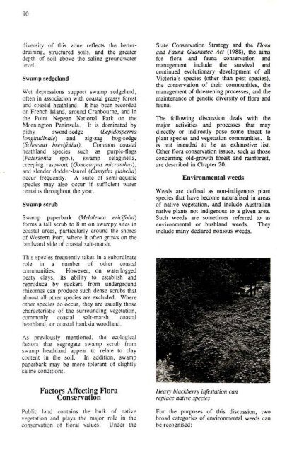
<strong>Environmental</strong> weeds<br />
Weeds are defined as non-indigenous plant<br />
species that have become naturalised in areas<br />
of native vegetation, and include Australian<br />
native plants not indigenous to a given area.<br />
Such weeds are sometimes referred to as<br />
environmental or bushland weeds. They<br />
include many declared noxious we^s.<br />
This species frequenfly takes in a subordinate<br />
role in a number of other coastal<br />
communities. However, on waterlogged<br />
peaty clays, its ability to establish and<br />
reproduce by suckers from underground<br />
rhizomes can produce such dense scmbs that<br />
almost all other species are excluded. Where<br />
other species do occur, they are usually those<br />
characteristic of the surrounding vegetation,<br />
commonly coastal salt-marsh, coastal<br />
heathland, or coastal banksia woodland.<br />
As previously mentioned, the ecological<br />
factors that segregate swamp scmb from<br />
swamp heathland appear to relate lo clay<br />
content in the soil. In addition, swamp<br />
paperbark may be more tolerant of slightly<br />
saline conditions.<br />
<strong>Factors</strong> <strong>Affecting</strong> <strong>Flora</strong><br />
<strong>Conservation</strong><br />
Public land contains the bulk of native<br />
vegetation and plays the major role in the<br />
conservation of fioral values. Under the<br />
Hea\y blackberry infestation can<br />
replace native species<br />
For the purposes of this discussion, two<br />
broad categories of environmental weeds can<br />
be recognised:
91<br />
(a) background weeds, which occur over<br />
extensive areas but which are rarely<br />
dominant; the presence of these species<br />
does not normally threaten indigenous<br />
species, and<br />
(b) swampers, which tend to occur in dense,<br />
often localised swards, out-competing<br />
and replacing indigenous species.<br />
Weed species in either category can be<br />
controlled or eradicated in a given area with<br />
suftlcient resources. However, the second<br />
category are usually given the highest<br />
priority where weed management resources<br />
are limited.<br />
Given the extent of the weed problem in<br />
native vegetation on public land and the<br />
limited resources available to deal with it, the<br />
most efficient approach may be to operate on<br />
a site by site basis, with sites of biological<br />
significance given priority, so that the<br />
management of a variety of weeds can be coordinated<br />
with other efforts to maintain or<br />
enhance the sites' biological values.<br />
Some of the major environmental weed<br />
species of native vegetation in the study area<br />
are dealt with below, according to the<br />
vegetation categories in which they<br />
commonly occur. This is not a complete list.<br />
Sub-alpine vegetation<br />
The relatively low occurrence of weeds<br />
refiects the environmental extremes here. A<br />
prominent weed of sub-alpine woodland is<br />
the English broom (Cytisus scoparius), which<br />
appears to be proliferating unchecked,<br />
especially on Mt Maflock.<br />
Montane vegetation<br />
English broom is also a problem species in<br />
montane vegetation, as is blackberry (Rubus<br />
fruticosus spp. agg.), which grows in dense<br />
patches in saddles and gully-heads - for<br />
example, around Royston River and Snobs<br />
Creek.<br />
Moist forests<br />
Common moist forest weeds include Japanese<br />
honeysuckle (Lonicera japonica), holly (Ilex<br />
aquifolium), common ivy, cherty-plum<br />
(Prunus cerasifera), sycamore maple (Acer<br />
pseudoplatanus), poison-berries (CJestrwn<br />
spp.), Himalayan honeysuckle (Leycesteria<br />
formosa), holly, and blackberry. While not<br />
particularly widespread, many of these<br />
species become pests where private gardens<br />
adjoin native forest, as in the Dandenong<br />
Ranges. Also, while they may not grow in<br />
dense stands, scattered oufliers can develop<br />
into problem sites. The most widespread<br />
weed species of moist forest are cat's ear<br />
(Hypochoeris radicata) and spear thistle<br />
(Cirsium vulgare), which usually occur as<br />
background weeds.<br />
Riparian foresi is among the most weedprone<br />
of the vegetation communities.<br />
Blackberry is the most obvious problem<br />
species, but blue periwinkle, tutsan<br />
(Hypericum androsaemum), Darwins<br />
barberry (Berberis darwinii), wood-sorrels<br />
{Oxalis spp.), and species of willow (Salix<br />
spp.) may become established, particularly<br />
where the riparian forest adjoins agricultural<br />
land or townships.<br />
Several grasses may also proliferate on moist<br />
river flats: Yorkshire fog (Holcus lanatus),<br />
cocksfoot (Dactylis glomerata), canarygrasses<br />
(Phalaris spp.), and sweet vernalgrass<br />
(Authoxauthwn odoratum).<br />
Dry forests<br />
The drier forests, particularly those with<br />
relatively fertile soils, may contain a large<br />
suite of introduced grasses and herbs, most of<br />
which are intractable. One that may respond<br />
to management is St John's wort (Hypericum<br />
perforatum), a noxious weed that also infests<br />
native vegetation, and that is especially<br />
prominent in the EUdon district. Other<br />
troublesome species, particularly around the<br />
urban fringe of Melboume, are Monterey<br />
pine, sweet pittospomm, and cotoneaster<br />
(Conoteaster spp.).<br />
Hair-grasses (Aira spp.), fescues (Vulpia<br />
spp.), bromes (Bromus spp.), and quakinggrasses<br />
(Briza spp.) are common weedy<br />
grasses in dry forests. A number of herbs<br />
such as cat's ear (Hypochoeris radicata),<br />
species of centaury (Centaurium spp.), and<br />
chickweeds (Cerastium spp.) also occur, but<br />
usually as background weeils.<br />
Two New South Wales species of Acacia,<br />
cootamundra wattle (Acacia baileyana) and<br />
early black wattle (A. decurrens), have<br />
become naturalised and are also spreading in
92<br />
Riparian forest is prone to weed infestation<br />
dry foresi areas. Sallow wattle (A.<br />
longifolia) is another native species that has<br />
become naturalised outside its natural range.<br />
Plains vegetation<br />
Vegetation communities occurring on drier,<br />
fertile plains are subject to invasion by a<br />
wide range of intractable weeds.<br />
Of these, the mosl prominent include sweet<br />
briar (Rosa rubiginosa), hawthorn (Cretaegus<br />
monogyna), fennel (Foeniculum vulgare),<br />
spear-grass (Nassella neesiana), rye-grasses<br />
(Lolium spp.), Yorkshire fog (Holcus<br />
lanatus), cocksfoot (Dactylis glomerata),<br />
canary-grasses (Phalaris spp.), fescues<br />
(Vulpia spp.), sweet vernal-grass<br />
(Anthoxanthum odoratum), bromes (Bromus<br />
spp.), and quaking-grasses (Briza spp.).<br />
Heathland vegetation<br />
Heathland communities and heathy woodland<br />
tend not to be vulnerable to weed invasion.<br />
probably due to very low natural fertility of<br />
their soUs. However, two species may pose<br />
problems: maritime pine (Pinus pinaster) and<br />
coast tea-tree.<br />
Coastal vegetafion<br />
Largely due to the long history and extent of<br />
dismrbance, coastal areas are particularly<br />
prone to invasion by introduced species.<br />
Notable among the problem species are the<br />
woody shmbs boneseed, myrtle-leaf<br />
milkwort, smilax asparagus, and mirror-bush.<br />
Coastal areas are also prone to invasion by<br />
introduced grasses, such as veldt grasses<br />
{Ehrharta spp.) and hare's tails (Lagurus<br />
ovatus), and although normally considered<br />
background weeds, may become locally<br />
abundant. Another introduced species,<br />
marram grass, has been widely planted to<br />
stabilise coastal sand dunes. It is now well<br />
established and spreading.<br />
Two Australian native species can become<br />
weeds in coastal vegetation: coast tea-tree.
93<br />
which normally would be confined to coastal<br />
dune scmb, but frequently extends into<br />
adjoining vegetation and bluebell creeper<br />
(Sollya heterophylla) which is a pest in the<br />
Arthurs Seat area.<br />
Cinnamon fungus<br />
Pathogens<br />
Although present in the study area, cinnamon<br />
fungus (Phytophthora cinnamomi) has yet to<br />
display the impact on native vegetation that<br />
has occurred in the Brisbane Ranges, Otway<br />
Ranges, Wilsons Promontory, and Gippsland.<br />
Species characteristic of heathland or heathy<br />
woodland vegetation appear to be most<br />
susceptible to the fungus, with members of<br />
die Proteaceae (hakeas, banksias, grevilleas)<br />
and grass-trees (Xanthorrhoea spp.) being<br />
most noticeably affected. A range of<br />
vegetation communities within the study area<br />
are potentially susceptible, but the extent of<br />
any current infection is unknown.<br />
Myrtle wilt<br />
This disease affects myrtle beech. First<br />
documented in 1973, and known to occur in<br />
Tasmania and southern Victoria, it is<br />
associated with infection by a native fungus,<br />
Chalara australis. The result of infection is<br />
wilting and leaf-fall, beginning with the<br />
crown. Mature trees appear to be most<br />
susceptible. Most infected trees die, usually<br />
12 to 30 months after the appearance of early<br />
symptoms. Small, isolated stands appear<br />
most vulnerable.<br />
A correlation between the occurrence of<br />
myrtle wUt and disturbance from timberharvesting<br />
and roading has been documented,<br />
and it would appear that these activities may<br />
accelerate the spread of Chalara australis.<br />
However, undisturbed stands may also be<br />
affected.<br />
The presence and extent of myrtle wilt in the<br />
study area, and the threat it poses to cool<br />
temperate rainforest, have not been studied,<br />
but a suspected case has been reported from<br />
Tyers River.<br />
Pest Animals<br />
The impact of grazing by rabbits on native<br />
vegetation has not been studied in detail, but<br />
is considered to be high. It is most<br />
noticeable in plains vegetation and dry<br />
forests. Indirect impacts may also occur<br />
through the spread of weeds, and through soil<br />
degradation associated with warrens.<br />
Foxes act as a wide-ranging dispersal agent<br />
for blackberry, particularly where roads<br />
provide ready access to unaffected areas.<br />
Native birds and bees pollinate large numbers<br />
of native plants. Introduced species of birds<br />
and the introduced honey bee can displace<br />
their native counterparts, which may affect<br />
the composition of native vegetation.<br />
Introduced birds can carry the seeds of<br />
environmental weeds with fleshy fiiiit (such<br />
as blackberry, hawthorn, and cherry laurel).<br />
Timber-harvesting<br />
Human Activities<br />
This is widespread in the study area,<br />
especially in moist forests. Its effects on<br />
native vegetation are the subject of scientific<br />
study and much community debate.<br />
Principally, it maintains the harvested<br />
vegetation in relatively early successional<br />
stages, and results in substantial short-term<br />
soil disturbance.<br />
Such changes may have ramifications for the<br />
harvested forests, and the adjacent<br />
vegetation, with regard to tire, soil stmcture<br />
and nutrient levels, water quality and yield,<br />
exposure to wind, changes in micro-climate,<br />
and the spread of pathogens and weeds.<br />
Scientific studies into the impacts of timberharvesting<br />
on vegetation have been<br />
undertaken. The Department of <strong>Conservation</strong><br />
and Environment has an ongoing program of<br />
research, the Silvicultural Systems Project, to<br />
investigate these issues and recommend on<br />
any necessary improvements. The Board of<br />
Works has undertaken and reported on the<br />
results of long-term catchment studies into<br />
forest hydrology. Refer to Chapter 20 for<br />
further (liscussion.<br />
Road construction and maintenance<br />
A network of roads, both public and<br />
restricted, has been developed in areas<br />
supporting native vegetation to provide<br />
access for a variety of purposes, including<br />
timber-harvesting, recreation, mining, fire
94<br />
protection and suppression, and water<br />
production.<br />
The eftects of roading may include changes<br />
to micro-climates, and changes to soil and<br />
drainage - simUar in some ways to those<br />
associated with timber-harvesting. Most<br />
roads involve the permanent loss of<br />
vegetation, and new road constmction,<br />
alignment, or upgrading can involve the<br />
clearance of substantial areas. The road she<br />
alters drainage, and mn-oft' can create<br />
erosion and lower water quality in receiving<br />
waters.<br />
In some places, the location of roads adjacent<br />
to watercourses leads to significant and<br />
continuing dismrbance to stands of cool<br />
temperate rainforest, often within prescribed<br />
buffer strips.<br />
Roads provide access to native vegetation for<br />
recreation and other activities, which may<br />
add to the incidence of wildfire in these<br />
areas. By contrast, they also allow access for<br />
fire-suppression activities. Roads may also<br />
accelerate the spread of weeds and pest<br />
animals.<br />
Fire<br />
Considerable controversy has raged over the<br />
role of fire in native vegetation for some<br />
years. Meredith (1988) provides a review of<br />
this subject. Fire is generally accepted to be<br />
involved, along with other factors, in the<br />
natural maintenance of vegetation. It is<br />
believed to have been used by Aborigines as<br />
a tool to assist hunting and food-gathering,<br />
although this is likely to have occurral<br />
mainly in grasslands and grassy woodlands<br />
rather than in the densely forested areas.<br />
European settlers deliberately extended the<br />
use of tire to all areas, largely for purposes<br />
related to mining and agricultural activities.<br />
Today, fire is used in the management of<br />
native vegetation for human use and<br />
protection - for example, to reduce fuel, to<br />
regenerate pastures, to stimulate fodder<br />
species, to suppress fire, and to control pest<br />
plants and animals. It is occasionally used to<br />
maintain or create habitat conditions for flora<br />
or fauna conservation.<br />
The important ecological aspects of the tire<br />
regime to which anv stand of vegetation is<br />
Wildfire in eucalypt forest<br />
exposed are intensity, seasonality, and<br />
frequency. The degree of variability within<br />
the regime over long periods is also<br />
important. Namral (non-human) causes of<br />
fire are few, with lightning being the by far<br />
the dominant one. Our knowledge of fire<br />
regimes prior to European settlement is<br />
currently poor.<br />
Vegetation communities and their constituent<br />
species respond to fire in a variety of ways.<br />
Plants may:<br />
* resprout from lignotubers, roots,<br />
epicormic buds or other vegetative parts<br />
(e.g. eucalypts, some woody shmbs,<br />
most ferns, many grasses and sedges)<br />
* regenerate from seeds stored in woody<br />
fmits or in the soil (e.g. various wattles<br />
and peas, herbs, and some grasses)<br />
* recolonise the site, either by seeds or<br />
vegetatively, from adjacent vegetation<br />
(e.g. some members of the daisy family,<br />
mistletoe).<br />
Fire-sensitive vegetation communities and<br />
their constituent species may also use one or<br />
more of these mechanisms to recover from<br />
fire. For example, mountain ash is killed by<br />
tires of moderate intensity, but recolonises<br />
using seed held in the canopy. A mountain<br />
ash-dominated wet sclerophyll forest may fail<br />
to regenerate if fire occurs more frequently<br />
than the time it takes for the regrowth trees<br />
to produce adequate seed. The result may be<br />
a fire-induced shift in the floristic<br />
composition of the site, either to a thicket of,
95<br />
for example, silver wattle, or to a more firetolerant<br />
vegetation community such as damp<br />
sclerophyll forest.<br />
Rainforest development is closely related to<br />
the fire regime. If a rainforest area is burnt,<br />
the dominant species, myrtle beech, may<br />
resprout from epicormic buds on the roots,<br />
butt, or tmnk. However, species from the<br />
surrounding vegetation may recolonise the<br />
site more successfully than the rainforest<br />
species. Under these circumstances, the<br />
forest that becomes established is drier and<br />
more flammable dian rainforest, and is not<br />
only more likely to carry further fires, but<br />
more likely to re-establish following<br />
subsequent fires.<br />
In this way, the more fire-tolerant vegetation<br />
community can reinforce its occupation of the<br />
site, and only a fire-free period lasting<br />
several centuries would create conditions<br />
suitable for the redevelopment of cool<br />
temperate rainforest.<br />
The fire-induced changes in floristic<br />
composition of a site may also involve the<br />
promotion, loss, or reduction of particular<br />
species, without the total replacement of the<br />
vegetation community. This is commonly the<br />
case in communities such as heathy<br />
woodland, where frequent low-intensity fires<br />
may favour resprouting species such as wiry<br />
spear-grass at the expense of obligate seed<br />
regenerators such as banksias and hakeas.<br />
Odier prominent examples include the<br />
predominance of austral bracken and forest<br />
wire-grass in shmbby and heathy foothill<br />
forest following frequent low-intensity<br />
burning.<br />
Frequent fires of moderate intensity in heathy<br />
dry forest may also favour leguminous<br />
species such as bitter-peas and narrow-leaf<br />
wattle at the expense of the slower-growing,<br />
later-maturing species of the Epacrldaceae.<br />
Extensive areas of this community in the<br />
study area are relatively species-poor and<br />
dominated by legumes.<br />
The role of seasonality of fire has been<br />
demonstrated in sand heathland into which<br />
coast tea-tree has invaded. Autumn burning<br />
favours this species, which produces large<br />
volumes of short-lived seed after summer<br />
flowering. Spring burning favours the<br />
characteristic heath tea-tree, which can retain<br />
seed in its woody fmit for many years.<br />
As evidence regarding the responses of<br />
vegetation communifies and individual<br />
species is progressively gathered, it wUl be<br />
possible to manage fire in these communities<br />
so that flora conservation goals are better<br />
satisfied.<br />
Mining<br />
Although mining activity was once far more<br />
widespread in the study area, today its<br />
impacts tend to be localis^.<br />
Open-cut mining for constmcfion materials<br />
such as sand, clay, gravel, and rock has a<br />
severe, long-term but localised impact on the<br />
vegetation.<br />
Underground mining for gold continues, but<br />
at a much reduced rate, mainly near Woods<br />
Point. Historically, the greatest impact of<br />
this mining was indirect, through the<br />
development of settlements, which in turn<br />
was associated with clearing of forests, the<br />
spread of weeds, increased incidence of fire,<br />
and earthworks, particularly along streams.<br />
Similar consequences followed from alluvial<br />
mining and dredging.<br />
The accidental spillage of effluent containing<br />
various toxins into streams remains a cause<br />
for concern, although its impact on<br />
vegetation is largely unknown.<br />
Eductor dredging formerly damaged a<br />
number of watercourses in the study area, but<br />
was banned in 1990. The mining and<br />
extractive industrial activity adjacent to<br />
watercourses and illegal eductor dredging,<br />
can have an impact on riparian vegetation,<br />
mainly through increased turbidity and<br />
sedimentation, and through erosion and the<br />
spread of weeds.<br />
Recreation<br />
A wide variety of recreational activities are<br />
undertaken in the study area, with many<br />
focused on areas of native vegetation.<br />
Activities that potentially threaten flora<br />
values are principally those that disturb the<br />
ground cover. Of particular concern are the<br />
more sensitive vegetation communities,<br />
which include the sub-alpine, coastal, and<br />
riparian ones.<br />
Sub-alpine soils are vulnerable to erosion,<br />
and recover slowly from disturbance; the
96<br />
hydrology of alpine bogs is delicate and<br />
sensitive to changes in local drainage.<br />
Activities associated with alpine resorts,<br />
horse-riding, vehicle use, and camping can<br />
result in soil erosion and/or vegetation<br />
disturbance.<br />
Riparian areas provide the focus for many<br />
water-dependent and water-enhanced<br />
activities, including picnicking, camping,<br />
walking, fishing, swimming, and canoeing.<br />
Using riparian areas or gaining access to<br />
water bodies can disturb vegetation, cause<br />
erosion, and introduce weeds.<br />
Coastal vegetation is vulnerable to<br />
disturbance. A multitude of tracks traversed<br />
coastal dunes in the vicinity of popular<br />
beaches in the study area, frequently resulting<br />
in dune erosion. Salt-marsh and mangrove<br />
vegetation has been disturbed by coastal<br />
facilities and recreational activhies.<br />
The environmental implications of recreation,<br />
and the eftects of particular activities, are<br />
described in Chapter 13.<br />
Climate change<br />
Although some debate remains about the<br />
direction and rate of human-induced climate<br />
change, the moderate to exfreme predictions<br />
have considerable implications for<br />
conservation of flora. A warmer climate,<br />
changed rainfall patterns, and a higher sea<br />
level would be likely to favour some species<br />
and communities at the expense of others.<br />
The current distribution of communities<br />
could alter under such conditions, together<br />
with the limits of distribution. Changes to<br />
the conservation status of some species could<br />
occur.<br />
Water production<br />
The impact of water production on native<br />
vegetation centres around the constmction of<br />
dams and weirs, the associated roading and<br />
tunnelling, and the total and permanent loss<br />
of vegetation in the inundation area. In<br />
addition, the altered flow regimes<br />
downstream of dams may affect riparian and<br />
floodplain communities.<br />
Ski slopes on the summit ofMt Baw Baw<br />
Alpine Resort
97<br />
Almost all the major rivers of the study area<br />
have been dammed: the Goulbum, Yarra,<br />
Rubicon, Tarago, Tyers, Tanj ii, and<br />
Thomson Rivers and Cardinia Creek. The<br />
genfle topography of the Yea, Acheron, and<br />
Murrindindi Rivers and King Parrot Creek<br />
probably precludes them from future<br />
damming, but the Aberfeldy, Big, and upper<br />
Goulburn Rivers have the potential to be<br />
dammed.<br />
Clearing for agriculture and urban<br />
development<br />
public land uses protect floral values to some<br />
extent, but may also allow exploitative uses<br />
and conservation values may be necessarily<br />
compromised. Important and notable exceptions<br />
in the study area are the catchments<br />
under Board of Works control, where the<br />
current policy of controlled uses in these<br />
areas confers high levels of protection of floral<br />
values. The effectiveness of a particular<br />
land-use recommendation to protect fioral<br />
values by management prescription depends<br />
on the effectiveness of management practice.<br />
It is now unusual for large parcels of public<br />
land to be alienated for agriculture or<br />
housing, or cleared. In addition, only a<br />
small percentage of public land is currenfly<br />
cleared, with the clearing mosfly having<br />
taken place many years ago.<br />
However, it is important to reflect on the<br />
extent to which clearing of land for these<br />
purposes in the past has substanfially aff'ected<br />
our ability to conserve native vegetation<br />
communities by establishing reserves. The<br />
communities most affected are those on the<br />
fertile plains, along river valleys, and in the<br />
vicinity of the Melbourne metropolitan area.<br />
Specifically, these communities include plains<br />
grassy woodland, plains grassland, floodplain<br />
riparian woodland, floodplain wetland<br />
complex, box woodland, coastal banksia<br />
woodland, coastal grassy forest, and swamp<br />
scrub.<br />
<strong>Conservation</strong> Status<br />
The following section broadly describes the<br />
distribution of each vegetation community<br />
and makes a qualitative assessment of its<br />
current conservation status.<br />
Assessment of conservation status is a<br />
complex task that involves consideration of<br />
many factors, one of which is the current<br />
level of protection. Different public land<br />
uses confer different levels of protecfion to<br />
floral values. Areas that have Nature<br />
conservation as the primary purpose for the<br />
recommended use receive the highest level of<br />
protection; they include reference areas,<br />
national and State parks, flora reserves, and<br />
flora and fauna reserves. However, the<br />
conservation reserve system cannot achieve<br />
protection of floral values in isolation; all<br />
public lands with such values have a role in<br />
floral conservation. A large number of other<br />
Creating this agricultural land at Wonthaggi<br />
involved clearing heathland and<br />
coastal vegetation<br />
<strong>Conservation</strong> status assessment involves the<br />
extent, current level of protection, and<br />
representation of vegetation communities.<br />
The Land <strong>Conservation</strong> Council considers<br />
that the reserve system should include<br />
adequate representation of all major plant<br />
communities, and this has become an<br />
important considerafion in its recent deliberations<br />
about parks and other reserves. WTiile<br />
it is not possible to protect all variafions of<br />
vegetation associations, it is necessary to<br />
recognise the diversity and variability within<br />
each plant community and identify an optimal<br />
set of regional variants. Assessment of the<br />
relative extent of a representafive sample<br />
should include consideration of the reduction<br />
of some communities since European<br />
setflement (that is, representation of the<br />
current or 'original' extent).
98<br />
Dry sub-alpine shrubland<br />
The major occurrences, and best examples, of<br />
dry sub-alpine shmbiand are on the Baw Baw<br />
Plateau, and are reserved within the Baw<br />
Baw National Park. Pressure from passive<br />
recreation poses a minor threat to this<br />
community.<br />
Damp sub-alpine heathland and wet subalpine<br />
heathland<br />
These two communities, which normally<br />
occur together, are found on the Baw Baw<br />
Plateau in reserved land. Further west,<br />
unreserved examples occur on Lake<br />
Mountain and Mt Bullfight. At its western<br />
limit, this complex grows in the headwaters<br />
of Storm Creek, north of Mt Margaret, where<br />
its relatively low elevation, makes the stand<br />
noteworthy. Other noteworthy stands occur<br />
in the Myrrhee area in the headwaters of die<br />
Thomson, Yarra, and Toorongo Rivers.<br />
These stands are unreserved. The major<br />
impacts come from the risk of severe fire,<br />
and any physical dismption likely to alter<br />
drainage patterns.<br />
Sub-alpine woodland<br />
This community grows on the Baw Baw<br />
Plateau, Lake Mountain, and Mounts<br />
Torbreck, Bullfight, Maflock, Terrible,<br />
Duffy, Selma, and Useful. A small, unusual<br />
stand occurs on Mt Ritchie. Only the Baw<br />
Baw instances are reserved. Major threats to<br />
sub-alpine woodland come from inappropriate<br />
tire regimes, localised ski resort development<br />
in the case of Lake Mountain, and the spread<br />
of weeds.<br />
Montane dry woodland<br />
Such woodland occurs mainly in the eastern<br />
mountains, both north and south of the Great<br />
Dividing Range. A small area is reserved<br />
within Eildon State Park, but on the whole<br />
this community is poorly reserved. It faces<br />
the minor threat that too-frequent burning<br />
may aftect die grassy and herb-rich<br />
un(lerslorey.<br />
Montane damp forest<br />
Extensive areas of montane damp forest<br />
occur usually above 900 m in the upper<br />
Yarra, upper Thomson, upper Goulburn, and<br />
Big River catchments, and extend north of<br />
MarysviUe to the upper slopes of the<br />
Cerberean Ranges. This community was<br />
particularly devastated by the 1939 fires, and<br />
today very few areas of mature or old-growth<br />
forest remain.<br />
Small areas are reserved within the fringes of<br />
Baw Baw National Park, with minor stands<br />
in reference areas within the Upper Yarta,<br />
O'Shannassy, and Watts River water<br />
catchments.<br />
Montane damp forest is harvested for timber.<br />
It is sensitive to frequent, intense fires.<br />
Montane wet forest<br />
This forest covers considerably more<br />
restricted area than montane damp forest,<br />
being concentrated on protected slopes south<br />
of the Divide and around Lake Mountain.<br />
The best examples occur in the O'Shannassy<br />
water catchment. Other valuable sites<br />
include the headwaters of the Taggerty River,<br />
and some parts of the Tcwrongo Plateau.<br />
Small stands are included in Baw Baw<br />
National Park and the Mt Gregory and Watts<br />
River Reference Areas. This community is<br />
especially sensitive to fire. It is harvested for<br />
timber.<br />
Montane riparian thicket<br />
This community occupies drainage lines<br />
above 800 m around Baw Baw and in the<br />
proposed Lake Mountain State Park. It is<br />
reserved in Baw Baw National Park, but<br />
lower-elevation examples are unreserved.<br />
The major threats to montane riparian thicket<br />
centre around excessive sedimentation and<br />
changes to water flow regimes. As it usually<br />
grows in stream headwaters, limberharvesting<br />
may take place in close proximity,<br />
exposing these stands to physical disturbance<br />
and damage from regeneration burning.<br />
Cool temperate rainforest<br />
Such rainforest occurs throughout the higherelevation<br />
wel forests of the study area. Small<br />
stands are reserved in die Baw Baw National<br />
Park, and in die Deep Creek, Wallaby Creek,<br />
and Watts River Reference Areas.<br />
This community is unusual in that efforts to<br />
protect it have centred on management
99<br />
prescriptions rather than reservation. These<br />
ban harvesting or deliberate burning, and<br />
require buffer areas to be maintained around<br />
stands. Buffer widths range from 20 m<br />
around 'linear', usually streamside, tracts to<br />
40 m around larger, 'non-linear' stands. As<br />
a result, the reserves listed above represent<br />
only a small proportion of the area covered<br />
by cool temperate rainforest in Melbourne<br />
District 2 which, it should.be noted, contains<br />
by far the majority of stands of the<br />
community in Victoria.<br />
Biologically significant stands of this<br />
rainforest occur in the Board of Works water<br />
catchments, the headwaters of the Yea,<br />
Taggerty, Royston, Acheron, Torbreck,<br />
Murrindindi, TanjU, Tyers, Toorongo, Ada,<br />
and Bunyip Rivers, and Pioneer Creek.<br />
rainforest species to recolonise. The result is<br />
the reversion to non-rainforest species or, in<br />
the case of roads, a permanent gap. The size<br />
of buffer required to give long-term protection<br />
to rainforest, and the sorts of activities<br />
that should be permitted within these buffers,<br />
have yet to be established scientifically.<br />
Other threats include soil erosion, weed<br />
invasion, and the effects of pathogens.<br />
Wet sclerophyll forest<br />
Protected mountain slopes in the high-rainfall<br />
zone support large areas of this community.<br />
Much of this zone was burnt in 1939. As a<br />
result, the majority of stands are 50-year-old<br />
regrowth.<br />
Old-growth and older regrowth stands are<br />
often small and scattered. By far the best are<br />
located in the Board of Works catchments,<br />
with large stands in the O'Shannassy<br />
catchment, and smaller ones in Wallaby<br />
Creek, Maroondah, and Watts River<br />
catchments. Other noteworthy stands of oldgrowth<br />
wet sclerophyll forest are scattered<br />
around the Baw Baw Plateau, in the upper<br />
Bunyip River catchment, parts of Dandenong<br />
Ranges National Park, and isolated pockets in<br />
the Cerberean Ranges.<br />
Reserved areas of wet sclerophyll forest<br />
include small stands in Dandenong Ranges<br />
National Park and Kinglake National Park,<br />
others within a number of reference areas in<br />
the Board of Works Catchments, Hawthorn<br />
Creek Reference Area, and a small patch in<br />
Baw Baw National Park, south of Mt Erica.<br />
The viability of both of the national parks for<br />
wet sclerophyll forest is somewhat doubtful<br />
given their high use for recreation, small size<br />
of stands, and their proximity to urban areas<br />
with their attendant problems regarding<br />
introduced species. These reserved stands<br />
amount to a small percentage of the<br />
total covered by this community in the study<br />
area.<br />
Wet sclerophyll forest, much of which is 1939<br />
regrowth<br />
The major threats to cool temperate rainforest<br />
are inadequate protection from fire, wind,<br />
and physical disturbance (for example, road<br />
constmction or the falling of trees). These<br />
events create gaps in the rainforest canopy<br />
diat are too large or exposed for the<br />
Beyond the study area, wet sclerophyll forest<br />
occurs in eastern Victoria, mainly south of<br />
the Great Dividing Range, and in the Otway<br />
Ranges. Since the clearing last century of the<br />
extensive areas of wet sclerophyll forest in<br />
South Gippsland, certain stands in the study<br />
area have gained pre-eminence for their<br />
conservation values, largely based on their<br />
ecological maturity, integrity, and lack of<br />
disturbance.
100<br />
Major threats to the forest come from<br />
frequent fire, environmental weeds, and the<br />
possible impact of long-term intensive<br />
timber-harvesting and associated roading.<br />
Damp sclerophyll forest<br />
Extensive tracks in the foothill and mountain<br />
country of the study area carry damp<br />
sclerophyll forest. Examples are reserved in<br />
Kinglake National Park, Stony Creek<br />
Reference Area in the Silver Creek<br />
Catchment, Bunyip State Park, Dandenong<br />
Ranges National Park, the lowland extension<br />
of Baw Baw National Park, and the Walsh<br />
Creek Reference Area in the Upper Yarra<br />
Catchment. These reservations represent<br />
only a small proportion of the total area the<br />
community covers.<br />
Damp sclerophyll forest is harvested for<br />
timber. It is relatively fire-tolerant, but due<br />
to its moist understorey, fires are infrequent.<br />
Other threats are minor.<br />
Riparian thicket<br />
Found both north and south of the Great<br />
Dividing Range, the best examples of<br />
riparian thicket are on the Murrindindi River,<br />
in the headwaters of Starvation Creek, and in<br />
the upper Bunyip and upper Tarago<br />
catchments. It is unreser\'ed on public land.<br />
Changes to drainage patterns, particularly<br />
associated widi roading, are the major threats<br />
here.<br />
Riparian forest<br />
This community is widespread along the<br />
middle to upper reaches of rivers throughout<br />
the study area. Best examples include the<br />
upper Yarra, upper Goulburn, upper<br />
Thomson, Big, Torbreck, Taponga,<br />
Jamieson, Howqua, Tyers, and upper<br />
Acheron Rivers, and sections along the<br />
Watts, Murrindindi, Yea, Tanjil, Little, and<br />
La Trobe Rivers.<br />
Small areas of riparian forest are reserved in<br />
Cathedral Range State Park and Eildon State<br />
Park. Disturbed but valuable examples occur<br />
in Warrandyte State Park and in the Plenty<br />
Gorge.<br />
Alluvial mining and recreation activities such<br />
as fishing and camping, if concentrated on<br />
particular areas, can pose minor threats to<br />
riparian forest. River reserves are subject to<br />
a variety of uses and conservation values may<br />
be compromised.<br />
Swampy riparian forest<br />
Growing in scattered locafions throughout the<br />
study area, swampy riparian forest is<br />
reserved in the Silver Gum <strong>Flora</strong> Reserve at<br />
Buxton, in Moondarra State Park, and in<br />
Bunyip State Park. The best unreserved<br />
stands occur along Big, Torbreck, and<br />
Murrindindi Rivers, and White's Creek.<br />
Changes to the drainage regime and weed<br />
invasion post the main threats.<br />
Herb-rich foothill forest<br />
The distribution of this community is centred<br />
around the foothills and alluvial terraces of<br />
the Goulburn Valley and its tributaries.<br />
Examples are reserved in Cathedral Range<br />
Slate Park, Switzerland Ranges <strong>Flora</strong><br />
Reserve, Eildon Slate Park, Fraser Nafional<br />
Park, and the Gobur, Caveat, and Yarck<br />
<strong>Flora</strong> Reserves.<br />
Frequent low-intensity fire poses a minor<br />
threat.<br />
Shrubby foothill forest<br />
The higher slopes of foothills of the Great<br />
Divide, in the centre of the study area, carry<br />
shmbby foothill forest. Small areas are<br />
reserved in Bunyip State Park, Dandenong<br />
Ranges National Park, Kinglake National<br />
Park, and in the lowland extension of Baw<br />
Baw National Park.<br />
The major threat comes from frequent fire,<br />
which may alter the species composition.<br />
Heathy foothill forest<br />
This forest type occupies relatively infertile<br />
soils in the Bunyip, Tarago, and La Trobe<br />
River catchments. It is reserved in<br />
Moondarra State Park, French Island Stale<br />
Park, and Bunyip State Park. The floristic<br />
composition of the overstorey and<br />
understorey of heathy foothill forest may<br />
change with frequent burning. One of the<br />
dominant eucalypts, silvertop, has been<br />
shown to increase in abundance at the<br />
expense of other species when fire frequency<br />
is relatively high.
101<br />
Heathy dry forest<br />
Valley forest<br />
The community is restricted to the lower<br />
slopes and valleys in the foothills to the north<br />
and east of Melbourne. Kinglake National<br />
Park and the Reference Areas in Yan Yean<br />
Water Catchment include representative<br />
examples. Weeds are the major threat to<br />
valley forest, which has been drastically<br />
reduced in extent by agricultural and urban<br />
development.<br />
Heathy dry forest<br />
Of the three variants of heathy dry forest<br />
described earlier, only the Kinglake type is<br />
well represented in flora conservation<br />
reserves (Kinglake National Park).<br />
Both the upper Goulbum and upper Thomson<br />
variants are poorly reserved, although the<br />
lowland extension of Baw Baw National Park<br />
contains some stands of the latter. Valuable<br />
examples of the upper Goulburn variant<br />
include one at Moonlight Spur, and another<br />
near die junction of Slander Creek with the<br />
upper Goulburn River, east of Woods Point.<br />
Additional valuable stands in the Thomson<br />
Valley are found around Swingler and<br />
Mormon Town, near Walhalla. Highquality<br />
examples of this community also<br />
occur in the Upper Yarra Catchment.<br />
Frequent burning may also be detrimental to<br />
heathy dry forest.<br />
Dry sclerophyll forest<br />
This community is widespread from Kinglake<br />
to Jamieson. It is well represented in<br />
conservation reserves, including Kinglake<br />
National Park, Cathedral Range State Park,<br />
Eildon State Park, and Fraser National Park.<br />
An unreserved variant of dry sclerophyll<br />
forest grows soudi of die Thomson River and<br />
west of Toongabbie.<br />
The community often contains many<br />
environmental weeds, which appear to be the<br />
major threat to it.<br />
Box woodland<br />
Apart from stands on the lower slopes and<br />
alluvial plains of the Goulburn River valley.
102<br />
small, disturbed examples of box woodland<br />
occur in the McKenzie <strong>Flora</strong> Reserve near<br />
Alexandra. This community has been<br />
substantially depleted, and is poorly reserved<br />
in the study area.<br />
Plains grassy woodland<br />
This woodland occurs on the basalt plains to<br />
the north of Melbourne, and on alluvial<br />
plains along the Goulburn and Yarra Rivers<br />
and their tributaries. It is rarely found on<br />
sedimentary geologies.<br />
Il is poorly represented on public land,<br />
occurring at Yan Yean (in a disturbed form)<br />
and in the Epping and Yan Yean Cemeteries.<br />
Weed invasion and grazing pose the greatest<br />
threat.<br />
Plains grassland<br />
With the exception of a small example in the<br />
Epping Cemetery, plains grassland does not<br />
occur on public land in the study area.<br />
An action plan for the management of this<br />
much-depleted community has been prepared<br />
by the Department of <strong>Conservation</strong> and<br />
Environment, and is being implemented. The<br />
remaining examples are commonly disturbed<br />
by grazing and weed invasion.<br />
Floodplain riparian woodland<br />
Woodland of this type is restricted to river<br />
banks and billabongs in the valleys of the<br />
Yarra, Goulburn, Yea, and the Acheron<br />
Rivers, and Hughes, King Parrot, and<br />
Dabyminga Creeks.<br />
Most of these stands are surrounded by<br />
agricultural land. Generally, they fall within<br />
river reserves, which, despite being public<br />
land, are often grazed or used as watering<br />
points by slock. Many are partially or<br />
completely cleared. The majority are in poor<br />
condition. Weed invasion and erosion of<br />
banks are the major threats.<br />
Grassy wetland<br />
Although not known to occur on public land<br />
in the study area, grassy wefland is believed<br />
lo occur on government-owned railway<br />
reserves in the Wallan area. Grazing and<br />
associated weed invasion pose the major<br />
threats lo il.<br />
Floodplain wetland complex<br />
Examples of this complex are found on<br />
alluvial plains in the Yarra and Goulbum<br />
Valleys, but many are disturbed by weeds<br />
and grazing. The best examples are scattered<br />
in the river reserves along the Goulburn<br />
River between Eildon and Seymour, although<br />
valuable examples also occur along die Yarra<br />
and Little Yarta Rivers near Yarra Junction<br />
and Yarra Glen.<br />
Heathy woodland<br />
A band of heathy woodland straddles the<br />
lower foothills to the south of the Great<br />
Dividing Range, from the Cardinia-<br />
Gembrook area eastwards to north of<br />
Moe. Representative examples are reserved<br />
within Bunyip State Park and Moondarta<br />
State Park.<br />
Fire regimes play an important role in<br />
determining the species composition and<br />
abundance in this community. <strong>Flora</strong><br />
conservation, both inside and outside<br />
biological reserves, would be assisted by<br />
maintaining a full range of fire regimes<br />
(including unburnt areas), and monitoring<br />
any floristic changes, in order to increase our<br />
understanding of this interaction.<br />
Wet heathland<br />
This community is scattered throughout a<br />
range similar to that of heathy woodland,<br />
with which it usually occurs in conjunction.<br />
The wet heathland occupies wetter depressions<br />
and lower slopes. It is well reserved in<br />
Bunyip State Park and Moondarra State Park.<br />
The major threat to the community comes<br />
from changes to drainage, although it may also<br />
be prone to infection by cinnamon fungus.<br />
Swamp heathland<br />
Often associated with both wet heathland and<br />
swampy riparian forest, swamp heathland has<br />
a disjunct distribution. The most noteworthy<br />
stands occur along Woori Yallock and<br />
Cockatoo Creeks, in Bunyip State Park and<br />
Moondarra Stale Park.<br />
Sand heathland<br />
This community is found on French Island,<br />
Mornington Peninsula, and around Grantville
103<br />
Appropriate fire regimes are again required<br />
to maintain species and stmctural diversity<br />
(see previous section on fire). Maritime pine<br />
(Pinus pinaster) and coast tea-tree<br />
(Leptospermum laevigatum) may become<br />
troublesome weeds.<br />
Coastal grassy forest<br />
The community has been greafly depleted by<br />
the development of agriculture and<br />
settlements throughout the coastal region. It<br />
was once far more widespread, particularly<br />
on the Momington Peninsula and around<br />
Western Port. It is represented in the Point<br />
Nepean National Park. Weed invasion<br />
presents the major threat.<br />
Coastal dune scrub<br />
Coastal dune scrub at Woolamai Beach,<br />
Phillip Island, has been eroded by pedestrian<br />
traffic from the access road<br />
and Wonthaggi. Il once had a far wider<br />
distribution, which clearing for agriculmre<br />
has reduced. It is reserved in French Island<br />
State Park, Point Nepean National Park, and<br />
a number of flora and fauna reserves on the<br />
eastern side of Western Port.<br />
Appropriate management of this community<br />
should include careful, monitored use of<br />
planned fire in order to maintain a range of<br />
fire age classes. This may also be relevant<br />
for habitat management for fauna species. A<br />
minor threat is posed by invasion by coast<br />
tea-tree (Leptospermum laevigatum), although<br />
careful application of fire may also<br />
assist in its control.<br />
Coastal heathland<br />
Such heathland - found on the Momington<br />
Peninsula, French Island, scattered around<br />
Western Port, and near Wonthaggi - has been<br />
substantially reduced in area since European<br />
settlement. It frequently occurs with sand<br />
headiland. French Island Stale Park and<br />
Point Nepean National Park include<br />
representative examples. The Wonthaggi<br />
heathland reserve, although not secure, also<br />
contains valuable examples.<br />
Most of the coastline of study areas, except<br />
the salt-marsh, mangrove, and mud-flats in<br />
Western Port, once carried coastal dune<br />
scmb. Point Nepean National Park contains<br />
some of the least disturbed examples.<br />
The community is threatened by weed<br />
invasion, and by soil erosion where recreation<br />
has caused the loss of vegetative cover.<br />
Coastal banksia woodland<br />
Disturbed examples of the much-depleted<br />
coastal banksia woodland occur along the<br />
Port PhUlip Bay foreshore between Mt Eliza<br />
and Portsea. The best remnants on public<br />
land are a disturbed stand in the Point<br />
Nepean National Park, north of Cape<br />
Schanck, and a more extensive and natural<br />
stand in the Commonwealth Naval Area at<br />
Sandy Point, on the shores of Westem Port.<br />
Weed invasion has caused widespread<br />
degradation.<br />
Coastal tussock grassland<br />
This community is confined to the southern<br />
cliffs on PhUlip Island, on public land, but<br />
not within a conservation reserve. The best<br />
example is believed to be in the vicinity of<br />
Nafive Dog Creek.<br />
Coastal salt-marsh<br />
The main examples of coastal salt-marsh in<br />
the study area are around the northern shores
104<br />
of Western Port, on the northern shores of<br />
French Island, and, to a lesser extent, PhUlip<br />
Island. It is reserved in French Island State<br />
Park. Most other major occurrences are<br />
unreserved. Incidental protection is provided<br />
in some wUdlife reserves (Quail Island, Rhyll<br />
Swamp), but some important stands around<br />
Western Port are unprotected and vulnerable.<br />
The major impacts on this community come<br />
from rabbit-grazing, oil pollution, and<br />
uncontrolled access. In the long term, rising<br />
sea levels pose a major if unpredictable<br />
threat.<br />
Swamp sedgeland<br />
This occurs in association with sand<br />
heathland and coastal heathland, in nearcoastal<br />
locations from Mornington Peninsula<br />
to Wonthaggi. Representative examples are<br />
reserved in Point Nepean National Park, the<br />
Royal Botanic Gardens Annexe at<br />
Cranboume, and French Island State Park.<br />
Swamp scrub<br />
The community has been severely depleted<br />
by the draining and clearing of swamps,<br />
particularly, the Koo-Wee-Rup Swamp. The<br />
remnants are mostly stands fringing saltmarsh<br />
on French Island (where they are<br />
reserved), and around the northern shore of<br />
Western Port. Few of the original extensive<br />
swampy stands remain, most being small and<br />
on private land. Of these, many are likely to<br />
be cleared or further degraded in the near<br />
future.<br />
Clearing, fragmentation, and draining of<br />
swamps are the major threats to swamp<br />
scmb.<br />
The Role of Isolated Blocks of<br />
Public Land<br />
Generally speaking, opportunities exist<br />
within the major blocks of public land for the<br />
creation of reserves to cater for the<br />
conservation of vegetation communities in the<br />
sub-alpine, montane, moist forest, dry forest,<br />
and heathland vegetation categories.<br />
Isolated blocks of public land are often<br />
significant for flora conservation because<br />
they lend to occur in regions that have been<br />
largely cleared for other land uses. In the<br />
smdy area, this is tme for the vegetation<br />
Coastal salt-marsh has been greatly reduced<br />
in area - a remnant mangrove<br />
communities of the coastal<br />
fertile plains.<br />
districts and<br />
River reserves are particularly valuable<br />
because they perform a secondary role as<br />
wildlife corridors. Unfortunately, the<br />
condition of most river reserves in the study<br />
area is poor and unlikely to improve without<br />
active management.<br />
Rare and threatened species<br />
All plant species recorded in the smdy area<br />
are listed in Appendix III, with the rare and<br />
threatened species listed in Appendix IV.<br />
References<br />
Ealey, E.H.M. (ed.) (1984). Fighting fire<br />
with tire. Graduate School of <strong>Environmental</strong><br />
Science, Monash University, Melbourne.<br />
Ferguson, LS. (1985). Report of die Board of<br />
Inquiry into the Timber Industry in Victoria.<br />
Volume II; Commissioned Papers. Department<br />
of Conservafion, Forests and Lands,<br />
East Melbourne.<br />
GUI, A.M. (1975). Fire and the Australian<br />
flora; A review. Australian Forestry 38(1);<br />
4-25.<br />
GUI, A.M., Groves, R.H., and Noble, I.E.<br />
(eds.) (1981). Fire and the Australian Biota.<br />
(Australian Academy of Science: Canberra.)<br />
Groves, R.H., and Burdon, J.J. (eds.)<br />
(1986). Ecology of Biological Invasions: an<br />
Australian perspective. (Australian Academy<br />
of Science: Canberra.)
105<br />
Guflan, P.K., Cheal, D.C, and Walsh, N.G.<br />
(1990). Rare or Threatened Plants in<br />
Victoria. <strong>Victorian</strong> Department of <strong>Conservation</strong><br />
and Environment, East Melboume.<br />
Gullan, P.K., Forbes, S.J., Earl, G.E.,<br />
Bafiey, R.H., and Walsh, N.G. (1985).<br />
Vegetation of south and central Gippsland.<br />
Muelleria 6: 97-145.<br />
Gullan, P.K., Parkes, D.M., Morton, A.G.,<br />
and Bartley, M.J. (1979). Sites of Botanical<br />
Significance in the Upper Yarra Region.<br />
Ministry for <strong>Conservation</strong>. <strong>Victorian</strong><br />
<strong>Environmental</strong> Study Program No. 246.<br />
Howard, T.M. and Ashton,D.H. (1973).<br />
The distribution of Nothofagus cunninghamii<br />
rainforest. Proceedings of the Royal Society<br />
of Victoria S6(l): 41-16.<br />
KUe, G.A., Packham, J.M., and Elliott, H.J.<br />
(1989). Myrtle wilt and its possible<br />
management in association with human<br />
disturbance of rainforest in Tasmania. New<br />
Zealand Journal of Forestry Science 19(2/3):<br />
256-64. N<br />
Marks, G.C. and Smidi, LW. (1991). The<br />
Cinnamon Fungus in <strong>Victorian</strong> Forests.<br />
Lands arul Forests Bulletin No. 31, <strong>Victorian</strong><br />
Department of <strong>Conservation</strong> and Environment.<br />
Melbourne and Metropolitan Board of Works<br />
(1980). Water Supply Catchment Hydrology<br />
Research. Melbourne and Metropolitan<br />
Board of Works Reports Nos.<br />
MMBW-W-0010, MMBW-W-OOU, MMBW-<br />
W-0012.<br />
Meredidi, C (1988). Fire in die <strong>Victorian</strong><br />
environment; a discussion paper. A report to<br />
the <strong>Conservation</strong> CouncU of Victoria,<br />
Melboume.<br />
McMahon, A., Carr, G.W., and Bedggood,<br />
S.E. (1987). The vegetation of public land<br />
in the Balcombe Creek catchment,<br />
Mornington Peninsula. Unpublished report<br />
on file al the Shire of Mornington.<br />
Molnar, CD., Fletcher, D., and Parsons,<br />
R.F. (1989). Relationships between headi<br />
and Leptospermum laevigatum scmb at<br />
Sandringham, Victoria. Proceedings of the<br />
Royal Society of Victoria 101: 77-87.<br />
Opie, A.M., Gullan, P.K., Van Berkel, S.C,<br />
and Van Rees, H. (1984). Sites of Botanical<br />
Significance in the Westem Port<br />
Region. Ministry for <strong>Conservation</strong> Victoria.<br />
<strong>Victorian</strong> <strong>Environmental</strong> Study Program No.<br />
328.<br />
Richardson, R.G. (ed.) (1988). Weeds on<br />
public land - an action plan for<br />
today. Proceedings of a symposium<br />
presented by the Weed Society of<br />
Victoria arul the School of <strong>Environmental</strong><br />
Science. (Weed Society of Victoria:<br />
Melbourne.)
106<br />
8. FAUNA<br />
Melbourne Area, District 2, has very diverse<br />
vertebrate fauna, containing over 60% of<br />
those species currently known in Victoria.<br />
Few of the species known to occur in the<br />
study area at the time of European settlement<br />
have become extinct. However, the study<br />
area contains a large proportion of the State's<br />
threatened species, which makes it important<br />
for the general conservation of many of<br />
these. For example, il contains the entire<br />
range of Victoria's two faunal emblems -<br />
Leadbeaters possum and helmeted honeyeater<br />
- both of which are classified as endangered.<br />
Its proximity to metropolitan Melbourne has<br />
contributed to the alienation and clearing of a<br />
variety of habitats. In addition, current landuse<br />
praciices continue to degrade the<br />
landscape, aftecting both the status and<br />
distribution of the fauna.<br />
Since Council's 1973 descriptive report on<br />
the Melbourne area, we have increased our<br />
knowledge of the fauna, and of the habitat<br />
requirements of many significant species.<br />
Information provided in diis chapter<br />
describes the mammals, birds, reptiles, and<br />
amphibians of the region.<br />
Its preparation, undertaken by the WUdlife<br />
Branch of the Department of <strong>Conservation</strong><br />
and Environment (DCE), involved extensive<br />
field surveys and the collation of existing<br />
information. Field work was conducted<br />
between August 1988 and November 1990,<br />
predominanfly in the Cenlral Highlands, to<br />
expand the knowledge of particular areas<br />
and/or species. The Wildlife Branch<br />
conducted concurrent surveys in the Greater<br />
Melbourne area which have identitled sites of<br />
zoological significance. Data on wefiand bird<br />
species has been incorporated from the DCE<br />
Wefiand Unit.<br />
Earlier studies to identify sites of zoological<br />
significance have been conducted in the<br />
Upper Yarra region (Fleming et al. 1979),<br />
Western Port catchment (Andrew et al.<br />
1984), and Gippsland Lakes catchment (Mansergh<br />
and Nortis 1982, Norris et al. 1983).<br />
Other studies have concentrated on smaller<br />
areas such as Western Port (Loyn 1975),<br />
Boola Boola State Forest (Loyn et al. 1980),<br />
and Acheron Valley (Brown et al. 1989), or<br />
on particular habitats such as mountain ash<br />
forests (Loyn 1985, Macfarlane 1988).<br />
Extensive research on the ecology of<br />
particular species, Leadbeaters possum<br />
(Smidi 1980, Lindenmayer 1989), has also<br />
been undertaken.<br />
Data from these investigations, and many<br />
more, have been entered on the Atlas of<br />
<strong>Victorian</strong> Wildlife, which now contains more<br />
than 100 000 records of mammals, birds,<br />
reptiles, and amphibians for the Melbourne<br />
Area, District 2. This extensive data-base<br />
has been used to assess the distribution,<br />
abundance, and conservation status of fauna<br />
there.<br />
The present study, undertaken for the Land<br />
<strong>Conservation</strong> Council, had four major aims:<br />
* to provide a comprehensive list of<br />
vertebrate species present in the study<br />
area<br />
* to determine habitat utilisation by<br />
fauna in relation to vegetation<br />
communities<br />
* to collect information on distribution<br />
and status of significant species<br />
* to identify areas of importance for the<br />
conservation of the vertebrate fauna in<br />
the study area<br />
This chapter, and associated appendices,<br />
provides a full list of vertebrate species that<br />
have been recorded in recent times in the<br />
study area. Appendix V tabulates habitat<br />
utilisation by each species in relation to the<br />
seven broad vegetation communities<br />
identified in the flora chapter, and discusses<br />
the distribution and abundance of each one.<br />
Appendix VI lists the significant and notable<br />
species for the study area and provides<br />
information on their distribution, abundance,<br />
conservation status, and population trend.<br />
Later sections of the chapter present short<br />
accounts of the significant and some of the<br />
notable species and discuss historical changes<br />
that have occurred since European settlement,<br />
as well as factors that continue to affect the<br />
distribution and status of fauna. Those<br />
attributes of the environment that are<br />
particularly important for the conservation of<br />
the vertebrate fauna in the study area are<br />
highlighted.
107<br />
An additional section gives a summarised<br />
description of fresh-water fish, and a general<br />
discussion on the influences on fish<br />
conservation. A short section on invertebrates,<br />
prepared for CouncU by Mr P.J.<br />
Vaughan, has also been added.<br />
Common names have been used throughout<br />
the text, except for several species of reptile<br />
that do not have accepted ones. The<br />
scientific and common names of all species<br />
are given in Appendix V; those for mammals<br />
follow Menkhorst (1987); for birds Emison et<br />
al. (1987); and for reptiles and amphibians<br />
die Atlas of <strong>Victorian</strong> WUdlife (Cogger 1986)<br />
except for Litoria spenceri, Austrelaps<br />
ramsayi, Lamphropholis, and Sphenomorphus).<br />
Because of the many taxonomic<br />
changes in recent years, many species names<br />
used in this report differ from those listed in<br />
CouncU's 1973 report. To enable the reader<br />
to make use of that earlier information, these<br />
changes are documented in Appendix VII.<br />
Historical Changes to the<br />
Vertebrate Fauna<br />
Being close to Melboume, the study area has<br />
more historical faunal information than many<br />
other parts of the State. This is especially<br />
tme for regions such as the Mornington<br />
Peninsula, Western Port, and the<br />
Dandenongs. However, only limited information<br />
is available for much of the Central<br />
Highlands.<br />
The first published comment on the fauna<br />
was made by George Bass when he entered<br />
Western Port in 1798. He was impressed by<br />
die large numbers of waterfowl, and<br />
commented that 'black swans went by in<br />
hundreds of a flight, and ducks, a small but<br />
excellent kind, by thousands, and the usual<br />
wildfowl were in abundance'. In 1855<br />
William Blandowski, the first government<br />
zoologist of Victoria conducted two<br />
excursions reporting on the fauna: one to the<br />
Mornington Peninsula; the other to the<br />
eastern side of Westem Port and to Phillip<br />
and French Islands.<br />
By far the most comprehensive historical<br />
description of the fauna was written by<br />
Horace Wheelwright (1862), an Englishman<br />
who became a professional hunter in the area<br />
between Port Phillip Bay and Westem Port,<br />
between 1853 and 1857. He described all of<br />
the species with which he was familiar in his<br />
book 'Bush Wanderings of a Naturalist', and<br />
gave a comprehensive record of the fauna and<br />
its local abundance at the time. Andrew et<br />
al. (1984) provide a list of more dian 200<br />
identifiable species, with a quote from<br />
Wheelwright for each indicating abundance,<br />
and a comment on the present stams of the<br />
species if it has changed markedly.<br />
Some parts of the study area have changed<br />
drastically since European setdement as a<br />
result of habitat destmction or modification.<br />
This has affected the composition of the<br />
fauna and also the abundance and distribution<br />
of the remaining species. Some species are<br />
now extinct in the study area, others have<br />
decreased in abundance, while some have<br />
benefited from the alterations. The range of<br />
some species-has contracted and disttibution<br />
changed.<br />
Mammals<br />
Compared with other parts of the State, such<br />
as the Mallee, where large numbers of<br />
mammal extinctions have occurred, this area<br />
has fared reasonably well, as only two<br />
species, here the eastern quoll and Tasmanian<br />
pademelon, have become extinct here. The<br />
eastern quoll, which no longer occurs on the<br />
Australian mainland, was described by<br />
Wheelwright as 'one of the commonest of all<br />
the bush animals ...'. By the 1940s it had<br />
disappeared from almost the whole of its<br />
former mainland range.<br />
The Tasmanian pademelon was recorded in<br />
the 'Narracan Hills' (south of the La Trobe<br />
Valley) last century. Wheelwright noted that<br />
'I never met with the wallaby on the<br />
mainland in these parts, but I believe they are<br />
common in certain places further inland: diey<br />
abound however, in the scmb on PhUlip<br />
Island, in Westem-port Bay. The wallaby is<br />
very common in Van Diemen's Land, and on<br />
certain islands in the strait.' Unfortunately<br />
there are no museum specimens of this<br />
species from the study area to confirm these<br />
observations, and it is now extinct on the<br />
mainland.<br />
Several species reported by WTieelwright<br />
have decreased in numbers. The eastern grey<br />
kangaroo was so abundant on the Mornington<br />
Peninsula that he believed '... it seems as if<br />
they could never be shot out; although as the<br />
country becomes more peopled, their
108<br />
numbers must decrease. During the two<br />
seasons I shot here, I am certain considerably<br />
more than 2000 kangaroos were killed by our<br />
party and another within a very limUed<br />
distance ... Al present the kangaroo appears<br />
to be regarded as nuisances in the bush, and<br />
every means are used to exterminate the race,<br />
they are snared, shot, and mn down with<br />
hounds just for the sake of killing them and<br />
the carcasses left to rot in the forest.' It<br />
appears that population levels declined<br />
rapidly, as only 40 years later the kangaroo<br />
had practically disappeared from this area.<br />
Wheelwright described the potoroo as '...<br />
excellent eating and common throughout the<br />
whole bush.' This species is no longer found<br />
on the Mornington Peninsula, but still occurs<br />
on French and PhUlip Islands.<br />
The range of Leadbeaters possum has<br />
contracted significandy. It was originally<br />
described from specimens collected in 1867<br />
'... in scmb on the banks of the Bass<br />
River, Victoria' (McCoy 1867). Another<br />
specimen was collected from the edge of die<br />
Koo-Wee-Rup Swamp, south of Tynong. By<br />
1921 Spencer feared the species was extinct:<br />
'... the destmction of the scmb and forest in<br />
the valley of the Bass River has resulted in<br />
the complete extermination of one of our<br />
most interesting marsupials, the little<br />
opossum-like Gymnobelideus leadbeateri'<br />
(Spencer 1921). Not until 1961 was die<br />
species re-discovered near MarysviUe, but it<br />
is now known to be widely distributed<br />
throughout the montane ash forests of the<br />
Central Highlands.<br />
Koala abundance has fluctuated markedly.<br />
Some evidence suggests that at the time of<br />
European settlement this marsupial was<br />
relatively uncommon. However, rapid<br />
increases were observed shortly afterwards,<br />
and it has been suggested that the increase<br />
correlated with the decrease of hunting<br />
pressure by the declining Aboriginal<br />
population. The numbers increased<br />
dramatically, with some areas reported as<br />
having one or more koalas in every maima<br />
gum tree. Shooting (both commercially and<br />
for 'sport'), clearing of the forests, and<br />
bushfires drastically reduced the animals,<br />
until in the 1920s it seemed they had<br />
disappeared from most of Victoria except for<br />
a few localifies in South and West Gippsland.<br />
One of these was an area between Grantville<br />
and Corinella. Koalas did not occur naturally<br />
Koala<br />
on any of the islands in Western Port, but in<br />
the 1870s and 1880s local fishermen released<br />
small numbers on French and Phillip Islands.<br />
These multiplied rapidly and in the 1930s<br />
thousands of koalas were removed and<br />
released into other parts of the State from<br />
where they had disappeared. As a result of<br />
these re-introductions, the <strong>Victorian</strong><br />
population increased from approximately 500<br />
in 1925 to many thousantis in the 1950s.<br />
Early in die 1930s, 165 koalas from French<br />
Island were released onto Quail Island in the<br />
norfli of Western Port. In 1944, 1176<br />
animals were removed when it was found that<br />
the population had built up to such high<br />
numbers diat they were stripping the trees of<br />
foliage, killing many of them. Now only a<br />
very small population remains on Quad<br />
Island. Koalas are still being removed from<br />
French Island for release elsewhere in the<br />
State. The Phillip Island population,<br />
however, is very low and declining steadily.<br />
While most species have declined in the study<br />
area since European settlement, the eastern<br />
horseshoe-bat could have increased its range<br />
as a direct result of human activities. It is<br />
restricted to areas that contain suitable roost<br />
sites in the form of naturally occurring caves,<br />
or artificially constmcted equivalents such as
109<br />
mineshafts. In Victoria, its former<br />
distribufion probably did not extend west of<br />
East Gippsland. No namral caves suitable<br />
for it have been found in the study area, and<br />
there are no historical records. It was first<br />
recorded in central Victoria in 1977 and is<br />
now known to occur in a number of<br />
mineshafts around Mount Disappointment-<br />
Kinglake—EUdon.<br />
Many species of mammal and bird were<br />
introduced into Victoria last century, to<br />
'enhance' the Australian bush and to provide<br />
the new settlers with famUiar sights and<br />
sounds. Numerous reserves established here<br />
for the propagation and release of introduced<br />
animals included Phillip Island, Gembrook,<br />
and Quail Island. The 13 introduced<br />
mammal species that now occur in the study<br />
area form a significant component of the<br />
fauna and have varying effects upon the<br />
nafive fauna.<br />
One natural phenomenon has had a major<br />
effect on the fauna of the Central Highlands -<br />
the devastating 1939 bushfires. Prior to this,<br />
the forests were of various age classes, with<br />
large aieas of old-growth forests. As a result<br />
of the 1939 fires, extensive areas of ash<br />
forests became predominanfly single-age<br />
stands, and this has modified the distribution<br />
and abundance of many forest-dependent<br />
species.<br />
Birds<br />
Both distribution and abundance of many<br />
native species of bird have changed greafly<br />
since European settlement. Six species have<br />
become extinct in the region, and many more<br />
have undergone major reductions in their<br />
distribufion. A few species have become<br />
more common since settlement, and 12<br />
species of introduced birds have established<br />
substantial feral populations within the study<br />
area. The declines in native species have<br />
been caused primarily by the clearance of<br />
native vegetation, drainage of swamps,<br />
alteration to fire regimes, timber-harvesting,<br />
and, in a few cases, hunting and eggcollecting.<br />
Wheelwright's 1862 documentation of the<br />
birds of the upper Momington Peninsula<br />
makes the extinction of the six species<br />
apparent. The pied goose is one that no<br />
longer occurs naturally in south-eastern<br />
Australia, due to the drainage of breeding<br />
swamps, poisoning, and shooting by settlers.<br />
However, Wheelwright commented that it<br />
was 'the common wild goose' there, while<br />
Australian bustards, although uncommon<br />
breeding residents, '... generally came into<br />
our disfrict as stragglers, but an odd couple<br />
or so bred in the heather'. WTieelwright<br />
further noted that brolgas '... generally<br />
frequent the open swamps and wet plains in<br />
small companies ... I once found a nest in a<br />
swamp near us.' He cited reports of glossy<br />
black cockatoos as being 'not uncommon'<br />
near Point Nepean where they fed on the<br />
seeds of drtwping she-oak. Ground parrots<br />
were '... common in the long grass in the<br />
plains, on the heather and often in low teatree<br />
scmb ... We used to find them during<br />
the whole year frequenting different localities<br />
at different times.'. The reef heron was<br />
observed last century in Western Port, but<br />
has not been reportexl since. The turquoise<br />
parrot was a regular summer migrant in small<br />
flocks, but is now only recorded as a vagrant.<br />
Hunting has also had a significant impact on<br />
the abundance of some species, such as<br />
ducks. Wheelwright commented, *I do not<br />
believe that any country in the world is better<br />
adapted as a home for the waterfowl than<br />
Australia ... When I first came into this<br />
country the balmy days of the duck shooter<br />
were in their zenith; the fowls and buyers<br />
plentiful the shooters scarce ... But this did<br />
not last long. The duck shooters of that day<br />
... never heeded the morrow and not one laid<br />
up for a rainy day. As the bfrds became<br />
scarcer the shooters increase ...'. By the turn<br />
of the century ducks were considered scarce<br />
on the Mornington Peninsula (Shepherd<br />
1903). J<br />
Black duck
no<br />
While many species have declined, some<br />
native birds have dramatically increased in<br />
numbers - mainly those that can utilise<br />
farmland, and particularly the ibis and<br />
spoonbills. In commenting on the strawnecked<br />
ibis. Wheelwright noted 'Occasionally<br />
an odd ibis is kUled here ... The real home of<br />
the ibis is, however, far inland; and it is only<br />
when the up country is heavily flooded that<br />
they visit the districts near the coast.' By<br />
1900 they appear to have increased slighfly,<br />
but Shepherd (1903) still considered them<br />
unusual; 'A good many flocks of Strawnecked<br />
Ibis were occasionally observed<br />
during last winter and early spring - an<br />
unusual occurrence owing probably to the dry<br />
conditions in the interior.' The sacred ibis is<br />
a recent addition to the Western Port region<br />
and is not mentioned by either Wheelwright<br />
or Shepherd. Counts of up to 4000 strawnecked<br />
ibis and 2500 sacred ibis have been<br />
recorded in the region.<br />
35^<br />
Straw-necked Ibis<br />
Human activities have also affected natural<br />
plant communities, and therefore avifauna, in<br />
more subtle ways. Timber-harvesting has<br />
reduced the suitability of harvested forests for<br />
some species of birds, by reducing the<br />
avaUability of hollows used for nesting and<br />
roosting. Areas remaining now as remnant<br />
vegetation may have changed significantly<br />
from the time of European settlement. For<br />
example, Robert Brown in 1802 described the<br />
vegetation at Point Nepean as grassy, with<br />
scattered coast banksia, or drooping she-oak,<br />
and wirUda wattle. At diis time, the coast<br />
tea-tree grew in a narrow band just above<br />
h igh-water mark. Coast tea-tree now<br />
dominates substantial areas of Point Nepean<br />
National Park, and appears to have colonised<br />
areas depleted of the larger trees by<br />
firewood-collecting. These changes have<br />
been to the detriment of some species (Vike<br />
the glossy black cockatoo) and have<br />
probably benefited others (such as New<br />
Holland honeyeater).<br />
Reptiles and amphibians<br />
Early accounts of the fauna of the study area<br />
rarely included information on reptiles or<br />
amphibians. Where they were mentioned it<br />
was often only in general terms, and it is<br />
difficult to determine species identity.<br />
Wheelwright recorded snakes as being<br />
extremely abundant: 'I do not believe any<br />
part of the world can be more infested with<br />
these reptiles in the summer season'. He<br />
commented on the hundreds he had shot and<br />
how he rarely went out in summer without<br />
killing two or three. WTiile not uncommon<br />
now, snakes have obviously decreased in<br />
numbers.<br />
Frogs were abundant. Wheelwright wrote<br />
'Thousands of small frogs inhabit the<br />
swamps, and afford unlimited supply of food<br />
to the different aquatic birds.' Draining the<br />
extensive swamps, such as the Koo-Wee-Rup<br />
Swamp, must have dramatically reduced the<br />
availability of frog habitat.<br />
There have been no recent sightings within<br />
the smdy area of two species, first recorded<br />
around the turn of the century. The blind<br />
snake Ramphotyphlops proximus has only<br />
been noted prior to 1901, in the Seymour<br />
area. The only records of the Blue<br />
Mountains tree-frog are from Aberfeldy,<br />
collected in 1922. It is not known if these<br />
species remain in the study area.<br />
The Vertebrate Fauna<br />
The 477 species of vertebrate (excluding fish)<br />
currenfly known in the study area comprise<br />
79 mammal, 332 bird, 44 reptile, and 22<br />
amphibian species. This high diversity<br />
reflects the wide range of landscapes and<br />
vegetation categories present, as the study<br />
area encompasses parts of four physiographic<br />
regions.<br />
* Eastern Uplands - the dominant<br />
physiographic region - incorporate the<br />
Cenfral Highlands, and are characterised<br />
by tall wet forests of the Great Dividing<br />
Range, and drier forests north of the<br />
Divide.
Ill<br />
* West Gippsland Plains include the<br />
Mornington Peninsula and land around<br />
Western Port. The remaining native<br />
vegetation is predominantly coastal and<br />
heathland.<br />
* Strzelecki Ranges once contained tall<br />
wet forest but are now largely cleared.<br />
* Volcanic Plains have only a small<br />
portion within the west of the study<br />
area. It comprises native grasslands and<br />
grassy woodlands.<br />
The fauna characteristic of these four<br />
regions, and those species that are<br />
widespread, are discussed below.<br />
Mammals<br />
A total of 79 species of mammal - 66 native<br />
and 13 introduced species - have been<br />
recenfly recorded in the study area. Among<br />
them are 2 monotremes, 26 marsupials, and<br />
38 eutherians, including 16 marine mammals.<br />
This comprises 72% of the <strong>Victorian</strong> extant<br />
terrestrial mammal fauna. Some groups,<br />
such as the bats, are particularly well<br />
represented, containing 81% ofthe <strong>Victorian</strong><br />
species, while others are less so (for<br />
example, only 28% of the <strong>Victorian</strong><br />
macropods are found in the study area). One<br />
species, Leadbeaters possum, is now endemic<br />
here, being largely resfricted to the montane<br />
ash forests of the Central Highlands. While<br />
only two species are known to have become<br />
extinct since European settlement, a high<br />
proportion of the mammal fauna is<br />
considered threatened, with 16 species (24%)<br />
classified as significant or notable in the area<br />
(see Appendix VI).<br />
The Eastern Uplands physiographic region<br />
supports a characteristic suite of forestdwelling<br />
species. These include a number of<br />
arboreal marsupials (such as mountain<br />
bmshtail possum, Leadbeaters possum,<br />
yellow-bellied glider, and greater glider) that<br />
are now largely resfricted, in the study area,<br />
to this region. While most of the bat species<br />
are widespread, several (like the great<br />
piplstrelle and Gould's long-eared bat) are<br />
restricted to the forests of the Divide. The<br />
eastern horseshoe-bat has only been recorded<br />
in this physiographic region, centred around<br />
the known r(X)st sUes. Most records of the<br />
tiger quoll, broad-toothed rat, and smoky<br />
mouse come from here. Species restricted to<br />
drier forests inland of the Divide in this<br />
region include the yellow-footed antechinus<br />
and squirtel glider.<br />
While the Strzelecki Ranges would have<br />
formerly contained many species in common<br />
with the Eastern Uplands, extensive clearing<br />
has now largely depleted the mammal fauna<br />
of this part of the study area.<br />
Two species are restricted to the West<br />
Gippsland Plains - the New Holland mouse<br />
and long-nosed potoroo. The swamp<br />
antechinus and southern brown bandicoot are<br />
also distinctive inhabitants. Grassland and<br />
woodland species such as the fat-tailed<br />
dunnart and little masfiff-bat are<br />
characteristic of the Volcanic Plains region.<br />
While some species are largely restricted to<br />
certain physiographic regions, many occur<br />
throughout the study area. These include the<br />
short-beaked echidna, brown antechinus,<br />
common ringtail possum, sugar gl ider,<br />
swamp wallaby, white-striped mastift'-bat.<br />
King River eptesicus, and lesser long-eared<br />
bat. The bush rat is widespread and common<br />
throughout most native vegetation in the<br />
study area, except on the Mornington<br />
Peninsula although apparenfly suitable habitat<br />
occurs there.<br />
Compared with the surrounding mainland<br />
areas, the islands of Westem Port have a<br />
very depauperate mammal fauna. French<br />
Island has no camivorous marsupials,<br />
bandicoots, possums, or large macropods.<br />
The long-nosed potoroo, although once<br />
generally widespread on the mainland, is now<br />
restricted, within the study area, to French<br />
and Phillip Islands. Interestingly, one reason<br />
the species still occurs in g(xxl numbers on<br />
French Island is probably the absence of<br />
foxes. The only arboreal mammal found on<br />
the Island is the koala, which did not occur<br />
there naturally, but was introduced late last<br />
century (Lewis 1954).<br />
The coastal waters of the study area support a<br />
number of marine mammals. A large<br />
breeding colony of the Australian fur-seal is<br />
located at Seal Rocks, off PhUlip Island, and<br />
this species frequents the waters off the coast<br />
and in Westem Port. There are also<br />
occasional records of the New Zealand furseal<br />
on Seal Rocks, although its present<br />
Australian disfribution is mainly confined to<br />
South Australia and Westem Australia. The
112<br />
leopard seal, which usually inhabits the outer<br />
fringes of the Antarctic ice-pack and sub-<br />
Antarctic islands, occasionally ventures north<br />
to the southern coast of Australia, and a<br />
number of records describe individual<br />
animals hauling out on beaches in the smdy<br />
area. The southern elephant seal also<br />
inhabits the southern oceans, with few<br />
records on the Australian mainland, but one<br />
animal was observed at Seal Rocks in 1967.<br />
Twelve species of whales and dolphins have<br />
been recorded the coastal waters of the smdy<br />
area. Some species, such as the common<br />
dolphin, bottle-nosed dolphin, southem right<br />
whale, and killer whale, regularly use this<br />
area. Others such as the pygmy sperm<br />
whale, minke whale, fin whale, false killer<br />
whale, and long-finned pilot whale, have only<br />
been recorded as stranded beach-washed<br />
specimens, usually of single animals. A mass<br />
stranding of 36 sperm whales occurred at<br />
Gunnamatta Beach in 1972.<br />
Since the 1973 LCC report, the identity of<br />
several species of bats has been clarified, and<br />
these changes are documented in Appendix<br />
VII. Taxonomic revision of some groups is<br />
still under way. The two recognised forms<br />
of the little mastiff-bat have not yet been<br />
formally described, but have been listed<br />
separately in this report. Since the 1973<br />
report, the eastern horseshoe-bat and common<br />
dunnart have now been recorded here.<br />
Birds<br />
Of the 332 species of birds recently recorded<br />
in the study area, 12 are introduced.<br />
Approximately 235 are resident during the<br />
breeding season. Of these species, about 35<br />
breeding migrants arrive in spring, including<br />
the mfous whistler and sacred kingfisher.<br />
Approximately 30 species are non-breeding<br />
migrants that spend either summer (for<br />
example many shorebirds from northern<br />
Asia) or winter (for example, white-fronted<br />
terns and double-banded dotterels from New<br />
Zealand). The 28 species considered to be<br />
occasional visitors (vagrant) include the<br />
broad-billed sandpiper, mrquoise parrot, and<br />
scarlet honeyeater. A total of 33 species are<br />
considered to be either significant or notable<br />
in the study area.<br />
The high diversity of bird species reflects the<br />
range of landscapes and vegetation categories<br />
represented in the four physiographic<br />
regions. The Eastern Uplands has a<br />
characteristic fauna of forest-dwelling birds,<br />
including the s(X)ty owl, wonga pigeon, bmsh<br />
cuckoo, superb lyrebird, large-bUled<br />
scmbwren, pilotblrd, Lewins honeyeater, and<br />
red-browed treecreeper.<br />
Wonga pigeon<br />
Many of the species characteristic of the<br />
Eastern Uplands occur in small remnants<br />
within the Strzelecki Ranges. However, this<br />
region is now dominated by species typical of<br />
open areas such as the black-shouldered kite,<br />
masked lapwing, welcome swallow, Richards<br />
pipit, and Australian magpie.<br />
Along the coast, the West Gippsland Plains<br />
contain a wide range of species including;<br />
many sea-birds (little penguin, short-tailed<br />
shearwater, and Australasian gannet); waders<br />
(hooded plover, red-necked stint, eastern<br />
curlew); and water-birds (royal spoonbill and<br />
pied cormorant). The orange-bellied parrot,<br />
king quail, and grey-crowned babbler are<br />
restricted, widiin die study area, to this<br />
region. Other characteristic birds have included<br />
the blue-winged partot, calamanthus,<br />
tawny-crowned honeyeater, singing honeyeater,<br />
and little wattlebird.<br />
Birds characteristic of the small area of<br />
volcanic plains include the long-bUled corella<br />
and pi ains-wanderer. Many species are<br />
widespread throughout the study area. These<br />
include brown goshawk, southern boobook,<br />
crimson rosella, laughing kookaburra, fantailed<br />
cuckoo, grey fantail, flame robin,<br />
golden whisfler, and grey currawong.<br />
Fish , •<br />
A State-wide inventory of fresh-water fish<br />
studies (DWR 1989) indicated that 19 native
113<br />
fish species, of the 44 surviving species in<br />
Victoria, had been recorded in the study area;<br />
these are listed in Appendix VIII which also<br />
shows their current conservation status.<br />
Seven species are considered to be<br />
threatened; Australian grayling, broad-finned<br />
galaxias, dwarf galaxias, Macquarie perch,<br />
Murray cod, pouched lamprey, and spotted<br />
galaxias. In addition, the brown<br />
galaxias (which is recognised as a separate<br />
taxon, but not described as a species) is<br />
endangered.<br />
Appendix VIII includes a separate list of six<br />
native species whose probable natural<br />
distribution extends to the study area, that are<br />
not recorded in the inventory of fish studies.<br />
These species may no longer be present in<br />
the study area, which is probably tme of the<br />
trout cod, or may be present but not<br />
recorded.<br />
Ten introduced species, of the <strong>Victorian</strong> total<br />
of 14, have been recorded in the study area<br />
(DWR 1989); these are also listed in<br />
Appendix VIII.<br />
P<br />
1<br />
^mi<br />
V<br />
mk<br />
0.<br />
r -V"'<br />
W^<br />
1 •<br />
..„., .<br />
p<br />
Australian grayling<br />
m<br />
. •!• \ - - -<br />
-- :^<br />
' . * * . . " ,<br />
Reptiles and amphibians<br />
^<br />
•<br />
' • > '•<br />
1<br />
•=g ^^^B^^<br />
m^&<br />
,-':<br />
••s<br />
-i-^"<br />
*••'"-«%;"'•<br />
^1<br />
k^<br />
.^.<br />
Approximately 40% (44 of 113) of the reptile<br />
species currently recognised in Victoria have<br />
been recorded in the study area. The best<br />
represented group, the skinks (Family<br />
Sclncidae), comprises 23 species. The nextlargest<br />
group, the front-fanged snakes<br />
(Elapidae) has eight species, followed by die<br />
dragons (Agamidae) with five<br />
species. Another five families are poorly<br />
represented: two fresh-water tortoises<br />
(Chelidae), one gecko (Gekkonidae), two<br />
legless lizards (Pygopodidae), one goanna<br />
(Varanidae), and two bl ind snakes<br />
(Typhlopidae).<br />
A larger proportion, 67% (22 of 33), of<br />
Victoria's amphibian species has been<br />
recorded in the study area. Nine of the<br />
•eleven species of tree frog (Hylidae) 13 ofthe<br />
22 species of southem frog (Myobatrachidae)<br />
occur here. Such a high degree of<br />
representation of amphibian species may be<br />
attributed to the variation in extent<br />
and type of wedand present. This broad<br />
range of habitats includes high-altitude<br />
sphagnum bogs, fast-flowing rocky streams,<br />
and low-lying swampy areas, all of which<br />
contain their own distinctive amphibian<br />
assemblage. For example, the Baw Baw frog<br />
has adapted to the harsh and extreme alpine<br />
environment on the Baw Baw Plateau,<br />
Lesueurs frog is found in drainage lines<br />
flowing from the forested mountainous<br />
ranges; while the shallow lowland swamps<br />
provide suitable habitat for the striped marsh<br />
frog.<br />
Relatively few documented accounts have<br />
dealt with reptiles and amphibians in the<br />
study area, compared with the other<br />
vertebrate groups. The pioneering works of<br />
Rawlinson (1965 and 1971) are exceptions,<br />
and have added greatly to our<br />
knowledge of the reptiles of the Melbourne<br />
area and West Gippsland. The frog species,<br />
tadpoles, and eggs of the Melbourne<br />
metropolitan area have been described by<br />
Llttlejohn (1963), Martin (1965), and Martin<br />
et al. (1966) respectively. Several studies<br />
have concentrated on specific areas.<br />
Hutchinson (1979) and Braby (1989) have<br />
produced comprehensive lists from the<br />
Kinglake area, and Smales (1981) gave a<br />
detailed account of species found at the<br />
YeUingbo State Nature Reserve, including<br />
some of their microhabitat requirements.<br />
Since the CouncU's 1973 invesfigation, a<br />
number of nomenclature changes have come<br />
into effect. To avoid conftislon, a brief<br />
synopsis of these changes is given in<br />
Appendix VII. Some groups are still under<br />
taxonomic revision, and two species of lizard<br />
currendy contain a number of undescribed<br />
taxa: the southem water skink, which<br />
includes die cool temperate form (CTF) and<br />
warm temperate form (WTF); and the grass<br />
skink, which also includes two forms (Form<br />
A and Form B). These forms have been<br />
consistenfly referred to within the scientific<br />
literature and wamant specific status. They<br />
will consequently be treated as separate<br />
species in this report.
114<br />
In addition to these changes, two species now<br />
known to occur in the study area - the<br />
common scaly-foot and Coventry's skink -<br />
did not appear on the 1973 inventory.<br />
The Eastern Uplands physiographic region<br />
has a number of species restricted to it. The<br />
Baw Baw frog, alpine tree frog, Coventry's<br />
skink, Spencers skink, mountain dragon, and<br />
highland copperhead are all characteristic of<br />
its wetter areas. It also contains many<br />
species that are largely restricted to the drier<br />
forests north of the Divide, including the<br />
marbled gecko, three-toed skink, plains<br />
froglet, and plains brown tree frog.<br />
As for the mammals and birds, the reptile<br />
and amphibian fauna of the Strzelecki Ranges<br />
would once have resembled those of the<br />
Eastern Uplands but are now largely depleted<br />
due to the extensive clearing. The West<br />
Gippsland Plains contain the entire<br />
distribution, within the study area, of<br />
Haswells frog and the common scaly-foot.<br />
The swamp skink is largely restricted to this<br />
region and the southern foothills of the<br />
Eastern Uplands. The volcanic plains contain<br />
all the known study area records of two<br />
grassland species - the lined earless dragon<br />
and the striped legless lizard.<br />
Reptile species that are widespread<br />
throughout most regions include the tree<br />
dragon. White's skink, garden skink,<br />
southern water skink (CTF), blotched bluetongue<br />
lizard, and tiger snake. Widespread<br />
frog species include the southern bullfrog,<br />
common froglet, southern brown tree frog,<br />
and growling grass frog.<br />
A number of species reach their geographic<br />
limits within the study area. The Highland<br />
copperhead is at the western limh of its range<br />
here, and the Thomson River constitutes the<br />
westernmost edge of the Gippsland water<br />
dragon's range. One of the blind snakes,<br />
Ramphotyphlops nigrescens, more commonly<br />
found inland of the Great Dividing Range,<br />
reaches its southem limit near Yarra Glen.<br />
Another species reaching its southern limit,<br />
one of the striped skinks, Ctenotus uber<br />
orientalis, has ordy once been recorded in the<br />
study area, from Mangalore. The Blue<br />
Mountains tree frog is known only from three<br />
specimens collected in the 1920s from the<br />
Aberfeldy River, which is the extreme<br />
western limit of its range.<br />
Of the 54 species of reptUe and amphibian<br />
regarded as endangered or otherwise<br />
threatened in Victoria (Baker-Gabb 1990), 10<br />
(18.5%) are known in the study area. The<br />
distributions of some species appears to have<br />
diminished over the years, and there is no<br />
doubt that habitat degradation has had, and<br />
continues to have, long-lasting deleterious<br />
effects upon many local populations.<br />
Habitat Use by the Vertebrate<br />
Fauna<br />
Different species of vertebrate fauna respond<br />
differenfly to various components in their<br />
environment. One way to detennine patterns<br />
of distribution is to examine how the fauna<br />
respond to the habitat in which they live.<br />
Some species occur in a broad range of<br />
vegetation communities, whUe others have<br />
very specific habitat requirements and are<br />
found in only one or two. The study area has<br />
a wide range of vegetation communities (as<br />
described in die flora chapter). To facilitate<br />
description of the patterns of use by fauna,<br />
these communities have been grouped into<br />
seven broad categories, as listed in the legend<br />
to Appendix V, which also documents<br />
records of each species in vegetation<br />
communities and categories in the study area.<br />
This information is drawn largely from the<br />
field surveys undertaken by the Wildlife<br />
Branch, supplemented by earlier surveys.<br />
Unfortunately, some of the earlier records do<br />
not provide a sufficienfly detailed vegetation<br />
description to confidenfly allocate them to<br />
particular communities.<br />
Tiger snake<br />
The completeness of a species list for a<br />
community depends on a number of<br />
variables, including the amount, and season,<br />
of sampling, and its extent and disfribution
115<br />
widiin the study area. For example, riparian<br />
forest is widespread and was extensively<br />
sampled during field surveys, resulting in a<br />
comprehensive species list. Conversely, subalpine<br />
heathland complex is not extensive<br />
within the study area and received little<br />
sampling attention, and therefore the number<br />
of species recorded there is likely to be an<br />
underestimate. It should be recognised that<br />
the absence of a record of a species in a<br />
particular community does not necessarily<br />
mean that it does not occur there.<br />
The vegetation communities discussed in this<br />
chapter may be viewed as an environmental<br />
gradient ranging from high-altitude subalpine<br />
heathland complex to coastal saltmarsh.<br />
The boundaries between them are<br />
sometimes in-distinct and often reflect ecotonal<br />
zones. Many species (such as brown<br />
antechinus, common wombat, eastern yellow<br />
robin, white-browed scmbwren, southern<br />
water skink (CTF), and common froglet)<br />
span a broad range of this environmental<br />
gradient, and occupy vegetation communities<br />
from sub-alpine to the coastal areas. Conversely,<br />
others occur in a very narrow range and<br />
have a preference for certain vegetation<br />
communities. For example, here the New<br />
Holland mouse is restricted to coastal areas in<br />
sand heathland, the king quail has been<br />
recorded only in coastal heath, the orangebellied<br />
parrot in coastal salt-marsh, and the<br />
Baw Baw frog in sub-alpine vegetation.<br />
The communities are derived from an analysis<br />
of the floristic composition of vegetation.<br />
However, other factors, such as vegetation<br />
stmcture, can also aftect the distribution<br />
patterns of fauna. For example, Leadbeaters<br />
possum occurs in wet sclerophyll forest, but<br />
not all areas have the necessary stmcture, in<br />
terms of suitable tree hollows and<br />
understorey density, to support this species.<br />
Reptiles that rely upon solar radiation as their<br />
energy source will ch(X)se home sites on the<br />
basis of stmctural components of the<br />
overstorey vegetation (related to solar<br />
penetration) and the degree of ground cover<br />
(related to shelter-sites), rather than the vegetation<br />
community itself. Other environmental<br />
factors such as topography and prevailing<br />
climatic conditions may also influence habitat<br />
selection by a particular species.<br />
The occurtence of a species within a<br />
community is not a static response.<br />
Stmctural changes over time, due to<br />
processes such as natural plant succession,<br />
burning, or timber removal, may alter the<br />
suitabUity ofthe habitat for a given species.<br />
Sub-alpine vegetation<br />
This includes sub-alpine heathland complex<br />
and sub-alpine woodland. Sub-alpine<br />
vegetation is not widespread in the study<br />
area. Its limited distribution and simple<br />
stmcture, as well as the exfreme winter<br />
climate, contribute to the generally low<br />
diversity and abundance of wildlife.<br />
i<br />
In confrast to many other groups, it supports<br />
relatively abundant small ground mammals.<br />
The bush rat and brown antechinus reach<br />
high densities. The smoky mouse and<br />
eastern pygmy-possum are found in subalpine<br />
woodland that contains a diverse<br />
heathy understorey, and the broad-toodied rat<br />
has been recorded in areas with a dense<br />
understorey. Seven species of bat have been<br />
found here. Common wombats are<br />
conspicuous in both summer and winter, and<br />
their fracks are frequently seen in the snow.<br />
Many bird species utUising this vegetation<br />
category do so seasonally, arriving in spring<br />
to feed on the numerous emerging<br />
invertebrates, remaining to breed, and<br />
leaving again in autumn; flame robin and,<br />
Richards pipit are examples. White's thmsh,<br />
red wattlebird, and white-nosed honeyeater<br />
are common in sub-alpine woodland in<br />
summer. Species resident in sub-alpine<br />
woodland include crimson rosella, striated<br />
thornbill, white-eared honeyeater, whitebrowed<br />
scmbwren, grey shrike-thmsh, and<br />
grey currawong. Ausfralian kesfrels are<br />
recorded from the open shmblands and<br />
heathlands.<br />
With low temperatures and snow coverage<br />
during the winter months, few repfile and<br />
amphibian species can tolerate these highaltitude<br />
conditions; only 12 species have been<br />
recorded. One of diese, die Baw Baw frog,<br />
is totally confined to sub-alpine vegetation.<br />
Large numbers of grass skink (Form B) have<br />
been observed within sub-alpine woodland on<br />
peaks such as Mounts Tertible and Torbreck.<br />
White's skink inhabits this vegetation<br />
category more rarely.<br />
The alpine free frog, a montane-adapted<br />
subspecies of Litoria verreauxii, occurs in<br />
isolated populations around the Baw Baw
116<br />
Plateau and Lake Mountain, at elevations<br />
above approximately 1200 m (Watson and<br />
Llttlejohn 1985). At Mount Baw Baw it is<br />
found in ponds in open sphagnum bogs, and<br />
it also occurs in fire dams, swamps, and<br />
streams in sub-alpine woodland (Norris et al.<br />
1983). Its habitat preferences differ<br />
markedly from those of the other subspecies,<br />
Verreauxs tree frog, which is more<br />
commonly found in the mid-altitude and<br />
heathy forests.<br />
such as the brown thornbill and white-browed<br />
scmbwren. Uncommon species here include<br />
the sooty owl, Australian king parrot, and<br />
pink robin. Montane dry woodland provides<br />
habitat for species such as the painted buttonquail<br />
and spotted quaU-thmsh, which are<br />
more typically found in dry forests.<br />
Montane vegetation<br />
Montane dry woodland and montane forest<br />
complex comprise montane vegetation.<br />
Montane dry woodland is found at altitudes<br />
between 900—1200 m, with snow gum<br />
occurring in association with a range of other<br />
eucalypts such as broad-leafed peppermint<br />
and candlebark.<br />
It supports a more diverse arboreal mammal<br />
fauna than sub-alpine woodland, due possibly<br />
to the more temperate conditions and the<br />
wider range of nesting and foraging sites the<br />
additional eucalypts provide. The seven<br />
species recorded here include the yellowbellied<br />
glider, which incises the smoothbarked<br />
candlebarks with distinctive feeding<br />
notches. Montane forest complex usually<br />
occurs above 900 m and is dominated by<br />
alpine ash and/or shining gum. While it<br />
supports a similar arboreal mammal fauna to<br />
the montane dry woodland, the abundance is<br />
higher in die taller forests. Leadbeaters<br />
possum occurs in the forest complex where<br />
this meets its specific habitat requirements of<br />
nesting sites and dense understorey.<br />
Among the suite of eight bat species<br />
occurring at these high altitudes, the King<br />
River eptesicus is the most abundant. High<br />
densities of bush rats are found in both the<br />
drier woodland understorey and the wetter<br />
one of the forest complex. The rare and<br />
restricted smoky mouse occurs in montane<br />
dry woodland with a diverse heathy<br />
understorey.<br />
The montane vegetation has a relatively low<br />
diversity and density of birds. In the<br />
montane forest complex, the avifauna tends to<br />
be dominated by a few common forest species<br />
such as the crimson rosella, striated thornbill,<br />
and white-browed treecreeper. These forests<br />
tend to have a simple understorey and thus<br />
have a low density of understorey species<br />
Australian king parrot<br />
Reptiles and amphibians are poorly<br />
represented in montane vegetation, with only<br />
ten species known. The southern water skink<br />
(CTF), Spencers skink, grass skink (Form<br />
B), tiger snake, and highland copperhead are<br />
typical of this vegetation category. Bodi the<br />
mountain dragon and garden skink occur in<br />
the montane dry woodland, but not in the<br />
montane forest complex, suggesting a<br />
preference for a grassy open understorey.<br />
Moist forests<br />
The category includes c(X>l temperate<br />
rainforest, wet sclerophyll forest, damp<br />
sclerophyll forest, and riparian forest<br />
complex. Moist forests are widely<br />
distributed in the study area and occur in a<br />
wide range of altitudes, from lowland<br />
riparian forest to the mountain-ash-dominated<br />
forests at high elevations. Cool temperate<br />
rainforest, while limited in extent, occurs<br />
mainly in narrow strips along watercourses<br />
and in gully heads and only limited survey<br />
work has been undertaken.<br />
Mammal diversity is high in moist forests,<br />
especially damp sclerophyll forest, and<br />
several rare species such as the tiger quoll,<br />
white-footed dunnart, and broad-toodied rat
117<br />
have been recorded. The ferny understorey<br />
of cool temperate rainforest supports high<br />
densities of the dusky antechinus, a species<br />
that is relatively uncommon in other<br />
communities. The long-nosed bandicoot is<br />
widespread but uncommon, and the swamp<br />
wallaby and common wombat are both<br />
common.<br />
Moist forests provide important habitats for<br />
arboreal marsupials, and 10 species have<br />
been recorded in each of riparian forest<br />
complex, wet sclerophyll forest, and damp<br />
sclerophyll forest. This includes all except<br />
one of the species of arboreal mammal<br />
recorded in the study area. Leadbeaters<br />
possum has its most important habitats in<br />
mountain-ash-dominated forests of wet<br />
sclerophyll forest and damp sclerophyll<br />
forest. Riparian forest complex at high<br />
altitudes does not support it, but a population<br />
occurs at relatively low altitudes in swampy<br />
riparian forest at YeUingbo State Nature<br />
Reserve. The common bmshtail possum,<br />
which is absent from the higher altitudes,<br />
occurs in low numbers in these moist forests,<br />
whereas the closely related mountain<br />
bmshtail possum is common here. Other<br />
arboreal species characteristic of moist<br />
forests are the greater, yellow-bellied, and<br />
sugar gliders.<br />
Riparian forest complex supports 12 species<br />
of bat, including the significant species largefooted<br />
myotis, eastern broad-nosed bat, and<br />
common bent-wing bat. The large-footed<br />
myotis is restricted to lowland areas with<br />
permanent water, over which it forages for<br />
aquatic insects and small fish, so most<br />
records come from riparian forest complex.<br />
Common bent-wing bat<br />
The disfribution of the common bent-wing<br />
bat is largely influenced by the availability of<br />
suitable roosting sites such as caves, mines,<br />
and tunnels. The little forest eptesicus, a<br />
species rarely found at high altitudes, occurs<br />
in low numbers. The most common species<br />
of bat here are the King River eptesicus,<br />
large forest eptesicus, and chocolate watfied<br />
bat.<br />
Moist forests provide die major habitat for a<br />
number of bird species within the study area.<br />
Cool temperate rainforest is the most<br />
important breeding habitat of the pink robin<br />
(Loyn 1985). Rufous fantalls migrate from<br />
northem Ausfralia and breed primarily in the<br />
wet gullies. Moist forests that contain large,<br />
hollow-bearing eucalypts are important for a<br />
number of species that nest in hollows, such<br />
as the sooty owl, which is largely restricted<br />
to these forests. Powerful owls require large<br />
old eucalypts for nesting and roosting, and<br />
may reach maximum densities in old-growth<br />
damp sclerophyll forest. Other species<br />
restricted to moist forests include the largebilled<br />
scmbwren, pilotblrd, rose robin,<br />
Lewins honeyeater, and helmeted honeyeater.<br />
Species most commonly encountered there<br />
include the golden whisder, crimson rosella,<br />
superb lyrebird, crescent honeyeater, and fantailed<br />
cuckcx).<br />
These forests contain 33 species of reptile<br />
and amphibian, of which 88% occur in<br />
riparian forest complex. This community is<br />
widespread and incorporates areas with<br />
diverse temperature regimes, moisture<br />
contents, and soil types, and adjoins a range<br />
of other communities. As a result, it<br />
contains a diverse assemblage of reptiles and<br />
amphibians (for example, delicate skink,<br />
weasel skink, black rock skink, White's<br />
skink, white-lipped snake, and growling<br />
grass frog). Often within a landscape<br />
dominated by an even-aged forest, the gully<br />
vegetation retains mature hollow-bearing<br />
trees. Such frees offer basking sites for large<br />
species such as the tree goanna, and may also<br />
provide an important resource for developing<br />
young.<br />
Stags that emerge above the canopy provide<br />
valuable habitat for the arboreal Spencers<br />
skink. It uses surfaces exposed to the<br />
sunlight for basking and foraging, and may<br />
exploit the crevices for shade or shelter and<br />
as sites for winter hibernation (Wilson and<br />
Knowles 1988). Some ofthe taller stags, up
118<br />
to 75 m high, allow this skink to utUise a<br />
number of strata within the forest (Rawlinson<br />
1974).<br />
Two amphibians, Lesueurs frog and spotted<br />
tree frog, have been recorded only in riparian<br />
forest complex and both favour fast-flowing<br />
rocky streams. The Gippsland water dragon<br />
occurs along the Thomson River. The<br />
southern water skink (CTF), Coventry's<br />
skink. Spencers skink, <strong>Victorian</strong> smooth<br />
froglet, and tiger snake all require a moist<br />
environment and are commonly found within<br />
moist forests.<br />
Dry forests<br />
This vegetation category contains the foothill<br />
forest complex, dry sclerophyll forest, heathy<br />
dry forest, and rocky outcrop shmbiand, at<br />
altitudes ranging from about 200 to 900 m.<br />
Rocky outcrop shmbiand only occurs in<br />
small isolated locations, and is considered to<br />
be not a tme community, but a grouping of<br />
quite distinct subcommunities. It is not an<br />
important habitat for mammals or birds, and<br />
was not sampled for these groups. However,<br />
it does provide valuable habitat for reptiles,<br />
which were investigated.<br />
Mammal diversity is relatively high. The<br />
understorey, drier than that of the moist<br />
forests, supports lower densities of species<br />
such as the bush rat and dusky antechinus,<br />
whereas the brown antechinus reaches its<br />
highest concentrations here. The whitefooted<br />
and common dunnarts both occur in<br />
dry sclerophyll forest, although not at the<br />
same sites. Most of the bmsh-tailed<br />
phascogale records have come from dry<br />
sclerophyll forest. The smoky mouse<br />
depends on a diverse dry heathy understorey,<br />
and is only found in tiie heathy dry forest<br />
widiin this vegetation category. The foothill<br />
forest complex on French Island supports<br />
species such as the long-nosed potoroo and<br />
swamp rat. The eastern grey kangaroo is<br />
commonly observed in dry forests.<br />
The bat fauna of the dry forests is similar to<br />
that of the moist forests, except that the<br />
large-footed myotis is absent and the eastern<br />
horseshoe-bat has been recorded in dry<br />
sclerophyll forest where most of the mineshafts<br />
providing suitable roost sites occur.<br />
Within the study area, dry forests provide<br />
habitat for many widespread forest-dwelling<br />
An eastern grey kangaroo in<br />
Fraser National Park<br />
bird species such as the Australian owletnightjar,<br />
mfous whisder, grey shrike-thmsh,<br />
yellow-faced honeyeater, and striated<br />
thornbill, and thus share a range of species<br />
with moist forests. Other species, such as<br />
spotted quail-thmsh, fuscous honeyeater, and<br />
leaden flycatcher, are only found in, or reach<br />
their highest densities in, dry forests.<br />
Species at the southern edge of their range,<br />
and more common north of the Divide,<br />
include the black-eared cockatoo, red-capped<br />
robin, hooded robin, white-throated gerygone,<br />
black-chinned honeyeater, and noisy<br />
friarbird.<br />
Cicadabirds appear to be more common in<br />
dry forests in the north of the study area than<br />
elsewhere. The chestnut-mmped hylacola<br />
utilises the heath and understorey found in<br />
heathy dry forest.<br />
Diversity of reptiles and amphibians reaches<br />
a peak in these forests, where 45 species have<br />
been recorded. Unlike the moist forests,<br />
these communities have a relatively even<br />
distribution of species. Dry sclerophyll<br />
forest supports the greatest diversity, with 23
119<br />
species recorded. This richness may be<br />
explained, in part, by a sparser upper canopy<br />
that allows greater solar penetration to<br />
potential basking sites. The grassy<br />
understorey found here is an essential habitat<br />
requirement for some species, such as the<br />
delicate skink, eastern three-lined skink, and<br />
growling grass frog.<br />
Although not widespread within the study<br />
area, rocky outcrop shmbiand appears to be<br />
an extremely valuable habitat for reptiles.<br />
Exfoliating granite outcrops, such as near<br />
Tallarook, provide ideal shelter-sites for the<br />
black rock skink, grass skink (Form A),<br />
Cunninghams skink, and little whip snake.<br />
The large striped skink is also confined to<br />
rocky areas (characterised by the lack of any<br />
overstorey) and is usually associated with a<br />
grassy understorey. Cunninghams skink<br />
relies upon large boulders for refuge and is<br />
therefore restricted, in the dry forests, to<br />
areas containing this type of microhabitat.<br />
Species more typical of habitats at lower<br />
altimdes (such as Bougainvilles skink,<br />
lowland copperhead, and eastern small-eyed<br />
snake) reach their upper altltudinal limit in<br />
dry forests.<br />
Plains vegetation<br />
Four communities comprise this vegetation<br />
category. Very little plains vegetation<br />
remains on public land, as most has been<br />
cleared for agriculture. Box woodland,<br />
characterised by grey box, now occurs only<br />
as remnants north of the Divide. Plains<br />
grassy woodland and floodplain riparian<br />
woodland both have an overstorey dominated<br />
by river red gum. The latter woodland<br />
grows along major rivers and creeks, such as<br />
the Goulburn River and King Parrot Creek,<br />
while the former occurs away from the<br />
rivers, often on volcanic soUs, such as<br />
throughout the Whittiesea area. In Appendix<br />
V these two communities have been grouped<br />
together under the name of floodplain<br />
riparian w(X)dland. Wetland community<br />
complex, which incorporates wetland areas in<br />
die north of the stutiy area, has only been<br />
assessed for birds.<br />
The composition of the mammal fauna in this<br />
vegetation category differs from that found in<br />
higher-altitude mountain forests in a number<br />
of ways. Several of the arboreal mammals<br />
such as the mountain bmshtail possum.<br />
yellow-bellied glider, and greater glider are<br />
absent, and species such as the common<br />
bmshtail possum, common ringtail possum,<br />
and sugar glider predominate and reach their<br />
highest densities here. The rare squirrel<br />
glider has only been recorded, in the smdy<br />
area, in box woodland near Seymour.<br />
Floodplain riparian woodland and plains<br />
grassy woodland, combined, support a<br />
diverse bat fauna, with 12 species recorded.<br />
It is the only community in the smdy area<br />
with records ofthe little mastiff-bat, which is<br />
characteristic of areas north of the Divide,<br />
and both forms are found here. The largefooted<br />
myotis lives in fictodplain riparian<br />
woodland, where it forages over water<br />
b
120<br />
here, may be found in large numbers in<br />
plains grassy woodland. The grass skink<br />
(Form A) is not found in the low-lying<br />
swampy areas, and appears to favour open<br />
grassy sites. The large striped skink may<br />
occupy dry, rocky country with a river red<br />
gum overstorey, and often with a grassy<br />
understorey. Five species have only been<br />
recorded within the floodplain riparian<br />
woodland and plains grassy woodland;<br />
common spadefoot toad, Perons tree frog,<br />
striped legless lizard, eastern bearded dragon,<br />
and lined earless dragon. The striped legless<br />
lizard is considered vulnerable in Victoria,<br />
and the lined earless dragon is endangered.<br />
Thus, this vegetation category contains not<br />
only a relatively high species richness, but<br />
also a number of significant species.<br />
Perons tree frog<br />
Heathland vegetation<br />
record in wet heathland in the Bunyip State<br />
Park. The long-nosed potoroo occurs in sand<br />
heathland and coastal heathland on French<br />
Island.<br />
Arboreal mammal diversity is low in these<br />
heath-dominated communities. The common<br />
ringtail possum is cominon and widespread,<br />
whereas the yellow-bellied glider has only<br />
been found in heathy woodland in the<br />
foothills. Koalas are common. Seven<br />
species of bat have been recorded, ali of<br />
which are common and widespread at low<br />
elevations.<br />
A characteristic bird fauna uses the shmb<br />
layer typical of this vegetation category,<br />
feeding on the numerous nectar-producing<br />
plants (like the New Holland honeyeater), or<br />
finding suitable cover and foraging substrates<br />
wiihin the dense shmb layer (like the<br />
southem emu-wren, chestnut-mmped<br />
hylacola). Clearance of wet headiland<br />
appears to have caused a decline in the<br />
distribution of the beautiful firetail in the<br />
study area. Other uncommon or rare species<br />
recorded from wet heathland include Lewins<br />
rail, king quaU, and brown quad. Species<br />
commonly encountered in headiland<br />
vegetation include crimson rosella, scarlet<br />
robin, grey shrike-thmsh, and superb fairywren.<br />
Heathy woodland and wet, sand, and coastal<br />
heathlands comprise heathland vegetation.<br />
Mosl of these communities have a dense<br />
shrubby understorey with, or without, a<br />
eucalypt overstorey. Heathy woodland has a<br />
fioristically rich grassy understorey, and<br />
occurs in the foothill country from Cockatoo<br />
to Moondarra. Interspersed among it, wet<br />
heathland occupies seasonally waterlogged<br />
soils. Closer to the coast, sand heathland is<br />
widespread, while the coastal heathland is<br />
largely restricted to French Island.<br />
The heathy understorey of this vegetation<br />
category supports a rich small mammal fauna<br />
with characteristic species including the<br />
swamp ral, bush rat, brown antechinus, and<br />
southern brown bandicoot. The endangered<br />
New Holland mouse has only been recorded,<br />
in the study area, in three localities, all in<br />
sand heathland. The swamp antechinus also<br />
has restricted habitat preferences, being<br />
found near the coast, in heath or tussock<br />
grasslands, except for an isolated inland<br />
RingtaU possums<br />
Of the 27 species of reptile and amphibian<br />
recorded heathland vegetation, common ones<br />
include the garden skink, tree dragon,<br />
common froglet, southern bullfrog and<br />
southern brown tree frog. The southem<br />
toadlet is a common inhabitant of the heaths<br />
south of the Divide. Less frequenfly<br />
encountered species found in sand heathland<br />
are the white-lipped snake, growling grass
121<br />
frog, and metallic skink. Haswells froglet,<br />
more commonly found along the eastem<br />
<strong>Victorian</strong> coast, has been recorded in the<br />
study area only in heathland vegetation.<br />
Coastal vegetation<br />
This category includes coastal grassy forest,<br />
swamp scmb, dry coast complex<br />
(incorporating coastal dune scmb, coastal<br />
banksia woodland, and coastal tussock<br />
grassland), and coastal salt-marsh (including<br />
mangroves). Many of these communities<br />
occur as small and often linear areas, that are<br />
surrounded by several other communities,<br />
making it difficult to determine precise<br />
habitat utilisation. The faunal fists for some<br />
of diem may be incomplete.<br />
Two uncommon species of mammal, the<br />
swamp antechinus and white-footed dunnart,<br />
occur in coastal tussock grassland. Sea caves<br />
along the southern coast of the Mornington<br />
Peninsula provide roosting sites for the<br />
common bent-wing bat. For other species of<br />
non-cave dwelling bats, the lack of suitable<br />
roosting sites (free hollows) restricts use of<br />
these areas, bul individuals roosting nearby<br />
are likely to forage here.<br />
The ability of the common ringtail possum to<br />
constmct nest-like dreys, and so not depend<br />
on tree hollows, has allowed it to become the<br />
most widespread arboreal mammal. The<br />
common bmshtail possum and sugar glider<br />
are found in coastal grassy forest where tree<br />
hollows are more abundant. Very few native<br />
mammals utilise coastal salt-marsh; however,<br />
the swamp wallaby wUl forage in this<br />
community.<br />
Coastal bird species such as the red-capped<br />
plover, hooded plover, and pied oystercatcher<br />
feed and nest on die beach and in die<br />
foredunes of this vegetation category. On die<br />
southern coast of PhUlip Island, die extensive<br />
areas of dry coast complex contain nesting<br />
sites for large numbers of short-tailed<br />
shearwaters and little penguins. In coastal<br />
dune scmb, the coastal tea-tree provides<br />
dense cover for forest birds such as grey<br />
fantalls as well as two species, the singing<br />
honeyeater and spiny-cheeked honeyeater,<br />
that (in the study area), specialise in coastal<br />
vegetation. Coastal banksia woodland offers<br />
abundant foraging opportunities for<br />
lorikeets and honeyeaters (such as the little<br />
watflebird).<br />
The extensive coastal salt-marsh in Western<br />
Port is the primary habitat of the<br />
calamanthus, and also supports Lewins rail<br />
and Japanese snipe. On French Island,<br />
coastal salt-marsh is used in autumn by<br />
orange-bellied parrots, and by the Australian<br />
pelican for nesting. Mangrove vegetation is<br />
also used by Lewins raU, as well as by black<br />
swans, sacred ibis, white-faced heron, and<br />
other water- and wading birds, such as greytailed<br />
tattler. Pied cormorants have nested in<br />
mangroves on French Island. Some forest<br />
birds such as the brown thornbUl also forage<br />
in mangroves.<br />
Coastal vegetation provides habitat for 21<br />
reptile and 7 amphibian species. Coasta)<br />
grassy woodland supports the most diverse<br />
herpetofauna, with 77% found here. Species<br />
associated with this community include die<br />
southern water skink (CTF), delicate skink,<br />
weasel skink, eastem small-eyed snake,<br />
eastern three-lined skink, and southern<br />
toadlet.<br />
The glossy grass skink, listed as a threatened<br />
species in Victoria, apparenfly occupies<br />
swamp scmb almost exclusively. Another<br />
threatened species with a restricted<br />
distribution, the swamp skink, occurs wiihin<br />
this community and also inhabits the tidal<br />
coastal salt-marsh areas within Westem Port.<br />
The only other species able to tolerate these<br />
tidal conditions are the metallic skink and<br />
glossy grass skink. The common scaly-foot,<br />
a cryptic legless lizard, occurs as remnant<br />
populafions in coastal tussock grassland on<br />
the Momington Peninsula, where cracking<br />
soils and grassy tussocks appear to be<br />
important.<br />
Coastal embayments and oceans<br />
A large number of marine mammals have<br />
been recorded in coastal regions of the study<br />
area. Seal Rocks, off' Phillip Island, supports<br />
the largest <strong>Victorian</strong> breeding colony of the<br />
Australian fur-seal. The coastal waters are<br />
used by a number of whales and dolphins,<br />
some of which, such as common dolphin and<br />
bottle-nosed dolphin are resident, while<br />
others, such as southern right whale and<br />
humpback whale use the area on a seasonal<br />
basis.<br />
Westem Port has an extensive coasfline, large<br />
areas of shallow waters, and at low tide<br />
substantial mud and sand flats. Together
122<br />
- - 'S.vCS--,<br />
r,:C:^-^»v<br />
Australian fur seals at Seal Rocks, Phillip Island<br />
with the inshore ocean waters, it supports a<br />
large number and variety of birds. Westem<br />
Port is used by at least 37 species of wading<br />
birds (Loyn 1978), including significant<br />
numbers of eastern curlew, double-banded<br />
plover, greenshank, grey-tailed tattler, and<br />
curlew sandpiper. The coastline is habiiat for<br />
the sooty oystercatcher, pied oystercatcher,<br />
hooded plover, and red-capped plover.<br />
Large numbers of the crested terns and silver<br />
gulls roosting on ocean and bay beaches, in<br />
addition to small numbers of Caspian terns.<br />
Ocean beaches are used by small numbers of<br />
sanderlings. Species such as Arctic jaegers<br />
and black-faced shags occur mainly at the<br />
entrances to Western Port. Other sea-birds<br />
use embayments (Uke the little penguin and<br />
short-tail^ shearwaters), while the many in<br />
inshore ocean waters include black-browed<br />
and shy albatross, fluttering shearwater,<br />
Australasian gannet, and white-faced stormpetrel.<br />
A full list of sea-birds recorded for<br />
the study area, either as sightings or beachwashed<br />
birds, is included in Appendix V.<br />
Significant and Notable<br />
Vertebrate Fauna<br />
A number of vertebrate taxa have been<br />
identified as being of 'significant' or<br />
'notable' status in the study area. The large<br />
number here relative to other LCC study<br />
areas reflects its importance for the<br />
conservation of vertebrate fauna in Victoria.<br />
Of the native species recorded, 24% of the<br />
mammals are considered significant or<br />
notable, as are 11% of the birds, 21% of die<br />
repfiles, and 18% of the amphibians.<br />
Criteria used in assessing status<br />
A taxon is listed as 'significant'<br />
conforms to either of two criteria.<br />
if it<br />
It is considered to be threatened in<br />
Victoria and is in the lUCN categories<br />
of endangered, vulnerable, or<br />
indeterminate.<br />
The study area is important for its total<br />
conservation.
123<br />
Taxa are listed as 'notable' if they conform to<br />
either of the following criteria.<br />
* The taxon is considered to be threatened<br />
in Victoria and is in the lUCN<br />
categories of rare, indeterminate,<br />
insufficiently known, or restricted<br />
colonial breeding or rtwsting sites.<br />
* It is threatened regionally.<br />
Species categorised as indeterminate have<br />
been allocated to significant or notable<br />
depending on the importance of the study<br />
area for the species (for example, if only old<br />
records exist, the species may wartant a<br />
notable classification).<br />
A full list of taxa considered significant or<br />
notable in the study area is presented in<br />
Appendix VI, together with: an assessment of<br />
their distribution and abundance in Australia,<br />
in Victoria, and in the study area; their<br />
conservation status in Australia and Victoria;<br />
and the population trend since European<br />
settlement in Victoria. Appendix VI also<br />
provides definitions of the lUCN threatenedspecies<br />
categories.<br />
birds, arboreal mammals, and reptUes (Edgar<br />
1983). Habitat destmction in the form of<br />
clearing, or timber-harvesting, is likely to<br />
have deleterious effects on the avaUability of<br />
nest sites and food.<br />
Records of tiger quolls are scattered widely<br />
throughout the Cenfral Highlands; however,<br />
very few are within conservation reserves.<br />
There are few records subsequent to 1970.<br />
Leadbeaters possum (Gymnobelideus<br />
leadbeateri)<br />
In 1960, Leadbeaters possum was listed as<br />
'probably extinct'. At this fime, only five<br />
specimens had been collected, all before<br />
1910; three came from the Bass River area,<br />
one from Tynong on the edge of the<br />
Koo-Wee-Rup Swamp, and one from Mount<br />
WUls 250 km north-east of Bass River. As<br />
Significant Taxa - Mammals<br />
Tiger quoll (Dasyurus maculatus)<br />
The tiger quoll is the largest marsupial<br />
carnivore surviving on the Australian<br />
mainland. It is limited to eastern Australia,<br />
and the distribution at the time of European<br />
settlement approximated the region receiving<br />
a mean annual rainfall in excess of 600 mm<br />
(Mansergh 1984). In Victoria this was<br />
concentrated on the Great Dividing Range<br />
and included 60% of the State. Since<br />
European settlement the range has contracted<br />
by about half. Changes in abundance are<br />
more diftlcult to assess; however, many early<br />
accounts (including that of Wheelwright)<br />
considered the species to be rare. A<br />
combination of habitat destmction,<br />
widespread trapping and poisoning, and<br />
possible competition for f(xxi with foxes and<br />
feral cats, has probably caused the decline in<br />
this species (Mansergh 1984), which is now<br />
classified as vulnerable in Victoria.<br />
Little is known of its biology, but it makes<br />
nests in hollow logs and trees, and is an<br />
opportunistic predator on a range of<br />
terrestrial and arlwreal species including<br />
i:<br />
Leadbeaters possum<br />
virtually all of the forest had been cleared<br />
from the first two localities, and numerous<br />
searches in all three had failed to locate any<br />
more animals, its survival was considered<br />
unlikely.<br />
In 1961, however, Leadbeaters possum was<br />
rediscovered at Tommy's Bend near<br />
MarysviUe in the Central Highlands
124<br />
(Wilkinson 1961). Since then it has received<br />
considerable attention from the general public<br />
and wildlife biologists. Extensive surveys<br />
and intensive research have greafly increased<br />
our knowledge of the species. The<br />
Department of <strong>Conservation</strong> and<br />
Environment has recenfly prepared a draft<br />
management strategy (Macfarlane and<br />
Seebeck 1991) with the aim of ensuring its<br />
long-term conservation.<br />
The species is now classified as endangered,<br />
and the entire range occurs within the study<br />
area. It is largely restricted to the montane<br />
ash forests of the Central Highlands, within a<br />
tract less dian 100 x 100 km. Not all ash<br />
forest within this area supports suitable<br />
habitat, and the distribution of the species is<br />
patchy and disjunct (Smith and Lindenmayer<br />
1988). The possum has recenfly been found<br />
at one locality outside the Central Highlands,<br />
in the YeUingbo State Nature Reserve - a<br />
lowland, swamp-gum-dominated forest along<br />
the Cockatoo Creek. This habitat differs<br />
markedly from those in the Central<br />
Highlands, but may be similar to the site<br />
where the early specimen was collected from<br />
the edge of the Koo-Wee-Rup Swamp.<br />
Leadbeaters possum, its habhat requirements,<br />
and the draft management plan prepared for<br />
its protection are discussed in Chapter 20.<br />
Large-footed myotis (Myotis adversus)<br />
This rare bat feeds on aquatic insects and<br />
small fish taken from the surface of water.<br />
Thus, its distribution is restricted to areas<br />
containing suitable permanent water bodies,<br />
mainly relatively slow-flowing rivers and<br />
creeks at low altitudes (see Figure 2).<br />
However, its precise habitat requirements are<br />
not known, and the species has not been<br />
recorded at many apparently suitable sites.<br />
In the recent survey of the Cenlral Highlands,<br />
die Wildlife Branch caught the large-footed<br />
myotis at only five of the 42 sites trapped<br />
specifically for this species, which comprised<br />
less than 1% ofthe 5000 bats trapped. The<br />
large-footed myotis was originally recorded<br />
as a cave-roosting species in Victoria;<br />
however, these caves were deserted soon<br />
after discovery, and very few roosting sites<br />
have since been located. It is now thought<br />
that this bat probably uses tree hollows, in<br />
addition to caves and tunnels. Due to its<br />
rarity and our lack of knowledge about it, the<br />
species has been classified as indeterminate in<br />
Vicloria (that is, known to be endangered,<br />
vulnerable, or rare, but with insuftlcient<br />
information avaUable to decide which of<br />
these applies).<br />
As the species is restricted to areas with<br />
permanent water, the majority of known sites<br />
in the study area are in riparian forest<br />
complex, with some in floodplain riparian<br />
woodland. The bat has been recorded on the<br />
Goulbum, O'Shannassy, Taponga, Tyers,<br />
and Yarta Rivers, and also uses smaller<br />
creeks such as Badger Creek at HealesviUe<br />
and Walsh Creek in the Upper Yarra<br />
catchment. Most of these sites are outside<br />
conservation reserves, although several are<br />
within Board of Works-control led<br />
catchments. As the species depends on die<br />
aquatic environment, any practices that<br />
adversely effect this are likely lo be<br />
detrimental to its conservation. However,<br />
the detailed effects of practices such as<br />
timber-harvesting and associated roadbuUding<br />
are not known.<br />
Eastem broad-nosed bat (Scotorepens orion)<br />
Its taxonomic status has been in a state of<br />
flux for many years, and the eastern broadnosed<br />
bat has frequenfly been included with<br />
other broad-nosed bats. Recenfly Kitchener<br />
and Caputi (1985) have elevated it to full<br />
species status. In external appearance it is<br />
very simUar to the western broad-nosed bat<br />
(Scotorepens balstoni) and the disfribution of<br />
the two in Victoria is still being resolved.<br />
Further information is required to clarify its<br />
distribution, abundance, and ecological<br />
requirements before its conservation status<br />
can be hilly ascertained, and meanwhUe it<br />
has been classified as indeterminate. Records<br />
in the study area have come from the outer<br />
suburbs of Melbourne such as Eltham,<br />
Braeside, and at Healesville, in riparian and<br />
heathland vegetation.<br />
New Holland mouse (Pseudomys<br />
novaehollandiae)<br />
The first record of the New Holland mouse in<br />
Victoria occurted in 1970, on private land at<br />
Tyabb on the Momington Peninsula. Since<br />
then it has been recorded at several other<br />
sites along the coast in coastal heaths (see<br />
Figure 3). However, its distribution remains<br />
disjunct and restricted, and it is classified as<br />
endangered in this State. Within the study<br />
area, in addition to Tyabb, the species has
147 149<br />
Source; Alias of <strong>Victorian</strong> Wildlif>:<br />
34-^<br />
FIGURE 3:<br />
riEW HOLLAriD MOUSE<br />
^<br />
since 1970 before 1970<br />
36-<br />
^<br />
c<br />
7 - ^<br />
1 -^^<br />
38- -V.r-A-<br />
JW"<br />
141<br />
143 145 !47 149<br />
Source: Alias of <strong>Victorian</strong> Wildlife
126<br />
been recorded at the Cranboume Annex of<br />
the Royal Botanic Gardens and Langwarrin<br />
<strong>Flora</strong> and Fauna Reserve. However, it was<br />
last recorded al Tyabb in 1972, al<br />
Cranboume in 1976, and al Langwarrin in<br />
1983. Extensive trapping at Langwarrin in<br />
recent years has failed to detect any animals<br />
(Brereton et al, in prep.). It is likely diat the<br />
New Holland mouse is now very rare, or<br />
possibly extinct, in the study area.<br />
The New Holland mouse has been described<br />
as a habitat specialist and a food generalist<br />
(Braithwaite and Gullan 1978). It feeds on a<br />
wide range of foods such as seeds, root<br />
material, fungi, moss sporangia, and insects<br />
(Walts and Braidiwaiie 1978). The introduced<br />
house mouse also has a preference for the<br />
early stages of regenerating heath, bul it has<br />
been shown that the species, where they<br />
co-exist, have a strong dietary separation<br />
(Cockburn 1980). Both species are<br />
omnivorous, but the house mouse tends<br />
towards an insect diet and the New Holland<br />
mouse towards a diet of grains. Further<br />
research is required to determine the current<br />
stams of this species in the study area and to<br />
ascertain appropriate management strategies.<br />
This species has very restricted habitat<br />
requirements. All the above sites are in the<br />
sand heathland community, and the animal<br />
appears to depend on regenerating heath<br />
between 2 and 8 years after fire or clearing.<br />
At some of the known sites, especially<br />
Tyabb, the vegetation is now much older than<br />
this, and is probably no longer suitable for<br />
the species. At Langwarrin, however, in an<br />
attempt to provide suitable habitat, a program<br />
of prescriptive burning lo produce a mosaic<br />
of different-aged heaths has been carried out<br />
since 1980.<br />
Australian fur-seal (Arctocephalus pusillus)<br />
This is the most common of the diree species<br />
of seals resident in Australian waters. It is<br />
found throughout Bass Strait and around<br />
Tasmania, and extends along the east coast of<br />
the mainland into south-eastern New Soulh<br />
Wales. Early last century intensive sealing in<br />
Bass Strait almost wiped out the population.<br />
Since becoming a protected species, which in<br />
Victoria occurred in 1891 (Wameke 1983),<br />
its numbers have recovered and are now<br />
stable at approximately 30 000. However,<br />
the original population was probably two to<br />
five times greater.<br />
Australian fur-seals use fraditional breeding<br />
sites, where the large males establish<br />
territories, mating occurs, and the females<br />
give birth to their young. There are only<br />
nine of these breeding colonies, of which the<br />
<strong>Victorian</strong> ones comprise half the total populafion.<br />
Seal Rocks State Faunal Reserve, off<br />
Phillip Island, contains the largest <strong>Victorian</strong><br />
of these, estimated at 5600 individuals and<br />
hence the study area is important for the<br />
conservation of the species. The seals can be<br />
observed in the study area along the ocean<br />
coasfline, as well as within Western Port.<br />
Southern right whale (Baleana glacialis<br />
australis)<br />
In the 1800s when whaling first began in<br />
Victoria, the slow speed of the southern right<br />
whale, and the fact dial it was so rich in oU<br />
that it floated even when dead, led to its<br />
name as the 'right' whale to hunt.<br />
Throughout the summer, die southern right<br />
whale feeds in die plankton-rich sub-<br />
Antarctic waters, moving north to spend the<br />
winter along the coasts of South America,<br />
South Africa, New Zealand, and southern<br />
Australia. In order for the calves to survive<br />
they need to be born in relatively warm<br />
water, and the whales use sheltered bays<br />
close inshore for calving. This made them<br />
very vulnerable to bay-based whaling, and<br />
last century many whaling stations were sel<br />
up along die <strong>Victorian</strong> coast. By 1843 the<br />
number of southern right whales wintering<br />
here was on the decline, and in the 1850s<br />
most of those companies were dissolved.<br />
Ship-based whaling then took over as the<br />
main hunting mefliod. By the end of die 19th<br />
century, die southern right whale was on the<br />
edge of extinction. In 1935 it became the<br />
first whale to be protected by international<br />
agreement and, although it is still rare, with a<br />
total world populafion of only approximately<br />
2000, its numbers show signs of a slow<br />
recovery. It is classified as endangered in<br />
Ausfralia (CONCOM 1990) and vulnerable in<br />
Victoria.<br />
In recent years individuals have been seen<br />
regularly along the <strong>Victorian</strong> coast, and<br />
females are returning to traditional breeding<br />
areas, such as Logans Beach near<br />
Warrnambool, to give birth to their young.<br />
In the last 10 to 20 years the number of<br />
sightings of the southern right whale off the<br />
coasfline of die study area has been<br />
increasing.
127<br />
Humpback whale (Megaptera novaeangllae)<br />
Like the southern right whale, the humpback<br />
has been extensively hunted since the 1840s.<br />
However, exploitation of this species<br />
continued for longer, with more than 20 000<br />
humpbacks taken by Australian shore stations<br />
between 1949 and 1962. It is now estimated<br />
that less than 2000 remain in the Southern<br />
Hemisphere (Watson 1981). The species is<br />
classified as endangered in both Australian<br />
(CONCOM 1990) and <strong>Victorian</strong> waters.<br />
Two virtually independent populations are<br />
recognised and each spends the summer in<br />
dift'erent areas of Antarctic waters. Each<br />
population migrates north, one up the west<br />
coast of Australia and the other up the east<br />
coast, including the islands of the south-west<br />
Pacific. The westem edge of the east coast<br />
migration route follows the east coast of<br />
Tasmania and New South Wales; however,<br />
some animals enter Bass Strait and several<br />
have been off the study area coastline.<br />
Significant Taxa - Birds<br />
Little penguin (Eudyptula minor)<br />
The little penguin - the world's smallest<br />
penguin - is the only species to breed in<br />
Australia. It nests on islands and<br />
occasionally on the coast of the southem<br />
mainland and Tasmania, mainly in burrows<br />
(Emison et al. 1987). It feeds at sea, tending<br />
lo keep within 20 km of the coast, where it<br />
catches small schooling fish and squid. In<br />
Vicloria it breeds in suitable habitat along the<br />
entire coastline. The largest breeding<br />
colonies occur on Gabo Island in eastern<br />
Little penguins<br />
Victoria and on Phillip Island. In 1978<br />
Harris and Norman (1981) estimated<br />
approximately 20 000 little penguin burtows<br />
in the State (an index of the size of the<br />
breeding population), with about 30% on<br />
PhUlip Island and 30% on Gabo Island.<br />
Outside the breeding season, little penguins<br />
may forage at sea for many weeks. Those on<br />
Phillip Island appear to move mainly into<br />
Port Phillip Bay in the non-breeding season<br />
(Weavers in prep.).<br />
The Phillip Island population has declined<br />
substantially, but now shows signs of<br />
stabilising (Dann in prep.). Substantial<br />
efforts have been made to protect breeding<br />
habitat and remove infroduced predators from<br />
nesting colonies. The pilchard and anchovy<br />
fishing industry is a potential competitor for<br />
food resources, and a recent increase in the<br />
commercial harvest of whitebait in Port<br />
PhUlip Bay is of concern. Parts of Port<br />
Phillip Bay and Bass Strait have primary<br />
importance as foraging areas for adult little<br />
penguins from Phillip Island. As an<br />
important step to ensure conservation of the<br />
colony on PhUlip Island, these areas require<br />
special care to protect them from disturbance<br />
(for example, oU spills, dredging,<br />
overfishing).<br />
Short-tailed shearwater (Puffinus tenuirostris)<br />
The short-tailed shearwater is a sea-bird that<br />
breeds exclusively in Ausfralia and lives at<br />
sea for extended periods of time, feeding on<br />
krill and small squid. It leaves each year in<br />
May to winter in the northern Pacific and<br />
returns in the following September to breed<br />
on islands in south-eastern Ausfralia. In<br />
Victoria, it breeds in excavated burrows in<br />
soil under vegetation. Most nesting takes<br />
place on Gabo Island, on islands off Wilsons<br />
Promontory and off Port Fairy, and, in the<br />
study area, on Phillip Island and French<br />
Island. The largest numbers nest on the<br />
north-western and southern coasflines of<br />
Phillip Island (Andrew et al. 1984). The<br />
number of nesting burrows (an index of the<br />
population size) in Victoria was estimated in<br />
1979 to be 1.45 million, or approximately<br />
10% of die world total (Blakers et al. 1984).<br />
At this time, the Phillip Island population<br />
was estimated to be 540 OCX), or<br />
approximately 30% of die State total (Harris<br />
and Bode 1981). The majority of nesting<br />
colonies occur on public land managed by<br />
DCE. <strong>Factors</strong> such as a reduction in fish
128<br />
availability may affect short-tailed shearwater<br />
numbers, and so the size and stams of<br />
shearwater populations should be regularly<br />
assessed.<br />
Australian pelican (Pelicanus conspicillatus)<br />
This well-known, large, moderately common<br />
water-bird occurs on open wetlands, tidal<br />
bays, and estuaries in the study area.<br />
Pelicans nest in colonies, and in Victoria they<br />
breed at only four sites, one of which is<br />
within the French Island Stale Park, where<br />
approximately 100 pairs nest in spring and<br />
summer. Its restricted, colonial breeding<br />
strategy has resulted in the Australian Pelican<br />
being placed on the <strong>Victorian</strong> threatened<br />
Bay, where 150 pairs nest (Emison et al.<br />
1987). Pied cormorants have probably nested<br />
in Western Port for most of this century.<br />
The most recent colony was at Clump<br />
Lagoon on French Island, where 150 pairs<br />
bred in 1980. They abandoned the colony<br />
site when the nest frees collapsed and,<br />
although no new colony site has been located,<br />
are probably still nesting in Western Port.<br />
Potential breeding sites can be preserved by<br />
protecfing the remaining weflands and<br />
mangroves around Westem Port from<br />
clearance and drainage. Any nesting colonies<br />
within the study area have conservation<br />
values for the species.<br />
Square-tailed kite (Lophoictinia isura)<br />
The square-tailed kite, a bird of prey,<br />
specialises in hunting among the canopy of<br />
trees, catching insects and nestiings of<br />
smaller birds (Frith 1979). In southem<br />
Australia it shows a preference for open<br />
forests and woodlands, particularly on fertUe<br />
soils.<br />
Australian pelican<br />
species list. With a significant proportion of<br />
the State's breeding population found on<br />
French Island, the study area is important for<br />
the conservation ofthe species in Victoria.<br />
Pied cormorant (Phalacrocorax varius)<br />
Being large fish-eating birds, which catch<br />
their prey by underwater pursuit, pied<br />
cormorants live in large fresh-water and<br />
saline wetlands and tend to be most common<br />
in coastal embayments. They are widespread<br />
in Australia and Victoria and are relatively<br />
common throughout their range, but have a<br />
restricted breeding distribution. They build<br />
their nests in trees within lakes and<br />
mangroves. In Victoria, few permanent<br />
breeding colonies are known, the largest<br />
being at Lake Borrie west of Port PhUlip<br />
The species is uncommon to rare throughout<br />
its range (Brouwer and Gamett 1990) and is<br />
considered vulnerable in Victoria. Records<br />
are scattered throughout the State and the<br />
kites migrate here in spring to breed. Habitat<br />
destmction and alteration have probably<br />
caused a decline in the population in<br />
Victoria, now estimated to be less than 50<br />
breeding pairs (Debus and Silveira 1989). Of<br />
the few sightings recorded in the study area,<br />
the most recent occurred in 1989, when an<br />
individual was observed in foothill forest<br />
complex in the Black Range, east of<br />
Woodbourne.<br />
King quail (Coturnix chinensis)<br />
This species, a small granivorous bird, lives<br />
in pairs or small groups and forages and nests<br />
on the ground. In Victoria it appears to<br />
favour wet treeless heaths (Emison et al.<br />
1987). Elsewhere in Australia, it also occurs<br />
in very dense wet grasslands and on swamp<br />
edges. In subtropical heaths, king quaU<br />
prefer 'middle-aged' heaths (2.5-7.5 years<br />
since the last fire), which have the highest<br />
vegetation density and seed production. This<br />
preference may also apply lo the <strong>Victorian</strong><br />
population.<br />
King quail range from India and south-east<br />
Asia through to Australia. Australian records
129<br />
are all broadly coastal, including northern,<br />
eastem, and south-eastern Ausfralia, but rare<br />
in Victoria, with only six sightings reported<br />
here between 1973 and 1986 (Emison et al,<br />
1987). Most of these records came from<br />
French Island, where a resident populafion<br />
occupies coastal heathland and has been<br />
recorded breeding there since 1986.<br />
Management of the fire regime in these<br />
heaths is likely to be important in maintaining<br />
king quail on French Island.<br />
Draining and clearance of wet headis has<br />
eliminated the species from areas near<br />
Melbourne.<br />
PI ains-wanderer (Pedionomus torquatus)<br />
The plains-wanderer is a small quail-like bird<br />
that nests and forages on the ground, feeding<br />
on insects and seeds. Its preferted habitat is<br />
open native grassland where the cover of<br />
grass is approximately 50%. Its current<br />
distribution is restrict^ to parts of: western<br />
Victoria, the Riverina in southern New South<br />
Wales, the Mallee, north-eastern South<br />
Australia, and south-western Queensland<br />
(Baker-Gabb et al. 1990). It is considered<br />
rare in Australia (Brouwer and Garnett 1990)<br />
and vulnerable in Victoria. The main causes<br />
of its decline in range and abundance are<br />
overgrazing, cultivation, and pasture<br />
improvement, leading to the extinction<br />
of local populations. In the study area,<br />
pi ains-wanderers have been recorded<br />
immediately east of the Hume Highway on<br />
private land, most recently in 1983. All<br />
records are from private land. Here the<br />
pi ains-wanderer is at the south-eastern edge<br />
of its known range and the study area<br />
probably never contained substantial areas of<br />
suitable habitat.<br />
Bush thick-knee (Burhinus magnirostris)<br />
This species is a ground-dwelling bird whose<br />
presence is often only detected by its<br />
mournful nocturnal call. It is omnivorous<br />
and nests on the ground. In Victoria, the<br />
bush thick-knee now lives in open grassy<br />
woodlands and wooded farmland in the north<br />
and west. Its range has declined markedly<br />
since European setflement, especially in<br />
southern cenfral Victoria (Emison et al.<br />
1987). It is now considered vulnerable in<br />
Victoria. It was present around Western Port<br />
last century and was probably moderately<br />
common in grassy wocxllands in the northwest<br />
of the study area. A small population of<br />
less than 20 individuals survives in the far<br />
north of the study area on land owned by the<br />
Commonwealth Department of Defence,<br />
where breeding was recorded in 1990. The<br />
decline in numbers and distribution of bush<br />
thick-knees has been attributed to clearance<br />
and fragmentation of habitat, and predation<br />
by foxes and cats. Some suitable habitat<br />
occurs in roadside reserves and small nature<br />
reserves. <strong>Conservation</strong> of this species<br />
requires the confrol of introduced predators,<br />
and the management of renmant vegetation in<br />
cooperation with private land-owners.<br />
Pied oystercatcher (Haematopus longirostris)<br />
The pied oystercatcher is a medium-sized<br />
shore-bird, whose red bUI and legs contrast<br />
sfrikingly with its black and white plumage.<br />
It lives on beaches and estuaries around<br />
Ausfralia, feeding in the littoral zone and<br />
nesting above the high-tide mark. In the<br />
study area, it inhabits muddy shores, sandbanks,<br />
and sheltered rocky or sandy beaches,<br />
especially if near mudflats. Pied<br />
oystercatchers are relatively common in<br />
Westem Port and the population here appears<br />
to be increasing: it is now the second-largest<br />
breeding population in Victoria (which<br />
contains a total of only about 1200<br />
individuals), (Lane 1987) and is important for<br />
the conservation of this species. Nesting pied<br />
oystercatchers are vulnerable to distiubance<br />
by people and dogs using beaches, and to<br />
predation by foxes.<br />
Hooded plover (Charadrius rubricollis)<br />
Plains-wanderer<br />
This small endemic wader lives on sandy<br />
ocean and bay beaches. It feeds on<br />
invertebrates caught in the intertidal zone,<br />
and nests above die high-tide mark on the
130<br />
beach and in the dunes. It appears that<br />
hooded plovers have always occurred in low<br />
numbers and have always been restricted in<br />
their distribution. However, numbers are<br />
likely to have declined since European<br />
settlement and the <strong>Victorian</strong> population is<br />
now estimated at no more than 500 pairs<br />
(Schulz and Bamford 1987). It is considered<br />
to be vulnerable in Victoria.<br />
Widiin the study area, the birds are found in<br />
low numbers along all ocean beaches,<br />
although uncommon in the muddier beaches<br />
within Western Port. Nesting hooded<br />
plovers are highly vulnerable to disturbance<br />
by people, dogs, and other introduced<br />
predators. On PhiUip Island, the population<br />
size is stable, despite observations of very<br />
low breeding success: in 1989, the local<br />
council banned dogs from beaches where<br />
hooded plovers were nesting, and breeding<br />
success subsequently rose. Population size<br />
on other study area ocean beaches also<br />
appears stable (Murliss 1989).<br />
Eastern curlew (Numenius madagascariensis)<br />
The eastem curlew, a large wading bird,<br />
breeds in the eastern Soviet Union and<br />
spends the northern winter in Ausfralia where<br />
it feeds in estuaries, mudflats, and sandy<br />
beaches, preferring mudflats with extensive<br />
seagrass meadows (Lane 1987). The world<br />
population of eastem curlews is thought to be<br />
less than 20 000 individuals, most of which<br />
overwinter in eastern Australia. It is a rare<br />
species in die State. Within Victoria its<br />
largest populations live on tidal mudflats in<br />
Corner Inlet (counts of 1740 birds) and in<br />
Western Port (1020 birds), which is its<br />
fourth-most important overwintering site in<br />
Australia (Lane 1987). A decline in die<br />
population size in Western Port in the 1970s<br />
appeared to be associaied with an 85%<br />
reduction in the biomass of seagrass in the<br />
bay; however, eastern curlew numbers have<br />
subsequently recovered, while seagrass<br />
communities do not appear to have. <strong>Conservation</strong><br />
of eastern curlews and many other<br />
shore-birds in the study area requires further<br />
research to understand and better manage the<br />
seagrass communities of Westem Port.<br />
Little tem (Sterna albifrons)<br />
The little tem is the smallest tern in<br />
Australia. It is migratory, arriving in spring<br />
to breed in eastem and south-eastern<br />
Australia on ocean beaches or islands,<br />
usually associated with estuaries. The birds<br />
tend to nest in colonies and, during nesting,<br />
are vulnerable to disturbance from people an
131<br />
range of forest types, moving seminomadically<br />
according to the timing of<br />
eucalypt flowering in a particular year. It<br />
breeds on the eastem coast of Tasmania, in<br />
hollows in blue gums, only where the blue<br />
gums are flowering. In March the majority<br />
of the population migrate to Vicloria, while<br />
some go ftirther north into New South Wales.<br />
Here they feed primarily on flowering<br />
eucalypts such as manna gum, grey box, red<br />
ironbark, yellow gum, white box, and swamp<br />
gum.<br />
In the study area swift parrots favour dry<br />
forests, however they will use moist forests<br />
where suitable flowering eucalypts occur.<br />
For example, approximately 200 birds visited<br />
flowering manna gums at the YeUingbo Stale<br />
Namre Reserve in March 1990. The marked<br />
decline in numbers has been attributed to<br />
clearance and harvesting of blue gum in<br />
Tasmania, and extensive clearing of winterflowering<br />
eucalypts in northern Victoria and<br />
central New South Wales. In Victoria,<br />
recommended conservation measures include<br />
reducing harvesting of box-ironbark forests<br />
in the north and planting winter-flowering<br />
eucalypts in mral areas.<br />
Orange-bellied parrot {Neophema<br />
chrysogaster)<br />
This small parrot visits Victoria each year<br />
from its breeding range in south-western<br />
Tasmania, where it nests in tree hollows in<br />
eucalypt forests intersected by sedgeland<br />
plains, and feeds on the seeds and flowers of<br />
a variety of sedge and heathland species<br />
(Brown and Wilson 1984). In autumn it<br />
migrates to south-eastern Australia, where il<br />
feeds in coastal salt-marsh and dune<br />
vegetation on the seeds of salt-marsh shmbs.<br />
The distribution and abundance of the<br />
orange-bellied parrot has declined markedly<br />
and now it is one of Australia's rarest birds,<br />
widi a total population of fewer than 200<br />
individuals, including about 50 breeding pairs<br />
(Menkhorst et al. 1990). Figure 4 shows its<br />
winter range - from the mouth of the Murray<br />
River in Soudi Australia, east to Jack Smiths<br />
Lake in South Gippsland. Most of the birds<br />
use less than five overwintering sites, and at<br />
times 50-70% of the population congregates<br />
at three sites on the westem side of Port<br />
Phillip Bay (Menkhorst et al. 1990). Some<br />
use coastal salt-marsh on French Island in<br />
March and April, when they first arrive from<br />
Tasmania.<br />
Orange-bellied parrot<br />
The decline of the orange-beUied parrot can<br />
be largely attributed to the clearance and<br />
degradation of coastal salt-marsh, and a lack<br />
of this overwintering habitat may be limiting<br />
the species' recovery. A recovery plan was<br />
developed in 1984, and implementation is<br />
continuing (Brown and WUson 1984).<br />
Monitoring indicates that population numbers<br />
have remained stable over the last 10 years.<br />
Sooty owl (Tyto tenebricosa)<br />
The sooty owl is a nocturnal, forest-dwelling<br />
owl listed as rare in Victoria. It nests and<br />
roosts in hollows within large old eucalypts<br />
(more than 2 m diameter), and feeds on a<br />
variety of small to medium-sized mammals<br />
and birds as well as insects. In Victoria, it is<br />
restricted to tall eucalypt forests, often in<br />
association with cool or warm temperate<br />
rainforest. Two main populations occur, one<br />
in the Central Highlands, and the other in<br />
East Gippsland (see Figure 5).<br />
Within the study area, sooty owls occur<br />
primarUy in wet sclerophyll forest and damp<br />
sclerophyll forest dominated by mountain<br />
ash, and in riparian forest complex dominated<br />
by mountain grey gum or manna gum. They<br />
tend to occur within or near large patches of<br />
old-growth (including mixed-age) mountain<br />
ash forests in the mountain ash forests in the<br />
Cenfral Highlands. Forests utilised for<br />
timber production (and/or aft'ected by<br />
wildfire) may be less suitable habitat for<br />
sooty owls because they have fewer of the
FIQURE 4:<br />
ORAriGE-BELLIED PARROT<br />
147 149<br />
Source; Atlas of <strong>Victorian</strong> Wildlife<br />
147 149<br />
Source: Atlas of <strong>Victorian</strong> Wildlife
133<br />
large trees required for nesting and roosting,<br />
and the density and diversity of some<br />
potential prey species may be lower. The<br />
old-growth forests of the Board of Workscontrolled<br />
catchments are very important for<br />
die conservation ofthe owl, which has rarely<br />
been recorded within conservation reserves in<br />
the study area.<br />
Pink robin (Petroica radinogaster)<br />
This small songbird feeds on insects and<br />
other invertebrates taken from the ground, in<br />
die air, and from foliage. It is resfricted to<br />
south-eastern Australia, where it occurs<br />
predominanfly in central and eastern Victoria<br />
and in Tasmania. In summer, pink robins<br />
live and breed in upland cool temperate<br />
rainforest and occasionally in wet eucalypt<br />
forest (Loyn 1985). In autumn, many birds<br />
move into drier and lower-elevation forests,<br />
and coastal scmb. The extensive moist<br />
forests in the Central Highlands are important<br />
breeding areas and hence vital for the<br />
species' conservation.<br />
Grey-crowned babbler (Pomatostomus<br />
temporalis)<br />
recommended in an attempt to rescue this<br />
population; these include encouraging landowners<br />
to retain native vegetation, replanting<br />
roadside vegetation, and controlling feral<br />
predators around known colonies.<br />
Regent honeyeater (Xanthomyza phrygia)<br />
The nomad regent honeyeater follows the<br />
flowering of eucalypts in small groups of up<br />
to 20 birds. It is restricted to south-eastern<br />
Australia, now being found mainly in a few<br />
sites in north-eastern Victoria and centraleastern<br />
New South Wales (Franklin et al.<br />
1989). Regent honeyeaters were once<br />
widespread here, mainly in box-ironbark<br />
forests (Webster and Menkhorst 1990);<br />
however, their range has contracted markedly<br />
this century, and they are considered to be in<br />
danger of extinction, with possibly fewer<br />
than 1000 individuals remaining (Brouwer<br />
and Garnett 1990). The decline appears to be<br />
associated with clearance of their preferred<br />
habitat for agriculture, mral tree decline, and<br />
removal of mature trees during timberharvesting.<br />
The grey-crowned babbler I ives in small<br />
groups of related individuals, and feeds on<br />
invertebrates and small vertebrates in the<br />
ground litter layer. Il nests and roosts in<br />
large-domed nests or dormitories, which are<br />
a conspicuous feature of a territory. It now<br />
inhabits dry forest and woodland remnants,<br />
generally on floodplains (Emison et al.<br />
1987), (see Figure 6).<br />
The grey-crowned babbler is considered<br />
vulnerable in Victoria because its range has<br />
contracted significantly. Although once<br />
common and widespread in south-eastern<br />
Australia, its range now appears to be slowly<br />
contracting northwards and die last<br />
population soudi of the Great Dividing<br />
Range, on the Mornington Peninsula, is now<br />
direatened with extinction. Since I960, at<br />
least nine of the 19 known colonies on die<br />
Peninsula have become extinct (Schulz in<br />
press). Most of the rest have undergone<br />
population reductions, and now occupy<br />
remnant vegetation on roadsides and golfcourses:<br />
none are within conservation<br />
reserves. Fragmentation and modification of<br />
remaining habitat, and predation by foxes and<br />
cats, appear to be the main causes of their<br />
decline. A number of steps have been<br />
Regent honeyeater<br />
In die study area regent honeyeaters are only<br />
known to occur regularly in the Plenty<br />
Gorge, where they visit flowering red<br />
ironbark in winter. Until recenfly they have<br />
been regular visitors to outer north-eastern<br />
suburbs Gil^^e Eldiam and Christmas Hills),<br />
Fraser National Park, and around Eildon, and
134<br />
these areas may be used regularly again in<br />
the future.<br />
Helmeted honeyeater (Lichenostomus<br />
melanops cassidix)<br />
These subspecies of the yellow-mfted<br />
honeyeater, which is widely distributed in<br />
Victoria (Emison et al. 1987), live in a<br />
variety of forested habitats, in riparian<br />
vegetation (subspecies gippslandica and<br />
cassidix), and in a range of drier forests (ssp.<br />
meltoni).<br />
The helmeted honeyeater is classified as<br />
endangered in Victoria. It occurs in lowland<br />
swampy riparian forest with a dense shmb<br />
understorey, but its range and population size<br />
have declined substantially in recent years.<br />
In 1963, the total population was esfimated to<br />
be no more than 270 individuals, with at least<br />
180 individuals around YeUingbo (Hyett<br />
1964). Now, however, only one population<br />
is still extant, at YeUingbo State Nature<br />
Reserve, where 50—60 individuals survive<br />
(see Figure 7). This decline may be due to<br />
dieback in eucalypts, clearance of the slope<br />
vegetation honeyeaters use for foraging in<br />
winter, and competition with bell miners for<br />
food and space (Smales et al. 1990). A<br />
recovery plan for this species, currenfly<br />
being implemented, includes revegetation on<br />
the reserve and adjacent private land, control<br />
of bell miners, population manipulation to<br />
increase breeding success, and the<br />
establishment of a captive population.<br />
none of the other populations appear to have<br />
survived.<br />
In addition to the Taponga, river systems<br />
within the study area where the spotted tree<br />
frog has been collected between 1960 and<br />
1980 are the Thomson River, Big River<br />
(Eildon), and the Goulburn River (Woods<br />
Point).<br />
All records have been from naturally -<br />
vegetated, rocky, fast-flowing upland streams<br />
at elevations of 300-800 m (Watson et al. in<br />
prep). The specimens were all detected<br />
between November and April; activity<br />
patterns outside of this period are not known.<br />
Individuals often shelter under rocks on<br />
shingle bardcs and in rock crevices next to<br />
flowing water, retreat into dense vegetation,<br />
perch on low overhanging branches, or bask<br />
on exposed boulders and log debris during<br />
the day. All of these stmctural components<br />
appear to be important habitat requirements<br />
for the species.<br />
Significant Taxa - Reptiles and<br />
Amphibians<br />
spotted tree frog (Litoria spenceri)<br />
Despite much recent scientific interest, few<br />
data concerning the spotted tree frog its basic<br />
biology are available. Since 1983, only two<br />
ofthe previously known 13 populations have<br />
been confirmed extant in Victoria (Watson et<br />
al. in prep.). Figure 8 shows the distribution<br />
of these populations. One of them occurs in<br />
the study area in the Taponga River<br />
catchment and the other, in north-eastern<br />
Victoria, on the upper reaches of the<br />
Wongungarra River (Shulz et al. 1987). It<br />
has been recorded outside of Victoria at only<br />
one locality, Bogong Creek near Mount<br />
Kosciusko (Cogger 1986). Despite extensive<br />
searching in recent years at all known sites,<br />
Spotted tree frog<br />
The breeding biology of this frog is unclear.<br />
However, within a fast-flowing sfream<br />
environment the quiet, shallow, riverside<br />
p(X)ls are likely breeding sites. Intensive<br />
searches around the Taponga River are<br />
revealing substantial numbers of<br />
metamorphlings, indicating successful<br />
breeding over the last 3 years. Although<br />
adult males are found regularly, the apparent<br />
absence of adult females from the stream<br />
environs remains enigmatic. The location<br />
and movements of adult females is not<br />
known.<br />
A number of past and future threats to the<br />
continued survival of the spotted tree frog in<br />
Victoria have been suggested.
135<br />
\J^<br />
• I I I •<br />
FIQURE 6:<br />
QREY-CROWriED BABBLER<br />
since 1970 before 1970<br />
36-<br />
•\<br />
1 ^<br />
• I •<br />
•rTTi'^"^<br />
•••<br />
••<br />
•••• •<br />
_^<br />
• /•-<br />
• • •<br />
XT ^<br />
J<br />
38^<br />
+ Vt^,<br />
*t<br />
f^'<br />
y<br />
/<br />
/ •<br />
n \<br />
141 143 145 147 149<br />
Source: Atlas of <strong>Victorian</strong> Wildlife<br />
FIGURE 7:<br />
HELMETED HOPiEYEATER<br />
'-^<br />
since 1970 before 1970<br />
34-<br />
36-<br />
A<br />
7-rf ;=^iv-=<br />
)<br />
r<br />
s<br />
38- JM±.<br />
fr 'f-^*<br />
r"<br />
.r:^<br />
r'<br />
/<br />
^-,<br />
.^<br />
r \<br />
141 143 145<br />
I<br />
147 149<br />
Source; Atlas of Vielorian Wildlife
M7 149<br />
Source: Atlas of <strong>Victorian</strong> Wildlife<br />
34-^r-<br />
FIQURE 9:<br />
BAW BAW FROG<br />
+ before 1970<br />
147 149<br />
Source: Adas of <strong>Victorian</strong> Wildlife
137<br />
Dam construction and subsequent<br />
inundation of a natural river system<br />
has implications for the stream-flow<br />
regime and water temperatures; both<br />
these factors potentially influence the<br />
survival and growth of eggs and<br />
larvae. Alteration of flow regimes and<br />
inundation of suitable habitat during<br />
constmction of the Thomson Dam<br />
probably caused the loss of the<br />
population from the Thomson River.<br />
Eductor Dredging, although once<br />
widespread in the upper catchments of<br />
the study area, is now illegal in<br />
Victoria. More then half the localifies<br />
from which the spotted tree frog has<br />
apparently disappeared have<br />
experienced either legal or illegal<br />
dredging. Such activity could have<br />
detrimental eft'ects on all stages of the<br />
life cycle of this rare frog. Both rivers<br />
with surviving populations have been<br />
free of dredging practices.<br />
Exotic fish may prey on one or more<br />
stages. To co-exist with native fish,<br />
the eggs, larvae, and adults of frogs<br />
may evolve a certain degree of<br />
unpalatability. However, introduced<br />
fish (such as brown trout),<br />
previously not exposed to them, may<br />
find them less unpalatable.<br />
Consequently, the tadpoles may now<br />
be restricted to those streams (or<br />
sections of streams) that are not<br />
accessible to exotic fish.<br />
The spotted tree frog faces a serious threat of<br />
extinction. It has declined rapidly over the<br />
last 30 years, and further research on its<br />
ecology is required in order to develop<br />
effective management strategies for its longterm<br />
conservation.<br />
Giant burrowing frog (Heleioporus<br />
australiacus)<br />
Little is known of the ecology of this large,<br />
burtowing frog. Prior to 1965, only a single<br />
specimen had been collected in Victoria;<br />
elsewhere it was known as a small population<br />
in and around Sydney. In Febmary 1966,<br />
individuals were located near Walhalla and<br />
Boola Camp (Llttlejohn and Martin 1967),<br />
but it has not been sighted in the study area<br />
since that time.<br />
Recent extensive surveys have detected the<br />
giant burrowing frog in a variety of habitats<br />
throughout eastern Victoria (Gillespie 1990).<br />
WTiile no specific habitat details are known<br />
for the stutly area, habitats used in eastern<br />
Victoria include low montane riparian forest,<br />
damp sclerophyll forest, dry sclerophyll<br />
forest, and montane sclerophyll woodland.<br />
Despite extensive searches, no records have<br />
come from cleared land, which suggests a<br />
dependence on forested habitats. Many of<br />
the individuals found were active after<br />
periods of heavy rainfall.<br />
Timber harvesting and associated roadbuilding<br />
may adversely aft'ect potential<br />
habitat of the spotted tree frog,<br />
particularly if they affect stream<br />
conditions - temperamre, sediment<br />
loads, mrbidity, nutrient levels, and<br />
water yields.<br />
Recreational activities such as<br />
angling and bait collecting, involving<br />
varying levels of disturbance, may<br />
aft'ect populations of the spotted tree<br />
frog.<br />
Introduced predators such as the fox<br />
and cat are often seen hunting along<br />
river edges, and the practice of basking<br />
in the open during the day may make<br />
the spotted tree frog vulnerable to<br />
predation.<br />
Giant burrowing frog<br />
The frog has a distinctive external<br />
morphology, being readily identified by; its<br />
large size (body length up to 95 mm); the<br />
presence of black spines capping the warts on<br />
the back, sides, and throat; and the colourful<br />
bluish and yellow sides and underparts.<br />
Most calling, mating, and egg-laying activity<br />
occurs from within a burrow, usually
138<br />
adjacent to water. Dredging of streams<br />
increases sedimentation and may have longlasting<br />
deleterious eftects on breeding shes<br />
by altering flow rates, decreasing food<br />
availability, and changing temperature<br />
regimes. Streams can also be affected by<br />
timber-harvesting and road-building in their<br />
catchments, and such disturbances may<br />
potentially affect the viability of amphibians<br />
such as the giant burrowing frog.<br />
Due to its limited distribution, and to our<br />
lack of knowledge of both its habitat use and<br />
vulnerability to current land management<br />
practices, this frog has been assigned an<br />
indeterminate conservation status in Victoria.<br />
It is poorly represented within conservation<br />
reser\es in the State. The historical localities<br />
(25 years ago) in the study area lie within<br />
State forest that is subject to timberharvesting<br />
and occasional mining.<br />
Baw Baw frog (Philoria frosti)<br />
The entire global distribution ofthe Baw Baw<br />
frog is contained within the Melbourne Area,<br />
District 2, centred upon the Baw Baw Plateau<br />
above 1300 m, predominanfly within the Baw<br />
Baw National Park (see Figure 9). Despite<br />
extensive searching, it has not been recorded<br />
outside this area. The species is one of the<br />
seven amphibians regarded by CONCOM<br />
(1990) as being either endangered or<br />
vulnerable within Australia, and is listed as<br />
vulnerable in Victoria. The allocation of<br />
such a high conservation status is due to<br />
several factors;<br />
its highly restricted distribution<br />
the constant threat of habitat attrition<br />
from recreational activities associated<br />
with the skiing industry<br />
its narrow ecological requirements<br />
The total number of adult males in the<br />
population (as extrapolated from calling<br />
males during the 1983-84 breeding seasons)<br />
was estimated as 10 000-15 000 (Malone<br />
1985). These breeding aggregations appear<br />
to be closely associated with the 'wet alpine<br />
heath-bog ecotones and wet alpine heath<br />
communifies'. The Baw Baw frog exhibits<br />
an unusual reproductive strategy. Females<br />
lay between 50 and 200 large unpigmented<br />
eggs in a foam nest usually located within a<br />
protected burrow. These eggs hatch up to 8<br />
weeks later, producing free-swimming, nonfeeding<br />
tadpoles. The tadpoles are sustained<br />
through to metamorphosis by a yolk-store in<br />
the gut.<br />
Potential conflict arises where the habitat of<br />
the Baw Baw frog coincides with areas<br />
managed for skiing, and environmental<br />
changes are occurting in parts of the Baw<br />
Baw Plateau (Rawlinson 1981). These<br />
include; clearing of natural vegetation in and<br />
around the Baw Baw vUlage for the<br />
associated infrastmcture, and from the<br />
downhill ski slopes, which are then planted<br />
with introduced pasture grasses; diversion of<br />
stream flow to supply the vUlage with water;<br />
and pollution of streams with drainage from<br />
the village area. WTiile it is not known what<br />
specific effects these disturbances have on the<br />
Baw Baw frog, it has been demonstrated that<br />
the species has greater reproductive success<br />
in undisturbed sites than in disturbed ones<br />
(Malone 1985). A management plan for the<br />
Baw Baw National Park is cumenfly being<br />
prepared and will address these issues.<br />
Striped legless lizard (Delma impar)<br />
The striped legless lizard received a<br />
considerable degree of public attention during<br />
the late 1980s due to the apparent<br />
disappearance of populations near<br />
Melbourne, and the lack of knowledge about<br />
its general biology (Coulson 1990). It is now<br />
regarded as vulnerable in Victoria. Museum<br />
records indicate its main distribution was in<br />
western Victoria (particularly just west of<br />
Melbourne) with isolated populations in<br />
South Australia (Bool Lagoon Game Reserve)<br />
and the Australian Capital Territory. Within<br />
the study area, the striped legless lizard has<br />
only been documented at Yea and Trawool,<br />
with recent observations occurring on private<br />
land around Craigieburn.<br />
Striped legless lizard
139<br />
Recent studies in Victoria suggest that the<br />
population density is highest in dense<br />
relatively undisturbed native grassland. Most<br />
known sites are on flat or gendy undulating<br />
basalt plains, with a g
•<br />
34 s,<br />
140<br />
- - ^<br />
FIGURE 10:<br />
SWAMP SKiriK<br />
" ^<br />
1<br />
• since 1970 + before 1970<br />
\ r—V _ .-<br />
vJ ^--' ^-^:/--' • N<br />
\<br />
\<br />
'^^•r^^<br />
• ^<br />
a<br />
m<br />
/- •-••<br />
1<br />
r-<br />
.A<br />
• ^':v==<br />
y<br />
• ^<br />
-^--•^<br />
'^•^^y<br />
141 143 145 147 149<br />
Source: Atlas of <strong>Victorian</strong> Wildlife<br />
^J<br />
. - • • -<br />
34-<br />
^<br />
FIGURE 1 1:<br />
METALLIC SKiriK<br />
since 1970 * before 1970<br />
36<br />
^<br />
•"^-, i/--^:/^-^^"^<br />
r^^^^U^<br />
^<br />
I /<br />
++ '^<br />
X.<br />
• - 1,^—I<br />
141 143<br />
145 147 149<br />
Source: Atlas of <strong>Victorian</strong> Wildlife
141<br />
The swamp skink has been recorded in a<br />
number of conservation reserves (for<br />
example, French Island State Park and<br />
Cranboume Annex of the Royal Botanical<br />
Gardens), and also occurs on private land.<br />
Further alienation or drainage of swampy<br />
environments will pose serious threats to its<br />
persistence.<br />
Metallic skink (Leiolopisma metallicum)<br />
The study area is very important for the<br />
conservation of this species, because it<br />
contains a large proportion (approximately<br />
60%) of the skink's <strong>Victorian</strong> distribution<br />
(see Figure 11). This small, terrestrial skink<br />
occurs in a range of habitat types, including<br />
sub-alpine vegetation at Mount Baw Baw, dry<br />
forests in the foothills north of Tyers,<br />
heathland vegetation around Western Port,<br />
and coastal vegetation at the mouth of the<br />
Bunyip River, and is well represented in<br />
reserves. It is one of the few species that can<br />
tolerate conditions within a coastal salt-marsh<br />
environment. Outside Victoria, the metallic<br />
skink occurs on nearly all of the Bass Strait<br />
islands and is one of the most widespread<br />
skinks in Tasmania (Rawlinson 1967).<br />
Metallic skink<br />
Notable Species<br />
Swamp antechinus {Antechinus minimus)<br />
The swamp antechinus is classified as rare in<br />
Victoria, and is restricted to near-coastal<br />
areas west of Corner Inlet. It occurs in dense<br />
closed heath, tussock grassland, and<br />
sedgeland (Wainer and Gibson 1976) and has<br />
a patchy distribution in the State, reflecting<br />
die disjunct nature of suitable habitat. In<br />
heath, it prefers areas with relatively open<br />
ground vegetation and dense cover one to two<br />
metres above the ground.<br />
Like most species of antechinus, it has a<br />
single breeding season, with all males dying<br />
immediately after mating and births occurring<br />
in July an(i August. The swamp antechinus<br />
feeds on insects and insect larvae found in the<br />
soil (Wainer 1983).<br />
In the study area, this species has been<br />
recorded at only a small number of localities<br />
along the coastline, such as at the mouth of<br />
the Powlett River in coastal tussock grassland<br />
and at The Gurdies in sand heathland.<br />
Isolated inland records have come from<br />
Kommburta in 1978, and from an area of wet<br />
heathland east of Gembrook, in the Bunyip<br />
State Park, in 1981.<br />
Bmsh-tailed phascogale (Phascogale<br />
tapoatafa)<br />
This medium-sized, predominanfly<br />
insectivorous marsupial, has a striking bottlebmsh<br />
tail. Although largely arboreal and<br />
nests in tree hollows. It is currenfly<br />
distributed in a broad band across lowland<br />
inland Victoria from Tallangatta to the southwest,<br />
it is classified as rare in the State. It<br />
formerly occumed in Gippsland, but no<br />
confirmed sightings have taken place there<br />
since the 1960s. The reason for this<br />
disappearance remains unknown, but the<br />
general reduction in numbers and disfribution<br />
is probably a result of extensive modification<br />
to its preferted habitat, including widespread<br />
clearing, and the effects of goldmining,<br />
timber-cutting, and grazing (Menkhorst and<br />
Gilmore 1979). The bmsh-tailed phascogale<br />
is also susceptible to predation by cats.<br />
Its preferted habitat is dry sclerophyll open<br />
forests and woodlands, especially of box and<br />
stringybark eucalypts. In the study area the<br />
species is widespread throughout the northern<br />
drier areas, predominanfly in dry sclerophyll<br />
forest, and is found in some outer suburbs of<br />
Melboume, such as Warrandyte and<br />
Christmas Hills (see Figure 12), but only<br />
rarely within conservation reserves.<br />
Common dunnart (Sminthopsis murina)<br />
Confrary to its name, the common dunnart is<br />
not common in Victoria, and is classified as<br />
rare. It is widespread, although rarely<br />
recorded, throughout westem and northern
142<br />
FIQURE 12:<br />
BRUSH-TAILED PHASCOGALE<br />
FIGURE 13:<br />
COMMOri DUnriART<br />
S«.nu AllMiorVkmuii Wildlife<br />
FIGURE 14:<br />
EASTERN HORSESnOE-BAT<br />
FIGURE 15:<br />
SMOKY MOUSE<br />
Easiern Horseshoe-bal<br />
Smoky Mouse<br />
oni! 1970 - before 1970<br />
nm 1970 - befoR 19T0<br />
^ ^<br />
y '<br />
^^^<br />
la<br />
^n<br />
^^<br />
la J-<br />
• •<br />
V^L.-^"<br />
v4>--.r-—v<br />
^<br />
k<br />
^<br />
• ^<br />
SouKF AiLu of V^bjruq WdOhfc<br />
SuuTTE AIluorVKiUnuWildlifc
143<br />
Victoria, and the smdy area forms the eastern<br />
limit of its disfribution (see Figure 13).<br />
Habitats utilised include dry open forest,<br />
woodland, mallee, and open heath, all where<br />
the shmb and ground layer are sparse. The<br />
common dunnart feeds opportunistically on a<br />
range of invertebrate prey. As much of its<br />
preferred habitat has been cleared since<br />
European settlement, its numbers have<br />
probably been greatly reduced.<br />
The closely related white-footed dunnart has<br />
a complementary distribution and occurs in<br />
eastem and soudiern Victoria. The study<br />
area is an important region for studying the<br />
relationships between these two species, as<br />
their ranges closely approach one another<br />
north-east of Melbourne (Christmas Hills-<br />
Buxton). The common dunnart prefers drier<br />
habitats to those used by the white-footed<br />
dunnart; however, both occur in the study<br />
area in dry sclerophyll forest.<br />
Squirrel glider (Petaurus norfolcensis)<br />
In Victoria the squirtel glider is restricted to<br />
dry sclerophyll forest and woodland of the<br />
northern plains. Within this range it has a<br />
patchy distribution, as the natural vegetation<br />
has been extensively cleared and the<br />
remaining areas are highly fragmented. As a<br />
result, it is classified as rare here. In some<br />
places, the loss of suitable habitat means that<br />
the squirrel glider is restricted to narrow<br />
reserves, along roads and streams, that<br />
contain mamre trees. Timber-harvesting<br />
(including firewood-collecting) and grazing<br />
further threatens its conservation (Menkhorst<br />
etal. 1988).<br />
Squirrel glider<br />
The species lives in mamre or mixed-aged<br />
stands, usually where more than one eucalypt<br />
species is present, or riparian open forests of<br />
river red gum (Menkhorst et al. 1988). The<br />
mixed-species stands usually contain gumbarked<br />
and high-nectar-producing species,<br />
including many that flower during winter.<br />
Squirrel gliders are primarily insectivorous<br />
but also take plant exudates, such as gum<br />
from silver watUes, which may provide an<br />
important source of winter f(xxl.<br />
In the study area, the squirtel glider has been<br />
recorded around Seymour in 1966, and again<br />
in 1989. This represents the southern limit<br />
of its range in cenfral Victoria. It was<br />
detected in an extensive roadside reserve east<br />
of Seymour that had a high diversity of<br />
eucalypts, including mature grey box, red<br />
sfringybark, red box, river red gum, and red<br />
ironbark. Four other species of arboreal<br />
mammals, including the closely related sugar<br />
glider, were also recorded at this site,<br />
demonstrating the importance of such mature<br />
diverse remnants in areas that are<br />
predominantly cleared.<br />
The use of veteran frees for firewood in the<br />
Seymour district is of concem, as this<br />
depletes the availability of essential nest sites<br />
for the squirrel glider. Residential<br />
development currently being undertaken in<br />
the vicinity of the known colony also poses a<br />
serious threat. To expand the area of suitable<br />
habitat, tree-planting, such as that being<br />
undertaken in the Whitehorse Creek<br />
catchment, should be encouraged.<br />
Eastern horseshoe-bat (Rhinolophus<br />
megaphyllus)<br />
By utilising mineshafts, the eastern<br />
horseshoe-bat appears to have expanded its<br />
range into the study area since European<br />
settlement, and this now forms the westem<br />
limit of the species in Victoria (as shown in<br />
Figure 14). An extensive network of<br />
mineshafts stretches throughout the north of<br />
the study area, and the eastem horseshoe-bat<br />
has now been recorded in mines around<br />
Mount Disappointment, Kinglake, Black<br />
Range, and Eildon. Only a small proportion<br />
of the mines have been investigated and it is<br />
possible that further searching wUl reveal<br />
more roost sites. To date, it appears that the<br />
Cenfral Highlands population is small; die<br />
largest congregation found comprised about<br />
40 animals.
144<br />
Eastern horseshoe-bat<br />
This species requires high temperature and<br />
humidity at roosting sites (Hall et al. 1975).<br />
These conditions are extremely critical at<br />
maternity sites, of which only three have<br />
been located in Victoria - all in East<br />
Gippsland. Because a significant proportion<br />
of the population congregate at single sites<br />
during the breeding season, the species is<br />
vulnerable to disturbance and has been placed<br />
on the threatened species list for Victoria.<br />
Females have been found in an advanced state<br />
of pregnancy in the Central Highlands,<br />
suggesting the presence of a local, as-yetunlocated,<br />
maternity site. If found, this site<br />
will be extremely important for the<br />
conservation ofthe species here.<br />
Several of the occupied mines are within<br />
conservation reserves. However, many other<br />
mines, not yet investigated, are in State<br />
forest. People, including those re-working<br />
the mine for extracting minerals, may disturb<br />
a roost site, possibly causing die bats to<br />
desert it. Gates to exclude people, if used,<br />
need to be fitted in such a way that they<br />
neither impede the fiight ofthe bats, nor alter<br />
the microclimate within the roost.<br />
Common bent-wing bat {Miniopterus<br />
schreibersii)<br />
The common bent-wing bat is restricted to<br />
parts of southern Victoria that contain<br />
suitable roost sites in the form of caves,<br />
mines or tunnels. In the study area its<br />
populations are centred around mineshafts<br />
and aqueduct tunnels, where colonies of up to<br />
several thousand have been located.<br />
The bat has been placed on the list of<br />
threatened species in Victoria, because of its<br />
reliance on only a small number of maternity<br />
sites where the females congregate to give<br />
birth to their young. Only two of these are<br />
known here, one in East Gippsland and the<br />
other in die west of the State; although<br />
<strong>Victorian</strong> bats are known to use two other<br />
maternity sites across the border. Large<br />
numbers of bats congregate at these sites,<br />
with an estimate of 60 (X)0 individuals at die<br />
East Gippsland one (Dwyer and Hamilton-<br />
Smidi 1965). During die WUdlife Branch<br />
survey of the sttidy area, pregnant females<br />
were banded in December 1988 at a mine<br />
near EUdon. Several were recaught a month<br />
later at the maternity site in East Gippsland,<br />
approximately 200 km away.<br />
Although it does not contain any known<br />
maternity sites, the study area does provide<br />
important sites for non-breeding females,<br />
males, and dispersing young. These are<br />
vojlnerable to human disturbance, especially<br />
in winter when the bats are in torpor. Any<br />
disturbance at this time results in the bats<br />
raising their body temperature to become<br />
active, costing them valuable energy<br />
reserves. If they cannot replenish this energy<br />
(which is difficult during winter when food<br />
supplies are low), many may die. The<br />
resurgence in re-working old mineshafts may<br />
also conflict with die conservation of diis<br />
species.<br />
Broad-toothed rat (Mastacomys fuscus)<br />
The broad-toothed rat occurs in east and<br />
soudiern Victoria at altitudes from sea level<br />
to 1800 m. It occupies a range of habitats,<br />
from alpine sedgelands to tall open forests<br />
and coastal tussock grasslands. However, it<br />
appears to be restricted to areas of high<br />
annual rainfall where the vegetation includes<br />
a dense ground layer of grasses, sedges, and<br />
herbs, as it feeds mainly on the stems and<br />
leaves of such plants. These habitat and<br />
dietary requirements result in a patchy<br />
distribution with discrete populations, and<br />
consequently the species is classified as<br />
rare in Victoria. Pr^ation from foxes, dogs,<br />
and cats, a sparseness of suitable habitat, a<br />
low reproductive rate, and competition from<br />
other native rodents may all confribute to its<br />
rarity.<br />
In the study area, the broad-t(X)thed rat is<br />
moderately widespread throughout forested<br />
zones of the Central Highlands, in patches of<br />
suitable habitat. Vegetation communities
145<br />
utilised include riparian forest complex and<br />
damp sclerophyll forest.<br />
Smoky mouse (Pseudomys fitmeus)<br />
Although classified as rare in Victoria, the<br />
smoky mouse was, untU recenfly, thought to<br />
be endemic to the State, where it has a wide,<br />
but disjunct distribution. It occurs in the<br />
Grampians, Otways, East Gippsland, and the<br />
Central and Eastem Highlands. Its preferted<br />
habitat is ridge-top sclerophyll forest with a<br />
diverse understorey of heath, dominated by<br />
legumes (Menkhorst and Seebeck 1981). The<br />
seeds and berries from these shmbs are an<br />
important food source. Underground fungi<br />
and insects such as the Bogong moth are also<br />
important dietary items at certain times of the<br />
year. Like several others in the genus<br />
Pseudomys, this species is adapted to certain<br />
successional stages of post-fire regeneration<br />
(Cockbum 1983).<br />
In die study area, the smoky mouse occurs on<br />
dry ridge-tops in the Upper Yarra Catchment<br />
east to Woods Point and Mount Terrible. It<br />
utilises several vegetation communities here,<br />
including sub-alpine woodland, montane dry<br />
forest, foothill forest complex, and heathy<br />
dry forest, all containing a heathy<br />
understorey, but has not been recorded in any<br />
ofthe conservation reserves (see Figure 15).<br />
Most sightings have occurred in State forest,<br />
and others in Board of Works-controlled<br />
catchments. The effect of frequent fuelreduction<br />
burning, often undertaken in the<br />
preferred habitat of this species, is not<br />
known.<br />
<strong>Factors</strong> <strong>Affecting</strong> Distribution and<br />
Status of the Vertebrate Fauna<br />
Numerous factors influence the disfribution,<br />
abundance, and conservation status of fauna<br />
in the study area. Some of the most<br />
prominent are discussed below.<br />
Habitat loss and fragmentation<br />
As discussed in previous chapters, the<br />
primary factors affecting the disfribution and<br />
abundance of many species include the loss<br />
and fragmentation of habitat. Approximately<br />
half of die Melboume Area, District 2, has<br />
been cleared for agriculture or urban<br />
development. Clearing has not occurred<br />
uniformly across all habitats, but has been<br />
concenfrated mainly at low altitudes. Many<br />
vegetation communities that would have once<br />
been widespread, such as box woodland, are<br />
now reduced to small remnants. Most tracts<br />
of near-coastal and low-lying vegetation have<br />
been completely cleared, including the<br />
extensive swamps on the eastern side of Port<br />
Phillip Bay and to the north of Western Port.<br />
The Koo-Wee-Rup Swamp was the largest of<br />
these, covering approximately 40 000 ha.<br />
That clearing is directly responsible for the<br />
extinction from the study area of species such<br />
as the ground partot that relied on such<br />
vegetation. Other species still occur here but<br />
have declined greafly in distribution and<br />
abundance as a result of the clearing. For<br />
example, Australasian bitterns - common in<br />
the swamps where Wheelwright hunted last<br />
century - are now a threatened species in<br />
Victoria and rare in the study area.<br />
Although clearing no longer occurs to the<br />
same extent, some species are still declining<br />
as a result of habitat loss. Expanding<br />
urbanisation threatens native grasslands on<br />
the northern edge of Melbourne, affecting<br />
species such as the lined earless dragon and<br />
striped legless lizard. The grey-crowned<br />
babbler and bush thick-knee are now<br />
restricted to small populations in remnant<br />
vegetation, and further habitat loss would<br />
threaten their continued existence in the study<br />
area.<br />
Timber-harvesting<br />
Smoky mouse<br />
Extensive areas of native hardwood forests<br />
within the Central Highlands are subjected to<br />
timber-harvesting for the commercial tree<br />
species mountain ash, alpine ash, shining
146<br />
gum, mountain grey gum, and messmate<br />
stringybark. The net productive area suitable<br />
for these logging operations within the study<br />
area is 265 728 ha (see Ch^ler 15), only a<br />
relatively small portion of which is cut over<br />
in any one year. Although stUl heavUy<br />
utilised, the less economic mixed-species<br />
forests are not as extensively harvested.<br />
Approximately 315 000 cu.m of sawlogs are<br />
extracted from the study area annually. The<br />
two major timber-harvesting techniques<br />
employed are clearfelling and selective<br />
logging, which result in a mosaic of<br />
dift'erent-aged forest following regenerafion.<br />
Modification to the forest environment at this<br />
scale and magnitude must influence the<br />
distribution and status of many forestdependent<br />
species. TyndaJe-Biscoe and<br />
Calaby (1975) categorised forest fauna into<br />
four groups: transient species, marginal<br />
species, non-dependent residents, and<br />
dependent residents, of which the last are<br />
most adversely affected by timber-harvesting.<br />
The Research Working Group of the<br />
Australian Forestry Council lists 44% of<br />
terrestrial mammals recorded in the study<br />
area as sensitive to forestry operations (see<br />
Appendix V), and a lower proportion of the<br />
bird species (mainly owls and parrots).<br />
Conversely, some species will increase in<br />
numbers following timber-harvesting<br />
principally those that colonise early<br />
successional stages in regrowth or those<br />
adapted to more open habitats. As dieir<br />
conservation status is usually secure, they<br />
will not be discussed further.<br />
The susceptible dependent residents, such as<br />
arboreal marsupials, rely on hollows in<br />
mature trees for denning and breeding sites.<br />
Most eucalypts take many decades before<br />
they begin to form hollows (for example,<br />
mountain ash takes 120 years). This exceeds<br />
the standard harvesting rotation cycle of 80<br />
years for production forests. Some hollowbearing<br />
trees are protected under forestry<br />
prescriptions, such as designated habitat trees<br />
and those within streamside buffers. In the<br />
study area, all of the arboreal marsupials<br />
except the koala are known to use tree<br />
hollows for nesting. Consequenfly, the loss<br />
of hollow-bearing trees during timberharvesting<br />
can have a significant long-term<br />
impact on them. The greater glider, for<br />
example, is more abundant in old-growth<br />
forest than in forests regenerating after<br />
harvesting (Macfarlane 1988). Individuals of<br />
many of these species, including the greater<br />
glider and mountain brushtail possum, do not<br />
survive clearfelling, nor do diey migrate to<br />
other habitat once an area has been logged.<br />
Arboreal marsupials, such as the<br />
sugar glider, are dependent on forest habitats<br />
Bats too UtUise tree hollows for nest sites and<br />
refuge. In Victoria, 18 of the 20 species of<br />
microchiropteran bat use them for roosting.<br />
Removal of hollow-bearing trees therefore<br />
probably adversely affects bats also.<br />
Mature forests have a greater range of<br />
foraging substrates, utilised by arboreal<br />
fauna, than younger ones. Leadbeaters<br />
possum searches the loose bark hanging from<br />
living mature trees for arthropods, one ofthe<br />
essential requirements of its diet. Another<br />
foraging substrate affected by timberharvesting<br />
occurs in specific eucalypt trees<br />
that yellow-bellied glitlers incise to extract<br />
the phloem sap. Gliders will ordy utilise<br />
certain, usually large, trees; however, the<br />
basis of this exploitation is sfill poorly<br />
understood. Clearfelling of forests on a<br />
rotation cycle that does not allow frees to<br />
develop the fuU range of foraging subsfrates<br />
can be detrimental to many forest-dependent<br />
species.<br />
Many studies have assessed the impact of<br />
timber-harvesfing on the forest avifauna.<br />
These have revealed that mature eucalypt<br />
forests support the highest populations and<br />
diversity of birds. Most bird species<br />
disappear from an area that has been<br />
cleaifelled but return progressively as the<br />
regeneration ages. The main species of<br />
concern are the high-order predators, such as<br />
the powerful owl and S(X)ty owl. Both of<br />
these rely on large deep free hollows for<br />
nesting, which take several hundred years to<br />
develop, and may be particularly vulnerable
147<br />
to the removal of the large trees. • The<br />
existence of large owls in an area is also<br />
related to the abundance of their prey species.<br />
It has been estimated that a pair of powerful<br />
owls consume the equivalent of 250-300<br />
greater gliders per year (Tilley 1982). If<br />
timber-harvesting reduces the numbers of a<br />
common prey specie (such as the greater<br />
glider), it will affect the suitability of the area<br />
for predators like the powerful owl.<br />
Relatively little information has been<br />
documented concerning the effect of timberharvesting<br />
on the distribution and status of<br />
reptiles and amphibians in Australia.<br />
Nevertheless, a knowledge of their ecological<br />
requirements suggests that the clearfelling<br />
process and subsequent regeneration burn<br />
may adversely affect many species. The<br />
opening up of the canopy and burning of the<br />
understorey alter the on-ground habitat<br />
components (shelter, breeding, and basking<br />
sites) of many reptiles (Lurmey et al. 1991).<br />
Amphibians diat breed in streams and rivers<br />
may be adversely affected by increased<br />
sediment loading derived from logging and<br />
road-building activhies within the catchment<br />
area and changes in temperamre as a result of<br />
clearing.<br />
Much emphasis has been placed on the value,<br />
for wildlife conservation, of exclusion zones<br />
(that is streamside reserves, wildlife<br />
corridors, buffer zones, and steep and rocky<br />
areas) within hardwood production areas.<br />
Few data are available as to the effectiveness<br />
of these zones for the conservation of forestdependent<br />
fauna. Although these unlogged<br />
zones may cater for some species, within they<br />
may not be sufficient for the entire habitat<br />
requirements of the more sensitive ones.<br />
Further research is required to ascertain the<br />
value of these exclusion zones in effectively<br />
sustaining viable populations.<br />
Road construction in the Central Highlands<br />
In 1988, the Department of <strong>Conservation</strong>,<br />
Forests and Lands (now Department of<br />
<strong>Conservation</strong> and Environment) commenced a<br />
major upgrading and extension of the road<br />
network in the Central Highlands, often<br />
referred to as 'ash roading'. The purpose of<br />
die program was to increase access to the<br />
regions' timber resources, especially the ash<br />
forests. It was planned to upgrade<br />
approximately 1200 km of existing roads and<br />
build 6(X) km of new ones over a period of<br />
20 years. Apart from safety considerations,<br />
the expected high volume of traffic, and long<br />
time fi^ame over which harvesting will occur,<br />
these 'ash roads' differ considerably from<br />
typical forest fracks. They have large<br />
clearing widths, some initially up to 100 m.<br />
Canopy connection is limited, due to the<br />
large clearings and the generally small crown<br />
size of ash frees.<br />
Roading is an integral part of timberharvesting<br />
and, due to its potential impact on<br />
fauna conservation, requires sensitive<br />
management. Its major impacts on fauna and<br />
are summarised below.<br />
* Roads form bartiers to movement for<br />
many species of vertebrates and<br />
invertebrates. These can limit gene flow<br />
and may result in populations becoming<br />
isolated, and fragmentation of a species'<br />
distribution into small populations<br />
increases the likelihood of extinction.<br />
The width of the road and its easement<br />
largely determines its effect as a barrier.<br />
Even relafively narrow clearings may<br />
affect species with limited mobility.<br />
Little research has been undertaken in<br />
Australia to assess the impact of roads as<br />
bartiers. However, a study of small<br />
mammals in New South Wales found<br />
that the number of road crossings by<br />
bush rats and brown antechinus<br />
decreased as the width of the<br />
road increased. Even small overgrown<br />
and disused fracks influenced the<br />
movement of small mammals (Bamett et<br />
al. 1978). A similar study in nordi<br />
Queensland also revealed a reluctance by<br />
the brown antechinus to cross roads<br />
(Burnett 1991).<br />
* Road constmction involves the direct<br />
destmction of wildlife habitat.<br />
* Road constmction exposes soU, making<br />
it vulnerable to erosion and weed<br />
invasion. In the Central Highlands,<br />
creek crossings are numerous. Silt<br />
production from roads tends to be<br />
highest during and immediately<br />
following constmaion, and following<br />
high-rainfall events. Erosion may be<br />
reduced as vegetation"^ is re-established<br />
on verges, and proper maintenance<br />
undertaken. Increased water turbidity<br />
and siltation can affect the many species<br />
dependent on the aquatic environment.
148<br />
such as platypus, water-rat, frogs, and<br />
their invertebrate prey.<br />
* Introduced predators, such as the fox<br />
and feral dog, preferentially use roads<br />
and tracks as movement pathways and<br />
for hunting. Fauna living close to roads<br />
are consequenfly exposed to higher rates<br />
of predation. Introduced carnivores may<br />
also compete for prey with native ones<br />
such as the tiger quoll, and this wiU be<br />
more prevalent where roads provide<br />
access.<br />
Due to public concern over the environmental<br />
impact of these 'ash roads', the Minister for<br />
<strong>Conservation</strong>, Forests and Lands initiated a<br />
review of this process in September 1989.<br />
Since then, all proposed roads have been<br />
assessed by specialists from various fields of<br />
natural resource management, including flora<br />
and fauna. To reduce the impact of road<br />
networks on fauna, many aspects of road<br />
planning and constmction have been<br />
modified; for example, clearing widths have<br />
been reduced, canopy connectance increased,<br />
habitat trees protected, wUdlife corridors<br />
established, and roads re-routed.<br />
Fire<br />
Most of Australia's flora and fauna have<br />
evolved in the presence of fire of varying<br />
intensities and frequencies and have adapted<br />
to it. Fire affects the floristic composition<br />
and stmcture of the vegetation, which<br />
subsequenfly aft'ects the faunal composition.<br />
A fire regime has three major components -<br />
frequency, intensity, and season of burning -<br />
all of which affect fauna in various ways.<br />
The two general types are uncontrolled<br />
wildfire and controlled fuel-reduction<br />
burning.<br />
The study area has been subjected to a<br />
number of intense wUdfires since European<br />
settlement. The most devastating, the 1939<br />
fires, burnt 1.3 mUlion hectares, including<br />
79% of the montane ash forests of the<br />
Central Highlands (Macfarlane 1988) and<br />
converted extensive areas of old growth<br />
forest into even-aged regeneration, which has<br />
had a marked eft'ect on the distribution and<br />
abundance of many species. The effects of<br />
these fires are still evident today and continue<br />
to influence the fauna, especially those<br />
species dependent on hollows for nesting or<br />
roosting. In 1983 wUdfires again burnt<br />
approximately 50 000 ha in the Warburton,<br />
Upper Beaconsfield, and Cockatoo areas<br />
(Rawson era/. 1983).<br />
A preventative measure used widely<br />
diroughout the dry forests of Victoria is ftielreduction<br />
burning. Its aira is to reduce the<br />
amount of fuel on the forest fl(x>r so as to<br />
slow, or stop, the progress of wildfires. The<br />
technique involves intentional burning during<br />
periods when fuel moisture levels and<br />
weather conditions are optimal to allow a<br />
low-intensity fire with flame heights less than<br />
2 m. It is not undertaken in all forest types -<br />
ash and other wet forests, alpine and subalpine<br />
areas, reference areas, and<br />
environmentally and silvicuiturally sensitive<br />
ones are excluded - but is concentrated in the<br />
foothill mixed-species forests.<br />
Fuel-reduction burning differs from wildfires<br />
in ali three of the basic components of a fire<br />
regime. Its frequency is much higher; every<br />
3-5 years in Priority 1 zones; 5-8 years in<br />
Priority 2 zones; and 8-12 years in Priority<br />
3 zones. Intensity is much lower; and the<br />
season usually differs, burns being conducted<br />
at a cooler time of the year. The vegetation<br />
and the fauna generally are not adapted to<br />
this altered fire regime, and respond<br />
differently as a result (Shaw 1984).<br />
Diff'erent vegetation communities are adapted<br />
to differing fire regimes. Some communities,<br />
such as heathlands, are relatively flammable<br />
due to the rate of accumulation of litter and<br />
the continuity of fuel; heaths reach maturity<br />
at approximately 20-30 years old and depend<br />
on a relatively frequent fire regime for their<br />
continued existence. Others, such as cool<br />
temperate rainforest, burn relatively<br />
infrequently, due to high moisture content.<br />
Rainforest is at the climax of the wet forest<br />
successional stage and has developed in the<br />
absence of fire, and is dierefore adversely<br />
aff'ected if burnt.<br />
Following European settlement, the increased<br />
frequency of fire is thought to have changed<br />
the composition and stmcture of some dry<br />
sclerophyll forests, with an increase in<br />
abundance of bracken and understorey shmbs<br />
at the expense of grasses and herbs<br />
(Chesterfield 1984). A hot fire stimulates<br />
prolific regeneration of plants, such as the<br />
native legumes, that regenerate from seeds.<br />
Large areas of Victoria's dry forests now<br />
have a simple understorey dominated by a
149<br />
few leguminous shmbs as a result of overfrequent<br />
fires (ABRG 1984). Changes in<br />
vegetation stmcture are likely to affect the<br />
composition and abundance of the fauna<br />
using these understorey layers. Many birds<br />
are restricted to, or are most abundant in, one<br />
particular stratum of the vegetation. Species<br />
that favour an open grassy ground layer, such<br />
as the spotted quaU-thmsh, have been greafly<br />
aftected as a result of frequent fires<br />
producing a shmbby understorey.<br />
The response of animals to successional<br />
stages following fire have been most<br />
thoroughly studied for small mammals. They<br />
respond in a variety of ways depending on<br />
their preferred habitats and food<br />
requirements. The introduced house mouse<br />
is usually the first species to colonise a burnt<br />
area and is most abundant in the first 2 years<br />
after the fire. Some natives such as the New<br />
Holland mouse depend on early successional<br />
stages of regenerating heathland and are most<br />
common 2-8 years following a fire. Others,<br />
such as the brown and dusky antechinus and<br />
bush and swamp rats, may take 6 years or<br />
more to reach pre-fire densities (Fox 1982).<br />
The intensity of a fire influences direct<br />
mortality rates. A low-intensity fire results<br />
in fairly low mortality rates and mainly<br />
aft'ects the ground and understorey fauna.<br />
Many species of mammal and reptile can take<br />
refuge in burrows or under rocks. Large<br />
mammals and many birds may be able to<br />
escape. A high-intensity fire is likely to kill<br />
large numbers of animals and affect species at<br />
all levels of the forest strata. Far more<br />
significant, however, is the high rate of<br />
mortality in the weeks following the fire due<br />
to starvation and predation. Predators may<br />
alter their diet after a high-intensity wildfire,<br />
in response to prey availability. For<br />
example, in a study in south-eastern New<br />
South Wales, small mammals constituted a<br />
large proportion of dingo diet prior to the<br />
fires, but the fire severely reduced their<br />
numbers. The dingoes then changed their<br />
diet to large macropods (such as swamp<br />
wallaby), which slowed the rate of recovery<br />
in macropod numbers (Newsome et al.<br />
1975).<br />
Fuel-reduction burns that occur in spring<br />
have the potential to aft'ect breeding<br />
populations of small mammals. Species of<br />
Antechinus are particularly vulnerable at this<br />
time, when the population comprises only<br />
lactating females (Suckling and Macfarlane<br />
1984). They also have die potential to<br />
dismpt reproduction in birds.<br />
Brown antechinus<br />
Mining activities<br />
Mining acfivities last century and early this<br />
century have resulted in an extensive network<br />
of mines in parts of the study area. Some of<br />
these now provide suitable roosting sites for<br />
cave-dwelling bats, expanding the<br />
distribution of the eastern horseshoe-bat and<br />
common bent-wing bat. However, the recent<br />
resurgence of interest in re-working these old<br />
mines can disturb the bats and cause them to<br />
desert these sites. The suspected eastern<br />
horseshoe-bat maternity site described above,<br />
if located, has very great significance.<br />
Eductor dredging, now banned, was<br />
conducted on many watercourses in the<br />
Cenfral Highlands. Disturbance caused by<br />
this activity may have affected a range of<br />
species that depend on the streams, including<br />
water-rat, platypus, large-footed myotis, and<br />
a number of frogs, particularly, the<br />
endangered spotted tree frog. The timing of<br />
the disappearance of the spotted tree frog<br />
from many rivers coincides with these<br />
widespread operations and Watson et al.<br />
(1990) consider that they could have been<br />
critical in the recent local extinctions of this<br />
species.<br />
Introduced animals<br />
Thirteen species of introduced mammal and<br />
12 species of introduced birds have<br />
established feral populations in the smdy<br />
area. Most are widespread throughout the
150<br />
extensively cleared areas. Some (such as<br />
dog, fox, cat, European rabbit, and<br />
blackbird), are also found throughout die<br />
large regions of native vegetation, while<br />
many of the bird species (including house<br />
sparrow, European goldfinch, common<br />
mynah, conmion starling, feral pigeon, and<br />
spotted turtledove) only utilise the edges of<br />
the extensive blocks of vegetation. Species<br />
with limited distributions here include feral<br />
pig, goat, fallow deer, mallard, and song<br />
thrush. Sambar deer are widespread in the<br />
Central Highlands and also occur on French<br />
Island. The introduced black rat and house<br />
mouse, although widespread, are more<br />
abundant close to human habitation.<br />
Some non-indigenous native species have<br />
been introduced as a result of the escape of<br />
pets. These include scaly-breasted lorikeet,<br />
pale-headed rosella. Port Lincoln ringneck,<br />
and chestnut-breasted mannikin.<br />
Cats and dogs - both free-ranging domestic<br />
pets and feral animals - affect native wildlife,<br />
and dumping of unwanted pets into the bush<br />
contributes to the already established feral<br />
populations. The status of wild dogs in the<br />
study area is unclear. In the Eastern<br />
Highlands of Victoria, Jones (1990)<br />
considered that most of the population could<br />
be regarded as dingo-like wild canids,<br />
displaying more variability than pure<br />
dingoes.<br />
sparse or absent, native species form the<br />
major prey items.<br />
Several studies indicate that foxes play a<br />
significant role in the decline of native<br />
animals. In Western Ausfralia, population<br />
levels of rock wallabies increased by up to<br />
223% after a 4-year fox-confrol program<br />
(Kinnear et al. 1988). In a study on the<br />
Murtay River tortoise (Thompson 1983),<br />
foxes destroyed 93% of nests, in comparison<br />
with 3% desfroyed by natural predators. The<br />
tortoise population consisted predominanfly<br />
of old individuals with very little recmitment<br />
of juveniles. Predation accounted for at least<br />
79% of nesfing mortality of superb lyrebirds<br />
at Sherbrooke and in the Maroondah<br />
Catchment (within the study area). Indirect<br />
evidence suggested that the large introduced<br />
carnivores were responsible for a large<br />
proportion of nest failures (LUI 1980).<br />
In areas of native vegetation close to human<br />
habitation, uncontrolled domestic cats and<br />
dogs are a further problem. Unlike feral<br />
predators, whose populafion levels are<br />
controlled by the abundance of their prey<br />
species, domestic animals do not depend on<br />
wild prey for their food and often kill just<br />
from instinct. Especially in small isolated<br />
patches surtounded by human habitation,<br />
freeranging domestic animals could result in<br />
the local extinction of native species.<br />
Introduced species interact with native<br />
wildlife in two main ways; predation and<br />
competition.<br />
The carnivores prey on a wide range of<br />
native species. In general the dog, fox, and<br />
cat are all opportunistic carnivores, preying<br />
and scavenging on animals that are readily<br />
available in the area. The variation in the<br />
diet of these three species within southeastern<br />
Australia reflects the diff'eremial<br />
availabUity of prey species. Mammals<br />
usually account for a high proportion of die<br />
diet of ail three predators. In general, dogs<br />
tend to take large to medium-sized prey such<br />
as wallabies, wombats, and possums, whUe<br />
foxes and cats tend to take medium to small<br />
prey like possums and rats. Cats also<br />
consume a greater proportion of birds and<br />
reptiles. Large prey taken by foxes is usually<br />
scavenged. Rabbits, where abundant, usually<br />
comprise a large proportion of the diet of<br />
both fox and cat; however, where they are<br />
Superb lyrebirds have been subject to severe<br />
predation by introduced species in<br />
the Dandenong Ranges<br />
Probably because of competition, the native<br />
marsupial camivores once found in the area<br />
are now either in very low numbers (tiger<br />
quoll) or extinct (eastern quoll). Aldiough<br />
little is known of die diet of the tiger quoll,<br />
both foxes and cats may compete for similar
151<br />
food resources. Tasmania, where the tiger<br />
quoll and eastern quoll are most common,<br />
has no foxes.<br />
Hollow-nesting birds, such as the common<br />
starling compete with pamots, treecreepers<br />
and other native species for nesting sites in<br />
old frees, especially in areas of remnant<br />
vegetation.<br />
Possibly the introduced honey bee may aft'ect<br />
die native fauna by a reduction in available<br />
nectar supply, which may lead to a decline in<br />
numbers of native pollinators; increased<br />
hybridisation of native plants; inefficient<br />
pollination and consequenfiy seed production<br />
in native plants; and competition for tree<br />
hollows with hollow-dependent fauna.<br />
Urbanisation<br />
The study area incorporates most of the outer<br />
northern, eastern, and southem suburbs of<br />
Melbourne. As the population of Melboume<br />
grows and extends the outer urban limits,<br />
land is converted from mral or native<br />
vegetation into housing estates. The study<br />
area contains sections of two current major<br />
growth corridors - the Plenty Valley and the<br />
Berwick/Pakenham Cortidors.<br />
Increased urbanisation can aft'ect wUdlife in a<br />
number of ways, including the following.<br />
* The removal of native vegetafion to<br />
make way for houses and associated<br />
infrastmcture decreases the amount of<br />
available faunal habitat. Grassland<br />
species diat occur on the outskirts of<br />
Melboume, such as the striped legless<br />
lizard and lined earless dragon, are<br />
especially vulnerable.<br />
* Increased fragmentation of remaining<br />
namral areas can result in populations<br />
becoming isolated and less viable, and<br />
hence more susceptible to catastrophic<br />
events such as wildfire.<br />
* Degradation of native vegetation in the<br />
vicinity of urban areas can result from<br />
factors such as increased recreational use<br />
and the gathering of firewood, which<br />
results in the removal of nest and shelter<br />
sites.<br />
* Predation by free-ranging domestic cats<br />
and dogs from urban areas can have a<br />
marked effect on populations of native<br />
animals, especially when diese<br />
populations are already small due to<br />
habitat fragmentation. Remnants of<br />
native vegetation within urban areas are<br />
often used as dumping grounds for<br />
unwanted pets, which further<br />
exacerbates this problem.<br />
* Native vegetafion surrounded by altered<br />
areas suffer from weed infestation and<br />
this can change the natural habitat of<br />
faunal species.<br />
* Pollution of sfream environments<br />
can affect a number of species, such as<br />
frogs.<br />
WhUe some species - such as common<br />
ringtail possum, grey butcherbird, whiteplumed<br />
honeyeater, and garden skink - have<br />
adapted to altered environments and can<br />
survive in urban areas, most are adversely<br />
affected and have declined in abundance or<br />
become extinct there.<br />
Climatic changes<br />
Currenfly, 'greenhouse effect', which may<br />
result from human-induced changes to the<br />
earth's atmosphere, forms the focus of<br />
considerable scientific debate. It is the global<br />
warming predicted to occur as a result of an<br />
increase in atmospheric concentrations of<br />
cart>on dioxide and other 'greenhouse' gases.<br />
This warming would change weather patterns<br />
at a rate unprecedented in the last 160 000<br />
years (Pearman 1988). As climate is a<br />
fundamental environmental variable that<br />
determines die geographic disfribution of<br />
species, such changes have the capacity to<br />
dramatically alter the disfribution of<br />
individual species and the floral and faunal<br />
composition of ecosystems. The predicted<br />
resultant climatic changes and general<br />
implications for Nature conservation were<br />
discussed in Chapter 5.<br />
WUdlife species most at risk from the<br />
predicted 'greenhouse effect' include those<br />
with one or more of the following ecological<br />
attributes (with examples):<br />
* genetically impoverished and/or<br />
localised populations (helmeted<br />
honeyeater)<br />
* specialised habitat requirements<br />
(Leadbeaters possum)
152<br />
to be concentrated in those areas predicted as<br />
most likely to contain suitable habitat in die<br />
future.<br />
New Holland mouse<br />
V.^^-^^^ ••-•<br />
^ ^ " — ^ J^^-- *«:,^- *•-<br />
* peripheral or disjunct populations<br />
(New Holland mouse)<br />
* coastal species (orange-bellied parrot)<br />
* alpine species (Baw Baw frog)<br />
The WUdlife Branch of DCE is currenfly<br />
examining the potential 'greenhouse effects'<br />
on the distribution of fauna within Victoria.<br />
This project uses BIOCLIM, a bioclimate<br />
analysis and prediction model, to establish<br />
the 'climatic profile' of selected faunal<br />
species occurring in the State, from<br />
distributional data stored in the Adas of<br />
<strong>Victorian</strong> WUdlife. One of its aims is to<br />
assess the effectiveness of Victoria's reserve<br />
system in coping with fumre climate change<br />
and the consequent eftects on the distribution<br />
of flora and fauna.<br />
Bioclimafic and predictive modelling have<br />
been undertaken for Leadbeaters possum<br />
(Lindenmayer et al. 1990), which is<br />
restricted to a narrow range of climatic<br />
conditions confined to the <strong>Victorian</strong> Central<br />
Highlands. All the 'greenhouse' scenarios<br />
analysed substantially reduced its predicted<br />
distribufion. Bioclimafic analyses can be<br />
used to help identify areas with the greatest<br />
conservation value for a species, both in the<br />
immediate and long-term fumre. For<br />
example, all the scenarios examined predicted<br />
that the Snobs Creek Reserve, at the northern<br />
limit of this possum's distribution, is unlikely<br />
to remain climafically suitable. Thus, any<br />
areas reserved specifically for the<br />
conservation of Leadbeaters possum will need<br />
The orange-bellied partot is simUarly clearly<br />
vulnerable to potential 'greenhouse' effects<br />
(Mansergh and Bennett 1989). It has a total<br />
breeding populafion of fewer than 200<br />
individuals and depends on winter feeding<br />
areas in <strong>Victorian</strong> coastal salt-marshes. The<br />
predicted rise in sea levels would eliminate<br />
much of its existing habitat, and increased<br />
storms and wind speeds would effect the biannual<br />
migration across Bass Sfrait.<br />
Other species that are currenfly more<br />
widespread would also be affected. The<br />
smoky mouse currenfly has a patchy and<br />
disjunct distribution across Victoria. If the<br />
temperamre rose by 3^C, its distribution<br />
would probably contract to the Eastem<br />
Highlands, with the areas occupied by the<br />
outlying populations becoming climatically<br />
unsuitable.<br />
Various strategies have been suggested to<br />
counter the effects of 'greenhouse' on ""<br />
wildlife (Mansergh and Bennett 1989).<br />
* Increase the resilience of the reserve<br />
system to ensure that reserves are as<br />
healthy as possible, to retain the<br />
potential to adapt to cUmate change. To<br />
achieve Uiis, land uses that degrade the<br />
environment should be phased out;<br />
reserves should be made larger and<br />
accommodate adjacent climatic zones;<br />
the reserve system should be flexible;<br />
and conservation practices on private<br />
property should be encouraged.<br />
* Prevent fragmentation and/or elimination<br />
of all remaining native vegetation and<br />
faunal communities.<br />
* Implement a State-wide regional corridor<br />
system to link major conservation<br />
reserves.<br />
* Support reafforestation of cleared land<br />
with local indigenous trees and shmbs.<br />
Under die 'greenhouse effect' scenario<br />
examined, the resulting cUmate change would<br />
have major eftects on the fauna of the smdy<br />
area, with many species becoming locally<br />
extinct and the disfributions of many odiers<br />
drastically altered.
153<br />
Influences on Fish <strong>Conservation</strong><br />
European settlement greafly altered catchment<br />
and in-stream conditions, and many of these<br />
changes are described in other parts of this<br />
report. Most of them resulted in the loss of<br />
fish habitat and greafly aft'ected the<br />
conservation stams of native fish by reducing<br />
the range and population sizes of particular<br />
species. Listed below are the major factors<br />
influencing this stams (after Koehn and<br />
O'Connor 1990).<br />
Removal of in-sfream habitat causes loss of<br />
spawning sites and food supply sources.<br />
Fl(X)d mitigation or control can reduce<br />
avaUable offstream habitat in wetlands that<br />
are replenished by flood events.<br />
Riparian conditions<br />
Riparian vegetation forms much fish habitat<br />
and greafly influences in-stream conditions.<br />
It acts as filter for mn-off, assists in<br />
maintaining namral water quality and bank<br />
StabUity, and provides organic matter and<br />
habitat for invertebrates that are major<br />
sources of energy and food. Its woody debris<br />
furnishes fish habitat and spawning sites, and<br />
it gives shade that influences the temperature<br />
regime. Clearing, grazing, and introduced<br />
vegetation species (such as willows) alter<br />
such habitat conditions.<br />
Sedimentation<br />
Macquarie perch<br />
Rapid erosion of exposed soUs in die<br />
catchment, and within the watercourse and<br />
riparian zone, accelerates the input of<br />
sediment into the watercourse. Sources of<br />
eroded sediment include catchment mn-oft'<br />
from agriculmral and urban areas,<br />
constmction works (such as water storages,<br />
bridges, and roads), and timber-harvesting,<br />
mining, and in-stream gravel extraction.<br />
Sedimentation causes loss of in-stream habitat<br />
by changing not only bed and bank<br />
conditions (perhaps destroying bed spawning<br />
sites), but also in-stream vegetation and<br />
possibly the biological funcfions of fish -<br />
such as respiration, feeding, and spawning.<br />
Reduced water quality<br />
Murray cod<br />
Habitat removal<br />
A wide range of activities remove or alter<br />
fish habitat. De-snagging of watercourses,<br />
channelising, river straightening, wetland<br />
drainage, and sand and gravel extraction have<br />
all contributed to the loss or reducfion of fish<br />
species. These activities cause loss of shelter,<br />
which fish use as protection from water<br />
velocity, predators, competitors, and<br />
sunlight.<br />
Pollutants may emanate from diffuse sources<br />
(such as die mn-off of chemicals from agriculmral<br />
lands or salt from salinised areas) or<br />
from point-sources (like effluents from sewerage<br />
works, industry, or stormwater drains).<br />
Water storages can also alter water quality<br />
chemically, physically, and biologically.<br />
Loss of water quality produces lethal and<br />
sub-lethal effects on fish. Sub-lethal eftects<br />
include loss of suitable habitat, reduction of<br />
growth rates, reduced feeding, and<br />
physiological and behavioural changes.<br />
Intiirect effects of pollution can include loss<br />
or changes to riparian and in-stream<br />
vegetation.
154<br />
Changed stream flow and barriers to fish<br />
passage<br />
Water storages and diversions can alter<br />
stream flow and yield. Irrigation releases can<br />
alter the seasonality of peak flows. Storages<br />
alter the namral patterns of flow, typically<br />
reducing the incidence of small and moderate<br />
floods. The total yield of a watercourse can<br />
be substantially altered through the operation<br />
of a storage or the direct diversion of stream<br />
flows. Storages, weirs, and other smaller<br />
barriers (such as erosion-control stmcmres,<br />
culverts, and drains) can block the movement<br />
of fish, which can dismpt the life cycles of<br />
some species.<br />
Changes in stream flow affect available habitat<br />
through reduced inundation of weflands<br />
and other areas, and may dismpt spawning<br />
and thus the life cycles of those species<br />
dependent on the namral timing of flows.<br />
Habitat loss can occur through changes in the<br />
flooding regime and reductions in water<br />
yield. <strong>Environmental</strong> flow allocations are<br />
designed to address some of the eff'ects of<br />
changes within managed water supply systems,<br />
and these are described in Chapter 12.<br />
Introduced species<br />
Introduced fish compete with native species<br />
for food and habitat; for example, trout and<br />
redfin have similar diets to many native fish.<br />
Predation can pose a threat to the smaller<br />
species. For example, brown galaxias is<br />
particularly prone to predation by trout and at<br />
least two populations have disappeared<br />
following trout introduction. Introduced<br />
species may carry foreign fish diseases, with<br />
potential for great loss of native fish.<br />
Introduced species are artificially stocked and<br />
released in the smdy area.<br />
Slocking<br />
The Department of <strong>Conservation</strong> and<br />
Environment maintains a program for<br />
stocking native and fresh-water species, tbr<br />
recreational and conservation purposes.<br />
Three native species, two of which are<br />
considered vulnerable and occur namrally<br />
here (Macquarie perch and Murray cod), are<br />
stocked in watercourses in the smdy area.<br />
Introduced trout are stocked in several<br />
watercourses and water bodies for<br />
recreational purposes, as described in<br />
Chapter 13.<br />
Areas of High <strong>Conservation</strong> Value<br />
for the Vertebrate Fauna<br />
Representation of fauna within the current<br />
reserve system<br />
Assessment of how well the fauna of the<br />
smdy area are represented within the curtent<br />
reserve system can use either of two main<br />
criteria; the faunal habitat, in terms of<br />
representation of die vegetation communifies,<br />
or the distributions of individual species.<br />
Some species have very specific habitat<br />
requirements and may only occur in one or<br />
two vegetation communities (for example,<br />
New Holland mouse, helmeted honeyeater,<br />
and Baw Baw frog). If those communities<br />
are not well represented in the reserve system<br />
then these species may not be adequately<br />
protected. Other species that are more<br />
widespread and utUise a wide range of<br />
communities are more likely to have at least<br />
some of their preferred habitat reserved.<br />
Some fauna, while widespread for most of<br />
the year, have very precise habitat<br />
requirements in the breeding season. For<br />
example, the pink robin has been recorded in<br />
a range of communities in moist forests, dry<br />
forests, and heathland vegetation. However,<br />
it breeds almost exclusively in cool temperate<br />
rainforest, and to ensure adequate reservation<br />
stams, this community needs to be targeted.<br />
Chapter 7 discussed the conservation stams of<br />
the vegetafion communities. Although<br />
individual ones probably have varied extent<br />
within the broad vegetation categories, it is<br />
useful to consider the extent of those<br />
categories.<br />
Sub-alpine vegetation is limited m extent in<br />
the smdy area, but occurs in a number of<br />
conservation reserves such as Baw Baw<br />
National Park and the unreserved Lake<br />
Mountain State Park. Non-reserved areas,<br />
particularly of sub-alpine wtxxlland, include<br />
Mounts Tertible, Maflock, Torbreck, and<br />
Bullfight.<br />
Montane vegetation and moist forests are<br />
both very poorly represented within<br />
conservation reserves, except for small areas<br />
in the two parks above. The Board of<br />
Works-controlled catchments contain<br />
significant areas but die bulk lies within Slate<br />
forest. The lack of representation of these<br />
vegetation categories is illustrated by species
155<br />
diat are resfricted to them; Leadbeaters<br />
possum, for example, has less than 5% of its<br />
distribution within reserves.<br />
Dry forests are more adequately represented,<br />
being found in EUdon State Park, Cathedral<br />
Ranges National Park, Fraser National Park,<br />
Bunyip State Park, and Moondama State<br />
Park. Nevertheless, although relatively<br />
widespread they do not adequately cover all<br />
species contained within them. For example,<br />
the smoky mouse is restricted to dry forests,<br />
sub-alpine vegetation, and montane vegetation,<br />
the first two being relatively well<br />
reserved. However, no records ofthe smoky<br />
mouse within the smdy area have come from<br />
conservation reserves.<br />
Plains vegetation is poorly represented on the<br />
public land. Mosl of it has been cleared for<br />
agriculmre and the balance often comprises<br />
small remnants or linear strips. Very little<br />
native grassland remains on public land, and<br />
even less is reserved. This severely limits<br />
the areas of suitable habitat for the threatened<br />
grassland species, the striped legless lizard<br />
and lined earless dragon.<br />
Heathland vegetation is relatively well<br />
represented. Bunyip and M(X)ndarra Stale<br />
Parks contain areas of heathy woodland and<br />
wet heathland, and coastal heathland is well<br />
represented in French Island State Park.<br />
Other coastal vegetation is also relatively<br />
well represented, being included in French<br />
Island State Park, and Point Nepean National<br />
Park, and on Phillip Island.<br />
At the level of vegetation category it is<br />
apparent that those types most poorly<br />
represented in conservation reserves are the<br />
montane and moist forests.<br />
The second way to assess the adequacy of<br />
fauna representation in the current reserve<br />
system is to consider individual species.<br />
Significant and notable species are usually<br />
rare, have a limited distribution, or have<br />
specific habitat requirements. If these species<br />
are adequately catered for in the reserve<br />
system, then the more common and widespread<br />
ones should also be accommodated.<br />
Many of the accounts of significant and<br />
notable species given above, have discussed<br />
representation in the curtent reserve system.<br />
Their level of representation varies greatly.<br />
For some, such as the Baw Baw frog and<br />
helmeted honeyeater, despite an extremely<br />
limited distribution, most of the population<br />
are within the reserve system. In contrast,<br />
other species have been recorded in few if<br />
any reserves. Significant or notable ones<br />
p(X)rly represented include the tiger quoll,<br />
Leadbeaters possum, large-footed myotis,<br />
bmsh-taUed phascogale, squirrel glider,<br />
smoky mouse, bush thick-knee, sooty owl,<br />
powerful owl, grey-crowned babbler, painted<br />
honeyeater, mountain dragon, spotted tree<br />
frog, and giant burrowing frog. None of<br />
these species are well-represented State-wide,<br />
as most have little curtent representation,<br />
although a few have a moderate level outside<br />
the smdy area.<br />
Old-growth forest<br />
Management of viable old-growth forest<br />
ecosystems is one of the most cmcial issues<br />
facing forest managers in Australia. ' The<br />
smdy area supports some of the most<br />
important old-growth forests in the State,<br />
which are perceived as being uncommon and<br />
diminishing, but a detaUed inventory has not<br />
yet been undertaken. The Department of<br />
<strong>Conservation</strong> and Environment is currendy<br />
developing a working definition for oldgrowth<br />
forest, and a discussion paper<br />
(Humphries 1990) has suggested die<br />
following basis.<br />
'Old growth is forest characterized by<br />
the presence of standing Uving trees ...<br />
that are both large and old, and have low.<br />
growth rates ... and in which senescence<br />
is facilitating the development of<br />
hollows suitable for the denning needs of<br />
a range of hollow-dependent vertebrate<br />
fauna.'<br />
These forests may contain frees of<br />
predominantly one age class (even-aged<br />
forest) or more than one (multi-aged forest).<br />
Old-growth forests are important for the<br />
conservation of a range of fauna, especially<br />
hollow-dependent species. Most arboreal<br />
mammals and bats within the smdy area<br />
require hollows for nesting or roosting, as do<br />
many birds, including owls, parrots, and<br />
treecreepers. For some species, like the sooty<br />
owl, old-growth ash forest is the principal<br />
habitat within the smdy area. Others<br />
such as the greater glider, while also<br />
occurting in regeneration, are most abundant<br />
here.
156<br />
The 1939 bushfires resulted in predominanfly<br />
even-aged regeneration, with many of the<br />
fire-killed old trees remaining as stags. As<br />
these stags collapse over the next 50 years,<br />
the 1939 regeneration will become largely<br />
devoid of hollow-bearing trees. The<br />
remaining old-growth forest will then provide<br />
the main habhat for those species dependent<br />
on hollows. Even species currenfly more<br />
abundant in 1939 regeneration than in oldgrowth<br />
forests (for example, Leadbeaters<br />
possum), depend on the latter for their longterm<br />
conservation.<br />
Multi-aged forest contains a high stmcmral<br />
diversity that provides a wide range of<br />
foraging substrates. The uneven canopy<br />
layer contains a variety of habitats suhable<br />
for invertebrates, which are required by<br />
canopy-feeding insectivorous birds such as<br />
the satin flycatcher and black-faced monarch.<br />
Multi-aged forests also provide a variety of<br />
hollow sizes, necessary to support a range of<br />
species.<br />
Large logs on the forest floor are another<br />
characteristic of old-growth forests,<br />
providing habitats for ground-dwelling fauna.<br />
These may be important in recycling<br />
nutrients, particularly nitrogen and carbon, as<br />
well as providing habitats for grounddwelling<br />
fauna. Fallen logs provide valuable<br />
basking and foraging substrates for some<br />
reptiles, like the southern water skink (CTF),<br />
movement pathways for small and mediumsized<br />
mammals, shelter for ground-nesting<br />
birds, and a rich source of invertebrates for<br />
insectivorous species.<br />
A significant proportion of the old-growth<br />
ash forests of the smdy area occur in Board<br />
of Works-controlled catchments. The<br />
O'Shannassy Catchment and the State forest<br />
surrounding its northern boundary are<br />
particularly important as they form the<br />
largest and most intact continuous tract of<br />
old-growth forest in the smdy area.<br />
Elsewhere, the patches are smaller and more<br />
fragmented (for example, south of Baw Baw<br />
National Park, Royston River south of<br />
Rubicon, and New Turkey Spur north-east of<br />
Powelltown).<br />
While most discussions on old-growth forest<br />
have focused on ash species, mixed-species<br />
old-growth forests are also very important for<br />
fauna conservation. The powerful owls, for<br />
example, probably require these for its<br />
survival, and arboreal mammals are more<br />
abundant here than in younger forests. The<br />
eucalypts in them often survive wUdfires,<br />
which results in multi-aged forests (compared<br />
with the even-aged regeneration forest, mostoften<br />
produced when an ash forest is burnt).<br />
Therefore, multi-aged mixed-species forests<br />
are relatively more common than multi-aged<br />
ash forests. The figures provided in Chapter<br />
15 for mamre/over mamre forest, whUe this<br />
is not identical to old-growth forest, give<br />
some indication of the extent. Approximately<br />
85% of mixed-species forest in the smdy area<br />
is classified, in foresfry terminology, as<br />
mamre/over mamre, compared with 20% of<br />
mountain ash, 10% of alpine ash, and 8% of<br />
shining gum.<br />
Powerful owl<br />
In addition to protecting old-growth forests,<br />
particularly ash species, consideration must<br />
be given to the continued development of this<br />
age class. Existing areas of old-growth forest<br />
can be further reduced through timber<br />
harvesting or if another extensive wUdfire<br />
occumed. To ensure the continued survival<br />
of species dependent on old-growth forest,<br />
strategies to ensure the maintenance and<br />
protection of current ecological processes<br />
must be invesfigated.<br />
The location, mapping, and identification of<br />
'ecologically mamre forest' (a term often<br />
used interchangeably with old-growth forest),<br />
and the protection of representative and<br />
ecologically viable samples of this forest<br />
type, are commitments made in the 1987<br />
State <strong>Conservation</strong> Strategy (Victoria 1987).<br />
Although some of these forests are still being<br />
logged at present, the inception of a<br />
comprehensive strategy will better cater for<br />
the management of old-growth forests in<br />
timber-production areas in the fumre.
157<br />
Board of Works-controlled water supply<br />
catchments<br />
The Board of Works' protected water<br />
catchments of the smdy area (Wallaby Creek,<br />
Maroondah, O'Shannassy, and Upper Yama)<br />
have a high faunal conservation value. Their<br />
use is carefully controlled and the level of<br />
human dismrbance is low. Logging is<br />
normally excluded (although some salvage<br />
logging following the major November 1982<br />
fire has been undertaken in the Wallaby<br />
Creek catchment), and so they have not<br />
suffered the generally deleterious effects<br />
fauna associated with this activity. Due to<br />
the requirement for high water quality, roads<br />
are maintained in good condition, which<br />
minimises sediment mn-off into streams and<br />
maintains stream quality.<br />
The O'Shannassy, Maroondah, and Wallaby<br />
Creek Catchments contain large areas of oldgrowth<br />
ash forest (up to 300 years old) that<br />
are very important for the long-term<br />
conservation of hollow-dependent fauna.<br />
Being namrally very wet, they have less<br />
probability of being burnt by wildfire, and<br />
are therefore more likely to retain and<br />
develop old-growth forest over a long period.<br />
If a wildfire did burn these forests, the<br />
resulting highly dense stags would still<br />
provide short-term suitable habitat for<br />
hoi low-dependent fauna. However, salvage<br />
logging, if undertaken after the fire, would<br />
decrease the number of trees remaining as<br />
stags and hence the value to fauna.<br />
The combinafion of the above factors makes<br />
these catchments extremely important for<br />
fauna conservation in the Central Highlands.<br />
To maintain this value, an appropriate<br />
management regime for them would need to<br />
be maintained.<br />
certain species migrate between Australia and<br />
Japan and that some of these are endangered<br />
in one or other country, and includes a<br />
commitment to conserve their habitats of<br />
these species. There is a simUar agreement<br />
widi China (CAMBA).<br />
The most numerous of the birds using<br />
Western Port are the migratory waders,<br />
which predominandy breed in the Northern<br />
Hemisphere and migrate south each year to<br />
spend the northem winter in Australia.<br />
Many of these are included in the<br />
international agreements. There have been<br />
counts of up to 16 OCX) waders from Western<br />
Port, making it one of the most important<br />
areas for waders m Victoria. Westem Port<br />
supports the second-largest aggregation of the<br />
rare eastern curlew in Victoria, and it is the<br />
fourth-largest overwintering site for the<br />
species in the world (Lane 1987). Significant<br />
proportions of the <strong>Victorian</strong> populations of<br />
whimbrel, grey-taUed tattler, greenshank, and<br />
terek sandpiper also occur here.<br />
Other species of water-birds present in large<br />
numbers include the black swan (recent<br />
counts of 12 000), sacred ibis (2000), and<br />
white-faced heron (1100).<br />
Birds that feed on mudflats frequenfly<br />
congregate, sometimes in their thousands, at<br />
high-tide roosts awaiting the next ebbing tide.<br />
The waders utilise roost sites on small<br />
islands, promontories, or banks of sand or<br />
stone. Some of the more important ones<br />
include Rams Island, Tortoise Head, BaraUier<br />
Island, and Yallock Creek/Bunyip River<br />
mouth (Loyn 1975). Many of the larger<br />
Western Port<br />
The extensive intertidal mudflats of Westem<br />
Port are important for the conservation of a<br />
wide range of bird species. In 1983, its<br />
international significance was formally<br />
recognised by its listing on die Ramsar<br />
Convention (the 'Convention on Wefiands of<br />
International Importance especially as<br />
Waterfowl Habitat' convened at Ramsar,<br />
Iran). Many of the birds that use Western<br />
Port are also listed on two other international<br />
agreements. The Japan-Australia Migratory<br />
Birds Agreement (JAMBA) recognises diat<br />
Royal spoonbill
158<br />
water-birds, such as the white-faced heron,<br />
sacred ibis, and royal spoonbill, roost in<br />
mangroves and so have a wide choice of<br />
roosting sites available to them in Western<br />
Port.<br />
A number of human activities have the<br />
potential to affect the conservation stams of<br />
birds using Western Port.<br />
Habitat destmction and alteration such<br />
as that resuUing from reclamation of<br />
mudflats for indusfrial development.<br />
The most important mudflats are those<br />
that stay exposed at high tide, thus<br />
providing extended feeding<br />
oppormnities. If these areas are<br />
removed (and being closest to the<br />
shore they are often the ones most<br />
Australian pelicans and black swans<br />
vulnerable) some species would be<br />
unable to feed for a suftlcient period of<br />
time during each tide cycle to ensure<br />
their continued use of the bay.<br />
Mangroves provide secure roost sites for<br />
many of the larger water-birds, and<br />
removal of mangroves could result in a<br />
decline in their numbers (Loyn 1975).<br />
* Human dismrbance to shore-birds which<br />
require undismrbed feeding and hightide<br />
roosting sites, can cause birds to<br />
take flight and use valuable energy<br />
reserves, by either flying around until<br />
the dismrbance is past or moving to an<br />
alternative roost which may be several<br />
kilometres away (Loyn 1975).<br />
Dismrbance to breeding sites of species<br />
such as the pied oystercatcher can reduce<br />
breeding success.<br />
* Pollution can affect birds by altering<br />
their invertebrate food supply.<br />
Sometimes organic pollution can<br />
increase die amount of food available<br />
and benefit some species; however, it<br />
may be to the detriment of others (Lane<br />
1987). The effects of odier types of<br />
pollutants such as pefrochemicals,<br />
synthetic chemicals, and heavy metals<br />
are not precisely known, but are likely<br />
to be detrimental.<br />
In 1977, die LCC recommended diat a large<br />
proportion of Westem Port become a wUdlife<br />
management co-operative area. It recognised
159<br />
diat the region was very important for<br />
wildlife, but that the waters of the bay also<br />
served a number of other functions. This<br />
recommendation has not been implemented<br />
due, in part, to the difTiculty and complexity<br />
of coastal management.<br />
Of the few large embayments that occur on<br />
the <strong>Victorian</strong> coast, some, such as Port<br />
Phillip Bay, have already been extensively<br />
developed for urban and indusfrial use.<br />
Western Port, however, has remained largely<br />
rural and the bay is comparatively unpolluted<br />
(by world standards), which makes it<br />
extremely important, especially for the<br />
migratory waders whose survival depends<br />
equally on the protection of the breeding<br />
areas in the Northem Hemisphere and on that<br />
of the overwintering sites in Australia.<br />
There is a commitment under the<br />
international agreements to protect the<br />
wetland habitat in Western Port. It is<br />
therefore very important that Westem Port be<br />
maintained as an area of suitable habitat for<br />
these species.<br />
Remnant vegetation<br />
Although much of the smdy area incorporates<br />
large areas of intact native forests, some<br />
communities such as box woodland have been<br />
extensively cleared for agriculmral<br />
development. The native vegetation in these<br />
areas is now restricted to small remnants<br />
surrounded by farmland.<br />
The value of remnant vegetation for the<br />
conservation of wildlife in fragmented areas<br />
cannot be over-emphasised (Bennett 1990).<br />
In less than 2(X) years, broad-scale clearing<br />
has drastically reduced the available wildlife<br />
habitat here to fragmented blocks or linear<br />
strips such as roadsides, disused laneways,<br />
creeks, and fencelines. These linear reserves<br />
often contain old-growth elements and, if<br />
large enough, can support viable populations<br />
of species. Their value is further increased if<br />
they adjoin larger forested blocks and, by<br />
functioning as corridors, they allow for the<br />
movement of wildlife. Their stmcmre, age,<br />
and degree of dismrbance influence the<br />
composition and diversity of fauna persisting<br />
in the area.<br />
Roadside reserves with very old frees can<br />
support a large number of individuals. For<br />
example, arboreal marsupials such as the<br />
common ringtail possum and the common<br />
bmshtail possum can reach high densities<br />
within them. They often provide tree<br />
hollows and foraging substrates for birds and<br />
mammals, and shelter-sites for grounddwelling<br />
reptUes and mammals. Patches of<br />
remnant vegetation also provide some cover,<br />
against predation by raptors, for birds<br />
moving through cleared landscapes.<br />
WUdlife UtUising renmant vegetation can<br />
have positive benefits for the sumounding<br />
mral environment. For example,<br />
insectivorous bats, roosting in remnant<br />
patches and foraging over farmland, consume<br />
large quantities of pest insects.<br />
A number of roadside reserves within the<br />
smdy area have been identified as cmcial for<br />
the survival of some significant species. For<br />
example, the only known population of the<br />
squirrel glider here, is along a minor road in<br />
the Seymour district, where the overstorey<br />
vegetation is predominanfly mamre grey box.<br />
The value of this reserve is enhanced as it is<br />
continuous with more extensive river red<br />
gum forests along the Goulbum River.<br />
Furthermore, the connecting vegetation<br />
contains a high eucalypt species diversity,<br />
including important nectar-producers such as<br />
yellow box, red box, and red ironbark. The<br />
survival of some rare bird species in the<br />
smdy area depends upon remnant patches.<br />
The only known population of the greycrowned<br />
babbler south of the Divide occurs<br />
within remnant woodland on the Momington<br />
Peninsula. The bush thick-knee survives<br />
within a small patch in the north of die smdy<br />
area.<br />
An alarming number of trees within these<br />
already fragmented reserves are suffering<br />
from ill health; the precise causes of this<br />
problem remain unknown. However, the<br />
long-term viability of these remnants may be<br />
affected by minor-produce activities (such as<br />
firewood-gathering), grazing, mral tree<br />
decline (dieback), insect attack, salting, aerial<br />
spraying of herbicides, and roadworks. The<br />
effects of all of these processes need to be<br />
investigated so that remnant areas can be<br />
managed to provide valuable wildlife habitat<br />
within these mral environments.<br />
Invertebrates<br />
Invertebrates - animals without backbones -<br />
are the most numerous and diverse group
160<br />
of multi-cellular organisms on earth.<br />
Australia supports about 6000 vertebrates,<br />
but about 100 000 described invertebrate<br />
species and possibly another 200 000<br />
undescribed ones.<br />
It would be extremely useful if all the<br />
invertebrate species that occur in the smdy<br />
area could be listed as we have done above,<br />
with few exceptions, for the vertebrate fauna.<br />
It would also be worth while to describe their<br />
ecology, distribution, and conservation<br />
stams. We could then state what species<br />
were rare and where each was located. Sites<br />
of significance for them could then be<br />
identified and taken into account in the landuse<br />
planning processes. However, with a<br />
limited number of exceptions, this is not<br />
possible.<br />
Because invertebrates are so diverse and<br />
complexly distributed, and because<br />
insufficient research has been conducted on<br />
them, our knowledge of invertebrate fauna is<br />
poor.<br />
A broad-scale survey of invertebrates in the<br />
Mallee was conducted for the Land<br />
<strong>Conservation</strong> Council's Mallee Area Review<br />
but this has not been done for the Melbourne<br />
Area, District 2. The following assessment<br />
therefore, provides a generalised view of the<br />
composition, distribution, and ecology of the<br />
invertebrate fauna, with an indication of<br />
species known to be at risk, and identifies<br />
some threatening processes.<br />
Ecological importance<br />
Invertebrates comprise the largest portion of<br />
animal biomass in both terrestrial and aquatic<br />
environments. They range from microscopic<br />
organisms to earthworms, cmstaceans,<br />
molluscs, scorpions, spiders, and insects.<br />
Invertebrates perform a wide range of<br />
functions, including maintaining die energy<br />
flow through die ecosystem, recycling<br />
nutrients, aerating and fertilising soil,<br />
maintaining water quality, pollinating and<br />
dispersing the seed of flowering plants,<br />
regulating the growth of individual plants and<br />
of plant communhies, regulating the<br />
population size and distribution of plants and<br />
animals, and providing food for animals and<br />
plants.<br />
A very small proportion of invertebrates are<br />
detrimental from a human perspective. Some<br />
may be the agents or vectors of disease of<br />
human beings, their stock, or crops. Others<br />
attack forest frees, timber, clothing, food,<br />
and other materials.<br />
Apart from their essential roles in namral<br />
ecosystems, invertebrates are also of direct<br />
benefit to humanity. They may provide food<br />
- nol only die shellfish etc, but products such<br />
as honey from bees. In combination with<br />
other factors, they assist in maintaining<br />
namral water quality, A vast array of insects<br />
pollinate crops and garden flowers. Many<br />
predatory and parasific species provide<br />
biological confrol over pest species,<br />
decreasing the need for the application of<br />
dangerous pesticides. Many of the larger and<br />
more brighfly coloured ones have<br />
considerable aesthetic appeal. All species are<br />
of great scientific interest, providing<br />
invaluable information on the organisation<br />
and functioning of namral ecosystems,<br />
evolution, and blogeography. Many are<br />
useful as indicators of environmental health.<br />
All form a genefic resource with unforeseen<br />
benefits for humanity.<br />
The fauna<br />
Invertebrates are found in all terrestrial and<br />
aquatic habitats within the Melboume,<br />
District 2 smdy area, from the sea and rocky<br />
and sandy shores to the rivei^, swamps,<br />
grasslands, woodlands, and forests. Very<br />
specialised species are found in caves, are<br />
associaied with particular host plants, or are<br />
confined to climatic refuge areas such as<br />
mountain tops.<br />
A partial review of the existing literamre by<br />
Vaughan in 1989 provided a preliminary<br />
fisting of species recorded in the Department<br />
of <strong>Conservation</strong> and Environment's Melbourne<br />
region, but the lack of comprehensive<br />
information on the smdy area's invertebrate<br />
fauna, remains. Apart from a few wellsmdied<br />
taxa, it is not possible to idenfify<br />
significant species here, and therefore their<br />
protection depends upon protection of<br />
remaining namral habitat and upon the<br />
widespread amelioration of the threatening<br />
processes identified below.<br />
Significance of the invertebrate fauna<br />
In the virmal absence of species inventories<br />
arising from recent surveys of the fauna, die<br />
following discussion deals with species that
161<br />
are sufficiently well known to be identified as<br />
significant and at risk. Most of them appear<br />
to be rare and could be considered for listing<br />
under the <strong>Flora</strong> arul Fauna Guarantee Act<br />
1988.<br />
Eltham copper butterfly (Paralucia<br />
pyrodiscus lucida)<br />
The Eltham copper butterfly utilises a dwarf<br />
form of the sweet bursaria (Bursaria<br />
spinosa), and is attended by species of the<br />
plant genus Notoncus. Rural and urban<br />
expansion have destroyed much of the habitat<br />
of the butterfly, which was generally thought<br />
extinct until its rediscovery in early 1987 on<br />
a planned subdivision in Eltham. Additional<br />
colonies were subsequently found near<br />
Eldiam, at Casfiemaine, and al Kiata in the<br />
Wimmera. Extensive searching of other<br />
potentially suitable habitat was unsuccessful,<br />
and established that the sub-species is rare<br />
and patchy in occurrence.<br />
The developers took positive aciion by<br />
delaying work on the subdivision. A public<br />
appeal raised funds for acquisition of part of<br />
the subdivision, which were supplemented by<br />
additional funds from the Eltham CouncU and<br />
the then Department of <strong>Conservation</strong>, Forests<br />
and Lands. The land has now been bought, a<br />
management plan has been produced, and<br />
three areas have been set aside for<br />
conservation of the species, but it still faces<br />
considerable threat from the surrounding<br />
residential development.<br />
Mount Donna Buang wingless stonefly<br />
{Riekoperla darlingtoni)<br />
This rare stonefly is one of the two <strong>Victorian</strong><br />
species listed by the International Union for<br />
the <strong>Conservation</strong> of Namre (lUCN). It is<br />
confmed to small temporary streams close to<br />
the summit of Mount Donna Buang, and is<br />
already subject to the pressure of visitors and<br />
the encroachment of car parks. As with other<br />
species that are found in mountain refugia, it<br />
may face the loss of its habitat through<br />
changes to climate arising from the enhanced<br />
greenhouse effect.<br />
Dandenong freshwater amphipod<br />
{Austrogammarus australis Sayce)<br />
The species has been found only in the<br />
foothills of the Dandenong Ranges, including<br />
the Dandenong Creek near Bayswater, a<br />
tributary of the Monbulk Creek, and in a<br />
'gully half way to Sassafras'. It has not been<br />
coUected since 1911, and is either rare or<br />
extinct. The Dandenong Creek locality has<br />
been heavily modified and now functions as a<br />
stormwater drain. Many other creeks in the<br />
vicinity have been degraded as a result of<br />
urban development.<br />
An action statement has been prepared for die .<br />
amphipod as required under the <strong>Flora</strong> and<br />
Fauna Guarantee Act 1988. Intended<br />
management actions include a survey of die<br />
headwater creeks of the Dandenong<br />
Ranges to determine whether the species still<br />
exists there and, if found, the collection of<br />
data on the characteristics of its habitat and<br />
the implementation of safeguards to protect<br />
it.<br />
Giant Gippsland earthworm (Megascolides<br />
australis)<br />
One of the largest earthworms in the world,<br />
the giant Gippsland earthworm, is endemic to<br />
a small area in South Gippsland. It is listed<br />
as vulnerable by the lUCN and smdies on its<br />
ecology and population dynamics are<br />
currenfly being undertaken. The species<br />
appears to be locally common but declining<br />
within an area of some 100 000 ha centred on<br />
Loch, Kormmburta, and Warragul, in the<br />
hUls ofthe western Sfrzelecki Ranges. It has<br />
been found mosdy on private land, apart<br />
from a small populafion discovered in the Mt<br />
Worth State Park in 1988. Most worms are<br />
presenfiy found on stream-banks or hills too<br />
steep to plough.<br />
<strong>Factors</strong> that may influence the worm's<br />
numbers are altered drainage patterns, land<br />
dismrbance (ploughing), altered land use<br />
(crops instead of dairying), addition of<br />
chemicals (herbicides, insecticides), and the<br />
collection of the worm by biological supply<br />
houses for sale to collectors, educational<br />
instimtions, and museums.<br />
Long-terra research on its ecology and<br />
biology is required. Members of the local<br />
farming community are quite proud of their<br />
giant worm, and are keen to ensure its longterm<br />
survival here. It would be opportune,<br />
given this attimde, to develop stream and<br />
river management plans and incentive<br />
schemes to persuade farmers to manage their<br />
land in ways to assist the conservation of the<br />
worm.
162<br />
Copepods<br />
The following species of copepod appear to<br />
be restricted to one or two localifies and may<br />
be rare.<br />
* Canthocamptus dedeckkeri (Hamond)<br />
is only known to occur on Mt Baw<br />
Baw and in the Lake Mountain Alpine<br />
Resort, where it has been found among<br />
soil and plant remains or in sphagnum.<br />
* Canthocamptus mammillifurca<br />
(Hamond) occurs near Lake Mountain,<br />
in a small, slowly trickling, ankledeep,<br />
and rather muddy stream full of<br />
leaf Utter that tlows into the Snowy<br />
Creek, which is a tributary of the<br />
Acheron River.<br />
* Canthocemptus sublaevis (Hamond) is<br />
found at Mt Baw Baw, among<br />
sphagnum at high altitude.<br />
AU these species are restricted to highland<br />
country, which may render them susceptible<br />
to lemperamre changes associated with the<br />
greenhouse eft'ect, particularly if highland<br />
areas become warmer. It is important to<br />
establish their distributional and conservation<br />
status and, if they are regarded as rare, to<br />
establish their temperamre tolerance regimes.<br />
Warragul burrowing crayfish (Engaeus<br />
sternalis)<br />
Only known in the Labertouche Creek, near<br />
Warragul, this burrowing crayfish has been<br />
recorded as vulnerable because of the<br />
potential threats posed to the population by<br />
agriculmral activity. Cattle have access to<br />
the creek and coultj damage the population by<br />
trampling banks and causing erosion. Parts<br />
of the floodplain of the creek are in process<br />
of being drained.<br />
Narracan burrowing crayfish (Engaeus<br />
phyllocercus)<br />
This species is found only over a 30-km<br />
section of the highland region of the western<br />
Strzelecki Ranges in South Gippsland, and<br />
was first collected from near Narracan<br />
around the mrn of the cenmry. There is a<br />
need to document its life history and breeding<br />
biology. Any activity that may lead to an<br />
alteration in the namre of the stream-side<br />
watertable should be discouraged. In the<br />
case of development, forestry activity, or<br />
mining activity, the habitat of the species<br />
requires protection by providing buffer strips<br />
diat include the stream or gully banks and die<br />
floodplains of the creeks.<br />
Gippsland crayfish (Euastacus kershawi)<br />
The Gippsland crayfish has also suffered<br />
range reduction, which may be due to heavy<br />
amateur fishing and land development.<br />
Research on Euastacus has suggested that<br />
crayfish may survive in developed areas, if<br />
the riparian vegetation is retained.<br />
Nemerfine worm (Argonemertes<br />
australiensis)<br />
One of three Australian terrestrial nemertine<br />
worms listed as rare in the lUCN Red Data<br />
Book, it is found in Gippsland and at other<br />
sites. It is vulnerable to deforestation, as the<br />
forest where it occurs has been rapidly<br />
logged. Several of its other sites of<br />
occurtence in Victoria have been lost by the<br />
expansion of Melbourne. Australia is the<br />
only continent with endemic temestrial<br />
Nemertina and the group therefore has<br />
international significance.<br />
Sites of significance for invertebrates<br />
Any habitat that is critical to the survival of<br />
the species Usted above should be regarded as<br />
sites of significance.<br />
In addition, vegetation communities and<br />
subcommunities that are restricted in<br />
distribution are likely to be of significance.<br />
However, because many invertebrates are<br />
distributed in a patchy and often<br />
unpredictable manner within a given<br />
vegetation type, making their conservation a<br />
complex issue. Therefore all areas of<br />
indigenous vegetation are potential sites of<br />
signitlcance for invertebrates, and<br />
establishment of priorities should be based on<br />
the best available information.<br />
A great many species have been described for<br />
the first time from locations within the smdy<br />
area. These type localities are often the only<br />
site where a species has been recorded<br />
(although this may arise because of<br />
insuftlcient sampling elsewhere). They are<br />
also important for subsequent scientific<br />
research, giving them significance on two<br />
counts.
163<br />
Odier significant sites are scientific reference<br />
areas subject to ongoing research and<br />
monitoring. These include the upper reaches<br />
of the Acheron River, the Taggerty and<br />
Stevenson Rivers and Cement Creek, where<br />
scientists from the Museum of Victoria and<br />
Monash University have conducted research<br />
on aquatic invertebrate communities for many<br />
years. An important site on the Acheron<br />
river was recenfly disturbed by the building<br />
of a dam across the river for water<br />
extraction.<br />
Threatening processes<br />
Invertebrates, like plants and vertebrate animals,<br />
are subject to direct loss of their habitat<br />
due to the expansion of urbanisation, industry,<br />
forestry, mining, agriculmre, and the<br />
damming and diversion of waterways. Apart<br />
from the direct removal of habitat, native<br />
vegetation adjacent to developed areas may<br />
be subject to altered drainage patterns, weed<br />
invasion, pollution, and the increased incursion<br />
of humans and their domestic stock.<br />
Contamination of terrestrial and aquatic<br />
habitats by biocides, herbicides, and<br />
fertUisers also threatens invertebrates.<br />
Of particular concern is the excessive<br />
removal of logs and fallen wood, either for<br />
firewo(xl or through their destmction along<br />
widi die leaf litter and upper soil habitat as a<br />
result of fuel-reduction burning. This<br />
removes the habitat of a great many<br />
invertebrates and much greater care should be<br />
taken to develop a program of mosaic<br />
burning, with areas burnt at different time<br />
intervals and other areas not burnt at all.<br />
Later successional species will be driven to<br />
local if not total extinction if all their habitat<br />
is bumt at short intervals. The increased<br />
fragmentation and isolation of namral habitat<br />
remnants aggravates the simation.<br />
Certain species are under threat from overcollection.<br />
This applies particularly to rare<br />
and highly prized species, especially<br />
butterflies such as the Eltham copper<br />
butterfly. It also applies to the edible<br />
shellfish of our rocky shores, which have<br />
been subject to heavy illegal collection over<br />
recent years.<br />
Considerable debate has concerned the impact<br />
of the introduced honey bee (Apis mellifera)<br />
on native invertebrates and other wildlife.<br />
Research on the topic continues, but results<br />
to date have been inconclusive and often<br />
confradictory. There is, however, consensus<br />
on the need to eliminate feral populations of<br />
the honey bee. Also, nobody can dispute that<br />
the introduction of an animal in large<br />
numbers has an impact on namral<br />
ecosystems.<br />
Other infroduced invertebrates of concern are<br />
the European wasp (Vespula germanica),<br />
snails and slugs, and a host of pests of<br />
agriculmral crops that may also aJFfect on<br />
native conununities.<br />
Any potential alterations to climate arising<br />
from the enhanced greenhouse effect will<br />
affect invertebrates, whether through<br />
alteration to the habitat on which they depend<br />
or through the creation of conditions to<br />
which they are not physiologically adapted.<br />
Of most concern are coastal habitats, which<br />
may suffer inundation, and odier habitats of<br />
restricted distribution such as mountain<br />
refugia, which may disappear completely<br />
with climatic change.<br />
References<br />
Andrew, D.L., Lumsden, L.F., and Dixon,<br />
J.M. (1984). Sites of zoological significance<br />
in the Western Port region. Ministry for<br />
<strong>Conservation</strong> <strong>Environmental</strong> Studies Program<br />
No. 327.<br />
Ausfralian Biological Research Group (1984).<br />
The impacts of timber production and<br />
harvesting on native flora and fauna.<br />
Appendix C. Report of the Board of Inquiry<br />
into the Timber Industry in Victoria.<br />
(<strong>Victorian</strong> Government Printer Office;<br />
Melbourne.)<br />
Baker-Gabb, D.J. (1990). List of direatened<br />
fauna in Victoria in 1990. Unpublished<br />
report. Department of <strong>Conservation</strong> and<br />
Environment, Victoria.<br />
Baker-Gabb, D.J., Benshemesh, J.S., and<br />
Maher, P.N. (1990). A revision of die<br />
disfribution, stams and management of the<br />
Plains-wanderer Pedionomus torquatus. Emu<br />
90: 161-8.<br />
Bamett, J.L., How, R.A., and Humphreys,<br />
W.F. (1978). The use of habitat components<br />
by small mammals in eastern Australia.<br />
Australian Journal of Ecology 3: 277-85.
164<br />
Bennett, A.F. (1990). Habitat corridors,<br />
their role in wUdlife management and<br />
conservation. Department of <strong>Conservation</strong><br />
and Environment, Victoria.<br />
Blakers, M., Davies, S.J.J.F., and ReUly,<br />
P.N. (1984). 'The Adas of Australian Birds.'<br />
Royal Australasian Ornithologists Union.<br />
(Melbourne University Press: Carlton.)<br />
Blandowski, W. (1855a). Excursion to<br />
Frankston, Balcomb's Creek, Mount Martha,<br />
Port Phillip Heads, and Cape Schanck.<br />
Transactions of the Philosophic Institute of<br />
Victoria 1: 24-37.<br />
Blandowski, W. (1855b). Excursion from<br />
Kings Station to Bass River, Phillip and<br />
French Islands. Transactions of the<br />
Philosophic Institute of Victoria 1: 50-67.<br />
Braby, M.F. (1989). Reptiles ofthe nordiern<br />
section of Kinglake National Park. <strong>Victorian</strong><br />
Naturalist 106: 79-85.<br />
Braithwaite, R.W., and Gullan, P.K. (1978).<br />
Habitat selection by small mammals in a<br />
<strong>Victorian</strong> heathland. Australian Journal of<br />
Ecology 3: 109-27.<br />
Brereton, R., Schulz, M., Beardsell, C,<br />
Mansergh, I., Sanditbrd, K., and Bennett, S.<br />
(in prep.). Sites of zoological significance of<br />
south-east Melbourne and the Mornington<br />
Peninsula. Arthur Rylah Institute for<br />
<strong>Environmental</strong> Research Technical Report<br />
Series No. 92.<br />
Brouwer, J., and Garnett, S. (Eds.). (1990).<br />
Threatened birds of Australia. An annotated<br />
list. Royal Australian Ornithological Union<br />
Report No. 68.<br />
Brown, G.W., Earl, G.E., Griftlflis, R.C,<br />
Horrocks, G.F.B., and Williams, L.M.<br />
(1989). <strong>Flora</strong> and fauna ofthe Acheron forest<br />
block, Central Highlands, Victoria.<br />
Department of <strong>Conservation</strong>, Forests and<br />
Lands. Ecological Sun-ey Report No. 30.<br />
Brown, P.B. (1989). The Swift Parrot<br />
Lathamus discolor. A report on its ecology,<br />
distribution and stams including management<br />
considerations. (Department of Lands, Parks<br />
and WUdlife: Tasmania.)<br />
Brown, P.B. and Wilson, R.I. (1984). The<br />
Orange-beUied Parrot recovery plan.<br />
(Department of Lands, Parks and Wildlife;<br />
Tasmania.)<br />
Burnett, S. (1991). The effects of a rainforest<br />
road on the movements of small mammals.<br />
Abstract 37th Scientific Meeting of the<br />
Australian Mammal Society. University of<br />
New England, Armidale.<br />
Chesterfield, E.A. (1984). Effects of fire on<br />
the flora of dry sclerophyll forests. In<br />
'Fighting Fire... With Fire: A Symposium on<br />
Fuel Reduction Burning in Forests.' (Ed.<br />
E.H.M. Ealey.) pp. 129-^5. (Monash<br />
University: Melbourne.)<br />
Cockburn, A. (1980), The diet of die New<br />
Holland Mouse (Pseudomys novaehollandiae)<br />
and the House Mouse (Mus musculus) in a<br />
<strong>Victorian</strong> coastal heathland. Australian<br />
Mammalogy 3: 31-4.<br />
Cockburn, A. (1983). Smoky Mouse<br />
Pseudomys fitmeus. In 'The Australian<br />
Museum Complete Book of Australian<br />
Mammals.' (Ed. R. Strahan.) p.413. (Angus<br />
and Robertson: Melbourne.)<br />
Cogger, H.G. (1986). 'ReptUes and<br />
Amphibians of Australia.' (rev. edn.) (Reed<br />
Books; Frenchs Forest, NEW SOUTH<br />
WALES.)<br />
CONCOM (1990). Draft list of Australian<br />
endangered vertebrate fauna. CONCOM<br />
Adhoc Working group on Endangered Fauna.<br />
Coulson, G. (1990). <strong>Conservation</strong> biology of<br />
the Striped Legless Lizard (Delma impar).<br />
An initial investigation. Arthur Rylah<br />
Institute for <strong>Environmental</strong> Research Technical<br />
Report Series No. 106.<br />
Dann, P. (in prep.). Distribufion, populafion<br />
trends and factors influencing the population<br />
size of Little Penguins Eudyptula minor on<br />
Phillip Island, Victoria.<br />
Debus, S.J.S. and Silveira, CE. (1989). The<br />
Square-tailed Kite Lophoictinia isura in<br />
Victoria. Australian Bird Watcher 13: 118-<br />
23.<br />
Department of <strong>Conservation</strong>, Forests and<br />
Lands (1988b). A permanent road network<br />
for die ash and associated mixed species<br />
forests of the Central Highlands of Eastern<br />
Strzeleckis. Internal technical report.
165<br />
Department of <strong>Conservation</strong>, Forests and<br />
Lands, Victoria.<br />
Department of <strong>Conservation</strong>, Forests and<br />
Lands (1989). Code of forest practices for<br />
timber production. Revision No. I. Department<br />
of <strong>Conservation</strong>, Forests and Lands,<br />
Victoria.<br />
Department of Water Resources (1989).<br />
Water Victoria: An <strong>Environmental</strong><br />
Handbook. (<strong>Victorian</strong> Govemment Printing<br />
Oftlce: Melbourne).<br />
Dwyer, P.D. and HamUton-Smidi, E. (1965).<br />
Breeding caves and matemity colonies of the<br />
Bent-winged Bat in south-eastern Australia.<br />
Helictite 4: 3-21.<br />
Edgar, R. (1983). Spotted-taUed Quoll<br />
Dasyurus maculatus. In 'The Australian<br />
Museum Complete Book of Australian<br />
Mammals.' (Ed. R. Strahan.) pp.18-19.<br />
(Angus and Robertson; Melbourne.)<br />
Emison, W.B., Beardsell, CM., Norman,<br />
F.I., Loyn, R.H., and Bennett, S. (1987).<br />
'Atlas of <strong>Victorian</strong> Birds.' (Departmeni of<br />
<strong>Conservation</strong>, Forests and Lands, and Royal<br />
Australian Ornithologists Union: Melbourne.)<br />
Fleming, M.R., Temby, I.D, and Thomson,<br />
R.L. (1979). Sites of zoological significance<br />
in the Upper Yarra region. Ministry for<br />
<strong>Conservation</strong>, <strong>Environmental</strong> Studies<br />
Program Report No. 247.<br />
Fox, B.J. (1982). Fire and mammalian<br />
secondary succession in an Australian coastal<br />
headi. Ecology 63: 1332-41.<br />
Franklin, D.C, Menkhorst, P.W., and<br />
Robinson, J.L. (1989). Ecology of die<br />
Regent Honeyeater Xanthomyza phrygia.<br />
Emu 89: 140-54.<br />
Frith, H.J. (Ed.) (1979). 'The Readers<br />
Digest Complete Book of Australian Birds.'<br />
(Readers Digest Service: Sydney.)<br />
Gillespie, G.R. (1990). Disfribution, habitat<br />
and conservation stams of the Giant<br />
Burrowing Frog, Heleioporus australiacus<br />
(Myobairachidae), in Victoria. <strong>Victorian</strong><br />
Naturalist 107: 144-53.<br />
Gmen, F., Leslie, A., and Smidi, A.P.<br />
(1989). Inquiry into the proposed trial ofthe<br />
value adding utilisation system in die Central<br />
and East Gippsland Forest Management<br />
areas, under the <strong>Environmental</strong> Assessment<br />
Act. Ministry for Planning and Environment,<br />
Melboume.<br />
Hall, L.S., Young, R.A., and Spate, A.P.<br />
(1975). Roost selection of the Eastern<br />
Horseshoe Bat Rhinolophus megaphyllus.<br />
Proceedings 10th Biennal Conference<br />
Australian Speleological Federation, pp.47-<br />
56.<br />
Harris, M.P. and Bode, K.C (1981).<br />
Population of Short-tailed Shearwaters and<br />
Litfle Penguins and other seabirds on Phillip<br />
Island. Emu%\: 20-8.<br />
Harris, M.P. and Norman, F.I. (1981).<br />
Distribution and stams of coastal colonies of<br />
seabirds in Victoria. Memoirs of the<br />
National Museum of Victoria 42; 89-l()6.<br />
Heyer, W.R. and Liem, D.S. (1976).<br />
Analysis of the iniergeneric relationships of<br />
the AustraUan frog family Myobairachidae.<br />
Smithsonian Contributions to Zoology 233;<br />
1-29.<br />
HUl, R., Bamford, M., Rounsevell, D., and<br />
Vincent, J. (1988). Little Terns and Fairy<br />
Terns in Australia - an RAOU <strong>Conservation</strong><br />
Statement. Royal Australian Ornithological<br />
Union Report No. 53.<br />
Humphries, R. (1990). A review of criteria<br />
on which old growth forests in Victoria may<br />
be based. Unpublished report. Department<br />
of <strong>Conservation</strong> and Environment, Victoria.<br />
Hutchinson, M.N. (1979). The reptUes of<br />
Kinglake National Park. <strong>Victorian</strong> Naturalist<br />
96: 124-34.<br />
Hyett, J. (1964). The present stams of the<br />
Helmeted Honeyeater (Lichenostomus<br />
cassidix). VORG Notes 12: H-32.<br />
Jones, E. (1990). Physical characteristics<br />
and taxonomic stams of wild canids, Canis<br />
familiaris, from the eastern highlands of<br />
Victoria. Australian Wildlife Research 17;<br />
69-81.<br />
Kinnear, I.E., Onus, M.L. and Bromilow, R.<br />
N. (1988). Fox control and rock-wallaby<br />
population dynamics. Australian Wildlife<br />
Research 15; 435-50.
166<br />
Kitchener, D.J. and Capufi, N. (1985).<br />
Systematic revision of Australian Scoteanax<br />
and Scotorepens (Chiroptera: Vespertilionidae),<br />
with remarks on relationships to other<br />
Nycticeiini. Records of West Australian<br />
Museum 12: 85-146.<br />
Koehn, J.D., and O'Connor, W.G. (1990b).<br />
Threats to <strong>Victorian</strong> native freshwater fish.<br />
<strong>Victorian</strong> Naturalist 107(1): 5-11.<br />
Land <strong>Conservation</strong> CouncU (1973). 'Report<br />
on the Melbourne Smdy Area.' (<strong>Victorian</strong><br />
Government Printing Oftlce: Melbourne.)<br />
Land <strong>Conservation</strong> Council (1977). 'Final<br />
Recommendations, Melbourne Smdy Area.'<br />
(<strong>Victorian</strong> Government Printing Oftlce;<br />
Melbourne.)<br />
Land <strong>Conservation</strong> CouncU (1985).<br />
'Melbourne Area, District 1. Review.'<br />
(<strong>Victorian</strong> Governmeni Printing Oftlce;<br />
Melbourne.)<br />
Lane, B.A. (1987). 'Shorebirds in<br />
Australia.' (Nelson Publishers: Melbourne.)<br />
Lewis, F. (1954). The rehabilitation of the<br />
Koala in Victoria. <strong>Victorian</strong> Naturalist 70:<br />
196-200.<br />
LUI, A. (1980). Reproductive success and<br />
nest predation in the superb lyrebird, Menura<br />
superba. Australian Wildlife Research 1:<br />
271-80.<br />
Lindenmayer, D.B. (1989). The ecology, and<br />
habitat requirements of Leadbeaters possum.<br />
Ph.D. Thesis. Australian National<br />
University, Canberra.<br />
Lindenmayer, D.B., Nix, H.A., McMahon,<br />
L., and Hutchinson, M.F. (1990e).<br />
Bioclimatic modelling and wUdlife conservation<br />
and management - a case smdy on<br />
Leadbeaters possum, Gymnobelideus leadbeateri.<br />
In 'Management and <strong>Conservation</strong><br />
of Small Populations.' (Eds. T.W. Clark and<br />
J.H. Seebeck.) pp.253-73. (Chicago<br />
Zoological Society: Brookfield, fllinois.)<br />
Llttlejohn,<br />
Melbourne<br />
296-304.<br />
M.J.<br />
area.<br />
(1963).<br />
<strong>Victorian</strong><br />
Frogs of<br />
Naturalist<br />
the<br />
79:<br />
Llttlejohn, M.J. and Martin, A.A. (1967).<br />
The rediscovery of Heleioporus australiacus<br />
(Shaw) (Anura: Leptodactylldae) in eastern<br />
Victoria. Proceedings ofthe Royal Society of<br />
ViaoriaHO: 31-6.<br />
Loyn, R. (1975). Report on the avifauna of<br />
Westemport Bay. Ministry for <strong>Conservation</strong>,<br />
<strong>Environmental</strong> Studies Program, Project<br />
Report No. 448.<br />
Loyn, R.H. (1978). A survey of birds of<br />
Western Port Bay, Victoria, 1973-74. Emu<br />
78: 11-19.<br />
Loyn, R.H. (1985). A bird population in<br />
successional forests of Mountain Ash<br />
Eucalyptus regnans in central Victoria. Emu<br />
S5: 213-30.<br />
Loyn, R.H., Macfarlane, M.A., Chesterfield,<br />
E.A. and Harris, J.A. (1980). Foresi<br />
utilisation and the flora and fauna in Boola<br />
Boola State Forest in south-east Victoria.<br />
Forests Commission Victoria Bulletin No. 28.<br />
Lunney, D., Eby, P. and O'Connell, M.<br />
(1991). Effects of logging, fire and drought<br />
on three species of lizards in Mumbulla State<br />
Forest on the south coast of New Soudi<br />
Wales. Australian Journal of Ecology 16:<br />
33-46.<br />
McCoy, F. (1867). On a new genus of<br />
Phalanger. Ann. Mag. Nat. Hist. 20: 287-8.<br />
Macfarlane, M.A. (1988). Mammal<br />
populations in Mountain Ash (Eucalyptus<br />
regnans) forests of various ages in the<br />
Central Highlands of Victoria. Australian<br />
Forestry 51: 14—27.<br />
Macfarfane, M.A. and Seebeck, J.H. (1991).<br />
Draft management strategies for die<br />
conservation of Leadbeaters possum<br />
Gymnobelideus leadbeateri, in Victoria.<br />
Arthur Rylah Institute for <strong>Environmental</strong><br />
Research Technical Report Series No. 111.<br />
Malone, B.S. (1985). Stams, disfribution<br />
and ecology of the Baw Baw Frog (Philoria<br />
frosti). Arthur Rylah Institute for<br />
<strong>Environmental</strong> Research Technical Report<br />
Series No. 36.<br />
Mansergh, I. (1984). The stams, disfribution<br />
and abundance of Dasyurus maculatus<br />
(Tiger Quoll) in Australia, widi particular<br />
reference to Victoria. Australian Zoology 21:<br />
109-22.
167<br />
Mansergh, I., Beardsell, C, Bennett, S.,<br />
O'Connor, W., Sandiford, K., and Schulz,<br />
M. (1989). Report on the sites of zoological<br />
significance in the Upper Yarta<br />
Valley (western sections) and Dandenong<br />
Ranges. Upper Yarra Valley and Dandenong<br />
Ranges Authority Technical Report Series<br />
No. 25.<br />
Mansergh, I. and Bennett, S. (1989).<br />
Greenhouse and wildlife management in<br />
Victoria. Viaorian Naturalist 106: 243-52.<br />
Mansergh, I.M. and Nortis, K.C. (1982).<br />
Sites of zoological significance in Central<br />
Gippsland. Ministry for <strong>Conservation</strong>,<br />
<strong>Environmental</strong> Studies Program No. 359.<br />
Martin, A.A. (1965). Tadpoles of die<br />
Melboume area. <strong>Victorian</strong> Naturalist 82:<br />
139-49.<br />
Martin, A.A., Llttlejohn, M.J. and<br />
Rawlinson, P.A. (1966). A key to the<br />
anuran eggs of the Melbourne area, and an<br />
addition to the anuran fauna. <strong>Victorian</strong><br />
Naturalist S3: 312-15.<br />
Menkhorst, P.W. (1987). Working list of<br />
<strong>Victorian</strong> mammals. Second edition. Arthur<br />
Rylah Institute for <strong>Environmental</strong> Research<br />
Technical Report Series No. 50.<br />
Menkhorst, P.W. and GUmore, A.M. (1979).<br />
Mammals and reptiles of north central<br />
Victoria. Memoirs of the National Museum<br />
of Victoria 40: 1-34.<br />
Menkhorst, P.W., Loyn, R.H., and Brown,<br />
P.B. (1990). Management of die Orangehellied<br />
Partot. In 'Management and<br />
<strong>Conservation</strong> of Small Populations.' (Eds.<br />
T.W. Clark and J.H. Seebeck.) pp.239-52.<br />
(Chicago Zoological Society: Brookfield,<br />
lUinois.)<br />
Menkhorst, P.W. and Seebeck, J.H. (1981).<br />
The distribution, habitat and stams of<br />
Psuedomys fimieus Brazenor (Rodentia;<br />
Muridae). Australian Wildlife Research 8:<br />
87-96.<br />
Menkhorst, P.W., Weavers, B.W., and<br />
Alexander, J.S.A. (1988). Disfribution,<br />
habitat and conservation stams of the Squirtel<br />
Glider Petaurus norfolcensis (Peiamidae:<br />
Marsupialia) in Victoria. Australian Wildlife<br />
Research 15: 590-71.<br />
Muriiss, M. (1989). Hooded Plover and Pied<br />
Oystercatcher survey - Victoria 1988. Stilt<br />
14: 31-3.<br />
Newsome, A.E., Mcllroy, J. and Cafling, P.<br />
(1975). The effects of an extensive wildfire<br />
on populations of twenty ground vertebrates<br />
in south east Austr^ia. Proceedings<br />
of the Ecological Society of Australia<br />
9:107-23.<br />
Norris, K.C, Mansergh, LM., Ahern, L.D.,<br />
Belcher, CA., Temby, I.D., and Walsh,<br />
N.G. (1983). Vertebrate fauna of die<br />
Gippsland Lakes catchment, Victoria.<br />
Fisheries and Wildlife Victoria Occassional<br />
Paper Series No. 1.<br />
Pearman, G.L (Ed.) (1988). 'Greenhouse;<br />
Planning for Climate Change.' (CSIRO:<br />
Melboume.)<br />
Rawlinson, P. (1965). Snakes of the<br />
Melbourne area. <strong>Victorian</strong> Naturalist 81:<br />
245-54.<br />
Rawlinson, P.A. (1967). The vertebrate<br />
fauna of the Bass Strait Islands: 2. The<br />
reptilia of Flinders and King Islands.<br />
Proceedings of the Royal Society of Victoria<br />
80:211-24.<br />
Rawlinson, P.A. (1971). The reptiles of<br />
West Gippsland. Proceedings of the Royal<br />
Society of Victoria 84: 37-51.<br />
Rawlinson, P.A. (1974). Revision of the<br />
endemic southeastern Australian lizard genus<br />
Pseudomoia (Sclncidae; Lygosominae).<br />
Memoirs of the National Museum of Victoria<br />
35: 87-96.<br />
Rawlinson, P.A. (1981). <strong>Conservation</strong> of<br />
Australian amphibian and reptile<br />
communities. In * Proceedings of the<br />
Melboume Herpetological Symposium.'<br />
(Eds. CB. Banks "and A.A. Martin.)<br />
pp. 127-38. (Zoological Board of Victoria:<br />
Melbourne.)<br />
Rawson, R.P., BiUing, P.R. and Duncan,<br />
S.F. (1983). The 1982-83 forest fires in<br />
Victoria. Australian Forestry 46: 163-72.<br />
Schulz, M. (1985). The occurtence of the<br />
Mourning Skink, Egernia coventryl, in<br />
saltmarsh in Westernport Bay, Victoria.<br />
Viaorian Naturalist 102: 148-52.
168<br />
Schulz, M. (in press.). The Grey-crowned<br />
Babbler Pomatostomus temporalis - a cause<br />
for concern in southern Victoria. Australian<br />
Bird Watcher,<br />
Schulz, M. and Bamford, M. (1987). The<br />
Hooded Plover - an RAOU <strong>Conservation</strong><br />
Statement. Royal Australian Orthinological<br />
Union Report No. 35.<br />
Schulz, M., Macfarlane, M.A., Parkes,<br />
D.M., TraUl, B.J., Triggs, B., and<br />
Menkhorst, K.A. (1987). <strong>Flora</strong> and fauna of<br />
the Mount Murtay Forest Block, northeastern<br />
Vicloria. Department of<br />
Consenation, Forests and Lands, Ecological<br />
Sun'ey Report No. 14.<br />
Scotts, D.J. (in press). Old-growth forests:<br />
their ecological characteristics and value to<br />
forest-dependent vertebrate fauna of southeast<br />
Australia. In '<strong>Conservation</strong> of<br />
Australia's Foresi Fauna.' (Ed. D. Lunney.)<br />
(Royal Zoological Society New South Wales;<br />
Mosman.)<br />
Shaw, S. (1984). Fire protection by the<br />
Forests Commission; planning operations. In<br />
'Fighting Fire ... With Fire: A Symposium<br />
on Fuel Reduction Burning in Forests.' (Ed,<br />
E.H.M. Ealey.) pp.78-84. (Monash<br />
University; Melbourne.)<br />
Shepherd, G.E. (1903).<br />
Emu 2: 2\9~20. '<br />
Western Port notes.<br />
Smales, I. (1981). The herptofauna of<br />
YeUingbo State Faunal Reserve. <strong>Victorian</strong><br />
Naturalist 9S: 234-46.<br />
Smales, I.J., Craig, S.A., WUIiams, G.A.,<br />
and Dunn, R.W. (1990). The Helmeted<br />
Honeyeater: decline, conservation and recent<br />
initiatives for recovery. In 'Management and<br />
<strong>Conservation</strong> of Small Populations.' (Eds.<br />
T.W. Clark and J.H. Seebeck.) pp.225-38.<br />
(Chicago Zoological Society; Brookfield,<br />
Illinois.)<br />
Smith, A.P. (1980). The diet and ecology of<br />
Leadbeaters possum and the Sugar Glider.<br />
Ph.D. Thesis. Monash University,<br />
Melbourne.<br />
Smidi, A.P. and Lindenmayer, D. (1988).<br />
Tree hollow requirements of Leadbeaters<br />
possum and other possums and gliders in<br />
timber production ash forests of the <strong>Victorian</strong><br />
Central Highlands.<br />
Research 15: 347-62.<br />
Australian<br />
Wildlife<br />
Spencer, B. (1921). The necessity for an<br />
immediate and co-ordinated investigation into<br />
the land and freshwater fauna of Australia<br />
and Tasmania. <strong>Victorian</strong> Naturalist 37:<br />
120-2.<br />
Suckling, G.C. and Macfarlane, M.A.<br />
(1984). The effects of fire on fauna - review.<br />
In 'Fighting Fire ... With Fire: A<br />
Symposium on Fuel Reduction Buming in<br />
Forests.' (Ed. E.H.M. Ealey.) pp. 107-28.<br />
(Monash University: Melboume.)<br />
Thompson, M.B. (1983). Populations of the<br />
Murray River Tortoise Emydura (Chelodina):<br />
the eff'ect of egg predation by the red fox<br />
Vulpes vulpes. Australian Wildlife Research<br />
10: 363-71.<br />
TUIey, S. (1982). The diet of die Powerful<br />
Owl Ninox strenua in Victoria. Australian<br />
Wildlife Research 9: 157-75.<br />
Tyndale-Biscoe, CH. and Calaby, J.H.<br />
(1975). Eucalypt forests as reftige for<br />
wUdlife. Australian Forestry 3S: 117-33.<br />
Wainer, J.W. (1983). Swamp Antechinus<br />
Antechinus minimus. In 'The Australian<br />
Museum Complete Book of Australian<br />
Mammals.' (Ed. R, Strahan.) pp.48-9.<br />
(Angus and Roberston: Melbourne.)<br />
Victoria, Government of (1987).<br />
<strong>Conservation</strong> Strategy for Victoria;<br />
Protecting the Environment. (<strong>Victorian</strong><br />
Government Printing Oftlce; Melboume.)<br />
Wainer, J.W. and Gibson, R.J. (1976).<br />
Habitat of the Swamp Antechinus in Victoria.<br />
Distribution and habitat requirements of the<br />
mainland Swamp Antechinus Antechinus<br />
minimus maritimus (Finlayson) (Marsupialia:<br />
Dasyurldae). <strong>Victorian</strong> Naturalist 93;<br />
253-5.<br />
Warneke, R.M. (1983). Australian Fur-seal<br />
Arctocephalus pusillus. In 'The Ausfralian<br />
Museum Complete Book of Australian<br />
Mammals.' (Ed. R. Strahan.) pp.462-3.<br />
(Angus and Roberston; Melboume.)<br />
Watson, G.F. and Llttlejohn, M.J. (1985).<br />
Pattems of distribution, speciafion and<br />
vicariance blogeography of south-eastern
169<br />
Australian amphibians. In 'Biology of<br />
Australasian Frogs and ReptUes.' (Eds. G.<br />
Grigg, R. Shine and H. Ehmann.) pp.91-7.<br />
(Surrey Beatty and Sons: Chipping Norton,<br />
New Soufli Wales.)<br />
Watson, G.F., Litflejohn, M.L., Hero, J.M.,<br />
and Robertson, P. (in prep.). <strong>Conservation</strong><br />
stams, ecology and management<br />
requirements of the Spotted Tree Frog,<br />
Litoria spenceri. Final report - September<br />
1990.<br />
Watson, L. (1981). 'Sea Guide to Whales of<br />
the World.' (Hutchinson: London.)<br />
Watts, C.H.S. and Braithwaite, R.W. (1978).<br />
The diet of Rattus lutreolus and five other<br />
rodents in southern Vicloria. Australian<br />
Wildlife Research 5; 47-57.<br />
Weavers, B. (in prep.). Seasonal foraging<br />
ranges and movements at sea of Little<br />
Penguins Eudyptula minor, determined by<br />
radiotracking.<br />
Webster, R. and Menkhorst, P. (1990). The<br />
Regent Honeyeater (Xanthomyza phrygia):<br />
population stams and ecology in Victoria and<br />
New South Wales. Unpublished report to<br />
Australian Nafional Parks and WUdlife<br />
Service.<br />
Wheelwright, H.W. (*An Old Bushman').<br />
(1862). 'Bush Wanderings of a Namralist'.<br />
(Roufledge, Wame and Roufledge: London.)<br />
WUkinson, H.E. (1961). The rediscovery of<br />
Leadbeaters possum, Gymnobelideus leadbeateri<br />
McCoy. <strong>Victorian</strong> Naturalist 78:97-<br />
102.<br />
WUson, S.K. and Knowles, D.G. (1988).<br />
'Australia's Repfiles: A Photographic<br />
Reference to the Temestrial Reptiles of<br />
Australia.' (Collins: Sydney.)
170<br />
9. MARINE AND COASTAL ENVIRONMENT<br />
The marine and coastal environment<br />
comprises the coastal areas, waters, and seabed<br />
of Western Port and the ocean coasts<br />
from Point Nepean to Cape Paterson and<br />
5.5 km seaward. Although Port Phillip Bay<br />
lies wiihin the Land <strong>Conservation</strong> Council's<br />
Melbourne Area, District 1, District 2<br />
includes the coastal lands above low-water<br />
mark of the Mornington Peninsula.<br />
This chapter provides basic descriptions of<br />
marine and coastal physical and biological<br />
resources, but it does not attempt a<br />
comprehensive or detailed coverage of the<br />
subjecl. Chapter 8 gives details on the<br />
mammals, birds, reptiles, and amphibians of<br />
the smdy area, including the marine and<br />
coastal zones, and describes the high<br />
conservation values of Western Port for<br />
vertebrate fauna. Some aspects of flora are<br />
described below, with further information<br />
provided in the flora chapter.<br />
Marine and coastal environments are valued<br />
for a range of uses, notably conservation,<br />
recreation, industrial, transport, and utility<br />
development. Within the smdy area, sites of<br />
floral, faunal, geological, and<br />
geomorphological significance have been<br />
identified, some of which have State,<br />
national, or intemational significance; a<br />
number of parks and reserves have been<br />
created; and international agreements apply to<br />
fauna and habiiat areas.<br />
Resource use and environmental degradation<br />
were well advanced last cenmry, with<br />
wetland drainage, catchment clearance, and<br />
removal of coastal vegetation. Although<br />
much modified, extensive remnants - notably<br />
on French Island, sections of the coastal<br />
reserve in Westem Port, and stretches of the<br />
open coast - remain.<br />
Some marine areas have been given<br />
protection under Council's recommendations<br />
and other Stale and local govemment policies<br />
serve to protect a range of recognised values.<br />
However, some conservation values are<br />
threatened, and issues arise over the<br />
appropriate use of coastal and marine areas<br />
and their resources, and protection of existing<br />
values.<br />
Physical<br />
Western Port<br />
Westem Port is a tidal embalmment covering<br />
some 680 sq.km, of which 270 sq.km are<br />
intertidal flats (see Map 8). It contains two<br />
large islands, Phillip Island and French<br />
Island, and a number of much smaller ones.<br />
It has a catchment area of 3100 sq. km.<br />
Most of the fresh-water watercourses flow<br />
into the north of Western Port, but these<br />
inputs are relatively minor (about<br />
400 000 ML per annum) in comparison with<br />
the volume in the bay. Bass and Lang Lang<br />
Rivers, Yallock and Toomuc Creeks, and<br />
Main Drain/Bunyip River are the principal<br />
watercourses.<br />
Ocean swells penefrate Western Port, but<br />
only to a limited extent. The outer coasfline,<br />
along the soulh of Phillip Island, is exposed<br />
to ocean swell prevailing from the southwest.<br />
These swells are weakened by<br />
refraction in the soudiem portion of Western<br />
Port. In the bay's north, the sheltered shores<br />
have a low topography feamring sandy<br />
beaches, low cliffs, cusps, spits, salt-marsh,<br />
and mangrove fringes.<br />
A number of distinct morphological units<br />
comprise the marine and coastal<br />
environments of Western Port; beaches, rock<br />
platforms, rocky reefs, salt-marshes,<br />
mangrove zone, inshore marginal sandy<br />
zones, intertidal flats and banks, off-shore<br />
banks and shoals, embalmment plains, and<br />
tidal channels. Two tidal flows dominate the<br />
channel system. North Arm and East Arm.<br />
North Arm, a shipping channel, contains a<br />
dredged section from Western Entrance<br />
(where most tidal waters enter) through to the<br />
Port of Hastings. Most sediment within the<br />
bay is transported by tidal energy.<br />
Water temperamres vary from approximately<br />
lO^C in winter to approximately 22°C in<br />
summer. Tidal range Increases with distance<br />
northwards: at Flinders the range is 1.6 m,<br />
but it reaches 2.2 m at Tooradin. Water<br />
movement follows complex pattems, as<br />
shown by the distribution of bottom<br />
sediments, with a net circulation clockwise
WESTERN PORT<br />
T7r<br />
LEGEND<br />
1 :250 000<br />
NTERTIDAL PUTS<br />
KC<br />
Land CoRS«rvatlon CouncU<br />
Vicrteris<br />
MAPS
172<br />
around French and Phillip Islands. Broad<br />
stretches of inter-tidal flats, exposed at low<br />
tide, are crossed by a complex network of<br />
ebb and flow channels. In the north of the<br />
bay, the ebb divides on either side ofthe tidal<br />
watershed between Lang Lang and French<br />
Island, a feamre of international significance.<br />
Sandy shorelines are generally receding in<br />
Western Port, as they are across Victoria,<br />
except for a small number of localised sites<br />
of accretion. Longshore sand drifts are<br />
building up spits on Sandy Point, Stockyard<br />
Point, and Observation Point, while an active<br />
dune spilling from the Woolamai isthmus<br />
supplies the shores of Cleeland Bight.<br />
Clift'ed sections are in retreat between<br />
Yallock Creek and Lang Lang River. Sandy<br />
beach sectors at Somers, Cowes, and Phillip<br />
Island's north coast are subject to continuing<br />
erosion.<br />
Western Port contains significant geological<br />
and geomorphological sites in its coastal<br />
area; Table 15 lists those of international and<br />
national significance. In addition, some 42<br />
sites of State significance were identified in<br />
the coastal area. Of the two sites with<br />
international significance. Pioneer Bay is<br />
within the Pt Nepean National park an(l the<br />
Western Port tidal watershed is within the<br />
Wildlife management Co-operative Area<br />
recommended by Council in 1977.<br />
Table 15<br />
COASTAL GEOLOGICAL AND<br />
GEOMORPHOLOGICAL SITES OF<br />
INTERNATIONAL AND NATIONAL<br />
SIGNTHCANCE - WESTERN PORT<br />
International significance<br />
Pioneer Bay - Quaternary stratigraphy<br />
Western Port - tidal watershed<br />
Nafional significance<br />
Bass River delta and fl(X)dplain<br />
Cape Woolamai - tombolo<br />
Lyall Inlet to Bunyip River - coastline<br />
Native Dog Creek to Thorny Beach<br />
Woolamai Beach and tie bar<br />
Yallock Creek - swamp sediments<br />
Source: Rosengren (1984)<br />
Erosion of the beach and primary dunes at<br />
Somers is causing vegetation loss<br />
Vegetation<br />
Much of the Western Port coastal vegetation<br />
consists of salt-marsh and swamp vegetation<br />
types along the sheltered intertidal areas. A<br />
zonation of species is apparent and is related<br />
to tidal submergence, possibly indicating a<br />
succession of vegetation types accompanying<br />
extension of marshland terrace and<br />
accumulation of salt-marsh peats.<br />
Most of the intertidal mudflats cartied<br />
seagrass beds (Zostera muelleri, Heterozostera<br />
tasmanica, Amphibolis antartica) until<br />
recent and extensive dieback. Above the<br />
mid-tide level, many mudflats have a<br />
mangrove-fringed shoreline, with a mangrove<br />
zone up to 100 m wide, usually extending<br />
landward to the mean high-water spring-tide<br />
level.<br />
Mangroves line 108 km of Western Port's<br />
total shoreline of 263 km, with the remainder<br />
mainly comprising beaches and rock platforms.<br />
One species, the white mangrove<br />
(Avicennia marina), comprises the mangrove<br />
zone, behind which a community dominated<br />
by shmbby glasswort may occur. Landward<br />
of the mangroves and within the area<br />
inundated by the maximum tidal reach is the<br />
salt-marsh. This contains a small number of<br />
species - Barson and Calder (1981) listed 49<br />
(including introduced species) in Western<br />
Port. Swamp paperbark (Melaleuca ericifolia)<br />
frequently occurs on the landward side<br />
of die salt-marsh, above die level of<br />
maximum high tide.<br />
Changes in the mangrove fringe have been<br />
determined by comparing current conditions
173<br />
with a survey conducted in 1842. Mangrove<br />
dieback and disappearance have considerably<br />
reduced the once-almost-continuous fringe in<br />
northern Western Port, parts of the east<br />
coasfline, and on Phillip and French Islands.<br />
The numerous reasons blamed for the losses<br />
include destmction for landings, jetties, and<br />
harbours, installation of drainage ouflets<br />
(especially for the draining of Koo-Wee-Rup<br />
Swamp), wood-harvesting, and drifting sand.<br />
Toxic pollutants and smothering by accumulations<br />
of washed up seagrass are other<br />
possible causes. Following mangrove losses,<br />
coastal erosion produces foreshore instability,<br />
with possible subsequent loss of salt-marsh<br />
areas.<br />
There has been a significant loss of seagrass<br />
in Western Port. Primary production by<br />
mangroves and seagrass probably plays a<br />
major role in the bay's ecosystem, through<br />
nutrient cycling, productivity, and their<br />
effects on the patterns of sedimentation there.<br />
Seagrasses have an important ecological role;<br />
one seagrass community (Zostera sp.) was<br />
shown to have provided the food supply for<br />
19 fish species. Chapter 20 discusses the<br />
decline ofthe seagrass beds, in the section on<br />
namre conservation in marine and coastal<br />
areas.<br />
virmally all others on the Australian<br />
coasdine. Shapiro (1975) stated that Western<br />
Port is virmally unique in species'<br />
composition and faunal invertebrate diversity.<br />
Two species are identified as being of<br />
particular importance. A bivalve mollusc,<br />
Neotrigonia margoritacea, belongs to a<br />
family widely represented around the world<br />
as fossUs, but rare as living members. This<br />
species of 'living fossil' is far more abundant<br />
here than anywhere else in Australia. A<br />
brachiopod species, Magellonia flavescens,<br />
occurs in large populations in Westem Port,<br />
one of the few places where this archaic and<br />
unusual species occurs.<br />
Benthic macrofauna have a distribution<br />
closely related to sediment distribution.<br />
They comprise two main faunal assemblages:<br />
one lives in the deeper portions of the North<br />
and East Arms where little or no mud occurs<br />
in the subsfrate; the other occupies the muddy<br />
substrate at the shallow edges of the channels<br />
and on the intertidal flats. Shapiro (1975)<br />
found a high species' diversity at most<br />
sampling stations, but unexpectedly low<br />
diversity in the North Arm.<br />
Both commercial and recreational fisheries<br />
depend on fishes and other marine life that<br />
feed on seagrass and seagrass detrims. Birds<br />
and other marine fauna also depend on the<br />
seagrass.<br />
Marine invertebrates<br />
Western Port has a numerous and highly<br />
diverse invertebrate fauna. Some 1350<br />
species have been recorded, representing an<br />
estimated 50-60% of the total number of<br />
species in all invertebrate groups. Because of<br />
its habitat diversity - tidal channels, fast tidal<br />
currents, rock platforms, beaches, tidal flats,<br />
mangroves, and salt-marshes - Western Port<br />
supports a wide range of species. Each<br />
habitat contains a unique assemblage of flora<br />
and fauna, as the hydrological conditions,<br />
substramm available for settling and colonisation,<br />
and the degree of aerial exposure,<br />
togedier determine the species' distribution.<br />
A rich and diverse fauna of sessile, filterfeeders<br />
- sponges, ascidians, hydroids,<br />
bryozoans, bivalves, and brachiopods - is the<br />
feamre of the bay that distinguishes it from<br />
Inter-tidal areas at San Remo<br />
Investigations associated with the proposed<br />
marina at San Remo resulted in the discovery<br />
of several new species and subsequent<br />
proposed nomination of the San Remo<br />
Marine Community to schedule 2 of the<br />
<strong>Flora</strong> and Fauna Guarantee Act (1988) by<br />
the <strong>Flora</strong> and Fauna Guarantee Scientific<br />
Advisory Committee.<br />
Fish<br />
Shapiro (1975) also sampled fish during his<br />
smdy: trawling collect^ 68 species and
174<br />
beach seining collected 33 species, nine of<br />
which differed from those gathered by<br />
trawling. Results differed between sampling<br />
stations: the Entrance sampling area with its<br />
heavy surf and shifting substramm yielded<br />
fewer species, lower biomass and fewer<br />
individuals than more sheltered areas. Low<br />
diversity also occurred in the industrialised<br />
North Arm, possibly due to the effects of<br />
effluent discharges and of dredging.<br />
Diversity indices from the macro-invertebrate<br />
surveys were lowest in the industrialised<br />
section of North Arm, a similar finding to the<br />
fish smdy.<br />
been established at several locations in<br />
northem Westem Port, providing berths for<br />
several hundred craft.<br />
A proposal for a marina at San Remo<br />
proceeded to the environmental effects<br />
statement, after which it was not approved.<br />
Investigations may proceed into alternative<br />
sites for a similar development.<br />
Development<br />
The development along the Westerh Port<br />
coast reflects the industrial, port, fishing,<br />
recreation, and military values of the area.<br />
Settlement to date has been characterised by a<br />
relatively high density of small coastal towns.<br />
After Cowes (2251) and Hastings (5186)<br />
(ABS 1990), die next 20 largest settlements<br />
have populations under 1CX)0 people.<br />
Industrial development is concentrated at<br />
Hastings and at nearby Long Island. An oil<br />
refinery, gas-process ing plant, steel mill, and<br />
associated stmcmres occupy extensive tracts<br />
in the coastal zone. Severaj of the industrial<br />
sites abut sensitive public foreshore and<br />
coastal areas. Many associated works -<br />
roads, piers, and easements - occupy public<br />
foreshore lands. <strong>Environmental</strong> protective<br />
measures employed in contemporary planning<br />
were not developed at the time of<br />
establishment of many of these indusfrial<br />
facilifies. It follows, therefore, that many<br />
stmcmres are not ideally sited and a loss of<br />
environmental values has taken place in this<br />
section of the coast. However, some<br />
exceptional circumstances exist, such as at<br />
Long Island Point, where resfricted access<br />
has assisted in protecting some important bird<br />
habitat.<br />
Recreation has a widespread impact across<br />
Western Port; many facilities associated with<br />
recreation involve public lands. There are 18<br />
yacht and boat clubs around Westem Port<br />
and Phillip Island. Westhaven Marina, a<br />
large facility at Hastings, entailed<br />
considerable coast and foreshore works. A<br />
smaller marina, operating at Yaringa,<br />
involves a lengthy artificial inlet cut through<br />
the mangrove fringe. Mooring points have<br />
Commercial and recreationcd craft at<br />
Hastings pier<br />
Port facUities at Hastings include jetties at the<br />
steel mill and at Long Island for the<br />
Esso/BHP fracfionation plant. Further to the<br />
south, at Crib Point, a jetty has been<br />
constmcted to convey liquid hydrocarbons<br />
ashore.<br />
Dredging occurs in the main shipping channel<br />
within the North Arm, to maintain the<br />
required depth in this zone of active sediment<br />
movement. Routine dredging is also<br />
undertaken at numerous jetties and boat<br />
ramps.<br />
The Royal Australian Navy occupies two<br />
large sites. Flinders base, HMAS 'Cerbems'<br />
at Crib Point township, which incorporates<br />
Hanns Inlet. High conservation values have<br />
been recognised for the Sandy Point area of<br />
the Crib Point base, notably for bird habitat,<br />
and for koala and small mammal populations.<br />
The second area of Commonwealth land - the<br />
RAN gunnery range - occupies West Head at<br />
Flinders.<br />
Koo-Wee-Rup Swamp<br />
Drainage of Koo-Wee-Rup Swamp, clearance<br />
of its wedand vegetation, and replacement of<br />
those species with introduced pasmres and<br />
row crops produced a range of environmental
175<br />
promontories with small embayments.<br />
Between Martha Point and The Sisters, near<br />
Sortento, is a 23 km long sandy beach<br />
formerly backed by dunes but now much<br />
dismrbed and altered. Cliffs and shore<br />
platforms with sections of narrow beach lie<br />
beyond The Sisters to Point Nepean.<br />
Beaches between Canadian Bay and<br />
Balcombe Bay have quartose sands, some<br />
with gravel; those between Dromana and<br />
Portsea carty predominantly calcareous<br />
Table 16<br />
Bunyip River/Main Drain close to<br />
the river mouth<br />
eft'ects on the adjacent coastline and marine<br />
environment. Clearance of this very large<br />
fresh-water wedand (of about 40 000 ha),<br />
caused permanent loss of large areas of<br />
habitat. Artificial chaimels, channelised<br />
watercourses, and namral watercourses all<br />
underwent high rates of bed and bank erosion<br />
as the drainage works greafly increased the<br />
rate of drainage and frequency of flooding.<br />
Prior to alteration, the swamp was largely<br />
drained by a series of meandering creeks,<br />
opening onto a mangrove-fringed shore,<br />
backed by fresh-water swamps. Koo-Wee-<br />
Rup Swamp's conversion to agriculmral<br />
lands changed the drainage network and<br />
morphology of northern Western Port. The<br />
Standing Consultative Committee on River<br />
Improvement (1984) estimated that six<br />
million cubic metres of sand and gravel were<br />
carried into the previously muddy tidal flats<br />
and channels of northern Western Port.<br />
Channel erosion was greatest in the Lang<br />
Lang River, Bunyip River/Main Drain, and<br />
Toomuc and Cardinia Creeks. Bird and<br />
Barson (1975) identified beaches of these<br />
sediments, smothering some salt-marsh areas.<br />
Some authors have attributed the draining of<br />
the swamp and subsequent sediment<br />
deposition to the seagrass (Jecline, but this<br />
association has yet to be proved.<br />
Physical<br />
Port Phillip Bay Coast<br />
From soudi of Canadian Bay to Schnapper<br />
Point, Mornington, the coasfline comprises<br />
sandy beaches backed by cliffs of sandstone<br />
and granite. South of Mornington to Martha<br />
Point it forms a succession of cliff's and<br />
COASTAL GEOLOGICAL AND<br />
GEOMORPHOLOGICAL SFFES OF<br />
NATIONAL AND STATE<br />
SIGNIFICANCE - PORT PHILLIP BAY<br />
National significance<br />
Fossil Beach<br />
State significance<br />
Half Moon Bay (Mt Eliza)<br />
Manyung ROCKS<br />
Sunnyside Beach<br />
Manmangur Creek<br />
Red Bluff' (Mornington)<br />
Harmon Rocks<br />
Mount Martha<br />
Balcombe Point (Martha Cliffs)<br />
Martha Point East<br />
Point McArthur<br />
Source: Ministry for Planning and<br />
Environment (1988-90)<br />
sands. Shallow off'-shore sand-bars between<br />
Dromana and Sortento are a feamre of this<br />
coast; the innermost bar may be exposed at<br />
low tide.<br />
Several sites of geological and<br />
geomorphological significance have been<br />
identified along die coastline; Table 16 lists<br />
diose of national and State significance.<br />
Vegetation<br />
Much of the namral coastal vegetation has<br />
been removed, and infroduced species and<br />
land-use activities have significanfly aff'ected<br />
the remainder.<br />
Prior to European setdement the coastal<br />
fringe supported banksia and casuarina open<br />
forest, while melaleuca scmb, eucalypt open
176<br />
forest and woodland grew further landward.<br />
Lime-burning in the 1850s consumed large<br />
quantities of coastal timber. Drooping sheoak<br />
stands between McCrae and Rosebud<br />
were cleared to fuel the lime kUns; watfles<br />
replaced the drooping she-oak, but had their<br />
bark stripped for use by tanneries and were<br />
replaced by coast tea-tree and coast banksia.<br />
Coast tea-tree also colonised the<br />
areas between Mount Martha and<br />
Mornington, after drooping she-oak and<br />
manna gum were cleared. Boneseed and<br />
myrtle leaf milkwort are two introduced<br />
species considered to have had a considerable<br />
impact on native species.<br />
However, the namow band of remnant native<br />
vegetation within the foreshore reserve,<br />
although often in poor condition, is the only<br />
such vegetation along much of the coast.<br />
Camping areas, car-parking, and formed and<br />
unformed beach-access paths have<br />
contributed to the degradation of vegetation<br />
in the reserve, especially adjacent to popular<br />
beaches. Remnant native vegetation at Point<br />
Nepean (within the Pt Nepean National park<br />
and Commonwealth land) has been identified<br />
in several smdies as having high botanical<br />
value.<br />
Shore platforms, sea stacks, arches, blow<br />
holes, and caves are common feamres along<br />
this section of coast.<br />
Basalt cliffs and headlands extend from the<br />
Nobbies on Phillip Island to the vicinity of<br />
Sunderland Bluff. There are many small<br />
embayments, some of which have beaches.<br />
Woolamai Beach, backed by an extensive<br />
dune system forms an isthmus to Cape<br />
Woolamai, a tall, cliffed granite outcrop.<br />
Along the coast from San Remo to Kilcunda,<br />
shore platforms front a cliffed coasfline of<br />
Mesozoic siltstones and mudstones. At<br />
KUcunda, sandy beaches are backed by<br />
parallel dunes extending to Coal Point, near<br />
Wonthaggi. From Coal Point to Cape Paterson<br />
are sandy beaches and shore platforms,<br />
backed by a dune system. At Cape Paterson,<br />
sandy beaches have some bedrock exposure.<br />
Ocean Coasts<br />
Phvsical<br />
From Point Nepean to Selwyn Fault, west of<br />
Cape Schanck, cliffs of dune limestone are<br />
indented with numerous embayments and<br />
beaches of siliceous sand. Gunnamatta and<br />
Rye ocean beaches have considerable length.<br />
Dune systems are prominent along diis coast.<br />
The remnants of ancient dune systems are<br />
preserved by the development of dune<br />
limestone or calcarenite. Cliffed outcrops of<br />
calcarenite are clearly exposed at Point<br />
Nepean, Portsea, and Sorrento ocean<br />
beaches. Younger and uiUithified calcareous<br />
dunes become mobile if not bound by<br />
vegetation.<br />
East of Selwyn Fault (at die eastem end of<br />
Gunnamatta Beach) to West Head at Flinders<br />
rise tall basalt cliff's, reaching more than<br />
100 m near Cape Schanck (Keble 1957). A<br />
few small embayments with shingle beaches<br />
lie above the intertidal platiforms; an<br />
exception is Bushrangers Bay, a large<br />
embalmment with a sandy beach.<br />
The cliffed coast between San Remo and<br />
Kilcurida is of high scenic value<br />
Vegetation<br />
Calder (1986) surveyed the vegetation here.<br />
On die foredunes, the earliest colonisers are<br />
grasses such as hairy spinifex and the<br />
introduced marram grass. Salt spray has a<br />
major influence on dune vegetation;<br />
successive landward dunes suffer less from<br />
salt and develop a deeper soil profile,<br />
producing a horizontal zonation.<br />
As die dune ages, sallow wattle and coast teatree<br />
replace the grasses; further landward the<br />
coast banksia is often dominant and grading<br />
into manna gum woodland.<br />
Erosion has attacked many foredunes and<br />
new dunes rarely form; restorative works<br />
have been undertaken at many locations.
1T7<br />
The basalt and calcareous cliffs have skeletal<br />
and alkaline soils, and the plants they carry<br />
are exposed to sfrong winds and salt spray.<br />
Widespread shmbs on the cliffed coasts<br />
include seabemy saltbush, white correa, coast<br />
beardheath, sea-box, boobialla, coast daisybush,<br />
and cushionbush, with kankalla, bower<br />
spinach, and New Zealand spinach prominent<br />
among the creepers. Exposed cliffs carry<br />
only infrequent frees, but some coast banksia<br />
and coast tea-tree. Communities occur on die<br />
calcareous cliffs that are absent from other<br />
cliffs; species include m
178<br />
Knowledge of the marine and<br />
coastal environment is deficient in several<br />
fields, and the limited understanding often<br />
hampers assessment of proposed developments.<br />
Greater details on the issues described below<br />
may be obtained from the Department of<br />
<strong>Conservation</strong> and Environment, the Marine<br />
Science Laboratories, the Environment<br />
Protection Authority, and the Westernport<br />
Regional Planning and Co-ordination<br />
Committee.<br />
Catchment management<br />
Coastal and marine areas have been greatly<br />
influenced by catchment modifications, as<br />
broadly described above. Those changes<br />
resulting in the increased stream flows and<br />
sediment delivery into Western Port and the<br />
removal of extensive areas of wefland habitat,<br />
have had particular importance.<br />
Activities associated with the phases of mral<br />
settlement, closer settlement, modern<br />
agriculmre, and the expansion of urban<br />
development and secondary industry in the<br />
catchment of Western Port have had a serious<br />
impact on the marine and coastal ecosystems.<br />
They included: clearing of native forests,<br />
woodlands, and wetlands; extensive wetland<br />
drainage; channel modifications (including<br />
straightening, deepening, and levee-building)<br />
and extensive drain constmction;<br />
establishment of agriculture; waste discharge;<br />
and the expansion of urban areas.<br />
<strong>Environmental</strong> consequences of these<br />
activities included: increases In catchment<br />
mn-off, erosion of catchments, erosion of<br />
stream-bed and banks, and flooding<br />
frequency; a substantial loss of flora and<br />
fauna; a loss of riverine water quality; and<br />
the discharge of large volumes of sediment<br />
into Westem Port.<br />
Management practices to tackle this issue<br />
focus on controlling erosion within the<br />
catchment, undertaking appropriate river<br />
management activities such as control of<br />
stream bank and headward erosion, and<br />
ensuring the protection of river frontages. A<br />
works program by the Western Port<br />
Catchment Authority is under way. These<br />
measures address the issues of water quality<br />
and sedimentation, but protection of the<br />
remaining wetland areas and remnant coastal<br />
vegetation is also important.<br />
Water quality<br />
European setflement and subsequent land uses<br />
have caused a decline in marine water quality<br />
in several locations. Physical changes that<br />
have altered the movement of waters and<br />
sediments have contributed. Of concern are<br />
those changes to water quality that are<br />
most likely partly responsible for the<br />
extensive depletion of the seagrass beds in<br />
Western Port (described in Chapter 20).<br />
Agriculmral mn-off is a potential source of<br />
additional nutrients reaching the marine<br />
environment.<br />
Drainage from urban areas is another source<br />
of nutrient and other materials input. It<br />
causes disquiet that currenfly only three<br />
coastal towns in Westem Port are sewered,<br />
and that seepage from septic tanks may enter<br />
the waters of the bay. Given the likely<br />
population increases predicted for the region<br />
the problem may intensify. Dredging<br />
within the Western Arm, minor works at<br />
launching ramps and similar sites, and the<br />
resultant need for spoil disposal gives rise to<br />
concern, as inappropriate marine or land<br />
disposal can result in the loss of<br />
environmental values.<br />
The relatively few large point-source<br />
discharges in the smdy area, all have EPA<br />
licences. Effluent from the Board of Work's<br />
South East Purification Plant, which services<br />
the sewers of south-eastern Melboume and<br />
most of the Mornington Peninsula, discharges<br />
at Boags Rocks on Gunnamatta Beach.<br />
Average daily discharges are 330 ML, and<br />
the eftluent is treated to secondary level. A<br />
few indusfrial discharges (from the Esso<br />
refinery and Lysaght steel mills), enter the<br />
waters of Westem Port at Hastings. Minor<br />
point-source discharges to the marine<br />
environment do not have EPA licences and<br />
these include stormwater drains, which may<br />
carty comparatively high pollutant levels<br />
following storms.<br />
Water quality may fall through the increase<br />
of various materials that are discharged to the<br />
marine environment, or occur as an indirect<br />
consequence of curtent or earlier human<br />
activities. Loss of water quality can result in<br />
degradation of the environment, but also in a<br />
loss of the values derived from use of these<br />
waters, such as for commercial or<br />
recreational fishing, and a wide range of<br />
recreational activities.
179<br />
The EPA undertakes regular monitoring of<br />
water quality in Western Port. Some<br />
biological monitoring of species indicative of<br />
water quality has also been conducted.<br />
Longer-term smdies will be necessary to<br />
examine the water-quality issues of persistent<br />
contaminants and changes in marine<br />
communities, and to assess the effects of<br />
various discharges over time. Under the<br />
State Environment Protection Policy - Waters<br />
of Victoria, disposal of sewage to land is<br />
prefemed to water disposal.<br />
Recreation<br />
Recreational use of coastal areas is<br />
exceptionally high, although much of it is<br />
focused in specific areas. It involves a wide<br />
range of activities, and of greatest interest are<br />
those with land use and environmental<br />
implications. Issues relating to coastal<br />
recreation include; access to the coast; the<br />
effects of stmcmres (such as roads, buildings,<br />
car parks, picnic grounds, and boat ramps);<br />
damage to dune, salt-marsh, and mangrove<br />
vegetation; recreational boating; marina<br />
development; 'consumptive' activities (for<br />
example, fishing, and legal shell-collecting);<br />
walking on reef flats or inter-tidal areas; and<br />
dismrbance to bird habitat.<br />
Melbourne's growth, particularly along the<br />
south-eastern cortidor, wUI increase<br />
recreation demand here. Popular sites are<br />
likely to receive even more visitors. Areas<br />
within Western Port are expected to<br />
experience growth in coastal recreation,<br />
notably boating and beach activities.<br />
Boats (and other water craft) pose particular<br />
problems. Demand for boat ramps will<br />
probably increase in future. Upgrading of<br />
existing ramps and installation of new<br />
facilities may threaten the environmental<br />
values of particular sites.<br />
Boating activity may also lower<br />
environmental values. Dismrbance - by<br />
water-craft, their passengers, and pets - of<br />
bird habitat in wedand and inter-tidal areas is<br />
of particular concem, and is described in<br />
greater detail in Chapter 20.<br />
UnconfroUed vehicle access in coastal areas<br />
can damage coastal vegetafion. Similarly,<br />
walking fracks can often destroy dune<br />
Mangroves have been removed to provide moorings, such as here at Warneet,<br />
and for a variety of other purposes in Western Port
180<br />
of acceleration, with erosion losses exceeding<br />
deposition in the majority of places.<br />
*-i«»*-^i;-—'-<br />
Woolamai Beach car park is currently sited<br />
adjacent to the beach<br />
vegetation and other coastal environments,<br />
and controls undertaken have included<br />
closing extraneous tracks and revegetating<br />
damaged areas.<br />
Exploitative recreafional pursuits, like<br />
fishing, and shellfish- and bait-collection may<br />
threaten environmental values. Confiicts can<br />
arise between the need for protection of some<br />
species and their exploitation for recreation.<br />
Collection of plants, animals, shells, and<br />
other material in the inter-tidal and shallow<br />
water is considered by several authors to<br />
pose a significant long-term threat to these<br />
ecosystems, particularly close to population<br />
centres.<br />
Harvesting of inter-tidal invertebrates (such<br />
as seashells, marine worms, and urchins) may<br />
cause diminution of selected species and<br />
alteration of marine and inter-tidal<br />
communities. Although this is recognised as<br />
an issue in policy documents and by<br />
management authorities, little research is<br />
available. Collection activities can involve<br />
physical dismrbance of reef and inter-tidal<br />
habitat. Some species are protected under the<br />
Shellfish Protection Regulations (1983), but<br />
others not included are also believed to be in<br />
need of protection and a review of the<br />
regulations is required under the 'Making the<br />
most ofthe Bay' policy.<br />
At a number of sites in the smdy area, the<br />
effects of coastal erosion on the<br />
environmental and recreational values can be<br />
observed. At Somers Beach, for example,<br />
high tides inundate the beach and are ero(iing<br />
the coastal dunes and causing the tea tree and<br />
other dune vegetation to fall into the sea. On<br />
the same beach the Somers Yacht<br />
Club, occupies an area of coastal dunes, and<br />
faces similar problems from encroaching sea<br />
water. Cowes beach and the remainder of die<br />
Phillip Island north coast is under active<br />
erosion.<br />
Sea-level rises caused by the greenhouse<br />
effect have the potential to increase coastal<br />
erosion, and pose a threat to the<br />
environmental and other values of the coastal<br />
zone. Widi much renmant habitat confined to<br />
the often relatively narrow coastal reserves,<br />
permanent or regular inundation could result<br />
in the loss of these areas and the values they<br />
currently present.<br />
Low-lying areas are at greatest risk, with the<br />
inter-tidal areas and coastal wefiands of<br />
Western Port being particularly vulnerable.<br />
These areas have high conservation value as<br />
habitat for water-birds, among other species,<br />
and any diminution of this habitat could<br />
result in substantial change to the Western<br />
Port ecosystems.<br />
Loss of beaches, inter-fidal areas, coastal<br />
wefiands, and coastal vegetation threatens a<br />
range of values. In addition to their namre<br />
conservation values, these areas support<br />
recreation, the port and industry, and utilities<br />
and survey.<br />
Coastal erosion and the greenhouse effect<br />
Erosion and deposition are namral processes<br />
of coastal environments; however, accelerated<br />
erosion may cause land management and<br />
environmental problems. Some authors have<br />
suggested that coastline erosion is in a phase<br />
Somers Yacht Qub
181<br />
Furdier research is required into the influence<br />
of the greenhouse effect on coastal areas.<br />
Preliminary mapping has already identified<br />
areas along the Port Phillip Bay coast at risk<br />
from a sea-level rise induced this way.<br />
Port and industrial development<br />
Development of the indusfry-port complex in<br />
Westem Port involved extensive modification<br />
to the coastal vegetation and landforms.<br />
Activities with environmental impacts<br />
included dredging, land reclamation, erection<br />
of sea walls, changes to pattems of erosion<br />
and deposition, and vegetation clearance.<br />
Fumre port development here will require<br />
careful planning and management, to avoid<br />
further loss of environmental values. Plans<br />
for possible port development at Hastings or<br />
Tyabb North are being considered by the<br />
Port of Melbourne Authority. Current<br />
boundaries for the Port of Hastings include<br />
areas of high conservafion value for birds.<br />
Alternative locations are also being sought<br />
for the marina formerly proposed at San<br />
Remo.<br />
Increased shipping activity carries a risk of<br />
contamination of the environment resulting<br />
from accidental spillages. Oil spills pose a<br />
high environmental risk, as Western Port has<br />
a heavy traffic in oil shipping as well as an<br />
environment susceptible to oil spills,<br />
including its inter-tidal and seagrass areas,<br />
mangroves, and sea-bed sediments. A major<br />
oil spUl could result in die death of large<br />
numbers of water-birds if the mudflats<br />
become oil-covered. The environmental impacts<br />
of the detergents and other dispersants<br />
used to break up oil slicks could add to those<br />
of hydrocarbons; the result oil—dispersant<br />
mix could harm seagrass beds. No large<br />
spills have occurted to date, although a small<br />
land spill occurred at Hastings in late 1990,<br />
as well as minor ones earUer. Increased oil<br />
importation with a resultant rise in shipping<br />
traffic would increase the risk of major spills.<br />
Waste disposal, the sewage system, and<br />
stormwater discharges from industrial areas<br />
have the potential to degrade the aquatic<br />
environment. Further development of the<br />
Port of Hastings will necessitate considerafion<br />
of waste-discharge issues. Chapter 18<br />
gives a description of die Port of Hastings.<br />
Losses of mangroves and salt-marshes in<br />
Western Port have been incremental since<br />
European settlement. Clearance, coastal<br />
engineering, wood-harvesting, and<br />
sedimentation are among the causes of<br />
destmction. Mangroves have an important<br />
ecological role in stabUising shorelines, as a<br />
food source, and as fish nursery areas.<br />
Reclamation, urban and recreational developments,<br />
stock-grazing, and vehicle access<br />
have contributed to the losses of salt-marsh.<br />
Increasing population will increase the<br />
number of development proposals in marine<br />
and coastal areas. Careful planning is<br />
necessary to prevent the loss of signitlcanl<br />
environmental values through developments.<br />
References<br />
Austral ian Bureau of Statistics (1990).<br />
<strong>Victorian</strong> Year Book.<br />
Barson, M.M., and Calder, D.M. (1981).<br />
Vegetation of the <strong>Victorian</strong> coast.<br />
Proceedings of the Royal Society of Victoria<br />
92(1); 55-65.<br />
Bird, E.C.F. (1987). 'The Problem of Beach<br />
Erosion on the North Coast of Phillip Island.'<br />
(Phillip Island <strong>Conservation</strong> Society;<br />
Melbourne.)<br />
Bird, E.C.F. (1980) Historical changes on<br />
sandy shorelines in Victoria. Proceedings of<br />
the Royal Society of Victoria 91(1): 17-32.<br />
Bird, E.C.F., and Barson, M.M. (1975).<br />
Shoreline changes in Westemport Bay.<br />
Proceedings of the Royal Society of Victoria<br />
87(l,2):15-26.<br />
Calder, W. (1986). 'Peninsula Perspectives:<br />
Vegetation on the Momington Peninsula.'<br />
2nd ed. (Jimaringle Publications: Melbourne.)<br />
Connell, D.W. (1975) A strategy for smdies<br />
of the marine environment of Westernport<br />
Bay. Proceedings of the Royal Society of<br />
Victoria S7(\,2):95-105,<br />
Holmes, N. (1988). A preliminary ecological<br />
assessment of some <strong>Victorian</strong> coastal<br />
discharges. Environment Protection Authority:<br />
Scientific Series SRS 87/008.<br />
Keble, R.A. (1957). The Momington<br />
Peninsula. Geological Survey of Victoria,<br />
Memoir No. 17.
182<br />
Marsden, M.A.H., and MaUet, CW. (1975).<br />
Quatemary evolution, morphology, and<br />
sediment distribution, Westernport Bay,<br />
Victoria. Proceedings ofthe Royal Society of<br />
Victoria S7(l,2):\01-3^.<br />
MUes, I.W. (1976). The tidal watershed in<br />
Westernport Bay. Victoria's Resources<br />
18(3):7-9.<br />
Ministry for <strong>Conservation</strong> (1982).<br />
Recommendations and guidelines for the<br />
protection of seagrass communities in<br />
Western Port, Victoria. <strong>Environmental</strong><br />
Studies Project No. 387.<br />
Ministry for Planning and Environment<br />
(1988-90). Technical Report Series: Making<br />
the Most ofthe Bay.<br />
Port PhUlip Audiority (1977). 'Port PhiUip<br />
Coastal Smdy' (<strong>Victorian</strong> Government<br />
Printing Office; Melbourne.)<br />
Rosengren, N. (1984). Sites of geological<br />
and geomorphological significance in the<br />
Westemport Bay catchment. <strong>Environmental</strong><br />
Studies Project No. 401.<br />
Shapiro, M.A. (1975). 'Westemport Bay<br />
<strong>Environmental</strong> Smdy 1973-1974: a Preliminary<br />
Report. (Ministry for <strong>Conservation</strong>;<br />
Melbourne.)<br />
Smidi, B.J., Coleman, N., and Watson, J.E.<br />
(1975). The invertebrate fauna of Westemport<br />
Bay. Proceedings ofthe Royal Society of<br />
Victoria S7(\,2):H9-55.<br />
Standing Consultative Committee on River<br />
Improvement (1984). 'The State of die<br />
Rivers.' (<strong>Victorian</strong> Government Printing<br />
Office; Melbourne.)<br />
Victoria, Govemment of (1988). 'A Coastal<br />
Policy for Victoria.' (<strong>Victorian</strong> Govemment<br />
Printing Office: Melboume.)
183<br />
10. LAND SYSTEMS<br />
Land systems provide a method of describing<br />
the characteristic pattern of a number of<br />
environmental factors across die landscape.<br />
The interactions of climate, llthology, and<br />
landform largely determine tbe namral<br />
distributions of indigenous vegetation and<br />
soils. Land systems map units express the<br />
co-existence of landform, llthology, cUmate,<br />
soils, and vegetation as a synthesis. In this<br />
form, environmental information can be<br />
readily used for land-use planning and<br />
management decisions. Such information has<br />
been used by the Land <strong>Conservation</strong> CouncU<br />
and other planning organisations for public<br />
land-use planning and management.<br />
At the time of the earlier investigation of the<br />
smdy area (LCC 1973), no complete<br />
coverage of land systems information was<br />
available. Council's State-wide assessment<br />
(LCC 1988) incorporated a State-wide map at<br />
1:250 000 scale - produced by compiling all<br />
available and relevant data from smdies of<br />
individual areas (both published and<br />
unpublished materials) and remapping at a<br />
single scale in consistent mapping units.<br />
Map 9 reproduces that information.<br />
The system divides the broad geomorphology<br />
of Victoria into six categories with a fiirther<br />
subdivision into geomorphic units, of which<br />
13 occur in the smdy area. Landform,<br />
llthology, and climate are determined for<br />
each geomorphic unit. To these independent<br />
variables can be added the dependent<br />
variables of soils and vegetation.<br />
Within this land classification system, there<br />
is a hierarchy of mapping units, in which the<br />
smallest unit is the land component. Each<br />
land system comprises an aggregation of land<br />
components and in mrn forms part of a<br />
geomorphic unit in this hierarchy. It follows<br />
that each land system represents a range of<br />
conditions, and examination at a more<br />
detailed level will uncover differences in the<br />
homogeneity of a land system.<br />
Climate includes mean annual rainfall<br />
categories, broadly indicative of soil moismre<br />
availability. Temperamre differences,<br />
especially in the high-rainfall, mountainous<br />
areas, are used to diff'erentiate the temperate,<br />
montane, and subalpine areas. Landform is<br />
categorised on the recognition of easily<br />
identifiable units. Llthology categories range<br />
from broad rock to unconsolidated materials,<br />
which have different effects on soil<br />
formation.<br />
Data sources<br />
Each of the data sources used in compiling<br />
the land systems map is listed below in Table<br />
18, whUe Map 10 shows the areas covered by<br />
the different smdies below. These data<br />
sources include the published reports of the<br />
Soil <strong>Conservation</strong> Authority and Land<br />
Protection Division of the Department of<br />
<strong>Conservation</strong> and Environment, maps and<br />
descriptions in Land <strong>Conservation</strong> Council<br />
descriptive reports, internal Soil<br />
<strong>Conservation</strong> Authority reports, and<br />
additional mapping from unpublished land<br />
system data. As a result, some differences in<br />
reliability could be expected in the land<br />
systems map.<br />
Mapping units<br />
Table 19 gives the categories for each land<br />
system component. Each land system is<br />
identified by a code representing, in<br />
sequence, landform, llthology and climate<br />
(see Table 20). Instances where landform or<br />
llthology are represented by more than one<br />
letter indicate a mixmre of categories, with<br />
the order of letters indicating descending<br />
importance of the categories within the land<br />
system. A numerical subscript distinguishes<br />
between land systems dift'ering in soils and<br />
vegetation.<br />
Table 18<br />
E<br />
Gn<br />
GL<br />
Mb<br />
U<br />
WB<br />
Y<br />
DATA SOURCES FOR LAND<br />
SYSTEMS MAP<br />
Eildon (Rundle 1977)<br />
Goulburn (White et al. in prep)<br />
Gippsland Lakes (Aldrick et al.<br />
in press)<br />
Melbourne (Jeftery 1981)<br />
Unpublished data<br />
Western Port (Sargeant 1975)<br />
Yarta (Van de Graaff' and Howe 1976)<br />
Source: Rowan (1990)
184<br />
Table 19<br />
KEY TO GEOMORPFHC CATEGORIES<br />
Table 20<br />
KEY TO LAND SYSTEM SYMBOLS<br />
Central <strong>Victorian</strong> Uplands<br />
East <strong>Victorian</strong> Uplands<br />
South <strong>Victorian</strong><br />
uplands<br />
West <strong>Victorian</strong><br />
Volcanic Plains<br />
South <strong>Victorian</strong><br />
Coastal Plains<br />
South <strong>Victorian</strong><br />
Riverine Plains<br />
Categor>'<br />
l.l<br />
1.2<br />
1.3<br />
3.1<br />
3.3<br />
3.4<br />
7.1<br />
7.2<br />
8.1<br />
8.4<br />
8.5<br />
9.1<br />
9.2<br />
Description<br />
Dissected uplands<br />
Dissected plateaux<br />
High Plains<br />
Dissected fault blocks<br />
Moderately dissected<br />
ridge<br />
Dissected fault blocks<br />
Undulating plains<br />
Stony undulating plains<br />
Ridges and flats<br />
Fans and terraces<br />
Barrier complexes<br />
Present floodplains<br />
High terraces and fans<br />
Landform *<br />
C Coastal dune<br />
E East-west dune<br />
F Present floodplain<br />
G Genfle to moderate hUl<br />
I Irregular dune<br />
L Lunette<br />
P Plain above flood level<br />
R Stranded beach ridge, usually<br />
tending NNW-SSE<br />
S Steep mountains and hill<br />
W Weakly elongated dune<br />
Y Gypseous dune<br />
Lithology<br />
c Coarsely texmred unconsolidated<br />
deposits<br />
f Finely texmred unconsolidated deposits<br />
g Granites and gneisses<br />
1 Limestone<br />
s Sedimentary rocks<br />
v Volcanic rocks<br />
z Saline, finely textured deposits<br />
Additional informafion<br />
Key letters giving information on landform,<br />
lithology, and climate are listed in Table 20.<br />
The variety in descriptive terms used for<br />
soils, results from the range of soil types and<br />
the descriptive systems used in diff'erent<br />
studies. Most descriptions refer to colour,<br />
texmre or stmcmre; they relate to the great<br />
soil groups of Stace et al. (1969) and use<br />
descriptive terms from Northcote (1979).<br />
Vegetation is described by stmctural<br />
category, as developed by Specht<br />
(1970), together with a listing of the<br />
dominant species. Soil process limitations<br />
are those deterioration processes to which the<br />
lands of each particular land system are<br />
susceptible.<br />
In addition, the symbols used in the earlier<br />
published smdies for each land system are<br />
provided, allowing the reader lo obtain<br />
greater detail from the referenced<br />
smdies.<br />
Climate (mean annual rainfall)<br />
2 200-300 mm<br />
3 300-400 mm<br />
4 400-500 mm<br />
5 500-600 mm<br />
6 600-700 mm .. -<br />
7 > 700 mm temperate<br />
8 > 700 mm montane<br />
9 > 700 mm subalpine<br />
Representation within reserves<br />
Areas recommended by Council for inclusion<br />
in several major land-use categories (national<br />
and State parks, reference areas, and<br />
education areas) have been selected partly on<br />
the basis of the land systems they represent.<br />
CouncU's policy as set out in its 'State-wide<br />
Assessment of PubUc Land Use' (LCC 1988)<br />
is to represent the more extensive land<br />
systems on suitable areas of public land, as<br />
well as those smaller land systems having<br />
important land or landform characteristics.
LAND SYSTEMS STUDIES<br />
LEGEND<br />
Ap - Rcwe 1977, Alpine,<br />
E - Rundle 1977, BIdon<br />
GL - Aldrick et al (Jn press), Gippsland Lakes Catchrnants<br />
Gn - White et al (in preparat»n), Goulbum<br />
Mb - Jeffrey 1981, Melboume<br />
U - Unpublished data, mainly interpretation by J. N. Rowan<br />
WB - Sargeant 1975, \flfesiernpoft Bay<br />
Y • ^fen 3e Graaff and Howe 1976, Yarra<br />
1 :1 OOD 000<br />
10 20 30 40<br />
I ff Land <strong>Conservation</strong> Council<br />
KKK Victoria<br />
BOUNDARY OF STUDY AREA<br />
BOUNDARY OF LAND SYSTEMS<br />
MAP 10
186<br />
Adequate representation was assumed to be a<br />
minimum of 10%, although other assessment<br />
criteria were involved (LCC 1988). Those<br />
land systems within the smdy area currently<br />
without adequate representation are shown in<br />
Table 21. Where only small areas of a<br />
particular land system remain on public land,<br />
there are few opportunities for incorporation<br />
into a reserve. Readers will note that most<br />
land systems without adequate representation<br />
are those small in area and found<br />
predominanfly or entirely on private land.<br />
Information provided in Table 21 was<br />
compUed from 1:500 000 scale maps; land<br />
systems too small to be shown at this scale<br />
were not listed.<br />
Table 21<br />
LAND SYSTEMS WITHOUT ADEQUATE STATE-WIDE REPRESENTATION<br />
IN RESERVES<br />
Geomorphic units and<br />
land systems<br />
Land system<br />
extent^<br />
<strong>Conservation</strong><br />
reserves^<br />
Freehold^<br />
(%)<br />
CENTRAL VICTORIAN UPLANDS - EAST VICTORIAN UPLANDS<br />
1.1 DISSECTED UPLANDS<br />
1.2<br />
Ss6i<br />
Sg6j<br />
Ss73<br />
Ss7ii<br />
Ss8,<br />
Sg82<br />
GsSj<br />
Gs6i<br />
Gs7.<br />
Gs72<br />
Gs73<br />
Gs74<br />
Gs78<br />
Ge^<br />
Ga7i<br />
GiS^<br />
GgSg<br />
Gv74<br />
Pt7i<br />
Pf77<br />
Pt73<br />
Pv7<br />
Ffc6<br />
Ffc7i<br />
Ss7i<br />
Sv7,<br />
Gs7i<br />
S<br />
S-M<br />
M-E<br />
VE<br />
S<br />
VS<br />
VE<br />
S<br />
VS<br />
E<br />
S<br />
VS<br />
M-E<br />
E<br />
S<br />
M<br />
S-M<br />
E<br />
S-M<br />
S-M<br />
S<br />
S<br />
VS<br />
S<br />
VS<br />
S<br />
M<br />
-<br />
-<br />
A6, B8-9, H6-7<br />
-<br />
H12<br />
-<br />
-<br />
Al<br />
-<br />
-<br />
-<br />
-<br />
A6, BIO, C13<br />
A6-7, A9, H6-7<br />
-<br />
-<br />
All<br />
-<br />
B16<br />
-<br />
B20<br />
-<br />
-<br />
-<br />
-<br />
-<br />
Cll<br />
ELLINGl 'ON UPLANDS)<br />
VS<br />
-<br />
VS<br />
-<br />
M-E<br />
-<br />
CENTRAL VICTORIAN UPLANDS - WEST VICTORIAN UPLANDS<br />
-<br />
97<br />
25<br />
3<br />
83<br />
-<br />
80<br />
10<br />
100<br />
99<br />
92<br />
100<br />
90<br />
94<br />
95<br />
94<br />
65<br />
90<br />
-<br />
95<br />
10<br />
97<br />
100<br />
98<br />
100<br />
100<br />
97<br />
75<br />
100<br />
99<br />
2.1 DISSECTED UPLANDS<br />
Gg76 VS 100
187<br />
Table 21 (continued)<br />
Geomorphic units and<br />
land systems<br />
SOUTH VICTORIAN UPLANDS<br />
Land system<br />
extent^<br />
<strong>Conservation</strong><br />
reserves^<br />
Freehold^<br />
(%)<br />
3.3 MODERATELY DISSECTED RIDGE (MORNINGTON PENINSULA)<br />
Sg7<br />
Gs7<br />
Gvf7<br />
Pvf7<br />
Pf7i<br />
Pf79<br />
Pf73<br />
Pf74<br />
PCc7<br />
Ss7i<br />
Ss8i<br />
SsS<br />
SS83<br />
Sf8<br />
Gf7<br />
pa<br />
s<br />
S-M<br />
^<br />
VS<br />
.<br />
M<br />
s<br />
WEST VICTORIAN VOLCANIC PLAINS<br />
7.2 STONY UNDULATING PLAIN '<br />
PV63<br />
Ss62<br />
-<br />
C16, C18, HI5<br />
-<br />
- C18, C28, H17<br />
014<br />
-<br />
C14, H18<br />
CKS (SOUTH GIPPSLAND RANC<br />
E<br />
VE<br />
S-M<br />
S<br />
VS<br />
M-E<br />
SOUTH VICTORIAN COASTAL PLAINS<br />
8.4 FANS AND TERRACES (WESTERN PORT)<br />
Pf7i<br />
Pf73<br />
VS-S<br />
S<br />
VS<br />
.^<br />
A2, AlO, 35<br />
-<br />
-<br />
•»'<br />
-<br />
8.5 BARRIER COMPLEXES (DISCOVERY BAY/GIPPSLAND LAKES)<br />
Pc7 VS -<br />
85<br />
95<br />
97<br />
97<br />
99<br />
98<br />
77<br />
100<br />
94<br />
100<br />
65<br />
80<br />
85<br />
90<br />
98<br />
100<br />
100<br />
100<br />
100<br />
100<br />
SOUTH VICTORIAN RIVERINE PLAINS<br />
9.1 PRESENT FLOODPLAINS (GIPPSLAND)<br />
FHi<br />
Ff72<br />
Ff73<br />
Ff74<br />
Ff7c<br />
S-M<br />
^M<br />
M<br />
S<br />
VS<br />
S-M<br />
C14<br />
100<br />
100<br />
97<br />
100<br />
100<br />
98<br />
9.3 HIGH TERRACES AND FANS (GIPPSLAND)<br />
GH-<br />
M<br />
Notes:<br />
1 • Extent of land system State-wide<br />
E Extensive (60 000-225 000 ha)S Small (5000-20 000 ha) VS Very small (less than 5000 ha)<br />
M Moderate (20 000-60 000 ha) VEVery extensive (>225 000 ha)<br />
2. <strong>Conservation</strong> reserves indicated by the recommendation numbers for national. State and coastal parks, reference areas, and<br />
wildlife reserves, wildlife management co-operative areas, flora reserves, and flora and fauna reserves.<br />
3. Percentage estimates of each land system occurring on freehold land State-wide.<br />
**• Land systems 1.1 Gs7i, 2.1 GgTg, 7.2 Pv'63 and Ss62 He only within the City of WhitUesea in the study area, while 1.1 Ss73,<br />
Gs73, Pp7], lie partly within the City of \^'hittIesca and in the'study area.<br />
Source: LCC (1988)
References<br />
Aldrick, J.M., Hook, R.A., Van de Graaff,<br />
R.H.M., Nicholson, B.M., O'Beime,<br />
D.A., and Schoknecht, N.R. (Vol. 1 1988,<br />
Vol. 2 in press). A smdy of the land in the<br />
catchments of the Gippsland Lakes. Land<br />
Protection Division, Department of<br />
Consen'ation, Forests and Lands Technical<br />
Communication No. 17.<br />
Jeffery, P.J. (1981). 'A Smdy of die Land in<br />
the Catchments to the North of Melbourne.<br />
(Soil <strong>Conservation</strong> Authority:<br />
Melboume.)<br />
Land <strong>Conservation</strong> Council (1973). 'Report<br />
on the Melbourne Area'. (<strong>Victorian</strong><br />
Government Printing Oftlce;<br />
Melbourne.)<br />
Land Conser\'ation Council (1988).<br />
'Statewide Assessment of Public Land Use'.<br />
(<strong>Victorian</strong> Government Printing Office:<br />
Melbourne.)<br />
Northcote, K.H. (1979). 'A Facmal Key for<br />
the Recognition of Australian Soils.' 4th ed.<br />
(Rellim Technical Publications/CSIRO;<br />
Adelaide.)<br />
Rowan, J.N. (1990). 'Land Systems of<br />
Victoria.' (Land <strong>Conservation</strong> Council and<br />
Department of <strong>Conservation</strong>, Forests and<br />
Lands: Melbourne.)<br />
Rundle, A.S. (1977). A smdy of die land in<br />
the catchment of Lake Eildon. Technical<br />
Communication No 11. Soil <strong>Conservation</strong><br />
Authority, Victoria.<br />
Sargeant, I.J. (1975). SoU survey. In<br />
'Westernport Bay <strong>Environmental</strong> Smdy<br />
1973-74,' ed. M.A. Shapiro, (Ministry of<br />
<strong>Conservation</strong>: Melbourne.)<br />
Specht, R.L. (1970). Vegetation. In 'The<br />
Australian Environment,' ed. G.W. Leeper,<br />
4th ed. (Melbourne University Press:<br />
Melbourne.)<br />
Stace, H.T.C., Hubble, G.D., Brewer, R.,<br />
Northcote, K.H., Sleeman, J.R., Mulcahy,<br />
M.J., and Hallswordi, E.G. (1968), 'A<br />
Handbook of Australian SoUs.' (Rellim<br />
Technical Publications: Adelaide.)<br />
Van der Graaff, R.H.M., and Howe D.F.<br />
(1976). A smdy of die land in die Yarra<br />
Valley catchment. Soil <strong>Conservation</strong><br />
Authority, Victoria; unpublished report.
PART m<br />
CURRENT RESOURCE USE
191<br />
11. PUBLIC LAND USE<br />
This chapter provides a general view of<br />
public land use in the smdy area, the current<br />
resource aspects of which are described in the<br />
following chapters. More specifically, it<br />
reviews those changes to the public land<br />
estate since Council's original Melboume<br />
area investigation. Of particular interest is<br />
the current stams of various public land<br />
areas, the implementation of Council's<br />
recommendations, and subsequent special<br />
invesfigations by Council within or involving<br />
the study area.<br />
Land <strong>Conservation</strong> Council final<br />
recommendations - Melbourne area<br />
Each of the categories of public land use in<br />
the Melbourne Area Final Recommendations<br />
(LCC 1977) is shown in Table 22. The areas<br />
listed are only those within Melbourne Area,<br />
District 2. Readers seeking details on the<br />
remainder are referred to Council's<br />
Melbourne Area, District 1, Review Final<br />
Recommendations (LCC 1987).<br />
Since Council's earlier investigation the City<br />
of Whittlesea is now excluded from the smdy<br />
area. However, Council's approved<br />
recommendations for the City of Whittlesea<br />
remain current. A significant addition to the<br />
study area is the Borough of Wonthaggi,<br />
which contains approximately 900 ha of<br />
public land over which CouncU wUI be<br />
making recommendations in this review.<br />
Current public land use is shown on Map 11.<br />
Several major differences exist between the<br />
Council's recommendations and current<br />
public land use. These have resulted from<br />
several factors (described below): changes to<br />
the public land estate; changes of stams of<br />
some areas; public land additions and<br />
deletions; diose recommendations not<br />
accepted by government; and subsequent<br />
special investigations by Council.<br />
Changes to public land-use categorisation<br />
As could be expected, there has been an<br />
evolution in the categories developed for<br />
public land use since Council's earlier<br />
investigations in the 1970s. New categories<br />
have been developed, while some of the<br />
original ones have been absorbed into new or<br />
existing categories and are no longer in use.<br />
Most significant of these is the category of<br />
State forest. Hardwood production, uncommitted<br />
land, and forest areas (used primarily<br />
as a buffer to softwood plantations) have been<br />
classified as 'State forest' in more recent<br />
Council recommendations. Additional classifications<br />
have been used in subsequent Land<br />
<strong>Conservation</strong> Council investigations and<br />
reviews. Some may be applied in the<br />
recommendations phase of this review, but<br />
the original categories in the Melbourne<br />
investigation remain current until a<br />
government decision on final recommendations<br />
arising from this review.<br />
Changes of status<br />
Some of Council's recommendations are<br />
varied by Government or Parliament. Such<br />
changes account for the major differences<br />
between the Council's<br />
recommendations and current public land use,<br />
and usually relate to parks, as shown in Table<br />
23. A summary of Council's parks<br />
recommendations and current park stams, as<br />
shown in that table, reveals that government<br />
has retained the pre-existing stams of several<br />
parks recommended for a different stams by<br />
CouncU, and that two national parks<br />
(Dandenong Ranges and Point Nepean) are<br />
the outcome of specific government decisions<br />
and actions.<br />
The new Dandenong Ranges National Park is<br />
the product of combining the former Ferntree<br />
Gully National Park (recommended by<br />
Council in 1977 to become a regional park),<br />
Sherbrooke Forest park, and Doongalla forest<br />
reserve and covers 1920 ha. Council's<br />
recommendations covering the Cape Schanck<br />
—Arthurs Seat area was for a regional park of<br />
23CX) ha. This area was substantially<br />
implemented as the Cape Schanck Coastal<br />
Park (which was pre-existing) and the<br />
Nepean State Park which have, more<br />
recently, become the Point Nepean National<br />
Park and Arthurs Seat State Park. Point<br />
Nepean consists of the ocean coast areas, the<br />
Greens Bush area (including recently<br />
acquired land) and the newly added former<br />
Commonwealth land at Point Nepean (2450<br />
ha in total, with an additional 230 ha stUl to
192<br />
Table 22<br />
PUBLIC LAND USE: LCC HNAL RECOMMENDATIONS (1977)<br />
Category<br />
Recommended<br />
area (ha)<br />
1977<br />
Number of<br />
recommendations<br />
1977<br />
Current<br />
area (ha)<br />
199P<br />
Current no.<br />
of reserves<br />
199P<br />
Parks .<br />
national<br />
State<br />
regional<br />
multi-purpose<br />
Reference areas<br />
13 300<br />
75 500<br />
14 640<br />
113 000<br />
7 270<br />
1<br />
7<br />
11<br />
1<br />
16<br />
33 080<br />
58 223<br />
5 720<br />
33 500<br />
7 270<br />
5<br />
8<br />
5<br />
d<br />
16<br />
Wildlife<br />
7<br />
Water production<br />
34 697<br />
NA<br />
14<br />
69<br />
34 718<br />
NA<br />
14<br />
71<br />
Hardwood production<br />
296 100<br />
13<br />
297 000<br />
13<br />
Softwood production<br />
35 940<br />
12<br />
35 940<br />
It<br />
Forest area<br />
4 300<br />
1<br />
4 300<br />
1<br />
<strong>Flora</strong> reserves and<br />
flora & fauna reserves<br />
2 461<br />
17<br />
2 209<br />
15<br />
Bushland reserves<br />
9<br />
71<br />
9<br />
72<br />
Coasts<br />
2 532<br />
5<br />
2 920<br />
5<br />
Rivers & streams<br />
57<br />
15<br />
49<br />
12<br />
Roadside conservation and<br />
highway parks<br />
8<br />
1<br />
Education areas and<br />
school plantations<br />
1 996<br />
9<br />
I 996<br />
9<br />
Historical areas<br />
2 500<br />
1<br />
2 500<br />
1<br />
Recreation<br />
681<br />
22 •<br />
727<br />
24 _<br />
Scenic reserves<br />
215<br />
3<br />
211<br />
2<br />
Agriculmre<br />
592<br />
5<br />
5<br />
Mineral and stone production 496<br />
14<br />
494<br />
IS<br />
UtiUties and survey<br />
131<br />
6<br />
131<br />
6<br />
Township land<br />
377<br />
3<br />
377<br />
3<br />
Uncommitted land<br />
10 800<br />
4<br />
10 800<br />
4<br />
Total;<br />
617 602<br />
321<br />
5532 182<br />
317<br />
Notes:<br />
1. Point Nepean National Park: the portion outside the study area is included in this total.<br />
2. Water production: recommended areas usually not specitled.<br />
3. Current area and current reserves refer to areas that are implemented,<br />
4. Current area and current reserves include the City of Whittiesea.<br />
5. Several reference areas are within parks, and are included in the totals for park and reference areas (4050 ha in totaI)>
193<br />
Table 23<br />
PARK RECOMMENDATIONS AND CURRENT STATUS (1977)<br />
LCC recommendations<br />
Area<br />
(ha)<br />
Current stams<br />
Area<br />
(ha)<br />
Baw Baw National Park<br />
13 300<br />
National Park<br />
13 300<br />
Bunyip State Park<br />
Cathedral Ranges State Park<br />
Eildon State Park<br />
Kinglake State Park<br />
French Island State Park<br />
Lake Mountain State Park<br />
Moondarra State Park<br />
13 500<br />
3 600<br />
29 500<br />
10 300<br />
7 700<br />
2 400<br />
8 500<br />
State Park<br />
State Park<br />
State Park<br />
National Park<br />
State Park<br />
not implemented<br />
State Park<br />
13 900<br />
3 577<br />
24 000<br />
11 430-<br />
8 3003<br />
4<br />
6 470<br />
Crossover Regional Park<br />
Fraser Regional Park<br />
Gembrook Regional Park<br />
Mt Worth Regional Park<br />
Tyers Regional Park<br />
Wandong Regional Park<br />
Warrandyte Regional Park<br />
Yea River Regional Park<br />
Ferntree Gully Regional Park<br />
Dandenongs Regional Park<br />
Cape Schanck-Arthurs Seat<br />
Regional Park<br />
Yarra Valley Multi-purpose Park<br />
340<br />
3 900<br />
2 300<br />
200<br />
1200<br />
700<br />
100<br />
200<br />
400<br />
3000<br />
2 300<br />
113 000<br />
Regional Park<br />
National Park<br />
Regional Park<br />
State Park<br />
Regional Park<br />
Regional Park<br />
State Park<br />
Regional Park<br />
Dandenong Ranges National Park<br />
(Silvan Reservoir & Dandenong<br />
National Park)<br />
Arthurs Seat State Park<br />
Point Nepean National Park<br />
not implemented<br />
340<br />
3 750<br />
2 650<br />
1 040<br />
1 810<br />
700<br />
586<br />
220<br />
1 920<br />
350<br />
2 680<br />
33 500<br />
Notes:<br />
1. Total park areas are taken from the schedules of the Nalional Parks Act 1975 (although not all areas are proclaimed). Portions of<br />
several parks extend beyond the study area: Kinglake National Park (16(X) ha); Point Nepean National Park (215 ha); Tyers State<br />
Park (730 ha); and Warrandyte Stale Park (282 ha), but are included in the totals given here.<br />
2. As a portion ofthe park now lies in the City of'Whittlesea, it is outside the study area.<br />
3. Further areas have been acquired, but have yet to be added to the National Parks Act 1975.<br />
4. The recommended State park has not been implemented. However, 590 ha has been gazetted as the Lake Mountain Alpine<br />
Resort, including part ofthe State park.<br />
5. Those reference areas within parks (Baw Baw National Park, Bunyip State Park, and French Island State Pari) are included in the<br />
parks as totals.<br />
be proclaimed). Arthurs Seat State Park<br />
covers the 350 ha of public land at Arthurs<br />
Seat.<br />
Significant additions to public land<br />
A significant addition to the <strong>Victorian</strong> public<br />
land estate has been Greens Bush on the<br />
Mornington Peninsula, a valuable remnant of<br />
native vegetation that has now been added to<br />
Point Nepean National Park. Little of the<br />
Peninsula carries native vegetation, and all of<br />
the remaining larger parcels are now at least<br />
partially protected by eidier State or federal<br />
government management. A number of plant<br />
communities in the 900 ha of Greens Bush<br />
have become regionally rare, and several<br />
faunal species have State or regional<br />
significance. Acquisition occurred in several<br />
stages, with purchases commencing in 1975<br />
and further purchases in 1988 (170 ha) and<br />
1989 (270 ha).<br />
A number of other parks have had significant<br />
areas of private land added since 1977, as a<br />
result of land purchases and donations, as<br />
shown in Table 23. Considerable<br />
consolidation of the French Island State Park<br />
has also occurred, with 600 ha added.<br />
Several other parks have been enlarged


