Fairway 30 - Royal Institute of Navigation
Fairway 30 - Royal Institute of Navigation
Fairway 30 - Royal Institute of Navigation

Create successful ePaper yourself
Turn your PDF publications into a flip-book with our unique Google optimized e-Paper software.
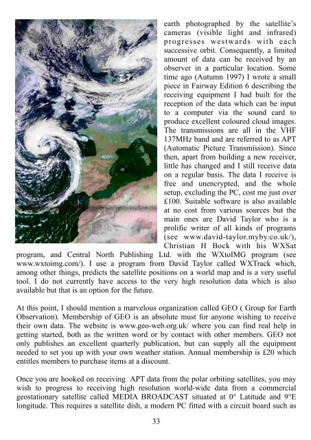
earth photographed by the satellite’s<br />
cameras (visible light and infrared)<br />
progresses westwards with each<br />
successive orbit. Consequently, a limited<br />
amount <strong>of</strong> data can be received by an<br />
observer in a particular location. Some<br />
time ago (Autumn 1997) I wrote a small<br />
piece in <strong>Fairway</strong> Edition 6 describing the<br />
receiving equipment I had built for the<br />
reception <strong>of</strong> the data which can be input<br />
to a computer via the sound card to<br />
produce excellent coloured cloud images.<br />
The transmissions are all in the VHF<br />
137MHz band and are referred to as APT<br />
(Automatic Picture Transmission). Since<br />
then, apart from building a new receiver,<br />
little has changed and I still receive data<br />
on a regular basis. The data I receive is<br />
free and unencrypted, and the whole<br />
setup, excluding the PC, cost me just over<br />
£100. Suitable s<strong>of</strong>tware is also available<br />
at no cost from various sources but the<br />
main ones are David Taylor who is a<br />
prolific writer <strong>of</strong> all kinds <strong>of</strong> programs<br />
(see www.david-taylor.myby.co.uk/),<br />
Christian H Bock with his WXSat<br />
program, and Central North Publishing Ltd. with the WXtoIMG program (see<br />
www.wxtoimg.com/). I use a program from David Taylor called WXTrack which,<br />
among other things, predicts the satellite positions on a world map and is a very useful<br />
tool. I do not currently have access to the very high resolution data which is also<br />
available but that is an option for the future.<br />
At this point, I should mention a marvelous organization called GEO ( Group for Earth<br />
Observation). Membership <strong>of</strong> GEO is an absolute must for anyone wishing to receive<br />
their own data. The website is www.geo-web.org.uk/ where you can find real help in<br />
getting started, both as the written word or by contact with other members. GEO not<br />
only publishes an excellent quarterly publication, but can supply all the equipment<br />
needed to set you up with your own weather station. Annual membership is £20 which<br />
entitles members to purchase items at a discount.<br />
Once you are hooked on receiving APT data from the polar orbiting satellites, you may<br />
wish to progress to receiving high resolution world-wide data from a commercial<br />
geostationary satellite called MEDIA BROADCAST situated at 0° Latitude and 9°E<br />
longitude. This requires a satellite dish, a modern PC fitted with a circuit board such as<br />
33