Foothills Fescue Range Plant Community Guide - Sustainable ...
Foothills Fescue Range Plant Community Guide - Sustainable ...
Foothills Fescue Range Plant Community Guide - Sustainable ...

You also want an ePaper? Increase the reach of your titles
YUMPU automatically turns print PDFs into web optimized ePapers that Google loves.
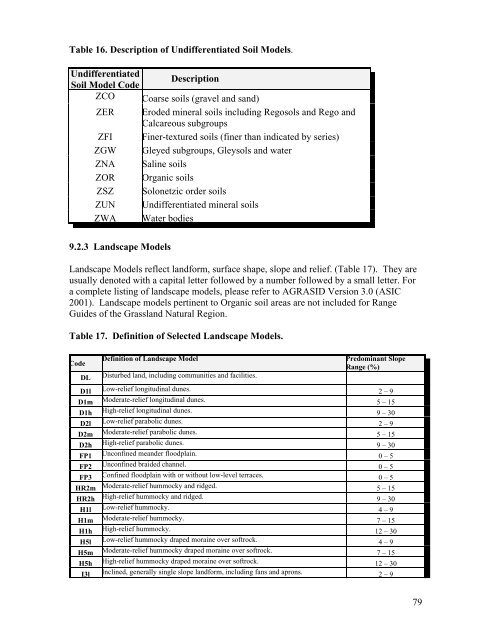
Table 16. Description of Undifferentiated Soil Models.<br />
Undifferentiated<br />
Soil Model Code Description<br />
ZCO Coarse soils (gravel and sand)<br />
ZER Eroded mineral soils including Regosols and Rego and<br />
Calcareous subgroups<br />
ZFI Finer-textured soils (finer than indicated by series)<br />
ZGW Gleyed subgroups, Gleysols and water<br />
ZNA Saline soils<br />
ZOR Organic soils<br />
ZSZ Solonetzic order soils<br />
ZUN Undifferentiated mineral soils<br />
ZWA Water bodies<br />
9.2.3 Landscape Models<br />
Landscape Models reflect landform, surface shape, slope and relief. (Table 17). They are<br />
usually denoted with a capital letter followed by a number followed by a small letter. For<br />
a complete listing of landscape models, please refer to AGRASID Version 3.0 (ASIC<br />
2001). Landscape models pertinent to Organic soil areas are not included for <strong>Range</strong><br />
<strong>Guide</strong>s of the Grassland Natural Region.<br />
Table 17. Definition of Selected Landscape Models.<br />
Code<br />
Definition of Landscape Model Predominant Slope<br />
<strong>Range</strong> (%)<br />
DL Disturbed land, including communities and facilities.<br />
D1l Low-relief longitudinal dunes. 2 – 9<br />
D1m Moderate-relief longitudinal dunes. 5 – 15<br />
D1h High-relief longitudinal dunes. 9 – 30<br />
D2l Low-relief parabolic dunes. 2 – 9<br />
D2m Moderate-relief parabolic dunes. 5 – 15<br />
D2h High-relief parabolic dunes. 9 – 30<br />
FP1 Unconfined meander floodplain. 0 – 5<br />
FP2 Unconfined braided channel. 0 – 5<br />
FP3 Confined floodplain with or without low-level terraces. 0 – 5<br />
HR2m Moderate-relief hummocky and ridged. 5 – 15<br />
HR2h High-relief hummocky and ridged. 9 – 30<br />
H1l Low-relief hummocky. 4 – 9<br />
H1m Moderate-relief hummocky. 7 – 15<br />
H1h High-relief hummocky. 12 – 30<br />
H5l Low-relief hummocky draped moraine over softrock. 4 – 9<br />
H5m Moderate-relief hummocky draped moraine over softrock. 7 – 15<br />
H5h High-relief hummocky draped moraine over softrock. 12 – 30<br />
I3l Inclined, generally single slope landform, including fans and aprons. 2 – 9<br />
79