Planning Post Newsletter Winter, 2012 - City of Bloomington
Planning Post Newsletter Winter, 2012 - City of Bloomington
Planning Post Newsletter Winter, 2012 - City of Bloomington

Create successful ePaper yourself
Turn your PDF publications into a flip-book with our unique Google optimized e-Paper software.
MPO Crash Report<br />
The <strong>Bloomington</strong>/Monroe County Metropolitan <strong>Planning</strong> Organization<br />
(MPO) recently released a report providing thorough analysis <strong>of</strong> the causes<br />
and trends <strong>of</strong> crashes in Monroe County. This year’s report includes crash<br />
data from 2008 to 2010.<br />
A total <strong>of</strong> 12,415 crashes were reported between 2008 and 2010. This<br />
figure is roughly the same as the three year total from 2007 to 2009, as<br />
reported in last year’s crash report. Just over three quarters <strong>of</strong> the total<br />
crashes reported no injuries (property damage or unknown) and the rest<br />
reported various levels <strong>of</strong> severity in injuries sustained. Over the course<br />
<strong>of</strong> the three years analyzed, there were 31 fatalities, somewhat more than<br />
the 22 fatalities reported from 2007 to 2009. Of the 31 fatalities, almost<br />
half (13) were from single car crashes, six were from two-car crashes, six<br />
involved mopeds/motorcycles, and five involved a pedestrian. There were<br />
no fatalities involving a bicycle or a bus.<br />
Top 5 Crash Locations, 2008-2010<br />
1) State Road 45/46 @ N. College Ave./N. Walnut St.<br />
2) State Road 37 @W. Bloomfield Rd.<br />
3) State Road 37@ W. 3rd St.<br />
4) E. 3rd St. @ S. Pete Ellis Dr.<br />
5) State Road 46 @ E. 3rd St.<br />
The greatest number<br />
<strong>of</strong> crashes occurred<br />
during weekday rush<br />
hours between 3:00<br />
P.M. and 6:00 P.M., with<br />
an average slightly<br />
greater than 1 crash<br />
per hour. The weekend also follows a predictable pattern, but the crash<br />
rate has a more even distribution through the day and early evening hours.<br />
Between the hours <strong>of</strong> 7pm and 4am, the weekend experiences a higher<br />
crash frequency than during the week. Friday continued to have the<br />
highest number <strong>of</strong> crashes overall, while Sunday had the lowest number<br />
<strong>of</strong> crashes.<br />
State highways are prominently featured in the list <strong>of</strong> problematic<br />
intersections. This could be attributable to several factors, but higher traffic<br />
volumes and speeds on these roads are likely factors. The intersection at<br />
College Avenue/Walnut Street and the State Road 45/46 Bypass topped<br />
the list <strong>of</strong> problematic intersections, followed by Bloomfield Road and<br />
State Road 37 and then W. 3rd Street and State Road 37. Because these<br />
intersections continue to exhibit high numbers <strong>of</strong> crashes from year to<br />
year, safety improvements should be considered.<br />
The leading cause <strong>of</strong> crashes during the study period was once again<br />
failure to yield right <strong>of</strong> way with 2,470 incidents. Other leading causes<br />
include reaction to other driver behaviors, following too closely, and unsafe<br />
backing. These causes may be reduced through law enforcement and<br />
education efforts as well as through physical improvements. Bicycle<br />
and pedestrian crashes are an important consideration due to a relatively<br />
high number <strong>of</strong> non-motorized trips in the area, and the sensitivity to<br />
injury <strong>of</strong> individuals using these modes. Therefore, reducing the frequency<br />
<strong>of</strong> these crashes is a priority. The intersection <strong>of</strong> Dunn Street and Kirkwood<br />
Avenue has topped the list for pedestrian crashes in two consecutive crash<br />
reports, warranting further investigation.<br />
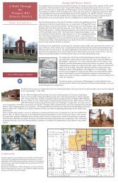
Preservation Plan for<br />
Historic <strong>Bloomington</strong><br />
The Historic Preservation<br />
Commission (HPC) recently<br />
completed a new historic<br />
preservation strategic plan for<br />
the community. Beginning<br />
in February <strong>of</strong> 2010, the HPC<br />
undertook a planning process to<br />
update and revise the existing<br />
historic preservation plan from<br />
1998. The Preservation Plan<br />
for Historic <strong>Bloomington</strong> is an<br />
advisory document that will<br />
provide the HPC with a fresh set<br />
<strong>of</strong> historic preservation goals and<br />
strategies for the future. <strong>Planning</strong><br />
Department staff worked closely<br />
with the HPC to provide technical<br />
assistance and land use guidance<br />
to complete this important effort.<br />
Key goals <strong>of</strong> the plan include:<br />
work with stakeholders and<br />
<strong>City</strong> entities to locally designate<br />
and expand local preservation<br />
incentives for the Courthouse<br />
Square district, complete a<br />
comprehensive historic survey <strong>of</strong><br />
the Monon Corridor area, draft<br />
signage and awning standards for<br />
historic properties, prioritize core<br />
neighborhoods for historic or<br />
conservation districts, and locally<br />
designate the historic Showers<br />
buildings and participate in the<br />
Showers area’s redevelopment<br />
planning.<br />
Read the full report online at:<br />
http://bloomington.in.gov/bhpc<br />
<strong>Planning</strong> <strong>Post</strong> <strong>Winter</strong> <strong>2012</strong> Page 2