Planning Post Newsletter Winter, 2012 - City of Bloomington
Planning Post Newsletter Winter, 2012 - City of Bloomington
Planning Post Newsletter Winter, 2012 - City of Bloomington

You also want an ePaper? Increase the reach of your titles
YUMPU automatically turns print PDFs into web optimized ePapers that Google loves.
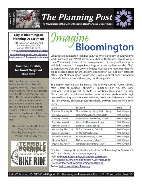
Issue XXI<br />
<strong>Winter</strong> <strong>2012</strong><br />
<strong>City</strong> <strong>of</strong> <strong>Bloomington</strong><br />
<strong>Planning</strong> Department<br />
401 N. Morton St., Suite 160<br />
<strong>Bloomington</strong>, IN 47404<br />
phone: (812)349-3423<br />
e-mail: planning@bloomington.in.gov<br />
www.bloomington.in.gov/planning<br />
facebook.com/bloomingtonplanning<br />
Terrible, Horrible,<br />
No Good, Very Bad<br />
Bike Ride<br />
Rain nor sleet nor snow nor<br />
roving bands <strong>of</strong> zombies will<br />
keep us from the streets during<br />
<strong>Bloomington</strong>’s first annual Terrible<br />
Horrible No Good Very Bad Bike<br />
Ride. The 5-mile ride will traverse<br />
urban cycling routes around<br />
<strong>Bloomington</strong> to prove that it’s<br />
possible to bike in all kinds <strong>of</strong><br />
weather. Intended for both the<br />
fearful and the fearless. If you can<br />
ride on this day, you can ride any<br />
day.<br />
The Terrible Horrible No Good<br />
Very Bad Bike Ride<br />
Saturday, February 18 at 10 am<br />
Meet in front <strong>of</strong> <strong>City</strong> Hall<br />
The <strong>Planning</strong> <strong>Post</strong><br />
The <strong>Newsletter</strong> <strong>of</strong> the <strong>City</strong> <strong>of</strong> <strong>Bloomington</strong> <strong>Planning</strong> Department<br />
<strong>Bloomington</strong><br />
What does <strong>Bloomington</strong> look like in 2040? Where and how should we live,<br />
work, learn, and play? What are our priorities for the future? How do we get<br />
there? These are just a few <strong>of</strong> the many questions that Imagine<strong>Bloomington</strong><br />
will help answer. Imagine<strong>Bloomington</strong> is an update to the <strong>City</strong>’s<br />
comprehensive plan, the Growth Policies Plan. It’s the road map that will<br />
guide <strong>Bloomington</strong>’s future. Imagine<strong>Bloomington</strong> will not only establish<br />
<strong>of</strong>ficial <strong>City</strong> <strong>of</strong> <strong>Bloomington</strong> policies, but it will also direct both current and<br />
future decision makers with carrying out those policies.<br />
The kick<strong>of</strong>f meeting will be held at the Monroe County Public Library,<br />
Main Library on Tuesday, February 21 in Room 1B at 7:00 pm. Nine<br />
additional workshops will be held in locations throughout the city.<br />
Citizens can also participate from the comfort <strong>of</strong> their own homes through<br />
Imagine<strong>Bloomington</strong>’s interactive web tool, UserVoice. Citizens can submit<br />
ideas on a variety <strong>of</strong> topics, provide feedback, and vote on ideas from other<br />
users.<br />
Date Location Time<br />
Tuesday, February 21 Monroe County Library, Main Library 7:00-8:30 pm<br />
Thursday, March 1 <strong>Bloomington</strong> High School North 7:00-8:30 pm<br />
Tuesday, March 6 Highland Park Elementary School 7:00-8:30 pm<br />
Thursday, March 8 University Elementary School 7:00-8:30 pm<br />
Monday, March 19 Batchelor Middle School 7:00-8:30 pm<br />
Wednesday, March 21 Binford Elementary School 7:00-8:30 pm<br />
Tuesday, March 27 Tri-North Middle School 7:00-8:30 pm<br />
Thursday, March 29 Summit Elementary School 7:00-8:30 pm<br />
Monday, April 2 Childs Elementary School 7:00-8:30 pm<br />
Wednesday, April 4 Templeton Elementary School 7:00-8:30 pm<br />
Don’t miss this opportunity to shape the future <strong>of</strong> <strong>Bloomington</strong>. Stay tuned.<br />
We’ll be updating these sources regularly:<br />
Website: bloomington.in.gov/imaginebloomington<br />
UserVoice: http://imaginebloomington.uservoice.com/<br />
Facebook: facebook.com/bloomingtonplanning<br />
Twitter: twitter.com/Btown<strong>Planning</strong><br />
Inside This Issue: MPO Crash Report <strong>Bloomington</strong> Preservation Plan Construction Buzz
MPO Crash Report<br />
The <strong>Bloomington</strong>/Monroe County Metropolitan <strong>Planning</strong> Organization<br />
(MPO) recently released a report providing thorough analysis <strong>of</strong> the causes<br />
and trends <strong>of</strong> crashes in Monroe County. This year’s report includes crash<br />
data from 2008 to 2010.<br />
A total <strong>of</strong> 12,415 crashes were reported between 2008 and 2010. This<br />
figure is roughly the same as the three year total from 2007 to 2009, as<br />
reported in last year’s crash report. Just over three quarters <strong>of</strong> the total<br />
crashes reported no injuries (property damage or unknown) and the rest<br />
reported various levels <strong>of</strong> severity in injuries sustained. Over the course<br />
<strong>of</strong> the three years analyzed, there were 31 fatalities, somewhat more than<br />
the 22 fatalities reported from 2007 to 2009. Of the 31 fatalities, almost<br />
half (13) were from single car crashes, six were from two-car crashes, six<br />
involved mopeds/motorcycles, and five involved a pedestrian. There were<br />
no fatalities involving a bicycle or a bus.<br />
Top 5 Crash Locations, 2008-2010<br />
1) State Road 45/46 @ N. College Ave./N. Walnut St.<br />
2) State Road 37 @W. Bloomfield Rd.<br />
3) State Road 37@ W. 3rd St.<br />
4) E. 3rd St. @ S. Pete Ellis Dr.<br />
5) State Road 46 @ E. 3rd St.<br />
The greatest number<br />
<strong>of</strong> crashes occurred<br />
during weekday rush<br />
hours between 3:00<br />
P.M. and 6:00 P.M., with<br />
an average slightly<br />
greater than 1 crash<br />
per hour. The weekend also follows a predictable pattern, but the crash<br />
rate has a more even distribution through the day and early evening hours.<br />
Between the hours <strong>of</strong> 7pm and 4am, the weekend experiences a higher<br />
crash frequency than during the week. Friday continued to have the<br />
highest number <strong>of</strong> crashes overall, while Sunday had the lowest number<br />
<strong>of</strong> crashes.<br />
State highways are prominently featured in the list <strong>of</strong> problematic<br />
intersections. This could be attributable to several factors, but higher traffic<br />
volumes and speeds on these roads are likely factors. The intersection at<br />
College Avenue/Walnut Street and the State Road 45/46 Bypass topped<br />
the list <strong>of</strong> problematic intersections, followed by Bloomfield Road and<br />
State Road 37 and then W. 3rd Street and State Road 37. Because these<br />
intersections continue to exhibit high numbers <strong>of</strong> crashes from year to<br />
year, safety improvements should be considered.<br />
The leading cause <strong>of</strong> crashes during the study period was once again<br />
failure to yield right <strong>of</strong> way with 2,470 incidents. Other leading causes<br />
include reaction to other driver behaviors, following too closely, and unsafe<br />
backing. These causes may be reduced through law enforcement and<br />
education efforts as well as through physical improvements. Bicycle<br />
and pedestrian crashes are an important consideration due to a relatively<br />
high number <strong>of</strong> non-motorized trips in the area, and the sensitivity to<br />
injury <strong>of</strong> individuals using these modes. Therefore, reducing the frequency<br />
<strong>of</strong> these crashes is a priority. The intersection <strong>of</strong> Dunn Street and Kirkwood<br />
Avenue has topped the list for pedestrian crashes in two consecutive crash<br />
reports, warranting further investigation.<br />
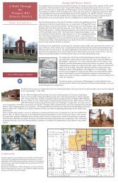
Preservation Plan for<br />
Historic <strong>Bloomington</strong><br />
The Historic Preservation<br />
Commission (HPC) recently<br />
completed a new historic<br />
preservation strategic plan for<br />
the community. Beginning<br />
in February <strong>of</strong> 2010, the HPC<br />
undertook a planning process to<br />
update and revise the existing<br />
historic preservation plan from<br />
1998. The Preservation Plan<br />
for Historic <strong>Bloomington</strong> is an<br />
advisory document that will<br />
provide the HPC with a fresh set<br />
<strong>of</strong> historic preservation goals and<br />
strategies for the future. <strong>Planning</strong><br />
Department staff worked closely<br />
with the HPC to provide technical<br />
assistance and land use guidance<br />
to complete this important effort.<br />
Key goals <strong>of</strong> the plan include:<br />
work with stakeholders and<br />
<strong>City</strong> entities to locally designate<br />
and expand local preservation<br />
incentives for the Courthouse<br />
Square district, complete a<br />
comprehensive historic survey <strong>of</strong><br />
the Monon Corridor area, draft<br />
signage and awning standards for<br />
historic properties, prioritize core<br />
neighborhoods for historic or<br />
conservation districts, and locally<br />
designate the historic Showers<br />
buildings and participate in the<br />
Showers area’s redevelopment<br />
planning.<br />
Read the full report online at:<br />
http://bloomington.in.gov/bhpc<br />
<strong>Planning</strong> <strong>Post</strong> <strong>Winter</strong> <strong>2012</strong> Page 2
Construction Buzz<br />
1 1825 S. Highland<br />
Options for Better Living<br />
Options for Better Living<br />
(Options), a non-pr<strong>of</strong>it<br />
organization that assists<br />
in affordable housing and<br />
employment opportunities<br />
for persons with disabilities,<br />
was approved to build two<br />
duplexes and one group home.<br />
2 1800 W. Tapp Rd.<br />
BUGS & BUSS<br />
The Plan Commission approved<br />
an amendment to allow<br />
recreation uses within the<br />
Woolery PUD. <strong>Bloomington</strong><br />
United Gymnastics School<br />
(BUGS) and <strong>Bloomington</strong><br />
United Soccer School (BUSS)<br />
proposed to relocate to a site<br />
within the PUD and construct<br />
a new 26,000 SF building near<br />
the Clear Creek Trail.<br />
Elevation <strong>of</strong> BUGS/BUSS Building<br />
3 626 N. Morton St.<br />
Horizons<br />
ERL-9, LLC<br />
Construction has begun on the<br />
Horizons, a 64-bedroom multifamily<br />
apartment building on<br />
N. Morton Street.<br />
Ground has been broken at the<br />
construction site.<br />
Construction Buzz Location Map<br />
SR 48<br />
SR 46<br />
SR 45<br />
Curry Pk<br />
3rd St.<br />
Tapp Rd<br />
SR 37<br />
Bloomfield Rd.<br />
SR 37<br />
Rockport Rd<br />
Kinser Pk.<br />
17th St<br />
Walnut St.<br />
2nd St.<br />
Walnut St.<br />
Fee Ln.<br />
Hillside Dr.<br />
Winslow Rd<br />
Henderson<br />
IU<br />
10th St.<br />
3rd St.<br />
High St<br />
Rhorer Rd<br />
Safe Routes to School<br />
Sare Rd<br />
College Mall<br />
Snoddy<br />
Legend<br />
Park<br />
Downtown<br />
Shopping Center<br />
<strong>Planning</strong> <strong>Post</strong> <strong>Winter</strong> <strong>2012</strong> Page 3<br />
School<br />
<strong>Planning</strong> staff has been assisting the Monroe County Community<br />
School Corporation (MCCSC) to implement an Indiana Department <strong>of</strong><br />
Transportation Safe Routes to School planning grant that was awarded<br />
to MCCSC in 2009. The project will complete comprehensive Safe Routes<br />
to School plans for the following seven schools: Tri-North Middle School,<br />
Arlington Elementary, Fairview Elementary, Highland Park Elementary,<br />
Binford/Rogers Elementary, St. Charles School, and University Elementary.<br />
Each plan will detail a strategy to increase the number <strong>of</strong> students walking<br />
and bicycling to school. This will include, but not be limited to:<br />
•<br />
•<br />
•<br />
•<br />
•<br />
2<br />
3<br />
Smith Rd<br />
SR 45<br />
SR 46<br />
SR 446<br />
N<br />
Data collection and analysis <strong>of</strong> existing walking and bicycling<br />
patterns, school traffic patterns, and barriers to walking and<br />
bicycling<br />
Meetings with school staff, <strong>City</strong> <strong>of</strong> <strong>Bloomington</strong> and Monroe County<br />
staff, and parents groups<br />
Recommended solutions to address specific barriers to walking and<br />
bicycling<br />
Recommendations for signage and striping improvements in the<br />
school walk-in area<br />
Identification <strong>of</strong> a system <strong>of</strong> preferred walking routes for each<br />
school<br />
Consultant proposals are currently being evaluated, and the project is<br />
scheduled to begin this spring.<br />
1
INDOT I-69 Route Map through Southwest<br />
Indiana<br />
<strong>Planning</strong> <strong>Post</strong> <strong>Winter</strong> <strong>2012</strong> Page 4<br />
<strong>City</strong> <strong>of</strong> <strong>Bloomington</strong> <strong>Planning</strong> Department<br />
401 N. Morton St., Suite 160<br />
P.O. Box 100<br />
<strong>Bloomington</strong>, IN 47402<br />
Subscribe to the <strong>Planning</strong> <strong>Post</strong> to receive<br />
three newsletters per year via email.<br />
Simply send your request to:<br />
planning-news+subscribe@bloomington.in.gov<br />
To unsubscribe, send an email to:<br />
planning-news+unsubscribe@bloomington.in.gov<br />
The MPO and Interstate 69<br />
The <strong>Bloomington</strong>/Monroe County Metropolitan <strong>Planning</strong><br />
Organization (MPO) is a regional transportation body which is<br />
required to show how federal transportation funding is programmed<br />
and spent in the <strong>Bloomington</strong> urban area. In 2010, the Indiana Dept.<br />
<strong>of</strong> Transportation (INDOT) requested the MPO add Section 4 <strong>of</strong> I-69 to<br />
the Transportation Improvement Program (TIP). Section 4 <strong>of</strong> I-69 runs<br />
from US 231 by the Crane Naval Base to SR 37 south <strong>of</strong> <strong>Bloomington</strong><br />
near Victor Pike. In November 2010, the MPO agreed to show the<br />
preliminary engineering and right-<strong>of</strong>-way phases <strong>of</strong> the project but<br />
not the construction phase.<br />
The MPO and INDOT have remained at an impasse as to whether or<br />
not to include construction <strong>of</strong> I-69 to the TIP. A subcommittee <strong>of</strong> the<br />
Policy Committee was formed in the fall <strong>of</strong> 2011 to work through<br />
some <strong>of</strong> the issues and formulate a resolution to the disagreement.<br />
Questions were asked by the Policy Committee and answered by<br />
INDOT and the Federal Highway Administration (FHWA). INDOT<br />
is proceeding with Section 4 <strong>of</strong> the project and the MPO is under<br />
increased pressure to make a decision on construction <strong>of</strong> I-69 Section<br />
4. To follow what has transpired from the MPO’s perspective, visit<br />
the Policy Committee’s Agenda and Packets webpage at http://<br />
bloomington.in.gov/MPO_Policy_Committee