

n Alas - Alaska Division of Geological & Geophysical Surveys - State ...
n Alas - Alaska Division of Geological & Geophysical Surveys - State ...
n Alas - Alaska Division of Geological & Geophysical Surveys - State ...

You also want an ePaper? Increase the reach of your titles
YUMPU automatically turns print PDFs into web optimized ePapers that Google loves.
intrusive rocks within tt tea but a short di<br />
tance to the south is intruded and altered by them (,.<br />
M. Woare, written commun., 1981). The diorite and<br />
tonalite occur as narrow elongate bodies pardleling<br />
the Chiroskey fault along the west side <strong>of</strong> the struc-<br />
tural high. Both bodies are extensively sheared, and<br />
their field relations uncertain; however, newly deter-<br />
mined K-Ar ages (table 3) suggest thet the tonalite is<br />
younger than the diorite.<br />
.t fossils <strong>of</strong> Late Cretaceous age (Pal<br />
~ ~ 1 3 ) .<br />
Calc-alkalic subaerial volcanic rocks uncon for rnably<br />
overlie the Cretaceous sandstone end shale unit in<br />
the eastern and central parts <strong>of</strong> the map area. Between<br />
the Anvik fault and the Yukon River, a volcanic<br />
pile <strong>of</strong> more than 1,000 m <strong>of</strong> basalt and andesite flows<br />
in its lower part and <strong>of</strong> rhyolite tuff, breccia, and<br />
domes in its upper part is preserved in a large partly<br />
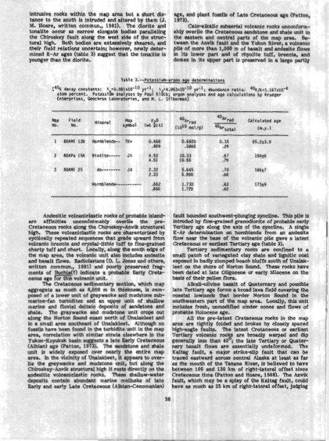
Tab1 a 3. --Potsss!um-argon detegnln.btlons<br />
LTUK decay constants: 1 -0.581~10'~~ yr"l- 1 =d.963~10-~~ yr-l; abundance ratio: 40~/~=1.167~10'd<br />
atom percent. ~otassitm boslyses by ~aui ~lgck; argon dnslyses and age calcularfons by Krueger<br />
Enterprises, Geochron Laboratorfes, and M. L. Si lbennan]<br />
Map Fleld<br />
No. No.<br />
Map<br />
symbol<br />
Andesitic volcaniclastic rwk s <strong>of</strong> probt ible islandarc<br />
effinities unconformabIy overlie . -- the pre-<br />
Cretaceous rocks along the Chlroskey-Anvw structural<br />
high. These volcaniclastic rocks are characterized by<br />
cyclically repeated sequences that grade upward from<br />
volcanic breccia and crystal-lithic tuff to fine-grained<br />
cherty tuff and chert. Locally, along the south edge <strong>of</strong><br />
the map area, the volcanic unit also includes andeslte<br />
and basalt flows. Radiolarians (D. L. Jones and others,<br />
written commun., 1981) and poorly preserved fragments<br />
<strong>of</strong> Buchia(?) indicate a probable Early Cretaceous<br />
age for this volcanic unit.<br />
The Cretaceous sedimentary section , which may<br />
aggregate as much as 8,000 m in thickn ess, is composed<br />
<strong>of</strong> a lower unit <strong>of</strong> graywackc ? and m udstone submarine-fan<br />
turbidites and an upper unit <strong>of</strong> shallow<br />
marine and fluvial deltaic deposits <strong>of</strong> sandstone and<br />
shale. The graywacke and mudstone unit crops out<br />
along the Norton Sound coast north <strong>of</strong> UndakIeet md in a small area southeast <strong>of</strong> UnalakIeet. Although no<br />
fossils heve been found in the turbidite unit in the map<br />
area, correlation with similar strata elsewhere in the<br />
~ukon-Koyukuk basin suggests a late Early Cretaceous<br />
(Albian) age (Patton, 1973). The sandstone and shale<br />
unit Is widely exposed over nearly the entire map<br />
area. In the vicinity <strong>of</strong> Unalakleet, it appears to overlie<br />
the graywacke and mudstone unit, but along the<br />
Chimskey-Anvik structural high it rests directly on the<br />
andesitic volc~nicIastic rocks. 'these shallow-water<br />
deposits contain abundant marine mollusks <strong>of</strong> late<br />
Early and early Late Cretaceous (Albian-Cenommian)<br />
K2°<br />
40<br />
Arrad<br />
40<br />
Ar,ad Calculated age<br />
pcr' (1010 nei/g) 4hrtota, (rn.y.1<br />
fault bounded southwest-plunging syncline. This pile is<br />
intruded by fine-grained granodlorite <strong>of</strong> probable early<br />
Tertiary age dong the axis <strong>of</strong> the syncllne. A single<br />
K-Ar determination on hornblende from an andesite<br />
flow near the base <strong>of</strong> the volcenic pile gave n latest<br />
Cretaceous or earliest Tertiary age (table 3).<br />
Tertiary sedimentary rocks are confined to a<br />
small patch <strong>of</strong> variegated clay shale and lignitic coal<br />
exposed In badly slumped beach bluffs south <strong>of</strong> Unalak-<br />
leet on the shore <strong>of</strong> Norton Sound. These rocks have<br />
been dated at late Oligocene or early Miocene on the<br />
basis <strong>of</strong> their pollen flora.<br />
Alkdi-olivine basalt <strong>of</strong> Quaternary and possible<br />
late Tertiary age forms a broad lava field covering the<br />
coastal lowlands that border Norton Saund in the<br />
southwestern part <strong>of</strong> the map area. Locdly, this unit<br />
includes fresh, unmodified cinder cones and flows <strong>of</strong><br />
probable Holocene age.<br />
All the pre-latest Cretaceous rocks in the map<br />
area are tightly folded and broken by cIosely spaced<br />
high-angle faults. The latest Cretaceous or earliest<br />
Tertiary volcanic rocks are broadly warped and dip<br />
generally less than 40'; the late Tertiary or Quater-<br />
nary basalt flows are essentlslly undeformed. The<br />
Kaltag fotdt, a major strikeslip fault that can be<br />
traced eastward across central <strong>Alas</strong>ka at least es far<br />
as the mouth <strong>of</strong> the Tanana River, is believed to have<br />
between 100 and 130 km <strong>of</strong> right-lateral <strong>of</strong>fset since<br />
Cretaceous time (Patton and Hoare, 1968). 'Iho Anvik<br />
fault, which may be a splay <strong>of</strong> the Kaltag fault, could<br />
have as much as 35 km <strong>of</strong> right-lateral <strong>of</strong>fset, judging


