

USGS Professional Paper 1697 - Alaska Resources Library
USGS Professional Paper 1697 - Alaska Resources Library
USGS Professional Paper 1697 - Alaska Resources Library

Create successful ePaper yourself
Turn your PDF publications into a flip-book with our unique Google optimized e-Paper software.
<strong>USGS</strong> Prepared in collaboration with <strong>Alaska</strong> Division of Geological and Geophysical<br />
Surveys, Geological Survey of Canada, Russian Academy of Sciences, Russian<br />
Ministry of Natural <strong>Resources</strong><br />
Metallogenesis and Tectonics of the Russian<br />
Far East, <strong>Alaska</strong>, and the Canadian Cordillera<br />
Russian<br />
Southeast<br />
Japan<br />
0<br />
0<br />
Subduction<br />
zone<br />
60 o<br />
KU<br />
800 KM<br />
Craton<br />
margin<br />
Sea of<br />
Okhotsk<br />
Northeast<br />
Asia arc<br />
800 MI<br />
North Asian<br />
Craton<br />
<strong>Professional</strong> <strong>Paper</strong> <strong>1697</strong><br />
U.S. Department of the Interior<br />
U.S. Geological Survey<br />
Pacific<br />
plate<br />
ARCTIC OCEAN<br />
COLLAGE OF<br />
ACCRETED TERANES<br />
Russian<br />
Northeast<br />
Bering Sea<br />
Gakkel<br />
Ridge<br />
Eurasia, Amerasia,<br />
and Canada basins<br />
180 o<br />
<strong>Alaska</strong><br />
Aleutian-<br />
Wrangell arc<br />
Pacific<br />
plate<br />
AP<br />
PACIFIC OCEAN<br />
MAJOR PRESENT-DAY METALLOGENIC BELTS AND<br />
TECTONIC ELEMENTS FOR CIRCUM-NORTH PACIFIC<br />
80 o<br />
North American<br />
Craton<br />
Craton<br />
margin<br />
Canadian Cordillera<br />
OC<br />
Juan de Fuca<br />
ridge<br />
Cascade<br />
arc
Metallogenesis and Tectonics of the Russian Far East,<br />
<strong>Alaska</strong>, and the Canadian Cordillera<br />
By Warren J. Nokleberg, Thomas K. Bundtzen, Roman A. Eremin, Vladimir V. Ratkin, Kenneth M. Dawson,<br />
Vladimir I. Shpikerman, Nikolai A. Goryachev, Stanislav G. Byalobzhesky, Yuri F. Frolov, Alexander I. Khanchuk,<br />
Richard D. Koch, James W.H. Monger, Anany I. Pozdeev, Ilya S. Rozenblum, Sergey M. Rodionov,<br />
Leonid M. Parfenov, Christopher R. Scotese, and Anatoly A. Sidorov<br />
Prepared in collaboration with:<br />
<strong>Alaska</strong> Division of Geological and Geophysical Surveys<br />
Geological Survey of Canada<br />
Russian Academy of Sciences<br />
Russian Ministry of Natural <strong>Resources</strong><br />
<strong>Professional</strong> <strong>Paper</strong> <strong>1697</strong><br />
U.S. Department of the Interior<br />
U.S. Geological Survey
U.S. Department of the Interior<br />
Gale A. Norton, Secretary<br />
U.S. Geological Survey<br />
Charles G. Groat, Director<br />
U.S. Geological Survey, Reston, Virginia: 2005<br />
For sale by U.S. Geological Survey Information Services<br />
Box 25286, Denver Federal Center<br />
Denver, CO 80225<br />
This report and any updates to it are available online at:<br />
http://pubs.usgs.gov//pp/p1692/<br />
Additional <strong>USGS</strong> publications can be found at:<br />
http://geology.usgs.gov/products.html<br />
For more information about the <strong>USGS</strong> and its products:<br />
Telephone: 1–888–ASK–<strong>USGS</strong> (1–888–275–8747)<br />
World Wide Web: http://www.usgs.gov/<br />
Any use of trade, product, or firm names in this publication is for descriptive purposes only and does not imply<br />
endorsement of the U.S. Government.<br />
Although this report is in the public domain, it contains copyrighted materials that are noted in the text. Permission<br />
to reproduce those items must be secured from the individual copyright owners.<br />
Cataloging-in-publication data are on file with the <strong>Library</strong> of Congress (URL http://www.loc.gov/).<br />
Published in the Western Region, Menlo Park, California<br />
Manuscript approved for publication, June 2, 2004<br />
Text edited by James W. Hendley II<br />
Production and design by Sara Boore, Susan Mayfield, and Judy Weathers<br />
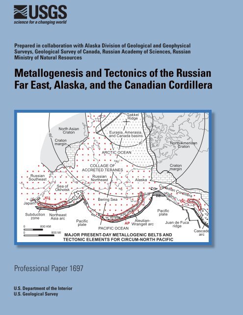
Front Cover Major present-day metallogenic and tectonic elements for the Circum-North Pacific<br />
and geographic names for major regions. The major features, continued from the Neogene are (1) a<br />
series of continental-margin arcs and companion subduction-zone assemblages around the Circum-<br />
North Pacific; (2) continuation of opening of major sedimentary basins behind major arcs; (3) in the<br />
eastern part of the Circum-North Pacific, dextral transpression between the Pacific ocean plate and<br />
the present-day Canadian Cordillera margin; and (4) sea-floor spreading in the Arctic and eastern<br />
Pacific Oceans. Refer to text for detailed explanation of tectonic events (section on Pliocene to<br />
Present) and to figure 18 for explanation of abbreviations, symbols, and patterns. The major metallogenic<br />
belts are (1) the Kuril (KU) metallogenic belt, which is hosted in the Kuril volcanic-plutonic<br />
belt (part of Northeast Asia arc); (2) the <strong>Alaska</strong> Peninsula and Aleutian Islands (AP) metallogenic belt<br />
that contains granitic-magmatism-related deposits and is hosted in the Aleutian volcanic belt (part of<br />
Aleutian-Wrangell arc); and (3) the Owl Creek (OC) metallogenic belt, which is hosted in the Cascade<br />
volcanic-plutonic belt (part of Cascade arc).
Contents<br />
Abstract ……………………………………………………………………………………… 1<br />
Introduction …………………………………………………………………………………… 2<br />
Associated Project ……………………………………………………………………… 2<br />
Metallogenic Belts ……………………………………………………………………… 3<br />
Methodology …………………………………………………………………………… 3<br />
Tectonic Controls for Metallogenesis …………………………………………………… 4<br />
Metallogenic and Tectonic Definitions ………………………………………………… 5<br />
Mineral Deposit Models ………………………………………………………………… 7<br />
Acknowledgments …………………………………………………………………………… 7<br />
Introduction to Phanerozoic Metallogenic and Tectonic Model for the Russian Far East,<br />
<strong>Alaska</strong>, and the Canadian Cordillera ………………………………………………… 8<br />
Paleomagnetic Dilemma: Loci of Accretion of Wrangellia Superterrane ……………… 8<br />
Proterozoic Metallogenic Belts (2500 to 570 Ma; figures 2, 3) ………………………………… 9<br />
Overview ………………………………………………………………………………… 9<br />
Metallogenic Belts Formed During Proterozoic Rifting of North Asian Craton or Craton<br />
Margin …………………………………………………………………………… 9<br />
Oroek Metallogenic Belt of Ironstone and Sediment-Hosted Cu Deposits (Belt OK),<br />
West-Central Part of Russian Northeast …………………………………… 9<br />
Pobeda Ironstone Deposit …………………………………………………… 10<br />
Oroek Sediment-Hosted Cu Deposit ………………………………………… 11<br />
Origin of and Tectonic Controls for Oroek Metallogenic Belt ………………… 11<br />
Lantarsky-Dzhugdzhur Metallogenic Belt of Anorthosite Apatite-Ti-Fe and Gabbroic<br />
Ni-Cu (PGE) Deposits (Belt LD), Central Part of Russian Far East) ………… 13<br />
Origin of and Tectonic Controls for Lantarsky-Dzhugdzhur Metallogenic Belt … 15<br />
Ulkan Metallogenic Belt of Felsic Plutonic REE Deposits (Belt UL), Northwestern<br />
Part of Russian Southeast ………………………………………………… 15<br />
Bilyakchan Metallogenic Belt of Sediment-Hosted Cu and Basaltic Cu Deposits<br />
(Belt BI), Southwestern Part of Russian Northeast ………………………… 15<br />
Dzhagdag Basaltic Cu and Severny Uy Occurrences ………………………… 15<br />
Origin of and Tectonic Controls for Bilyakchan Metallogenic Belt …………… 15<br />
Omolon Metallogenic Belt of Ironstone (Superior Fe) Deposits (Belt OM), Central<br />
Part of Russian Northeast ………………………………………………… 16<br />
Verkhny-Omolon Ironstone Deposit …………………………………………… 16<br />
Origin of and Tectonic Controls for Omolon Metallogenic Belt ……………… 16<br />
Kilbuck Metallogenic Belt of Ironstone (Superior Fe) Deposits (Belt KI),<br />
Southwestern <strong>Alaska</strong> ……………………………………………………… 16<br />
Metallogenic Belts Formed During Proterozoic Sedimentation, Rifting, and Hydrothermal<br />
Activity Along Cratons or Craton Margins ……………………………………… 17<br />
Sinuk River Metallogenic Belt of Massive Sulfide-Barite and Stratabound Fe and<br />
Mn Deposits (Belt SR), Northwestern <strong>Alaska</strong> ……………………………… 17<br />
Aurora Creek Massive Sulfide-Barite Deposit ………………………………… 17<br />
Origin of and Tectonic Controls for Sinuk River Metallogenic Belt …………… 18<br />
Gillespie Metallogenic Belt of SEDEX Zn-Cu-Pb-Au-Ag Deposits (Belt GM),<br />
Northern Yukon Territory …………………………………………………… 18<br />
Blende SEDEX Zn-Cu-Pb-Au-Ag Deposit ……………………………………… 18<br />
iii
iv<br />
Hart River SEDEX Zn-Cu-Ag Deposit ………………………………………… 18<br />
Origin of and Tectonic Setting for Gillespie Metallogenic Belt ……………… 18<br />
Wernecke Metallogenic Belt of U-Cu-Fe (Au-Co) Vein and Breccia Deposits (Belt<br />
WR), Central Yukon Territory ……………………………………………… 19<br />
Rapitan Metallogenic Belt of Sedimentary Iron Formation Deposits (Belt RA),<br />
Central Yukon Territory …………………………………………………… 19<br />
Crest Iron Formation Deposit ………………………………………………… 19<br />
Origin of and Tectonic Setting for Rapitan Metallogenic Belt ………………… 19<br />
Metallogenic Belts Formed During Proterozoic Rifting of North American Craton or<br />
Craton Margin …………………………………………………………………… 20<br />
Redstone Metallogenic Belt of Sediment-Hosted Cu-Ag Deposits (Belt RS), Central<br />
Yukon Territory ……………………………………………………………… 20<br />
Coates Lake (Redstone) sediment-hosted Cu-Ag Deposit …………………… 20<br />
Origin of and Tectonic Controls for Redstone Metallogenic Belt ……………… 20<br />
Churchill Metallogenic Belt of Cu Vein Deposits (Belt CH), Northern British Columbia … 20<br />
Churchill (Davis Keays) Cu Vein Deposits. …………………………………… 20<br />
Origin of and Tectonic Controls for Churchill Metallogenic Belt ……………… 20<br />
Monashee Metallogenic Belt of Sedimentary Exhalative (SEDEX) Zn-Pb-Ag<br />
Deposits (Belt MO), Southern British Columbia …………………………… 21<br />
Big Ledge SEDEX Zn-Pb Deposit ……………………………………………… 21<br />
Ruddock Creek SEDEX Zn-Pb Deposit ………………………………………… 21<br />
Mount Copeland Porphyry Mo Deposit ……………………………………… 21<br />
Origin of and Tectonic Controls for Monashee Metallogenic Belt …………… 21<br />
Purcell Metallogenic Belt of SEDEX Zn-Pb-Ag Deposits (Belt PR), Southern British<br />
Columbia …………………………………………………………………… 21<br />
Sullivan SEDEX Zn-Pb-Ag Deposit …………………………………………… 21<br />
Origin of and Tectonic Setting for Purcell Metallogenic Belt ………………… 22<br />
Clark Range Metallogenic Belt of Sediment-Hosted Cu-Ag Deposits, Southern<br />
British Columbia (Belt CR) ………………………………………………… 23<br />
Clark Range Sediment-Hosted Cu-Ag Deposits ……………………………… 23<br />
Origin of and Tectonic Controls for Clark Range Metallogenic Belt ………… 23<br />
Cambrian through Silurian Metallogenic Belts (570 to 408 Ma) ……………………………… 23<br />
Overview ………………………………………………………………………………… 23<br />
Metallogenic Belts Formed During Early Paleozoic Marine Sedimentation in Rifted<br />
Fragments of Gondwandaland Supercontinent ………………………………… 24<br />
Voznesenka Metallogenic Belt of Korean Pb-Zn Deposits (Belt VZ), Southern<br />
Russian Southeast ………………………………………………………… 24<br />
Voznesenka-I Korean Pb-Zn Deposit ………………………………………… 24<br />
Chernyshevskoe Korean Pb-Zn Deposit ……………………………………… 24<br />
Origin of and Tectonic Controls for Voznesenka Metallogenic Belt …………… 24<br />
Kabarga Metallogenic Belt of Ironstone Superior Fe) Deposits (Belt KB), Southern<br />
Russian Southeast ………………………………………………………… 24<br />
Metallogenic Belts Formed During Early Paleozoic Sedimentation or Marine Volcanism<br />
in Manchurid or Altaid Orogenic Systems ……………………………………… 25<br />
South Khingan Metallogenic Belt of Ironstone (Superior Fe) Deposits (Belt SK),<br />
Southern Russian Southeast ……………………………………………… 25<br />
Gar Metallogenic Belts of Volcanogenic Fe Deposits and Stratiform Cu and Pb-Zn<br />
Deposits (Belt GR), Western Part of Russian Southeast …………………… 26<br />
Gar Volcanogenic Fe Deposit ………………………………………………… 26<br />
Kamenushinskoe Cu Massive Sulfide Deposit ………………………………… 26
Chagoyan Stratiform Pb-Zn Deposit ………………………………………… 27<br />
Origin of and Tectonic Controls for Gar Metallogenic Belts ………………… 27<br />
Metallogenic Belts Formed During Early Paleozoic Sea-Floor Spreading, Regional Metamorphism,<br />
or During Subduction-Related Volcanism in Russian Far East Terranes …… 27<br />
Galam Metallogenic Belt of Volcanogenic Fe, Volcanogenic Mn, and Sedimentary<br />
P Deposits (Belt GL), Central Part of Russian Far East ……………………… 27<br />
Gerbikanskoe Volcanogenic Fe Deposit ……………………………………… 27<br />
Origin of and Tectonic Controls for Galam Metallogenic Belt ………………… 27<br />
Omulevka River Metallogenic Belt of Austrian Alps W and Kipushi Cu-Pb-Zn<br />
Deposits (Belt OR), Northwest Part of Russian Northeast ………………… 28<br />
Omulev Austrian Alps W Deposit ……………………………………………… 29<br />
Vesnovka Kipushi Cu-Pb-Zn Deposit ………………………………………… 29<br />
Origin of and Tectonic Controls for Omulevka River Metallogenic Belt ……… 30<br />
Rassokha Metallogenic Belt of Basaltic Cu and Sediment-Hosted Cu Deposits<br />
(Belt RA), Northern Part of Russian Northeast …………………………… 30<br />
Agyndja Basaltic Cu and Sediment-Hosted Cu Deposit ……………………… 30<br />
Origin of and Tectonic Controls for Rassokha Metallogenic Belt …………… 30<br />
Metallogenic Belts Formed During Early Paleozoic Rifting of Continental Margins or in<br />
Continental-Margin Arc Terranes ……………………………………………… 31<br />
Dzhardzhan River Metallogenic Belt of Southeast Missouri Pb-Zn, Sediment-Hosted Cu<br />
and Sandstone-Hosted U deposits (Belt DZ), Northern Part of Eastern Siberia … 31<br />
Manganiler Southeast Missouri Pb-Zn and Deposit ………………………… 31<br />
Kyongdyoi Sandstone-Hosted U Deposit ……………………………………… 31<br />
Origin of and Tectonic Controls for Dzhardzhan River Metallogenic Belt …… 31<br />
Anvil Metallogenic Belt of Zn-Pb-Ag SEDEX Deposits, Yukon Territory,<br />
Canada (Belt AN) …………………………………………………………… 31<br />
Anvil District SEDEX Zn-Pb-Ag Deposits ……………………………………… 32<br />
Origin of and Tectonic Controls for Anvil Metallogenic Belt ………………… 32<br />
Howards Pass Metallogenic Belt of Sedimentary Exhalative Zn-Pb Deposits (Belt<br />
HP), Eastern Yukon Territory ……………………………………………… 33<br />
Howards Pass (XY) Zn- Pb SEDEX Deposit …………………………………… 33<br />
Anniv (OP) SEDEX Zn- Pb Deposit …………………………………………… 33<br />
Origin of and Tectonic Setting for Howards Pass Metallogenic Belt ………… 33<br />
Kootenay Metallogenic Belt of Carbonate of Sediment-Hosted Deposits (Belt KO),<br />
Southern British Columbia ………………………………………………… 34<br />
Mastadon SEDEX Pb-Zn(?) Deposit …………………………………………… 34<br />
Jersey SEDEX Pb-Zn Deposit ………………………………………………… 34<br />
H.B. (Zincton) Pb-Zn SEDEX Deposit ………………………………………… 34<br />
Origin of and Tectonic Setting for Kootenay Metallogenic Belt ……………… 34<br />
Prince of Wales Island Metallogenic Belt of Continental-Margin Arc-Related<br />
Deposits (Belt PW), Southeastern <strong>Alaska</strong> ………………………………… 35<br />
McLean Arm Porphyry Cu-Mo District ……………………………………… 35<br />
Polymetallic Vein, Skarn, and Disseminated Deposits in Paleozoic Plutons at<br />
Klakas Inlet and Kassan Peninsula …………………………………… 35<br />
Salt Chuck Zoned Mafic-Ultramafic Cu-Au-PGE Deposit …………………… 35<br />
Origin of and Tectonic Controls for Prince of Wales Island Metallogenic Belt … 36<br />
Middle and Late Devonian Metallogenic Belts (387 to 360 Ma; figures 16, 17) ……………… 37<br />
Overview ………………………………………………………………………………… 37<br />
Metallogenic-Tectonic Model for Middle through Late Devonian (387 to 360 Ma; figure 18) … 38<br />
v
vi<br />
Specific Events for Middle Through Late Devonian ………………………………… 38<br />
Metallogenic Belt Formed During Collision ……………………………………………… 42<br />
Yaroslavka Metallogenic Belt of Fluorite and Sn Greisen Deposits (Belt YA),<br />
Southern Part of Russian Southeast ……………………………………… 42<br />
Voznesenka-II Fluorite Greisen Deposit ……………………………………… 42<br />
Yaroslavka Sn Greisen Deposit ……………………………………………… 43<br />
Origin of and Tectonic Controls for Yaroslavka Metallogenic Belt …………… 44<br />
Metallogenic Belts Formed in a Middle Paleozoic Continental Arc Along North Asian and<br />
North American Craton Margins ………………………………………………… 44<br />
Kedon Metallogenic Belt of Au-Ag Epithermal Vein, Porphyry Mo, Fe Skarn, and<br />
Associated Deposits (Belt KE) Central Part of Russian Northeast ………… 44<br />
Kubaka Au-Ag Epithermal Vein Deposit ……………………………………… 44<br />
Olcha Au-Ag Epithermal Vein Deposit ………………………………………… 45<br />
Origin of and Tectonic Controls for Kedon Metallogenic Belt ………………… 46<br />
Eastern Seward Peninsula (Kiwalik Mountain) Metallogenic Belt of Kuroko Massive<br />
Sulfide Deposits (Belt ES) Northwestern <strong>Alaska</strong> …………………………… 46<br />
Arctic Metallogenic Belt of Kuroko and Kipushi Massive Sulfide Deposits (Belt AT)<br />
Northern <strong>Alaska</strong> …………………………………………………………… 46<br />
Arctic Kuroko Massive Sulfide Deposit ……………………………………… 46<br />
Origin of and Tectonic Controls for Arctic Metallogenic Belt ………………… 46<br />
Brooks Range (Chandalar) Metallogenic Belt of Granitic Magmatism Deposits<br />
(Belt BR) Northern <strong>Alaska</strong> ………………………………………………… 47<br />
Vein, Skarn, and Porphyry Deposits Central Brooks Range …………………… 48<br />
Skarn, Vein, and Porphyry Deposits Northeastern Brooks Range …………… 48<br />
Origin of and Tectonic Controls for Brooks Range Metallogenic Belt ………… 48<br />
<strong>Alaska</strong> Range and Yukon-Tanana Upland Metallogenic Belt of Kuroko Massive<br />
Sulfide Deposits (Belt AKY) Central and East-Central <strong>Alaska</strong> ……………… 49<br />
Bonnifield District of Kuroko Massive Sulfide Deposits ……………………… 49<br />
Anderson Mountain Kuroko Massive Sulfide(?) Deposit ……………………… 49<br />
WTF and Red Mountain Kuroko Massive Sulfide Deposit …………………… 49<br />
Delta District of Kuroko Massive Sulfide Deposits …………………………… 49<br />
Origin of and Tectonic Controls for <strong>Alaska</strong> Range and Yukon-Tanana Upland<br />
Metallogenic Belt …………………………………………………… 51<br />
Dawson Metallogenic Belt of Volcanogenic Pb-Zn-Cu Massive Sulfide and SEDEX<br />
Pb-Cu-Zn-Ba Deposits (Belt DA) Northwestern Yukon Territory …………… 51<br />
Frances Lake Metallogenic Belt of Volcanogenic Zn-Cu-Pb Massive Sulfide<br />
Deposits (Belt FR) Southern Yukon Territory ……………………………… 51<br />
Kudz Ze Kayah Kuroko Massive Sulfide Deposit ……………………………… 52<br />
Wolverine-Lynx Kuroko Massive Sulfide Deposits …………………………… 52<br />
Origin of Tectonic Setting for Frances Lake Metallogenic Belt ……………… 52<br />
Tracy Metallogenic Belt of Kuroko Massive Sulfide Deposits (Belt TR) Southeastern<br />
<strong>Alaska</strong> and Western British Columbia ……………………………………… 52<br />
Sumdum Kuroko Zn-Cu Massive Sulfide Deposit …………………………… 52<br />
Ecstall Kuroko Zn-Cu Massive Sulfide Deposit. ……………………………… 52<br />
Origin of and Tectonic Controls for Tracy Metallogenic Belt ………………… 52<br />
Mount Sicker Metallogenic Belt of Kuroko Volcanogenic Massive Sulfide Zn-Cu-Pb-<br />
Au-Ag Deposits (Belt MS) Vancouver Island ……………………………… 53<br />
Mount Sicker (Lenora-Tyee, Twin J, Lara, Copper Canyon) Kuroko Massive<br />
Sulfide Zn-Cu-Pb-Au-Ag Deposit ……………………………………… 53
Myra Falls (Buttle Lake, Myra, Lynx, H-W, Battle) Kuroko Massive Sulfide<br />
Zn-Cu -Au-Ag Deposit ………………………………………………… 53<br />
Origin of and Tectonic Controls for Mount Sicker Metallogenic Belt ………… 54<br />
Kootenay-Shuswap Metallogenic Belt of Volcanogenic Zn-Pb-Cu-Ag-Au Massive<br />
Sulfide Deposits(Belt KS) Southern British Columbia ……………………… 54<br />
Homestake and Rea Gold Kuroko Zn-Pb-Cu-Au-Ag Deposits ………………… 54<br />
Goldstream Besshi Cu-Zn-Ag Deposit ………………………………………… 54<br />
Harper Creek and Chu Chua Cu-Zn-Ag-Au Deposits ………………………… 54<br />
Adams Plateau SEDEX Zn-Pb-Ag Deposits …………………………………… 55<br />
Origin of and Tectonic Setting for Kootenay-Shuswap Metallogenic Belt …… 55<br />
Metallogenic Belts Formed During Middle Paleozoic Rifting of North Asian Craton Margin … 55<br />
Khamna River Metallogenic Belt of Carbonatite-Related Nb, Ta, and REE Deposits<br />
(Belt KR) Southern Part of Eastern Siberia ………………………………… 55<br />
Khamna Carbonatite-Related REE Deposits ………………………………… 56<br />
Gornoye Ozero Carbonatite-Related REE Deposit …………………………… 56<br />
Origin of and Tectonic Controls for Khamna River Metallogenic Belt ………… 57<br />
Sette-Daban Range Metallogenic Belt of Southeast Missouri Pb-Zn, Sediment-Hosted<br />
Cu, and Basaltic Cu Deposits (Belt SD) Southern Part of Eastern Siberia …… 57<br />
Sardana Missouri Pb-Zn Deposit ……………………………………………… 57<br />
Urui Southeast Missouri Pb-Zn Deposit ……………………………………… 57<br />
Kurpandzha Sediment-Hosted Cu Deposit …………………………………… 57<br />
Dzhalkan Basaltic Cu Deposit ………………………………………………… 58<br />
Origin of and Tectonic Controls for Sette-Daban Range Metallogenic Belt …… 58<br />
Selennyakh River Metallogenic Belt of Southeast Missouri Pb-Zn, Stratabound Hg and Au,<br />
and Pb-Zn Vein Deposits (Belt SEL) Northwestern Part of Russian Northeast … 59<br />
Gal-Khaya Carbonate-Hosted Hg Deposit …………………………………… 59<br />
Kondakovskoe Southeast Missouri Pb-Zn Occurrence ……………………… 59<br />
Chistoe Pb-Zn Vein Deposit …………………………………………………… 59<br />
Khatynnakh-Sala Au Quartz Vein Deposit …………………………………… 59<br />
Origin of and Tectonic Controls for Selennyakh River Metallogenic Belt …… 60<br />
Tommot River Metallogenic Belt of Carbonatite-Related Nb, Ta, and REE Deposits<br />
(Belt TO) North-Central Part of Russian Northeast ………………………… 60<br />
Tommot REE Deposit ………………………………………………………… 60<br />
Origin of and Tectonic Controls for Tommot River Metallogenic Belt ………… 60<br />
Urultun and Sudar Rivers Metallogenic Belt of Southeast Missouri Pb-Zn,<br />
Carbonate-Hosted Hg, Basaltic Cu, and Volcanogenic Mn Deposits (Belt<br />
URS) West-Central Part of Russian Northeast …………………………… 60<br />
Urultun Southeast Missouri Pb-Zn Deposit …………………………………… 61<br />
Carbonate-Hosted Hg Deposits ……………………………………………… 61<br />
Basaltic Cu, Volcanogenic Mn, and Bedded Barite Deposits ………………… 62<br />
Origin of and Tectonic Controls for Urultun and Sudar Rivers Metallogenic Belts … 62<br />
Yarkhodon Metallogenic Belt of Southeast Missouri Pb-Zn Deposits (Belt YR)<br />
West-Central Part of Russian Northeast …………………………………… 62<br />
Slezovka Southeast Missouri Pb-Zn Deposit ………………………………… 62<br />
Origin of and Tectonic Controls for Yarkhodon Metallogenic Belt …………… 62<br />
Berezovka River Metallogenic Belt of Kuroko Massive Sulfide Deposits (Belt BE)<br />
Central Part of Russian Northeast ………………………………………… 63<br />
Berezovskoe Kuroko Massive Sulfide Occurrence …………………………… 63<br />
Origin of and Tectonic Controls for Berezovka River Metallogenic Belt ……… 63<br />
vii
viii<br />
Metallogenic Belts Formed During Middle Paleozoic Rifting of North American Craton<br />
Margin or in Low-Temperature Brines Along Craton Margin …………………… 63<br />
Mystic Metallogenic Belt of SEDEX Bedded Barite and Southeast Missouri Pb-Zn<br />
Deposits (Belt MY) West-Central <strong>Alaska</strong> …………………………………… 63<br />
Bedded Bariteand Southeast Missouri Pb-Zn Deposit ……………………… 63<br />
Shellebarger Pass Besshi Massive Sulfide(?) Deposit ……………………… 63<br />
Origin of and Tectonic Controls for Mystic Metallogenic Belt ………………… 64<br />
Northern Cordillera Metallogenic Belt of Southeast Missouri Zn-Pb Deposits (Belt<br />
NCO) Central Yukon Territory ……………………………………………… 64<br />
Gayna River Southeast Missouri Zn-Pb Deposit. ……………………………… 64<br />
Goz Creek (Barrier Reef) Southeast Missouri Zn-Pb Deposit ………………… 64<br />
Bear-Twit Southeast Missouri Zn-Pb District. ………………………………… 64<br />
Origin of and Tectonic Controls for Northern Cordillera Metallogenic Belt …… 65<br />
Dempster Metallogenic Belt of SEDEX Ba, Sedimentary-Exhalative (SEDEX), SEDEX<br />
Ni-Zn-PGE-Au, and Kuroko Zn-Pb-Cu Massive Sulfide Deposits (Belt DE)<br />
Northwestern Yukon Territory ……………………………………………… 65<br />
Rein SEDEX Ba Deposits ……………………………………………………… 65<br />
Marg Kuroko Volcanogenic Zn-Pb-Cu Deposit ……………………………… 65<br />
Nick SEDEX Ni-Zn-PGE-Au Deposit …………………………………………… 66<br />
Origin of and Tectonic Controls for Dempster Metallogenic Belt …………… 66<br />
Macmillan Pass Metallogenic Belt of Zn-Pb-Ag-Ba SEDEX Deposits, Central Yukon<br />
Territory (Belt MP) ………………………………………………………… 66<br />
Tom, Jason Main, and Jason East Pb-Zn-Ag-Ba SEDEX Deposits …………… 66<br />
Moose Ba SEDEX Deposit …………………………………………………… 66<br />
Origin of and Tectonic Setting for MacMillan Pass Metallogenic Belt ……… 66<br />
Finlayson Lake Metallogenic Belt of SEDEX Zn-Pb-Ag-Cu-Au Deposits (Belt FL),<br />
Southern Yukon Territory …………………………………………………… 67<br />
Maxi SEDEX Zn-Pb-Ag Occurrence …………………………………………… 67<br />
Matt Berry SEDEX Pb-Zn Deposit …………………………………………… 67<br />
Origin of and Tectonic Setting for Finlayson Lake Metallogenic Belt ………… 67<br />
Liard Metallogenic Belt of Southeast Missouri Ba-F Deposits (Belt LI) Northern<br />
British Columbia …………………………………………………………… 67<br />
Leguil Creek Bedded Ba Deposit ……………………………………………… 67<br />
Lower Liard Southeast Missouri Ba-F and Muncho Lake Ba Deposits ……… 67<br />
Origin of and Tectonic Setting for Liard Metallogenic Belt …………………… 67<br />
Gataga Metallogenic Belt of Zn-Pb-Ag-Ba SEDEX Deposits (Belt GA) Northern<br />
British Columbia …………………………………………………………… 68<br />
Cirque (Stronsay) Deposit …………………………………………………… 68<br />
Driftpile Creek SEDEX Zn-Pb-Ag-Ba Deposit ………………………………… 68<br />
Origin of and Tectonic Setting for Gataga Metallogenic Belt ………………… 69<br />
Robb Lake Metallogenic Belt of Southeast Missouri Zn-Pb Deposits (Belt RL),<br />
Northern British Columbia ………………………………………………… 69<br />
Robb Lake Southeast Missouri Zn-Pb Deposits ……………………………… 69<br />
Origin of and Tectonic Controls for Robb Lake Metallogenic Belt …………… 69<br />
Ingenika Metallogenic Belt of Southeast Missouri Zn-Pb-Ag-Ba Deposits, and<br />
Manto Zn-Pb-Ag Deposits (Belt IN) Northern British Columbia …………… 70<br />
Westlake Area (Susie, Beveley, Regent) Southeast Missouri Zn-Pb-Ag-Ba<br />
Deposits ……………………………………………………………… 70<br />
Origin of and Tectonic Setting for Ingenika Metallogenic Belt ……………… 70
Cathedral Metallogenic Belt of Southeast Missouri Zn-Pb-Ag Deposits Southern<br />
British Columbia (Belt CA) ………………………………………………… 70<br />
Monarch (Kicking Horse) Southeast Missouri Zn- Pb Deposit ……………… 70<br />
Origin of and Tectonic Controls for Cathedral Metallogenic Belt …………… 70<br />
Southern Rocky Mountains Metallogenic Belt of Stratabound Barite-Magnesite-<br />
Gypsum Deposits (Belt SRM) Southern British Columbia ………………… 70<br />
Windermere Creek (Western Gypsum) Chemical-Sedimentary Gypsum Deposit … 71<br />
Marysville and Mount Brussilof (Baymag) Chemical–Sedimentary Magnesite<br />
Deposits ……………………………………………………………… 71<br />
Parson and Brisco Barite Vein and Gypsum Deposits ………………………… 71<br />
Origin of and Tectonic Setting for Southern Rocky Mountains Metallogenic Belt … 71<br />
Mississippian Metallogenic Belts (360 to 320 Ma; figs. 16, 17) ……………………………… 71<br />
Overview ………………………………………………………………………………… 71<br />
Metallogenic-Tectonic Model for Mississippian (360 to 320 Ma; figure 29) ……………… 71<br />
Specific Events for Mississippian ……………………………………………………… 71<br />
Metallogenic Belt Formed During Mississippian-Pennsylvanian Back-Arc Spreading<br />
Along North American Craton Margin …………………………………………… 73<br />
Northwestern Brooks Range Metallogenic Belt of SEDEX Zn-Pb, Bedded Barite,<br />
Kuroko Massive Sulfide, and Sulfide Vein Deposits (Belt NBR),<br />
Northwestern <strong>Alaska</strong> ……………………………………………………… 73<br />
Red Dog Creek SEDEX Zn-Pb Deposit ………………………………………… 73<br />
Drenchwater Creek SEDEX Zn-Pb and (or) Kuroko Massive Sulfide Deposit … 73<br />
Origin of and Tectonic Controls for Northwestern Brooks Range<br />
Metallogenic Belt …………………………………………………… 74<br />
Pennsylvanian Metallogenic Belts (320 to 286 Ma; figs. 31, 32) ……………………………… 75<br />
Overview ………………………………………………………………………………… 75<br />
Metallogenic-Tectonic Model for Pennsylvanian (320 to 286 Ma; fig. 33) ……………… 76<br />
Specific Events for Pennsylvanian ………………………………………………… 77<br />
Metallogenic Belt Formed in Late Paleozoic Island Arc Terrane in Russian Southeast … 78<br />
Laoelin-Grodekovsk Metallogenic Belt of Porphyry Cu-Mo and Au-Ag Epithermal<br />
Vein Deposits (Belt LG) Southern Part of Russian Southeast ……………… 78<br />
Baikal Porphyry Cu-Mo Prospect …………………………………………… 78<br />
Komissarovskoe Au-Ag Epithermal Deposit ………………………………… 78<br />
Origin of and Tectonic Controls for Laoelin-Grodekovsk Metallogenic Belt …… 79<br />
Metallogenic Belts Formed In Late Paleozoic Oceanic Lithosphere Preserved in<br />
Subduction Zones Terranes in Russian Northeast ……………………………… 79<br />
Aluchin Metallogenic Belt of Podiform Cr Deposits (Belt AC) Central Part of Russian<br />
Northeast …………………………………………………………………… 79<br />
Teleneut Podiform Cr Deposit ………………………………………………… 79<br />
Origin of and Tectonic Controls for Aluchin Metallogenic Belt ……………… 79<br />
Ust-Belaya Metallogenic Belt of Podiform Cr Deposits (Belt UB) Northeastern<br />
Part of Russian Northeast ………………………………………………… 79<br />
Origin of and Tectonic Controls for Ust-Belaya Metallogenic Belt …………… 80<br />
Metallogenic Belts Formed in Late Paleozoic Skolai Island Arc in Wrangellia<br />
Superterrane ……………………………………………………………… 80<br />
<strong>Alaska</strong> Range-Wrangell Mountains Metallogenic Belt of Granitic Magmatism Deposits (Belt<br />
ARW), Central and Eastern- Southern <strong>Alaska</strong> ………………………………………… 80<br />
Rainy Creek Cu-Ag Skarn District …………………………………………… 80<br />
Chistochina District …………………………………………………………… 80<br />
ix
x<br />
Origin of and Tectonic Controls for <strong>Alaska</strong> Range-Wrangell Mountains Metallogenic<br />
Belt …………………………………………………………… 80<br />
Ketchikan Metallogenic Belt of Kuroko Massive Sulfide Deposits (Belt KK),<br />
Southeastern <strong>Alaska</strong> ……………………………………………………… 81<br />
Late Triassic Metallogenic Belts (230 to 208 Ma; fig. 32) ……………………………………… 81<br />
Overview ………………………………………………………………………………… 81<br />
Metallogenic-Tectonic Model for Late Triassic (230 to 208 Ma; fig. 34) ………………… 81<br />
Specific Events for Late Triassic (Carnian through Norian) ………………………… 82<br />
Metallogenic Belt Formed During Early Mesozoic Rifting? in <strong>Alaska</strong>n Passive<br />
Continental-Margin Terranes …………………………………………………… 84<br />
Farewell Metallogenic Belt of Gabbroic Ni-Cu-PGE Deposits (Belt EAR), Western<br />
<strong>Alaska</strong> ……………………………………………………………………… 84<br />
Roberts PGM Prospect ……………………………………………………… 84<br />
Origin of and Tectonic Controls for Farewell Metallogenic Belt ……………… 84<br />
Metallogenic Belts Formed in Middle Mesozoic Talkeetna-Bonzana Island Arc in<br />
Wrangellia Superterrane ………………………………………………………… 84<br />
Kodiak Island and Border Ranges Metallogenic Belt of Podiform Cr Deposits (Belt<br />
KOD), Southern Coastal <strong>Alaska</strong> …………………………………………… 84<br />
Red Mountain Podiform Cr Deposit …………………………………………… 85<br />
Origin of and Tectonic Controls for Kodiak Island and Border Ranges<br />
Metallogenic Belt ……………………………………………………… 85<br />
Eastern <strong>Alaska</strong> Range Metallogenic Belt of Gabbroic Ni-Cu Deposits, Besshi<br />
Massive Sulfide, and Related Deposits (Belt EAR), Southern <strong>Alaska</strong> and<br />
Northwestern Canadian Cordillera ………………………………………… 86<br />
Denali Cu-Ag Besshi(?) Massive Sulfide Deposit …………………………… 86<br />
Fish Lake Gabbroic Ni-Cu Deposit …………………………………………… 86<br />
Wellgreen Gabbroic Ni-Cu Deposit …………………………………………… 86<br />
Origin of and Tectonic Controls for Eastern and Western <strong>Alaska</strong> Range<br />
Metallogenic Belt …………………………………………………… 86<br />
Alexander Metallogenic Belt of Volcanogenic Cu-Pb-Zn and Carbonate-Hosted<br />
Massive Sulfide Deposits, Southeastern <strong>Alaska</strong> (Belt AX) ………………… 87<br />
Windy Craggy Cu-Co Massive Sulfide Deposit ……………………………… 87<br />
Greens Creek Kuroko Zn-Pb-Cu Massive Sulfide Deposit …………………… 88<br />
Castle Island Bedded Barite Deposit ………………………………………… 88<br />
Origin of and Tectonic Controls for Alexander Metallogenic Belt of Massive<br />
Sulfide Deposits ……………………………………………………… 88<br />
Metallogenic Belts Formed in Middle Mesozoic Stikinia-Quesnellia Island Arc ………… 90<br />
Galore Creek Metallogenic Belt of Porphyry Cu-Au Deposits (Belt GL) Northern<br />
British Columbia …………………………………………………………… 90<br />
Galore Creek Alkalic Porphyry Cu-Au Deposit ………………………………… 90<br />
Red Chris Porphyry Cu-Au Deposit …………………………………………… 90<br />
Origin of and Tectonic Controls for Galore Creek Metallogenic Belt ………… 90<br />
Sustut Metallogenic Belt of Basaltic Cu Deposits (Belt SU), Northern British<br />
Columbia …………………………………………………………………… 90<br />
Sustut Basaltic Cu Deposit …………………………………………………… 91<br />
Origin of and Tectonic Controls for Sustut Metallogenic Belt ………………… 91<br />
Copper Mountain (North) Metallogenic Belt of Porphyry Cu-Au Deposits (Belt<br />
CMN), Northern British Columbia ………………………………………… 91<br />
Lorraine Porphyry Cu-Au Deposit …………………………………………… 91<br />
Mount Milligan Porphyry Cu-Au Deposit ……………………………………… 91
Origin of and Tectonic Controls for Copper Mountain (North) Metallogenic Belt … 92<br />
Copper Mountain (South) Metallogenic Belt of Porphyry Cu-Au Deposits (Belt<br />
CMS), Southern British Columbia ………………………………………… 92<br />
Copper Mountain (Ingerbelle) Porphyry Cu-Au Deposit ……………………… 92<br />
Iron Mask (Afton, Ajax) Porphyry Cu-Au Deposit …………………………… 92<br />
Mt. Polley (Cariboo-Bell) Porphyry Cu-Au Deposit …………………………… 93<br />
Lodestone Mountain Zoned Mafic-Ultramafic Fe-Ti Deposit ………………… 93<br />
Origin of and Tectonic Controls for Copper Mountain (South) Metallogenic Belt … 93<br />
Guichon Metallogenic Belt of Porphyry Cu-Mo-Au and Au Skarn Deposits (Belt GU),<br />
Southern British Columbia ………………………………………………… 94<br />
Highland Valley District (Bethlehem, Valley Copper, Lornex, Highmont ) of<br />
Porphyry Cu-Mo Deposits …………………………………………… 94<br />
Valley Copper, Brenda, Axe, and Primer Porphyry Cu-Mo Deposits ………… 94<br />
Brenda Porphyry Cu-Mo Deposit ……………………………………………… 95<br />
Craigmont Cu-Fe Skarn Deposit ……………………………………………… 95<br />
Hedley Au Skarn Deposit ……………………………………………………… 95<br />
Origin of and Tectonic Controls for Guichon Metallogenic Belt ……………… 96<br />
Texas Creek Metallogenic Belt of Porphyry Cu-Mo-Au, Au-Ag Polymetallic Vein<br />
and Au Quartz Vein Deposits (Belt TC), Northern British Columbia ………… 96<br />
Texas Creek District Porphyry Cu-Mo-Au Deposits …………………………… 96<br />
Polaris Au Quartz Vein Deposit ……………………………………………… 97<br />
Muddy Lake Au Quartz Vein Deposit ………………………………………… 97<br />
Origin of and Tectonic Controls for Texas Creek Metallogenic Belt ………… 97<br />
Early Jurassic Metallogenic Belts (208 to 193 Ma; fig. 42) …………………………………… 97<br />
Overview ………………………………………………………………………………… 97<br />
Metallogenic-Tectonic Model for Early Jurassic (208 to 193 Ma; fig. 43) ……………… 97<br />
Specific Events for Early Jurassic ………………………………………………… 98<br />
Metallogenic Belts Formed in Middle Mesozoic Talkeetna-Bonzana Island Arc in<br />
Wrangellia Superterrane …………………………………………………………100<br />
<strong>Alaska</strong> Peninsula Metallogenic Belt of Granitic Magmatism Deposits (Belt AP),<br />
<strong>Alaska</strong> Peninsula ……………………………………………………………100<br />
Crevice Creek Cu-Au Skarn Deposit …………………………………………100<br />
Origin of and Tectonic Controls for <strong>Alaska</strong> Peninsula Metallogenic Belt ……100<br />
Talkeetna Mountains-<strong>Alaska</strong> Range Metallogenic Belt of Kuroko Massive Sulfide<br />
Deposits (Belt TM), Northern Part of Southern <strong>Alaska</strong> ……………………101<br />
Johnson River Massive Sulfide(?) Deposit ……………………………………101<br />
Origin of and Tectonic Controls for Talkeetna Mountains-<strong>Alaska</strong> Range<br />
Metallogenic Belt ……………………………………………………101<br />
Island Porphyry Metallogenic Belt of Porphyry Cu-Mo, Cu Skarn, Fe Skarn and Cu<br />
Skarn Deposits (Belt IP), Vancouver Island …………………………………101<br />
Island Copper Porphyry Cu-Mo-Au Deposit …………………………………101<br />
Fe and Cu-Fe-Au Skarns in Island Porphyry Metallogenic Belt ………………102<br />
Texada Iron Fe Skarn Deposit ……………………………………………102<br />
Origin of and Tectonic Controls for Island Porphyry Metallogenic Belt ………103<br />
Metallogenic Belts Formed in Middle Mesozoic in Stikinia-Quesnellia Island Arc ………103<br />
Klotassin Metallogenic Belt of Porphyry Cu-Au-Ag Deposits (Belt KL), Southern<br />
Yukon Territory ………………………………………………………………103<br />
Minto Copper and Williams Creek Porphyry Cu-Au-Ag Deposits ……………103<br />
Origin of and Tectonic Controls for Klotassin Metallogenic Belt ………………104<br />
xi
xii<br />
Toodoggone Metallogenic Belt of Au-Ag Epithermal Vein and Porphyry Cu-Au<br />
Deposits (Belt TO), Northern British Columbia ……………………………104<br />
Toodoggone District of Au-Ag Epithermal Vein Deposits ………………………104<br />
Kemess North and South Porphyry Cu-Au Deposit ……………………………104<br />
Origin of and Tectonic Controls for Toodoggone Metallogenic Belt …………105<br />
Coast Mountains Metallogenic Belt of Volcanogenic Cu-Zn-Au-Ag Massive Sulfide<br />
Deposits (Belt CM), Northern British Columbia ……………………………106<br />
Tulsequah Chief Kuroko Massive Sulfide Deposit ……………………………106<br />
Granduc Besshi Massive Sulfide Deposit ……………………………………106<br />
Eskay Creek Kuroko Massive Sulfide Deposit …………………………………106<br />
Alice Arm Silver District of Massive Sulfide Deposits …………………………106<br />
Anyox Cyprus Massive Sulfide Deposit ………………………………………106<br />
Origin of and Tectonic Controls for Coast Mountains Metallogenic Belt ………107<br />
Middle Jurassic Metallogenic Belts (193 to 163 Ma) (fig. 47) …………………………………107<br />
Overview …………………………………………………………………………………107<br />
Metallogenic-Tectonic Model for Middle Jurassic (193 to163 Ma; fig. 47) ………………107<br />
Specific Events for Middle Jurassic ………………………………………………107<br />
Late Jurassic Metallogenic Belts (163 to 144 Ma; figs. 48, 49) …………………………………109<br />
Overview …………………………………………………………………………………109<br />
Metallogenic-Tectonic Model for Late Jurassic (163 to 144 Ma; fig. 50) …………………111<br />
Specific Events for Late Jurassic …………………………………………………111<br />
Metallogenic Belt Formed Along Late Mesozoic Along Continental-Margin Transform<br />
Fault ………………………………………………………………………………114<br />
Ariadny Metallogenic Belt of Zoned Mafic- Ultramafic Ti Deposits (Belt AR),<br />
Southern Part of Russian Far East …………………………………………114<br />
Metallogenic Belts Formed in Late Mesozoic Continental Margin and Island Arc<br />
Systems in Russian Far East ……………………………………………………114<br />
North Bureya Metallogenic Belt of Au-Ag Epithermal Vein and Granitoid-Related<br />
Au Deposits (Belt NB), Northwestern Part of Russian Southeast …………114<br />
Pokrovskoe Au-Ag Epithermal Vein Deposit …………………………………114<br />
Pioneer Granitoid-Related Au Deposit …………………………………………115<br />
Origin of and Tectonic Controls for North Bureya Metallogenic Belt …………115<br />
Chersky-Argatass Ranges Inferred Metallogenic Belt of Kuroko Massive Sulfide<br />
Deposits (Belt CAR), West-Central Part of Russian Northeast ……………115<br />
Khotoidokh Kuroko Massive Sulfide Deposit …………………………………115<br />
Origin of and Tectonic Controls for Chersky-Argatass Ranges Metallogenic<br />
Belt ……………………………………………………………………115<br />
Yassachnaya River Metallogenic Belt of Pb-Zn Skarn, Porphyry Cu, and Cu-Ag<br />
Vein Deposits (Belt YS) Western Part of Russian Northeast ………………116<br />
Terrassnoe Pb-Zn Skarn Deposit ………………………………………………117<br />
Kunarev Porphyry Cu and Pb-Zn-Cu-Ag Skarn Deposit ………………………117<br />
Origin of and Tectonic Controls for Yasachnaya River metallogenic belt ……117<br />
Oloy Metallogenic Belt of Porphyry Cu-Mo and Au-Ag Epithermal Vein Deposits<br />
(Belt OL), North-Central Part of Russian Northeast …………………………117<br />
Peschanka Porphyry Cu-Mo Deposit …………………………………………119<br />
Vesennee Au-Ag Epithermal Vein Deposit ……………………………………119<br />
Origin of and Tectonic Controls for Oloy metallogenic belt ……………………120<br />
Pekulney Metallogenic Belt of Basaltic Cu Deposits (Belt PK), Eastern Part of<br />
Russian Northeast …………………………………………………………120
Skalistaya Basaltic Cu Deposit ………………………………………………121<br />
Origin of and Tectonic Controls for Northwestern Pekulney Metallogenic Belt …121<br />
Tamvatney-Mainits Metallogenic Belt of Podiform Cr Deposits (Belt TAM),<br />
East-Central Part of the Russian Northeast …………………………………121<br />
Krasnaya Podiform Cr Deposit …………………………………………………121<br />
Origin of and Tectonic Controls for Tamvatney-Mainits Metallogenic Belt ……121<br />
Mainits Metallogenic Belt of Kuroko Massive Sulfide Deposits (Belt MA), Eastern<br />
Part of Russian Northeast …………………………………………………122<br />
Ugryumoe Massive Sulfide Deposit ……………………………………………122<br />
Origin of and Tectonic Controls for Mainits metallogenic belt …………………122<br />
Svyatoy-Nos Metallogenic Belt of Au-Ag Epithermal Vein Deposits (Belt SVN),<br />
Northern Part of Russian Northeast ………………………………………123<br />
Polevaya Au-Ag Polymetallic Vein Deposit ……………………………………123<br />
Origin of and Tectonic Controls for Svyatoy-Nos Metallogenic Belt …………123<br />
Kuyul Metallogenic Belt of Podiform Cr, PGE and Associated Deposits (Belt KUY),<br />
East-Central Part of Russian Northeast ……………………………………123<br />
Origin of and Tectonic Controls for Kuyul Metallogenic Belt …………………123<br />
Metallogenic Belts Formed in Late Mesozoic Koyukuk and Togiak Island Arc Systems in<br />
Western and Southwestern <strong>Alaska</strong> ………………………………………………124<br />
Eastern Seward Peninsula and Marshall Metallogenic Belt of Podiform Cr Deposits<br />
(Belt ESM), Northwestern <strong>Alaska</strong> …………………………………………124<br />
Kobuk Metallogenic Belt of Podiform Cr Deposits (Belt KB), Northern <strong>Alaska</strong> ……124<br />
Misheguk Mountain Podiform Cr Deposit ……………………………………124<br />
Avan Podiform Cr Deposit ……………………………………………………124<br />
Origin of and Tectonic Controls for Kobuk Metallogenic Belt …………………124<br />
Southwestern <strong>Alaska</strong> Metallogenic Belt of Zoned Mafic-Ultramafic PGE Deposits<br />
(Belt SWA), Southwestern <strong>Alaska</strong> …………………………………………125<br />
Kemuk Mountain Fe-Ti (PGE) Deposit …………………………………………125<br />
Origin of and Tectonic Controls for Southwestern <strong>Alaska</strong> Metallogenic Belt …125<br />
Yukon River Metallogenic Belt of Podiform Cr Deposits (Belt YR), West-Central<br />
<strong>Alaska</strong> ………………………………………………………………………126<br />
Kaiyuh Hills Podiform Cr Deposit ………………………………………………126<br />
Origin of and Tectonic Controls for Yukon River Metallogenic Belt ……………126<br />
Metallogenic Belts Formed in Late Mesozoic Gravina Island Arc in Southern <strong>Alaska</strong> and<br />
Canadian Cordillera ………………………………………………………………126<br />
Eastern-Southern <strong>Alaska</strong> Metallogenic Belt of Granitic Magmatism Deposits (Belt<br />
ESA), Eastern-Southern <strong>Alaska</strong> ……………………………………………126<br />
Pebble Copper Porphyry Au-Cu Deposit ………………………………………126<br />
Orange Hill and Bond Creek Porphyry Cu-Mo Deposits ………………………127<br />
Baultoff, Horsfeld, Carl Creek Porphyry Cu Deposits …………………………129<br />
Origin of and Tectonic Controls for Eastern-Southern <strong>Alaska</strong> Metallogenic Belt …129<br />
Klukwan-Duke Metallogenic Belt of Mafic-Ultramafic Ti-Fe-Cr-PGE Deposits, Southeastern<br />
<strong>Alaska</strong> (Belt KL) ……………………………………………………129<br />
Union Bay Zoned Mafic-Ultramafic Fe-Cr-PGE Deposit ………………………130<br />
Klukwan Zoned Mafic-Ultramafic Fe-Ti Deposit ………………………………130<br />
Origin of and Tectonic Controls for Klukwan-Duke Metallogenic Belt ………130<br />
Metallogenic Belts Formed in Late Mesozoic Collision and Overthrusting in Eastern<br />
<strong>Alaska</strong> and Canadian Cordillera …………………………………………………131<br />
Fortymile Metallogenic Belt of Serpentinite-Hosted Asbestos Deposits (Belt ECA),<br />
East-Central <strong>Alaska</strong> and Northwestern Canadian Cordillera ………………131<br />
xiii
xiv<br />
Slate Creek Serpentinite-Hosted Asbestos Deposit …………………………131<br />
Clinton Creek Serpentine-Hosted Asbestos Deposit …………………………131<br />
Origin of and Tectonic Controls for Fortymile Metallogenic Belt ………………131<br />
Cassiar Metallogenic Belt of Serpentinite-Hosted Asbestos Deposits, Northern<br />
British Columbia (Belt CS) …………………………………………………132<br />
Cassiar (McDame) Serpentine-Hosted Asbestos Deposit ……………………132<br />
Origin of and Tectonic Controls for Cassiar Metallogenic Belt ………………132<br />
Francois Lake Metallogenic Belt of Porphyry Mo Deposits (Belt FL), Central British<br />
Columbia ……………………………………………………………………133<br />
Endako Porphyry Mo Deposit …………………………………………………133<br />
Cariboo Metallogenic Belt of Au Quartz Vein Deposits (Belt CB), Southern British<br />
Columbia ……………………………………………………………………133<br />
Cariboo-Barkerville District (Cariboo Gold Quartz, Mosquito Creek, Island<br />
Mountain) of Au Quartz Vein Deposits …………………………………133<br />
Frasergold Au-Quartz Vein Deposit ……………………………………………133<br />
Origin of and Tectonic Controls for Cariboo Metallogenic Belt ………………134<br />
Rossland Metallogenic Belt of Au-Ag Polymetallic Vein Deposits Belt RL), Southern<br />
British Columbia ……………………………………………………………134<br />
Rossland Au-Ag Polymetallic Vein Camp ……………………………………134<br />
Sheep Creek Au-Ag Polymetallic Vein District ………………………………134<br />
Ymir-Erie Creek Au-Ag Polymetallic Vein Deposit ……………………………134<br />
Origin of and Tectonic Controls for Rossland Metallogenic Belt ………………135<br />
Early Cretaceous Metallogenic Belts (144 to 120 Ma; figs. 61, 62) ……………………………135<br />
Overview …………………………………………………………………………………135<br />
Metallogenic-Tectonic Model for Early Cretaceous (144 to 120 Ma; fig. 63) ……………137<br />
Specific Events for Early Cretaceous ………………………………………………138<br />
Metallogenic Belts Formed Along Late Mesozoic Continental-Margin Transform Faults<br />
in Russian Southeast ……………………………………………………………141<br />
Samarka Metallogenic Belt of W Skarn, and Porphyry Cu-Mo Deposits (Belt SA),<br />
West-Central Part of Russian Southeast ……………………………………141<br />
Vostok-2 W Skarn Deposit ……………………………………………………141<br />
Benevskoe W Skarn Deposit …………………………………………………141<br />
Origin of and Tectonic Controls for Samarka Metallogenic Belt ………………141<br />
Algama Metallogenic Belt of Stratiform Zr Deposits (Belt AL), Northern Part of<br />
Russian Southeast …………………………………………………………142<br />
Kondyor Metallogenic Belt of Zoned Mafic-Ultramafic Cr-PGE Deposits (Belt KO)<br />
Northern Part of Russian Southeast ………………………………………143<br />
Kondyor Zoned Mafic-Ultramafic Cr-PGE Deposit ……………………………143<br />
Origin of and Tectonic Controls for Kondyor Metallogenic Belt ………………144<br />
Metallogenic Belts Formed During Late Mesozoic Closure of Mongol-Okhotsk Ocean in<br />
Russian Southeast ………………………………………………………………144<br />
Selemdzha-Kerbi Metallogenic Belt of Au Quartz Vein Deposits and Granitoid-Related<br />
Au Deposits (Belt SK), Northwestern Part of Russian Southeast …………144<br />
Tokur Au Quartz Vein Deposit …………………………………………………144<br />
Origin of and Tectonic Controls for Selemdzha-Kerbi Metallogenic Belt ……144<br />
Stanovoy Metallogenic Belt of Granitoid-Related Au Deposits (Belt ST) Northern<br />
Part of the Russian Southeast ………………………………………………145<br />
Kirovskoe Granitoid-Related Au Deposit ………………………………………145<br />
Zolotaya Gora Au Quartz Vein Deposit ………………………………………145<br />
Burindinskoe Au-Ag Epithermal Vein Deposit …………………………………145
Origin of and Tectonic Controls for Stanovoy Metallogenic Belt ………………145<br />
Metallogenic Belts Formed During Late Mesozoic Accretion of Kolyma-Omolon<br />
Superterrane in Russian Northeast ………………………………………………145<br />
Kular Metallogenic Belt of Au Quartz Vein, Granitoid-Related Au, and Sn Quartz<br />
Vein Deposits (Belt KV), Northern Part of Eastern Siberia …………………145<br />
Allakh-Yun Metallogenic Belt of Au Quartz Vein Deposits, and Associated W-Sn<br />
Quartz Vein Deposits (Belt AY), Southern Part of Russian Northeast ………146<br />
Nezhdanin Au Quartz Vein Deposit ……………………………………………146<br />
Yur Au Quartz Vein Deposit ……………………………………………………147<br />
Levo-Dybin Granitioid-Related Au Deposit ……………………………………147<br />
Origin of and Tectonic Controls for Allakh-Yun Metallogenic Belt ……………147<br />
Yana-Polousnen Metallogenic Belt of Granitoid-Related Au, Sn Quartz Vein, W Vein,<br />
Sn Greisen, Co-, Au-, and Sn-Skarn, Sn-Silicate Sulfide Vein and Related<br />
Deposits (Belt YP), Central Part of Russian Northeast ………………………148<br />
Polyarnoe Sn greisen and Vein Deposit ………………………………………148<br />
Kandidatskoe Au Skarn Deposit ………………………………………………148<br />
Chistoe Granitoid-Related Au Deposit …………………………………………148<br />
Ilin-Tas Sn Silicate-Sulfide Vein Deposit ………………………………………148<br />
Origin of and Tectonic Controls for Yana-Polousnen Metallogenic Belt ………149<br />
Darpir Metallogenic Belt of Sn and Associated Felsic-Magmatism Deposits (Belt<br />
DP), Western Part of Russian Northeast ……………………………………149<br />
Titovskoe Sn (B) Magnesium Skarn Deposit …………………………………149<br />
Chepak Granitoid-Related Au Deposit …………………………………………150<br />
Origin of and Tectonic Controls for Darpir Metallogenic Belt …………………150<br />
Tompon Metallogenic Belt of Cu, W, Sn Skarn, and Sn Quartz Vein Deposits (Belt<br />
TO), West-Central Part of Eastern Siberia …………………………………150<br />
Shamanikha Metallogenic Belt of Au Quartz Vein and Cu-Ag Quartz Vein Deposits<br />
(Belt SH), Central Part of the Russian Northeast ……………………………150<br />
Au Quartz Vein Deposits ………………………………………………………151<br />
Cu-Ag quartz Vein Deposits ……………………………………………………151<br />
Origin of and Tectonic Controls for Shamanikha Metallogenic Belt …………151<br />
Verkhoyansk Metallogenic Belt of Au Quartz Vein, Au-Sn Polymetallic Vein Deposits<br />
(Belt VK), Western Part of Russian Northeast ………………………………151<br />
Nikolaevskoe and Otkrytoe Au Quartz Vein Deposits …………………………151<br />
Chochimbal Au Polymetallic Vein Deposit ……………………………………152<br />
Imtandzha Sn polymetallic Vein Deposit ………………………………………152<br />
Origin of and Tectonic Controls for Verkhoyansk Metallogenic Belt …………152<br />
Yana-Kolyma Metallogenic Belt of Au Quartz Vein, Sn Vein and Greisen, W Vein,<br />
Granitoid-Related Au, and Clastic-Sediment-Hosted Hg Deposits (Belt YA),<br />
Central Part of Russian Northeast …………………………………………152<br />
Host Granitoid rocks and Associated Lode Deposits …………………………153<br />
Natalka Au Quartz Vein Deposit ………………………………………………154<br />
Svetloe and Kholodnoe Au Quartz Vein Deposits ……………………………154<br />
Zhdannoe Au Quartz Vein Deposit ……………………………………………155<br />
Utin Au Quartz Vein Deposit …………………………………………………156<br />
Alyaskitovoe Sn-W Greisen Deposit …………………………………………156<br />
Origin and Tectonic Controls for Yana-Kolyma Metallogenic belt ……………156<br />
Metallogenic Belts Formed During Late Mesozoic Island Arcs in Russian Northeast and<br />
Southeastern <strong>Alaska</strong>, and Southern Canadian Cordillera ……………………………157<br />
xv
xvi<br />
Left Omolon Belt of Porphyry Mo-Cu and Mo-Cu Skarn Deposits (Belt LO), East-Central<br />
Part of Russian Northeast ………………………………………………………157<br />
Bebekan Porphyry Mo-Cu Deposit …………………………………………………157<br />
Medgora Mo-Cu skarn Deposit ……………………………………………………157<br />
Origin of and Tectonic Controls for Left Omolon Metallogenic Belt ……………157<br />
Western-Southeastern <strong>Alaska</strong> Metallogenic Belt of Granitic-Magmatism-Related<br />
Deposits (Belt WSE), Southeastern <strong>Alaska</strong> …………………………………157<br />
Jumbo Cu-Au Skarn Deposit …………………………………………………157<br />
Bokan Mountain Felsic plutonic U-REE deposit ………………………………158<br />
Origin of and Tectonic Controls for Western-Southeastern <strong>Alaska</strong><br />
Metallogenic Belt ……………………………………………………158<br />
Britannia Metallogenic Belt of Kuroko Cu-Zn Massive Sulfide Deposits, Southern<br />
British Columbia (Belt BR) …………………………………………………158<br />
Britannia Kuroko Volcanogenic Cu-Zn Massive Sulfide Deposit ………………158<br />
Origin of and Tectonic Controls for Britannia Metallogenic Belt. ……………158<br />
Late Early Cretaceous Metallogenic Belts (120 to 100 Ma; figs. 61, 62) ………………………159<br />
Overview …………………………………………………………………………………159<br />
Metallogenic-Tectonic Model for Late Early Cretaceous (120 to 100 Ma; fig. 72) ………160<br />
Specific Events for Late Early Cretaceous …………………………………………160<br />
Metallogenic Belt Formed in Late Mesozoic Continental-Margin Arc, Russian …………161<br />
Southeast Badzhal-Ezop-Khingan Metallogenic Belt of Sn Greisen, Skarn, and Sn<br />
Quartz Vein Deposits (BZ-KH), Western Part of Russian Southeast ………161<br />
Solnechnoe Sn Quartz Vein Deposit …………………………………………164<br />
Pravourmiskoe Sn Greisen Deposit ……………………………………………164<br />
Khingan Sn Greisen Deposit …………………………………………………164<br />
Verkhnebidzhanskoe Sn Quartz Vein Deposit …………………………………164<br />
Origin of and Tectonic Controls for Badzhal-Ezop-Khingan Metallogenic Belt 164<br />
Metallogenic Belts Formed in Late Mesozoic Collision and Accretion of Island Arcs, and<br />
Transform Continetnal-Margin Faulting, Russian Northwest, Western and<br />
Northern <strong>Alaska</strong>, and Northern Canadian Cordillera ……………………………166<br />
Anadyr River Metallogenic Belt of Au Quartz Vein and Associated Deposits (Belt<br />
AD), Eastern Part of Russian Northeast ……………………………………166<br />
Vaegi Au Quartz Vein Occurrence ……………………………………………166<br />
Nutekin Au Quartz Vein Occurrence …………………………………………166<br />
Nome Metallogenic Belt of Au Quartz Vein Deposits (Belt NO), Seward Peninsula 166<br />
Rock Creek Au Quartz Vein Deposit ……………………………………………167<br />
Big Hurrah Au Quartz Vein Deposit ……………………………………………167<br />
Origin of and Tectonic Controls for Nome Metallogenic Belt …………………167<br />
Southern Brooks Range Metallogenic Belt of Au Quartz Vein Deposits (Belt SBR),<br />
Northern <strong>Alaska</strong> ……………………………………………………………167<br />
Mikado Au Quartz Vein Deposit ………………………………………………168<br />
Origin of and Tectonic Controls for Southern Brooks Range Metallogenic Belt …168<br />
Fish River Metallogenic Belt of Sedimentary P and Fe Deposits (Belt FR), Northern<br />
Yukon Territory ………………………………………………………………168<br />
Metallogenic Belts Formed in Late Mesozoic Collision and Accretion of Wrangellia Superterrane,<br />
and Generation of Omineca-Selwyn Plutonic Belt, Canadian Cordillera ………169<br />
Selwyn Metallogenic Belt of W-Cu Skarn, Zn-Pb-Ag Skarn, and Zn-Pb-Ag Manto<br />
Deposits, Eastern and Northeastern Yukon Territory (Belt SW) ……………169<br />
Canada Tungsten (Cantung) W Skarn Deposit …………………………………169<br />
Macmillan Pass (Mactung) Skarn W Deposit …………………………………170
Sa Dena Hes, Quartz Lake, and Prairie Creek Skarn and Manto Zn-Pb-Ag<br />
Deposits ………………………………………………………………170<br />
Origin of and Tectonic Controls for Selwyn Metallogenic Belt ………………170<br />
Tombstone Metallogenic Belt of Ag Polymetallic Vein, Au-Sb Vein, and W-Sn-Au<br />
and Cu-Au Skarn Deposits, Central Yukon Territory (Belt TS) ………………171<br />
Keno Hill-Galena Hill District of Ag Polymetallic Vein Deposits ………………171<br />
Brewery Creek Sb-Au Vein Deposit ……………………………………………172<br />
Eagle (Dublin Gulch) Porphyry Au-W Deposit …………………………………172<br />
Ray Gulch W Skarn Deposit ……………………………………………………172<br />
Origin of and Tectonic Controls for Tombstone Metallogenic belt ……………172<br />
Cassiar Metallogenic Belt of Porphyry Mo-W; W Skarn, Zn-Pb-Ag Manto, Sn Skarn,<br />
and Au Skarn Deposits (Belt CA), Northern British Columbia and Southern<br />
Yukon Territory ………………………………………………………………173<br />
Logtung Porphyry Mo-W Deposit ……………………………………………173<br />
Risby Skarn W Deposit ………………………………………………………173<br />
Midway (Silvertip) Manto Pb-Zn-Ag Deposit …………………………………173<br />
Ketza River Manto Au Deposit …………………………………………………174<br />
JC Skarn Sn Deposit …………………………………………………………174<br />
Origin of and Tectonic Controls for Cassiar Metallogenic Belt ………………174<br />
Whitehorse Metallogenic Belt of Cu-Fe Skarn, Porphyry Cu-Au-Ag, and Au-Ag<br />
Polymetallic Vein Deposits (Belt WH), Southern Yukon Territory …………174<br />
Whitehorse Copper Belt of Cu Skarn Deposits ………………………………174<br />
Origin of and Tectonic Controls for Whitehorse Metallogenic Belt ……………175<br />
Bayonne Metallogenic Belt of Porphyry Mo and Cu-Mo-W-Zn Skarn Deposits<br />
(Belt BA) , Southern British Columbia ………………………………………176<br />
Boss Mountain Porphyry Mo Deposit …………………………………………176<br />
Trout Lake Porphyry Mo Deposit ………………………………………………176<br />
Red Mountain Mo Skarn Deposit ………………………………………………176<br />
Emerald-Invincible W-Mo Skarn Deposit ……………………………………176<br />
Phoenix-Greenwood Cu Deposit ………………………………………………177<br />
Mineral King Zn-Pb-Ag Skarn and Manto Deposit ……………………………177<br />
Origin of and Tectonic Controls for Bayonne Metallogenic Belt ………………177<br />
Early Late Cretaceous Metallogenic Belts (100 to 84 Ma; figs. 79, 80) …………………………177<br />
Overview …………………………………………………………………………………177<br />
Metallogenic-Tectonic Model for Early Late Cretaceous (100 to 84 Ma; fig. 81) …………179<br />
Specific Events for Early Late Cretaceous …………………………………………179<br />
Metallogenic Belt Formed in Late Mesozoic Part of East Sikhote-Aline Continental-Margin<br />
Arc, Russian Southeast …………………………………………………………181<br />
Sergeevka Metallogenic Belt of Granitoid-Related Au Deposits (Belt SG), Southern<br />
Part of Russian Southeast …………………………………………………181<br />
Progress Granitoid-Related Au Deposit ………………………………………182<br />
Askold Granitoid-Related Au Deposit …………………………………………182<br />
Origin of and Tectonic Controls for Sergeevka Metallogenic Belt ……………183<br />
Taukha Metallogenic Belt of B Skarn, Pb-Zn Skarn, Pb-Zn Polymetallic Vein, and<br />
Related Deposits (Belt TK), Eastern Part of Russian Southeast ……………183<br />
Dalnegorsk B Skarn Deposit …………………………………………………184<br />
Nikolaevskoe Pb-Zn Skarn Deposit ……………………………………………185<br />
Partizanskoe Pb-Zn Skarn Deposit ……………………………………………186<br />
Krasnogorskoe Pb-Zn Polymetallic Vein Deposit ……………………………186<br />
xvii
xviii<br />
Origin of and Tectonic Controls for Taukha Metallogenic Belt ………………187<br />
Kema Metallogenic Belt of Ag-Au Epithermal Vein, and Porphyry Cu-Mo Deposits<br />
(Belt KM), Eastern Part of Russian Southeast ………………………………187<br />
Glinyanoe Ag Epithermal Vein Deposit ………………………………………188<br />
Sukhoi Creek Porphyry Cu-Mo Deposit ………………………………………188<br />
Tayozhnoe Ag Epithermal Vein Deposit ………………………………………188<br />
Verkhnezolotoe Porphyry Cu Deposit …………………………………………188<br />
Origin of and Tectonic Controls for Kema Metallogenic Belt …………………188<br />
Luzhkinsky Metallogenic Belt of Sn Greisen, Sn Polymetallic Vein, Sn silica-sulfide<br />
vein, and Porphyry Sn Deposits (Belt LZ), Southern Part of Russian<br />
Southeast …………………………………………………………………189<br />
Sn greisen and Sn polymetallic Vein Deposits ………………………………189<br />
Tigrinoe Sn Greisen Deposit …………………………………………………190<br />
Zimnee Sn Polymetallic Vein Deposit …………………………………………190<br />
Arsenyevskoe Sn Silica-Sulfide Vein Deposit …………………………………190<br />
Yantarnoe Porphyry Sn Deposit ………………………………………………191<br />
Origin of and Tectonic Controls for Luzhkinsky Metallogenic Belt ……………192<br />
Lower Amur Metallogenic Belt of Au-Ag Epithermal Vein, Porphyry Cu, and Sn<br />
Greisen Deposits (Belt LA), Northern Part of Russian Southeast …………192<br />
Mnogovershinnoe Au-Ag Epithermal Vein Deposit ……………………………193<br />
Belaya Gora Au-Ag Epithermal Vein Deposit …………………………………193<br />
Origin of and Tectonic Controls for Lower Amur Metallogenic Belt …………194<br />
Metallogenic Belt Formed in Late Mesozoic Oceanic Crust and Island Arc Terranes,<br />
Russian Southeast ………………………………………………………………194<br />
Aniva-Nabil Metallogenic Belt of Volcanogenic Mn and Fe and Cyprus Massive Sulfide<br />
Deposits (Belt ANN), Sakhalin Island, Southeastern Part of Russian Far East …194<br />
Metallogenic Belts Formed in Late Mesozoic and Early Cenozoic Olyutorka Island Arc,<br />
Russian Northeast ………………………………………………………………194<br />
Koryak Highlands Metallogenic Belt of Zoned Mafic-Ultramafic PGE and Cu Massive<br />
Sulfide Deposits (Belt KH), East-Central Part of Russian Northeast ………194<br />
Snezhnoe Podiform Cr Deposit ………………………………………………194<br />
Galmeononsky-Seinavsky PGE Occurrences …………………………………195<br />
Origin of and Tectonic Controls for Koryak Highlands Metallogenic Belt ……195<br />
Vatyn Metallogenic Belt of Volcanogenic Mn and Fe Deposits (Belt VT), Southeastern<br />
Part of Russian Northeast …………………………………………………195<br />
Itchayvayam Volcanogenic Mn Deposit ………………………………………196<br />
Origin of and Tectonic Controls for Vatyn Metallogenic Belt …………………196<br />
Eastern Asia-Arctic Metallogenic Belt Formed in Late Mesozoic Part of Okhotsk-Chukotka<br />
Continental-Margin Arc, Russian Northeast ……………………………………196<br />
General Setting of Metallogenic Zones in Eastern Asia-Arctic Metallogenic Belt …196<br />
Origin of and Tectonic Controls for Eastern Asia-Arctic Metallogenic Belt ………196<br />
Eastern Asia-Arctic Metallogenic Belt: Dogdo-Erikit Metallogenic Zone of Au-Ag<br />
Epithermal Vein, Sn-polymetallic vein (Southern Bolivian type?), and<br />
Volcanic-Hosted Hg (Plamennoe type) Deposits (Belt DE), West-Central<br />
Part of Russian Northeast …………………………………………………197<br />
Kysylga Au-Ag Epithermal Vein Deposit ………………………………………197<br />
Solkuchan Sn-Ag Polymetallic Vein (Southern Bolivian type?) Deposit ………197<br />
Dogdo Volcanic-Hosted Hg (Plamennoe type) Deposit ………………………197<br />
Eastern Asia-Arctic Metallogenic Belt: Okhotsk Zone of Au-Ag Epithermal Vein<br />
Deposits (Belt EAOH), Southeastern Part of Russian Northeast ……………197
Karamken Au-Ag Epithermal Vein Deposit ……………………………………198<br />
Julietta Au-Ag Epithermal Vein Deposit ………………………………………199<br />
Agat Au-Ag Epithermal Vein Deposit …………………………………………199<br />
Eastern Asia-Arctic Metallogenic Belt: Koni-Yablon Zone of Porphyry Cu-Mo and<br />
Cu-Mo Skarn Deposits (Belt EAKY), Southern Part of Russian Northeast …199<br />
Nakhatandjin-Lori Porphyry Cu Deposits ………………………………………200<br />
Osennee Porphyry Cu-Mo Deposit ……………………………………………200<br />
Etandzha Porphyry Cu-Mo and Muromets Cu-Mo Skarn Deposits ……………200<br />
Eastern Asia-Arctic Metallogenic Belt: Korkodon-Nayakhan Zone of Porphyry Mo<br />
and Granitoid-Related Au Deposits (Belt EAKN), East-Central Part of<br />
Russian Northeast …………………………………………………………201<br />
Orlinoe Porphyry Mo Deposit …………………………………………………201<br />
Khetagchan Porphyry Granitoid-Related Au Deposit …………………………201<br />
Eastern Asia-Arctic Metallogenic Belt: Verkhne-Kolyma Zone of Sn-Ag Polymetallic<br />
Vein, Southern Bolivian type), Sn Polymetallic Vein, Rhyolite-Hosted Sn, and<br />
Granitoid-Related Au Deposits (Belt EAVK), Southeastern Part of<br />
Russian Northeast …………………………………………………………201<br />
Tigrets-Industriya Sn Polymetallic Vein Deposit ………………………………201<br />
Kandychan Sn Polymetallic Vein Deposit ……………………………………202<br />
Suvorov Rhyolite-Hosted Sn Deposit …………………………………………202<br />
Shkolnoe Granitoid-Related Au and Au Quartz Vein Deposit …………………202<br />
Eastern Asia-Arctic Metallogenic Belt: Vostochno-Verkhoyansk Zone of Ag<br />
Polymetallic Vein and Clastic Sediment-Hosted Hg Deposits (Belt VV),<br />
West-Central Part of Russian Northeast ……………………………………203<br />
Mangazeika Ag Polymetallic Vein Deposit ……………………………………203<br />
Eastern Asia-Arctic Metallogenic Belt: Adycha-Taryn Zone of Au-Ag Epithermal<br />
Vein, Ag-Sb Polymetallic Vein, and Clastic Sediment-Hosted Sb-Au<br />
Deposits (Belt AT), Western Part of Russian Northeast ……………………203<br />
Sentachan Clastic-Sediment-Hosted Au-Sb Deposit …………………………204<br />
Ak-Altyn Au-Ag Epithermal Vein Deposit ………………………………………204<br />
Eastern Asia-Arctic Metallogenic Belt: Omsukchan Zone of Sn Polymetallic Vein, Sn<br />
Silicate-Sulfide, Porphyry Sn, Au-Ag Epithermal Vein, Porphyry Mo-Cu, and<br />
Associated Deposits (Belt EAOM), Southeastern Part of Russian Northeast …204<br />
Nevskoe Porphyry Sn Deposit …………………………………………………204<br />
Mechta Ag-Polymetallic Vein Deposit …………………………………………205<br />
Dukat Ag Epithermal Vein Deposit ……………………………………………205<br />
Eastern Asia-Arctic Metallogenic Belt: Chokurdak Zone of Granitoid-Related Sn<br />
Greisen, Sn-Polymetallic Vein, Sn Greisen, and Au-Ag Epithermal Vein<br />
Deposits (Belt EACD), Northern Part of Russian Northeast …………………206<br />
Deputatskoe Sn Polymetallic Vein(?) Deposit …………………………………206<br />
Churpunnya Sn silicate-Sulfide Vein Deposit …………………………………206<br />
Eastern Asia-Arctic Metallogenic Belt: Chaun Zone of Granitic-Magmatism-Related<br />
Deposits (Belt EACN), Northeastern Part of Russian Northeast ……………206<br />
Iultin Sn-W Polymetallic Vein and Greisen Deposit ……………………………207<br />
Svetloe Sn-Quartz Vein Deposit ………………………………………………208<br />
Valkumei Sn Silicate-Sulfide Vein Deposit ……………………………………208<br />
Chechekuyum Pb-Zn Skarn Deposit …………………………………………208<br />
Metallogenic Belt Formed During Late Mesozoic Collision and Accretion of Chukotka<br />
Superterrane, Russian Northeast ………………………………………………208<br />
xix
xx<br />
Chukotka Metallogenic Belt of Au Quartz Vein and Related Deposits (Belt CH),<br />
Northern Part of Russian Northeast ………………………………………208<br />
Au Quartz Vein Deposits ………………………………………………………208<br />
Karalveem Au Quartz Vein Deposit ………………………………………209<br />
Origin of and Tectonic Controls for Chukotka Metallogenic Belt ………………209<br />
Metallogenic Belts Formed in Late Mesozoic Collision and Accretion of Wrangellia<br />
Superterrane, Southern <strong>Alaska</strong> …………………………………………………209<br />
East-Central <strong>Alaska</strong> Metallogenic Belt of Granitic Magmatism Deposits (Older,<br />
Mid-Cretaceous Part; Belt ECA), East-Central <strong>Alaska</strong> ………………………209<br />
Fairbanks Area ………………………………………………………………210<br />
Fort Knox Granitoid-Related Au Deposit …………………………………210<br />
Democrat (Mitchell Lode) Granitoid-Related Au Deposit ………………211<br />
Pogo Granitoid-Related Au Quartz Vein Deposit …………………………212<br />
Kantishna District ……………………………………………………………212<br />
Origin of and Tectonic Controls for East-Central <strong>Alaska</strong> Metallogenic Belt<br />
(mid-Cretaceous part) …………………………………………………212<br />
Misused Name: Tintina Gold Belt ……………………………………………213<br />
Yukon-Tanana Upland Metallogenic Belt of Au-quartz vein Deposits (Belt WT),<br />
East-Central <strong>Alaska</strong> …………………………………………………………213<br />
Purdy Au Quartz Vein Deposit …………………………………………………213<br />
Origin of and Tectonic Controls for Yukon-Tanana Upland Metallogenic Belt …213<br />
Wrangell Mountains Metallogenic Belt of Cu-Ag Quartz Vein and Kennecott Cu<br />
Deposits (Belt WR), Eastern-South <strong>Alaska</strong> …………………………………213<br />
Kathleen-Margaret Cu-Ag Quartz Vein Deposit ………………………………214<br />
Kennecott Cu Deposits ………………………………………………………214<br />
Origin of and Tectonic Controls for Wrangell Mountains Metallogenic Belt …215<br />
Late Cretaceous and Early Tertiary Metallogenic Belts (84 to 52 Ma) (figs. 102, 103) …………215<br />
Overview …………………………………………………………………………………215<br />
Metallogenic-Tectonic Model for Late Cretaceous and Early Tertiary (84 to 52 Ma;<br />
fig. 104) …………………………………………………………………………216<br />
Specific Events for Late Cretaceous and Early Tertiary ……………………………217<br />
Metallogenic Belt Formed in Late Mesozoic and Early Cenozoic Olyutorka Island Arc,<br />
Russian Northeast ………………………………………………………………219<br />
Iruneiskiy Metallogenic Belt of Porphyry Cu Deposits (Map Unit IR), Southern<br />
Kamchatka Peninsula ………………………………………………………219<br />
Metallogenic Belts Formed in Late Mesozoic and Early Cenozoic Part of Okhotsk-Chukotka<br />
Continental-Margin Arc, Russian Northeast and Western <strong>Alaska</strong> ………………220<br />
Eastern Asia-Arctic Metallogenic Belt: Verkhne-Yudomsky (Yuzhno-Verkhoyansk)<br />
Zone of Sn and Ag Polymetallic Vein (Southern Bolivian type) Deposits<br />
(Belt VY), West-Central Part of Russian Northeast …………………………220<br />
Zarnitsa-Kutinskoe Pb-Zn-Ag Polymetallic Vein Deposit ………………………220<br />
Eastern Asia-Arctic Metallogenic Belt: Verkhoyansk-Indigirka (Dulgalak) Zone of<br />
Clastic Sediment-Hosted Hg and Sb-Au Vein Deposits (Belt EAVI), Western<br />
Part of Russian Northeast …………………………………………………220<br />
Zagadka Clastic Sediment-Hosted Hg Deposit ………………………………220<br />
Kyuchyus Sb-Au-Hg Vein Deposit ……………………………………………221<br />
Eastern Asia-Arctic Metallogenic Belt: Anuyi-Beringovsky Zone of Au-Ag<br />
Epithermal Vein and Disseminated Au Sulfide Deposits (Belt EAAB),<br />
Northeastern Part of Russian Northeast ……………………………………222<br />
Valunistoe Au-Ag Epithermal Vein Deposit ……………………………………222
Maiskoe Disseminated Au-Sulfide Deposit ……………………………………222<br />
Eastern Asia-Arctic Metallogenic Belt: Chukotka Zone of Igneous-Related Hg<br />
Deposits (Belt EACH), Northeastern Part of Russian Northeast ……………223<br />
Palyanskoe Clastic Sediment-Hosted Hg or Hot-Spring Hg(?) Deposit ………224<br />
Seward Peninsula Metallogenic Belt of Granitic Magmatism Deposits (Belt SP),<br />
Northwestern <strong>Alaska</strong> ………………………………………………………224<br />
Lost River Sn-W Skarn and Sn Greisen Deposit ………………………………224<br />
Felsic Plutonic U and Sandstone U deposits …………………………………224<br />
Origin of and Tectonic Controls for Seward Peninsula Metallogenic Belt ……224<br />
Northwestern Koyukuk Basin Metallogenic Belt of Felsic Plutonic U and Manto-<br />
Replacement (Polymetallic Pn-Zn, Au) Deposits (Belt NWK), West-Central<br />
<strong>Alaska</strong> ………………………………………………………………………226<br />
Wheeler Creek, Clear Creek, and Zane Hills Felsic Plutonic U Deposits ………226<br />
Illinois Creek Manto-Replacement (Polymetallic Pn-Zn, Au) Deposit …………226<br />
Origin of and Tectonic Controls for Northwestern Koyukuk Basin<br />
Metallogenic Belt ……………………………………………………226<br />
West-Central <strong>Alaska</strong> Metallogenic Belt of Porphyry Cu-Au Deposits (Belt WCA),<br />
West-Central <strong>Alaska</strong> ……………………………………………………………226<br />
Indian Mountain and Purcell Mountain Porphyry Cu-Au Deposits ……………227<br />
Zane Hills Porphyry Cu-Au Deposit ……………………………………………227<br />
Origin of and Tectonic Controls for West-Central <strong>Alaska</strong> Metallogenic Belt …227<br />
Metallogenic Belts Formed in Late Mesozoic and Early Cenozoic Kluane Continental-<br />
Margin Arc, Southern <strong>Alaska</strong> ……………………………………………………227<br />
Kuskokwim Mountains Metallogenic Belt of Granitic-Magmatism-Related<br />
Deposits (Belt SWK), Southwestern <strong>Alaska</strong> ………………………………227<br />
Geologic Setting of Kuskokwim Mountains Metallogenic Belt ………………227<br />
Kuskokwim Mountains Sedimentary and Volcanic Belt ………………………228<br />
Origin of and Tectonic Setting for Kuskokwim Mountains Metallogenic Belt …228<br />
Felsic Porphyry Mo Deposit, Kuskokwim Mountains Metallogenic Belt, Southwestern<br />
<strong>Alaska</strong> ………………………………………………………229<br />
McLeod Porphyry Molybdenum Prospect ………………………………229<br />
Molybdenum Mountain Porphyry Molybdenum Prospect ………………229<br />
Alkalic-Calcic Porphyry Cu-Au Prospects, Kuskokwim Mountains<br />
Metallogenic Belt ……………………………………………………229<br />
Chicken Mountain Cu-Au Deposit ………………………………………229<br />
Cirque, Tolstoi, Bismarck Creek, and Win Sn-Ag Polymetallic Deposits …231<br />
Von Frank Mountain Porphyry Cu-Au Prospect …………………………232<br />
Peraluminous Granite Porphyry Au Deposits, Kuskokwim Mountains<br />
Metallogenic Belt ……………………………………………………232<br />
Donlin Creek Porphyry Au Deposit ………………………………………232<br />
Vinasale Granitoid-Related (Porphyry) Au Deposit ………………………233<br />
Marshall District of Granitoid-Related Au Deposits, West-Central <strong>Alaska</strong> ……234<br />
Au-Ag-Hb-Sb Epithermal Deposits, Kuskokwim Mineral Belt …………………234<br />
Other Significant Deposits in the Kuskokwim Mineral Belt ……………………235<br />
East-Central <strong>Alaska</strong> Metallogenic Belt of Granitic Magmatism Deposits (Younger,<br />
Late Cretaceous and Early Tertiary Part; Belt ECA), East-Central <strong>Alaska</strong> and<br />
Northern Canadian Cordillera ………………………………………………235<br />
Casino Porphyry Cu-Mo-Au Deposit …………………………………………236<br />
Taurus Porphyry Copper-Molybdenum Deposit ………………………………236<br />
Road Metal Tourmaline-Topaz-Quartz-Sulfide Greisen Deposit ………………236<br />
xxi
xxii<br />
Plutonic Rocks Hosting East-Central <strong>Alaska</strong> Metallogenic Belt ………………237<br />
Origin of and Tectonic Setting for East-Central <strong>Alaska</strong> Metallogenic Belt<br />
(Younger Late Cretaceous and Early Tertiary Part) ……………………237<br />
Southern <strong>Alaska</strong> Metallogenic Belt of Granitic Magmatism Deposits (Belt SA),<br />
Central and Northern Part of Southern <strong>Alaska</strong> ……………………………237<br />
Tin Creek Cu-Pb-Zn Skarn Deposit ……………………………………………237<br />
Kijik River Porphyry Cu Deposit ………………………………………………238<br />
Golden Zone Deposit …………………………………………………………240<br />
Nabesna Glacier Polymetallic Vein(?) deposit …………………………………240<br />
Sn and Mo Lode Deposits Hosted by Granitoid plutons of McKinley Sequence …240<br />
<strong>Alaska</strong> Range-Talkeetna Mountains Igneous Belt ……………………………240<br />
Origin of and Tectonic Setting for Southern <strong>Alaska</strong> Metallogenic Belt ………241<br />
Metallogenic Belts Formed During Early Tertiary Oblique Subduction of Kula-Farallon<br />
Oceanic Ridge Under Margin of Southern and Southeastern <strong>Alaska</strong> ……………241<br />
Maclaren Metallogenic Belt of Au Quartz Vein Deposits (Belt MC), Northern Part of<br />
Eastern-Southern <strong>Alaska</strong> ……………………………………………………241<br />
Lucky Hill and Timberline Creek Au Quartz Vein Deposits ……………………241<br />
Origin of and Tectonic Controls for Maclaren Metallogenic Belt ……………241<br />
Talkeetna Mountains Metallogenic Belt of Au Quartz Vein Deposits (Belt TM),<br />
Northern Part of Southern <strong>Alaska</strong> …………………………………………241<br />
Independence Au Quartz Vein Deposit ………………………………………241<br />
Origin of and Tectonic Controls for Talkeetna Mountains Metallogenic Belt …242<br />
Chugach Mountains Metallogenic Belt of Au Quartz Vein Deposits (Belt CM)<br />
Southern <strong>Alaska</strong> ……………………………………………………………242<br />
Cliff Au Quartz Vein Deposit ……………………………………………………242<br />
Origin of and Tectonic Controls for Chugach Mountains Metallogenic Belt …242<br />
Baranof Metallogenic Belt of Au Quartz Vein Deposits Southeastern <strong>Alaska</strong><br />
(Belt BN) ……………………………………………………………………242<br />
Chichagoff and Hirst-Chichagof Au Quartz Vein Deposit ………………………243<br />
Apex and El Nido Au Quartz Vein Deposit ……………………………………243<br />
Origin of and Tectonic Controls for Baranof Metallogenic Belt ………………243<br />
Juneau Metallogenic Belt of Au Quartz Vein Deposits (Belt JU), Southeastern<br />
<strong>Alaska</strong> ………………………………………………………………………243<br />
<strong>Alaska</strong>-Juneau Au Quartz Vein Deposit ………………………………………243<br />
Jualin Au Quartz Vein Deposit …………………………………………………243<br />
Riverside Au Quartz Vein Deposit ……………………………………………244<br />
Sumdum Chief Au Quartz Vein Deposit ………………………………………244<br />
Treadwell Au Quartz Vein Deposit ……………………………………………244<br />
Origin of and Tectonic Controls for Juneau Metallogenic Belt ………………244<br />
Metallogenic Belts Formed During Early Tertiary Spreading Along Kula-Farallon Oceanic<br />
Ridge, Southern and Southeastern <strong>Alaska</strong> ………………………………………244<br />
Prince William Sound Metallogenic Belt of Besshi and Cyprus Massive Sulfide<br />
Deposits (Belt PW), Eastern-Southern <strong>Alaska</strong> ………………………………244<br />
Beatson (Latouche) and Ellamar Besshi Massive Sulfide Deposits …………245<br />
Midas Besshi Massive Sulfide Deposit ………………………………………245<br />
Copper Bullion (Rua Cove) Cyprus Massive Sulfide Deposit …………………245<br />
Origin of and Tectonic Controls for Prince William Sound Metallogenic Belt …245<br />
Yakobi Metallogenic Belt of Gabbroic Ni-Cu Deposits (Belt YK) Southeastern <strong>Alaska</strong> …245<br />
Bohemia Basin Gabbroic Ni-Cu Deposit ………………………………………246
Brady Glacier Gabbroic Ni-Cu Deposit ………………………………………246<br />
Origin of and Tectonic Controls for Yakobi Metallogenic Belt …………………247<br />
Metallogenic Belts Formed in Late Cretaceous and Early Tertiary Coast Continental-Margin<br />
Arc, Southeastern <strong>Alaska</strong>, and Southern Canadian Cordillera …………………248<br />
Surprise Lake Metallogenic Belt of Porphyry Mo-W-Cu, and Au-Ag Polymetallic<br />
Vein Deposits (Belt SL), Northern British Columbia …………………………248<br />
Adanac-Adera Porphyry Mo Deposit …………………………………………248<br />
Mount Ogden Porphyry Mo Deposit …………………………………………248<br />
Red Mountain Porphyry Mo Deposit …………………………………………248<br />
Surprise Lake Polymetallic and Epithermal Au-Ag Veins. ……………………249<br />
Origin of and Tectonic Controls for Surprise Lake Metallogenic Belt …………249<br />
Central-Southeastern <strong>Alaska</strong> Metallogenic Belt of Porphyry Mo and Cu Deposits<br />
(Belt CSE), Southeastern <strong>Alaska</strong> ……………………………………………249<br />
Margerie Glacier Porphyry Cu Deposit ………………………………………250<br />
Nunatak Porphyry Cu-Mo Deposit ……………………………………………250<br />
Quartz Hill Porphyry Mo Deposit ………………………………………………250<br />
Origin of and Tectonic Controls for Central-Southeastern <strong>Alaska</strong><br />
Metallogenic Belt ……………………………………………………250<br />
Bulkley Metallogenic Belt of Porphyry Cu-Mo and Polymetallic Vein Deposits<br />
(Belt BK), Central British Columbia …………………………………………251<br />
Glacier Gulch (Hudson Bay Mountain) Porphyry Mo (W, Cu) Deposit …………252<br />
Huckleberry Porphyry Cu-Mo (Au-Ag) Deposit ………………………………252<br />
Poplar Porphyry Cu-Mo (Ag) Deposit …………………………………………252<br />
Red Rose W-Au-Cu-Ag Polymetallic Vein Deposit ……………………………253<br />
Capoose Lake Ag-Au Polymetallic Vein Deposit ………………………………253<br />
Nadina (Silver Queen) Ag Polymetallic Vein Deposit …………………………253<br />
Origin of and Tectonic Controls for Bulkey Metallogenic Belt …………………253<br />
Fish Lake-Bralorne Metallogenic Belt of Porphyry Cu-Mo, Porphyry Cu-Au, Au<br />
Quartz Vein, Au-Ag Polymetallic Vein, and Related Deposit Types (Belt FLB),<br />
Southwestern British Columbia ……………………………………………253<br />
Bralorne and Pioneer Au Quartz Vein Deposits ………………………………253<br />
Fish Lake Porphyry Cu-Au (Ag-Mo-Zn) Deposit ………………………………254<br />
Maggie Porphyry Cu-Mo Deposit ……………………………………………254<br />
Poison Mountain Porphyry Cu-Mo (Ag-Au) Deposit …………………………254<br />
Origin of and Tectonic Controls for Fish Lake-Bralorne Metallogenic Belt ……254<br />
Tyaughton-Yalakom Metallogenic Belt of W-Sb Polymetallic Vein and Hg-Sb Vein<br />
Deposits (Belt TY), Southern British Columbia ………………………………254<br />
Gambier Metallogenic Belt of Porphyry Cu-Mo and Zn-Pb-Cu Skarn Deposits<br />
(Belt GB), Southern British Columbia ………………………………………255<br />
Gambier Island Porphyry Cu-Mo Deposit ……………………………………255<br />
Hi-Mars Porphyry Cu-Mo Deposit ……………………………………………255<br />
O.K. Porphyry Cu-Mo Deposit …………………………………………………255<br />
Lynn Creek Zn-Pb Skarn Deposit ………………………………………………255<br />
Origin of and Tectonic Controls for Gambier Metallogenic Belt ………………256<br />
Catface Metallogenic Belt of Porphyry Cu-Mo-Au and Au-Ag Polymetallic Vein<br />
Deposits (Belt CF), Vancouver Island ………………………………………256<br />
Porphyry Cu-Mo and Polymetallic Vein Deposits ……………………………256<br />
Origin of and Tectonic Controls for Catface Metallogenic Belt ………………256<br />
Metallogenic Belts Formed in Back-arc Part of Early Tertiary Coast Continental-Margin<br />
Arc, Southern Canadian Cordillera ………………………………………………256<br />
xxiii
xxiv<br />
Skeena Metallogenic Belt of Porphyry Cu-Mo, Porphyry Mo; Ag Polymetallic Vein<br />
and Au-Ag Epithermal Vein Deposits (Belt SK), Central British Columbia …257<br />
Porphyry Mo and Cu-Mo Deposits Associated with Nanika Intrusions of<br />
Nanika Plutonic Suite …………………………………………………257<br />
Berg Porphyry Cu-Mo (Pb-Zn-Ag-Au) Deposit …………………………257<br />
Mount Thomlinson Porphyry Mo Deposit ………………………………257<br />
Redbird Porphyry Mo Deposit …………………………………………………257<br />
Porphyry Mo Deposits Associated with Alice Arm Intrusions of Nanika<br />
Plutonic Suite …………………………………………………………258<br />
Ajax Porphyry Mo Deposit ………………………………………………258<br />
Bell Moly Porphyry Mo-W Deposit ………………………………………258<br />
Kitsault (B.C. Moly) Porphyry Mo Deposit ………………………………258<br />
Ag Polymetallic Vein Deposits Associated with Goosly Plutonic Suite ………258<br />
Equity Silver (Sam Goosly) Ag Polymetallic Vein Deposit ………………258<br />
Prosperity-Porter Idaho Ag Polymetallic Vein Deposit …………………258<br />
Porphyry Cu-Au-Ag Deposits Associated with Babine Plutonic Suite …………258<br />
Bell Copper Porphyry Cu-Au (Mo) Deposit ………………………………259<br />
Granisle Porphyry Cu-Au (Mo) Deposit …………………………………260<br />
Morrison Porphyry Cu-Au (Mo) Deposit …………………………………260<br />
Au-Ag Epithermal Vein Deposits Associated with Quanchus Plutonic Suite …260<br />
Origin of and Tectonic Controls for Skeena Metallogenic Belt ………………260<br />
Nelson Metallogenic Belt of Ag Polymetallic Vein, Ag-Pb-Zn Manto, Au-Ag<br />
Epithermal Vein, Porphyry Mo, Paleoplacer U. and Related Deposits (Belt<br />
NS), Southern British Columbia ……………………………………………260<br />
Bluebell (Riondel) Zn-Pb-Ag Skarn and Manto Deposit ………………………260<br />
Highland Bell (Beaverdell) Ag-Polymetallic Vein Deposit ……………………261<br />
Carmi Moly Porphyry Mo-Cu (U-F) Deposit ……………………………………261<br />
Lassie Lake and Hydraulic Lake Paleoplacer U deposits ……………………261<br />
Origin of and Tectonic Controls for Nelson Metallogenic Belt ………………261<br />
Early to Middle Tertiary Metallogenic Belts (52 to 23 Ma; figs. 102, 103) ………………………262<br />
Overview …………………………………………………………………………………262<br />
Metallogenic-Tectonic Model for Early to Middle Tertiary (52 to23 Ma; fig. 123) …………262<br />
Specific Events for Early to Middle Tertiary …………………………………………263<br />
Metallogenic Belts Formed in Tertiary Collision of Outboard Terranes, Russian Southeast …264<br />
Central Sakhalin Metallogenic Belt of Au Quartz Vein and Talc Deposits (Belt CS)<br />
Sakhalin Island, Southeastern Part of Russian Far East ……………………264<br />
Sredinny Metallogenic Belt of Au Quartz Vein and Metamorphic REE Vein(?)<br />
Deposits (Belt SR), Southern Kamchatka Peninsula ………………………265<br />
Tumannoe Au quartz vein deposit ……………………………………………265<br />
Anomalnoe Metamorphic REE Vein(?) Deposit ………………………………265<br />
Origin of and Tectonic Controls for Sredinny Metallogenic Belt ………………265<br />
Metallogenic Belts Formed in Tertiary Back-arc Rifting and Continental-Margin<br />
Transform, and Transcurrent Faulting, Russian Southeast ………………………265<br />
Kvinumsky Metallogenic Belt of Hornblende Peridotite and Gabbroic Cu-Ni<br />
Deposits (Belt KV), Southern Kamchatka Peninsula ………………………265<br />
Central Koryak Metallogenic Belt of Igneous Arc Deposits (Belt CKY), East-Central<br />
Part of Russian Northeast …………………………………………………265<br />
Sn polymetallic Deposits ………………………………………………………266<br />
Ainatvetkin Sn polymetallic Deposit ……………………………………266
Ag-Au and Au-Ag Epithermal Vein Deposits …………………………………266<br />
Ametistovoe Au-Ag Epithermal Vein Deposit ……………………………266<br />
Hg Deposits ……………………………………………………………………266<br />
Lyapganai Clastic Sediment-Hosted Hg Deposit …………………………266<br />
Lamut Volcanic-Hosted Hg Deposit ………………………………………267<br />
Tamvatney Silica-Carbonate Hg Deposit …………………………………267<br />
Porphyry Mo-Cu Deposits ……………………………………………………268<br />
Kuibiveen Porphyry Mo Deposit …………………………………………268<br />
Origin of and Tectonic Controls for Central Koryak Metallogenic Belt ………268<br />
Metallogenic Belts Formed in Tertiary Continental-Margin Arcs, Kamchatka Peninsula,<br />
and Southern Canadian Cordillera ………………………………………………268<br />
Olyutor Metallogenic Belt of Igneous-Arc-Related Deposits (Belt OT), Kamchatka<br />
Peninsula ……………………………………………………………………268<br />
Olyutor Clastic Sediment-Hosted Hg Deposit …………………………………268<br />
Lalankytap Porphyry Mo-Cu Deposit …………………………………………269<br />
Maletoivayam Sulfur-Sulfide Deposit …………………………………………269<br />
Origin of and Tectonic Controls for Olyutor Metallogenic Belt ………………269<br />
Pinchi Lake Metallogenic Belt of Hg Epithermal Vein, Sb-Au Vein, and Silica-<br />
Carbonate Hg Deposits (Belt PC), Central British Columbia ………………269<br />
Pinchi Lake Silica-Carbonate Hg Deposits ……………………………………269<br />
Pinchi Lake District of Sb-Au Vein Deposits …………………………………269<br />
Origin of and Tectonic Controls for Pinchi Lake Metallogenic Belt ……………270<br />
Owl Creek Metallogenic Belt of Porphyry Cu-Mo, Porphyry Mo, and Au<br />
Polymetallic Vein Deposits (Belt OC), Southern British Columbia …………270<br />
Clear Creek (Gem) Porphyry Mo Deposit ………………………………………270<br />
Owl Creek Porphyry Cu-Mo District ……………………………………………270<br />
Salal Creek Porphyry Mo Deposit ……………………………………………270<br />
Origin of and Tectonic Controls for Owl Creek Metallogenic Belt ……………270<br />
Middle Tertiary Metallogenic Belts (20 to 10 Ma) (figs. 125, 126) ………………………………271<br />
Overview …………………………………………………………………………………271<br />
Metallogenic-Tectonic Model for Middle Tertiary (20 to10 Ma; fig. 127) …………………271<br />
Specific Events for Middle Tertiary …………………………………………………271<br />
Metallogenic Belts Formed in Tertiary Continental-Margin Arcs, Kamchatka Peninsula,<br />
Southern <strong>Alaska</strong>, and Southern Canadian Cordillera ……………………………274<br />
East Kamchatka Metallogenic Belt of Au-Ag Epithermal Deposits (Belt EK), Eastern<br />
and Southern Kamchatka Peninsula ………………………………………274<br />
Asachinskoe Au-Ag Epithermal Vein Deposit …………………………………275<br />
Mutnovskoe Au-Ag Epithermal Vein Deposit …………………………………275<br />
Rodnikovoe Au Quartz-Adularia Epithermal Vein Deposit ……………………275<br />
Origin of and Tectonic Controls for East Kamchatka Metallogenic Belt ………275<br />
Central Kamchatka Metallogenic Belt of Au-Ag Epithermal and Porphyry Cu-Mo<br />
Deposits (Belt CK), Kamchatka Peninsula …………………………………276<br />
Ozernovskoe Au-Ag Epithermal Vein Deposit …………………………………276<br />
Aginskoe Au-Ag Epithermal Vein Deposit ……………………………………276<br />
Kirganik Porphyry Cu Deposit …………………………………………………277<br />
Origin of and Tectonic Controls for Central Kamchatka Metallogenic Belt ……277<br />
<strong>Alaska</strong> Peninsula and Aleutian Islands Metallogenic Belt of Igneous Arc Deposits<br />
(Belt AP), Western-Southern <strong>Alaska</strong> ………………………………………277<br />
Pyramid Porphyry Cu Deposit …………………………………………………277<br />
xxv
xxvi<br />
Bee Creek Porphyry Cu Deposit ………………………………………………277<br />
Aleutian Arc ……………………………………………………………………278<br />
Tectonic Setting for <strong>Alaska</strong> Peninsula and Aleutian Islands Metallogenic Belt …278<br />
Late Tertiary and Quaternary Metallogenic Belts (4 to 0 Ma; figs. 125, 126) …………………278<br />
Overview …………………………………………………………………………………278<br />
Metallogenic-Tectonic Model for Late Tertiary and Quaternary (4 to 0 Ma; fig. 128) ……279<br />
Specific Events for Late Tertiary and Quaternary …………………………………279<br />
Metallogenic Belts Formed in Late Tertiary and Quaternary Continental-Margin Arcs,<br />
Kamchatka Peninsula, Southern <strong>Alaska</strong>, and Southern Canadian Cordillera ……280<br />
Sakhalin Island Metallogenic Belt of Silica- Carbonate or Volcanic-Hosted Hg<br />
Deposits (Belt SH). Sakhalin Island, Southeastern Part of Russian Far East …280<br />
Kuril Metallogenic Belt of Au-Ag Epithermal Vein, Cu-Pb-Zn Polymetallic Vein, Sn<br />
Silica-Sulfide vein, Sn Vein, Sulfur-Sulfide (volcanic S), Kuroko Massive<br />
Sulfide, and Porphyry Mo Deposits (Belt KU) Kuril Islands, East-Central<br />
Part of Russian Far East ……………………………………………………281<br />
Novoe Sulfur-Sulfide (Volcanic S) Deposit ……………………………………281<br />
Prasolovskoe Au-Ag Epithermal Vein Deposit …………………………………281<br />
Koshkina Cu-Pb-Zn Polymetallic Vein Deposit ………………………………281<br />
Valentinovskoe Kuroko Cu-Pb-Zn Deposit ……………………………………282<br />
Origin of and Tectonic Controls for Kuril Metallogenic Belt …………………282<br />
Summary of Metallogenic and Tectonic History ………………………………………………282<br />
Preaccretionary Metallogenic Belts ……………………………………………………282<br />
Accretionary Metallogenic Belts …………………………………………………………283<br />
Postaccretionary Metallogenic Belts ……………………………………………………283<br />
Conclusions ……………………………………………………………………………………283<br />
References Cited ………………………………………………………………………………284<br />
Figures<br />
1. Generalized theoretical example illustrating the methodology for metallogenic<br />
analysis of cratons, terranes, accretionary assemblages, overlap assemblages,<br />
and contained metallogenic belts ………………………………………………… 5<br />
2. Generalized map of major Proterozoic and Cambrian through Silurian metallogenic<br />
belts and terranes for Russian Far East, northern Japan, and adjacent offshore<br />
areas ……………………………………………………………………………… 10<br />
3. Generalized map of major Proterozoic and Cambrian through Silurian metallogenic<br />
belts and terranes for <strong>Alaska</strong>, Canadian Cordillera, and adjacent offshore areas … 12<br />
4. Pobeda ironstone deposit, Oroek metallogenic belt, Russian Northeast …………… 13<br />
5. Oroek sediment-hosted Cu deposit, Oroek metallogenic belt, Russian Northeast.<br />
Schematic geologic map and cross section for southern part of deposit ………… 14<br />
6. Verkhny-Omolon ironstone deposit, Omolon metallogenic belt, Russian Northeast.<br />
Schematic geologic map …………………………………………………………… 17<br />
7. Sullivan sedimentary-exhalative Zn-Pb-Ag deposit, Purcell metallogenic belt,<br />
Canadian Cordillera ………………………………………………………………… 22<br />
8. Voznesenka-I Korean Zn massive sulfide deposit (Voznesenka metallogenic belt)<br />
and Voznesenka-II fluorite greisen deposit, Yaroslavka metallogenic belt, Russian<br />
Southeast …………………………………………………………………………… 25<br />
9. South Khingan ironstone deposit, South Khingan metallogenic belt, Russian<br />
Southeast …………………………………………………………………………… 26
10. Gerbikanskoe volcanogenic Fe deposit, Galam metallogenic belt, Russian<br />
Southeast. ………………………………………………………………………… 28<br />
11. Omulev Austrian Alps W deposit, Omulevka River metallogenic belt, Russian<br />
Northeast …………………………………………………………………………… 29<br />
12. Faro sedimentary-exhalative Zn-Pb-Ag deposit, Anvil metallogenic belt, Canadian<br />
Cordillera …………………………………………………………………………… 32<br />
13. Howards Pass sedimentary exhalative Zn- Pb deposit, Howards Pass metallogenic<br />
belt, Canadian Cordilliera …………………………………………………………… 33<br />
14. McLean Arm porphyry Cu-Mo district, Prince of Wales Island metallogenic belt,<br />
southeastern <strong>Alaska</strong> ……………………………………………………………… 36<br />
15. Salt Chuck zoned mafic-ultramafic Cu-Au-PGE deposit, Prince of Wales Island<br />
metallogenic belt, southeastern <strong>Alaska</strong> …………………………………………… 37<br />
16. Generalized map of major Middle and Late Devonian and Mississippian metallogenic<br />
belts and terranes for Russian Far East, northern Japan, and adjacent offshore<br />
areas ……………………………………………………………………………… 38<br />
17. Generalized map of major Middle and Late Devonian metallogenic and Mississippian<br />
belts and terranes for <strong>Alaska</strong>, Canadian Cordillera, and adjacent offshore areas … 39<br />
18. A. Middle through Late Devonian (387 to 360 Ma) stage of metallogenic-tectonic<br />
model for the Russian Far East, <strong>Alaska</strong>, and the Canadian Cordillera and adjacent<br />
offshore areas ……………………………………………………………………… 40<br />
19. Voznesenka II F greisen deposit, Yaroslavka metallogenic belt, Russian Southeast … 42<br />
20. Yaroslavka Sn greisen deposit, Yaroslavka metallogenic belt, Russian Southeast … 43<br />
21. Kubaka Au-Ag epithermal vein deposit, Kedon metallogenic belt, Russian<br />
Northeast …………………………………………………………………………… 45<br />
22. Ruby Creek (Bornite) Kipushi Cu-Pb-Zn deposit and related deposits, Cosmos Hills<br />
area, Arctic metallogenic belt, northern <strong>Alaska</strong> …………………………………… 47<br />
23. Delta district of kuroko massive sulfide deposits, <strong>Alaska</strong> Range and Yukon-Tanana<br />
Upland metallogenic belt, east-central <strong>Alaska</strong> …………………………………… 50<br />
24. H-W kuroko massive sulphide Zn-Cu -Au-Ag deposit, Mount Sicker metallogenic<br />
belt, Canadian Cordillera …………………………………………………………… 53<br />
25. Gornoye Ozero carbonatite-related rare-earth element (REE) deposit, Khamna<br />
metallogenic belt, Russian Southeast ……………………………………………… 56<br />
26. Sardana Southeast Missouri Pb-Zn deposit, Sette-Daban metallogenic belt, Russian<br />
Northeast …………………………………………………………………………… 58<br />
27. Urultun Southeast Missouri Pb-Zn deposit, Urultun and Sudar Rivers metallogenic<br />
belt, Russian Northeast …………………………………………………………… 61<br />
28. Cirque (Stronsay) sedimentary-exhalative Zn-Pb-Ag-Ba deposit, Gataga metallogenic<br />
belt, Canadian Cordillera …………………………………………………………… 68<br />
29. Mississippian (360 to 320 Ma) stage of metallogenic-tectonic model for the Russian<br />
Far East, <strong>Alaska</strong>, and the Canadian Cordillera and adjacent offshore areas ……… 72<br />
30. Red Dog Creek sedimentary exhalative Zn-Pb-barite deposit, Northwestern Brooks<br />
Range metallogenic belt, northern <strong>Alaska</strong> ………………………………………… 74<br />
31. Generalized map of major Pennsylvanian metallogenic belts and terranes for Russian<br />
Far East, northern Japan, and adjacent offshore areas …………………………… 75<br />
32. Generalized map of major Pennsylvanian and Late Triassic metallogenic belts and<br />
terranes for <strong>Alaska</strong>, Canadian Cordillera, and adjacent offshore areas …………… 76<br />
33. Pennsylvanian (320 to 286 Ma) stage of metallogenic-tectonic model for the Russian<br />
Far East, <strong>Alaska</strong>, and the Canadian Cordillera and adjacent offshore areas ……… 77<br />
34. Late Triassic (Carnian through Norian—230 to 208 Ma) stage of tectonic model … 82<br />
35. Red Mountain podiform Cr deposit, Kodiak Island and Border Ranges metallogenic<br />
belt, southern <strong>Alaska</strong> ……………………………………………………………… 85<br />
xxvii
xxviii<br />
36. Wellgreen gabbroic Ni-Cu deposit, eastern <strong>Alaska</strong> Range metallogenic belt ……… 87<br />
37. Windy Craggy Cyprus massive sulfide deposit, Alexander metallogenic belt,<br />
northern British Columbia, Canadian Cordillera …………………………………… 88<br />
38. Greens Creek kuroko massive sulfide deposit, Alexander metallogenic belt,<br />
southeastern <strong>Alaska</strong> ……………………………………………………………… 89<br />
39. Copper Mountain (Ingerbelle) porphyry Cu-Au deposit, Copper Mountain South<br />
metallogenic belt, Canadian Cordillera …………………………………………… 93<br />
40. Valley Copper porphyry Cu-Mo deposit, Guichon metallogenic belt, Canadian<br />
Cordillera …………………………………………………………………………… 94<br />
41. Nickel Plate Au skarn deposit, Hedley Camp, Guichon metallogenic belt, Canadian<br />
Cordillera …………………………………………………………………………… 95<br />
42. Generalized map of major Early and Middle Jurassic metallogenic belts and<br />
terranes for <strong>Alaska</strong>, Canadian Cordillera, and adjacent offshore areas …………… 98<br />
43. Early Jurassic (Hettangian through Pliensbachian—208 to 193 Ma) stage of metallogenic-tectonic<br />
model for the Russian Far East, <strong>Alaska</strong>, and the Canadian Cordillera<br />
and adjacent offshore areas ……………………………………………………… 99<br />
44. Island Copper porphyry Cu-Mo deposit, Island Copper metallogenic belt, Canadian<br />
Cordillera ……………………………………………………………………………102<br />
45. Prescott body, Texada Fe skarn deposit, Island Porphyry metallogenic belt,<br />
Canadian Cordillera …………………………………………………………………103<br />
46. Lawyers Au-Ag epithermal vein deposit, Toodoggone metallogenic belt, Canadian<br />
Cordillera ……………………………………………………………………………105<br />
47. Middle Jurassic (Toarcian through Callovian—193 to 163 Ma) stage of metallogenictectonic<br />
model for the Russian Far East, <strong>Alaska</strong>, and the Canadian Cordillera and<br />
adjacent offshore areas ……………………………………………………………108<br />
48. Generalized map of major Late Jurassic metallogenic belts and terranes for<br />
Russian Far East, northern Japan, and adjacent offshore areas ……………………110<br />
49. Generalized map of major Late Jurassic metallogenic belts and terranes for<br />
<strong>Alaska</strong>, Canadian Cordillera, and adjacent offshore areas …………………………111<br />
50. Late Jurassic (Oxfordian through Kimmeridigian—163 to 144 Ma) stage of metallogenic-tectonic<br />
model for the Russian Far East, <strong>Alaska</strong>, and the Canadian Cordillera<br />
and adjacent offshore areas ………………………………………………………112<br />
51. Khotoidokh kuroko Pb-Zn massive sulfide deposit, Chersky-Argatass Ranges<br />
metallogenic belt, Russian Northeast ………………………………………………116<br />
52. Kunarev Pb-Zn-Cu-Ag skarn deposit, Yasachnaya River metallogenic belt, Russian<br />
Northeast ……………………………………………………………………………118<br />
53. Peschanka porphyry Cu deposit, Oloy metallogenic belt, Russian Northeast ………120<br />
54. Krasnaya Gora podiform Cr deposit, Tamvatney-Mainits metallogenic belt, Russian<br />
Northeast ……………………………………………………………………………122<br />
55. Red Mountain mafic-ultramafic PGE occurrence, southwestern <strong>Alaska</strong> metallogenic<br />
belt, southwestern <strong>Alaska</strong> …………………………………………………………125<br />
56. Nabesna Fe-Au skarn mine, eastern-southern <strong>Alaska</strong> metallogenic belt, southern<br />
<strong>Alaska</strong> ………………………………………………………………………………127<br />
57. Bond Creek and Orange Hill porphyry Cu-Mo deposits, eastern-southern <strong>Alaska</strong><br />
metallogenic belt, eastern-southern <strong>Alaska</strong> ………………………………………128<br />
58. Union Bay zoned mafic-ultramafic Fe-Cr-PGE deposit, Klukwan-Duke metallogenic<br />
belt, southeastern <strong>Alaska</strong> ……………………………………………………………130<br />
59. Cassiar (McDame) serpentine-hosted asbestos deposit, Cassiar metallogenic belt,<br />
northern British Columbia. Schematic cross section. Adapted from Burgoyne (1986) 132<br />
60. Rossland Au-Ag polymetallic vein and related deposits, Rossland metallogenic<br />
belt, Canadian Cordillera ……………………………………………………………135
61. Generalized map of major Early Cretaceous metallogenic belts, overlap assemblages,<br />
and tectonically linked subduction-zone or accretionary-wedge assemblages for<br />
Russian Far East, northern Japan, and adjacent offshore areas ……………………136<br />
62. Generalized map of major Early Cretaceous metallogenic belts and overlap assemblages<br />
for <strong>Alaska</strong>, Canadian Cordillera, and adjacent offshore areas. Refer to text<br />
for description of metallogenic belts ………………………………………………138<br />
63. Early Cretaceous (Neocomian—144 to 120 Ma) stage of metallogenic-tectonic<br />
model for the Russian Far East, <strong>Alaska</strong>, and the Canadian Cordillera and adjacent<br />
offshore areas ………………………………………………………………………140<br />
64. Vostok-2 W skarn deposit, Luzhkinsky metallogenic belt, Russian Southeast ………142<br />
65. Kondyor zoned mafic-ultramafic PGE-Cr deposit, Kondyor metallogenic belt,<br />
Russian Southeast …………………………………………………………………143<br />
66. Nezhdaninka Au-Ag-quartz vein deposit, South Verkhoyansk metallogenic belt,<br />
Russia, east-central Yakutia (Verkhoyansk area) ……………………………………147<br />
67. Bolshoy Kanyon Sn skarn deposit, Darpir metallogenic belt, Russian Northeast …149<br />
68. Utinka Au-quartz vein deposit, Yana-Kolyma metallogenic belt, Russian Northeast …153<br />
69. Natalka Au quartz vein deposit, Yana-Kolyma metallogenic belt, Russian Northeast …154<br />
70. Svetloe Au quartz vein deposit, Yana-Kolyma metallogenic belt, Russian Northeast …155<br />
71. Bokan Mountain felsic plutonic uranium and rare-earth element (U-REE) deposit,<br />
western-southeastern <strong>Alaska</strong> metallogenic belt, southeastern <strong>Alaska</strong> ……………159<br />
72. Late Early Cretaceous (Aptian through Albian—120 to 100 Ma) stage of metallogenictectonic<br />
model for the Russian Far East, <strong>Alaska</strong>, and the Canadian Cordillera and<br />
adjacent offshore areas ……………………………………………………………160<br />
73. Solnechnoe Sn quartz vein deposit, Badzhal-Ezop-Khingan metallogenic belt,<br />
Russian Southeast …………………………………………………………………162<br />
74. Pravourmiskoe Sn greisen deposit, Badzhal-Ezop-Khingan metallogenic belt,<br />
Russian Southeast …………………………………………………………………163<br />
75. Khingan Sn greisen deposit, Badzhal-Ezop-Khingan metallogenic belt, Russian<br />
Southeast ……………………………………………………………………………165<br />
76. Canada Tungsten W skarn deposit, Selwyn metallogenic belt, Canadian Cordillera …169<br />
77. Keno Hill (Galena Hill) Ag polymetallic vein deposit, Tombstone metallogenic belt,<br />
Canadian Cordillera …………………………………………………………………171<br />
78. Whitehorse Copper Belt of Cu skarn deposits, Whitehorse metallogenic belt,<br />
Canadian Cordillera …………………………………………………………………175<br />
79. Generalized map of major Late Cretaceous metallogenic belts, overlap assemblages,<br />
and tectonically linked subduction-zone or accretionary-wedge terranes for Russian<br />
Far East, northern Japan, and adjacent offshore areas ……………………………178<br />
80. Generalized map of major Late Cretaceous metallogenic belts, overlap assemblages,<br />
and tectonically linked subduction-zone or accretionary-wedge terranes for <strong>Alaska</strong>,<br />
Canadian Cordillera, and adjacent offshore areas …………………………………179<br />
81. Early Late Cretaceous (Cenomanian through Santonian—100 to 84 Ma) stage of<br />
metallogenic-tectonic model for the Russian Far East, <strong>Alaska</strong>, and the Canadian<br />
Cordillera and adjacent offshore areas ……………………………………………180<br />
82. Askold Au granitoid-related Au deposit, Sergeevka metallogenic belt, Russian<br />
Southeast ……………………………………………………………………………182<br />
83. Novo-Monastyrskoe Pb-Zn polymetallic vein deposit, Taukha metallogenic belt,<br />
Russian Southeast …………………………………………………………………183<br />
84. Belogorskoe Fe skarn deposit, Taukha metallogenic belt, Russian Southeast ………184<br />
85. Dalnegorsk B skarn deposit, Taukha metallogenic belt, Russian Southeast.<br />
Schematic geologic map ……………………………………………………………185<br />
86. Nikolaevskoe Pb-Zn skarn deposit, Taukha metallogenic belt, Russian Southeast …186<br />
xxix
xxx<br />
87. Partizanskoe Pb-Zn skarn deposit, Taukha metallogenic belt, Russian Southeast …186<br />
88. Krasnogorskoe Pb-Zn polymetallic vein deposit, Taukha metallogenic belt, Russian<br />
Southeast ……………………………………………………………………………187<br />
89. Vysokogorskoe Sn silicate-sulfide vein deposit, Luzhkinsky metallogenic belt,<br />
Russian Southeast …………………………………………………………………189<br />
90. Iskra deposit Sn polymetallic vein deposit, Luzhkinsky metallogenic belt, Russian<br />
Southeast ……………………………………………………………………………190<br />
91. Tigrinoe Sn-W greisen deposit, Luzhkinsky metallogenic belt, Russian Southeast …191<br />
92. Arsenyevskoe Sn silicate-sulfide vein deposit, Luzhkinsky metallogenic belt,<br />
Russian Southeast …………………………………………………………………192<br />
93. Mnogovershinnoe Au-Ag epithermal vein deposit, Lower Amur metallogenic belt,<br />
Russian Southeast …………………………………………………………………193<br />
94. Karamken Au-Ag epithermal vein deposit, Okhotsk zone, eastern Asia-Arctic<br />
metallogenic belt, Russian Northeast ………………………………………………198<br />
95. Shkolnoe granitoid-related Au deposit, Verkhne Kolyma zone, eastern Asia-Arctic<br />
metallogenic belt, Russian Northeast ………………………………………………202<br />
96. Dukat Au-Ag epithermal vein deposit, Omsukchan zone, eastern Asia-Arctic<br />
metallogenic belt, Russian Northeast ………………………………………………205<br />
97. Iultin Sn quartz vein deposit, Chukotka metallogenic belt, Russian Northeast ………207<br />
98. Karalveem Au quartz vein deposit, Chukotka metallogenic belt, Russian Northeast …209<br />
99. Fort Knox granitoid-related Au deposit, east-central <strong>Alaska</strong> metallogenic belt,<br />
east-central <strong>Alaska</strong> …………………………………………………………………210<br />
100. Democrat granitoid-related Au deposit, east-central <strong>Alaska</strong> metallogenic belt,<br />
east-central <strong>Alaska</strong> …………………………………………………………………211<br />
101. Kennecott district of Kennecott Cu deposits, Wrangell Mountains metallogenic<br />
belt, southern <strong>Alaska</strong> ………………………………………………………………214<br />
102. Generalized map of major Late Cretaceous and early Tertiary metallogenic belts,<br />
overlap assemblages, and tectonically linked subduction-zone or accretionary-wedge<br />
terranes for Russian Far East, northern Japan, and adjacent offshore areas ………216<br />
103. Generalized map of major Late Cretaceous and early Tertiary metallogenic belts,<br />
overlap assemblages, and tectonically linked subduction-zone or accretionary-wedge<br />
terranes for <strong>Alaska</strong>, Canadian Cordillera, and adjacent offshore areas ……………217<br />
104. Late Cretaceous and early Tertiary (Campanian through early Eocene—84 to 52 Ma)<br />
stage of metallogenic-tectonic model for the Russian Far East, <strong>Alaska</strong>, and the Canadian<br />
Cordillera and adjacent offshore areas ………………………………………218<br />
105. Kyuchyuss Sb-Au-Hg vein deposit, Verkhoyansk-Indigirka (Dulgalak) zone, eastern<br />
Asia-Arctic metallogenic belt, Russian Northeast …………………………………221<br />
106. Maiskoe disseminated Au-sulfide deposit, Anuyi-Beringovsky zone, eastern<br />
Asia-Arctic metallogenic belt, Russian Northeast …………………………………223<br />
107. Lost River Sn-W skarn and Sn greisen deposit, Seward Peninsula metallogenic belt,<br />
Seward Peninsula, <strong>Alaska</strong>. Schematic geologic map and cross section. Adapted<br />
from Dobson (1982) and Hudson and Reed (1997) …………………………………225<br />
108. Chicken Mountain and Black Creek granitoid-related Au-Ag (Cu) deposits, Flat<br />
district, Kuskokwim Mountains metallogenic belt, southwestern <strong>Alaska</strong> …………230<br />
109. Beaver Mountains Ag-Sn polymetallic vein deposits, Kuskokwim Mountains<br />
metallogenic belt, southwestern <strong>Alaska</strong> ……………………………………………231<br />
110. Donlin Creek porphyry Au deposit, southwestern Kuskokwim Mountains<br />
metallogenic belt, southwestern <strong>Alaska</strong> ……………………………………………233<br />
111. Vinasale Mountain granitoid-related (porphyry) Au deposit, Kuskokwim Mountains<br />
metallogenic belt, southwestern <strong>Alaska</strong> ……………………………………………234<br />
112. Nixon Fork Cu-Au skarn deposit, adjacent prospects, and surrounding area,<br />
Kuskokwim Mountains metallogenic belt, southwestern <strong>Alaska</strong> ……………………235
113. Zackly Cu-Au skarn deposit, southern <strong>Alaska</strong> metallogenic belt, southern <strong>Alaska</strong> …238<br />
114. Sleitat Sn greisen and skarn deposit, Kuskokwim Mountains metallogenic belt,<br />
southwestern <strong>Alaska</strong> ………………………………………………………………239<br />
115. Tin Creek Cu-Pb-Zn skarn deposit, southern <strong>Alaska</strong> metallogenic belt, southern<br />
<strong>Alaska</strong> ………………………………………………………………………………239<br />
116. Copper Bullion (Rua Cove) Cyprus massive sulfide deposit, Prince William Sound<br />
metallogenic belt, southern <strong>Alaska</strong> …………………………………………………246<br />
117. Brady Glacier gabbroic Ni-Cu deposit, Yakobi metallogenic belt, southeastern<br />
<strong>Alaska</strong> ………………………………………………………………………………247<br />
118. Adanac-Adera porphyry Mo deposit, Surprise Lake metallogenic belt, Canadian<br />
Cordillera ……………………………………………………………………………249<br />
119. Quartz Hill porphyry Mo deposit, Central-southeastern <strong>Alaska</strong> metallogenic belt,<br />
southeastern <strong>Alaska</strong> ………………………………………………………………251<br />
120. Huckleberry porphyry Cu-Mo deposit, Bulkley metallogenic belt, Canadian<br />
Cordillera ……………………………………………………………………………252<br />
121. Bell Copper porphyry Cu-Au deposit, Skeena metallogenic belt, Canadian<br />
Cordillera ……………………………………………………………………………259<br />
122. Bluebell (Riondel) Zn-Pb-Ag skarn and manto deposit, Nelson metallogenic belt,<br />
Canadian Cordillera …………………………………………………………………261<br />
123. Early to middle Tertiary (Middle Eocene through early Miocene—52 to 23 Ma) stage<br />
of metallogenic-tectonic model for the Russian Far East, <strong>Alaska</strong>, and the Canadian<br />
Cordillera and adjacent offshore areas ……………………………………………263<br />
124. Ametistovoe Au-Ag epithermal vein deposit, Central Koryak metallogenic belt,<br />
Russian Northeast …………………………………………………………………267<br />
125. Generalized map of major Tertiary through Present metallogenic belts, overlap<br />
assemblages, and tectonically linked subduction-zone or accretionary-wedge<br />
terranes for Russian Far East, northern Japan, and adjacent offshore areas ………272<br />
126. Generalized map of major middle Tertiary through Present metallogenic belts, overlap<br />
assemblages, and tectonically linked subduction-zone or accretionary-wedge<br />
terranes for <strong>Alaska</strong>, Canadian Cordillera, and adjacent offshore areas ……………273<br />
127. Middle Tertiary (Miocene—20 to 10 Ma) stage of metallogenic-tectonic model for the<br />
Russian Far East, <strong>Alaska</strong>, and the Canadian Cordillera and adjacent offshore areas …274<br />
128. Late Tertiary and Quaternary (Pliocene through present—4 to 0 Ma) stage of<br />
metallogenic-tectonic model for the Russian Far East, <strong>Alaska</strong>, and the Canadian<br />
Cordillera and adjacent offshore areas ……………………………………………279<br />
Tables<br />
1. Mineral deposit models for classification of significant lode deposits and for metallogenic<br />
analysis of Russian Far East, <strong>Alaska</strong>, and the Canadian Cordillera …………339<br />
2. Summary of correlations and tectonic linkages for the Circum-North Pacific ………341<br />
3. Tectonic environment of Proterozoic and Phanerozoic metallogenic belts in the<br />
Russian Far East, <strong>Alaska</strong>, and the Canadian Cordillera ……………………………346<br />
4. Significant lode deposits, locations, and major metals for major Proterozoic and<br />
Phanerozoic metallogenic belts in the Russian Far East, <strong>Alaska</strong>, and the Canadian<br />
Cordillera ……………………………………………………………………………367<br />
xxxi
Metallogenesis and Tectonics of the Russian Far East,<br />
<strong>Alaska</strong>, and the Canadian Cordillera<br />
By Warren J. Nokleberg 1 , Thomas K. Bundtzen 2,* , Roman A. Eremin 3 , Vladimir V. Ratkin 4 ,<br />
Kenneth M. Dawson 5 , Vladimir I. Shpikerman 3,+ , Nikolai A. Goryachev 3 , Stanislav G. Byalobzhesky 3 ,<br />
Yuri F. Frolov 6 , Alexander I. Khanchuk 4 , Richard D. Koch 1 , James W.H. Monger 5 , Anany I. Pozdeev 6 ,<br />
Ilya S. Rozenblum 7 , Sergey M. Rodionov 8 , Leonid M. Parfenov 9 , Christopher R. Scotese 10 ,<br />
and Anatoly A. Sidorov 11<br />
Abstract<br />
The Proterozoic and Phanerozoic metallogenic and<br />
tectonic evolution of the Russian Far East, <strong>Alaska</strong>, and the<br />
Canadian Cordillera is recorded in the cratons, craton margins,<br />
and orogenic collages of the Circum-North Pacific mountain<br />
belts that separate the North Pacific from the eastern North<br />
Asian and western North American Cratons. The collages<br />
consist of tectonostratigraphic terranes and contained metallogenic<br />
belts, which are composed of fragments of igneous arcs,<br />
accretionary-wedge and subduction-zone complexes, passive<br />
continental margins, and cratons. The terranes are overlapped<br />
by continental-margin-arc and sedimentary-basin assemblages<br />
and contained metallogenic belts. The metallogenic and<br />
geologic history of terranes, overlap assemblages, cratons,<br />
and craton margins has been complicated by postaccretion<br />
dismemberment and translation during strike-slip faulting that<br />
occurred subparallel to continental margins.<br />
Seven processes overlapping in time were responsible for<br />
most of metallogenic and geologic complexities of the region<br />
(1) In the Early and Middle Proterozoic, marine sedimentary<br />
basins developed on major cratons and were the loci for ironstone<br />
(Superior Fe) deposits and sediment-hosted Cu deposits<br />
that occur along both the North Asia Craton and North<br />
1U.S. Geological Survey, Menlo Park, California, United States<br />
2<strong>Alaska</strong> Division of Geological and Geophysical Surveys, Fairbanks,<br />
<strong>Alaska</strong>, United States<br />
3Russian Academy of Sciences, Magadan, Russia<br />
4Russian Academy of Sciences, Vladivostok, Russia<br />
5Geological Survey of Canada, Vancouver, Canada<br />
6Russian Ministry of Natural <strong>Resources</strong>, Geological Committee of Kamchatka,<br />
Petropavlovsk-Kamchatsky, Russia<br />
7Russian Ministry of Natural <strong>Resources</strong>, Geological Committee of Northeastern<br />
Russia, Magadan<br />
8Russian Academy of Sciences, Khabarovsk, Russia<br />
9Russian Academy of Sciences, Yakutsk, Russia<br />
10University of Texas, Arlington, Texas, United States<br />
11Russian Academy of Sciences, Moscow, Russia<br />
* Now at Pacific Rim Geological Consulting, Fairbanks, <strong>Alaska</strong><br />
+ Now at Russian Ministry of Natural <strong>Resources</strong>, St. Petersberg, Russia<br />
American Craton Margin. (2) In the Late Proterozoic, Late<br />
Devonian, and Early Carboniferous, major periods of rifting<br />
occurred along the ancestral margins of present-day Northeast<br />
Asia and northwestern North America. The rifting resulted in<br />
fragmentation of each continent, and formation of cratonal and<br />
passive continental-margin terranes that eventually migrated<br />
and accreted to other sites along the evolving margins of the<br />
original or adjacent continents. The rifting also resulted in<br />
formation of various massive-sulfide metallogenic belts. (3)<br />
From about the late Paleozoic through the mid-Cretaceous, a<br />
succession of island arcs and contained igneous-arc-related<br />
metallogenic belts and tectonically paired subduction zones<br />
formed near continental margins. (4) From about mainly the<br />
mid-Cretaceous through the present, a succession of continental-margin<br />
igneous arcs (some extending offshore into island<br />
arcs) and contained metallogenic belts, and tectonically paired<br />
subduction zones formed along the continental margins. (5)<br />
From about the Jurassic to the present, oblique convergence<br />
and rotations caused orogen-parallel sinistral, and then dextral<br />
displacements within the plate margins of the Northeast Asian<br />
and North American Cratons. The oblique convergences and<br />
rotations resulted in the fragmentation, displacement, and<br />
duplication of formerly more continuous arcs, subduction<br />
zones, passive continental margins, and contained metallogenic<br />
belts. These fragments were subsequently accreted<br />
along the margins of the expanding continental margins. (6)<br />
From the Early Jurassic through Tertiary, movement of the<br />
upper continental plates toward subduction zones resulted in<br />
strong plate coupling and accretion of the former island arcs,<br />
subduction zones, and contained metallogenic belts to continental<br />
margins. In this region, the multiple arc accretions were<br />
accompanied and followed by crustal thickening, anatexis,<br />
metamorphism, formation of collision-related metallogenic<br />
belts, and uplift; this resulted in the substantial growth of the<br />
North Asian and North American continents. (7) In the middle<br />
and late Cenozoic, oblique to orthogonal convergence of the<br />
Pacific Plate with present-day <strong>Alaska</strong> and Northeast Asia<br />
resulted in formation of the present ring of volcanoes and<br />
contained metallogenic belts around the Circum-North Pacific.
2 Metallogenesis and Tectonics of the Russian Far East, <strong>Alaska</strong>, and the Canadian Cordillera<br />
Oblique convergence between the Pacific Plate and <strong>Alaska</strong><br />
also resulted in major dextral-slip faulting in interior and<br />
southern <strong>Alaska</strong> and along the western part of the Aleutian-<br />
Wrangell arc. Associated with dextral-slip faulting was crustal<br />
extrusion of terranes from western <strong>Alaska</strong> into the Bering Sea.<br />
Introduction<br />
This report provides an analysis of the metallogenesis and<br />
tectonics of significant metalliferous lode deposits, selected<br />
major nonmetalliferous lode deposits, and host rocks in the<br />
Russian Far East, <strong>Alaska</strong>, and the Canadian Cordillera. The<br />
report is based on a series of published terrane and overlap<br />
assemblage maps, mineral deposit and metallogenic belt maps,<br />
and mineral deposit databases, and interpretive articles for the<br />
region (Nokleberg and others, 1987, 1993, 1994a,b,c,d, 1995a,<br />
1996, 1997a,b,c, 1988a,b, 1989a,b, 2000). For the analysis, this<br />
report synthesizes and combines coeval and genetically-related<br />
groups of significant lode mineral deposits into metallogenic<br />
belts. Each section on a specific metallogenic belt contains (1)<br />
a description of the significant mineral deposits, (2) a description<br />
of the host rocks for the significant lode deposits, and (3)<br />
an interpretation of the origin of and tectonic controls for the<br />
host rocks and contained deposits and metallogenic belt(s). The<br />
report also provides (1) metallogenic and tectonic definitions,<br />
(2) explanation of methodology, (3) list of mineral deposits<br />
models, (4) an integrated metallogenic and tectonic model for<br />
the Phanerozoic geologic history of the region, and (5) an extensive<br />
list of cited references for the geology, mineral deposits,<br />
metallogenesis, and tectonics of the region. The descriptions<br />
of significant mineral deposits in this report are adapted from<br />
Nokleberg and others (1997a), with additional data and revision<br />
from the authors. For British Columbia (southwest Canadian<br />
Cordillera), descriptions of significant mineral deposits are also<br />
revised with new data from MINFILE (2002).<br />
The Russian Far East, <strong>Alaska</strong>, and the Canadian Cordillera<br />
are commonly regarded as frontier areas in the world for the<br />
discovery of metalliferous lode and placer deposits. During the<br />
late 1800’s and early 1900’s, the region was subject to recurring<br />
rushes or stampedes to sites of newly discovered deposits.<br />
During the last few decades, the region has been substantially<br />
explored for lode and placer deposits, and geologically mapped<br />
and assessed for mineral resource potential at various scales.<br />
These activities have resulted in abundant new information<br />
on lode and placer deposits, geology, and patterns of mineral<br />
resources. In addition over the last three decades, various<br />
tectonic analyses have interpreted the region as being composed<br />
of numerous fault-bounded assemblages of rocks defined as<br />
tectono-stratigraphic terranes (Jones and others, 1987; Monger<br />
and Berg, 1984, 1987; Zonenshain and others, 1990; Silberling<br />
and others, 1992; Nokleberg and others, 1994c, 1997c, 2000;<br />
Parfenov, 1995a; Monger and Nokleberg, 1996).<br />
This report defines, describes, synthesizes, and interprets<br />
the major metallogenic belts and contained significant lode<br />
mineral deposits according to tectonic origins. This paper<br />
contains five types of information and interpretation (1) an<br />
introduction and discussion of terms, methods, and concepts<br />
applied to the metallogenesis and tectonics of the region, (2)<br />
descriptions and interpretations of metallogenic belts and their<br />
notable or significant lode deposits, (3) description of the host<br />
rocks for the major metallogenic belts, (4) interpretation of the<br />
tectonic origin of metallogenic belts and host rocks; and (5) a<br />
model for the Phanerozoic metallogenic and tectonic evolution<br />
of the region. The method of metallogenic analysis utilized in<br />
this study is modeled after that employed for a metallogenic<br />
and tectonic analysis of porphyry copper and molybdenum<br />
(gold, silver), and granitoid-hosted gold deposits of <strong>Alaska</strong><br />
(Nokleberg and others, 1995). Related recently-published<br />
articles are (1) a dynamic computer model, which illustrates<br />
the metallogenesis and tectonics of the Circum-North Pacific<br />
(Scotese and others, 2001); and (2) an article interpreting the<br />
Phanerozoic tectonic evolution of the Circum-North Pacific by<br />
Nokleberg and others (2000).<br />
Associated Project<br />
This study is the concluding part of a project on the<br />
significant mineral deposits, metallogenesis, and tectonics of<br />
the Russian Far East, <strong>Alaska</strong>, and the Canadian Cordillera. The<br />
project provides critical information on bedrock geology and<br />
geophysics, tectonics, major metalliferous mineral resources,<br />
metallogenic patterns, and crustal origin and evolution of<br />
mineralizing systems of the region. The major scientific goals<br />
and benefits of the project are to (1) provide a comprehensive<br />
international data base for the mineral resources of the region<br />
in English, (2) provide major new interpretations of the origin<br />
and crustal evolution of mineralizing systems and their host<br />
rocks, thereby enabling enhanced, broad-scale tectonic reconstructions<br />
and interpretations, and (3) promote trade, scientific,<br />
and technical exchanges between North America and the Russian<br />
Far East. The project provides sound scientific data and<br />
interpretations for commercial firms, governmental agencies,<br />
universities, and individuals that are developing new ventures<br />
and studies in the project area and also for land-use planning<br />
studies that deal with mineral-resource potential issues. Vast<br />
potential for known and undiscovered mineral deposits exists<br />
in the western part of the study area; however, prior to this<br />
study, little information existed in English in the West.<br />
Major companion studies already published are (1) a<br />
compilation and analysis of the regional metallogenesis of<br />
the Circum-North Pacific (Nokleberg and others, 1993), (2) a<br />
tectono-stratigraphic terrane map of the Circum-North Pacific<br />
at a scale of 1:5,000,000, including a detailed explanation of<br />
map units and stratigraphic columns (Nokleberg and others,<br />
1994c; digital version in Grenninger and others, 1999), (3) a<br />
summary terrane map of the Circum-North Pacific at a scale<br />
1:10,000,000 (Nokleberg and others, 1997c), (4) detailed<br />
tables of mineral deposits and placer districts for the Russian<br />
Far East, <strong>Alaska</strong>, and the Canadian Cordillera in paper
format (Nokleberg and others, 1996) and in CD-ROM format<br />
(Nokleberg and others, 1997a), (5) a GIS compilation of the<br />
summary terrane map, mineral deposit maps, and metallogenic<br />
belt maps of the Russian Far East, <strong>Alaska</strong>, and the Canadian<br />
Cordillera (Nokleberg and others, 1998), (6) a study of the<br />
Phanerozoic tectonic evolution of the Circum-North Pacific<br />
(Nokleberg and others, 2000), and (7) a dynamic computer<br />
model for the metallogenesis and tectonics of the Circum-<br />
North Pacific (Scotese and others, 2001). These articles,<br />
tables, and maps contain the full suite of mineral deposit data,<br />
mineral deposit location maps, metallogenic belt maps, and<br />
tectonic interpretations that are utilized in this study.<br />
A complete listing of the project goals, and methods are<br />
available on the Internet/Web at http://minerals.er.usgs.gov/<br />
wr/projects/majdeps.pdf. Major recent articles for the project<br />
(Nokleberg and others, 1993, 1994a, 1996, 1997a,b,c, 1998,<br />
2000) are available on the Internet/Web at http://geopubs.<br />
wr.usgs.gov/. This project was started at the invitation of the<br />
Soviet Academy of Sciences to the U.S. Geological Survey in<br />
1988. Subsequently, several organizations and many individuals<br />
volunteered to work on various aspects of the project,<br />
which has produced a large variety of articles and maps. Other<br />
organizations participating in the project include the Russian<br />
Academy of Sciences, Russian Ministry of Natural <strong>Resources</strong><br />
(former Ministry of Geology and ROSKOMNEDRA), <strong>Alaska</strong><br />
Division of Geological and Geophysical Surveys, Geological<br />
Survey of Canada, Geological Survey of Japan, Exxon<br />
Exploration Company, University of <strong>Alaska</strong>, and Michigan<br />
State University.<br />
This project represents a major joint attempt of a large<br />
group of geologists from Russia, <strong>Alaska</strong>, and the Canadian Cordillera<br />
to compile, synthesize, interpret, and publish major studies<br />
on the mineral resources, metallogenesis, and tectonics of<br />
this vast and geologically complicated region of the earth. The<br />
project includes a number of geologists who have each gathered<br />
field data and observations in their respective parts of the<br />
Russian Far East, <strong>Alaska</strong>, and Canadian Cordillera over many<br />
years and who have come together as a large international team<br />
to compile and synthesis a vast amount of data for a large region<br />
of the Earth. Other recent metallogenic synthesis of parts of the<br />
Russian Far East, <strong>Alaska</strong>, and the Canadian Cordillera include<br />
those by Dawson and others (1991), Sidorov and Eremin<br />
(1994), Goncharov (1995a,b), Goryachev (1995, 2003), Nekrasov<br />
(1995), Parfenov (1995d), Popeko (1995), Ratkin (1995),<br />
Ratkin and Khanchuk (1995), Nokleberg and others (1984,<br />
1987, 1988, 1993, 1994a,b, 1995a, 1996, 1997a,b), Sidorov and<br />
Eremin (1995), Goldfarb (1997), Goldfarb and others (1997,<br />
1998, 2000), and Young and others (1997). A volume containing<br />
papers on the geology and mineral deposits of the Russian<br />
Far East was edited by Bundtzen and others (1995). A volume<br />
containing papers on the stratiform ore deposits in northeastern<br />
Asia was edited Goryachev and Byalobzhesky (1996). A<br />
volume containing papers on the mineral deposits of <strong>Alaska</strong> was<br />
edited by Goldfarb and Miller (1997). A volume on the geology<br />
of Mesozoic gold quartz veins in Northeastern Asia was published<br />
by Goryachev (1998). A volume on the pre-Cretaceous<br />
metallogeny of Northeastern Asia was published by Shpikerman<br />
(1998). A volume containing papers on the Tintina Gold Belt in<br />
<strong>Alaska</strong> and the Yukon-Territory, Canada, was edited by Tucker<br />
and Smith (2000).<br />
Metallogenic Belts<br />
In this study, the regional metallogenesis of the Russian<br />
Far East, <strong>Alaska</strong>, and the Canadian Cordillera is synthesized,<br />
compiled, and interpreted in terms of metallogenic belts. This<br />
synthesis and compilation is based on data for about 1,079 significant<br />
lode deposits and 144 major metallogenic belts for the<br />
region (Nokleberg and others 1997a,b, 1998). A key element<br />
for this type of analysis is definition of metallogenic belt that<br />
is defined on the basis of a geologic unit (area) which either<br />
contains or is favorable for a group of coeval and genetically<br />
related, significant lode mineral deposit types (defined in the<br />
below section on definitions). A metallogenic belt may be of<br />
irregular shape and variable size; the size is partly a function<br />
of the scale of the analysis; in this study, metallogenic belts<br />
were synthesized and compiled at a scale of 1:10,000,000<br />
scale (Nokleberg and others 1997a,b, 1998). In this report for<br />
each time span, metallogenic belts are described in a clockwise<br />
geographic succession, according to similar tectonic<br />
environments, around the Circum-North Pacific, from the Russian<br />
Far East to <strong>Alaska</strong> to the Canadian Cordillera.<br />
For definition and outline of metallogenic belts, the following<br />
three criteria were used (Nokleberg and others, 1995a)<br />
(1) Mineral Deposit Association—Each metallogenic belt<br />
includes a single mineral deposit type or a group of coeval,<br />
closely-located and genetically-related mineral deposits types<br />
for the region, as listed in table 1. (2) Tectonic Event for Formation<br />
of Mineral Deposits—Each belt includes a group mineral<br />
deposits, which formed in a specific tectonic event (for<br />
example, collision, accretion, rifting). (3) Favorable Geological<br />
Environment—Because a metallogenic belt is underlain by<br />
a geological host rock and (or) structure that is favorable for a<br />
particular suite of mineral deposit types, a belt is predictive for<br />
undiscovered deposits. Consequently, the synthesis and compilation<br />
of metallogenic belts can be useful for mineral exploration,<br />
land-use planning, and environmental studies.<br />
In this study, a metallogenic belt is essentially synonymous<br />
with the term mineral-resource tract as originally<br />
defined by Pratt (1981) and used for assessment of mineral<br />
resource potential in the United States, as exemplified in<br />
Ludington and Cox (1996). The metallogenic belt maps and<br />
underlying regional geologic (terrane and overlap assemblage)<br />
maps constitute a basic part of the three-part methodology of<br />
quantitative mineral resource assessment as described by Cox<br />
(1993) and Singer (1993, 1994).<br />
Methodology<br />
Introduction 3<br />
The methodology for the analysis of the complex metallogenic<br />
and tectonic history of the Russian Far East, <strong>Alaska</strong>,
4 Metallogenesis and Tectonics of the Russian Far East, <strong>Alaska</strong>, and the Canadian Cordillera<br />
and the Canadian Cordillera consists of the following steps.<br />
(1) The significant lode deposits are described and classified<br />
according to defined mineral deposit models (table 1).<br />
Description of the mineral deposit models for the region, and<br />
descriptions of the 1,079 significant lode deposits and 161<br />
placer districts for the region are contained in Nokleberg and<br />
others (1996, 1997a). (2) Metallogenic belts are delineated<br />
(Nokleberg and others, 1997b). (3) Tectonic environments<br />
(tables 2, 3) for the cratons, craton margins, orogenic collages<br />
of terranes, overlap assemblages, and contained metallogenic<br />
belts are assigned from regional compilation and<br />
synthesis of stratigraphic, structural, metamorphic, isotopic,<br />
faunal, paleomagnetic, and provenance data. The tectonic<br />
environments include cratonal, passive continental margin,<br />
metamorphosed continental margin, continental-margin arc,<br />
island arc, transform continental-margin arc, oceanic crust,<br />
seamount, ophiolite, accretionary wedge, subduction zone, turbidite<br />
basin, and metamorphic (Nokleberg and others, 1994c,<br />
1997c; Greninger and others, 1999). (4) Correlations are made<br />
between terranes, fragments of overlap assemblages, and<br />
fragments of contained metallogenic belts. (5) Coeval terranes<br />
and their contained metallogenic belts are grouped into those<br />
that formed in a single metallogenic and tectonic origin, for<br />
instance, into a single island arc or subduction zone. (6) Igneous-arc<br />
and subduction-zone terranes, which are interpreted<br />
as being tectonically linked, and their contained metallogenic<br />
belts, are grouped into coeval, curvilinear arc-subductionzone-complexes.<br />
(7) Geologic, faunal, and paleomagnetic data<br />
are employed to interpret the original geographic positions of<br />
terranes and their metallogenic belts. (8) The paths of tectonic<br />
migration of terranes and contained metallogenic belts are<br />
constructed. (9) The timing and nature of accretion of various<br />
terranes and contained metallogenic belts are determined from<br />
geologic, age, and structural data. (10) The nature of collision-related<br />
geologic units and their contained metallogenic<br />
belts are determined from geologic data. (11) The age and<br />
nature of postaccretionary overlap assemblages and contained<br />
metallogenic belts are determined from geologic and age data.<br />
The part of this methodology, which enables the correlation of<br />
belts of related lode deposits to the tectonic origin of host rock<br />
units, was first employed for Northern and Central America by<br />
Albers and others (1988).<br />
For additional information on the tectonic analysis of the<br />
region, including correlations of terranes and tectonic linkages<br />
between terranes and overlap assemblages, see table 2<br />
(derived from Nokleberg and others, 2000). For a summary<br />
of the tectonic setting (environment) of the major Proterozoic<br />
and Phanerozoic metallogenic belts in the region, the mineral<br />
deposit models, and the significant mineral deposits in each<br />
beltsee table 3. For a listing of the significant mineral deposits<br />
in each major metallogenic belt, locations of deposits, major<br />
metals in each deposit, see table 4. Most significant mineral<br />
deposits for British Columbia (southwest Canadian Cordillera)<br />
have deposit numbers from MINFILE (2002). These deposit<br />
descriptions can be accessed from the MINFILE Web site at<br />
www.em.gov.bc.ca/mining/geolsurv/minfile/.<br />
A theoretical example of the first steps of the methodology<br />
for the metallogenic and tectonic analysis is provided in<br />
figure 1. Figure 1A illustrates a theoretical suite of metallogenic<br />
belts, which are hosted in several geologic units cratons,<br />
terranes, and overlap assemblages, or along major faults<br />
between terranes. Figure 1B illustrates the stratigraphic and<br />
metallogenic history of the map area. The six steps in this theoretical<br />
example are as follows (1) Key terms are defined or<br />
cited from previous studies (for example, Nokleberg and others,<br />
1997a). (2) A regional geologic base map is constructed<br />
that illustrates two major cratons (A, B), several fault-bounded<br />
terranes (1, 2, 3, 4), one accretionary assemblage (a), and four<br />
postaccretion overlap assemblages (b, c, d, e). (3) A series of<br />
mineral deposit models are defined and described, and a highquality<br />
mineral deposit data base is compiled. For this theoretical<br />
example, the major mineral deposit types are low-sulfide<br />
Au quartz vein, ironstone, epithermal Au vein, porphyry<br />
Cu, bedded barite, and kuroko massive sulfide. (4) Metallogenic<br />
belts are delineated. For simplicity in this example, each<br />
metallogenic belt contains only a single mineral deposit type.<br />
The two cratons (A, B) each contain distinctive, preaccretionary<br />
metallogenic belts (ironstone and bedded barite deposits)<br />
that formed early in their geologic history, and an island arc<br />
assemblage (terrane 4) contains a preaccretionary metallogenic<br />
belt of kuroko massive sulfide deposits. A collisional granitic<br />
pluton with a porphyry Cu metallogenic belt formed during<br />
accretion of terrane 3 against terrane 4. A metallogenic belt<br />
containing Au quartz vein deposits formed during accretion<br />
of terrane 1 against terrane 2. Overlying all terranes and both<br />
cratons is a postaccretion overlap assemblage that contains<br />
a metallogenic belt of epithermal Au vein deposits. (5) The<br />
genesis of formation of bedrock geologic units and (or) structures<br />
and contained mineral resource tract or metallogenic<br />
belt is interpreted using modern tectonic concepts (fig. 1B).<br />
Examples include kuroko massive sulfide deposits forming in<br />
an island arc environment; porphyry Cu and low-sulfide Au<br />
quartz vein deposits forming in an accretionary environment,<br />
and epithermal Au vein deposits forming in a continental-margin<br />
igneous-arc environment. (6) By carefully defining each<br />
metallogenic belt to be the geologically-favorable area for a<br />
group of coeval and genetically-related mineral deposits, a<br />
predictive character is established within the belt for undiscovered<br />
deposits. Hence, regional metallogenic analysis should<br />
be valuable for mineral exploration, land-use planning, and<br />
environmental studies.<br />
Tectonic Controls for Metallogenesis<br />
Interpretation of the comprehensive data base of mineral<br />
deposits (Nokleberg and others, 1997a), mineral-resource tract<br />
maps (Nokleberg and others, 1997b, 1998), terrane and overlap<br />
assemblage maps (Nokleberg and others, 1997c, 1998),<br />
and the companion metallogenic and tectonic model for the<br />
Russian Far East, <strong>Alaska</strong>, and the Canadian Cordillera, reveals<br />
seven major tectonic environments for the Phanerozoic metal-
logenesis of the region (1) subduction-related arc, (2) collisional<br />
(anatectic)-related arc, (3) post-collisional extension,<br />
(4) oceanic rift, (5) continental rift, (6) back-arc rift, and (7)<br />
transform continental-margin arc. Each tectonic environment<br />
provides a unique interpretation for the origin of the 144 major<br />
metallogenic belts and 1,079 significant mineral deposits in<br />
the region.<br />
Examples of metallogenic belts associated with each of<br />
the seven tectonic environments are as follows (1) An example<br />
of a subduction-related arc tectonic environment is the mid-<br />
and Late Cretaceous Eastern Asia metallogenic belt of mainly<br />
epithermal and polymetallic vein deposits, which is hosted by<br />
the Okhotsk-Chukotka volcanic-plutonic belt. (2) An example<br />
of a collisional (anatectic)-related arc tectonic environment is<br />
the Late Jurassic-Early Cretaceous Yana-Kolyma metallogenic<br />
belt of mainly Au quartz vein deposits, which is hosted along<br />
the suture bordering Kolyma-Omolon superterrane. (3) An<br />
example of a post-collisional extension tectonic environment<br />
is the Late Cretaceous and early Tertiary Chugach Mountains<br />
metallogenic belt of Au quartz vein deposits, which is associated<br />
with underthrusting of Kula-Farallon oceanic ridge and<br />
post-underthrusting extension. (4) An example of an oceanic-rifting<br />
tectonic environment is the early Tertiary Prince<br />
William metallogenic belt of Besshi and Cyprus massive<br />
sulfide deposits, which is associated with the Kula-Farallon<br />
oceanic ridge. (5) An example of a continental-rifting tectonic<br />
environment is the Late Devonian Selennyakh metallogenic<br />
belt of Southeast Missouri Pb-Zn deposits, which is associated<br />
with rifting of North Asian craton margin. (6) An example of a<br />
<br />
<br />
<br />
<br />
<br />
<br />
<br />
<br />
<br />
<br />
<br />
<br />
<br />
<br />
<br />
<br />
<br />
<br />
<br />
<br />
<br />
<br />
back-arc rifting tectonic environment is the Late Triassic Alexander<br />
metallogenic belt of Cyprus massive sulfide deposits<br />
associated with the back arc of Talkeetna-Bonanza arc. (7) An<br />
example of a transform continental-margin arc tectonic environment<br />
is the Early Tertiary Central Koryak metallogenic belt<br />
of polymetallic and epithermal vein deposits associated with<br />
the Kamchatka-Koryak igneous belt. The tectonic controls for<br />
each of the metallogenic belts of the region are listed in table 3<br />
and described in more detail in the below sections on descriptions<br />
and interpretations of origins of metallogenic belts.<br />
The tectonic classification of lode mineral deposits has<br />
been a topic of considerable debate (Sawkins, 1990); however,<br />
classification of lode mineral deposits by mineral deposit<br />
types and tectonic environment can be extremely useful. These<br />
classifications are useful for regional mineral exploration<br />
and assessment, for research on the critical or distinguishing<br />
characteristics of metallogenic belts, and for synthesizing of<br />
metallogenic and tectonic models. For this report in describing<br />
the metallogenic belts of the region, the significant lode<br />
deposits are classified both according to mineral deposit type<br />
and tectonic environment.<br />
Metallogenic and Tectonic Definitions<br />
Definitions for mineral deposit, metallogenic, and tectonic<br />
terms used in this report were adapted from Coney and<br />
others (1980), Jones and others (1983), Howell and others<br />
(1985), Monger and Berg (1987), Nokleberg and others (1987,<br />
<br />
<br />
<br />
<br />
<br />
<br />
<br />
<br />
<br />
<br />
<br />
<br />
<br />
<br />
<br />
<br />
<br />
<br />
<br />
<br />
<br />
<br />
<br />
<br />
<br />
<br />
<br />
<br />
<br />
<br />
<br />
<br />
<br />
<br />
<br />
<br />
<br />
<br />
<br />
<br />
<br />
<br />
<br />
<br />
<br />
<br />
<br />
<br />
<br />
<br />
<br />
<br />
<br />
<br />
<br />
<br />
<br />
<br />
<br />
<br />
<br />
<br />
<br />
<br />
<br />
<br />
<br />
<br />
<br />
<br />
<br />
<br />
<br />
<br />
<br />
<br />
<br />
<br />
<br />
<br />
<br />
<br />
<br />
<br />
<br />
<br />
<br />
<br />
<br />
<br />
<br />
<br />
<br />
<br />
<br />
<br />
<br />
<br />
Figure 1. Generalized theoretical example illustrating the methodology for metallogenic analysis of cratons, terranes,<br />
accretionary assemblages, overlap assemblages, and contained metallogenic belts. Refer to text for discussion.<br />
Introduction 5
6 Metallogenesis and Tectonics of the Russian Far East, <strong>Alaska</strong>, and the Canadian Cordillera<br />
1994a, c, 2000), and Wheeler and others (1988). In alphabetical<br />
order, these terms and their definitions are as follows.<br />
Accretion—Tectonic juxtaposition of two or more terranes, or<br />
tectonic juxtaposition of terranes to a craton margin.<br />
Accretionary wedge and subduction-zone terrane—Fragment<br />
of a mildly to intensely deformed complex consisting<br />
of varying amounts of turbidite, hemipelagic, and<br />
pelagic deposits, and oceanic crust and upper mantle.<br />
This type of terrane is divided into units composed<br />
predominantly of turbidite deposits or predominantly<br />
of oceanic rocks. Units are interpreted to have formed<br />
during tectonic juxtaposition in a zone of major thrusting<br />
of one lithospheric plate over another, generally along the<br />
margin of a continent or an island arc. The terrane may<br />
include large fault-bounded units that contain a coherent<br />
internal stratigraphy. Many subduction-zone terranes<br />
contain fragments of oceanic crust and associated rocks<br />
that exhibit a complex structural history, occur in a major<br />
thrust zone, and possess blueschist-facies metamorphism.<br />
Collage of terranes—A composite group of tectonostratigraphic<br />
terranes.<br />
Craton—Regionally metamorphosed and deformed shield<br />
assemblages of Archean and Early Proterozoic sedimentary,<br />
volcanic, and plutonic rocks, and overlying platform successions<br />
of Late Proterozoic, Paleozoic, and local Mesozoic and<br />
Cenozoic sedimentary and lesser volcanic rocks.<br />
Craton margin—Chiefly Late Proterozoic through Jurassic<br />
miogeoclinal units deposited on a continental shelf or<br />
slope. Locally has, or may have had an Archean and<br />
Early Proterozoic cratonal basement.<br />
Cratonal terrane—Fragment of a craton.<br />
Continental-margin arc terrane—Fragment of an igneous belt<br />
of coeval plutonic and volcanic rocks and associated<br />
sedimentary rocks that formed on or close to a continent,<br />
above a subduction zone dipping beneath a continent.<br />
Inferred to possess a sialic basement.<br />
Deposit—A general term for any lode or placer mineral occurrence,<br />
mineral deposit, prospect, and (or) mine.<br />
Island-arc terrane—Fragment of a belt of plutonic rocks,<br />
coeval volcanic rocks, and associated sedimentary rocks<br />
that formed above an intraoceanic subduction zone.<br />
Metallogenic belt—A geologic unit (area) that either contains<br />
or is favorable for a group of coeval and genetically<br />
related, significant lode and placer deposit models. Using<br />
this definition, a metallogenic belt is a predictive tool for<br />
undiscovered deposits.<br />
Metamorphic terrane—Fragment of a highly metamorphosed<br />
or deformed assemblage of sedimentary, volcanic, and<br />
(or) plutonic rocks that cannot be assigned to a single<br />
tectonic environment because the original stratigraphy<br />
and structure are obscured. Includes intensely deformed<br />
structural melanges that contain fragments of two or<br />
more terranes.<br />
Metamorphosed continental margin terrane—Fragment of<br />
a passive continental margin, in places moderately to<br />
highly metamorphosed and deformed that cannot be<br />
linked with certainty to the nearby craton margin. May<br />
be derived either from a nearby craton margin or from a<br />
distant site.<br />
Mine—A site where valuable minerals have been extracted.<br />
Mineral deposit—A site where concentrations of potentially<br />
valuable minerals for which grade and tonnage estimates<br />
have been made.<br />
Mineral occurrence or prospect—A site of potentially valuable<br />
minerals in which no known exploration has occurred,<br />
or for which no grade and tonnage estimates have been<br />
made.<br />
Oceanic crust, seamount, and ophiolite terrane—Fragment of<br />
part or all of a suite of eugeoclinal deep-marine sedimentary<br />
rocks, pillow basalt, gabbro, and ultramafic rocks<br />
that are interpreted as a fragment of oceanic sedimentary<br />
and volcanic rocks and the upper mantle. Includes<br />
both inferred offshore oceanic and marginal ocean basin<br />
rocks, minor volcaniclastic rocks of magmatic arc derivation,<br />
and major marine volcanic accumulations formed<br />
at a hotspot, fracture zone, or spreading axis.<br />
Overlap assemblage—A postaccretion unit of sedimentary or<br />
igneous rocks deposited on or intruded into two or more<br />
adjacent terranes. The sedimentary and volcanic parts<br />
either depositionally overlie, or are interpreted to have<br />
originally depositionally overlain two or more adjacent<br />
terranes, or terranes and the craton margin. Plutonic<br />
rocks, which may be coeval and genetically related to<br />
overlap volcanic rocks, may stitch together adjacent terranes,<br />
or a terrane and a craton margin.<br />
Passive continental margin terrane—Fragment of a craton<br />
margin.<br />
Postaccretion rock unit—Suite of sedimentary, volcanic, or<br />
plutonic rocks that formed late in the history of a terrane,<br />
after accretion. May occur also on adjacent terranes or<br />
on the craton margin either as an overlap assemblage or<br />
as a basinal deposit. A relative-time term denoting rocks<br />
formed after tectonic juxtaposition of one terrane to an<br />
adjacent terrane.<br />
Preaccretion rock unit—Suite of sedimentary, volcanic, or plutonic<br />
rocks that formed early in the history of a terrane,<br />
before accretion. Constitutes the unique stratigraphy and<br />
igneous geology of a terrane. A relative-time term denoting<br />
rocks formed before tectonic juxtaposition of one<br />
terrane to an adjacent terrane.<br />
Prospect—A site of potentially valuable minerals in which<br />
exploration has occurred.<br />
Significant mineral deposit. A mine, mineral deposit, prospect,<br />
or occurrence that is judged as important for the metallogenesis<br />
of a geographic region.
Subterrane—A fault-bounded unit within a terrane that exhibits<br />
similar, but not identical geologic history relative to<br />
another fault-bounded unit in the same terrane.<br />
Superterrane—An aggregate of terranes that is interpreted to<br />
share either a similar stratigraphic kindred or affinity or<br />
a common geologic history prior to accretion (Moore,<br />
1992). An approximate synonym is composite terrane<br />
(Plafker and Berg, 1994).<br />
Tectonic linkage—The interpreted association of a suite of<br />
coeval tectonic units that formed in the same region and<br />
as the result of the same tectonic processes. An example<br />
is the linking of a coeval continental-margin arc, forearc<br />
deposits, a back-arc rift assemblage, and a subduction-zone<br />
complex, all related to the underthrusting of a<br />
continental margin by oceanic crust.<br />
Tectonostratigraphic terrane—A fault-bounded geologic entity<br />
or fragment characterized by a distinctive geologic history<br />
that differs markedly from that of adjacent terranes<br />
(Jones and others, 1983; Howell and others, 1985).<br />
Transform continental-margin arc—An igneous belt of coeval<br />
plutonic and volcanic rocks and associated sedimentary<br />
rocks that formed along a transform fault that cuts the<br />
margin of a craton, passive continental margin, and (or)<br />
collage of terranes accreted to a continental margin.<br />
Turbidite basin terrane—Fragment of a sedimentary basin<br />
filled with deep-marine clastic deposits in either an orogenic<br />
fore-arc or back-arc setting. May include continental-slope<br />
and continental-rise turbidite, and submarinefan<br />
turbidite deposited on oceanic crust. May include<br />
minor epiclastic and volcaniclastic deposits.<br />
Mineral Deposit Models<br />
For the metallogenic analysis of the Russian Far East,<br />
<strong>Alaska</strong>, and the Canadian Cordillera, metalliferous and<br />
selected nonmetalliferous lode deposits are classified into<br />
various models or types as described in Nokleberg and others<br />
(1996, 1997a) and as listed in table 1. This classification of<br />
mineral deposits was chiefly derived mainly from the mineral<br />
deposit types of Eckstrand (1984), Cox and Singer (1986),<br />
Bliss and others (1992), and Eckstrand and others (1995), but<br />
includes some modifications. The mineral deposit types are<br />
systematically arranged to describe the essential properties of<br />
a class of mineral deposits. Some mineral deposit models are<br />
descriptive (empirical), in which instance the various attributes<br />
are recognized as essential, even though their relationships<br />
may not be known. An example of a descriptive mineral<br />
deposit type is the basaltic Cu type in which the essential<br />
attribute is empirical datum of a geologic association of Cu<br />
sulfides with relatively Cu-rich metabasalt or greenstone.<br />
Other deposit types are genetic (theoretical), in which case<br />
the attributes are related through some fundamental concept.<br />
An example is the W skarn deposit type in which the essential<br />
attribute is the genetic process of contact metasomatism is the<br />
essential attribute. For additional information on the methodology<br />
of mineral deposit types, see Eckstrand (1984), Cox and<br />
Singer (1986), and Bliss (1992). The lode deposit models that<br />
are utilized in this report and previous, related publications<br />
(Nokleberg and others, 1996, 1997a) are listed in table 1 and<br />
are grouped according to host rock lithologies and (or) origin.<br />
Lode deposit models that share a common origin, such as contact<br />
metasomatic deposits, or porphyry deposits, are grouped<br />
together under a single heading.<br />
Acknowledgments<br />
Acknowledgments 7<br />
We thank the many geologists with whom we have<br />
worked for their valuable expertise in each region of <strong>Alaska</strong>,<br />
the Russian Far East, Hokkaido Island of Japan, the Canadian<br />
Cordillera, and the U.S.A. Pacific Northwest. We also thank<br />
our managers who have so kindly supported our project studies.<br />
Specifically, we thank J.N. Aleinikoff, Yu.V. Arkhipov,<br />
H.C. Berg, R.B. Blodgett, S.E. Box, D.A. Brew, M.D. Bulgakova,<br />
Ch. B. Borukaev, D.C. Bradley, Howard Brooks, J.<br />
Decker, J.M. Duke, Cynthia Dusel-Bacon, Robert B. Forbes,<br />
H.L. Foster, J.M. Franklin, V.V. Gaiduk, B.M. Gamble, V.V.<br />
Golozubov, Arthur Grantz, D.G. Howell, C.W. Jefferson, D.L.<br />
Jones, S.M. Karl, S.V. Kovalenko, W.C. McClelland, E.M.<br />
MacKevett, Jr., A.V. Makhinin, M.V. Martynyuk, M.L. Miller,<br />
T.P. Miller, L.Ph. Mishin, E.J. Moll-Stalcup, T.E. Moore, S.W.<br />
Nelson, V.S. Oxman, S.A. Palanjan, I.V. Panchenko, T.L. Pavlis,<br />
L.I. Popeko, A.V. Prokopiev, J.C. Reed, Jr., D.H. Richter,<br />
S.M. Roeske, N.J. Silberling, the late G.M. Sosunov, A.B.<br />
Till, F.F. Tret’yakov, A.N. Vishnevskiy, I.G. Volkodav, W.K.<br />
Wallace, G.R. Winkler, the late L.P. Zonenshain, and Yu.P.<br />
Zmievsky for their many beneficial discussions. We thank the<br />
late Ch.B. Borykaev, the late William R. Greenwood, Donald<br />
Grybeck, B.A. Morgan III, I.Ya. Nekrasov, A.T. Ovenshine,<br />
P.P. Hearn, T.E. Smith, D.J. Templeman-Kluit, and W.H. White<br />
for their encouragement and support of the project. We thank<br />
S.G. Byalobzhesky, A. Grantz, K.G. Mackey, B.A. Natal’in,<br />
L.M. Natapov, G. Plafker, W.W. Patton, Jr., S.D. Sokolov,<br />
G.M. Sosunov, R.W. Tabor, N.V. Tsukanov, and T.L. Vallier<br />
for their very fine work on the detailed terrane and overlap<br />
assemblage map of the Circum-North Pacific (Nokleberg<br />
and others, 1994a) and for many discussions of the tectonics<br />
of the region. We thank various Russian interpreters, including<br />
the late Lidiya I. Kovbas, Tatyana L. Koryakina, Tatyana<br />
N. Velikoda, Elena P. Burak, and Elena V. Alekseenko for<br />
their skilled assistance during long and complex scientific<br />
dialogues, and for translation of complex geologic descriptions<br />
and references. We thank B.A. Natal’in for participation<br />
in the compilation and synthesis of a portion of the Russian<br />
Southeast part of the terrane map of the Circum-North Pacific.<br />
We thank Julie A. Nokleberg for computer drafting of most<br />
of the metallogenic belt figures and for most of the mineral<br />
deposit figures for <strong>Alaska</strong> and the Russian Far East. We thank
8 Metallogenesis and Tectonics of the Russian Far East, <strong>Alaska</strong>, and the Canadian Cordillera<br />
Richard D. Lancaster and Kim Nguyen of the Geological<br />
Survey of Canada for computer drafting of the lode mineral<br />
deposit figures for the Canadian Cordillera. We thank Dani<br />
Alldrick, Chris Ash, Derek Brown, Larry Diakow, Fil Ferri,<br />
Trygve Höy, Dan Hora, David Lefebure, Jim Logan, Donald<br />
MacIntyre, Bill McMillan, Mitch Mihalynuk, JoAnne Nelson,<br />
Andre Panteleyev, Robert Pinsent, Gerry Ray, Paul Schiarizza,<br />
and George Simandl for revisions of mineral deposit descriptions<br />
for British Columbia, Canada. We also thank Marti L.<br />
Miller and Suzanne Paradis for their constructive and very<br />
helpful reviews.<br />
Introduction to Phanerozoic Metallogenic<br />
and Tectonic Model for the Russian Far<br />
East, <strong>Alaska</strong>, and the Canadian Cordillera<br />
In the Phanerozoic (Devonian through Recent) time-span<br />
sections on metallogenesis of the region that follow, an interpretative<br />
model is presented for the Phanerozoic metallogenictectonic<br />
evolution of the Russian Far East, <strong>Alaska</strong>, and the<br />
Canadian Cordillera. The model is derived from the descriptions<br />
below of metallogenic belts and host rocks, and from a detailed<br />
analysis of the Phanerozoic tectonic evolution of the region<br />
(Nokleberg and others, 2000). The metallogenic-tectonic model<br />
attempts to (1) integrate stratigraphic, age, structural, and paleomagnetic<br />
data and field relations for the region, (2) integrate<br />
data on metallogenic belts and contained lode deposits with<br />
host-rock geology and structures, and (3) portray the regional<br />
metallogenic-tectonic interactions between the North Asian<br />
and North American continents. The model concentrates on<br />
the Devonian through the Present. For more descriptions of the<br />
regional geology and tectonics of the region, a detailed analysis<br />
was published by Nokleberg and others (2000).<br />
The metallogenic-tectonic model illustrates (1) major<br />
metallogenic belts superposed, at approximate scale, over major<br />
units, including cratons, craton margins, terranes, and overlap<br />
assemblages, (2) geologic units that are proportional to those<br />
on detailed terrane and overlaps assemblage maps (Nokleberg<br />
and others, 1994a, 1997b,c; Monger and Nokleberg, 1996), and<br />
(3) known or interpreted displacements along major strike-slip<br />
and thrust faults. In most cases, however, the tectonic model<br />
does not incorporate internal deformation of terranes or tectonic<br />
erosion of terrane margins. In the following descriptions of the<br />
metallogenic-tectonic model, the tectonic features of the model<br />
are condensed. For complete description of tectonic features,<br />
refer to the separate publication on Phanerozoic tectonic evolution<br />
of the Circum-North Pacific (Nokleberg and others, 2000).<br />
A dynamic (computer) version of the metallogenic-tectonic<br />
model is published by Scotese and others (2001).<br />
The metallogenic-tectonic model provides a guide for<br />
future research by (1) integrating geologic, mineral deposit,<br />
metallogenic belt, paleontologic, isotopic, and paleomagnetic<br />
data from the Russian Far East, <strong>Alaska</strong>, the Canadian Cordil-<br />
lera, the Pacific Ocean, and the Arctic Ocean, (2) proposing a<br />
new, unified interpretation that spans the area from northeastern<br />
part of the North Asian Craton to the northwestern part<br />
of the North American Craton, and (3) identifying problems<br />
with data and interpretations. Because of a lack of abundant<br />
Proterozoic and older rock units exterior to the craton margins,<br />
the model starts with the Devonian. For various published<br />
tectonic reconstructions for the Proterozoic, which illustrate<br />
highly different global interpretations, the studies of Hoffman<br />
(1989, 1991), Moores (1991), Ross and others (1992), Scotese<br />
(1997), Unrug (1997), and Karlstrom and others (1999) are<br />
recommended.<br />
An important complication of terrane recognition and<br />
analysis is that the margins of terranes and parts of their preaccretionary<br />
metallogenic belts, have been tectonically removed,<br />
either by dislocation of terranes from distant locations, or<br />
by tectonic erosion of the margins of terranes. In the case of<br />
dislocation, place overlap assemblages, passive continentalmargin<br />
assemblages, and cratonal assemblages should provide<br />
the original site of origin. In the case of tectonic erosion, as in<br />
the case of subduction-zone terranes, large parts of the original<br />
unit (such as an oceanic plate) may have been thrust to great<br />
depths and thereby may essentially have disappeared.<br />
An important interpretation in the metallogenic-tectonic<br />
model is that a succession of coeval single arcs and companion<br />
subduction zones, and their contained, preaccretionary<br />
metallogenic belts formed on or near the margins of the North<br />
Asian and North American Cratons. One consequence of this<br />
interpretation is that many of the complexities of the collage<br />
of accreted terranes and contained metallogenic belts in<br />
the region are the results of oblique subduction and resultant<br />
strike-slip displacements within active continental margins,<br />
rather than the migration of island-arc systems across ocean<br />
basins to accrete eventually to the margins of plates. Substantiation<br />
of this interpretation will require (1) determination of<br />
the facing directions of the arcs with respect to cratons, (2)<br />
correlation of coeval arc and tectonically linked (companion)<br />
subduction zones to establish them as different parts of a<br />
former, single, curvilinear arc/subduction-zone system, and (3)<br />
determination of the linkage of arcs to cratons. This interpretation<br />
is reasonably well established for most of the Mesozoic<br />
and Cenozoic, but less so for the Paleozoic. For each time<br />
interval (stage) in the metallogenic-tectonic model, specific<br />
(numbered) tectonic events are described in a clockwise order,<br />
according to similar tectonic environments, starting with the<br />
area of the Russian Southeast and ending with the area of the<br />
southern Canadian Cordillera. The time scale used for the<br />
tectonic model is from Palmer (1983).<br />
Paleomagnetic Dilemma: Loci of Accretion of<br />
Wrangellia Superterrane<br />
A major paleomagnetic dilemma exists for the loci<br />
of accretion of superterranes to the margin of the North<br />
American Craton in the mid-Cretaceous to early Tertiary. The
dilemma consists of two conflicting hypotheses for the loci<br />
of accretion of the Wrangellia superterrane, which constitutes<br />
most of the Insular superterrane, and the Intermontane superterrane<br />
that consists of the Stikinia, Quesnellia, and Cache<br />
Creek terranes (Cowan, 1994; Cowan and others, 1997). One<br />
hypothesis, based on geologic evidence, including magmatic,<br />
stratigraphic, and faunal ties, interprets the Wrangellia<br />
superterrane as accreting at a northerly paleolatitude, approximately<br />
at its present latitude. The other hypothesis, based on<br />
paleomagnetic data for both continental volcanic rocks and<br />
coeval plutonic rocks, interprets the Wrangellia superterrane<br />
and the western part of the Intermontane terrane as accreting<br />
at a paleolatitude approximately 3,000 km farther south.<br />
This hypothesis is informally named the Baja British Columbia<br />
controversy, in reference to accretion of the Wrangellia<br />
superterrane at the approximate latitude of Baja California<br />
(Umhoefer, 1987; Cowan and others, 1997; Dickinson and<br />
Butler, 1998). For the synthesis of the tectonic evolution of<br />
the Circum-North Pacific, these two hypothesis are called<br />
the northern-accretion interpretation and southern-accretion<br />
interpretation. For the metallogenic analysis of the Wrangellia<br />
superterrane in the Mesozoic and early Cenozoic, only the<br />
northern-accretion interpretation is considered. For additional<br />
information and references for both interpretations, please<br />
refer to the discussion and references in Nokleberg and others<br />
(2000).<br />
Proterozoic Metallogenic Belts (2500<br />
to 570 Ma; figures 2, 3)<br />
Overview<br />
The major Proterozoic metallogenic belts in the Russian<br />
Far East, <strong>Alaska</strong>, and the Canadian Cordillera are summarized<br />
in table 3 and portrayed on figures 2 and 3. The major belts<br />
(and their major mineral deposit types) are as follows (1) In<br />
the central and southeastern part of the Russian Northeast,<br />
are the Bilyakchan (BI) (basaltic Cu), Oroek (OK) (ironstone<br />
and sediment-hosted Cu), Omolon (OM) (Ironstone (Superior<br />
Fe)), and Ulkan (UL) (Felsic Plutonic REE and related deposits)<br />
metallogenic belts. These belts are interpreted as forming<br />
during incipient rifting of the passive continental margin of<br />
the North Asian Craton or Craton Margin. (2) In the same<br />
region are the Lantarsky-Dzhugdzhur (LD) metallogenic belts<br />
of anorthosite-hosted apatite Ti-Fe and gabbroic Cu-Ni-Co-<br />
PGE that is interpreted as forming during Mesoproterozoic<br />
rifting of passive continental margin of North Asian Craton.<br />
(3) On the Seward Peninsula in western <strong>Alaska</strong>, the Sinuk<br />
River (SR) metallogenic belt, which contains massive sulfidebarite<br />
and stratabound Fe-Mn deposits, is hosted in Proterozoic<br />
or older metavolcanic and sedimentary rock. The belt is<br />
interpreted as forming during marine volcanogenic rifting(?)<br />
of the North American Continental Margin. (4) In southwest-<br />
Proterozoic Metallogenic Belts (2500 to 570 Ma; figures 2, 3) 9<br />
ern <strong>Alaska</strong>, the Kilbuck (KI) metallogenic belt, which contains<br />
mainly ironstone (Superior Fe) deposits, is hosted in the<br />
Kilbuck-Idono cratonal terrane and is interpreted as forming<br />
during rifting of the North Asian Craton. (5) In the northern<br />
part of the Canadian Cordillera is the Wernecke (WR) metallogenic<br />
belt of U-Cu-Fe (Au-Co) vein and breccia deposits.<br />
This belt is hosted in the North American Craton Margin and<br />
is interpreted as forming during hydrothermal activity along a<br />
Paleoproterozoic passive continental margin. (6) In the same<br />
region is the Gillespie (GE) metallogenic belt of sedimentary<br />
exhalative (SEDEX) Pb-Zn deposits that is hosted in the<br />
North American Craton Margin and is interpreted as forming<br />
during intrusion of gabbro and diorite sills during Paleoproterozoic<br />
rifting. (7) In the same region is the Rapitan (RA)<br />
metallogenic belt of iron formation deposits that is hosted in<br />
the North American Craton Margin. This belt is interpreted<br />
as forming during marine exhalation along Mesoproterozoic<br />
North American Craton Margin. (8) In the same region is the<br />
Redstone (RD) metallogenic belt of sediment-hosted Cu-Ag.<br />
deposits that is hosted in the North American Craton Margin.<br />
This belt is interpreted as forming during incipient Neoproterozoic<br />
rifting of the North American Craton Margin. (9)<br />
In the southern Canadian Cordillera is the Monashee (RD)<br />
metallogenic belt of SEDEX Zn-Pb-Ag deposits . This belt,<br />
which is hosted in the Monashee terrane, is interpreted as a<br />
fragment of the North American Craton and formed during<br />
Late Proterozoic rifting of North American Craton. (10)<br />
In the same region, the Purcell (PR) belt of massive sulfide<br />
deposits is hosted in the North American Craton Margin and<br />
is interpreted as forming during incipient rifting of the craton.<br />
(11) In the same region, the Clark Range (CR) belt of sediment-hosted<br />
Cu-Ag deposits is hosted in the North American<br />
Craton Margin, and is interpreted as forming during incipient<br />
rifting of the craton margin. In the below descriptions of<br />
metallogenic belts, only notable examples of significant lode<br />
deposits are described for each belt. table 4, which is adapted<br />
and revised from Nokleberg and others (1997a), lists the significant<br />
lode deposits in each metallogenic belt.<br />
Metallogenic Belts Formed During Proterozoic<br />
Rifting of North Asian Craton or Craton Margin<br />
Oroek Metallogenic Belt of Ironstone and<br />
Sediment-Hosted Cu Deposits (Belt OK),<br />
West-Central Part of Russian Northeast<br />
The Oroek metallogenic belt of ironstone and sediment-hosted<br />
Cu deposits (fig. 2; tables 3, 4)occurs mainly in<br />
the Shamanikha River basin in the central part of the Russian<br />
Northeast (Shpikerman, 1998). The belt is hosted in the<br />
Shamanikha subterrane of the Prikolyma passive continental<br />
margin terrane of the Kolyma-Omolon superterrane (Nokleberg<br />
and others, 1994c, 1997c). The belt trends north-south<br />
for 400 km along the axis of the Prikolyma terrane and has a
10 Metallogenesis and Tectonics of the Russian Far East, <strong>Alaska</strong>, and the Canadian Cordillera<br />
maximum width of 100 km. The ironstone deposits occur in<br />
the Late Proterozoic Spiridon and Gorbunov Formations. The<br />
significant deposits are at Pobeda and Oroek (Nokleberg and<br />
others 1997a,b, 1998). The Oroek metallogenic belt is herein<br />
interpreted as a faulted fragment of the Bilyakchan metallogenic<br />
belt, described below, which is hosted in the North Asian<br />
Craton Margin (Verkhoyansk fold belt, unit NSV).<br />
Pobeda Ironstone Deposit<br />
One part of the Pobeda ironstone deposit (fig. 4) occurs<br />
in the Spiridon Formation consists of stratiform hematite (Z.G.<br />
Potapova, written commun., 1954; A.G. Kats, written commun.,<br />
1979) and is interpreted as a fossil littoral zircon-tita-<br />
<br />
<br />
<br />
<br />
<br />
<br />
<br />
<br />
<br />
<br />
<br />
<br />
<br />
<br />
<br />
<br />
<br />
<br />
<br />
<br />
<br />
<br />
<br />
<br />
<br />
<br />
<br />
<br />
<br />
<br />
<br />
<br />
<br />
<br />
<br />
<br />
<br />
<br />
<br />
<br />
<br />
<br />
<br />
<br />
<br />
<br />
<br />
<br />
<br />
<br />
<br />
<br />
<br />
<br />
<br />
<br />
<br />
<br />
<br />
<br />
<br />
<br />
<br />
<br />
<br />
<br />
<br />
<br />
<br />
<br />
<br />
<br />
<br />
<br />
<br />
<br />
<br />
<br />
<br />
<br />
<br />
<br />
<br />
<br />
<br />
<br />
<br />
<br />
<br />
<br />
<br />
<br />
<br />
<br />
<br />
<br />
<br />
<br />
<br />
<br />
<br />
<br />
<br />
<br />
<br />
<br />
<br />
<br />
<br />
<br />
<br />
<br />
<br />
<br />
<br />
<br />
<br />
<br />
<br />
<br />
<br />
<br />
<br />
<br />
<br />
<br />
<br />
<br />
<br />
<br />
<br />
<br />
<br />
<br />
<br />
<br />
<br />
<br />
<br />
<br />
<br />
<br />
<br />
<br />
<br />
<br />
<br />
<br />
<br />
<br />
<br />
<br />
<br />
<br />
<br />
<br />
<br />
<br />
<br />
<br />
<br />
<br />
<br />
<br />
<br />
<br />
<br />
<br />
nium-magnetite placer deposit. The other part of the deposit<br />
occurs in Late Proterozoic dolomitic marble of the Gorbunov<br />
Formation in a zone of imbricated thrust faults. This part of<br />
the deposit consists of gabbro and gabbro-amphibolite bodies<br />
and with hematite masses that occur along thrust fault planes.<br />
The deposit contains massive, brecciated, and stockwork ores.<br />
Massive ores contain as much as 70 percent Fe. The brecciated<br />
ores are composed of clasts of dolomite and gabbroamphibolite<br />
cemented by hematite. The stockwork is defined<br />
by separate, halo-shaped bodies that are located around the<br />
massive and brecciated ores. Ore minerals also include calcite,<br />
quartz, barite, chlorite, pyrite, chalcopyrite, galena, and malachite.<br />
The ore-bearing horizon extends for 18 km, but the best<br />
defined stratiform hematite deposit is 150 to 600 m long and<br />
<br />
<br />
<br />
<br />
<br />
<br />
<br />
<br />
<br />
<br />
Figure 2. Generalized map of major Proterozoic and Cambrian through Silurian metallogenic belts and terranes for Russian Far East,<br />
northern Japan, and adjacent offshore areas. Refer to text for description of metallogenic belts. Adapted from Nokleberg and others<br />
(1997b, 1998).
2 to 20 m thick. A related dolomite-hosted Fe deposit in the<br />
Gorbunov Formation is interpreted as forming during chemical<br />
deposition of Fe from seawater.<br />
Oroek Sediment-Hosted Cu Deposit<br />
The sediment-hosted Cu Oroek deposit (fig. 5) (I.G.<br />
Volkodav and Korobitsyn, A.V. written commun., 1979,<br />
Shpikerman and Shpikerman, 1996) occurs in the Oroek<br />
Formation that consists of an Late Proterozoic volcaniclastic<br />
rock sequence that varies between 150 to180 m in thickness.<br />
The sequence consists mainly of quartzite, quartz-chlorite and<br />
graphite-chlorite schist, and phyllite and thin conformable<br />
beds of basalt and tuffaceous rocks. The major ore minerals<br />
are chalcocite, bornite, and chalcopyrite, which occur in metamorphosed<br />
sandstone, siltstone, and shale. Local abundant<br />
quartz bodies also contain chalcopyrite, bornite, and hematite.<br />
Later cross-cutting quartz veins also contain minor malachite,<br />
chalcocite, azurite, chrysocolla,bornite, and native copper.<br />
Mineralized rocks are deformed and form an overturned, isoclinal<br />
fold whose limbs dip southeast at 40° to 90°.<br />
Origin of and Tectonic Controls for Oroek Metallogenic Belt<br />
The sediment-hosted Cu deposits of the Oroek metallogenic<br />
belt are hosted mainly in the Middle Riphean Oroek Formation,<br />
which consists of metamorphosed sedimentary rocks<br />
with a thickness of 1,300 to 1,500 m (Shpikerman, 1998). The<br />
Cu deposits occur only in two lithologies—quartz-chloritoid<br />
and quartz-chlorite schist. The quartz-chloritoid schist locally<br />
contains polimictic siltstone and sandstone with parallel and<br />
oa<br />
Overlap assemblages<br />
(Cretaceous and Cenozoic)<br />
NSC NSC North Asian Craton<br />
NSS NSS North Asian Craton - Stanovoy block<br />
NSV<br />
CRATON<br />
North Asian Craton Margin<br />
(Verkhoyansk fold and thrust belt)<br />
CRATONAL TERRANES<br />
AK Avekova; AU Argun; BL Baladek;<br />
GZ Gonzha; OK Okhotsk; OM Omolon<br />
PASSIVE CONTINENTAL-MARGIN TERRANES<br />
AA Arctic <strong>Alaska</strong>; AY Ayansk; CH Chukotka;<br />
KN Kula-Nera; OD Oldoi; OV Omulevka;<br />
PL Prikolyma; VL Viliga<br />
METAMORPHOSED CONTINENTAL-MARGIN TERRANES<br />
SD Seward; SR Sredinny-Kamchatka;<br />
ZL Zolotogorskiy<br />
ACCRETED TERRANES<br />
Continental-margin arc terranes<br />
BU Bureya; KE Kema; KA Khanka;<br />
MM Mamyn<br />
Island-arc terranes<br />
Figure 2.—Continued.<br />
AL Alazeya; IR Iruneiskiy; KM Kony-Murgal;<br />
KRO Kronotskiy; KH Khetachan; KY Koyukuk;<br />
LD Laoelin-Grodekorsk; MAI Mainitskiy;<br />
NE Nemura; NU Nutesyn; OKA Olyutorka-<br />
Kamchatka; OL Oloy; SB Stolbovskoy;<br />
SH Shmidt; TR Terpeniya; WP West Pekulney;<br />
YA Yarakvaam<br />
Proterozoic Metallogenic Belts (2500 to 570 Ma; figures 2, 3) 11<br />
EXPLANATION<br />
oblique laminations. The chlorite schists contain dark green<br />
chloritoid porphyryblasts, dark green chlorite, quartz, epidote,<br />
mica, and rutile, and have a dark color, fine-grain composition,<br />
and a laminated shaley and lenticular texture. The ore-bearing<br />
rocks of the Oroek Formation are derived from subaqueous,<br />
polymictic sandstone, siltstone and shale (pelite) that contain<br />
considerable volcanic rock fragments (L.A. Shpikerman,<br />
written commun., 1999). Metamorphism occurred at quartzalbite-<br />
epidote-biotite subfacies, and the age of metamorphism<br />
is probably Pre-Vendian (Shpikerman, 1998). The sedimenthosted<br />
Cu deposits and host rocks are interpreted as forming<br />
in rift-related troughs in a sublittoral and shelf area during the<br />
early history of the Prikolyma passive continental margin terrane,<br />
during Middle or Late Proterozoic incipient rifting of the<br />
North Asian Craton Margin (Shpikerman, 1998).<br />
The ironstone deposits of the Oroek metallogenic belt<br />
(Pobeda deposit and others) occur in the Vendian Syapyakane<br />
suite that ranges from 300 to 800 m thick and is composed<br />
of mainly feldspathic-quartz sandstones with thin interbeds<br />
and lenses consisting of hematite (martite), magnetite, titanic<br />
magnetite, ilmenite, rutile, and zircon (Shpikerman, 1998).<br />
The sandstones are typical occurrences of Vendian beach<br />
placers and are similar to sandstones in the Middle Riphean<br />
Spiridonova Formation that occurs to the west, also in the<br />
Prikolyma terrane. However, these formations are underlain by<br />
the Gorbunova Formation that contains beds of dolomite and<br />
stratiform hematite-carbonate iron deposits. The Prikolyma<br />
terrane is interpreted as a rifted fragment of the North Asian<br />
Craton Margin (Verkhoyansk fold belt, unit NSV; Nokleberg<br />
and others, 1994c, 1997c; Shpikerman, 1998).<br />
Accretionary-wedge, subduction-zone,<br />
or ophiolite terranes<br />
Dominantly oceanic rocks:<br />
AG Angayucham; AC Aluchin; ANV Aniva;<br />
ARG Argatas; BD Badzhal; DB Debin; EK Ekonay;<br />
GB Garbynya; GL Galam; HI Hidaka; IN Indigirka;<br />
KK Kamuikotan; KYB Kybytygas; MU Munilkan;<br />
NAB Nabilsky; NS Nora-Sukhotin;<br />
PA Penzhina-Anadyr; PK Pekulney;<br />
SA South Anyui; SMA Samarka;<br />
TD Tukuringra-Dzhagdi;<br />
TO Tokoro; TU Taukha; UY Uyandina;<br />
VE Velmay; VT Vetlovskiy<br />
Dominantly turbidites:<br />
AM Amur River; AV Alkatvaam;<br />
KUK Kuril-Kamchatka;<br />
PW Prince William; RA Rassokha;<br />
SY Sorachi-Yezo;<br />
TL Talovskiy; UL Ulban;<br />
WK West Kamchatka<br />
Turbidite-basin terranes:<br />
BE Beryozovka; LN Lan; SY Sorachi-Yezo;<br />
UB Uniya-Bom; WSA West Sakhalin;<br />
ZT Zhuravlesk-Tumnin<br />
PAC Pacific oceanic plate<br />
SK<br />
Contact<br />
Active subduction zone<br />
Metallogenic belt
12 Metallogenesis and Tectonics of the Russian Far East, <strong>Alaska</strong>, and the Canadian Cordillera<br />
NAC<br />
AG<br />
SD<br />
CO RB<br />
CO<br />
NAC<br />
RB<br />
YO<br />
YT<br />
SD<br />
AG<br />
NX<br />
AG<br />
DL,<br />
MY<br />
CC<br />
YT<br />
AX<br />
AX<br />
WR<br />
AX<br />
BR WA<br />
OF<br />
PR<br />
PR SZ<br />
BA<br />
HO<br />
JF<br />
AG<br />
PROTEROZOIC TO SILURIAN KO - Kootenay<br />
METALLOGENIC BELTS MO - Monashee<br />
AN - Anvil<br />
PR - Purcell<br />
Arctic<br />
Ocean<br />
CA - Cathedral<br />
CH - Churchill<br />
CR - Clark Range<br />
PW - Prince of<br />
Wales Island<br />
RA - Rapitan<br />
GE - Gillespie<br />
RS - Redstone<br />
HP - Howard Pass<br />
SR - Sinuk River<br />
AA<br />
KI - Kilbuck<br />
WR - Wernecke<br />
AA<br />
oa<br />
AG AG<br />
WS<br />
PC<br />
NAM<br />
GE<br />
WR<br />
RA<br />
AN YT<br />
HP<br />
RS<br />
NAM<br />
SR<br />
KY<br />
oa<br />
CG<br />
KY<br />
oa<br />
oa KI<br />
KI<br />
oa<br />
oa NY<br />
PE<br />
GD<br />
TG<br />
PE<br />
CG<br />
SV YT<br />
SM<br />
QN<br />
ST<br />
CH<br />
oa YT<br />
WR<br />
SM<br />
AX oa<br />
CA<br />
MO PR<br />
ST<br />
KO<br />
MO NAM<br />
CG<br />
CC<br />
YT<br />
QN CR<br />
CD MT<br />
KO<br />
PW YAK<br />
MT<br />
oa<br />
PW<br />
CG<br />
CR<br />
PW<br />
WR<br />
PAC<br />
oa<br />
IZ<br />
OC<br />
oa<br />
CG<br />
Pacific<br />
Ocean<br />
168<br />
168<br />
156<br />
PW<br />
oa<br />
NAC<br />
NAM<br />
144<br />
156<br />
132<br />
52<br />
72<br />
56<br />
Overlap assemblages<br />
(Cretaceous and Cenozoic)<br />
CRATON AND CRATON MARGIN<br />
North American Craton<br />
North American Craton Margin<br />
CRATONAL TERRANES<br />
KI Kilbuck-Idono; MO Monashee<br />
PASSIVE CONTINENTAL-MARGIN TERRANES<br />
AA Arctic <strong>Alaska</strong>; CA Cassiar;<br />
DL Dillinger; MY Mystic;<br />
NX Nixon Fork; PC Porcupine;<br />
WS Wickersham; YO York<br />
144<br />
METAMORPHOSED CONTINENTAL-MARGIN TERRANES<br />
CO Coldfoot; KO Kootenay;<br />
RB Ruby; SD Seward;<br />
YT Yukon-Tanana<br />
ACCRETED TERRANES<br />
Arc terranes<br />
Inner:<br />
OF Olds Ferry;<br />
QN Quesnellia; ST Stikinia<br />
Intermediate:<br />
CD Cadwallader; CR Chilliwack River;<br />
IZ Izee; MT Methow; WA Wallowa<br />
Outer:<br />
AX Alexander; KY Koyukuk; NY Nyac;<br />
PE Peninsular; TG Togiak; WR Wrangellia<br />
EXPLANATION<br />
64<br />
48<br />
132<br />
JFR<br />
56<br />
Eastern limit of<br />
Cordilleran mation<br />
defor<br />
0<br />
800 km<br />
0 800 mi<br />
Accretionary-wedge and<br />
subduction-zone terranes<br />
Dominantly oceanic rocks:<br />
AG Angayucham; BA Baker;<br />
BR Bridge River; CC Cache Creek;<br />
CG Chugach; GD Goodnews;<br />
SM Slide Mountain; SV Seventymile<br />
Dominantly turbidites:<br />
CG Chugach (part); GS Grindstone; HO Hoh;<br />
OC Olympic Core; PR Pacific Rim;<br />
PW Prince William; SZ Siletzia; YAK Yakutat;<br />
OCEANIC PLATES AND RIDGES<br />
JF Juan de Fuca; PAC<br />
Pacific;<br />
JFR Juan de Fuca oceanic ridge<br />
Contact<br />
Active subduction zone<br />
Active strike-slip fault<br />
Metallogenic belt<br />
Figure 3. Generalized map of major Proterozoic and Cambrian through Silurian metallogenic belts and terranes<br />
for <strong>Alaska</strong>, Canadian Cordillera, and adjacent offshore areas. Refer to text for description of metallogenic<br />
belts. Adapted from Nokleberg and others (1997b, 1998).<br />
PW<br />
48
Lantarsky-Dzhugdzhur Metallogenic Belt of<br />
Anorthosite Apatite-Ti-Fe and Gabbroic Ni-Cu<br />
(PGE) Deposits (Belt LD), Central Part of<br />
Russian Far East)<br />
The Lantarsky-Dzhugdzhur metallogenic belt of anorthosite<br />
apatite-Ti-Fe and gabbroic Cu-Ni-Co-PGE deposits<br />
is hosted in the conamed igneous belt of layered gabbro and<br />
anorthosite complexes in one of a linear series of mafic plutons<br />
that crop out along in the Stanovoy block along the southern<br />
flank of the North Asian Craton (fig. 2; tables 3, 4) (Nokleberg<br />
and others, 1997b, 1998). The belt occurs in the northern<br />
Khabarovsk Province in the central part of the Russian Far East<br />
tt<br />
t t<br />
tt t t t t t t tt<br />
t t t t<br />
55<br />
t t t t t t t t<br />
t t t t t t t t t t t t t t<br />
tt<br />
t t t t t t<br />
t<br />
50<br />
tt<br />
tt<br />
t t t t t t t t t t t t<br />
50<br />
30<br />
t t t t<br />
t t<br />
t t t t<br />
t t t t<br />
t t<br />
65<br />
60<br />
t t<br />
tt<br />
tt<br />
t t<br />
t t t t t t<br />
t t t t t t t t t t t t t t<br />
t<br />
tt<br />
t t<br />
tt<br />
t t t t t t<br />
55<br />
65<br />
tt<br />
t t<br />
50<br />
t t<br />
50<br />
t t<br />
tt<br />
tt<br />
t t<br />
tt<br />
t t<br />
t t t t<br />
t t<br />
60<br />
tt<br />
70<br />
t t t t t t t t t t t t<br />
tt t t<br />
t t t t t t t t<br />
70<br />
Spiridonova River<br />
Fall Creek<br />
40<br />
38<br />
t t<br />
t t<br />
45<br />
85<br />
tt<br />
t t<br />
t t t t t t tt tt<br />
t<br />
t t t t t t t t<br />
t t<br />
t<br />
tt<br />
t t t t<br />
40<br />
t t<br />
t t t t t t t t t t tt<br />
t t t t<br />
60<br />
52<br />
Fugitive Creek<br />
Proterozoic Metallogenic Belts (2500 to 570 Ma; figures 2, 3) 13<br />
and in southern Yakutia. U-Pb and Sm-Nd isotopic ages for the<br />
host anorthosite intrusions range from 1.7 to 1.9 Ga (Sukhanov<br />
and others, 1989; Neimark and others, 1992).<br />
The Lantarsky-Dzhugdzhur igneous belt consists of five<br />
gabbroic Cu-Ni-Co-PGE deposits that are hosted in anorthosite<br />
and gabbro bodies that occur along the 1,000 km-long<br />
Stanvoy suture (collisional) zone between the Archean Aldan<br />
shield of the North Asian Craton to the North and the Proterozoic<br />
Stanovoy block to the south. The Archean rocks to<br />
the north consist of gneiss and schist intruded by Paleozoic<br />
to Mesozoic granitic rock (Lennikov, 1979). The rocks south<br />
of the suture zone consist of Archean granulite facies metamorphic<br />
rock, and Paleozoic greenschist to amphibolite facies<br />
metamorphic rock. The Lantrasky-Dzhugdzhur anorthosite<br />
t t t<br />
40<br />
Surficial deposits (Quaternary)<br />
Siltstone, argillites of<br />
Tabakchanskaya Suite (Late Jurassic)<br />
Quartz-feldspathic sandstone (Vendian)<br />
Dolomites of Gorbunovaskaya Suite<br />
(Middle-upper Riphean)<br />
Siltstone, shale<br />
Spiridonovskaya Suite, Upper Riphean<br />
Hematite-bearing shale, upper suite<br />
Sandstone<br />
Limestone<br />
Shale, lower subsuite<br />
Hematite ore<br />
Gabbro-diabase dike<br />
Contact<br />
Thrust<br />
Strike and dip of bedding<br />
0 500 m<br />
Figure 4. Pobeda ironstone deposit, Oroek metallogenic belt, Russian Northeast. Adapted from Shpikerman (1998). See<br />
figure 2 and table 4 for location. For this and succeeding mineral deposit figures, all elevations above sea level, except<br />
as noted.
14 Metallogenesis and Tectonics of the Russian Far East, <strong>Alaska</strong>, and the Canadian Cordillera<br />
complex is elongated along the Stanvoy suture zone, is 170<br />
km long, varies from 5 to 34 km wide, and covers and areas<br />
of approximately 2,700 km 2 . The complex is composed of<br />
approximately 70 percent anorthosite, and 30 percent gabbro,<br />
norite, and ultramafic rock. The complex contains a classic<br />
layered series of anorthosite plutons, similar to those found in<br />
Finland, Canada, and South America (Papunen, 1986; Ryan<br />
and others, 1995). The five gabbroic Cu-Ni-Co-PGE prospects<br />
that have been identified since 1990 are at Avlandzhinsky,<br />
Kontaktovy, Nyandomi, Ozerny, and Odorin. These prospects<br />
occur near the contact between anorthosite and gabbro layers<br />
and rare earth element (REE)-bearing alkali granitic rock.<br />
The two largest prospects at the Kontaktovy and Nyandomi<br />
are 300 to 600 m wide and range as much as several km long.<br />
Surface samples of massive sulfides contain as much as 3.4<br />
percent Cu, 0.74 percent Ni, 0.17 percent Co, 5.43 g/t Pt, 2.8<br />
g/t Pd, and 0.85 g/t Rh (Pollack, 1997; Panskikh, 1978). These<br />
prospects are geological and geochemical analogs to the Cu-<br />
Ni-Co-PGE deposits in the layered Svecokarelian complexes<br />
of Finland and Western Russia, and Cu-Ni-PGE deposits in<br />
A<br />
A<br />
25m<br />
0.3% 5m<br />
0.3% 15m<br />
0.87%<br />
Map<br />
C r o s s s e c t i o n<br />
the Nain plutonic suite at Voisey Bay, Canada (Papunen, 1986;<br />
Pollack, 1997). The deposits in the Lantasky-Dzhugdzhur belt<br />
have been explored by Vostok Gold Corporation.<br />
Another similar group of anorthosite Apatite-Ti-Fe deposits<br />
are the Bogidenskoe, Gayumskoe, Maimakanskoe, and<br />
Dzhaninskoe deposits. These deposits occur to the south of<br />
the above-described deposits and generally consist of apatite,<br />
ilmenite, and titanium magnetite, which are hosted in melanocratic<br />
olivine gabbro, gabbrosyenite, gabbro-pyroxenite,<br />
and pyroxenite. These mafic and ultramafic rocks often form<br />
stock-like bodies in the Geransky anorthosite massif (Lennikov<br />
and others, 1987) that has a Pb-Pb isotopic age of 2.2 to<br />
1.8 Ga. The deposits occur on the southern, southwestern, and<br />
western margins of the Geransky anorthosite massif. The four<br />
largest deposits are spaced about 15 to 30 km between each<br />
other, and together contain an estimated 350 million tonnes<br />
P 2O 5 (Panskikh and Gavrilov, 1984). Together, the deposits in<br />
the belt contain approximately one billion tonnes of P 2O 5, an<br />
amount that is comparable with deposits in the Kola province<br />
in northwestern Russia near Sweden.<br />
7m<br />
0.95%<br />
Level of Kolyma River<br />
0 50 100 m<br />
B<br />
B<br />
a b<br />
7m<br />
0.95%<br />
River gravel<br />
Quartzite<br />
Graphite-chlorite schist<br />
Quartz-chloritoid schist<br />
Chlorite schist and phyllite<br />
Cu-bearing horizons<br />
Contact<br />
Sampled intervals<br />
a. Cu content > 0.1%<br />
b. Cu content < 0.1%<br />
High-grade composite samples with<br />
greater than 3 percent Cu. For orebearing<br />
horizons, thickness<br />
denoted above horizontal line;<br />
average Cu grade for the section<br />
below horizontal line.<br />
Thickness<br />
Cu content in percent<br />
Figure 5. Oroek sediment-hosted Cu deposit, Oroek metallogenic belt, Russian Northeast. Schematic geologic map and cross section<br />
for southern part of deposit. Adapted from Shpikerman (1996). See figure 2 and table 4 for location.
Origin of and Tectonic Controls for Lantarsky-Dzhugdzhur<br />
Metallogenic Belt<br />
The Lantasky-Dzhugdzhur metallogenic belt is interpreted<br />
as forming during Mesoproterozoic rifting along the<br />
edge of the North Asian Craton. During rifting, coeval, large<br />
anorthosite plutons intruded the Stanovoy suture and adjacent<br />
area for a distance of more than 1,000 km, and adjacent region<br />
to the south.<br />
Ulkan Metallogenic Belt of Felsic Plutonic REE<br />
Deposits (Belt UL), Northwestern Part of Russian<br />
Southeast<br />
The Ulkan metallogenic belt of felsic plutonic REE<br />
deposits occurs in the northwestern part of the Russian Southeast<br />
(fig. 2; tables 3, 4) (Nokleberg and others, 1997b, 1998).<br />
The belt occurs mainly in the Paleoproterozoic Ulkan volcanotectonic<br />
basin that has isotopic ages of 1.9 to 1.5 Ga and that<br />
overlies folded Archean basement rocks of the North Asian<br />
Craton (unit NSC). The REE, Be, U-Mo, Nb-Ta and related<br />
deposits are interpreted as forming in two periods.<br />
An older group of Be, Ce, La, Y, Nb, and Ta deposits is<br />
related to Rapakivi-type granites with isotopic ages of 1.65<br />
to 1.7 Ga. The granites intrude subalkalic siliceous volcanic<br />
rocks. The Be deposits, as at Burgundiy and Nygvagan, occur<br />
in albite-genthevite-bearing zones within granite intrusions.<br />
The Ce, La, Y, Nb, and Ta deposits, as at Albititovoe and Gurjanouskoe,<br />
occur within zones of quartz, microcline, albite,<br />
riebeckite, aegirine along a linear zone of altered volcanic<br />
rocks. For both types of deposits, the main ore minerals are<br />
zircon, monazite, gagarinite, cassiterite, bastnasite, columbite,<br />
xenotime, and pyrochlore.<br />
A younger group of Y, Ce, U, Mo, Nb, and Ta deposits<br />
exhibit isotopic ages of 1.1 to 1.3 Ga,but show no clear connection<br />
with igneous rocks. Coeval dikes of alkalic basalt,<br />
with as much as 12 percent K 2O, occur in the area. The large<br />
Y-Ce deposit at Uzhnoe consists of metasomatic albite and<br />
apatite, which occur in a fault zone. The apatite contains Ce<br />
and as much as 1 percent Y. Other ore minerals are zircon,<br />
synchysite, monozite, xenotime, thorite, and brannerite. The<br />
U-Mo deposits, as at Mezhdurechnoe and Zapadnoe, are<br />
associated with altered beresite formed of muscovite, sericite,<br />
hydromica, pyrite, and Ca-Fe-Mg carbonate minerals. The<br />
chief ore minerals are mainly molybdenite, native gold and<br />
Cu-, Zn-, and Pb-sulfides. The Nb-Ta deposits, as at Krasnogorskoe,<br />
occur in zones of argillaceous-altered volcanic<br />
rocks now mainly quartz, hydromica, and clay. The chief ore<br />
minerals are Nb-bearing gematite (as much as 1 percent Nb),<br />
euxenite, and molybdenite. The deposits of the Ulkan metallogenic<br />
belt are similar to those in the Pikes Peak, Colorado,<br />
region in the United States. The metallogenic belt is isolated,<br />
distant from roads, and has only recently been studied<br />
(Kirillov, 1991, 1993). Insufficient data preclude determining<br />
the origin of the Ulkan metallogenic belt. The Ulkan belt is<br />
Proterozoic Metallogenic Belts (2500 to 570 Ma; figures 2, 3) 15<br />
coeval anorthosite to the south that is interpreted as forming in<br />
a Mesoproterozoic rift-related volcanic-plutonic center.<br />
Bilyakchan Metallogenic Belt of Sediment-<br />
Hosted Cu and Basaltic Cu Deposits (Belt BI),<br />
Southwestern Part of Russian Northeast<br />
The Bilyakchan metallogenic belt of sediment-hosted<br />
Cu and basalt Cu deposits (fig. 2; tables 3, 4) occurs in the<br />
southwestern part of the Russian Northeast in Proterozoic<br />
rocks of the Verkhoyansk fold belt (unit NSV) that constitutes<br />
the North Asian Craton Margin (Nokleberg and others,<br />
1994c, 1997b, c, 1998; Shpikerman, 1998). The belt strikes<br />
north-northeast for 350 km along the western folded margin<br />
of the Okhotsk cratonal terrane and is about 50 km wide. The<br />
deposits occur in metamorphosed sandstone and basalt of<br />
the Riphean and Vendian Bilyakchan sequence with a thickness<br />
of 3,100 m (Kutyrev and others, 1986). The Bilyakchan<br />
metallogenic belt is correlated with the tectonically-displaced<br />
Oroek metallogenic belt of ironstone and sediment-hosted Cu<br />
deposits, which is described above.<br />
Dzhagdag Basaltic Cu and Severny Uy Occurrences<br />
Basaltic Cu occurrences, as at Dzhagdag, occur in the<br />
lower part of the sequence. The Dzhagdag deposit consists<br />
of two layers of late Riphean (Vendian) amygdaloidal basalt,<br />
intercalated with tuff and sandstone, which contain Cu-bearing<br />
horizons that are 0.4 to 5 m thick and contain finely disseminated<br />
to small masses of chalcocite, bornite, native copper,<br />
cuprite, covellite, and malachite (Kutyrev and others, 1988).<br />
The basaltic Cu deposits and the hosting basalts are interpreted<br />
as forming during rifting on a shallow-submerged scarp of<br />
the western Okhotsk cratonal terrane. The sediment-hosted<br />
(sandstone) Cu occurrences, as at Severny Uy and Borong,<br />
occur at higher stratigraphic levels. The Severny Uy deposit<br />
consists of Cu-bearing horizons from 1 to 3 m thick and occur<br />
in Late Riphean (Vendian) quartz and polymictic sandstone<br />
and siltstone (Kutyrev and others, 1986). The deposit contains<br />
fine disseminations and pockets of massive pyrite, chalcopyrite,<br />
bornite, chalcocite, and hematite. The sediment-hosted<br />
Cu deposits and the host sandstones are interpreted as forming<br />
during erosion of volcanic rocks with basaltic Cu deposits.<br />
Origin of and Tectonic Controls for Bilyakchan<br />
Metallogenic Belt<br />
The southwestern part of the North Asia Craton Margin<br />
(Verkhoyansk fold belt, unit NSV), which hosts the Bilyakchan<br />
metallogenic belt, consists of the following major units<br />
(1) Middle to Late Riphean shelf limestone, sandstone, and<br />
shale with a combined thickness of more than 3 km; and (2)<br />
Late Riphean to Late Vendian clastic and volcanic rocks,<br />
including variegated conglomerate, sandstone, siltstone,<br />
basalt, and rare rhyolite. The late Riphean (Vendian) sedimentary<br />
and volcanic rock that host the Cu deposits are interpreted
16 Metallogenesis and Tectonics of the Russian Far East, <strong>Alaska</strong>, and the Canadian Cordillera<br />
as forming in a rift-related depression that formed in the transition<br />
between a continental shelf and adjacent onshore area,<br />
within the Siberian paleocontinental passive margin. The riftrelated<br />
sedimentary rocks and Cu deposits were subsequently<br />
deformed into gentle folds and metamorphosed at greenschist<br />
facies. Sedimentary rocks of the fold belt are apparently tectonically<br />
detached from crystalline basement of craton. In this<br />
region, the Verkhoyansk fold belt is separated from the North<br />
Asian Craton by a west-verging thrust fault.<br />
Omolon Metallogenic Belt of Ironstone (Superior<br />
Fe) Deposits (Belt OM), Central Part of Russian<br />
Northeast<br />
The Omolon metallogenic belt of ironstone (Superior Fe)<br />
deposits (fig. 2; tables 3, 4) occurs in the central part of the<br />
Russian Northeast. The belt is hosted in Archean metamorphic<br />
rocks of the Omolon cratonal terrane of the Kolyma-Omolon<br />
superterrane (Nokleberg and others, 1994c, 1997c; Shpikerman,<br />
1998). More than ten local ironstone deposits are known<br />
in the belt (table 4) (Nokleberg and others, 1997a,b, 1998).<br />
The significant deposit is at Verkhny-Omolon.<br />
Verkhny-Omolon Ironstone Deposit<br />
The significant Verkhny-Omolon ironstone deposit (fig.<br />
6) consists of sheet-like and podiform bodies of banded iron<br />
formation that occur in Archean migmatite, amphibole and<br />
biotite-amphibole plagiogneiss, amphibolite, and mafic schist<br />
(Gelman, Titov, and Fadeev, 1974; Fadeev, 1975; Zhulanova,<br />
1990; Milov, 1991). The banded iron ore consists of mediumto<br />
coarse-grained masses or layers of magnetite and quartz that<br />
is intergrown with apatite and actinolite. The deposit extends<br />
for 3.5 km, averages 250 m thick in the central portion, and<br />
locally consists of alternating, nearly conformable ore bodies<br />
and horizons in the country rock. The original quartzite and<br />
possibly the ironstone deposits may be derived from marine<br />
sedimentary rocks that originally contained ironstone (Superior<br />
Fe) deposits. The host rocks are extensively granitized.<br />
Rb-Sr isotopic data reveal polymetamorphisms of the Archean<br />
basement. Granulite facies metamorphism occurred at 3.4 to<br />
3.8 Ga; regional granitization occurred approximately at 2.0<br />
Ga; and low grade metamorphism and deformation occurred<br />
approximately at 1.0 Ga (Zhulanova, 1990; Milov, 1991).<br />
Origin of and Tectonic Controls for Omolon<br />
Metallogenic Belt<br />
The Omolon metallogenic belt is hosted in various<br />
outcrops of the Archean crystalline basement of the Omolon<br />
metamorphic assemblage in the Omolon cratonal terrane<br />
(Zhulanova, 1990; Shpikerman, 1998). These crystalline<br />
rocks consist of Archean to Early Proterozoic sedimentary,<br />
volcanic, and magmatic rocks that are metamorphosed at<br />
granulite and amphibolite facies into gneiss, granitic gneiss,<br />
and amphibolite. Isotopic ages range from 2.3 to 1.7 Ma. The<br />
assemblage exhibits granulite facies of metamorphism, including<br />
amphibole, clinopyroxene-amphibole, and hypersthenebearing<br />
schist, and biotite-hypersthene plagiogneiss and<br />
garnet-clinopyroxene gneiss. Leucocratic migmatites prevail<br />
in the assemblage and formed from multiple granitization. The<br />
crystalline basement is unconformably overlain by a gentlydipping<br />
sedimentary and volcanic rock sequence of Riphean<br />
and younger age. The Omolon terrane is interpreted as a rifted<br />
fragment of the North Asian Craton (unit NSC; Nokleberg and<br />
others, 1994c, 1997c). Rifting is interpreted as occurring in the<br />
Late Devonian and Early Carboniferous (Nokleberg and others,<br />
2000). The Omolon terrane and contained ironstone metallogenic<br />
belt are herein interpreted as possibly correlative with<br />
the Kilbuck-Idono terrane and contained Kilbuck ironstone<br />
metallogenic belt in southwestern <strong>Alaska</strong> (fig. 3) (Nokleberg<br />
and others, 1998, 2000).<br />
Kilbuck Metallogenic Belt of Ironstone (Superior<br />
Fe) Deposits (Belt KI), Southwestern <strong>Alaska</strong><br />
The Kilbuck metallogenic belt of ironstone (probable<br />
Superior Fe type) deposits (fig. 3; tables 3, 4) occurs in<br />
southwestern <strong>Alaska</strong>. The metallogenic belt is hosted in the<br />
Kilbuck-Idono cratonal terrane, which occurs in two discontinuous<br />
fragments separated along the dextral-slip Nixon Fork<br />
Fault (fig. 3). The one known occurrence is at Canyon Creek<br />
(table 4) (Nokleberg and others 1997a,b, 1998).<br />
The Canyon Creek ironstone (Superior Fe) occurrence<br />
consists of rhythmically-layered hematite, magnetite, and<br />
siderite in layers as much as 4 cm thick that occur in bleached<br />
Early Proterozoic quartzite (Bruce Hickok, T.K. Bundtzen,<br />
and M.L. Miller, written commun., 1992). The host rocks are<br />
mainly quartzite, garnet-biotite schist, meta felsic volcanic<br />
rocks, and amphibolite that are metamorphosed at amphibolite<br />
facies. The occurrence is about 150 m long but is poorly<br />
exposed.<br />
The Kilbuck-Idono terrane, which hosts the Canyon<br />
Creek ironstone (banded Fe formation) occurrence, consists<br />
chiefly of metamorphosed diorite, tonalite, trondhjemite,<br />
and granite orthogneiss, subordinate amphibolite, and minor<br />
metasedimentary rocks (Box and others, 1993; Miller and<br />
others, 1991). The metasedimentary rocks of the terrane are<br />
mainly quartz-mica schist, marble, garnet amphibolite, and<br />
minor banded iron formation. The metaplutonic rocks of the<br />
terrane yield Early Proterozoic (2.06 to 2.07 Ga) U-Pb zircon<br />
ages of emplacement (Box and others, 1990; Miller and others,<br />
1991). The Kilbuck-Idono terrane may be a displaced cratonal<br />
fragment of either the North America Craton or the North<br />
Asian Craton. The Kilbuck-Idono terrane is possibly correlative<br />
with the Omolon terrane of the Kolyma-Omolon superterrane,<br />
or the Okhotsk terrane, both in the Russian Northeast and<br />
interpreted as rifted fragments of the North Asian Craton (fig.<br />
2) (Nokleberg and others, 1994c, 1997c, 2000). The Omolon<br />
terrane has a somewhat similar stratigraphy and also contains<br />
ironstone deposits in the Omolon metallogenic belt.
Metallogenic Belts Formed During Proterozoic<br />
Sedimentation, Rifting, and Hydrothermal<br />
Activity Along Cratons or Craton Margins<br />
Sinuk River Metallogenic Belt of Massive<br />
Sulfide-Barite and Stratabound Fe and Mn<br />
Deposits (Belt SR), Northwestern <strong>Alaska</strong><br />
The Sinuk River metallogenic belt of stratiform massive<br />
sulfide-barite and stratabound Fe deposits occurs in<br />
the Sinuk River area in the southwestern part of the Seward<br />
Peninsula in northwestern <strong>Alaska</strong> (fig. 3; tables 3, 4) (Nokleberg<br />
and others, 1997b, 1998). The metallogenic belt occurs<br />
in a 250 km 2<br />
region of metamorphosed, upper Paleozoic,<br />
carbonate-dominated rocks of the Seward metamorphosed<br />
continental margin terrane (Nokleberg and others, 1994c,<br />
1997c), about 30 km west of Nome (Herreid, 1968; Hudson<br />
and others, 1977; Bundtzen and others, 1994, 1995; New-<br />
<br />
<br />
<br />
55<br />
50<br />
60<br />
<br />
65<br />
<br />
0 200 400 m<br />
<br />
60<br />
75 80<br />
<br />
<br />
65<br />
<br />
80<br />
30<br />
<br />
85<br />
Proterozoic Metallogenic Belts (2500 to 570 Ma; figures 2, 3) 17<br />
berry and others, 1997). At least 15 separate occurrences<br />
of massive to disseminated galena, sphalerite, fluorite, and<br />
barite, and massive hematite occur in the area. The deposits<br />
vary widely in morphology and size and consist of (1) disseminated<br />
to massive barite sulfide lenses (Aurora Creek,<br />
Nelson, Rocky Mountain Creek, Quarry), which are hosted<br />
in felsic metavolcanic schist, carbonate rock, and metamorphosed<br />
mafic flows(?), and which are interpreted as kuroko<br />
massive sulfide and replacement deposits, and (2) massive,<br />
stratabound segregations of hematite, magnetite, and pyrolusite,<br />
interpreted as volcanogenic(?) Fe and Mn deposits<br />
(American, Bear, Cub, Monarch) that are hosted in calcschist<br />
and marble.<br />
Aurora Creek Massive Sulfide-Barite Deposit<br />
The Aurora Creek massive sulfide-barite deposit (Herreid,<br />
1968, 1970; Bundtzen and others, 1994, 1995; Schmidt,<br />
1997b) consists of disseminated to massive sphalerite,<br />
galena,barite, pyrite, magnetite, and minor chalcopyrite in<br />
a b<br />
a b<br />
<br />
65<br />
30<br />
a - Quartz-rich sandstone<br />
b - Conglomerate lenses<br />
in sandstone<br />
Sericite-chlorite schist<br />
Marl<br />
Migmatite<br />
Amphibolite<br />
Schist<br />
Gabbro and diorite (Late Proterozoic)<br />
Ore bodies: a - known;<br />
b - indicated by geophysical data<br />
Mineralized host rock<br />
Fault<br />
Contact<br />
Strike and dip of schistosity<br />
Strike and dip of sedimentary<br />
rock bedding<br />
Sedimentary and<br />
metamorphic rock<br />
(Late Proterozoic -<br />
Riphean)<br />
Archean<br />
crystalline<br />
rock<br />
Figure 6. Verkhny-Omolon ironstone deposit, Omolon metallogenic belt, Russian Northeast. Schematic geologic map. Adapted from<br />
Gelman and Fadeev (1983). See figure 2 and table 4 for location.
18 Metallogenesis and Tectonics of the Russian Far East, <strong>Alaska</strong>, and the Canadian Cordillera<br />
muscovite-feldspar metavolcanic schist of Aurora Creek<br />
sequence, which is part of the Late Proterozoic and early<br />
Paleozoic Nome Group. Sulfide minerals occur for 2,400 m<br />
along strike. Significant dolomite formation is interpreted to<br />
have accompanied sulfide deposition. The deposit has been<br />
explored with limited drill cores and trenches. Intense alteration<br />
to tourmaline occurs in feldspar-rich metavolcanic schists<br />
near massive sulfides and barite occurrences. Limited sulfur<br />
isotopic analyses indicate that heavy sulfur probably formed in<br />
a seawater-contaminated, marine volcanogenic setting. Lead<br />
isotope analyses from the Aurora Creek, Quarry, and Rocky<br />
Mountain Creek suggest either a kuroko massive sulfide and<br />
SEDEX deposit type (Bundtzen and others, 1995). One zone<br />
in one drill core contains an average of 15.9 percent Zn, 1.38<br />
percent Pb, 0.07 percent Cu, 35 percent Ba, 2.6 g/t Au, 45<br />
g/t Ag. Similar, but smaller occurrences are located at the<br />
Nelson, Rocky Mountain Creek, and Quarry prospects. The<br />
Aurora Creek and nearby deposits are interpreted as similar<br />
to the Ansil mine and related deposits in the Noranda area of<br />
Quebec.<br />
Origin of and Tectonic Controls for Sinuk River<br />
Metallogenic Belt<br />
The Sinuk River metallogenic belt, which contains the<br />
Aurora Creek, Quarry, Nelson, and Rocky Mountain Creek<br />
Zn-Pb-barite-Ag deposits, is hosted in the Aurora Creek<br />
sequence of the Nome Group (Bundtzen and others, 1994;<br />
Schmidt, 1997b). The Monarch, Quarry, American, and Cub<br />
Bear Fe-Mn deposits are hosted in the overlying Mount Distan<br />
sequence. New U-Pb zircon isotopic ages of 675 and 681 Ma<br />
were obtained from orthogneiss that intrudes the Mount Distan<br />
sequence (T.K. Bundtzen, this study). This relation suggests<br />
that both the stratiform massive sulfide-barite and stratabound<br />
Fe and Mn deposits of the Sinik River metallogenic belt are<br />
probably of Late Proterozoic or older age (Bundtzen and<br />
others, 1994, 1995; Patrick and McClelland, 1995). Sulfur<br />
isotopic analyses of sulfides from the massive sulfide-barite<br />
deposits suggest formation in a seawater-contaminated, marine<br />
volcanogenic rift(?) environment. The Aurora Creek sequence<br />
and the hosting Nome Group are part of the Seward metamorphosed<br />
continental margin terrane that is interpreted as part<br />
of the North American Continental Margin (Nokleberg and<br />
others, 2000). The Sinuk River metallogenic belt is interpreted<br />
as forming during marine volcanogenic rifting(?) of the North<br />
American Continental Margin.<br />
Gillespie Metallogenic Belt of SEDEX Zn-Cu-<br />
Pb-Au-Ag Deposits (Belt GM), Northern Yukon<br />
Territory<br />
The Gillespie metallogenic belt of SEDEX Zn-Cu-Pb-Au-<br />
Ag deposits occurs in the northern Yukon Territory (fig. 3; tables<br />
3, 4) (Nokleberg and others, 1997b, 1998). The belt is hosted in<br />
the Gillespie Lake Group, which is the uppermost unit of the<br />
Early Proterozoic Wernecke Supergroup of the North American<br />
Craton Margin. The group is about 1 km thick and consists<br />
mainly of dolostones and dolomitic clastic rocks (Mustard and<br />
others, 1990). The major SEDEX occurrences are Blende in<br />
the eastern Ogilvie Mountains, and Hart River.<br />
Blende SEDEX Zn-Cu-Pb-Au-Ag Deposit<br />
The East and West Zones of the Blende deposit consist<br />
primarily of galena, sphalerite and pyrite, with lesser chalcopyrite<br />
and tetrahedrite, in vein and breccia zones with siderite-dolomite-quartz<br />
gangue (NDU <strong>Resources</strong>, press release,<br />
1993; Robinson and Godwin, 1995). The deposit contains an<br />
estimated resource of 19.6 million tonnes grading 3.04 percent<br />
Zn, 2.81 percent Pb, 1.6 percent Cu, 56 g/t Ag, and 2.75 g/t<br />
Au. Ore horizons extend more than 700 m vertically and 6 km<br />
along strike along a structural zone of shears and breccia. The<br />
mineralization is multistage. The deposits are hosted in stromatolite-bearing<br />
dolostone of the Middle Proterozoic Gillespie<br />
Lake Group in the Wernecke Supergroup. Stocks, plugs, and<br />
dikes of hornblende gabbro intrude the dolostone and appear<br />
to be associated with mineralization (Robinson and Godwin,<br />
1995).<br />
Hart River SEDEX Zn-Cu-Ag Deposit<br />
The Hart River SEDEX Zn-Cu-Ag deposit consists of<br />
pyrite and pyrrhotite and minor sphalerite, galena and tetrahedrite<br />
that occur as a tabular mass along a facies change from<br />
dolomite to calcareous black argillite of the Early Proterozoic<br />
Gillespie Lake Group (EMR Canada, 1989; MacIntyre, 1991).<br />
The host rocks are cut by numerous diabase sills and dikes that<br />
metamorphose the dolomite to serpentinite-talc and the argillite<br />
to hornfels. The footwall is silicified and contains a stockwork<br />
of sulfide veinlets, whereas the hanging wall contains<br />
thinly layered sulfides. The deposit has estimated reserves of<br />
1.1 million tonnes grading 3.6 percent Zn, 1.45 percent Cu,<br />
0.9 percent Pb, 49.7 g/t Ag, and 1.4 g/t Au (MacIntyre, 1991;<br />
Abbott and others, 1994).<br />
Origin of and Tectonic Setting for Gillespie Metallogenic Belt<br />
The Gillespie metallogenic belt SEDEX deposits are<br />
hosted in the Wernecke Supergroup, which is part of a shelf<br />
assemblage at least 14 km thick, and is part of the North<br />
American Craton Margin. The assemblage consist of finegrained,<br />
turbidite clastic rocks that grade upward into carbonate<br />
rocks and is broadly correlated with the Purcell Supergroup<br />
of the southern Canadian Cordillera (Young and others, 1979).<br />
The major SEDEX occurrences in the Gillespie metallogenic<br />
belt at Blende (and the Carpenter Ridge prospect) may be<br />
related to Proterozoic gabbro-diorite sills (Robinson and Godwin,<br />
1995), or may be possibly related to correlative overlying<br />
mafic volcanic flows as at Hart River (Abbott and others,<br />
1994). Other SEDEX Zn-Pb occurrences, as at Cord, which<br />
is hosted by the upper Gillespie Lake Group in the Wernecke<br />
Mountains, and other stratabound Zn-Pb-Ag vein occurrences,
as at Oz, Monster, and Tart, may also be related to this mafic<br />
igneous activity. Similar mineralization ages occur at Blende<br />
(1.4 Ga; Robinson and Godwin, 1995), Hart River (1.24 to<br />
1.28 Ga; Morin, 1978), and Sullivan (1.43 Ga; LeCouteur,<br />
1979). These ages and host rock setting indicate sedimentary<br />
exhalation occurred in a distal sedimentary shelf facies and<br />
was possibly related to a widespread Middle Proterozoic<br />
event, including faulting, rifting, and associated mafic intrusion<br />
(Dawson and others, 1991). This rifting is interpreted as<br />
influencing sedimentation in the Wernecke and Purcell Supergroups<br />
and the Muskwa Ranges Assemblage.<br />
Wernecke Metallogenic Belt of U-Cu-Fe (Au-Co)<br />
Vein and Breccia Deposits (Belt WR), Central<br />
Yukon Territory<br />
The Wernecke metallogenic belt of U-Cu-Fe (Au-Co)<br />
vein and breccia deposits (fig. 3; tables 3, 4) occurs in the<br />
central Yukon Territory and is hosted in the Early Proterozoic<br />
Wernecke Supergroup in the North American Craton Margin.<br />
In this area, the Early Proterozoic Wernecke Supergroup<br />
consists of a thick sequence of dominantly fine-grained clastic<br />
rocks (Delaney, 1981). More than 40 deposits of Cu, U, and<br />
Fe are associated with extensive heterolithic breccias, veins,<br />
and disseminations in the matrices and clasts and in adjacent<br />
hydrothermally altered rock (Nokleberg and others 1997a,b,<br />
1998). The significant deposits are at Dolores, Igor, Irene,<br />
Pagisteel, Porphyry, and Slab (table 4). Chalcopyrite, brannerite,<br />
hematite and magnetite are associated with alteration<br />
assemblages of Na and K-feldspar, silica, chlorite and carbonate<br />
(Dawson and others, 1991). No definitive tonnage and<br />
grade data exist for the deposits and occurrences in the Wernecke<br />
metallogenic belt; however, resource estimates exist for<br />
two significant occurrences that contain varying proportions<br />
of Cu, U, Au, Fe and Co. The Igor occurrence contains an estimated<br />
resource of 0.5 million tonnes grading 1.0 percent Cu,<br />
and the Pagisteel occurrence contains an estimated resource<br />
of 1 tonne grading 29 percent Fe (Archer and others, 1986;<br />
Hitzman and others, 1992; Abbott and others, 1994). Other<br />
significant occurrences are at Slab, Irene, Porphyry, Dolores,<br />
Athens, and Olympic (table 4).<br />
Formation of the vein and breccia deposits in spatial<br />
relationship to associated mafic dikes and minor diorite intrusions<br />
was proposed by Abbott and others (1994). Similarities<br />
between these deposits in the Wernecke belt and those<br />
in the better known Kiruna-Olympic Dam deposit type were<br />
discussed by Gandhi and Bell (1996), but evidence of coeval,<br />
large-scale magmatic activity, regarded as an important feature<br />
of the later deposit type, is lacking. A deep-seated magmatic<br />
hydrothermal source the formation and mineralization of the<br />
breccias was proposed for both the Kiruna-Olympic Dam<br />
deposit type and the deposits in the Wernecke belt (Hitzman<br />
and others, 1992; Thorkelson and Wallace, 1993). A recent,<br />
unpublished U-Pb zircon isotopic age of 1.72 Ga for a postdeposit<br />
dike suggests an Early Proterozoic age for both the<br />
Proterozoic Metallogenic Belts (2500 to 570 Ma; figures 2, 3) 19<br />
Wernecke Supergroup and the mineralization (D.J. Thorkelson,<br />
personal commun., 1994).<br />
Rapitan Metallogenic Belt of Sedimentary Iron Formation<br />
Deposits (Belt RA), Central Yukon Territory<br />
The Rapitan metallogenic belt of iron formation deposits<br />
(fig. 3; tables 3, 4) occurs in the central Yukon Territory and<br />
is hosted in the Rapitan Sedimentary Assemblage, the lowest<br />
and easternmost unit of the Windermere Supergroup, which<br />
is part of the North American Craton Margin. The Rapitan<br />
assemblage is interpreted as forming in a rift environment<br />
that exhibits rapid facies and thickness changes and contains a<br />
suite of rift-related igneous intrusions and extrusions with isotopic<br />
ages of about 770 Ma (Gabrielse and Campbell, 1991).<br />
Diamictite, in part glaciogenic, occurs at several localities and<br />
stratigraphic levels, notably at two well defined horizons in<br />
eastern Mackenzie Mountains. The largest deposit of hematitejaspilite<br />
iron deposit in North America occurs in one of these<br />
horizons at Snake River (Crest Iron; table 4) (Nokleberg and<br />
others 1997a,b, 1998).<br />
Crest Iron Formation Deposit<br />
The Crest Iron (Snake River) formation deposit consists<br />
of a main zone of banded, laminated, or nodular jasper<br />
hematite that occurs along a stratigraphic interval about 130-m<br />
thick near the base of the ice marginal glacial diamictite complex<br />
of the Shezal Formation. The richest part of the deposit<br />
occurs in the top 80 m that contains little or no interbedded<br />
sedimentary rocks. Estimated resources are 5.6 billion tonnes<br />
grading 47.2 percent Fe. Numerous smaller regional occurrences<br />
are also hosted in the ‘proglacial’ siltstone facies of the<br />
underlying Sayunei Formation (Eisbacher, 1985; Yeo, 1986).<br />
This type of banded iron formation mineral deposit is named<br />
the Rapitan-type by Gross (1996). This type iron of deposit<br />
exhibits distinctive lithological features, including association<br />
with diamictites (tillite) that contain dropstone, sandstone,<br />
conglomerate, and argillite. The Crest Iron deposit and the Jacadigo<br />
iron formation in Brazil are interpreted as having been<br />
deposited in Late Proterozoic or early Paleozoic rock grabens<br />
and fault-scarp basins along the rifted margins of continents or<br />
ancient cratons (Gross, 1996).<br />
Origin of and Tectonic Setting for Rapitan Metallogenic Belt<br />
An origin of marine exhalation along synsedimentary<br />
faults was proposed for this type of hematite-jaspilite iron<br />
formation by Gross (1965), with modifications by Yeo (1986)<br />
to include brine transport by currents generated by the thermal<br />
gradients between cold glacial and warm hydrothermal waters.<br />
The iron deposits in the Rapitan assemblage are correlated<br />
with hematite-jasper iron formation in siltstone and diamictite<br />
of the Late Proterozoic Tindir Group near Tatonduk River in<br />
eastern <strong>Alaska</strong> (Payne and Allison, 1981; Young, 1982). Dawson<br />
and others (1994) correlate the iron deposits in the Rapitan
20 Metallogenesis and Tectonics of the Russian Far East, <strong>Alaska</strong>, and the Canadian Cordillera<br />
Assemblage and Tindir Group with Late Proterozoic tillite and<br />
hematite iron units of the Prikolyma terrane of the Kolyma<br />
region in eastern Siberia (Furduy, 1968). This interpretation<br />
tentatively supports juxtaposition of Siberia and Laurentia in<br />
the Late Proterozoic.<br />
Metallogenic Belts Formed During Proterozoic<br />
Rifting of North American Craton or Craton Margin<br />
Redstone Metallogenic Belt of Sediment-Hosted<br />
Cu-Ag Deposits (Belt RS), Central Yukon Territory<br />
The Redstone metallogenic belt of sediment-hosted Cu-<br />
Ag deposits (fig, 3; tables 3, 4), which occurs in the western<br />
Mackenzie district in the central Yukon Territory, is hosted in<br />
the dominantly clastic rocks of the Late Proterozoic Windermere<br />
Supergroup, which is part of the North American Craton<br />
Margin (Gabrielse and Campbell, 1991; Nokleberg and others,<br />
1997b, 1998). The largest deposits is at Coates Lake (Redstone);<br />
the other deposit in the belt is the June Creek (Baldwin-<br />
Shell) deposit (table 4) (Nokleberg and others 1997a,b, 1998).<br />
Coates Lake (Redstone) sediment-hosted Cu-Ag Deposit<br />
The Coates Lake (Redstone) sediment-hosted Cu-Ag<br />
deposit consists of chalcopyrite, bornite, digenite, chalcocite<br />
and covellite as disseminations stratabound in eight repetitive<br />
algal carbonate/evaporite sabkha sequences along a transgressive<br />
contact with underlying continental redbeds of the<br />
Redstone River Formation (Chartrand and others, 1989). The<br />
deposit contains estimated reserves of 37 million tonnes grading<br />
3.9 percent Cu and 11.3 g/t Ag. Other deposits in the belt<br />
are at June Creek, Hayhook Lake, and Per.<br />
Origin of and Tectonic Controls for Redstone<br />
Metallogenic Belt<br />
The Coates Lake deposit is the largest and best-documented<br />
example of Kuperschiefer-type, syngenetic mineral<br />
deposit in Canada. Typically Kuperschiefer deposits are zonally<br />
distributed and contain disseminated sulfides at oxidationreduction<br />
boundaries in anoxic marine sedimentary rock at the<br />
base of a marine or large-scale saline lacustrine transgressive<br />
cycle. The host strata either overlie or are interbedded with<br />
continental redbeds. The redbeds, along with characteristically-associated<br />
evaporites, are a probable source of evaporitederived<br />
ore fluid and copper (Kirkham, 1996a).<br />
The Redstone metallogenic belt of sediment-hosted Cu-Ag<br />
deposits and hosting Windermere Supergroup are interpreted<br />
as forming during a period of major Late Proterozoic rifting<br />
along the western continental margin of North America<br />
(Gabrielse and Campbell, 1991). The Coates Lake Group that<br />
hosts the Coates Lake deposit is an unconformity-bounded<br />
rift assemblage, which occupies several fault-controlled<br />
embayments over a 300 km-long trend that is located along<br />
the eastern limit of Late Proterozoic strata in the Mackenzie<br />
Mountains (Jefferson and Ruelle, 1986).<br />
Churchill Metallogenic Belt of Cu Vein Deposits<br />
(Belt CH), Northern British Columbia<br />
The Churchill metallogenic Belt of Cu vein deposits<br />
occurs in the Muskwa Ranges assemblage in northern British<br />
Columbia (fig. 3; tables 2, 3) (Nokleberg and others, 1997b,<br />
1998). This assemblage consists of a platformal succession,<br />
about 6-km-thick, of quartzite, carbonate rocks, and flysch<br />
that are tentatively correlated with the Purcell (Belt) Supergroup,<br />
which was deposited along the passive continental<br />
margin of the North American Craton (Bell, 1968; Aitken and<br />
McMechan, 1991). The Muskwa Ranges assemblage consists<br />
of a lower sequence of platformal quartzite and carbonate rocks<br />
that is about 3.5 km thick, and an upper sequence of shaley flysch,<br />
which is about 2.5 km thick. In this area are 12 significant<br />
Cu vein deposits that occur in clastic and impure carbonate<br />
rocks of the Aida and Gataga formations in the Racing River-<br />
Gataga River region (Taylor and Stott, 1973). The significant<br />
deposit is at Churchill. Other Cu vein deposits in the Churchill<br />
metallogenic belt are at Davis Keays, Gataga, and Fram.<br />
Churchill (Davis Keays) Cu Vein Deposits.<br />
The major Churchill (Davis Keays) Cu vein deposit<br />
occurs along the Magnum vein system. The deposit consists<br />
of chalcopyrite, pyrite, quartz, and ankerite in a zone that is<br />
100 m wide (Preto and Tidsbury, 1971; Dawson and others,<br />
1991). The deposit occurs in strongly folded Late Proterozoic<br />
dolomites and slates of the Aida Formation (with K-Ar<br />
isotopic age 780 Ma) and is intruded by diabase dikes and<br />
sills. Overlying Cambrian basal conglomerate contains clasts<br />
of mineralized vein material. The deposit age is interpreted as<br />
Late Proterozoic. From 1971 to 1974, 498,00 tonnes grading<br />
3.43 percent Cu were produced. The grade is highly variable<br />
and discontinuous.<br />
Origin of and Tectonic Controls for Churchill<br />
Metallogenic Belt<br />
The Cu vein deposits in the Churchill metallogenic belt<br />
are associated with a northwest-striking diabase dike swarm<br />
that crosscuts folded sedimentary rocks in the Purcell (Belt)<br />
Supergroup that were deposited along the passive continental<br />
margin of the North American Craton. The Cu vein deposits<br />
are partly concordant with and intruded by genetically related<br />
diabase dikes. However, no diabase dikes occur in the Late<br />
Proterozoic Windermere Groas much as the west, indicating<br />
an early Late Proterozoic age for dike emplacement and<br />
formation of associated Cu vein deposits (Dawson and others,<br />
1991). The Churchill metallogenic belt is interpreted as<br />
forming in a major, Mesoproterozoic rifting event, which is<br />
reflected in the sedimentary assemblages of the Purcell and<br />
Wernecke Supergroups and the Muskwa Ranges assemblage.
Monashee Metallogenic Belt of Sedimentary<br />
Exhalative (SEDEX) Zn-Pb-Ag Deposits (Belt<br />
MO), Southern British Columbia<br />
The Monashee belt of sedimentary exhalative (SEDEX)<br />
Zn-Pb-Ag deposits (fig. 3; tables 3, 4), located in southern<br />
British Columbia in the southeastern Canadian Cordillera, is<br />
hosted in the Monashee cratonal terrane. The major SEDEX<br />
deposits (table 4) are Big Ledge, Ruddock Creek, Cottonbelt,<br />
and River Jordan (King Fissure), as well as the Neoproterozoic<br />
Mount Copeland porphyry Mo deposit, which is herein<br />
included in the metallogenic belt because the porphyry<br />
systems are part of the Monashee cratonal terrane (Nokleberg<br />
and others 1997a,b, 1998). The SEDEX deposits and prospects<br />
are within the upper paragneiss part of the terrane. Estimated<br />
resources range from less than 1 million to 6.5 million tonnes.<br />
Big Ledge SEDEX Zn-Pb Deposit<br />
The Big Ledge SEDEX Zn-Pb deposit consists of sphalerite,<br />
pyrrhotite, galena, and pyrite in lenses (Høy, 1982a;<br />
MINFILE, 2002). The deposit contains estimated reserves of<br />
6.5 million tonnes grading 4 percent Zn. The deposit is in a<br />
dark, pyrrhotite and pyrite-rich, graphitic, calcareous schist<br />
that extends along strike for approximately 10 km. The schist<br />
is part of a paragneiss that is interpreted as the amphibolitegrade<br />
metamorphic equivalent of the Late Proterozoic Windermere<br />
Group.<br />
Ruddock Creek SEDEX Zn-Pb Deposit<br />
The Ruddock Creek SEDEX Zn-Pb deposit consists of<br />
several layers with banded sphalerite, pyrrhotite, galena, pyrite<br />
and minor chalcopyrite and local barite and fluorite, which<br />
occur in discontinuous lenses and layers along strike length<br />
for several kilometers (Dawson and others, 1991; Høy, 1982a,<br />
2001; MINFILE, 2002). The deposit has estimated reserves of<br />
approximately 5.0 million tonnes grading 7.5 percent Zn, 2.5<br />
percent Pb and is hosted in possibly Paleoproterozoic schist,<br />
calc-silicate gneiss, quartzite, and marble.<br />
Mount Copeland Porphyry Mo Deposit<br />
The Mount Copeland porphyry Mo deposit consists of<br />
molybdenite, pyrite, pyrrhotite, bornite, chalcopyrite and<br />
galena that occur along the northern boundary of a large mass<br />
of nepheline syenite gneiss flanking the southern boundary of<br />
the Frenchman’s Cap Dome, one of several gneissic domes<br />
flanking the eastern margin of the Shuswap Metamorphic<br />
Complex (McMillan, 1973; Okulitch and others, 1981; MIN-<br />
FILE, 2002). The deposit has estimated reserves of 180,000<br />
tonnes grading 1.82 percent MoS2 and production of 171,145<br />
tonnes grading 0.75 percent MoS2. The deposit is hosted in<br />
irregular lenses of aplite and pegmatite syenite. U-Pb zircon<br />
isotopic analysis suggests an age of 773 Ma. This age indicates<br />
the porphyry deposit formed in the early history of the Monashee<br />
cratonal terrane prior to fragmentation and migration.<br />
Proterozoic Metallogenic Belts (2500 to 570 Ma; figures 2, 3) 21<br />
Origin of and Tectonic Controls for Monashee<br />
Metallogenic Belt<br />
The SEDEX Zn-Pb deposits in the Monashee metallogenic<br />
belt, which are interpreted as Broken Hill type Pb-Zn-<br />
Ag deposits by Høy (2001), consist of extensive, thin, sulfide<br />
layers that are folded and metamorphosed along with their predominantly<br />
calcareous and schistose host rock (Fyles, 1970;<br />
Høy, 1982a, 2000; Dawson, and others, 1991). A correlation<br />
of the SEDEX Zn-Pb deposits and host rocks of the Monashee<br />
terrane with those in the Kootenay terrane may exist (Dawson<br />
and others, 1991; Høy, 2001). The Monashee terrane is interpreted<br />
as a displaced fragment of the North American Craton,<br />
which consists of a core of basement paragneiss (with a Late<br />
Archean and Paleoproterozoic isotopic age of 2.8 to 1.96 Ga),<br />
intruded by orthogneiss (2.1 Ga) and mantled by paragneiss<br />
that is intruded by a syenite pluton that may be as old as 1,852<br />
Ma (Scammell and Brown, 1990; Nokleberg and others,<br />
1994c, 1997c; Crowley, 1997). In the area of the Mount Copeland<br />
porphyry Mo deposit, minor occurrences of pyrochlore<br />
and columbite-tantalite in carbonatite associated with syenite<br />
gneiss (McMillan, 1973) suggest a genetic relationship of<br />
these alkaline intrusions to a rifting event that resulted in the<br />
separation of the Monashee terrane from the craton in the Late<br />
Proterozoic (Monger and Nokleberg, 1996).<br />
Purcell Metallogenic Belt of SEDEX Zn-Pb-Ag<br />
Deposits (Belt PR), Southern British Columbia<br />
The Purcell metallogenic belt of SEDEX Zn-Pb-Ag deposits<br />
(fig. 3; tables 3, 4) occurs in the southern Canadian Cordillera<br />
and is hosted in sedimentary rocks of the Mesoproterozoic<br />
Purcell Supergroup. The sedimentary rocks of the supergroup<br />
comprise a dominantly passive margin depositional sequence<br />
of fine-grained, basinal clastic rocks at least 11 km thick.<br />
This basinal sequence thins eastward into platformal sedimentary<br />
rocks toward the North American Craton (Aitken<br />
and McMechen, 1991). The Purcell Supergroup is correlated<br />
with the Belt Supergroup in the western and northern United<br />
States. The major SEDEX deposit is Sullivan; other significant<br />
deposits in the belt are the Moyie (St. Eugene) and Vine<br />
Ag-Au polymetallic vein deposits (table 4) (Høy, 1991, 2001;<br />
Nokleberg and others 1997a,b, 1998).<br />
Sullivan SEDEX Zn-Pb-Ag Deposit<br />
The Sullivan SEDEX Zn-Pb-Ag deposit (fig. 7) consists<br />
of a laminated sulfide assemblage of galena, sphalerite<br />
and pyrite that has undergone metamorphic recrystallization,<br />
and tectonically-induced mechanical and chemical remobilization<br />
(Leitch and Turner, 1991, 1992; Lydon, 1995). The<br />
deposit occurs near a north-trending rift axis at an intersection<br />
with the east-west-trending, proto-Kimberley Fault. The<br />
Sullivan deposit originally contained 170 million tonnes of<br />
ore with a grade of 5.5 percent Zn, 5.8 percent Pb, and 59 g/t<br />
Ag. About 70 percent of the deposit occurs in a massive pyr-
22 Metallogenesis and Tectonics of the Russian Far East, <strong>Alaska</strong>, and the Canadian Cordillera<br />
rhotite-galena-sphalerite vent complex that overlies a heavily<br />
tourmaline-altered hydrothermal upflow zone. The remaining 30<br />
percent of the deposit occurs in concordant laminated pyrrhotitesphalerite-galena<br />
ore bands that extend eastwards from the vent<br />
complex (Lydon, 1995). Ongoing hydrothermal activity from<br />
marine brines generated successive chlorite-pyrrhotite-muscovite<br />
and albite-chlorite-pyrite-sericite-calcite assemblages<br />
in ore zone and hanging wall and footwall, all coincident<br />
with gabbro dikes and sills. The deposit is hosted conformably<br />
within folded, Middle Proterozoic turbidite of the Early<br />
Aldridge formation of the Purcell Supergroup. The turbidites<br />
fill an intracontinental extensional-rift marine basin, which<br />
is extensively intruded by tholeiitic Mesoproterozoic Moyie<br />
Sills series. The sulfide deposition is interpreted as predating<br />
the Mine Sill series, part of the Moyie Sills series, and was<br />
accompanied by extensive boron (tourmaline) alteration of<br />
marine sedimentary origin. Related, smaller Zn-Pb-Ag deposits<br />
are at Fors, Stemwinder, North Star, and Vine.<br />
Origin of and Tectonic Setting for Purcell<br />
Metallogenic Belt<br />
The Purcell metallogenic belt of SEDEX Zn-Pb-Ag<br />
deposits (fig. 3; tables 3, 4) is hosted in the Purcell Supergroup<br />
that is as much as 10 km thick to the west, but thins eastward<br />
Creston Fm.<br />
Aldridge Formation<br />
LowerUpper<br />
Middle<br />
W Rocky Mtn.<br />
E<br />
Purcell Mountains<br />
Trench Hughes Range<br />
into platformal sedimentary rocks. The Supergroup is overlain<br />
by shallow marine and nonmarine rocks (Aitken and<br />
McMechan, 1991), is underlain by basement rocks older than<br />
1.7 Ga, and is intruded by the tholeiitic Moyie Sills with a<br />
U-Pb zircon isotopic age of 1,467 Ma (Anderson and Davis,<br />
1996). As much as 30 percent of outcrops of the turbidite<br />
sequence consists of the tholeiitic sills that were emplaced<br />
before significant consolidation of the sedimentary rocks.<br />
The sills are interpreted as forming during rifting (Høy, 1989;<br />
Lydon, 1995). The SEDEX Zn-Pb-Ag deposits of the Purcell<br />
metallogenic belt are interpreted as forming at the beginning<br />
of major period of mid-Purcell (middle Paleozoic) rifting,<br />
which consisted of exhalation of Zn-Pb-Ag-bearing fluids<br />
and associated hydrothermal alternation that was followed<br />
by intrusion of the abundant Moyie Sills series. Several other<br />
similar metallogenic belts of Mesoproterozoic stratiform<br />
massive sulfide deposits occur in parts of the North American<br />
Craton Margin and are interpreted as forming during a major<br />
period of Middle Proterozoic rifting along the passive continental<br />
margin of the North American Craton (Stewart, 1975).<br />
These belts include (1) Churchill belt of Cu vein deposits, (2)<br />
Clark Range belt of sediment-hosted Cu-Ag deposits, and (3)<br />
Gillespie belt of SEDEX deposits. The SEDEX deposits are<br />
interpreted as directly associated with mafic volcanic rocks<br />
and hydrothermal activity.<br />
1,000 m Approximate<br />
scale<br />
10 km<br />
Moyie Sills<br />
Gabbro, diorite<br />
Creston Formation<br />
Siltite, argillite,<br />
subtidal to peritidal<br />
Aldridge Formation<br />
Upper<br />
Argillite, siltite,<br />
upward shoaling to<br />
intertidal<br />
Middle<br />
Turbidite, sandy-silty,<br />
deep water<br />
Lower<br />
Turbidite, silty,<br />
deep water<br />
Fort Steele Formation<br />
Quartzite,<br />
tidal marine or<br />
braided stream<br />
Sullivan Deposit<br />
Contact<br />
Figure 7. Sullivan sedimentary-exhalative Zn-Pb-Ag deposit, Purcell metallogenic belt, Canadian Cordillera. Schematic restored cross<br />
section. Adapted from Lydon (1995). See figure 2 and table 4 for location.
Clark Range Metallogenic Belt of Sediment-<br />
Hosted Cu-Ag Deposits, Southern British<br />
Columbia (Belt CR)<br />
The Clark Range metallogenic belt of sediment-hosted<br />
Cu-Ag deposits occurs in the Clark Range of southeastern<br />
British Columbia and southwestern Alberta (fig. 3; tables 3,<br />
4) (Nokleberg and others, 1997b, 1998). The belt is hosted in<br />
the predominantly clastic rocks of the Appekuny, Grinnell, and<br />
Siyeh Formations of the lower Purcell Supergroup, which was<br />
deposited along the passive continental margin of the North<br />
American Craton. The metallogenic belt contain numerous,<br />
minor occurrences of sediment-hosted Cu-Ag and less common<br />
Zn-Pb-Cu deposits (Kirkham, 1974; Morton and others,<br />
1974; Collins and Smith, 1977; Binda and others, 1989). The<br />
sedimentary rocks of the Mesoproterozoic Purcell Supergroup<br />
comprise a dominantly passive margin depositional sequence<br />
of fine-grained, basinal clastic rocks at least 11 km thick. They<br />
thin eastward into platformal sedimentary rocks toward the<br />
North American Craton. The supergroup is correlated with the<br />
Belt Supergroup in the western and northern United States.<br />
The metallogenic belt contains no significant mineral deposits<br />
(Nokleberg and others, 1997a,b).<br />
Clark Range Sediment-Hosted Cu-Ag Deposits<br />
The sediment-hosted Cu-Ag sulfide occurrences in<br />
the Clark Range metallogenic belt are most abundant in the<br />
Grinnell Formation. The deposits typically consist of erratically<br />
disseminated chalcocite, bornite, and less common Cu<br />
sulfides that are hosted in relatively permeable white quartzarenite<br />
interlayered with red argillite. Larger Canadian<br />
occurrences include Kinshena Creek and Bull River and an<br />
extensive occurrence in the Akamina syncline along the contact<br />
between the Grinnell and Siyeh Formations (Binda and<br />
others, 1989). None contain measured reserves or resources.<br />
The Grinnell Formation is the stratigraphic equivalent of the<br />
Revett Formation of Montana, which hosts the important<br />
Spar Lake Cu (Ag) deposit (Hayes and others, 1989). In this<br />
area is a 75-km-long belt of sediment-hosted Cu-Ag and Zn-<br />
Pb occurrences that are located in the Spokane and Helena<br />
Formations in the eastern Belt Basin of western Montana.<br />
These units are the equivalents to the Siyeh Formation in<br />
Canada (Lange and others, 1989).<br />
Origin of and Tectonic Controls for Clark Range<br />
Metallogenic Belt<br />
The Clark Range metallogenic belt is hosted by sedimentary<br />
rocks that are interpreted as part of Proterozoic<br />
through middle Paleozoic passive margin along the North<br />
American Craton (Nokleberg and others, 1994c, 1997b,c,<br />
1998, 2000; Monger and others, 1996). The sediment-hosted<br />
Cu occurrences in the Clark Range metallogenic belt, which<br />
occur in quartz-arenite beds in dominantly red argillite, were<br />
interpreted by Kirkham (1974) as forming during late diage-<br />
Cambrian through Silurian Metallogenic Belts (570 to 408 Ma) 23<br />
netic mineralization of eolian beds in a sabkha sequence. In<br />
contrast, the occurrences are interpreted by Collins and Smith<br />
(1977) as the product of cyclically controlled redox conditions<br />
during short-lived, fluvial to lacustrine episodes. Alternatively,<br />
Morton and others (1974) interpret the metal-bearing fluids<br />
forming from exhalations along faults.<br />
Deposition of a prograding wedge of Purcell (Belt)<br />
sedimentary rocks is interpreted as the result of major Mesoproterozoic<br />
rifting along the passive continental margin of<br />
the North American Craton (Monger and others, 1972). A<br />
rift-related, exhalative origin for the sediment-hosted copper<br />
deposits in the Clark Range metallogenic belt is supported by<br />
analogous, similar deposits elsewhere in the North American<br />
Craton Margin (1) Cap Mountains deposit in the southern<br />
Franklin Mountains, Northwest Territories (Aitken and others,<br />
1973), (2) Churchill belt of Cu vein deposits, (3) Gillespie belt<br />
of SEDEX deposits, and (4) the Purcell belt of SEDEX deposits.<br />
Many of the metallogenic belts with SEDEX deposits are<br />
directly associated with mafic volcanic rocks and hydrothermal<br />
activity.<br />
Cambrian Through Silurian<br />
Metallogenic Belts (570 to 408 Ma)<br />
Overview<br />
The major Cambrian through Silurian metallogenic belts<br />
in the Russian Far East, <strong>Alaska</strong>, and the Canadian Cordillera<br />
are summarized in table 3 and portrayed on figures 2 and 3.<br />
The major belts, although with disparate origins, are as follows<br />
(1) In the Russian Southeast, Voznesenka (VZ) and the<br />
Kabarga (KA) belts, which contain Korean Pb-Zn and Ironstone<br />
(Superior Fe) deposits, are hosted in the Khanka continental-margin<br />
arc superterranes. These belts are interpreted as<br />
forming during marine sedimentation in rifted fragments of<br />
the Gondwandaland supercontinent. (2) In the same region,<br />
the South Khingan (SK), and Gar (GA) belts, which contain<br />
ironstone (Superior Fe), volcanogenic Fe, Cu massive sulfide,<br />
and stratiform Zn-Pb deposits, are hosted in the Bureya<br />
or Khanka continental-margin arc superterranes. These belts<br />
are interpreted as forming during early Paleozoic sedimentation<br />
or marine volcanism in Manchurid and Altaid orogenic<br />
systems. (3) In the central part of the Russian Far East, Galam<br />
(GL) belts, Omulevka River (OR), Rassokha (RA), which<br />
contain Volcanogenic Fe and Mn sedimentary, Austrian Alps<br />
W, Kipushi Cu-Pb-Zn, and Basaltic Cu, sediment-hosted<br />
Cu deposits, are interpreted as forming during early Paleozoic<br />
sea-floor spreading, regional metamorphism, or during<br />
subduction-related volcanism. (4) In the Russian Northeast,<br />
Dzhardzhan River (DZR) belt, which contains Southeast<br />
Missouri Pb-Zn, sediment-hosted Cu, and sandstone-hosted<br />
U deposits, is interpreted as forming during incipient rifting<br />
of early Paleozoic (Cambrian) continental-margin. (5) In the<br />
Canadian Cordillera, the Anvil (AN), Howards Pass (HP),
24 Metallogenesis and Tectonics of the Russian Far East, <strong>Alaska</strong>, and the Canadian Cordillera<br />
and Kootenay (KO) belts, which contain SEDEX Zn-Pb-Ag<br />
deposits, are hosted in the North American Craton Margin<br />
or in the Yukon-Tanana and Kootenay continental-margin<br />
terranes, which are interpreted as having been rifted from the<br />
North American Craton Margin. These belts are interpreted as<br />
forming during rifting of early Paleozoic (Cambrian) North<br />
American Continental-Margin. (6) In southeastern <strong>Alaska</strong>, the<br />
Prince of Wales Island (PW) porphyry Cu and polymetallic<br />
vein deposits, which are hosted in the Alexander sequence of<br />
the Wrangellia superterrane, are interpreted as forming in a<br />
short-lived continental-margin arc. In the below descriptions<br />
of metallogenic belts, a few of the notable or significant lode<br />
deposits are described for each belt. table 4, which is adapted<br />
and revised from Nokleberg and others (1997a), provides a<br />
complete listing of significant lode deposits in each metallogenic<br />
belt.<br />
Metallogenic Belts Formed During Early Paleozoic<br />
Marine Sedimentation in Rifted Fragments<br />
of Gondwandaland Supercontinent<br />
Voznesenka Metallogenic Belt of Korean Pb-Zn<br />
Deposits (Belt VZ), Southern Russian Southeast<br />
The Voznesenka metallogenic belt of Korean Pb-Zn<br />
massive sulfide deposits (fig. 2; tables 3, 4) occurs in the<br />
southern part of the Russian Southeast. The belt is hosted in<br />
the Voznesenka terrane of the Khanka superterrane, a fragment<br />
of a Paleozoic active continental-margin arc (Androsov and<br />
Ratkin, 1990; Nokleberg and others, 1994c, 1997c; Khanchuk<br />
and others, 1996, 1998; Ryazantseva, 1988). The significant<br />
deposits are at Voznesenka-I and Chernyshevskoe (table 4)<br />
(Nokleberg and others 1997a,b, 1998). The massive sulfide<br />
ores generally occur conformable to organic-rich, bituminous<br />
limestones near a contact with overlying marl. Banded magnetite<br />
ore associated with algae bioherms is a peculiarity of the<br />
stratiform deposits of the Voznesenka metallogenic belt.<br />
Voznesenka-I Korean Pb-Zn Deposit<br />
The Voznesenka-I (Korean Pb-Zn deposit (fig. 8) (Androsov<br />
and Ratkin, 1990; Ryazantseva, 1988) consists of massive<br />
and thick-banded sphalerite and magnetite-sphalerite layers in<br />
bedded Early Cambrian limestone turbidite. The ore bodies are<br />
lenticular, 1-2 m thick, 20 to 100 m long, and occur in dolomitic<br />
limestone and marl. The sulfide bodies and host rocks are folded<br />
and regionally metamorphosed. The sulfide bodies were locally<br />
altered to skarn and greisen during emplacement of a Silurian<br />
granitic stock that intrudes the carbonate unit. The deposit is of<br />
medium size with an average grade of 4 percent Zn.<br />
Chernyshevskoe Korean Pb-Zn Deposit<br />
The nearby Chernyshevskoe Korean Pb-Zn deposit<br />
(Bazhanov, 1988; Ryazantseva, 1988) consists of sheeted<br />
pyrrhotite-arsenopyrite-pyrite-galena-sphalerite bodies that<br />
occur at the contact of a limestone sequence with overlying<br />
Early Cambrian siltstone. Rare conformable zones of disseminated<br />
sulfide mineralization occur within the limestone away<br />
from the contact. The sulfide bodies are 1 to 2 m thick, with a<br />
surface exposure 100 to 200 m long. The deposit was drilled to<br />
a depth of about 100 m. The deposit is small with an average<br />
grade of 1.5-6.5 percent Pb and 0.7 to 2.5 percent Zn. Both<br />
the Voznesenka-I and Chernyshevskoe deposits were formerly<br />
interpreted as skarns and were previously not evaluated properly.<br />
Locally abundant sedimentary-exhalative siliceous rocks<br />
have anomalously high F, B, and Zn values.<br />
Origin of and Tectonic Controls for Voznesenka<br />
Metallogenic Belt<br />
The Cambrian through Silurian units of the Voznesenka<br />
terrane consists are (Nokleberg and others, 1994c, 1997c;<br />
Khanchuk and others, 1996, 1998) (1) Cambrian sandstone,<br />
pelitic schist, rhyolite, felsic tuff, and limestone and dolomite<br />
that together are as much as several thousand meters thick,<br />
are intensely deformed, (2) Ordovician collision-related<br />
biotite and Li-F protolithionite granitoid rocks with Rb-Sr and<br />
Sm-Nd ages 450 Ma (Belyatsky and others, 1999), and (3)<br />
Ordovician to Early Silurian conglomerate and sandstone with<br />
questionable-age flora. The limestone turbidites hosting the<br />
Voznesenka-I and Chernyshevskoe Korean Zn-Pb deposits are<br />
interpreted as forming on the upper part of an Early Cambrian<br />
continental slope. The limestone turbidite and other Cambrian<br />
sedimentary and volcanic units of the Voznesenka terrane are<br />
interpreted as a fragment of a Late Proterozoic to early Paleozoic<br />
carbonate-rich sedimentary rock sequence that formed<br />
on a passive continental margin. Archaeocyathid fauna in<br />
Cambrian limestone is related to the Australia paleogeographic<br />
province. The Voznesenka terrane probably was a part of the<br />
passive continental margin of Gondwanaland (Khanchuk and<br />
others, 1998). Similar stratiform Cambrian Zn deposits occur<br />
in fragments of Gondwanaland in Africa and South America.<br />
Kabarga Metallogenic Belt of Ironstone Superior<br />
Fe) Deposits (Belt KB), Southern Russian Southeast<br />
The Kabarga metallogenic belt of ironstone (Superior Fe)<br />
deposits (fig. 2; tables 3, 4) occurs in the southern part of the<br />
Primorye province in the Russian Southeast and is hosted in<br />
the Kabarga terrane of the Khankha superterrane (Nokleberg<br />
and others, 1994c, 1997c). The belt is defined principally by<br />
a group of ironstone deposits at Ussuri that consist of beds of<br />
magnetite- and hematite-magnetite-bearing chert that occur<br />
in a sequence of Early Cambrian clastic-carbonate rocks that<br />
overlie Early Cambrian dolomite (Denisova, 1990; Nokleberg<br />
and others 1997a,b, 1998). Magnetite and hematite layers also<br />
occur along the layering planes between chert and intercalated<br />
with quartz-sericite-chlorite and quartz-sericite schist<br />
and dolomite. The upper part of the Fe deposit is oxidized,<br />
and contains Mn deposits, mainly pyrolusite, which occur
in addition to the Fe deposits. Mineralogic and geochemical<br />
studies suggest an exhalative-sedimentary origin. The deposits<br />
are generally small, with Fe contents that range from 24 to 39<br />
percent).<br />
The Kabarga metallogenic belt of ironstone (Superior<br />
Fe) is hosted in the Kabarga terrane of Khanka superterrane<br />
(Nokleberg and others, 1994c, 1997c). The ironstone deposits<br />
occur in Cambrian siliceous limestone, limestone, graphitic<br />
pelitic shale, ferromanganese and phosphate layers, and dolomite.<br />
The rocks are intensively deformed. The stratigraphic<br />
thickness is as much as 1 km. The older units of the Kabarga<br />
terrane, which underlie the deposits described above, consist<br />
of highly metamorphosed and deformed marble, calc-schist,<br />
gneiss, and quartzite, which exhibit granulite and amphibolite-facies<br />
metamorphism, and yield a Rb-Sr whole-rock<br />
isotopic age of greater than 1,517 Ma. Younger units consist<br />
of Silurian sandstone, limestone, Silurian collisional-related<br />
granitoid plutons, Permian basalt, andesite, and rhyolite, and<br />
Early Triassic sandstone. The Khanka superterrane is inter-<br />
Voznesenka I<br />
Voznesenka II<br />
Cambrian through Silurian Metallogenic Belts (570 to 408 Ma) 25<br />
preted as a fragment of a Paleozoic continental-margin arc<br />
(Nokleberg and others, 1994c, 1997c). In the Early Cretaceous,<br />
the Khanka superterrane was accreted to the eastern<br />
margin of Asia.<br />
Metallogenic Belts Formed During Early<br />
Paleozoic Sedimentation or Marine Volcanism<br />
in Manchurid or Altaid Orogenic Systems<br />
South Khingan Metallogenic Belt of Ironstone<br />
(Superior Fe) Deposits (Belt SK), Southern<br />
Russian Southeast<br />
The South Khingan metallogenic belt of ironstone (Superior<br />
Fe) deposits (fig. 2; tables 3, 4) occurs in the southwestern<br />
parts of the Khabarovsk province in the Russian Southeast in<br />
the Malokhingansk terrane of the Bureya superterrane. The<br />
Basalt and andesite dikes<br />
(Late Cretaceous and early<br />
Tertiary)<br />
Granite porphyry (Late<br />
Paleozoic)<br />
Diorite (Middle Paleozoic)<br />
Li-F granite (Early Paleozoic)<br />
Slate and siltstone<br />
Slate, siltstone,<br />
chert<br />
Black limestone and<br />
dolomitic limestone<br />
Dolostone and<br />
limestone<br />
Skarn<br />
Fluorite-bearing greisen<br />
(fluorite ore)<br />
Cambrian massive sulfide ore<br />
Figure 8. Voznesenka-I Korean Zn massive sulfide deposit (Voznesenka metallogenic belt) and Voznesenka-II fluorite greisen deposit,<br />
Yaroslavka metallogenic belt, Russian Southeast. Schematic geologic map. Adapted from Ratkin (1995). See figure 2 and table 4 for location.<br />
Fault<br />
Contact<br />
0 1 km<br />
Early<br />
Cambrian
26 Metallogenesis and Tectonics of the Russian Far East, <strong>Alaska</strong>, and the Canadian Cordillera<br />
belt contains a group of significant deposits at South Khingan<br />
(table 4) (Nokleberg and others 1997a,b, 1998).<br />
The South Khingan deposit (fig. 9) consists of Fe- and<br />
Mn-bearing beds that are composed of magnetite-, hematite-,<br />
and magnetite-hematite-bearing quartzite in beds from 18 to<br />
26 m thick that are interlayered with chlorite-dolomite breccia<br />
(Kazansky, 1972). Underlying sedimentary rocks contain<br />
braunite-haussmanite-rhodochrosite layers between 2 and<br />
9 m thick. The Fe- and Mn-bearing layers are overlain by a<br />
dolomite sequence that is overlain in turn by shale, limestone,<br />
and dolomite that all occur in the lower portion of the Early<br />
Cambrian Khingan series. The deposit has not been developed<br />
because of the difficulties with ore concentration and<br />
steeply dipping beds. The largest deposits at Kimkanskoe,<br />
Kastenginskoe, and South Khingan are estimated as containing<br />
approximately 3 billion tonnes of Fe and Mn minerals.<br />
Mineralogic and geochemical studies suggest an sedimentaryexhalative<br />
origin. The Early Cambrian Khingan series is part<br />
of the Bureya superterrane, which is interpreted as a fragment<br />
of a continental-margin arc that was accreted to Sino-Korean<br />
Craton during the Paleozoic (Nokleberg and others, 1994c,<br />
1997c). The superterrane contains Late Proterozoic and<br />
Devonian granitoid rocks, with K-Ar isotopic ages of 604 and<br />
301 Ma that locally form extensive plutons and batholiths.<br />
The metallogenic belt is interpreted as forming in volcanic and<br />
sedimentation basin along an unstable protocontinental margin<br />
or in a fragment of Archean craton that was incorporated into<br />
an accretionary wedge terrane.<br />
Gar Metallogenic Belts of Volcanogenic Fe<br />
Deposits and Stratiform Cu and Pb-Zn Deposits<br />
(Belt GR), Western Part of Russian Southeast<br />
Two Gar metallogenic belts of volcanogenic Fe and<br />
stratiform Cu and Pb-Zn deposits (fig. 2; tables 3, 4) occur in<br />
the northwestern part of the Russian Southeast. The belts are<br />
hosted in the Mamyn continental-margin arc terrane (unit MM,<br />
fig. 2) (Nokleberg and others, 1994c, 1997c). The Fe deposits<br />
generally consist of lenses and beds of magnetite that is<br />
spatially associated with basalt and limestone. A large deposit<br />
occurs at Gar; coincidental with the Gar of volcanogenic Fe<br />
deposits is a metallogenic belt of Cu and Pb-Zn stratiform sulfide<br />
deposits (Nokleberg and others 1997a,b, 1998). The belt<br />
also contains (table 4) (1) small massive Cu sulfide deposits,<br />
as at Kamenushinskoe, which occur in rhyolite that underlies a<br />
sequence of magnetite-bearing basalt; and (2) a small stratiform<br />
Pb-Zn vein deposit at Chagoyan.<br />
Gar Volcanogenic Fe Deposit<br />
The large Gar volcanogenic Fe deposit (Zimin, 1985;<br />
Zimin and Konoplev, 1989) consists of sheeted iron ore bodies<br />
that occur in metamorphosed, Early Cambrian(?) felsic<br />
and mafic volcanogenic rocks with limestone lenses part of<br />
the Gar terrane. The iron ore beds occur chiefly in the upper<br />
Early Cambrian(?) section composed mainly of mafic volcanic<br />
rocks. The ore occurs within a section 220 to 250 m thick, but<br />
most of the ore, about 75 percent, occurs within an interval<br />
ranging from 156 to 184 m thick. The ore horizon occurs for<br />
4 km along strike. The deposit has estimated reserves of 389.1<br />
million tonnes grading 41.7 percent Fe. Total inferred reserves<br />
in the metallogenic belt are 4 billion tonnes (Zimin and Konoplev,<br />
1989). The Gar deposit has not been mined. The deposit<br />
is intruded by early Paleozoic gabbro, diabase, and plagiogranite<br />
and is locally metamorphosed to skarn. Magnetite is<br />
the dominant ore mineral. Similar volcanogenic iron deposits<br />
occur north of the Gar deposit and need further exploration.<br />
Kamenushinskoe Cu Massive Sulfide Deposit<br />
The small Kamenushinskoe Cu massive sulfide deposit<br />
(P.N. Radchevsky, written commun., 1956; V.V. Ratkin, this<br />
Schist (Cambrian)<br />
Limestone (Cambrian)<br />
Ironstone (Cambrian)<br />
Manganese ore (Cambrian)<br />
Dolomite sedimentary breccia<br />
(Cambrian)<br />
Fault<br />
Contact<br />
0 1 2 3 km<br />
Figure 9. South Khingan ironstone deposit, South Khingan metallogenic belt, Russian Southeast. Schematic<br />
geologic map and cross section. Adapted from Korostelev and others (1990). See figure 2 and table 4<br />
for location.
study) consists of lenses, from 100 to 800 m long and 2 to<br />
12 m thick, which occur conformable to bedding. Eleven ore<br />
bodies have been explored by drilling to a depth of 300 m.<br />
Pyrite is the most common ore mineral; however, some ore<br />
bodies consist of hematite-magnetite-pyrite ore. Chalcopyrite<br />
locally comprises as much as 1 to 2 percent. The deposit<br />
is locally contact-metasomatized into skarn by Paleozoic<br />
granite. The deposit is interpreted as of sedimentary-exhalative<br />
origin, which was associated with felsic seafloor<br />
volcanism. The Kamenushinskoe deposit occurs in Cambrian<br />
rhyolite of the Mamyn terrane. The rhyolite underlies<br />
a basaltic and limestone sequence that contains the volcanogenic<br />
Gar deposit.<br />
Chagoyan Stratiform Pb-Zn Deposit<br />
The Chagoyan stratiform Pb-Zn deposit (I.G. Khel’vas,<br />
written commun., 1963; V.V. Ratkin, this study) consists of a<br />
galena-sphalerite aggregate, which occurs as cement between<br />
grains in sandstone. Veinlets are also common. The deposit is<br />
about 270 m long and 1.0 m thick and is hosted in quartz-feldspar<br />
sandstone, which underlies Cambrian(?) limestone and<br />
dolomite. Galena and sphalerite are the dominant ore minerals,<br />
with subordinate pyrite, pyrrhotite, and chalcopyrite. Post-ore<br />
dikes and stocks of Early Cretaceous diorite and granodiorite<br />
cut the deposit. The Mesozoic igneous rocks and the contained<br />
stratiform ore bodies locally exhibit hydrothermal alteration<br />
to quartz, sericite, and tourmaline. The deposit occurs on the<br />
northern bank of the Zeya River and is small. Average grades<br />
are 1.42 percent Pb, 5.16 percent Zn, and as much as 3,000 g/t<br />
Ag. The deposit contains estimated reserves of 65 thousand<br />
tonnes zinc.<br />
Origin of and Tectonic Controls for Gar Metallogenic Belts<br />
The rocks hosting the two Gar metallogenic belts are<br />
interpreted as forming in a Late Proterozoic volcanic-tectonic<br />
basin in which marine basalt to rhyolite volcanism occurred<br />
(V.V. Ratkin, this study). The volcanogenic Fe deposits of the<br />
Gar metallogenic belt consist of sheeted Fe layers, mainly<br />
magnetite, which are hosted in metamorphosed Early Cambrian(?)<br />
felsic and mafic volcanic rocks and limestone. The<br />
stratiform Cu and Pb-Zn deposits of the Gar metallogenic belt<br />
are hosted in Cambrian rhyolite (Cu deposits) and quartz-feldspar<br />
sandstone (Pb-Zn deposits), which underlies Cambrian(?)<br />
basalt and calcareous rocks. These stratified units comprise<br />
part of the Mamyn continental-margin arc terrane (fig. 2).<br />
These stratigraphic units and stratiform deposits are (Nokleberg<br />
and others, 1994c, 1997c) (1) underlain by Archean(?)<br />
gneiss and schist, granite-gneiss, gabbro, and amphibolite that<br />
exhibit granulite facies metamorphism, and Proterozoic(?) and<br />
Early Cambrian sequence consists of greenschist, metasandstone,<br />
marble, quartzite, felsites, sandstone, and siltstone; and<br />
(2) are overlain by Silurian clastic rocks and Middle Devonian<br />
siltstone, sandstone, and limestone that are gently folded. The<br />
tectonic origins of the stratiform sulfide deposits are poorly<br />
understood and need further study.<br />
Cambrian through Silurian Metallogenic Belts (570 to 408 Ma) 27<br />
Metallogenic Belts Formed During Early Paleozoic<br />
Sea-Floor Spreading, Regional Metamorphism,<br />
or During Subduction-Related Volcanism<br />
in Russian Far East Terranes<br />
Galam Metallogenic Belt of Volcanogenic Fe,<br />
Volcanogenic Mn, and Sedimentary P Deposits<br />
(Belt GL), Central Part of Russian Far East<br />
The Galam metallogenic belt of volcanogenic Fe,<br />
volcanogenic Mn, and sedimentary P deposits (fig. 2; tables<br />
3, 4) occurs in the central part of the Russian Far East in the<br />
Galam accretionary wedge terrane (Shkolnik, 1973). The<br />
significant deposit is the Gerbikanskoe volcanogenic Fe<br />
deposit; other deposits are the North-Shantarskoe, Nelkanskoe,<br />
Ir-Nimiiskoe-2, and Lagapskoe sedimentary P deposits;<br />
and the Ir-Nimiiskoe-1, Milkanskoe, Galamskoe, Gerbikanskoe,<br />
Kurumskoe, and Itmatinskoe volcanogenic Fe and Mn<br />
deposits (table 4) (Nokleberg and others 1997a,b, 1998). The<br />
Fe and Mn deposits occur in Cambrian beds and lenses with<br />
chert in seafloor basins and are interpreted as forming during<br />
seafloor hydrothermal activity that was associated with mafic<br />
volcanism.<br />
The sedimentary P deposits are phosphorites that formed<br />
in limestone caps that formed in two stages on accreted seamounts,<br />
atolls, and guyots. The older stage consisted of siliceous<br />
deposition of phosphate coquina (for example, inarticulate<br />
brachiopods and trilobites) in the section of those atolls.<br />
Abrasion resulted in the formation of fragmentary trains,<br />
including phosphorite fragments. The younger stage consists<br />
of accumulations of phosphorite fragments. The deposits are<br />
interpreted as being subsequently deformed and metamorphosed<br />
during subsequent accretion of the Galam terrane.<br />
Gerbikanskoe Volcanogenic Fe Deposit<br />
The Gerbikanskoe volcanogenic Fe deposit (fig. 10)<br />
(Shkolnik, 1973) consists of two zones separated by a<br />
sequence of sandstone and siltstone. The two zones contain<br />
approximately 30 steeply dipping sheets and lenses of magnetite<br />
and hematite. Individual bodies are several tens of m to 5<br />
to 7 km long, and locally occur in a closely spaced enechelon<br />
pattern. Thickness varies from 5 to 50 m and is commonly<br />
8 to 28 m. Fe-rich zones vary from banded to thinly banded,<br />
lenticular banded, and bedded and consists of finely-dispersed<br />
hematite, magnetite, and rare pyrite and chalcopyrite. The<br />
deposit is large with an average grade of 42 to 43 percent Fe<br />
(soluble Fe 33-53 percent); 1.8 percent Mn, and 9.6 percent P.<br />
Origin of and Tectonic Controls for Galam Metallogenic Belt<br />
The volcanogenic Fe deposits in the Galam metallogenic<br />
belt consist of numerous lenticular and sheeted<br />
magnetite bodies that consist of conformable, steeply dipping<br />
bodies of complex composition. Magnetite bodies occur in
28 Metallogenesis and Tectonics of the Russian Far East, <strong>Alaska</strong>, and the Canadian Cordillera<br />
a layer as much as 600 m thick that consists of alternating,<br />
weakly metamorphosed Cambrian dark gray jasper, schist,<br />
shale, spilite, basalt, and basaltic tuff that is interlayered<br />
with rare sandstone, siltstone, sedimentary breccia, limestone,<br />
and dolomite. The volcanogenic Mn deposits consist<br />
of partly metamorphosed, steeply dipping, lenticular and<br />
sheeted, bedded Mn bodies that occur in a diverse Lower<br />
Cambrian sequence of jasper, shale, schist, spilite, basalt,<br />
and basaltic tuff that overlays a carbonate reef complex with<br />
seamounts. The Fe and Mn deposits occur in long beds and<br />
lenses and are interpreted as forming during seafloor hydrothermal<br />
activity and associated with basaltic volcanism that<br />
was accompanied by chert deposition in seafloor depressions.<br />
The sedimentary P deposits are hosted in complex,<br />
steeply dipping and folded sequence of jasper and volcanic<br />
rocks, which represent a reef edifice. The deposits consist of<br />
carbonate beds that contain phosphorite-bearing breccia with<br />
Cambrian fossils. The sedimentary breccia is interpreted as<br />
forming in atoll fans and seamounts (Khanchuk, 1993).<br />
The Galam terrane consists of a complexly built accretionary<br />
prism with numerous regional-size olistoliths of early<br />
Paleozoic (Cambrian and Ordovician) marine basalt, chert,<br />
A<br />
Map<br />
400 m<br />
0<br />
A<br />
B<br />
and clastic rocks (Khanchuk, 1993). The matrix consists of<br />
late Paleozoic turbidite and olistostrome. The early Paleozoic<br />
strata and overlying middle to late Paleozoic sedimentary<br />
rocks are interpreted as forming in a marine basin (Shkolnik,<br />
1973; Khanchuk, 1993).<br />
Omulevka River Metallogenic Belt of Austrian<br />
Alps W and Kipushi Cu-Pb-Zn Deposits (Belt OR),<br />
Northwest Part of Russian Northeast<br />
The Omulevka River metallogenic belt of stratabound<br />
Austrian Alps W and Kipushi Cu-Pb-Zn deposits (fig. 2; tables<br />
3, 4) occurs in the northwest part of the Russian Northeast<br />
(Shpikerman, 1998). The belt occurs between the Moma and<br />
Omulevka Rivers, and is hosted in the northeastern part of the<br />
Omulevka passive continental margin terrane of the Kolyma-<br />
Omolon superterrane (Nokleberg and others, 1994c, 1997c).<br />
The belt is greater than 300 km long and is as much as 100<br />
km wide. The significant deposits are the Omulev stratabound<br />
Austrian Alps W deposit and the Vesnovka Kipushi Cu-Pb-Zn<br />
deposit (table 4) (Nokleberg and others 1997a,b, 1998).<br />
Cross Section<br />
0 400 800 m<br />
B<br />
400 m<br />
0<br />
Granodiorite<br />
(Early Cretaceous)<br />
Sedimentary rocks (Cambrian)<br />
Sandstone<br />
Interbedded<br />
sandstone,<br />
siltstone,<br />
and chert<br />
Chert<br />
Ore body<br />
Contact<br />
metamorphic<br />
(hornfels) zone<br />
Contact<br />
Figure 10. Gerbikanskoe volcanogenic Fe deposit, Galam metallogenic belt, Russian Southeast. Schematic geologic map and<br />
cross section. Adapted from Shkolnik (1973). See figure 2 and table 4 for location.
Omulev Austrian Alps W Deposit<br />
The Omulev Austrian Alps W deposit (fig. 11) (Shpikerman<br />
and others, 1986) consists of veinlets in Middle Ordovician<br />
black, carbonaceous, calcareous siltstone. The main ore<br />
mineral is scheelite with local pyrite, antimony realgar, orpiment,<br />
galena, and chalcopyrite. The ore minerals are restricted<br />
to a conformable, thin layer that is intricately folded along<br />
with adjacent sedimentary rocks. The ore minerals and sedimentary<br />
rocks exhibit greenschist-facies metamorphism. The<br />
deposit occurs in the core of a large, open, northwest-trending<br />
anticline and covers an area of about 100 km 2. The deposit is<br />
small and has an average grade of as much as 1 percent WO 3.<br />
55 o<br />
Realgar Greek<br />
40 o<br />
Lower band: Phyllite, schistose<br />
siltstone and argillite<br />
Upper band: Argillaceous limestone<br />
Lower band: Limestone, carboniferous<br />
argillaceous shale<br />
Upper band: Marl, phyllite<br />
Horizons with low-grade<br />
sulfide-scheelite<br />
Zone with high grade sheelite<br />
Contact<br />
Cambrian through Silurian Metallogenic Belts (570 to 408 Ma) 29<br />
0 2 km<br />
Vesnovka Kipushi Cu-Pb-Zn Deposit<br />
The Vesnovka Kipushi Cu-Pb-Zn deposit (Shpikerman,<br />
1998) consists of veinlets and disseminated sulfides in<br />
Middle Ordovician limestone, shale, and siltstone. The ore<br />
bodies trend east-west and form metasomatic replacements<br />
conformable to bedding. The chief ore minerals are sphalerite,<br />
galena, chalcopyrite, and renierite(?). The calcareous siltstone<br />
that hosts the ore bodies is silicified and cut by calcite<br />
veins. Local tuff beds in these formations suggest a volcanic<br />
island arc that occurred along the margin of an Early and<br />
Middle Ordovician continental-margin sedimentary basin<br />
(Bulgakova, 1986).<br />
40 o<br />
Vo<br />
Fault<br />
40 o<br />
lnistyi Greek<br />
Pionee e<br />
r Gr ek<br />
Krivun Formation<br />
(Middle Ordovician)<br />
60 o<br />
Mokry Formation<br />
(Lower-Middle Ordovician)<br />
Strike and dip of bedding<br />
Figure 11. Omulev Austrian Alps W deposit, Omulevka River metallogenic belt, Russian Northeast. Schematic<br />
geologic map. Adapted from Shpikerman and others (1986). See figure 2 and table 4 for location.
30 Metallogenesis and Tectonics of the Russian Far East, <strong>Alaska</strong>, and the Canadian Cordillera<br />
Origin of and Tectonic Controls for Omulevka River<br />
Metallogenic Belt<br />
The Omulevka River metallogenic belt of stratabound<br />
Austrian Alps W and Kipushi Cu-Pb-Zn deposits consists<br />
mainly of vein deposits that are hosted in the Omulevka passive<br />
continental margin terrane (Shpikerman, 1998).<br />
The stratabound Austrian Alps W mineralization deposits<br />
are hosted in the lower part of the Middle Ordovician<br />
(Llanvirnian) Krivun Formation, which ranges from 600 to<br />
700 m thick and consists of flysch composed of rhythmically<br />
interbedded black clay-carbonaceous limestone, calcareous<br />
siltstone and phyllite. The ore-bearing rock horizon ranges<br />
from 10 to 15 m thick and is composed of black calcareous<br />
siltstone with clastic, round grains of calcite (65 to 70 percent),<br />
quartz (20 to 30 percent), and graphite (3 to 5 percent).<br />
Metamorphism has produced a fine-grained granoblastic and<br />
lepidogranoblasic texture. Former interstitial clay is metamorphosed<br />
to a fine-grained epidote aggregate.<br />
The Vesnovka and related Kipushi Cu-Pb-Zn deposits<br />
are hosted in the Middle Ordovician Minutka Formation,<br />
which is about 325 m thick and consists of rhythmically<br />
interlayered black clay limestone and shale wit beds of siltstone<br />
and calcareous sandstone. The sulfide deposits are beds<br />
of sandstone and calcareous siltstone. The deposits and host<br />
rocks are interpreted as having been regionally metamorphosed<br />
in the Late Silurian for several reasons (1) The Ordovician<br />
and Silurian sedimentary rocks of Rassokha terrane<br />
and the northern part of the Omulevka terrane are unconformably<br />
overlapped by Lower Devonian conglomerates, and<br />
pebbles of the metamorphic rocks occur in these conglomerates.<br />
(2) A model Pb age of 410 to 432 Ma is obtained for the<br />
galena from the sulfide ores of the Omulevka Austrian Alps<br />
W deposit (Shpikerman, 1998).<br />
Because the stratabound Austrian Alps W and Kipushi<br />
Cu-Pb-Zn deposits occur as veins and replacements, the<br />
Omulevka River metallogenic belt is interpreted as forming<br />
during regional metamorphism. The regional metamorphism is<br />
interpreted as occurring during accretion of the small Rassokha<br />
oceanic crust terrane to the North Asian Craton Margin (NSV)<br />
in the Late Silurian (Shpikerman, 1998). The host Omulevka<br />
continental margin terrane is interpreted as a rifted fragment of<br />
the North Asian Craton Margin (Nokleberg and others, 1994c,<br />
1997c). Rifting is interpreted as occurring in the Late Devonian<br />
and Early Carboniferous.<br />
Rassokha Metallogenic Belt of Basaltic Cu and<br />
Sediment-Hosted Cu Deposits (Belt RA),<br />
Northern Part of Russian Northeast<br />
The Rassokha metallogenic belt of basaltic Cu and<br />
sediment-hosted Cu deposits (fig. 2; tables 3, 4) occurs in<br />
the northern part of the Russian Northeast (Shpikerman,<br />
1998). The belt is 80 km long and 20 km wide and is hosted<br />
in the Rassokha passive continental-margin terrane of the<br />
Kolyma-Omolon superterrane (Nokleberg and others, 1994c,<br />
1997c). The metallogenic belt also contains sparse Pb-Zn<br />
vein deposits, which occur in the Middle and Late Ordovician<br />
Bulkut Formation. This volcanic-rock-dominated unit<br />
consists of potassic trachybasalt, trachyandesite, basalt, and<br />
trachyte flows, interbedded tuff, siliceous shale, red sandstone,<br />
conglomerates and gray limestone, and hypabyssal shoshonite<br />
bodies. The Pb-Zn vein deposits are interpreted as forming<br />
during a period of postvolcanic, hydrothermal activity. The<br />
Bulkut Formation is interpreted as part of a distal(?) oceanic<br />
island arc volcanic assemblage. The significant deposit is the<br />
basaltic Cu and sediment-hosted Cu Agyndja deposit (table 4)<br />
(Nokleberg and others 1997a,b, 1998).<br />
Agyndja Basaltic Cu and Sediment-Hosted Cu Deposit<br />
The basaltic Cu and sediment-hosted Cu Agyndja deposit<br />
(Shpikerman and others, 1988) consists of disseminated and<br />
vein-like ore bodies, and sparse breccia ores that are hosted<br />
in amygdaloidal trachybasalt and sandstone of Middle to Late<br />
Ordovician age. The ore minerals are bornite, chalcocite,<br />
chalcopyrite, covellite, and local native copper. The lower part<br />
of the stratified deposit is commonly composed of mineralized<br />
trachybasalt that is overlain by Cu-bearing sandstone. The Cu<br />
minerals in trachybasalt occur in amygdules and synvolcanic<br />
fissures in the upper portion of lava flows. The Cu minerals<br />
also occur both as cement and as clasts in sandstone. The<br />
deposit occurs over an area of about 100 km2 . Individual ore<br />
horizons are 1 to 30 m thick and trend northwest. The Cu sulfide<br />
deposits occur in submarine lava flows, subvolcanic porphyry<br />
intrusions, and shallow-water sandstones. The Agyndja<br />
deposit is large with an average grade of about 1 percent Cu.<br />
Origin of and Tectonic Controls for Rassokha<br />
Metallogenic Belt<br />
The Rassokha passive continental-margin terrane, which<br />
hosts the Rassokha metallogenic belt, consist of two structural<br />
complexes (Shpikerman, 1998). A lower complex consists<br />
mainly of Ordovician marine sedimentary and volcanic<br />
rock and is about 5,000 m thick. The major lithologies are<br />
Cambrian sandstone and conglomerate with round clasts of<br />
serpentinite, trachybasalt, tuff, volcaniclastic sandstone, minor<br />
trachyte. The basaltic Cu and sediment-hosted Cu deposits of<br />
the Rassokha metallogenic belt are hosted in the Middle and<br />
Late Ordovician Agyndja Formation, which contains sedimentary<br />
and volcanic rocks and is from 800 to 1,000 m thick. The<br />
major lithologies in the formation are interbedded lava flows<br />
(10-30 m thick), mainly red porphyry trachybasalt, rare trachyte,<br />
trachyandesite, tuff, volcaniclastic sandstone, and conglomerate.<br />
Local limestone and dolomite with marine fauna<br />
occur (Shpikerman, 1998). The lower complex is intruded by<br />
sills of K-rich basalt, monzonite, and syenite porphyry that are<br />
interpreted as comagmatic with the flows. The igneous rocks<br />
are interpreted as forming during rifting of an island-arc complex<br />
located close to a continent. The unconformably overlying<br />
upper complex consists of marine and abyssal sedimentary
ock, including coarse clastic rock, carbonate, volcaniclastic<br />
rock, and black shale. Based on Devonian graptolites, the age<br />
of the upper complex ranges from Devonian to Triassic. The<br />
upper complex is interpreted as having been deposited along<br />
the middle Paleozoic passive continental margin in the Verkhoyansk<br />
fold belt (North Asian Craton Margin). The basaltic<br />
Cu and sediment-hosted Cu deposits of the Rassokha metallogenic<br />
belt are interpreted as forming during Ordovician rifting<br />
of an island arc (Shpikerman, 1998).<br />
Metallogenic Belts Formed During Early<br />
Paleozoic Rifting of Continental Margins or in<br />
Continental-Margin Arc Terranes<br />
Dzhardzhan River Metallogenic Belt of<br />
Southeast Missouri Pb-Zn, Sediment-Hosted<br />
Cu and Sandstone-Hosted U deposits (Belt DZ),<br />
Northern Part of Eastern Siberia<br />
The Dzhardzhan River metallogenic belt of Southeast<br />
Missouri Pb-Zn, sediment-hosted Cu, and sediment-hosted U<br />
deposits (fig. 2; tables 3, 4) occurs in two areas in the northern<br />
part of eastern Siberia in the northeastern North Asian<br />
Craton Margin (Verkhoyansk fold belt, unit NSV; Nokleberg<br />
and others, 1994c; Shpikerman, 1998). The two parts of the<br />
belt trend for more than 400 km from the Dzardzhan River<br />
in the south to the Laptev Sea in the north. The Dzhardzhan<br />
River metallogenic belt contains sparse stratabound deposits in<br />
Vendian, Early Cambrian, Late Devonian, and Early Carboniferous<br />
sedimentary rocks. The major Southeast Missouri Pb-Zn<br />
deposits are at Manganiler and Aga-Kukan, and the major<br />
sediment-hosted U deposit is at Kyongdyoi (table 4) (Nokleberg<br />
and others 1997a,b, 1998).<br />
Manganiler Southeast Missouri Pb-Zn and Deposit<br />
The Manganiler Southeast Missouri Pb-Zn and similar<br />
deposits generally consist of layers of concordant, lenticular<br />
galena-sphalerite ore bodies that occur in Early Cambrian<br />
dolomite (Shpikerman, 1998). The ore bodies vary from 0.4<br />
to 3.6 m thick and are as much as 135 m long. Disseminated<br />
sulfides are locally replaced by massive, predominantly<br />
sphalerite in the lower portion of the deposit. The sulfides<br />
are banded locally. The major ore minerals are sphalerite and<br />
lesser galena. Subordinate ore minerals are pyrite, marcasite,<br />
and smithsonite. The occurrences also exist to the south, as at<br />
the Aga-Kukan deposit, is a Southeast Missouri Pb-Zn occurrence,<br />
and is hosted in Early Carboniferous limestone. Nearby<br />
Late Devonian sandstone and shale contain sediment-hosted<br />
Cu occurrences.<br />
Kyongdyoi Sandstone-Hosted U Deposit<br />
The Kyongdyoi sandstone-hosted U deposit consists of<br />
uraninite crust, which occurs in Late Proterozoic (Vendian)<br />
Cambrian through Silurian Metallogenic Belts (570 to 408 Ma) 31<br />
and Early Cambrian sandstone and limestone (unit NSV, Verkhoyansk<br />
fold belt; Yu.M. Arsky and others, written commun.,<br />
1963). Uranium occurs in disseminated sulfides, such as pyrite<br />
and sphalerite, and in bitumen (kerite) inclusions. The deposit<br />
occurs in various stratigraphic levels of anticlinal domes and<br />
in lens-shaped bodies that range from 0.3 to 2.3 m thick and<br />
from 100 to 400 m long. The uranium-bearing zone is as much<br />
as 50 km long.<br />
Origin of and Tectonic Controls for Dzhardzhan River<br />
Metallogenic Belt<br />
The southeast Missouri Pb-Zn deposits of the Dzhardzhan<br />
River metallogenic belt occur along two stratigraphic<br />
horizons—in the lower part of a Cambrian sedimentary rock<br />
sequence and in the Early Carboniferous Aga-Kukan suite.<br />
The Lower Cambrian sedimentary rocks, about 110 m thick,<br />
consist of bituminous and clay limestone and sandstone, conglomerate,<br />
basalt flows, tuff (Natapov and Shuligina, 1991).<br />
The Early Carboniferous Aga-Kukan suite is about 150 m<br />
thick and consists of limestone and sandstone (Melnikov and<br />
Izrailev, 1975). The sediment-hosted Cu deposits are hosted<br />
in the Late Devonian and Early Carboniferous Artygan suite,<br />
which is about 800 m thick and is stratigraphically beneath<br />
the Aga-Kukan suite. The suite is composed of red limestone,<br />
siltstone, and sandstone (Melnikov and Izrailev, 1975). The<br />
sandstone-hosted U deposits are hosted in Vendian sandstone,<br />
which contains local bitumen (kerite).<br />
The Southeast Missouri Pb-Zn and sediment-hosted U<br />
deposits in the Dzhardzhan River metallogenic belt are herein<br />
interpreted as forming during prolonged action of subsurface<br />
water in carbonate and sandstone along the passive margin of<br />
the North Asian Craton Margin (Verkhoyansk fold belt, unit<br />
NSV; Shpikerman, 1998). The sediment-hosted Cu deposits<br />
are interpreted as forming during migration of Cu from the<br />
craton to a shallow sea during both Riphean and Late Devonian<br />
rifting of the North Asian Craton Margin. This unit is<br />
chiefly a thick wedge of continental margin deposits, which<br />
are as much as 20 km thick (Nokleberg and others, 1994c,<br />
1997c). The sedimentary rocks of the Verkhoyansk fold belt<br />
are apparently tectonically detached from crystalline basement<br />
of craton. The fold belt is separated from the Siberian platform<br />
by the Late Cretaceous, west-verging Lena thrust belt (fig. 2).<br />
Anvil Metallogenic Belt of Zn-Pb-Ag SEDEX<br />
Deposits, Yukon Territory, Canada (Belt AN)<br />
The Anvil metallogenic belt of Zn-Pb-Ag sedimentary<br />
exhalative (SEDEX) deposits (fig. 3; tables 3, 4) occurs in the<br />
Anvil district in the western Selwyn Basin, Yukon Territory, Canada.<br />
The deposits are hosted in the passive continental margin<br />
rocks of the North American Craton, which represent the transition<br />
from shelf to off-shelf facies. The SEDEX deposits occur<br />
in calcareous and noncalcareous phyllites, which are correlated<br />
(Jennings and Jilson, 1986) with Early Cambrian to Silurian<br />
strata in the Howards Pass region (Gordey and Anderson, 1993)
32 Metallogenesis and Tectonics of the Russian Far East, <strong>Alaska</strong>, and the Canadian Cordillera<br />
that contain Early Silurian SEDEX deposits (Howards Pass<br />
metallogenic belt described below). The major deposits are in the<br />
Anvil district are the Faro, Vangorda Creek, Grum, Firth, DY,<br />
and Swim (table 4) (Nokleberg and others 1997a,b, 1998).<br />
Anvil District SEDEX Zn-Pb-Ag Deposits<br />
The Anvil district contains six pyrite-bearing, stratiform<br />
Zn-Pb-Ag (Au-Cu-Ba) deposits and two stratiform pyritic<br />
Cu-Zn occurrences, which extend southeastward along strike<br />
for 45 km. The deposits and occurrences are hosted in distinctive,<br />
Early Cambrian graphitic phyllite, which forms a<br />
district-wide metallotect. Ore from the three principal deposits<br />
(Faro, Vangorda, and Grum) consists of massive pyrite, pyrrhotite,<br />
sphalerite, galena and marcasite with patchy barite in a<br />
siliceous gangue. Higher ore grades are associated with barite.<br />
Pyrite-bearing massive sulfides are overlain by barite-bearing<br />
massive sulfides, and are underlain by pyrite-bearing quartzite<br />
that grades laterally into ribbon-banded graphitic quartzite and<br />
graphitic phyllite. The Faro deposit (fig. 12) occurs approximately<br />
100 metres stratigraphically below the contact between<br />
phyllite and quartzite of the Early Cambrian Mount Mye<br />
Formation and calcareous rocks of the Cambrian and Ordovician<br />
Vangorda Formation. At the northern end, the deposit is<br />
intruded and contact metamorphosed by the Cretaceous Anvil<br />
SW<br />
S<br />
Overburden<br />
Cretaceous<br />
Diorite, quartz/feldspar porphyry dykes<br />
Cambrian and Ordovician<br />
Calcareous phyllite, metabasalt, calc-silicate<br />
Carbonaceous phyllite<br />
Noncalcareous phillite and schist<br />
batholith and related dikes. For the district, the combined,<br />
premining reserves were 120 million tonnes grading 5.6<br />
percent Zn, 3.7 percent Pb, and 45 to 50 g/t Ag (Jennings and<br />
Jilson, 1986). Faro, the largest deposit, ceased production in<br />
1997. The Vangorda deposit, a smaller mine, containing 7.1<br />
million tonnes of ore, was largely exhausted between 1990 and<br />
1993 (Brown and McClay, 1993), and the Grum mine produced<br />
16.9 million tonnes of ore from 1993 to 1996.<br />
Origin of and Tectonic Controls for Anvil Metallogenic Belt<br />
The Anvil metallogenic belt is hosted by sedimentary<br />
rocks of western Selwyn Basin that are part of the Cambrian<br />
through Devonian passive margin of the North American<br />
Craton (Nokleberg and others, 1994c, 1997c; Monger and<br />
Nokleberg, 1996). The host sedimentary strata represent a transition<br />
from shelf to slope facies. The coincidence of southwestward<br />
thickening in the graphitic phyllite with a linear array<br />
of alkaline basalt volcanism centers suggests that rift-related<br />
synsedimentary faults may have served as conduits for the<br />
SEDEX fluids. However, demonstrable feeder zones have not<br />
been observed. The elongate subbasins hosting the deposits<br />
are interpreted as forming during Middle Cambrian to Early<br />
Ordovician extension and faulting (Jennings and Jilson, 1986).<br />
The resulting structural conduits provided concentrated exha-<br />
Staurolite line<br />
Other Features<br />
NE<br />
White mica alteration envelope<br />
Quartzose disseminated sulphides<br />
Massive sulphides<br />
Contact<br />
1,216 m<br />
1,070 m<br />
0 100 M<br />
Figure 12. Faro sedimentary-exhalative Zn-Pb-Ag deposit, Anvil metallogenic belt, Canadian Cordillera.<br />
Schematic cross section. Adapted from Jennings and Jilson (1986). See figure 3 and table 4 for location.
lative metalliferous brines in a reducing environment in which<br />
the deposits formed. Related extensional faulting and emplacement<br />
of Middle Ordovician alkalic basalt dikes, which occur<br />
along the eastern margin of Selwyn Basin and southward to<br />
Gataga Trough, may have served both as a tectonic control on<br />
the development of the sedimentary basins in the Anvil and<br />
Howards Pass areas and as a source of both heat and metalliferous<br />
brines.<br />
The mineral assemblages, host rock age, and geologic<br />
setting for the Anvil metallogenic belt are similar to<br />
those for the Howards Pass and Kootenay metallogenic<br />
belts of the Canadian Cordillera (described below). All<br />
three metallogenic belts are interpreted as forming from<br />
Pb- and Zn-rich fluids resulting during rifting, volcanism,<br />
basinal subsidence, local marine transgression, and related<br />
hydrothermal activity along the passive continental margin<br />
of the North American Craton. Rifting is interpreted to<br />
have formed the Misty Creek Embayment in the Early to<br />
Middle Cambrian (Cecile, 1982), the Selwyn Basin in the<br />
Late Proterozoic to Ordovician (Gabrielse, 1963), and the<br />
Meilleur River Embayment in the Early to Middle Ordovician<br />
(Morrow, 1984), with the latter event marked by alkalic<br />
basaltic volcanism (Fritz and others, 1991). SEDEX occurrences<br />
also formed during these events mainly in the Anvil<br />
and Howards Pass metallogenic belts, and to a minor extent<br />
in the Misty Creek and Meilleur River embayments.<br />
Howards Pass Metallogenic Belt of Sedimentary<br />
Exhalative Zn-Pb Deposits (Belt HP), Eastern<br />
Yukon Territory<br />
The Howards Pass metallogenic belt of sedimentary<br />
exhalative (SEDEX) Zn-Pb deposits (fig. 3; tables 3, 4) occurs<br />
in the eastern Yukon Territory. The belt is hosted in the Selwyn<br />
Basin that constitutes part of a Cambrian to Devonian passive<br />
margin of the North American Craton Margin. The major<br />
deposits are at Howards Pass and Anniv (table 4) (Nokleberg<br />
and others 1997a,b, 1998).<br />
Howards Pass (XY) Zn- Pb SEDEX Deposit<br />
The Howards Pass (XY) sedimentary exhalative<br />
(SEDEX) Zn- Pb deposit (fig. 13) consists of fine-grained,<br />
well-bedded sphalerite and galena with pyrite as stratiform<br />
and stratabound massive bodies, as much as 50 meters thick<br />
and 3 to 4 km long, which are interlaminated with carbonaceous,<br />
cyclical, limy mudstone and chert of the rift-related<br />
Early Silurian active zone of the Ordovician to Devonian<br />
Road River Group (Yukon Minfile, 1984; Abbott and others,<br />
1986a,b; Abbott and others, 1994; MacIntyre, 1991). The<br />
deposit is one of three related Zn-Pb SEDEX deposits, which<br />
occur in an elongate, 20 km-wide subbasin in the eastern Selwyn<br />
Basin. The deposits are interpreted as forming at the base<br />
of the continental slope, about 10 km to 20 km seaward of a<br />
carbonate platform margin. Total reserves and resources are<br />
Cambrian through Silurian Metallogenic Belts (570 to 408 Ma) 33<br />
estimated at about 500 million tonnes grading 5 percent Zn,<br />
and 2 percent Pb (Placer Developments Ltd. Annual Report,<br />
June 1982).<br />
Anniv (OP) SEDEX Zn- Pb Deposit<br />
The Anniv (OP) SEDEX Zn- Pb deposit consists of<br />
sphalerite and galena, which occur in saucer-shaped stratiform<br />
and stratabound bodies in Early Silurian cyclic, rift-related<br />
carbonaceous mudstone and chert of the Ordovician to Silurian<br />
Road River Group (Morganti, 1981; Yukon Minfile, 1984;<br />
EMR Canada, 1989; MacIntyre, 1991). The host rocks interpreted<br />
as part of a Cambrian and Devonian passive margin of<br />
the North American Craton Margin. The deposit averages 13<br />
m thick (maximum 45 m) over a 1.5 km strike length.<br />
Origin of and Tectonic Setting for Howards Pass<br />
Metallogenic Belt<br />
The Zn-Pb SEDEX deposits of the Howards Pass<br />
metallogenic belt are hosted Selwyn Basin, which contains a<br />
sequence of late Precambrian to Middle Devonian, turbiditic<br />
sandstone, deep-water limestone, shale, and chert. The basin<br />
is the offshore equivalent of the shallow-water carbonate and<br />
sandstone of the Mackenzie Platform (Gordey and Anderson,<br />
1993). A major SEDEX event was localized in eastern<br />
Selwyn Basin at Howards Pass, where large stratiform bodies<br />
Limestone<br />
Chert<br />
Chert and sulphides<br />
up to 50% Zn + Pb<br />
Laminated cherty mudstone,<br />
usually contains Zn + Pb,<br />
locally up to 15% Zn + Pb<br />
Calcareous mudstone<br />
and mudstone,<br />
locally up to 10% Zn + Pb<br />
Laminated limestone<br />
Figure 13. Howards Pass sedimentary exhalative Zn- Pb deposit,<br />
Howards Pass metallogenic belt, Canadian Cordilliera. Schematic<br />
stratigraphic column illustrating major stratiform sulfide zones.<br />
Adapted from Morganti (1981). See figure 3 and table 4 for location.
34 Metallogenesis and Tectonics of the Russian Far East, <strong>Alaska</strong>, and the Canadian Cordillera<br />
of Zn-Pb-Fe sulfides were deposited synchronously with Early<br />
Silurian (Norford and Orchard, 1983) carbonaceous and limy<br />
mudstone and chert. The Howards Pass metallogenic belt is<br />
interpreted as forming from Pb- and Zn-rich fluids resulting<br />
during rifting, volcanism, basinal subsidence, local marine<br />
transgression, and related hydrothermal activity (Goodfellow<br />
and Jonasson, 1986; Dawson and others, 1991). The fluids<br />
were discharged episodically into a stable, starved marine basin<br />
during restricted seawater circulation and resultant formation of<br />
sulphidic, anoxic bottom waters. The mineral assemblages, host<br />
rock age, and geologic setting for the Howards Pass metallogenic<br />
belt are similar to those for the Anvil and Kootenay metallogenic<br />
belts of the northern and southern Canadian Cordillera<br />
(described above and below, respectively). All three belts are<br />
interpreted as forming from Pb- and Zn-rich fluids resulting during<br />
rifting, volcanism, basinal subsidence, local marine transgression,<br />
and related hydrothermal activity along the passive<br />
continental margin of the North American Craton.<br />
Kootenay Metallogenic Belt of Carbonate of<br />
Sediment-Hosted Deposits (Belt KO), Southern<br />
British Columbia<br />
The Kootenay metallogenic belt of carbonate or sedimenthosted<br />
(SEDEX) Zn-Pb deposits (fig. 3; tables 3, 4) occurs<br />
in southeastern British Columbia. The deposits are hosted in<br />
metamorphosed and intensely deformed siliceous clastic,<br />
carbonate, volcanic, and plutonic rocks of the Kootenay metamorphosed<br />
continental margin terrane. This metamorphosed<br />
continental margin terrane occurs between the North America<br />
Craton Margin and to the east, and the accreted island arc<br />
Quesnellia terrane to the west (fig. 3). Some of the older sedimentary<br />
rock units, notably the middle Paleozoic Eagle Bay<br />
Assemblage in Kootenay and Shuswap regions of southeastern<br />
British Columbia, can probably be stratigraphically correlated<br />
with units in the North America Craton Margin (Monger and<br />
Nokleberg, 1996). The significant deposits in the metallogenic<br />
belt are the Mastadon, Jersey, Duncan Lake area, H.B.<br />
(Zincton), and Reeves-MacDonald (Reemac) deposits (table 4)<br />
(Nokleberg and others 1997a,b, 1998).<br />
Mastadon SEDEX Pb-Zn(?) Deposit<br />
The Mastadon SEDEX Pb-Zn (?) deposit consists of<br />
pyrite, arsenopyrite, sphalerite, galena and sulfosalts that occur<br />
in bands, lenses, and stringers from 0.1 to 12 m wide (Mining<br />
Review, 1992). The hanging wall part of the deposit consists of<br />
disseminated sphalerite, galena, and pyrite; the footwall part of<br />
deposit consists of massive arsenopyrite, sphalerite and pyrite.<br />
Ore minerals are concentrated along the contact between phyllite<br />
and limestone. Au is refractory and associated with arsenopyrite.<br />
The deposit contains estimated production and reserves of 12.27<br />
million tonnes grading 4.9 percent Zn, 2.3 percent Pb, and 62 g/t<br />
Au. The deposit is hosted in Early Cambrian Hamill Formation<br />
quartzite and Badshot Formation with limestone forming the<br />
footwall. The deposit origin is poorly understood.<br />
Jersey SEDEX Pb-Zn Deposit<br />
The Jersey deposit consists of fine-grained sphalerite<br />
and galena with pyrite, pyrrhotite and minor arsenopyrite in<br />
five ore bands ranging from 0.30 to 9 meters thick (Fyles and<br />
Hewlett, 1959; Sangster, 1986; MacIntyre, 1991). Sulfides<br />
occur more abundantly in fold troughs relative to fold crests.<br />
Cd is associated with sphalerite, Ag with galena. The deposit<br />
has produced 7.7 million tonnes grading 3.49 percent Zn, 1.65<br />
percent Pb, 3.08 g/t Ag. The deposit is hosted in the folded<br />
Reeves Member dolomite of the Early Cambrian Laib Formation,<br />
and may be a SEDEX Pb-Zn deposit.<br />
H.B. (Zincton) Pb-Zn SEDEX Deposit<br />
The H.B. (Zincton) Pb-Zn SEDEX deposit consists of<br />
pyrite and sphalerite that occur in narrow bands, irregular<br />
lenses or disseminations in dolomite of the Early Cambrian<br />
Reeves Formation (Sangster, 1986; MacIntyre, 1991; Hoy,<br />
1982b; MINFILE, 2002). Local cross-zones contain finegrained<br />
massive sulfides that commonly occur as matrix in a<br />
coarse breccia. The breccia zones are related to thrust faults<br />
and are interpreted as secondary structures. Much of the<br />
dolomite in the West orebody is altered to talc. The deposit<br />
has produced 6.7 million tonnes grading 3.91 percent Zn, 0.74<br />
percent Pb, 4.42 g/t Ag.<br />
Origin of and Tectonic Setting for Kootenay<br />
Metallogenic Belt<br />
The Kootenay metallogenic belt of Zn-Pb SEDEX<br />
deposits is hosted in platformal, Early Cambrian carbonate<br />
rocks in the Kootenay metamorphosed continental margin<br />
terrane. The deposits commonly consist of bands and<br />
lenses of sphalerite, galena, and pyrite, both conformable<br />
and discordant to often isoclinally folded and regionally<br />
metamorphosed dolostone of the Badshot, Reeves, and Laib<br />
formations. Along with their host rocks, these deposits were<br />
deformed prior to deposition of unconformably overlying<br />
strata of the Carboniferous Milford Assemblage (Monger and<br />
others, 1991). The age of the carbonate-hosed deposits is not<br />
known with certainty and may be either SEDEX or highlydeformed<br />
replacement deposits in Early Cambrian carbonate<br />
rock. The mineral assemblages, host rock age, and geologic<br />
setting for the Kootenay metallogenic belt are similar to<br />
those for the Anvil and Howards Pass metallogenic belts of<br />
the northern Canadian Cordillera as described above. All<br />
three belts are interpreted as forming from Pb- and Zn-rich<br />
fluids resulting during rifting, volcanism, basinal subsidence,<br />
local marine transgression, and related hydrothermal activity<br />
along the passive continental margin of the North American<br />
Craton. Episodic rifting in the Cambrian through Ordovician<br />
is interpreted as opening several sedimentary basins in the<br />
Canadian Cordillera, such as the Selwyn Basin, with related<br />
formation of Zn-Pb SEDEX deposits, which are similar to<br />
those in the Kootenay metallogenic belt.
Prince of Wales Island Metallogenic Belt of Continental-Margin<br />
Arc-Related Deposits (Belt PW),<br />
Southeastern <strong>Alaska</strong><br />
The Prince of Wales Island metallogenic belt occurs in<br />
southeastern <strong>Alaska</strong> and consists mainly of a suite of porphyry<br />
Cu-Mo, polymetallic vein, and skarn deposits (fig. 3; tables<br />
3, 4) that primarily occur in alkalic Orodovician and Silurian<br />
plutons in the Alexander sequence of the Wrangellia superterrane.<br />
The deposits and metallogenic belt occur on central and<br />
southern Prince of Wales Island, and to a much lesser extent<br />
on Chichagof, Annette, and Gravina Islands in central- southeastern<br />
<strong>Alaska</strong> (Nokleberg and others, 1995a). These alkalic<br />
plutons range in age from Late Ordovician to Early Silurian.<br />
The plutons intrude the metamorphosed Devonian(?) St. Joseph<br />
Island Volcanics (Eberlein and others, 1983; D.A. Brew, oral<br />
commun., 1995), Early and Middle(?) Devonian Karheen<br />
Formation (Gehrels, 1992; D.A. Brew, oral commun., 1995),<br />
Middle to Late Ordovician to Early Silurian Descon Formation<br />
(Herreid and others, 1978; D.A. Brew, oral commun., 1995),<br />
and metamorphosed Late Proterozoic and Early Cambrian(?)<br />
Wales Group (Gehrels and Berg, 1992; D.A. Brew, oral commun.,<br />
1995). The plutons and metasedimentary rocks form the<br />
older part of the Alexander sequence in the region. The major<br />
granitic-magmatism-related deposits are represented by deposits<br />
in four areas (1) several deposits in the McLean Arm porphyry<br />
Cu-Mo district, (2) the Klaka Inlet polymetallic skarn and vein<br />
deposit, (3) the Kassan Peninsula Cu-Fe skarn deposit, and (4)<br />
the major zoned mafic-ultramafic Cu-Au-PGE deposit at Salt<br />
Chuck (table 4) (Nokleberg and others 1997a,b, 1998).<br />
McLean Arm Porphyry Cu-Mo District<br />
The McLean Arm porphyry Cu-Mo district (fig. 14)<br />
contains a group of porphyry copper-molybdenum deposits,<br />
which consist of precious metal stockworks and veins at<br />
Poison, Ickis, Veta, Apex, and Stone Rock Bay prospects in<br />
the central part of a northwest-trending belt of middle Paleozoic,<br />
multiphase plutons composed of pyroxenite, syenite,<br />
quartz monzonite, and mixed intermediate-composition igneous<br />
rocks. The plutonic rocks intrude the clastic rocks of the<br />
Descon Formation on the extreme tip of southern Prince of<br />
Wales Island. The central part of the complex, which contains<br />
the deposits, is mainly syenite. The altered and mineralized<br />
syenite at Stone Rock Bay has a a U-Pb zircon age of 436 Ma<br />
(Gehrels, 1992). The sulfide deposits occur mainly in stockwork<br />
that occurs along joints and faults that strike 25° or 295°<br />
and dip steeply. The deposits and their host joints and faults<br />
appear to be related to a concentric alteration zone of about<br />
5 km2 area, with a carbonate-albite center and an albite and<br />
sericite rim. The higher grade veins and stockwork range from<br />
0.4 to 5.6 percent Cu, 0.01 to 0.08 percent Mo, and 2.1 to 11.0<br />
g/t Au. Anomalous Ag, Pt, Bi, Te, and base metals also occur<br />
in the deposits (MacKevett, 1963; F.D. Forgeron and L.W.<br />
Leroy, written commun., 1971; T.K. Bundtzen, unpub. data,<br />
1990; Nokleberg and others, 1995a). Soil sampling, trenching,<br />
Cambrian through Silurian Metallogenic Belts (570 to 408 Ma) 35<br />
and limited diamond drilling done in 1972 suggests a potential<br />
for 40 million tonnes of Cu-Mo ore at the Apex zone.<br />
Polymetallic Vein, Skarn, and Disseminated Deposits in<br />
Paleozoic Plutons at Klakas Inlet and Kassan Peninsula<br />
A suite of polymetallic vein, skarn, and disseminated<br />
deposits, which form part of the Prince of Wales Island metallogenic<br />
belt, are associated with Silurian or older alaskite and<br />
granodiorite in Klakas Inlet. The granodiorite, with a minimum<br />
K-Ar isotopic age of 428 Ma (Turner and others, 1977), contains<br />
sericite-altered veinlets of chalcopyrite, molybdenite, and galena<br />
in a 100 m2 area. The deposit contains as much as 0.23 percent<br />
Cu, 0.06 percent molybdenum, 0.05 percent Co, 0.05 percent Sn,<br />
and 0.01 percent W. The high Sn and W values occur adjacent to<br />
the main Cu and Mo deposits (Herreid and others, 1978).<br />
A suite of polymetallic Cu vein, Cu-Fe (magnetite) skarn,<br />
and disseminated deposits also occurs in or near altered Late<br />
Ordovician to Early Silurian, intermediate-composition plutons<br />
on Kasaan Peninsula. About 607,690 tonnes of Fe and Cu<br />
ore were mined in this area prior to World War II (Warner and<br />
Goddard, 1961). Most of the deposits consist of irregular bodies<br />
of magnetite, chalcopyrite, and pyrite, and contain lesser<br />
amounts of sphalerite and galena. The deposits contain minor<br />
Au and Ag and generally occur in skarn associated with alkali<br />
gabbro, diorite, and granodiorite. The plutonic rocks exhibit<br />
U-Pb zircon isotopic ages ranging from the Late Ordovician to<br />
the Early Silurian (Gehrels and Berg, 1992). The largest skarn<br />
deposit in the area occurs at the Mount Andrew-Mamie mine,<br />
the biggest Cu producer in the district (Bundtzen, 1978). The<br />
deposits in this area are associated with peripheral polymetallic<br />
veins and stockworks that contain chalcopyrite and pyrite<br />
and Au values. Concentric magnetic anomalies in the area are<br />
interpreted by Warner and Goddard (1961) as reflecting as a<br />
buried porphyry Cu deposit.<br />
Salt Chuck Zoned Mafic-Ultramafic Cu-Au-PGE Deposit<br />
The Salt Chuck zoned mafic-ultramafic Cu-Au-PGE<br />
(platinum group element) deposit (fig. 15) consists of irregularly<br />
and randomly distributed veinlets of bornite and associated<br />
minor chalcopyrite, chalcocite, covellite, native copper,<br />
and magmatic magnetite (Donald Grybeck and David A. Brew,<br />
written commun., 1985; Loney and others, 1987; Loney and<br />
Himmelberg, 1992; Foley and others, 1997). The deposit produced<br />
about 300,000 tonnes grading 0.95 percent Cu, 1.2 g/t<br />
Au, 5.8 g/t Ag, 2.2 g/t PGE (mainly Pd and Pt), and produced<br />
610,400 g PGE from 1907 to 1941. The sulfides and oxides<br />
occur as disseminations and along cracks and fractures in<br />
pipe-like late Paleozoic or Mesozoic gabbro-clinopyroxenite<br />
stock intruding Silurian metagraywacke. Clinopyroxenite<br />
and gabbro grade irregularly into one another. Bornite, the<br />
principal sulfide; occurs mainly as interstitial grains in clinopyroxenite<br />
in amounts as much as 15 percent. Extensive, late<br />
magmatic or hydrothermal epidote veins occur in gabbro and<br />
clinopyroxenite. Low-K, altered biotite from clinopyroxenite
36 Metallogenesis and Tectonics of the Russian Far East, <strong>Alaska</strong>, and the Canadian Cordillera<br />
has a K-Ar isotopic age of 429 Ma. The deposit is interpreted<br />
to be magmatic; however, considerable hydrothermal remobilization<br />
of sulfides has occurred.<br />
Origin of and Tectonic Controls for Prince of Wales Island<br />
Metallogenic Belt<br />
The continental-margin arc-related deposits of the Prince of<br />
Wales Island metallogenic belt are mainly hosted in Orodovician<br />
and Silurian granitoid rocks that intrude early Paleozoic stratified<br />
Wano Prospect (Cu)<br />
Copper Lake<br />
Gabbro<br />
Quartz monzonite<br />
Pyroxenite<br />
Poison and<br />
Ickis Prospect<br />
Quartz diorite<br />
Syenite, both red and<br />
blue-gray phases<br />
Mainly syenite and<br />
lesser diorite and<br />
quartz monzonite<br />
Aplite and aplite dikes<br />
Descon Formation -<br />
Chiefly metavolcanic<br />
rock derived from mainly<br />
andesite and basalt<br />
McLean Arm<br />
Cu, Au<br />
Late<br />
Silurian<br />
or older<br />
Ordovician<br />
and Silurian<br />
rocks of the Alexander sequence of the Wrangellia superterrane<br />
(Nokleberg and others, 1995a). The stratified rocks consist of felsic<br />
to mafic volcanic and associated marine sedimentary rocks.<br />
The known porphyry Cu and associated deposits occur in plutons<br />
that range from 472 to 432 Ma in age (Turner and others; 1977;<br />
Herreid and others, 1978; Eberlein and others, 1983; Gehrels,<br />
1992; Gehrels and Berg, 1992). The zoned mafic-ultramafic Salt<br />
Chuck deposit, one of a series of mafic-ultramafic bodies intruding<br />
the Descon Formation (Loney and Himmelberg, 1992), has<br />
a K-Ar isotopic age of 429 Ma (Loney and others, 1987). This<br />
Veta Prospect<br />
(Cu, Au, Mo, Ag)<br />
0<br />
Mallard<br />
Bay<br />
Ag, U<br />
Ankerite alteration halo<br />
Albite alteration halo<br />
Sericite alteration halo<br />
Prospect or deposit showing<br />
principle commodities<br />
Fault<br />
Contact<br />
Figure 14. McLean Arm porphyry Cu-Mo district, Prince of Wales Island metallogenic<br />
belt, southeastern <strong>Alaska</strong>. Adapted from MacKevett (1963), Gehrels (1992), T.K. Bundtzen,<br />
F.D. Forgeran, and L.W. LeRoy (written comm., 1993), and Nokleberg and others (1995). See<br />
figure 3 and table 4 for location.
suite of deposits and host rocks are interpreted as forming during<br />
Ordovician and Silurian, subduction-related, island-arc magmatism<br />
in the Alexander sequence of the Wrangellia superterrane<br />
(Gehrels and Berg, 1994; Nokleberg and others, 1994c, 1995a,<br />
Goose Creek<br />
40<br />
45<br />
Foot<br />
Lake<br />
0 1 2 km<br />
Lake<br />
Ellen<br />
Lake No 3<br />
45<br />
30 80<br />
45<br />
50<br />
Rush and<br />
Brown Mine<br />
North Lake<br />
20 30<br />
Salt Chuck Mine<br />
85<br />
Power Lake<br />
20<br />
Lakes, tide-water, and tidal zones (Holocene)<br />
Surficial deposits (Holocene). Chiefly alluvium,<br />
tidal mudflat, and glaciofluvial deposits<br />
Quartz diorite porphyry (Cretaceous?). Contains<br />
large plagioclase phenocrysts<br />
Metaigneous complex (Early Devonian to Early<br />
Ordovican). Chiefly hornblende and (or) quartz<br />
chloritic magmatite, leucogabbro, trondhjemite, and<br />
minor pyroxenite. Cut by mafic and felsic dike swarms<br />
Salt Chuck intrusion (Early Devonian? to Early Ordovician).<br />
Chiefly sulfide-bearing clinopyroxenite and gabbro.<br />
Gabbro<br />
Clinopyroxenite<br />
Undivided gabbro and clinopyroxenite<br />
65<br />
40<br />
Descon Formation (Lower Silurian and Ordovician).<br />
Stream<br />
Contact, approximately located<br />
Fault, approximately located<br />
Strike and dip of cumulate layering<br />
Strike and dip of bedding<br />
Mine shaft<br />
Salt Chuck<br />
40<br />
Loon<br />
Lake<br />
Figure 15. Salt Chuck zoned mafic-ultramafic Cu-Au-PGE<br />
deposit, Prince of Wales Island metallogenic belt, southeastern<br />
<strong>Alaska</strong>. Schematic geologic map. Adapted from Loney and Himmelberg<br />
(1992). See figure 3 and table 4 for location.<br />
Middle and Late Devonian Metallogenic Belts (387 to 360 Ma; figures 16, 17) 37<br />
1997c, Goldfarb, 1997). The granitoid plutons and associated<br />
plutons are herein interpreted as forming at intermediate levels of<br />
the arc, whereas the Salt Chuck zoned-mafic-ultramafic deposit<br />
is herein interpreted as forming from magmas that intruded into<br />
the deeper levels of the arc.<br />
Middle and Late Devonian Metallogenic<br />
Belts (387 to 360 Ma; figures 16, 17)<br />
Overview<br />
The major Middle and Late Devonian metallogenic belts<br />
in the Russian Far East, <strong>Alaska</strong>, and the Canadian Cordillera<br />
are summarized in table 3 and portrayed on figures 16 and 17.<br />
The major belts are as follows (1) In the Russian Southeast,<br />
the Yaroslavka (YA) belt, which contains F and Sn greisen<br />
deposits, is hosted in the Khanka continental-margin arc<br />
terrane. The belt is interpreted as forming during anatectic<br />
granitic plutonism that occurred during terrane accretion. (2)<br />
In the Russian Northeast, Northern <strong>Alaska</strong>, and the Canadian<br />
Cordillera, the Arctic (AT), Brooks Range (BR), Dawson<br />
(DA) Frances Lake (FR), Kedon (KE), Kootenay-Shuswap<br />
(KS), and Tracy (TR) belts contain deposits associated with<br />
felsic to mafic marine volcanism or with granitic magmatism.<br />
These belts are hosted in the North Asian or North American<br />
Cratons or Craton Margins or in cratonal or continental-margin<br />
(arc) terranes that were derived from those craton margins.<br />
These belts are interpreted to be associated with formation of<br />
a short-lived continental-margin arc (Kedon arc in the Russian<br />
Northeast) along the margin of the North Asian Craton<br />
and Craton Margin and the North American Craton Margin.<br />
(3) In southern <strong>Alaska</strong> and the Canadian Cordillera, the Mount<br />
Sicker belt, which contains kuroko massive sulfide deposits,<br />
is hosted in the Wrangellia island-arc superterrane. This belt is<br />
interpreted as forming during subduction-related volcanism in<br />
the short-lived Sicker island arc.<br />
In the Russian Northeast, <strong>Alaska</strong>, and Canadian Cordillera,<br />
the Berezovka River (BE), Cathedral (CA), Dempster<br />
(DE), Finlayson Lake (FL); Gataga (GA), Ingenika (IN), Liard<br />
(LI), Northern Cordillera (NCO), Macmillan Pass (MP), older<br />
part of Mystic (MY), Robb Lake (RL), Selennyakh River<br />
(SEL), Sette-Daban (SD), Southern Rocky Mountain (SRM),<br />
Tommot River (TO), Urultun and Sudar Rivers (URS), and<br />
Yarkhodon (YR) belts, which contain massive sulfide, bedded<br />
barite, carbonatite-related Nb, Ta, and REE, and related deposits,<br />
are hosted either in the North Asian or North American<br />
Craton Margins or in passive continental margin terranes<br />
derived from those craton margins. These belts are interpreted<br />
as forming during late Late Devonian and (or) Early Mississippian<br />
rifting of either the North Asian or the North American<br />
Craton Margins (table 3) or during generation of low-temperature<br />
brines from adajacent shale basins. In the below descriptions<br />
of metallogenic belts, a few of the noteable or significant<br />
lode deposits (table 4) are described for each belt.
38 Metallogenesis and Tectonics of the Russian Far East, <strong>Alaska</strong>, and the Canadian Cordillera<br />
Metallogenic-Tectonic Model for Middle<br />
through Late Devonian (387 to 360 Ma; figure 18)<br />
During the Middle to Late Devonian (387 to 360 Ma), the<br />
major metallogenic-tectonic events were (fig. 18; table 3) (1)<br />
formation of a discontinuous continental-margin arc (Kedon<br />
arc in Russian Northeast) and contained metallogenic belts and<br />
associated subduction zone along the North Asian and North<br />
American Craton Margins, (2) in the late Late Devonian,<br />
inception of rifting of the North Asian and North American<br />
Cratons and Craton Margins, resulting in formation of new<br />
terranes and associated metallogenic belts (table 3), and (3)<br />
formation of the Sicker arc and contained metallogenic belts,<br />
and associated subduction zone in the Wrangellia superterrane.<br />
Sedimentation continued along the North Asian and North<br />
American Craton Margins. Out of the field of view of figure<br />
18 was formation of the Yaroslavka (YA) belt that contains F<br />
and Sn greisen deposits. The belt is hosted in the Voznesenka<br />
120<br />
44<br />
132<br />
144<br />
0<br />
800 km<br />
0 800 mi<br />
60<br />
156<br />
68<br />
terrane in the Khanka continental-margin arc superterrane and<br />
is interpreted as forming during anatectic granitic plutonism<br />
that occurred during accretion of the Voznesenka terrane with<br />
other parts of the Khanka superterrane in the early Paleozoic.<br />
Specific Events for Middle Through Late Devonian<br />
(1) In the early Paleozoic, on the basis of paleomagnetic<br />
data, the North Asian Craton and Craton Margin (NSC, NSV,<br />
KN) migrated to a position adjacent to the North American<br />
Craton and Craton Margin (NAC, NAM) along a pre-Devonian<br />
sinstral-slip suture.<br />
(2) The Kedon continental-margin arc and associated<br />
subduction zone formed along the margin of the North Asian<br />
Craton and Craton Margin (NSC, NSV, KN) and along the<br />
NSC<br />
oa<br />
KT<br />
oa<br />
AU<br />
GZ<br />
OD<br />
NSS<br />
NSC<br />
NSV<br />
SA<br />
KN oa<br />
UY<br />
OV<br />
OV<br />
MU<br />
KY, IN AL<br />
KN oa<br />
Arctic<br />
Ocean<br />
168<br />
76<br />
TD<br />
oa<br />
UB<br />
NS<br />
LN<br />
BL<br />
MM<br />
AY<br />
BU<br />
GL GL<br />
UL GL<br />
UL<br />
BD<br />
SH<br />
SMA SMA<br />
oa<br />
oa<br />
Sea of<br />
Japan<br />
oa<br />
oa OK<br />
Sea of<br />
Okhotsk<br />
NSV<br />
VL<br />
OV RA RA<br />
ARG PR<br />
KH<br />
BE<br />
NU<br />
CH<br />
GB<br />
CH<br />
KN<br />
OM AC<br />
SA oa<br />
CH<br />
KN<br />
OL YA WP<br />
DB<br />
KM PA<br />
OM<br />
ZL VE<br />
AK<br />
PK<br />
VL<br />
KM<br />
TL<br />
MAI<br />
SD<br />
PA<br />
IR<br />
oa<br />
WK<br />
EK AV<br />
oa<br />
WK<br />
Bering<br />
SR IK<br />
OKA<br />
Sea<br />
OKA<br />
OKA<br />
SB<br />
72<br />
68<br />
60<br />
GZ<br />
VT<br />
oa<br />
PAC<br />
56<br />
AM<br />
MIDDLE AND LATE DEVONIAN,<br />
AND MISSISSIPPIAN<br />
METALLOGENIC BELTS<br />
BE - Berezovka River<br />
KE - Kedon<br />
KR - Khamna River<br />
SD - Sette-Daban<br />
TO - Tommot River<br />
URS - Urultun & Sudar Rivers<br />
YA - Yaroslavka<br />
YR - Yarkhodon<br />
SD<br />
SEL<br />
TO<br />
SEL<br />
(unmapped)<br />
SD<br />
KA<br />
AM<br />
LD<br />
YA<br />
KA<br />
ANV<br />
NAB<br />
KE<br />
TU<br />
ZT<br />
TR<br />
WSA<br />
SY<br />
ANV<br />
KR<br />
YR<br />
URS<br />
BE<br />
KE<br />
AA<br />
KY<br />
KRO<br />
KK<br />
HI<br />
TO<br />
oa<br />
oa<br />
oa<br />
NE<br />
KUK<br />
oa<br />
oa<br />
Figure 16. Generalized map of major Middle and Late Devonian and Mississippian metallogenic belts and terranes for Russian Far<br />
East, northern Japan, and adjacent offshore areas. Refer to text for description of metallogenic belts. Adapted from Nokleberg and others<br />
(1997b, 1998). Refer to figure 2 for explanation.<br />
168<br />
76<br />
Pacific<br />
Ocean<br />
120 132<br />
144<br />
180<br />
156<br />
PW<br />
168 180<br />
168<br />
52
margin of the North American Craton Margin (NAM). The<br />
relative positions of the two cratons (NSC, NAC) and their<br />
craton margin units (NSC, NSV, KN, NAM) are determined<br />
from paleomagtic data for the cratons (see Nokleberg and others,<br />
2000). In the North Asian Craton Margin and outboard terranes,<br />
the arc is preserved today in (1) sporadic occurrences of<br />
marine and continental volcanic and associated rocks and subduction-related<br />
granitic rocks in the southern part of the craton<br />
margin (NSV), (2) units that overlie parts of the Okhotsk<br />
(OK), Akekova (AK), Omolon (OM) cratonal terranes, (3) the<br />
Oloy (OL) and Yarakvaam (YA) island-arc terranes, and (4)<br />
the Beryozovka (BE) turbidite-basin terrane. Associated with<br />
this arc was the subduction of the older part of the Galam (GL)<br />
accretionary-wedge terrane along the margin of the North<br />
Asian Craton and Craton Margin (NSC, NSV), and subduction<br />
of the Angayucham and ancestral Pacific Oceans along the<br />
margin of the North American Craton Margin (NAM). Forming<br />
in part of the North Asian Craton Margin, from which the<br />
Omolon terrane was rifted, was the Kedon metallogenic belt<br />
168<br />
168<br />
156<br />
PW<br />
144<br />
156<br />
132<br />
52<br />
72<br />
56<br />
Middle and Late Devonian Metallogenic Belts (387 to 360 Ma; figures 16, 17) 39<br />
144<br />
that contains deposits related to felsic to mafic marine volcanism<br />
or to granitic magmatism in the Kedon arc.<br />
In the <strong>Alaska</strong> and the Canadian Cordillera, the arc is<br />
preserved today in sporadic occurrences of marine volcanic and<br />
associated rocks and shallow- to deep-level subduction-related<br />
granitic rocks in various parts of the Arctic <strong>Alaska</strong> (AA), Coldfoot<br />
(CO), Ruby (RB), Seward (SD), Yukon-Tanana (YT), and<br />
Kootenay (KO) terranes. Occurring in this arc, now preserved<br />
in various continental-margin terranes, were the Arctic (AT),<br />
Brooks Range (BR), Dawson (DA), Frances Lake (FR), Kootenay-Shuswap<br />
(KS), and Tracy (TR) metallogenic belts, which<br />
contain deposits related to felsic to mafic marine volcanism or to<br />
granitic magmatism. The Devonian arc is interpreted as extending<br />
discontinuously from Arctic <strong>Alaska</strong> to northern California<br />
(Rubin and others, 1991; Mortensen, 1992; Smith and Gehrels,<br />
1992; Nokleberg and others, 1994a; Plafker and Berg, 1994).<br />
(3) In the late Late Devonian, rifting of the North Asian<br />
and North American Cratons and Craton Margins occurred.<br />
Derived from the North Asian Craton (NSC) and Craton<br />
NAC<br />
CO<br />
AG<br />
CO<br />
SD<br />
RB<br />
NAC<br />
RB<br />
YO<br />
YT<br />
CC<br />
SD<br />
AG<br />
NX<br />
AG<br />
DL,<br />
MY<br />
YT<br />
AX<br />
AX<br />
WR<br />
AX<br />
BR WA<br />
OF<br />
PR<br />
PR SZ<br />
BA<br />
HO<br />
JF<br />
AG<br />
MIDDLE DEVONIAN TO GA - Gataga<br />
MISSISSIPPIAN<br />
IN - Ingenika<br />
METALLOGENIC BELTS KS - Kootenay-Shuswap<br />
Arctic<br />
Ocean<br />
AKY - <strong>Alaska</strong> Range &<br />
Yukon-Tanana Upland<br />
AT - Arctic<br />
BR - Brooks Range<br />
LI - Liard<br />
MP - Macmillan Pass<br />
MS - Mount Sicker<br />
MY - Mystic<br />
CA - Cathedral<br />
NBR - Northwestern<br />
BR<br />
DA - Dawson<br />
Brooks Range<br />
AA<br />
DE - Dempster<br />
NCO - Northern Cordillera<br />
oa<br />
BR<br />
ES - Eastern Seward RL - Robb Lake<br />
NAM<br />
Peninsula<br />
SRM - Southern Rocky<br />
BR<br />
PC<br />
NBR AA<br />
FL - Finlayson Lake Mountain<br />
AG AG<br />
NCO<br />
WS<br />
NAM FR - Frances Lake TR - Tracy<br />
AT<br />
YT<br />
DE MP<br />
NCO LI<br />
FI<br />
ES<br />
AKY SV YT<br />
FR<br />
RL<br />
DA<br />
SM<br />
QN<br />
ST<br />
KY<br />
oa YT<br />
GA<br />
CA<br />
oa<br />
AKY WR<br />
SM<br />
AX oa<br />
CA IN<br />
SRM<br />
MO<br />
TR<br />
CG<br />
ST<br />
TR<br />
KO<br />
KY<br />
oa<br />
NAM<br />
CG<br />
TR<br />
CC<br />
oa KI<br />
YT<br />
KS QN<br />
CD MT<br />
PW YAK<br />
MT<br />
MY<br />
oa<br />
oa<br />
TR<br />
CG<br />
CR<br />
oa NY<br />
PE<br />
MS<br />
GD<br />
TG<br />
PW<br />
WR<br />
PAC<br />
oa<br />
PE<br />
IZ<br />
CG<br />
OC<br />
oa<br />
CG<br />
Pacific<br />
Ocean<br />
64<br />
48<br />
0<br />
132<br />
56<br />
Eastern limit of<br />
JFR<br />
Cordilleran mation<br />
800 km<br />
defor<br />
0 800 mi<br />
Figure 17. Generalized map of major Middle and Late Devonian metallogenic and Mississippian belts and terranes for <strong>Alaska</strong>, Canadian<br />
Cordillera, and adjacent offshore areas. Refer to text for description of metallogenic belts. Adapted from Nokleberg and others<br />
(1997b, 1998). Refer to figure 3 for explanation.<br />
48
40 Metallogenesis and Tectonics of the Russian Far East, <strong>Alaska</strong>, and the Canadian Cordillera<br />
Margin (NSV) were the Kotelnyi (KT), Omulevka (OV),<br />
Prikolyma (PR), Nixon Fork-Dillinger-Mystic (NX, DL, MY),<br />
Viliga (VL), and Zolotogorskiy (ZL) passive continental-margin<br />
terranes, the Avekova (AK), Kilbuck-Idono (KI), Okhotsk<br />
Position unknown.<br />
Possible derivation from<br />
Barents Sea region.<br />
?<br />
WRA<br />
(AX)<br />
NSC<br />
EARLY MISSISSIPPIAN<br />
RIFTS<br />
SD,<br />
KR<br />
(OK)<br />
BE<br />
BE<br />
0 800 km<br />
0 800 mi<br />
NSC<br />
NSV,<br />
KN<br />
(KT)<br />
GL<br />
OL<br />
KEYA<br />
KEDON<br />
ARC<br />
WRA<br />
(AX)<br />
SICKER ARC<br />
(AK)<br />
40<br />
MS<br />
(VL)<br />
o<br />
YR<br />
?<br />
UNK<br />
(OV)<br />
(OM)<br />
(KI)<br />
ANGAYUCHAM<br />
OCEAN<br />
14 o<br />
(NX, DL,<br />
MYMY)<br />
(PR)<br />
NAM<br />
(SD)<br />
UNK<br />
(OK), and Omolon (OM) cratonal terranes. Derived from the<br />
Devonian continental-margin arc that formed along the margins<br />
of the North Asian Craton Margin were the Beryozovka<br />
(BE), Oloy (OL), and Yarakvaam (YA) terranes (fig. 18). The<br />
SEL<br />
TO EARLY MISSISSIPPIAN<br />
SINISTRAL-SLIP<br />
FAULT AND RIFT<br />
(ZL)<br />
AT<br />
PRE-DEVONIAN<br />
DEXTRAL-SLIP<br />
SUTURE<br />
URS<br />
(RA)<br />
?<br />
AKY<br />
(CO)<br />
NAC<br />
(AA)<br />
(RB)<br />
ANCESTRAL<br />
PACIFIC<br />
OCEAN<br />
DE<br />
DA<br />
BR<br />
NCO MP<br />
0 o<br />
(KO)<br />
NAC<br />
LATE DEVONIAN &<br />
EARLY<br />
FL GA MISSISSIPPIAN<br />
(YT) RL RIFT<br />
SRM<br />
FR TR<br />
UNK<br />
387 to 360 Ma.<br />
METALLOGENIC BELTS<br />
AKY - <strong>Alaska</strong> Range &<br />
Yukon-Tanana Upland<br />
AT - Arctic<br />
BE - Berezovka River<br />
BR - Brooks Range<br />
DE - Dempster<br />
FL - Finlayson Lake<br />
FR - Frances Lake<br />
GA - Gataga<br />
KE - Kedon<br />
KR - Khamna River<br />
KS - Kootenay-Shuswap<br />
MP - Macmillan Pass<br />
MS - Mount Sicker<br />
MY - Mystic<br />
NBR - Northwestern Brooks<br />
Range<br />
NCO - Northern Cordillera<br />
RL - Robb Lake<br />
SD - Sette-Daban<br />
SEL - Selennyakh River<br />
SRM - Southern Rocky Mountain<br />
TR - Tracy<br />
TO - Tommot River<br />
URS - Urultun & Sudar Rivers<br />
YA - Yaroslavka<br />
Figure 18. Middle through Late Devonian (387 to 360 Ma) stage of metallogenic-tectonic model for the Russian Far East, <strong>Alaska</strong>, and the<br />
Canadian Cordillera and adjacent offshore areas. Refer to text for explanation of metallogenic-tectonic events and to tables 3 and 4 for<br />
descriptions metallogenic belts and significant deposits. Adapted from Nokleberg and others (1997b, 1998, 2000).<br />
KS<br />
NAM<br />
?
newly created terranes migrated into the Angayucham Ocean.<br />
Derived from the North American Craton Margin (NAM) were<br />
the Kootenay (KO) and Yukon-Tanana (YT) passive continental-margin<br />
terranes. The following metallogenic belts, which<br />
contain massive sulfide, carbonatite-related Nb, Ta, and REE,<br />
or related deposits, formed during rifting: Berezovka River<br />
(BE); Cathedral (CA), Dempster (DE), Finlayson Lake (FL);<br />
Gataga (GA), Ingenika (IN), Liard (LI), older part of Mystic<br />
CRATON MARGIN<br />
TECTONIC ENVIRONMENTS AND<br />
GEOLOGIC UNITS<br />
EXPLANATION<br />
CRATONAL<br />
Cratons (No patterns) : NAC , North American; NSC , North Asian; NSS, Stanovoy block;<br />
Terranes: AK, Avekova; GN, Gonzha; KI , Kilbuck-Idono; OK, Okhotsk;<br />
OM,<br />
Omolon<br />
CONTINENTAL-MARGIN ARC, ISLAND ARC, OR TURBIDITE BASIN<br />
(Subduction-related; includes forearc and backarc, and related turbidite basin deposits)<br />
SUBDUCTION-ZONE OR ACCRETIONARY-WEDGE COMPLEX OR OPHIOLITE<br />
BACKARC SPREADING OR HOT-SPOT UNITS<br />
OCEANIC<br />
Craton Margins: NAM, North American; NSV,<br />
North Asian (Verkhoyansk foldbelt;<br />
NSS,<br />
North Asian (Stanovoy block)<br />
Passive continental-margin terranes (derived from craton margins): AA,<br />
Arctic<br />
<strong>Alaska</strong>; AP, Artis Plateau; CA, Cassiar; CH, Chukotka; CK, Chukchi Cap; CO,<br />
Coldfoot;<br />
CS, Chukchi Spur; DL, Dillinger; KN, Kula-Nera; KO, Kootenay; KT, Kotel’nyi; LO,<br />
Lomonosov; MY, Mystic; NR, Northwind Ridge; NX, Nikon Fork; OL, Oldoi; OV,<br />
Omulevka; PC, Porcupine; PR, Prikolyma; RA, Rassokha; RB, Ruby; SD, Seward; SR,<br />
Sredinny-Kamchataka; VL, Viliga; WS, Wickersham; YT , Yukon-Tanana; ZL,<br />
Continental-margin arcs: al, Aleutian; at, <strong>Alaska</strong> Range-Talkeetna Mountains; bw, Bowers<br />
Ridge; ca, Cascade; ck, Central Kamchatka; cn, Coast-North Cascade; ej, East Japanl; ek, East<br />
Kamchatka; es, East Sikhote-Alin; gg, Gravina-Nutzotin-Gambier; io, Indigirka-Oloy; ka,<br />
Kamloops; kc, Central Kamchatka; kk, Kamchatka-Koryak; kh, Kahiltna; km, Kuskokwim<br />
Mountains; ko, Khingan-Okhotsk; ku, Kuril; mo, Monakin; no, North Okhotsk; oc, Okhotsk-<br />
Chukotka; ol, Oloy; os, Oloy-Svyatov Nos; pn, Penzhina; ns Nelson; sb Spences Bridge; sh<br />
Shirshov Ridge; sv, Svyotoy-Nos; tt, Tahtsa-Twin Sisters- Francois Lake; ud, Uda; uo,<br />
Umlekan-Ogodzhin; wk, West Kamchatka; wr, Wrangell<br />
Terranes: AL, Alazeya; AX, Alexander; BE, Beryozovka; BU, Bureya; CD, Cadwallader;<br />
CK, Chilliwack River; IR, Iruneisky; IZ, Izee; KE, Kema; KH, Khetachan; KLO, Kolyma-Omolon<br />
superterrane; KM, Kony-Murgal; KRO, Kronotskiy; KT, Kotel’nyi; KY, Koyukuk; LA, Lan; LD,<br />
Laoelin-Grodekorsk; MAI, Mainitskiy; MT, Methow; NE, Nemuro; NU, Nutesyn; NY, Nyac; PE,<br />
Peninsula; OF, Olds Ferry; OKA, Olyutorka-Kamchatka; OL, Oloy; QN, Quesnellia; SB,<br />
Stobolvskoy; SG, Sergeevka; SH, Shmidt; ST, Stikinia; SY, Sorachi-Yezo; TG, Togiak; TR,<br />
Terpeniya; UB, Uniya-Bom; WA, Wallowa; WP, West Pekul’ney; WR, Wrangellia; WRA,<br />
Wrangellia superterrane; WSA, West Sakhalin; YA, Yarakvaam<br />
AG, Angayucham; AM, Amur River; AC, Aluchin; AGR, Argatas; ANV, Aniva; AV, Alkatvaam;<br />
BA, Baker; BD, Badzhal; BR, Bridge River; CC, Cache Creek; CG, Chugach; DB, Debin; EA,<br />
Easton; EK, Ekonay; GB, Garbyn’ya; GD, Goodnews; GL, Galam; GS, Grindstone; HI, Hidaka;<br />
HO, Hoh; KB, Khabarovsk; KK, Kamuikotan; KLM, Kiselevka-Manoma; KN, Kula Nera; KUK,<br />
Kuril-Kamchatka; MU, Munilkan; NAB, Nabilsky; OC, Olympic Core; OS, Oshima; PA, Penzhina-<br />
Anadyr; PK, Pekul’ney; PR, Pacific Rim; PW, Prince William; SA, South Anyui; SM, Slide<br />
Mountain; SMA, Samarka; SV, Seventymile; SZ, Siletzia; TD, Turkuringra-Dzhagdi; TL,<br />
Talovskiy; TO, Tokoro; TR, Terpeniya; TU, Taukha; UL, Ulban; UNK, Unknown; VE, Velmay; VT,<br />
Vetlovskiy; WK, West Kamchatka; YAK, Yakutat; YN, Yanranay<br />
am, Alpha and Mendeleev Ridges; bs, Bering Sea; cr, Columbia River; kr, Kuril;<br />
sj, Sea of Japan; sp, Sakhalin-Primorye<br />
Plates: FAR, Farallon; JF, Juan de Fuca; KULA, Kula; PAC, Pacific; EX, Explorer;<br />
Oceanic ridges: GK, Gakkel; JFR, Juan de Fuca; KOM, Komandorsky<br />
POST-ACCRETION OVERLAP SEDIMENTARY AND VOLCANIC UNIT,<br />
SUBMARINE FAN, OR OCEAN BASIN DEPOSIT<br />
ab, Amerasia Basin; ar, Anadyr; atb, Aleutian-Bowers; bo, Bowser; bu, Bureya; cb, Canada<br />
Basin; cf, Cordilleran Foreland; co, Colville; eb, Eurasia Basin; kb, Kuibiveem; kn, Kandik River;<br />
kw, Kuskokwim<br />
COLLAGE OF PREVIOUSLY ACCRETED TERRANES AND EXTINCT TERRANES,<br />
OVERLAP ASSEMBLAGES, AND BACKARC UNITS (names of units in parentheses)<br />
COLL, Collages of various accreted terranes (some labeled); ASC, Academy of Sciences;<br />
IOC, Institute of Oceanology; KT, Kotel’nyi; TA, Taymyr Peninsula<br />
Figure 18.—Continued.<br />
Middle and Late Devonian Metallogenic Belts (387 to 360 Ma; figures 16, 17) 41<br />
(MY), Northern Cordillera (NCO), Macmillan Pass (MP),<br />
Robb Lake (RL), Selennyakh River (SEL), Sette-Daban (SD),<br />
Southern Rocky Mountain (SRM), Tommot River (TO), Urultun<br />
and Sudar Rivers (URS), and Yarkhodon (YR).<br />
(4) The Sicker island arc was active along most of the<br />
length of the Wrangellia superterrane (WRA), which at this<br />
time was composed only of the Alexander sequence (AX) of<br />
the Wrangellia superterrane. Associated with the Sicker arc<br />
B B<br />
CONTACTS AND FAULTS<br />
(Dashed where concealed or approximately located; querried<br />
where unknown)<br />
Contact<br />
DE<br />
(cb)<br />
14 o<br />
Thrust fault, barbs on upper plate<br />
Strike-slip fault<br />
Regional continental-rift. Barbs<br />
towards extended area<br />
Subduction zone, barbs point<br />
toward subducting margin<br />
Transform fault along oceanic ridge<br />
SYMBOLS<br />
Oceanic ridges: GK, Gakkel;<br />
JFR, Juan de Fuca<br />
Backarc spreading, barbs face<br />
spreading basin<br />
Zone of active metamorphism and<br />
deformation of continental margin<br />
Zone of blueschist-facies metamorphism<br />
Fault name abbreviation<br />
Abbreviations for extensive extinct basin,<br />
previously accreted terranes, or inactive<br />
arcs in parentheses<br />
Direction of tectonic migration or major<br />
oroclinal bending<br />
Paleopole<br />
Paleolatitude<br />
PLUTONIC BELTS<br />
Collisional granite belts: ma, Main; no, Northern;<br />
om, Omineca-Selwyn; tr, transverse; wvk,<br />
West Verkhoyansk<br />
Subduction-related continental-margin plutonic rocks<br />
Oceanic-ridge-related plutonic rocks: sab,<br />
Sanak-Baranof plutonic belt<br />
FAULT NAMES<br />
AD Adycha-Taryn<br />
AL Aleutian megathrust<br />
CA Central Sikhote-Alin<br />
CC Cascadia megathrust<br />
CO Contact<br />
DE Denali<br />
FS Frasier-Straight Creek<br />
HA Harrison<br />
KA Kaltag<br />
KE Ketanga<br />
KK Kuril Kamchatka megathrust<br />
KO Kobuk-South Fork<br />
LE Lena<br />
Boundary of neotectonic block defined by<br />
modern seismicity<br />
METALLOGENIC BELT<br />
OH<br />
Relative direction and motion of<br />
oceanic plate and continental plates<br />
with respect to North American or North<br />
Asian Cratons<br />
LS Lyakhov-South<br />
Anyui<br />
MO Mongol-Okhotsk<br />
MY Myatisk<br />
NF Nixon Fork<br />
RL Ross Lake<br />
QC Queen Charlotte-<br />
Fairweather<br />
SH Sakhalin-Hokkaido<br />
TE Teslin<br />
TI Tintina<br />
UL Ulban<br />
UM Ulakhay<br />
Metallogenic belt with abbreviation
42 Metallogenesis and Tectonics of the Russian Far East, <strong>Alaska</strong>, and the Canadian Cordillera<br />
was an unknown subduction zone (UNK). In the southern<br />
Canadian Cordillera today, the Sicker arc is defined by the<br />
Sicker Group, which consists of Late Devonian arc-related<br />
volcanic and sedimentary strata, having a U-Pb zircon age<br />
of 367 Ma, and coeval intrusions (Muller, 1980; Parish and<br />
McNicoll, 1992). Occurring in the Alexander sequence (AX)<br />
was the Mount Sicker metallogenic belt of kuroko massive<br />
sulfide deposits, which formed in the subduction-related,<br />
short-lived Sicker arc. Insufficient data exist to ascertain the<br />
relative positions of the Wrangellia superterrane (WRA) and<br />
associated subduction zone. On the basis of paleomagnetic,<br />
geologic, geochronologic, and faunal data, the Wrangellia<br />
superterrane (Alexander sequence, AX) may have been<br />
derived from the Russian platform (Baltica) in the Barents<br />
Sea region (Bazard and others, 1993, 1994) or possibly from<br />
Australia (Gehrels and Saleeby, 1987).<br />
Metallogenic Belt Formed During Collision<br />
Yaroslavka Metallogenic Belt of Fluorite and Sn<br />
Greisen Deposits (Belt YA), Southern Part of<br />
Russian Southeast<br />
The Yaroslavka metallogenic belt of fluorite and Sn<br />
greisen deposits (fig. 16; tables 3, 4) occurs in the southwestern<br />
part of the Primorye Province of the Russian southeast<br />
(Ryazantseva, 1998). The deposits occur in numerous early<br />
W<br />
~ ~<br />
~<br />
~<br />
~<br />
~<br />
~<br />
~<br />
~<br />
~<br />
~<br />
~<br />
~<br />
~<br />
~<br />
~<br />
~<br />
~<br />
~<br />
~<br />
~<br />
~<br />
E<br />
Paleozoic granitoid plutons that intrude Cambrian clastic and<br />
limestone units in the Vosensenka continental-margin arc terrane<br />
of the Khanka superterrane. The major fluorite greisen<br />
deposit is at Voznesenka-II; the major Sn greisen deposit is at<br />
Yaroslavka (table 4) (Nokleberg and others 1997a,b, 1998).<br />
Voznesenka-II Fluorite Greisen Deposit<br />
The major Voznesenka-II fluorite greisen deposit (fig. 19)<br />
(Androsov and Ratkin, 1990; Ryazantzeva, 1998) consists<br />
of fluorite that occurs above the apex of a 1.5 km-wide Late<br />
Cambrian intrusion of lithium-fluorine alaskite granite with<br />
Rb-Sr isotopic ages of about 512-475 Ma. The fluorite is interpreted<br />
as forming from metasomatic replacement and alteration<br />
of Early Cambrian, black organic limestone to greisen<br />
along a north-south-trending fault into which the alaskite granite<br />
intruded. An aggregate of muscovite and fluorite occurs<br />
at the periphery of the ore zone, whereas the greisen occurs<br />
in the middle of the zone. The greisen is often brecciated into<br />
fragments of mica and fluorite, fluoritized limestone, greisen,<br />
and greisenized granite, which are cemented by an aggregate<br />
of quartz, topaz, and micaceous-fluorite. The deposit is very<br />
large and contains an estimated 450 million tons fluorite ore<br />
averaging 30 to 35 percent CaF2. The Voznesenka-II deposit<br />
has been mined since 1960’s, is the sole producer of Russian<br />
fluorspar, and is currently one of the largest fluorine producers<br />
in the world.<br />
The formation of the greisen fluorspar deposits is interpreted<br />
as related to intrusion of Late Cambrian leucogranite<br />
0 m<br />
200 m<br />
400 m<br />
v v<br />
v v v<br />
+<br />
~<br />
~<br />
Quaternary deposits<br />
Basic and intermediate<br />
dikes<br />
Greisenized granite<br />
Fluoritized limestone<br />
Fluorite ore<br />
Slate<br />
Limestone<br />
Tectonic fault and zone<br />
Contact<br />
0 120 m<br />
Figure 19. Voznesenka II F greisen deposit, Yaroslavka metallogenic belt, Russian Southeast. Schematic<br />
cross section through Glavnoe deposit. Adapted from Androsov and Ratkin (1990) and Ryazantzeva<br />
(1998). See figure 16 and table 4 for location. Elevations below sea level.
(Ryazantzeva and Shurko, 1992). The high fluorine content<br />
of the granitic intrusions is related to the presence of Precambrian<br />
accumulations of boron, fluorine, and sufur, and other<br />
metals in the zone in the host sedimentary rocks. Isotopic<br />
analyses of boron in tourmaline from leucogranite suggests<br />
that evaporites were the source for the boron and that florine<br />
may be derived from associated dolomite.<br />
Yaroslavka Sn Greisen Deposit<br />
The major Yaroslavka Sn greisen deposit (fig. 20) (Govorov,<br />
1977; Ryazantzeva, 1998) occurs mainly in greisen that<br />
mainly replaces skarn, limestone, and schist and to lesser extent<br />
in granite and granite porphyry with a Rb-Sr isotopic age of<br />
S<br />
S<br />
S<br />
S<br />
S<br />
S<br />
S<br />
S<br />
S<br />
S<br />
S<br />
S<br />
S<br />
S<br />
S<br />
S<br />
S<br />
S S<br />
S<br />
S<br />
S<br />
S<br />
S<br />
S<br />
S<br />
S<br />
Middle and Late Devonian Metallogenic Belts (387 to 360 Ma; figures 16, 17) 43<br />
S<br />
S<br />
S<br />
S<br />
S<br />
S<br />
S<br />
S<br />
S<br />
408 Ma and an initial Sr ratio of 0.7136 (Rayazantseva and<br />
others, 1994). Tin-bearing quartz and quartz-tourmaline veins,<br />
related to replacement of skarn by greisen, are classified into<br />
(1) mineralized fracture zones, (2) ore veins, (3) veinlets and<br />
ore pods, and (4) saddle-shaped and sheeted ore. The Sn ores<br />
are classified into three types based on mineral association—(1)<br />
tourmaline-quartz, (2) tourmaline-fluorite, and (3) sulfide-tourmaline-quartz<br />
with subordinate cassiterite-polymetallic and<br />
chlorite-sulfides. The sulfide minerals are dominantly pyrite,<br />
arsenopyrite, galena, and sphalerite. The deposit occurs along<br />
the contact of an early Paleozoic biotite granite (approximately<br />
400 Ma) that intrudes Early Cambrian shale, siltstone, sandstone,<br />
and limestone. The pre-ore pyroxene-scapolite, vesuvianite-garnet,<br />
and epidote-amphibole skarn occurs in limestone and<br />
S<br />
+<br />
+<br />
Granite (Devonian)<br />
Limestone (Cambrian)<br />
Slate (Cambrian)<br />
Skarn<br />
Cassiterite-sulfide and cassiteritesulfide-quartz-tourmaline<br />
vein<br />
Sulfide-quartz-fluorite vein<br />
Cassiterite-tourmaline-fluorite vein<br />
Fault<br />
Contact<br />
Shear zone<br />
0 300 m<br />
Figure 20. Yaroslavka Sn greisen deposit, Yaroslavka metallogenic belt, Russian Southeast.<br />
Schematic geologic map. Adapted from Govorov (1977) and Ryazantzeva (1998). See figure 16 and<br />
table 4 for location.
44 Metallogenesis and Tectonics of the Russian Far East, <strong>Alaska</strong>, and the Canadian Cordillera<br />
shale along the granite contacts, and in rare limestone inclusions<br />
within the granite. The deposit is of medium size. The average<br />
grade is 0.52 percent Sn. The deposit was mined from the<br />
1950’s through the 1970’s. More than forty occurrences of and<br />
vein deposits are known in the Yaroslavka metallogenic belt.<br />
Origin of and Tectonic Controls for Yaroslavka<br />
Metallogenic Belt<br />
The leucogranites hosting the Yaroslavka metallogenic<br />
belt of fluorite and Sn greisen deposits are lithium-fluorine-<br />
REE enriched (Ryazantseva, 1998). The extensive deposits<br />
occur in the apical parts of plutons, altered to quartz-mica-fluorite-REE<br />
greisen, which intruded Early Cambrian limestone<br />
of the Voznesenka passive continental-margin terrane. The<br />
leucogranites are interpreted as forming during anatectic melting<br />
of older granitic gneisses and Cambrian sedimentary rocks<br />
(Khetchikov and others, 1992) presumably during collision of<br />
the Voznesenka and Kabarga terranes in the early Paleozoic<br />
(Nokleberg and others, 1994c, 1997c; Khanchuk and others,<br />
1996, 1998). The Voznesenka terrane hosting the Yaroslavka<br />
metallogenic belt consists of four major units: (1) Cambrian<br />
sandstone, pelitic schist, rhyolite, felsic tuff, and limestone and<br />
dolomite form a section as much as several thousand meters<br />
thick, with rhyolite that yields a Rb-Sr whole-rock isotopic age<br />
of 512 Ma, (2) Ordovician to Early Silurian conglomerate and<br />
sandstone that contains a questionable flora, (3) Early Devonian<br />
rhyolite and felsic tuff, Middle to Late Devonian rhyolite,<br />
felsic tuff, and rare basalt, and (4) Late Permian basalt,<br />
andesite, rhyolite, sandstone. The stratified Cambrian rocks are<br />
intensely deformed and intruded by collision-related Devonian<br />
granitoid rocks with isotopic ages of 440 to 396 Ma (Ryazantseva<br />
and others, 1994. The Cambrian sedimentary and volcanic<br />
units of the Voznesenka terrane are interpreted as a fragment<br />
of a Late Proterozoic to early Paleozoic carbonate-rich sedimentary<br />
rock sequence that formed on a passive continental<br />
margin. Archaeocyathid in Cambrian limestone is related to the<br />
Australia paleogeographic province. The Voznesenka terrane is<br />
interpreted as a fragment of the passive continental margin of<br />
Gondwanaland (Khanchuk and others, 1998).<br />
Metallogenic Belts Formed in a Middle<br />
Paleozoic Continental Arc Along North Asian<br />
and North American Craton Margins<br />
Kedon Metallogenic Belt of Au-Ag Epithermal<br />
Vein, Porphyry Mo, Fe Skarn, and Associated<br />
Deposits (Belt KE) Central Part of Russian<br />
Northeast<br />
The Kedon metallogenic belt of Au-Ag epithermal vein,<br />
porphyry Mo, Fe skarn and associated deposits (fig. 16; tables<br />
3, 4) occurs in the central part of the Russian Northeast. The<br />
belt is hosted in early and middle Paleozoic granite, and<br />
coeval rhyolite, andesite, trachyandesite, silicic tuff, and associated<br />
sedimentary rocks of the Omolon cratonal terrane of the<br />
Kolyma-Omolon superterrane (Nokleberg and others, 1994c,<br />
1997c). The areal extent of the Kedon metallogenic belt is<br />
approximately 40,000 km 2<br />
.<br />
The Au-Ag epithermal vein deposits occur in subaerial<br />
extrusive rocks and subvolcanic equivalents and in tuff of<br />
Middle Devonian through Early Carboniferous age. The significant<br />
deposits are at Olcha, Kubaka, and Zet (table 4) (Nokleberg<br />
and others 1997a,b, 1998). These deposits occur in trachyandesite-trachydacite<br />
volcanic rocks of Early Carboniferous age<br />
(Igor N. Kotlyar, written commun., 1995). Small deposits, such<br />
as at Tumannaya, Obyknovennoe, and Yolochka, occur in felsic<br />
volcanic rocks of Late Devonian age. Some epithermal vein<br />
deposits, as at Grisha, also occur in early(?) Paleozoic syenite.<br />
Porphyry Mo-Cu deposits, as at Vechernee and elsewhere, occur<br />
in middle Paleozoic, potassic granitoid rocks and subvolcanic<br />
rhyolites. Fe skarn deposits, as at Skarnovoe and elsewhere,<br />
occur in early Paleozoic granite that intrudes an Archean iron<br />
formation, which provided Fe for the Fe skarn deposit (Fadeev,<br />
1975). The available field, isotopic, and paleoflora data indicate<br />
that the magmatic rocks of the Kedon metallogenic belt formed<br />
mainly in the Middle Devonian through the Early Carboniferous<br />
(Lychagin and others, 1989).<br />
Kubaka Au-Ag Epithermal Vein Deposit<br />
The Kubaka Au-Ag epithermal vein deposit (fig. 21)<br />
(Savva and Vortsepnev, 1990; Stepanov and others, 1991; V.A.<br />
Banin, oral commun., 1993; I.N. Kotlar, written commun.,<br />
1986; Layer and others, 1994) consists of veins and zones of<br />
adularia-quartz and adularia-chalcedony-hydromica-quartz<br />
veinlets that contain fluorite, barite, and carbonate. The veins<br />
occur in a northwest-trending elongate caldera 4 km in diameter.<br />
The caldera lies transverse to the northeast trend of the main<br />
regional structural trend. The caldera is rimmed by Middle to<br />
Late Devonian volcanic rocks and volcanogenic sediments and<br />
is filled with Late Devonian to Early Carboniferous volcanic<br />
rocks. The Au-bearing veins occur within the caldea and are<br />
localized in subvolcanic trachydacite in a stratified Middle to<br />
Late Devonian volcaniclastic sequence composed of ignimbrite,<br />
pumiceous rhyolite to dacite, trachyandesite and rhyolite-dacite<br />
sills, and tephra and agglomerate tuff of various compositions.<br />
The veins die out in the overlying Early Carboniferous carbonaceous<br />
shale and siltstone. The most intensely mineralized<br />
veins trend about east-west and west-northwest. The host rocks<br />
are intensely silicified, adularized, and sericitized, with the<br />
development of much hydromica. Initial stage of mineralization<br />
was marked by a gold-chalcedony association with colloidal<br />
gold (with electrum and küstelite). A later adularia-quartz stage<br />
contains coarser, recrystallized native gold and scattered, disseminated<br />
pyrite, arsenopyrite, galena, freibergite, acanthite,<br />
aguilarite, naumannite, argentopyrite, and Au-Ag sulfides<br />
in fine-grained aggregates. Native gold predominates markedly<br />
over sulfide-bound gold. The Au:Ag ratio is 1:1 to 1:2.<br />
The deposit is medium size with proven reserves of about 100
tonnes Au and an average grade of about 17 g/t Au and 15.7 g/t<br />
Ag. Since 1996, the Kubaka deposit has been developed under a<br />
joint venture agreement between the Kinross Gold Corporation<br />
of Canada and a consortium of Russian firms under the Omolon<br />
Mining Company. The joint venture is the first Western and<br />
Russian mining venture to succeed in the Russian Federation.<br />
The stratified volcanic rocks and subvolcanic caldera<br />
rocks yield Rb-Sr isochron ages of 332 to 344 Ma. Post-ore<br />
alkalic basalt dikes exhibit K-Ar isotopic ages of 124-155 Ma.<br />
Adularia from ore vein samples exhibit Ar-Ar ages that range<br />
from 110 to 175 Ma, with plateau ages ranging from 110 to<br />
130 Ma. Cretaceous rhyolite and alkalic basalt dikes occur<br />
within and beyond the mineralized tectonic block. Basalt<br />
1,000 m<br />
1,000 m<br />
0<br />
1,000 m<br />
50<br />
70<br />
28<br />
10<br />
Middle and Late Devonian Metallogenic Belts (387 to 360 Ma; figures 16, 17) 45<br />
10<br />
Kubaka River<br />
dikes cross the mineralized veins and are themselves cut by<br />
later, Au-poor quartz-carbonate veins and veinlets. The age of<br />
mineralization is interpreted as Late Devonian to Early Carboniferous<br />
because fragments of Au-bearing calcedonic quartz<br />
occur in the adjacent conglomerates, which contain Early-<br />
Middle Carboniferous fossils.<br />
Olcha Au-Ag Epithermal Vein Deposit<br />
The Olcha Au-Ag epithermal vein deposit (Zagruzina and<br />
Pokazaniev, 1975; Pokazaniev, 1976a,b; I.N. Kotlar, written<br />
commun., 1984) consists of steeply dipping quartz, carbonatequartz,<br />
and adularia-quartz veins and stockwork zones ranging<br />
Aulandja River<br />
0 5 km<br />
N<br />
10<br />
Alkalic gabbro<br />
Korbin Formation, Coaly shale<br />
(Lower Carboniferous)<br />
Kubaka Sequence, trachy<br />
basaltic tuff, and trachyandesite<br />
(Lower Carboniferous)<br />
Trachydacite<br />
Rhyolite<br />
Tuffaceous sandstone<br />
Rhyolite ignimbrite and tuff<br />
(Devonian)<br />
Biotite-amphibolite gneiss<br />
(Archean)<br />
Ore bodies<br />
Fault<br />
Thrust fault<br />
Contact<br />
Strike and dip of bedding<br />
Figure 21. Kubaka Au-Ag epithermal vein deposit, Kedon metallogenic belt, Russian Northeast. Schematic geologic map and<br />
oblique view cross sections. Adapted from I.N.Kotlyar and N.E. Savva (written comm. 1994) and Sidorov and Goryachev (1994).<br />
See figure 16 and table 4 for location.
46 Metallogenesis and Tectonics of the Russian Far East, <strong>Alaska</strong>, and the Canadian Cordillera<br />
from several tens of meters to 1,300 m long. The veins and<br />
stockworks are hosted in Middle to Late Devonian or Early<br />
Carboniferous volcanic rocks of the Kedon series. The veins<br />
occur along fractures, mainly in extrusive andesite breccia of a<br />
volcanic vent, and more rarely, in hypabyssal dacite-porphyry<br />
bodies and felsic extrusive rocks. The ore minerals include<br />
gold, chalcopyrite, argentite, polybasite, galena, sphalerite,<br />
pyrite, hematite, Mn-oxides, stromeyerite, tetrahedrite, native<br />
silver, and tellurides. The gangue minerals are quartz and<br />
adularia, with lesser calcite, dolomite, rhodochrosite, and<br />
barite. Au and Ag is associated with Hg, Cu, Mo, Pb, Zn, Mn,<br />
and As. The deposit exhibits propylitic and quartz-sericite<br />
alteration. The Au-Ag ore bodies are controlled by arcuate<br />
faults that occur around a volcano-tectonic depression over a<br />
basement composed of Archean metamorphic rocks and early<br />
Paleozoic(?) carbonate and clastic sedimentary rocks. Adularia<br />
from quartz veins has been dated by K-Ar isotopic studies as<br />
268 Ma and by Rb-Sr isotopic studies as 251 Ma. More recent<br />
K-Ar dating of adularia from Au-bearing veins yields an age<br />
of 318 Ma. The deposit is medium size, and grade ranges from<br />
0.5 to 273 g/t Au and 26.3 to 4,978 g/t Ag.<br />
Origin of and Tectonic Controls for Kedon Metallogenic Belt<br />
The Omolon cratonal terrane, which hosts the Kedon<br />
metallogenic belt, consists of a long-lived succession of<br />
Archean to Early Proterozoic crystalline basement and Middle<br />
Proterozoic through middle Paleozoic miogeoclinal sedimentary<br />
rocks (Nokleberg and others, 1994c, 1997c). The younger<br />
part of the stratigraphy consists of unconformably overlying,<br />
widespread, gently-dipping Middle and Late Devonian<br />
calc-alkalic lava and rhyolite tuff, and Early Carboniferous<br />
trachyte, trachyandesite, and basalt, which are interlayered<br />
with nonmarine sandstone, conglomerate, and siltstone. These<br />
rocks constitute the Kedon arc of Shpikerman (1998). The<br />
felsic-magmatism-related lode deposits and host rocks of the<br />
Kedon metallogenic belt are interpreted as forming in the<br />
Kedon continental-margin magmatic arc, which formed in<br />
the Late Devonian. Subsequent to the Kedon arc, the Omolon<br />
terrane is interpreted having been rifted from the North Asian<br />
Craton (Nokleberg and others, 2000; Shpikerman, 1998).<br />
Eastern Seward Peninsula (Kiwalik Mountain)<br />
Metallogenic Belt of Kuroko Massive Sulfide<br />
Deposits (Belt ES) Northwestern <strong>Alaska</strong><br />
The Eastern Seward Peninsula metallogenic belt of<br />
kuroko massive sulfide deposits occurs in the Kiwalik Mountain<br />
region of the Seward Peninsula in northwestern <strong>Alaska</strong><br />
(fig. 17; tables 3, 4) (Nokleberg and others, 1997b, 1998). The<br />
metallogenic belt is hosted in a thin, tectonically-transposed<br />
unit of middle Paleozoic(?) felsic schists and metavolcanic<br />
rocks of the Seward metamorphosed continental margin terrane<br />
(Nokleberg and others, 1994c, 1997c). Two small occurrences<br />
on the west flank of Kiwalik Mountain consist of chalcopyrite,<br />
galena, tetrahedrite, and sphalerite in layers and as disseminations.<br />
The layers range from 0.2 to 2 m thick and occur parallel<br />
to compositional layering in a 200 meter-thick section of<br />
metafelsite, button schist, and metatuff. The Kiwalik Mountain<br />
belt are interpreted as the extension of the Arctic metallogenic<br />
belt of kuroko massive sulfide deposits described below (T.K.<br />
Bundtzen and Thomas Crafford, written commun., 1991).<br />
Arctic Metallogenic Belt of Kuroko and Kipushi<br />
Massive Sulfide Deposits (Belt AT) Northern <strong>Alaska</strong><br />
The extensive Arctic metallogenic belt of major kuroko<br />
massive sulfide deposits (tables 3, 4), which contains the Ambler<br />
district, and one Kipushi Cu-Pb-Zn deposit, occurs along an<br />
east-west trend for about 260 km along the southern flank of the<br />
Brooks Range in northern <strong>Alaska</strong> (fig. 17). The metallogenic belt<br />
is hosted in a sequence of metavolcanic and sedimentary rocks<br />
that occur in both the Coldfoot metamorphosed continentalmargin<br />
terrane of the southern Brooks Range and in the Nome<br />
Group in the southern Seward Peninsula in the Seward metamorphosed<br />
continental-margin terrane (Nokleberg and others, 1994c,<br />
1997c; Schmidt, 1997b). The Arctic kuroko massive sulfide and<br />
the Ruby Creek Kipushi Cu-Pb-Zn (fig. 22) deposits occur in<br />
the Ambler district (Hitzman and others, 1986); other kuroko<br />
massive sulfide deposits of the district are at Smucker, Michigan<br />
Creek, BT, Jerri Creek, Sun, and Roosevelt Creek prospects<br />
(table 4) (Nokleberg and others 1997a,b, 1998).<br />
Arctic Kuroko Massive Sulfide Deposit<br />
The Arctic kuroko massive sulfide deposit (Wiltse, 1975;<br />
Sichermann and others, 1976; Hitzman and others, 1982;<br />
Schmidt, 1983; Schmidt, 1986, 1988; Hitzman and others,<br />
1986) consists of stratiform, semimassive to massive chalcopyrite<br />
and sphalerite accompanied by lesser pyrite, minor pyrrhotite,<br />
galena, tetrahedrite, arsenopyrite, and traces of bornite,<br />
magnetite, and hematite. The deposit occurs in a thick horizon,<br />
which has an areal extent of about 900 by 1,050 m, and in two<br />
thinner horizons above the main horizon. The sulfides form<br />
multiple lenses as much as 15 m thick over stratigraphic interval<br />
of 6 to 80 m. The gangue minerals are mainly calcite, dolomite,<br />
barite, quartz, and mica. Locally abundant chlorite, phlogopitetalc-barite,<br />
and pyrite-calcite-white mica occur in hydrothermally-altered<br />
wall rocks overlying, underlying, and interlayered<br />
with sulfide mineralization. The alteration is interpreted as<br />
occurring during rapid influx of cold seawater into a hot hydrothermal<br />
vent system. The deposit contains an estimated 37 million<br />
tonnes grading 4.0 percent Cu, 5.5 percent Zn, 0.8 percent<br />
Pb, 47 g/t Ag, 0.62 g/t Au. The deposit is hosted in part of the<br />
Devonian and Mississippian Ambler sequence. The main horizon<br />
of sulfides is hosted in mainly graphitic pelitic schist and<br />
metarhyolite porphyry derived from submarine ash-flow tuff.<br />
Origin of and Tectonic Controls for Arctic Metallogenic Belt<br />
The kuroko massive sulfide deposits in the Arctic metallogenic<br />
belt are hosted in or occur adjacent to submarine
mafic and felsic metavolcanic rocks and associated carbonate,<br />
pelitic, and graphitic metasedimentary rocks of the Devonian<br />
and Mississippian Ambler sequence (Hitzman and others,<br />
1982, 1986; Newberry and others, 1997) that forms part of<br />
the informally named Ambler schist belt or Coldfoot metamorphosed<br />
continental margin terrane of the southern Brooks<br />
Range (Moore and others, 1992; Nokleberg and others,<br />
1994c, 1997c). On the basis of local bimodal volcanic rocks,<br />
a back-arc rift environment is interpreted by some workers in<br />
the southern Brooks Range belt for the origin of kuroko massive<br />
sulfide deposits and host rocks (Hitzman, 1986; Newberry<br />
and others, 1997; Schmidt, 1986; Moore and others,<br />
1994; Goldfarb, 1997). However, this belt shares many characteristics<br />
with the broadly coeval Eastern <strong>Alaska</strong> Range belt<br />
of kuroko massive sulfide deposits, described below, which is<br />
interpreted as forming in a submerged continental-margin arc<br />
environment (Lange and others, 1993). In addition, regional<br />
tectonic analyses interpret the Devonian submarine and<br />
associated volcanic rocks of the southern Brooks Range and<br />
the belt of Devonian granitoid plutons, which occur along the<br />
southern flank of the Brooks Range, are part of a discontinuous<br />
Devonian continental-margin arc that extended along the<br />
25<br />
30<br />
20<br />
Aurora Mountain<br />
30<br />
Gabbro (Tertiary and<br />
Cretaceous)<br />
Angayucharn metabasalt<br />
(Jurassic to Devonian)<br />
Beaver Creek phyllite<br />
(Devonian?)<br />
Bornite carbonate<br />
sequence (Devonian<br />
and Silurian)<br />
Anirak (pelitic) schist<br />
(Devonian?)<br />
Hydrothermal dolostone<br />
Middle and Late Devonian Metallogenic Belts (387 to 360 Ma; figures 16, 17) 47<br />
25<br />
10<br />
20<br />
Pardners Hill<br />
25<br />
15<br />
margin of the North American Cordillera (Rubin and others,<br />
1991; Plafker and Berg, 1994; Goldfarb, 1997; Nokleberg and<br />
others, 2000). The Arctic metallogenic belt is herein interpreted<br />
as forming in the back-arc of the same continentalmargin<br />
arc in which formed the Brooks Range metallogenic<br />
belt of granitic magmatism deposits, described below (fig.<br />
17). With this interpretation, the SEDEX deposits formed<br />
later in the Late Mississippian and Early Pennsylvanian and<br />
in a distinctly different tectonic environment. This interpretation<br />
differs from Goldfarb (1997) who interprets that the<br />
Arctic metallogenic belt as forming during a long-protracted,<br />
100-m.y.-long event that included formation of SEDEX zinclead<br />
deposits in the Northwestern Brooks Range metallogenic<br />
belt (described below).<br />
Brooks Range (Chandalar) Metallogenic Belt of<br />
Granitic Magmatism Deposits (Belt BR) Northern<br />
<strong>Alaska</strong><br />
The Brooks Range metallogenic belt of granitic magmatism<br />
deposits (fig. 17; tables 3, 4), mainly porphyry, polyme-<br />
Strike and dip<br />
Contact<br />
Fault<br />
0 1 2 km<br />
35<br />
27<br />
40<br />
Ruby Creek<br />
Figure 22. Ruby Creek (Bornite) Kipushi Cu-Pb-Zn deposit and related deposits, Cosmos Hills area, Arctic<br />
metallogenic belt, northern <strong>Alaska</strong>. Schematic geologic map. Except where noted, all faults are downthrown<br />
to the east. Adapted from Hitzman (1986) and Schmidt (1997). See figure 17 and table 4 for location.<br />
30<br />
30<br />
20<br />
20<br />
15<br />
10<br />
30
48 Metallogenesis and Tectonics of the Russian Far East, <strong>Alaska</strong>, and the Canadian Cordillera<br />
tallic vein, and skarn deposits, occurs in the core of the Brooks<br />
Range in northern <strong>Alaska</strong> (Nokleberg and others, 1995a,<br />
1997b, 1998). The metallogenic belt is hosted in the Coldfoot,<br />
Hammond, and North Slope terranes of the Arctic <strong>Alaska</strong><br />
superterrane (Moore and others, 1992, 1994; Nokleberg and<br />
others, 1994c, 1997c). The belt is discontinuous but extends<br />
for over 900 km along the length of the Brooks Range. The<br />
significant deposits in the belt are: the Mount Igikpak and<br />
Arrigetch Peaks polymetallic vein, Au quartz vein, Sn skarn,<br />
Cu-Pb-Zn skarn deposits; the Ann (Ernie Lake), Galena Creek,<br />
Porcupine Lake, and Romanzof Mountains polymetallic vein<br />
deposits; the Jim-Montana Cu-Zn skarn deposit; the Sukakpak<br />
Mountain Sb-Zu vein deposit; the Victor, Venus, Evelyn Lee,<br />
and Ebo porphyry Cu and Cu skarn deposits; the Geroe Creek<br />
porphyry Cu-Mo deposit; the Esotuk Glacier Pb-Zn skarn and<br />
fluorite vein deposit; and the Bear Mountain porphyry Mo<br />
deposit (table 4) (Nokleberg and others 1997a,b, 1998). These<br />
significant deposits occur in two groups described below—a<br />
major group in the central Brooks Range, and a minor group<br />
in the northeastern Brooks Range. In the northeastern Brooks<br />
Range, the belt is sometimes referred to as the Chandalar belt<br />
(Newberry and others, 1997a,b).<br />
Vein, Skarn, and Porphyry Deposits Central Brooks Range<br />
Significant deposits in the central Brooks Range part of the<br />
belt are at Mount Igikpak and Arrigetch Peaks, Sukakpak Mountain,<br />
Victor, and Geroe Creek. These deposits include polymetallic<br />
quartz veins containing base-metal sulfides, Sn skarns containing<br />
both disseminated cassiterite and base-metal sulfides, Cu-Pb-Zn<br />
skarns containing disseminated Fe and base-metal sulfides, and<br />
porphyry Cu and Mo deposits (Nokleberg and others, 1995a).<br />
The Victor and associated porphyry Cu and Cu skarn<br />
deposits at Venus, Evelyn Lee, and Ebo (DeYoung, 1978;<br />
Donald Grybeck, written commun., 1984; Newberry and others,<br />
1997a) consist of veinlet and disseminated chalcopyrite, bornite,<br />
molybdenite, and pyrite in schistose Devonian granodiorite<br />
porphyry that intrudes either the Silurian and Devonian Skajit<br />
Limestone or older marble, calc-schist, and pelitic schist. The<br />
skarn minerals are mainly garnet, magnetite, and diopside, and<br />
retrograde vein and replacement epidote, amphibole, chlorite,<br />
calcite, and quartz. The skarns were subsequently regionally<br />
metamorphosed during the Mesozoic. Skarns in marble adjacent<br />
to plutonic rocks contain vugs with interstitial bornite, chalcopyrite,<br />
bornite, chalcocite, pyrite, magnetite, and some digenite.<br />
Zones in granitoid rocks as much as 30 m wide contain as much<br />
as 0.4 percent Cu. Grab samples of skarn contain as much as 5.5<br />
percent Cu, 0.41 g/t Au, and 0.29 g/t Ag.<br />
The felsic-magmatism-related deposits in the central<br />
Brooks Range are hosted in a structurally complex<br />
and polymetamorphosed assemblage of Devonian or older<br />
carbonate rocks, including Silurian and Devonian polymetamorphosed<br />
limestone, calc-schist, quartz-mica schist, and<br />
quartzite, which is intruded by mainly Late Devonian gneissic<br />
granitoid rocks that together with the metasedimentary rocks<br />
constitute the Hammond passive continental margin terrane of<br />
the Arctic <strong>Alaska</strong> superterrane (Moore and others, 1992).<br />
Skarn, Vein, and Porphyry Deposits Northeastern<br />
Brooks Range<br />
Significant deposits in the Brooks Range metallogenic<br />
belt in the northeastern Brooks Range are a cluster of Pb-<br />
Zn skarn, fluorite vein, polymetallic vein, and porphyry Cu<br />
deposits at Esotuk Glacier, Porcupine Lake, Romanzof Mountains,<br />
and Galena Creek (Nokleberg and others, 1995a). This<br />
part of the belt is sometimes referred to as the Chandalar belt<br />
(Newberry and others, 1997a,b).<br />
The Romanzof Mountains polymetallic vein and Pb-Zn<br />
skarn deposit (Brosge and Reiser, 1968; Grybeck, 1977; Sable,<br />
1977; W.P. Brosge, oral commun., 1984; Newberry and others,<br />
1997a) consists of numerous scattered mineral occurrences<br />
of polymetallic sulfides. The most common types of deposits<br />
are (1) zones of disseminated galena, sphalerite, chalcopyrite<br />
and pyrite, locally with Au and Ag, in Devonian(?) granite, (2)<br />
Pb-Zn skarn in marble with disseminated magnetite, pyrite,<br />
pyrrhotite, sphalerite, and galena in gangue of carbonate,<br />
clinopyroxene, epidote, amphibole, beryl, tourmaline, and<br />
fluorite, (3) disseminated galena, sphalerite, chalcopyrite, and<br />
(or) molybdenite in quartz veins along sheared contact in in<br />
Devonian(?) granite, and (4) local fluorite greisen in in Devonian(?)<br />
granite. Grab samples contain as much as 0.15 percent<br />
Sn. The skarns and quartz veins occur in Precambrian marble<br />
and calc-schist of the Neruokpuk Quartzite at the periphery of<br />
the Silurian or Early Devonian Okpilak (granite) batholith.<br />
These felsic-magmatism-related deposits are hosted in<br />
a variety of Paleozoic and late Proterozoic metasedimentary<br />
rock that consist mainly of marble, calc-schist, limestone,<br />
quartzite, and greenstone of the North Slope passive continental<br />
margin terrane (part of the Arctic <strong>Alaska</strong> superterrane)<br />
that were intruded by Devonian gneissose granite plutons<br />
(Newberry and others, 1997a). The paucity of deposits in the<br />
northeastern Brooks Range most likely reflects the limited<br />
geological exploration of the area. Although not part of this<br />
metallogenic belt, a nearby porphyry Mo deposit in this area at<br />
Bear Mountain consists of molybdenite- and wolframite-bearing<br />
Tertiary(?) granite porphyry stock (Barker and Swainbank,<br />
1986). The stock intrudes the Late Proterozoic(?) Neruokpuk(?)<br />
Quartzite, and the Tertiary(?) isotopic age for the stock<br />
may be a reset Devonian age. If so, the Bear Mountain deposit<br />
would be part of the Brooks Range metallogenic belt.<br />
Origin of and Tectonic Controls for Brooks Range<br />
Metallogenic Belt<br />
Field, chemical, and isotope data indicate the granitic magmatism<br />
deposits in the Brooks Range metallogenic belt formed<br />
during intrusion of the Devonian gneissic granitoid rocks (Dillon<br />
and others, 1987; Nokleberg and others, 1995a). High initial<br />
Sr ratios (about 0.715) and Pb and Sm-Nd isotopic studies<br />
indicate the presence of an older, inherited crustal component<br />
(about 1,000 to 800 Ma) and involvement of Proterozoic or<br />
older continental crust in the genesis of the plutons (Dillon and<br />
others, 1987; Nelson and others, 1993; Miller, 1994; Moore and<br />
others, 1994). U-Pb zircon and Rb-Sr isotopic studies indicate
intrusion from about 402 to 366 Ma (Dillon and other, 1987;<br />
Moore and others, 1994). Most of the gneissic granitoid plutons<br />
contain a moderately to intensely developed, subhorizontal to<br />
gently dipping schistosity that formed during lower greenschist<br />
facies metamorphsim. K-Ar, and incremental Ar studies indicate<br />
that mid-Cretaceous greenschist metamorphism was superposed<br />
on older blueschist facies metamorphism (Dusel-Bacon and others,<br />
1993; Moore and others, 1994).<br />
These field, petrologic, chemical, and isotopic data indicate<br />
that the Brooks Range metallogenic belt and associated<br />
Devonian gneissic granitoid plutons formed along a Devonian<br />
continental-margin arc that developed above a subduction zone<br />
(Newberry and others, 1997a; Nelson and others, 1993; Miller,<br />
1994; Moore and others, 1994; Nokleberg and others, 1995a,<br />
2000). U-Pb zircon isotopic ages indicate that the Devonian<br />
gneissic granitoid rocks intruded about 30 to 40 m.y. after the<br />
eruption of the submarine volcanic rocks that host the kuroko<br />
massive sulfide deposits to the west in the Arctic metallogenic<br />
belt (Newberry and others, 1997a; Nokleberg and others, 1997a)<br />
described above. Herein the Brooks Range metallogenic belt is<br />
interpreted as the axial arc part of a continental-margin arc in<br />
which the Arctic metallogenic belt of kuroko massive sulfide<br />
and associated deposits formed in the back arc. Regional<br />
tectonic analyses also suggest that the Devonian igneous of the<br />
Brooks Range are part of a discontinuous Devonian continentalmargin<br />
arc that extended along the margin of the North American<br />
Cordillera (Rubin and others, 1991; Nokleberg and others,<br />
1994c, 1997c, 2000; Plafker and Berg, 1994; Goldfarb, 1997).<br />
An alternative interpretation by Goldfarb and others (1997,<br />
1998) proposes that some of the deposits in the Arctic metallogenic<br />
belt formed during subsequent rifting, as indicated by Pb<br />
isotope data reported by Dillon and others (1987).<br />
<strong>Alaska</strong> Range and Yukon-Tanana Upland Metallogenic<br />
Belt of Kuroko Massive Sulfide Deposits<br />
(Belt AKY) Central and East-Central <strong>Alaska</strong><br />
The <strong>Alaska</strong> Range and Yukon-Tanana Upland metallogenic<br />
belt of kuroko massive sulfide deposits (fig. 17; tables 3, 4)<br />
occurs in the central and eastern <strong>Alaska</strong> Range in the southern<br />
part of the Yukon-Tanana metamorphosed continental margin terrane.<br />
The massive sulfide deposits extend for 350 km along strike<br />
on the northern flank of the <strong>Alaska</strong> Range and constitute one of<br />
the longer belts of massive sulfide deposits in <strong>Alaska</strong>. The significant<br />
deposits are WTF, Red Mountain, Sheep Creek, Liberty Bell,<br />
Anderson Mountain, Miyaoka, Hayes Glacier, McGinnis Glacier,<br />
and in several deposits in the Delta district (table 4) (Newberry<br />
and others, 1997; Nokleberg and others 1997a,b, 1998).<br />
Bonnifield District of Kuroko Massive Sulfide Deposits<br />
In the Bonnifield district along the Wood River drainage,<br />
the best-studied deposits are at Anderson Mountain, WTF, and<br />
Red Mountain. Twenty sulfur isotopic analyses from seven<br />
stratiform deposits in the Bonnifield district indicate enrichment<br />
by heavier sulfur during deposition, typical of many<br />
Middle and Late Devonian Metallogenic Belts (387 to 360 Ma; figures 16, 17) 49<br />
volcanogenic massive sulfide deposits (Gilbert and Bundtzen,<br />
1979; Newberry and others, 1997). One lead isotopic analysis<br />
from the Anderson Mountain deposit yielded a single-stage<br />
lead age of 370 Ma (Devonian).<br />
Anderson Mountain Kuroko Massive Sulfide(?) Deposit<br />
The Anderson Mountain kuroko massive sulfide(?) deposit<br />
(Gilbert and Bundtzen, 1979; Curtis J. Freeman, written commun.,<br />
1984; Newberry and others, 1997a) consists of massive<br />
sulfide layers with pyrite, chalcopyrite, galena, sphalerite, enargite,<br />
and arsenopyrite in gangue of quartz, sericite, chlorite, calcite,<br />
barite and siderite. The deposit is hosted in metamorphosed<br />
marine tuffaceous rhyolite and metamorphosed calcareous<br />
clastic rocks that are correlated with the Moose Creek Member<br />
of the Mississippian(?) Totatlanika Schist. Numerous high-angle<br />
faults cut the deposit. The massive sulfide beds lie on an irregular<br />
paleosurface in footwall with domal sulfide accumulations.<br />
The absence of footwall alteration and stringer mineralization<br />
suggests off-vent deposition. Grab samples contain as much as<br />
19 percent Cu, as much as 5 percent Pb, 28 percent Zn, and 171<br />
g/t Ag. High geochemical values of As, Sb, Hg, and W may be<br />
derived from underlying schist.<br />
WTF and Red Mountain Kuroko Massive Sulfide Deposit<br />
The WTF and Red Mountain Kuroko massive sulfide<br />
deposits (Gilbert and Bundtzen, 1979; David R. Gaard, written<br />
commun., 1984) consist of massive pyrite, sphalerite, galena, and<br />
chalcopyrite in a quartz-rich gangue. The sulfides are hosted in<br />
in felsic metavolcanic rock derived from crystal and lapilli tuff,<br />
minor flows, and metasedimentary rock. The stratiform massive<br />
sulfide layers occur on both sides of a large, east-west trending<br />
syncline. The massive sulfide layers at Red Mountain occur in a<br />
proximal setting on the south limb of the anticline, and occur in<br />
a sulfide-silica exhalite that is as much as 130 m thick. An older,<br />
southern horizon contains sphalerite and coarse pyrite in black<br />
chlorite schist. The WTF deposit occurs on the north limb of the<br />
antiform and consists of a thin blanket of fine-grained sulfides<br />
that are interpreted as having formed in a distal setting relative<br />
to the vent. The WTF deposit contains an estimated 1.10 million<br />
tonnes grading 0.15 percent Cu, 2.5 percent Pb, 7.9 percent<br />
Zn, 270 g/t Ag, and 1.9 g/t Au. The deposits occur immediately<br />
below the Sheep Creek Member and above the Mystic Creek<br />
Member of the Mississippian(?) Totatlanika Schist.<br />
Delta District of Kuroko Massive Sulfide Deposits<br />
The best-known kuroko massive sulfide deposits of the<br />
<strong>Alaska</strong> Range and Yukon-Tanana Upland metallogenic belt<br />
are part of the Delta district in the eastern part of the <strong>Alaska</strong><br />
Range (fig. 23). The district and large massive sulfide deposits<br />
have been described by several authors (Nauman and others,<br />
1980; Lange and Nokleberg, 1984; C.R. Nauman and S.R.<br />
Newkirk, written commun., 1984; Lange and others, 1990,<br />
1993; Newberry and others, 1997a). The district comprises<br />
an area of about 1,000 km 2 . The district contains about 26
50 Metallogenesis and Tectonics of the Russian Far East, <strong>Alaska</strong>, and the Canadian Cordillera<br />
deposits, many of which are stratiform or transposed and some<br />
of which are replacement deposits, which occur along four<br />
regional trends. The deposits consist of varying amounts of<br />
pyrite, chalcopyrite, galena, sphalerite, and lesser malachite<br />
and bornite. The gangue minerals are mainly quartz, carbonate,<br />
and white mica. Hydrothermal alteration consists of chlorite,<br />
quartz, sericite, pyrite, and Zn-Ag-Au sulfide minerals.<br />
The massive sulfides and adjacent disseminated sulfide layers<br />
occur in zones that average 500 m long, 200 m wide, and 15<br />
m thick. The deposits are hosted in metamorphosed Devonian<br />
I<br />
W. Fork Robertson River<br />
Mt. Kimball<br />
7 6<br />
Denali Fault<br />
Strike-slip fault with<br />
sense of displacement<br />
Contact<br />
VMS trends<br />
VMS deposit or occurrence<br />
YUKON-TANANA TERRANE<br />
Macomb subterrane<br />
Jarvis Creek Glacier subterrane<br />
Tok River metasedimentary rocks<br />
Delta metavolcanic rocks<br />
Rumble Creek cataclastite<br />
Tushtena Pass schist<br />
Robertson River gneiss<br />
Tushtena Pass schist and<br />
Robertson River gneiss<br />
Hayes Glacier subterrane<br />
II<br />
9<br />
8<br />
7<br />
IV<br />
II<br />
8<br />
7 6 5<br />
I<br />
5<br />
4<br />
Devonian<br />
4 3 2 1<br />
spilite, andesite, and keratophyre suite, which initially formed<br />
in flows, tuff, and breccia, and in metamorphosed shallow- to<br />
deep-marine sedimentary rocks; now mainly quartz schist,<br />
quartz-chlorite-feldspar schist, calc-schist, and marble. The<br />
host rocks are part of the extensive Devonian and Mississippian<br />
Yukon-Tanana terrane. Intruding the deposits are numerous<br />
tholeiitic greenstone sills that are interpreted as Triassic(?)<br />
to Cretaceous(?). The largest deposit contains an estimated 18<br />
million tonnes grading 0.3 to 0.7 percent Cu, 1 to 3 percent<br />
Pb, 3 to 6 percent Zn, 34 to 100 g/t Ag, 1 to 3.4 g/t Au.<br />
3<br />
2<br />
1<br />
III<br />
IV<br />
IV<br />
Dry Tok River Fault<br />
0 16 km<br />
Figure 23. Delta district of kuroko (volcanic) massive<br />
sulfide deposits, <strong>Alaska</strong> Range and Yukon-Tanana<br />
Upland metallogenic belt, east-central <strong>Alaska</strong>.<br />
Schematic geologic map. Roman numerals denote<br />
mineralization trends; arabic numerals denote volcanic<br />
massive sulfide (VMS) deposits within a trend. Deposits:<br />
PP-LZ Trend (I), 1-LBB, 2-PPD, 3-UPP, 4-LZ East,<br />
5-LZ, 6-RC East, 7-RC; DD-Rum Trend (II), 1-LBB, 2-Rum<br />
South, 3-Rum North, 4-Lower Rum, 5-DDS, 6-DDX,<br />
7-DDY, 8-DDN; PG-Trio-HD Trend (IV), 7-PGX, 8-PG,<br />
9-PGW. Modified from Lange and others (1993). See<br />
figure 17 and table 4 for location.
Origin of and Tectonic Controls for <strong>Alaska</strong> Range and<br />
Yukon-Tanana Upland Metallogenic Belt<br />
The <strong>Alaska</strong> Range and Yukon-Tanana Upland metallogenic<br />
belt of kuroko massive sulfide deposits is hosted in<br />
Devonian metavolcanic and interlayered metasedimentary<br />
rocks of the southern Yukon-Tanana terrane that is interpreted<br />
as a fragment of metamorphosed Devonian and Mississippian<br />
continental-margin arc (Lange and others, 1990, 1993;<br />
Nokleberg and others, 1994c, 1997, 2000). The metavolcanic<br />
rocks, which host most of the major base and precious<br />
metal deposits, are derived from a volcanic suite that varies<br />
in composition from spilite to andesite to keratophyre. Most<br />
studies of kuroko massive sulfide deposits interpret a backarc<br />
or arc-related rift origin for the deposits (Sawkins, 1990);<br />
however, in the eastern <strong>Alaska</strong> Range, the lack of coeval mafic<br />
plutonic or volcanic rocks appears to preclude a rift origin.<br />
The Yukon-Tanana terrane in east-central <strong>Alaska</strong>, southeastern<br />
<strong>Alaska</strong>, and the Canadian Cordillera, and the correlative Kootenay<br />
terrane in southern British Columbia are interpreted to<br />
be fragments of the herein, informally named, Kootenay arc, a<br />
discontinuous Devonian continental-margin arc that extended<br />
along the margin of the North American Cordillera from<br />
Arctic <strong>Alaska</strong> to California (Grantz and others, 1991; Rubin<br />
and others, 1991; Mortensen, 1992; Plafker and Berg, 1994;<br />
Nokleberg and others, 1994c, 1997c; Monger and Nokleberg,<br />
1996; Nokleberg and others, 2000). Fragments of the Kootenay<br />
arc include several metallogenic belts, which host kuroko<br />
massive sulfide and related deposits (Nokleberg and others,<br />
1997a,b,c)—(1) The Arctic metallogenic belt in the Coldfoot<br />
terrane in Arctic <strong>Alaska</strong>, (2) the Frances Lake metallogenic<br />
belt (Murphy and Piercey, 1999) in the Yukon-Tanana terrane<br />
in the southern Yukon Territory, (3) the Tracey metallogenic<br />
belt in the Yukon-Tanana terrane in southeastern <strong>Alaska</strong> and<br />
western British Columbia, and (4) the Kootenay-Shuswap belt<br />
in the Kootenay terrane in the southern Canadian Cordillera.<br />
Dawson Metallogenic Belt of Volcanogenic Pb-<br />
Zn-Cu Massive Sulfide and SEDEX Pb-Cu-Zn-Ba<br />
Deposits (Belt DA) Northwestern Yukon Territory<br />
The Dawson metallogenic belt of volcanogenic Pb-Zn-<br />
Cu massive sulfide and SEDEX Pb-Cu-Zn-Ba occurrences<br />
is located in the Yukon-Tanana terrane in the southern Yukon<br />
Territory (fig. 17; tables 2, 3) (Nokleberg and others, 1997b,<br />
1998). Stratiform massive sulfide occurrences exist in three<br />
sequences within the terrane. With more detailed study, each<br />
of the three sequences and contained massive sulfide deposits<br />
might be designated as separate metallogenic belts.<br />
Besshi Cu-Zn-Pb massive sulfide occurrences, such as<br />
Lucky Joe (Mortensen, 1992), are hosted in Devonian and Mississippian<br />
mafic metavolcanic and carbonaceous metasedimentary<br />
rocks. The occurrences are Kuroko and Besshi deposits that<br />
are associated with calc-alkaline and tholeiitic volcanic rocks,<br />
respectively. The host rocks are part of the Late Proterozoic to<br />
early Paleozoic Nisling assemblage, which consists of continen-<br />
Middle and Late Devonian Metallogenic Belts (387 to 360 Ma; figures 16, 17) 51<br />
tal margin metasedimentary rocks. These deposits and host rocks<br />
are correlated with similar, larger deposits of the Delta district in<br />
<strong>Alaska</strong> Range and Yukon-Tanana Upland metallogenic belt of<br />
Kuroko volcanogenic massive sulfide deposits described above.<br />
These extensive middle Paleozoic volcanics and granitoids are<br />
interpreted by and as part of a extensive continental-margin arc<br />
in the Late Devonian and Early Mississippian that formed along<br />
the margin of the North American Craton Margin (Lange and<br />
others, 1985; Mortensen, 1992; Nokleberg and others, 2000).<br />
Small pyrite-bearing Pb-Zn-Ba lens-shaped occurrences, as<br />
at Mickey (Mortensen, 1992), are hosted in carbonaceous schist<br />
and quartzite and Middle Mississippian felsic metatuff. These<br />
deposits, which are interpreted as SEDEX Zn-Pb deposits, may be<br />
correlated with similar-age SEDEX deposits of the Gataga metallogenic<br />
belt 1,000 km to the southeast, across the Tintina Fault<br />
(fig.17) (Johnston and Mortensen, 1994). However, the Dawson<br />
metallogenic belt is hosted in the Yukon-Tanana terrane that is<br />
interpreted as a rifted fragment of the North American Craton Margin<br />
(Mortensen, 1992; Monger and Nokleberg, 1996; Nokleberg<br />
and others, 2000), whereas these metallogenic belts to the east containing<br />
SEDEX deposits are hosted in a Devonian-Mississippian<br />
clastic wedge deposited on the North American Craton Margin<br />
(Nokleberg and others, 1997b, 1998). The host rocks for this part<br />
of the Dawson metallogenic belt are part of the Nasina assemblage<br />
that consists of Late Devonian to Middle Mississippian mafic to<br />
felsic metavolcanic rocks, quartzite, schist, and metaplutonic rocks.<br />
The tectonic origin of this group of deposits is unclear.<br />
Pyrite-bearing Kuroko Pb-Zn-Cu (Au-Ba) massive<br />
sulfide occurrences, as at Lone Star (Mortensen, 1992), are<br />
hosted in middle Permian felsic metavolcanic rocks. The host<br />
rocks are part of the Klondike schist and associated units that<br />
consist mainly of middle Permian felsic metavolcanic and<br />
metaplutonic rocks (Mortensen, 1992). Structurally interleaved<br />
with the metavolcanic rocks are blueschist and eclogite<br />
that are interpreted as remnants of a former subduction zone<br />
that was tectonically linked to the volcanic arc, which formed<br />
the metavolcanic rocks and associated occurrences.<br />
Frances Lake Metallogenic Belt of Volcanogenic<br />
Zn-Cu-Pb Massive Sulfide Deposits (Belt FR)<br />
Southern Yukon Territory<br />
The Frances Lake metallogenic belt of volcanogenic<br />
massive sulfide deposits (fig. 17; tables 3, 4) occurs in the<br />
southeastern Yukon Territory and is hosted in Early Mississippian<br />
felsic metavolcanic rocks and metavolcaniclastic units in<br />
the Yukon-Tanana terrane. The kuroko massive sulfide deposits,<br />
which occur northeast of the Tintina Fault and southwest<br />
of Finlayson Lake, are interpreted as equivalent to (1) smaller<br />
kuroko massive sulfide occurrences in the Dawson metallogenic<br />
belt (as at Mickey) that occur southwest of the Tintina<br />
Fault and are hosted in the Nasina Assemblage (Johnston and<br />
Mortensen 1994), and (2) major kuroko volcanogenic massive<br />
sulfide deposits, which occur across the Tintina Fault in the<br />
<strong>Alaska</strong> Range and Yukon-Tanana Upland metallogenic belt
52 Metallogenesis and Tectonics of the Russian Far East, <strong>Alaska</strong>, and the Canadian Cordillera<br />
in East-Central <strong>Alaska</strong>. The significant deposits are at Kudz<br />
Ze Kayah and Wolverine (table 4). Local Besshi and Cyprus<br />
volcanogenic massive sulfide deposits also occur in the belt.<br />
Kudz Ze Kayah Kuroko Massive Sulfide Deposit<br />
The Kudz Ze Kayah kuroko Zn-Cu-Pb massive sulfide deposit<br />
consists of pyrite-bearing massive sulfide bodies that are associated<br />
with deformed, subvolcanic domes or thick sills that occur within<br />
felsic metavolcanic units. The deposit contains mineable reserves<br />
of 11.3 million tonnes grading 5.9 percent Zn, 0.98 percent Cu, 1.5<br />
percent Pb, 133 g/t Ag, and 1.34 g/t Au (Mining Review, summer<br />
2000). The deposit and similar occurrences are hosted in felsic<br />
metavolcanic rocks of the Late Devonian to Middle Mississippian<br />
Nasina Assemblage, which constitutes the middle structural<br />
sequence of the Yukon-Tanana terrane (Mortensen, 1992).<br />
Wolverine-Lynx Kuroko Massive Sulfide Deposits<br />
The Wolverine-Lynx kuroko Zn-Cu-Pb-Ag-Au massive<br />
sulfide deposits consist of massive sulfides in a fragmental<br />
rhyolite unit, which is capped by an extensive magnetite iron<br />
formation and limy exhalite. The deposit contains estimated<br />
reserves (Wolverine and Lynx) of 6.2 million tonnes grading<br />
12.66 percent Zn, 1.3 percent Cu, 1.5 percent Pb, 350 g/t Ag,<br />
and 371 g/t Au (Mining Review, summer 2000).The deposit<br />
occurs in the Yukon-Tanana terrane about 135 km southeast of<br />
Ross River, Yukon Territory. It is hosted by interbedded felsic<br />
volcanics and argillite of Devonian and Mississippian age.<br />
Origin of Tectonic Setting for Frances Lake Metallogenic Belt<br />
The eastern Frances Lake belt of kuroko massive sulfide<br />
deposits is hosted in subvolcanic felsic domes or sills (Johnston<br />
and Mortensen, 1994) that form lensoidal metavolcanic units that<br />
interfinger with fine-grained quartzite and carbonaceous schist of<br />
the Devonian and Mississippian Nasina Assemblage or Nisutlin<br />
subterrane of the Yukon-Tanana terrane. The Nasina Assemblage<br />
consists of carbonaceous quartzite, quartz-mica schist, marble,<br />
mafic and felsic metavolcanic rocks and lesser amounts of metaplutonic<br />
rocks. These units are interpreted as part of the extensive<br />
Kootenay continental-margin igneous arc that formed along<br />
the margin of the North American Craton Margin, subsequent<br />
to rifting of the Yukon-Tanana and related terranes (Mortensen,<br />
1992; Nokleberg and others, 2000). Remnants of the extensive<br />
middle Paleozoic Kootenay continental margin arc and associated<br />
lode deposits extend for several thousand km in various<br />
metamorphosed continental margin terranes in Northern <strong>Alaska</strong>,<br />
East Central <strong>Alaska</strong>, the northern and southern Canadian Cordillera,<br />
and southeastern <strong>Alaska</strong> (Rubin and others, 1991; Plafker<br />
and Berg, 1994; Nokleberg and others, 1994c, 1997c; Monger<br />
and Nokleberg, 1996; Nokleberg and others, 2000). Fragments<br />
of the Kootenay arc include the following metallogenic belts, in<br />
addition to the Frances Lake belt, which host kuroko massive<br />
sulfide and related deposits (Nokleberg and others, 1997a,b,c)<br />
(1) Arctic metallogenic belt hosted in the Coldfoot terrane in<br />
Arctic <strong>Alaska</strong>, (2) <strong>Alaska</strong> Range and Yukon-Tanana Upland<br />
metallogenic belt hosted in the Yukon-Tanana terrane in central<br />
and eastern <strong>Alaska</strong>, (3) Tracy metallogenic belt hosted in the<br />
Yukon-Tanana terrane in southeastern <strong>Alaska</strong> and western British<br />
Columbia, and (4) Kootenay-Shuswap metallogenic belt hosted<br />
in the Kootenay terrane in the southern Canadian Cordillera.<br />
Tracy Metallogenic Belt of Kuroko Massive<br />
Sulfide Deposits (Belt TR) Southeastern <strong>Alaska</strong><br />
and Western British Columbia<br />
The Tracy metallogenic belt of kuroko massive sulfide<br />
deposits (fig. 17; tables 3, 4) extends from southeastern <strong>Alaska</strong><br />
into western British Columbia and is hosted in Devonian and<br />
Mississippian interlayered metavolcanic and metasedimentary<br />
rocks of the Yukon-Tanana terrane. In this region, the Yukon-<br />
Tanana metamorphosed continental margin terrane occurs as<br />
two, colinear, narrow fault-bounded fragments that extend discontinuously<br />
north-northeast for several hundred km west of the<br />
Stikinia island-arc terrane. The significant deposits are at Alamo,<br />
Ecstall, Packsack, Red River, Scotia, Sumdum, and Sweetheart<br />
Ridge (table 4) (Nokleberg and others 1997a,b, 1998).<br />
Sumdum Kuroko Zn-Cu Massive Sulfide Deposit<br />
The Sumdum kuroko Zn-Cu massive sulfide deposit consists<br />
of massive lenses and disseminated zones containing pyrrhotite,<br />
pyrite, chalcopyrite, sphalerite, and lesser bornite, malachite,<br />
azurite, and galena in bodies as much as 15 m wide (Brew<br />
and Grybeck, 1984; Kimball and others, 1984). The deposit<br />
contains an estimated 24 million tonnes grading 0.57 percent<br />
Cu, 0.37 percent Zn, and 10.3 to 103 g/t Ag, assuming deposit<br />
continues beneath the Sumdum Glacier. The zones occur parallel<br />
to layering along the crest and flanks of an isoclinal fold in<br />
Paleozoic or Mesozoic metasedimentary schist and gneiss at the<br />
western edge of the informally named Coast plutonic-metamorphic<br />
complex of Brew and Ford (1984). Local sulfide-bearing<br />
veins(?) and fault breccia, which may postdate the stratabound<br />
deposit, may represent remobilization of the original deposit.<br />
Ecstall Kuroko Zn-Cu Massive Sulfide Deposit.<br />
The Ecstall kuroko Zn-Cu massive sulfide deposit, which<br />
consists of pyrite, chalcopyrite, sphalerite, pyrrhotite, marcasite,<br />
and galena, occurs in two tabular massive stratabound lenses in<br />
Middle Devonian schist and quartzite that are intruded by granitoid<br />
gneiss. These units are part of the Nisling assemblage of the<br />
Yukon-Tanana terrane in the Coast Plutonic Complex of British<br />
Columbia, Canada (EMR Canada, 1989; Hoy, 1991; Allrick and<br />
others, 2001; MINFILE, 2002). The deposit contains estimated<br />
reserves of 6.9 million tonnes grading 0.65 percent Cu and 2.5<br />
percent Zn. The deposit occurs in a metavolcanic sequence that is<br />
overprinted by an intense hydrothermal alteration assemblage of<br />
chlorite, sericite, and silica.<br />
Origin of and Tectonic Controls for Tracy Metallogenic Belt<br />
The Tracy metallogenic belt of kuroko massive sulfide<br />
deposits is hosted in metavolcanic and interlayered metasedi-
mentary rocks of the Cambrian to Devonian Nasina and Nisling<br />
assemblages and equivalent rocks of the Yukon-Tanana terrane.<br />
The assemblage consists of carbonaceous quartzite, quartz-mica<br />
schist, marble, mafic and felsic metavolcanic rocks and lesser<br />
amounts of metaplutonic rocks. Locally large parts of the terrane<br />
occur in pendants and screens within plutons of the Coast<br />
Plutonic Complex. These units are interpreted as part of the<br />
extensive continental-margin igneous arc that formed along the<br />
North American Craton Margin, prior to rifting of the Yukon-<br />
Tanana and related terranes (Nokleberg and others, 1994c,<br />
1997c). Remnants of the extensive middle Paleozoic Kootenay<br />
continental margin arc and associated lode deposits extend for<br />
several thousand km in various metamorphosed continental<br />
margin terranes in Northern <strong>Alaska</strong>, East Central <strong>Alaska</strong>, the<br />
northern Canadian Cordillera, and southeastern <strong>Alaska</strong> (Rubin<br />
and others, 1991; Plafker and Berg, 1994; Nokleberg and others,<br />
1994c, 1997c; Monger and Nokleberg, 1996; Nokleberg and others,<br />
2000). Fragments of the Kootenay arc include several metallogenic<br />
belts hosting the kuroko volcanogenic massive sulfide<br />
and related deposits (Nokleberg and others, 1997a,b,c) (1) The<br />
Arctic metallogenic belt in the Coldfoot terrane in Arctic <strong>Alaska</strong>,<br />
(2) <strong>Alaska</strong> Range and Yukon-Tanana Upland metallogenic belt in<br />
the Yukon-Tanana terrane in central and eastern <strong>Alaska</strong>, (3) the<br />
Tracy metallogenic belt hosted in the Yukon-Tanana terrane in<br />
southeastern <strong>Alaska</strong> and western British Columbia, (4) the Frances<br />
Lake belt in the Yukon-Tanana terrane in the southern Yukon<br />
Territory, and (5) the Kootenay-Shuswap belt in the Kootenay<br />
terrane in the southern Canadian Cordillera and the Frances Lake<br />
metallogenic belt in the southern Yukon Territories.<br />
Mount Sicker Metallogenic Belt of Kuroko<br />
Volcanogenic Massive Sulfide Zn-Cu-Pb-Au-Ag<br />
Deposits (Belt MS) Vancouver Island<br />
The Mount Sicker metallogenic belt of kuroko massive<br />
sulfide Zn-Cu-Pb-Au-Ag deposits (fig 17; tables 3, 4) occurs in<br />
0 40 m<br />
Middle and Late Devonian Metallogenic Belts (387 to 360 Ma; figures 16, 17) 53<br />
southwestern British Columbia on Vancouver Island. The belt is<br />
hosted by the Late Devonian to Early Permian Sicker Group, a<br />
sequence of arc-related volcanic and sedimentary strata in the<br />
southern Alexander sequence of the Wrangellia superterrane.<br />
The significant deposits are at Mount Sicker near Duncan<br />
(Lenora-Tyee, Twin J, Lara, Copper Canyon), and Myra Falls<br />
(Buttle Lake, Lynx, H-W, Battle; table 4) (Nokleberg and others<br />
1997a,b, 1998).<br />
Mount Sicker (Lenora-Tyee, Twin J, Lara, Copper Canyon)<br />
Kuroko Massive Sulfide Zn-Cu-Pb-Au-Ag Deposit<br />
The Mount Sicker (Lenora-Tyee, Twin J, Lara, Copper<br />
Canyon) kuroko massive sulfide Zn-Cu-Pb-Au-Ag deposit<br />
consists of massive pyrite, chalcopyrite, sphalerite, and<br />
galena with barite hosted in Late Devonian felsic volcanic<br />
tuffs of the McLaughlin Ridge Formation (Juras, 1987;<br />
Sicker Group; Hoy, 1991; Robinson and others, 1994). The<br />
combined estimated reserves and production for the Lenora-<br />
Tyee-Twin J deposit are 594,852 tonnes grading 2.46 percent<br />
Cu, 3.85 percent Zn, 0.37 percent Pb, 117.0 g/t Ag, and 2.5<br />
g/t Au. Estimated reserves for the Lara deposit are 529,000<br />
tonnes grading 1.01 percent Cu, 5.87 percent Zn, 1.22 percent<br />
Pb, 100.1 g/t Ag, and 4.73 g/t Au. Estimated reserves for<br />
the Copper Canyon deposit are 32.4 million tonnes grading<br />
0.75 percent Cu, 8.57 g/t Ag, and 1.17 g/t Au (Dawson and<br />
others, 1991).<br />
Myra Falls (Buttle Lake, Myra, Lynx, H-W, Battle) Kuroko<br />
Massive Sulfide Zn-Cu -Au-Ag Deposit<br />
The Myra Falls (Lynx-Myra, Price, H-W, Battle) kuroko<br />
volcanogenic massive sulfide Zn-Cu -Au-Ag deposit (fig. 24)<br />
consists of massive sphalerite, chalcopyrite, pyrite and lesser<br />
galena and barite with minor tennantite, bornite, pyrrhotite,<br />
digenite, covellite and stromeyerite that occur in a number of<br />
lenses along an east-west trend (Juras, 1987; Juras and Pear-<br />
Hangingwall<br />
(Lower Myra Fm.)<br />
Footwall<br />
(Price Fm.)<br />
Quartz-feldspar phyric rhyolite:<br />
Massive to in - situ brecciated<br />
Hangingwall mafic sill:<br />
Massive to in-situ brecciated<br />
Zone of interaction between mafic<br />
sill and felsic volcaniclastic debris<br />
Massive to semimassive sulphide<br />
Interbedded quartz-feldspar phyric<br />
volcaniclastic beds and black mudstone<br />
Footwall mafic volcanic rock<br />
Contact<br />
Fault<br />
Figure 24. H-W kuroko massive sulphide Zn-Cu -Au-Ag deposit, Mount Sicker metallogenic belt, Canadian Cordillera. Schematic<br />
cross section. Adapted from Barrett and Sherlock (1996b). See figure 17 and table 4 for location.
54 Metallogenesis and Tectonics of the Russian Far East, <strong>Alaska</strong>, and the Canadian Cordillera<br />
son, 1991; Dawson and others, 1991; Hoy, 1991; George Cross<br />
Newsletter no. 30, February 12, 1993; Pearson, 1993). The<br />
deposits contain an estimated combined production and reserves<br />
of 30.3 million tonnes grading 2.23g/t Au, 54.5g/t Ag, 2.12 percent<br />
Cu, and 7.1 percent Zn. The deposit is hosted within felsic<br />
volcanics of the Late Devonian Myra Formation in the Sicker<br />
Group. The deposits occur at two stratigraphic levels—the H-W<br />
horizon, at the base of the Myra Formation and the Lynx-Myra-<br />
Price horizon, in the central portion of the Myra Formation.<br />
Under the H-W deposit, the stratigraphic footwall consists of<br />
greater than 300 m of basaltic andesite of the Price Formation<br />
that is intensely altered to to quartz-sericite-pyrite.<br />
Origin of and Tectonic Controls for Mount Sicker<br />
Metallogenic Belt<br />
The kuroko volcanogenic massive sulfide Zn-Cu-Pb-<br />
Au-Ag deposits in the Mount Sicker metallogenic belt occurs<br />
mainly in fragmental basaltic andesite, lesser dacite and<br />
andesite, intermediate pillow lava, and epiclastic volcanic<br />
rock. The host rock and deposit distribution are defined by<br />
three fault-bounded uplifts. The volcanic rocks are 310 to 440<br />
m thick and exhibit an U-Pb zircon isotopic age of 370 Ma<br />
(Juras, 1987 ). Underlying pillow basaltic flows of the Price<br />
Formation formed during a nonexplosive effusive event that<br />
was succeeded by rifting, felsic volcanism, and formation<br />
of massive sulfide deposits. The volcanic rocks are overlain<br />
by Carboniferous sedimentary rocks that contain bioclastic<br />
crinoidal limestone in the Buttle Lake Formation. Significant<br />
kuroko massive sulfide deposits occur in felsic volcanics of<br />
the upper part of the Sicker Group in domal culminations.<br />
The calc-alkaline volcanic rocks hosting the Mount Sicker<br />
metallogenic belt are interpreted as part of the minor, middle<br />
Paleozoic Sicker island arc, which forms the oldest part of the<br />
Alexander sequence of the Wrangellia superterrane (Monger<br />
and Nokleberg, 1996; Nokleberg and others, 1994c, 1997c). In<br />
this paper, following Nokleberg and others (1994c, 2000), the<br />
Wrangellia superterrane is subdivided into three sequences,<br />
from west to east to southeast, the Peninsular, Wrangellia,<br />
and Alexander sequences. These sequences are interpreted as<br />
forming the once continuous core of the superterrane and have<br />
been subsequently tectonically dismembered.<br />
Kootenay-Shuswap Metallogenic Belt of Volcanogenic<br />
Zn-Pb-Cu-Ag-Au Massive Sulfide<br />
Deposits(Belt KS) Southern British Columbia<br />
The Kootenay-Shuswap metallogenic belt of volcanogenic<br />
Zn-Pb-Cu-Ag-Au massive sulfide deposits (fig. 17;<br />
tables 3, 4) occurs in Southern British Columbia. The belt is<br />
hosted in is a discontinuous assemblage of metamorphosed<br />
and intensely deformed siliceous clastic, carbonate, volcanic,<br />
and plutonic rocks of the Kootenay terrane in the Shuswap<br />
region. This metamorphosed continental margin terrane occurs<br />
between the North America Craton Margin to the east, and<br />
the accreted island arc Quesnellia terrane to the west (fig. 17).<br />
The belt contains Kuroko, Besshi, Cyprus, SEDEX Zn-Pb,<br />
Southeast Missouri, and bedded barite deposits (table 4) (Nokleberg<br />
and others (1997a,b). Four types of volcanogenic massive<br />
sulfide deposits are recognized by Preto and Schiarriza<br />
(1985).The significant deposits in the metallogenic belt are<br />
the Cyprus-type Chu Chua and Harper Creek Cyprus massive<br />
sulfide deposits, the kuroko-type Homestake and Rea (Hilton)<br />
kuroko sulfide deposits, the Goldstream Besshi massive<br />
sulfide deposit, the Adams Plateau Zn-Pb-Ag SEDEX deposits<br />
(Spar, Lucky Coon, King Tutt, Mosquito King), and the Rexspar<br />
(Birch Island) felsic plutonic U-REE deposit (Nokleberg<br />
and others 1997a,b, 1998).<br />
Homestake and Rea Gold Kuroko Zn-Pb-Cu-Au-Ag Deposits<br />
The Homestake kuroko Zn-Pb-Cu-Au-Ag deposit<br />
consists of two tabular sulfide-barite horizons that occur in<br />
intensely quartz-sericite-pyrite altered sericite schist derived<br />
from felsic to mafic tuffaceous units of the Devonian Eagle<br />
Bay Assemblage (Dawson and others, 1991; Høy, 1991).<br />
Sulfide minerals are tetrahedrite, galena, sphalerite, pyrite, and<br />
chalcopyrite. Estimated reserves are 919,420 tonnes grading<br />
248 g/t Ag, 2.5 percent Pb, 4 percent Zn, 0.55 percent Cu, and<br />
275,500 tonnes grading 36.7 percent Ba. The deposit is overlain<br />
by intermediate to felsic volcanics of Eagle Bay Assemblage.<br />
The Rea Gold volcanogenic sulfide deposit occurs<br />
about 4 km to the norwest, and contains contains mining<br />
reserves of 376,385 tonnes grading 2.2 percent Pb, 2.3 percent<br />
Zn, 6.1 g/t Au, and 76 g/t Ag.<br />
Goldstream Besshi Cu-Zn-Ag Deposit<br />
The Goldstream Besshi Cu-Zn-Ag volcanogenic massive<br />
sulfide deposit occurs in the eastern part of the Kootenay<br />
terrane and consists of massive pyrrhotite, chalcopyrite and<br />
sphalerite often exhibiting gneissic texture with subrounded<br />
quartz, phyllite and carbonate inclusions (Høy, 1991; MIN-<br />
FILE, 2002). The deposit occurs as a thin, conformable sheet<br />
(400 x 1500 x 1-3m thick) and as several other horizons in<br />
sericite quartzite and calcareous and chloritic phyllite in the<br />
lower Index Formation of the Cambrian Lardeau Group. The<br />
host metavolcanic-phyllite unit consists of mafic tholeiitic<br />
volcanic rocks, massive greenstone, chloritic phyllite, ultramafic<br />
pods and dark calcareous to pelitic schist. In 1983 and<br />
1984, 427,886 tonnes were mined averaging 8.9 g/t Au, 4.43<br />
percent Cu, and 0.12 percent Zn. Production restarted in 1992;<br />
estimated reserves are 3.2 million tonnes grading 4.5 percent<br />
Cu, 3.1 percent Zn, and 20 g/t Ag.<br />
Harper Creek and Chu Chua Cu-Zn-Ag-Au Deposits<br />
The Harper Creek Cu-Ag-Au volcanogenic massive sulfide<br />
deposit consists of disseminated pyrite, pyrrhotite and chalcopyrite<br />
with minor molybdenite, galena, sphalerite, and tetrahedrite<br />
that occur in tabular zones in mafic metavolcanic rocks and<br />
quartz-sericite phyllite of the Devonian Eagle Bay Formation
(Preto and Schiarizza, 1985; Schiarizza and Preto, 1987; Høy,<br />
1997. The deposit occurs in two parts (1) the East Zone with<br />
reserves of 42.5 million tonnes grading 0.39 percent Cu, 2.4<br />
g/t Ag, and 0.044 g/t Au; and (2) the West Zone with reserves<br />
of 53.5 million tonnes grading 0.42 percent Cu, 2.6 g/t Ag and<br />
0.047 g/t Au. The deposit has estimated reserves of 96 million<br />
tonnes grading 0.41 percentCu, 2.5g/t Ag, 0.04g/t Au, and<br />
0.016 percent Mo. A skarn or porphyry origin was interpreted<br />
by Schiarizza and Preto (1987) with a relation to Devonian<br />
intrusive rocks that are now metamorphosed to orthogneiss<br />
and are interpreted as derived from bimodal, calcalkaline<br />
volcanic rocks. The deposit is herein interpreted as a kuroko<br />
massive sulfide deposit.<br />
The Chu Chua Cyprus Cu-Zn volcanogenic massive<br />
sulfide consists of pyrite with chalcopyrite and minor sphalerite<br />
that occur in two major and several smaller stratiform<br />
massive sulfide lenses associated with pyritic, cherty sediments<br />
and pillow basalt of the late Paleozoic (Devonian to<br />
Permian) Fennel Formation (McMillan, 1980; Schiarizza and<br />
Preto, 1987). Chalcopyrite and sphalerite occur interstitially to<br />
pyrite. Basalt is locally extensively altered to talc and carbonate<br />
in structures interpreted as vents. The deposit contains<br />
estimated reserves of 2.5 million tonnes grading 2 percent Cu,<br />
0.5 percent Zn, 0.5 g/t Au, 9 g/t Ag. The deposit is interpreted<br />
as a Cyprus(?) massive sulfide deposit (Høy, 1991).<br />
Adams Plateau SEDEX Zn-Pb-Ag Deposits<br />
Several SEDEX Zn-Pb-Ag deposits that occur in the<br />
Adams Plateau area are hosted in clastic metasedimentary<br />
sequences of probable Cambrian age and lower Eagle Bay<br />
Assemblage (Schiarizza and Preto, 1987; Høy, 1991) in the<br />
Kootenay terrane, and in Devonian and older magmatic arc<br />
rocks in the Yukon-Tanana terrane in the Canadian Cordillera.<br />
The assemblage is correlative in part with the Nisutlin Assemblage<br />
of the Yukon-Tanana terrane (Wheeler and McFeely,<br />
1991). The significant deposits are two previously-producing,<br />
small mines at Mosquito King and Lucky Coon.<br />
Origin of and Tectonic Setting for Kootenay-Shuswap<br />
Metallogenic Belt<br />
A diverse group of volcanogenic and related mineral deposits<br />
occur in the Kootenay-Shuswap metallogenic belt. Because<br />
of a wide age range of host rocks and deposits, this metallogenic<br />
belt may be divided into two metallogenic belts, one of Cambrian<br />
age and the other of Devonian and Mississippian age.<br />
The Kuroko massive sulfide deposits in the Kootenay-<br />
Shuswap metallogenic belt are hosted in Devonian and Mississippian<br />
felsic to intermediate metavolcanic units. The calc-alkaline<br />
igneous-arc rocks are interpreted as part of the extensive middle<br />
Paleozoic continental-margin arc that extends for several thousand<br />
km along the North American Craton Margin (Grantz and others,<br />
1991; Rubin and others, 1991; Plafker and Berg, 1994; Nokleberg<br />
and others, 1994c, 1997c; Monger and Nokleberg, 1996). Fragments<br />
of the continental-margin arc include several metallogenic<br />
belts hosting the kuroko massive sulfide and related deposits<br />
Middle and Late Devonian Metallogenic Belts (387 to 360 Ma; figures 16, 17) 55<br />
(Nokleberg and others, 1997a,b,c)—(1) The Arctic metallogenic<br />
belt hosted in the Coldfoot terrane in Arctic <strong>Alaska</strong>, (2) <strong>Alaska</strong><br />
Range and Yukon-Tanana Upland metallogenic belt hosted in the<br />
Yukon-Tanana terrane in central and eastern <strong>Alaska</strong>, and (3) the<br />
Frances Lake and Finlayson Lake metallogenics belt hosted in the<br />
Yukon-Tanana terrane in the southern Yukon Territory.<br />
The Cyprus massive sulfide deposits in the Kootenay-<br />
Shuswap metallogenic belt are hosted in Devonian mafic<br />
volcanic and associated metasedimentary rocks. The deposits<br />
and host oceanic assemblages, together with SEDEX sulfide<br />
deposits and their host rocks, occur in imbricated thrust sheets<br />
within other assemblages in the Kootenay terrane. These oceanic<br />
assemblages and deposits, which are interpreted to have<br />
formed in the back-arc of the Kootenay arc and were subsequentally<br />
structurally emplaced within shelf and continentalmargin<br />
arc parts of the Kootenay terrane during accretion of<br />
the outboard Slide Mountain oceanic terrane in the Jurassic<br />
(Monger and Nokleberg, 1996; Nokleberg and others, 2000).<br />
The Besshi Cu-Zn-Ag deposits in the Kootenay-Shuswap<br />
metallogenic belt are hosted in Cambrian tholeiitic metavolcanic<br />
and associated rocks that constitutes the older part of<br />
the Kootenay terrane. The Besshi Cu-Zn-Ag deposits in the<br />
Kootenay-Shuswap metallogenic belt are herein interpreted as<br />
forming in a short-lived Cambrian continental-margin arc.<br />
The Adams Plateau SEDEX Zn-Pb-Ag deposits in the<br />
Kootenay-Shuswap metallogenic belt are hosted in Cambrian<br />
metasedimentary rocks. The deposits are correlated with<br />
similar SEDEX deposits in the Kootenay metallogenic belt<br />
to the east, and with deposits in the Anvil and Howards Pass<br />
metallogenic belts to the north in the Selwyn Basin of the<br />
northern Canadian Cordillera. All three metallogenic belts are<br />
interpreted as forming from Pb- and Zn-rich fluids during rifting,<br />
volcanism, basinal subsidence, local marine transgression,<br />
and related hydrothermal activity along the passive continental<br />
margin of the North American Craton.<br />
Metallogenic Belts Formed During Middle<br />
Paleozoic Rifting of North Asian Craton Margin<br />
Khamna River Metallogenic Belt of Carbonatite-Related<br />
Nb, Ta, and REE Deposits (Belt KR)<br />
Southern Part of Eastern Siberia<br />
The Khamna River metallogenic belt of carbonatiterelated<br />
Nb, Ta, and REE deposits (tables 3, 4) occurs in the<br />
southern part of eastern Siberia in the North Asian Craton<br />
Margin (fig. 16; Verkhoyansk fold belt, unit NSV) (Nokleberg<br />
and others, 1994c). The belt strikes north-south, is about 300<br />
km long, and varies from 20 to 60 km wide. The significant<br />
deposits are at Khamna and Gornoye Ozero (table 4) (Nokleberg<br />
and others 1997a,b, 1998). These deposits consist of<br />
pyrochlore, orthite, perovskite, and monozite that occur in<br />
halos adjacent to or around alkalic igneous rocks. The Khamna<br />
River metallogenic belt is similar to the Tommot River metal-
56 Metallogenesis and Tectonics of the Russian Far East, <strong>Alaska</strong>, and the Canadian Cordillera<br />
logenic belt, described below, occurs in the passive continental<br />
margin Omulevka terrane of the Kolyma-Omolon superterrane<br />
in the western part of the Russian Northeast.<br />
Khamna Carbonatite-Related REE Deposits<br />
The Khamna deposit (Elyanov and Moralev, 1973; N.D.<br />
Kobtseva and T.G. Devyatkina, written commun., 1988)<br />
consists of steep fluorite-carbonate veins and stockworks<br />
that occur in Late Proterozoic metasomatic carbonate in the<br />
vicinity of dikes and stocks of probable Late Devonian alkalic<br />
syenite and alkalic magmatic breccia. The veins range from<br />
0.1 to 1.5 km long and from 1.4 to 30 m thick. Individual<br />
stockworks are 100 to 500 m2 in size. The main ore minerals<br />
are bastnaesite, parisite, and galena. Disseminated mineralization<br />
also occurs. The average grade is 0.2 to 1.93 percent REE;<br />
0.03 to 0.26 percent Nb205. The syenite exhibits U-Th-Pb<br />
isotopic ages that range from 240 to 417 Ma (V.I. Shpikerman<br />
and N.A. Goryachev, this study).<br />
Gornoye Ozero Carbonatite-Related REE Deposit<br />
The major Gornoe Ozero Nb-Ta-REE deposit (fig. 25)<br />
(Korostylyov, 1982; N.D. Kobtseva and T.A. Devyatkina, writ-<br />
A<br />
A<br />
Map<br />
Cross section<br />
Gornoe Lake<br />
B<br />
B<br />
ten commun., 1988) occurs in a middle Paleozoic (Late Devonian)<br />
ellipsoid intrusion of alkalic rocks, with a surface area of 10.3 km 2 .<br />
The alkalic intrusion exhibits a zoned structure. The core consists<br />
of nepheline-cancrinite syenite and small relic pyroxenite and<br />
melteigite pockets. Carbonatite is as much as 90 percent of the<br />
intrusion and occurs mostly in the periphery. The host rocks are<br />
limestone, shale, and siltstone of the middle Riphean Lakhandin<br />
suite, which is altered to fenite near the intrusion. The carbonatite<br />
consists of dominate calcite, along with ankerite-calcite<br />
and dolomite-calcite. Other parts of the carbonatite contain<br />
aegirine, amphibole, chlorite, pyroxene, magnetite, biotite, and<br />
barite. Relatively older parts of the intrusion contain pyroxenite<br />
are in association with perovskite, magnetite, spinel, and apatite.<br />
Pyrochlore, apatite, and magnetite occur in syenite, which<br />
formed after pyroxenite. The relatively younger carbonatite<br />
formed during two stages—(1) an earlier stage of pyrochlorehatchettolit;<br />
and (2) a later stage of REE minerals including<br />
bastnasite, parisite and monazite, and also pyrochlore and<br />
columbite. The average grade is 0.35 percent REE oxides; 0.09<br />
to 0.36 percent Nb 20 5; and 0.011 percent Ta 20 5. The complex<br />
exhibits K-Ar isotopic ages of 280 to 350 Ma and the age of<br />
mineralization is interpreted as probably 290 Ma.<br />
0 1 km<br />
Quaternary sedimentary rock<br />
Carbonatite<br />
Nepheline-cancrinite syenite<br />
Melteigite<br />
Pyroxenite<br />
Gabbro, diabase<br />
Areas of fenitization<br />
Kandykskaya suite<br />
Lakhandinskaya suite<br />
Contact<br />
Fault<br />
Strike and dip of bedding<br />
Upper<br />
Riphean<br />
Figure 25. Gornoye Ozero carbonatite-related rare-earth element (REE) deposit, Khamna metallogenic<br />
belt, Russian Southeast. Adapted from Korostelev (1982). See figure 16 and table 4 for location.
Origin of and Tectonic Controls for Khamna River<br />
Metallogenic Belt<br />
The carbonatites and alkalic igneous rocks of the Khamna<br />
River metallogenic belt intrude Late Proterozoic and early<br />
Paleozoic sedimentary deposits of the folded margin of the<br />
North Asian Craton Margin (Shpikerman, 1998; Verkhoyansk<br />
fold belt, unit NSV). U-Pb isotopic studies of the carbonatites<br />
and ores yield an age of 417 to 240 Ma, and K-Ar isotopic<br />
studies yield an age of 350 to 280 Ma (Elyanov and Moralev,<br />
1973). Because coeval, rift-related basaltic rocks formed in<br />
adjacent areas, the Khamna River metallogenic belt is interpreted<br />
as forming during rifting of the North Asian Craton<br />
during the Late Devonian to Early Mississippian. The sedimentary<br />
rocks of the Verkhoyansk fold belt are apparently<br />
tectonically detached from crystalline basement of craton. The<br />
fold belt is separated from the Siberian platform by a Late<br />
Cretaceous, west-verging thrust belt.<br />
Sette-Daban Range Metallogenic Belt of<br />
Southeast Missouri Pb-Zn, Sediment-Hosted Cu,<br />
and Basaltic Cu Deposits (Belt SD) Southern Part<br />
of Eastern Siberia<br />
The Sette-Daban Range metallogenic belt of Southeast<br />
Missouri Pb-Zn, sediment-hosted Cu, and basaltic Cu deposits<br />
(fig. 16; tables 3, 4) occurs in the southern part of eastern<br />
Siberia (Nokleberg and others, 1994c, 1997c; Shpikerman,<br />
1998) in the North Asian Craton Margin (Verkhoyansk fold<br />
belt, unit NSV). The metallogenic belt trends south to north<br />
for more than 700 km along the Sette-Daban Mountain Range.<br />
The deposits, of Late Proterozoic to Early Carboniferous<br />
age, occur at different stratigraphic levels of the North Asian<br />
Craton Margin (Verkhoyansk fold belt, unit NSV). The major<br />
Southeast Missouri Pb-Zn deposits are at Lugun, Sakyryr,<br />
Segenyakh, and Urui; the major sediment-hosted Cu deposit<br />
is at Kurpandzha; and the major basaltic Cu deposit is at<br />
Dzhalkan (table 4) (Nokleberg and others 1997a,b, 1998). The<br />
Southeast Missouri Pb-Zn deposits are the dominate deposit<br />
type in the metallogenic belt. The Southeast Missouri Pb-Zn<br />
deposits at Urui and Lugun occur in Vendian dolomite of the<br />
Udom Formation, and the Southeast Missouri Pb-Zn-fluorite<br />
occurrences at Segennyak and Sakyryr are hosted by Late<br />
Silurian dolomite of the Oron Formation. The sediment-hosted<br />
Cu deposits are associated with basaltic Cu deposits, which<br />
usually occur at the same or nearby stratigraphic levels. The<br />
sediment-hosted Cu deposits are hosted in Late Devonian and<br />
Early Carboniferous sandstone and shale.<br />
Sardana Missouri Pb-Zn Deposit<br />
The Sardana Missouri Pb-Zn deposit (fig. 26) (Kuznetsov<br />
and Yanshin, 1979; Ruchkin and others, 1979; Kutyrev and<br />
others, 1989) consists of disseminated, banded, massive, breccia,<br />
and ore, and in stringers that occur within and adjacent<br />
to a dolomite bioherm, which is from 50 to 80 m thick. The<br />
Middle and Late Devonian Metallogenic Belts (387 to 360 Ma; figures 16, 17) 57<br />
bioherm is hosted in the Late Proterozoic (Late Vendian)<br />
dolomite of the Yudom Formation. The ore bodies are lenticular,<br />
ribbon-like, and cylindrical in form and are mostly<br />
confined to the overturned limb of a syncline. The limb dips<br />
eastward at 75 to 85°. The ore bodies are as much as 40 m<br />
thick and are 200 to 300 m long at depth. Drilling indicates<br />
additional ore bodies occur at a depth of 200 to 300 m. Most<br />
of the ore is associated with metasomatic, sugar-textured<br />
dolomite and zebra (brown and white striped) dolomite. The<br />
main ore minerals are sphalerite, galena, calcite, and dolomite,<br />
and subordinate ore minerals are pyrite, marcasite, arsenopyrite,<br />
quartz, and anthraxolite. Oxidized ore minerals include<br />
smithsonite, cerussite, anglesite, goethite, hydrogoethite, and<br />
aragonite. Low-grade disseminations occur in Late Proterozoic<br />
(Late Vendian) dolomite for many kilometers in both limbs<br />
and in the axis of a north-south-trending syncline, which is 3<br />
km wide and more than 10 km long. The deposit is medium<br />
to large with reserves of more than 1.0 million tonnes Pb+Zn<br />
and a Pb:Zn ratio of 1:3-4. The dolomite of Yudom Formation<br />
is 200 m thick and transgressively overlies Late Proterozoic<br />
(Late Riphean) quartz and quartz-feldspar sandstone and siltstone<br />
that in turn is conformably overlain by Early Cambrian<br />
variegated clay and carbonate rocks. The deposit intruded by<br />
sparse diabase and dolerite dikes.<br />
Urui Southeast Missouri Pb-Zn Deposit<br />
The Urui Southeast Missouri Pb-Zn deposit (Ruchkin<br />
and others, 1977; Volkodav and others, 1979; Bogovin and<br />
others, 1979; N.D. Kobtseva and T.G. Devyatkina, written<br />
commun., 1988) consists of stratified ribbon-like deposits,<br />
from 2 to 40 m thick and 0.5 to 1.2 km long, which occur in<br />
metamorphosed Late Proterozoic (Vendian) dolomite. The ore<br />
bodies are conformable to host rocks and strike 30 to 45°NW;<br />
and commonly wedge out at a depth of 30 to 40 m. The<br />
deposits vary from massive to pocket-stringer to disseminated<br />
to banded. Galena and sphalerite are the main ore minerals;<br />
pyrite, marcasite, arsenopyrite are secondary; and pyrrhotite,<br />
chalcopyrite, and electrum are scarce. Calcite, quartz, and<br />
anthraxolite also occur. The deposit is medium to large with<br />
an average grade of 9.9 to 25.6 Pb; 6.4 to 21.3 percent Zn; 6.8<br />
to 200 g/t Ag; as much as 10 g/t Ge. The deposit is associated<br />
with a significant recrystallization of dolomite and formation<br />
of peculiar zebra dolomite rocks. The general structural pattern<br />
of deposit controlled by monoclinal strike of sedimentary<br />
rocks to the west and by numerous post-ore faults that trend<br />
roughly east-west and strike northwest. Local Paleozoic diabase<br />
dikes in area.<br />
Kurpandzha Sediment-Hosted Cu Deposit<br />
The Kurpandzha Southeast sediment-hosted Cu deposit<br />
(Kutyrev, 1984; Ioganson, 1988) consists of more than three<br />
stratified horizons of finely disseminated to massive copper<br />
ore that is hosted in Late Devonian to Early Carboniferous<br />
coastal and deltaic sandstone. The main ore minerals are<br />
chalcocite, bornite, chalcopyrite, and pyrite. Ore bodies range
58 Metallogenesis and Tectonics of the Russian Far East, <strong>Alaska</strong>, and the Canadian Cordillera<br />
from 0.2 as much as 4 m thick and as much as 1.5 km long.<br />
The host polymictic sandstone contains pyroclasts of volcanic<br />
rock. The deposit occurs in a stratigraphic interval from 50 as<br />
much as 300 m thick that is underlain by Famennian basalt that<br />
also contains copper mineralization. The deposit occurs within<br />
a major syncline that has an amplitude of as much as 4 km. Ore<br />
bodies and host rocks strike at 40 to 70° on syncline limbs.<br />
Dzhalkan Basaltic Cu Deposit<br />
The well-known basaltic Cu deposit at Dzhalkan<br />
(Kutyrev, 1984; Kutyrev and others, 1988) occurs in a Famennian<br />
amygdaloidal basalt flow and near the Kurpandzha sediment-hosted<br />
Cu deposit. The deposit consists of disseminated<br />
Cu in a sequence of basalt flows with a total thickness of 180<br />
m. The deposit is mostly confined to horizons that range from<br />
0.5 to 2.0 m thick and contain both cinders and amygdules<br />
at the top of flows. The ore minerals include native copper<br />
A<br />
Map<br />
A<br />
Cross section<br />
and cuprite, with lesser bornite, chalcocite, and chalcopyrite.<br />
Epidosite (epidote-quartz) wallrock alteration occurs locally.<br />
The ore bodies range from 0.3 to 1.0 m thick and as much as<br />
100 m long. Areas of copper mineralization are separated by<br />
unmineralized areas of as much as several kilometers. The<br />
deposit is small with average grades of 0.3 as much as 4.5<br />
percent Cu. The basalt flows erupted into shallow water and<br />
subaerial environments. The host basalts are folded, with fold<br />
limbs dipping 40 to 60°.<br />
Origin of and Tectonic Controls for Sette-Daban Range<br />
Metallogenic Belt<br />
The Sette-Daban metallogenic belt occurs within the<br />
Sette-Daban horst/anticlinorium in the southwestern part of<br />
the North Asia Craton Margin (the Verkhoyansk fold belt, unit<br />
NSV; Shpikerman, 1998). The local units that host the Sette-<br />
Daban metallogenic belt consist of mainly thick, shelf carbon-<br />
B<br />
B<br />
<br />
1 km<br />
+400or<br />
0<br />
-400 above<br />
-800<br />
-1200Meters, River gravel and sand<br />
(Quaternary)<br />
Particoloured limestone<br />
(Middle Cambrian)<br />
Grey-green limestone with<br />
glauconite and black<br />
siliceous siltstone<br />
(Lower Cambrian)<br />
Dolostone, limestone,<br />
stromatolithic biogerms,<br />
carbonate breccia, more<br />
rarely marl, sandstone,<br />
argillite, tuff (Vendian)<br />
Greenish-grey sandstone,<br />
siltstone, varigated argillite<br />
(Upper Riphean)<br />
Zn-Pb ore body<br />
Fault<br />
Contact<br />
Figure 26. Sardana Southeast Missouri Pb-Zn deposit, Sette-Daban metallogenic belt, Russian Northeast.<br />
Schematic geologic map and cross section. Adapted from Shpikerman (1998) using materials of A.I.<br />
Starnikov and A.V. Prokopiev. See figure 16 and table 4 for location.<br />
0<br />
below sea level
ate and clastic rocks and volcaniclastic deposits of Riphean,<br />
Vendian, and Cambrian age with a combined thickness of as<br />
much as 13 km. The major lithologies are limestone, dolomite,<br />
marl, mudstone, shale, mudstone, siltstone, sandstone,<br />
quartzite, conglomerate, basalt, tuff, Cu-bearing sandstone,<br />
and Cu-bearing basalt. Rare mafic and ultramafic dikes occur.<br />
The units are metamorphosed to lower greenschist facies. The<br />
sulfide deposits, as at Sardana, are interpreted as syngenetic.<br />
The Southeast Missouri Pb-Zn deposits are located in the<br />
upper part of the Oron Formation of Ludlovian age (350-500<br />
m thick), which consists of large black and thin bedded dolomites<br />
and hydrogenic dolomite breccia. Hiod unit is overlapped<br />
by the Hurat Formation that consists mainly of marl.<br />
The Southeast Missouri Pb-Zn deposits of the Sette-Daban<br />
Range metallogenic belt are interpreted as forming from<br />
artesian thermal waters that circulated through the carbonate<br />
rocks of the North Asia passive continental margin. The sediment-hosted<br />
Cu deposits of the Sette-Daban belt are hosted in<br />
volcanic sedimentary rocks of Givetian, Fronian, Famenian<br />
and Turonian age. The significant deposits are in the upper<br />
Famenian and Turonian Menkule suite, which ranges from 100<br />
to 550 m thick and contains coastal-marine and continental<br />
sandstone, tuffaceous sandstone, siltstone, and dolomite. The<br />
basaltic Cu and sediment-hosted Cu deposits are interpreted<br />
as forming during rifting, mainly in the Middle Devonian to<br />
Early Carboniferous (Shpikerman, 1998).<br />
Selennyakh River Metallogenic Belt of Southeast<br />
Missouri Pb-Zn, Stratabound Hg and Au, and<br />
Pb-Zn Vein Deposits (Belt SEL) Northwestern<br />
Part of Russian Northeast<br />
The Selennyakh River belt metallogenic belt of diverse<br />
lode deposits, including Mississippi Zn-Pb, stratabound Hg<br />
and Au, and Pb-Zn vein deposits (fig. 16; tables 3, 4) occurs<br />
in the northwestern part of the Russian Northeast (Shpikerman,<br />
1998). The metallogenic belt is hosted in the Omulevka<br />
terrane of the Kolyma-Omolon superterrane in early through<br />
late Paleozoic, passive continental-margin carbonate and shale<br />
(Nokleberg and others, 1994c, 1997c; Shpikerman, 1998).<br />
The significant deposits are (table 4) (Nokleberg and others<br />
1997a,b, 1998) (1) stratabound Hg deposits, such as the<br />
Gal-Khaya carbonate-hosted Hg deposit, (2) small Southeast<br />
Missouri type Pb-Zn occurrences as at Kondakovskoe, (3) Pb-<br />
Zn vein deposits as at Chistoe, and (4) Au quartz vein deposits<br />
as at Khatynnakh-Sala. This metallogenic belt, which needs<br />
further study, occurs along a sublatitudinal strike for more than<br />
600 km (fig. 16).<br />
Gal-Khaya Carbonate-Hosted Hg Deposit<br />
The Gal-Khaya carbonate-hosted Hg deposit (Babkin,<br />
1975) consists of a zone of quartz-carbonate breccia and veins<br />
that occurs along the contact of Early Silurian limestone and<br />
calcareous shale. The zone is 600 m long, 60 to 80 m wide,<br />
Middle and Late Devonian Metallogenic Belts (387 to 360 Ma; figures 16, 17) 59<br />
dips 75°, and is concordant to host rock bedding. The ore<br />
occurs in cylindrical ore shoots, mainly in carbonate breccia<br />
cemented with calcite and quartz-calcite. The main ore mineral<br />
is cinnabar. Also present are metacinnabar, galkhaite (Hg, Cu,<br />
Zn; As, Sb), stibnite, realgar, orpiment, pyrite, chalcopyrite,<br />
fluorite, barite, native gold, tennantite, sphalerite, bornite,<br />
chalcocite, covellite, malachite, and azurite. Gangue minerals<br />
include quartz, calcite, dolomite, barite, dickite, kaolinite, and<br />
bitumen (anthraxolite). The (syngenetic) deposit is interpreted<br />
as forming in the Late Devonian or Carboniferous (Shpikerman,<br />
1998), or as an epigenetic deposit that formed in the Late<br />
Cretaceous (Galkin, 1968).<br />
Kondakovskoe Southeast Missouri Pb-Zn Occurrence<br />
The Kondakovskoe Southeast Missouri Pb-Zn deposit<br />
(Bakharev and others, 1988) consists of sulfide disseminations<br />
and pockets in Devonian limestone, which is locally metamorphosed<br />
to marble. The deposit is localized along the southern<br />
contact of the Early Cretaceous Ulakhan-Siss granodiorite<br />
intrusion. The mineralized layer is several hundred meters<br />
long and consists of two mineral assemblages—(1) galenasphalerite;<br />
and (2) less common pyrite-tetrahedrite. The<br />
deposit contains as much as 0.1 percent Cd, 0.05 to 1 percent<br />
Pb, 0.08 to 1.5 percent Zn, and 0.01 to 0.3 percent Sb.<br />
Chistoe Pb-Zn Vein Deposit<br />
The Chistoe Pb-Zn vein deposit (Shpikerman, 1998)<br />
consists of a galena vein that occurs in a shear zone in Ordovician<br />
limestone locally metamorphosed to marble. The vein<br />
varies from 10 to 20 m thick and is about ten meters long. The<br />
ore minerals include galena, which is predominant, and also<br />
pyrite, sphalerite, chalcopyrite, cerussite, and smithsonite.<br />
Oxidized minerals are locally abundant.<br />
Khatynnakh-Sala Au Quartz Vein Deposit<br />
The Khatynnakh-Sala Au quartz vein deposit (Nekrasov,<br />
1959, 1962; O.G. Epov and others, written commun., 1964)<br />
occurs in anticlinal domes and is controlled by bedding-plane<br />
faults. The ore bodies include 30 veins, lenses, lenticular<br />
bodies, and stockworks. The veins are generally not more<br />
than 1 m thick, generally 15 to 20 m long, and not more than<br />
30 to 40 m long. Most of the veins and host rocks are isoclinally<br />
folded. The host rocks include Ordovician and Silurian<br />
amphibole-mica-carbonate shale and limestone locally<br />
metamorphosed to marble. Two levels of intensely sulfidized<br />
shale, from 0.4 to 6 m thick and as much as 250 m long, also<br />
occur in the deposit. Post-mineralization diabase and diorite<br />
porphyritic dikes are present, which are probably Late Jurassic-to-Early<br />
Cretaceous in age. Besides pyrite and pyrrhotite,<br />
the ore minerals are arsenopyrite, galena, fahlore, sphalerite,<br />
and gold. Gangue minerals constitute 95 percent of the deposit<br />
and include quartz, albite, ankerite, barite, and fluorite. Pyrite<br />
is altered to pyrrhotite, and metamorphic actinolite, zoisite,<br />
biotite, sphene replace gangue minerals along with recrystal-
60 Metallogenesis and Tectonics of the Russian Far East, <strong>Alaska</strong>, and the Canadian Cordillera<br />
lization of quartz. A late Paleozoic age is interpreted for the<br />
deposit and associated metamorphism. The deposit averages<br />
0.2 to 2 g/t Au.<br />
Origin of and Tectonic Controls for Selennyakh River<br />
Metallogenic Belt<br />
The Selennyakh River metallogenic belt is hosted in the<br />
Omulevka passive continental margin terrane. The local units<br />
that host the Selennyakh River metallogenic belt consist of<br />
a continuous succession of Ordovician, Early Carboniferous,<br />
and Permian sedimentary rocks that are about 10,000 to<br />
12,000 km thick. The major lithologies are continental-shelf<br />
carbonate rocks with layers of deep-marine limestone and<br />
shale. The stratabound Hg and Au deposits, which are the<br />
major element of the Selennykh River belt, are hosted in Middle<br />
Ordovician and Lower Silurian limestone and dolomite<br />
that ranges from 300 to 500 m thick. The ore-bearing carbonate<br />
stratum is overlapped by calcareous shale (Shpikerman,<br />
1998). Local middle Paleozoic mafic and syenite intrusions<br />
also occur. The younger, Carboniferous and Permian stratiform<br />
deposits are interpreted as forming during a short-lived<br />
rifting event within the Omulevka terrane.<br />
The diversity of deposit types in the Selennyakh River<br />
metallogenic belt is interpreted as the result of the complex<br />
metallogenic history (Shpikerman, 1998) of the terrane<br />
that consisted of (1) subsurface mineralization occurring in<br />
artesian thermal basins associated with Late Devonian rifting,<br />
thereby forming Southeast Missouri Zn-Pb and stratabound<br />
Hg deposits, and (2) subsequent formation of veins during<br />
intrusion and regional metamorphism of the stratabound<br />
deposits, thereby forming Hg, Au, and Pb-Zn vein deposits.<br />
The local units that host the Selennyakh River metallogenic<br />
belt consist of a continuous succession of Middle Ordovician<br />
to Middle Devonian sedimentary rocks that are about 10,000<br />
to 12,000 km thick. The major lithologies are continentalshelf<br />
carbonate rocks with layers of calcareous shale. Local,<br />
rift-related, middle Paleozoic alkali-mafic and syenite intrusions<br />
also occur and have 40Ar-39Ar isotopic ages of 300 and<br />
141+07 Ma, respectively (Trunilina and others, 1996). The<br />
host Omulevka terrane is interpreted as a rifted fragment of the<br />
North Asian Craton Margin (Verkhoyansk fold belt, unit NSV;<br />
Nokleberg and others, 1994c, 1997c; Shpikerman, 1998).<br />
Tommot River Metallogenic Belt of Carbonatite-<br />
Related Nb, Ta, and REE Deposits (Belt TO)<br />
North-Central Part of Russian Northeast<br />
The small Tommot River metallogenic belt of carbonatite-related<br />
Nb, Ta, and REE deposits occurs in the northcentral<br />
part of the Russian Northeast (fig. 16; tables 3, 4)<br />
(Nokleberg and others, 1997b, 1998). The belt is hosted in the<br />
passive continental margin Omulevka terrane of the Kolyma-<br />
Omolon superterrane (Nokleberg and others, 1994c, 1997c),<br />
extends almost 50 km, and varies between 20 to 30 km wide.<br />
The Tommot River metallogenic belt is herein correlated with<br />
the Khamna River metallogenic belt, which is hosted in the<br />
North Asian Craton Margin (unit NAV, Verkhoyansk fold belt).<br />
This interpretation suggests that the Omulevka terrane is a<br />
faulted fragment of the North Asian Craton Margin.<br />
Tommot REE Deposit<br />
The one significant deposit in the belt at Tommot (Nekrasov,<br />
1962; L.M. Parfenov, P.W. Layer, written commun., 1994)<br />
consists of REE, Ta, and Nb minerals that occur in fenite,<br />
metasomatic alkalic pegmatite, and aegirine granite and in<br />
country rock adjacent to a zoned Late Devonian (?) alkalic<br />
gabbroic-syenite pluton. These igneous rocks intrude early<br />
Paleozoic slate. The 20 ore bodies at the deposit include metasomatic<br />
veins and lenses that vary from several to 25 m thick<br />
and are as much as a hundred meters long. The most important<br />
elements in the deposit are Y, Ce, La, Ta, and Nb. Some rock<br />
samples contain 0.1 to 0.2 percent Y; 0.1 to 0.5 percent Zn;<br />
and 0.01 to 0.5 percent Nb. K-Ar isotopic studies indicate a<br />
Permian to Carboniferous age, whereas U-Pb isotopic studies<br />
indicate an age of 368 Ma (Nekrasov, 1962).<br />
Origin of and Tectonic Controls for Tommot River<br />
Metallogenic Belt<br />
The intrusion of alkalic igneous rocks that host the Nb,<br />
Ta and REE deposits of the Tommot River metallogenic belt<br />
are interpreted as forming during Late Devonian rifting of<br />
the North Asian Craton and the formation of the Omulevka<br />
Omulevka passive continental margin terrane (Nokleberg<br />
and others, 1997b, 1998). The alkalic igneous rocks that host<br />
the Tommot River metallogenic belt are part of a sequence<br />
of Mississippian igneous rocks in the terrane. The Omulevka<br />
terrane is herein interpreted as rifted fragment of the Paleozoic<br />
passive continental margin of North Asian Craton (Nokleberg<br />
and others, 1994c, 1997c, 2000), which in the Khamna River<br />
area contains a possibly similar belt of carbonatite-related Nb,<br />
Ta, and REE deposits.<br />
Urultun and Sudar Rivers Metallogenic Belt of<br />
Southeast Missouri Pb-Zn, Carbonate-Hosted Hg,<br />
Basaltic Cu, and Volcanogenic Mn Deposits (Belt<br />
URS) West-Central Part of Russian Northeast<br />
The Urultun and Sudar Rivers metallogenic belt of Southeast<br />
Missouri Pb-Zn, volcanogenic-sedimentary Mn, basaltic<br />
Cu, bedded barite, and carbonate-hosted Hg deposits (fig. 16;<br />
tables 3, 4) occurs in three discontinuous fragments that extend<br />
northwesterly for 170 km in the west-central part of the Russian<br />
Northeast (Shpikerman, 1998. The southeastern portion<br />
of the belt is in the Sudar River Basin, and the northwestern<br />
portion of the belt is in the Late Taskan and Urultun Rivers.<br />
The deposits occur in various parts of the Paleozoic Sudar rift<br />
sequence in the Omulevka passive continental margin terrane
(Nokleberg and others, 1994c, 1997c). Southeast Missouri<br />
Pb-Zn-fluorite deposits, as at Urultun, are most prevalent,<br />
and occur in Late Ordovician through Middle Devonian strata<br />
(Shpikerman, 1987, 1988). The significant deposits are the<br />
Urultun Southeast Missouri Pb-Zn deposit, the Uochat carbonate-hosted<br />
Hg deposit, the Batko basaltic Cu deposit, the Lyglykhtakh<br />
volcanogenic Mn deposit, and the Prizovoe bedded<br />
barite deposit (table 4) (Nokleberg and others 1997a,b, 1998).<br />
Urultun Southeast Missouri Pb-Zn Deposit<br />
The Urultun Southeast Missouri Pb-Zn deposit (fig. 27)<br />
(Shpikerman, 1987, 1998) consists of disseminated veinlets<br />
and brecciated ore that occur in Early Devonian dolomite<br />
overlain by Middle Devonian (Givetian) marl. The ore bodies<br />
are composed of dolomite, calcite, fluorite, galena, sphalerite,<br />
and anthraxolite. Barite, pyrite, and cinnabar are present<br />
locally. The deposit is interpreted as forming in two stages—<br />
(1) an early sphalerite-fluorite stage that resulted in disseminated<br />
metasomatic ore, and (2) a galena-fluorite-calcite stage<br />
0 0.5 km<br />
60<br />
o<br />
50<br />
o<br />
Middle and Late Devonian Metallogenic Belts (387 to 360 Ma; figures 16, 17) 61<br />
80<br />
o<br />
70<br />
o<br />
that resulted in brecciated and veinlet ores. The ore-bearing<br />
dolomite sequence is as much as 240 m thick and occurs along<br />
a synclinal limb of a fold that generally trends northwesterly.<br />
Two to five conformable ore horizons, varying in thickness<br />
from 1 to 10 m, occur in the dolomite sequence. The ore bodies<br />
are sporadic within a given horizon. The deposit occurs<br />
over an area of about 20 by 4 km. This and other deposits<br />
and host rocks are stratigraphically overlapped by deep-sea<br />
argillaceous and carbonaceous sedimentary rocks. The deposit<br />
contains an estimated resource of 23 million tonnes with an<br />
average grade of about 2.85 percent Pb, 6.74 percent Zn, and<br />
10 percent fluorite.<br />
Carbonate-Hosted Hg Deposits<br />
The carbonate-hosted Hg deposits of the Urultun and<br />
Sudar Rivers metallogenic belt are interpreted as forming in<br />
the same event as the Southeast Missouri Pb-Zn deposits. The<br />
significant deposit at Uochat (Babkin, 1975) consists of disseminated,<br />
cinnabar-bearing veinlets that occur in brecciated<br />
60<br />
o<br />
Unconsolidated Quaternary<br />
sediment<br />
Diabasic sill (Late Paleozoic)<br />
Siltstone, argillaceous and<br />
cherty shale (Late Devonian<br />
and Early Carboniferous)<br />
Limestone (Late Devonian)<br />
Dolomite, dolomitic marl, &<br />
dolomite breccia (Middle<br />
Devonian)<br />
Limestone (Early Devonian)<br />
Diagenetic dolomite (Early<br />
Devonian)<br />
Dolomitic marl (Late Silurian and<br />
Early Devonian)<br />
Thrust fault<br />
Fault, displacement unknown<br />
Contact<br />
High grade fluorite-lead-zinc ore<br />
Strike and dip of bedding<br />
Figure 27. Urultun Southeast Missouri Pb-Zn deposit, Urultun and Sudar Rivers metallogenic belt, Russian Northeast. Generalized geologic<br />
map of the Bitum-Sdvig area of stratabound F-Pb-Zn deposit. Adapted from Shpikerman (1987). See figure 16 and table 4 for location.
62 Metallogenesis and Tectonics of the Russian Far East, <strong>Alaska</strong>, and the Canadian Cordillera<br />
Early(?) Devonian dolomite along a major north-south-trending<br />
fault. The deposit is about 20 m long and 4 to 7 m thick.<br />
The main ore mineral is cinnabar, which occurs with calcite<br />
in masses and irregular veinlets. Pyrite, quartz, sphalerite,<br />
and anthraxolite also occur. The deposit formed in several<br />
stages—(1) pre-ore silicification, (2) pre-ore calcite alteration,<br />
(3) deposition of cinnabar and calcite;,and (4) post-ore deposition<br />
of calcite. The deposit is small.<br />
Basaltic Cu, Volcanogenic Mn, and Bedded Barite Deposits<br />
The stratabound basaltic Cu deposits occur in rift-related<br />
trachybasalt flows of the Givetian Formation that formed in a<br />
shallow marine environment. The significant deposit is at Batko.<br />
The Batko basaltic Cu deposit (Shpikerman and others,<br />
1991) consists of disseminated and irregular masses of sulfides<br />
that occur in subalkalic, amygdaloidal basalt flows as much<br />
as 200 m thick, within folded red beds of Middle Devonian<br />
(Givetian) age. The ore minerals are bornite, chalcocite, and<br />
covellite. The deposit occurs at the tops of the basalt flows.<br />
The adjacent trachybasalt is intensely epidotized and carbonatized.<br />
The upper mineralized horizon is no more than 2 to 3<br />
m thick. The deposit is small with grab samples that contain as<br />
much as 3.1 percent Cu and 13.7 g/t Ag. Ag and Ba are associated<br />
with the Cu.<br />
The stratiform volcanogenic Mn deposits, as at Lyglykhtakh,<br />
and the bedded barite deposits occur in folded Early<br />
Carboniferous (Mississippian) through Late Permian siliceous<br />
shales, cherts and siliceous-carbonate rocks that are intercalated<br />
with tuff and diabase bodies. The Prizovoe bedded barite<br />
deposit occurs in the Early and Middle Carboniferous Batko<br />
Formation. Associated stratiform rhodochrosite deposits, at<br />
Lyglykhtakh and elsewhere in the Sudar and nearby river<br />
basins, occur in the lower part of the Late Permian Turin Formation.<br />
Stratigraphic breaks may exist between these formations<br />
of sedimentary rocks.<br />
Origin of and Tectonic Controls for Urultun and Sudar<br />
Rivers Metallogenic Belts<br />
Both the Southeast Missouri Pb-Zn and carbonate-hosted<br />
Hg deposits are interpreted as forming in a middle Paleozoic<br />
thermal artesian paleobasin in a major petroleum area (Shpikerman,<br />
1998). Early and middle Carboniferous rifting is interpreted<br />
as the source of mineralizing fluids. Similarly, the deep-marine<br />
sedimentary and mafic volcanic rocks that host the basaltic<br />
Cu, volcanogenic Mn, and associated deposits of the Urultun<br />
and Sudar Rivers metallogenic belt are interpreted either as<br />
allochthonous blocks of oceanic-floor sedimentary rocks or<br />
as sedimentary and volcanic rocks that were deposited during<br />
Devonian rifting of the North Asian Craton Margin to form the<br />
Omulevka terrane (Nokleberg and others, 1994c, 1997c). Characteristic<br />
pyroclastic debris in the sedimentary rocks indicates<br />
that submarine volcanism and was associated with these SEDEX<br />
deposits. This interpretation is supported by anomalous values of<br />
Pb, Zn, Cu, Ag, and Hg in the host rocks. In spite of the variety<br />
of mineral deposit types in this belt, a genetic relation is inter-<br />
preted between most of the deposits. The sedimentary-exhalative<br />
accumulation of Mn and barite ores, and anomalous Pb, Zn, Cu,<br />
Ag, and Hg concentrations are interpreted as forming during<br />
deposition of the Southeast Missouri Pb-Zn deposits in artesian<br />
horizons. The younger parts of the Omulevka terrane consists<br />
of Carboniferous and Permian fossiliferous tuff, chert, shale,<br />
limestone, siltstone, and sandstone, and Triassic fossiliferous<br />
siltstone, mudstone, marl, and shaley limestone.<br />
Yarkhodon Metallogenic Belt of Southeast<br />
Missouri Pb-Zn Deposits (Belt YR) West-Central<br />
Part of Russian Northeast<br />
The Yarkhodon metallogenic belt of Southeast Missouri<br />
Pb-Zn-barite deposits occurs mainly in the Yarkhodon River<br />
basin in the west-central part of the Russian Northeast (fig. 16;<br />
tables 3, 4) (Nokleberg and others, 1997b, 1998). The belt is<br />
hosted in the Yarkhodon subterrane in the eastern part of the<br />
Prikolyma passive continental margin terrane. The belt is 330<br />
km long and as much as 50 km wide. Most of the deposits occur<br />
in the same stratigraphic level of the Yarkhodon Formation of<br />
Givetian age and are hosted in diagenetic dolomite and dolomitized<br />
limestone. Rare deposits occur in Proterozoic dolomite.<br />
The depositional environment for the original limestone is<br />
interpreted as a carbonate bank formed on a passive continental<br />
shelf. The significant deposits are at Slezovka and Gornoe.<br />
Slezovka Southeast Missouri Pb-Zn Deposit<br />
The Slezovka Southeast Missouri Pb-Zn deposit (A.V.<br />
Artemov and others, written commun., 1976; Davydov and<br />
others, 1988) consists of vein, disseminated, and breccia<br />
sulfides that occur in Middle Devonian a mineralized dolomite<br />
sequence, which occurs in a sequence of clastic sedimentary<br />
rocks and carbonate rocks. The deposit contains as much as<br />
five mineralized beds, each 3 to 5 m thick that are separated by<br />
barren interbeds ranging from 3 to 10 m thick. The ore minerals<br />
are mainly galena, sphalerite, pyrite, and barite. The deposit<br />
is cut by quartz and calcite veinlets. The deposit is small.<br />
Origin of and Tectonic Controls for Yarkhodon<br />
Metallogenic Belt<br />
The Yarkhodon subterrane of the Prikolyma passive continental<br />
margin terrane, which hosts the Yarkodon metallogenic<br />
belt, consists of two major units (1) Givetian limestone, dolomite,<br />
marl, and siltstone, and (2) Famennian to Early Permian<br />
argillite, siltstone, volcaniclastic sandstone, rhyolite tuff, and<br />
basalts. The sedimentary rocks are very thick are interpreted<br />
as forming along continental-slope base of a rift-related trough<br />
within a passive continental-margin area. The Prikolyma terrane<br />
is interpreted as a rift-related fragment of the North Asia<br />
Craton (unit NSC; Nokleberg and others, 1994c, 1997c). The<br />
Southeast Missouri Pb-Zn-barite deposits of the Yarkodon<br />
metallogenic belt are interpreted as forming during rifting during<br />
the Late Devonian through the Mississippian.
Berezovka River Metallogenic Belt of Kuroko<br />
Massive Sulfide Deposits (Belt BE) Central Part<br />
of Russian Northeast<br />
The Berezovka River metallogenic belt of kuroko massive<br />
sulfide and sulfide vein deposits occurs in the Berezovka<br />
River basin in the west-central part of the Russian Northeast<br />
(fig. 16; tables 3, 4) (Nokleberg and others, 1997b, 1998).<br />
The belt is hosted in the Late Devonian through Late Permian<br />
turbidite deposits that are part of the Beryozovka turbidite<br />
basin terrane of the Kolyma-Omolon superterrane (Nokleberg<br />
and others, 1994c, 1997c). The northwest-trending belt is<br />
120 km long and as much as 100 km wide. The belt occurs<br />
in four areas separated by units of postaccretionary volcanic<br />
rocks. In addition to kuroko massive sulfide deposits, the belt<br />
also contains numerous stratiform vein and veinlet-disseminated<br />
Au- and Ag-bearing Ba-Pb-Zn deposits. The significant<br />
deposit at Berezovskoe and other similar deposits are hosted<br />
in the Tynytyndzhin formation of Late Devonian (Frasnian and<br />
Famennian) age.<br />
Berezovskoe Kuroko Massive Sulfide Occurrence<br />
The Berezovskoe deposit consists of tuffaceous sandstone<br />
and siltstone, and rhyolite and basalt flows (Gorodinsky and<br />
others, 1974; N.A. Bobrov, written commun., 1976; Shpikerman,<br />
1998). The Berezovskoe deposit consists of quartzsulfide<br />
veins and stratiform barite-sulfide bodies, which are<br />
conformable to bedding in the host rocks. The major sulfide<br />
minerals are galena and sphalerite. Some of the vein deposits<br />
are interpreted as forming during late Mesozoic magmatism<br />
that remobilized and redeposited the volcanic-rock-hosted<br />
massive sulfide deposits (Davydov and others, 1988). Because<br />
of a bimodal assemblage of basalt and rhyolite has recently<br />
been recognized in the Devonian rocks of the Berezovka terrane<br />
(Dylevsky, 1992), potential exists for the discovery of<br />
new stratiform massive sulfide deposits.<br />
Origin of and Tectonic Controls for Berezovka River<br />
Metallogenic Belt<br />
The Beryozovka turbidite basin terrane occurs in a series<br />
of tectonic sheets that are thrust southward over the northern<br />
margin of the Omolon terrane (Nokleberg and others, 1994c,<br />
1997c). The Beryozovka terrane consists of (1) a basal section<br />
of deep- and shallow-marine basalt, rhyolite, siliceous siltstone,<br />
chert, sandstone, and conglomerate that formed in a rift setting<br />
and that contains Late Devonian conodonts and radiolarians and<br />
Early Carboniferous forminiferas, conodonts, and macrofossils,<br />
and (2) Middle and Late Carboniferous to Early Jurassic chert,<br />
siltstone, mudstone, and shale with pelitomorphic limestone<br />
layers and argillaceous-calcareous concretions. The Late Devonian<br />
Kuroko massive-sulfide deposits and associated bimodal<br />
volcanic rocks are herein interpreted as forming during rifting,<br />
which was the earliest interpreted event for the Beryozovka terrane<br />
(Nokleberg and others, 1994c, 1997c).<br />
Middle and Late Devonian Metallogenic Belts (387 to 360 Ma; figures 16, 17) 63<br />
Metallogenic Belts Formed During Middle Paleozoic<br />
Rifting of North American Craton Margin or<br />
in Low-Temperature Brines Along Craton Margin<br />
Mystic Metallogenic Belt of SEDEX Bedded<br />
Barite and Southeast Missouri Pb-Zn Deposits<br />
(Belt MY) West-Central <strong>Alaska</strong><br />
The Mystic metallogenic belt of SEDEX massive bedded<br />
barite and Southeast Missouri Pb-Zn deposits occurs in West-<br />
Central <strong>Alaska</strong> (fig. 17; tables 3, 4) (Nokleberg and others,<br />
1997b, 1998). The belt is hosted in the Mystic and Nixon<br />
passive continental-margin terranes (Nokleberg and others,<br />
1994c, 1997c). The significant deposits are at Gagaryah and<br />
Reef Ridge. The belt also contains younger a younger Besshi<br />
massive sulfide(?) deposit at Shellebarger Pass. In addition,<br />
very high Cu background values (350 to 450 ppm Cu) occur<br />
in Late Triassic basalt, and several small syngenetic Cyprustype<br />
chalcopyrite deposits occur within interstices of pillow<br />
structures and in aquagene tuff of the Mystic terrane in the<br />
McGrath quadrangle (T.K. Bundtzen, written commun., 1992).<br />
Bedded Barite and Southeast Missouri Pb-Zn Deposit<br />
A sedimentary-exhalative (SEDEX) bedded barite deposit<br />
is hosted Gagaryah at in Late Devonian (Frasnian) shales and<br />
clastic rock host barite mineralization in the Lime Hills D-4<br />
Quadrangle (Bundtzen and Gilbert, 1991). The deposit consists<br />
of nodular, laminated, composite, and massive, light gray barite<br />
in Frasnian (early Late Devonian) shale, limestone, and minor<br />
chert of Mystic Terrane. The deposit extends along strike for 640<br />
m, has an average thickness of 20 m, and an estimated down-dip<br />
extension of 300 m. The deposit contains slightly elevated levels<br />
of Av, V, Sr (in celestite), but no lead or zinc. Sulfide isotopic<br />
analyses of +20 and +24 determined from nodular and massive<br />
barite, respectively. The deposit contains 2.3 million tonnes grading<br />
51 percent barite. The barite is interpreted as deposited syngenetically<br />
into host shale basin with barite rapidly precipitating<br />
from low temperature hydrothermal fluids distal from exhalative<br />
vents. Barite nodules and spheroids are also commonly encountered<br />
in either Devonian or Mississippian strata at other localities<br />
in the Mystic terrane to the northeast.<br />
A Southeast Missouri Pb-Zn deposit at Reef Ridge consists<br />
of stringers of brown sphalerite and minor galena in hydrothermal<br />
breccia in carbonate rocks of the Silurian and Devonian<br />
Whirlwind Creek Formation in the Nixon Fork terrane (Harold<br />
Noyes, written commun., 1984). The deposit extends along<br />
strike for 2,000 m and is as much as 15 m thick. The sulfides<br />
pinch and swell along strike. The deposit is the best known<br />
of ten similar nearby occurrences, and contains bout 181,000<br />
tonnes of 15 percent combined Zn and Pb.<br />
Shellebarger Pass Besshi Massive Sulfide(?) Deposit<br />
The younger Shellebarger Pass Besshi massive sulfide(?)<br />
deposit (Reed and Eberlein, 1972; Bundtzen and Gilbert,
64 Metallogenesis and Tectonics of the Russian Far East, <strong>Alaska</strong>, and the Canadian Cordillera<br />
1983) consists of a very fine grained mixture of mainly pyrite<br />
and marcasite and lesser sphalerite, chalcopyrite, galena, and<br />
pyrrhotite in a gangue of siderite, calcite, quartz, and dolomite.<br />
The sulfides and gangue occur in massive, lenticular<br />
sulfide bodies, as replacements of carbonate-rich beds, and as<br />
fracture fillings, mainly in chert and siltstone. The host rocks<br />
are a Triassic and (or) Jurassic age sequence of chert, dolomite,<br />
siltstone, shale, volcanic graywacke, conglomerate, and<br />
aquagene tuff and are overlain by an upper sequence of pillow<br />
basalt, agglomerate, and breccia. At least six individual sulfide<br />
bodies are known. The main sulfide bodies may be proximal<br />
to basaltic flow fronts. The highest chalcopyrite concentrations<br />
occur in the basal parts of bodies. Minor sphalerite occurs in<br />
or near the hanging wall. Extensive hydrothermal alteration<br />
occurs in the footwall but is absent in hanging wall. The basalt<br />
displays high background Cu values of 250 to 300 g/t. The<br />
deposit contains an estimated several hundred thousand tonnes<br />
of unknown grade. Individual samples contain as much as 5<br />
percent Cu and average about 2 percent Cu and 1 percent Zn.<br />
Origin of and Tectonic Controls for Mystic Metallogenic Belt<br />
The Mystic metallogenic belt is hosted in the Mystic<br />
and Nixon passive continental margin terranes that consist of<br />
a complexly deformed but partly coherent, long-lived stratigraphic<br />
succession, including Devonian through Pennsylvanian<br />
carbonate and clastic sedimentary rock, Permian flysch<br />
and chert, and Triassic(?) pillow basalt (Nokleberg and others,<br />
1994c, 1997c): Recent studies report early to middle Paleozoic<br />
fauna in these terranes that are typical of taxa that occur in<br />
similar age units in the Kolyma region in the Russian Northeast<br />
and suggest that these three terranes were rifted from the<br />
Siberian continent (North Asian Craton Margin) (Blodgett<br />
and Brease, 1997; Blodgett, 1998; Fryda and Blodgett, 1998;<br />
Dumoulin and others, 1998, 1999; Blodgett and Boucot,<br />
1999). The Mississippian and older parts of these terranes<br />
have a stratigraphy that is similar to the North Asian Craton<br />
Margin (NSV). Accordingly, these Mississippian and older<br />
parts of these terranes and their Mississippian and older lode<br />
SEDEX bedded barite deposits and metallogenic belts are<br />
herein interpreted as being derived from rifting of the North<br />
Asian Craton Margin (NSV) (Nokleberg and others, 2000).<br />
Coeval metallogenic belts with similar origin deposits residing<br />
in the Russian Northeast include the Urultun and Sudar<br />
Rivers, Selennyakh River, and Sette-Daban, and Yarkhodon<br />
belts (table 3). The tectonic origin of the younger Triassic(?)<br />
Besshi(?) and Cyprus massive sulfide deposits in the Mystic<br />
metallogenic belt, as at Shellebarger, is not clear.<br />
Northern Cordillera Metallogenic Belt of<br />
Southeast Missouri Zn-Pb Deposits (Belt NCO)<br />
Central Yukon Territory<br />
The Northern Cordillera metallogenic belt of Proterozoic<br />
and early Paleozoic Southeast Missouri Zn-Pb deposits (fig.<br />
17; tables 3, 4) occurs in the east-central Yukon-Territory and<br />
western Northwest Territories and is hosted in an extensive<br />
pericratonic platformal sequence in the North American<br />
Craton Margin. The major Proterozoic deposits are at Gayna<br />
River and Goz Creek. The major early Paleozoic deposit is<br />
at Bear-Twit; other examples are at Gayna River, Goz Creek<br />
area (Barrier Reef), and Rusty Springs (Termuende) (table 4)<br />
(Nokleberg and others 1997a,b, 1998).<br />
Gayna River Southeast Missouri Zn-Pb Deposit.<br />
The Gayna River Southeast Missouri Zn-Pb deposit consists<br />
of sphalerite with minor pyrite and galena that occur in<br />
breccias and as tabular replacement bodies in Late Proterozoic<br />
shallow water carbonate of the Little Dal Group (Mackenzie<br />
Mountain Assemblage; Hardy, 1979; Aitken, 1991; Hewton,<br />
1982; EMR Canada, 1989). Sphalerite and lesser galena occur<br />
as disseminations in breccias that formed as slumps over the<br />
flanks of stromatolitic reefs. Sphalerite is also concentrated<br />
in solution-collapse and fault-related crackle breccias. The<br />
Gayna River district contains 18 deposits and more than 100<br />
occurrences. Several deposits exceed 1 million tonnes grading<br />
10 percent combined Zn and Pb.<br />
Goz Creek (Barrier Reef) Southeast Missouri Zn-Pb Deposit<br />
Deposits in the Goz Creek area consist of sphalerite with<br />
minor galena, pyrite and boulangerite that occur as fracture and<br />
breccia filling and disseminations (EMR Canada, 1989; Dawson<br />
and others, 1991; Fritz and others, 1991). The deposit contains<br />
estimated reserves of 2.49 million tonnes grading 11 percent<br />
combined Zn and Pb. The deposits occur in both stratigraphically<br />
and tectonically controlled zones in pervasively silicified sandy<br />
dolostone. Smithsonite occurs as weathering product of sphalerite.<br />
The deposit age is interpreted to be Late Proterozoic. Other<br />
Southeast Missouri Pb-Zn districts hosted by Late Proterozoic<br />
dolostone include Nadaleen Mountain, south of Goz Creek, and<br />
Coal Creek Dome, north of Dawson.<br />
Bear-Twit Southeast Missouri Zn-Pb District.<br />
The Bear-Twit Southeast Missouri Zn-Pb district consists<br />
of galena and sphalerite with minor tetrahedrite that occur in<br />
brecciated dolomitized shallow water (reef) carbonates of the<br />
Early Devonian Whittaker, Delorme and Camsell Formations<br />
(Dawson, 1975; Archer Cathro and Associates, unpub. company<br />
report, 1978; EMR Canada, 1989). The deposit contains<br />
estimated reserves of 8 million tonnes grading 5.4 percent Zn,<br />
2.6 percent Pb, and 0.5 g/t Ag. The deposit occurs in cross-cutting<br />
fractures, breccia matrices, fossil replacement, and also as<br />
disseminations in dolomite. The deposit age is interpreted as<br />
Early Devonian. In the Godlin Lakes region, numerous deposits<br />
are hosted by orange-weathering ferroan dolostone of the<br />
Early Cambrian Sekwi Formation (Dawson, 1975). The Rusty<br />
Springs deposit in northwestern Yukon is an Ag-rich Southeast<br />
Missouri Pb-Zn deposit hosted by brecciated dolostone of the<br />
Middle Devonian Ogilvie Formation.
Origin of and Tectonic Controls for Northern Cordillera<br />
Metallogenic Belt<br />
The deposits in the Northern Cordilleran metallogenic belt<br />
are classic Southeast Missouri Pb-Zn deposits composed of<br />
sphalerite, galena, and pyrite, with a gangue of dolomite, quartz,<br />
calcite and barite, and lesser gypsum, fluorite, chalcopyrite, and<br />
pyrobitumen. These minerals occur in vugs, pores, burrows,<br />
various sedimentary and tectonic breccias, and minor to major<br />
fractures. Secondary dolomite commonly accompanies mineralization.<br />
Zn: Pb ratios average 10:1, and Ag and Fe contents are<br />
low. The deposit form is highly irregular and usually discordant<br />
on a local scale, but stratabound on a district scale. The deposit<br />
sizes range from a few tens of thousands to about 10 million<br />
tonnes, and grades range from 3 to 10 percent combined Zn and<br />
Pb in larger deposits and to about 50 percent combined Zn and<br />
Pb in small bodies (Dawson and others, 1991). Remote location<br />
and lack of infrastructure has limited drilling and development to<br />
only a few of the several hundred known occurrences.<br />
The Late Proterozoic to Middle Devonian passive part of<br />
the North American Craton Margin consists of a miogeoclinal<br />
sedimentary prism that is segmented into two contrasting<br />
facies belts. To the northeast are shallow water sandstone,<br />
dolostone and limestone that define the Mackenzie Platform,<br />
whereas to the southwest are turbiditic sandstone, deep-water<br />
limestone, shale and chert that define the Selwyn Basin. Sedimentary<br />
lithofacies exerted a primary control upon the localization<br />
of preaccretionary sediment-hosted mineral deposits.<br />
Minor occurrences of Southeast Missouri Pb-Zn deposits are<br />
a common feature of carbonate rocks of all ages in the North<br />
American miogeocline; however, significant deposits commonly<br />
are localized along the carbonate-shale facies changes<br />
near the tectonically unstable, western margin of Late Proterozoic<br />
to early Paleozoic platformal carbonate successions.<br />
The apparent spatial relationship of mineralization to extensional<br />
structures suggests formation of the Southeast Missouri<br />
Zn-Pb deposits during major rifting and basinal subsidence along<br />
the passive North American Craton Margin. These structures<br />
include rift-induced, synsedimentary and block faulting, uplift,<br />
basinal subsidence, resultant facies changes, reefal development,<br />
development of karsts, brecciation, and basinal brine migration<br />
(Dawson and others, 1991). The common association of<br />
hydrocarbons with Zn-Pb deposits in carbonate rocks suggests a<br />
genetic relationship between mineralization and oil maturation,<br />
migration, and entrapment (Jackson and Beales, 1967). Although<br />
the timings of mineral deposition commonly are not well known<br />
(Sangster, 1986), the two major age groups of Southeast Missouri<br />
Zn-Pb deposits are herein interpreted as forming during<br />
two major periods of incipient rifting of the North American<br />
Continental Margin in the Late Proterozoic and early Paleozoic.<br />
Other metallogenic belts in the Canadian Cordillera, which<br />
contain stratiform or stratabound massive sulfide deposits that are<br />
hosted in parts or rifted fragments of the North American Craton<br />
Margin, are (in order of decreasing age) (1) Monashee belt of<br />
Late Proterozoic SEDEX deposits, (2) Redstone belt of Late Proterozoic<br />
sediment-hosted Cu deposits, (3) Cathedral belt of Cam-<br />
Middle and Late Devonian Metallogenic Belts (387 to 360 Ma; figures 16, 17) 65<br />
brian Southeast Missouri Zn-Pb deposits, (4) Churchill belt of<br />
Late Proterozoic Cu vein deposits, (5) Kootenay belt of Cambrian<br />
SEDEX deposits, and (6) Anvil belt of Cambrian through Silurian<br />
SEDEX deposits. An important distinction occurs between some<br />
of the metallogenic belts. Many metallogenic belts with SEDEX<br />
deposits are directly associated with mafic volcanic rocks and<br />
hydrothermal activity, whereas the metallogenic belts containing<br />
Southeast Missouri Zn-Pb deposits are not.<br />
Dempster Metallogenic Belt of SEDEX Ba,<br />
Sedimentary-Exhalative (SEDEX), SEDEX Ni-Zn-<br />
PGE-Au, and Kuroko Zn-Pb-Cu Massive Sulfide<br />
Deposits (Belt DE) Northwestern Yukon Territory<br />
The Dempster metallogenic belt of SEDEX Ba, SEDEX<br />
Ni-Zn-PGE-Au, and Kuroko Zn-Pb-Cu massive sulfide deposits<br />
occurs in the northwestern Yukon Territory (fig. 17; tables<br />
3, 4) (Nokleberg and others, 1997b, 1998). The belt is hosted<br />
in the North American Craton Margin in a sequence Devonian<br />
and Mississippian clastic strata, which are part of the Earn<br />
assemblage in the region north of Tintina Fault and south of<br />
Dawson Fault. The significant deposits are the Rein SEDEX,<br />
Marg Kuroko massive sulfide, and the Nick SEDEX deposits.<br />
Rein SEDEX Ba Deposits<br />
The Rein and several other large SEDEX deposits in<br />
the region contain barite, barytocalcite, and witherite and are<br />
hosted in Early to Middle Devonian (late Emsian to early<br />
Eifelian) sedimentary rocks that crop our near Dempster<br />
Highway (M.J. Orchard, written communication, 1985). None<br />
of the occurrences has measured reserves. The upper Earn<br />
Assemblage includes beds between the Tombstone and Robert<br />
Service thrust faults previously interpreted to be Mesozoic,<br />
including the Keno Hill quartzite, which host the large<br />
polymetallic silver-vein district of Keno Hill in the Tombstone<br />
metallogenic belt.<br />
Marg Kuroko Volcanogenic Zn-Pb-Cu Deposit<br />
The Marg kuroko Zn-Pb-Cu-Au-Ag massive sulfide<br />
deposit consists of pyrite, sphalerite, chalcopyrite and galena<br />
with minor arsenopyrite and tetrahedrite that occur in a quartz<br />
and barite gangue (Eaton, written commun., Archer, Cathro,<br />
and Associates, 1989; Yukon Minfile, 1991). The deposit<br />
occurs in four stacked massive sulfide lenses that occur at the<br />
contact of quartz-sericite-chlorite phyllite and graphitic phyllite.<br />
The deposit contains an estimated 2.097 million tonnes<br />
grading 5.0 percent Zn, 2.7 percent Pb, 1.8 percent Cu, 65<br />
g/t Ag, 1.2 g/t Au. The host rocks are tectonically interleaved<br />
with and overlain by the Keno Hill quartzite of the Late Earn<br />
Assemblage, part of a Devonian and Mississippian clastic<br />
wedge (Mortensen and Thompson, 1990; Turner and Abbott,<br />
1990). The felsic metavolcanic rocks are interpreted as part of<br />
a Carboniferous continental-margin arc form along the North<br />
American Craton Margin.
66 Metallogenesis and Tectonics of the Russian Far East, <strong>Alaska</strong>, and the Canadian Cordillera<br />
Nick SEDEX Ni-Zn-PGE-Au Deposit<br />
The Nick SEDEX Ni-Zn-PGE-Au deposit consists<br />
of pyrite, vaesite, melnikovite-type-pyrite, sphalerite and<br />
wurtzite that occur in a gangue of phosphatic-carbonaceous<br />
chert, amorphous silica and intergrown bitumen (Hulbert and<br />
others, 1992; Yukon Minfile, 1992). The deposit has reserves<br />
of 900,000 tonnes grading 5.3 percent Ni, 0.73 percent Zn,<br />
and 0.8 g/t PGE, along with minor Au. The deposit forms a<br />
thin, conformable unit at the contact between Middle and Late<br />
Devonian Earn Group. The deposit extends laterally over a<br />
80 km 2 basin (Hulbert and others, 1992). The host rocks are<br />
the basinal sedimentary part of a Devonian and Mississippian<br />
clastic wedge exposed in an east-west trending syncline. The<br />
basin is interpreted as a local trough or embayment on the<br />
eastern margin of the Selwyn Basin. The only known deposits<br />
similar to this rare SEDEX deposit are the Ni-Mo sulfide beds<br />
of the Yangtze Platform, China (Coveney and others, 1994).<br />
Origin of and Tectonic Controls for Dempster<br />
Metallogenic Belt<br />
In the Middle Devonian, a dramatic change in sedimentation<br />
patterns occurred throughout the North American Craton<br />
Margin when continental shelf platform assemblages of<br />
carbonate and clastic rocks were drowned and starved of clastic<br />
sediments before being inundated by mainly turbidite and chertrich<br />
clastic rocks derived from the west and north. The abrupt<br />
change from passive-margin to variably coarsening-upward<br />
clastic sedimentation represented by the Earn Assemblage is<br />
interpreted as the result of local block uplift as a consequence of<br />
regional extension or strike-slip faulting (Gordy, 1991; Gordey<br />
and Anderson, 1993), or as interpreted herein, related to syndepositional<br />
faults that bounded a westerly trending, rift-related<br />
trough. The formation of the Dempster metallogenic belt and<br />
the similar Macmillan Pass and Gataga metallogenic belts is<br />
interpreted as occurring during deposition of the clastic wedge.<br />
Macmillan Pass Metallogenic Belt of Zn-Pb-Ag-Ba<br />
SEDEX Deposits, Central Yukon Territory (Belt MP)<br />
The Macmillan Pass metallogenic belt of SEDEX Zn-Pb-<br />
Ag-Ba deposits (fig. 17; tables 3, 4) occurs in the central Yukon<br />
Territory and is hosted in the Devonian and Mississippian<br />
sedimentary rocks of Earn Group, part of the North American<br />
Craton Margin in the northern Canadian Cordillera. The significant<br />
deposits are at Cathy (Bar, Walt, Hess), Gravity (BA),<br />
Jeff (Naomi, Baroid), Macmillan Pass (Tom, Jason Main, Jason<br />
East), Moose (Spartan, Racicot), Oro (Buc, Mar, Dar, Tang),<br />
and Tea (Brock) (table 4) (Nokleberg and others 1997a,b, 1998).<br />
Tom, Jason Main, and Jason East Pb-Zn-Ag-Ba SEDEX<br />
Deposits<br />
Tom, Jason Main, and Jason East SEDEX Pb-Zn-Ag-<br />
Ba deposits occur in two or more stratigraphic intervals in<br />
the Middle to Late Devonian lower Earn Group, interpreted<br />
as part of a Devonian and Mississippian clastic wedge in the<br />
MacMillan Pass area. The deposits are interpreted as spatially<br />
related to syndepositional faults bounding a rift-related trough<br />
filled with fine- to coarse-grained siliceous turbiditic clastic<br />
rocks (MacIntyre, 1991; Mining Review, 1992). Estimate<br />
reserves are 9.3 million tonnes grading 7.5 percent Pb, 6.2 percent<br />
Zn, and 69.4 g/t Ag for the Tom deposit, and 14.1 million<br />
tonnes grading 7.09 percent Pb, 6.57 percent Zn, and 79.9 g/t<br />
Ag for the Jason deposits (MacIntyre, 1991; Mining Review,<br />
1992). The distribution of ore facies consists of (1) a Cu- and<br />
Ag-rich footwall stockwork that is overlain by Pb- and Zn-<br />
rich massive sulfide facies, (2) an upward and lateral gradation<br />
into a Zn- and Fe-rich, laminated sulfide facies, and (3) a distal<br />
gradation into Ba-rich ore. This distribution is interpreted<br />
as forming during a zonal deposition from low-temperature<br />
brines exhaled into an anoxic subbasin (McClay and Bidwell,<br />
1986; Large, 1983). The Jason deposits, 5 km southwest of<br />
Tom, possess similar ore facies but occur closer to a graben<br />
margin and are characterized by slump and debris flows and<br />
discordant, replacement ore textures.<br />
Moose Ba SEDEX Deposit<br />
The Moose Ba SEDEX deposit consists of finely laminated<br />
barite that occurs in two beds from 25 to 45 meters<br />
thick and exposed for 200 to 250 meters along strike (Dawson<br />
and Orchard, 1982; Yukon Minfile, 1992). The deposit has<br />
estimated reserves of 3.0 million tonnes grading 84 percent<br />
BaSO4, and 12 to 14 percent SiO2. The deposit occurs near the<br />
base of a shale member of the Middle to Late Devonian lower<br />
Earn Group, immediately above an underlying chert pebble<br />
conglomerate. The host rocks are interpreted as part of a<br />
Devonian and Mississippian clastic wedge.<br />
Origin of and Tectonic Setting for MacMillan Pass<br />
Metallogenic Belt<br />
The MacMillan Pass metallogenic belt of Zn-Pb-Ag-Ba<br />
SEDEX deposits is hosted mainly in Late Devonian (Frasnian)<br />
units of the North American Craton Margin (Dawson and<br />
Orchard, 1982). Most of the SEDEX deposits in the metallogenic<br />
belt are related to syndepositional faults that bound<br />
a westerly trending, rift-related trough filled with turbiditic<br />
siliceous clastic rocks of the lower Earn Group (Abbott,<br />
1986b). The Devonian and Mississippian Earn Group, which<br />
hosts the metallogenic belt, represents a dramatic change in<br />
sedimentation patterns. The change consisted of drowning of<br />
shelf carbonate-clastic platforms and subsequent inundation<br />
by turbidite- and chert-rich clastic rock derived from the west<br />
and north (Gordey and others, 1991). The abrupt change from<br />
passive continental margin sedimentation to variable, coarsening-upward<br />
clastic sedimentation is interpreted as the result<br />
of local block uplift as a consequence of regional extension<br />
related to rifting or strike-slip faulting (Gordey, 1992) or as a<br />
consequence of ensialic arc magmatism, uplift, and foreland<br />
clastic wedge deposition (Gabrielse and others, 1982).
Finlayson Lake Metallogenic Belt of SEDEX<br />
Zn-Pb-Ag-Cu-Au Deposits (Belt FL), Southern<br />
Yukon Territory<br />
The Finlayson Lake metallogenic belt of SEDEX Zn-Pb-<br />
Ag-Cu-Au deposits (fig. 17; tables 3, 4) occurs in the Selwyn<br />
Basin of the North American Craton Margin in the Yukon<br />
Territory. The significant deposits at Maxi and Matt Berry<br />
(table 4) (Nokleberg and others 1997a,b, 1998) are hosted in<br />
deformed sedimentary rocks of the Road River Group. The<br />
stratigraphic position and age of the host rocks at Maxi are<br />
better known than at Matt Berry.<br />
Maxi SEDEX Zn-Pb-Ag Occurrence<br />
The Maxi SEDEX Zn-Pb-Ag occurrence consists of<br />
galena, sphalerite, and quartz that occur as penetratively<br />
deformed and transformed lamellae and bands in black phyllite<br />
in the basal Road River Group (Blusson, 1978). The sulfides<br />
are commonly coarse grained and concentrated in minor<br />
fold hinges, indicating mobilization during pre-Late Devonian,<br />
regional metamorphism. A second stage of folding and thermal<br />
metamorphism is interpreted as related to Cretaceous granitoid<br />
plutons in the area (Blusson, 1978). No reserves or resources<br />
are reported.<br />
Matt Berry SEDEX Pb-Zn Deposit<br />
The Matt Berry SEDEX deposit consists of massive<br />
galena, sphalerite, pyrrhotite and chalcopyrite that occur with<br />
minor antimony-silver minerals (Ostler, 1979; Bremner and<br />
Ouellette, 1991). The deposit contains estimated reserves of<br />
533,434 tonnes grading 6.81 percent Pb, 4.8 percent Zn, and<br />
102.9 g/t Ag (Northern Miner, August 5, 1980). The sulfides<br />
are concentrated with quartz, in fold noses, and in discontinuous<br />
enechelon lenses over a strike length of 500 m. The<br />
rocks have undergone at least three periods of deformation<br />
and metamorphism, including thermal metamorphism along<br />
the contacts of a Cretaceous granitoid pluton. The deposits<br />
constitute a zone of sulfide lenses as much as 10 m thick that<br />
are hosted by deformed black phyllite and quartz-sericite<br />
phyllite, probably of the Paleozoic Road River Group in eastern<br />
Selwyn Basin, Yukon. The copper and antimony minerals<br />
are interpreted as related to local Cretaceous intrusive<br />
activity that overprints the Paleozoic SEDEX mineralization<br />
that formed along a Devonian and Mississippian passive<br />
continental margin.<br />
Origin of and Tectonic Setting for Finlayson Lake<br />
Metallogenic Belt<br />
The Maxi and Matt Berry deposits are interpreted as<br />
originally stratiform SEDEX sulfides deposits, which were<br />
deposited with black shale in the Ordovician and Silurian<br />
Road River Group and are provisionally correlated with the<br />
adjacent Howards Pass metallogenic belt to the northeast. The<br />
Maxi and Matt Berry deposits were attenuated, deformed,<br />
Middle and Late Devonian Metallogenic Belts (387 to 360 Ma; figures 16, 17) 67<br />
remobilized, and contact metamorphosed during mid-Cretaceous<br />
magmatism, uplift and deformation.<br />
Liard Metallogenic Belt of Southeast Missouri<br />
Ba-F Deposits (Belt LI) Northern British Columbia<br />
The Liard metallogenic belt of Southeast Missouri Ba-F<br />
deposits occurs in northern British Columbia and is hosted mainly<br />
in early to middle Devonian shelf carbonate rocks in the North<br />
American Craton Margin (fig. 17; tables 3, 4) (Nokleberg and<br />
others, 1997b, 1998). The deposits are epigenetic stockworks, breccia-fillings,<br />
replacements, and (or) veins that exhibit stratigraphic<br />
and structural controls similar to those of Southeast Missouri<br />
Zn-Pb deposits. The large deposits exhibit a southward lateral gradation<br />
towards several, small Zn-Pb vein and breccia occurrences<br />
that are hosted in a dolomite-barite-fluorite gangue (Dawson,<br />
1983). The Ba-F deposits are herein interpreted as analogous to<br />
Southeast Missouri Pb-Zn deposits. However, local epigenetic barite<br />
deposits occur in the area without fluorspar and Pb-Zn sulfides.<br />
Leguil Creek Bedded Ba Deposit<br />
The Leguil Creek (Letain) bedded Ba deposit consists of<br />
three stratabound zones of veins and lenses of barite that are hosed<br />
in Cambrian to Devonian shale and siltstone (MINFILE, 2002).<br />
The barite and host rocks are gently folded. Discordant, fault-controlled<br />
barite vein zones range from 1 to 4 m thick. Barite sulphur<br />
isotopic analysis indicate a Devonian age of mineralization (K.M.<br />
Dawson, unpub. data, 1995). A SEDEX barite origin, similar to<br />
that for the adjacent Gataga SEDEX metallogenic belt, with subsequent<br />
tectonic remobilization, is herein proposed.<br />
Lower Liard Southeast Missouri Ba-F and Muncho Lake<br />
Ba Deposits<br />
The Lower Liard Southeast Missouri Ba-F deposit consists<br />
of fluorite with barite, witherite, barytocalciite, quartz<br />
and calcite that occurs as veins, lenses, and breccia-fillings at<br />
the contact between limestone of the Middle Devonian Dunedin<br />
Formation and shale of the Besa River Formation (EMR<br />
Canada, 1989; MINFILE, 2002). Fission-track dating suggests a<br />
Mississippian age of mineralization (MINFILE, 2002). Massive<br />
stratabound Ba deposits, which occur in the same region at<br />
Muncho Lake, northern British Columbia, are not hosted by the<br />
same strata, and may be spatially related to fluorite-free barite<br />
replacements and breccias. The Muncho Lake Ba in northern<br />
British Columbia deposit consists of massive, stratabound barite<br />
that is devoid of fluorite. The barite layer overlies the Waknash<br />
Formation and is bedded and contains local abundant sandstone<br />
and may exhibit evaporite textures (Dan Hora, written commun.,<br />
2000). Also occurring in the area barite veins (Butnerchuk<br />
and Hancock, 1997; MINFILE, 2002).<br />
Origin of and Tectonic Setting for Liard Metallogenic Belt<br />
The Liard metallogenic belt of Southeast Missouri(?) Ba-<br />
F deposits is hosted in Devonian passive continental-margin
68 Metallogenesis and Tectonics of the Russian Far East, <strong>Alaska</strong>, and the Canadian Cordillera<br />
sedimentary rocks of the North American Craton Margin. The<br />
deposits exhibit characteristics similar to Southeast Missouri<br />
Pb-Zn deposits in the Robb Lake metallogenic belt of Southeast<br />
Missouri Pb-Zn deposits (described herein) and to the Gataga<br />
metallogenic belt of SEDEX deposit (described herein). Sulphur<br />
isotope analyses exhibit heavy values for barite sulfur in all three<br />
metallogenic belts (K.M. Dawson, unpublished data, 1995).<br />
These data and a similar geologic setting suggest a genetic<br />
relation between the two deposit types and three metallogenic<br />
belts. A similar rifting origin is interpreted for all three metallogenic<br />
belts. The rifting is interpreted as occurring during the<br />
Late Devonian and Early Mississippian rifting event when the<br />
Yukon-Tanana and Kootenay metamorphosed continental-margin<br />
terranes separated from the North American Craton Margin<br />
(Nokleberg and others, 1994c, 1997c, 2000; Monger and Nokleberg,<br />
1996). During the rifting, volcanism, plutonism, related<br />
hydrothermal activity, and sedimentary exhalations occurred in<br />
the North American Craton Margin and in the Yukon-Tanana and<br />
Kootenay terranes (Paradis and others, 1998).<br />
Gataga Metallogenic Belt of Zn-Pb-Ag-Ba SEDEX<br />
Deposits (Belt GA) Northern British Columbia<br />
The Gataga metallogenic belt of Zn-Pb-Ag-Ba SEDEX<br />
deposits (fig. 17; tables 3, 4) occurs in northeastern British<br />
Columbia. The deposits are hosted in basinal sedimentary strata<br />
of the Kechika Trough, a southeastern extension of Selwyn<br />
Basin (Fritz and others, 1991). The belt contains eight significant<br />
deposits and extends for 180 km southeastward from Driftpile<br />
Creek to Akie River. The deposits are localized in inferred<br />
euxinic subbasins in a structurally controlled trough that was<br />
partly flanked by carbonate reefs (MacIntyre, 1982, 1998). The<br />
significant deposits are at Akie, Cirque (Stronsay), and Driftpile<br />
Creek (Saint, Roen; table 4) (Nokleberg and others 1997a,b,<br />
1998). The deposits and host rocks are part of a sequence of<br />
Late Devonian (Famennian) turbiditic shale and cherty argillite<br />
of the Earn Group (Pigage, 1986; Paradis and others, 1998).<br />
Cirque (Stronsay) Deposit<br />
The Cirque (Stronsay) Zn-Pb-Ag-Ba SEDEX deposit (fig.<br />
28), the largest in the Gataga belt, consists of stratiform, laminar<br />
banded, massive barite with pyrite, galena, and sphalerite that<br />
occur in turbidite shale, chert, and cherty argillite of the Late<br />
Devonian Gunsteel Formation (Jefferson and others, 1983;<br />
Gorzynski, 1986). The host rocks are siliceous and contacts<br />
between sulfide bodies and sediments are sharp. The deposit<br />
forms a 300 by 1000 m tapering, wedge-shaped lens that is about<br />
10 to 60 m thick. The Cirque and adjacent South Cirque deposits<br />
contain estimated reserves of 52.2 million tonnes grading 8 percent<br />
Zn, 2 percent Pb, and 47 g/t Ag (Mining Review, 1992).<br />
Driftpile Creek SEDEX Zn-Pb-Ag-Ba Deposit<br />
The three sulfide bodies at the Driftpile SEDEX Zn-Pb-<br />
Ag-Ba deposit consist of stratiform pyrite, sphalerite, galena,<br />
Cirque Deposit<br />
(surface projection)<br />
South Cirque<br />
Deposit<br />
(surface projection)<br />
SW<br />
Gunsteel Formation<br />
Porcellanite<br />
Siliceous shale<br />
Akie Formation (shale)<br />
Road River Group<br />
Map<br />
Earn Group<br />
Warneford Fm.<br />
Akie Fm.<br />
Gunsteel Fm.<br />
Barite / Pyrite<br />
Road River Group<br />
Shale, siltstone,<br />
limestone, chert<br />
Normal fault<br />
Thrust fault<br />
0 1 km<br />
0<br />
Cross section<br />
Mineral Facies<br />
Baritic<br />
Pyritic<br />
Laminar<br />
pyrite<br />
Contact<br />
NE<br />
200 m<br />
Contact<br />
Normal fault<br />
Thrust fault<br />
Figure 28. Cirque (Stronsay) sedimentary-exhalative Zn-Pb-Ag-<br />
Ba deposit, Gataga metallogenic belt, Canadian Cordillera. Schematic<br />
map and cross section. Adapted from Jefferson and others<br />
(1983). See figure 16 and table 4 for location.
and barite in siliceous black turbiditic shale of Famennian<br />
(Late Devonian) age (Paradis and others, 1998). The deposit<br />
has estimated reserves of 18.1 million tonnes grading 2.38 percent<br />
Zn+Pb (Insley, 1991; Paradis and others, 1995). The sulfide<br />
bodies occur in three stratigraphic levels in the Gunsteel<br />
Formation of the Earn Assemblage in different thrust-bounded<br />
panels. The host sedimentary rocks are interpreted as part of a<br />
Devonian-Mississippian clastic wedge.<br />
Origin of and Tectonic Setting for Gataga Metallogenic Belt<br />
The SEDEX Zn-Pb-Ag-Ba deposits of the Gataga metallogenic<br />
belt are interpreted as forming during deposition of<br />
basinal clastic rocks of the Earn Assemblage during the early<br />
to late Famennian over a time span of not more than 7 million<br />
years. This relatively brief episode occurred during or immediately<br />
after a period of continental-margin arc formation and<br />
subsequent rifting of the North American Craton Margin in the<br />
early Mississippian (Paradis and others, 1998). The rifting is<br />
interpreted to have influenced sedimentation and volcanism in<br />
the Yukon-Tanana and Kootenay terranes (Nokleberg and others,<br />
1994c, 1997c; Monger and Nokleberg, 1996; Nokleberg<br />
and others, 2000). The SEDEX deposits of the Gataga metallogenic<br />
belt are interpreted as forming during a relatively brief<br />
period immediately after rifting (Paradis and others, 1998; this<br />
study). However, other metallogenic belts containing Devonian-Mississippian<br />
SEDEX deposits are interpreted as forming<br />
over a longer age range, from Frasnian (early Late Devonian)<br />
at Macmillan Pass to Tournasian (Early Mississippian) in the<br />
Cassiar terrane.<br />
Robb Lake Metallogenic Belt of Southeast<br />
Missouri Zn-Pb Deposits (Belt RL), Northern British<br />
Columbia<br />
The Robb Lake metallogenic belt of Southeast Missouri<br />
Zn-Pb deposits occurs in northern British Columbia<br />
(fig. 17; tables 3. 4) (Nokleberg and others, 1997b, 1998;<br />
Nelson and others, 2002) and is hosted in the Proterozoic to<br />
Devonian passive continental units of the Rocky Mountains,<br />
which constitute part of North American Craton Margin. The<br />
Southeast Missouri Pb-Zn deposits in the Robb Lake metallogenic<br />
belt occur in secondary breccias of either solution or<br />
tectonic origin in folded dolostones mainly of the Silurian and<br />
Devonian Muncho-McConnel Formation (Taylor and others,<br />
1975; Nelson and othes, 2002). Occurrences also are located<br />
in the underlying Silurian Wokkpash and overlying Devonian<br />
Stone,Dunedin, Pine Point, and Slave Point Formations (Macqueen<br />
and Thompson, 1978; Nelson and others, 1999; Paradis<br />
and others, 1999). The significant deposit is at Robb Lake.<br />
Robb Lake Southeast Missouri Zn-Pb Deposits<br />
The Robb Lake deposit consists of sphalerite, galena and<br />
pyrite that occur primarily in tabular and lenticular zones parallel<br />
to bedding in dolomite collapse breccias of the Silurian and<br />
Middle and Late Devonian Metallogenic Belts (387 to 360 Ma; figures 16, 17) 69<br />
Devonian Muncho-McConnel Formation (EMR Canada, 1989;<br />
Dawson and others, 1991; Mining Review, 1992; Nelson and<br />
others, 2002). The deposit occurs on the west limb and crest of<br />
a large south plunging anticline. The deposit occurs in an 8 km 2<br />
area, and consists of a series of interconnected, bedding-parallel<br />
and crosscutting breccia bodies with a matrix of dolomite,<br />
sphalerite, galena, pyrite, quartz, calcite, and pyrobitumen, and<br />
peripheral veins and stockwork. (Nelson and others, 2002). Estimated<br />
reserves are 7.1 million tonnes grading 4.7 percent Zn<br />
and 1.5 percent Pb (Mining Review, summer, 2000). A significantly<br />
larger, but less defined resource for the district and belt is<br />
an estimated 20.1 million tonnes grading 5.1 percent combined<br />
Pb and Zn (Dawson and others, 1991).<br />
Origin of and Tectonic Controls for Robb Lake<br />
Metallogenic Belt<br />
The southern part of the Robb Lake metallogenic belt<br />
occurs along a Devonian carbonate facies front in shales of the<br />
Besa River Formation to the west for 250 km, extending from<br />
Mount Burden on the south to the CTV and DODO deposits<br />
near Tuchodi Lakes on the north. The stratigraphic setting for<br />
these occurrences, which consists of a carbonate front adjacent<br />
to the major Great Slave Lake Basin, is interpreted as analogous<br />
to that at Pine Point (Nelson, 1991).<br />
Some occurrences in the northern part of the Robb Lake<br />
metallogenic belt contain fluorite, barite, and pyrobitumen and<br />
are poor in sphalerite, galena, and pyrite. This feature suggests<br />
continuity with the southern end of the Liard metallogenic belt<br />
of Southeast Missouri Ba-F deposits, which occur in similar<br />
Devonian host rocks (Nelson and others, 2002). The timing of<br />
mineralization is poorly constrained but is interpreted as preearly<br />
Tertiary (pre-Laramide) on the basis of rotated geopetal<br />
structures (Manns, 1981) or as Devonian or Missippian on the<br />
basis of isotopic studies (Nelson and others, 2002).<br />
The Robb Lake metallogenic belt exhibits characteristics<br />
similar to the Liard metallogenic belt of Southeast Missouri(?)<br />
Ba-F deposits (described above) and to the Gataga Lake metallogenic<br />
belt of SEDEX deposit (described above). Sulphur<br />
isotope analyses exhibit heavy values for barite in all three<br />
metallogenic belts (K.M. Dawson, unpub. data, 1995). These<br />
data and a similar geologic setting suggest a genetic relation<br />
between the two deposit types and three metallogenic belts. A<br />
similar rifting origin is interpreted for all three metallogenic<br />
belts. A major period of Late Devonian and Early Mississippian<br />
rifting along the North American Craton Margin is<br />
interpreted with rifting away of the Yukon-Tanana and Kootenay<br />
continental-margin terranes and formation of the Robb<br />
Lake and coeval metallogenic belts (Nokleberg and others,<br />
1994c, 1997c; Monger and Nokleberg, 1996; Nokleberg and<br />
others, 2000). Nelson and others (2002) propose a somewhat<br />
contrasting interpretation of back-arc and intra-arc spreading,<br />
and exhalative activity for the genesis of the Robb Lake and<br />
related, coeval metallogenic belts. This back-arc and intra-arc<br />
spreading would be coeval with the slightly older Kootenary<br />
arc as interpreted by Nokleberg and others (2000).
70 Metallogenesis and Tectonics of the Russian Far East, <strong>Alaska</strong>, and the Canadian Cordillera<br />
Ingenika Metallogenic Belt of Southeast Missouri<br />
Zn-Pb-Ag-Ba Deposits, and Manto Zn-Pb-<br />
Ag Deposits (Belt IN) Northern British Columbia<br />
The Ingenika metallogenic belt of Southeast Missouri<br />
Zn-Pb-Ag-Ba deposits and manto Zn-Pb-Ag deposits occurs<br />
in central British Columbia. The belt is hosted in Late Proterozoic<br />
to Devonian carbonate-dominated strata of the proximal<br />
pericratonic Cassiar terrane (fig. 17; tables 2, 3) (Nokleberg<br />
and others, 1997b, 1998). The significant deposits are in the<br />
Wasi Lake area at Susie, Beveley, and Regent.<br />
Westlake Area (Susie, Beveley, Regent) Southeast<br />
Missouri Zn-Pb-Ag-Ba Deposits<br />
The Susie, Beveley, and Regent Southeast Missouri Zn-<br />
Pb-Ag-Ba deposits consist of sphalerite, galena and barite in<br />
four zones of vein and breccia filling that are hosted in Late<br />
Proterozoic to Devonian platformal dolostones (EMR Canada,<br />
1989; Ferri and others, 1992). The deposits contain estimated<br />
resources of 2.82 million tonnes grading 2.24 percent Zn, 1.42<br />
percent Pb, and 36.3 g/t Ag. The deposit age is interpreted as<br />
Cambrian to Devonian, similar to the host rocks. A series of<br />
probably early Tertiary foliated felsic dikes occur along the top<br />
of Bevely Mountain. The dikes are as much as 200 m wide.<br />
Origin of and Tectonic Setting for Ingenika Metallogenic Belt<br />
The Southeast Missouri Zn-Pb-Ag-Ba deposits and<br />
Manto Zn-Pb-Ag deposits in the Ingenika metallogenic belt<br />
possess an ore mineral assemblage and morphology characteristic<br />
of manto replacement (Nelson, 1991). The deposits<br />
in the belt are interpreted as forming during deposition of<br />
metal from low temperature brines that may have originated<br />
within an adjacent shale basin. The Ingenika metallogenic<br />
belt is herein interpreted as a displaced part of the Cathedral<br />
metallogenic belt of Southeast Missouri Zn-Pb-Ag deposits<br />
(Dawson, 1996a; Nokleberg and others, 1997b, 1998), which<br />
occurs mainly in the western margin of the North American<br />
Craton Margin. Rock sequences in the Cassiar terrane are<br />
similar to those in the western North American Craton Margin<br />
to the south, thereby suggesting a dextral, northward displacement<br />
of Cassiar terrane about 700 km along the Tintina-Rocky<br />
Mountain Trench Fault System in the Late Cretaceous and<br />
early Tertiary, as proposed by Gabrielse (1985). Restoration of<br />
this displacement would juxtapose the Ingenika and Cathedral<br />
metallogenic belts of Southeast Missouri Pb-Zn deposits.<br />
Cathedral Metallogenic Belt of Southeast<br />
Missouri Zn-Pb-Ag Deposits Southern British<br />
Columbia (Belt CA)<br />
The Cathedral metallogenic belt of Southeast Missouri Zn-Pb-<br />
Ag deposits occurs in southern British Columbia (fig. 17; tables 2,<br />
3) (Nokleberg and others, 1997b, 1998). The metallogenic belt is<br />
hosted in the Middle Cambrian Cathedral and Jubilee Formations,<br />
which contain dominantly carbonate rocks that are part of a shallowwater,<br />
carbonate-clastic shelf deposited along the passive continental<br />
margin of the North American Craton Margin. The deposits in the<br />
Cathedral metallogenic belt contain the only Southeast Missouri Pb-<br />
Zn deposits in the Canadian Cordillera with significant production.<br />
The significant deposit is at Monarch (Kicking Horse).<br />
Monarch (Kicking Horse) Southeast Missouri Zn- Pb Deposit<br />
The Monarch Southeast Missouri Zn-Pb-Ag deposit<br />
extends along strike for more than 1,370 m in folded, brecciated,<br />
and dolomitized limestone of the Cathedral Formation<br />
(Høy, 1982; MINFILE, 2002). The deposit consists of argentiferous<br />
galena, sphalerite, and pyrite that occur as fillings in<br />
north-south striking, vertical fissures along the east limb of<br />
an anticline. Combined production and reserves are 820,000<br />
tonnes grading 5.63 percent Pb, 8.85 percent Zn, 31 g/t Ag.<br />
The deposit age is interpreted as Middle Cambrian. Minor<br />
similar occurrences are at Hawk Creek, Steamboat and Shag,<br />
to the southeast of the Monarch (Kicking Horse) deposit.<br />
Origin of and Tectonic Controls for Cathedral<br />
Metallogenic Belt<br />
The age of mineralization for the Cathedral metallogenic belt<br />
is not known precisely, and the genesis of Southeast Missouri-type<br />
deposits is debatable. Faults, breccias, and other open spaces in the<br />
host shelf limestone are filled by an assemblage of sulfide minerals<br />
and calcite-dolomite-fluorite gangue. The ore metals probably<br />
were transported and deposited by low-temperature brines that<br />
may have originated within the adjacent shale basin. The Cathedral<br />
metallogenic belt is correlated with the DevonianI(?) Ingenika<br />
metallogenic belt in central British Columbia, described above.<br />
This relation suggests dextral, northward displacement of about<br />
700 km along the Tintina Fault system (Gabrielse (1985).<br />
Southern Rocky Mountains Metallogenic Belt of<br />
Stratabound Barite-Magnesite-Gypsum Deposits<br />
(Belt SRM) Southern British Columbia<br />
The Southern Rocky Mountains metallogenic belt of stratabound<br />
barite-magnesite-gypsum deposits (fig. 17; tables 3, 4)<br />
occurs in southeastern British Columbia and is hosted in passive<br />
continental margin sedimentary rocks of the North American<br />
Craton Margin. The significant deposits are at Brisco, Forgetmenot<br />
Pass, Kootenay River Gypsum, Lussier River (United<br />
Gypsum), Marysville, Mount Brussilof, Parson, and Windermere<br />
Creek (Western Gypsum) (table 4) (Nokleberg and<br />
others 1997a,b, 1998). Most of the deposits range in age from<br />
Cambrian to Devonian; a few formed in the Triassic (Nokleberg<br />
and others, 1997a,b). Most of the magnesite and barite<br />
deposits in the belt are hosted primarily in Cambrian carbonate<br />
units. In southeastern British Columbia, the belt contains<br />
a major group of gypsum mines that are hosted in Devonian<br />
strata. Also occurring in the belt are local magnesite, and Zn-<br />
Pb deposits, as at Kicking Horse.
Windermere Creek (Western Gypsum) Chemical-<br />
Sedimentary Gypsum Deposit<br />
The Windermere Creek (Western Gypsum) chemicalsedimentary<br />
gypsum deposit consists of gypsum and anhydrite<br />
that underlie basal carbonate strata of the Devonian Burnais<br />
Formation (British Columbia Department of Mines, and<br />
Petroleum <strong>Resources</strong>, 1991; MINFILE, 2002). The deposit<br />
and related occurrences form a belt that extends 80 km from<br />
Windermere Creek southeastward to Kootenay River and<br />
Lussier River. Estimated reserves range from 7 to 12 million<br />
tonnes of ore grading 90 percent gypsum. About 6.8 million<br />
tonnes of ore has been produced at four open-pit operations. A<br />
synsedimentary evaporite origin is interpreted for the deposits<br />
and for gypsum in concordant beds in dolostone of the Late<br />
Triassic Whitehorse Formation at Forgetmenot Pass.<br />
Marysville and Mount Brussilof (Baymag) Chemical-<br />
Sedimentary Magnesite Deposits<br />
These chemical-sedimentary magnesite deposits consist<br />
of conformable, interbedded magnesite that is hosted within<br />
quartzites of the upper 100 m of the Early Cambrian Cranbrook<br />
Formation (Grant, 1987; Simandl and Hancock, 1999;<br />
MINFILE, 2002). The thickest beds are as much as approximately<br />
15 m thick and are exposed over a strike length of<br />
5.5 km. The average grade is 40 to 45 percent MgO. Chemical-sedimentary<br />
magnesite forms extensive replacements of<br />
carbonates of the Middle Cambrian Cathedral Formation at the<br />
Mount Brussilof (Baymag) deposit (Grant, 1987; Simandl and<br />
Hancock, 1991; MINFILE, 2002). Estimated reserves are 40.7<br />
million tonnes grading 92.4 percent to 95 percent MgO.<br />
Parson and Brisco Barite Vein and Gypsum Deposits<br />
The Parson barite vein deposit consists of barite and<br />
lesser gypsum in vein and breccia fillings in Early Cambrian<br />
quartzite that is underlain by dolostone and shale (Leitch,<br />
1991; MINFILE, 2002). The mine at Parson produced 75,000<br />
tonnes of barite at unspecified grade from two parallel veins<br />
between 1957 and 1988. The Brisco vein and breccia deposit<br />
occurs in a breccia zone in Ordovician dolostone (Reesor,<br />
1973; MINFILE, 2002). Between 1947 and 1973 the mine at<br />
the deposit produced 140,000 tonnes grading 98 percent barite.<br />
In both cases, early Paleozoic replacement is interpreted.<br />
Origin of and Tectonic Setting for Southern Rocky<br />
Mountains Metallogenic Belt<br />
The Southern Rocky Mountains metallogenic belt contains a<br />
diverse age group of large, stratabound and stratiform deposits of<br />
gypsum-anhydrite, barite, and magnesite. From oldest to youngest,<br />
the ages and modes of formations of the significant deposits are<br />
(1) early Paleozoic replacement for formation of Parson Ba vein<br />
deposit, (2) Cambrian synsedimentary deposition of stratiform<br />
Marysville chemical-sedimentary magnesite deposit, (3) Middle<br />
Cambrian replacement for formation of Mount Brussilof chemical-sedimentary<br />
magnesite deposit, (4) Ordovician replacement for<br />
Mississippian Metallogenic Belts (360 to 320 Ma; figs. 16, 17) 71<br />
formation of Brisco Ba vein deposit, and (5) Devonian synsedimentary<br />
deposition of stratiform Windermere Creek chemicalsedimentary<br />
gypsum deposit. A few deposits are also interpreted<br />
as forming in either the late Paleozoic or Triassic (Nokleberg and<br />
others, 1997a,b). From this short list, at least two major origins<br />
exist, either stratiform evaporate-related deposits, or replacement<br />
vein deposits that formed over a long geologic history. With<br />
further study, the Southern Rocky Mountains metallogenic belt<br />
may be divided into several metallogenic belts that formed during<br />
several tectonic events that affected the passive continental margin<br />
sedimentary rocks of the North American Craton Margin.<br />
Mississippian Metallogenic Belts (360<br />
to 320 Ma; figs. 16, 17)<br />
Overview<br />
The Mississippian metallogenic belts in the Russian Far<br />
East, <strong>Alaska</strong>, and the Canadian Cordillera are summarized in<br />
table 3 and portrayed on figures 16 and 17. The major belt was<br />
the Northwestern Brooks Range (NBR) belt of SEDEX Zn-Pb<br />
and bedded barite deposits that is hosted in the Arctic <strong>Alaska</strong><br />
superterrane. This belt is interpreted as forming during Mississippian-Pennsylvanian<br />
back-arc spreading along North American<br />
Craton Margin. Continuing on from the Middle and Late<br />
Devonian were the Berezovka River (BE), Selennyakh River<br />
(SEL), Sette-Daban (SD), Urultun and Sudar Rivers (URS),<br />
Kedon (KE), Yarkhodon (YR), Northern Cordillera (NCO),<br />
Macmillan Pass (MP), Finlayson Lake (FL), and Gataga (GA)<br />
metallogenic belts. In the below descriptions of metallogenic<br />
belts, a few the noteable or significant lode deposits (table 4)<br />
are described for each belt.<br />
Metallogenic-Tectonic Model for Mississippian<br />
(360 to 320 Ma; figure 29)<br />
During the Mississippian (360 to 320 Ma), the major<br />
metallogenic-tectonic events were (table 3) (1) separation<br />
of North Asian and North American Cratons and Cratons<br />
Margins along a series of oblique-sinistral rifts, (2) ending of<br />
rifting of fragments from cratons and their margins and formation<br />
of associated metallogenic belts, and (3) continuation of<br />
the Sicker arc and associated subduction in the Wrangellia<br />
superterrane. Sedimentation continued along the North Asian<br />
and North American Craton Margins.<br />
Specific Events for Mississippian<br />
(1) From the late Devonian and to the Early Mississippian,<br />
rifting occurred along the eastern margin of the North<br />
Asian Craton Margin (NSV, KN). This event formed the<br />
Kotelnyi (KT), Omulevka (OV), Prikolyma (PR), Nixon Fork-
72 Metallogenesis and Tectonics of the Russian Far East, <strong>Alaska</strong>, and the Canadian Cordillera<br />
Dillinger-Mystic (NX, DL, MY), Viliga (VL), and Zolotogorskiy<br />
(ZL) passive continental-margin terranes, the Avekova<br />
(AK), Kilbuck-Idono (KI), Okhotsk (OK), and Omolon (OM)<br />
cratonal terranes, and the Beryozovka (BE), Oloy (OL), and<br />
Yarakvaam (YA) terranes. Before the rifting, these terranes were<br />
parts of either the North Asian Craton (NSC), the North Asian<br />
?<br />
WRA<br />
(AX)<br />
OK<br />
KE<br />
AK<br />
GL<br />
Position unknown<br />
relative to Yukon-Tanana<br />
and Kootenay terranes<br />
SD,<br />
URS<br />
NSC<br />
VL<br />
BE<br />
KEDON<br />
ARC<br />
0 800 km<br />
0 800 mi<br />
NSC<br />
WRA<br />
(AX)<br />
NSV,<br />
KN<br />
OM<br />
40<br />
OV<br />
URS<br />
YR<br />
PR<br />
RA<br />
OL<br />
BE<br />
UNK<br />
o<br />
YA<br />
TO<br />
?<br />
8-14 o<br />
SEL<br />
ZL<br />
KI<br />
NX, DL,<br />
MY<br />
ANGAYUCHAM<br />
OCEAN<br />
ANCESTRAL<br />
PACIFIC<br />
OCEAN<br />
Craton Margin (NSV), or the Devonian continental-margin arc that<br />
formed along the margins of the North American and North Asian<br />
Craton Margins (fig. 29). The newly created terranes remained<br />
into the Angayucham Ocean. Derived from the North Asian<br />
Craton (NSC) and Craton Margin (NSV) were the Kotelnyi (KT),<br />
Omulevka (OV), Prikolyma (PR), Nixon Fork-Dillinger-Mystic<br />
EARLY MISSISSIPPIAN<br />
SINISTRAL-SLIP FAULTS &<br />
KT RIFTS<br />
NBR<br />
NAM<br />
MY<br />
DE<br />
NAM<br />
360 to 320 Ma<br />
NAC<br />
NCO MP<br />
FL<br />
SLIDE<br />
MOUNTAIN<br />
OCEAN<br />
YT<br />
METALLOGENIC BELTS<br />
BE - Berezovka River<br />
FL - Finlayson Lake<br />
FR - Frances Lake<br />
GA - Gataga<br />
KE - Kedon<br />
LI - Liard<br />
MP - Macmillan Pass<br />
MY - Mystic<br />
NBR - Northwestern Brooks Range<br />
NCO - Northern Cordillera<br />
RL - Robb Lake<br />
SD - Sette-Daban<br />
TO - Tommot River<br />
URS - Urultun & Sudar Rivers<br />
YR - Yarkhodon<br />
LI<br />
CACHE CREEK<br />
OCEAN<br />
Figure 29. Mississippian (360 to 320 Ma) stage of metallogenic-tectonic model for the Russian Far East, <strong>Alaska</strong>, and the<br />
Canadian Cordillera and adjacent offshore areas. Refer to text for explanation of metallogenic-tectonic events. Refer to text for<br />
explanation of metallogenic-tectonic events, to tables 3 and 4 for descriptions metallogenic belts and significant deposits, and<br />
to figure 18 for explanation of abbreviations, symbols, and patterns. Adapted from Nokleberg and others (1997b, 1998, 2000).<br />
0 o<br />
RL<br />
GA<br />
NAC<br />
KO<br />
?
(NX, DL, MY), Viliga (VL), and Zolotogorskiy (ZL) passive<br />
continental-margin terranes and the Avekova (AK), Kilbuck-Idono<br />
(KI), Okhotsk (OK), and Omolon (OM) cratonal terranes. Derived<br />
from the Devonian continental-margin arc that formed along the<br />
margins of the North Asian Craton Margin were the Beryozovka<br />
(BE), Oloy (OL), and Yarakvaam (YA) terranes (fig. 29). Derived<br />
from the North American Craton Margin (NAM) were the Kootenay<br />
(KO) and Yukon-Tanana (YT) passive continental-margin<br />
terranes. Accompanying the rifting was formation of the Northwestern<br />
Berezovka River (BE), Brooks Range (NBR), Dempster<br />
(DE), Finlayson Lake (FL), Gataga (GA), Northern Cordillera<br />
(NCO), Macmillan Pass (MP), older part of Mystic (MY), Selennyakh<br />
River (SEL), Sette-Daban (SD), Southern Rocky Mountain<br />
(SRM), Tommot River (TO), and Urultun and Sudar Rivers (URS)<br />
metallogenic belts, which all contain massive sulfide, carbonatiterelated<br />
Nb, Ta, and REE, and related deposits.<br />
(2) Movement along a series of oblique-sinistral rifts<br />
resulted in the separation of North Asian and North American<br />
Cratons and Cratons Margins.<br />
(3) The Kedon continental margin arc and associated<br />
subduction zone continued activity along the margin of the North<br />
Asian Craton and Craton Margin (NSC, NSV) until about the<br />
late Early Mississippian. Associated with the arc was subduction<br />
of the older part of the Galam (GL) accretionary wedge terrane.<br />
Remnants of the arc are preserved in the part of the North Asian<br />
Craton and Craton Margin (NSC, NSV, KN, units that overlie<br />
parts of the Okhotsk (OK), Akekova (AK), Omolon (OM) cratonal<br />
terranes, (3) the Oloy (OL) and Yarakvaam (YA) island-arc<br />
terranes, and the Beryozovka (BE) turbidite-basin terrane.<br />
(4) The Sicker island arc, which formed in the Devonian<br />
along most of the length of the Wrangellia superterrane<br />
(WRA) ceased activity. Insufficient data exist to ascertain the<br />
relative positions of the Wrangellia superterrane.<br />
Metallogenic Belt Formed During Mississippian-Pennsylvanian<br />
Back-Arc Spreading Along<br />
North American Craton Margin<br />
Northwestern Brooks Range Metallogenic Belt<br />
of SEDEX Zn-Pb, Bedded Barite, Kuroko Massive<br />
Sulfide, and Sulfide Vein Deposits (Belt NBR),<br />
Northwestern <strong>Alaska</strong><br />
The major Northwestern Brooks Range metallogenic<br />
belt of large SEDEX Zn-Pb-Ag (SEDEX), kuroko massive<br />
sulfide, bedded barite, and sulfide vein deposits (fig. 17;<br />
tables 3, 4) occurs in northwestern <strong>Alaska</strong>. The metallogenic<br />
belt is hosted in the Kagvik sequence in the Endicott Mountains<br />
passive continental margin terrane of the Arctic <strong>Alaska</strong><br />
superterrane (Nokleberg and others, 1994c, 1997c). The belt<br />
extends along strike for more than 200 km. Locally associated<br />
with the SEDEX deposits are vein sulfide deposits. The larger<br />
SEDEX Zn-Pb-Ag deposits are at Lik and the Red Dog Creek<br />
deposit, a world-class mine of zinc and lead (Schmidt, 1997a),<br />
Mississippian Metallogenic Belts (360 to 320 Ma; figs. 16, 17) 73<br />
and the Drenchwater Creek kuroko-massive sulfide deposit<br />
(Nokleberg and Winkler, 1982; Lange and others, 1985). Other<br />
deposits in the belt are the Hannum Creek metamorphosed<br />
SEDEX Zn-Pb? deposit, the Omar Kipushi Cu-Pb-Zn deposit,<br />
the Frost, Story Creek, and Whoopee Creek Cu-Zn-Pb-Ba<br />
sulfide vein deposits, and the Nimiuktuk bedded barite deposit<br />
(table 4) (Nokleberg and others 1997a,b, 1998).<br />
Red Dog Creek SEDEX Zn-Pb Deposit<br />
The Red Dog Creek SEDEX Zn-Pb-Ag deposit (fig. 39)<br />
(Tailleur, 1970; Plahuta, 1978; Booth, 1983; Joseph T. Plahuta,<br />
L.E. Young, J.S. Modene, and D.W. Moore, written commun.,<br />
1984; Lange and others, 1985; Moore and others, 1986;<br />
Schmidt, 1997a; Schmidt and Zierenberg, 1988; Bundtzen and<br />
others, 1996) consists of disseminated and massive sphalerite,<br />
galena, pyrite, and barite in Mississippian and Pennsylvanian<br />
shale, chert, and silica exhalite of the Kuna Formation. The<br />
deposit is 1,600 m long and as much as 150 m thick and occurs<br />
near the base of the Kuna Formation. Barite-rich lenses, as<br />
much as 50 m thick locally cap the deposit. The sulfide minerals<br />
occur as disseminated sulfides in organic-rich siliceous<br />
shale, coarse-grained sulfide veins, fine-grained, fragmentaltextured<br />
to indistinctly bedded sulfides,; and silica exhalite<br />
lenses. Minor hydrothermal alteration consists of silicification<br />
and decarbonatization of shale. A small, propylitically altered<br />
diorite plug or hydrothermally altered pyroxene andesite flow<br />
occurs at north end of deposit. Prior to mining, which began<br />
in 1990, the Main deposit was estimated to contain 85 million<br />
tonnes grading 17.1 percent Zn, 5 percent Pb, and 82 g/t<br />
Ag. By the end of 1999, the four SEDEX deposits at Red Dog<br />
(Main, Aggaluk, Hill Top, Anarrag) contained an estimated<br />
142.3 million tonnes grading 15.8 percent Zn, 4.3 percent Pb,<br />
and 83 g/t Ag (Swainbank and Szumigla, 2000) The host rocks<br />
and deposit are extensively structurally imbricated along many<br />
subhorizontal thrust faults. Graywacke of the Cretaceous Okpikruak<br />
Formation structurally underlies deposit.<br />
Drenchwater Creek SEDEX Zn-Pb and (or) Kuroko<br />
Massive Sulfide Deposit<br />
The Drenchwater Creek SEDEX Zn-Pb and (or) kuroko massive<br />
sulfide deposit consists of disseminated and massive sphalerite,<br />
galena, pyrite, and barite in Mississippian shale, chert, tuff, and<br />
quartz-exhalite of the Kagvik sequence (Nokleberg and Winkler,<br />
1982; Lange and others, 1985). Volcanic sandstone and keratophyre<br />
are locally abundant. The sulfides occur as disseminations<br />
in chert, disseminations and massive aggregates in quartz-exhalite,<br />
and as sparse, remobilized disseminations in sulfide-quartz veins<br />
crosscutting cleavage in shale and chert. Locally extensive hydrothermal<br />
alteration of chert and shale is accompanied by extensive<br />
replacement by kaolinite, montmorillonite, sericite, prehnite, fluorite,<br />
actinolite, chlorite, calcite, and quartz. Grab samples contain<br />
more than 1 percent Zn, 2 percent Pb, and 150 g/t Ag. The deposit<br />
is as much as 1,800 m long and as much as 50 m thick. The host<br />
rocks and deposit are extensively faulted and structurally imbricated<br />
by many thrust faults that dip moderately south
74 Metallogenesis and Tectonics of the Russian Far East, <strong>Alaska</strong>, and the Canadian Cordillera<br />
Origin of and Tectonic Controls for Northwestern Brooks<br />
Range Metallogenic Belt<br />
The Northwestern Brooks Range metallogenic belt of<br />
Zn-Pb-Ag SEDEX, bedded barite, kuroko massive sulfide, and<br />
vein deposits is hosted in a tectonically disrupted and strongly<br />
folded assemblage of Mississippian and Pennsylvanian chert,<br />
shale, limestone turbidite, minor tuff, and sparse intermediate<br />
to silicic volcanic rocks, mainly keratophyre, named<br />
the Kuna Formation by Mull and others (1982). The Kuna<br />
Formation is the basal unit of the Kagvik sequence of Churkin<br />
and others (1979) and the Kagvik terrane of Jones and others<br />
(1987) and part of the DeLong Mountains terrane of the Arctic<br />
0 100 m<br />
Okpikruak Formation - shale > sandstone<br />
(Cretaceous)<br />
Otuk Formation - chert and shale (Triassic)<br />
Siksikpuk Formation - shale and chert<br />
(Permian and Pennsylvanian)<br />
Barite and baritic ore (Pennsylvanian and<br />
Mississippian)<br />
Siliceous ore and silica rock (Pennsylvanian<br />
& Mississippian)<br />
Veined - siliceous<br />
black shale<br />
Calcareous black shale<br />
Volcaniclastic rocks<br />
Drill hole<br />
Thrust fault<br />
Contact<br />
<strong>Alaska</strong> superterrane of Moore and others (1994). This unit<br />
and younger late Paleozoic and early Mesozoic cherts and<br />
shales are interpreted either as a deep-water, allochthonous<br />
oceanic assemblage (Churkin and others, 1979; Nokleberg and<br />
Winkler, 1982; Lange and others, 1985) or as an assemblage<br />
deposited in an intracratonic basin (Mull and others, 1982;<br />
Mayfield and others, 1983; Schmidt, 1997a). Herein, the<br />
SEDEX Zn-Pb-Ag, bedded barite, and kuroko volcanogenic<br />
massive sulfide deposits in the Northwestern Brooks Range<br />
belt are interpreted as forming during a short-lived period of<br />
Late Mississippian and Early Pennsylvanian rifting or backarc<br />
spreading that was possibly associated with a short-lived<br />
continental-margin arc.<br />
S N<br />
1,200<br />
1,000<br />
800<br />
Kuna Formation<br />
(Pennsylvanian<br />
and Mississippian)<br />
Median Ore Plate<br />
Footwall<br />
Median Plate<br />
Waste Lower<br />
Plate Ore<br />
Plate<br />
Figure 30. Red Dog Creek sedimentary exhalative Zn-Pb-barite deposit, Northwestern<br />
Brooks Range metallogenic belt, northern <strong>Alaska</strong>. Schematic geologic cross section<br />
through the Main deposit showing the structural interpretation of thrust plates and the<br />
overturned fold related to thrust faults. Section along N 40 E. Adapted from Schmidt<br />
(1997). See figure 17 and table 4 for location.
South of the main east-west-trending belt of SEDEX<br />
Zn-Pb-Ag and bedded barite deposits are a group of sulfide<br />
vein deposits at Story Creek, Whoopee Creek, and Frost, and a<br />
Kipushi Cu-Pb-Zn deposit at Omar. The vein deposits generally<br />
consist of sphalerite and galena in association with quartz<br />
and minor carbonate gangue in veins and fractures (Ellersieck<br />
and others, 1982; Mayfield and others, 1983; Schmidt, 1997b).<br />
The vein deposits occur in the middle Paleozoic continentalmargin<br />
sedimentary rocks of the Arctic <strong>Alaska</strong> superterrane.<br />
The veins and fractures occur in 1.5 to 3 km-long linear zones<br />
that cross tightly folded strata, indicating an epigenetic origin<br />
(Schmidt, 1997b). No tonnage and grade data are available.<br />
Insufficient data preclude assignment of these deposits to a<br />
specific mineral deposit type. The vein deposits are interpreted<br />
by some workers as the possible feeders to the Zn-Pb SEDEX<br />
deposits and as having possibly formed during dewatering of<br />
PENNSYLVANIAN<br />
METALLOGENIC BELTS<br />
AC - Aluchin<br />
LG - Laoelin-Grodekovsk<br />
UB - Ust-Belaya<br />
120<br />
44<br />
132<br />
LD<br />
(unmapped)<br />
AU<br />
Sea of<br />
Japan<br />
oa<br />
144<br />
GZ<br />
SMA AM<br />
LG KA<br />
KA<br />
TU<br />
KK<br />
oa<br />
oa<br />
OD<br />
oa<br />
NS<br />
MM<br />
BU<br />
SMA<br />
ZT<br />
NSS<br />
GL<br />
KE<br />
SY<br />
TD<br />
BD<br />
HI<br />
TO<br />
UB<br />
60<br />
NSC<br />
LN BL AY<br />
GL<br />
UL<br />
AM<br />
WSA<br />
ANV<br />
NE<br />
0<br />
800 km<br />
0 800 mi<br />
oa<br />
ANV<br />
TR<br />
oa<br />
GL<br />
UL<br />
SH<br />
NAB<br />
156<br />
oa<br />
OK<br />
Sea of<br />
Okhotsk<br />
oa<br />
KUK<br />
Pennsylvanian Metallogenic Belts (320 to 286 Ma; figs. 31, 32) 75<br />
68<br />
NSV<br />
NSV<br />
VL<br />
GZ<br />
the same source basin (Schmidt, 1993). However, this interpretation<br />
is contradicted by the field relation that the vein<br />
deposits cross tightly folded strata, indicating formation of<br />
veins after Cretaceous deformation of the strata.<br />
Pennsylvanian Metallogenic Belts (320<br />
to 286 Ma; figs. 31, 32)<br />
Overview<br />
The major Pennsylvanian metallogenic belts in the Russian<br />
Far East, <strong>Alaska</strong>, and the Canadian Cordillera are summarized<br />
in table 3 and portrayed on figures 29 and 30. The major belts<br />
NSC<br />
VL<br />
KM<br />
168<br />
IR<br />
76<br />
oa<br />
PA<br />
AK<br />
120 132<br />
oa<br />
KT<br />
WK<br />
oa<br />
WK<br />
SR IK<br />
OKA<br />
OKA<br />
SB<br />
KRO<br />
VT<br />
GB<br />
KN<br />
DB<br />
KN<br />
UY<br />
OV<br />
MU<br />
OV<br />
KY, IN<br />
KN<br />
AL<br />
oa<br />
OV RA RA<br />
ARG PR<br />
BE<br />
KH<br />
PAC<br />
KN<br />
OM<br />
oa<br />
Pacific<br />
Ocean<br />
SA<br />
144<br />
oa<br />
NU<br />
180<br />
156<br />
CH<br />
AC<br />
OL AC<br />
SA oa<br />
YA WP<br />
KM PA<br />
OM UB<br />
PK<br />
ZL<br />
TL<br />
MAI<br />
OKA<br />
oa<br />
EK<br />
AV<br />
168 180<br />
Arctic<br />
Ocean<br />
PW<br />
VE<br />
CH<br />
Bering<br />
Sea<br />
oa<br />
CH<br />
168<br />
SD<br />
oa<br />
AA<br />
KY<br />
Figure 31. Generalized map of major Pennsylvanian metallogenic belts and terranes for Russian Far East, northern Japan, and adjacent offshore<br />
areas. Refer to text for description of metallogenic belts. Adapted from Nokleberg and others (1997b, 1998). Refer to figure 2 for explanation.<br />
168<br />
76<br />
72<br />
68<br />
60<br />
56<br />
52
76 Metallogenesis and Tectonics of the Russian Far East, <strong>Alaska</strong>, and the Canadian Cordillera<br />
are as follows: (1) In the Russian Southeast, the Laoelin-<br />
Grodekovsk (LG) belt, which contains granitic-magmatismrelated<br />
deposits, is hosted in the Laoelin-Grodekovsk island-arc<br />
terrane. This belt is interpreted as forming during subductionrelated<br />
granitic plutonism that formed the Laoelin-Grodekovsk<br />
island arc, part of Khanka superterrane. (2) In the Russian<br />
Northeast, the Aluchin (AC) and Ust-Belaya (UB) belts contain<br />
podiform Cr deposits and are hosted mainly in fragments of<br />
ophiolites that are preserved in the Aluchin and Penzhina-<br />
Anadyr subduction-zone terranes, respectively. The Aluchin belt<br />
is interpreted as forming in Oceanic lithosphere preserved in<br />
Aluchin subuction zone that was tectonically linked to Alazeya<br />
island arc. The Ust-Belaya belt is interpreted as forming in Oceanic<br />
lithosphere preserved in Penzhina Anadyr subuction zone<br />
that was tectonically linked to Koni-Murgal continental margin<br />
and island arc. (3) In northwestern <strong>Alaska</strong>, the Northwestern<br />
Brooks Range metallogenic belt, which contains SEDEX Zn-<br />
Pb-Ag, kuroko volcanogenic massive sulfide, bedded barite, and<br />
sulfide vein deposits, continued to form. (4) In southern <strong>Alaska</strong>,<br />
168<br />
168<br />
156<br />
PW<br />
144<br />
156<br />
132<br />
52<br />
72<br />
56<br />
144<br />
the <strong>Alaska</strong> Range-Wrangell Mountains (ARW) and Ketchikan<br />
(KK) belts, which contain granitic-magmatism-related deposits<br />
and kuroko massive sulfide deposits, are hosted in the Wrangellia<br />
superterrane and are interpreted as forming in the short-lived<br />
Skolai island arc. In the below descriptions of metallogenic<br />
belts, a few of the noteable or signficant lode deposits (table 4)<br />
are described for each belt.<br />
Metallogenic-Tectonic Model for Pennsylvanian<br />
(320 to 286 Ma; fig. 33)<br />
During the Pennsylvanian (320 to 286 Ma), the major<br />
metallogenic-tectonic events were (table 3) (1) inception of the<br />
older parts of Stikinia-Quesnellia arc (Stikinia and Quesnellia<br />
terranes) and associated subduction zone in the Yukon-Tanana<br />
(YT) and Kootenay (KO) terranes in an area offshore of the<br />
North American Craton Margin (NAM) and (2) formation of the<br />
Skolai island arc and associated metallogenic belt and associ-<br />
NAC<br />
AG<br />
CO<br />
SD<br />
RB<br />
CO<br />
NAC<br />
RB<br />
YO<br />
YT<br />
CC<br />
SD<br />
AG<br />
NX<br />
AG<br />
DL,<br />
MY<br />
AX<br />
YT<br />
AX<br />
WR<br />
AX<br />
BR WA<br />
PR<br />
PR SZ<br />
HO<br />
BA<br />
JF<br />
AG<br />
Arctic<br />
Ocean<br />
PENNSYLVANIAN AND LATE TRIASSIC<br />
METALLOGENIC BELTS<br />
ARW - <strong>Alaska</strong> Range-Wrangell Mountains<br />
AX - Alexander<br />
CMN - Copper Mountain North<br />
CMS - Copper Mountain South<br />
EAR - Eastern <strong>Alaska</strong> Range<br />
FW - Farewell<br />
GL - Galore Creek<br />
oa<br />
AA<br />
NBR<br />
AG<br />
AA<br />
PC<br />
AG<br />
WS<br />
NAM<br />
YT<br />
NAM<br />
GU - Guichon<br />
KOD - Kodiak Island and Border Ranges<br />
KK - Ketchikan<br />
NBR - Northwestern Brooks Range<br />
SU - Sustut<br />
TC - Texas Creek<br />
SV YT<br />
ARW, EAR<br />
SM<br />
ST<br />
KY<br />
oa YT<br />
oa<br />
WR<br />
AX oa TC<br />
CG<br />
KOD<br />
KY<br />
oa<br />
EAR<br />
CG<br />
oa FW<br />
KI<br />
KOD<br />
AX<br />
PW YAK<br />
ARW oa<br />
CG<br />
oa NY<br />
PE KOD<br />
GD<br />
TG<br />
PW<br />
PAC<br />
PE<br />
CG<br />
QN<br />
CMN SM<br />
CA<br />
MO<br />
GL ST SU<br />
CMS<br />
KO<br />
TC<br />
NAM<br />
CC<br />
YT KK<br />
QN<br />
CD MT<br />
MT<br />
oa<br />
CR GU<br />
WR<br />
oa<br />
OC<br />
IZ<br />
oa<br />
CG<br />
Pacific<br />
Ocean<br />
64<br />
48<br />
0<br />
132<br />
56<br />
Eastern limit of<br />
JFR<br />
Cordilleran mation<br />
800 km<br />
defor<br />
OF<br />
0 800 mi<br />
Figure 32. Generalized map of major Pennsylvanian and Late Triassic metallogenic belts and terranes for <strong>Alaska</strong>, Canadian Cordillera,<br />
and adjacent offshore areas. Refer to text for description of metallogenic belts. Adapted from Nokleberg and others (1997b,<br />
1998). Refer to figure 3 for explanation.<br />
48
ated subduction zone in the Wrangellia superterrane. Sedimentation<br />
continued along the passive continental margins of North<br />
Asia and North America. Out of the field of view of figure 33<br />
was formation of the Laoelin-Grodekovsk (LG) metallogenic<br />
belt, which contains granitic-magmatism-related deposits and<br />
that formed in the Laoelin-Grodekovsk island-arc terrane.<br />
Specific Events for Pennsylvanian<br />
(1) Along the margin of the North Asian Craton (NSC),<br />
dextral-slip occurred along the Mongol-Okhotsk suture (MO),<br />
resulting in displacement of its southern margin relative to the<br />
Mongol-Okhotsk Ocean.<br />
(2) Between the North Asian and North American<br />
Cratons, sporadic sea-floor spreading is interpreted as having<br />
enlarged the ancestral Pacific Ocean and formed the<br />
Oimyakon, Angayucham, and Goodnews Oceans. Forming<br />
during this event were the Aluchin (AC), and Ust-Belaya (UB)<br />
metallogenic belts, which contain podiform Cr deposits and<br />
are hosted mainly in fragments of ophiolites that are now pre-<br />
SKOLAI<br />
ARC<br />
?<br />
MO<br />
MONGOL-<br />
OKHOTSK<br />
OCEAN<br />
UB<br />
WRA<br />
(PE)<br />
NSC<br />
GL<br />
Position unknown<br />
relative to Stikinia and<br />
Quesnellia arcs<br />
ARW<br />
UNK<br />
OK<br />
NSV,<br />
KN<br />
?<br />
WRA<br />
(AX)<br />
60 o<br />
SKOLAI<br />
ARC<br />
KK<br />
NSC<br />
VL<br />
UNK<br />
UNK<br />
OM<br />
AK<br />
RA<br />
PR<br />
?<br />
?<br />
8-14 o<br />
(TA)<br />
OIMYAKON<br />
OCEAN<br />
COLL<br />
OL<br />
BE<br />
AC<br />
YA<br />
OV<br />
?<br />
AL<br />
AC<br />
KT<br />
ALAZEYA<br />
ARC<br />
Pennsylvanian Metallogenic Belts (320 to 286 Ma; figs. 31, 32) 77<br />
ANGAYU-<br />
CHAM<br />
OCEAN<br />
served in the Aluchin, and Penzhina-Anadyr, subduction-zone<br />
terranes. Fragments of the Oimyakon Ocean are preserved<br />
in the Debin and Garbyn’ya terranes (fig. 33). Fragments of<br />
the Angayucham and Goodnews Oceans are preserved in the<br />
Angayucham and Goodnews terranes, respectively (fig. 33).<br />
Within the Angayucham Ocean were the Kilbuck-Idono<br />
cratonal terrane (KI), derived from the North Asian Craton<br />
(NSC), and the Nixon Fork-Dillinger-Mystic passive continental-margin<br />
terranes (NX, DL, MY), derived from the North<br />
Asian Craton Margin (NSV). During this time span, before<br />
accretion to the present North American continent, the Nixon<br />
Fork-Dillinger-Mystic terrane may have experienced several<br />
post-rifting events that formed additional units, such as the<br />
siliciclastic rocks of the Sheep Creek Formation and the Mt.<br />
Dall Conglomerate.<br />
(3) The intraoceanic Omulevka Ridge, which separated<br />
the Oimyakon and ancestral Pacific Oceans, consisted of the<br />
Omulevka (OV), Prikolyma (PR), and Omolon (OM) terranes.<br />
These terranes were previously rifted from North Asian Craton<br />
and Craton Margin in the Early Mississippian. The Paleozoic<br />
ZL<br />
ANCESTRAL PACIFIC<br />
OCEAN<br />
KI<br />
GOOD-<br />
NEWS<br />
OCEAN<br />
YT<br />
NAM<br />
NX, DL,<br />
MY<br />
STIKINIA<br />
ARC<br />
0 800 km<br />
0 800 mi 320 to 286 Ma<br />
UNK<br />
NAC<br />
ST<br />
30 o<br />
SEVENTYMILE<br />
OCEAN<br />
METALLOGENIC BELTS<br />
AC - Aluchin<br />
ARW - <strong>Alaska</strong> Range-<br />
Wrangell<br />
Mountains<br />
KK - Ketchikan<br />
UB - Ust-Belaya<br />
NAM<br />
CACHE CREEK<br />
OCEAN<br />
NAC<br />
SLIDE MOUNTAIN<br />
OCEAN<br />
Figure 33. Pennsylvanian (320 to 286 Ma) stage of metallogenic-tectonic model for the Russian Far East, <strong>Alaska</strong>, and the Canadian<br />
Cordillera and adjacent offshore areas. Refer to text for explanation of metallogenic-tectonic events, to tables 3 and 4 for descriptions<br />
metallogenic belts and significant deposits, and to figure 18 for explanation of abbreviations, symbols, and patterns. Adapted<br />
from Nokleberg and others (1997b, 1998, 2000).<br />
KO
78 Metallogenesis and Tectonics of the Russian Far East, <strong>Alaska</strong>, and the Canadian Cordillera<br />
Yarakvaam (YA), Oloy (OL), and the Alazeya (AL) island-arc<br />
terranes, together with the Beryozovka turbidite-basin terrane<br />
(BE), are interpreted as parts of an active island arc on an<br />
extension of the Omulevka Ridge.<br />
(4) Along the margin of the Angayucham Ocean, between<br />
the North Asian and North American Cratons and Craton Margins,<br />
was the Taymyr Peninsula collage (TA; Vernovskiy and others<br />
(1998) that is interpreted as a series of Late Proterozoic ophiolite,<br />
island-arc, and passive continental-margin terranes that were<br />
displaced along dextral-slip faults along the margin of the North<br />
Asian Craton (NSC) and North Asian Craton Margin (NSV, KN)<br />
(Zonenshain and others, 1990; Vernikovsky and others, 1998).<br />
(5) Fragments of the North American Craton Margin<br />
(NAM), including the Yukon-Tanana (YT) and Kootenay (KO)<br />
terranes, which formed offshore during Early Mississippian rifting,<br />
occurred offshore from the North American Craton Margin<br />
(NAM). Towards the North American Craton Margin were the<br />
Slide Mountain and Seventymile Oceans. An extensive but<br />
thin submarine fan was deposited in the Slide Mountain Ocean<br />
(Anvil Ocean of Templeman-Kluit, 1979) between the Yukon-<br />
Tanana (YT) and Kootenay (KO) continental-margin terranes<br />
and the North American Craton Margin (NAM).<br />
(6) At an unknown location, the Skolai island arc was<br />
active along the length of the Wrangellia superterrane (WRA).<br />
Associated with the arc was a presumed (unknown) subduction<br />
zone (UNK). The Skolai arc deposits consist mainly of<br />
Early to Middle Pennsylvanian plutons and Pennsylvanian<br />
and Permian marine volcanic and volcaniclastic rocks that are<br />
interpreted as forming at high latitudes (Nokleberg and others,<br />
1994b, 2000). Forming with the arc was the <strong>Alaska</strong> Range-<br />
Wrangell Mountains (ARW) metallogenic belt, which contains<br />
granitic-magmatism-related deposits and the Ketchikan (KK)<br />
metallogenic belt, which contains kuroko massive sulfide<br />
deposits. The basement for the Skolai arc may in part be the<br />
Alexander terrane, which contains a fragment of an early<br />
and middle Paleozoic continental-margin arc (Nokleberg and<br />
others, 1994b). Insufficient data exist to ascertain the relative<br />
positions of the Wrangellia superterrane (WRA; and contained<br />
Skolai arc), and its associated subduction zone with respect to<br />
the Stikinia and Quesnellia island-arc terranes and their associated<br />
subduction zones. Fauna in the Slana Spur and Eagle<br />
Creek (former Mankommen) Formations of the eastern <strong>Alaska</strong><br />
Range indicate a high-latitude environment (Petocz, 1970).<br />
(7) Subsequently in the Permian, the major part of the Stikinia-Quesnellia<br />
arc overlapped part of the Yukon-Tanana terrane<br />
after weak initiation of the arc in the Mississippian. This<br />
arc, defined by Permian granitic plutons in the Yukon-Tanana<br />
terrane and by the Stikine Assemblage in the Stikinia terrane,<br />
may have been tectonically linked to subduction of part of the<br />
Seventymile Ocean. Evidence in the Yukon Territory favors<br />
the Stikine part of the arc facing toward the North American<br />
Craton Margin (NAM; Monger and Nokleberg, 1996). Along<br />
strike, the extension of the arc occurs in the Harper Ranch<br />
Group of the Quesnellia (QN) island arc terrane. Part of the arc<br />
was probably linked tectonically to subduction of part of the<br />
Cache Creek Ocean (Monger and Nokleberg, 1996).<br />
(8) Fauna of the Quesnellia and Stikinia terranes (QN and<br />
ST) are closest to those of the southwestern United States and<br />
northern Andean regions; the terranes probably formed along<br />
the continental margin at lower latitudes than their present<br />
positions. Estimates suggest that Stikinian fauna were located<br />
anywhere from near 0 to 8,000 km away from the craton<br />
(Belasky and Runnegar, 1994).<br />
Metallogenic Belt Formed in Late Paleozoic<br />
Island Arc Terrane in Russian Southeast<br />
Laoelin-Grodekovsk Metallogenic Belt of Porphyry<br />
Cu-Mo and Au-Ag Epithermal Vein Deposits<br />
(Belt LG) Southern Part of Russian Southeast<br />
The Laoelin-Grodekovsk metallogenic belt of porphyry<br />
Cu-Mo and Au epithermal vein deposits (fig. 31; tables 3, 4)<br />
occurs in the late Paleozoic Laoelin-Grodekovsk island-arc<br />
terrane in the southern part of the southern Russia Far East. The<br />
porphyry Cu-Mo deposits and Au-Ag epithermal vein deposits<br />
occur in or are associated with a thick Permian marine sequence<br />
of felsic and mafic volcanic rocks that may also be favorable for<br />
undiscovered kuroko massive sulfide deposits. Small lenses of<br />
sphalerite ore occur conformable to shales in this sequence. The<br />
principal deposit porphyry Cu-Mo deposit is at Baikal, and the<br />
significant Au-Ag epithermal vein deposit is at Komissarovskoe<br />
(table 4) (Nokleberg and others 1997a,b, 1998). The region and<br />
metallogenic belt is poorly exposed and poorly studied.<br />
Baikal Porphyry Cu-Mo Prospect<br />
The Baikal porphyry Cu-Mo prospect (Petrachenko and<br />
Petrachenko, 1985) consists of veinlets and disseminations<br />
along contacts of gabbro-diorite and gabbro-syenite, both<br />
within and adjacent to the intrusive rocks. The mineralization<br />
occurs over an area of 150 to 200 m2 in hydrothermally altered<br />
biotite-K-feldspar rock that is surrounded in turn by propylitic<br />
epidote-chlorite alteration. The ore minerals are chalcopyrite,<br />
bornite, pyrite, and molybdenite. The hydrothermally altered<br />
area exhibits anomalous Au. The host rocks are metamorphosed<br />
Silurian and Devonian sedimentary and siliceous volcanic rocks<br />
and Permian(?), subalkaline, gabbro-diorite, gabbro-syenite,<br />
and granite porphyry that intrude the sedimentary sequence. The<br />
gabbro-diorite is highly alkaline. The gabbro-syenite and granite<br />
porphyry hosting the deposit are K-enriched. The deposit is<br />
small. Because the ore is highly oxidized, the Cu is content low<br />
(0.01 percent. Cu. Molybdenum grade is about 0.01 percent.<br />
Komissarovskoe Au-Ag Epithermal Deposit<br />
The Komissarovskoe Au-Ag epithermal deposit (A.N.<br />
Rodionov, written commun., 1991) consists of low-grade,<br />
short Au-Ag-pyrite veins that occur in dacite volcanic rocks,<br />
presumably part of a Permian volcanic sequence. The veins<br />
contain minor galena and sphalerite, occur in metasomatic ser-
icite-biotite-quartz bodies in fracture zones and are conformable<br />
to and crosscut bedding. The epithermal deposits may<br />
be related to areas of higher carbon contents in thin-bedded<br />
siltstone and argillite. Associated Au placer deposits occur in<br />
adjacent parts of China. The deposit is small. Average grades<br />
are 1.92 g/t Au and 49 to 52 g/t Ag.<br />
Origin of and Tectonic Controls for Laoelin-Grodekovsk<br />
Metallogenic Belt<br />
The Laoelin-Grodekovsk metallogenic belt of porphyry<br />
Cu-Mo and Au-Ag epithermal vein deposits is hosted by the<br />
Laoelin-Grodekovsk island-arc terrane, which consists chiefly<br />
of two units (Nokleberg and others, 1994c, 1997c): (1) A lower<br />
tectonic mélange unit is composed of fragments of Early Silurian<br />
granite-pebble-bearing conglomerate, sandstone, siliceous<br />
mudstone and lesser interbedded basalt, andesite, rhyolite, and<br />
tuff. The sedimentary rocks are locally intensely deformed and<br />
metamorphosed to middle amphibolite facies. And (2) an upper<br />
unit is composed of Permian basalt, andesite, rhyolite, conglomerate,<br />
sandstone, mudstone, and shale and lesser interbedded<br />
limestone lenses that contain Late Permian Tethyan fusulinids.<br />
The structural thickness is about several thousand meters. The<br />
Permian rocks are intruded by zoned dunite-clinopyroxenitegabbro<br />
intrusions that form <strong>Alaska</strong>n-Uralian zoned mafic-ultramafic<br />
plutons, and local tonalite and plagiogranite. The zoned<br />
dunite-clinopyroxenite-gabbro intrusions may be favorable<br />
for undiscovered zoned mafic-ultramafic Cr-PGE deposits<br />
(V.V. Ratkin, this study). The Permian igneous rocks that host<br />
Laoelin-Grodekovsk metallogenic belt are part of the younger<br />
Permian sequence of the Laoelin-Grodekovsk terrane that is<br />
interpreted a Permian island arc (Nokleberg and others, 2000).<br />
Metallogenic Belts Formed In Late Paleozoic<br />
Oceanic Lithosphere Preserved in Subduction<br />
Zones Terranes in Russian Northeast<br />
Aluchin Metallogenic Belt of Podiform Cr Deposits<br />
(Belt AC) Central Part of Russian Northeast<br />
The Aluchin metallogenic belt of podiform Cr deposits<br />
(fig. 31; tables 3, 4) occurs in the Big Anui River Basin in the<br />
central part of the Russian Northeast. The belt is hosted in the<br />
Aluchin ophiolite terrane of the Kolyma-Omolon superterrane<br />
(fig. 31) (Nokleberg and others, 1994c, 1997c). The podiform<br />
Cr deposits, as at Teleneut, are hosted by dunite and serpentinite<br />
and occur in the north-eastern and southern portions of the<br />
metallogenic belt in a large, linear mass of dunite and harzburgite<br />
that extends for more than 100 km (Nokleberg and others<br />
1997a,b, 1998).<br />
Teleneut Podiform Cr Deposit<br />
The Teleneut podiform Cr deposit (Aksenova and others,<br />
1970) occurs in serpentinite rocks at the southern end of the<br />
Pennsylvanian Metallogenic Belts (320 to 286 Ma; figs. 31, 32) 79<br />
Aluchin alpine-type ultramafic body, where ultramafic rocks<br />
crop out on the surface as a fault-bounded lens that is 7 km<br />
long by 2.5 km wide with a north-south trend. The ultramafic<br />
rocks consist of serpentinite (70 percent) and subordinate<br />
little-altered dunite and pyroxenite. The Teleneut podiform Cr<br />
occurrence occurs in the central part of the lens that contains<br />
mostly serpentinite. The chromite occurrence is 1,500 m long<br />
and 700 m wide along a north-south trend. The occurrence<br />
contains rare disseminations and massive accumulations<br />
with as much as 70 percent chromite. The structure is usually<br />
banded, lensoidal, or rarely massive. The main ore minerals<br />
are chromite, magnetite, and spinel that are associated with<br />
Ni, Fe, and Cu sulfides, and pentlandite, millerite, bravoite,<br />
violarite, pyrrhotite and chalcopyrite. Sulfides occur both in<br />
high-chromite ores and in low-chromite ores and listvenites.<br />
Sulfide grains usually occur between chromite grains and<br />
serpentinite-altered silicates and are xenomorphic.<br />
Origin of and Tectonic Controls for Aluchin Metallogenic Belt<br />
The ultramafic rocks hosting the deposits of the Aluchin<br />
metallogenic belt are part of a faulted succession of the<br />
Aluchin subduction-zone terrane (AC) that consists chiefly of<br />
(Lychagin and others, 1989; Byalobzhesky and others, 1990;<br />
Seslavinskiy and Ged’ko, 1990) of (1) dismembered ophiolites<br />
of presumed middle Paleozoic age, including harzburgite,<br />
pyroxenite, dunite, lherzolite, gabbro, plagiogranite, a mafic<br />
dike suite, basalt, and local glaucophane schist, (2) tectonic<br />
lenses of Middle Carboniferous to Early Permian island-arc<br />
clastic-tuffaceous deposits, basalt, and andesitic basalt that<br />
are intruded by diorite and tonalite, and (3) unconformably<br />
overlying Late Triassic (Norian) shallow-marine volcanic and<br />
sedimentary rocks, and Early Jurassic clastic deposits, which<br />
contain pebbles of the underlying diorite and tonalite. In the<br />
inner part of the Kolyma-Omolon superterrane, the subduction<br />
zone linked to the Alazeya arc can be traced beneath Cenozoic<br />
deposits along a horseshoe-like magnetic high (Parfenov,<br />
1995c). The Aluchin subduction-zone terrane is interpreted as<br />
a small part of an elongate subduction zone that was tectonically<br />
linked to the mainly Late Triassic and Early Jurassic<br />
Alazeya island arc (Nokleberg and others, 2000).<br />
Ust-Belaya Metallogenic Belt of Podiform Cr<br />
Deposits (Belt UB) Northeastern Part of Russian<br />
Northeast<br />
The Ust-Belaya metallogenic belt of podiform Cr<br />
deposits (fig. 3; tables 3, 4) occurs in the Ust-Belaya duniteharzburgite<br />
subterrane of the Penzhina Anadyr accretionary<br />
wedge-oceanic terrane in the northeastern part of the Russian<br />
Northeast (Nokleberg and others, 1994c, 1997a,b,c, 1998).<br />
The one significant deposit at Ust-Belaya consists of zones of<br />
closely spaced, banded chromite (10 to 30 percent chromite)<br />
that occur as lenses, schlieren, and vein-like bodies of disseminated<br />
and massive chromite (Silkin, 1983). The chromite
80 Metallogenesis and Tectonics of the Russian Far East, <strong>Alaska</strong>, and the Canadian Cordillera<br />
occurs in layers as much as 1,300 m long and 400 m wide in<br />
the dunite of the Ust-Belaya alpine-type ultramafic body. The<br />
chromite occurrences extend northward for 13 km along a belt<br />
more than 2 km wide. The chromite is of economic, low- and<br />
medium-Cr metallurgical grade (Silkin, 1983). Associated<br />
PGE placer deposits are dominated by Os, Ir, and Ru minerals,<br />
which are typical of dunites and harzburgites, particularly in<br />
the Koryak Highlands (Dmitrenko and others, 1990).<br />
Origin of and Tectonic Controls for Ust-Belaya<br />
Metallogenic Belt<br />
The Ust-Belaya metallogenic belt is hosted in ophiolite<br />
that is a tectonic fragment in the Ust’belaya accretionary<br />
wedge or subduction zone subterrane that forms the northern<br />
part of the Penzhina-Anadyr’ terrane (fig. 31). This Ust-Belaya<br />
subterrane consists mainly of a large early Paleozoic ophiolite<br />
with an areal extent exceeding 1,000 km 2<br />
. Extensive zones of<br />
chromite deposits are confined to dunites that occur together<br />
with peridotite, metagabbro, amphibolite, and gabbro. The<br />
subterrane consists of the following tectonic sheets, which<br />
are distinguished by contrasting lithologies (Nokleberg and<br />
others, 1994c, 1997c): (1) The Otrozhnaya sheet is composed<br />
of an ophiolite that contains metamorphosed ultramafic rocks,<br />
gabbro, diabase, basalt, and volcanic breccia and an overlying<br />
sequence of chert, calcareous sandstone, tuff, and limestone<br />
that yield Middle and Late Devonian and Early Carboniferous<br />
faunas. The Otrozhnaya sheet is intruded by diabase,<br />
plagiogranite, and diorite dikes that yield K-Ar ages of 180<br />
to 304 Ma. (2) An unnamed sheet is composed of serpentinite<br />
mélange. (3) The Mavrina sheet is composed of shallowmarine<br />
sandstone and siltstone and interlayered conglomerate<br />
and limestone that yield a Middle Jurassic fauna. And (4)<br />
an uppermost sheet is composed of interlayered sandstone,<br />
siltstone, and mudstone that yield an Late Jurassic to Early<br />
Cretaceous fauna. The Penzhina-Anadyr’ terrane is interpreted<br />
as accretionary wedge or subduction zone unit that contains<br />
fragments of oceanic lithosphere, now preserved as ophiolites.<br />
The Penzhina-Anadyr’ subduction zone terrane is tectonically<br />
linked to the Late Jurassic part of the Kony-Murgal island-arc<br />
terrane (Nokleberg and others, 2000).<br />
Metallogenic Belts Formed in Late Paleozoic<br />
Skolai Island Arc in Wrangellia Superterrane<br />
<strong>Alaska</strong> Range-Wrangell Mountains Metallogenic<br />
Belt of Granitic Magmatism Deposits (Belt ARW),<br />
Central and Eastern- Southern <strong>Alaska</strong><br />
The <strong>Alaska</strong> Range-Wrangell Mountains metallogenic belt<br />
of granitic magmatism deposits (fig. 32; tables 3, 4) (mainly<br />
porphyry, polymetallic vein, and skarn deposits) occurs in the<br />
<strong>Alaska</strong> Range and the Nutzotin and Wrangell Mountains in<br />
central and eastern-southern <strong>Alaska</strong> (Nokleberg and others,<br />
1995a). The metallogenic belt is hosted in the late Paleozoic<br />
part of the Wrangellia sequence of the Wrangellia island-arc<br />
terrane that contains late Paleozoic volcanic and granitoid rocks<br />
(Nokleberg and others, 1994c, 1997c). The significant deposits<br />
are the Rainy Creek Cu-Ag skarn deposit, and the Chistochina<br />
deposits, and smaller occurrences or prospects as the Rainbow<br />
Mountain and Slate Creek porphyry Cu deposits (table 4)<br />
(Nokleberg and others 1997a,b, 1998). Farther to the southeast<br />
in the Nutzotin and Wrangellia Mountains, similar small,<br />
subvolcanic intrusions occur in the Permian and Pennsylvanian<br />
Slana Spur, Hazen Creek, and Station Creek Formations and in<br />
the Tetelna Volcanics (Richter, 1975; MacKevett, 1978).<br />
Rainy Creek Cu-Ag Skarn District<br />
The Rainy Creek Cu-Ag skarn deposit (Rose, 1966; Lange<br />
and others, 1981; Nokleberg and others, 1984, 1991) comprises<br />
a zone about 10 km long and as much as 5 km wide that contains<br />
scattered garnet-pyroxene skarn bodies with disseminated<br />
to small masses of chalcopyrite and bornite, minor sphalerite,<br />
galena, magnetite, secondary Cu-minerals, and sparse gold. The<br />
deposits occur in faulted lenses of marble of the Pennsylvanian<br />
and Permian Slana Spur Formation adjacent to late Paleozoic(?)<br />
metagabbro, metadiabase, and hypabyssal meta-andesite intrusive<br />
rocks. Local disseminated sulfides also occur in metaandesite.<br />
The sulfide-bearing bodies and adjacent wall rocks are<br />
locally intensely faulted. Grab samples contain as much as 5.6<br />
percent Cu, 300 g/t Ag, 1.2 g/t Au, 0.07 percent Zn.<br />
Chistochina District<br />
The Chistochina porphyry Cu and polymetallic vein<br />
deposit (Richter, 1966; Rainier J. Newberry, written commun.,<br />
1985) contains several small areas containing galena, pyrite,<br />
chalcopyrite, tetrahedrite, and gold in quartz veins, small<br />
masses, and disseminations in margins of the Pennsylvanian<br />
and Permian Ahtell quartz diorite pluton and in adjacent volcanic<br />
and sedimentary rocks of the Pennsylvanian and Permian<br />
Slana Spur Formation. The quartz veins are as much as 10<br />
m wide, locally contain massive barite, calcite, and cerussite,<br />
and occur over an area about 5 km long and 3 km wide. The<br />
district also contains small Cu-Au and Pb-Zn skarns. Grab<br />
samples contain as much as 20 percent Pb, 1.4 percent Cu, 21<br />
g/t Ag, 1.4 g/t Au.<br />
Origin of and Tectonic Controls for <strong>Alaska</strong><br />
Range-Wrangell Mountains Metallogenic Belt<br />
The <strong>Alaska</strong> Range-Wrangell Mountains metallogenic belt<br />
is hosted by granitoid plutons and associated volcanic rocks of<br />
the Pennsylvanian and Early Permian Skolai arc (Nokleberg<br />
and others, 1984, 1985; 1995a; Nokleberg and Lange, 1985,<br />
1994d; Plafker and others, 1989). The Skolai arc forms a<br />
lithologically variable suite of volcanic and plutonic rocks that<br />
is discontinuously exposed in the Wrangellia and Alexander<br />
sequences of the Wrangellia superterrane that extends from<br />
eastern-southern <strong>Alaska</strong> into adjacent parts of the western
Canada Cordillera. The granitoid rocks in this arc are Early<br />
to Middle Pennsylvanian plutons of granodiorite and granite<br />
that were preceded by gabbro and diorite and succeeded by<br />
shoshonite (Beard and Barker, 1989; Barker, 1994). U-Pb<br />
zircon isotopic age studies reveal ages of 290 to 316 Ma (late<br />
Paleozoic) for this suite of plutons and volcanic rocks (Richter<br />
and others, 1975a; Barker and Stern, 1986; Aleinikoff and<br />
others, 1987; Gardner and others, 1988; Plafker and others,<br />
1989). Common Pb isotopic compositions for the granitoid<br />
rocks yield low radiogenic Pb values and suggest derivation<br />
from a mixture of oceanic mantle and pelagic sediment leads,<br />
without an older continental component (Aleinikoff and others,<br />
1987). Rb-Sr isotopic data and REE volcanic and plutonic<br />
whole-rock chemical analyses suggest an intraoceanic island<br />
arc origin (Barker and Stern, 1986; Beard and Barker, 1989;<br />
Barker, 1994; Miller, 1994). A marine origin for the Skolai arc<br />
is supported by submarine deposition of the volcanic flows,<br />
tuff, and breccia, and associated volcanic graywacke and<br />
argillite (Richter and Jones, 1973; Bond, 1973, 1976). The<br />
principal data for an island arc origin are (1) the absence of<br />
abundant continental crustal detritus in late Paleozoic stratified<br />
rocks, (2) little or no quartz in the volcanic rocks and associated<br />
shallow-intrusive bodies, (3) high-latitude fauna, and (4)<br />
isotopic data summarized above.<br />
Ketchikan Metallogenic Belt of Kuroko Massive<br />
Sulfide Deposits (Belt KK), Southeastern <strong>Alaska</strong><br />
The Ketchikan Metallogenic Belt of kuroko massive sulfide<br />
deposits occurs in southeastern <strong>Alaska</strong> (fig. 32; tables, 3, 4)<br />
(Nokleberg and others, 1997b, 1998). The belt strikes northsouth,<br />
is about 300 km long, and varies from 20 to 60 km<br />
wide. The significant kuroko massive sulfide deposit at Moth<br />
Bay consists of discontinuous lenses and layers of massive<br />
pyrite and pyrrhotite, minor chalcopyrite and galena, and local<br />
disseminated pyrite (Berg and others, 1978; Newberry and<br />
others, 1997). The deposit contains an estimated 91,000 tonnes<br />
grading 7.5 percent Zn and 1 percent Cu and an additional<br />
181,000 tonnes grading 4.5 percent Zn and 0.75 percent Cu.<br />
The host rocks are light brown-gray, upper Paleozoic or Mesozoic<br />
muscovite-quartz-calcite schist, subordinate pelitic schist<br />
and quartz-feldspar schist, and possibly metachert. Layers and<br />
lenses of massive sulfides, as much as 1 m thick, occur parallel<br />
to compositional layering in the schist.<br />
The Moth Bay deposit is hosted in the former Taku terrane,<br />
now designated as part of late Paleozoic sedimentary and<br />
volcanic rocks of the Wrangellia sequence of the Wrangellia<br />
superterrane that consists of a poorly understood sequence of<br />
mainly Permian and Triassic marble, pelitic phyllite, and felsic<br />
metavolcaniclastic and metavolcanic rocks that are overlain<br />
by Late Jurassic to mid-Cretaceous units of the Gravina belt<br />
(Gehrels and Berg, 1994). The Ketchikan metallogenic belt and<br />
host rocks are herein interpreted as a fragment of a late Paleozoic<br />
Skolai island arc, which formed early in the history of the<br />
Wrangellia superterrane (Nokleberg and others, 1994c, 2000).<br />
Late Triassic Metallogenic Belts (230 to 208 Ma; fig. 32) 81<br />
Late Triassic Metallogenic Belts<br />
(230 to 208 Ma; fig. 32)<br />
Overview<br />
The major Late Triassic metallogenic belts in the <strong>Alaska</strong><br />
and the Canadian Cordillera are summarized in table 3 and<br />
portrayed on figure 32. No major Late Triassic metallogenic<br />
belts exist in the Russian Far East. The major belts in <strong>Alaska</strong><br />
and the Canadian Cordillera are as follows: (1) In the same<br />
region is the Farewell belt of gabbroic Ni-Cu-PGE deposits<br />
that is hosted in the Dillinger, Mystic, and Nixon Fork passive<br />
continental margin terranes. The tectonic origin of this belt is<br />
uncertain. (2) In southern <strong>Alaska</strong>, three belts are interpreted<br />
as forming in the middle Mesozoic Talkeetna-Bonzana island<br />
arc in Wrangellia Superterrane. These belts are the (a) the<br />
Kodiak Island and Border Ranges (KOD) belt of podiform Cr<br />
deposits, which is interpreted as forming in the roots of the<br />
Talkeetna-Bonzana arc, and (b) eastern and western <strong>Alaska</strong><br />
Range (EAR) belt of gabbroic Ni-Cu, Besshi massive sulfide<br />
and related deposits and the Alexander (AX) belt of massive<br />
sulfide and related deposits. Both belts are interpreted as<br />
forming during back-arc rifting of the Talkeetna-Bonzana arc<br />
preserved in the Wrangellia island-arc superterrane. (3) In the<br />
Canadian Cordillera, the Copper Mountain (North; CMN),<br />
Copper Mountain (South; CMS), Galore (GL), Guichon (GU),<br />
and Texas Creek (TC) belts, which all contain granitoid magmatism-related<br />
deposits, are interpreted as forming in the axial<br />
parts of the Stikinia-Quesnellia island arcs. The Stikinia and<br />
Quesnellia island-arc terranes are interpreted as forming on the<br />
deformed continental-margin strata of Yukon-Tanana terrane,<br />
which was previously rifted from the North American Craton<br />
Margin (Gehrels and others, 1990; Monger and Nokleberg,<br />
1996; Nokleberg and others, 1994c, 1997c, 2000). Mineralization<br />
in all these belts continued into the Early Jurassic. (4)<br />
Also in the Canadian Cordillera, the Sustut metallogenic belt<br />
of basaltic Cu deposits, which is hosted in the Stikinia island<br />
arc terrane, formed in the upper oxidized parts of an island arc<br />
volcanic pile during shallow burial metamorphism and diagenesis.<br />
In the below descriptions of metallogenic belts, a few of<br />
the noteable signficant lode deposits (table 4) are described for<br />
each belt.<br />
Metallogenic-Tectonic Model for Late Triassic<br />
(230 to 208 Ma; fig. 34)<br />
During the Late Triassic (Carnian to Norian—230 to 208<br />
Ma), the major metallogenic-tectonic events were (table 3) (1)<br />
inception of continental-margin arcs and associated subduction<br />
along the North Asian Craton Margin, (2) continued formation<br />
of the Stikinia and Quesnellia island arcs and inception<br />
of subduction-related Talkeetna and Bonanza island arc in the<br />
Wrangellia superterrane, and associated metallogenic belts in<br />
these island arc systems, and (3) beginning of sinistral-slip
82 Metallogenesis and Tectonics of the Russian Far East, <strong>Alaska</strong>, and the Canadian Cordillera<br />
imbrication of the Stikinia-Quesnellia island arc and metallogenic<br />
belt, and associated subduction zones. Sedimentation<br />
continued along the passive continental margins of North Asia<br />
and North America.<br />
Specific Events for Late Triassic (Carnian<br />
through Norian)<br />
(1) The continental-margin Uda arc, defined by the Uda<br />
volcanic-plutonic belt (ud) and associated units, commenced<br />
activity and was associated with subduction and sinistral<br />
80 60<br />
o<br />
NSS<br />
MONGOL-<br />
OKHOTSK<br />
OCEAN<br />
o<br />
?<br />
TD<br />
GL<br />
ud<br />
ud<br />
TL<br />
KONY-MURGAL<br />
ARC KM<br />
PA<br />
TALKEETNA<br />
ARC<br />
MO<br />
UL<br />
Nikolai<br />
Greenstone<br />
UDA ARC<br />
CG<br />
NSC<br />
AK<br />
KOD<br />
WRA<br />
(PE)<br />
NSV,<br />
KN<br />
BONANZA<br />
WRA<br />
ARC<br />
(WR) AX<br />
WRA<br />
(AX)<br />
OK<br />
VL<br />
Karmutsen<br />
Formation<br />
CG<br />
OM<br />
OIMYAKON<br />
OCEAN<br />
PR<br />
BE<br />
OL<br />
15 o<br />
BR<br />
YA<br />
ANCESTRAL PACIFIC OCEAN<br />
0 800 km<br />
0 800 mi<br />
o<br />
At about 15 latitude<br />
EAR<br />
?<br />
CACHE CREEK<br />
OCEAN<br />
?<br />
AC<br />
BA<br />
CD<br />
COLL<br />
(TA, KT)<br />
SOUTH<br />
ANYUI<br />
OCEAN<br />
OV<br />
RA<br />
ZL<br />
ARG<br />
AL, KH<br />
ALAZEYA<br />
ARC<br />
ANGAYU-<br />
CHAM<br />
OCEAN<br />
transpression of the Mongol-Okhotsk oceanic plate to form<br />
the Turkuringra-Dzhagdi (TD), Ulban (UL), and older part of<br />
Galam (GL) terranes. Both subduction and sinistral transpression<br />
occurred along the Mongol-Okhotsk suture (MO).<br />
(2) The extensive Kony-Murgal island arc (KM) commenced<br />
activity as an offshore extension of the Uda arc.<br />
Associated with the arc was subduction of part of the ancestral<br />
Pacific oceanic plate to form the Talovskiy (TL) and Penzhina-<br />
Anadyr (PA) terranes. Inboard of the Kony-Murgal arc, the<br />
Okhotsk (OK) cratonal terrane was accreted to the North Asian<br />
Craton (NSC) and Craton Margin (NSV) together with the<br />
o<br />
At about 25 latitude<br />
CC<br />
KI<br />
FW<br />
NX, DL,<br />
MY<br />
GOOD-<br />
NEWS<br />
OCEAN<br />
TC,<br />
GL<br />
YT<br />
230 to 208 Ma<br />
NAM<br />
Stuhini<br />
Group<br />
NAC<br />
SV<br />
SEVENTYMILE<br />
OCEAN<br />
ST<br />
SLIDE MOUNTAIN<br />
OCEAN<br />
STIKINIA-<br />
QUESNELLIA<br />
ARC Takla &<br />
Nicola QN<br />
SV QN<br />
SM<br />
Groups<br />
25<br />
o<br />
NAM<br />
SLIDE MOUNTAIN<br />
OCEAN<br />
SM<br />
SU<br />
CC<br />
CMN<br />
CACHE CREEK<br />
OCEAN<br />
METALLOGENIC BELTS<br />
AX - Alexander<br />
CMN - Copper Mountain<br />
North<br />
CMS - Copper Mountain<br />
South<br />
EAR - Eastern <strong>Alaska</strong><br />
Range<br />
GL - Galore<br />
GU - Guichon<br />
FW - Farewell<br />
KOD - Kodiak<br />
SU - Sustut<br />
TC - Texas Creek<br />
NAC<br />
CMS, GU<br />
Figure 34. Late Triassic (Carnian through Norian—230 to 208 Ma) stage of tectonic model. Refer to text for explanation of metallogenic-tectonic<br />
events, to tables 3 and 4 for descriptions metallogenic belts and significant deposits, and to figure 18 for explanation of<br />
abbreviations, symbols, and patterns. Adapted from Nokleberg and others (1997b, 1998, 2000).<br />
30 o<br />
KO<br />
?
Viliga (VL) passive continental-margin terrane and the Omolon<br />
(OM) and Avekova (AK) cratonal terranes. The Kony-Murgal<br />
terrane (KM) contains Triassic, Jurassic, and Neocomian<br />
Boreal fauna (Dagis and others, 1979; Dagis and Dagis, 1984;<br />
Zakharov and others, 1984). The Viliga terrane contains Carboniferous,<br />
Permian, Triassic, and Jurassic Boreal fauna.<br />
(3) The Alazeya arc, consisting of the Alazeya (AL)<br />
and Khetachan (KH) island-arc terranes, continued activity<br />
and moved toward the Omulevka Ridge. Associated with the<br />
Alazeya arc was subduction of part of the Ancestral Pacific<br />
Ocean to form the Aluchin (AC) and Argatas (ARG) accretionary-wedge<br />
terranes. These terranes can be traced by magnetic<br />
anomalies under extensive Cenozoic deposits of the Russian<br />
Northeast (Parfenov and others, 1999). Behind the arc were<br />
fragments of prior Devonian to Pennsylvanian island arcs,<br />
including the Beryozovka turbidite-basin (BE) and the Oloy<br />
(OL) and Yarakvaam (YA) island-arc terranes.<br />
(4) The Kotel’nyi passive continental-margin terrane<br />
(KT) was accreted and became part of the Taimyr Peninsular<br />
collage (TA). Within the Angayucham, Goodnews, and<br />
Seventymile Oceans were previously rifted terranes, including<br />
the Kilbuck-Idono cratonal (KI) and the combined Nixon<br />
Fork-Dillinger-Mystic passive continental-margin terrane<br />
(NX, DL, MY). During this time span, before accretion to<br />
the North American continent, the Dillinger, Mystic, and<br />
Nixon Fork terranes may have experienced several post-rifting<br />
events that formed additional units, such as the Triassic<br />
basaltic rocks that occur in the Tatina River area. Coeval<br />
mafic-ultramafic sills and dikes and cogenetic alkali-olivine<br />
basalt flows host gabbroic Ni-Cu-PGE deposits of the Farewell<br />
(FW) metallogenic belt.<br />
(5) The complex Stikinia-Quesnellia island arc and<br />
associated subduction zones were active. The Stuhini Group is<br />
preserved in the Stikinia (ST) terrane, whereas the Takla and<br />
Nicola Groups are preserved in the Quesnellia (QN) terrane.<br />
Forming with the Stikinia-Quesnellia island arc were the Copper<br />
Mountain (North; CMN), Copper Mountain (South; CMS),<br />
Galore (GL), Guichon (GU), and Texas Creek (TC) belts,<br />
which contain granitic magmatism-related deposits. Also in<br />
the Stikinia island arc terrane is the Sustut (SU) metallogenic<br />
belt of basaltic Cu deposits that is interepreted as forming in in<br />
the upper oxidized parts of an island arc volcanic pile during<br />
shallow burial metamorphism and diagenesis. The Stikinia-<br />
Quesnellia arc is interpreted as forming stratigraphically on the<br />
Yukon-Tanana (YT) and Kootenay (KO) terranes, previously<br />
rifted fragments of the North American Craton Margin (NAM;<br />
Mihalynuk and others, 1994). On the outboard side of the arcs<br />
was subduction of part of the Cache Creek oceanic plate to<br />
form the Cache Creek terrane (CC). The Cache Creek terrane<br />
and similar subduction-zone assemblages, which were tectonically<br />
linked to the Talkeetna and Bonanza arcs, along with the<br />
Chugach (CG), possibly Bridge River (BR), and Baker (BA)<br />
terranes, all contain exotic Permian Tethyan faunas in carbonate<br />
blocks in matrices of mainly early Mesozoic age. The<br />
Cache Creek terrane contains detritus probably derived from<br />
the Stikinia-Quesnellia arc (Monger and Nokleberg, 1996).<br />
Late Triassic Metallogenic Belts (230 to 208 Ma; fig. 32) 83<br />
(6) Parts of the Seventymile (SV) and Slide Mountain<br />
(SM; Anvil Ocean of Templeman-Kluit, 1979) oceanic plates<br />
were obducted onto the Yukon-Tanana (YT) and Kootenay<br />
(KO) terranes, and onto the North American Craton Margin<br />
(NAM). Part of the obduction occurred by the Late Triassic<br />
and (or) Early Jurassic, when granitic plutons of the Stikinia-<br />
Quesnellia arc intruded across an intervening fault.<br />
(7) The beginning of dextral-slip imbrication of the<br />
Stikinia-Quesnellia arc occurred along the Tally Ho shear zone<br />
(Hansen and others, 1990; Hart, 1995; inset, fig. 34). Alternatively,<br />
the present-day configuration of the Stikinia-Quesnellia<br />
island-arc and associated subduction zone terranes may have<br />
formed by oroclinal warping and counter-clockwise rotation<br />
of the Stikinia-Quesnellia arc in response to a combination of<br />
oblique convergence and arc migration toward the companion<br />
subduction zone of the Cache Creek terrane (fig. 34) (Mihalynuk<br />
and others, 1994). Migration of the Stikinia-Quesnellia<br />
arc and associated terranes toward North America was accomplished<br />
by subduction and (or) obduction of the Seventymile<br />
terrane along the continental margin.<br />
(8) The Talkeetna and Bonanza arcs formed along the<br />
length of the Wrangellia superterrane. Forming with the<br />
arcs were (a) the Kodiak Island and Border Ranges (KOD)<br />
metallogenic belt, which contains podiform Cr deposits and<br />
is interpreted as forming in the roots of the arc, (b) the eastern<br />
and western <strong>Alaska</strong> Range (EAR) metallogenic belt, which<br />
contains gabbroic Ni-Cu, Besshi massive sulfide, and related<br />
deposits, and (c) the Alexander (AX) metallogenic belt, which<br />
contains deposits related to felsic to mafic marine volcanism.<br />
The Talkeetna arc is preserved in the Late Triassic(?) and<br />
Jurassic Talkeetna Formation and coeval granitic plutonic<br />
rocks of the Peninsular sequence (PE) of the Wrangellia<br />
superterrane (WRA), and the Bonzana arc is preserved in the<br />
Cadwallader island-arc terrane (CD). Associated with the<br />
island arcs was subduction of part the Cache Creek oceanic<br />
plate to form the Chugach (CG), possibly Bridge River (BR),<br />
and Baker (BA) terranes. These terranes locally contain early<br />
Mesozoic blueschist (Plafker and others, 1994).<br />
(9) During subduction of the Cache Creek oceanic plate<br />
to form the Talkeetna, Bonanza, and Stikinia-Quesnellia arcs,<br />
limestone blocks containing mainly Permian Tethyan faunas<br />
were accreted, locally in thick and extensive blocks in the subduction-zone<br />
complexes of the Chugach (CG) and Cache Creek<br />
(CC) terranes (Monger and Berg, 1987; Monger and Nokleberg,<br />
1996). Tethyan faunas are generally interpreted as being<br />
derived from the late Paleozoic and early Mesozoic Tethys<br />
Ocean, remnants of which occur in the present-day Mediterranean<br />
region, Middle East, Himalayas, Southeast Asia, eastern<br />
China, Russian Southeast, and Japan (Monger and Ross, 1971;<br />
Monger and others, 1972; Stevens and others, 1997).<br />
(10) In the Wrangellia superterrane (WRA), back-arc<br />
rifting or hot-spot activity formed the widespread basalt fields<br />
of the Nikolai Greenstone and Karmutsen Formation (Barker<br />
and others, 1989; Richards and others, 1991; Lassiter and<br />
others, 1994). The mafic magmatism forming those rocks was<br />
first interpreted as forming in a rift setting (Barker and others,
84 Metallogenesis and Tectonics of the Russian Far East, <strong>Alaska</strong>, and the Canadian Cordillera<br />
1989). Alternatively, the mafic magmatism may have formed<br />
in a short-lived mantle-plume setting similar to that in Java<br />
(Richards and others, 1991; Lassiter and others, 1994).<br />
Metallogenic Belt Formed During Early<br />
Mesozoic Rifting? in <strong>Alaska</strong>n Passive<br />
Continental-Margin Terranes<br />
Farewell Metallogenic Belt of Gabbroic<br />
Ni-Cu-PGE Deposits (Belt EAR), Western <strong>Alaska</strong><br />
The Farewell metallogenic belt of gabbroic Ni-Cu-PGE<br />
deposits (fig. 32; tables 3, 4) is hosted in the the Dillnger,<br />
Nixon Fork, and Mystic subterranes of the Farewell composite<br />
terrane of Decker and others (1994) in western <strong>Alaska</strong>. The<br />
belt contains the Farewell gabbroic Ni-Cu district (Foley and<br />
others, 1997; Bundtzen and others, 2003a,b; Bundtzen, Sidorov,<br />
and Chubarov, 2003) in the west-central <strong>Alaska</strong> Range.<br />
The deposits in the district are hosted in the informally named<br />
Farewell mafic-ultramafic suite that consists of differentiated,<br />
tholeiitic, peridotite, clinopyroxenite, and gabbro sills and cogenetic<br />
alkali-olivine basalt flows that intrude or overlie (1) silty<br />
limestone and shale of the Cambrian to Ordovician Lyman Hills<br />
Formation, and (2) calcareous sandstone and shale of the Permian-Pennsylvanian<br />
Sheep Creek Formation. The mafic-ultramafic<br />
suite are enstatite rich, orthopyroxene poor, and contain<br />
Ti-chromitite. REE and other trace element data from the Farewell<br />
suite suggests a magma mixing model with local crustal<br />
contamination. 40 Ar/ 39 Ar isotopic ages for three sills range from<br />
225.6 to 233.7 Ma (Norian). The Farewell district contains three<br />
prospects at Gargaryah, Roberts, and Straight Creek.<br />
Roberts PGM Prospect<br />
The Roberts PGM prospect consists of disseminated to<br />
semimassive pyrrhotite, chalcopyrite, pentlendite, speerylite,<br />
and bravoite that occur in the lower part of an enstatite-rich<br />
ultramafic sill that intrudes the Lyman Hills Formation. Surface<br />
channel sampling yields grades as much as 16.9 g/t PGE,<br />
1.48 g/t Au, 2.27 percent Ni, 1.31 percent Cu, and 0.14 percent<br />
Co. A 5-meter-thick drill interval yields grades of as much as<br />
4.13 g/t PGE, 0.67 percent Ni, 0.32 percent Cu, and 298 ppm<br />
Co. The Straight Creek and Gargaryah River deposits, discovered<br />
in 2001, consists of sills with as much as 1.59 g/t PGE,<br />
1.00 percent Co, 0.87 percent Ni, and 250 ppm Co. Several<br />
sills containing these PGE-Ni-Cu-Co prospects in the Farewell<br />
district exhibit a strong magnetic signature with maximum<br />
intensities of as much as 4,300 milligals. Trace element data<br />
obtained for the sill intrusions hosting the prospects and PGE<br />
element ratios (Pt, Pd, Ir, Rh, Ru, Os) are similar to those<br />
reported from sulfide-bearing mafic intrusions in the Paxson-<br />
Canwell Glacier in the Eastern <strong>Alaska</strong> Range and Kluane<br />
Lake area in the Yukon Territory. These deposits are part of<br />
the Eastern <strong>Alaska</strong> Range metallogenic belt, described below,<br />
which is hosted in the Wrangellia superterrane.<br />
Origin of and Tectonic Controls for Farewell Metallogenic Belt<br />
The Farewell metallogenic belt is hosted in the Dillinger,<br />
Mystic, and Nixon Fork passive continental margin terranes of<br />
Nokleberg and others (1997c) (Dillinger, Mystic, and Nixon<br />
Fork subterranes of the Farewell (composite) terrane of Decker<br />
and others, 1994, and Bundtzen and others, 1997). North of the<br />
Farewell district in the Dillinger terrane are similar, deformed<br />
mafic-ultramafic sills in the Nixon Fork terrane at St. Johns<br />
Hill (McGrath quadrangle) and in the Babybasket Hills (Medfra<br />
quadrangle). Geological mapping and paleontological<br />
data indicate that the Nixon Fork and Dillinger terranes were<br />
coeval, continental margin platform sections that were overlain<br />
by the Mystic terrane. These three terranes are interpreted as<br />
having been rifted from the North Asian Craton Margin in the<br />
Late Devonian and Early Mississippian (Blodgett and Brease,<br />
1997; Blodgett, 1998; Fryda and Blodgett, 1998; Dumoulin<br />
and others, 1998, 1999; Blodgett and Boucot, 1999) when the<br />
North Asian and North American Cratons (and their margins)<br />
are interpreted as having been adjacent (Nokleberg and others,<br />
2000). The early to middle Paleozoic fauna in the Dillnger,<br />
Nixon Fork, and Mystic terranes are typical of taxa that occur in<br />
similar age units in the Kolyma region of the North Asian Craton<br />
Margin (Verkhoyansk fold belt) in the Russian Northeast.<br />
The tectonic origin of the Farewell metallogenic belt is<br />
uncertain. The Late Triassic gabbroic Ni-Cu deposits of the<br />
Farewell metallogenic belt and host rocks are similar to the<br />
deposits and host rocks of the Late Triassic Eastern <strong>Alaska</strong><br />
Range metallogenic belt, now located a few hundred km to<br />
the east in southern <strong>Alaska</strong>. However, available paleomagnetic<br />
data (table 3 in Nokleberg and others (2000)), indicate that<br />
the Wrangellia superterrane, which hosts the Eastern <strong>Alaska</strong>n<br />
Range metallogenic belt, was within a few degrees of the<br />
Late Triassic paleoequator. In contrast, the three subterranes<br />
(Dillnger, Nixon Fork, and Mystic), constituting the Farewell<br />
terrane, are interpreted as having been located several thousand<br />
km away, near the North American Craton Margin (fig.<br />
34) (Nokleberg and others, 2000). Additional work is needed<br />
to determine the tectonic origin of the Farewell metallogenic<br />
belt, contained deposits, and host rocks. Herein, the Farewell<br />
metallogenic belt is interpreted as forming during incipient<br />
Late Triassic rifting of Dillinger and adjacent passive-continental-margin<br />
terranes<br />
Metallogenic Belts Formed in Middle Mesozoic<br />
Talkeetna-Bonzana Island Arc in Wrangellia<br />
Superterrane<br />
Kodiak Island and Border Ranges Metallogenic<br />
Belt of Podiform Cr Deposits (Belt KOD), Southern<br />
Coastal <strong>Alaska</strong><br />
The Kodiak Island and Border Ranges metallogenic belt<br />
of podiform Cr deposits and one gabbroic Ni-Cu deposit (fig.
32; tables 3, 4) occurs along the northern margin of Kodiak<br />
Island, on the Kenai Peninsula, and along the northern flank<br />
of the Chugach Mountains in southern coastal <strong>Alaska</strong> (Foley,<br />
1985; Foley and others, 1997). This belt occurs discontinously<br />
along a strike distance of several hundred kilometers<br />
from Kodiak Island in the southwest to the eastern Chugach<br />
Mountains on the east. The metallogenic belt is hosted in the<br />
Border Ranges ultramafic-mafic assemblage, which forms the<br />
southern part of the Talkeetna part of the Talkeetna-Bonzana<br />
island arc in Wrangellia superterrane (Burns, 1985; Plafker<br />
and others, 1989; Nokleberg and others, 1994c, 1997c, 2000).<br />
The significant deposits are at Halibut Bay, Claim Point, Red<br />
Mountain, and Bernard and Dust Mountains; a possibly related<br />
gabbroic Ni-Cu deposit is at Spirit Mountain (table 4) (Nokleberg<br />
and others 1997a,b, 1998).<br />
Red Mountain Podiform Cr Deposit<br />
The Red Mountain podiform Cr deposit (fig. 35) (Guild,<br />
1942; Bundtzen, 1983b; Burns, 1985; Foley and Barker, 1985;<br />
Foley and others, 1985, 1997) consists of layers and lenses of<br />
chromite in dunite tectonite; the layers and lenses are as much<br />
as several hundred meters long and 60 m wide. The largest<br />
chromite layer is about 190 m long and as much as 1.5 m<br />
Tom Stringer Zone<br />
Tram Stringer Zone<br />
Turner Stringer Zone<br />
A<br />
5 4 3 2<br />
Star Stringer Zone<br />
wide, and more than 10 smaller ore bodies exist. The host Late<br />
Triassic to Early Jurassic dunite tectonite is interlayered with<br />
subordinate pyroxenite in zones about 60 m thick. Serpentinite<br />
is locally abundant along contacts of bodies. Exploration and<br />
development occurred sporadically from about 1919 to the<br />
1980’s. Several hundred meters of underground workings and<br />
trenches were constructed. An estimated 26,000 tonnes of ore,<br />
ranging from 38 to 42 percent Cr 2O 3, was produced from 1943<br />
to 1957. The two largest remaining deposits are estimated to<br />
contain 87,000 tonnes grading about 25 to 43 percent Cr 2O 3.<br />
An additional, low-grade deposit contains an estimated 1.13<br />
million tonnes Cr 2O 3. The nearby Windy River chromite<br />
placer deposit, which occurs downstream from Red Mountain<br />
deposit, in hosted in glaciofluvial sand and gravel deposits<br />
and is estimated to contain 15.6 million m 3 grading about 1.33<br />
percent Cr 2O 3.<br />
Origin of and Tectonic Controls for Kodiak Island and<br />
Border Ranges Metallogenic Belt<br />
The Kodiak Island and Border Ranges metallogenic belt<br />
of podiform Cr and associated deposits occurs in the Late<br />
Triassic to Early Jurassic Border Ranges ultramafic and mafic<br />
assemblage (Burns, 1985; Plafker and others, 1989; DeBari<br />
B<br />
Late Triassic Metallogenic Belts (230 to 208 Ma; fig. 32) 85<br />
Star #4<br />
2<br />
Quaternary alluvium<br />
containing placer chromite<br />
Dunite<br />
0 800 m<br />
Pyroxenite<br />
Graywacke, argillite,<br />
chert, and greenstone<br />
Chromitite stringers<br />
Chromitite stringer<br />
zone<br />
Drill hole<br />
Contact<br />
Mesozoic<br />
Figure 35. Red Mountain podiform Cr deposit, Kodiak Island and Border Ranges metallogenic belt, southern <strong>Alaska</strong>. Schematic<br />
geologic map showing locations of the larger chromite deposits. Modified from Guild (1942), and Foley and others (1997). See<br />
figure 32 and table 4 for location.
86 Metallogenesis and Tectonics of the Russian Far East, <strong>Alaska</strong>, and the Canadian Cordillera<br />
and Coleman, 1989; Foley and others, 1997). The assemblage<br />
is a major belt of ultramafic tectonite, cumulate gabbro, and<br />
norite that occurs along the southern, faulted margin of the<br />
Peninsular sequence of the Wrangellia island arc superterrane<br />
directly north of the Border Ranges Fault system (unit WR,<br />
fig. 32) (MacKevett and Plafker, 1974; Burns, 1985; Plafker<br />
and others, 1989; Nokleberg and others, 1994c, 1997c). In<br />
this region, the ultramafic and mafic rocks are interpreted as<br />
the deep-level root of the Late Triassic to Jurassic Peninsular<br />
sequence (Talkeetna part of the Talkeetna-Bonanza island<br />
arc) of the Wrangellia superterrane (Burns, 1985; Debari and<br />
Coleman, 1989). This sequence consists of the Late Triassic(?)<br />
and Early Jurassic marine andesite volcanic rocks of the<br />
Talkeetna Formation and the Middle Jurassic plutonic rocks of<br />
the <strong>Alaska</strong>-Aleutian Range batholith. The age of the Talkeetna<br />
part of the Talkeetna-Bonanza island arc is interpreted as about<br />
180 to 217 Ma (Newberry and others, 1986a; Roeske and<br />
others, 1989). These data indicate that the Kodiak Island and<br />
Border Ranges metallogenic belt are a deep-level suite of lode<br />
deposits formed in the root of the Talkeetna-Bonanza island<br />
arc along the margin of the Wrangellia superterrane (Nokleberg<br />
and others, 1994d, 2000).<br />
Eastern <strong>Alaska</strong> Range Metallogenic Belt of<br />
Gabbroic Ni-Cu Deposits, Besshi Massive Sulfide,<br />
and Related Deposits (Belt EAR), Southern<br />
<strong>Alaska</strong> and Northwestern Canadian Cordillera<br />
The Eastern <strong>Alaska</strong> Range metallogenic belt of gabbroic<br />
Ni-Cu, Besshi massive sulfide, and related deposits (fig. 32;<br />
tables 3, 4) occurs in the eastern <strong>Alaska</strong> Range and Wrangell<br />
Mountains in southern <strong>Alaska</strong> and in the northwestern Canadian<br />
Cordillera (Foley, 1982; Foley and others, 1997) and is<br />
equivalent to the Kluane- Nikolai belt (Mortensen and Hulbert,<br />
1991; Hulbert, 1995; Hulbert and Carne, 1995). Bundtzen and<br />
others (2000) named this belt as the Kluane-Nikolai maficultramafic<br />
belt. In <strong>Alaska</strong>, Barker (1987) first recognized that<br />
the differentiated, Triassic sill-like plutons contained significant<br />
PGE in addition to Cu and Ni. These mafic-ultramafic bodies<br />
are the focus of intense exploration for PGE. The metallogenic<br />
belt occurs in the Wrangellia sequence of the Wrangellia<br />
superterrane. This sequence contains the areally extensive, Late<br />
Triassic Nikolai Greenstone and coeval mafic and ultramfic<br />
sills, dikes, and plutons (Nokleberg and others, 1994c, 1997c).<br />
The significant deposits are at Denali, Fish Lake, and Wellgreen<br />
(table 4) (Nokleberg and others 1997a,b, 1998). The<br />
metallogenic belt is hosted in Late Triassic marine pillow basalt<br />
and interlayered marine clastic metasedimentary rock of the<br />
Wrangellia sequence of the Wrangellia superterrane.<br />
Denali Cu-Ag Besshi(?) Massive Sulfide Deposit<br />
The Denali Cu-Ag Besshi(?) massive sulfide deposit<br />
(Stevens, 1971; Seraphim, 1975; Smith, 1981) contains at<br />
least six stratiform bodies of very fine grained and rhythmi-<br />
cally layered chalcopyrite and pyrite laminations in thin-bedded,<br />
shaly, carbonaceous, and limy argillite enclosed in the<br />
Late Triassic Nikolai Greenstone. The largest body is about<br />
166 m long and 9 m wide and extends at least 212 m below<br />
surface. The massive sulfide layers contain abundant Cu and<br />
as much as 13 g/t Ag. The sulfide deposits and host rocks are<br />
metamorphosed at lower greenschist facies and locally moderately<br />
folded. The deposit contains several hundred meters<br />
of underground workings that were developed from 1964 to<br />
1969, but never put into production. The deposit is interpreted<br />
as forming in a submarine volcanic environment of a reducing<br />
or euxinic marine basin containing abundant organic matter<br />
and sulfate reducing bacteria.<br />
Fish Lake Gabbroic Ni-Cu Deposit<br />
The Fish Lake gabbroic Ni-Cu deposit (Stout, 1976;<br />
Nokleberg and others, 1984; I.M. Lange and W.J. Nokleberg,<br />
written commun., 1985; Nokleberg and others, 1991) consists<br />
disseminated and wispy-layered chromite, in serpentinized<br />
olivine cumulate. The deposit occurs in a zone as much as 15<br />
km long along strike, and is as much as 2 km wide. Isolated<br />
grab samples contain greater than 0.5 percent Cr and as much<br />
as 0.3 percent Ni, and local anomalous Cu and Ni in streamsediment<br />
and rock samples. The gabbroic Ni-Cu deposit is<br />
hosted in small- to moderate-size gabbro plutons and local<br />
cumulate mafic and ultramafic rocks. The mafic and ultramafic<br />
rocks intrude the Nikolai Greenstone and older rocks<br />
and are interpreted as comagmatic with the mafic magmas<br />
that formed the Middle and Late Triassic Nikolai Greenstone<br />
(Nokleberg and others, 1994d, 2000).<br />
Wellgreen Gabbroic Ni-Cu Deposit<br />
The Wellgreen gabbroic Ni-Cu deposit (fig. 36) (Campbell,<br />
1976; Hulbert and others, 1988; EMR Canada, 1989; Mining<br />
Review, 1991) consists of massive pyrrhotite, pentlandite,<br />
chalcopyrite, and magnetite lenses that are scattered along the<br />
footwall contact of a steeply dipping fault zone in gabbroic rocks<br />
of the Late Triassic Quill Creek Complex. In the Yukon Territory,<br />
the belt includes the Canalask deposit at White River (Bremes,<br />
1994) in which Cu-Ni sulfides generally occur as disseminations<br />
in mafic dikes and peridotite. The deposit is medium size and has<br />
estimated reserves of 50 million tonnes grading 0.36 percent Ni,<br />
0.35 percent Cu, 0.51g/t Pt, 0.34 g/t Pd. The deposit occurs in a<br />
130-km-long belt of Ni-Cu-Co-PGE occurrences that, along with<br />
host gabbroic bodies, are interpreted as Late Triassic.<br />
Origin of and Tectonic Controls for Eastern and Western<br />
<strong>Alaska</strong> Range Metallogenic Belt<br />
The gabbroic Ni-Cu and PGE deposits in the Eastern<br />
<strong>Alaska</strong> Range metallogenic belt are hosted in gabbro and<br />
ultramafic sills and plutons that are interpreted as coeval with,<br />
and genetically related to the mainly Late Triassic Nikolai<br />
Nikolai Greenstone (Nokleberg and others, 1994d). The Nikolai<br />
Greenstone, which forms a major part of the Wrangellia
superterrane, consists mainly of massive, subaerial amygdaloidal<br />
basalt flows, lesser pillow basalt flows, and thin beds of<br />
argillite, chert, and mafic volcaniclastic rocks that are as much<br />
as 4,350 m thick (Nokleberg and others, 1994c, d, 2000).<br />
The flows are predominantly intermixed aa, pahoehoe, and<br />
pillow basalt flows with minor interlayered chert and argillite<br />
(Nokleberg and others, 1994d); individual flows range from 5<br />
cm to more than 15 m thick. The Late Triassic mafic volcanic<br />
and sedimentary rocks of the Nikolai Greenstone also host the<br />
Besshi massive sulfide deposit at Denali.<br />
In the southwesternmost Yukon Territory, the Wellgreen<br />
and associated deposits of the eastern and western <strong>Alaska</strong><br />
Range metallogenic belt occur in gabbroic bodies that intrude<br />
the Pennsylvanian Skolai assemblage, part of the Wrangellia<br />
sequence of the Wrangellia superterrane (Campbell,<br />
1960; Read and Monger, 1976; Nokleberg and others, 1994c,<br />
1997c; Hulbert, 1994). The Skolai assemblage is overlain by<br />
mainly Late Triassic basalt of the Nikolai Greenstone and by<br />
Late Triassic carbonate rock (Nokleberg and others, 1994c,<br />
1997c). In this area, the gabbro bodies hosting the Wellgreen<br />
deposit and similar gabbroic Ni-Cu deposits in the same area<br />
are also interpreted as coeval with the Late Triassic Nikolai<br />
Greenstone. This suite of mafic flows and related units and<br />
mafic and ultramafic shallow intrusive to plutonic rocks are<br />
interpreted as forming during either a short-lived period of<br />
back-arc rifting or hot spot (oceanic plume) activity within<br />
the Talkeetna-Bonanza island arc in Wrangellia superterrane<br />
(Nokleberg and Lange, 1985a; Nokleberg and others, 1985a;<br />
1987, 1994c, d, 2000; Plafker and others, 1989).<br />
S<br />
0<br />
Quill Creek Complex<br />
(Late Triassic)<br />
Massive sulfides<br />
Disseminated<br />
sulfides<br />
Peridotite<br />
Station Creek Formation<br />
(Pennsylvanian)<br />
Quartzite<br />
50 m Contact<br />
Figure 36. Wellgreen gabbroic Ni-Cu deposit, eastern <strong>Alaska</strong><br />
Range metallogenic belt. Schematic cross section through East<br />
Zone. Adapted from Hulbert and others (1998). See figure 32 and<br />
table 4 for location.<br />
N<br />
Late Triassic Metallogenic Belts (230 to 208 Ma; fig. 32) 87<br />
Also occurring in part of the Eastern <strong>Alaska</strong> Range metallogenic<br />
belt in the Yukon Territory are generally subeconomic<br />
volcanic redbed Cu deposits that are hosted in the predominantly<br />
subaerial tholeiitic basalt of the Late Triassic Karmutsen Formation,<br />
part of the Wrangellia sequence of the Wrangellia superterrane<br />
(Read and Monger, 1976). Significant volcanic redbed<br />
Cu-Ag deposits at Silver City and Johobo consist of stratabound<br />
lenses of native Cu, chalcocite, bornite, chalcopyrite and pyrite<br />
(Sinclair and others, 1979; Carriere and others, 1981). The origin<br />
of these deposits is not well understood. Kirkham (1996a,b)<br />
proposed that the deposits formed during early-stage burial metamorphism,<br />
analogous to diagenesis in sedimentary Cu deposits.<br />
Also in the Yukon Territory, the eastern and western <strong>Alaska</strong><br />
Range metallogenic belt contains sparse stratiform gypsum<br />
deposits, as at Bullion Creek, which are hosted in limestone of<br />
the Late Triassic Nizina Formation, also part of a structurally<br />
displaced fragment of the Alexander sequence of the Wrangellia<br />
superterrane (Monger and others, 1991; Nokleberg and others,<br />
1994c, 1997c).<br />
Alexander Metallogenic Belt of Volcanogenic<br />
Cu-Pb-Zn and Carbonate-Hosted Massive Sulfide<br />
Deposits, Southeastern <strong>Alaska</strong> (Belt AX)<br />
The Alexander metallogenic belt of volcanogenic and<br />
carbonate-hosted massive sulfide and associated deposits<br />
(fig. 32; tables 3, 4) occurs for about 750 km along the length<br />
of southeastern <strong>Alaska</strong>. The metallogenic belt is hosted in<br />
the early Paleozoic (and older) to Late Triassic Alexander<br />
sequence of the Wrangellia superterrane (Nokleberg and others,<br />
1994c, 1997c). The belt contains volcanic- and carbonatehosted<br />
massive sulfide deposits, and bedded barite deposits.<br />
The significant deposits in the belt (tables 3, 4) are the Windy<br />
Craggy massive sulfide deposit (Alsek River area, British<br />
Columbia); the Glacier Creek, Greens Creek, Khayyam,<br />
Kupreanof Island, Niblack, and Orange Point kuroko massive<br />
sulfide deposits (Dawson and others, 1991; Nokleberg and<br />
others, 1994c, 1997a,b, 1998, 2000; Newberry and others,<br />
1997); the Castle Island, Haines, and Lime Point bedded<br />
barite deposits (Nokleberg and others, 1994c, 1997a,b, 1998;<br />
Schmidt, 1997b); and the Moonshine carbonate-hosted massive<br />
sulfide deposit (Herreid and others, 1978; Nokleberg and<br />
others 1997a,b, 1998).<br />
Windy Craggy Cu-Co Massive Sulfide Deposit<br />
The world-class Windy Craggy deposit (fig. 37) occurs in<br />
the Tatshenshini River area, northern British Columbia, Canada,<br />
and consists of one or more pyrrhotite, pyrite and chalcopyrite<br />
massive sulfide bodies that are hosted in Late Triassic submarine,<br />
tholeiitic to calcalkaine basalt flows, with lesser intercalated<br />
siltstone, chert, argillite, and limestone, and numerous<br />
diorite dikes and sills that cut footwall units (EMR Canada,<br />
1989; Schroeter and Lane, 1991; G. Harper, written commun.,<br />
1992; MacIntyre and others, 1993). Both zones have adjacent
88 Metallogenesis and Tectonics of the Russian Far East, <strong>Alaska</strong>, and the Canadian Cordillera<br />
sulfide stringer stockworks. The deposit contains reserves<br />
of 265 million tonnes grading 1.44 percent Cu, 0.07 percent<br />
Co, and 0.20 g/t Au. Five additional stratiform Cu occurrences<br />
were discovered in the area in 1992. The deposit age is<br />
interpreted as Late Triassic on the basis of Norian conodonts<br />
in limestone from the deposit (M. Orchard, written commun.,<br />
1983). The host rocks are intruded by calc-alkaline diorite sills<br />
and dikes and overlain by calc-alkaline pillow basalt at least<br />
1,500 m thick. The large, Cu-bearing pyrite-pyrrhotite massive<br />
sulfide bodies are folded, faulted, and sheared. The deposit is<br />
transitional between Cyprus and Besshi volcanogenic massive<br />
sulfide deposit types.<br />
Greens Creek Kuroko Zn-Pb-Cu Massive Sulfide Deposit<br />
The Greens Creek Kuroko Zn-Pb-Cu massive sulfide<br />
deposit (fig. 38) occurs on Admiralty Island and consists of<br />
sphalerite, galena, chalcopyrite, and tetrahedrite in a pyriterich<br />
matrix. The sulfides occur in massive pods, bands,<br />
laminations, and disseminations and are associated with<br />
pyrite-carbonate-chert exhalite (Berg, 1984; Wells and others,<br />
1986; Brew and others, 1991; Newberry and others, 1997).<br />
The structural hanging wall contains chlorite- and sericite-bearing<br />
metasedimentary rocks. The structural footwall<br />
contains black graphitic argillite. Black ore forms an extensive<br />
blanket deposit and is composed of fine-grained pyrite,<br />
sphalerite, galena, and Ag-rich sulfosalts in laminations in<br />
black carbonaceous exhalite and argillite. “White ore” occurs<br />
along edges of massive sulfide pods and is composed of minor<br />
tetrahedrite, pyrite, galena, and sphalerite in laminations,<br />
stringers, or disseminations in massive chert, carbonate rocks,<br />
or sulfate-rich exhalite. Local veins occur below the massive<br />
sulfides and contain bornite, chalcopyrite, and gold. The veins<br />
may constitute brine conduits. The sulfides and host rocks are<br />
underlain by serpentinized mafic volcanic flows and tuffs. An<br />
1,600 m<br />
Adit<br />
1,200 m<br />
Argillite<br />
Volcanic rocks<br />
Contact<br />
North Zone<br />
0 100 m<br />
Sulphide stringer zone<br />
Massive sulphide - pyrite<br />
Massive sulphide - pyrrhotite<br />
Figure 37. Windy Craggy Cyprus massive sulfide deposit, Alexander<br />
metallogenic belt, northern British Columbia, Canadian Cordillera.<br />
Schematic cross section through North Zone. Adapted from<br />
Downing and others (1990). See figure 32 and table 4 for location.<br />
incremental Ar age of 211 Ma was obtained for hydrothermal<br />
mariposite from a small massive sulfide occurrence near<br />
Greens Creek (Taylor and others, 1995). The host rocks are<br />
part of a Triassic suite of metasedimentary and metavolcanic<br />
rocks in the Wrangellia sequence that overlies the early to<br />
middle Paleozoic rocks of Alexander sequence. Both are part<br />
of the Wrangellia superterrane (Nokleberg and others, 1994c,<br />
1997c). The host rocks are tightly folded into a southeastplunging,<br />
overturned antiform. The deposit is interpreted as<br />
forming during marine exhalation in a Triassic back-arc or<br />
wrench-fault extensional basin during deposition of the arc.<br />
From 1989-1999, the Greens Creek mine produced 299,480<br />
tonnes zinc, 122,400 tonnes lead, 1,896 tonnes silver, and<br />
10,617 kg gold from 2,924,294 tonnes of ore (Swainbank and<br />
Szumigala, 2000).<br />
Castle Island Bedded Barite Deposit<br />
The Castle Island bedded barite deposit consists of lenses<br />
of massive barite interlayered with metamorphosed limestone<br />
of probable Triassic age and with metamorphosed calcareous<br />
and tuffaceous clastic rock (Berg and Grybeck, 1980; Berg,<br />
1984; Grybeck and others, 1984; Brew and others, 1991).<br />
Sulfide-rich interbeds contain sphalerite, galena, pyrite, pyrrhotite,<br />
bornite, tetrahedrite, and chalcopyrite. The deposit<br />
produced 680,000 tonnes of ore grading 90 percent barite.<br />
Sulfide-rich layers contain as much as 5 percent galena and<br />
sphalerite, and 100 g/t Ag.<br />
Origin of and Tectonic Controls for Alexander<br />
Metallogenic Belt of Massive Sulfide Deposits<br />
The deposits in the Alexander metallogenic belt of massive<br />
sulfide and associated deposits (tables 3, 4) are hosted in<br />
a variety of rocks. At the Windy Craggy deposit, the basalt<br />
flows hosting the massive sulfide deposit consist of a thick<br />
unit of dominantly alkaline to subalkaline composition and<br />
abundant interleaved, craton-derived clastic sedimentary<br />
rocks that are more characteristic of a Besshi-type deposit.<br />
Hosting the Greens Creek and other kuroko massive sulfide<br />
deposits are suites of Triassic metasedimentary rocks, argillite,<br />
and siliceous metavolcanic rocks. Hosting the Castle Island<br />
bedded barite deposit is Triassic(?) limestone and calcareous<br />
and tuffaceous clastic rocks. The Triassic units constitute<br />
the younger part of the Wrangellia sequence in southeastern<br />
<strong>Alaska</strong>, which in this area overlies the early to middle Paleozoic<br />
Alexander sequence; together the two sequences form the<br />
Wrangellia superterrane in the region (Nokleberg and others,<br />
1994c, d, 1997c, 2000)<br />
In southeastern <strong>Alaska</strong>, in addition to marine basalt, the<br />
Triassic part of the Wrangellia sequence contains siliceous<br />
(meta)volcanic rocks (rhyolite and tuff), limestone, argillite,<br />
and conglomerate in a relatively narrow belt on the eastern<br />
side of the terrane (Gehrels and Berg, 1994). In contrast, in<br />
southern <strong>Alaska</strong>, the Triassic part of the Wrangellia sequence<br />
consists of thick unit of marine and subaerial basalt in the<br />
Nikolai Greenstone, and lesser limestone (Nokleberg and oth-
ers, 1994c, 1997c). In southern British Columbia on Vancouver<br />
Island, similar thick marine basalt forms the Karmutsen<br />
Volcanics (Nokleberg and others, 1994c, 1997c).<br />
The Triassic strata and contained massive sulfide deposits<br />
of the Alexander metallogenic belt are interpreted as forming<br />
in a back-arc rift environment on the basis of (Dawson, 1990;<br />
Gehrels and Berg, 1994; Nokleberg and others, 1994c, 1997c)<br />
(1) the presence of bimodal volcanic rock (basalt and rhyolite),<br />
(2) a variety of deposit types (Cyprus to Besshi, kuroko, and<br />
carbonate-hosted massive sulfide deposits, and bedded barite<br />
deposits) that are generally related to rifting, and (3) the occur-<br />
0 200 m<br />
Host Rocks (Triassic)<br />
Metamorphosed argillite and calc-argillite<br />
Quartz-pyrite-sericite-carbonate phyllite<br />
Chlorite-calcite phyllite<br />
Greenstone<br />
Sulfide Assemblages & Related Units (Triassic)<br />
White ore carbonate and locally barite rich<br />
Massive sulfide, base-metal rich<br />
Massive sulfide, fine-grained chiefly pyrite<br />
White massive sulfides, silica-rich<br />
Siliceous, carbonate breccia<br />
Contact<br />
> 0.4% Cu<br />
+ _ Au, Zn<br />
< 0.2% Cu<br />
?<br />
?<br />
?<br />
Late Triassic Metallogenic Belts (230 to 208 Ma; fig. 32) 89<br />
rence of turbiditic clastic rocks. On the basis of geochemical<br />
data, either back-arc rifting or hot-spot activity is interpreted<br />
to have formed the widespread basalt fields of the Nikolai<br />
Greenstone and Karmutsen Formation and coeval mafic and<br />
ultramafic sills and plutons (Barker and others, 1989; Richards<br />
and others, 1991; Lassiter and others, 1994). Herein, back-arc<br />
rifting is interpreted as the tectonic environment for the Triassic<br />
strata and contained massive sulfide deposits. The rifting is<br />
tectonically linked to the coeval Bonzana-Talkeetna island arc,<br />
which occurs along the length of the Wrangellia superterrane<br />
for several thousand km (Nokleberg and others, 2000).<br />
Cu < 0.2%<br />
0<br />
30 m<br />
Figure 38. Greens Creek kuroko massive sulfide deposit, Alexander metallogenic belt, southeastern<br />
<strong>Alaska</strong>. Schematic, predeformation, cross-section model based on drill core logging and underground<br />
and surface mapping. Modified from Newberry and others (1997). See figure 32 and table 4 for location.
90 Metallogenesis and Tectonics of the Russian Far East, <strong>Alaska</strong>, and the Canadian Cordillera<br />
Metallogenic Belts Formed in Middle Mesozoic<br />
Stikinia-Quesnellia Island Arc<br />
Galore Creek Metallogenic Belt of Porphyry Cu-<br />
Au Deposits (Belt GL) Northern British Columbia<br />
The Galore Creek metallogenic belt of porphyry Cu-Au<br />
deposits (fig. 32; tables 3, 4) occurs in northern British Columbia<br />
and is hosted in alkaline granitoid plutons that are coeval and<br />
comagmatic with volcanic, volcaniclastic and subordinate sedimentary<br />
rocks of the Late Triassic Stuhini Group of the northern<br />
Stikinia terrane. The significant deposits are the Galore Creek,<br />
Gnat Lake, and Red Chris porphyry Cu, porphyry Cu-Au, and Cu-<br />
Au skarn deposits (table 4) (Nokleberg and others 1997a,b, 1998).<br />
Galore Creek Alkalic Porphyry Cu-Au Deposit<br />
The Galore Creek alkalic porphyry Cu-Au deposit consists<br />
of chalcopyrite, pyrite, bornite and magnetite that occur as disseminations,<br />
skarns, coarse replacements, and fracture fillings<br />
in syenitic porphyry and breccias and the Late Triassic Stuhini<br />
Group metasedimentary and metavolcanic rocks (Allen and<br />
others, 1976; EMR Canada, 1989; Dawson and others, 1991;<br />
Mining Review, 1992, J. Mortensen, written commun., 1993;<br />
Enns and others, 1995). The deposit contains estimated reserves<br />
of 125 million tonnes grading 1.06 percent Cu, 7.7 g/t Ag, and<br />
0.4 g/t Au. Approximately 80 percent of the deposit consists of<br />
altered skarn and replacements along contacts between syenite<br />
intrusives and Triassic volcanic and sedimentary rock. A U-Pb<br />
zircon isotopic age of 210 Ma is reported for the intramineral<br />
syenite porphyry. The porphyry is typical of undersaturated,<br />
feldspathoid-bearing subclass of alkalic porphyry deposits.<br />
The Galore Creek deposit is hosted in volcanic rocks of<br />
the Stuhini Formation. The rocks are dominantly augite and<br />
plagioclase phyric basalt and andesite flows, fragmental rocks,<br />
and less abundant feldspathoid-bearing flows. Prograde Cu<br />
skarns, which occurs in calcareous pyroclastic, volcaniclastic,<br />
and shoshonite volcanic rocks adjacent to contacts of pseudoleucite-phyric<br />
syenite dikes, constitute about 80 percent of ore<br />
reserves in the Central Zone. Potassic alteration assemblages<br />
of orthoclase and biotite, which occur in or adjacent to potassic<br />
host rocks, are replaced by a calcic skarn assemblage of<br />
zoned andradite, diopside, Fe-rich epidote, and vesuvianite<br />
along with chalcopyrite, bornite, pyrite, and magnetite, and<br />
minor chalcocite, sphalerite, and galena. Retrograde assemblages<br />
consist of anhydrite, chlorite, sericite, calcite, gypsum,<br />
and fluorite (Dawson and Kirkham, 1996).<br />
The Southwest Zone consists of disseminated chalcopyrite<br />
in a late-stage, diatreme breccia and adjacent orthoclase porphyry.<br />
The North Junction and other satellite deposits consist of disseminated<br />
chalcopyrite and bornite in volcanic rocks. Reserves calculated<br />
in 1992 are Central Zone—233.9 million tonnes grading<br />
0.67 percent Cu, 0.35 g/t Au, and 7 g/t Ag; Southwest Zone—42.4<br />
million tonnes grading 0.55 percent Cu, 1.03 g/t Au, and 7 g/t Ag;<br />
and North Junction—7.7 million tonnes grading 1.5 percent Cu.<br />
Red Chris Porphyry Cu-Au Deposit<br />
The Red Chris alkalic porphyry Cu-Au deposit consists<br />
of a stockwork and a set of sheeted-veins containing quartz,<br />
pyrite, chalcopyrite, and increasing bornite at depth. The<br />
deposit is hosted in an elongate porphyritic monzonite stock<br />
emplaced within the Late Triassic alkaline volcanic and volcaniclastic<br />
rocks of either the Stuhini, Group (EMR Canada,<br />
1989; American Bullion Minerals Ltd., news release, Jan.<br />
1995; Newell and Peatfield, 1995; Ash and others, 1997). The<br />
monzonite exhibits an isotopic age of 203+1.3 Ma (Friedman<br />
and Ash, 1997). An early K-Na alteration stage of orthoclasealbite-biotite<br />
with variable quartz-sericite was succeeded by<br />
pervasive quartz-ankerite-sericite-pyrite alteration. Pyrite<br />
occurs as a halo to the steeply dipping deposit, which is both<br />
controlled and offset by east-northeast trending subvertical<br />
faults. The deposit contains estimated resources of 320 million<br />
tonnes grading 0.38 percent Cu and 0.30 g/t Au (American<br />
Bullion Minerals, news release, Jan., 1995). A minimum K-<br />
Ar isotopic age of mineralization of 195 Ma (Early Jurassic)<br />
is obtained from a post-mineral dike (Newell and Peatfield,<br />
1995). Subvolcanic complexes similar to the Red Chris stock<br />
occur at the Rose and Groat Creek porphyry Cu-Au prospects<br />
that are located 10 km northwest, and 25 km southwest of Red<br />
Chris, respectively (Newell and Peatfield, 1995). Porphyry<br />
Cu-Au prospects at June and Stikine in the Gnat Lake area<br />
are hosted in quartz monzonite and granodiorite phases of the<br />
Hotailuh Batholith (Panteleyev, 1977).<br />
Origin of and Tectonic Controls for Galore Creek<br />
Metallogenic Belt<br />
The Galore Creek metallogenic belt of porphyry Cu-Au<br />
deposits is hosted in and adjacent to a Late Triassic (210 Ma)<br />
center of alkaline volcanism, contemporaneous with multiphase<br />
intrusion and magmatic-hydrothermal activity, and late<br />
diatreme breccias that together probably contributed to the high<br />
Cu and Au contents at Galore Creek relative to other alkaline<br />
porphyry systems as at Cat Face in British Columbia (Enns and<br />
others, 1995). The Galore Creek metallogenic belt is part of<br />
the subduction related Stikinia island arc (Monger and Nokleberg,<br />
1996; Nokleberg and others, 2000). Isotopic ages indicate<br />
intrusion of host granitoid plutons and formation of associated<br />
mineral deposits from the Late Triassic to the Early Jurassic.<br />
This age represents the main and final part of subductionrelated<br />
igneous building of the Stikinia island arc, just before<br />
accretion of the Stikinia terrane, along the with tectonically<br />
related Quesnellia island arc and Cache Creek subduction-zone<br />
terranes, onto the North American Craton Margin (Monger and<br />
Nokleberg, 1996; Nokleberg and others, 2000).<br />
Sustut Metallogenic Belt of Basaltic Cu Deposits<br />
(Belt SU), Northern British Columbia<br />
The Sustut metallogenic belt of basaltic Cu deposits,<br />
which occurs in northern British Columbia, is hosted in frag-
mental volcanic rocks of intermediate composition and interlayered<br />
sedimentary rocks of the Late Triassic Takla Group<br />
in the northeastern part of the Stikinia island-arc terrane (fig.<br />
32; tables 3, 4) (Nokleberg and others, 1997b, 1998). A more<br />
extensive but less coherent belt could be defined to the south<br />
and west that would include minor volcanic redbed Cu occurrences<br />
in the overlying Hazelton Assemblage and the Nicola<br />
Assemblage in southern Quesnellia island-arc terrane. In each<br />
case, the deposits are located within emergent, subaerial parts<br />
of island-arc terranes. The significant deposit is at Sustut.<br />
Sustut Basaltic Cu Deposit<br />
The Sustut basaltic Cu deposit consists of a stratabound<br />
assemblage of hematite, pyrite, chalcocite, bornite, chalcopyrite,<br />
and native copper that occurs as disseminations and as blebs<br />
and grains in the matrix of sandstone, conglomerate, tuff breccia<br />
and lahar of the Late Triassic Takla Group (EMR Canada, 1989;<br />
Dawson and others, 1991). The deposit is a large concordant<br />
body that is strongly zoned inward from an outer zone of pyrite,<br />
chalcopyrite, and bornite into a core of chalcocite, native copper<br />
and hematite. The zonation is interpreted as reflecting the<br />
migration of ore fluids along permeable aquifers. The host rocks<br />
are sandstone, conglomerate, lahar, and red/green or grey tuff<br />
breccia of subaerial origin. Estimated resources are 21 million<br />
tonnes grading 1.11 percent Cu (Kirkham, 1996b; Harper,<br />
1977; Mining Review, summer 2000). The grade increases in<br />
finer grained units. Pyrite forms an incomplete envelope around<br />
Cu-bearing lenses, and hematite is ubiquitous. The deposit age<br />
is interpreted as Late Triassic. The Northstar deposit to the south<br />
of Sustut is a faulted block of lower-grade, chalcocite-bearing<br />
sedimentary rocks that are apparently interlayered within volcanic<br />
flows of the Takla Group (Sutherland Brown, 1968).<br />
Origin of and Tectonic Controls for Sustut Metallogenic Belt<br />
The origin of basaltic Cu deposits hosted in volcanic rocks<br />
is interpreted as analogous to that for diagenetic sedimentary<br />
Cu deposits in sedimentary sequences. However, the common<br />
presence of low-grade metamorphic minerals may also supports a<br />
metamorphic origin (Kirkham, 1996b). In the Sustut metallogenic<br />
belt, the deposits are interpreted as forming in the upper oxidized<br />
parts of volcanic piles during shallow burial metamorphism and<br />
diagenesis (Kirkham, 1996b) that was coeval with Late Triassic<br />
island-arc volcanism in the Stikinia and Quesnellia terranes.<br />
Copper Mountain (North) Metallogenic Belt of<br />
Porphyry Cu-Au Deposits (Belt CMN), Northern<br />
British Columbia<br />
The Copper Mountain (North) metallogenic belt of porphyry<br />
Cu-Mo-Au deposits (fig. 32; tables 3, 4) occurs in northern<br />
British Columbia and is hosted in granitoid plutonic rocks<br />
of the mainly in intermediate-composition granitoid plutons in<br />
the Copper Mountain suite in the Quesnellia island-arc terrane.<br />
Most plutons in the suite are small, equant stocks with diam-<br />
Late Triassic Metallogenic Belts (230 to 208 Ma; fig. 32) 91<br />
eters as much as a few kilometers. The significant deposits are<br />
the Lorraine and Mount Mulligan porphyry Cu-Au deposits<br />
(table 4) (Nokleberg and others 1997a,b, 1998).<br />
Lorraine Porphyry Cu-Au Deposit<br />
The Lorraine porphyry Cu-Au deposit consists of two<br />
fault-bounded zones of chalcopyrite, bornite, and magnetite<br />
that occur as disseminations in the 30- by 5-km-wide Middle<br />
Jurassic Duckling Creek Syenite Complex, which is part of the<br />
largest pluton in the Hogem Batholith of the alkaline Copper<br />
Mountain Suite (EMR Canada, 1989; Dawson and others,<br />
1991; Woodsworth and others, 1991; Bishop and others, 1995;<br />
MINFILE, 2002). The sulfides are dominantly disseminated,<br />
but also occur in veins. In the Lower Zone, sulfides occur in<br />
mafic-rich lenses and are zoned from chalcopyrite and pyrite at<br />
the rim through chalcopyrite with minor bornite to bornite with<br />
minor chalcopyrite at the core. Magnetite is common in veinlets<br />
and as an accessory mineral. The deposit contains an estimated<br />
resource of 9.1 million tonnes grading 0.70 percent Cu and<br />
0.27 g/t Au (MINFILE, 2002). An Upper Zone is similar but is<br />
highly oxidized (Garnett, 1978). The Cu-Au deposit exhibits<br />
characteristics of both hydrothermal and magmatic origins and<br />
is related to orthomagmatic-hydrothermal fluid flow contemporaneous<br />
with magmatism and development of migmatitic fabrics<br />
(Bishop and others, 1995). Cu minerals are associated with<br />
elevated intensity of biotite, chlorite, potassium feldspar, and<br />
sericite alteration. A K-Ar isotopic age of 175+5 Ma (Middle<br />
Jurassic) for the syenite at Lorrine is interpreted as a reset age; a<br />
U-Pb zircon age is about 181 Ma (Bishop and others, 1995).<br />
Mount Milligan Porphyry Cu-Au Deposit<br />
The Mount Milligan Porphyry Cu-Au deposit consists<br />
of pyrite, chalcopyrite, bornite, and magnetite that occur<br />
as disseminations and in quartz veinlets (Delong and others,<br />
1991; McMillan, 1991; Nelson and others, 1991; Barrie,<br />
1993; Sketchley and others, 1995). The deposit has estimated<br />
reserves of 298.4 million tonnes grading 0.22 percent Cu and<br />
0.45 g/t Au. The deposit is hosted in augite porphyritic andesite<br />
of the Witch Lake (informal) formation of the Late Triassic<br />
to Early Jurassic Takla Group that is intruded by several small<br />
brecciated diorite and monzonite porphyry dikes and stocks.<br />
Cu-Au mineralization in the Main deposit accompanied the<br />
emplacement of the MBX stock and Rainbow dyke; the<br />
Southern Star deposit surrounds the stock of the same name.<br />
A U-Pb zircon isotopic age of 183±1 Ma is obtained for the<br />
Southern Star monzonite. Cu and Au minerals are associated<br />
with moderate to intense potassic alteration around intrusive<br />
contacts. Potassic alteration, which is ubiquitous in mineralized<br />
stocks and surrounding volcanic rocks, is surrounded<br />
by propylitic alteration that decreases in intensity outward<br />
from intrusive. A well-developed mineral zoning consists of<br />
a biotite-rich core in the potassic zone that contains most of<br />
the Cu and Au. Numerous polymetallic veins are hosted by<br />
the propyliyic alteration zone immediately beyond the limits<br />
of the porphyry deposit.
92 Metallogenesis and Tectonics of the Russian Far East, <strong>Alaska</strong>, and the Canadian Cordillera<br />
Origin of and Tectonic Controls for Copper Mountain<br />
(North) Metallogenic Belt<br />
The Copper Mountain (North) metallogenic belt is hosted<br />
mainly in intermediate-composition granitoid plutons in the<br />
Copper Mountain suite, which are part of the subductionrelated<br />
Quesnellia island arc (Nokleberg and others, 1994a,b;<br />
Monger and Nokleberg, 1996; Nokleberg and others, 2000).<br />
Emplacement of plutons was apparently along faults and<br />
intersections of faults. In both the Copper Mountain (North)<br />
and Copper Mountain (South) metallogenic belts, many of the<br />
porphyry Cu-Au deposits occur in alkaline plutons. Isotopic<br />
ages indicate intrusion of host granitoid plutons and formation<br />
of associated mineral deposits from about 175 to 185 Ma in<br />
the Middle Jurassic in the Copper Mountain (North) metallogenic<br />
belt. This age represents the end of subduction-related<br />
igneous building of Quesnellia island arc, just before accretion<br />
of the Quesnellia terrane, along the with tectonically related<br />
Stikinia island arc and Cache Creek subduction-zone terranes,<br />
onto the North American Craton Margin (Monger and Nokleberg,<br />
1996; Nokleberg and others, 2000).<br />
Copper Mountain (South) Metallogenic Belt of<br />
Porphyry Cu-Au Deposits (Belt CMS), Southern<br />
British Columbia<br />
The Copper Mountain (South) metallogenic belt of porphyry<br />
Cu-Au deposits (fig. 32; tables 3, 4) occurs in southern<br />
British Columbia and is hosted in the Copper Mountain<br />
alkalic plutonic suite in the Quesnellia island-arc terrane. The<br />
significant deposits are the Copper Mountain, Iron Mask area<br />
(Afton, Ajax), and Mt. Polley (Cariboo-Bell) porphyry Cu-Au<br />
deposits and the Lodestone Mountain zoned mafic-ultramafic<br />
Fe-V deposits (table 4) (Nokleberg and others 1997a,b, 1998).<br />
Copper Mountain (Ingerbelle) Porphyry Cu-Au Deposit<br />
The Copper Mountain (Ingerbelle) alkalic porphyry<br />
Cu-Au deposit (fig. 39) consists of mainly of chalcopyrite and<br />
bornite that occur as disseminations and in stockworks in Early<br />
Jurassic alkaline intrusive rocks of the Copper Mountain Suite<br />
and similar age volcanic and volcaniclastic rocks of the Nicola<br />
Assemblage (Preto, 1972; McMillan, 1991; P. Holbeck, Cordilleran<br />
Roundup, written commun., 1995; MINFILE, 2002).<br />
This and similar deposits in the Copper Mountain area occur<br />
along a northwest trend for over 4 km. The main ore bodies are<br />
the Copper Mountain Pits 1 to 3, Ingerbelle East, Ingerbelle,<br />
Virginia, and Alabama. Production up to 1994 was 108 million<br />
tonnes containing 770,000 tonnes Cu and 21.8 tonnes Au.<br />
Estimated reserves are 127 million tonnes grading 0.38 percent<br />
Cu, 0.16 g/t Au, and 0.63 g/t Ag (MINFILE, 2002). Estimated<br />
resources are 200 million tonnes grading 0.4 percent Cu<br />
equivalent. Significant values in Pt and Pd were reported from<br />
assays of chalcopyrite- and bornite-rich concentrates.<br />
The Copper Mountain (Ingerbelle) deposit consists<br />
of a silica-deficient, chalcopyrite-pyrite-bornite stockwork<br />
hosted almost entirely by fragmental andesitic volcanic rocks,<br />
calcareous volcaniclastic rocks and minor carbonate strata<br />
(Fahrni and others, 1976). Intrusive rocks are equigranular<br />
diorite stocks and more siliceous dikes, sills, and irregular<br />
plugs of the Lost Horse Intrusive Complex, a porphyritic unit<br />
that is often closely associated with bornite-chalcopyritepyrite-magnetite<br />
mineral deposits and occurrences. A K-Ar<br />
biotite isotopic age of 197 to 200 Ma is interpreted as an Early<br />
Jurassic age for the deposit. Alteration mineral assemblages at<br />
the Copper Mountain Pits 1 to 3 and the Alabama and Virginia<br />
ore bodies are early albite-diopside-epidote-calcite, potassium<br />
feldspar-biotite-epidote-magnetite, and a later propylitic<br />
assemblage of chlorite-pyrite-epidote-scapolite-calcite (Preto,<br />
1972; Stanley and others, 1995).<br />
At the Ingerbelle deposit, skarn-like ore and gangue mineral<br />
zonation occurs along the contact of the Lost Horse stock<br />
where it intrudes agglomerate, tuff, tuff-breccia, and sedimentary<br />
rocks of the Nicola Assemblage (Sutherland Brown and<br />
others, 1971; Preto, 1972; Macauley, 1973; Fahrni and others,<br />
1976; and Dawson and Kirkham, 1996). In these areas, early<br />
biotite hornfels was overprinted by prograde albite-epidote,<br />
chlorite, andradite, diopside, and sphene; both the stock and<br />
prograde skarn were then extensively replaced by retrograde<br />
albite, potassium feldspar, scapolite, calcite and hematite.<br />
Chalcopyrite-bornite ore, about 90 percent of which occurs<br />
in andesitic volcanic rocks, occurs along contacts, apophyses,<br />
and dikes of the Lost Horse stock.<br />
Iron Mask (Afton, Ajax) Porphyry Cu-Au Deposit<br />
The Iron Mask (Afton, Ajax) porphyry Cu-Au and<br />
other deposits in the Iron Mask district are hosted in the Iron<br />
Mask Batholith that consists of an Early Jurassic composite<br />
alkaline intrusion emplaced into the Nicola Group. The Ajax<br />
deposit occurs at the contact between two diorite phases of the<br />
Iron Mask pluton, a hybrid diorite and the younger Sugarloaf<br />
diorite (Ross and others, 1992, 1993; Ross and others,<br />
1995). Pyrite, chalcopyrite, minor bornite, and molybdenite<br />
are accompanied by main-stage albite and peripheral propylitic<br />
alteration. Potassic and scapolitic alteration crosscuts<br />
albite and propylitic alteration (Ross and others, 1992, 1993,<br />
1995). The Afton deposit consists of a tabular-shaped body<br />
of chalcopyrite and bornite that is hosted in fractured diorite<br />
of the Cherry Creek pluton. A deeply penetrating supergene<br />
zone contains native copper and lesser chalcocite. Aggregate<br />
preproduction reserves and production for the Ajax East and<br />
West deposits and for the Afton deposit are 66 million tonnes<br />
grading 0.77 percent Cu and 0.56 g/t Au. The common occurrence<br />
of picrite intrusions along faults that cut the Nicola Group<br />
and their association with the porphyry deposits in the Iron Mask<br />
pluton indicate that regional, steeply dipping faults controlled<br />
emplacement of the plutons in the batholith and also served as<br />
conduits for mineralizing fluids. An U-Pb zircon isotopic age of<br />
207 Ma (Late Triassic) for the Cherry Creek pluton.<br />
Deep drilling in 2001-2002 southwest of and below the<br />
Afton orebody by DRC <strong>Resources</strong> Corporation has proven
a resource of 34.3 million tonnes of 1.55 percent Cu, 1.14<br />
g/t Au, 3.42 g/t Ag and 0.125 g/t Pd in the Main Zone, and<br />
an additional 1.1 million tonnes of similar material in the<br />
Northeast Zone. The roughly tabular body is 850 m long, 750<br />
m deep, and 70 m wide, and is open to length and depth. The<br />
deposit exhibitsboth hydrothermal and magmatic characteristics<br />
(DRC <strong>Resources</strong> Corp, news release April 2003).<br />
Smelter<br />
Lake<br />
Stock<br />
Lost<br />
Horse<br />
Intrusive<br />
Complex<br />
Ingerbelle Pit<br />
4<br />
4<br />
1<br />
2<br />
3<br />
5<br />
Copper Mountain Stock<br />
Middle Eocene<br />
Princeton Group<br />
Andesitic volcanic rock<br />
Lower Cretaceous<br />
Verde Creek quartz monzonite<br />
Upper Triassic<br />
Copper Mountain Intrusions<br />
Lost Horse Complex<br />
Porphyritic microdiorite to<br />
microsyenite and breccia<br />
Contact<br />
Fault<br />
River<br />
Similkamen<br />
Pit 1<br />
8 9<br />
Virginia Pit<br />
Voigt Stock<br />
10<br />
11<br />
Pit<br />
2<br />
Pit 3<br />
6<br />
120°30'N<br />
7<br />
13<br />
14<br />
12<br />
Prospects & deposits<br />
1 Duke of York<br />
2 Oronoco<br />
3 Honeysuckle<br />
4 Ingerbelle East<br />
5 Pit No. 2 West<br />
6 Pit No. 2 East<br />
7 Mill Zone<br />
8 Alabama<br />
9 June Bug<br />
10 Connector<br />
11 Voigt<br />
12 P4 Zone<br />
13 Oriole Pits<br />
14 Oriole<br />
Copper Mountain, Voigt and<br />
Smelter Lake Stocks<br />
Syenite<br />
Monzonite<br />
Diorite<br />
Gabbro or pyroxenite<br />
49°20'N<br />
0 1 km<br />
Nicola Group<br />
Sedimentary and volcanic<br />
rock<br />
Figure 39. Copper Mountain (Ingerbelle) porphyry Cu-Au<br />
deposit, Copper Mountain South metallogenic belt, Canadian<br />
Cordillera. Schematic map view. Adapted from Preto and others<br />
(1972) and Stanley and others (1995). See figure 32 and table 4<br />
for location.<br />
Late Triassic Metallogenic Belts (230 to 208 Ma; fig. 32) 93<br />
Mt. Polley (Cariboo-Bell) Porphyry Cu-Au Deposit<br />
The Mt. Polley (Cariboo-Bell) Porphyry Cu-Au deposit<br />
consists of magnetite, chalcopyrite and minor pyrite that occur<br />
in several intrusive phases and three distinct breccias in an Early<br />
Jurassic pseudoleucite-bearing alkaline complex that intrudes<br />
Upper Triassic Nicola alkaline volcanic and volcaniclastic rocks<br />
of the Quesnel trough (EMR Canada, 1989; McMillan, 1991;<br />
Mining Review, 1991; Gosh, 1992; Fraser and others, 1993;<br />
MINFILE, 2002). Some skarn and vein occurs in tuff and flows<br />
of the Nicola Assemblage. Supergene mineralization includes<br />
malachite, native copper, cuprite, chalcocite and covellite. The<br />
deposit contains proven reserves of 76.5 million tonnes grading<br />
0.30 percent Cu, 0.47 g/t Au. Production through 1999 was<br />
15.26 million tonnes with 341,000 g Ag, 6,858,448 g Au, and 31,<br />
637,173 kg Cu (MINFILE, 2002). A U-Pb zircon isotopic age of<br />
200 ± 1.5 Ma for diorite and a monzonite porphyry indicates an<br />
Early Jurassic age for intrusion of the host granitoid rocks.<br />
Lodestone Mountain Zoned Mafic-Ultramafic Fe-Ti Deposit<br />
The Lodestone Mountain zoned mafic-ultramafic Fe-Ti<br />
deposit consists of titaniferous magnetite and ilmenite that occur<br />
in pods and lenses and as disseminated grains in pyroxenite of<br />
the Tulameen zoned mafic-ultramafic (<strong>Alaska</strong>n type) complex<br />
(St. Louis and others, 1986; Nixon and others, 1997). The deposit<br />
contains estimated reserves of 81.65 million tonnes grading 17.56<br />
percent Fe (EMR Canada, 1989). Minor Pt and Pd are reported.<br />
Reported Ti content of magnetite is 1 percent. An additional<br />
249 million tons of possible and inferred ore is estimated. The<br />
deposit is interpreted as forming primarily by magmatic differentiation.<br />
The Late Triassic Tulameen layered mafic-ultramafic<br />
(<strong>Alaska</strong>n-type) complex is coeval and in part cogenetic with<br />
adjacent gabbro plutons of the Lost Horse intrusive complex<br />
(Findlay, 1969). The complex intrudes basaltic andesite of the<br />
Nicola Group. Several lode and placer Pt-Pd deposits occur at<br />
Grasshopper Mountain in the Tulameen Complex (Findlay, 1969).<br />
Origin of and Tectonic Controls for Copper Mountain<br />
(South) Metallogenic Belt<br />
The Copper Mountain (South) metallogenic belt is<br />
hosted in the Copper Mountain plutonic suite. Syenite,<br />
monzonite, and monzodiorite are most common, but diorite,<br />
monzogranite, clinopyroxenite occur locally. The porphyry<br />
Cu-Au deposits are hosted in the felsic plutons, whereas the<br />
major Fe-Ti deposit at Lodestone Mountain is hosted in zoned<br />
mafic-ultramafic rocks. Many felsic plutons are lithologically<br />
and texturally complex, with multiple phases of intrusion and<br />
potassic metasomatism, characterized by abundant apatite and<br />
magnetite. Some plutons are nepheline and leucite normative;<br />
others are both quartz saturated and quartz undersaturated<br />
(Woodsworth and others, 1991). The deposits in the Copper<br />
Mountain (South) and (North) metallogenic belts are part of<br />
the subduction related Quesnellia island arc (Monger and Nokleberg,<br />
1996; Nokleberg and others, 2000). In both the Copper<br />
Mountain (North) and Copper Mountain (South) metallogenic
94 Metallogenesis and Tectonics of the Russian Far East, <strong>Alaska</strong>, and the Canadian Cordillera<br />
belts, many of the porphyry Cu-Au deposits occur in alkaline<br />
plutons. Isotopic ages indicate intrusion of host granitoid<br />
plutons and formation of associated mineral deposits occurred<br />
from about 207 to 197 Ma in the Late Triassic and Early<br />
Jurassic (Ross and others, 1995; Stanley and others, 1995).<br />
This age represents the end of subduction-related igneous<br />
building of Quesnellia island arc, just before accretion of the<br />
Quesnellia terrane, along the with tectonically related Stikinia<br />
island arc and Cache Creek and Slide Mountain subductionzone<br />
terranes, onto the North American Craton Margin (Monger<br />
and Nokleberg, 1996; Nokleberg and others, 2000).<br />
Guichon Metallogenic Belt of Porphyry<br />
Cu-Mo-Au and Au Skarn Deposits (Belt GU),<br />
Southern British Columbia<br />
The Guichon metallogenic belt of porphyry Cu-Mo-Au and<br />
Au skarn deposits (fig. 32; tables 3, 4) occurs in southern British<br />
Columbia and is associated with the Guichon Suite of numerous<br />
large calc-alkaline granitoid plutons hosted by the western<br />
Quesnellia island-arc terrane. The Guichon Suite has close<br />
spatial and temporal affinities with the Late Triassic and Early<br />
Jurassic island-arc volcanic rocks of the Nicola Assemblage of<br />
the Quesnellia island-arc terrane (Woodsworth and others, 1991).<br />
Parallel facies belts define a west-facing arc that progresses<br />
compositionally from calc-alkaline on the west to alkaline on the<br />
east for both volcanic and comagmatic granitoid plutonic rocks<br />
(Mortimer, 1987). The significant deposits in the belt are (1)<br />
porphyry Cu-Mo deposits in the Highland Valley district (Bethlehem-JA,<br />
Valley Copper, Lornex, Highmont (Gnawed Mountain)),<br />
(2) porphyry Cu-Mo deposits at Axe (Summers Creek), Brenda<br />
(Peachland area), and Gibraltar (Pollyanna, Granite Mt), (3) porphyry<br />
Cu deposits at Primer (North Zone), (4) the Craigmont Cu-<br />
F<br />
F<br />
Rockslide<br />
Tertiary sedimentary and<br />
volcanic rock<br />
Tertiary conglomerate<br />
Silicic reentrant fringe zone<br />
Fault<br />
0.36% 0.36% 0.36% Cu Cu Cu<br />
F<br />
0.3 0.36% .36% Cu Cu C<br />
Lornex<br />
Fault<br />
Zone<br />
Overburden<br />
Fe skarn deposit, and (5) the Hedley Camp (Nickel Plate, Mascot)<br />
Au skarn deposit (table 4) (Nokleberg and others 1997a,b, 1998).<br />
Highland Valley District (Bethlehem, Valley Copper,<br />
Lornex, Highmont ) of Porphyry Cu-Mo Deposits<br />
The Highland Valley district contains large porphyry Cu-Mo<br />
deposits, which occur in the calc-alkaline, composite Guichon<br />
Creek Batholith in the southern Quesnellia terrane. Associated<br />
with the youngest, innermost, and most leucocratic phases of the<br />
batholith are late-stage dike swarms (McMillan, 1985; Casselman<br />
and others, 1995). The batholith ranges from diorite and<br />
quartz diorite at the border to younger granodiorite in the center.<br />
Although much variation occurs, individual deposits typically<br />
exhibit concentric zonation alteration that grades from central<br />
silicic alteration, to potassic, phyllic, and argillic alteration in an<br />
intermediate zone and to peripheral propylitic alteration (McMillan<br />
and others, 1995). The principal deposits in the district at<br />
Bethlehem, Valley Copper, Lornex, and Highmont have combined<br />
production and reserves of about 2,000 million tonnes grading<br />
0.45 percent Cu. The Highland Valley district is the largest porphyry<br />
Cu district in the Canadian Cordillera (McMillan, 1985).<br />
Valley Copper, Brenda, Axe, and Primer Porphyry Cu-Mo<br />
Deposits<br />
The Valley Copper porphyry Cu-Mo deposit (fig. 40)<br />
consists of fracture-controlled chalcopyrite (potassic alteration)<br />
and bornite (phyllic alteration) with minor digenite, covellite,<br />
pyrite, pyrrhotite, molybdenite, sphalerite, and galena<br />
(McMillan, 1985, 1991; Highland Valley Copper Ltd., annual<br />
report, 1991; MINFILE, 2002). The linkages between sulfide<br />
minerals and alteration types are not clear because chalcopyrite<br />
also occurs in the phyllic zone and bornite occurs in the<br />
0 200 m<br />
Silicic reentrant zone<br />
Bethsaida salt-and-pepper<br />
granodiorite<br />
Bethsaida granodiorite<br />
Bethlehem granodiorite<br />
Contact<br />
1,000 m<br />
500 m<br />
Figure 40. Valley Copper porphyry<br />
Cu-Mo deposit, Guichon<br />
metallogenic belt, Canadian<br />
Cordillera. Schematic cross<br />
section. Adapted from McMillian<br />
and others (1995). Line of<br />
section bears 060° to right.<br />
See figure 32 and table 4 for<br />
location.
potassic zone. Combined estimated production and reserves<br />
are 716 million tonnes grading approximately 0.47 percent Cu,<br />
and 0.006 percent Mo. The deposit is hosted in granodiorite<br />
and quartz monzonite of the Bethsaida phase of the Guichon<br />
Creek Batholith. Minor amounts of Fe-Sb sulfide (gudmundite)<br />
and native gold are reported. An oxidized halo ranging in<br />
thickness from 0.3 to 100 meters consists of limonite, malachite,<br />
pyrolusite, digenite, native copper, and tenorite. The<br />
average thickness of the oxidized zone is 33 meters.<br />
The smaller Brenda, Axe, and Primer porphyry Cu-Mo deposits<br />
are hosted in calc-alkaline Jurassic stocks south of Highland<br />
Valley. The Gibraltar porphyry Cu-Mo deposit (Bysouth and others,<br />
1995) is hosted in the calc-alkaline Granite Mountain granodiorite<br />
pluton, which intruded the Cache Creek terrane during accretion<br />
with the tectonically-linked Stikinia Quesnellia island-arc terranes<br />
to the east and west, respectively. This accretion is interpreted as<br />
occurring during oroclinal warping of these terranes in the Early<br />
Jurassic (Drummond and others, 1976; Dawson and others, 1991).<br />
Brenda Porphyry Cu-Mo Deposit<br />
As another example, the Brenda porphyry Cu-Mo deposit<br />
consists of chalcopyrite and molybdenite with minor pyrite<br />
and magnetite that occur within veins and fractures (McMillan,<br />
1991; Weeks and others, 1995; MINFILE, 2002). The deposit<br />
contains estimated combined production and reserves of 164.0<br />
million tonnes grading 0.16 percent Cu, 0.04 percent Mo, 0.031<br />
g/t Au, and 0.63g/t Ag. The deposit is hosted in granodiorite and<br />
quartz diorite of the Middle Jurassic Brenda Stock. Mineralization<br />
is interpreted as occurring during at least five stages of vein<br />
emplacement, each with unique attitudes and overall mineralogy<br />
developed in fractures. Grade is a function of fracture density<br />
and mineralogy of the veins. Potassic alteration (K-feldspar and<br />
SW Garnet/Pyroxene Ratio<br />
1:2 1:3<br />
Approximate<br />
open pit limit<br />
NE<br />
Toronto<br />
Stock<br />
Garnet/Pyroxene Ratio<br />
1:1 1:2<br />
Contact<br />
Fault<br />
Bend in<br />
section<br />
Au > 3 g/t<br />
Epidote<br />
Scapolite<br />
Marble line<br />
Silicification<br />
Late Triassic Metallogenic Belts (230 to 208 Ma; fig. 32) 95<br />
biotite) accompanies sulfide mineralization. K-Ar hornblende<br />
ages are 176 Ma for the Brenda Stock and K-Ar biotite ages of<br />
146 Ma is interpreted as the age of deposit.<br />
Craigmont Cu-Fe Skarn Deposit<br />
The Craigmont Cu-Fe skarn deposit occurs 30 km south of<br />
Highland Valley and consists of magnetite, hematite and chalcopyrite<br />
that occur as massive pods, lenses, and disseminations<br />
within a calc-silicate skarn assemblage that replaces carbonate<br />
the Nicola Assemblage (Dawson and others, 1991; MINFILE,<br />
2002). Combined production and reserves are estimated at 34.9<br />
million tonnes grading 1.21 percent Cu and 19.6 percent Fe.<br />
The host rocks are calcareous volcaniclastic and reefoid carbonate<br />
rocks of the western facies belt of the Nicola Assemblage<br />
at their embayed contacts with the border phase of the Guichon<br />
Creek Batholith. Younger intrusive phases in the core of the<br />
batholith host the large Highland Valley porphyry Cu-Mo district<br />
(Dawson and others, 1991). Production between 1962 and<br />
1982 was 33.4 million tonnes grading 1.21 percent Cu, 0.002<br />
g/t Au and 0.007 g/t Ag. Reserves are estimated at 1.5 million<br />
tonnes grading 1.13 percent Cu. A 500,000 tonne stockpile of<br />
magnetite ore exists, from which approximately 45,000 tonnes<br />
per year are shipped to coalfields for use in heavy media separation.<br />
The deposit age is interpreted as Early Jurassic.<br />
Hedley Au Skarn Deposit<br />
The Hedley Au-Ag skarn deposit consists of pyrrhotite,<br />
arsenopyrite, pyrite, chalcopyrite and sphalerite with trace<br />
galena, native Bi, native Au, electrum, tetrahedrite, native Cu,<br />
molybdenite and cobaltite (Ray and Webster, 1991; Ettlinger<br />
and others, 1992; Ray and others, 1993; Ray and Dawson,<br />
1994) (fig. 41 for Nickel Plate part of deposit). The deposit<br />
0 100 m<br />
Early Jurassic<br />
Hedley intrusion: quartz<br />
diorite, diorite, gabbro<br />
Late Triassic<br />
Hedley Formation<br />
Sunnyside Limestone<br />
Figure 41. Nickel Plate Au<br />
skarn deposit, Hedley Camp,<br />
Guichon metallogenic belt,<br />
Canadian Cordillera. Schematic<br />
cross section. Adapted from<br />
Dawson (1996b). See figure 32<br />
and table 4 for location.
96 Metallogenesis and Tectonics of the Russian Far East, <strong>Alaska</strong>, and the Canadian Cordillera<br />
is hosted in calc-silicate skarn associated with contact metamorphism<br />
of limestone of the eastern sedimentary facies of<br />
the Late Triassic Nicola Assemblage adjacent to the Early<br />
Jurassic Hedley diorite and gabbro intrusives. Production<br />
1904 to 1991 was 8.43 million tonnes of ore, from which<br />
was extracted 62.68 tonnes Au and 14.74 tonnes Ag from the<br />
Nickel Plate, Mascot, French, Goodhope and Canty parts of<br />
the deposit. Remaining reserves are 5.07 million tonnes grading<br />
3.0 g/t Au, 2.5 g/t Ag, and 0.1 percent Cu. The ore bodies<br />
are semiconformable, tabular sulfide zones developed near the<br />
skarn-marble boundary, where alternating layers of garnet-rich<br />
and diopside-hedenbergite-rich prograde skarn follow bedding.<br />
Au together with anomalous amounts of Ag, Bi, Te, and<br />
Co are concentrated with arsenopyrite, pyrrhotite, and pyrite<br />
in the latest stage, a retrograde quartz-calcite-epidote-sulfide<br />
assemblage (Ettlinger and others, 1992). The deposit age is<br />
interpreted as Early Jurassic.<br />
The intrusions associated with Au skarns in the Canadian<br />
Cordillera constitute a distinctive suite of calc-alkaline to alkaline<br />
plutons of synorogenic to late orogenic timing. At Hedley,<br />
intrusions are enriched in Fe, depleted in total alkalies and<br />
silica, and have low ferric/ferrous iron ratios, that is reduced<br />
relative to other types of skarn deposits (Ray and Webster,<br />
1991; Dawson, 1996b).<br />
Origin of and Tectonic Controls for Guichon<br />
Metallogenic Belt<br />
The Guichon metallogenic belt of porphyry Cu-Mo deposits<br />
is hosted in and adjacent to Late Triassic to Early Jurassic<br />
plutonic rocks of the Quesnellia island arc (Monger and<br />
Nokleberg, 1996; Nokleberg and others, 2000). The calc-alkaline<br />
Guichon Creek batholith, which hosts the porphyry Cu-Mo<br />
deposits in the Highland Valley district, was emplaced at about<br />
210 Ma, approximately contemporaneous with the intrusion<br />
of the composite alkaline Iron Mask and Copper Mountain<br />
plutons, 40 and 120 km away to the northeast and southeast,<br />
respectively (McMillan and others, 1995). About 100 km to the<br />
south, the <strong>Alaska</strong>n-type, ultramafic-mafic Tulameen Complex<br />
was emplaced. The Quesnellia island-arc is interpreted as forming<br />
on the deformed continental-margin strata of Yukon-Tanana<br />
terrane, as a rifted fragment of the North American Craton<br />
Margin (Gehrels and others, 1990; Monger and Nokleberg,<br />
1996; Nokleberg and others, 1994c, 1997c, 2000).<br />
Texas Creek Metallogenic Belt of Porphyry Cu-<br />
Mo-Au, Au-Ag Polymetallic Vein and Au Quartz<br />
Vein Deposits (Belt TC), Northern British Columbia<br />
The Texas Creek composite metallogenic belt of porphyry<br />
Cu-Mo-Au, Au-Ag polymetallic vein, and Au quartz vein<br />
deposits (fig. 32; tables 3, 4) occurs in northern British Columbia<br />
and is hosted in Late Triassic to Middle Jurassic granitoid<br />
plutons that intrude coeval marine and subaerial mafic to felsic<br />
volcanic, volcaniclastic, and sedimentary rocks of the Stuhini<br />
and Hazelton Groups in the Stikinia island-arc terrane. The<br />
major porphyry Cu-Mo-Au deposits are at Schaft Creek (Liard<br />
Copper), Kerr (Main Zone), and Sulphurets (Gold Zone) (table<br />
4) (Nokleberg and others 1997a,b, 1998). The major polymetallic<br />
vein deposits are at Brucejack Lake (West Zone, Shore<br />
Zone), Snip (Shan), Red Mountain, Silbak-Premier (Premier<br />
Gold), and Snowfields. Other significant deposits are the<br />
Polaris-Taku (Whitewater) and Muddy Lake (Golden Bear,<br />
Totem) Au quartz vein deposits, and the E & L gabbroic Ni-Cu<br />
deposit at Snippaker Creek.<br />
Texas Creek District Porphyry Cu-Mo-Au Deposits<br />
The Texas Creek district contains significant porphyry<br />
Cu-Mo and polymetallic vein deposits. The large Schaft Creek<br />
(Liard Copper) porphyry Cu-Mo deposit is hosted mainly in<br />
Triassic andesite that is intruded by diorite and granodiorite of<br />
the Middle Jurassic Hickman batholith. The deposit consists<br />
of a quartz-vein stockwork with potassic alteration in a lowgrade<br />
core, an intermediate zone of bornite, chalcopyrite,<br />
and molybdenite associated with chlorite-sericite alteration,<br />
which contains the bulk of the ore, and epidote in the periphery<br />
(EMR Canada, 1989; Spilsbury, 1995; MINFILE, 2002).<br />
Estimated reserves are 971.5 million tonnes grading 0.298<br />
percent Cu, 0.033 percent MoS 2, 1.20 g/t Ag, and 0.14 g/t Au.<br />
The Hickman batholith has an isotopic age of 182 Ma.<br />
The Kerr and Sulphurets porphyry Cu-Au deposits (Ditson<br />
and others, 1995; Fowler and Wells, 1995; Kirkham and Margolis,<br />
1995) occur in intermediate volcanic rocks, volcaniclastic,<br />
and sedimentary rocks of the Early Jurassic Unuk River formation<br />
of the Hazelton Assemblage. The Kerr deposit consists of<br />
an elongate shear zone, about 2 km long by 900 m wide. The<br />
deposit contains estimated reserves of 134.9 million tonnes<br />
grading 0.76 percent Cu and 0.34 g/t Au (Ditson and others,<br />
1995). The Sulphurets deposit consists of a 1.5 km northeasttrending<br />
halo that surrounds the Kerr (Main Zone) deposit and<br />
consists of a quartz-pyrite-sericite halo and associated stockwork<br />
of chalcopyrite and bornite surrounding the main copper<br />
deposit (Fowler and Wells, 1995). Estimated reserves are 18.2<br />
million tonnes grading 0.82 g/t Au and 0.35 percent Cu.<br />
The Snip (Au), Red Mountain (Au- Cu), Snowfields<br />
Au-Ag, and Brucejack Lake Au-Ag polymetallic vein deposits<br />
are hosted in clastic, volcaniclastic, and volcanic rocks of<br />
the Early Jurassic Hazelton Assemblage and adjacent plutons<br />
of the Texas Creek plutonic suite. The Snip deposit, the only<br />
mine in the group, consists of a shear-vein system with high<br />
Au values that crosscuts graywacke and siltstone adjacent to a<br />
contact with a porphyritic quartz monzonite stock. Estimated<br />
combined production and reserves are 1.9 million tonnes<br />
grading 29.5 g/t Au (Rhys and Godwin, 1992; Rhys and others,<br />
1995). The Red Mountain deposit (Brown and Kahlert,<br />
1995) consists of a semitabular stockwork of pyrite-pyrrhotite<br />
that contains high Au and Ag values (as much as 20 g/t Au),<br />
disseminated sphalerite-pyrrhotite mineralization, and intense<br />
sericite alteration. The deposit occurs above a quartz-molybdenite<br />
stockwork at the top of a Early Jurassic monzodiorite
and quartz monzodiorite stock and sill that intrude sedimentary<br />
and volcanic rocks of the Triassic Stuhini Group and<br />
the Early and Middle Jurassic Hazelton Group. Estimated<br />
resources at Red Mountain are 2.5 million tonnes of 12.8 g/t<br />
Au and 38.1 g/t Ag (Rhys and others, 1995).<br />
The Silbak Premier Au-Ag-Pb-Zn epithermal vein deposit<br />
is hosted by volcanic and volcaniclastic rocks of the Hazelton<br />
Assemblage. The deposit consists of argentite and electrum that<br />
occur both in low-sulfide and base-metal sulfide ore. The veins<br />
are related to subvolcanic, quartz-K-feldspar porphyry dikes<br />
that form part of the Texas Creek plutonic suite. Between 1918<br />
and 1987, about 56.1 tonnes of Au and 1,270 tonnes of Ag were<br />
produced. Estimated reserves are 6.1 million tonnes grading<br />
2.33 g/t Au and 90.5 g/t Ag (Alldrick and others, 1987).<br />
Polaris Au Quartz Vein Deposit<br />
The Polaris Au quartz vein deposit consists of native gold<br />
associated with arsenopyrite and stibnite in quartz-ankerite<br />
veins (Marriott, 1992; Mihalynuk and Marriott, 1992). The<br />
deposit has produced approximately 231,000 oz Au from<br />
760,000 tons of ore, with a recovered grade of 0.30 oz Au/t.<br />
The deposit contains estimated resources of 2.196 million<br />
tonnes grading 14.74 g/t Au. The deposit is underlain by late<br />
Paleozoic to Triassic Stuhini Group volcanic and sedimentary<br />
rocks. The volcanic rocks composed of andesite and basalt<br />
flows and pyroclastic rocks host gold in an assemblage of<br />
arsenopyrite, ankerite, sericite, pyrite, fuchsite, and stibnite.<br />
The structures hosting the deposit are splays of the Tulsequah<br />
River shear zone.<br />
Muddy Lake Au Quartz Vein Deposit<br />
The Muddy Lake (Golden Bear, Totem) Au quartz vein<br />
deposit consists of disseminations and fracture-fillings of<br />
extremely fine-grained pyrite that occur along fault contacts<br />
of tuffite and limestone (Melis and Clifford, 1987; Osatenko<br />
and Britton, 1987; Schroeter, 1987; Dawson and others, 1991;<br />
North American Metals Corp, news release, February 1995).<br />
The deposit contains estimated reserves of 720,000 tonnes<br />
grading 5.75 g/t Au. The deposit has been interpreted as a<br />
mesothermal Au-quartz veins hosted by silicified limestone,<br />
dolostone, and tuff of the Permian Asitka Assemblage, and<br />
mineralization is probably related to an unexposed pluton of<br />
the Texas Creek suite. The deposit occurs in a north-trending,<br />
20-km-long fault zone. Four deposits occur on the property at<br />
Bear, Fleece, Totem, and Kodiak. Recent studies interpret the<br />
deposit as a Carlin-type deposit (Poulsen, 1996; Lefebure and<br />
others, 1999) that contains both oxidized and primary ore.<br />
Origin of and Tectonic Controls for Texas Creek<br />
Metallogenic Belt<br />
The Texas Creek metallogenic belt occurs in a suite of<br />
dominantly calc-alkaline granitoid, but in part gabbroic and<br />
alkalic, plutons that intruded mainly in the Early Jurassic as<br />
part of the Stikinia arc and the flanking Cache Creek subduc-<br />
Early Jurassic Metallogenic Belts (208 to 193 Ma; fig. 42) 97<br />
tion-zone terrane, prior to accretion to North America in the<br />
Middle Jurassic (Dawson and others, 1991; Kirkham and<br />
Margolis, 1995; Mihalynuk and others, 1994; Monger and<br />
Nokleberg, 1996; Nokleberg and others, 2000). The Stikinia<br />
island-arc terrane is interpreted as forming on the deformed<br />
continental-margin strata of Yukon-Tanana terrane, which is<br />
interpreted as a rifted fragment of the North American Craton<br />
Margin (Gehrels and others, 1990; Monger and Nokleberg,<br />
1996; Nokleberg and others, 1994c, 1997c; 2000). Several<br />
metallogenic belts formed during granitic magmatism associated<br />
with formation of the Stikinia and Quesnellia island arcs.<br />
The metallogenic belts, which formed in conjunction with the<br />
Stikinia island arc are the Copper Mountain (North), Galore<br />
Creek, Guichon, Klotassin, Texas Creek, and Toodoggone<br />
belts. The Copper Mountain (South) and Guichon metallogenic<br />
belts formed in conjunction with the Quesnellia island arc.<br />
Early Jurassic Metallogenic Belts (208<br />
to 193 Ma; fig. 42)<br />
Overview<br />
The major Early Jurassic metallogenic belts in <strong>Alaska</strong> and<br />
the Canadian Cordillera are summarized in table 3 and portrayed<br />
on figure 40. No major Early Jurassic metallogenic belts existed<br />
in the Russian Far East. The major belts in <strong>Alaska</strong> and the Canadian<br />
Cordillera are as follows: (1) Three belts are hosted in the<br />
Wrangellia island-arc superterrane. These belts are the Talkeetna<br />
Mountains-<strong>Alaska</strong> Range belt (TM), which contains kuroko<br />
massive sulfide deposits, the <strong>Alaska</strong> Peninsula (AP) belt, which<br />
contains granitic magmatism deposits, and the Island Porphyry<br />
(IP) belt, which contains granitic-magmatism-related deposits.<br />
These belts are interpreted as forming in the Talkeetna-Bonzana<br />
arc preserved in the Wrangellia superterrane. (2) In the Canadian<br />
Cordillera, continuing on from the Late Triassic and commencing<br />
in the Early Jurassic were the Coast Mountains (CM),<br />
Copper Mountain (North; CMN), Copper Mountain (South;<br />
CMS), Galore (GL), Guichon (GU), Klotassin (KL), and Texas<br />
Creek (TC), and Toodoggone (TO) belts, which contain granitic<br />
magmatism-related deposits and are interpreted as forming in the<br />
axial parts of the Stikinia-Quesnellia island arc. In the followiung<br />
descriptions of metallogenic belts, a few of the noteable signficant<br />
lode deposits (table 4) are described for each belt.<br />
Metallogenic-Tectonic Model for Early Jurassic<br />
(208 to 193 Ma; fig. 43)<br />
During the Early Jurassic (Hettangian to Pleinsbachian—208<br />
to 193 Ma), the major metallogenic-tectonic<br />
events were (fig. 43; table 3) (1) continuation of continentalmargin<br />
arcs and associated subduction near the North Asian<br />
Craton in the Russian Far East, (2) beginning of assembly<br />
of previously rifted cratonal, passive continental-margin and
98 Metallogenesis and Tectonics of the Russian Far East, <strong>Alaska</strong>, and the Canadian Cordillera<br />
island-arc terranes between that craton and the ancestral Pacific<br />
Ocean to form the Kolyma-Omolon superterrane, (3) continuation<br />
of the Talkeetna, Bonanza, and Stikinia-Quesnellia arcs<br />
and associated metallogenic belts, and formation of companion<br />
subduction zones, (4) continued sinistral-slip imbrication<br />
of the Stikinia-Quesnellia island arc, contained metallogenic<br />
belts, and associated subduction zones during oblique-sinistral<br />
convergence between the ancestral Pacific Ocean Plate and the<br />
North American Craton Margin, and (5) with the beginning of<br />
accretion of the Stikinia-Quesnellia arc at about 185 Ma, the<br />
start of mountain building in the North American Cordillera.<br />
Sedimentation continued along the passive continental margins<br />
of the North Asian and North American Cratons.<br />
Specific Events for Early Jurassic<br />
(1) The Monakin continental-margin arc, consisting of<br />
the Monakin volcanic-plutonic belt (mo) and the Umlekan<br />
continental-margin arc, consisting of the Umlekan-Ogodzhin<br />
168<br />
168<br />
156<br />
PW<br />
144<br />
156<br />
132<br />
52<br />
72<br />
56<br />
144<br />
volcanic-plutonic belt (uo) and associated units, commenced<br />
activity. Associated with this arc was oblique (sinstral) subduction<br />
of part of the Ancestral Pacific oceanic plate to form the<br />
Samarka (SMA), Khabarovsk (KB), and Badzhal (BD) terranes.<br />
(2) The continental-margin arc Uda arc, consisting of the<br />
Uda volcanic-plutonic belt (ud) and Uda-Zeya Sedimentary<br />
Basin (uz) continued to form. Associated with the arc was<br />
subduction and sinistral transpression of part of the Mongol-<br />
Okhotsk oceanic plate to form the Turkuringra-Dzhagdinski<br />
(TD), Ulban (UL), and Galam (GL) terranes. Subduction and<br />
sinistral transpression occurred along the Mongol-Okhotsk<br />
suture (MO).<br />
(3) The extensive Kony-Murgal island arc (Kony-Murgal<br />
terrane (KM)) continued to form as an offshore extension of<br />
the Uda arc. Associated with the arc was subduction of part of<br />
the Ancestral Pacific oceanic plate to form the Talovskiy (TL)<br />
and Penzhina-Anadyr (PA) terranes. Inboard of the Kony-Murgal<br />
island arc (KM) were the Okhotsk (OK), Avekova (AK),<br />
NAC<br />
CO<br />
AG<br />
CO<br />
SD<br />
RB<br />
NAC<br />
RB<br />
YO<br />
YT<br />
CC<br />
SD<br />
AG<br />
NX<br />
AG<br />
DL,<br />
MY<br />
YT<br />
AX<br />
AX<br />
WR<br />
AX<br />
BR WA<br />
OF<br />
PR<br />
PR SZ<br />
BA<br />
HO<br />
JF<br />
AG<br />
Arctic<br />
Ocean<br />
EARLY AND MIDDLE JURASSIC<br />
METALLOGENIC BELTS<br />
AP - <strong>Alaska</strong> Peninsula<br />
CM - Coast Mountains<br />
CMN - Copper Mountain North<br />
CMS - Copper Mountain South<br />
GL - Galore Creek<br />
GU - Guichon<br />
IP - Island Copper<br />
AA<br />
KL - Klotassin<br />
oa<br />
TC - Texas Creek<br />
TM - Talkeetna Mountains-<strong>Alaska</strong> Range<br />
NAM<br />
PC<br />
TO - Toodoggone<br />
AA<br />
AG AG<br />
WS<br />
NAM<br />
YT<br />
SV YT<br />
KL<br />
SM<br />
QN<br />
ST<br />
KY<br />
oa YT<br />
TO<br />
oa<br />
WR<br />
CMN SM<br />
TM<br />
AX oa<br />
CA<br />
MO<br />
GL<br />
CG<br />
ST<br />
CMS<br />
TC<br />
KO<br />
KY<br />
oa<br />
GL<br />
CM<br />
NAM<br />
CG<br />
CC<br />
oa<br />
TM,<br />
KI<br />
TC<br />
YT<br />
QN<br />
AP<br />
CD MT<br />
PW YAK<br />
MT<br />
oa<br />
oa<br />
CG<br />
CR GU<br />
TM<br />
oa NY<br />
PE<br />
GD<br />
TG<br />
PW<br />
IP<br />
AP<br />
IPWR<br />
PAC<br />
oa<br />
PE<br />
IZ<br />
CG<br />
OC<br />
oa<br />
CG<br />
Pacific<br />
Ocean<br />
64<br />
48<br />
0<br />
132<br />
JFR<br />
56<br />
Eastern limit of<br />
Cordilleran mation<br />
800 km<br />
defor<br />
0 800 km<br />
Figure 42. Generalized map of major Early and Middle Jurassic metallogenic belts and terranes for <strong>Alaska</strong>, Canadian Cordillera, and<br />
adjacent offshore areas. Refer to text for description of metallogenic belts. Adapted from Nokleberg and others (1997b, 1998). Refer to<br />
figure 3 for explanation.<br />
48
and Omolon (OM) cratonal terranes, which were previously<br />
rifted from the North Asian Craton (NSC), and the Viliga (VL)<br />
passive continental-margin terranes, which were previously<br />
rifted from the North Asian Craton Margin (NSV). Behind the<br />
arc were fragments of prior Devonian to Pennsylvanian islandarc<br />
terranes, including the Beryozovka turbidite-basin (BE),<br />
Oloy (OL), and Yarakvaam (YA) island-arc terranes.<br />
(4) The Angayucham Ocean (Kobuck Sea of Plafker and<br />
Berg, 1994), along with the South Anyui Ocean, continued to<br />
receive sparse continental-derived detritus. Previously rifted<br />
terranes, including the Kilbuck-Idono cratonal (KI) and the<br />
combined Nixon Fork-Dillinger-Mystic passive continentalmargin<br />
(NX, DL, MY) terranes, were near the North American<br />
Craton Margin.<br />
(5) The dextral-slip imbrication of the Stikinia-Quesnellia<br />
arc and associated subduction-zone terranes continued<br />
MONAKIN<br />
ARC - mo<br />
COLL<br />
SMA, KB, BD<br />
?<br />
(BU)<br />
UMLEKAN<br />
ARC - uo<br />
TALKEETNA<br />
ARC<br />
MO<br />
?<br />
CG<br />
NSS<br />
uz<br />
WRA<br />
(PE)<br />
UL<br />
WRA<br />
(AX)<br />
UDA ARC<br />
ud<br />
TD<br />
MONGOL-<br />
OKHOTSK TL<br />
OCEAN<br />
GL<br />
KONY-MURGAL<br />
ARC<br />
KM<br />
0 800 KM<br />
0 800 MI<br />
o o<br />
At about 25 or 45 latitude?<br />
TM,<br />
AP<br />
BONANZA<br />
ARC<br />
80<br />
o<br />
AK<br />
PA<br />
NSC<br />
OK<br />
?<br />
?<br />
NSV.<br />
KN<br />
VL<br />
BA<br />
o<br />
25<br />
MT<br />
CD<br />
BR IP<br />
CACHE CREEK<br />
WRA<br />
(WR)<br />
OCEAN<br />
CG<br />
OIMYAKON<br />
OCEAN<br />
OV<br />
RA<br />
PR<br />
OM<br />
OL<br />
OL<br />
(TA, KT)<br />
SOUTH<br />
ANYUI<br />
OCEAN<br />
COLL<br />
YA<br />
AC<br />
ANCESTRAL PACIFIC OCEAN<br />
o<br />
60<br />
along the Tally Ho shear zone (Hansen and others, 1990;<br />
Hart, 1995) (inset, fig. 43). Part of the Tally Ho shear zone<br />
may occur be defined by a string of fault-bounded(?) ultramafic<br />
rocks that occur within the Yukon-Tanana terrane in<br />
northern southeastern <strong>Alaska</strong> (Himmelberg and others, 1985).<br />
Alternatively, the present-day configuration of the Stikinia-Quesnellia<br />
island-arc and associated subduction-zone<br />
terranes may have formed by oroclinal warping in response<br />
to a combination of oblique convergence and arc migration<br />
toward the companion subduction zone of the Cache Creek<br />
terrane (Mihalynuk and others, 1994) (not depicted in fig.<br />
43). Oroclinal warping is interpreted as forming in response<br />
to (1) oblique-sinstral convergence between the ancestral<br />
Pacific oceanic plate and the Stikinia-Quesnellia arc, and (2)<br />
arc migration toward the companion subduction zone (trench<br />
rollback), similar to tectonics of the present-day Banda arc in<br />
ZL<br />
ANGAYU-<br />
CHAM<br />
OCEAN<br />
ARG<br />
AL, KH<br />
ALAZEYA<br />
ARC<br />
208 to 193 Ma<br />
Early Jurassic Metallogenic Belts (208 to 193 Ma; fig. 42) 99<br />
NAM<br />
KI<br />
NX, DL,<br />
MY<br />
GOOD-<br />
NEWS<br />
OCEAN<br />
KL<br />
CC<br />
NAC<br />
NAC<br />
SV<br />
SEVENTYMILE<br />
OCEAN<br />
o<br />
At about 25 latitude<br />
YT<br />
TALLY HO SINISTRAL<br />
SHEAR ZONE<br />
TC,<br />
GL<br />
Hazelton<br />
Group<br />
CM<br />
SV<br />
ST<br />
o<br />
25<br />
NAM<br />
QN<br />
METALLOGENIC BELTS<br />
AP - <strong>Alaska</strong> Peninsula<br />
CM - Coast Mountains<br />
CMN - Copper Mountain<br />
North<br />
CMS - Copper Mountain<br />
South<br />
GL - Galore<br />
GU - Guichon<br />
IP - Island Porphyry<br />
KL - Klotassin<br />
TC - Texas Creek<br />
TM - Talkeetna Mountains<br />
TO - Toodoggone<br />
CC<br />
CACHE CREEK<br />
OCEAN<br />
NAC<br />
SM<br />
SLIDE MOUNTAIN<br />
OCEAN<br />
NAM<br />
o<br />
40<br />
STIKINIA-<br />
QUESNELLIA Rossland<br />
ARC Group<br />
Takla QN<br />
SM<br />
Group<br />
KO<br />
TO, CMN,<br />
CMS, GU<br />
Figure 43. Early Jurassic (Hettangian through Pliensbachian—208 to 193 Ma) stage of metallogenic-tectonic model for the Russian<br />
Far East, <strong>Alaska</strong>, and the Canadian Cordillera and adjacent offshore areas. Refer to text for explanation of metallogenic-tectonic events,<br />
to tables 3 and 4 for descriptions metallogenic belts and significant deposits, and to figure 18 for explanation of abbreviations, symbols,<br />
and patterns. Adapted from Nokleberg and others (1997b, 1998, 2000).<br />
?
100 Metallogenesis and Tectonics of the Russian Far East, <strong>Alaska</strong>, and the Canadian Cordillera<br />
Southeast Asia (McCaffrey and Abers, 1991; Mihalynuk and<br />
others, 1994). Migration of the Stikinia-Quesnellia arc and<br />
associated terranes toward North America was accomplished<br />
by subduction and (or) obduction of the Seventymile oceanic<br />
plate along the continental margin.<br />
(6) The Stikinia part of the arc consisted of the extensive<br />
suite of the subduction-related volcanic and plutonic arc<br />
rocks of the Hazelton Group that also formed in response to<br />
subduction of the Cache Creek oceanic plate (CC). In central<br />
part of the Stikinia-Quesnellia island arc, coeval subductionrelated<br />
granitic plutonic rocks also intruded the previously<br />
accreted passive continental-margin Yukon-Tanana terrane<br />
(YT), which may have been the stratigraphic basement for<br />
part of the Stikinia island arc (Mihalynuk and others, 1994).<br />
The plutonic rocks also intrude the structurally overlying<br />
Slide Mountain (SM) and Seventymile (SV) terranes. The<br />
subduction-related volcanic and plutonic arc rocks of the<br />
Quesnellia part of the arc, consisting of the Takla and Rossland<br />
Groups, and the coeval igneous belts formed in response<br />
to continued subduction of part of the Cache Creek oceanic<br />
plate (CC; Mihalynuk and others, 1994).<br />
(7) In the axial parts of the Stikinia-Quesnellia island arc,<br />
continuing on from the Late Triassic, were the Coast (CM),<br />
Copper Mountain (North; CMN), Copper Mountain (South;<br />
CMS), Galore (GL), Guichon (GU), Klotassin (KL), and<br />
Texas Creek (TC), and Toodoggone (TO) belts, which contain<br />
granitic magmatism-related deposits.<br />
(8) Also occurring was obduction of parts of the Seventymile<br />
and Slide Mountain oceanic plates onto the North<br />
American Craton Margin (NAM; Mihalynuk and others,<br />
1994). Part of the obduction occurred by the Late Triassic<br />
and (or) Early Jurassic when granitic plutons of the Stikinia-<br />
Quesnellia island arc intruded across an intervening fault.<br />
During the final stage of obduction of the Slide Mountain<br />
terrane (SM) over the Kootenay metamorphosed continentalmargin<br />
terrane (KO), these terranes started to obduct onto the<br />
North American Craton Margin (NAM). Migration of the Stikinia-Quesnellia<br />
arc and associated terranes toward the North<br />
American Craton Margin was accomplished by subduction of<br />
the Seventymile oceanic plate along the continental-margin<br />
and by obduction.<br />
(9) Outboard and perhaps at a lower paleolatitude (either<br />
25° or 45°), the Talkeetna and Bonanza arcs continued activity<br />
in the Wrangellia superterrane (WRA). This extensive arc<br />
formed along most of the length of the Wrangellia superterrane<br />
with coeval equivalents in the Cadwallader (CD) island<br />
arc and Methow (MT) turbidite-basin terranes. Forming in<br />
the arcs were the Talkeetna Mountains-<strong>Alaska</strong> Range metallogenic<br />
belt, which contains kuroko massive sulfide deposits,<br />
the <strong>Alaska</strong> Peninsula metallogenic belt (AP), which contains<br />
Cu- and Fe-skarn deposits, and the Island Porphyry metallogenic<br />
belt (IP), which contains granitic-magmatism-related<br />
deposits. Associated with the Talkeetna and Bonanza arcs was<br />
subduction of part of the Cache Creek oceanic plate to form<br />
the Chugach (CG), Bridge River (BR), and possibly Baker<br />
(BA) terranes.<br />
Metallogenic Belts Formed in Middle Mesozoic<br />
Talkeetna-Bonzana Island Arc in Wrangellia<br />
Superterrane<br />
<strong>Alaska</strong> Peninsula Metallogenic Belt of Granitic<br />
Magmatism Deposits (Belt AP), <strong>Alaska</strong> Peninsula<br />
The <strong>Alaska</strong> Peninsula metallogenic belt of granitic magmatism<br />
deposits (fig. 42; tables 3, 4), mainly Cu-Au, Cu-Zn, and<br />
Fe skarn deposits, occurs on the northeastern <strong>Alaska</strong> Peninsula.<br />
The metallogenic belt is hosted in the central and northwestern<br />
part of the Peninsular sequence of the Talkeetna-Bonanza island in<br />
the Wrangellia superterrane where intruded by Jurassic granitoid<br />
plutons (Nokleberg and others, 1994c, 1997c). The significant<br />
deposits in the belt are the Crevice Creek, Glacier Fork, Kasna<br />
Creek Cu-Fe skarn deposits, and the Magnetite Island Fe skarn<br />
deposit (table 4) (Nokleberg and others 1997a,b, 1998).<br />
Crevice Creek Cu-Au Skarn Deposit<br />
The Crevice Creek Cu-Au skarn deposit (Martin and<br />
Katz, 1912; Richter and Herreid, 1965) consists of at least ten<br />
epidote-garnet skarn bodies that occur in limestone over a 2<br />
km2 area adjacent to the Jurassic(?) granodiorite stock of Pilot<br />
Knob. The skarn bodies vary from 3 to 800-m long and from<br />
a few centimeters to 60 m wide. Local magnetite-rich skarn<br />
occurs in isolated pods in nearby metavolcanic rocks, and<br />
local disseminated magnetite zones occur in epidote-garnet<br />
skarns. The garnet skarn bodies occur in limestone, chert, and<br />
argillite of the Late Triassic Kamishak Formation and in overlying<br />
metavolcanic rocks of the Late Triassic(?) to Early Jurassic<br />
Talkeetna Formation (Nokleberg and others, 1994d). The<br />
largest skarn body at Sargent Creek contains epidote, garnet,<br />
actinolite, quartz, pyrite, and chalcopyrite. Lenses as much<br />
as 1 m wide and 10 m long average 7 percent Cu. Numerous<br />
airborne magnetic anomalies occur in the area surrounding the<br />
granodiorite stock. The Crevice Creek deposit produced 11<br />
tonnes of ore from high-grade zones, with an average grade of<br />
4.5 g/t Au, 514 g/t Ag, and 17.5 percent Cu.<br />
Origin of and Tectonic Controls for <strong>Alaska</strong> Peninsula<br />
Metallogenic Belt<br />
The Cu-Au and Cu-Zn skarn deposits of the <strong>Alaska</strong><br />
Peninsula metallogenic belt occur in areas where Jurassic(?)<br />
quartz diorite and tonalite intrude calcareous sedimentary rock<br />
and generally consist of epidote-garnet skarn in limestone or<br />
marble, containing disseminations and layers of chalcopyrite,<br />
sphalerite, and pyrrhotite. The Fe skarn deposits occur in<br />
dolomite or marble and generally consist of magnetite skarn<br />
containing lesser garnet, amphibole, and rare chalcopyrite.<br />
The Fe skarns occur in areas where Jurassic(?) quartz diorite<br />
and tonalite intrude calcareous sedimentary rocks. These<br />
skarn deposits occur in marine sedimentary rocks of the Late<br />
Triassic Kamishak Formation, in Early Triassic marble, and
in volcanic and volcaniclastic rocks of the Late Triassic(?) to<br />
Early Jurassic Talkeetna Formation.<br />
The <strong>Alaska</strong> Peninsula metallogenic belt occurs in, or adjacent<br />
to, the Late Triassic(?) and Early to Middle Jurassic, Talkeetna<br />
part of the Talkeetna-Bonanza island arc, which extends<br />
for several hundred km along the strike length of the <strong>Alaska</strong> Peninsular<br />
part of the Wrangellia superterrane (Burns, 1985; Plafker<br />
and others, 1989; Nokleberg and others, 1994c, 1997c; DeBari<br />
and Coleman, 1989). Abundant field, chemical, and isotopic data<br />
indicate that the Talkeetna arc is mainly gabbro, diorite, tonalite,<br />
and rarely granodiorite, has calc-alkaline composition and lower<br />
initial Sr ratios, and is interpreted as having formed in an island<br />
arc above a subduction zone (Reed and others, 1983; Burns,<br />
1985; Plafker and others, 1985). The Jurassic(?) plutonic rocks,<br />
which host the <strong>Alaska</strong> Peninsula metallogenic belt, form the<br />
older part of the <strong>Alaska</strong>-Aleutian Range batholith, which along<br />
with the Late Triassic(?) and Early Jurassic Talkeetna Formation<br />
and Border Ranges ultramafic-mafic complex collectively<br />
define the Talkeetna arc that is a key comlonent of the Peninsular<br />
sequence (Nokleberg and others, 1994a).<br />
Talkeetna Mountains-<strong>Alaska</strong> Range Metallogenic<br />
Belt of Kuroko Massive Sulfide Deposits<br />
(Belt TM), Northern Part of Southern <strong>Alaska</strong><br />
The Talkeetna Mountains-<strong>Alaska</strong> Range metallogenic<br />
belt of kuroko massive sulfide deposits (fig. 42; tables 3, 4)<br />
occurs in the northern part of southern <strong>Alaska</strong>. The metallogenic<br />
belt is hosted in submarine tuff, andesite, and dacite<br />
of the Late Triassic(?) and Early Jurassic Talkeetna Formation,<br />
which is a major unit in the Peninsular sequence and<br />
Talkeetna-Bonanza islanc arc of the Wrangellia superterrane<br />
(Nokleberg and others, 1994c, 1997c). The one significant<br />
deposit is the Johnson River prospect (table 4) (Nokleberg and<br />
others 1997a,b, 1998).<br />
Johnson River Massive Sulfide(?) Deposit<br />
The Johnston River kuroko massive sulfide(?) deposit (R.<br />
L. Detterman, oral commun., 1984; Steefel, 1987; Madelyn<br />
Mollholyn, written commun., 1988; J. Proffett, written commun.,<br />
1991) consists of quartz-sulfide veins and massive sulfide<br />
lenses containing chalcopyrite, pyrite, sphalerite, galena,<br />
and gold that occur in discordant pipe-like bodies of silicified<br />
volcanic rock. Veins of chlorite, sericite, and anhydrite<br />
and a cap of barite occur proximal to the four ore horizons.<br />
The deposit occurs in pyroclastic and volcaniclastic rocks<br />
of Portage Creek Agglomerate in the Talkeetna Formation;<br />
similar mineralized horizons have been found along strike to<br />
the northeast. Local stockworks, which cut the metavolcanic<br />
rock, suggest either mobilization or additional deposition. The<br />
deposit is interpreted as forming from deposition of sulfides<br />
directly over a capped submarine vent system during Jurassic<br />
volcanism. The deposit contains an estimated 997,540 tonnes<br />
grading 10.35 g/t Au, 7.84 g/t Ag, 8.3 percent Zn, 1.1 percent<br />
Early Jurassic Metallogenic Belts (208 to 193 Ma; fig. 42) 101<br />
Pb, and 0.76 percent Cu (Bundtzen and others, 1994). In the<br />
same region, in the Oshetna River drainage of the Nelchina<br />
district, northeast of Anchorage, tuff in the Talkeetna Formation<br />
contains disseminated chalcopyrite and barite. Also in<br />
this region, Au-enriched massive sulfide deposits in the Eskay<br />
Creek district contain many similar morphological features to<br />
those described at Johnson River.<br />
Origin of and Tectonic Controls for Talkeetna<br />
Mountains-<strong>Alaska</strong> Range Metallogenic Belt<br />
The Late Triassic(?) and Early Jurassic Talkeetna Formation<br />
(fig. 42), which hosts the Talkeetna Mountains-<strong>Alaska</strong><br />
Range metallogenic belt consists mainly of bedded andesitic<br />
volcaniclastic sandstone and tuff, ignimbrite, breccia, and<br />
agglomerate; andesite and lesser rhyolite and basalt flows;<br />
and shale (Plafker and others, 1989; Nokleberg and others,<br />
1994a). The Talkeetna Formation is linked to Middle Jurassic<br />
plutonic rocks that form the older part of the <strong>Alaska</strong>-Aleutian<br />
Range batholith, which along with the Border Ranges ultramafic-mafic<br />
complex, define the Talkeetna arc (Nokleberg and<br />
others, 1994a). The Peninsular sequence forms a major part<br />
of the Talkeetna-Bonanza island arc, and is one of three major<br />
sequences in the Wrangellia superterrane. The Talkeetna arc is<br />
tectonically linked to a discontinuous series of Early Triassic<br />
to Jurassic(?) blueschist units and the McHugh Complex that<br />
form a partly coeval subduction-zone complex that occurs<br />
along the northern margin of the Chugach terrane (Nokleberg<br />
and others, 2000).<br />
Island Porphyry Metallogenic Belt of Porphyry<br />
Cu-Mo, Cu Skarn, Fe Skarn and Cu Skarn<br />
Deposits (Belt IP), Vancouver Island<br />
The Island Porphyry metallogenic belt of porphyry Cu-<br />
Mo; and Fe and Cu-Fe-Au skarn deposits (fig. 42; tables 3, 4)<br />
occurs on Vancouver Island and Queen Charlotte Islands in<br />
southern British Columbia and is hosted in the Island Plutonic<br />
Suite rocks that are part the Gambier overlap assemblage of<br />
the Wrangellia superterrane (Woodsworth and others, 1991;<br />
Anderson and Reichenbach, 1991). On Vancouver Island,<br />
the plutons are mainly Early to Middle Jurassic, whereas on<br />
Queen Charlotte Island, the plutons are mainly Middle to<br />
Late Jurassic. The significant deposits are the Island Copper<br />
(Rupert Inlet), Hushamu, Red Dog, porphyry Cu-Mo and<br />
porphyry Cu deposits, the Burnaby Iron (Jib), Jedway (Magnet,<br />
Jessie), Kennedy Lake (Brynnor), Tasu Sound (Wesfrob,<br />
Tasu, Garnet), Texada Iron, and Zeballos Iron (Ford) Fe skarn<br />
deposits, the Benson area (Empire, Coast Copper) Cu-Fe skarn<br />
deposits, and the Texada (Vananda, Marble Bay) Cu-Au skarn<br />
deposit (table 4) (Nokleberg and others 1997a,b, 1998).<br />
Island Copper Porphyry Cu-Mo-Au Deposit<br />
The Island Copper (Rupert Inlet) porphyry Cu-Mo-Au<br />
deposit (fig. 44) consists of pyrite, chalcopyrite and molyb-
102 Metallogenesis and Tectonics of the Russian Far East, <strong>Alaska</strong>, and the Canadian Cordillera<br />
denite that occur as fracture fillings and disseminations (EMR<br />
Canada, 1989; Perello and others, 1995; MINFILE, 2002).<br />
The main part of the deposit, which occurs in a carapace<br />
that surrounds a quartz-feldspar porphyry dike, is tabular<br />
shaped, is from 60 to 180 meters wide, is 1,700 meters long<br />
and 300 meters deep, and strikes 290° and dips 60°N, parallel<br />
to the dike. Between 1971 and 1994, the mine at the deposit<br />
produced 345 million tonnes with an average grade of 0.41<br />
percent Cu, 0.017 percent Mo, 0.91 g/t Au, and 1.4 g/t Ag<br />
(MINFILE, 2002). The deposit contains additional estimated<br />
reserves of 257 million tonnes grading 0.52 percent Cu and<br />
0.22 g/t Au. The deposit is hosted in andesite and basalt tuff<br />
in the Middle Jurassic Bonanza Group that are intruded by a<br />
quartz feldspar porphyry dike.<br />
At Island Copper, early, intramineral and late stages of<br />
quartz-feldspar porphyry dike intrusions, which exhibit a U-Pb<br />
zircon isotopic age of 168.5 Ma (Ross and others, 1996), are<br />
mantled by breccias and concentrically enveloped by earlystage<br />
biotite-magnetite-chalcopyrite-molybdenite, main-stage<br />
quartz-chalcopyrite-molybdenite and magnetite-actinoliteplagioclase<br />
veining, and a late-stage, peripheral assemblage of<br />
chlorite-sericite-clay-epidote-chalcopyrite-pyrite (Leitch and<br />
others, 1995). The mineralized dikes are interpreted as coeval<br />
and cogenetic with the adjacent Rupert stock to the east (Ross<br />
and others, 1996). Late stage porphyry dikes and associated<br />
breccia contain an advanced argillic alteration assemblage of<br />
kaolinite, pyrophyllite, sericite and dumortierite, similar to<br />
advanced alteration assemblages of silica, clay, pyrophyllite,<br />
diaspore, zunyite, and alunite in volcanic rocks of the Bonanza<br />
Group at Mount McIntosh and Pemberton Hills. These units<br />
are interpreted by Panteleyev and Koyanagi (1994 ) as high<br />
levels of alteration related to a stock hosting porphyry Cu-Mo<br />
deposits as at Hushamu (Dasler and others, 1995).<br />
0<br />
- 380 m<br />
Fe and Cu-Fe-Au Skarns in Island Porphyry<br />
Metallogenic Belt<br />
Significant skarn Fe and skarn Cu deposits are hosted<br />
mainly by limestone of the Late Triassic Quatsino Formation<br />
on Vancouver and Texada Islands, the equivalent Kunga Formation<br />
on the Queen Charlotte Islands, and to a lesser degree,<br />
by volcanic rocks of the underlying Karmutsen Formation.<br />
Skarn deposits rich in iron and some deposits containing significant<br />
copper and precious metals commonly occur along contacts<br />
of the above strata with granitoid plutons of the Jurassic<br />
Island Suite. Magnetite, chalcopyrite, bornite, pyrite, pyrrhotite<br />
and molybdenite are associated with the prograde skarn assemblage<br />
of grandite garnet, diopside, wollastonite and epidote.<br />
Significant concentrations of base and precious metals may be<br />
associated with the retrograde assemblage of actinolite, tremolite,<br />
epidote, quartz, chlorite and calcite (Dawson and Kirkham,<br />
1996). The deposit size is as much as 30 million tonnes grading<br />
40 to 50 percent Fe. Important past iron producers were Tasu,<br />
Jedway, Burnaby Iron, Brynnor, and Texada Island. Significant<br />
copper skarns are Coast Copper and Marble Bay.<br />
Texada Iron Fe Skarn Deposit<br />
Texada Iron Fe skarn deposit consists of massive magnetite<br />
skarn mineralization that occurs as replacement bodies at<br />
the Prescott (fig. 45), Yellow Kid, and Paxton mines (Webster<br />
and Ray, 1990; Ray and Webster, 1997; MINFILE, 2002). The<br />
deposits produced an estimated 17.6 million tonnes grading<br />
61 percent Fe. The deposits are hosted in limestone of the Late<br />
Triassic Quatsino Formation at or near contacts with quartz<br />
monzonite of the Middle Jurassic Gillies Stock that has an U-Pb<br />
zircon isotopic age of 178 Ma. The deposits consist of massive<br />
magnetite and associated garnet, pyroxene, epidote, amphibole,<br />
SW End Creek<br />
NE<br />
End Creek Fault<br />
Fault<br />
Contact<br />
Proposed<br />
pit limit<br />
0 100 m<br />
Marginal breccia<br />
Rhyodacite porphyries<br />
Bonanza Volcanics<br />
Bedded tuff in Bonanza<br />
Volcanics<br />
Figure 44. Island Copper<br />
porphyry Cu-Mo deposit,<br />
Island Copper metallogenic<br />
belt, Canadian Cordillera.<br />
Schematic cross section.<br />
Adapted from Perello and<br />
others (1995). Elevations<br />
below sea level. See figure<br />
42 and table 4 for location.
minor calcite, and sporadic pyrite and pyrrhotite. Rare arsenopyrite<br />
and sphalerite also occur. Sampling of Fe-skarn magnetite<br />
from the Texada Iron Mines by Webster and Ray (1990) indicate<br />
grades of 3.14 percent Cu, 46.6 g/t Ag, and 2.8 g/t Au.<br />
Origin of and Tectonic Controls for Island Porphyry<br />
Metallogenic Belt<br />
The Island Porphyry metallogenic belt is hosted in the<br />
Jurassic volcanic and plutonic rocks that form part of the<br />
Gambier overlap assemblage in southern British Columbia.<br />
This group is part of the Talkeetna-Bonanza arc in the Wrangellia<br />
superterrane (Nokleberg and others, 2000). In southern<br />
British Columbia, the host rocks on northern Vancouver Island<br />
consist of the Bonanza Group, and on Queen Charlotte Island,<br />
the host rocks consist of the correlative Yakoun Group. The<br />
Middle Jurassic volcanic and plutonic rocks, with isotopic<br />
ages of 165 to 170 Ma, which host the Island Copper metallogenic<br />
belt are the youngest part of the Bonanza arc, which was<br />
initiated in the Early Jurassic (Monger and Nokleberg, 1996;<br />
Ross and others, 1996). The Middle to Late Jurassic plutons<br />
of the Burnaby Island suite and coeval volcanic rocks of the<br />
Yakoun Group are a younger and northern part of the arc.<br />
The younger, Late Jurassic part of the Island Porphyry<br />
metallogenic belt is coeval with (1) the western-southeastern<br />
<strong>Alaska</strong> metallogenic belt that is hosted in the Late Jurassic<br />
and Early Cretaceous Gravina belt of the Wrangellia superterrane<br />
in southeastern <strong>Alaska</strong>, and (2) the Eastern <strong>Alaska</strong><br />
Range metallogenic belt, which is hosted in the Kahiltna and<br />
Nutzotin overlap assemblages in southern <strong>Alaska</strong>. Together,<br />
the granitoid plutonic and andesitic volcanic rocks of the<br />
Gravina-Nutzotin-Gambier overlap assemblage, and the<br />
Kahiltna overlap assemblage define the Gravina island arc,<br />
which is interpreted as forming on the northern or leading<br />
edge of the Wrangellia island-arc terrane during migration<br />
0 200 m<br />
Intrusive dikes<br />
Garnet-pyroxene skarn<br />
Magnetite skarn<br />
Gilles Bay granodiorite stock<br />
(Middle Jurassic)<br />
Marble Bay Formation (Middle<br />
Triassic)<br />
Texada Formation (Late and<br />
Middle Triassic)<br />
Fault<br />
Contact<br />
W E<br />
Early Jurassic Metallogenic Belts (208 to 193 Ma; fig. 42) 103<br />
towards North America (Nokleberg and others, 1984, 1985,<br />
2000; Nokleberg and Lange, 1985a; Plafker and others,<br />
1989; Plafker and Berg, 1994; Nokleberg and others, 2000).<br />
The Gravina arc and associated granitic magmatism deposits<br />
are tectonically linked to the younger part of the McHugh<br />
Complex, which forms the northern part of the Chugach subduction<br />
zone and accretionary wedge complex (Nokleberg<br />
and others, 2000).<br />
Metallogenic Belts Formed in Middle Mesozoic<br />
in Stikinia-Quesnellia Island Arc<br />
Klotassin Metallogenic Belt of Porphyry Cu-Au-<br />
Ag Deposits (Belt KL), Southern Yukon Territory<br />
The Klotassin metallogenic belt of porphyry Cu-Au-Ag<br />
deposits (fig. 42; tables 3, 4) occurs in the southern Yukon Territory<br />
and is hosted in the Klotassin Batholith. This batholith<br />
consists of a calc-alkaline granitoid pluton that forms part of<br />
the more extensive Klotassin Plutonic Suite, which intrudes<br />
the Stikinia island-arc terrane in southwestern Yukon Territory<br />
(Woodsworth and others, 1991). The significant deposits are<br />
metamorphosed and deformed porphyry Cu-Au-Ag deposits<br />
at Minto Copper and Williams Creek (table 4) (Nokleberg and<br />
others 1997a,b, 1998). Both deposits are hosted in a foliated<br />
Early Jurassic granodiorite pluton. Significant PGE prospects<br />
occur in mafic and ultramafic plutons at Pyroxene Mountain<br />
(Mortensen and others, 1994).<br />
Minto Copper and Williams Creek Porphyry Cu-Au-Ag<br />
Deposits<br />
The Minto Copper porphyry Cu-Au-Ag deposit consists<br />
of an assemblage of disseminated chalcopyrite, bornite,<br />
Figure 45. Prescott body, Texada Fe skarn<br />
deposit, Island Copper metallogenic belt,<br />
Canadian Cordillera. Schematic cross section.<br />
Adapted from Webster and Ray (1990).<br />
See figure 42 and table 4 for location.
104 Metallogenesis and Tectonics of the Russian Far East, <strong>Alaska</strong>, and the Canadian Cordillera<br />
magnetite and pyrite with minor hessite and native gold<br />
that occur in zones of moderate to strong gneissic foliation<br />
in diorite of the Early Jurassic Klotassin Batholith (EMR<br />
Canada, 1989; Minto Explorations Ltd., news release, January<br />
25, 1994). Estimated reserves are 6.55 million tonnes grading<br />
1.87 percent Cu and 0.51 g/t Au. The deposit is interpreted<br />
as a metamorphosed porphyry Cu deposit. The deposit age is<br />
interpreted as Early Jurassic (Mortensen and others, 1994).<br />
The Williams Creek porphyry Cu-Au-Ag deposit consists<br />
of chalcopyrite, bornite, pyrite and minor arsenopyrite<br />
and molybdenite that occur as interstitial grains parallel with<br />
the gneissic foliation in granodiorite of the Triassic Klotassin<br />
Batholith (EMR Canada, 1989; Western Holdings Ltd., annual<br />
report, 1992). Estimated reserves are 14.2 million tonnes grading<br />
1.01 percent Cu and 0.51 g/t Au. Jurassic regional metamorphism<br />
destroyed much of the original features of the deposit. An<br />
oxidized zone, as much as 200 meters deep, contains malachite<br />
and azurite that replaces copper sulfides. The deposit age is<br />
interpreted as Early Jurassic (Mortensen and others, 1994).<br />
Origin of and Tectonic Controls for Klotassin<br />
Metallogenic Belt<br />
The Minto Copper and Williams Creek porphyry Cu-Au-<br />
Ag deposits are similar, preaccretionary porphyry Cu-Au-Ag<br />
deposits, which are hosted in foliated, gneissic granodiorite and<br />
diorite of the Klotassin pluton (Pearson and Clark, 1979). The<br />
original textures of the deposits were mostly destroyed during<br />
Middle to Late Jurassic regional metamorphism and associated<br />
deformation. These events are interpreted as occurring during<br />
accretion of the Stikinia island arc and associated terranes<br />
onto the North American Craton Margin (Le Couteur and<br />
Tempelman-Kluit, 1976) after oroclinal warping of the Stikinia-Quesnellia<br />
island arc and tectonically-linked Cache Creek<br />
subduction-zone terrane (Mihalynuk and others; 1994; Monger<br />
and Nokleberg, 1996; Nokleberg and others, 2000). Before<br />
accretion, the Stikinia island arc is interpreted as forming on<br />
the Yukon-Tanana terrane, a rifted and deformed fragment of<br />
the North American Craton Margin (Monger and Nokleberg,<br />
1996; Nokleberg and others, 2000). Several metallogenic belts<br />
formed during granitic magmatism associated with formation<br />
of the Stikinia and Quesnellia island arcs. The metallogenic<br />
belts, which formed in conjunction with the Stikinia island<br />
arc are the Copper Mountain (North), Galore Creek, Guichon,<br />
Klotassin, Texas Creek, and Toodoggone belts. The Copper<br />
Mountain (South) and Guichon metallogenic belts formed in<br />
conjunction with the Quesnellia island arc.<br />
Toodoggone Metallogenic Belt of Au-Ag<br />
Epithermal Vein and Porphyry Cu-Au Deposits<br />
(Belt TO), Northern British Columbia<br />
The Toodoggone metallogenic belt of Au-Ag epithermal<br />
vein and porphyry Cu-Au deposits (fig. 42; tables 3, 4) occurs in<br />
northern British Columbia and is hosted by (1) the Toodoggone<br />
Formation, a Early Jurassic succession of subaerial, intermediate,<br />
calc-alkaline to alkaline, predominantly pyroclastic rocks<br />
(Diakow and others, 1991, 1993; Monger and others, 1991), and<br />
(2) the coeval and comagmatic calc-alkaline plutons of the Black<br />
Lake Suite (Woodsworth and others, 1991). The belt and host<br />
rocks occur in the eastern part of the Stikinia island-arc terrane<br />
along the southwestern flank of the Stikine Arch. The Toodoggone<br />
Formation forms part of the Early Jurassic, calc-alkaline<br />
part of the Stikinia terrane and were deposited on the alkalinesubalkaline,<br />
Late Triassic Takla Group. The Toodoggone Formation<br />
is correlated with the Hazelton Groas much as the south<br />
and west. The significant deposits are Au-Ag epithermal vein<br />
deposits in Toodoggone district and the Kemess porphyry Cu-Au<br />
deposit (table 4) (Nokleberg and others 1997a,b, 1998).<br />
Toodoggone District of Au-Ag Epithermal Vein Deposits<br />
The Toodoggone district contains significant Au-Ag epithermal<br />
vein deposits with production from four principal deposits—<br />
Cheni (Lawyers, Cliff Creek), Chappelle (Baker), Shas, and Al.<br />
The Lawyers Au-Ag epithermal vein deposit (fig. 46)<br />
consists of native gold, silver, and electrum, with amethystine<br />
quartz, calcite and barite occurring in veins, stockworks and<br />
breccia. The deposit is hosted in silicified, propylitized and<br />
argillized intermediate volcaniclastic rocks that are proximally<br />
associated with plutons of the Black Lake Suite and with<br />
regional faults. The current resource is estimated at 1.76 million<br />
tonnes grading 6.8 g/t Au and 242.7 g/t Ag (Schroeter, 1983;<br />
Vulimiri and others, 1986; Dawson and others, 1991). This and<br />
other deposits in the district display higher sulfide content and<br />
higher-temperature alteration assemblages in relation to decreasing<br />
distance from contacts with granitoid stocks and plutons.<br />
The Chappelle (Baker) Au-Ag epithermal vein deposit<br />
consists of a Zn-Pb-Fe-sulfide-rich mineral assemblage hosted in<br />
calcareous sedimentary rocks of the Takla Group along the contact<br />
with the Black Lake stock (Barr, 1980). The Shasta Au-Ag<br />
epithermal vein deposit lacks sulfides and any evidence of underlying<br />
plutons, but exhibit advanced argillic alteration assemblages<br />
that indicate high-level deposition (MINFILE, 2002).<br />
Kemess North and South Porphyry Cu-Au Deposit<br />
The Kemess North, a developed prospect, and the Kemess<br />
South mine are porphyry Cu-Au deposits, which consist of<br />
pyrite, chalcopyrite, magnetite, hematite, molybdenite and<br />
digenite that occur in stockwork veinlets and fractures and as<br />
disseminations (Diakow and others, 1991, 1993; Rebagliati<br />
and others, 1995, Diakow, 2001). The deposits are hosted in<br />
equigranular intrusions that cut mainly mafic volcanic rock of<br />
the the Late Triassic Takla Group. At the Kemess South mine,<br />
mineralization is related to a felsic to intermediate, mainly monzodiorite<br />
pluton of Early Jurassic age that is probably related to<br />
the Black Lake Suite and coeval with the Toodoggone Formation.<br />
At the Kemess North prospect, several large hydothermal<br />
alteration zones enclose six major zones of porphyry-style<br />
Cu-Au deposits, as well as several vein and skarn deposits.<br />
Oxidation of these deposits and subsequent development of a
supergene blanket are interpreted as an Early Jurassic event that<br />
occurred in Early Jurassic volcaniclastic and epiclastic rock<br />
(Diakow, 2001). The Late Cretaceous sedimentary rock of the<br />
Sustut Group are interpreted as capping the supergene zone.<br />
The Kemess South porphyry Cu-Au deposit is hosted by<br />
the relatively flat-lying Maple Leaf quartz monzodiorite sill.<br />
Higher Cu and Au grades correlate with zones of intense quartzpyrite-chalcopyrite<br />
stockwork that contains intensely developed<br />
K-feldspar vein selvages and magnetite stringers. A supergene<br />
zone, which formed contemporaneously with the Late Cretaceous<br />
Sustut Basin, forms about 20 percent of the deposit, and<br />
contains elevated Cu grades and contains chalcocite and native<br />
Cu. Production commenced at Kemess South in 1998, based on<br />
estimated reserves of 442 million tonnes of hypogene and supergene<br />
ore grading 0.23 percent Cu and 0.4 g/t Au (Rebagliati and<br />
others, 1995; Northern Miner, March 10, 2003).<br />
The Kemess North porphyry Cu-Au deposit is hosted in<br />
potassic-altered, mafic volcanic rocks of the Takla Group. The<br />
deposit is centered on Early Jurassic porphyritic monzodiorite<br />
dikes. Higher grade Cu-Au mineral assemblages in volcanic<br />
host rocks are associated with hydrothermal biotite alteration,<br />
whereas potassium feldspar and propylitic alteration decrease<br />
zonally outwards from these centers, along with decreasing Cu<br />
and Au. Estimated reserves are116 million tonnes grading 0.19<br />
percent Cu and 0.38 g/t Au (Rebagliati and others, 1995; El<br />
Condor <strong>Resources</strong> Ltd., news release, July 19, 1993).<br />
80°<br />
Cliff Creek<br />
Zone Duke's<br />
Ridge Zone<br />
10°<br />
10°<br />
Duke's Ridge<br />
Lawyers Ridge<br />
Attorney Fault<br />
60°<br />
80°<br />
Early Jurassic Metallogenic Belts (208 to 193 Ma; fig. 42) 105<br />
Origin of and Tectonic Controls for Toodoggone<br />
Metallogenic Belt<br />
The Toodoggone metallogenic belt is hosted in the<br />
Toodoggone Formation, a Early Jurassic succession of subaerial,<br />
intermediate, calc-alkaline to alkaline, predominantly<br />
pyroclastic rocks, and coeval and comagmatic calc-alkaline<br />
plutons of the Black Lake Suite that occur on the outer limb<br />
of the oroclinal warp of the Stikinia and Quesnellia island arc<br />
and associated terranes. The transition from alkaline to calcalkaline<br />
magmatism is interpreted as forming during the final<br />
stages of the oroclinal warp in the Early Jurassic, before accretion<br />
of the Stikinia-Quesnellia arc and associated Cache Creek<br />
subduction-zone terrane in the Middle Jurassic (Mihalynuk<br />
and others, 1994; Monger and Nokleberg, 1996; Nokleberg<br />
and others, 2000). The volcanic rocks of the Hazelton Group<br />
and correlative units, such as the Toodoggone Formation, and<br />
associated granitoid plutonic rocks, represent emergence of the<br />
arc and a transition from marine to subaerial deposition in the<br />
Early Jurassic. The Toodoggone Formation consists exclusively<br />
of high-K, calc-alkaline volcanic rock that was deposited<br />
in high-energy subaerial flows, associated air-fall tuff, and<br />
lesser lava flows bertween about 200 to 190 Ma.<br />
The Stikinia island-arc terrane is interpreted as forming<br />
on the deformed continental-margin strata of Yukon-Tanana<br />
terrane, which may be a rifted fragment of the North Ameri-<br />
Amythest Gold<br />
Breccia Zone<br />
30°<br />
80°<br />
85°<br />
Di Fault<br />
10°<br />
0 500 m<br />
Contact<br />
Fault<br />
Mineralized breccia zones<br />
Pyroxene basalt<br />
Upper andesite<br />
Upper trachyte flows<br />
Lapilli tuff and graywacke<br />
Trachyandesite<br />
Welded tuff<br />
Quartz andesite<br />
Figure 46. Lawyers Au-Ag epithermal vein deposit, Toodoggone metallogenic belt, Canadian Cordillera. Schematic<br />
geologic map showing various zones. Adapted from Vulimiri and others (1986). See figure 42 and table 4 for location.
106 Metallogenesis and Tectonics of the Russian Far East, <strong>Alaska</strong>, and the Canadian Cordillera<br />
can Craton Margin (Gehrels and others, 1990; Monger and<br />
Nokleberg, 1996; Nokleberg and others, 1994c, 1997c, 2000).<br />
Several other metallogenic belts are herein interpreted as<br />
forming during granitic magmatism associated with formation<br />
of the Stikinia and Quesnellia island arcs, including the<br />
Copper Mountain (North), Galore Creek, Guichon, Klotassin,<br />
Texas Creek, and Toodoggone belts.<br />
Coast Mountains Metallogenic Belt of Volcanogenic<br />
Cu-Zn-Au-Ag Massive Sulfide Deposits<br />
(Belt CM), Northern British Columbia<br />
The Coast Mountains metallogenic belt of volcanogenic<br />
massive sulfide deposits (fig. 42; tables 3, 4) occurs in the<br />
western limb of the oroclinally warped Stikinia island-arc terrane.<br />
To the west, the belt and terrane are borded by, and in part,<br />
intruded by plutons along the eastern edge of the Coast Plutonic<br />
Complex. The metallogenic belt contains a variety of significant<br />
kuroko, Cyprus, and Besshi massive sulfide deposits (Nokleberg<br />
and others, 1997a,b). The significant deposits are the Tulsequah<br />
Chief and Eskay Creek kuroko Zn-Cu-Pb-Au-Ag massive<br />
sulfide deposits, the Granduc Besshi massive sulfide deposit,<br />
and the Alice Arm Silver and Anyox districts of Cyprus massive<br />
sulfide deposits (table 4) (Nokleberg and others 1997a,b, 1998).<br />
The Coast metallogenic belt contains a variety of volcanogenic<br />
massive sulfide deposits of various ages. The following<br />
are major rock sequences host volcanogenic massive<br />
sulfide deposits in the Stikinia terrane: (1) the middle to upper<br />
Paleozoic Stikine assemblage, which contains interbedded volcanic<br />
arc, carbonate and fine-grained clastic rocks, (2) the Late<br />
Triassic Stuhini and Takla Groups that unconformably overlie<br />
the Stikine assemblage, and contain volcanic arc rocks and<br />
interfingering clastic rocks that are intruded by coeval granitoids,<br />
and (3) the unconformably-overlying, Early Jurassic<br />
Hazelton and Spatzizi Groups, and the Takwahoni Formation<br />
that contain andesitic volcanic rocks and intercalated sedimentary<br />
rocks. The Stikinia island-arc terrane is interpreted as<br />
forming on the deformed continental-margin strata of Yukon-<br />
Tanana terrane, which may be a rifted fragment of the North<br />
American Craton Margin (Gehrels and others, 1990; Monger<br />
and Nokleberg, 1996; Nokleberg and others, 1994c, 1997c).<br />
Tulsequah Chief Kuroko Massive Sulfide Deposit<br />
The Tulsequah Chief kuroko Zn-Cu-Au-Ag-Pb volcanogenic<br />
massive sulfide deposit consists of massive to disseminated<br />
pyrite, sphalerite, chalcopyrite, and galena, with minor<br />
tennantite and tetrahedrite in conformable lenses that occur<br />
between a hanging wall of dacite tuff and a footwall sequence<br />
of basalt and andesite flows. The volcanic rocks constitute<br />
a bimodal sequence within the Devonian and Mississippian<br />
Mount Eaton series of the Stuhini Group. The occurrence of<br />
several stacked ore lenses with repeated bimodal volcanic and<br />
sedimentary rocks indicate that several rifting events occurred<br />
in a local basin that was part of a mature island arc (Sebert and<br />
Barrett, 1996). Production from 1951 to 1957 was 574,000<br />
tonnes. The deposit has reserves of 8.8 million tonnes of ore<br />
grading 6.42 percent Zn, 1.3 percent Cu. 1.21 percent Pb, 2.1<br />
g/t Au and 106.4 g/t Ag. (Dawson and others, 1991; Redfern<br />
<strong>Resources</strong> Ltd., summary report,1995)<br />
Granduc Besshi Massive Sulfide Deposit<br />
The Granduc Besshi Cu (Ag-Au-Co) deposit consists of<br />
several overlapping, tabular sulfide lenses hosted in pelagic<br />
sedimentary rocks and turbidites that are underlain by basalt<br />
and andesite flows, within the Late Triassic Stuhini Group<br />
(Grove, 1986; Dawson and others, 1991; MINFILE, 2002).<br />
The host rocks are intruded by Jurassic to Tertiary granitoid<br />
plutons of the Coast Plutonic Complex. The deposit contains<br />
reserves of 32.5 million tonnes grading 1.93 percent Cu, 7 g/t<br />
Ag and 0.13 g/t Au. A Besshi-type exhalative origin is supported<br />
by laterally extensive, well-bedded ore lenses, dominantly<br />
sedimentary host rock, and ore minerals. The deposition<br />
is interpreted as occurring in a sedimentary basin adjacent to<br />
the Stuhini island arc.<br />
Eskay Creek Kuroko Massive Sulfide Deposit<br />
The Eskay Creek Ag-Au polymetallic kuroko massive<br />
sulfide deposit consists of sphalerite, tetrahedrite, boulangerite,<br />
and bournonite with minor pyrite and galena that occur as stratabound<br />
and stratiform massive, semi-massive and disseminated<br />
layers in carbonaceous and tuffaceous mudstone of the Lower<br />
Jurassic Mount Dilworth Formation of the Hazelton Assemblage<br />
(EMR Canada, 1989; Prime Equities Inc., 1991; Mac-<br />
Donald, 1992; Sherlock and others, 1999; MINFILE, 2002).<br />
Gold and silver occur as electrum grains (5 to 80 microns)<br />
within fractured sphalerite, commonly in contact with galena.<br />
The deposit has estimated reserves of 3.9 million tonnes grading<br />
26 g/t Au and 986 g/t Ag. The 21B zone has reserves 1.04<br />
million tonnes grading 63.8 g/t Au and 2567 g/t Ag, and the<br />
109 zone, a coeval epithermal vein deposit, has reserves of 0.97<br />
million tonnes grading 9.6 g/t Au and 127 g/t Ag.<br />
Alice Arm Silver District of Massive Sulfide Deposits<br />
The Alice Arm Silver district, which contains the Dolly<br />
Varden, North Star, and other kuroko Ag-Pb-Zn deposits, is<br />
hosted in Early Jurassic calc-alkaline volcanic rocks of the<br />
Hazelton Group. The deposits consists of pyrite, sphalerite,<br />
galena, tetrahedrite, pyrargyrite and some native silver in<br />
barite-Ag-rich sulfide lenses (Devlin and Godwin, 1986; EMR<br />
Canada, 1989; Mining Review, 1992). The various deposits are<br />
interpreted as structurally displaced parts of a once continuous<br />
massive sulfide zone. The combined production and reserves for<br />
the Alice Arm Silver district are 2.91 million tonnes grading 390<br />
g/t Ag, 0.53 percent Pb, and 0.82 percent Zn.<br />
Anyox Cyprus Massive Sulfide Deposit<br />
The Anyox Cyprus Cu-Ag-Au district contains the Hidden<br />
Creek and Bonanza deposits and five other occurrences. The
deposits and occurrences consist of lenticular to sheet-like ore<br />
bodies of pyrite and pyrrhotite, lesser chalcopyrite, and minor<br />
sphalerite and magnetite (Grove, 1986; EMR Canada, 1989; Hoy,<br />
1991; Smith, 1993). Combined production and reserves are 26.7<br />
million tonnes grading 1.48 percent Cu, 9.6 g/t Ag, and 0.17 g/t<br />
Au. The deposits and occurrences are located near the contact<br />
between volcanic and sedimentary rocks in a roof pendant of<br />
tholeiitic mafic volcanic rocks and overlying turbidites that are<br />
intruded by the Coast Plutonic Complex. Host rock geochemistry<br />
indicates formation along an ocean ridge. The host strata are interpreted<br />
as Early and Middle Jurassic volcanic and sedimentary<br />
units of the Stikinia terrane (Macdonald and others, 1996).<br />
Origin of and Tectonic Controls for Coast Mountains<br />
Metallogenic Belt<br />
The Coast Mountains metallogenic belt contains a variety<br />
of volcanogenic massive sulfide deposits, which occur in<br />
three age-range groups of volcanic and associated rocks in<br />
the Stikinia island-arc terrane. The following three age-range<br />
sequences of massive sulfide deposits and host rocks are identified:<br />
(1) The middle to upper Paleozoic Stikine assemblage<br />
contains interbedded volcanic arc, carbonate, and fine-grained<br />
clastic rocks. The Tulsequah Chief kuroko massive sulfide<br />
deposit and associated occurrences formed in this age-range<br />
of the island arc. (2) The Late Triassic Stuhini Group and<br />
Takla Group, which unconformably overlie the Stikine assemblage,<br />
contains volcanic arc rocks and interfingering clastic<br />
rocks that are intruded by coeval granitoids. The Granduc<br />
Besshi massive sulfide deposit formed in this age-range of the<br />
island arc. (3) The unconformably-overlying Early Jurassic<br />
Hazelton and Spatzizi Groups and the Takwahoni Formation<br />
contain andesitic volcanic rocks and intercalated sedimentary<br />
rocks. The kuroko massive sulfide deposits in the Alice Arm<br />
Silver district and the Cyprus massive sulfide deposits in<br />
the Anyox district formed in this age-range of an island arc.<br />
Each of the three age-range groups of volcanic and associated<br />
rocks are interpreted as parts of a long-lived volcanic arc that<br />
were deposited on Yukon-Tanana continental-margin terrane,<br />
a rifted fragment of the North American Craton Margin<br />
(Gehrels and others, 1990; Monger and Nokleberg, 1996;<br />
Nokleberg and others, 1994c, 1997c). With more detailed<br />
study, each of the three age-range groups of volcanic rocks<br />
and associate massive sulfide deposits might be designated as<br />
separate metallogenic belts.<br />
Middle Jurassic Metallogenic Belts<br />
(193 to 163 Ma) (fig. 47)<br />
Overview<br />
The major Middle Jurassic metallogenic belts in <strong>Alaska</strong><br />
and the Canadian Cordillera are summarized in table 3 and<br />
portrayed on figure 47. No significant Middle Jurassic metal-<br />
Middle Jurassic Metallogenic Belts (193 to 163 Ma) (fig. 47) 107<br />
logenic belts exist in the Russian Far East. The two major<br />
belts are as follows: (1) In southern <strong>Alaska</strong> and the Canadian<br />
Cordillera, continuing on from the Early Jurassic, are the<br />
Talkeetna Mountains-<strong>Alaska</strong> Range belt, which contains<br />
kuroko massive sulfide deposits, the <strong>Alaska</strong> Peninsula (AP)<br />
belt, which contains Cu- and Fe-skarn deposits, and the Island<br />
Porphyry (IP) belt, which contains granitic-magmatism-related<br />
deposits. These belts are hosted in the Wrangellia island-arc<br />
superterrane and are interpreted as forming in the Talkeetna-<br />
Bonzana arc preserved in the superterrane. (2) In the Canadian<br />
Cordillera, continuing on from the Early Jurassic were the<br />
Coast Mountains (CM), Copper Mountain (North; CMN),<br />
Copper Mountain (South; CMS), Galore (GL), Guichon (GU),<br />
Klotassin (KL), Texas Creek (TC), and Toodoggone (TO)<br />
belts, which contain either granitic magmatism-related deposits<br />
or deposits related to felsic to mafic marine volcanism.<br />
These belts are interpreted as forming in the axial parts of the<br />
Stikinia-Quesnellia island arc.<br />
Metallogenic-Tectonic Model for Middle<br />
Jurassic (193 to163 Ma; fig. 47)<br />
During the Middle Jurassic (Toarcian through Callovian—193<br />
to 193 Ma), the major metallogenic-tectonic<br />
events were (fig. 47; table 3) (1) continuation of continentalmargin<br />
arcs and associated subduction near the North Asian<br />
Craton in the Russian Far East, (2) beginning of assembly<br />
of previously rifted cratonal, passive continental-margin,<br />
and island-arc terranes between that craton and the ancestral<br />
Pacific Ocean to form the Kolyma-Omolon superterrane,<br />
(3) continuation of the Talkeetna, Bonanza, and Stikinia-<br />
Quesnellia arcs, associated metallogenic belts, and formation<br />
of companion subduction zones, (4) continued sinistral-slip<br />
imbrication of the Stikinia-Quesnellia island arc and associated<br />
subduction zones during oblique-sinistral convergence<br />
between the ancestral Pacific oceanic plate and the North<br />
American Craton Margin, and (5) with the beginning of<br />
accretion of the Stikinia-Quesnellia arc at about 185 Ma, the<br />
start of mountain building in the North American Cordillera.<br />
Sedimentation continued along the passive continental margins<br />
of North Asian and North American Cratons.<br />
Specific Events for Middle Jurassic<br />
(1) The Monakin continental-margin arc, consisting of<br />
the Monakin volcanic-plutonic belt (mo) and the Umlekan<br />
continental-margin arc, consisting of the Umlekan-Ogodzhin<br />
volcanic-plutonic belt (uo) and associated units, commenced<br />
activity. Associated with this arc was oblique (sinstral) subduction<br />
of part of the Ancestral Pacific oceanic plate to form the<br />
Samarka (SMA), Khabarovsk (KB), and Badzhal (BD) terranes.<br />
(2) The continental-margin arc Uda arc (consisting of the<br />
Uda volcanic-plutonic belt (ud) and Uda-Zeya Sedimentary<br />
Basin (uz) continued to form. Associated with the arc was<br />
subduction and sinistral transpression of part of the Mongol-
108 Metallogenesis and Tectonics of the Russian Far East, <strong>Alaska</strong>, and the Canadian Cordillera<br />
Okhotsk oceanic plate to form the Turkuringra-Dzhagdinski<br />
(TD), Ulban (UL), and Galam (GL) terranes. Subduction and<br />
sinistral transpression occurred along the Mongol-Okhotsk<br />
suture (MO).<br />
(3) The extensive Kony-Murgal island arc (Kony-Murgal<br />
terrane (KM)) continued to form as an offshore extension of<br />
the Uda arc. Associated with the arc was subduction of part of<br />
the Ancestral Pacific oceanic plate to form the Talovskiy (TL)<br />
and Penzhina-Anadyr (PA) terranes. Inboard of the Kony-Murgal<br />
island arc (KM) were the Okhotsk (OK), Avekova (AK),<br />
and Omolon (OM) cratonal terranes that were previously rifted<br />
from the North Asian Craton (NSC), and the Viliga (VL) passive<br />
continental-margin terranes, which was previously rifted<br />
from the North Asian Craton Margin (NSV). Behind the arc<br />
were fragments of prior Devonian to Pennsylvanian island-arc<br />
COLL<br />
MONAKIN<br />
ARC - mo (BU)<br />
UMLEKAN<br />
ARC - uo<br />
SMA, KB, BD<br />
TALKEETNA<br />
ARC<br />
?<br />
MO<br />
CG<br />
NSS<br />
uz<br />
?<br />
WRA<br />
(PE)<br />
UL<br />
WRA<br />
(AX)<br />
UDA ARC<br />
ud<br />
TD<br />
MONGOL-<br />
OKHOTSK TL<br />
OCEAN<br />
GL<br />
KONY-MURGAL<br />
ARC<br />
KM<br />
0 800 km<br />
0 800 mi<br />
o o<br />
At about 25 or 45 latitude?<br />
TM,<br />
AP<br />
BONANZA<br />
ARC<br />
80<br />
o<br />
AK<br />
PA<br />
NSC<br />
OK<br />
?<br />
?<br />
NSV,<br />
KN<br />
VL<br />
BA<br />
PR<br />
OM<br />
o<br />
25<br />
RA<br />
MT<br />
CD<br />
BR IP<br />
CACHE CREEK<br />
WRA OCEAN<br />
CG (WR)<br />
OV<br />
BE<br />
ANCESTRAL PACIFIC OCEAN<br />
OIMYAKON<br />
OCEAN<br />
COLL<br />
MU<br />
AC<br />
YA<br />
OL<br />
(TA, KT)<br />
SOUTH<br />
ANYUI<br />
OCEAN<br />
ARG<br />
ALAZEYA<br />
ARC<br />
AL, KH<br />
o<br />
60<br />
terranes, including the Beryozovka turbidite-basin (BE), and<br />
Oloy (OL), and Yarakvaam (YA) island-arc terranes.<br />
(4) During the Bathonian, the Alazeya island arc, consisting<br />
of the Alazeya (AL) and Khetachan (KH) island-arc<br />
terranes, as a result of flip of the associated subduction zone,<br />
migrated towards the terranes forming the Kolyma-Omolon<br />
superterrane. The southern part of the Kolyma structural<br />
loop was formed during the convergence of the Alazeya arc<br />
toward the terranes forming the Kolyma-Omolon superterrane.<br />
The major terranes in the superterrane are the Alazeya (AL),<br />
Aluchin (AC), Argatas (ARG), Beryozovka (BE), Khetachan<br />
(KH), Munilkan (MU), Oloy (OL), Omolon (OM), Omulevka<br />
(OV), Prikolyma (PL), Rassokha (RA), Uyandina (UY), and<br />
Yarakvaam (YM) terranes. During this collision, fragments of<br />
the older part of the Angayucham oceanic plate were obducted<br />
ZL<br />
ANGAYU-<br />
CHAM<br />
OCEAN<br />
NAM<br />
KI<br />
GOOD-<br />
NEWS<br />
OCEAN<br />
NX, DL,<br />
MY<br />
193 to 163 Ma<br />
NAC<br />
SV<br />
YT<br />
TALLY HO<br />
SINISTRAL<br />
SHEAR ZONE<br />
NAM<br />
KL<br />
METALLOGENIC BELTS<br />
AP - <strong>Alaska</strong> Peninsula<br />
CM - Coast Mountains<br />
CMN - Copper Mountain<br />
North<br />
CMS - Copper Mountain<br />
South<br />
GL - Galore<br />
GU - Guichon<br />
IP - Island Porphyry<br />
KL - Klotassin<br />
TC - Texas Creek<br />
TM - Talkeetna Mountains<br />
TO - Toodoggone<br />
QUESNELLIA<br />
ARC<br />
SM<br />
SV<br />
QN Takla<br />
Group<br />
NAC<br />
SM<br />
o<br />
40<br />
NAM<br />
KO<br />
UNK<br />
STIKINIA TC,<br />
CC<br />
ST<br />
ARC<br />
Hazelton<br />
GL Group TO, CMN,<br />
CM CMS, GU<br />
CACHE CREEK<br />
OCEAN<br />
Figure 47. Middle Jurassic (Toarcian through Callovian—193 to 163 Ma) stage of metallogenic-tectonic model for the Russian Far East,<br />
<strong>Alaska</strong>, and the Canadian Cordillera and adjacent offshore areas. Refer to text for explanation of metallogenic-tectonic events, to tables<br />
3 and 4 for descriptions metallogenic belts and significant deposits, and to figure 18 for explanation of abbreviations, symbols, and patterns.<br />
Adapted from Nokleberg and others (1997b, 1998, 2000).<br />
?
onto the Omulevka terrane to form the Munilkan (MU)<br />
ophiolite terrane, and the Uyandina, Kybytygas, and Indigirka<br />
ophiolite terranes of Oxman and others (1995).<br />
(5) The Angayucham Ocean (Kobuck Sea of Plafker and<br />
Berg, 1994), along with the South Anyui Ocean, continued to<br />
receive sparse continental-derived detritus. Previously rifted<br />
terranes, including the Kilbuck-Idono cratonal (KI) and the<br />
combined Nixon Fork-Dillinger-Mystic passive continentalmargin<br />
(NX, DL, MY) terranes, were near the North American<br />
Craton Margin.<br />
(6) The dextral-slip imbrication of the Stikinia-Quesnellia<br />
arc and associated subduction-zone terranes was completed<br />
along the Tally Ho shear zone (Hansen and others, 1990; Hart,<br />
1995). Alternatively, the oroclinal warping of the Stikinia-<br />
Quesnellia island-arc and associated subduction-zone terranes<br />
was completed (not depicted in fig. 47; Mihalynuk and others,<br />
1994). For either interpretation, migration of the Stikinia-<br />
Quesnellia arc and associated terranes toward North America<br />
was accomplished by subduction and (or) obduction of the<br />
Seventymile oceanic plate along the continental margin.<br />
(8) The subduction-related volcanic and plutonic arc<br />
rocks of the Quesnellia part of the arc, consisting of the<br />
Takla Group and the coeval igneous belts formed in response<br />
to continued subduction of part of the Cache Creek oceanic<br />
plate (CC; Mihalynuk and others, 1994). The Stikinia part<br />
of the arc consisted of the extensive suite of the subduction-related<br />
volcanic and plutonic arc rocks of the Hazelton<br />
Group that also formed in response to subduction of part of<br />
the Cache Creek oceanic plate. Remnants of this oceanic<br />
plate may be preserved in the terrane of ultramafic and<br />
related rocks that occurs discontinuously along the Denali<br />
strike-slip fault (DE, fig. 47) for several hundred kilometers<br />
(Nokleberg and others, 1994b).<br />
(9) Forming in the Stikinia-Quesnellia arc and continuing<br />
on from the Early Jurassic were the Coast Mountains (CM),<br />
Copper Mountain (North; CMN), Copper Mountain (South;<br />
CMS), Galore (GL), Guichon (GU), Klotassin (KL), Texas<br />
Creek (TC), and Toodoggone (TO) belts that contain either<br />
granitic magmatism-related deposits or deposits related to<br />
felsic to mafic marine volcanism.<br />
(10) Also completed was obduction of parts of the Seventymile<br />
and Slide Mountain oceanic plates onto the North<br />
American Craton Margin (NAM; Mihalynuk and others,<br />
1994). Migration of the Stikinia-Quesnellia arc and associated<br />
terranes toward the North American Craton Margin was<br />
accomplished by subduction of the Seventymile oceanic plate<br />
along the continental-margin and by obduction.<br />
(11) Outboard and perhaps at a lower paleolatitude (either<br />
25° or 45°), the Talkeetna and Bonanza arcs continued activity<br />
in the Wrangellia superterrane (WRA). This extensive arc<br />
formed along most of the length of the Wrangellia superterrane<br />
with coeval equivalents in the Cadwallader (CD) island arc<br />
and Methow (MT) turbidite-basin terranes. Forming in the arc<br />
and continuing on from the Early Jurassic were the Talkeetna<br />
Mountains-<strong>Alaska</strong> Range metallogenic belt, which contains<br />
kuroko massive sulfide deposits, the <strong>Alaska</strong> Peninsula (AP)<br />
Late Jurassic Metallogenic Belts (163 to 144 Ma; figs. 48, 49) 109<br />
metallogenic belt, which contains Cu- and Fe-skarn deposits,<br />
and the Island Porphyry (IP) metallogenic belt, which contains<br />
granitic-magmatism-related deposits. Associated with the Talkeetna<br />
and Bonanza arcs was subduction of part of the Cache<br />
Creek oceanic plate to form the Chugach (CG), Bridge River<br />
(BR), and possibly Baker (BA) terranes.<br />
Late Jurassic Metallogenic Belts (163<br />
to 144 Ma; figs. 48, 49)<br />
Overview<br />
The major Late Jurassic metallogenic belts in the Russian<br />
Far East, <strong>Alaska</strong>, and the Canadian Cordillera are summarized<br />
in table 3 and portrayed on figures 48 and 49. The major<br />
belts are as follows: (1) In the Russian Southeast, the Ariadny<br />
(AR) belt, which contains zoned mafic-ultramafic Ti deposits,<br />
is hosted in zoned mafic-ultramafic plutons intruding the<br />
Samarka subduction-zone terrane. The belt is interpreted as<br />
forming along a transform continental margin. (2) Also in the<br />
Russian Southeast is the North Bureya (NB) belt of graniticmagmatism-related<br />
deposits, which is interpreted as forming<br />
in the Umlekan continental-margin arc. (3) In the central<br />
part of the Russian Far East is the Stanovoy (ST) belt, which<br />
contains anatectic, granitic-magmatism-related deposits and is<br />
interpreted as forming during accretion of the Bureya superterrane<br />
to North Asian Craton. (4) In the Russian northeast is<br />
the Chersky-Argatass Ranges (CAR) belt of kuroko massive<br />
sulfide deposits and the Yasachnaya River (YS) belt of<br />
granitic-magmatism-related deposits. Both metallogenic belts<br />
are hosted in the Indigirka-Oloy volcanic-plutonic assemblage<br />
and are interpreted as forming in the Uyandina island arc. (5)<br />
In the Russian northeast, the Oloy (OL) belt contains graniticmagmatism-related<br />
deposits and is hosted in the Oloy island<br />
arc. (6) In the same region, the Pekulney (PK) belt, which contains<br />
basaltic Cu deposits, is hosted in Late Jurassic oceanic<br />
crustal rocks that were subsequently tectonically incorporated<br />
into the Pekul’ney subduction-zone terrane. (7) In the same<br />
region, the Tamvatney-Mainits (TAM) belt, which contains<br />
podiform Cr deposits, is hosted in zoned mafic-ultramafic<br />
plutons, and the Mainits (MA) belt, which contains kuroko<br />
massive sulfide deposits, are both interpreted as forming in<br />
the Mainitskiy island arc. (8) Also in the same region, the<br />
Svyatoy-Nos (SVN) belt, which contains Au-Ag epithermal<br />
vein deposits, is hosted in the Svyatoy-Nos volcanic belt,<br />
which is interpreted as forming in the conamed island arc. (9)<br />
In the Russian Northeast, <strong>Alaska</strong>, and the northern Canadian<br />
Cordillera, the Eastern Seward Peninsula and Marshall (ESM),<br />
Kobuk (KB), Kuyul (KUY), southwestern <strong>Alaska</strong> (SWA),<br />
and Yukon-River (YR) belts, which contain podiform Cr and<br />
related deposits and also zoned mafic-ultramafic PGE deposits,<br />
are hosted in mafic-ultramafic plutons that intruded into<br />
the basal parts of various island arcs. These arcs include the
110 Metallogenesis and Tectonics of the Russian Far East, <strong>Alaska</strong>, and the Canadian Cordillera<br />
Svyatoy-Nos, Kony-Murgal, Koyukuk, and Togiak arcs. (10) In<br />
southern <strong>Alaska</strong>, the Eastern-Southern <strong>Alaska</strong> (ESA) belt, which<br />
contains granitic-magmatism-related deposits, is hosted in the<br />
Gravina-Nutzotin-Gambier belt that overlies the Wrangellia<br />
superterrane, and is interpreted as forming along the axial part<br />
of the Gravina arc. In southeastern <strong>Alaska</strong>, the Klukwan-Duke<br />
(KL) belt, which contains oned mafic-ultramafic Ti-Cr-PGE<br />
deposits, is hosted in subduction-related, zoned mafic-ultramafic<br />
plutons that are associated with basal part of Gravina island arc<br />
on the Wrangellia superterrane. (11) In east-central <strong>Alaska</strong> and<br />
central Canadian Cordillera, the Fortymile (FM) and Cassiar<br />
(CS) belts, which contain serpentinite-hosted asbestos deposits,<br />
are hosted in ultramafic rock of the Seventymile subduction<br />
zone and Slide Mountain accretionary wedge terrane. These<br />
120<br />
44<br />
LATE JURASSIC<br />
METALLOGENIC BELTS<br />
AR - Ariadny<br />
CAR - Chersky-Argatass Ranges<br />
KUY - Kuyul<br />
MA - Mainits<br />
NB - North Bureya<br />
OL - Oloy<br />
PK - Pekulney<br />
ST - Stanovoy<br />
SVN - Svyatoy-Nos<br />
TAM - Tamvatney-Mainits<br />
YS - Yasachnaya River<br />
132<br />
LD<br />
(unmapped)<br />
KA<br />
AU<br />
SMA AM<br />
KA<br />
TU<br />
AR<br />
Sea of<br />
Japan<br />
oa<br />
KK<br />
144<br />
GZ<br />
oa<br />
NB<br />
oa<br />
NS<br />
MMNB<br />
BU<br />
NB<br />
GL<br />
AR<br />
oa<br />
OD<br />
SMA<br />
ZT<br />
NSS<br />
KE<br />
SY<br />
TD<br />
BD<br />
HI<br />
TO<br />
ST<br />
UB<br />
60<br />
NSC<br />
LN BL AY<br />
GL<br />
UL<br />
AM<br />
WSA<br />
ANV<br />
NE<br />
0<br />
800 km<br />
0 800 mi<br />
GL<br />
UL<br />
SH<br />
oa<br />
ANV<br />
TR<br />
oa<br />
NAB<br />
156<br />
oa<br />
OK<br />
Sea of<br />
Okhotsk<br />
oa<br />
KUK<br />
68<br />
NSV<br />
NSV<br />
VL<br />
GZ<br />
belts are interpreted as forming during regional metamorphism<br />
that occurred during obduction and overthrusting of oceanic<br />
lithosphere of oceanic terranes onto the North American Craton<br />
Margin. (12) In the Canadian Cordillera, the Cariboo (CB) belt<br />
of Au quartz vein, the Francois Lake (FL) of porphyry Mo, and<br />
the Rossland (RL) belt of Au-Ag polymetallic vein deposits,<br />
are hosted in various island-arc and subduction-zone terranes.<br />
These metallogenic belts are both interpreted as forming during<br />
regional metamorphism and anatectic granitic plutonism<br />
associated with obduction of the Stikinia-Quesnellia arc and<br />
associated subduction-zone complexes onto the North American<br />
Craton Margin. (13) In the southern Canadian Cordillera,<br />
the continuing the Island Porphyry (IP) belt of granitic-magmatism-related<br />
deposits is hosted in the Wrangellia island-arc<br />
NSC<br />
168<br />
76<br />
oa<br />
120 132<br />
oa<br />
KT<br />
WK<br />
oa<br />
WK<br />
SR IK<br />
OKA<br />
OKA<br />
SB<br />
KRO<br />
VT<br />
GB<br />
SVN<br />
KN<br />
UY<br />
SA<br />
OV<br />
OV<br />
MU CAR<br />
KY, IN<br />
KN<br />
AL<br />
oa<br />
OV RA RA<br />
CAR ARG PR<br />
KH<br />
YS<br />
BE<br />
PAC<br />
oa<br />
Pacific<br />
Ocean<br />
144<br />
oa<br />
NU<br />
OKA<br />
oa<br />
180<br />
156<br />
EK<br />
CH<br />
AV<br />
168 180<br />
Arctic<br />
Ocean<br />
KN<br />
OM AC<br />
SA oa<br />
KN<br />
OL OL<br />
YA WP<br />
DB<br />
KM<br />
PK<br />
PA<br />
OM<br />
ZL<br />
AK<br />
PK<br />
VL<br />
KM KUY<br />
MA,<br />
TL TAMMAI<br />
KUY PA<br />
IR<br />
PW<br />
VE<br />
CH<br />
Bering<br />
Sea<br />
oa<br />
CH<br />
168<br />
SD<br />
oa<br />
AA<br />
KY<br />
Figure 48. Generalized map of major Late Jurassic metallogenic belts and terranes for Russian Far East, northern Japan, and adjacent<br />
offshore areas. Refer to text for description of metallogenic belts. Adapted from Nokleberg and others (1997b, 1998). Refer to figure 2 for<br />
explanation.<br />
168<br />
76<br />
72<br />
68<br />
60<br />
56<br />
52
superterrane. This belt is interpreted as forming in the Gravina<br />
arc, which overlies the superterrane. In the below descriptions<br />
of metallogenic belts, a few of the noteable or signficant lode<br />
deposits (table 4) are described for each belt.<br />
Metallogenic-Tectonic Model for Late Jurassic<br />
(163 to 144 Ma; fig. 50)<br />
During the Late Jurassic (Oxfordian through Kimmeridgian;<br />
163 to 144 Ma), the major metallogenic-tectonic events<br />
were (fig. 50; table 3) (1) beginning of accretion of the Bureya<br />
superterrane against the North Asian Craton along the Mongol-Okhotsk<br />
suture and formation of associated metallogenic<br />
belts, (2) establishment of a series of continental-margin arcs,<br />
and formation of associated metallogenic belts companion<br />
subduction-zones around the Circum-North Pacific, (3) initiation<br />
of rift grabens that subsequently formed the Amerasia and<br />
Canada Basins and also resulted in inception of the Koyukuk<br />
arc (4) obduction of the Stikinia-Quesnellia arc and associated<br />
terranes onto the North American Craton Margin, and<br />
(5) ending of the previous long-lived period (Late Proterozoic<br />
through Early Jurassic) of passive sedimentation on the North<br />
Asian and North American Cratons.<br />
168<br />
168<br />
156<br />
PW<br />
144<br />
156<br />
132<br />
52<br />
72<br />
56<br />
144<br />
Late Jurassic Metallogenic Belts (163 to 144 Ma; figs. 48, 49) 111<br />
Specific Events for Late Jurassic<br />
(1) Far to the south at about 60º paleolatitude, the<br />
Mainitskiy island arc (Mainitskiy terrane, MAI) commenced<br />
activity. Forming in the arc were the Tamvatney-Mainits<br />
(TAM) belt of podiform Cr deposits, which is hosted in zoned<br />
mafic-ultramafic plutons, and the Mainits (MA) belt of kuroko<br />
massive sulfide deposits. Tectonically linked to the arc was the<br />
Alkatvaam accretionary-wedge terrane (AV), which formed<br />
from subduction of part of the adjacent oceanic plate. This arc<br />
and companion subduction zone migrated northward toward<br />
the Kony-Murgal island arc.<br />
(2) The Monakin arc (Monakin volcanic-plutonic belt,<br />
mo) and the Umlekan arc (Umlekan-Ogodzhin volcanic-plutonic<br />
belt, uo and associated units) continued activity. Forming<br />
in the arc was the North Bureya (NB) metallogenic belt, which<br />
contains subduction-related granitic-magmatism deposits.<br />
Associated with formation of the arcs was oblique (sinstral)<br />
subduction of part of the Ancestral Pacific oceanic plate to<br />
continue forming the Samarka (SMA), Khabarovsk (KB), and<br />
Badzhal (BD) terranes. Forming along the transform continental<br />
margin was the Ariadny (AR) belt of zoned mafic-ultramafic<br />
Ti deposits, which is hosted in zoned mafic-ultramafic<br />
plutons intruding the Samarka subduction-zone terrane.<br />
NAC<br />
AG<br />
CO<br />
SD<br />
RB<br />
CO<br />
NAC<br />
RB<br />
YO<br />
YT<br />
SD<br />
AG<br />
NX<br />
AG<br />
DL,<br />
MY<br />
CC<br />
YT<br />
AX<br />
AX<br />
WR<br />
AX<br />
BR WA<br />
PR<br />
PR SZ<br />
HO<br />
JF<br />
AG<br />
Arctic<br />
LATE JURASSIC<br />
METALLOGENIC BELTS<br />
CB - Cariboo<br />
CS - Cassiar<br />
ESA - Eastern-Southern <strong>Alaska</strong><br />
Ocean<br />
FL - Francois Lake<br />
FM - Fortymile<br />
IP - Island Porphyry<br />
KB - Kobuk<br />
AA<br />
KL - Klukwan-Duke<br />
oa<br />
AA<br />
AG<br />
KB KB<br />
KB PC<br />
AG<br />
YR<br />
WS<br />
NAM<br />
YT<br />
NAM<br />
RL - Rossland<br />
SWA - Southwestern <strong>Alaska</strong><br />
YR - Yukon River<br />
YR<br />
KY<br />
oa<br />
YR<br />
CG<br />
KY<br />
oa<br />
oa KI<br />
SWA<br />
ESA<br />
oa<br />
oa NY<br />
PE<br />
GD<br />
TG<br />
FM SV YT<br />
SM<br />
CS QN<br />
ST<br />
oa ESA YT<br />
WR<br />
SM<br />
AX oa<br />
CA<br />
MO<br />
ST<br />
ESA<br />
KO<br />
KL<br />
FL<br />
CB<br />
NAM<br />
CG<br />
CC<br />
YT<br />
QN<br />
CD MT<br />
RL<br />
PW YAK<br />
MT<br />
oa<br />
CG<br />
CR<br />
PW<br />
IP<br />
IPWR<br />
PAC<br />
oa<br />
PE<br />
CG<br />
OC<br />
oa<br />
CG<br />
Pacific<br />
Ocean<br />
64<br />
48<br />
132<br />
JFR<br />
56<br />
Eastern limit of<br />
Cordilleran mation<br />
defor<br />
OF<br />
BA<br />
0<br />
800 km<br />
0 800 mi<br />
Figure 49. Generalized map of major Late Jurassic metallogenic belts and terranes for <strong>Alaska</strong>, Canadian Cordillera,<br />
and adjacent offshore areas. Refer to text for description of metallogenic belts. Adapted from Nokleberg<br />
and others (1997b, 1998). Refer to figure 3 for explanation.<br />
IZ<br />
48
112 Metallogenesis and Tectonics of the Russian Far East, <strong>Alaska</strong>, and the Canadian Cordillera<br />
(3) In the same region, the Bureya (BU) superterrane<br />
accreted against the Ulban accretionary-wedge terrane (UL)<br />
along the Mongol-Okhotsk suture (MO), thereby closing the<br />
Mongol-Okhotsk Ocean. Forming during accretion was the<br />
Stanovoy (ST) metallogenic belt that contains anatectic, granitic-magmatism-related<br />
deposits.<br />
(4) The Uda continental-margin arc (Uda volcanic-plutonic<br />
belt, ud, and Uda-Zeya Sedimentary Basin, uz) continued<br />
to form. Associated with the arc was subduction and sinistral<br />
transpression of part of the Mongol-Okhotsk oceanic plate<br />
to form the Turkuringra-Dzhagdinsk (TD), and Ulban (UL)<br />
terranes. Subduction was associated with sinistral transpression<br />
along the Mongol-Okhotsk suture (MO).<br />
(5) The extensive Kony-Murgal continental-margin and<br />
island-arc terrane (KM) continued to form as an extension<br />
of the Uda continental-margin arc (ud). Associated with the<br />
MO<br />
COLL<br />
(BU) uz<br />
MONAKIN NB<br />
ARC - mo<br />
UMLEKAN<br />
ARC - uo<br />
AR SMA, KB, BD<br />
60<br />
o<br />
o<br />
At 60 latitude:<br />
MAI-MAINITSKIY<br />
ARC<br />
SVYATOY-<br />
NOS ARC<br />
OIMYAKON<br />
UYANDINA<br />
OCEAN<br />
ARC<br />
ST<br />
SVN<br />
NSS<br />
NSC<br />
MA,<br />
TAM<br />
UL<br />
AV<br />
METALLOGENIC BELTS<br />
AR - Ariadny<br />
CAR - Chersky-Argatass<br />
Ranges<br />
CB - Cariboo<br />
ESA - Eastern-Southern<br />
<strong>Alaska</strong><br />
FM - Fortymile<br />
IP - Island Porphyry<br />
KB - Kobuk<br />
KL - Klukwan-Duke<br />
KUY - Kuyul<br />
MA - Mainits<br />
UDA<br />
ARC<br />
ud<br />
TD<br />
TL<br />
(AK)<br />
LE<br />
NSV<br />
(OK)<br />
KONY-MURGAL<br />
ARC<br />
KM<br />
KUY<br />
AD<br />
KN<br />
io<br />
GB<br />
DB<br />
(VL)<br />
80 o<br />
PA<br />
(OM)<br />
ol<br />
?<br />
(YA)<br />
WP<br />
(OL)<br />
(BE)<br />
PK<br />
ANCESTRAL PACIFIC OCEAN<br />
SV<br />
0 800 km<br />
0 800 mi<br />
NB - North Bureya<br />
OL - Oloy<br />
PK - Pekulney<br />
TAM - Tamvatney-Mainits<br />
TC - Texas Creek<br />
TM - Talkeetna Mountains<br />
TO - Toodoggone<br />
RL - Rossland<br />
ST - Stanovoy<br />
SVN - Svyatoy-Nos<br />
SWA - Southwestern <strong>Alaska</strong><br />
YR - Yukon River<br />
YS - Yasachnaya River<br />
COLL<br />
(TA, KT)<br />
SA<br />
ZL<br />
ANGAYU-<br />
CHAM<br />
OCEAN<br />
CAR,<br />
YS<br />
KLO<br />
OL<br />
UNK<br />
OLOY ARC<br />
PK<br />
PEKUL’NEY<br />
ARC<br />
arc was continued subduction of part of the ancestral Pacific<br />
oceanic plate to form the Talovskiy (TL) and Penzhina-Anadyr<br />
(PA) terranes. The Kony-Murgal island arc overlapped the<br />
Okhotsk (OK) and Avekova (AK) cratonal terranes, which<br />
were previously rifted from the North Asian Craton (NSC),<br />
and the Viliga (VL) passive continental-margin terranes that<br />
were previously rifted from the North Asian Craton Margin<br />
(NSV). As a transform extension of the Kony-Murgal terrane,<br />
the West Pekul’ney island-arc terrane (WP) was initiated.<br />
Associated with the arc was subduction of part of the ancestral<br />
Pacific Ocean Plate to form the Pekul’ney terrane (PK).<br />
(6) The Kolyma-Omolon superterrane (KLO) continued<br />
to migrate toward the North Asian Craton Margin (NSV). During<br />
migration, the Uyandina arc (consisting of Uyandina-Yasachnaya<br />
volcanic belt in the western part of the long Indigirka-<br />
Oloy sedimentary-volcanic-plutonic assemblage (io)) started<br />
KI<br />
o<br />
At about 32 to 39 or<br />
o<br />
55 latitude?<br />
?<br />
VE<br />
SOUTH<br />
ANYUI<br />
OCEAN<br />
KY<br />
NX, DL,<br />
MY<br />
kh<br />
NUTESYN-<br />
ARC<br />
AG<br />
ESM, KB,<br />
SWA, YR<br />
GOOD-<br />
NEWS<br />
OCEAN<br />
ESA<br />
163 to 144 Ma<br />
NAM<br />
KOYUKUK<br />
ARC<br />
TG,<br />
NY<br />
gg<br />
NAC<br />
WRA<br />
(WR)<br />
CG FAR<br />
WRA<br />
(PE)<br />
INTIATION OF RIFT<br />
GRABENS FOR OPENING OF<br />
AMERASIA & CANADA BASINS<br />
NAM<br />
GRAVINA<br />
ARC<br />
KL<br />
60<br />
gg<br />
35 o<br />
o<br />
IP<br />
CG<br />
FARALLON<br />
OCEAN<br />
WRA<br />
(AX)<br />
NAC<br />
FM CS<br />
COLL<br />
FL<br />
(UNK)<br />
CB<br />
gg<br />
FARALLON<br />
OCEAN<br />
ns<br />
NAM<br />
RL<br />
BR,EA MT BA<br />
Figure 50. Late Jurassic (Oxfordian through Kimmeridigian—163 to 144 Ma) stage of metallogenic-tectonic model for<br />
the Russian Far East, <strong>Alaska</strong>, and the Canadian Cordillera and adjacent offshore areas. Refer to text for explanation of<br />
metallogenic-tectonic events, to tables 3 and 4 for descriptions metallogenic belts and significant deposits, and to figure<br />
18 for explanation of abbreviations, symbols, and patterns. Adapted from Nokleberg and others (1997b, 1998, 2000).
to form along the leading edge of the superterrane. Forming<br />
in the Uyandina arc was the Chersky-Argatass Ranges (CAR)<br />
metallogenic belt, which contains kuroko massive sulfide<br />
deposits, and the Yasachnaya River (YS) metallogenic belt,<br />
which contains granitic-magmatism-related deposits. Tectonically<br />
linked to the Uyandina arc was subduction of the oceanic<br />
crustal rocks preserved in the Garbyn’ya (GA) and Debin<br />
(DB) ophiolite belt (and corresponding terranes, fig. 48) of<br />
Oxman and others (1995) that are herein interpreted as a remnants<br />
of the Oimyakon oceanic plate.<br />
(7) On the opposite side of the Kolyma-Omolon superterrane<br />
(KLO), the Oloy island arc (ol) formed in response to<br />
subduction of part the South Anyui oceanic plate. Forming in<br />
the arc was the Oloy (OL) metallogenic belt that contains granitic-magmatism-related<br />
deposits. Along one part of the North<br />
Asian Craton Margin (NSV), the Svyotoy-Nos continentalmargin<br />
arc formed along the margin of the Taymyr Peninsula<br />
collage (TA) in response to subduction of another part of the<br />
South Anyui oceanic plate to form the South Anyui subduction-zone<br />
terrane (SA). Forming in the arc was the Svyatoy-<br />
Nos (SVN) metallogenic belt that contains Au-Ag epithermal<br />
vein deposits and is hosted in the Svyatoy-Nos volcanic belt.<br />
The Angayucham Ocean continued to exist along with the<br />
South Anyui Ocean.<br />
(8) Outboard of the Oloy arc was the minor Pekul’ney<br />
island arc. Incorporated into the tectonically linked Pekul’ney<br />
subduction-zone terrane was the basaltic Cu deposits of the<br />
Pekulney metallogenic belt that formed in a primitive island<br />
arc and neighboring sea-floor environment.<br />
(9) Adjacent to the North American Craton Margin<br />
(NAM) two extensive arcs formed. The Nutesyn continental-margin<br />
arc formed in response to subduction of part of<br />
the South Anyui oceanic plate to form the Velmay subduction-zone<br />
terrane (VE). The Koyukuk (KY), Togiak (TG),<br />
and Nyac (NY) island-arc terranes formed in response to<br />
subduction of an (inner) Angayucham oceanic plate to extend<br />
the Angayucham (AG) subduction-zone terrane and opening<br />
of the Aerasia and Canada Basins. Outboard of the island arc<br />
were the outer Angayucham and the Goodnews Oceans. Forming<br />
in the basal parts of the Koyukuk (KY), Togiak (TG), and<br />
Nyac (NY) island arcs were the Eastern Seward Peninsula and<br />
Marshall (ESM), Klukwan-Duke (KL), Kobuk (KB), Kuyul<br />
(KUY), southwestern <strong>Alaska</strong> (SWA), and Yukon-River (YR)<br />
metallogenic belts, which contain podiform Cr and related<br />
deposits and zoned mafic-ultramafic PGE deposits, and are<br />
hosted in mafic-ultramafic plutons. The polarity of the island<br />
arc was continentward, toward the North American Craton<br />
Margin (NAM).<br />
(10) The Kilbuck-Idono cratonal (KI) and the Nixon<br />
Fork-Dillinger-Mystic passive continental-margin terranes<br />
(NX, DL, MY) accreted onto the North American Craton<br />
Margin (NAM) at about the same time as obduction of the<br />
Stikinia-Quesnellia island arc described below.<br />
(11) Rift grabens, depicted as rifting associated with<br />
sea-floor spreading, began to open the Amerasia and Canada<br />
Basins (Grantz and others, 1998). These grabens were an early<br />
Late Jurassic Metallogenic Belts (163 to 144 Ma; figs. 48, 49) 113<br />
stage of creation of new oceanic crust in the Early Cretaceous,<br />
as described below.<br />
(12) A subduction zone (UNK) having a component of<br />
oblique sinistral-slip is inferred to have formed along and<br />
parallel to the continental margin in order to accomplish<br />
migration of the Wrangellia superterrane toward the North<br />
American Craton Margin. Remnants of the subduction zone<br />
may be preserved in the terrane of ultramafic and related rocks<br />
that occurs discontinuously along the Denali strike-slip fault<br />
(DE, fig. 50) for several hundred kilometers (Nokleberg and<br />
others, 1994b). The mafic and ultramafic rocks may in part be<br />
derived from the Farallon oceanic plate (FAR) that separated<br />
the Wrangellia superterrane from the North American Craton<br />
Margin.<br />
(13) Regional thrust faulting occurred with obduction of<br />
the Stikinia (ST), Quesnellia (QN), Cache Creek (CC), Slide<br />
Mountain (SM), Yukon-Tanana (YT), Seventymile (SM), and<br />
Kootenay (KO) terranes over the Cassiar (CA) terrane and the<br />
North American Craton Margin (NAM). This compressional<br />
event marked the beginning of a major orogenic event, including<br />
regional metamorphism, deformation, crustal thickening,<br />
anatectic magmatism, and uplift in the core of the Canadian<br />
Cordillera (Monger and Nokleberg, 1996). Forming during<br />
the regional metamorphism, or during younger hydrothermal<br />
alteration, were the serpentinite-hosted asbestos deposits of the<br />
Cassiar (CS) and Fortymile metallogenic belts (FM) that are<br />
hosted in ultramafic rock in the Slide Mountain (SM) and (or)<br />
Seventymile (SV) terranes. The Nelson plutonic suite (ns, fig.<br />
50), which intrudes the Stikinia, Quesnellia, Kootenay, Cache<br />
Creek, and Slide Mountain terranes, and the coeval Francois<br />
Lake plutonic suite formed during this compressional event.<br />
The Nelson plutonic suite consists chiefly of granodiorite,<br />
quartz monzonite, and local monzonite plutons that yield isotopic<br />
ages mainly of 185 to 155 Ma and exhibit local crustal<br />
inheritance (Parrish and others, 1988; Woodsworth and others,<br />
1992). Formed in the Nelson plutonic suite was the Rossland<br />
(RL) metallogenic belt of Au-Ag polymetallic vein deposits.<br />
Forming nearby in the Francois Lake plutonic suite was the<br />
Francois Lake (FL) metallogenic belt of porphyry Mo deposits.<br />
Forming in the nearby Kootenay terrane was the Cariboo<br />
(CB) belt of Au quartz vein deposits. By the Late Jurassic<br />
(about 155 Ma), detritus from this emergent orogenic welt in<br />
the eastern Canadian Cordillera was shed eastwards onto the<br />
North American Craton Margin (Cant, 1989).<br />
(14) The extensive Gravina island arc was initiated along<br />
the length of the Wrangellia superterrane. Remnants of the arc<br />
are preserved in the Kahiltna (kh) and Gravina-Nutzotin-Gambier<br />
(gg) overlap assemblages that occur only on the Wrangellia<br />
superterrane. Forming in the Gravina arc were the Eastern-Southern<br />
<strong>Alaska</strong> (ESA) metallogenic belt, which contains<br />
granitic-magmatism-related deposits, and the continuity of the<br />
Island Porphyry (IP) belt, which contains granitic-magmatismrelated<br />
deposits. Tectonically linked to the arc was subduction<br />
of part of the Farallon oceanic plate (FAR) to form the<br />
Chugach (CG), Bridge River (BR), Easton (EA), and Baker<br />
(BA) terranes.
114 Metallogenesis and Tectonics of the Russian Far East, <strong>Alaska</strong>, and the Canadian Cordillera<br />
Metallogenic Belt Formed Along Late<br />
Mesozoic Along Continental-Margin<br />
Transform Fault<br />
Ariadny Metallogenic Belt of Zoned Mafic-<br />
Ultramafic Ti Deposits (Belt AR), Southern Part<br />
of Russian Far East<br />
The Ariadny metallogenic belt of zoned mafic-ultramafic<br />
Ti deposits (fig. 48; tables 3, 4) occurs in the southern<br />
part of the Russian Southeast only in the Samarka accretionary-wedge<br />
terrane. The principal Ti deposits are at Katenskoe,<br />
Ariadnoe, and Koksharovskoe (table 4) (Nokleberg and<br />
others 1997a,b, 1998) and consist mainly of disseminated to<br />
massive ilmenite that is hosted in layers in gabbro and pyroxenite.<br />
Titanium-magnetite and apatite are rare. The deposits<br />
also contains sparse PGE minerals, and sparse PGE minerals<br />
occur in stream-sediment samples. The bodies are several<br />
tens of m thick and several hundred m long. K-Ar isotopic<br />
studies yield ages of 160 to 170 Ma. The petrochemical features<br />
and mineral composition of the gabbro and pyroxenite<br />
intrusions hosting the zoned mafic-ultramafic Ti deposits<br />
are similar to those hosting the Kondyor PGE deposit (A.I.<br />
Khanchuk, written commun., 1992).<br />
The zoned intrusions that host the Ariadny metallogenic<br />
belt consist of Late Jurassic ultramafic and gabbroic<br />
complexes with K-Ar isotopic ages of about 160<br />
Ma (Shcheka and Vrzhosek, 1985). The complexes are<br />
interpreted as synvolcanic intrusives that intruded into<br />
the turbidite deposits of the Samarka accretionary-wedge<br />
terrane immediately before accretion of the terrane in the<br />
Early Cretaceous (A.I. Khanchuk, written commun., 1993;<br />
Nokleberg and others, 1994c, 1997c). Intrusion of the<br />
Samarka terrane may have occurred in the final stages of<br />
accretion during seaward migration of the subduction zone<br />
(Khanchuk and Ivanov, 1999). The Middle and Late Jurassic<br />
clastic matrix of the terrane consists of parautochthonous<br />
turbidite and olistostromal deposits rocks that contain<br />
fragments of mainly middle and late Paleozoic ophiolitic<br />
rocks and greenstone, Middle Triassic chert, Early Jurassic<br />
schist and shale, and Triassic to Jurassic clastic rocks. Olistostromes,<br />
particularly in the northern part of the terrane,<br />
consist of large fragments of Carboniferous to Early Permian<br />
limestone. A fragment of the terrane occurs near the<br />
town of Bikin, where meimechite and picrite flows occur in<br />
a Late Jurassic (?) matrix (Philippov, 1990). The Samarka<br />
accretionary-wedge terrane and correlative subduction-zone<br />
units in Japan are tectonically linked to Jurassic granitoid<br />
rocks in Korea, and with a major Jurassic to Cretaceous<br />
volcanic-plutonic belt in southeastern China (Nokleberg<br />
and others, 1994c, 1997c). These subduction-related units<br />
are interpreted as offset from their tectonically-linked igneous<br />
arcs by left-lateral movement during the Cretaceous<br />
and Cenozoic (Nokleberg and others, 1994c, 1997c).<br />
Metallogenic Belts Formed in Late Mesozoic<br />
Continental Margin and Island Arc Systems in<br />
Russian Far East<br />
North Bureya Metallogenic Belt of Au-Ag Epithermal<br />
Vein and Granitoid-Related Au Deposits<br />
(Belt NB), Northwestern Part of Russian Southeast<br />
The North Bureya metallogenic belt of Au-Ag epithermal<br />
vein and granitoid-related Au deposits (fig. 48; tables 3, 4)<br />
(Radkevich, 1984) occurs in the northwestern part of the Russian<br />
Southeast. The deposits are hosted in Early Cretaceous<br />
felsic and intermediate volcanic rocks that occur (1) mainly in<br />
the Late Jurassic and Cretaceous Umlekan-Ogodzhin volcanicplutonic<br />
belt, and (2) in the northern part of the Late Jurassic<br />
to Cenozoic Late Amur sedimentary assemblage. These units<br />
overlie the Malokhingansk and Turan terranes of the Bureya<br />
superterrane, and the Gonzha, North Sukhotinsk, Mamyn,<br />
and Tukuringra-Dzhagdi terranes. The volcanic rocks extend<br />
along the boundary of the Tukuringra-Dzhagdi terrane with<br />
the North Asia Stanovoy cratonal block. The major Au-Ag<br />
epithermal vein deposits are at Bamskoe, Burindinskoe, and<br />
Pokrovskoe (table 4) (Nokleberg and others 1997a,b, 1998).<br />
A granitoid-related Au deposit is at Pioneer. Only a few<br />
Au-Ag epithermal vein deposits are known. Several poorly<br />
explored deposits are known in the area but are unexplored<br />
because of extensive Cenozoic surficial deposits and swamps<br />
(Melnikov, 1974). Numerous placer Au mines occur within<br />
the North Bureya metallogenic belt. The gold in the placer<br />
mines is interpreted by Gurov (1978) as being mainly derived<br />
from Au-bearing quartz veins hosted in Late Jurassic to Early<br />
Cretaceous sedimentary and volcanic rocks. The North Bureya<br />
metallogenic belt is assessed to be promising for Au resources<br />
and needs further study.<br />
Pokrovskoe Au-Ag Epithermal Vein Deposit<br />
The Pokrovskoe Au-Ag epithermal vein deposit<br />
(Khomich and others, 1978; Mel’nikov, 1984; V.D. Mel’nikov,<br />
written commun., 1993; Khomich, 1990) occurs in Late<br />
Cretaceous andesite, dacite andesite, and related tuff. This<br />
volcanic sequence overlies a Jurassic coal-bearing sequence<br />
of sandstone, siltstone, and argillite. The ore bodies consist of<br />
gently dipping quartz veins and zones of hydrothermal alteration.<br />
Main alteration types are propylitization (albite, sericite,<br />
calcite, chlorite, and pyrite), berezitization (quartz, sericite,<br />
and hydromica), and argillization (kaolinite, montmorillonite,<br />
hydromica, carbonates, quartz, and pyrite). The largest<br />
ore bodies are gently dipping zones of altered rock, located<br />
near the lower contact of andesitic sequence with a granodiorite<br />
porphyry sill. Hydrothermally altered rocks consist of<br />
quartz (25-85 percent), carbonate (2-5 percent), hydromica<br />
(5-12 percent), adularia (as much as 5 percent), kaolinite (5-7<br />
percent), and sulfides (less than 1 percent and mostly pyrite).<br />
Gold is fine-grained (0.0005 to 0.032 mm), is associated with
quartz, and is virtually not associated with sulfides. Silver<br />
grains (0.002 to 0.016 mm) were observed in Fe-hydroxide<br />
alteration. The deposit is medium size with reserves of 15<br />
million tonnes grading 4.4 g/t Au and 15 g/t Ag. The deposit is<br />
interpreted as forming in the Late Cretaceous.<br />
Pioneer Granitoid-Related Au Deposit<br />
The Pioneer granitoid-related Au deposit (N.E. Malyamin<br />
and V.E. Bochkareva, written commun., 1990; V.N. Akatkin,<br />
written commun., 1991) occurs near the margin of an Early<br />
Cretaceous granodiorite intrusion, both within the intrusion<br />
and in adjacent country rock of contact-metamorphosed Jurassic<br />
sandstone and siltstone. The ore bodies consist of quartz,<br />
quartz-feldspar, quartz-tourmaline, and quartz-carbonate veins<br />
and zones of altered quartz-potassium feldspar-sericite-albite<br />
rocks. The ore bodies vary from 1 to 50 m thick and in plan<br />
branch with variable trends. The ore bodies are large, have<br />
low Au content, and have no visible boundaries. The extent of<br />
mineralization is determined by geochemical sampling. Both<br />
gold and Au-sulfide bodies are recognized. The gold ore type<br />
consists of quartz-adularia-carbonate veins, and the Au-sulfide<br />
type consists of quartz veins with pyrite, galena, stibnite, and<br />
Ag-sulfosalts. The deposit is small, with estimated reserves of<br />
17.1 tonne Au, 20.1 tonne Ag, and average grades of grade 2.7<br />
g/t Au and 5.2 g/t Ag.<br />
Origin of and Tectonic Controls for North Bureya<br />
Metallogenic Belt<br />
The Umlekan-Ogodzhin volcanic-plutonic belt (Volsky,<br />
1983; Kozlovsky, 1988), which hosts the North Bureya<br />
metallogenic belt, consists chiefly of (1) Early Cretaceous<br />
sandstone, conglomerate, and mudstone with sparse flora and<br />
freshwater fauna, (2) Early Cretaceous calc-alkalic andesite,<br />
dacite, and tuff that yield K-Ar isotopic ages of 112-135 Ma,<br />
and (3) Late Cretaceous alkalic basalt and rhyolite. The belt<br />
is intruded by coeval Early Cretaceous granite, granodiorite,<br />
diorite, and monzodiorite. Some granitoid plutons are probably<br />
Late Jurassic, or older, because derived detritus occurs in<br />
the Early Cretaceous part of section of the Umlekan-Ogodzhin<br />
igneous belt. This belt was deposited on Gonzha terrane and<br />
on Mamyn and Turan terranes of Bureya superterrane after<br />
collision of these terranes with the Tukuringra-Dzhagdinsk<br />
terrane (Nokleberg and others, 1994c, 1997c).<br />
The Umlekan-Ogodzhin volcanic-plutonic belt belt<br />
constitutes part of the Umlekan continental-margin arc that is<br />
interpreted as forming from subduction of part of the ancestral<br />
Pacific oceanic plate that is now preserved as tectonically<br />
interwoven fragments of the Badzhal (BD), older Jurassic, part<br />
part of the Khabarovsk (KB), and Samarka (SMA) terranes.<br />
This tectonic pairing is based on (1) occurrence of the accretionary-wedge<br />
terranes outboard (oceanward) of the Umlekan<br />
arc (fig. 48), (2) formation of mélange structures during the<br />
Jurassic and Early Cretaceous (Nokleberg and others, 1994a;<br />
Khanchuk and others, 1996), and (3) where not disrupted by<br />
extensive Cretaceous and early Cenozoic movement along the<br />
Late Jurassic Metallogenic Belts (163 to 144 Ma; figs. 48, 49) 115<br />
Central Sihote-Aline strike-slip fault, the mélange structures<br />
and bounding faults dip toward and beneath the igneous units<br />
of the arc. Subduction is generally interpreted as ending in the<br />
Early Cretaceous when extensive sinstral faulting occurred<br />
along the subduction zone (Khanchuk and others, 1996).<br />
Chersky-Argatass Ranges Inferred Metallogenic<br />
Belt of Kuroko Massive Sulfide Deposits (Belt<br />
CAR), West-Central Part of Russian Northeast<br />
An inferred metallogenic belt of kuroko massive sulfide<br />
deposits (fig. 48; tables 3, 4) occurs in the west-central part<br />
of the Russian Northeast. The metallogenic belt is hosted<br />
in Late Jurassic volcanic rocks in the Chersky and Argatass<br />
Ranges in the Indigirka-Oloy sedimentary-volcanic assemblage<br />
(unit io, fig .48) (Nokleberg and others, 1994c, 1997c).<br />
The belt extends northwest for nearly 700 km and occurs in<br />
four areas that are as much as 35 to 30 km wide each (Danilov<br />
and others, 1990). The significant deposit is at Khotoidokh in<br />
the northwest part of the belt (table 4) (Nokleberg and others<br />
1997a,b, 1998).<br />
Khotoidokh Kuroko Massive Sulfide Deposit<br />
The Khotoidoh Kuroko massive sulfide deposit (fig. 51)<br />
(G.G. Naumov, written commun., 1987; Danilov and others.,<br />
1990; Dylevsky and others, 1996) consists of a steeply dipping<br />
stratiform body of massive sulfides in a lens that is as much as<br />
13 m wide and 450 m long. The lens is hosted in Late Jurassic<br />
sedimentary and volcanic rocks. The deposit is underlain by<br />
rhyolite and overlain by siltstone. The main ore minerals are<br />
pyrite, chalcopyrite, sphalerite, galena, tetrahedrite, and barite.<br />
Also occurring are bornite, native Au, native Ag and matildite.<br />
The ores vary from massive to thin banded. The ore is regionally<br />
metamorphosed, and wallrock metasomatic alteration<br />
includes propylitic and late-stage silica and sericite alternation.<br />
The host rocks are the Kimmeridgian Dogdin Formation<br />
that is about 450 m thick. This formation consists of marine,<br />
thin-bedded clastic sedimentary rocks that are interbedded<br />
with rhyolite lava and tuff and, to a smaller extent, with basalt<br />
and andesite-basalt. The volcanic rocks in the deposit are a<br />
bimodal rhyolite-basalt assemblage similar to that of island<br />
arcs. The environment of formation of the deposit is similar<br />
to that of the Miocene Kuroko massive sulfide deposits of the<br />
Green Tuff belt in Japan. The known reserves are 180,000<br />
tonnes Pb, 900,000 tonnes Zn, 150,000 tonnes Cu, and about<br />
1,000 tonnes Ag. The average grades are 5.15 percent Pb,<br />
14.9 percent Zn, 0.7 percent Cu, 0.5-1.0 g/t Au and more than<br />
100 g/t Ag.<br />
Origin of and Tectonic Controls for Chersky-Argatass<br />
Ranges Metallogenic Belt<br />
The Chersky-Argatass Ranges metallogenic belt is hosted<br />
in the Indigirka-Oloy sedimentary-volcanic assemblage, which<br />
consists chiefly of shallow-marine and nonmarine late Middle
116 Metallogenesis and Tectonics of the Russian Far East, <strong>Alaska</strong>, and the Canadian Cordillera<br />
Jurassic to Neocomian formations that overly various accreted<br />
terranes of the Kolyma-Omolon superterrane (Nokleberg and<br />
others, 1994c, 1997c). The Indigirka-Oloy is composed mainly<br />
of sandstone, siltstone, shale, conglomerate, and volcanic rocks<br />
of varying composition. The igneous rocks of the Indigirka-<br />
Oloy assemblage include coeval plutonic rocks and mainly<br />
shallow-marine, rarely nonmarine basalt, andesite, rhyolite, and<br />
tuff with interlayered sandstone, conglomerate, siltstone, and<br />
shale. The belt also contains small bodies of granite, granodiorite,<br />
and monzogranite. The igneous rocks of the Indigirka-<br />
Oloy sedimentary-volcanic assemblage are interpreted as part<br />
of the Jurassic Uyandina island arc, which formed on margin of<br />
the Kolyma-Omolon superterrane during final stages of migration<br />
towards but before accretion of the northeastern North<br />
Asian Craton (Nokleberg and others, 2000).<br />
Map<br />
A<br />
lll<br />
lll<br />
l<br />
l<br />
Cross section<br />
A<br />
l<br />
l<br />
lll<br />
lll<br />
lll<br />
lll<br />
l<br />
l<br />
80<br />
o<br />
l<br />
l<br />
B<br />
50<br />
o<br />
l<br />
l<br />
l<br />
l<br />
l<br />
0 100 m<br />
B<br />
100 m<br />
l<br />
l<br />
100 m<br />
0<br />
Yassachnaya River Metallogenic Belt of Pb-Zn<br />
Skarn, Porphyry Cu, and Cu-Ag Vein Deposits<br />
(Belt YS) Western Part of Russian Northeast<br />
The Yasachnaya River metallogenic belt of Pb-Zn skarn,<br />
porphyry Cu, and Cu-Ag vein deposits (fig. 48; tables 3, 4)<br />
occurs in the Yasachnaya River Basin in the western part of<br />
the Russian Northeast. The belt extends in two branches to<br />
the northwest for nearly 500 km and is as much as 100 km<br />
wide. The deposits are hosted in or near Late Jurassic granitic<br />
and subvolcanic intrusive bodies that are associated with<br />
the Uyandin-Yassachny volcanic-plutonic belt, part of the<br />
Indigirka-Oloy overlap assemblage (unit io, fig. 48) (Nokleberg<br />
and others, 1994c, 1997c). The significant Pb-Zn skarn<br />
l<br />
lll<br />
lll<br />
ll<br />
b<br />
a<br />
l l l<br />
80<br />
o<br />
Shale and siliceous<br />
shale<br />
Rhyolite<br />
Basalt and andesitebasalt<br />
Felsic tuff<br />
Intermediate and<br />
mafic tuff<br />
Andesite, andesitebasalt,<br />
tuff,rhyolite<br />
flows,basalt flows, and<br />
tuffaceous sandstone<br />
Subvolcanic and<br />
extrusive rhyolite<br />
Ore body<br />
Thrust fault (a, plan view; b,<br />
Cross section)<br />
Fault, sense of displacement<br />
unknown<br />
Contact<br />
Strike and dip of bedding<br />
Dogdin Suite<br />
(Late Jurassic)<br />
Emtandjin Suite<br />
(Late Jurassic)<br />
Figure 51. Khotoidokh kuroko Pb-Zn massive sulfide deposit, Chersky-Argatass Ranges metallogenic belt, Russian Northeast. Schematic<br />
geologic map and cross section. Adapted from Dylevsky, Zuyev, and Shpikerman (1996). See figure 48 and table 4 for location.
deposits are at Terrassnoe and Kunarev (table 4) (Nokleberg<br />
and others 1997a,b, 1998). A porphyry Cu stockwork deposit<br />
at Datsytovoe is spatially associated with the Pb-Zn skarn<br />
deposit at Kunarev. These relations define a complex mineral<br />
deposit district where Pb-Zn skarn and porphyry Cu deposits<br />
are closely associated.<br />
Terrassnoe Pb-Zn Skarn Deposit<br />
The Terrassnoe Pb-Zn skarn deposit (Shpikerman, 1987;<br />
V.I. Shpikerman and others, written commun., 1988) occurs<br />
along a fault between Late Devonian (Frasnian) limestone and<br />
late Paleozoic pelitic and chert in the bottom of a Late Jurassic<br />
volcanic depression intruded by hypabyssal dikes that overlie<br />
a buried late Mesozoic granitic intrusion. The skarn consists<br />
of hedenbergite, garnet (andradite-grossular), and ilvaite. The<br />
main ore minerals are sphalerite, galena, chalcopyrite, and<br />
magnetite. Silver occurs mainly with sulfide minerals and<br />
Ag-polymetallic minerals predominate. Ag mineralization was<br />
later than the skarn formation. The deposit contains a probable<br />
resource of 5.2 million tonnes with an average grade of<br />
about 1 percent Pb, 5 percent Zn, and 140 g/t Ag. The deposit<br />
extends for 700 m.<br />
Kunarev Porphyry Cu and Pb-Zn-Cu-Ag Skarn Deposit<br />
The Kunarev deposit (fig. 52) (Shpikerman, 1987; V.I.<br />
Shpikerman and N.E. Savva, written commun., 1988) is a<br />
composite deposit containing both porphyry Cu, Pb-Zn-Cu-Ag<br />
skarn, and polymetallic replacement deposits. In the middle<br />
of the host volcanic sequence is a Ag-Cu-Bi stockwork<br />
related to a porphyry trachyrhyolite dike and to a quartz<br />
diorite stock. Quartz-carbonate veinlets in the stockwork<br />
contain pyrite, chalcopyrite, sphalerite, galena, freibergite,<br />
and Ag-Pb-Bi sulfosalts. The host rhyolite and quartz diorite<br />
exhibit an intense pyrite alteration, and the quartz diorite is<br />
propylitically altered. This part of the deposit is known as the<br />
Datsytovoe porphyry Cu occurrence.<br />
To the west and south is the Kunaryov Pb-Zn-Cu-Ag skarn<br />
deposit. The skarns occur as sheet-like replacements in Middle<br />
and Late Jurassic calcareous conglomerate and in fissure veins<br />
above and beneath the conglomerate. The skarns consists of<br />
hedenbergite and garnet, along with pyrrhotite, sphalerite, and<br />
chalcopyrite. The central part of the deposit consists of relatively<br />
younger quartz-carbonate veins and veinlets that contain<br />
sphalerite, galena, chalcopyrite, pyrite, cobaltite, matildite, and<br />
galena-bismuthite. Average grades are 0.7-1.1 percent Pb, 1.15-<br />
10.5 percent Zn, and 47-170 g/t Ag. Farther to south, skarns<br />
in the conglomerate are replaced by epidote- and jasper-bearing<br />
metasomatic rocks. In addition, there are are polymetallic<br />
replacements with a thickness from 10 to 25 m that occur in<br />
several places at the southern end of the deposit. The ore minerals<br />
are pyrite, sphalerite, chalcopyrite, and marcasite.<br />
The nearby Shirokoe Ag occurrence is farthest from<br />
the central part of the volcanic structure at the northwestern<br />
end of the ore field. The deposit occurs in the lower volcanic<br />
sequence and consists of quartz-carbonate-sulfide stockwork<br />
Late Jurassic Metallogenic Belts (163 to 144 Ma; figs. 48, 49) 117<br />
and veins that are hosted in Early and Middle Devonian<br />
limestone. The stockwork and veins form conformable and<br />
crossing ore bodies with a complex morphology. The ore minerals<br />
are galena, Pb sulfostibnites, sphalerite, Ag sulfosalts,<br />
freibergite, acanthite, betechtinite, bournonite, native silver,<br />
and stibnite (N.E. Savva, written commun., 1989). The average<br />
grade of high-grade ore is 1,100 g/t Ag, 1.3 percent Pb, 0.6<br />
percent Zn, and 0.4 percent Sb.<br />
The Kunarev Pb-Zn-Cu-Ag skarn deposit is hosted in<br />
an eroded, oval-shaped, late Mesozoic volcanic structure. At<br />
the base of the volcanic sequence are faulted Paleozoic clastic<br />
and carbonate rocks. The main part of the volcanic sequence<br />
consists of gently lying, Late Jurassic volcanic and sedimentary<br />
rocks. The lower part the volcanic sequence contains calcareous<br />
conglomerates, as much as 150 m thick, overlain by argillite that<br />
is about 350 m thick. The upper part consists of a mixed tuff<br />
member, with a thickness of about 80 m. Tthe central part of the<br />
volcanic sequence is a downdropped caldera with a diameter of<br />
about 4 to 5 km that extends into the folded Paleozoic basement.<br />
The caldera is filled with the upper volcanic sequence. Intrusive<br />
rocks include subvolcanic stocks composed of andesite,<br />
dacite, diorite, and granite porphyries. Explosive breccias also<br />
occur. A trachyrhyolite dike is the youngest intrusive and trends<br />
northeast. Rb-Sr isotopic ages for the subvolcanic rocks are<br />
141.5+6.5 Ma (E.F. Dylevsky, written commun., 1988).<br />
Origin of and Tectonic Controls for Yasachnaya River<br />
Metallogenic belt<br />
The Zn-Pb skarns and associated deposits of the Yasachnaya<br />
River metallogenic belt occur mainly in Paleozoic carbonate<br />
rocks of the Omulevka passive-continental-margin terrane of the<br />
Kolyma-Omolon superterrane, where intruded by Late Jurassic<br />
granite, diorite, and rhyolite of the Uyandin-Yassachny volcanicplutonic<br />
belt, part of the Indigirka-Oloy overlap assemblage (fig.<br />
48). Petrochemical zonation of the Uyandina-Yassachny volcanicplutonic<br />
belt suggests that the igneous rocks of this magmatic<br />
arc and associated metallogenic belt formed over a subduction<br />
zone that dipped towards the core of the Omulevka terrane. The<br />
Uyandin-Yassachny volcanic-plutonic belt and associated lode<br />
deposits of the Yasachnaya River metallogenic belt are interpreted<br />
as forming in the Late Jurassic Uyandina igneous arc that formed<br />
along the margin of the Kolyma-Omolon superterrane, immediately<br />
before accretion of the superterrane to the North Asian<br />
Craton (Nokleberg and others, 2000).<br />
Oloy Metallogenic Belt of Porphyry Cu-Mo and<br />
Au-Ag Epithermal Vein Deposits (Belt OL),<br />
North-Central Part of Russian Northeast<br />
The Oloy metallogenic belt of porphyry Cu-Mo and<br />
Au-Ag epithermal vein deposits (fig. 48; tables 3, 4) occurs<br />
mainly in the Oloy volcanic-plutonic island arc belt mainly<br />
in the drainages between the Oloy and Bolshoy Anyui rivers<br />
in the north-central part of the Russian Northeast. The belt
118 Metallogenesis and Tectonics of the Russian Far East, <strong>Alaska</strong>, and the Canadian Cordillera<br />
extends for 400 km; the central part is as much as 160 km<br />
wide. The numerous porphyry Cu-Mo-Au deposits and Au-Ag<br />
epithermal deposits in the belt are hosted in the Oloy volcanic<br />
belt that forms the northeastern part of the Indigirka-Oloy<br />
sedimentary and igneous assemblage (table 4) (Nokleberg and<br />
others, 1994c, 1997c). The significant porphyry Cu deposits<br />
are at Asket, Dalny, Innakh, and Peschanka (table 4) (Nokleberg<br />
and others 1997a,b, 1998). The significant Au-Ag epithermal<br />
deposits are at Vesennee and Klen. Associated Cu-Mo<br />
stockwork deposits occur mainly in stocks and small bodies of<br />
the gabbro-monzonite-syenite series (Gorodinsky and others,<br />
1978). In some areas, a zonation of felsic-magmatism-related<br />
deposits occurs in the Oloy metallogenic belt. Au-Ag epithermal<br />
veins generally occur peripheral to granitic intrusions<br />
that host porphyry Cu-Mo deposits, whereas Au quartz-carbonate-sulfide<br />
polymetallic vein deposits occur in intermediate<br />
sites between the Au-Ag epithermal vein and porphyry<br />
Mo deposits.<br />
Figure 52. Kunarev Pb-Zn-Cu-Ag skarn deposit, Yasachnaya River metallogenic belt, Russian Northeast. A.<br />
Schematic geologic map and cross section. Adapted from Shpikerman (1998). See figure 48 and table 4 for<br />
location. B. Explanation. See figure 48 and table 4 for location.
Peschanka Porphyry Cu-Mo Deposit<br />
The Peschanka porphyry Cu-Mo deposit (fig. 53)<br />
(Gorodinsky and others, 1978; Volchkov and others, 1982;<br />
Kaminskiy and Baranov, written commun., 1982; Migachev<br />
and others, 1984; V.V. Gulevich and others, written commun.,<br />
1993) occurs in the eastern portion of the Late Jurassic to Early<br />
Cretaceous Egdegkych multiphase pluton that is composed<br />
of monzodiorite and quartz monzodiorite that are intruded by<br />
planar bodies of quartz monzonite and granodiorite porphyry.<br />
The deposits consists of sulfide veinlets and disseminations<br />
with pervasive Cu and Mo minerals that occur throughout the<br />
entire elongated quartz monzonite and granodiorite porphyry<br />
body and that extend into the wall rock. The main ore minerals<br />
are pyrite, chalcopyrite, bornite, tetrahedrite-tennantite, and<br />
molybdenite. Minor or rare minerals are magnetite, hematite,<br />
sphalerite, galena, chalcocite, native gold Au-tellurides,<br />
enargite, arsenopyrite, pyrrhotite, and marcasite. The gangue<br />
minerals are quartz, carbonate, and anhydrite. Four mineral<br />
associations occur—(1) molybdenite, which is associated with<br />
the quartz-sericite subzone of phyllic alteration, (2) pyrite and<br />
chalcopyrite that are associated with quartz-sericite-chlorite<br />
Figure 52—Continued.<br />
Late Jurassic Metallogenic Belts (163 to 144 Ma; figs. 48, 49) 119<br />
alteration, (3) chalcopyrite, bornite, and tetrahedrite, which<br />
are associated with quartz-sericite and biotite alteration, and<br />
(4) polysulfide minerals, which occur with all alteration types.<br />
Mineralization was preceded by wide-spread pyritization in the<br />
peripheral propylitic zone. The deposit contains an estimated<br />
resource of 940 million tonnes with an average grade 0.51 percent<br />
Cu, 0.019 percent Mo, 0.42 g/t Au, and 1.4 g/t Ag.<br />
Vesennee Au-Ag Epithermal Vein Deposit<br />
The Vesennee Au-Ag epithermal vein deposit (Gorodinsky<br />
and others, 1974; Shilo and others, 1975; Shapovalov,<br />
1976; Sidorov, 1978; V.V. Gulevich and others, written<br />
commun., 1993) consists of carbonate-quartz veins, altered<br />
veinlets, and mineralized breccias that occur in structurally<br />
complex forms. The veins are controlled by northeast- and<br />
approximately east-west-trending fractures that cut northwesttrending<br />
zones of associated granitoid rocks. Individual ore<br />
bodies range from 150 to 500 m long. The ore minerals are<br />
sphalerite, galena, pyrite, chalcopyrite, tetrahedrite, tennantite,<br />
bournonite, and electrum, with minor Ag-sulfides and sulfosalts,<br />
stannite, and matildite. The main gangue minerals are
120 Metallogenesis and Tectonics of the Russian Far East, <strong>Alaska</strong>, and the Canadian Cordillera<br />
quartz, calcite, and rhodochrosite with subordinate adularia,<br />
dolomite, celestite, and gypsum. Au:Ag ratio varies from 1:5<br />
to 1:30. The deposit occurs mainly in propylitically altered<br />
trachyandesite that is part of an Late Jurassic volcaniclastic<br />
sequence that is intruded by hypabyssal bodies and dikes of<br />
gabbro rocks, syenite, granodiorite porphyry, and andesitedacite,<br />
all of Late Jurassic to Late Cretaceous age. The deposit<br />
is of medium size and grade ranges from 0.1 to 48 g/t Au and<br />
as much as 300 g/t Ag.<br />
Origin of and Tectonic Controls for Oloy Metallogenic Belt<br />
The age of mineralization age for the Oloy metallogenic<br />
belt is interpreted as Late Jurassic (Gulevich, 1974). However,<br />
some K-Ar isotopic data indicate an Early Cretaceous age for<br />
some of the associated intrusions, and some deposits occur in<br />
Early Cretaceous wall rocks (Gorodinsky and others, 1978).<br />
Some, still younger porphyry and epithermal vein deposits<br />
may be related to remobilization during postaccretionary<br />
magmatism in the Late Cretaceous. The porphyry deposits in<br />
the Oloy metallogenic belt contain characteristic, widespread<br />
magnetite, Co, and PGE minerals that are interpreted as being<br />
derived from hosting oceanic terranes into which igneous<br />
rocks of the Oloy volcanic-plutonic belt intruded.<br />
The Oloy metallogenic belt is hosted in the younger (Neocomian)<br />
part of Late Jurassic-Neocomian Oloy-Svyatoy Nos<br />
volcanic belt (Nokleberg and others, 1994c, 1997c). This igne-<br />
<br />
<br />
<br />
0 4km<br />
ous belt occurs along the northeastern margin of the Kolyma-<br />
Omolon superterrane and is part of the Indigirka-Oloy sedimentary-volcanic-plutonic<br />
assemblage. The volcanic belt occurs<br />
along the northeastern margin of the Kolyma-Omolon superterrane<br />
and consists of shallow-marine and nonmarine mafic,<br />
intermediate, and siliceous volcanic rocks and tuff, associated<br />
sedimentary rocks, and small plutons of granite, granodiorite,<br />
and monzogranite (Shul’gina and others, 1990; Natapov and<br />
Shul’gina, 1991). The volcanic belt also contains small bodies<br />
of granite, granodiorite, and monzogranite. The Oloy volcanic<br />
belt is interpreted as forming the upper part of the Oloy island<br />
arc during a short-lived period of Early Cretaceous subduction<br />
of part of the South Anyui terrane beneath the northeastern margin<br />
of the Kolyma-Omolon superterrane after accretion of the<br />
Kolyma-Omolon superterrane to the North Asian Craton Margin<br />
(Nokleberg and others, 1994c, 1997c, 2000).<br />
Pekulney Metallogenic Belt of Basaltic Cu<br />
Deposits (Belt PK), Eastern Part of Russian<br />
Northeast<br />
The Pekulney metallogenic belt of basaltic Cu deposits<br />
occurs in a north-east-trending belt that extends along the<br />
Pekulney Range in the eastern part of the Russian Northeast<br />
(fig. 48; tables 3, 4) (Nokleberg and others, 1997b, 1998). The<br />
belt extends for about 170 km and is as much as 20 km wide.<br />
Surficial rock (Quaternary)<br />
Andesite and dacite<br />
(Late Cretaceous)<br />
Continental sedimentary rocks:<br />
sandstone & siltstone with<br />
interlayered gritstone,<br />
conglomerate, and coal (Early<br />
Cretaceous)<br />
Marine sedimentary rocks:<br />
siltstone, mudstone,<br />
sandstone, conglomerate,<br />
tuff, and lava (Late<br />
Jurassic)<br />
Late Jurassic-Early Cretaceous<br />
Subvolcanic and Intrusive rock<br />
Trachydacite, trachyrhyolite,<br />
trachyandesite<br />
Quartz syenite, granosyeniteporphyry,<br />
quartz monzonite,<br />
monozonite-porphyry<br />
Gabbro, monzodiorite,<br />
gabbro-monzonite<br />
Contact<br />
Fault<br />
Cu-Mo ore<br />
Au-Ag ore<br />
Figure 53. Peschanka porphyry Cu deposit, Oloy metallogenic belt, Russian Northeast. Schematic<br />
geologic map. Adapted from Migachev and others (1984) using materials of V.V. Gulevich and E.F.<br />
Dylevsky. See figure 48 and table 4 for location.
The belt is hosted in the Late Jurassic and Early Cretaceous<br />
rocks of the Pekul’ney subduction-zone terrane (Nokleberg and<br />
others, 1994c, 1997c). The significant deposit is at Skalistaya.<br />
Skalistaya Basaltic Cu Deposit<br />
The Skalistaya deposit (Shkursky and Matveenko, 1973)<br />
consists of a network of prehnite-pumpellyite-silica-carbonate<br />
and epidote-carbonate veinlets that vary from 2 to 20 cm<br />
thick and that contain disseminated native copper. The veinlets<br />
occur in basalt and consist mostly of prehnite and low-Fe<br />
pumpellyite. The secondary minerals consist of laumontite,<br />
calcite, dolomite, chlorite, quartz, epidote, and adularia. Native<br />
copper intergrowths, ranging from 0.5 to 8 mm in diameter,<br />
occur in prehnite and pumpellyite masses and in wall rocks.<br />
Cu content of the ore is about 1 to 2 percent, and the native<br />
copper contains as much as 100 g/t Ag. The ore bodies occur<br />
in amygdaloidal basalt and associated tuff in a Late Jurassic<br />
to Early Cretaceous volcaniclastic sequence that extends over<br />
an area of about 1.0 by 0.6 km. Similar occurrences of native<br />
copper are known along a zone that is as much as 18 km long.<br />
The deposit is small with Cu grading about 1-2 percent.<br />
Origin of and Tectonic Controls for Northwestern<br />
Pekulney Metallogenic Belt<br />
The Pekul’ney subduction-zone terrane, which hosts the<br />
Pekulney metallogenic belt, is divided into western and eastern<br />
units (Nokleberg and others, 1994c, 1997c). The western unit<br />
consists of (1) a basal serpentinite matrix melange that contains<br />
fragments of metamorphic rocks, including greenschist, glaucophane<br />
schist, and picritic basalt, (2) a metamorphic complex that<br />
is composed of amphibolite and schist, which are derived from<br />
dunite, spinel peridotite, clinopyroxenite that yields Pb-Pb isotopic<br />
ages of 1,600 to 1,800 Ma, and eclogite inclusions that yield<br />
isotopic ages of 2,400-1,900 Ma, and (3) the Late Jurassic and<br />
Early Cretaceous Pekulneyveem Formation, which is composed<br />
of basalt, tuff, hyaloclastite, radiolarian chert, siltstone, and sandstone.<br />
The basalt flows range as much as 60 to 80 m thick and are<br />
interbedded with tuff, and cherty shale, all with abundant hematite<br />
(Shkursky and Matveenko, 1973). The eastern Televeem unit<br />
consists of a thick flysch sequence of Early Cretaceous (Aptian to<br />
Albian) and Late Cretaceous (Cenomanian to Turonian) age. The<br />
basaltic Cu deposits occur in the Pekulneyveem Formation and<br />
are interpreted as forming in a primitive island arc and neighboring<br />
sea-floor environment with subsequent incorporation of the<br />
host rocks and deposits into a subduction zone, now preserved<br />
in the Pekul’ney subduction-zone terrane that was tectonically<br />
linked to the Pekul’ney island arc.<br />
Tamvatney-Mainits Metallogenic Belt of<br />
Podiform Cr Deposits (Belt TAM), East-Central<br />
Part of the Russian Northeast<br />
The Tamvatney-Mainits metallogenic belt of podiform Cr<br />
deposits (fig. 48; tables 3, 4) occurs in the Tamvatney ophio-<br />
Late Jurassic Metallogenic Belts (163 to 144 Ma; figs. 48, 49) 121<br />
lite and other similar units in the east-central part of the Russian<br />
Northeast. The Tamvatney ophiolite is tectonically interlayered<br />
with other units in the Mainitskiy island-arc terrane<br />
(Nokleberg and others, 1994c, 1997c). The deposits consist<br />
of sparse localities of massive chrome spinel with accessory<br />
Os-Ru-Ir minerals in dunite, pyroxenite, and associated rocks<br />
(Dmitrenko and others, 1987, 1990). The significant deposits<br />
at Krasnaya and Chirynai occur in dunites and layered complexes<br />
of gabbro, dunite, and peridotite (table 4) (Nokleberg<br />
and others 1997a,b, 1998).<br />
Krasnaya Podiform Cr Deposit<br />
The Krasnaya podiform Cr deposit (fig. 54) (Dmitrenko<br />
and Mochalov, 1986; Dmitrenko and others, 1987) consists of<br />
two horizons with numerous chromite bodies that occur within<br />
the Krassnaya Gora alpine-type ultramafic body. An upper<br />
horizon occurs at the contact of dunite and an overlying intergrown<br />
pyroxenite-dunite-harzburgite assemblage. Chromite<br />
occurs in dunite bands. Podiform and schlieren occurrences<br />
of nearly massive to massive chromite extend for 35 top 70 m<br />
with a thickness of as much as several meters. Several large<br />
podiform chromite bodies at the base of dunite layers contain<br />
massive and concentrated chromite for 60 to 100 m along<br />
strike and are more than 1 m thick. Zones of disseminated<br />
chromite as much as 22 m thick also occur. PGE associated<br />
with chromite occur as solid solution in the sulfides with Os,<br />
Ir, and Ru in hexagonal sites and Ir, Os, Pt, Ru, and Rh in<br />
cubic sites. Some secondary, rare, platinum, rhodium, and palladium<br />
arsenides and sulfoarsenides are also identified.<br />
Origin of and Tectonic Controls for Tamvatney-Mainits<br />
Metallogenic Belt<br />
The Tamvatney ophiolite that hosts the Tamvatney-<br />
Mainits metallogenic belt consists of a large, steeply dipping<br />
tectonic block composed of an older assemblage of mainly<br />
serpentinite mélange with peridotite and lherzolite and a<br />
younger assemblage of Late Jurassic to Early Cretaceous<br />
(Neocomian) basalt, andesite, and mafic volcaniclastic rocks<br />
(Dmitrenko and others, 1990). The serpentinite mélange has<br />
a complex structure and consists of ultramafic rocks, gabbro,<br />
chert, Paleozoic and Early Mesozoic limestone, amphibolite,<br />
green and glaucophane schist, and eclogite. The younger<br />
assemblage consists of jasper, shale, basalt, plagiorhyolite,<br />
siltstone, and sandstone (Tilman and others, 1982; Markov and<br />
others, 1982). Lower structural assemblage is an accretionary<br />
prism dominated by former oceanic lithosphere, whereas<br />
the upper assemblage is interpreted as the base of the Late<br />
Jurassic and Early Cretaceous Mainitskiy island arc (Palandzhyan<br />
and Dmitrenko, 1990). The podiform Cr deposits in<br />
the metallogenic belt (Krassnaya Gora and other deposits) are<br />
hosted in the older assemblage, whereas the minor Cyprus<br />
massive sulfide deposits are hosted in the younger assemblage.<br />
The Mainitskiy terrane is tectonically linked to the Alkatvaam<br />
accretionary-wedge terrane (Nokleberg and others, 2000).
122 Metallogenesis and Tectonics of the Russian Far East, <strong>Alaska</strong>, and the Canadian Cordillera<br />
Mainits Metallogenic Belt of Kuroko Massive<br />
Sulfide Deposits (Belt MA), Eastern Part of<br />
Russian Northeast<br />
The Mainits metallogenic belt of Kuroko massive sulfide<br />
deposits (fig. 48; tables 3, 4) occurs in the eastern part of the<br />
Russian Northeast. The east-west-trending belt is 170 km long,<br />
as much as 40 km wide, and is hosted in the Late Jurassic and<br />
Early Cretaceous Mainitskiy island-arc terrane (Nokleberg and<br />
others, 1994c, 1997c). The significant deposit in the belt is at<br />
Ugryumoe (table 4) (Nokleberg and others 1997a,b, 1998).<br />
Ugryumoe Massive Sulfide Deposit<br />
The Ugryumoe deposit consists of massive sulfides<br />
that contain high concentrations of Cu, Zn, Pb, and Au that<br />
occur along a silicified zone as much as 3 km long (Oparin<br />
and Sushentsov, 1988). The sulfide horizons consists of<br />
massive pyrite, and chalcopyrite, pyrite, and quartz. The<br />
sulfides occur in a Mesozoic sequence of interbedded basalt,<br />
plagiorhyolite, tuff, and siliceous tuffaceous siltstone. The<br />
deposit is interpreted as a possible kuroko massive sulfide<br />
deposit and occurs in the Hettangian and Sinemurian<br />
Lazov sequences. The sequences contain interbedded basalt,<br />
plagiorhyolite, tuffs, and tuffaceous siltstone. Intrusive<br />
rocks include granite, plagiogranite, and gabbro. Abundant<br />
0 1 km<br />
geological data suggest significant potential for additional<br />
massive sulfide deposits in this belt.<br />
Origin of and Tectonic Controls for Mainits<br />
Metallogenic Belt<br />
The Mainitskiy island-arc terrane that hosts the Mainits<br />
metallogenic belt consists of an older and a younger sequence<br />
(Nokleberg and others, 1994c, 1997c). The older sequence<br />
consists of (1) a lower unit of serpentinite and serpentinite<br />
mélange that contains fragments of late Paleozoic and early<br />
Mesozoic ophiolites, and limestone with spilite and bedded<br />
jasper that contains Middle and Late Jurassic radiolarians,<br />
and (2) an upper unit of graywacke, siltstone, tuff, and bedded<br />
chert that contain rare Berriasian and Valanginian Buchia.<br />
Local olistoliths are common and are composed of ophiolite,<br />
limestone, plagiogranite, andesite, and rhyolite that are all<br />
metamorphosed to pumpellyite facies. The younger sequence<br />
consists of a thick assemblage of Late Jurassic and Early Cretaceous<br />
island arc volcanic and sedimentary rocks composed<br />
of tholeiitic basalt, andesitic basalt, rhyolite, tuff, breccia,<br />
chert, siltstone, and sandstone. The younger sequence is interpreted<br />
as primitive island-arc sequence and contains the Lazov<br />
sequence, which hosts the massive sulfide deposits of the<br />
Mainits metallogenic belt. The Late Jurassic and Early Cretaceous<br />
part of the Mainitskiy terrane is interpreted as forming<br />
Dioritic porphyry and andesite<br />
intrusions (Late Cretaceous-<br />
Paleogene)<br />
Tuff-sandstone, siltstone, chert<br />
(Late Jurassic-Early<br />
Cretaceous(?))<br />
Dunite with<br />
orthopyroxenite<br />
veins<br />
Harzburgite<br />
Late Jurassic<br />
and Early<br />
Cretaceous(?)<br />
Pyroxenite, dunite,<br />
and harzburgite<br />
Serpentinite<br />
melange<br />
Contact<br />
Fault<br />
Facies transition<br />
PGE-chromite occurrence<br />
Strike and dip of<br />
compositional layering<br />
Figure 54. Krasnaya Gora podiform Cr deposit, Tamvatney-Mainits metallogenic belt, Russian Northeast. Schematic geologic<br />
map. Adapted from Dmitrenko and others (1987). See figure 48 and table 4 for location.
in a island arc that was tectonically linked to the Alkatvaam<br />
accretionary-wedge terrane (Nokleberg and others, 2000).<br />
Svyatoy-Nos Metallogenic Belt of Au-Ag<br />
Epithermal Vein Deposits (Belt SVN), Northern<br />
Part of Russian Northeast<br />
The Svyatoy-Nos metallogenic belt of Au-Ag epithermal<br />
vein deposits (fig. 48; tables 3, 4) occurs in the northern part<br />
of the Russian Northeast. The deposits are closely related to<br />
intermediate and felsic dikes with K-Ar isotopic ages of 149<br />
Ma that are part of Late Jurassic Svyatoy Nos volcanic belt<br />
(Bakharev and others, 1998). The epithermal Au-Ag deposits in<br />
the metallogenic belt, as at Polevaya, are associated with dikes<br />
and small bodies of Early Cretaceous subvolcanic rhyolite,<br />
monzonite, and quartz syenite-porphyry (Nokleberg and others<br />
1997a,b, 1998). The Svyatoy-Nos metallogenic belt is partly<br />
overlain by Cenozoic sedimentary rocks of the Primorskaya<br />
lowland. The sole significant deposit is at Polevaya (table 4).<br />
Polevaya Au-Ag Polymetallic Vein Deposit<br />
The Polevaya Au-Ag polymetallic vein deposit (Nekrasov,<br />
1962; Bakharev and others, 1988) consists of two thin,<br />
subparallel zones of intensely silicified and sericitized granodiorite<br />
and quartz diorite. The zones range from 1 to 2 m thick<br />
and to as much as 500 m long. The zones occur along and<br />
near the contact of an Early Cretaceous pluton that forms the<br />
core of a complex, Late Jurassic to Late Cretaceous volcanicplutonic<br />
structure. The major minerals are chalcedony-like<br />
cryptocrystalline quartz, calcite, pyrite, galena, sphalerite,<br />
chalcopyrite, and gold. The sulfide content is about 2-3 percent.<br />
The deposit contains as much as 10 g/t Au, 10 g/t Ag,<br />
0.020-1 percent Pb, 0.050-1 percent Zn, 0.005-0.3 percent Cu,<br />
and 0.5 percent Sn.<br />
Origin of and Tectonic Controls for Svyatoy-Nos<br />
Metallogenic Belt<br />
The Svyatoy-Nos metallogenic belt is hosted in the<br />
younger (Neocomian) part of Late Jurassic and Early Cretaceous<br />
Oloy-Svyatoy Nos volcanic belt (Nokleberg and others,<br />
1994c, 1997c). This igneous belt occurs along the northeastern<br />
margin of the Kolyma-Omolon superterrane and is part of the<br />
Indigirka-Oloy sedimentary-volcanic-plutonic assemblage. The<br />
belt contains mainly andesite, rhyolite, and tuff with interlayered<br />
shallow-marine sandstone, conglomerate, and siltstone<br />
(Parfenov, 1995a,b). The Oloy-Svyatoy Nos volcanic belt<br />
occurs adjacent to and southwest of the South Anyui terrane<br />
(fig. 48) and consists of mainly shallow-marine, rarely nonmarine<br />
basalt, andesite, rhyolite, and tuff with interlayered sandstone,<br />
conglomerate, siltstone, and shale. The volcanic belt also<br />
contains small bodies of granite, granodiorite, and monzogranite.<br />
The belt is interpreted as possibly related to a short-lived<br />
period of Late Jurassic Early Cretaceous subduction of the part<br />
of the South Anyui oceanic terrane beneath the northeastern<br />
Late Jurassic Metallogenic Belts (163 to 144 Ma; figs. 48, 49) 123<br />
margin of the Kolyma-Omolon superterrane, after accretion of<br />
the Kolyma-Omolon superterrane to the North Asian Craton<br />
Margin (Nokleberg and others, 1994c, 1997c, 2000).<br />
Kuyul Metallogenic Belt of Podiform Cr, PGE and<br />
Associated Deposits (Belt KUY), East-Central<br />
Part of Russian Northeast<br />
The Kuyul metallogenic belt of podiform Cr and associated<br />
PGE deposits (fig. 48; tables 3, 4) occurs in the southern<br />
part of the major nappe and thrust belt of the Koryak Highlands<br />
in the east-central part of the Russian Northeast. The belt<br />
extends for more than 900 km from the Taigonoss Peninsula<br />
to the northern spurs of the Pekulney Range. The metallogenic<br />
belt is hosted in the Kuyul ophiolite, part of the Gankuvayam<br />
and Elistratov units of the Kuyul subterrane (unit TLK) of the<br />
Talovskiy subduction-zone and oceanic terrane (Nokleberg<br />
and others, 1994c, 1997c). The Kuyul ophiolite contains about<br />
20 poorly-prospected Cr deposits in serpentinized peridotites<br />
that occur in about 50 mainly small, discontinuously exposed<br />
ultramafic bodies. The significant deposits in the belt are<br />
at Talov and Tikhorechen (table 4) (Nokleberg and others<br />
1997a,b, 1998). These deposits consist of chromite and accessory<br />
chromium spinel that occur with PGE minerals in dunite<br />
and associated ultramafic rocks. PGE minerals, in association<br />
with gold, are hosted in serpentinite and rodingite adjacent to<br />
peridotite and dunite. Local Cu-Zn-Co-Ag sulfide minerals<br />
occur in carbonate breccias (Gorelova, 1990).<br />
Origin of and Tectonic Controls for Kuyul Metallogenic Belt<br />
The Kuyul subterrane of the Talovskiy terrane consists<br />
chiefly of tectonic sheets composed of (Nokleberg and others,<br />
1994c, 1997c) (1) serpentinite mélange with blocks of: (a)<br />
ultramafic rock, gabbro, plagiogranite, dike suites of oceanic<br />
and subduction zone origin, and amphibolite,, (b) island<br />
arc volcanic and sedimentary deposits composed mainly of<br />
andesite, dacite, tuff; and glaucophane schist, and (c) fore-arc<br />
tuff and sedimentary rocks, (2) Kuyul ophiolite composed<br />
of harzburgite, gabbro, troctolite, wehrlite, plagiogranite,<br />
sheeted dikes, and pillow lava of Bathonian and Tithonian<br />
age (Chekov, 1982; Markov and others, 1982), (3) Kingiveem<br />
complex composed of oceanic volcanic, siliceous, and carbonate<br />
rocks of Permian, Middle and Late Triassic, and Middle<br />
Jurassic age, and (4) the Kuyul subduction-zone mélange composed<br />
of Late Jurassic and Early Cretaceous turbidite deposits,<br />
which contain Buchia and Middle Jurassic radiolarian chert.<br />
The Kulul ophiolite assemblage that hosts the Kuyul<br />
metallogenic belt is interpreted as forming either (1) during<br />
spreading of a marginal-sea basin during the early stages of<br />
island-arc formation; or (2) adjacent to a transform fault along<br />
the margin of an ocean basin (Palandzhyan and Dmitrenko,<br />
1990). The Talovskiy subduction-zone terrane is tectonically<br />
linked to the mainly Late Jurassic and Early Cretaceous Koni-<br />
Murgal island-arc terrane (Nokleberg and others, 2000).
124 Metallogenesis and Tectonics of the Russian Far East, <strong>Alaska</strong>, and the Canadian Cordillera<br />
Metallogenic Belts Formed in Late Mesozoic<br />
Koyukuk and Togiak Island Arc Systems in<br />
Western and Southwestern <strong>Alaska</strong><br />
Eastern Seward Peninsula and Marshall<br />
Metallogenic Belt of Podiform Cr Deposits (Belt<br />
ESM), Northwestern <strong>Alaska</strong><br />
The Eastern Seward Peninsula and Marshall metallogenic<br />
belt of podiform Cr deposits occurs in the eastern Seward<br />
Peninsula and in the Marshall (Andreatsky River) area to the<br />
south in northwestern <strong>Alaska</strong> (fig. 49; tables 3, 4) (Nokleberg<br />
and others, 1997b, 1998). No significant lode deposits are<br />
known from the belt, but small, isolated occurrences of nickel<br />
sulfide minerals are found in ultramafic rocks in the region.<br />
These occurrences are interpreted as the sources of PGE minerals<br />
that have been recovered in placer mines in Sheep Creek<br />
and Dime Creek, and in the Ungalik River in the Koyuk district.<br />
The metallogenic belt is hosted in a complexly deformed,<br />
fault-bounded unit of ophiolite and related rocks that occur<br />
discontinuously in five small areas (Foley and others, 1982).<br />
In the eastern Seward Peninsula area, the units consists of<br />
fault-bounded slivers of ultramafic rocks and serpentinite<br />
that occur along the tectonic boundary between the Koyukuk<br />
island-arc terrane to the east and the Seward metamorphosed<br />
continental-margin terrane to the west (Nokleberg and others,<br />
1997b, 1998). In the Marshall (Andreatsky River) area, the<br />
unit consists of pillow basalt, chert, diorite, gabbro, serpentinite,<br />
and harzburgite. In both areas, the ophiolite and related<br />
rocks are interpreted as small, isolated klippen or faulted<br />
slivers of the upper part of the Angayucham oceanic and<br />
subduction-zone terrane. The thrust slices of ultramafic rocks<br />
in the highest structural level of the Angayucham terrane are<br />
interpeted to be the lower part of an ophiolite that consitutes<br />
the base of the Koyukuk island arc (Loney and Himmelberg,<br />
1989, Patton and Box, 1989). This interpretation suggests that<br />
the Eastern Seward Peninsula and Marshall metallogenic belt<br />
of podiform Cr deposits formed during subduction-related<br />
intrusion of mafic-ultramafic plutons into the basal part of<br />
the Late Jurassic Koyukuk island arc (Nokleberg and others,<br />
1993; Goldfarb, 1997; Nokleberg and others, 2000).<br />
Kobuk Metallogenic Belt of Podiform Cr Deposits<br />
(Belt KB), Northern <strong>Alaska</strong><br />
The Kobuk metallogenic belt of podiform Cr and associated<br />
PGE deposits, and one serpentine-hosted asbestos deposit<br />
(fig. 49; tables 3, 4), occurs for several hundred kilometers<br />
along the southern flank of the Brooks Range in northern<br />
<strong>Alaska</strong>. The metallogenic belt is hosted in the upper structural<br />
of the Angayucham oceanic and subduction-zone terrane (Jones<br />
and others, 1987; Nokleberg and others, 1994c, 1997c), which<br />
is interpreted as the basal part of the Koyukuk island arc (Patton<br />
and others, 1994). The major podiform Cr deposits are at Iyik-<br />
rok Mountain, Avan, Misheguk Mountain, and Siniktanneyak<br />
Mountain (table 4) (Nokleberg and others 1997a,b, 1998). The<br />
serpentine-hosted asbestos deposit is at Asbestos Mountain.<br />
Misheguk Mountain Podiform Cr Deposit<br />
The Misheguk Mountain Podiform Cr deposit (Roeder<br />
and Mull, 1978; Degenhart and others, 1978; Zimmerman and<br />
Soustek, 1979; Foley and others, 1984, 1982, 1997) consists<br />
of disseminated fine- to medium-grained chromite in Jurassic<br />
or older locally serpentinized dunite and peridotite tectonite.<br />
The dunite and harzburgite layers are intensely deformed into<br />
minor folds. Grab samples contain as much as 27.5 percent<br />
Cr and 0.31 g/t PGE, and the deposit contains an estimated<br />
110,000 to 320,000 tonnes chromite. Chromite-bearing zones<br />
have surface dimensions of 31 by 107 m. The deposit is interpreted<br />
as part of a dismembered ophiolite.<br />
Avan Podiform Cr Deposit<br />
The Avan podiform Cr deposit (Roeder and Mull, 1978;<br />
Degenhart and others, 1978; Zimmerman and Soustek, 1979;<br />
Mayfield and others, 1983; Foley and others, 1985, 1982)<br />
consists of disseminated fine- to medium-grained chromite in<br />
Jurassic or older dunite and harzburgite tectonite that is locally<br />
altered to serpentinite. Zones of chromite in dunite are as<br />
much as a few meters wide and a few hundred meters long; the<br />
host dunite and harzburgite layers exhibit intense minor folds.<br />
Grab samples contain as much as 43 percent Cr and 0.48 g/t<br />
PGE. The deposit contains an estimated 290,000 to 600,000<br />
tonnes chromite.<br />
The dunite and harzburgite tectonite host rocks at Avan<br />
and elsewhere occur as fault-bounded slabs in the Misheguk<br />
igneous sequence that also contains pillow basalt, gabbro,<br />
chert, and minor limestone (Roeder and Mull, 1978; Zimmerman<br />
and Soustek, 1979; Nelson and Nelson, 1982; Foley<br />
and others, 1982). The age of the ultramafic rocks hosting the<br />
podiform Cr deposits is probably Jurassic (Patton and others,<br />
1994). This sequence is part of the Angayucham subductionzone<br />
terrane (Patton and others, 1994). The ultramafic rocks<br />
hosting the Asbestos Mountain deposit also occur as faultbounded<br />
slabs in the upper part of the Angayucham terrane.<br />
Origin of and Tectonic Controls for Kobuk Metallogenic Belt<br />
The Kobuk metallogenic belt occurs in highly deformed<br />
mafic and ultramafic rock that forms the upper structural<br />
level of the Angayucham subduction-zone terrane along the<br />
southern margin of the Brooks Range (fig. 49; tables 3, 4).<br />
The belt occurs mainly in a major east-west-striking, southdipping<br />
thrust sheet, which extends for several hundred km,<br />
and in sparse isolated klippen. These Angayucham terrane<br />
occurs along south-dipping faults over the highly deformed<br />
metamorphosed, middle Paleozoic and older metasedimentary,<br />
metavolcanic, and lesser metagranitoid rocks of the Coldfoot<br />
metamorphosed continental-margin terrane to the north and<br />
in turn are overthrust by the mainly island-arc, Late Jurassic
and Early Cretaceous Koyukuk island-arc terrane to the south<br />
(Moore and others, 1992; Patton and others, 1994). The thrust<br />
slices of ultramafic rocks in the highest structural level of the<br />
Angayucham terrane are interpeted lower part of an ophiolite<br />
that consitutes the base of the Koyukuk island arc (Loney and<br />
Himmelberg, 1989, Patton and Box, 1989; Patton and others,<br />
1994). This interpretation suggests that the Kobuk metallogenic<br />
belt of podiform Cr and related deposits formed during subduction-related<br />
intrusion of mafic-ultramafic plutons into the basal<br />
part of the Late Jurassic Koyukuk island arc (Nokleberg and<br />
others, 1993; Goldfarb, 1997; Nokleberg and others, 2000).<br />
Southwestern <strong>Alaska</strong> Metallogenic Belt of Zoned<br />
Mafic-Ultramafic PGE Deposits (Belt SWA),<br />
Southwestern <strong>Alaska</strong><br />
The southwestern <strong>Alaska</strong> metallogenic belt of zoned<br />
mafic-ultramafic PGE deposits (fig. 49; tables 3, 4) are hosted<br />
in the Goodnews subduction-zone and Togiak island-arc terranes<br />
(Nokleberg and others, 1994c, 1997c). The significant<br />
deposits in the belt are (1) a concealed Fe-Ti (PGE) deposit<br />
at Kemuk, and (2) a zoned mafic-ultramafic PGE occurrence<br />
at Red Mountain (fig. 55) in ultramafic rocks at Goodnews<br />
Bay, which is interpreted as the source of the extensive placer<br />
PGE deposits in the region (table 4) (Southworth and Foley,<br />
1986; Foley and others, 1997; Nokleberg and others 1997a,b,<br />
1998). The ultramafic plutons that host the deposits in both<br />
areas are a part of a belt of similar zoned mafic to ultramafic<br />
Bering<br />
Sea<br />
Smalls River<br />
Red<br />
Mountain<br />
Salmon<br />
River<br />
Late Jurassic Metallogenic Belts (163 to 144 Ma; figs. 48, 49) 125<br />
plutons that intrude both the Goodnews oceanic terrane and<br />
the adjacent Togiak island-arc terrane (Nokleberg and others,<br />
1994c, 1997c).<br />
Kemuk Mountain Fe-Ti (PGE) Deposit<br />
The Kemuk Mountain Fe-Ti (PGE) deposit (Humble Oil<br />
and Refining Company, written commun., 1958; Eberlein and<br />
others, 1977; C.C. Hawley, written commun., 1980; Foley<br />
and others, 1997) consists of a buried titaniferous magnetite<br />
deposit in crudely zoned pyroxenite that is interpreted as part<br />
of a zoned <strong>Alaska</strong>n-type ultramafic pluton. A steeply dipping<br />
, high-temperature, contact metamorphic zone occurs in adjacent<br />
Permian quartzite and limestone. An aeromagnetic survey<br />
indicates the concealed pluton is about 1,500 m thick, and<br />
underlies about 6 km2 area. Based on Humble Oil and Refining<br />
Company drill data (written commun., 1988; Bundtzen and<br />
others, 1994), the deposit is estimated to contain 2,200 million<br />
tonnes grading 15 to 17 percent Fe, and 2 to 3 percent TiO2. Origin of and Tectonic Controls for Southwestern <strong>Alaska</strong><br />
Metallogenic Belt<br />
The ultramafic plutons that host the Kemuk Mountain and<br />
Red Mountain deposits are a part of a belt of similar zoned mafic<br />
to ultramafic plutons that intrude both the Goodnews oceanic<br />
terrane and the adjacent Togiak island-arc terrane. These plutonic<br />
rocks are interpreted as the oldest known remnants of the Togiak<br />
island arc that consists chiefly of two major sequences (Box,<br />
Susie<br />
Mountain<br />
Alluvium and colluvium<br />
(Quaternary)<br />
Hornblende gabbro<br />
and hornblendite<br />
Clinopyroxenite<br />
Hornblende<br />
clinopyroxenite<br />
Dunite<br />
Wehrlite<br />
Sedimentary rock<br />
(Paleozoic and<br />
Mesozoic)<br />
Contact<br />
0 2 km<br />
Figure 55. Red Mountain mafic-ultramafic PGE occurrence, southwestern <strong>Alaska</strong> metallogenic belt, southwestern<br />
<strong>Alaska</strong>. Occurrence is hosted in Goodnews Bay mafic-ultramafic complex. Schematic geologic map. Adapted from<br />
Southworth (1986) and Foley and others (1997). See figure 49 and table 4 for location.<br />
Jurassic
126 Metallogenesis and Tectonics of the Russian Far East, <strong>Alaska</strong>, and the Canadian Cordillera<br />
1985; Nokleberg and others, 1994c, 1997c)—(1) a lower<br />
ophiolite sequence at the southwestern end of the terrane that<br />
consists of Late Triassic midocean-ridge pillow basalt, diabase,<br />
gabbro, and ultramafic rocks; and (2) a coherent upper<br />
sequence of Early Jurassic to Early Cretaceous marine volcaniclastic<br />
sandstone, conglomerate, shale, tuffaceous chert, minor<br />
argillaceous limestone, and marine to nonmarine andesite and<br />
basalt flows, flow breccia, and tuff. The Togiak island arc is<br />
interpreted as forming in the Jurassic and Early Cretaceous and<br />
is tectonically linked to the Goodnews subduction-zone terrane<br />
(Box and Patton, 1989; Decker and others, 1994; Plafker and<br />
Berg, 1994; Nokleberg and others, 2000).<br />
Yukon River Metallogenic Belt of Podiform Cr<br />
Deposits (Belt YR), West-Central <strong>Alaska</strong><br />
The Yukon River metallogenic belt of podiform Cr<br />
deposits (fig. 49; tables 3, 4) occurs along the southern flank of<br />
the Yukon-Koyukuk Basin in west-central <strong>Alaska</strong> (Foley and<br />
others, 1982, 1997). As in the Southern Brooks Range metallogenic<br />
belt of podiform Cr deposits to the north, the metallogenic<br />
belt is hosted in the upper structural level of the Angayucham<br />
oceanic and subduction-zone terrane, which is interpreted as<br />
the basal part of the Koyukuk island arc (Nokleberg and others,<br />
1994c, 1997c, 2000; Patton and others, 1994). The Yukon<br />
River metallogenic belt extends for several hundred kilometers.<br />
The principal deposits in the northeastern part of this belt are<br />
at Caribou Mountain, Lower Kanuti River, and Holonada, and<br />
the significant deposits in the southwestern part of this belt at<br />
Mount Hurst and Kaiyuh Hills are in the Tozitna and Innoko<br />
areas (table 4) (Nokleberg and others 1997a,b, 1998).<br />
Kaiyuh Hills Podiform Cr Deposit<br />
The Kaiyuh Hills podiform Cr deposit (Loney and Himmelberg,<br />
1984; Foley and others, 1984, 1997) consists of<br />
banded and disseminated chromite from 1 cm to 1 m thick that<br />
occur in fresh and serpentinized Jurassic(?) dunite of the Kaiyuh<br />
Hills ultramafic belt. The dunite interlayered with harzburgite<br />
tectonite. The largest deposit covers an area of 1 by 100 m and<br />
consists of massive chromite containing an estimated 5,000<br />
tonnes Cr2O3. Lesser occurrences consist of banded nodular<br />
pods of chromite. Metallurgical grade chromite containing 46<br />
percent Cr2O3 is present. The deposit contains an estimated<br />
15,000 to 34,000 tonnes Cr2O3 in one deposit. Surface samples<br />
from the largest deposit average 60 percent Cr2O3. Origin of and Tectonic Controls for Yukon River<br />
Metallogenic Belt<br />
Along the southern margin of the Brooks Range, the<br />
Angayucham oceanic terrane occurs mainly in a major eastwest-striking,<br />
south-dipping thrust sheet that extends for several<br />
hundred km, and in sparse isolated klippen that forms the<br />
upper structural level of the Angayucham subduction-zone terrane<br />
in west-central <strong>Alaska</strong> (fig. 49; tables 3, 4). These thrust<br />
sheets and klippen are thrust along north-dipping faults over<br />
the highly deformed metamorphosed, middle Paleozoic and<br />
older metasedimentary, metavolcanic, and lesser metagranitoid<br />
rocks of the Ruby metamorphosed continental-margin terrane<br />
to the south. To north is the Late Jurassic and Early Cretaceous<br />
Koyukuk island-arc terrane (Moore and others, 1992;<br />
Patton and others, 1994). The thrust slices of ultramafic rocks<br />
in the highest structural level of the Angayucham terrane are<br />
interpeted lower part of an ophiolite that consitutes the base of<br />
the Koyukuk island arc (Loney and Himmelberg, 1989, Patton<br />
and Box, 1989; Pattern and others, 1994). This interpretation<br />
suggests that the Yukon River metallogenic belt of podiform<br />
Cr deposits formed during subduction-related intrusion of<br />
mafic-ultramafic plutons into the basal part of the Late Jurassic<br />
Koyukuk island arc (Nokleberg and others, 1993; Goldfarb,<br />
1997; Nokleberg and others, 2000).<br />
Metallogenic Belts Formed in Late Mesozoic<br />
Gravina Island Arc in Southern <strong>Alaska</strong> and<br />
Canadian Cordillera<br />
Eastern-Southern <strong>Alaska</strong> Metallogenic Belt of<br />
Granitic Magmatism Deposits (Belt ESA),<br />
Eastern-Southern <strong>Alaska</strong><br />
The major Eastern-Southern <strong>Alaska</strong> metallogenic belt<br />
of granitic magmatism deposits (fig. 49; tables 3, 4) contains<br />
porphyry Cu, Mo, and Au, polymetallic vein, and Fe-Au skarn<br />
deposits (Nokleberg and others, 1995a). The metallogenic<br />
belt is hosted in the northern part of the Wrangellia island-arc<br />
superterrane, in and adjacent to the area underlain by the Late<br />
Jurassic to mid-Cretaceous Gravina-Nutzotin belt and coeval<br />
granitoid plutonic rocks (Nokleberg and others, 1994c, 1995a,<br />
1997c). This igneous belt, designated as part of a volcanicplutonic<br />
arc by Richter and others (1975), has been called the<br />
Nutzotin-Chichagof belt by Hudson (1983), the Chisana arc<br />
by Plafker and others (1989), and the Gravina arc by Stanley<br />
and others (1990). This igneous belt extends for a few hundred<br />
kilometers within and parallel to the northern margin of<br />
the Wrangellia island-arc superterrane. The deposits of the<br />
Eastern-Southern <strong>Alaska</strong> metallogenic belt are associated with<br />
Early to mid-Cretaceous granitoid rocks, mainly granite and<br />
granodiorite (Miller, 1994). Most of the granitoid rocks are<br />
calc-alkaline and intermediate in composition. The significant<br />
deposits are the Nabesna (fig 56) and Rambler Fe-Au skarn<br />
deposits, the Pebble Copper porphyry Au-Cu deposit, the<br />
Bond Creek-Orange Hill, and London and Cape, porphyry Cu<br />
and Mo deposits, and the Midas Cu-Au skarn deposit (table 4)<br />
(Nokleberg and others 1997a,b, 1998).<br />
Pebble Copper Porphyry Au-Cu Deposit<br />
The Pebble Copper porphyry Au-Cu deposit occurs in the<br />
western part of southern <strong>Alaska</strong> (Phil St. George, written commun.,<br />
1991; Bouley and others, 1995; Young and others, 1997).
The deposit consists of disseminated chalcopyrite, pyrite, and<br />
molybdenum, accompanied by minor to trace galena, sphalerite,<br />
and arsenopyrite, in a stockwork vein system. The deposit<br />
contains an inferred reserve of 430 million tonnes grading 0.35<br />
percent Cu, 0.4 g/t Au, and 0.015 percent Mo. Recent data<br />
indicates 1.0 billion tonnes grading 0.61 percent Cu equivalent,<br />
or 0.4 percent Cu and 0.30 g/t Au, 0.015 percent Mo (Northern<br />
Dynasty news release, September 25, 2003). The deposit<br />
is hosted in a mid-Cretaceous granodiorite porphyry and its<br />
adjacent hornfels aureole. The sulfide minerals formed during<br />
a late-stage intense hydrofracturing that followed potassic,<br />
silicic, and sericitic alteration events. Tourmaline breccias also<br />
exist locally. K-Ar ages for hydrothermal sericite and igneous<br />
K-feldspar are 90 and 97 Ma, respectively. The granodiorite<br />
hosting the deposit is part of a larger, composite 40 km 2<br />
volcanic-plutonic complex that also includes pyroxenite, alkali<br />
gabbro, and granite, and overlying dacite volcanic rocks. The<br />
volcanic and plutonic rocks are alkalic-calcic and quartz alkalic<br />
in composition. The granodiorite porphyry intrudes the Late<br />
GT<br />
ID-GT<br />
Garnet skarn<br />
GT<br />
MT<br />
SUL<br />
GT<br />
GT-PYX<br />
MT-SERP<br />
GT-PYX Garnet-pyroxene skarn<br />
PYX Pyroxene skarn<br />
PYX<br />
Late Jurassic Metallogenic Belts (163 to 144 Ma; figs. 48, 49) 127<br />
Jurassic and Early Cretaceous Kahiltna overlap assemblage and<br />
is overlain by Tertiary volcanic rocks.<br />
Orange Hill and Bond Creek Porphyry Cu-Mo Deposits<br />
The Orange Hill and Bond Creek porphyry Cu-Mo deposits<br />
(fig. 57) (Van Alstine and Black, 1946; Richter and others,<br />
1975a,b; Nokleberg and others, 1995a) occur in the northern<br />
Wrangell Mountains. The deposits consist of pyrite, chalcopyrite,<br />
and minor molybdenite that occur in quartz veins that contain<br />
K-feldspar and sericite, and as disseminations in the Cretaceous<br />
Nabesna pluton. The pluton, which has K-Ar isotopic ages of<br />
112 to 114 Ma, forms a complex intrusion of granodiorite and<br />
quartz diorite intruded by granite porphyry. The deposits exhibit<br />
abundant biotite-quartz, quartz-sericite, and chlorite-sericiteepidote<br />
alteration, and late-stage anhydrite veins (R.J. Newberry,<br />
written commun., 1985). Widespread, late-stage chlorite-sericiteepidote<br />
alteration also occurs in the Nabesna pluton. The altered<br />
areas associated with the deposit have dimensions of about 1.0<br />
by 3.0 km at Orange Hill and 2.0 by 3.0 km at Bond Creek.<br />
WNW ESE Colluvium (Holocene)<br />
Wrangell Lava (Quaternary)<br />
Nabesna Stock (mid-Cretaceous)<br />
Argillite<br />
Thin-bedded limestone<br />
metamorphased<br />
to calc-silicate hornfels<br />
Massive limestone<br />
metamorphosed to marble<br />
Algae marker bed<br />
Massive dolostone<br />
metamorphased to marble<br />
Nikolai Greenstone<br />
Contact<br />
0 100 m<br />
ID-GT Idocrase-garnet skarn<br />
MT-SERP Magnetite-serpentine skarn<br />
MT Magnetite bodies<br />
SUL Sulfide ore<br />
Late<br />
Triassic<br />
Figure 56. Nabesna Fe-Au skarn mine, eastern-southern <strong>Alaska</strong> metallogenic belt, southern <strong>Alaska</strong>. Schematic cross<br />
section showing sulfide-magnetite-skarn relations. Magnetite-rich ore replaces dolomite. Gold-rich ores form small<br />
marble front replacements. The chief ore mineral is chalcopyrite in garnet-pyroxene skarn. Adapted from Wayland<br />
(1953), Weglarz (1991), and Newberry and others (1997). See figure 49 and table 4 for location.
128 Metallogenesis and Tectonics of the Russian Far East, <strong>Alaska</strong>, and the Canadian Cordillera<br />
Orange Hill<br />
Deposit<br />
Deposit<br />
Nabesna<br />
Glacier<br />
0 2 km<br />
Ice (Holocene)<br />
Undifferentiated surficial deposits (Quaternary)<br />
Hornblende porphyry dikes and sills (Tertiary)<br />
Potassic, phyllic, silicic, and argillic alteration<br />
zones with limonite staining<br />
Granodiorite and quartz monzonite of<br />
Nabesna batholith (Cretaceous)<br />
Trondhjemite (Cretaceous)<br />
Subaerial basalt of Nikolai Greenstone<br />
(Upper Triassic)<br />
Fine-grained sedimentary rocks and limestone<br />
(Middle Permian to Middle Triassic)<br />
Volcaniclastic rocks, tuffs, and flows<br />
(Pennsylvanian to Permian)<br />
Fault Contact<br />
Bond Creek<br />
Deposit<br />
Figure 57. Bond Creek and Orange Hill porphyry Cu-Mo deposits, eastern-southern <strong>Alaska</strong> metallogenic<br />
belt, eastern-southern <strong>Alaska</strong>. Schematic geologic map. Adapted from Richter (1973) and<br />
Nokleberg and others (1995). See figure 49 and table 4 for location.<br />
Bond Bond Cre Creek Creek
The Orange Hill deposit contains an inferred reserve of<br />
320 million tonnes grading 0.35 percent Cu and 0.02 percent<br />
Mo, and the Bond Creek deposit contains an inferred<br />
reserve of 500 million tonnes grading 0.30 percent Cu and<br />
0.02 percent Mo (Richter and others, 1975a,b). The Nabesna<br />
pluton intrudes Late Jurassic and Early Cretaceous flysch of<br />
the Gravina-Nutzotin belt. Associated skarn deposits contain<br />
disseminated andradite garnet, pyroxene, pyrite, chalcopyrite,<br />
bornite, and magnetite and massive pyrrhotite, pyrite, chalcopyrite,<br />
and sphalerite. Also associated with the Nabesna<br />
pluton are the mined Nabesna Fe-Au and the Rambler Fe-Au<br />
skarn deposits (Weyland, 1943; Nokleberg and others, 1987;<br />
Newberry and others, 1997a).<br />
Baultoff, Horsfeld, Carl Creek Porphyry Cu Deposits<br />
The Baultoff, Horsfeld, and Carl Creek porphyry Cu<br />
deposits (Richter and others, 1975b) occur in three nearby<br />
areas in the northern Wrangell Mountains. The deposits<br />
consist of pyrite and chalcopyrite that occur both in veinlets<br />
and as disseminations in altered Cretaceous granitoid plutons<br />
composed of quartz diorite, quartz diorite porphyry, or granite<br />
porphyry. The altered areas associated with the deposits have<br />
dimensions as much as 1,000 by 2,000 m. Alteration minerals<br />
are chlorite, sericite, albite, pyrite; local actinolite veins and<br />
disseminations also occur. The deposits contain an estimated<br />
resource of 240 million tonnes grading 0.2 percent Cu,
130 Metallogenesis and Tectonics of the Russian Far East, <strong>Alaska</strong>, and the Canadian Cordillera<br />
to 110 Ma) that constitute a long, discontinuous suite of zoned<br />
plutons that intrude the flysch of the Late Jurassic and Early<br />
Cretaceous Gravina-Nutzotin-Gambier volcanic-plutonic-sedimentary<br />
belt. This belt, which forms a major overlap assemblage,<br />
occurs along the length of the Wrangellia island-arc<br />
superterrane (Nokleberg and others, 1994c, 1997c). The significant<br />
deposits (table 4) are at Union Bay, Klukwan, and Haines,<br />
and lesser deposits are at Funter Bay, Duke Island, Snettisham,<br />
and Union Bay (Nokleberg and others 1997a,b, 1998).<br />
Union Bay Zoned Mafic-Ultramafic Fe-Cr-PGE Deposit<br />
The Union Bay zoned mafic-ultramafic Fe-Cr-PGE deposit<br />
(fig. 58) (Ruckmick and Noble, 1959; Berg, 1984; Brew and<br />
others, 1991; Himmelberg and Loney, 1995; Foley and others,<br />
1997) consists of magnetite and chromite that are disseminated<br />
in dunite; chromite also occurs as discontinuous stringers in<br />
dunite. The deposit is hosted in a mid-Cretaceous, concentrically<br />
zoned mafic-ultramafic complex that has a dunite core,<br />
named the Union Bay ultramafic pluton. The dunite occurs<br />
in a pipe and a lopolith in the center of the ultramafic pluton.<br />
Peridotite also occurs with dunite, pyroxenite, and hornblende<br />
pyroxenite on the periphery of the pluton. The pluton intrudes<br />
the Late Jurassic and Early Cretaceous flysch of Gravina-Nutzotin<br />
overlap assemblage. Magnetite and chromite form primary<br />
segregations, and PGE also occurs with chromite and magnetite<br />
in dunite. Hand-picked specimens of chromite average 0.093<br />
g/t Pt, 0.200 g/t Pd, 0.062 g/t Rh and 0.215 g/t Ir. The deposit is<br />
Union Bay<br />
Black Bear Creek<br />
Ernest Sound<br />
Vixen Harbor<br />
Mount Burnett<br />
South Mountain<br />
Sunshine Island<br />
Vixen Inlet<br />
87GH27<br />
large and contains an estimated 1,000 million tonnes grading 18<br />
to 20 percent Fe. The deposit may also contain V.<br />
Klukwan Zoned Mafic-Ultramafic Fe-Ti Deposit<br />
The Klukwan Zoned mafic-ultramafic Fe-Ti deposit<br />
(Wells and Thorne, 1953; Robertson, 1956; MacKevett and<br />
others, 1974; Berg, 1984; Still, 1984; Wells and others, 1986;<br />
Brew and others, 1991; Foley and others, 1997) consists of<br />
titaniferous magnetite accompanied by minor chalcopyrite,<br />
hematite, pyrite, pyrrhotite, spinel, and leucoxene that occur<br />
either as disseminations or in tabular zones in a pyroxenite<br />
body surrounded by diorite. Magnetite occurs interstitial to<br />
pyroxene and is idiomorphic against hornblende. The host<br />
pyroxenite and diorite are Cretaceous and intrude Triassic or<br />
older rock of the Wrangellia superterrane. Associated with the<br />
lode deposit is the nearby Klukwan magnetite placer deposit at<br />
Takshanuk Mountain, which contains an estimated 453 million<br />
tonnes grading 10 percent titaniferous magnetite. The placer<br />
deposit occurs in an alluvial fan at the foot of the mountain<br />
slope below the Klukwan deposit.<br />
Origin of and Tectonic Controls for Klukwan-Duke<br />
Metallogenic Belt<br />
The zoned mafic-ultramafic Fe-Ti-PGE deposits of<br />
Klukwan-Duke metallogenic belt occur mainly in concentrically<br />
zoned, <strong>Alaska</strong>n-type, mafic and ultramafic plutons (fig.<br />
Union Bay Mafic-Utramafic Complex<br />
Gabbro<br />
Fault<br />
Contact<br />
0 2 km<br />
Clinopyroxenite<br />
Wehrlite<br />
Dunite<br />
Gravina Sequence<br />
Schist,<br />
gneiss<br />
Argillite, tuff,<br />
graywacke<br />
Cretaceous<br />
Late Jurassic<br />
and Early<br />
Cretaceous<br />
Figure 58. Union Bay zoned mafic-ultramafic Fe-Cr-PGE deposit, Klukwan-Duke metallogenic belt, southeastern <strong>Alaska</strong>.<br />
Schematic geologic map. Adapted from Himmelberg and Loney (1995). See figure 49 and table 4 for location.
49; tables 3, 4) (Foley and others, 1997). These plutons are part<br />
of the Gravina arc and intrude mainly Late Jurassic to Early<br />
Cretaceous flysch of the Gravina-Nutzotin-Gambier volcanicplutonic-sedimentary<br />
belt, and adjacent units of the Wrangellia<br />
island-arc superterrane (Plafker and Berg, 1994; Nokleberg<br />
and others, 1994c, 1997c; Himmelberg and Loney, 1995). In<br />
southeastern <strong>Alaska</strong> and the Canadian Cordillera, the Gravina-<br />
Nutzotin-Gambier belt consists chiefly of intercalated volcanic<br />
rocks and sedimentary rocks (Gravina, Dezadeash, and Gambier<br />
units) that range in age from Late Jurassic (Oxfordian) through<br />
Early Cretaceous (Albian) (Berg and others, 1972; Monger and<br />
Berg, 1987; McClelland and others, 1992). Coarse clastic rocks<br />
in the Gravina part of assemblage were largely derived from the<br />
stratigraphically underlying Wrangellia superterrane, which lies<br />
mainly to west, but may also have been derived in part from the<br />
Stikinia and Yukon-Tanana terranes to the east.<br />
The Gravina-Nutzotin-Gambier volcanic-plutonic-sedimentary<br />
belt (Berg and others, 1972; Monger and Berg, 1987;<br />
McClelland and others, 1992) forms a major Late Jurassic<br />
and Early Cretaceous overlap assemblage. The assemblage is<br />
generally interpreted as an island arc that was deposited on<br />
and intruded into the Wrangellia island-arc superterrane in<br />
southeastern <strong>Alaska</strong>. British Columbia, and Eastern-Southern<br />
<strong>Alaska</strong> (Nokleberg and others, 1994c, 1997c). The zoned<br />
mafic and ultramafic plutons and associated zoned maficultramafic<br />
Fe-Cr-PGE deposits of the Klukwan-Duke metallogenic<br />
belt are generally interpreted as the plutonic feeders to<br />
the island arc (Plafker and Berg, 1994; Nokleberg and others,<br />
2000; Monger and Nokleberg, 1996). Cessation of the island<br />
arc is generally interpreted as coincident with accretion of the<br />
Wrangellia island superterrane to the North American continental<br />
margin in the mid-Cretaceous.<br />
Metallogenic Belts Formed in Late Mesozoic<br />
Collision and Overthrusting in Eastern <strong>Alaska</strong><br />
and Canadian Cordillera<br />
Fortymile Metallogenic Belt of Serpentinite-Hosted<br />
Asbestos Deposits (Belt ECA), East-Central <strong>Alaska</strong><br />
and Northwestern Canadian Cordillera<br />
The Fortymile metallogenic belt of serpentinite-hosted<br />
asbestos deposits (fig. 49; tables 3, 4) occurs in the Yukon-<br />
Tanana Upland in east-central <strong>Alaska</strong> and in the northwestern<br />
part of the Canadian Cordillera (Foley, 1982). The metallogenic<br />
belt is hosted in the Seventymile oceanic and subduction-zone<br />
terrane, which occurs in a discontinuous klippen<br />
thrust over the eastern part of Yukon-Tanana metamorphosed<br />
continental-margin terrane in the Yukon-Tanana Upland (Jones<br />
and others, 1987; Foster and others, 1987; Nokleberg and<br />
others, 1994c, 1997c). The significant deposits are a large<br />
serpentinite-hosted asbestos deposit at Slate Creek, <strong>Alaska</strong>,<br />
and at Clinton Creek, northwestern Canadian Cordillera (table<br />
4) (Nokleberg and others 1997a,b, 1998).<br />
Late Jurassic Metallogenic Belts (163 to 144 Ma; figs. 48, 49) 131<br />
Slate Creek Serpentinite-Hosted Asbestos Deposit<br />
The Slate Creek serpentinite-hosted asbestos deposit<br />
(Foster and Keith, 1974; Robert K. Rogers, written commun.,<br />
1984) consists of antigorite with minor clinochrysotile,<br />
chrysotile, magnetite, brucite, and magnesite in serpentinized<br />
harzburgite. The chrysotile asbestos occurs in zones of fracturing<br />
near centers of thicker serpentinite, primarily as cross-fiber<br />
asbestos in randomly oriented veins about 0.5 to 1 cm thick.<br />
The veins contain alternating zones of chrysotile and magnetite,<br />
and commonly exhibit magnetite selvages. Some chrysotile<br />
is altered to antigorite. The harzburgite occurs as tabular<br />
tectonic lenses, generally from 60 to 150 m thick and as much<br />
as 800 m long. The deposit contains an estimated 58 million<br />
tonnes grading 6.4 percent fiber.<br />
Clinton Creek Serpentine-Hosted Asbestos Deposit<br />
In the northwestern Yukon Territory, northwestern<br />
Canadian Cordillera, the Fortymile metallogenic belt contains<br />
a significant asbestos deposits at Clinton Creek (EMR<br />
Canada, 1989). The asbestos occurs mainly in fractures zones<br />
in fault-bounded lenses of serpentinite in sheared metasedimentary<br />
rocks of the tectonically-imbricated Slide Mountain<br />
and Yukon-Tanana (Nisling) terranes (Abbott, 1983). The<br />
chrysotile occurs as cross-fiber asbestos veinlets. The deposit<br />
has estimated reserves of 6.8 million tonnes grading 4.37<br />
percent fibre. Approximately 0.94 million tonnes of fibre were<br />
produced from 15.9 million tonnes of ore mined between 1967<br />
and 1978. A maximum Permian age of chrysotile formation is<br />
suggested by K-Ar and Rb-Sr isotopic ages, which are interpreted<br />
as the age of metamorphism (Htoon, 1981).<br />
Origin of and Tectonic Controls for Fortymile<br />
Metallogenic Belt<br />
In east-central <strong>Alaska</strong>, the Seventymile subductionzone<br />
terrane, which contains the serpentinite-hosted asbestos<br />
deposits of the Fortymile metallogenic belt, occurs as<br />
discontinuous remnants of thrust sheets of ultramafic and<br />
associated rocks that are structurally thrust onto the subjacent<br />
Yukon-Tanana terrane. The Seventymile terrane contains<br />
serpentinized harzburgite and associated ultramafic rocks,<br />
gabbro, pillow basalt, chert, argillite, andesite, and graywacke<br />
of Permian to Triassic age (Foster and others, 1987; Nokleberg<br />
and others, 1994c, 1997c). The Seventymile terrane is<br />
interpreted as a dismembered ophiolite that formed during a<br />
Permian to Triassic period of sea-floor spreading (Foster and<br />
others, 1987; Nokleberg and others, 1989a, 1994c, 1997c).<br />
The Seventymile terrane is interpreted as a possible root to the<br />
Stikinia(?) island-arc terrane in east-central <strong>Alaska</strong> (Nokleberg<br />
and others, 2000). In the northern Canadian Cordillera, the Slide<br />
Mountain accretionary-wedge terrane is also interpreted as part<br />
of the root of the Jurassic Stikinia-Quesnellia island-arc terranes.<br />
The serpentinite-hosted asbestos deposits in the Fortymile<br />
metallogenic belt are the products of low-grade metamorphism<br />
and alteration of ultramafic rock in both the Seventymile and
132 Metallogenesis and Tectonics of the Russian Far East, <strong>Alaska</strong>, and the Canadian Cordillera<br />
Slide Mountain terranes. The metamorphism and alteration are<br />
herein interpreted as occurring during either Jurassic thrusting of<br />
these terranes onto the North American Craton Margin, or more<br />
likely, during younger hydrothermal activity associated with<br />
extensive Late Cretaceous granitic magmatism.<br />
Cassiar Metallogenic Belt of Serpentinite-Hosted<br />
Asbestos Deposits, Northern British Columbia<br />
(Belt CS)<br />
The Cassiar metallogenic belt of serpentinite-hosted asbestos<br />
(and local jade) deposits occurs in northern British Columbia<br />
in the east-central part of the Canadian Cordillera (fig. 49; tables<br />
2, 3) (Nokleberg and others, 1997b, 1998). The metallogenic belt<br />
is hosted in the altered ultramafic rocks of the Slide Mountain<br />
subduction-zone terrane. The two significant deposits are at Cassiar<br />
and adjacent McDame.<br />
Cassiar (McDame) Serpentine-Hosted Asbestos Deposit<br />
The Cassiar (McDame) serpentine-hosted asbestos<br />
deposit (fig. 59) (Burgoyne, 1986; Leaming, 1978; Northern<br />
Miner, December 12, 1987) consists of a chrysotile asbestos<br />
stockwork hosted in serpentinized alpine ultramafic intrusive<br />
rocks that occur along the fault contact of the Slide Mountain<br />
terrane and structurally underlying shelf sedimentary rocks of<br />
the passive-continental-margin Cassiar terrane (Nokleberg and<br />
2,000 m<br />
1,750<br />
1,500<br />
Footwall<br />
Thrust Sheet<br />
Sylvester Basal<br />
Thrust Fault<br />
0 200 m<br />
South Peak<br />
McDame<br />
Asbestos Deposit<br />
others, 1997b, 1998). The deposit consists of two-fibre vein<br />
type chrysotile with magnetite that occurs in vein partings and<br />
in wall rocks, accompanied by some pyrite and jade. About<br />
2.05 million tonnes of fibre were produced between 1953 and<br />
1984 from 23.3 million tonnes of ore mined between 1953 to<br />
1984. The deposit age is uncertain, but probably Cretaceous.<br />
The deposit is large and contains preproduction reserves of 55<br />
million tonnes with high quality chrysotile.<br />
Origin of and Tectonic Controls for Cassiar Metallogenic Belt<br />
The chrysotile asbestos deposits of the Cassiar metallogenic<br />
belt occur in sheared and altered serpentine lenses and<br />
bodies that occur along the contacts between alpine ultramafic<br />
intrusions of the Slide Mountain terrane and the structurally<br />
underlying sedimentary rocks of the Cassiar passive continentalmargin<br />
terrane (Nokleberg and others, 1997b, 1998). Chrysotile<br />
veinlets, along with lizardite, antigorite, magnetite, pyrite and<br />
nephrite, formed as infiltrational replacements of serpentinite<br />
in and along shear zones (O’Hanley and Wicks, 1995). An<br />
incremental 40Ar-39Ar isotopic age of 94 Ma on phlogopite in the<br />
orebody footwall (Nelson and Bradford, 1993) is interpreted as<br />
a minimum age of serpentinization. Phlogopite formation apparently<br />
postdates metamorphism related to emplacement of the<br />
Sylvester allochthon of the Slide Mountain terrane in the Middle<br />
to Late Jurassic (Harms, 1986; Monger and others, 1991).<br />
The Slide Mountain terrane consists mainly of a faultbounded<br />
oceanic assemblage of Devonian to Permian and<br />
Limestone<br />
Thrust Sheet<br />
McDame<br />
Serpentinite<br />
Thrust Sheet<br />
Cliffs<br />
Thrust<br />
Sheet<br />
Slide Mountain Terrane<br />
Sylvester Group<br />
Serpentinite<br />
Limestone<br />
Argillite, chert,<br />
greywacke<br />
Diorite, gabbro<br />
Volcanic (greenstone)<br />
Graphitic argillite<br />
North American Continental<br />
Margin<br />
Sandpile Group<br />
Dolomite, limestone<br />
Kechika Group<br />
Argillite<br />
Fault<br />
Contact<br />
Figure 59. Cassiar (McDame) serpentine-hosted asbestos deposit, Cassiar metallogenic belt, northern British Columbia. Schematic<br />
cross section. Line of section from left to right towards 090°. Adapted from Burgoyne (1986). See figure 49 and table 4 for location.
locally Late Triassic marine volcanic and sedimentary rocks,<br />
and local mafic and ultramafic plutonic rocks (Nokleberg and<br />
others, 1994c). The terrane occurs for about 2,000 km along the<br />
length of the Canadian Cordillera (Nokleberg and others, 1997b,<br />
1998). The Slide Mountain terrane is interpreted as a sequence<br />
of oceanic crustal rocks that formed adjacent to and were<br />
subducted under a late Paleozoic and early Mesozoic island arc<br />
now preserved as two fragments in the Quesnellia and Stikinia<br />
terranes (Nokleberg and others, 1994c; Monger and Nokleberg,<br />
1996; Nokleberg and others, 2000). The Slide Mountain terrane<br />
occurs in large blocks to small, discontinuous remnants that<br />
are thrust over and (or) tectonically imbricated onto the Yukon-<br />
Tanana, Kootenay, and Cassiar continental-margin terranes<br />
and onto the North American Craton Margin (Nokleberg and<br />
others, 1997b, 1998). The Slide Mountain terrane is interpreted<br />
as being emplaced onto the North American Craton and Craton<br />
Margin, along with the Stikinia, Quesnellia, and Cache Creek<br />
terranes during a major period of Jurassic accretion (Monger<br />
and Nokleberg, 1996). The serpentinite-hosted asbestos deposits<br />
in the Cassiar metallogenic belt are the products of low-grade<br />
metamorphism and alteration of ultramafic rock in the Slide<br />
Mountain terranes. The metamorphism and alteration are herein<br />
interpreted as occurring during either Jurassic thrusting of these<br />
terranes onto the North American Craton Margin, or more<br />
likely, during younger hydrothermal activity associated with<br />
extensive Late Cretaceous granitic magmatism.<br />
Francois Lake Metallogenic Belt of Porphyry Mo<br />
Deposits (Belt FL), Central British Columbia<br />
The Francois Lake metallogenic belt (fig. 49; tables 3, 4)<br />
(Nokleberg and others, 1997b, 1998) is defined by the distribution<br />
of porphyry Mo deposits in felsic plutons of the Francois Lake<br />
Suite (Carter, 1982) that intrude the Stikinia, Quesnellia, and<br />
Cache Creek terranes along the eastern part of the Skeena Arch in<br />
central British Columbia. The Middle and Late Jurassic plutons<br />
of the Stag Lake (171-163 Ma) and Francois Lake (157-145<br />
Ma) Suites (White and others, 1970; Whalen and others, 1998),<br />
with no identified coeval volcanic rocks, may correlate with the<br />
Nelson Plutonic Suite (170-155 Ma) in the southeastern part of<br />
the Canadian Cordillera. Both suites of intrusive rocks are herein<br />
interpreted as emplaced during major accretion and collision of<br />
the Stikinia-Quesnellia island arc and associated subduction-zone<br />
complexes to the west with the North American Craton Margin.<br />
Endako Porphyry Mo Deposit<br />
The Endako quartz monzonite pluton of the Francois Lake<br />
Suite hosts the Endako porphyry Mo deposit, the largest Mo<br />
deposit in Canada with initial reserves of 280 million tonnes<br />
grading 0.08 percent Mo. The deposit is essentially a stockwork<br />
of quartz-molybdenite, pyrite, and magnetite veins about 350 m<br />
wide, which extends for about 3.3 km along a west-northwesterly<br />
axis. The Endako pluton is flanked to the north and south<br />
by the younger Casey Alaskite and Francois Granite plutons,<br />
respectively. Potassic and phyllic assemblages envelope quartz-<br />
Late Jurassic Metallogenic Belts (163 to 144 Ma; figs. 48, 49) 133<br />
molybdenite and other vein assemblages, and the host rocks are<br />
pervasively kaolinized (Dawson and Kimura, 1972; Dawson<br />
and others, 1991; Bysouth and Wong, 1995). Similar, but<br />
smaller, Mo deposits occur at Nithi Mountain, Owl Lake and to<br />
the north and northwest of Endako deposit (Dawson, 1972).<br />
Cariboo Metallogenic Belt of Au Quartz Vein<br />
Deposits (Belt CB), Southern British Columbia<br />
The Cariboo metallogenic belt of Au quartz vein deposits<br />
(fig. 49; tables 3, 4) occurs in eastern-central British Columbia<br />
and is hosted by the Early Cambrian Downey Creek Formation<br />
of the Barkerville subterrane of Kootenay terrane. The belt<br />
consists of metamorphism-related, Au-quartz-sulfide lenses that<br />
are emplaced concordantly with limestone of the Baker Member<br />
of the Downey Creek Formation and cut by discordant quartzsulfide-gold<br />
veins that occur mainly in the Rainbow Member<br />
of the Downey Creek Formation (Robert and Taylor, 1989).<br />
The significant deposits in the belt are in the Cariboo-Barkerville<br />
district and at Frasergold (table 4) (Nokleberg and others<br />
1997a,b, 1998). The Cariboo-Barkerville district also contains<br />
major placer gold deposits (Nokleberg and others, 1997a).<br />
Cariboo-Barkerville District (Cariboo Gold Quartz,<br />
Mosquito Creek, Island Mountain) of Au Quartz<br />
Vein Deposits<br />
The Cariboo-Barkerville district contains three principal<br />
mines (Cariboo Gold Quartz, Mosquito Creek, and Island<br />
Mountain Mines) that consists of quartz-sulfide veins and<br />
pyritic replacement lenses (Robert and Taylor, 1989; Schroeter<br />
and Lane, 1991; MINFILE, 2002). The quartz-sulfide veins<br />
occur in phyllite and quartzite of the Rainbow Member, usually<br />
within 100 m of the contact with mafic volcanic rocks<br />
and limestone of the Baker Member of the Downey Creek<br />
Formation. Pyrite-gold lenses, which occur discontinuously in<br />
marble bands within the Baker Member, pre-date brittle deformation,<br />
are cut by quartz-sulfide-Au veins, and are interpreted<br />
as synmetamorphic (Robert and Taylor, 1989; Dawson and<br />
others, 1991). From 1933 to 1987, the three principal mines<br />
produced 38 tonnes of Au from 2.7 million tonnes of ore grading<br />
13.94 g/t Au and 1.87 g/t Ag. Recent exploration of the<br />
Mountain and Bonanza Ledge deposits indicates a probable<br />
reserve of 3,109,800 tonnes grading 2.95 g/t Au (International<br />
Wayside Gold Mines 2003 Annual Report). The associated<br />
Wells-Barkerville placer Au district also produced 64.8 tonnes<br />
of Au between 1850 and 1990. The deposit age is interpreted<br />
as Middle Jurassic through Early Cretaceous.<br />
Frasergold Au-Quartz Vein Deposit<br />
The Frasergold Au quartz vein deposit consists of pyrrhotite,<br />
pyrite and coarse-grained gold and minor galena, sphalerite,<br />
and chalcopyrite that occur in deformed quartz-carbonate<br />
veins and stockwork stratabound in at least three stratigraphic<br />
horizons in porphyroblastic phyllite (Eureka <strong>Resources</strong> Inc.,
134 Metallogenesis and Tectonics of the Russian Far East, <strong>Alaska</strong>, and the Canadian Cordillera<br />
annual report,1990; Mining Review, 1992; MINFILE, 2002).<br />
Estimated resources are 12.7 million tonnes grading 1.87 g/t<br />
Au. The prospect occurs 25 km south of Quesnel Lake in<br />
eastern British Columbia and consists of a 8-km-long zone of<br />
deformed, stratabound quartz-carbonate-pyrite-Au veins that<br />
are hosted in Late Triassic phyllite of the Quesnellia islandarc<br />
terrane near the suture with the adjacent Kootenay terrane<br />
(Dawson and others, 1991).<br />
Origin of and Tectonic Controls for Cariboo<br />
Metallogenic Belt<br />
The Cariboo metallogenic belt occurs near the margin<br />
of the Kootenay terrane near the suture (major fault) with the<br />
Quesnellia island-arc terrane (fig. 49, tables 3, 4). The deposits<br />
in the Cariboo-Barkerville district are interpreted as forming<br />
during chlorite- to sillimanite-grade regional metamorphism<br />
mainly in the Middle Jurassic to Early Cretaceous (Andrew<br />
and others, 1983). This event is related to the successive overthrusting<br />
of Kootenay terrane by Cassiar, Slide Mountain, and<br />
Quesnellia terranes during a major accretionary event (Struik,<br />
1986). Similarly, the Frasergold Au quartz-vein prospect is<br />
interpreted as forming early in the metamorphism of the area<br />
as metamorphic segregations related to the accretion of the<br />
Quesnellia island-arc terrane (Bloodgood, 1987).<br />
The deposits in the Cariboo metallogenic belt are interpreted<br />
as forming during accretion of the Quesnellia and adjacent<br />
terranes to the North American Continental Margin because of<br />
(1) the occurrence of the deposits near a major fault, (2) the metamorphic<br />
textures and structures of the deposits, and (3) an age<br />
of formation that approximates the interpreted age of accretion of<br />
the Quesnellia and adjacent terranes, which constitute the Intermontane<br />
Superterrane (Monger and others, 1972, 1992), to the<br />
North American Continental Margin. A Middle to Late Jurassic<br />
period of regional metamorphism and associated deformation is<br />
interpreted as the age of accretion of the Quesnellia and Stikinia<br />
island-arc terranes and associated terranes to the North American<br />
Craton Margin, after oroclinal warping of the Stikinia-Quesnellia<br />
island-arc terranes and tectonically linked Cache Creek and<br />
Slide Mountain subduction-zone terranes (Monger and others,<br />
1972, 1992; Mihalynuk and others; 1994; Monger and Nokleberg,<br />
1996; Nokleberg and others, 2000). Before accretion, the<br />
Quesnellia island arc may have formed on the Kootenay terrane,<br />
a rifted and deformed fragment of the North American Craton<br />
Margin, and the coeval Stikinia island arc may have formed on<br />
the Yukon-Tanana terrane, another rifted and deformed fragment<br />
of the North American Craton Margin (Monger and Nokleberg,<br />
1996; Nokleberg and others, 2000).<br />
Rossland Metallogenic Belt of Au-Ag<br />
Polymetallic Vein Deposits Belt RL), Southern<br />
British Columbia<br />
The Rossland metallogenic belt of Au-Ag polymetallic vein<br />
deposits (fig. 49; tables 3, 4), which occurs in southern British<br />
Columbia is hosted in or near granitoid plutons of the Middle<br />
Jurassic Nelson Plutonic Suite. This granitic suite represents the<br />
oldest continental-margin arc in the Canadian Cordillera. The<br />
plutons and vein deposits intrude the Quesnellia, Kootenay, and<br />
Cassiar terranes and the North American Craton Margin (Hoy<br />
and Dunne, 1992; Høy and Andrew, 1988). The significant<br />
deposits in the belt are at Rossland Camp (Le Roi, War Eagle),<br />
Sheep Creek (Kootenay Belle), and Ymir-Erie Creek (Yankee<br />
Girl; table 4) (Nokleberg and others 1997a,b, 1998).<br />
Rossland Au-Ag Polymetallic Vein Camp<br />
The Rossland Au-Ag polymetallic vein camp (fig. 60)<br />
occurs in three areas, the North belt, Main veins, and South<br />
belt. Most production (greater than 80 percent) has been from<br />
the Le Roi, Center Star, Nickel Plate, War Eagle, and Josie<br />
mines that occur in the Main vein system (Dawson and others,<br />
1991; Schroeter and Lane, 1991; Hoy and Dunne, 1992;<br />
MINFILE, 2002). The Main vein deposits consist of pyrrhotite<br />
and chalcopyrite in a gangue of quartz and calcite with an<br />
average ore grade of 1 percent Cu. The pyrrhotite-chalcopyrite<br />
veins are located along the margins of the intrusions, are disseminated<br />
and associated with K and Si skarn alteration at deep<br />
levels, grade to massive veins with minor gangue and alteration<br />
envelopes at higher levels, and in uppermost levels, brittle<br />
fracture-controlled veins with Pb-Zn-Ag and quartz-carbonate<br />
gangue predominate. The veins in the Main vein system form<br />
an enechelon set that occurs between two large north-trending<br />
lamprophyre dikes. The veins dip steeply north and strike<br />
070°. A structural control is inferred by growth faults that were<br />
active during deposition of Rossland Group. Total production<br />
from Rossland Camp between 1894 and 1941 was 7.62 million<br />
tonnes of ore grading 15.2 g/t Au, 19 g/t Ag, resulting in extraction<br />
of 84 tonnes of Au and 105 tonnes of Ag. The timing of<br />
vein emplacement with respect to the plutons in the district is<br />
not known precisely (Files, 1984; Hoy and others, 1998).<br />
Sheep Creek Au-Ag Polymetallic Vein District<br />
The deposits in the Sheep Creek Au-Ag polymetallic vein<br />
district (Kootenay Belle and others) consist of an assemblage<br />
of pyrite, sphalerite, galena, and chalcopyrite that occurs<br />
in quartz veins within quartzite, argillite, and argillaceous<br />
quartzite of the Nevada and Nugget members of the Early<br />
Cambrian Quartzite Range Formation of the North American<br />
Craton Margin (Panteleyev, 1991; Schroeter and Lane, 1991).<br />
Estimated combined production and reserves are 1.8 million<br />
tonnes grading 15 g/t Au and 6 g/t Ag. The veins are controlled<br />
by northeast-trending faults that are particularly productive<br />
where they cross the axes of two north-trending anticlines. The<br />
deposits are interpreted as related to local dikes of the Middle<br />
Jurassic Nelson Plutonic Suite.<br />
Ymir-Erie Creek Au-Ag Polymetallic Vein Deposit<br />
The Ymir-Erie Creek (Yankee Girl) Au-Ag polymetallic<br />
vein deposits consist of pyrite, galena, sphalerite and native
gold in a gangue of quartz, calcite and siderite that occur along<br />
northeast-trending shear zones in folded metasedimentary<br />
rocks of the Late Triassic Ymir and Early Jurassic Rossland<br />
groups (Schroeter and Lane, 1991). The veins occur near<br />
contacts of metasedimentary rocks intruded by granitoid dikes<br />
of the Middle Jurassic Nelson Plutonic Suite to which the<br />
deposits may be related (Hoy and Andrew, 1988; Hoy and<br />
others, 1998).<br />
Origin of and Tectonic Controls for Rossland<br />
Metallogenic Belt<br />
The Rossland metallogenic belt occurs in the southern<br />
Canadian Cordillera and, on the basis of spatial, structural, and<br />
age data, is interpreted as forming during intrusion of dikes<br />
and plutons of the Middle and Late Jurassic Nelson Plutonic<br />
Suite (Parrish and others, 1988; Woodsworth and others,<br />
1991). The Nelson plutonic suite consists chiefly of granodiorite,<br />
quartz monzonite, and local monzonite plutons that yield<br />
isotopic ages mainly of 155 to 170 Ma with local crustal inheritance.<br />
On the basis of structural and temporal relations, the<br />
Nelson Plutonic Suite is interpreted as forming immediately<br />
after a period of regional thrusting associated with accretion<br />
Middle Eocene<br />
Coryell Intrusions<br />
Marron Formation<br />
Jurassic<br />
Nelson Intrusions<br />
Rainy<br />
Day<br />
Pluton<br />
Gertrude<br />
Lower and Middle(?) Jurassic<br />
Rossland Monzonite<br />
Rossland Sill, Monzonite<br />
Rossland Group,<br />
Elise Formation<br />
Early Cretaceous Metallogenic Belts (144 to 120 Ma; figs. 61, 62) 135<br />
Red Mountain<br />
and obduction of the Stikinia, Quesnellia, Cache Creek, and<br />
Slide Mountain terranes and obduction of the latter two terranes<br />
over the Yukon-Tanana, Kootenay, Cassiar terranes, and<br />
the North American Craton Margin (Monger and Nokleberg,<br />
1996; Nokleberg and others, 2000). This major compressional<br />
orogenic event included regional metamorphism, deformation,<br />
crustal thickening, anatectic magmatism, and uplift in the core<br />
of the Canadian Cordillera. By the Late Jurassic (about 155<br />
Ma), detritus from this emergent orogenic welt in the eastern<br />
Canadian Cordillera was shed eastwards onto the North<br />
American Craton Margin (Cant, 1989).<br />
Early Cretaceous Metallogenic Belts<br />
(144 to 120 Ma; figs. 61, 62)<br />
Overview<br />
The major Early Cretaceous metallogenic belts in the<br />
Russian Far East, <strong>Alaska</strong>, and the Canadian Cordillera are<br />
summarized in table 3 and portrayed on figures 61 and 62.<br />
North Belt<br />
Main Belt<br />
Rossland<br />
Town Site<br />
0 500 m<br />
Pennsylvanian & Permian<br />
Mount Roberts Formation<br />
Ultramafic Rocks<br />
Breccia-skarn<br />
molybdenite zone<br />
Trail Pluton<br />
Evening Star<br />
Iron Colt<br />
Rossland veins<br />
Thrust fault<br />
Normal fault<br />
Contact<br />
Figure 60. Rossland Au-Ag polymetallic vein and related deposits, Rossland metallogenic belt, Canadian Cordillera.<br />
Schematic geologic map. Adapted from Hoy and Andrew (1988). See figure 49 and table 4 for location.
136 Metallogenesis and Tectonics of the Russian Far East, <strong>Alaska</strong>, and the Canadian Cordillera<br />
The major belts are as follows: (1) In the southern part of the<br />
Russian Far East is the Samarka metallogenic belt (SA), which<br />
contains W skarn and porphyry Cu-Mo deposits. This belt<br />
is interpreted as forming during anatectic granitic plutonism<br />
occurring during subduction of Kula oceanic ridge along the<br />
transform continental margin of the Russian Southeast. (2) In<br />
the same region are Algama (AL) belt, which contains stratiform<br />
Zr deposits, and the Kondyor (KO) belt that contains<br />
zoned mafic-ultramafic Cr-PGE deposits. The latter belt is<br />
hosted in zoned mafic-ultramafic plutons intruding Stanovoy<br />
block of the North Asian Craton, and the former belt is interpreted<br />
as related alkali igneous rock associated with the zoned<br />
mafic-ultramafic plutons that intrude the Stanovoy block.<br />
These two belts are interpreted as forming during plutonic<br />
EARLY CRETACEOUS<br />
METALLOGENIC BELTS<br />
AD - Anadyr<br />
AL - Algama<br />
AY - Allakh-Yun<br />
BZ-KH - Badzhal-Ezop-<br />
Khingan<br />
DP - Dapir<br />
KO - Kondyor<br />
KU - Kular<br />
LO - Left Omolon<br />
MA - Mainits<br />
OL - Oloy<br />
120<br />
44<br />
(unmapped)<br />
oa<br />
KK<br />
315<br />
ej<br />
oa<br />
HI<br />
TO<br />
kr<br />
NE<br />
0<br />
800 km<br />
0 800 mi<br />
60<br />
ku<br />
KK<br />
156<br />
ku<br />
KUK<br />
68<br />
intrusion related to continental-margin transform faults. (3)<br />
In the central part of the Russian Far East are the Selemdzha-<br />
Kerbi (SK) and Stanovoy (ST) belts, which contain Au-quartz<br />
vein and anatectic granitic-magmatism-related deposits and<br />
are hosted in veins and plutons that intruded various terranes<br />
and the Stanovoy block of the North Asian Craton. The belts<br />
are interpreted as forming during collision of the Bureya and<br />
Khanka continental-margin arc superterranes with the North<br />
Asian Craton and and closure of the Mongol-Okhotsk ocean.<br />
(4) In the Russian Northeast are the Allakh-Yun (AY), Darpir<br />
(DP), Kular (KU), Shamanikha (SH), Tompon (TO), Verkhoyansk<br />
(VK), Yana-Kolyma (YA), and Yana-Polousnen (YP)<br />
belts, which contain a large suite of Au quartz vein, and granitic-magmatism-related<br />
deposits. These belts are hosted in the<br />
SA - Samarka<br />
SH - Shamanika<br />
SK - Selemdzha-Kerbi<br />
ST - Stanovoy<br />
TAM - Tamvatney-Mainits<br />
TO - Tompon<br />
VK - Verkhoyansk<br />
NSC<br />
YA - Yana-Kolyma<br />
YP - Yana-Polousnen<br />
LE<br />
KU<br />
wvk<br />
KN<br />
YP<br />
ma io oa<br />
oa<br />
SA<br />
MO<br />
NSS<br />
ua<br />
ST<br />
ud<br />
TD<br />
oa uo ko<br />
SK<br />
bu ko<br />
ko<br />
UL<br />
BZ-KH BD<br />
NSC<br />
AL<br />
ud<br />
KO<br />
AY<br />
GL<br />
UL<br />
es<br />
oc<br />
VK<br />
NSV<br />
TO<br />
KN<br />
wvk ma<br />
AO<br />
ma<br />
no YP<br />
io<br />
KN DP<br />
Arctic<br />
io<br />
Ocean<br />
io<br />
AL YP<br />
DP<br />
oa<br />
RA io om<br />
MT<br />
YA<br />
KH<br />
om<br />
SH LO<br />
RA oa<br />
NU<br />
KN<br />
AGR<br />
rc<br />
LS<br />
om<br />
io AC<br />
SA oc<br />
OL<br />
KN<br />
io YA WP<br />
OL<br />
AD<br />
KM<br />
oc<br />
PA<br />
kk<br />
kk<br />
VE<br />
PA<br />
PK<br />
AM<br />
es<br />
SMA SA<br />
oa<br />
CA<br />
es<br />
TU<br />
SMA<br />
AM<br />
KE<br />
oa<br />
AM<br />
es<br />
sp<br />
oa<br />
ANV<br />
NAB<br />
TR<br />
Sea of<br />
Okhotsk<br />
KM<br />
IR<br />
ka<br />
IR<br />
OK<br />
kk<br />
OKA<br />
TL<br />
MAI ar<br />
kb<br />
MT MA,<br />
TAM<br />
EK<br />
kk VT AV<br />
OKA<br />
Bering<br />
Sea<br />
sj<br />
ej<br />
ANV<br />
SB<br />
KRO<br />
VT<br />
PAC<br />
168<br />
76<br />
al<br />
120 132<br />
Pacific<br />
Ocean<br />
144<br />
al<br />
156 168 180<br />
Figure 61. Generalized map of major Early Cretaceous metallogenic belts, overlap assemblages, and tectonically linked subductionzone<br />
or accretionary-wedge assemblages for Russian Far East, northern Japan, and adjacent offshore areas. Refer to text for description<br />
of metallogenic belts. Adapted from Nokleberg and others (1997b, 1998).<br />
180<br />
PW<br />
MT<br />
al<br />
KY<br />
om<br />
oc<br />
kk bs<br />
km<br />
168<br />
76<br />
168<br />
72<br />
68<br />
60<br />
56<br />
52
Verkhoyansk granite belt, which intrudes the Kolyma-Omolon<br />
superterrane and the North Asian Craton Margin and are interpreted<br />
as forming during regional metamorphism and anatectic<br />
granitic plutonism associated with accretion of Kolyma-Omolon<br />
superterrane onto the North Asian Craton Margin. (5) In<br />
the Russian Northeast, continuing on from the Late Jurassic,<br />
were (a) the Oloy (OL) belt, which contains granitic-magmatism-related<br />
deposits and is hosted in the Oloy island arc, (b)<br />
the Tamvatney-Mainits (TAM) belt, which contains podiform<br />
Cr deposits and is hosted in zoned mafic-ultramafic plutons,<br />
and (c) the Mainits (MA) belt, which contains kuroko massive<br />
sulfide deposits. In the Canadian Cordillera, also continuing<br />
on from the Late Jurassic, was the Cariboo (CB) belt of Au<br />
quartz vein deposits. (6) Also in the Russian Northeast was<br />
the Left Omolon (LO) belt, which contains porphyry Mo-Cu,<br />
Mo-Cu skarn deposits and is hosted in the the Oloy island arc.<br />
(7) In southeastern <strong>Alaska</strong> and the southern Canadian Cordillera<br />
are two metallogenic belts that formed during granitic<br />
plutonism that formed the Gravina island arc on the Wrangellia<br />
superterrane. These belts are the (a) the western-south-<br />
oa<br />
Overlap assemblages (Cretaceous and<br />
Cenozoic), and undivided terranes<br />
OVERLAPPING MIDDLE AND LATE TERTIARY MAGMATIC<br />
ARCS; EMPLACED ACROSS ALL MAJOR TERRANES<br />
Middle and Late Tertiary back-arc units<br />
EXPLANATION<br />
OVERLAPPING CRETACEOUS AND EARLY TERTIARY MAGMATIC<br />
ARCS; EMPLACED ACROSS ALL MAJOR TERRANES<br />
es East Sikhote-Alin; ko Khingan-Okhotsk;<br />
oc Okhotsk-Chukotka<br />
OVERLAPPING MIDDLE JURASSIC AND EARLY CRETACEOUS<br />
MAGMATIC ARCS AND FORE-ARC AND BACK-ARC BASINS;<br />
EMPLACED ACROSS KOLYMA-OMOLON SUPERTERRANE<br />
AD<br />
AM<br />
CA<br />
KK<br />
LE<br />
LS<br />
MT<br />
MU<br />
al Aleutian; ej East Japan; ka Kamchatka;<br />
ku Kuril (includes east, central, western parts)<br />
bs, Bering Strait; kr Kuril; sj Sea of Japan<br />
kk Kamchatka-Koryak; km Kuskokwim Mountains<br />
io Indigirka-Oloy<br />
OVERLAPPING JURASSIC ONTINENTAL-MARGIN ARC AND<br />
BACK-ARC BASIN; EMPLACED ACROSS NSS<br />
ud Uda; uo Umlekan-Ogodzhin<br />
CONTACTS AND FAULTS<br />
Contact<br />
Active subduction zone<br />
Thrust fault<br />
Major mid-Cretaceous and younger<br />
strike-slip transform faults<br />
FAULT NAMES<br />
Adycha-Taryn thrust fault<br />
Amur fault<br />
Central Sikhote-Alin fault<br />
Kuril-Kamchatka megathrust<br />
Lena thrust fault<br />
Lyakhov-South Anyui fault<br />
Myatis thrust fault<br />
Mongol-Okhotsk strike-slip fault<br />
Figure 61.—Continued.<br />
Early Cretaceous Metallogenic Belts (144 to 120 Ma; figs. 61, 62) 137<br />
eastern <strong>Alaska</strong> (WSE) belt, which contains granitic-magmatism-related<br />
deposits, and (b) the Britannia belt that contains<br />
Kuroko massive sulfide deposits. In the below descriptions<br />
of metallogenic belts, a few of the noteable or signficant lode<br />
deposits (table 4) are described for each belt.<br />
Metallogenic-Tectonic Model for Early<br />
Cretaceous (144 to 120 Ma; fig. 63)<br />
During the Early Cretaceous (Neocomian—144 to 120<br />
Ma), the major metallogenic-tectonic events were (fig. 63;<br />
table 3) (1) completion of accretion of the Bureya superterrane<br />
against the North Asian Craton along the Mongol-Okhotsk<br />
suture and formation of associated metallogenic belts, (2)<br />
continuation of the continental margin and island arcs, and formation<br />
of associated metallogenic belts and companion subduction-zone<br />
assemblages around the Circum-North Pacific,<br />
(3) accretion of the major Kolyma-Omolon superterrane and<br />
formation of associated metallogenic belts in the Russian<br />
JURASSIC AND CRETACEOUS ISLAND-ARC TERRANES<br />
AL Alazeya; IR Iruneisky; KE Kema;<br />
KM Kony-Murgal; KRO Kronotskiy;<br />
KH Khetachan; KY Koyukuk; MAI Mainitskiy;<br />
NE Nemuro; NU Nutesyn; OKA Olyutorka-Kamchatka;<br />
OL Oloy; SB Stolbovskoy; WP West Pekul’ney;<br />
YA Yarakvaam<br />
JURASSIC, CRETACEOUS, AND EARLY TERTIARY<br />
ACCRETIONARY-WEDGE AND SUBDUCTION-ZONE TERRANES<br />
Dominantly oceanic rocks<br />
AC Aluchin; AG Angayucham; AGR Argatas;<br />
ANV Aniva; BD Badzhal; EK Ekonay; GL Galam;<br />
HI Hidaka; KK Kamuikotan; NAB Navilsky;<br />
PA Penzhina-Anadyr; PK Pekul’ney; RO Rassokha;<br />
SA South Anyui; SMA Samarka;<br />
TD Tukuringra-Dzhagdi; TO Tokoro; TU Taukha;<br />
VE Velmay; VT Vetlovskiy<br />
Dominantly turbidites<br />
AM Amur River; AV Alkatvaam;<br />
KUK Kuril-Kamchatka; PW Prince William;<br />
TL Talovskiy; UL Ulban<br />
CLASTIC SEDIMENTARY BASINS<br />
(J, Jurassic; K, Cretaceous, T, Tertiary)<br />
ar Anadyr (T); bu Bureya (JK); kb Kuibiveem (K);<br />
rc Raucha (JK); ua Upper Amur (J)<br />
CRATON, CRATON MARGIN, AND PASSIVE<br />
CONTINENTAL-MARGIN TERRANES<br />
NSC North Asian Craton;<br />
NSC, NSS,<br />
NSS North Asian Craton - Stanovoy Block;<br />
NSV, KN<br />
NSV North Asian Craton Margin; KN Kular-Nera<br />
ma<br />
no<br />
wvk<br />
om<br />
GRANITE BELTS<br />
Main part, collisional granite belt<br />
Northern collisional granite belt<br />
West Verkhoyansk collisional granite belt<br />
Omineca-Selwyn collisional granite belt<br />
OCEANIC UNITS<br />
PAC Pacific oceanic<br />
plate<br />
METALLOGENIC BELTS<br />
TO
138 Metallogenesis and Tectonics of the Russian Far East, <strong>Alaska</strong>, and the Canadian Cordillera<br />
Northeast, (4) initiation of subduction of the North American<br />
Continental Margin under the Angayucham subduction-zone<br />
terrane, (5) continuation of opening of the Amerasia, Canada,<br />
and Eurasia Basins in response to sea-floor spreading in the<br />
Arctic Ocean, (6) the beginning of accretion of the Wrangellia<br />
superterrane in the Southern Canadian Cordillera, and (7)<br />
around the Circum-North Pacific, continued sinstral transpression<br />
between oceanic plates and continents.<br />
Specific Events for Early Cretaceous<br />
(1) Far to the south at about 32º paleolatitude, the<br />
Mainitskiy island arc (Mainitskiy terrane, MAI) commenced<br />
activity. Forming in the arc were the Tamvatney-Mainits<br />
(TAM) belt, which contains podiform Cr deposits hosted in<br />
zoned mafic-ultramafic plutons, and the Mainits (MA) belt,<br />
which contains kuroko massive sulfide deposits. Tectonically<br />
linked to the arc was the Alkatvaam accretionary-wedge terrane<br />
(AV), which formed from subduction of part of the adja-<br />
168<br />
168<br />
al<br />
156<br />
Arctic<br />
Ocean<br />
CG<br />
144<br />
PW<br />
132<br />
56<br />
52<br />
72<br />
NAC<br />
co<br />
yk<br />
oc<br />
KY<br />
ia<br />
K<br />
yk<br />
km<br />
K<br />
km<br />
at<br />
at<br />
kw<br />
kw<br />
at<br />
wr<br />
72<br />
oa<br />
FO<br />
co<br />
FR<br />
oa<br />
SBRoa<br />
om kn<br />
TI<br />
TS<br />
om SW<br />
om<br />
oa<br />
NO<br />
bs<br />
bs<br />
om<br />
KO<br />
ECAcn<br />
KA<br />
kh<br />
om<br />
oa<br />
ECAom DE<br />
BR<br />
CG<br />
gg<br />
WHTE<br />
cn<br />
TI<br />
CA<br />
om<br />
cr<br />
WSE<br />
FO<br />
NR<br />
PI<br />
sk<br />
bo<br />
bs<br />
km<br />
KY<br />
DE<br />
oa<br />
PW<br />
AL<br />
CG<br />
YAK<br />
gg cr<br />
cn<br />
NY<br />
GD<br />
TG<br />
oa PW<br />
QC<br />
CG<br />
PAC<br />
BR<br />
AL<br />
CO<br />
Pacific<br />
Ocean<br />
156 144<br />
cent oceanic plate. This arc and companion subduction zone<br />
migrated northward toward the Kony-Murgal island arc.<br />
(2) The Umlekan arc (Umlekan-Ogodzhin volcanic-plutonic<br />
belt (uo) and associated units) continued activity. Associated with<br />
this belt was subduction of part of the ancestral Pacific oceanic<br />
plate to form the Amur (AM) and Badzhal (BD) terranes.<br />
(3) In the same region, the accretion of the Bureya (BU)<br />
superterrane against the Ulban accretionary-wedge terrane<br />
(UL) was completed along the Mongol-Okhotsk suture (MO),<br />
thereby closing the Mongol-Okhotsk ocean. Forming during<br />
accretion was the Stanovoy (ST) metallogenic belt, which<br />
contains anatectic, granitic-magmatism-related deposits, and<br />
the Selemdzha-Kerbi (SK) metallogenic belt, which contains<br />
Au-quartz vein deposits. In the same region is the Kondyor<br />
(KO) metallogenic belt, which contains zoned mafic-ultramafic<br />
Cr-PGE deposits and is hosted in zoned mafic-ultramafic<br />
intrusions intruding Stanovoy block of the North Asian<br />
Craton. Also in the same region is the Algama (AL) metallogenic<br />
belt, which contains stratiform Zr deposits These two<br />
48<br />
0<br />
64<br />
tt<br />
CB<br />
kl<br />
cn<br />
oa<br />
cr<br />
NAC<br />
132<br />
EARLY CRETACEOUS<br />
METALLOGENIC BELTS<br />
BA - Bayonne<br />
CA - Cassiar<br />
CB - Caribou<br />
ECA - East-Central <strong>Alaska</strong><br />
FR - Fish River<br />
NO - Nome<br />
TS - Tombstone<br />
SBR - Southern Brooks Range<br />
SW - Selwyn<br />
WH - Whitehorse<br />
WSE - Western-Southeastern <strong>Alaska</strong><br />
ns<br />
FS gg gg PA<br />
gg<br />
oa<br />
cr<br />
BR ns<br />
sb<br />
PR<br />
HO<br />
OC<br />
JFR<br />
56<br />
JF<br />
SZ<br />
BA kl<br />
cn<br />
WA<br />
CC<br />
cr<br />
cn<br />
ca<br />
800 km<br />
om<br />
ca<br />
oa<br />
0 800 mi<br />
Figure 62. Generalized map of major Early Cretaceous metallogenic belts and overlap assemblages for <strong>Alaska</strong>, Canadian Cordillera,<br />
and adjacent offshore areas. Refer to text for description of metallogenic belts. Adapted from Nokleberg and others (1997b, 1998).<br />
ns<br />
FO<br />
48
metallogenic belts are interpreted as forming during plutonic<br />
intrusion related to continental-margin transform faults when<br />
the margin of the North Asian Craton was being deformed during<br />
collision and accretion of outboard terranes.<br />
(4) The continental-margin Uda arc (Uda volcanicplutonic<br />
belt, ud, and Uda-Zeya Sedimentary Basin, uz)<br />
continued to form. Associated with the arc was subduction<br />
and sinistral transpression of the final remnant of the Mongol-Okhotsk<br />
oceanic plate, thereby forming the Ulban (UL)<br />
terrane. Sinistral transpression continued along the Mongol-<br />
Okhotsk suture (MO).<br />
(5) The extensive Kony-Murgal continental-margin and<br />
island arc and Pekulney island arc continued to form. Associated<br />
with these arcs was subduction of part of the ancestral<br />
Pacific oceanic plate to form the Talovskiy (TL), Penzhina-<br />
Anadyr (PA), and Pekulney (PK) terranes.<br />
(6) Behind the Kony-Murgal arc, the Kolyma-Omolon<br />
superterrane (KLO) was accreted between at about 140 to 100<br />
Ma. During the early stage of accretion, the Main collisional<br />
granite belt (ma; 144 to 134 Ma) formed (Layer and others,<br />
1995; Fujita and others, 1997). At about the final stage of<br />
accretion, the subduction-related Northern granite belt (no)<br />
oa<br />
Overlap assemblages (Cretaceous and<br />
Cenozoic), and undivided terranes<br />
OVERLAPPING MIDDLE AND LATE TERTIARY MAGMATIC<br />
ARCS; EMPLACED ACROSS ALL MAJOR TERRANES<br />
al Aleutian; ca Cascade; ia Interior <strong>Alaska</strong>;<br />
wr Wrangell; yk Yukon-Kanuti<br />
Middle and late Tertiary back-arc units<br />
bs Bering Strait; cb Columbia River Basalt<br />
OVERLAPPING EARLY TERTIARY MAGMATIC ARCS<br />
EMPLACCED ACROSS ALL MAJOR TERRANES<br />
at <strong>Alaska</strong> Range-Talkeetna Mountains;<br />
cn Coast-North Cascade; ia Interior <strong>Alaska</strong>;<br />
km Kuskokwim Mountains<br />
OVERLAPPING MIDDLE JURASSIC AND EARLY CRETACEOUS<br />
MAGMATIC ARCS; EMPLACED ACROSS CC, KO, QN, NAM, ST<br />
ns Nelson; sb Spences Bridge;<br />
sk Skeena; tt Tahtsa-Three Sisters<br />
EMPLACED ACROSS WRANGELLIA SUPERTERRANE<br />
gg Gravina-Nutzotin-Gambier; kh Kahiltna<br />
JURASSIC AND CRETACEOUS ARC TERRANES<br />
KY Kyokuk; NY Nyac; TG<br />
Togiak<br />
JURASSIC, CRETACEOUS, AND EARLY TERTIARY<br />
ACCRETIONARY-WEDGE AND<br />
SUBDUCTION-ZONE TERRANES<br />
BR Bridge River (youngest part);<br />
CG Chugach; GD Goodnews; HO Hoh;<br />
OC Olympic Core; PR Pacific Rim;<br />
PW Prince William; SZ Siletzia; YA Yakutat<br />
Figure 62.—Continued,<br />
Early Cretaceous Metallogenic Belts (144 to 120 Ma; figs. 61, 62) 139<br />
EXPLANATION<br />
formed at about 127 to 120 Ma (Fujita and others, 1997). In<br />
contrast to the Main granite belt, the coeval Northern granite<br />
belt is interpreted as forming in response to subduction related<br />
to closure of an inlet of the South Anyui Ocean. As a result,<br />
the northern bend of the Kolyma-Omolon structural loop<br />
formed (Sengor and Natal’in, 1996a). As a continuation of<br />
the structural loop, the extensional Transverse granite belt (tr)<br />
formed (Parfenov, 1995c). Associated with accretion of the<br />
Kolyma-Omolon superterrane (KLO) and intrusion of anatectic<br />
granites were formation of the Allakh-Yun (AY), Darpir<br />
(DP), Kular (KU), Shamanikha (SH), Tompon (TO), Verkhoyansk<br />
(VK), Yana-Kolyma (YA), and Yana-Polousnen (YP)<br />
metallogenic belts, which contain a large suite of Au quartz<br />
vein and granitic-magmatism-related deposits.<br />
(7) The Oloy island arc and the opposing Nutesyn and<br />
Koyukuk island arcs continued to be active on the opposite<br />
sides of the South Anyui and Angayucham Oceans. Forming in<br />
the Oloy arc were the Oloy (OL) and Left Omolon (LO) metallogenic<br />
belts, which contain granitic-magmatism-related deposits.<br />
Parts of the Oloy, Nutesyn, and Koyukuk island arcs are<br />
preserved in the Nutesyn (NU), Koyukuk (KY), Togiak (TG),<br />
and Nyac (NY) terranes. Associated with these arcs was sub-<br />
AL<br />
BR<br />
CC<br />
CO<br />
DE<br />
FO<br />
FS<br />
KO<br />
PA<br />
QC<br />
TI<br />
WA<br />
om<br />
NAC<br />
CLASTIC SEDIMENTARY BASINS<br />
(Jurassic, J; Cretaceous, K; and Tertiary, T)<br />
co Colville (KT); bo Bowser (JK);<br />
kn Kandik River (JK); kw Kuskokwim (KT);<br />
K (undifferentiated)<br />
FAULT NAMES<br />
METALLOGENIC BELTS<br />
ECA<br />
CRATON<br />
NAC North American Craton<br />
CONTACTS AND FAULTS<br />
Contact<br />
Active subduction zone;<br />
Cretaceous thrust faults<br />
Pre-mid-Cretaceous thrust faults<br />
Major mid-Cretaceous and younger<br />
strike-slip transform faults<br />
Aleutian megathrust<br />
Border Ranges thrust fault<br />
Cascadia megathrust<br />
Contact thrust fault<br />
Denali strike-slip fault<br />
Foreland fold and thrust system<br />
Fraser-Straight Creek strike-slip fault<br />
Kobuk-South Fork strike-slip fault<br />
Pasayten strike-slip fault<br />
Queen Charlotte-Fairweather dextral<br />
transform fault<br />
Tintina strike-slip fault<br />
Waneta thrust fault<br />
GRANITE BELTS<br />
Omineca-Selwyn collisional granite belt<br />
OCEANIC UNITS<br />
JF Juan de Fuca; PAC<br />
Pacific<br />
JFR Juan de Fuca oceanic ridge
140 Metallogenesis and Tectonics of the Russian Far East, <strong>Alaska</strong>, and the Canadian Cordillera<br />
duction of parts of the South Anyui and Angayucham oceanic<br />
plate, thereby forming the South Anyui (SA), Velmay (VE),<br />
and (inner) Angayucham (AG) terranes, and subduction of the<br />
outboard margin of the Arctic <strong>Alaska</strong> terrane. An extensive<br />
zone of blueschist facies metamorphism occurs in this region in<br />
both the Angayucham and Arctic <strong>Alaska</strong> terranes. After initial<br />
accretion of the Koyukuk arc with the Arctic <strong>Alaska</strong> superterrane,<br />
beginning in the Late Jurassic at about 160 to 145 Ma<br />
(Moore and others, 1994a,b), subduction flipped to outboard of<br />
the new continental margin of this part of <strong>Alaska</strong>.<br />
(8) At about 140 to 135 Ma, sea-floor spreading and<br />
associated rifting, which started with the formation of grabens<br />
in the Late Jurassic or earlier (Lawver and Scotese, 1990;<br />
Grantz and others, 1990, 1991, 1998) formed (1) new oceanic<br />
crust and the large proto-Amerasia (ab) and proto-Canada<br />
(cb) basins, and (2) a collage of passive continental-margin<br />
terranes derived from the North American Craton Margin<br />
(Artis Plateau (AP), Chukchi Cap (CK), Chukchi Spur (CS),<br />
and Northwind Ridge (NR) terranes). Sea-floor spreading and<br />
opening of the Amerasia and Canada Basins is herein interpreted<br />
as causing (1) closure of the inner Angayucham Ocean,<br />
(2) subduction of the North American continental margin<br />
60 o<br />
o<br />
At 30 latitude<br />
MAI-MAINITSKIY<br />
ARC<br />
AV<br />
MO<br />
80 o<br />
LS<br />
?<br />
?<br />
(Chukotka terrane, CH, and the Arctic <strong>Alaska</strong> superterrane,<br />
AA), (3) beginning of closure of the South Anyui Ocean, (4)<br />
intense deformation and metamorphism of the southern margin<br />
of the eastern Chukotka terrane (CH) and southern Arctic<br />
<strong>Alaska</strong> superterrane (AA) to form the Seward (SD), Coldfoot<br />
(CO), and Ruby (RB) terranes, (5) formation of an extensive<br />
blueschist facies belt in both the subducted continental margin<br />
(Arctic <strong>Alaska</strong> superterrane (AA), and Seward (SD), Coldfoot<br />
(CO), and Ruby (RB) terranes) and in the overthrust Angayucham<br />
terrane (AG), and (6) deposition of synorogenic Early to<br />
mid-Cretaceous flysch in the Koyukuk Basin in what became<br />
western <strong>Alaska</strong>. For additional information the opening of the<br />
Canada Basin, whether by rifting and rotation, or by strike-slip<br />
translation, or by a combination of the two processes, please<br />
refer to the analyses by Grantz and others (1990, 1998) or<br />
Lane (1994, 1997).<br />
(9) Underthrusting in a subduction zone along the North<br />
American Craton Margin (NAM) resulted in consumption<br />
of the Farallon oceanic plate (FAR). Small tectonic lenses of<br />
terranes of alpine ultramafic and related rocks, which occur<br />
along the ancestral Denali Fault (fig. 63) (Nokleberg and others,<br />
1985, 1994a), may be remnants of the subduction-zone<br />
SOUTH ANYUI &<br />
ANGAYUCHAM OCEANS<br />
NU<br />
OPENING OF<br />
PROTO-<br />
AMERASIA<br />
BASIN<br />
SA<br />
NSS<br />
SK<br />
uz<br />
COLL<br />
(BU)<br />
KHINGAN<br />
ARC - ko<br />
ST<br />
NSC<br />
NSV<br />
UDA VK<br />
ARC<br />
ud TO tr no<br />
AL<br />
KO ma<br />
AY<br />
VE<br />
(TA, KT)<br />
COLL<br />
YP, ZL<br />
KU<br />
OLOY ARC<br />
LO<br />
KY<br />
UNK<br />
UNK<br />
CH<br />
AA<br />
B<br />
B<br />
B<br />
B<br />
B AA<br />
COLLAGE OF<br />
RIFTED<br />
TERRANES:<br />
NR, CK, CS, AP<br />
OPENING OF<br />
PROTO-<br />
CANADA BASIN<br />
NAC<br />
ZT AM, KB,<br />
KLM<br />
TD<br />
UL DP<br />
(KLO)<br />
ol<br />
SH OL<br />
AG<br />
KOYUKUK<br />
ARC<br />
B B<br />
B<br />
YA<br />
KM<br />
TL<br />
KONY-MURGAL<br />
ARC<br />
COLL<br />
PA<br />
WP<br />
PK<br />
PEKUL’NEY<br />
ARC<br />
KI<br />
GOOD-<br />
KY<br />
NEWS<br />
OCEAN<br />
NX, DL,<br />
MY<br />
TG,<br />
NY<br />
NAM<br />
ANCESTRAL PACIFIC OCEAN<br />
WSE<br />
GRAVINA<br />
ARC<br />
UNK<br />
MA,<br />
TAM<br />
LE<br />
AD<br />
kh<br />
WRA<br />
(PE)<br />
gg<br />
CG<br />
144 to 120Ma<br />
WRA<br />
(WR)<br />
FAR<br />
gg<br />
CG<br />
60 o<br />
WRA<br />
(AX)<br />
FARALLON<br />
OCEAN<br />
METALLOGENIC BELTS<br />
AL - Algama<br />
AY - Allakh-Yun<br />
DP - Darpir<br />
CB - Cariboo<br />
KO - Kondyor<br />
KU - Kular<br />
LO - Left Omolon<br />
NB - North Bureya<br />
OL - Oloy<br />
TAM - Tamvatney-Mainits<br />
SA - Samarka<br />
SH - Shamanikha<br />
SK - Selemdzha-Kerbi<br />
ST - Stanovoy<br />
TAMTamvatney-Mainst<br />
TO - Tompon<br />
VK - Verkhoyansk<br />
WSE - Western-<br />
Southwestern <strong>Alaska</strong><br />
YA - Yana-Kolyma<br />
YP - Yana-Polousnen<br />
COLL<br />
CBsb<br />
gg<br />
tt<br />
BR,EA<br />
MT<br />
BA<br />
WRA<br />
(WR)<br />
NAC<br />
gg<br />
NAM<br />
0 800 km<br />
0 800 km<br />
Figure 63. Early Cretaceous (Neocomian—144 to 120 Ma) stage of metallogenic-tectonic model for the Russian Far East, <strong>Alaska</strong>, and<br />
the Canadian Cordillera and adjacent offshore areas. Refer to text for explanation of metallogenic-tectonic events, to tables 3 and 4<br />
for descriptions metallogenic belts and significant deposits, and to figure 18 for explanation of abbreviations, symbols, and patterns.<br />
Adapted from Nokleberg and others (1997b, 1998, 2000).
assemblages, which may have been mostly thrust under the<br />
margin of what is now North America.<br />
(10) The Gravina arc continued to form. Associated<br />
with the Gravina arc was subduction of part of the Farallon<br />
oceanic plate to form the Chugach (CG), Bridge River (BR),<br />
Easton (EA), and Baker (BA) terranes. The arc is preserved<br />
in the Kahiltna (kh) and Gravina-Nutzotin-Gambier (gg)<br />
assemblages, which occur only on the Wrangellia superterrane.<br />
Forming in the Gravina arc was the western-southeastern<br />
<strong>Alaska</strong> (WSE) metallogenic belt, which contains granitic-magmatism-related<br />
deposits.<br />
(11) The Wrangellia superterrane (WRA) started to<br />
accrete at about 60° paleolatitude with the continentward part<br />
of the Wrangellia superterrane impinging onto a collage of<br />
terranes previously accreted to the North American Craton<br />
Margin (NAM). During accretion, the arc was extended to the<br />
south during the formation of two major overlap assemblages,<br />
the coeval Tahtsa-Three Sisters magmatic assemblage (tt) and<br />
the Spences Bridge volcanic-plutonic belt (sb).<br />
Metallogenic Belts Formed Along Late<br />
Mesozoic Continental-Margin Transform Faults<br />
in Russian Southeast<br />
Samarka Metallogenic Belt of W Skarn, and<br />
Porphyry Cu-Mo Deposits (Belt SA), West-<br />
Central Part of Russian Southeast<br />
The Samarka metallogenic belt of W and Sn skarn and<br />
porphyry Cu-Mo deposits (fig. 61; tables 3, 4) occurs in aluminous,<br />
mainly S-type granitoid rocks of Early to mid-Cretaceous<br />
age that intrude the Samarka accretionary-wedge terrane<br />
in the west-central part of the Russian Southeast. The belt<br />
contains major W skarn deposits at Benevskoe and Vostok-2,<br />
small porphyry Cu-Mo deposits at Khvoshchovoe, Kafen,<br />
and Malakhitovoe, and a porphyry Mo deposit at Skalistoe<br />
(table 4) (Nokleberg and others 1997a,b, 1998). The deposits<br />
are hosted in Early to mid-Cretaceous granodiorite porphyry,<br />
granite, and gabbro-diorite. The southern-most part of the<br />
Samarka metallogenic belt occurs in a displaced fragment of<br />
the Samarka terrane, which is displaced along a left-lateral,<br />
north-east-trending strike-slip fault (fig. 61). The small W<br />
skarn deposit at Benevskoe occurs in this displaced fragment.<br />
Also possibly part of the same Samarka metallogenic belt is<br />
a younger, Paleocene porphyry Cu-Mo deposit at Skalistoe<br />
(fig. 61). This deposit consists of veinlet molybdenum ore and<br />
wolframite that occur in a subvolcanic granite porphyry. Alternatively,<br />
the Skalistoe deposit may be part of postaccretionary<br />
Luzhkinsky metallogenic belt described below.<br />
Vostok-2 W Skarn Deposit<br />
The major productive Vostok-2 deposit (fig. 64) (Stepanov,<br />
1977; Rostovsky and others, 1987) consists of vein<br />
Early Cretaceous Metallogenic Belts (144 to 120 Ma; figs. 61, 62) 141<br />
and sheet skarn that formed in several stages. An older stage<br />
consists dominantly of pyroxene, plagioclase, amphibole, and<br />
garnet. A subsequent stage consists of greisen alteration of<br />
skarn and granitoid rocks with formation of quartz, feldspar,<br />
and muscovite, along with minor chlorite and biotite that contains<br />
scheelite and apatite, and minor arsenopyrite, pyrrhotite,<br />
and chalcopyrite. A late stage consists of scheelite and quartz<br />
followed by crystallization of low temperature scheelite and<br />
arsenopyrite. The deposit occurs along the flat to steeply dipping<br />
contacts of granitoid plutons that intrude olistostromes of<br />
large, Carboniferous-Permian limestone and calcareous-shale.<br />
Successive skarn and greisen alternation of limestone preceded<br />
the deposition of scheelite and other minerals, including<br />
gold and apatite, locally as much as a few tens of percent.<br />
Plagiogranite with an approximate K-Ar age of 110 ma is<br />
interpreted as forming with the deposit. The deposit is large<br />
with average grades of 0.65 percent W 2O 3 and 1.64 percent<br />
Cu. The deposit has been mined since the 1980’s.<br />
The olistostromes that host the Samarka belt of Sn and<br />
W skarn deposits are derived from the caps of guyots that<br />
are enclosed in a matrix host of highly deformed Jurassic<br />
sedimentary rocks in the accretionary-wedge complex of the<br />
Samarka terrane. The skarns are hosted in limestone layers<br />
and occur along the contacts of calcareous and alumosilicate<br />
clastic rock.<br />
Benevskoe W Skarn Deposit<br />
The small Benevskoe W skarn deposit (V.D. Shlemchenko<br />
and others, written commun., 1983) occurs along the<br />
margin of an Early Cretaceous biotite, peraluminous granite<br />
that intrudes olistoliths of Permian sedimentary shales and<br />
interbedded with limestone. The skarn occurs in altered<br />
limestone. Various mineral assemblages are magnetite, garnet,<br />
pyroxene-garnet, garnet-epidote, and garnet-orthoclase.<br />
Late-stage quartz-feldspar and quartz-amphibole overgrowths<br />
replace the skarns and locally contain disseminated scheelite.<br />
Late-stage quartz-sericite and zeolite alterations also occur.<br />
The major ore minerals are scheelite with minor magnetite,<br />
arsenopyrite, pyrite, and rare cassiterite. Gangue minerals are<br />
quartz, feldspar, amphibole, epidote, biotite, and tourmaline.<br />
Easily concentrated apatite also exists. The deposit is small<br />
with average grades of 0.44 to 3.15 percent W2O3. As to the<br />
north, small porphyry Cu-Mo occurrences also occur in this<br />
part of the metallogenic belt.<br />
Origin of and Tectonic Controls for Samarka<br />
Metallogenic Belt<br />
The W skarn deposits of the Samarka metallogenic belt<br />
occur near mainly Early Cretaceous, S-type granitoid rocks<br />
that intrude the Samarka accretionary-wedge terrane. The host<br />
granitoid rocks and associated deposits are herein interpreted<br />
as forming in underthrusting of the Kula oceanic ridge and<br />
resultant genesis of bimodal igneous activity along the transform<br />
continental margin of the Russian Southeast (A.I. Khanchuk,<br />
written commun., 1997; Khanchuk and others, 1998).
142 Metallogenesis and Tectonics of the Russian Far East, <strong>Alaska</strong>, and the Canadian Cordillera<br />
K-Ar isotopic studies indicate intrusive ages of 110 to 115 Ma<br />
for the granitoid rocks hosting the deposits (Rostovsky, 1987;<br />
Stepanov, 1977).<br />
Algama Metallogenic Belt of Stratiform Zr<br />
Deposits (Belt AL), Northern Part of Russian<br />
Southeast<br />
The Algama metallogenic belt of stratiform Zr deposits<br />
(fig. 61; tables 2, 3) occurs to the north of the Kondyor massif<br />
at Algama in the southeastern part of the Stanovoy block<br />
0 M<br />
100<br />
200<br />
300<br />
400<br />
500<br />
x x<br />
x<br />
x<br />
x<br />
x<br />
A x<br />
x<br />
x<br />
B<br />
0 100 200 300 m<br />
A B<br />
v<br />
v<br />
v<br />
of the North Asian Craton (unit NSS; Nokleberg and others,<br />
1997b, 1998). in the western part of the Khabarovsk province<br />
of the Russian Southeast. The deposits are hosted in Vendian<br />
carbonate rock. The belt contains many small occurrences and<br />
a significant deposit at Algaminskoe that has been drilled and<br />
explored by underground workings (Nekrasov and Korzhinsky,<br />
1991). The Algaminskoe deposit consists of hydrozircon<br />
and baddeleyite that occurs with a colloform texture. The ore<br />
occurs in long lenses, conformable to a layer of cavernous<br />
dolomite marble that is as much as about 40 m thick, and in<br />
zones that crosscut metamorphosed Vendian metasedimentary<br />
rocks. The baddeleyite deposits are interpreted as forming<br />
+<br />
+ +<br />
x x<br />
x x x<br />
Turbidite (Late Jurassic)<br />
Limestone (Late Paleozoic)<br />
Conglomerate (Late Paleozoic)<br />
Chert (Late Paleozoic)<br />
Siltstone and sandstone<br />
(Late Paleozoic)<br />
Granite (Early Cretaceous)<br />
Granodiorite (Early<br />
Cretaceous)<br />
Diorite porphyry dike (Early<br />
Cretaceous)<br />
Skarn<br />
Biotite hornfels<br />
Fault<br />
Contact<br />
Figure 64. Vostok-2 W skarn deposit, Luzhkinsky metallogenic<br />
belt, Russian Southeast.Schematic geologic map and cross section.<br />
Adapted from Stepanov (1977). See figure 61 and table 4 for location.
during hypogene and supergene alteration that was associated<br />
with karst formation. The U-Pb zircon isotopic age of baddeleyite<br />
is approximately 100 Ma (J.N. Aleinikoff, written<br />
commun., 1992). The origin of the stratiform Zr deposits is<br />
interpreted as related to alkalic igneous rocks, possibly including<br />
carbonatite, which were associated with the late stage<br />
intrusion of the zoned mafic-ultramafic rocks, possibly part<br />
of the same belt of Late Jurassic to mid-Cretaceous intrusives<br />
at Kondyor. With this interpretation, the Algama belt formed<br />
during intrusion of alkali igneous rock associated with maficultramafic<br />
plutons that intruded along major continentalmargin<br />
transform faults during subduction of terranes along<br />
Mongol-Okhotsk fault system.<br />
Kondyor Metallogenic Belt of Zoned<br />
Mafic-Ultramafic Cr-PGE Deposits (Belt KO)<br />
Northern Part of Russian Southeast<br />
The Kondyor metallogenic belt of zoned mafic-ultramafic<br />
PGE-Cr deposits (fig 61; tables 3, 4) occurs in several<br />
zoned linear intrusions (Kondyor, Chad, Ingagli, Sy-Bakn,<br />
Usmun-Dara, Arbarastakh) across the Khabarovsk province<br />
for about 850 km (Zalishchak and others, 1993). The deposits<br />
are interpreted as occurring along a northwest-trending,<br />
deep-seated, buried fault that cuts the southeastern part of the<br />
Stanovoy block of the North Asian Craton (unit NSS). This<br />
area is in the northern part of the Khabarovsk province of<br />
the Russian Southeast. The belt contains a single large zoned<br />
mafic-ultramafic Cr-PGE deposit at Kondyor and Chad (table<br />
4) (Nokleberg and others 1997a,b, 1998). In a generalized plan<br />
view, the zoned complexes consist of circular-shaped plutonic<br />
bodies of dunite that are successively rimmed by pyroxenite,<br />
0 1 km<br />
Early Cretaceous Metallogenic Belts (144 to 120 Ma; figs. 61, 62) 143<br />
peridotite, gabbro, ojolite, and nepheline syenite (Marakushev<br />
and others, 1990).<br />
Kondyor Zoned Mafic-Ultramafic Cr-PGE Deposit<br />
The productive Kondyor (fig. 65) (Marakushev and<br />
others, 1990) and Chad PGE-Cr deposits contain two types<br />
of lode deposits—(1) semi-massive to massive lenses of<br />
chromite, which range from 2 to 50 m thick, and (2) ovalshaped,<br />
roughly equadimensional metasomatic deposits,<br />
which range from 200 to 300 m thick. The first type consists<br />
of PGE minerals that occur as intergrowths with chromite<br />
and olivine, and as small inclusions. Isoferroplatinum is the<br />
major PGE mineral. The second type consists of PGE minerals<br />
that form intergrowths with magnetite, pyroxene, and rarely<br />
with metasomatic phlogopite, chrome diopside, and magnetite.<br />
This deposit is cut by veins and dikes of alkalic igneous<br />
rocks, including nepheline syenite, lujavrite, ijolite, and urtite.<br />
In addition to isoferroplatinum and tetraferroplatinum, this<br />
type of deposit commonly contains as much as 5 to 8 percent<br />
sulfide and arsenide minerals. At Kondyor approximately 13.5<br />
tonnes PGE were produced from 1984-1993 (Bundtzen and<br />
Sidorov, 1998). Annual production has averaged about 2.5 to<br />
3.0 tonnes PGE since 1993. In 1999, approximately 2.9 tonnes<br />
PGE were produced (Bakulin and others, 1999). Beginning in<br />
1999, PGE production was started at the Chad zoned complex<br />
(Bakulin and others, 1999; N.I. Lysyuk and N.P. Romanovsky,<br />
written commun., 2000). By-product gold, which is also<br />
recovered from the Kondyor deposit, contains as much as 10<br />
percent Pd and 40 percent Cu (Zalishchak and others, 1993; V.<br />
Molchanov and V. Sapin, written commun., 1993). All production<br />
is from placer deposits, not lode deposits. The Kondyor<br />
placer deposits have produced 3.1 and 2.2 kg platinum nuggets<br />
Granodiorite and granite<br />
Monzodiorite<br />
Dunite<br />
Pyroxenite<br />
Skarn<br />
Hornfels, calciphyre, and<br />
marble<br />
Riphean sandstone and<br />
mudstone<br />
Fault<br />
Contact<br />
Figure 65. Kondyor zoned mafic-ultramafic PGE-Cr deposit, Kondyor metallogenic belt, Russian Southeast.<br />
Adapted from Nekrasov and others (1994). See figure 61 and table 4 for location.
144 Metallogenesis and Tectonics of the Russian Far East, <strong>Alaska</strong>, and the Canadian Cordillera<br />
that rank as some of the world’s largest native platinum specimens.<br />
In 1998 and 1999, about 75 kg PGE were recovered<br />
from chromite lodes during pilot tests studies The Kondyor<br />
deposit is one of the most important sources of platinum in the<br />
Russian Federation.<br />
Origin of and Tectonic Controls for Kondyor<br />
Metallogenic Belt<br />
Controversy exists about the age and tectonic environment<br />
for the mafic and ultramafic rocks that host the Kondyor and<br />
similar deposits. The host rocks were originally interpreted as<br />
an integral part to the Late Proterozoic and older cratonal rocks<br />
of the Stanovoy block of the North Asian Craton. However,<br />
A.I. Khanchuk (written commun., 1994) interprets the mafic<br />
and ultramafic rocks as Jurassic, because the intrusions are<br />
similar in composition to other Jurassic massifs of the Ariadny<br />
igneous belt. However, this belt is herein interpreted as forming<br />
in the mid-Cretaceous along with the Algama metallogenic<br />
belt, described above. Unpublished K-Ar isotopic ages for the<br />
zoned mafic-ultramafic intrusions in the Kondyor metallogenic<br />
belt range from 60 to 110 to 160 Ma (A.M. Lennikov, written<br />
commun., 1993). An Ar-Ar isotopic age of 127 Ma (Early<br />
Cretaceous) was recently obtained for the alkalic mafic and<br />
ultramafic igneous rocks at Ingagli (Dalrymple and others,<br />
1995), that may be part of the same igneous belt that hosts the<br />
Kondyor metallogenic belt. The interplate intrusions of the<br />
Kondyor metallogenic belt are herein interpreted as having<br />
been emplaced along a deep-seated, continental-margin transform<br />
fault during the Early Cretaceous, when the margin of the<br />
North Asian Craton was being deformed during collision and<br />
accretion of outboard terranes.<br />
Metallogenic Belts Formed During Late<br />
Mesozoic Closure of Mongol-Okhotsk Ocean in<br />
Russian Southeast<br />
Selemdzha-Kerbi Metallogenic Belt of Au Quartz<br />
Vein Deposits and Granitoid-Related Au Deposits<br />
(Belt SK), Northwestern Part of Russian Southeast<br />
The Selemdzha-Kerbi metallogenic belt of Au quartz<br />
vein, granitoid-related Au deposits, and the Talaminskoe clastic-sediment-hosted<br />
Sb-Au deposit (fig. 61; tables 3, 4) occurs<br />
in the northwestern part of the Russian Southeast. The belt is<br />
hosted in the Tukuringra-Dzhagdi subduction-zone terrane and<br />
in the Nilan subterrane of the Galam accretionary-wedge terrane<br />
(Nokleberg and others, 1994c, 1997c).<br />
The Au quartz vein deposits, as at Afanas’evskoe,<br />
Kharga, Ingagli, Malomyr, Sagurskoe, Tokur, and Zazubrinskoe,<br />
occur throughout the metallogenic belt, but are mainly in<br />
three large and remote areas, the Verkhne-Selemdzha, Sophiisky,<br />
and Kerbi mining districts, which cover an area of more<br />
than 1,000 km 2 (Eirish, 1991; Nokleberg and others 1997a,b,<br />
1998). The deposits are interpreted as forming during regional<br />
metamorphism. In this area, Au was probably derived from<br />
black shale that commonly contains disseminated Au in very<br />
small quartz veinlets and rarely in small veins (Moiseenko,<br />
1977). In the Kerbi mining district, an exhalative origin for<br />
primary gold is interpreted because gold is concentrated near<br />
eruptive centers composed mainly of Paleozoic marine basalt.<br />
Placer gold mines, common in all three mining districts, have<br />
been active for many decades. The Au quartz vein mines at<br />
Tokur, the significant deposit in the belt, and at Petrovsko-<br />
Eleninsky occur near dike swarms where gold is interpreted as<br />
presumably forming just before dike intrusion. The belt also<br />
contains the Poiskovoe granitoid-related Au deposit and the<br />
Talaminskoe Sb-Au vein deposit (table 4).<br />
Tokur Au Quartz Vein Deposit<br />
The Tokur Au quartz vein deposit (Radkevich E.A., Moiseenko<br />
V.G., Molchanov P.Ya., Melnikov V.D., and Fat’yanov<br />
I.I., 1969; Eirish, 1972; Mel’nikov V.D. and Fat’yanov I.I.,<br />
1970; Layer, Ivanov, and Bundtzen, 1994) consists of Aubearing<br />
veins. The ore minerals are 3 percent of the veins<br />
and consist of pyrite, arsenopyrite, gold, sphalerite, galena,<br />
chalcopyrite, pyrrhotite, tetrahedrite, tennantite, and scheelite.<br />
Sphalerite and arsenopyrite increase with depth. The gangue<br />
minerals are quartz, adularia, sericite, chlorite, and calcite.<br />
Gold fineness ranges from 650 to 800. Vein zones normally<br />
range from 25 to 90 m thick, and carbonaceous material<br />
occurs along vein margins. The veins commonly occur conformable<br />
to bedding of host rocks and are locally discordant.<br />
The veins as much as 800 m in length and vary from 0.2 to 0.7<br />
m thick. The maximum depth of deposit is 500 m. The host<br />
rocks are argillite, sandstone, and quartzite, part of a structurally<br />
deformed middle Paleozoic sequence of sandstone and<br />
schist. The deposit is medium size; 27.1 tonnes of Au were<br />
mined between 1933 and 1940. Ar-Ar isotopic study of vein<br />
adularia indicate an age of 114 Ma or Early Cretaceous, which<br />
is interpreted as the age of mineralization (P.H. Layer, Ivanov,<br />
and Bundtzen, 1994). Diorite dikes and stocks cut the veins.<br />
The dikes are interpreted as forming during the late stage of<br />
accretion with Au having been derived from the host black<br />
shale, which is also the source for placer gold.<br />
Origin of and Tectonic Controls for Selemdzha-Kerbi<br />
Metallogenic Belt<br />
The Selemdzha-Kerbi metallogenic belt is interpreted as<br />
forming during Late Jurassic and Early Cretaceous collision<br />
of the Bureya and Khanka continental-margin arc superterranes<br />
with the North Asian Craton and closure of the Mongol-<br />
Okhotsk Ocean (Nokleberg and others, 2000). During this<br />
collision, the middle to late Paleozoic passive continental-margin<br />
clastic rocks of the craton to the north were thrust onto the<br />
Bureya superterrane to the south. The Paleozoic clastic rocks<br />
and the lesser oceanic tholeiite, chert, limestone, and black<br />
shale of the Tukuringra-Dzhagdi and Galam subduction zone<br />
and accretionary-wedge terranes occur in large nappes. During
collision and regional thrusting, these rock units underwent<br />
greenschist facies regional metamorphism with late-stage<br />
formation of Au quartz vein deposits. Local higher-grade<br />
metamorphism occurred in metamorphic domes.<br />
Stanovoy Metallogenic Belt of Granitoid-Related<br />
Au Deposits (Belt ST) Northern Part of the<br />
Russian Southeast<br />
The Stanovoy belt of granitoid-related Au deposits (fig.<br />
61; tables 3, 4) occurs in northern part of the Russian Southeast<br />
in the Stanovoy block of the North Asian Craton (unit<br />
NSS) in the northwestern part of the Russian Southeast. The<br />
granitoid-hosted Au deposits generally consist of quartz and<br />
quartz-carbonate veins that are spatially associated with Jurassic<br />
to Early Cretaceous granite and granodiorite that are generally<br />
interpreted as forming in a collisional setting (Parfenov,<br />
1995a,b; Nokleberg and others, 2001). The single, large<br />
granitoid-related Au deposit in the belt is at Kirovskoe, a small<br />
Au quartz vein deposit is at Zolotaya Gora, and Au-Ag epithermal<br />
vein deposits are at Bamskoe and Burindinskoe (table 4)<br />
(Nokleberg and others 1997a,b, 1998). Also occurring in the<br />
area are numerous placer Au mines, as at Dzhalinda, Yannan,<br />
and Ingagli Rivers, which constitute some of the largest placer<br />
Au mines in the west-central part of the Russian Far East.<br />
Kirovskoe Granitoid-Related Au Deposit<br />
The Kirovskoe granitoid-related Au deposit (Gurov,<br />
1969; G.P. Kovtonyuk, written commun., 1990) consists<br />
northwest-striking Au-quartz-sulfide veins hosted in an Early<br />
Cretaceous granodiorite stock. The veins occur mainly along<br />
the contacts of diabase porphyry dikes that cut the granodiorite.<br />
The contacts of veins are generally sharp, although host<br />
rocks are hydrothermally altered. The veins are 0.5 to 1.0 m<br />
thick, and the surrounding altered rock range from 5.0 to 9.0<br />
m thick. The altered rocks consist mainly of quartz (40 to 95<br />
percent), and albite, sericite, and hydromica. The main sulfide<br />
minerals are pyrrhotite, arsenopyrite, and chalcopyrite along<br />
with common galena, sphalerite, bismuthite, and tennantitetetrahedrite.<br />
Fineness of gold ranges from 844 to 977. The<br />
deposit is small, was mined until 1961, and about 10 tonnes<br />
Au were produced.<br />
Zolotaya Gora Au Quartz Vein Deposit<br />
The Zolotaya Gora Au quartz vein deposit (Mel’nikov,<br />
1984) consists of quartz veins and zones of hydrothermally<br />
altered metamorphic rocks that occur conformably to host<br />
rock layering. Alteration is predominantly sericite-quartz and<br />
chlorite-amphibole-quartz. The main mineral assemblage is<br />
sulfides-biotite-quartz, sulfide-sericite-quartz and biotitequartz-amphibole-chlorite.<br />
Less common are amphibolequartz-feldspar<br />
mineral assemblages. Four successive stages<br />
of mineralization are identified—(1) magnetite-chalcopyritepyrrhotite-quartz,<br />
(2) Au-carbonate-sulfide, (3) zeolite, and<br />
Early Cretaceous Metallogenic Belts (144 to 120 Ma; figs. 61, 62) 145<br />
(4) supergene. Gold occurs both in early and late quartz, and<br />
in hydrothermally-altered rocks. Gold generally forms films<br />
and fine plates in fractures and is concentrated in selvages of<br />
quartz and quartz-pyrite veins. Gold fineness is high (985).<br />
The deposit is small, has an average grade of grade 52 g/t Au,<br />
and was intermittently mined from 1917 to 1948, and about<br />
2.5 tonnes Au were produced. The deposit is hosted in gneissic<br />
granite, granulite, calcareous shale, and quartzite of the Stanovoi<br />
block of the North Asian Craton.<br />
Burindinskoe Au-Ag Epithermal Vein Deposit<br />
The Burindinskoe Au-Ag epithermal vein deposit (V.A.<br />
Taranenko, written commun., 1991; G.P. Kovtonyuk, written<br />
commun., 1993) occurs in steeply dipping quartz and quartzcarbonate<br />
gold-bearing veins. The veins range as much as 200<br />
m length, with an average thickness of about 10 m, and are<br />
hosted in an Early Cretaceous volcanic sequence overlying the<br />
Gonzhinsky terrane of the Burea-Khanka superterrane. The<br />
deposit is small with an average grade of 9.5 g/t Au, 42.6 g/t<br />
Ag. Ore reserves are about 827,400 tonnes with inferred 6,230<br />
kg Au and 38,200 kg silver.<br />
Origin of and Tectonic Controls for Stanovoy<br />
Metallogenic Belt<br />
The largest number of granitoid-related Au deposits and<br />
related large placer deposits occur in the southern part of the<br />
metallogenic belt, near a major fault between Precambrian<br />
gneisses of the Stanovoy block to the north with the Paleozoic<br />
rocks of the Tukuringra-Dzhagdi subduction-zone terrane<br />
to the south (fig. 61). The latter is metamorphosed to greenschist<br />
facies. The Paleozoic rocks contain beds of Au-bearing,<br />
pyritized graphitic shale (V.I. Sukhov and others, written<br />
commun., 1979). Because of these relations, the placer Au<br />
mines and the associated granitoid-related Au deposits, mainly<br />
Au-bearing veins and veinlets in collisional granitic intrusions<br />
and adjacent metamorphic rocks (Gurov, 1978), are herein<br />
interpreted as forming during the Late Jurassic and Early Cretaceous(?)<br />
accretion of the Bureya superterrane to the south<br />
with the North Asian Craton to the north and closure of the<br />
Mongol-Okhotsk ocean (Nokleberg and others, 2000).<br />
Metallogenic Belts Formed During Late<br />
Mesozoic Accretion of Kolyma-Omolon<br />
Superterrane in Russian Northeast<br />
Kular Metallogenic Belt of Au Quartz Vein,<br />
Granitoid-Related Au, and Sn Quartz Vein Deposits<br />
(Belt KV), Northern Part of Eastern Siberia<br />
The Kular metallogenic belt of Au quartz vein, granitoidrelated<br />
Au, and Sn-W quartz vein deposits (fig. 61; tables 3,<br />
4) occurs in the northern part of eastern Siberia. The belt may<br />
extend under extensive Cenozoic deposits of the Primorskaya
146 Metallogenesis and Tectonics of the Russian Far East, <strong>Alaska</strong>, and the Canadian Cordillera<br />
Lowland. The deposits of the Kular belt occur in or near Early<br />
Cretaceous collisional (anatectic) granitoid rocks of the Verkhoyansk<br />
collisional granite belt (unit vk), which intrude Late<br />
Permian and Triassic sandstone and shale of the Verkhoyansk<br />
complex within the Kular-Nera terrane of the Kolyma-Omolon<br />
superterrane (Nokleberg and others, 1994c, 1997c). Most<br />
of the deposits occur adjacent to or in granite and adamellite<br />
of the informally-named Kular batholith (Ivensen and others,<br />
1975). The significant deposits in the belt are the Burguat and<br />
Dzhuotuk Au quartz vein deposits, the Novoe and Solur granitoid-related<br />
Au deposits, and the Tirekhtyak district (Nagornoe,<br />
Podgornoe, Poputnoe) with Sn quartz vein deposits<br />
(table 4) (Nokleberg and others 1997a,b, 1998).<br />
The major Au quartz vein deposits, as at Burguat and<br />
Dzhuotuk, typically consist of lenticular veins of quartz and<br />
carbonate-quartz with gold and scarce (1 to 2 percent) sulfide<br />
minerals, including pyrite, galena, sphalerite, and chalcopyrite.<br />
Minor granitoid-related Au deposits, as at Solur and Novoe,<br />
typically consist of quartz and white mica-quartz veins. The<br />
veins and mineralized shear zones occur in Late Permian clastic<br />
rocks adjacent to an Early Cretaceous granitic intrusion.<br />
Also in this area are associated placer Au deposits in the Kular<br />
district. Small, non-economic occurrences of Sn and W occur<br />
in Sn quartz vein deposits, as at Nagornoe and Poputnoe in the<br />
Tirekhtyak district, and are also associated with Early Cretaceous<br />
granitoid plutons.<br />
The lode deposits of the Kular metallogenic belt are<br />
related mainly to the Early Cretaceous collisional (anatectic)<br />
granitoid rocks of the Verkhoyansk collisional granite belt<br />
(fig. 61) (Nokleberg and others, 1994c, 1997c). The Verkhoyansk<br />
belt, of Late Jurassic and Early Cretaceous age consists<br />
chiefly of two major belts, the Main granite belt of Late<br />
Jurassic to early Neocomian age, and the Northern granite belt<br />
of Neocomian age. The Northern granite belt, which hosts<br />
the Kular metallogenic belt, extends for about 600 km along<br />
northwestern margin of the Kolyma-Omolon superterrane.<br />
The Northern belt consists of inclined sheet-like plutons, as<br />
much as 200 km long, which are generally conformable with<br />
major folds. Major lithologies are tonalite, granodiorite, and,<br />
less commonly, two mica leucogranite. These granitoid rocks<br />
are interpreted as forming immediately after the Late Jurassic<br />
accretion of the Kolyma-Omolon superterrane to the North<br />
Asian Craton (Nokleberg and others, 2000).<br />
Allakh-Yun Metallogenic Belt of Au Quartz Vein<br />
Deposits, and Associated W-Sn Quartz Vein<br />
Deposits (Belt AY), Southern Part of Russian<br />
Northeast<br />
The Allakh-Yun metallogenic belt Au of quartz vein<br />
deposits, W and Sn quartz vein deposits (fig. 61; tables 3,<br />
4) occurs in the southern part of the Russian Northeast.<br />
The deposits are hosted in late Paleozoic to early Mesozoic<br />
carbonate and clastic rocks of the North Asian Craton Margin<br />
(Verkhoyansk fold belt, unit NSV; Nokleberg and others,<br />
1994c, 1997c; Goryachev, 1998, 2003). The sedimentary rocks<br />
are regionally metamorphosed to greenschist facies, locally to<br />
staurolite grade along major fault zones (Simanovich, 1978).<br />
Regional metamorphism is interpreted as occurring prior to<br />
the development of Au quartz vein deposits. Sparse intermediate-composition<br />
granitic dikes and major granodiorite plutons,<br />
with K-Ar ages of 140-110 Ma, occur in the region (Nenashev,<br />
1979). The Au-quartz vein deposits occur along a linear trend<br />
along the western boundary of the belt of granitoid plutons<br />
and dikes. The significant deposits in the belt are the Bular,<br />
Duet, Malyutka, Nezhdaninka, Novinka, Onello (Lider),<br />
Svetly, Voskhod, Yur, and Zaderzhnoe Au quartz vein deposits,<br />
the Dies and Muromets Cu-Mo skarn deposits, the Burgali<br />
porphyry-Mo (W) deposit, the Levo-Dybin granitoid-related<br />
Au deposit, and the It-Yuryak W vein and Sn (W)-quartz vein<br />
deposit (table 4) (Nokleberg and others 1997a,b, 1998).<br />
The Au quartz vein deposits consist of three types: (1)<br />
Concordant deposits, as at Bular, Yur, and Duet, are interpreted<br />
as metamorphic and have K-Ar isotopic ages of 170<br />
to 140 Ma (Nenashev, 1979; Goryachev, 1998, 2003). (2)<br />
Crosscuttting, postmetamorphic Au-quartz veins and mineralized<br />
shear zones, as at Voskhod, Novinka, Zaderzhnoe,<br />
and Nezhdanin, are closely related to the early stage granitic<br />
dikes and are interpreted as igneous (Ivensen, Levin, 1975;<br />
Gamyanin and others, 1985; Goryachev, 1998, 2003). (3)<br />
Quartz granitioid-related Au deposits, as at Levo-Dybin, and<br />
W-Sn quartz vein deposits, as at Yt-Yuryak, are associated<br />
with and interpreted as related to late-stage granitoid rocks.<br />
The deposit sizes range from small to large. Related placer<br />
Au deposits are widespread in the southern portion of the<br />
metallogenic belt.<br />
Nezhdanin Au Quartz Vein Deposit<br />
The major Nezhdanin Au quartz vein (shear zone Au)<br />
deposit (fig. 66) (V.I. Korostolev, written commun., 1963;<br />
Silichev and Skobelev, 1970; Grinberg and others, 1970;<br />
Gamyanin and others, 1985; G.N. Gamyanin and others, written<br />
commun., 1990, Goryachev, 1995, 1998, 2003) consists of<br />
disseminated gold in (1) steeply dipping shear zones as much<br />
as 40 m thick and 5.4 km long, (2) related tension-gash quartz<br />
veins as much as 200 m long and 1.2 m thick, and (3) quartz<br />
lenses within the shear zones. Vein minerals include quartz,<br />
carbonate, arsenopyrite, galena, sphalerite, scheelite, sericite,<br />
albite, chalcopyrite, tetrahedrite, lead and copper sulfosalts,<br />
stibnite, and gold. Wallrock alteration includes silicification,<br />
sulfidization, and sericitization. Quartz-silver-polymetallic ore<br />
bodies both cross-cut and post-date the feathered quartz-vein<br />
mineralization. The ore bodies are located along a deep fault<br />
that cuts the core of a doubly plunging anticline in Late Carboniferous<br />
to Early Permian sandstone and shale. The deposit<br />
extends more than 1,000 m vertically. Workings include<br />
boreholes and seven levels of adits. The deposit is major with<br />
proven reserves of 475 tonnes Au and an estimated additional<br />
resource of more than 500 tonnes Au. The average minimum<br />
grade is 5 g/t Au with as much as 6,748 g/t Au, and as much as<br />
8,300 g/t Ag in veins.
Yur Au Quartz Vein Deposit<br />
The small Yur Au quartz vein deposit (Strona, 1960; N.D.<br />
Kobtseva, written commun., 1988) consists of four interbedded<br />
quartz veins that occur in a zone of meridional faults in<br />
middle Carboniferous sandstone-shale. The veins range from<br />
0.3 to 0.4 m thick and are 100 to 500 m long. The main ore<br />
A<br />
C<br />
0<br />
Map<br />
L<br />
2 km<br />
Cross sections<br />
A<br />
C<br />
L<br />
Dikes (Early<br />
Cretaceous)<br />
L L<br />
Gabbrodiorite stocks<br />
(Early Cretaceous)<br />
Siltstone and sandstone<br />
(Late Permian and Triassic)<br />
Sandstone (Late Permian)<br />
B<br />
Siltstone<br />
(Late Permian)<br />
Shale<br />
(Early Permian)<br />
Siltstone<br />
(Early Permian)<br />
Fault<br />
Contact<br />
Figure 66. Nezhdaninka Au-Ag-quartz vein deposit, South Verkhoyansk<br />
metallogenic belt, Russia, east-central Yakutia (Verkhoyansk<br />
area). Schematic geologic map and cross sections. Adapted<br />
from Shour (1985). See figure 61 and table 4 for location.<br />
Early Cretaceous Metallogenic Belts (144 to 120 Ma; figs. 61, 62) 147<br />
B<br />
D<br />
D<br />
minerals are gold, arsenopyrite, galena, pyrite, and sphalerite.<br />
The ore minerals are as much as 2 percent of veins. The<br />
gangue minerals are quartz, ankerite, and albite. Wallrock<br />
alteration is insignificant, but includes sericite, silica, and arsenopyrite<br />
alteration. The deposit is small with an average grade<br />
of 3.5 to 5.7 g/t Au.<br />
Levo-Dybin Granitioid-Related Au Deposit<br />
The Levo-Dybin granitioid-related Au deposit (A.V.<br />
Kokin, written commun., 1978; Zubkov, 1984; Goryachev,<br />
1998, 2003) consist of abundant quartz stringers, from 0.2 to<br />
0.3 m thick, which form peculiar sheet stockworks in contact<br />
metamorphosed, Late Permian sandstone beds, which range<br />
from 5 to 20 m thick. The stringers consists of quartz (90 to 95<br />
percent), muscovite, potassium feldspar, scheelite, molybdenite,<br />
arsenopyrite, niccolite, löllingite, pyrrhotite, bismuth, gold, bismuthine,<br />
bismuth tellurides and sulfotellurides, and maldonite.<br />
The deposit occurs for 800 to 1,000 m along the strike of the<br />
bedding; and also occurs above an Early Cretaceous granitoid<br />
body and in adjacent country rocks. The deposit contains as<br />
much as 3 percent As, 7-13 g/t Au, as much as 2.5 percent WO3, as much as 1 percent Bi, and as much as 0.6 percent Te.<br />
Origin of and Tectonic Controls for Allakh-Yun<br />
Metallogenic Belt<br />
The vein deposits of the Allakh-Yun metallogenic belt<br />
are interpreted as forming during two major tectonic events<br />
(Goryachev, 1998, 2003). The relatively older, metamorphicrelated<br />
Au quartz vein deposits are interpreted as forming during<br />
the early stages of thrusting and associated metamorphism<br />
of the southern part of the North Asian Craton Margin (unit<br />
NSV, Verkhoyansk fold belt) during accretion of the Okhotsk<br />
terrane and Kolyma-Omolon superterrane onto the North<br />
Asian Craton Margin. Accretion of the Okhotsk terrane may<br />
have been accentuated by the coeval accretion of the outboard<br />
Kony-Murgal island-arc terrane. The relatively younger, crosscutting,<br />
Au-quartz vein deposit, and granitioid-related Au and<br />
W-Sn quartz vein deposits of the Allakh-Yun metallogenic belt<br />
are interpreted as forming during intrusion of the Early Cretaceous<br />
anatectic granitoid rocks of the Verkhoyansk collisional<br />
granite belt (unit vk; Nokleberg and others, 1994c, 1997c).<br />
This Late Jurassic and Early Cretaceous granite belt consists<br />
of two main belts, the Main granite belt of Late Jurassic to<br />
early Neocomian age, and the Northern granite belt of Neocomian<br />
age. The Main granite belt, which hosts the Allakh-Yun<br />
metallogenic belt, extends for about 110 km along southwest<br />
border of the Kolyma-Omolon superterrane and stitches the<br />
superterrane to North Asian Craton margin. The granites occur<br />
as inclined, sheet-like plutons, as much as 200 km long, which<br />
are generally conformable with major folds. Ar-Ar ages of<br />
granitoid rocks range from 134 to 144 Ma (Parfneov, 1995).<br />
These granitoid rocks are interpreted as forming immediately<br />
after the Late Jurassic accretion of the Kolyma-Omolon<br />
superterrane to the North Asian Craton Margin (Nokleberg and<br />
others, 1994c, 1997c, 2000).
148 Metallogenesis and Tectonics of the Russian Far East, <strong>Alaska</strong>, and the Canadian Cordillera<br />
Yana-Polousnen Metallogenic Belt of Granitoid-<br />
Related Au, Sn Quartz Vein, W Vein, Sn Greisen,<br />
Co-, Au-, and Sn-Skarn, Sn-Silicate Sulfide Vein<br />
and Related Deposits (Belt YP), Central Part of<br />
Russian Northeast<br />
The Yana-Polousnen metallogenic belt of granitoidrelated<br />
Au, Sn quartz vein, W vein, Sn greisen, Co-, Au-, and<br />
Sn-skarn, Sn-silicate sulfide vein and related deposits (fig.<br />
61; tables 3, 4) occurs in an enormous, discontinuous wide<br />
zone, about 1,000 km and as much as 200 km wide in the<br />
northwestern part of the Russian Northeast (Shpikerman and<br />
Goryachev, 1995, 1996, 2003). The belt trends from the lower<br />
part of the Alazeya River in the southwest to the headwaters of<br />
the Yana River in the northeast. The belt is locally extensively<br />
overlain by unconsolidated Cenozoic sedimentary deposits.<br />
The granitoid-related deposits occur in or near granitoid rocks<br />
that intrude (1) the North Asian Craton Margin (Verkhoyansk<br />
fold belt, unit NSV), (2) carbonate, clastic, and igneous<br />
rocks of the Omulevka, Munilkan, and Kular-Nera terranes<br />
of the Kolyma-Omolon superterrane, and (3) the overlapping<br />
Polousnen flysch of the Indigirka-Oloy sedimentary-volcanic<br />
assemblage (unit io; Nokleberg and others, 1994c, 1997c).<br />
Several types of lode deposits occur in the Yana-Polousnen<br />
metallogenic belt (table 4) (Nokleberg and others 1997a,b,<br />
1998): (1) Medium to major Sn and W quartz vein, and Sn<br />
greisen mines and deposits, some of that are now mostly<br />
exhausted, occur at Argin, Kester, Balyktaah, Ploskoe, Odinokoe,<br />
Polyarnoe, and Takalkan. These deposits generally occur<br />
in the apical portions of granitoid plutons and are associated<br />
with placer Sn and W placer deposits. (2) Co, Au, and Sn<br />
skarn deposits, as at Kandidatskoe and Arbatskoe, and granitoid<br />
related Au quartz vein deposits, as at Chistoye and Tuguchak-2,<br />
generally occur along the contacts of granitoid plutons.<br />
(3) Sn-silicate-sulfide and Sn polymetallic vein deposits,<br />
usually associated with Ag, occur at Alys-Khaya, Anomalinoe,<br />
Bugdogar, Burgachan, Ege-Khaya, Khoton-Khaya, Ilin-Tas,<br />
Sigilyakh, and Ulakhan-Egelyakh. These deposits generally<br />
occur adjacent to intrusions along contacts, often adjacent to<br />
mafic and intermediate dikes, and are associated with the late<br />
stage mineralization and associated granitic magmatism. (4)<br />
Sb, Pb, and Zn polymetallic vein deposits, as at Altinskoe,<br />
Aragochan, Dalnee, Dokhsun, and Verkhne-Naanchan, are<br />
associated with granitoid plutons. Isotopic studies indicate the<br />
deposits and associated granitoid rocks formed from about 130<br />
to 110 Ma (Nenashev, 1979; Goryachev, 1998, 2003; Parfenov,<br />
1995; Parfenov and others, 1999).<br />
Polyarnoe Sn Greisen and Vein Deposit<br />
The Polyarnoe Sn greisen and vein deposit (Nekrasov,<br />
1962; O.G. Epov and G.S. Sonin, written commun., 1964;<br />
Flerov, 1974) consists of quartz and quartz-topaz veins that<br />
dip gently to moderately (5-40°) near and within a stock of<br />
apogranite at the top of the major Cretaceous Omchikandin<br />
leucogranite batholith. The veins range from 0.1 to 3.5 m<br />
thick, are as much as 300 m long, and extend as much as 260<br />
m down dip. The main minerals are quartz, topaz, fluorite,<br />
muscovite, zinnwaldite, wolframite, cassiterite, arsenopyrite,<br />
molybdenite, tourmaline, sphalerite, galena, pyrite, chalcopyrite,<br />
stibnite, bismuth, bismuthine, and bismuth sulfosalts. No<br />
size or grade data are available. The deposit is associated with<br />
quartz-topaz greisen.<br />
Kandidatskoe Au Skarn Deposit<br />
The Kandidatskoe Au skarn deposit (Nekrasov, 1962;<br />
Bakharev and others, 1988) consists of zones of garnet-pyroxene,<br />
pyroxene-wollastonite, pyroxene, and epidote-pyroxene<br />
skarn, which are as much as 100 to 150 m long and as much as<br />
50 m thick. The skarn zones occur in a block of Devonian carbonate<br />
and Permian clastic rocks located between granodiorite<br />
of the Early Cretaceous Ulakhan-Tass pluton and monzonite of<br />
the mid-Cretaceous Kandidatsky stock. The main (No. 1) ore<br />
body occurs as a steeply-plunging, funnel-shaped pipe of massive<br />
and disseminated ore with an outcrop area of 150 m long<br />
and as much as 20 m wide. The main minerals are arsenopyrite,<br />
löllingite, pyrrhotite, molybdenite, glaucodot, cobaltite,<br />
gold, bismuth, bismuthine, maldonite, hedleyite, and A and<br />
B joseite. The gold is fine-grained (98 percent less than 0.08<br />
mm) and has a fineness of 650 to 1,000. At the adit level (50<br />
m), the thickness of the ore body is half of that at the surface.<br />
The deposit contains as much as 55 g/t Au, 3 percent Co, 20<br />
percent As, 0.5 percent Bi, 3 percent Zn, 0.5 percent Ni, 0.1<br />
percent Te.<br />
Chistoe Granitoid-Related Au Deposit<br />
The Chistoe granitoid-related Au deposit (Bakharev and<br />
others, 1988) consists of a set of quartz veins that range from<br />
10 to 50 m long and from 0.1 to 0.5 m thick. The veins occur<br />
in two steep-lying, northeast-striking shear zones that are as<br />
much as 500 m long and are hosted in contact metamorphosed<br />
Late Jurassic sandstone and in Early Cretaceous granodiorite<br />
stocks. The main minerals are muscovite, quartz, tourmaline,<br />
arsenopyrite, cobaltite, calcite, wolframite, native bismuth,<br />
native gold (fineness 500 to 1000), bismuthine, joseite (A,<br />
B, M, L types), and maldonite. The veins are associated with<br />
greisen zones that are as much as 1 to 2 m wide. The deposit<br />
contains as much as 20 g/t Au, 0.9 percent W, 0.5 percent Bi,<br />
and 1 percent As.<br />
Ilin-Tas Sn Silicate-Sulfide Vein Deposit<br />
The Ilin-Tas Sn silicate-sulfide vein deposit (Shur and<br />
Flerov, 1979; T.N. Spomior and others, written commun.,<br />
1985) consists of complex veins and less common shear<br />
zones and stringers that occur in contact metamorphosed<br />
Late Triassic sandstone and siltstone adjacent to the Bezymyanny<br />
granitoid pluton. Granodiorite of the early magmatic<br />
phase has an Rb-Sr isotopic age of 170 Ma with an initial Sr<br />
isotopic age of 0.7035, and fine-grained granite of the second
phase has a Rb-Sr isotopic age of 143 Ma with an initial Sr<br />
ratio of 0.0761 (Nenashev and others, 1985). The ore bodies<br />
dip steeply, range from 0.01 to 6 m thick. and are about<br />
100 m long. The veins are most dense at a distance of 500 to<br />
1,000 m from the intrusive contact. The major minerals are<br />
quartz, tourmaline, cassiterite, stannite, wolframite (ferberite),<br />
pyrrhotite, pyrite, arsenopyrite, and chalcopyrite. Also<br />
occurring are Bi and Te minerals. The deposit is major with<br />
an average grade of 0.7 to 2.5 percent Sn; 0.3 to 1.0 percent<br />
W0 3, and as much as 10 g/t Au.<br />
Origin of and Tectonic Controls for Yana-Polousnen<br />
Metallogenic Belt<br />
The lode deposits of the Yana-Polousnen metallogenic<br />
belt are related mainly to the Early Cretaceous collisional<br />
(anatectic) granitoid rocks of the northern part of the Verkhoyansk<br />
granite belt (unit vk) (Nokleberg and others, 1994c,<br />
1997c; Goryachev, 1995, 1998, 2003). The northern part of<br />
this granite belt, which extends for about 600 km along northwestern<br />
margin of the Kolyma-Omolon superterrane, consists<br />
of inclined sheet-like plutons, as much as 200 km long, which<br />
are generally conformable with major folds. Major lithologies<br />
are granodiorite, granite, and, less commonly, leucogranite.<br />
These granitoid rocks are interpreted as forming immediately<br />
after the final, Early Cretaceous stage of accretion of<br />
the Kolyma-Omolon superterrane to the North Asian Craton<br />
(Nokleberg and others, 2000).<br />
Darpir Metallogenic Belt of Sn and Associated<br />
Felsic-Magmatism Deposits (Belt DP), Western<br />
Part of Russian Northeast<br />
The Darpir metallogenic belt of Sn and associated felsicmagmatism-related<br />
deposits (fig. 61; tables 3, 4) occurs in the<br />
western part of the Russian Northeast. The belt is hosted in a<br />
zone of Early Cretaceous granitic intrusions that trends northwest<br />
along the southwest boundary of the Omulevka passivecontinental-margin<br />
terrane of the Kolyma-Omolon superterrane<br />
(Nokleberg and others, 1994c, 1997c). The belt extends<br />
for more than 1,000 km (fig. 61). The metallogenic belt and<br />
zone of granitic intrusions is transverse, or nearly orthogonal<br />
to the trend of the younger Okhotsk-Chukotka volcanic-plutonic<br />
belt to the southeast. A diverse group of granitic-intrusive-related<br />
mineral deposit types occur in the Darpir metallogenic<br />
belt (table 4). The significant deposits in the belt are<br />
the Bolshoy Kanyon Sn skarn deposit (fig. 67), the Bastion Sn<br />
greisen deposit, the Titovskoe Sn (B) magnesian skarn deposit,<br />
the Chibagalakh Sn-B skarn deposit, the Darpir and Lazo Sn<br />
silicate-sulfide deposit, the Verkhne-Seimchan Co-arsenide<br />
polymetallic vein deposit, and the Chepak granitoid-related Au<br />
deposit (Nokleberg and others 1997a,b, 1998). The belt also<br />
contains a few Pb-Zn skarn deposits.<br />
The significant felsic-magma-associated deposits of the<br />
Darpir metallogenic belt occur in diverse geologic settings.<br />
Early Cretaceous Metallogenic Belts (144 to 120 Ma; figs. 61, 62) 149<br />
The Sn skarn deposits at Titovskoe and Bolshoy Kanyon occur<br />
in Paleozoic carbonate rocks near Early Cretaceous granitoid<br />
plutons. The Sn greisen deposit at Bastion occurs in leucocratic<br />
granite. Sn polymetallic vein and Sn silicate-sulfide<br />
deposits, such as the Darpir and Lazo deposits, commonly<br />
occur in or near Early Cretaceous granite plutons that intrude<br />
contact-metamorphosed, Early and Middle Jurassic siltstone.<br />
Bi-, Co-, and As-vein deposits, as at Verkhny Seimchan, and<br />
granitoid-related Au deposits, as the Chepak deposit, occur in<br />
a similar setting.<br />
Titovskoe Sn (B) Magnesium Skarn Deposit<br />
The Titovskoe Sn (B) magnesium skarn deposit (Dorofeev,<br />
1979) consists of 40 ore bodies that occur along the<br />
contact between the quartz monzonite phase of an Early<br />
Cretaceous granitoid intrusion and Silurian and Devonian<br />
dolomite and limestone. The ore bodies range from 5 cm to 20<br />
m thick and from 50 to 1,000 m long. The main ore mineral<br />
is ludwigite, which is as much as 70 to 80 percent of some<br />
1,450 m<br />
1,400<br />
1,350<br />
1,320<br />
Map<br />
ÀA<br />
BÁ<br />
Cross section<br />
A B<br />
Adit Drillhole<br />
0 160 m<br />
Alluvium<br />
(Quaternary)<br />
Hornfels<br />
Granite<br />
Ore<br />
body<br />
Late<br />
Jurassic<br />
Marble (Permian)<br />
Contact<br />
Fault<br />
Figure 67. Bolshoy Kanyon Sn skarn deposit, Darpir metallogenic<br />
belt, Russian Northeast. Schematic geologic map and cross section.<br />
Adapted from Politov (1983). See figure 61 and table 4 for location.
150 Metallogenesis and Tectonics of the Russian Far East, <strong>Alaska</strong>, and the Canadian Cordillera<br />
ore bodies. The ore minerals also include ascharite, kotoite,<br />
datolite, harkerite, monticellite, fluoborite, clinohumite, calcite,<br />
periclase, forsterite, diopside, vesuvianite, brucite, garnet,<br />
axinite, tourmaline, biotite, phlogopite, serpentine, spinel,<br />
hornblende, pyroxene, feldspar, quartz, and magnetite. Sn<br />
occurs as an isomorphous admixture in ludwigite. Ludwigite<br />
is often replaced by sulfide minerals (pyrrhotite, sphalerite,<br />
pyrite, arsenopyrite, and chalcopyrite). Kotoite veins occur<br />
along the margins of ludwigite bodies. The contact between<br />
the intrusion and carbonate is highly irregular. Most of the<br />
skarns occur where the contact forms embayments (pockets)<br />
into the intrusion. The deposit covers a 3 by 6 km area, and is<br />
of medium to major size. The average grades are 9.5 percent<br />
B 2O 3; 0.3 percent Sn.<br />
Chepak Granitoid-Related Au Deposit<br />
The Chepak granitoid-related Au deposit (P.I. Skornyakov,<br />
written commun., 1951; V.I. Shpikerman and N.A.<br />
Goryachev, written commun., 1995) consists of steeply dipping,<br />
quartz-sulfide veinlets, replacement veins, and associated<br />
alteration zones that are both concordant with and cut<br />
intensely contact-metamorphosed Late Triassic sandstone<br />
and shale that overlie a buried granitoid pluton. The Au ore<br />
bodies occur in zones of northeast-trending veins. The host<br />
rocks are intruded by dikes of diorite porphyry, lamprophyre,<br />
and dolerite and by small intrusive bodies of Late Jurassic<br />
to Early Cretaceous granite porphyry, granodiorite porphyry,<br />
and dacite. Disseminated veinlets also occur in the magmatic<br />
rocks and in hornfels. The wall rocks are silicified, chloritized,<br />
and sericitized. The veins are composed mainly of<br />
quartz (30 to 60 percent), sericite, feldspar, chlorite, carbonate,<br />
apatite, arsenopyrite, löellingite, scheelite, pyrrhotite,<br />
and pyrite. Less common or rare are chalcopyrite, bismuth,<br />
bismuthinite, marcasite, wolframite, magnetite, ilmenite,<br />
rutile, sphene, tourmaline, epidote, and fluorite. Arsenopyrite<br />
and löellingite make as much as 20 to 40 percent of the<br />
veins. Most gold is finely dispersed in arsenopyrite, löellingite,<br />
and pyrrhotite. The deposit is medium size. The Au<br />
content ranges from 5 to 50 g/t Au, with values as high as<br />
200 g/t Au. Proven reserves are 30 tonnes Au with an average<br />
grade of 7 to 8 g/t Au.<br />
Origin of and Tectonic Controls for Darpir<br />
Metallogenic Belt<br />
The Early Cretaceous granitic intrusions that host the<br />
Darpir metallogenic belt are part of the Main part of the<br />
Verkhoyansk collisional granite belt (fig. 61) that intrudes<br />
Paleozoic and early Mesozoic bedrock of the Kolyma-Omolon<br />
superterrane and the adjacent North Asian Craton Margin<br />
(Nokleberg and others, 1994c, 1997c). The Main part of the<br />
collisional granite belt is of Late Jurassic to early Neocomian<br />
age. The Main part of the granite belt occurs along southwest<br />
border of the Kolyma-Omolon superterrane and stitches the<br />
superterrane to North Asian Craton Margin (Verkhoyansk fold<br />
belt, unit NSV). The Main part of the granite belt occurs as<br />
inclined, sheet-like plutons, as much as 200 km long, which<br />
are generally conformable with major folds. Younger differentiates<br />
are biotite, two-mica, and amphibole-biotite granitoid<br />
rocks. Ar-Ar ages of granitoid rocks range from 134 to 144<br />
Ma. The Main part of the Verkhoyansk collisional (anatectic)<br />
granitic belt and associated Darpir metallogenic belt are<br />
interpreted as forming during a period of anatectic granitic<br />
magmatism that occurred immediately after the Late Jurassic<br />
accretion of the Kolyma-Omolon superterrane to the North<br />
Asian Craton Margin (Nokleberg and others, 1994c, 1997c).<br />
Tompon Metallogenic Belt of Cu, W, Sn<br />
Skarn, and Sn Quartz Vein Deposits (Belt TO),<br />
West-Central Part of Eastern Siberia<br />
The small Tompon metallogenic belt of Cu, W, and<br />
Sn skarn deposits (fig. 61; tables 3, 4) occurs in the westcentral<br />
part of eastern Siberia. The belt extends for about<br />
150 km in the North Asian Craton margin (Verkhoyansk<br />
fold belt, unit NSV; Nokleberg and others, 1994c, 1997c).<br />
The deposits are hosted in altered Triassic limestone that is<br />
interlayered with sandstone and shale. The major deposits<br />
in the belt are the Khunkhada Sn-W skarn, Agylki W skarn,<br />
and Erikag Sn quartz vein deposits (table 4) (Nokleberg and<br />
others 1997a,b, 1998). The deposits generally occur above<br />
the apical portions of unexposed granitoid intrusions. W<br />
in the skarn deposits occurs as scheelite that is associated<br />
with chalcopyrite. The deposits contain anomalous Bi. The<br />
deposits are of small to medium size and are not economic.<br />
Older K-Ar isotopic studies yield an Early Cretaceous age<br />
of 125 to 130 Ma for the associated granitoid rocks. Newer<br />
Ar-Ar isotopic ages of granitoid rocks range from 134 to<br />
144 Ma (Layer and others, 1995).<br />
The lode deposits of the Tompon metallogenic belt are<br />
associated with intrusion of the Main part (Late Jurassic to<br />
early Neocomian) of the Verkhoyansk collisional granite belt<br />
(unit vk; Nokleberg and others, 1994c, 1997c). The Main collisional<br />
granite belt extends for about 110 km along southwest<br />
border of the Kolyma-Omolon superterrane and stitches the<br />
superterrane to North Asian Craton margin. The granites in the<br />
belt occur as inclined, sheet-like plutons, as much as 200 km<br />
long, which are generally conformable with major folds. These<br />
granitoid rocks are interpreted as forming immediately after<br />
the Late Jurassic accretion of the Kolyma-Omolon superterrane<br />
to the North Asian Craton Margin (Nokleberg and others,<br />
1994c, 1997c).<br />
Shamanikha Metallogenic Belt of Au Quartz<br />
Vein and Cu-Ag Quartz Vein Deposits (Belt SH),<br />
Central Part of the Russian Northeast<br />
The Shamanikha metallogenic belt of Au quartz and<br />
Cu-Ag quartz vein deposits (fig. 61; tables 3, 4) occurs in the<br />
Shamanikha River Basin in the west-central part of the Rus-
sian Northeast. The belt is hosted in a zone of metamorphic<br />
rocks in Paleozoic and older rocks in the western part of the<br />
Shamanikha subterrane of the passive continental-margin<br />
Prikolyma terrane of the Kolyma-Omolon superterrane (fig.<br />
61). The zone of metamorphic rocks and vein deposits is<br />
adjacent to the Late Jurassic volcanic and plutonic rocks of the<br />
Indigirka-Oloy overlap assemblage (unit io; Nokleberg and<br />
others, 1994c, 1997c). The major deposits in the belt are the<br />
Glukhariny and Kopach Au quartz vein deposits, and the Opyt<br />
Cu-Ag quartz vein deposit (table 4) (Nokleberg and others<br />
1997a,b, 1998). The metallogenic belt extends north-south for<br />
about 350 km and varies in width from 5 to 50 km.<br />
Au Quartz Vein Deposits<br />
The Au quartz vein deposits generally occur as thin quartz<br />
veins in late Proterozoic sedimentary rocks metamorphosed to<br />
greenschist facies. The significant Au quartz vein deposits are<br />
at Glukhariny and Kopach. The Glukhariny occurrence (E. Ya.<br />
Lutskin, written commun., 1964; V.A. Semenov, written commun.,<br />
1974) consists of gold in quartz veins in Late Proterozoic<br />
quartz-chlorite-epidote schist, quartzite, and metarhyolite and<br />
in quartz-cemented breccias in these rocks. The wall rocks are<br />
metamorphosed to upper greenschist facies. The ore minerals<br />
are native gold, galena, chalcopyrite, arsenopyrite, and hematite.<br />
The deposit occurs in three east-west trending zones that<br />
are as much as 1,200 to 4,000 m long and vary from 400 to 900<br />
m wide. The deposit is small. Grab samples contain as much as<br />
25 g/t Au and as much as 50 g/t Ag.<br />
Cu-Ag quartz Vein Deposits<br />
The Cu-Ag quartz vein deposits occur in Late Proterozoic<br />
Cu-bearing sandstone metamorphosed to greenschist facies.<br />
The significant deposit at Opyt (E. Ya. Lyaski, written commun.,<br />
1937; V.A. Erzin, written commun., 1946; A.N. Ruchkin<br />
and S.L. Tsykarev, written commun., 1984) occurs as veins<br />
and zones of massive, disseminated, and brecciated veinlets.<br />
The ore minerals are pyrite, chalcopyrite, bornite, galena,<br />
sphalerite, cuprite, native copper, chalcocite, arsenopyrite, and<br />
electrum. The gangue minerals are quartz, calcite, dolomite,<br />
graphite, and chlorite. The veins are hosted in Late Proterozoic,<br />
Cu-bearing, graphite-sericite-chlorite-quartz schist, and<br />
also in Late Jurassic siltstone and sandstone. The deposit is<br />
located at the intersection of a Late Jurassic depression and a<br />
block of old metamorphic rocks near a barely eroded granite<br />
body. The main ore body is about 2 km long; the entire<br />
deposit trends northwest-southeast for about 3 km. The deposit<br />
contains a probable resource of 14 million tonnes of reserves<br />
grading 1.5 percent Cu, 1.2 percent Pb, 0.5 percent Zn, 180 g/t<br />
Ag, and as much as 1 g/t Au. The Cu-Ag quartz vein deposits<br />
of the Shamanikha metallogenic belt occur adjacent to<br />
the Late Jurassic Uyandin-Yassachny volcanic-plutonic belt,<br />
which forms the southwestern part of the Indigirka-Oloy sedimentary<br />
and igneous assemblage (unit io, fig. 61). The Cu-Ag<br />
quartz vein deposits exhibit a more diverse mineral composition<br />
compared to the Au quartz vein deposits in the same belt.<br />
Early Cretaceous Metallogenic Belts (144 to 120 Ma; figs. 61, 62) 151<br />
Origin of and Tectonic Controls for Shamanikha<br />
Metallogenic Belt<br />
Because the metamorphic vein deposits of the Shamanikha<br />
metallogenic belt occur partly in Late Jurassic sedimentary<br />
rock, the veins are interpreted in forming in the latest Jurassic<br />
or Early Cretaceous (Nokleberg and others, 2000; this study).<br />
The metamorphism, associated deformation, and formation<br />
of the Au and Cu-Ag quartz vein deposits are interpreted as<br />
occurring during one of two major tectonic events (Nokleberg<br />
and others, 2000)—(1) the latest Jurassic and Early Cretaceous<br />
accretion of the Kolyma-Omolon superterrane, including accretion<br />
of the Prikolyma passive-continental-margin terrane, to the<br />
North Asian Craton margin (unit NSV, fig. 61), or (2) the Early<br />
to mid-Cretaceous accretion of the Chukotka superterrane<br />
against the South Anyui and Velmay subduction-zone terranes<br />
and the Nutesyn island-arc terrane that were in turn colliding<br />
with the Kolyma-Omolon superterrane to the southwest.<br />
Herein, the first interpretation is favored.<br />
Verkhoyansk Metallogenic Belt of Au Quartz<br />
Vein, Au-Sn Polymetallic Vein Deposits (Belt VK),<br />
Western Part of Russian Northeast<br />
The Verkhoyansk metallogenic belt of Au quartz vein and<br />
Au polymetallic vein and Sn vein deposits (fig. 61; tables 3, 4)<br />
occurs in the western part of the Russian Northeast (Goryachev,<br />
1998, 2003). The deposits are hosted in the North Asian Craton<br />
Margin (Verkhoyansk fold belt, unit NSV) (Nokleberg and others,<br />
1994c, 1997c). The belt extends for about 1,000 km from<br />
the Tompo River Basin to the Arctic Ocean in a narrow band<br />
that occurs in the axial portion of the Verkhoyansk meganticlinorium.<br />
The major Au quartz vein deposits are at Anna-<br />
Emeskhin, Enichan-Tolono, Galochka, Nikolaevskoe, Otkrytoe,<br />
Syncha-I and II, and Syugyunyakh-Kende, and the major Au-Sn<br />
polymetallic vein deposits are at Balbuk, Bochiyskoe, Chochimbal,<br />
Dyabkhanya, and Imtandzha (table 4) (Nokleberg and others<br />
1997a,b, 1998). A Pb polymetallic vein deposit is at Balbuk.<br />
The Au quartz vein deposits are interpreted as synmetamorphic<br />
and formed relatively earlier than the nearly coeval<br />
Au-polymetallic vein deposits (Goryachev, 1998, 2003). The<br />
Au quartz vein deposits are controlled by diagonal and longitudinal<br />
faults and anticlinal domes (Amuzinsky, 1975) and occur<br />
both as sheeted ore bodies and sometimes as stockworks.<br />
An example of an Au polymetallic vein deposit is at<br />
Chochimbal. An example of a Sn polymetallic vein deposits<br />
is at Imtandzha. The polymetallic vein deposits occur in the<br />
southern half of the metallogenic belt and are closely associated<br />
with Cretaceous granitoid rocks. The Au-Sn polymetallic<br />
vein deposits are relatively older than associated granitoid<br />
rocks (Ivensen and others, 1975; Goryachev, 1998, 2003).<br />
Nikolaevskoe and Otkrytoe Au Quartz Vein Deposits<br />
The Au quartz vein deposits at Nikolaevskoe and Otkrytoe<br />
(Abel and Slezko, 1988) consist of conformable and cross-
152 Metallogenesis and Tectonics of the Russian Far East, <strong>Alaska</strong>, and the Canadian Cordillera<br />
cutting quartz veins with gold, galena, arsenopyrite, pyrite,<br />
tetrahedrite, sulfosalts, carbonates, and albite that are hosted<br />
in Early Permian sandstone beds. The veins occur in anticlinal<br />
hinges, are as much as 1 km long, and range from 0.2 to 1 m<br />
thick, sometimes as much as 10 m thick. Sulfides constitute as<br />
much as 5 percent of the veins. The Au quartz vein deposits<br />
are not economic, but the source for the placer Au mines of the<br />
Verkhoyansk district.<br />
Chochimbal Au Polymetallic Vein Deposit<br />
The Au polymetallic vein deposit at Chochimbal (Goryachev,<br />
1994, 2003) consists of interbedded shallow-dipping,<br />
steeply dipping, cross cutting carbonate-quartz-sulfide veins<br />
that are hosted in mid-Carboniferous clastic rocks. The ore<br />
bodies vary from 0.1 to 2.8 m thick and from 400 to 500 m<br />
long. The major minerals are quartz, siderite, sulfides, pyrite,<br />
arsenopyrite, Fe-sphalerite, and galena. Less common minerals<br />
are chalcopyrite, pyrrhotite, tetrahedrite, bournonite, native<br />
gold, and boulangerite.<br />
Imtandzha Sn Polymetallic Vein Deposit<br />
The Imtandzha Sn polymetallic vein deposit occurs in<br />
a zone of an intense fissures along the axis of an anticline<br />
that is about 500 m wide and 2 km long. Coeval granodiorite<br />
porphyry dikes both cut and are cut by the polymetallic vein<br />
deposits (Goryachev, 1998, 2003). Early-stage polymetallic<br />
veins are mostly conformable, whereas late stage, cross cutting<br />
veins are less common. The early-stage veins range from 0.01<br />
to 0.85 m thick. The major minerals are galena, sphalerite, and<br />
siderite; minor minerals are quartz, tetrahedrite, pyrite, arsenopyrite,<br />
and boulangerite. The late stage veins contain quartz,<br />
chlorite, pyrite, arsenopyrite, galena, cassiterite, tourmaline,<br />
and stannite and range from 0.1 to 0.6 m thick.<br />
Origin of and Tectonic Controls for Verkhoyansk<br />
Metallogenic Belt<br />
The Verkhoyansk metallogenic belt is hosted in rocks<br />
late Paleozoic to early Mesozoic clastic sedimentary rocks<br />
that are weakly metamorphosed, lower greenschist facies with<br />
development of metamorphic chlorite and rare biotite. Permian<br />
and Triassic diabase dikes are widespread along with isolated<br />
Cretaceous granitoid plutons and variable-composition dikes.<br />
The Au quartz vein deposits of the Verkhoyansk metallogenic<br />
belt are interpreted as forming during regional deformation<br />
and metamorphism associated with accretion of the Kolyma-<br />
Omolon superterrane to the Verkhoyansk fold belt of the North<br />
Asian Craton Margin (Goryachev, 1998, 2003). The slightly<br />
younger Au and Sn polymetallic vein deposits of the Verkhoyansk<br />
metallogenic belt are interpreted as forming during<br />
the Main part of the Early Cretaceous Verkhoyansk collisional<br />
granitic belt (vk) (Nokleberg and others, 1994c, 1997c). The<br />
belt is interpreted as forming immediately after the Late Jurassic<br />
accretion of the Kolyma-Omolon superterrane to the North<br />
Asian Craton Margin (Nokleberg and others, 1994c, 1997c).<br />
Yana-Kolyma Metallogenic Belt of Au Quartz Vein,<br />
Sn Vein and Greisen, W Vein, Granitoid-Related<br />
Au, and Clastic-Sediment-Hosted Hg Deposits<br />
(Belt YA), Central Part of Russian Northeast<br />
The Yana-Kolyma metallogenic belt of mainly Au quartz<br />
vein, lesser Sn vein, Sn greisen, granitoid related Au, W vein<br />
deposits, and clastic-sediment-hosted Hg deposits (fig. 61;<br />
tables 3, 4) occurs in the central part of the Russian Northeast<br />
(Goryachev, 1998, 2003). The Yana-Kolyma belt is hosted<br />
in the upper Paleozoic through middle Mesozoic rocks of<br />
the Kular-Nera accretionary-wedge terrane of the Kolyma-<br />
Omolon superterrane (Nokleberg and others, 1994c, 1997c).<br />
Major, wide shear zones, distinct folds, and numerous granitic<br />
intrusions characterize the host rocks of the metallogenic belt.<br />
These structures and intrusions are interpreted as forming during<br />
collision of continental blocks in the Late Jurassic to Early<br />
Cretaceous. The collisional zone contains a major belt of Early<br />
Cretaceous granitoid plutons that are mainly high alumina and<br />
S-type with lesser I-type plutons (Shkodzinsky and others,<br />
1992). The latter are associated with numerous andesite and<br />
granitic porphyry dike suites.<br />
The numerous Au quartz vein lode and related placer<br />
Au deposits in the Yana-Kolyma metallogenic belt are sites<br />
of extensive Russian Northeast Au production (Shilo, 1960;<br />
Firsov, 1957, 1985; Goryachev, 1998, 2003). The total production<br />
has been more than 2,570 tonnes of placer Au and<br />
about 100 tonnes of lode Au. The most important lode Au<br />
deposits in the metallogenic belt are (1) the Natalka deposit,<br />
in production since 1945, which has produced about 75<br />
tonnes of Au, (2) the Igumen deposit, with a production of 11<br />
tonnes Au, (3) the Rodionov, Vetrenskoye, and Utin deposits<br />
with combined production about 8 tonnes Au, and (4) other<br />
deposits at Srednikan, and Shturm. Mining has ceased at all<br />
lode deposits except at Natalka and Svetloye. However, the<br />
majority of the deposits are not thoroughly prospected. The<br />
significant deposits in the belt are (tables 3, 4) (1) Au quartz<br />
vein deposits at Aleshkino, Bazovskoe, Badran, Burkhala,<br />
Chai-Yurya, Chelbanya, Daika Novaya, Darpir, Degdekan,<br />
Dirin-Yuryak, Djelgala-Tyellakh, Dorozhnoe, Ekspeditsionnoe,<br />
Goletsov (Golets), Igumen, Imtachan, Kamenistoe,<br />
Khangalass, Khaptagai-Khaya, Kholodnoe, Kontrandya,<br />
Laryukov, Lazo, Maldyak, Mitrei, Natalka, Nadezhda, Pavlik,<br />
Pil, Rodionov, Sana, Srednekan, Stakhanov, Shturm, Sokh,<br />
Svetloe, Taboga, Talalak, Tokichan, Tumannoe, Tunguss,<br />
Tuora-Tas, Uchui, Utinka (fig. 68), Verkhne-Khakchan,<br />
Vetrenskoe, Yugler, Yukhondja, Zatessnoe, and Zhdannoe, (2)<br />
granitoid-related Au deposits at Delyuvialnoe and Ergelyakh,<br />
(3) Sn and Sn-W greisen deposits at Alyaskitovoe, Baryllyelakh,<br />
Bekkem, and Kere-Yuryak, (4) Sn quartz vein deposits<br />
at Butugychag, Burgavli, Burkat, Medvezhje, and Svetloe, (5)<br />
a Sb-Au vein deposit at Krokhalin, (6) a W vein and greisen<br />
deposit at Bokhapcha, and (7) a clastic sediment-hosted Hg<br />
or hot-spring Hg deposit at Kuzmichan (Nokleberg and others<br />
1997a,b, 1998).
Host Granitoid Rocks and Associated Lode Deposits<br />
Hosting and associated with the lode deposits of the<br />
Yana-Kolyma metallogenic belt are various collisional plutons<br />
composed of diorite-granodiorite, granodiorite-granite, and<br />
granite-leucogranite (Goryachev, Goncharov, 1995, Goryachev,<br />
1998, 2003). The granitoid plutons are interpreted<br />
as forming at various depths. The Late Jurassic and Early<br />
Cretaceous granite-leucogranite plutons form large, homogeneous,<br />
batholith-like intrusions with surface areas as large as<br />
7,000 km 2 . The granitoid rocks occur in an axial portion of the<br />
Yana-Kolyma collision zone and consist of biotite and twomica<br />
granites with accessory sillimanite, andalusite, cordierite<br />
and garnet. High Rb contents are characteristic, the granites<br />
are typical S-type collisional granites that have initial Sr ratios<br />
ranging up 0.7045 to 0.7111 (Goryachev and Goncharov,<br />
1995; Goryachev, 1998, 2003). Small Sn occurrences are associated<br />
with these granites.<br />
Kolyma R.<br />
Quaternary sedimentary rock<br />
Diorite-granodiorite<br />
Granodiorite-granite<br />
Dike<br />
Middle Jurassic<br />
Early Jurassic<br />
Early Jurassic<br />
Au quartz vein deposit<br />
Granitoid-related Au deposit<br />
Contact<br />
Utinka deposit<br />
Late Jurassic and<br />
Early Cretaceous<br />
Sandstone, siltstone,<br />
shale<br />
Early Cretaceous Metallogenic Belts (144 to 120 Ma; figs. 61, 62) 153<br />
Daryal deposit<br />
The Late Jurassic and Early Cretaceous diorite-granodiorite<br />
intrusions form numerous dikes and small stocks that<br />
occur as separate suites in central portions of these zones.<br />
Diorite-porphyries, granodiorite-porphyries, and granite-porphyries<br />
are most prevalent as dikes; stocks are composed of<br />
two and three rock types, from diorite to biotite-amphibole<br />
granodiorite or granite. These igneous rocks are calc-alkaline,<br />
with some predominance of Na over K, locally contain<br />
accessory garnet (as much as 20.5 percent pyrope), and have<br />
initial Sr ratios of 0.7045 to 0.7087 (Goryachev and Goncharov,<br />
1995; Goryachev, 1988, 2003). These granites are typical<br />
I-type granites of the ilmenite-series. Au-quartz vein deposits<br />
are usually associated with these intrusions.<br />
The Early Cretaceous granodiorite-granite intrusions<br />
occur in small plutons (with surface areas as large as 300<br />
km 2 ) in the same area occupied by the diorite-granodiorite<br />
intrusions. The granodiorite-granite plutons are composed of<br />
granodiorite and mostly biotite granite rocks, are characterized<br />
0 10 km<br />
Figure 68. Utinka Au-quartz vein deposit, Yana-<br />
Kolyma metallogenic belt, Russian Northeast. Schematic<br />
geologic map showing geologic setting of the<br />
Utinka lode deposit. Adapted from Goryachev (1998).<br />
See figure 61 and table 4 for location.
154 Metallogenesis and Tectonics of the Russian Far East, <strong>Alaska</strong>, and the Canadian Cordillera<br />
by relatively high CaO and low alkali content, have some predominance<br />
of K over Na, and have initial Sr rations of 0.7057<br />
to 0.7087. Accessory minerals are ilmenite, garnet, zircon and<br />
sulfide minerals (Gamyanin and others, 1991). Associated<br />
with these plutons are Au lode and W vein deposits.<br />
Also part of the Yana-Kolyma metallogenic belt are suite<br />
of Sn quartz vein and greisen, W vein, Sb-Au and clasticsediment-hosted<br />
Hg occurrences (fig. 61). Notable examples<br />
are Sn quartz vein and greisen deposits at Alaskitovoye and<br />
Burgavli, the Krokhalin Sb-Au vein occurrence, and the clastic-sediment-hosted<br />
Hg at Kuzmichan. Most of the Sn deposits<br />
are small, except for Alaskitovoye.<br />
Natalka Au Quartz Vein Deposit<br />
The Natalka Au quartz vein deposit (fig. 68) (Firsov,<br />
1957a; Shilo, 1960; Voroshin and others, 1989; Goncharov,<br />
1995; Eremin and others, 1994) consists of zones of subparallel<br />
and reticulate quartz veinlets that can be grouped into<br />
two or three systems that converge locally along strike into<br />
podiform and platy veins. The ore minerals cement schistose,<br />
brecciated, cataclastic, and graphite-altered Late Permian<br />
tuffaceous sedimentary rocks. The deposit occurs along the<br />
Tenka strike-slip fault. The ore deposit is deformed with synclines<br />
and anticlines that occur near the fault zone. The deposit<br />
is intruded locally by abundant pre-ore and post-ore dikes of<br />
A<br />
A<br />
Cross section<br />
B<br />
B 1,000 m<br />
400 m<br />
0<br />
felsic to intermediate composition. The zone of mineralized<br />
veinlets is approximately 300 m wide; individual ore bodies<br />
occur in zones ranging from 50 to 300 m long and from 1 to<br />
15 m thick. The gangue in the veinlets are composed mainly<br />
of quartz (90 to 95 percent), albite, anorthoclase, carbonate,<br />
chlorite, and sericite, with lesser kaolinite, barite, apatite, and<br />
graphite. The ore minerals are dominated by fine-grained disseminated<br />
arsenopyrite intergrown with pyrite in wall rocks.<br />
Subordinate and rare minerals include galena, sphalerite,<br />
chalcopyrite, pyrrhotite, bournonite, boulangerite, tetrahedritetennantite,<br />
scheelite, rutile, ilmenite, and stibnite. Fine-grained<br />
and microscopic, low-grade Au is commonly associated with<br />
arsenopyrite and galena in the veins and veinlets. A considerable<br />
proportion of the gold is intergrown in arsenopyrite in the<br />
wall rock adjacent to the veins. The Natalka deposit is large<br />
with total reserves of 450 tonnes Au. From 1945 to 1994, the<br />
Natalka mine has produced 75 tonnes Au and 22 tonnes Ag.<br />
The annual production is 8 tonnes Au and 4 tonnes Ag. The<br />
lower grade ores average 4 g/t. More recent production data<br />
are not available.<br />
Svetloe and Kholodnoe Au Quartz Vein Deposits<br />
The Svetloe Au quartz vein deposit (fig. 70) (P.I.<br />
Skornyakov, written commun., 1953; Fedotov, 1960b, 1967,<br />
Goryachev, 1998, 2003) consists of subparallel quartz veins<br />
Upper Nerychin<br />
Formation<br />
Lower Nerychin<br />
Formation<br />
Atkan Formation<br />
Tasskaya<br />
Formation<br />
Porphyry dike<br />
Lamprophyre dike<br />
Quartz vein<br />
Fault<br />
Contact<br />
1<br />
2 km<br />
Permian<br />
Figure 69. Natalka Au quartz vein<br />
deposit, Yana-Kolyma metallogenic<br />
belt, Russian Northeast. Schematic<br />
geologic map and cross section.<br />
Adapted from Eremin (1995). See<br />
figure 61 and table 4 for location.
that are up to 600-1,500 m long, average 0.2 to 0.5 m thick,<br />
and 20 to 80 m apart. The veins occur as conformable bodies<br />
or in acute fractures in the limbs of an asymmetric anticline<br />
and dip 70° to 85°. The ore bodies trend mainly northwest, but<br />
range from east-west to north-south. Hosting the Au quartz<br />
veins is Late Triassic and Early Jurassic sandstone and shale<br />
that are intruded by a transverse set of dikes of felsic and intermediate<br />
composition. The ore minerals are mainly arsenopyrite,<br />
pyrite, and galena containing gold (858 fine). Subordinate<br />
ore minerals are sphalerite, chalcopyrite, scheelite, pyrrhotite,<br />
and native gold. The deposit is small and has proven reserves<br />
3.6 tonnes Au with grade ranging from 1.0 to 100 g/t Au. The<br />
nearby Kholodnoe deposit, which occurs to the south, is made<br />
up of three sets of quartz veins and mineralized fracture zones<br />
Map<br />
A<br />
1,000 m<br />
900<br />
800<br />
700<br />
A<br />
Au quartz vein<br />
Diorite porphyry dike<br />
(Early Cretaceous)<br />
Sandstone and siltstone<br />
(Middle Jurassic)<br />
Contact<br />
Cross section<br />
B<br />
Adit<br />
Early Cretaceous Metallogenic Belts (144 to 120 Ma; figs. 61, 62) 155<br />
Drillhole<br />
that trend northwest. Some veins occur within the dikes. Gold<br />
occurs as very small inclusions or irregular masses.<br />
Zhdannoe Au Quartz Vein Deposit<br />
The Zhdannoe Au quartz vein deposit (Gavrikov and<br />
Zharova, 1963; Rozhkov and others, 1971; Yu. A. Vladimirtseva,<br />
written commun., 1987; V.A. Amuzinskyi, G.S.<br />
Anisimova, and Ya.Yu. Zhdanov, written commun., 1992)<br />
consists of a set of 13 interbedded veins that range from 0.1<br />
to 3 m thick and to 500 m long. Some ore bodies occur in<br />
crosscutting fissures. Ore minerals are arsenopyrite, pyrite,<br />
galena, sphalerite, native gold (fineness 848), and very scarce<br />
boulangerite and chalcopyrite. Premineral content of quartz<br />
veins is 1 to 3 percent. Veins accompanied by minor wallrock<br />
0 160 m<br />
B<br />
Figure 70. Svetloe Au quartz vein<br />
deposit, Yana-Kolyma metallogenic<br />
belt, Russian Northeast. Schematic<br />
geologic map and cross section.<br />
Adapted from Goryachev (1998). See<br />
figure 61 and table 4 for location.
156 Metallogenesis and Tectonics of the Russian Far East, <strong>Alaska</strong>, and the Canadian Cordillera<br />
alteration to bersite. The deposit is judged to be exhausted<br />
and was small with an average grade of 22 to 95 g/t Au. The<br />
deposit occurs in the hinge of a brachyanticline at its periclinal<br />
closure and is hostedby Late Triassic (Carnian) silty shale and<br />
sandstone.<br />
Utin Au Quartz Vein Deposit<br />
The Utin Au quartz vein deposit (I.R. Yakushev, written<br />
commun., 1950; P.I. Skornyakov, written commun., 1953;<br />
Goryachev, 1995, 1998, 2003) occurs in a Late Jurassic suite<br />
of ore-bearing dikes that extend for about 35 km. The dikes<br />
cuts a Middle Jurassic sedimentary sequence at an acute angle<br />
to bedding. The host sedimentary rocks are isoclinally folded<br />
into west-northwest trending structures. The main ore body<br />
extends 12 km and occurs in a steeply dipping dike, 0.4 to 1.3<br />
m thick, which consists of hydrothermally altered andesite<br />
porphyry. The dike is intensely crushed and deformed. The Au<br />
quartz veins form complicated, often diagonally cross-cutting<br />
systems within the dike. Some quartz veins also cut the dikes<br />
obliquely and extend into the surrounding sedimentary rocks.<br />
Arsenopyrite, pyrite, and pyrrhotite constitute as much as<br />
several percent of the veins. Also occurring are gold, galena,<br />
sphalerite, chalcopyrite, jamesonite, Bi-boulangerite, tetrahedrite,<br />
scheelite, marcasite, and stibnite. The gold distribution is<br />
quite irregular; individual ore shoots extend from 5 to 30 m in<br />
strike and are as much as several hundreds of meters in width.<br />
The small deposit was discovered in 1929 and produced 12<br />
tonnes Au with grade ranging from 0.1 to 3,923 g/t Au. The<br />
grade of ore shoots ranges from 5 to 3,923 g/t Au.<br />
Alyaskitovoe Sn-W Greisen Deposit<br />
The Alyaskitovoe Sn-W greisen deposit (Shur, 1985; Yu.<br />
A. Vladimirtseva and V.M. Vladimirtsev, written commun.,<br />
1987) consists of veins and greisen that occur inside and adjacent<br />
to a stock of two-mica granite that intrudes Late Triassic<br />
sandstone and shale. The veins are greisen, variable in thickness<br />
and length and occur in fissures that strike north-northeast<br />
and dip northwest at 75-85°. The veins have complex morphology<br />
with enechelon lenses which alternate with thin stringers.<br />
The main ore minerals are wolframite, cassiterite, and arsenopyrite.<br />
The gangue minerals are mainly quartz, muscovite,<br />
tourmaline, and apatite. A complex combination of sulfosalts<br />
of lead, silver, and bismuth occur in the veins. The wallrocks<br />
exhibit quartz-muscovite, muscovite-apatite, and tourmaline<br />
greisen alteration. The deposit is small and has average grades<br />
of 0.45 to 1.33 percent WO3 and as much as 0.38 percent Sn.<br />
Origin and Tectonic Controls for Yana-Kolyma<br />
Metallogenic belt<br />
The Au quartz vein and associated deposits of the Yana-<br />
Kolyma metallogenic belt occur as linear bands and clusters<br />
that are controlled by two major sets of strike-slip fault zones<br />
that trend northwest for more than 600 km (Goryachev, 1995,<br />
1998, 2003). Secondary controlling structures are less exten-<br />
sive, diagonal and transverse fault zones that are bounded by<br />
northwest-trending strike-slip fault. The larger Au quartz vein<br />
deposits generally occur in the northwest-trending zones. The<br />
main types of the Au deposits occur in (1) mineralized shear<br />
zones (linear stockworks) with low-grade ores that are not<br />
as widespread as the other types of ore, but contain approximately<br />
half of the Au reserves in the region, (2) quartz veins<br />
that commonly contain high-grade ores and coarse gold that<br />
are most favorable for milling, but contain smaller reserves,<br />
(3) Au-bearing, quartz stockworks in altered dikes, with lowgrade<br />
ores, but they contain high-grade ore shoots and medium<br />
reserves, and (4) granitoid-related Au quartz veins and greisens<br />
with low-grade Au and arsenic enriched ores<br />
The host rocks for the Au quartz vein deposits of the<br />
Yana-Kolyma metallogenic belt are Permian to Jurassic black<br />
shale and tuffaceous sedimentary rocks that form part of the<br />
Kular-Nera accretionary-wedge terrane. The shales locally<br />
contain anomalous syngenetic carbonaceous matter. Au<br />
mineralization is associated with burial and low-grade greenschist<br />
facies metamorphism that consists of both contact and<br />
regional, penetrative metamorphism and hydrothermal activity<br />
(Gelman, 1976). The Au quartz vein deposits of the Yana-<br />
Kolyma metallogenic belt are similar to other deposits of this<br />
type throughout the world. The main features of this deposit<br />
type are (1) predominance of quartz, (2) minor amounts of<br />
subordinate sulfide minerals, mainly arsenopyrite and pyrite,<br />
but telluride minerals are absent, (3) less than 3 to 5 percent<br />
sericite, albite, carbonate minerals, and chlorite, and (4) in<br />
many places, a considerable down-dip extension of ore with<br />
little or no vertical zonation.<br />
Most of the Au quartz vein deposits are associated with<br />
the low-grade greenschist facies regional metamorphism. They<br />
formed during a collision event after small dikes and stocks<br />
of diorite-granodiorite intrusive suites, and before intrusion<br />
of the granitoid plutons granodiorite-granite suites, and were<br />
subsequently thermally metamorphosed. Consequently, the<br />
Yana-Kolyma Au quartz vein deposits are interpreted as being<br />
genetically or paragenetically related to the coeval, I-type,<br />
diorite dikes and small granitoid plutons. The Au is interpreted<br />
as forming in two stage (1) from the hydrothermal fluid generated<br />
during metamorphism of sediment-hosted Au that in turn<br />
was derived from an older period of multistage redeposition of<br />
Au from auriferous zones of pyrrhotite and pyrite in SEDEX<br />
deposits, and (2) from hydrothermal fluid generated during<br />
intrusion of the I-type granitoids. The granitoid-related Au<br />
quartz vein deposits are strongly genetically connected to the<br />
Late Jurassic and Early Cretaceous granodiorite-granite and<br />
granite-leucogranite plutons (Goryachev, 1998, 2003).<br />
The Yana-Kolyma metallogenic belt is hosted in rocks<br />
upper Paleozoic through middle Mesozoic age of the Yana-<br />
Kolyma fold belt in the Kular-Nera accretionary-wedge<br />
terrane of the Kolyma-Omolon superterrane (Nokleberg and<br />
others, 1994c, 1997c; Goryachev, 1998, 2003). These units<br />
are weakly metamorphosed to lower greenschist facies with<br />
development of metamorphic chlorite and biotite. The Au<br />
quartz vein, granitoid-related Au, and associated deposits of
Metallogenic Belts Formed During Late Mesozoic Island Arcs in Russian NE and SE <strong>Alaska</strong>, and Southern Canadian Cordillera 157<br />
the Yana-Kolyma are interpreted as forming during syncollisional<br />
regional deformation, metamorphism, and granitoid<br />
magmatism related with accretion of the Kolyma-Omolon<br />
superterrane to the North Asian Craton Margin (unit NSV,<br />
Verkhoyansk fold belt; Nokleberg and others, 2000). The Sn<br />
vein, Sn greisen, W vein deposits, and clastic-sediment-hosted<br />
Hg deposits of the Yana-Kolyma metallogenic belt are interpreted<br />
as forming during intrusion of the Early Cretaceous<br />
late-collisional (anatectic) granitoid rocks (granodiorite-granite<br />
and granite-leucogranite associations) of the Main part of<br />
the Verkhoyansk collisional granite belt (unit vk; Nokleberg<br />
and others, 1994c, 1997c). Alternatively, Babkin (1975) and<br />
Berger (1993) interpret that the clastic-sediment-hosted Hg<br />
deposits of the Yana-Kolyma metallogenic belt formed during<br />
a younger event in the Paleocene.<br />
Metallogenic Belts Formed During<br />
Late Mesozoic Island Arcs in Russian<br />
Northeast and Southeastern <strong>Alaska</strong>,<br />
and Southern Canadian Cordillera<br />
Left Omolon Belt of Porphyry Mo-Cu and Mo-Cu<br />
Skarn Deposits (Belt LO), East-Central Part of<br />
Russian Northeast<br />
The Left Omolon metallogenic belt of igneous-arc-related<br />
deposits is associated with a chain of Early Cretaceous granodiorite<br />
stocks and small bodies that trend northwest for nearly<br />
300 km along the left side of the Omolon River Basin (fig. 61;<br />
tables 3, 4) (Nokleberg and others, 1997b, 1998). The major<br />
deposit types in the belt are porphyry Mo-Cu and related Mo-<br />
Cu skarn deposits. The significant deposits are at Bebekan and<br />
Medgora. The porphyry Mo-Cu deposits are associated with<br />
Au-Ag and Pb-Zn vein deposits.<br />
Bebekan Porphyry Mo-Cu Deposit<br />
The Bebekan porphyry Mo-Cu deposit (Alekseenko,<br />
Korobeinikov, and Sidorov, 1990) consists of a stockwork of<br />
sulfide-quartz veinlets with disseminated molybdenite, chalcopyrite,<br />
pyrite, sphalerite, pyrrhotite, arsenopyrite, bornite, and<br />
covellite. The deposit occurs in an Early Cretaceous stock of<br />
porphyritic granodiorite. The ore body is confined to silicified<br />
and sericitized rocks marked by biotite, quartz, and orthoclase.<br />
The ore body is about 1.5 km by 400 to 500 m in size and<br />
coincides with the intrusion. A pyrite aureole extends about<br />
1 km from the intrusion and coincides with a zone of propylitic<br />
alteration of the host Late Jurassic volcanic-sedimentary<br />
sequence. The deposit is of small to medium size and on the<br />
average contains about 0.5 percent Mo and 0.7 percent Cu<br />
with minor Pb, Zn, W, Au, and Ag.<br />
Medgora Mo-Cu skarn Deposit<br />
The Medgora Mo-Cu skarn deposit (Gorodinsky, Gulevich,<br />
and Titov, 1978) consists of disseminated veinlets in skarn<br />
that is associated with the Early Cretaceous Medgora granite<br />
and granodiorite pluton. The metallic minerals are pyrite,<br />
chalcopyrite, molybdenite, pyrrhotite, magnetite, hematite,<br />
and sphalerite. The skarns are composed of garnet, pyroxene,<br />
actinolite, scapolite, calcite, quartz, chlorite, epidote,<br />
and green mica. Individual ore zones extend from 30 to 160<br />
m. The deposit is of medium size with grades of 0.1 to 0.64<br />
percent Mo, 0.94 to 2.94 percent Cu, and 0.4 g/t Au. The Cu<br />
content of the ore varies from hundredths of a percent to more<br />
than 2 percent.<br />
Origin of and Tectonic Controls for Left Omolon<br />
Metallogenic Belt<br />
The Left Omolon metallogenic belt occurs along the<br />
northeast marginal of the Omolon cratonal terrane. Two possible<br />
tectonic settings are interpreted for the Early Cretaceous<br />
granitic intrusions hosting this metallogenic belt—(1) The<br />
Early Cretaceous granitic intrusions may be a transverse,<br />
nearly orthogonal branch of the Cretaceous Okhotsk-Chukotka<br />
volcanic-plutonic belt, or (2) the Early Cretaceous granitic<br />
intrusives, as interpreted herein, are part of the Oloy-Svyatoy<br />
Nos volcanic belt that constitute part of the Early Cretaceous<br />
Oloy continental-margin magmatic arc that occurs to the<br />
northeast of the Omolon cratonal terrane (fig. 61) (Nokleberg<br />
and others, 1994c, 1997b, c, 1998, 2000).<br />
Western-Southeastern <strong>Alaska</strong> Metallogenic Belt<br />
of Granitic-Magmatism-Related Deposits (Belt<br />
WSE), Southeastern <strong>Alaska</strong><br />
The western-southeastern <strong>Alaska</strong> metallogenic belt of<br />
granitic-magmatism-related deposits (fig. 62; tables 3, 4)<br />
occurs in southeastern <strong>Alaska</strong> and is hosted in Early to mid-<br />
Cretaceous granitoid plutons of the Muir-Chichagof plutonic<br />
belt that intrude the Wrangellia superterrane (Nokleberg and<br />
others, 1995a). The significant deposits are in the Jumbo Cu-<br />
Au skarn district, and the Bokan Mountain felsic plutonic U-<br />
REE deposit (table 4) (Nokleberg and others 1997a,b, 1998).<br />
Jumbo Cu-Au Skarn Deposit<br />
The Jumbo Cu-Au skarn district includes a significant<br />
deposit at Jumbo, several small deposits at Magnetite Cliff,<br />
Copper Mountain, and Corbin, and lesser deposits at Late<br />
Magnetite, Gonnason, Houghton, Green Monster, and Hetta.<br />
All of the deposits occur within a few kilometers of the Jumbo<br />
deposit. The Jumbo district contains an estimated 280,000<br />
tonnes of ore grading 45 percent Fe and 0.73 percent Cu<br />
and has produced 4.6 million kg Cu, 220,000 g Au, and 2.73<br />
million g Ag from 111,503 tonnes of ore (Kennedy, 1953;<br />
Herreid and others, 1978; Newberry and others, 1997). The
158 Metallogenesis and Tectonics of the Russian Far East, <strong>Alaska</strong>, and the Canadian Cordillera<br />
deposits are hosted in or lie adjacent to early Paleozoic marble<br />
and pelitic metasedimentary rocks of the Wales Group of<br />
the Alexander sequence where intruded by mid-Cretaceous<br />
hornblende-biotite granodiorite that exhibits concordant hornblende<br />
and biotite K-Ar isotopic ages of 103 Ma. The Jumbo<br />
deposit consists of chalcopyrite, magnetite, sphalerite, and<br />
molybdenite in skarn that occurs at the contact between marble<br />
and a granodiorite stock. Gangue is mainly diopside and<br />
garnet. The deposit has been explored by more than 3.2 km<br />
of underground workings and is the largest in the district. The<br />
Magnetite Cliff deposit consists of a 25-m-thick shell of magnetite<br />
that mantles granodiorite in contact with garnet-diopside<br />
skarn. The skarn contains 2 percent to 3 percent chalcopyrite,<br />
and estimated resources of 335,600 tonnes grading 46 percent<br />
Fe and 0.77 percent Cu. The Copper Mountain deposit<br />
consists of scattered chalcopyrite and copper carbonate in<br />
diopside endoskarn that contains veins and masses of epidote,<br />
garnet, magnetite, and scapolite near granodiorite. This deposit<br />
has produced 101,800 kg Cu, 321,300 g Ag, and 4,510 g Au,<br />
and has about 410 m of tunnels and shafts.<br />
Bokan Mountain Felsic plutonic U-REE deposit<br />
The Bokan Mountain felsic plutonic U-REE deposit (fig.<br />
71) consists of disseminated U, Th, REE, and niobate minerals,<br />
including uranothorite, uranoan thorianite, uraninite,<br />
xenotime, allanite, monazite, pyrite, galena, zircon, and fluorite<br />
that occur in an irregular, steeply dipping pipe of Jurassic<br />
peralkaline granite (Warner and Barker, 1989; Brew and<br />
others, 1991; Berg, 1984; Foley and others, 1997; Thompson,<br />
1997). The deposit produced about 109,000 tonnes grading<br />
about 1 percent U3O8; Th was not recovered. Most of ore was<br />
produced from a crudely cigar-shaped upper part of the pluton.<br />
The central zone that contains the deposit grades outward into<br />
normal granite. Associated pegmatite and vein REE, Nb, Th,<br />
and U deposits occur in the outer parts of granite or adjacent<br />
country rock, which consists of metamorphosed early Paleozoic<br />
granitic and sedimentary rocks of Alexander sequence.<br />
Origin of and Tectonic Controls for Western-Southeastern<br />
<strong>Alaska</strong> Metallogenic Belt<br />
The western-southeastern <strong>Alaska</strong> metallogenic belt is<br />
hosted in the Jurassic(?) and Early to mid-Cretaceous granitoid<br />
plutons of the Muir-Chichagof plutonic belt, which are interpreted<br />
by Plafker and others (1989b) as part of the granitoid<br />
roots of the Late Jurassic to Early and mid-Cretaceous Gravina<br />
arc. The U-REE deposits in the belt, as at Bokan Mountain,<br />
may have formed in extensional setting (Goldfarb, 1997),<br />
possibly in a back-arc environment. The western-southeastern<br />
<strong>Alaska</strong> metallogenic belt is interpreted as a northern extension<br />
of the Island metallogenic belt to the south and as the<br />
southeastern extension of the Eastern-Southern <strong>Alaska</strong> metallogenic<br />
belt. All three metallogenic belts are hosted in the Late<br />
Jurassic through mid-Cretaceous Gravina island arc that was<br />
built on the Wrangellia superterrane. The Gravina island arc is<br />
interpreted as forming on the northern or leading edge of the<br />
Wrangellia island-arc terrane during migration towards North<br />
America (Nokleberg and others, 1984, 1985, 2000; Nokleberg<br />
and Lange, 1985a; Plafker and others, 1989; Plafker and<br />
Berg, 1994). The Gravina arc and associated granitic magmatism<br />
deposits are tectonically linked to the younger part of<br />
the McHugh Complex, which forms the northern part of the<br />
Chugach subduction zone and accretionary-wedge complex<br />
(Nokleberg and others, 2000).<br />
Britannia Metallogenic Belt of Kuroko Cu-Zn<br />
Massive Sulfide Deposits, Southern British<br />
Columbia (Belt BR)<br />
The Britannia metallogenic belt of kuroko Cu-Zn massive<br />
sulfide deposits is hosted in the Late Jurassic to Early<br />
Cretaceous Gravina-Nutzotin-Gambier volcanic-plutonicsedimentary<br />
belt, which forms an overlap assemblage on the<br />
inward margin of Wrangellia superterrane (fig. 63; tables 3,<br />
4) (Nokleberg and others, 1997b, 1998, 2000). The significant<br />
deposit is at Britannia. The metallogenic belt also includes the<br />
Maggie, Northair, and Nifty deposits.<br />
Britannia Kuroko Volcanogenic Cu-Zn Massive<br />
Sulfide Deposit<br />
The Britannia deposit consists of a series of kuroko Cu-<br />
Zn (Ag-Au) ore bodies hosted a roof pendant of dacite tuff and<br />
breccia. The massive sulfide bodies consists of massive pyrite,<br />
chalcopyrite, sphalerite with minor galena, tennantite, tetrahedrite,<br />
barite and fluorite that occur in numerous discrete,<br />
concentrically zoned siliceous ore bodies (EMR Canada,<br />
1989; Dawson and others, 1991; MINFILE, 2002). A U-Pb<br />
zircon age for a feldspar porphyry dike that cuts the deposit<br />
indicates a Middle Jurassic or older age for the deposit (Ray<br />
and Webster, 1994). The host rocks are metamorphosed dacite<br />
to andesite pyroclastic rocks. The massive sulfides consist<br />
mainly of stringers that occur in the upper of two major mafic<br />
to felsic metavolcanic layers, which are separated by and overlain<br />
by metasedimentary rock. From 1905 to 1974, the mine<br />
at the deposit produced 47,884,558 tonnes of ore from which<br />
15.3 tonnes Au, 180.8 tonnes Ag, 517 tonnes Cu, 15.6 tonnes<br />
Pb, and 125.3 tonnes Zn were recovered. The nearby Northair<br />
deposits near Whistler are interpreted as volcanogenic massive<br />
sulfide deposits remobilized during emplacement of adjacent<br />
plutons (Miller and Sinclair, 1985). The Early Cretaceous<br />
metavolcanic host rocks form pendants and screens within<br />
granodiorite of the Coast Plutonic Complex. The deposit and<br />
host rocks are thinned and partially remobilized by the northwest-trending<br />
Britannia shear zone (Payne and others, 1980).<br />
Origin of and Tectonic Controls for Britannia<br />
Metallogenic Belt.<br />
The Britannia metallogenic belt is hosted in the Middle<br />
and Late Jurassic and Early Cretaceous sedimentary and calcalkaline<br />
volcanic rock of the Gambier Group that is intruded
y partly coeval plutons that range in age from 130 to 94 Ma<br />
(Nokleberg and others, 1994c, 1997c; Monger and Nokleberg,<br />
1966). The arc-related, calc-alkaline volcanic and sedimentary<br />
rocks of the Gambier Group overlie Jurassic and older plutonic,<br />
volcanic, and sedimentary rocks of the Coast Plutonic Complex<br />
and Harrison terrane on the east and Middle to Late Jurassic<br />
plutons of Wrangellia Superterrane on the west. The Gambier<br />
Group and coeval plutonic rocks are part of the extensive<br />
South Arm Molra Sound<br />
0 2 km<br />
Biotite aplite, aplite, and pegmatite<br />
Fine-grained aegirine granite<br />
Riebeckite-aegirine grantite<br />
Aegirine granite<br />
Border-zone pegmatite<br />
Quartz monzonite<br />
Quartz diorite<br />
Bokan Mountain<br />
Normal facies<br />
Heterogeneous zones<br />
Undifferentiated sedimentary rock<br />
Undifferentiated sedimentary and<br />
volcanic rock<br />
Radioactive dike<br />
Contact<br />
Fault<br />
Bokan<br />
Mountain<br />
Granite<br />
(Jurassic)<br />
Country<br />
Rock<br />
West Arm Kendrick Bay<br />
Figure 71. Bokan Mountain felsic plutonic uranium and rareearth<br />
element (U-REE) deposit, western-southeastern <strong>Alaska</strong><br />
metallogenic belt, southeastern <strong>Alaska</strong>. Schematic geologic map.<br />
Adapted from Warner and Barker (1989) and Foley and others<br />
(1997). See figure 62 and table 4 for location.<br />
Late Early Cretaceous Metallogenic Belts (120 to 100 Ma; figs. 61, 62) 159<br />
Gravina-Nutzotin-Gambier volcanic-plutonic-sedimentary belt,<br />
which forms a major middle Mesozoic sequence of volcanic,<br />
sedimentary, and plutonic rocks deposited on and intruded into<br />
the Wrangellia superterrane. The belt is interpreted as an elongate<br />
island arc that extended for several thousand km along the inner<br />
margin of the Wrangellia superterrane (sheet 3; Nokleberg and others,<br />
1994c, 1997c). This Middle Jurassic to Early Cretaceous island<br />
arc, which was built on the Wrangellia superterrane, is interpreted<br />
as forming immediately before accretion of a of the superterrane<br />
to the accretionary margin of the North American Cordillera<br />
in the mid-Cretaceous (Monger and others, 1994; Monger and<br />
Nokleberg, 1996; Nokleberg and others, 2000). The volcanic<br />
exhalative activity deposited Kuroko-type massive sulfides in<br />
several centers in the Gambier Group. Mineral deposits and<br />
their host rocks were sheared and attenuated along faults active<br />
during and after the accretion of the Wrangellia superterrane.<br />
Late Early Cretaceous Metallogenic<br />
Belts (120 to 100 Ma; figs. 61, 62)<br />
Overview<br />
The major Late Early Cretaceous metallogenic belts in<br />
the Russian Far East, <strong>Alaska</strong>, and the Canadian Cordillera are<br />
summarized in table 3 and portrayed on figures 61 and 62.<br />
Six major belts are identified: (1) In the Russian Southeast,<br />
the Badzhal-Ezop-Khingan (BZ-KH) belt of granitic-magmatism-related<br />
deposits, which is hosted in the Khingan-Okhotsk<br />
volcanic-plutonic belt, is interpreted as forming in the Khingan<br />
continental-margin arc. (2) In the Russian Southeast, continuing<br />
on frm the Early Creteacoues was the Samarka (SA) belt of granitic-magmatism-related<br />
deposits. (3) In the Russian Northeast,<br />
continuing on from the Early Cretaceous, was the Kular (KU)<br />
metallogenic belt, which contains Au quartz vein and graniticmagmatism-related<br />
deposits. (4) Also in the Russian northeast<br />
was the Anadyr River (AD) metallogenic belt of Au quartz<br />
vein deposits, which is hosted in the Mainitskiy, West Pekulney,<br />
and (or) Penzhina-Anadyr terranes. The belt is interpreted<br />
as forming during regional metamorphism and generation of<br />
hydrothermal fluids associated with accretion and collision of<br />
Mainitskiy island arc onto North Asian Craton margin. (5) In<br />
Northern <strong>Alaska</strong>, the Nome (NO) and Southern Brooks Range<br />
(SBR) belts, which contain Au quartz vein deposits, are hosted<br />
in metamorphosed continental-margin terranes and are interpreted<br />
as forming during regional metamorphism associated<br />
with extension that occurred after overthrusting of Angayucham<br />
subduction-zone terrane. (6) In the northern Canadian Cordillera,<br />
the Fish River (FR) metallogenic belt, which contains<br />
stratabound sedimentary P and Fe deposits and is hosted in the<br />
North American Craton Margin, is interpreted as forming during<br />
Late Mesozoic, dextral movement along the Kaltag-Porcupine<br />
fault system. (7) In the Canadian Cordillera, continuing on<br />
from the Early Cretaceous was the western-southeastern <strong>Alaska</strong><br />
(WSE) belt, which contains granitic-magmatism-related depos-
160 Metallogenesis and Tectonics of the Russian Far East, <strong>Alaska</strong>, and the Canadian Cordillera<br />
its, which are hosted in the Gravina-Nutzotin-Gambier belt that<br />
overlies the Wrangellia superterrane. (8) Also in the Canadian<br />
Cordillera, the Bayonne (BA), Cassiar (CA), Selwyn (SW),<br />
Tombstone (TS), and Whitehorse (WH) belts, which contain<br />
granitic-magmatism-related deposits, are also hosted in or near<br />
anatectic granitic plutons of the Omineca-Selwyn plutonic belt<br />
that is interpreted as forming during final accretion of Wrangellia<br />
superterrane to North American continental margin. In the<br />
below descriptions of metallogenic belts, a few of the noteable<br />
or signficant lode deposits (table 4) are described for each belt.<br />
Metallogenic-Tectonic Model for Late Early<br />
Cretaceous (120 to 100 Ma; fig. 72)<br />
During the late Early Cretaceous (Aptian through<br />
Albian—120 to 100 Ma), the major metallogenic-tectonic<br />
events were (table 3) (1) inception of the short-lived Khinghan<br />
continental-margin arc and formation of associated metallogenic<br />
belts and companion subduction zone in the Russian<br />
Southeast, (2) accretion of the Mainitskiy island arc and<br />
associated Alkatvaam (AV) accretionary-wedge terranes to the<br />
active continental margin, (3) completion of accretion of the<br />
60 o<br />
o<br />
At 50 latitude<br />
AV<br />
MO<br />
COLL<br />
uz<br />
(BU)<br />
AM, KB, KHINGAN<br />
ZT<br />
KLM ARC - ko<br />
SA<br />
ANV,<br />
KK<br />
KE<br />
CA<br />
MAI-MAINITSKIY<br />
ARC<br />
NSS NSC<br />
BZ,<br />
KH<br />
(ud)<br />
ANCESTRAL PACIFIC OCEAN<br />
MA,<br />
TAM<br />
TD<br />
UL<br />
WK<br />
wvk<br />
CLOSING OF SOUTH ANYUI &<br />
ANGAYUCHAM OCEANS<br />
KU<br />
NSV<br />
KONY-MURGAL<br />
ARC EK, YN<br />
LE<br />
AD<br />
COLL<br />
(KN)<br />
(KLO)<br />
(ol)<br />
COLL<br />
(MAI) (AV)<br />
80 o<br />
LS<br />
NU CH<br />
?<br />
VE<br />
ZL<br />
VE<br />
KOYUKUK<br />
ARC<br />
PK<br />
WP<br />
PEKUL’NEY<br />
ARC<br />
major Kolyma-Omolon superterrane in the Russian Northeast<br />
and formation of associated metallogenic belts, (4) obduction<br />
of Angayucham subduction-zone terrane onto the Arctic <strong>Alaska</strong><br />
terrane and formation of metallogenic belts during extension<br />
that succeeded obduction, (5) continued opening of the<br />
Amerasia, Canada, and Eurasia Basins, and (6) continuation of<br />
the Gravina arc and formation of associated metallogenic belts<br />
during continuing accretion of the Wrangellia superterrane, and<br />
inception of collision-related metallogenic belts.<br />
Specific Events for Late Early Cretaceous<br />
(1) At about 50º paleolatitude, the Mainitskiy island arc<br />
(Mainitskiy terrane, MAI) continued activity. Associated with<br />
this arc was subduction of part of the adjacent oceanic plate to<br />
form the Alkatvaam accretionary-wedge terrane (AV). This arc<br />
and companion subduction zone continued to migrate northwards<br />
towards the North Asian Craton Margin and outboard<br />
terranes and was accreted to the active continental margin<br />
at the end of the Early Cretaceous (about 100 Ma). During<br />
this accretion, the Au quartz vein and associated deposits of<br />
the Anadyr River (AD) metallogenic belt formed. The accre-<br />
B SD<br />
B<br />
B<br />
B<br />
CO<br />
AA<br />
AG<br />
KY<br />
TG,<br />
NY<br />
B<br />
B<br />
B<br />
B RB<br />
NAM<br />
TS SW<br />
(NX, DL, UNK<br />
MY)<br />
(SV)<br />
KI<br />
?<br />
120 to 100 Ma<br />
WRA<br />
(PE)<br />
am<br />
AA<br />
NO SBR<br />
kh<br />
CONTINUED<br />
OPENING OF<br />
AMERASIA<br />
BASIN<br />
CG GRAVINA<br />
ARC<br />
WSE CG<br />
FAR<br />
COLLAGE OF<br />
RIFTED<br />
TERRANES:<br />
NR, CK, CS, AP<br />
OPENING OF<br />
CANADA BASIN<br />
gg<br />
60 o<br />
WRA<br />
(AX)<br />
FARALLON<br />
OCEAN<br />
METALLOGENIC BELTS<br />
BA - Bayonne<br />
BZ - Badzhal-Ezop<br />
CA - Cassiar<br />
KH - Khingan<br />
KU - Kular<br />
NO - Nome<br />
SA - Samarka<br />
SBR - Southern Brooks<br />
Range<br />
SW - NAC Selwyn<br />
TS - Tombstone<br />
WH - Whitehorse<br />
WSE - Western-<br />
Southwestern <strong>Alaska</strong><br />
CA COLL<br />
(ST, QN,<br />
(CA) CC, SM)<br />
NAM<br />
(KO)<br />
WH<br />
sb<br />
BA<br />
gg<br />
WRA<br />
BR,EA<br />
(WR) MT<br />
BA<br />
0 800 km<br />
0 800 mi<br />
Figure 72. Late Early Cretaceous (Aptian through Albian—120 to 100 Ma) stage of metallogenic-tectonic model for the Russian Far<br />
East, <strong>Alaska</strong>, and the Canadian Cordillera and adjacent offshore areas. Refer to text for explanation of metallogenic-tectonic events, to<br />
tables 3 and 4 for descriptions metallogenic belts and significant deposits, and to figure 18 for explanation of abbreviations, symbols,<br />
and patterns. Adapted from Nokleberg and others (1997b, 1998, 2000).
tion is interpreted as occuring by the beginning of the Albian<br />
with deposition of the overlying Kuibiveem sedimentary<br />
assemblage (kb), which is interpreted as a fore-arc unit to the<br />
Okhotsk-Chukotka continental-margin arc (oc). Subduction<br />
stepped outboard during accretion.<br />
(2) At the end of the Neocomian, oblique subduction was<br />
replaced by sinistral-slip faulting parallel to the continental<br />
margin. This faulting resulted in structural interleaving of<br />
the previously active subduction-zone terranes. This structural<br />
interleaving is interpreted as similar to the present-day<br />
region of Southern California and resulted in formation of the<br />
fault-bounded basin of marine turbidites now preserved in the<br />
Zhuravlesk-Tumnin turbidite-basin terrane (ZT) (Golozubov<br />
and Khanchuk, 1996).<br />
(3) The Khingan continental-margin arc (ko) started to<br />
form. Forming in the arc was the Badzhal-Ezop-Khingan (BZ-<br />
KH) belt of granitic-magmatism-related deposits. Tectonically<br />
linked to the arc was oblique subduction of part of the<br />
ancestral Pacific oceanic plate to form the Amur River (AM),<br />
Khabarovsk (KB), and Kiselevka-Manoma (KLM) subduction-zone<br />
and accretionary-wedge terranes. Also in the same<br />
region, the Samarka (SA) belt of granitic-magmatism-related<br />
deposits, which is hosted in the Samarka island-arc terrane<br />
(SA), is interpreted as forming during anatectic granitic plutonism<br />
associated with thrusting of Kula-Farallon oceanic ridge<br />
under margin of southern Russian Far East.<br />
(4) The continental-margin Uda arc and associated<br />
subduction zones ceased activity with accretion of the Bureya<br />
superterrane and closure of the Mongol-Okhotsk Ocean along<br />
the Mongol-Okhotsk suture (MO).<br />
(5) The extensive Kony-Murgal continental-margin and<br />
island arc and Pekulney island arc continued to form. Associated<br />
with these arcs was subduction of part of the ancestral<br />
Pacific oceanic plate to form the Talovskiy (TL), Penzhina-<br />
Anadyr (PA), and Pekulney (PK) terranes.<br />
(6) The final stages of accretion of the Kolyma-Omolon<br />
superterrane is interpreted as causing a second phase of deformation<br />
in the Verkhoyansk fold and thrust-belt and formation<br />
of the West Verkhoyansk collisional granite belt (wk; 90 to<br />
120 Ma) along the Lena fault (LE). Forming in the associated<br />
Verkhoyansk granite belt and continuing on from the Early<br />
Cretaceous was the Kular (KU) metallogenic belt, which contains<br />
Au quartz vein and granitic-magmatism-related deposits.<br />
(7) The Nutesyn and Koyukuk island arcs continued<br />
activity on the opposite sides of the South Anyui and Angayucham<br />
Oceans. Parts of these arcs are preserved in the<br />
Nutesyn (NU), Koyukuk (KY), Togiak (TG), and Nyac (NY)<br />
terranes. Associated with these arcs was subduction of parts<br />
of the South Anyui and Angayucham oceanic plate, thereby<br />
forming the Velmay (VE) and (outer) Angayucham (AG) terranes<br />
and causing subduction of the outboard margin of the<br />
Arctic <strong>Alaska</strong> terrane. An extensive zone of blueschist facies<br />
metamorphism occurs in this region in both the Angayucham<br />
and Arctic <strong>Alaska</strong> terranes. Forming during extension that<br />
succeeded obduction were Nome (NO) and Southern Brooks<br />
Range (SBR) metallogenic belts, which contain Au quartz vein<br />
Late Early Cretaceous Metallogenic Belts (120 to 100 Ma; figs. 61, 62) 161<br />
deposits and are hosted in metamorphosed continental-margin<br />
terranes. These belts are interpreted herein as forming during<br />
regional metamorphism associated with extension.<br />
(8) In the Arctic, sea-floor spreading and associated<br />
rifting continued with formation of large sedimentary basins,<br />
creation of a collage of passive continental-margin terranes<br />
derived from the North American Craton Margin (NAM;<br />
Lawver and Scotese, 1990; Grantz and others, 1990, 1991,<br />
1998). Continuing was closure of the Angayucham Ocean,<br />
subduction along the North American continental margin,<br />
intense thrusting in the passive continental-margin terranes,<br />
and deposition of Early to mid-Cretaceous flysch.<br />
(9) On the edge of the Wrangellia superterrane (WRA),<br />
the Gravina arc continued to form. Associated with the<br />
Gravina arc was subduction of part of the Farallon oceanic<br />
plate to form the Chugach (CG), Bridge River (BR), Easton<br />
(EA), and Baker (BA) terranes. Part of the arc was preserved<br />
in the Kahiltna (kh) and Gravina-Nutzotin-Gambier (gg)<br />
assemblages that occur only on the Wrangellia superterrane.<br />
The Gravina arc extended into the southern Canadian Cordillera<br />
with the formation of the Spences Bridge volcanic-plutonic<br />
belt (sb). Forming in the Gravina arc, and continuing<br />
on from the Early Cretaceous was the western-southeastern<br />
<strong>Alaska</strong> (WSE) belt, which contains granitic-magmatismrelated<br />
deposits.<br />
(10) The central and northern parts of the Wrangellia<br />
superterrane (WRA) accreted to the Northern Canadian Cordillera<br />
and southern <strong>Alaska</strong>. Along the accreting edge of the<br />
superterrane, the intervening oceanic plate and the Kahiltna<br />
overlap assemblage were thrust over the active continental<br />
margin of the southern <strong>Alaska</strong> and the northern Canadian Cordillera<br />
(Stanley and others, 1990). The small tectonic lenses<br />
of terranes of alpine ultramafic and related rocks along the<br />
ancestral Denali Fault (unit UM; Nokleberg and others, 1985,<br />
1994a) may be remnants of this oceanic lithosphere.<br />
(11) Coeval with accretion of the Wrangellia superterrane<br />
was intrusion of the Omineca-Selwyn anatectic granite belt<br />
(om), which occurs along the length of Canadian Cordillera<br />
and <strong>Alaska</strong>. Forming in or near the granite belt were the Bayonne<br />
(BA), Cassiar (CA), Selwyn (SW), Tombstone (TS), and<br />
Whitehorse (WH) metallogenic belts, which contain graniticmagmatism-related<br />
deposits.<br />
Metallogenic Belt Formed in Late Mesozoic<br />
Continental-Margin Arc, Russian<br />
Southeast Badzhal-Ezop-Khingan Metallogenic<br />
Belt of Sn Greisen, Skarn, and Sn Quartz Vein<br />
Deposits (BZ-KH), Western Part of Russian<br />
Southeast<br />
The Badzhal-Ezop-Khingan metallogenic belt of Sn greisen<br />
and Sn quartz vein deposits (fig. 61; tables 3, 4) occurs in<br />
the western part of the Russian Southeast. The belt consists of
162 Metallogenesis and Tectonics of the Russian Far East, <strong>Alaska</strong>, and the Canadian Cordillera<br />
A<br />
B<br />
A<br />
600 M<br />
400<br />
200<br />
0<br />
-200<br />
0 500 1,000 1,500 m<br />
Unconsolidated deposits (Quaternary)<br />
Pebble and gravel deposits (Miocene) and<br />
overlapping basalt (Pliocene and Pleistocene)<br />
Andesite and rhyolite (mid-Cretaceous)<br />
Siltstone and sandstone (Late Jurassic)<br />
Granodiorite dike (Late Jurassic)<br />
Granodiorite (Late Jurassic)<br />
Quartz-sericite-tourmaline alteration<br />
Ore body<br />
Fault<br />
Shear zone<br />
Contact<br />
Figure 73. Solnechnoe Sn quartz vein deposit, Badzhal-Ezop-Khingan metallogenic belt, Russian<br />
Southeast. Schematic geologic map and cross section. Elevation 0 is sea level. Adapted from Vedernikov<br />
and Peltsman (1980). See figure 61 and table 4 for location.
the Badzhal-Ezop and Khingan parts and is hosted in granitoid<br />
rocks of the Early and mid-Cretaceous Khingan-Okhotsk<br />
volcanic-plutonic belt (fig. 61; Nokleberg and others, 1994c,<br />
1997c). The significant deposits in the belt are the Festivalnoe,<br />
Ippatinskoe, Loshadinayadgriva, and Solnechnoe Sn quartz<br />
vein deposits, the Olgakanskoe and Pravourmiskoe Sn greisen<br />
deposits, the Kapral porphyry Mo deposit, and the Ezop Sn<br />
polymetallic vein deposit (table 4) (Nokleberg and others<br />
1997a,b, 1998).<br />
The Badzhal-Ezop part, which occurs in the northern part<br />
of the metallogenic belt, consists of Sn greisen, Sn skarn, and<br />
Sn quartz vein deposits. Sn minerals are predominant; Pb, Zn,<br />
Ag, Bi, Cu, and W minerals are less prevalent. The distribution<br />
of the Sn deposits is zoned. Quartz-cassiterite deposits (mainly<br />
greisen with rare Sn skarn and Sn quartz vein deposits, as at<br />
Verkhne-Ippatinskoe, Shirotnoe, Ezop, and Pravourmiiskoe)<br />
occur along the contacts of large, crustal-origin granite and<br />
leucogranite intrusions. These occur mainly in the western part<br />
of the metallogenic belt adjacent to the craton. K-Ar isotopic<br />
studies indicate the Sn deposits and associated Sn granites<br />
formed between 75 to 100 Ma. The Badzhal-Ezop metal-<br />
A<br />
Map<br />
0 750 1,500 m<br />
Cross section<br />
B<br />
A<br />
B<br />
Late Early Cretaceous Metallogenic Belts (120 to 100 Ma; figs. 61, 62) 163<br />
logenic belt contains Sn quartz vein deposits at Ezop, Festivalnoe,<br />
Ippatinskoe, Loshadinayadgrive, and Solnechnoe. Sn<br />
greisen and polymetallic vein deposits, as at Ezop, Olgakanskoe,<br />
and Pravourmiiskoe generally occur in veins.<br />
Disseminated manto replacement deposits, as at Shirotnoe,<br />
also occur in the Badzhal-Ezop part of the belt. In this<br />
and similar deposits, a major and relatively older assemblage<br />
of ore minerals consists of quartz, cassiterite, topaz, fluorite,<br />
muscovite, tourmaline, arsenopyrite, molybdenite, and<br />
wolframite. A relatively younger and minor assemblage of ore<br />
minerals consists of sphalerite, galena, chalcopyrite, bismuthite,<br />
pyrrhotite, stannite, fluorite, and rare scheelite. This<br />
younger assemblage is more dominant to the east, away from<br />
source granitic intrusions, thereby illustrating a lateral zoning.<br />
This zoned change of mineral composition of ore from east<br />
to west is clearly observed in the Badzhal and Ezop mining<br />
districts. In addition to Sn, the greisen deposits often contain<br />
molybdenite and wolframite; locally each mineral is dominant.<br />
The Khinghan part, which occurs in the southern part of<br />
the metallogenic belt, contains Sn deposits are mainly associated<br />
with potassic granitic intrusions with a K-Ar isotopic ages<br />
Dacite (Late Cretaceous)<br />
Rhyolite (Late Cretaceous)<br />
Granite Dike (Late Cretaceous)<br />
Granite-porphyry dike (Late<br />
Cretaceous)<br />
Alaskite (Late Cretaceous)<br />
Greisen<br />
Ore Body<br />
Contact<br />
Figure 74. Pravourmiskoe Sn<br />
greisen deposit, Badzhal-Ezop-<br />
Khingan metallogenic belt, Russian<br />
Southeast. Adapted from<br />
Semenyak and others (1988). See<br />
figure 61 and table 4 for location.
164 Metallogenesis and Tectonics of the Russian Far East, <strong>Alaska</strong>, and the Canadian Cordillera<br />
of 80 to 90 Ma (Ognyanov, 1986) and a Rb-Sr whole-rock isochron<br />
age of 78 Ma (Gonevchuk and others, 1998). Common<br />
in the belt are both Sn greisen deposits with topaz-muscovitequartz<br />
greisen, which formed adjacent to plutons (as at Khingan,<br />
Nizhnee, Obeshchayushchee, and Verkhnebidzhanskoe<br />
deposits), and volcanic wood tin deposits (as at Dzhalinda),<br />
which formed in the upper part of felsic vents or calderas. The<br />
major Sn quartz vein deposits is at Verkhnebidzhanskoe.<br />
Solnechnoe Sn Quartz Vein Deposit<br />
The Solnechnoe Sn quartz vein deposit (fig. 73) (Ognyanov,<br />
1986, Ishihara and others, 1997) consists of highly<br />
altered quartz-tourmaline veins with numerous apophyses and<br />
is related to a long north-south, left-lateral, strike-slip fault.<br />
The deposit varies from 0.5 to 15 m thick, 800 m long, and<br />
extends to the depth more than 500 m below the surface. Five<br />
vertically zoned mineral assemblages are distinguished, from<br />
bottom to top (1) quartz-tourmaline, (2) quartz-arsenopyritecassiterite<br />
with wolframite, bismuthinite, and scheelite, (3)<br />
quartz-sulfide (pyrrhotite, chalcopyrite, and marcasite), (4)<br />
quartz-galena-sphalerite, and (5) quartz-carbonate. The deposit<br />
is closely related to a K-rich granite phase of a gabbro-dioritegranodiorite<br />
complex with K-Ar isotopic ages of 75 to 86 Ma.<br />
The deposit is medium with an average grade of 0.56 percent<br />
Sn, 0.05 percent W, and 0.1 percent Cu. The deposit has been<br />
mined since 1960’s(?) and is mostly exhausted.<br />
Pravourmiskoe Sn Greisen Deposit<br />
The Pravourmiskoe Sn greisen deposit (fig. 74) (Ognyanov,<br />
1986) consists of disseminations and veins that occur in<br />
a linear area more than 1,500 m long and 5 to 25 m thick and<br />
extends several hundred m down dip. An earlier ore assemblage<br />
consists of quartz-topaz-cassiterite with fluorite, and a<br />
later assemblage consists of quartz-arsenopyrite-chalcopyrite,<br />
and quartz-tourmaline with cassiterite and stibnite. Found in<br />
addition to Sn, W, and Cu, are Bi, Pb, and Sb. The gangue is<br />
composed of quartz-siderophyllite (zwitters) with quartz-topaz<br />
greisen. The deposit is large with an average grade of 0.1 to 5<br />
percent Sn, 0.05 percent WO3, and 0.5 percent Cu. The deposit<br />
occurs along an east-west-trending thrust fault with small<br />
offset. The deposit is hosted in and genetically related to Late<br />
Cretaceous felsic volcanic rocks that overlie the large, shallow,<br />
granite and leucogranite complex of the Verkhneurmiisky<br />
batholith with K-Ar isotopic ages of 75 to 85 Ma. The granite<br />
has a long-ranging Rb-Sr age of 95 to 83 Ma with an initial Sr<br />
ratio of 0.703 to 0.708 (Lebedev and others, 1994).<br />
Khingan Sn Greisen Deposit<br />
The large and well known Khingan Sn greisen deposit<br />
(fig. 75) (Ognyanov, 1986) is of hypabyssal origin and occurs<br />
in a pipe-shaped ore bodies of hydrothermal explosion breccia<br />
that cut a sequence of felsic volcanic rocks. The deposit<br />
contains more than 15 ore zones from 10 to 50 m across and<br />
100 to 500 m wide that are concentrated down-dip in a sym-<br />
metrical breccia zone about 250 to 300 m across. The zone<br />
has been traced to depths of more than 1200 m. At the upper<br />
levels of the deposit, the breccia is replaced by chlorite, and<br />
at the depths of 700-800 m, the breccia is replaced by quartzmuscovite<br />
(sericite)-topaz greisen. Most of the ore zone is<br />
quartz-fluorite-cassiterite. Arsenopyrite, marcasite, loellingite,<br />
chalcopyrite, and Bi-minerals are subordinate. The deposit<br />
is interpreted as probably genetically related to subalkaline<br />
potassium granite with a K-Ar age of 80-90 Ma and a Rb-Sr<br />
whole-rock isochron age of 78 Ma with an initial Sr isotopic<br />
ratio of 0.7123 (Gonevchuk and others, 1991). The deposit has<br />
been mined since the 1970’s. The deposit is of large and averages<br />
0.6 to 0.7 percent Sn.<br />
Verkhnebidzhanskoe Sn Quartz Vein Deposit<br />
The Verkhnebidzhanskoe Sn quartz vein deposit (Ognyanov,<br />
1986) is hosted in Late Proterozoic dolomite adjacent to a<br />
rhyolite porphyry stock. The deposit occurs at a tectonic contact<br />
of the dolomite with Late Proterozoic schist. The deposit<br />
consists of metasomatic quartz-sulfide lenses that range from<br />
50 to 80 m along strike and extend as much as 70 m downdip<br />
with a maximum thickness of 10 to 12 m. The deposit extends<br />
for about 1,300 m. The dominate late-stage ore minerals are<br />
mainly sulfosalts (boulangerite, jamesonite). The subordinate,<br />
earlier-stage ore-minerals are quartz, cassiterite, and arsenopyrite.<br />
Alteration minerals include talc, calcite, siderite,<br />
and dolomite. Both the sedimentary and volcanic rocks are<br />
extremely rich in Sn (as much as 10 clarkes). A Late Cretaceous<br />
rhyolite porphyry stock, which contains geochemically<br />
anomalous Sn (about 0.005 percent), is interpreted as the<br />
source for the vein Sn that formed during hydrothermal alteration.<br />
The deposit is small and contains an average of 0.3 to 2.0<br />
percent Sn.<br />
Origin of and Tectonic Controls for Badzhal-Ezop-Khingan<br />
Metallogenic Belt<br />
The Sn deposits of the Badzhal (northern) part of the<br />
Badzhal-Ezop-Khingan metallogenic belt are hosted in or near<br />
the Early and mid-Cretaceous Khingan-Okhotsk volcanicplutonic<br />
belt (unit ko, fig. 61) (Nokleberg and others, 1994c,<br />
1997c). The deposits occur mainly around the outcrops of<br />
large intrusions of crustal-derived granite and leucogranite or<br />
crustal- to mantle-derived granitoid rocks that intrude mainly<br />
along older, elongate, east-west-striking faults that were<br />
subduction zones in the Middle Jurassic to Early Cretaceous.<br />
The Cretaceous Khingan-Okhotsk volcanic-plutonic belt is<br />
divided into two main sequences—(1) Barremian to Cenomanian<br />
andesite and minor basalt, with coeval gabbro, diorite,<br />
and granodiorite. Andesite exhibits calc-alkalic composition,<br />
whereas basalt exhibits tholeiitic composition, and (2) Late<br />
Cretaceous (mainly pre-Senonian) suite of K-rich felsic volcanic<br />
rocks, tuff, ignimbrite, and coeval subvolcanic intrusive<br />
and granitoid rocks. These Cretaceous granitoid rocks include<br />
granite, leucogranite, and composite gabbro-diorite-granodiorite<br />
plutons (Ognyanov, 1986). The plutonic units are coeval
and comagmatic with volcanic rocks; both suites exhibit high<br />
potassium contents. The Khingan-Okhotsk belt overlies the<br />
Turan and Malokhingask terranes of the Bureya continentalmargin<br />
arc superterrane and Badzhal and Ulban accretionarywedge<br />
terranes (Nokleberg and others, 1994c, 1997c). The<br />
belt defines the Khingan continental-margin arc in the Russian<br />
Southeast (fig. 61) (Nokleberg and others, 2000).<br />
The Khingan (southern) part of the Badzhal-Ezop-Khingan<br />
metallogenic belt is also hosted in the Khingan-Okhotsk<br />
volcanic-plutonic belt (isotopic age of 134 to 88 Ma). In the area<br />
underying the Khingan part of the metallogenic belt, these igneous<br />
rocks occur in a postaccretionary Cretaceous volcanic-tectonic<br />
depression in the eastern part of Bureya continental-margin<br />
arc superterrane. The volcanic-tectonic depression is filled with<br />
mid- Cretaceous, intermediate-composition volcanic rocks and<br />
overlying Late Cretaceous tuff and rhyolite lava. The volcanic<br />
rocks range from 1.5 to 3.0 km thick. The volcanic rocks rest<br />
on a basement Proterozoic metamorphic rocks of the Bureya<br />
superterrane. The intrusive rocks of the Khingan-Okhotsk belt<br />
in this area are dominantly granite and are comagmatic with the<br />
<br />
<br />
<br />
volcanic rocks. The granitoid rocks of the Khingan-Okhotsk belt<br />
are interpreted as subduction-related, calc-alkalic igneous rocks<br />
that include both S- and I-type granites.<br />
The Khingan continental-margin arc (ko) is herein interpreted<br />
as forming from oblique subduction of the ancestral<br />
Pacific oceanic plate. Fragments of this plate are interpreted<br />
as occurring in tectonically interwoven fragments of the Amur<br />
River (AM), Khabarovsk (KB; younger Early Cretaceous<br />
part), and Kiselevka-Manoma accretionary-wedge terranes<br />
(Natal’in, 1991, 1993; Nokleberg and others, 1994a; Sengör<br />
and Natal’in, 1996a,b). This tectonic pairing is based on (1)<br />
occurrence of accretionary-wedge terranes outboard (oceanward)<br />
of and parallel to the various parts of the Khinghan<br />
arc, (2) formation of mélange structures during the Early and<br />
mid-Cretaceous (Natal’in, 1991; Nokleberg and others, 1994a;<br />
Vrublevsky and others, 1988; Nechaev and others, 1996), and<br />
(3) where not disrupted by extensive Cretaceous movement<br />
along the Central Sihote-Aline strike-slip fault, dipping of<br />
mélange structures and bounding faults toward and beneath<br />
the igneous units of the arc (Natal’in, 1993). Formation of the<br />
body<br />
Ore<br />
Hydrothermal<br />
breccia<br />
Level 414<br />
Level 401<br />
Level 340<br />
Level 290<br />
Level 230<br />
Level 170<br />
Level 110<br />
Level 40<br />
Late Early Cretaceous Metallogenic Belts (120 to 100 Ma; figs. 61, 62) 165<br />
Rhyolite<br />
(Late Cretaceous)<br />
Granite porphyry<br />
(Late Cretaceous)<br />
Fault<br />
Contact<br />
0 100 m<br />
Figure 75. Khingan Sn greisen<br />
deposit, Badzhal-Ezop-Khingan<br />
metallogenic belt, Russian<br />
Southeast. Schematic threedimensional<br />
figure. Levels and<br />
contours in meters. Adapted<br />
from Ore Deposits of the U.S.S.R.<br />
(1978). See figure 61 and table 4<br />
for location.
166 Metallogenesis and Tectonics of the Russian Far East, <strong>Alaska</strong>, and the Canadian Cordillera<br />
Khingan arc and associated subduction is generally interpreted<br />
as ending in the late mid-Cretaceous, when oblique subduction<br />
changed into sinistral-slip faulting along the outboard margin<br />
of the arc (Nokleberg and others, 2000).<br />
Metallogenic Belts Formed in Late Mesozoic<br />
Collision and Accretion of Island Arcs, and<br />
Transform Continetnal-Margin Faulting, Russian<br />
Northwest, Western and Northern <strong>Alaska</strong>, and<br />
Northern Canadian Cordillera<br />
Anadyr River Metallogenic Belt of Au Quartz Vein<br />
and Associated Deposits (Belt AD), Eastern Part<br />
of Russian Northeast<br />
The Anadyr metallogenic belt of sparse Au quartz vein<br />
deposits occurs in the eastern part of the Russian Northeast<br />
in the Anadyr region (fig. 61, tables 3, 4) (Nokleberg and<br />
others, 1997b, 1998). The significant deposits are at Vaegi<br />
and Nutekin. Significant associated placer Au districts occur<br />
at Kenkeren, Otrozhny, and Pekulney (Nokleberg and others,<br />
1997b, 1998). The knowledge of associated lode deposits<br />
is poor, although placer Au deposits were discovered in the<br />
Zolotoy Range in 1902. The placer Au districts overlie island<br />
arc and oceanic crust terranes, which occur in intricate fold,<br />
thrust, and nappe structures.<br />
The lode sources for the placer Au deposits are interpreted<br />
as (1) various Au quartz and sulfide-quartz vein that<br />
containing feldspar, carbonate minerals, epidote, chlorite, and<br />
other minerals, and (2) various mineralized zones in Paleozoic<br />
and Mesozoic clastic rocks, chert, volcanogenic rocks that are<br />
intruded by Late Cretaceous calc-alkaline magmatism. Some<br />
Au occurrences are associated with PGE deposits, which occur<br />
in silica-carbonate metasomatic rocks in serpentinite melange.<br />
Two small Au quartz vein occurrences are at Vaegi and<br />
Nutekin. Both are hosted in the Mainitskiy island-arc terrane<br />
(Nokleberg and others, 1997b, 1998).<br />
The lode Au deposits of the Anadyr metallogenic belt<br />
are tentatively interpreted as forming mostly during late Early<br />
Cretaceous accretion and associated metamorphism and deformation<br />
of the Mainitskiy arc that includes the Mainitskiy and<br />
West Pekulney island-arc terranes and the Penzhina-Anadyr<br />
accretionary-wedge or subduction-zone terranes (Nokleberg<br />
and others, 1994c, 1997c; 2000).<br />
Vaegi Au Quartz Vein Occurrence<br />
The small Vaegi Au quartz vein occurrence (M.N. Zakharov<br />
and V.P. Vasilenko, written commun., 1977) consists of<br />
thin quartz and carbonate-quartz veins and veinlets that contain<br />
disseminated gold, hematite, pyrite, and chalcopyrite with spare<br />
arsenopyrite. The deposit is hosted in Paleozoic and supposed<br />
Proterozoic intermediate metavolcanic rocks. Gold-cinnabar<br />
intergrowths occur in nearby heavy mineral placers that have<br />
been mined. The deposit occurs in a nappe of early Paleozoic<br />
and possibly older metavolcanic rocks that display both greenschist<br />
facies metamorphism and extensive host rock replacement<br />
by sulfide minerals and quartz and that may have potential for<br />
vein and disseminated Au deposits (Ivanov and others, 1989).<br />
Nutekin Au Quartz Vein Occurrence<br />
The small Nutekin Au quartz vein occurrence (V.P.<br />
Vasilenko, written commun., 1977) consists of steeply dipping<br />
quartz and quartz-carbonate veins that grade into zones<br />
of silicified and sulfidized veinlets along strike. The deposits<br />
trend northwest and are as much as 500 m long. The Au-bearing<br />
veins occur in early Mesozoic, and less frequently Early<br />
Cretaceous, clastic sedimentary rocks. The highest Au contents<br />
are in veins within Paleogene dolerite dikes. The Au is<br />
associated with rare disseminated pyrite and arsenopyrite and<br />
is marked by high Hg content. The deposit occurs in the axial<br />
portion of a horst-anticlinorium structure.<br />
Nome Metallogenic Belt of Au Quartz Vein<br />
Deposits (Belt NO), Seward Peninsula<br />
The Nome metallogenic belt of Au-bearing quartz vein<br />
deposits (fig. 62; tables 3, 4) forms a 200 km long, east-westtrending<br />
belt along the southern part of the Seward Peninsula.<br />
The metallogenic belt occurs along the southern margin of the<br />
Seward metamorphosed continental-margin terrane (Nokleberg<br />
and others, 1994c, 1997c). The most favorable mineralized<br />
areas are associated with upper greenschist facies metamorphic<br />
rocks. Two major concentrations of deposits occur at (table 4)<br />
(Nokleberg and others 1997a,b, 1998) (1) Bluff and Big Hurrah<br />
in the Solomon District, and (2) Rock Creek, Mount Distin, and<br />
Sophia Gulch in the Nome District. In both areas, the deposits<br />
consist mainly of mesothermal, sulfide-poor, Au-quartz deposits<br />
in individual high-grade veins or in zones of multiple, moreor-less<br />
enechelon, sheeted veins that generally contain lower<br />
Au grades. The quartz veins, which typically contain minor<br />
carbonate, albite, and oligoclase, cut shallow-dipping metamorphic<br />
foliation. The best studied deposits in the Nome district<br />
are at Rock Creek and Mount Distin, both immediately north<br />
of Nome (Gamble and others, 1985; Apodaca, 1992). These<br />
newly evaluated lodes may be examples for the rich placer Au<br />
deposits mined in the Nome District.<br />
In the Nome district, Bundtzen and others (1994)<br />
recognize three major mineral deposit type—(1) early-stage<br />
chalcopyrite-sphalerite-gold-quartz-carbonate veins, which<br />
appear as boudins that are rolled around early fold axes<br />
(Banger deposit), (2) Au-quartz polysulfide veins that crosscut<br />
schistosity at low angles (Rodine, McDuffy, and Twin Mountain<br />
deposits), and (3) brittle, Au-polysulfide-quartz-albitecarbonate<br />
veins that crosscut schistosity at high angles (Rock<br />
Creek, Sliscovish, Sophies Gulch deposits). The Au deposits<br />
are thought to have formed during various stages of dewatering<br />
of a metamorphic pile during Barrovian-type, greenschist<br />
facies regional metamorphism and associated plutonism,
as interpreted for the Rock Creek deposit (Apodaca, 1992)<br />
and for the Mt. Distin and Bluff and deposits (Ford, 1990).<br />
However, recent Ar-Ar isotopic studies indicate the vein mica<br />
from quartz veins at the Bluff deposit formed at about 109<br />
Ma, about 30 m.y. after metamorphic mica in the area reached<br />
closure temperature (Ford and Snee, 1996).<br />
Rock Creek Au Quartz Vein Deposit<br />
The Rock Creek Au quartz vein deposit (Ted Eggelston<br />
and R.V. Bailey, written commun., 1990-1991; Apodaca,<br />
1992) consists of arsenopyrite, scheelite, galena, stibnite, and<br />
pyrite that occur in a northeast-trending, sheeted, quartz vein<br />
system. At the surface, the deposit extends for 1,200 meters<br />
along strike, averages 70 meters width, and extends as much<br />
as 150 meters in depth. The host rocks are phyllite and schist<br />
of the Paleozoic Nome Group. Fluid inclusion studies indicate<br />
ore deposition occurred in the mesothermal range (240<br />
to 320°C). The ore minerals occur along selvages of quartz<br />
vein-host rock contacts. Vein mica yields an Ar-Ar isotopic<br />
age of 109 to 104 Ma (T.K. Bundtzen and P.W. Layer, written<br />
commun., 1995). The deposit is interpreted as forming by<br />
hydrofracturing and dewatering during the waning stage of a<br />
mid-Cretaceous metamorphic event. The deposit contains an<br />
estimated 10.2 million tonnes grading 2.4 g/t Au and about<br />
0.43 percent W (Swainbank and Szumigala, 2000). At Mount<br />
Distin, several similar enechelon Au quartz veins occur along<br />
an east-west-trending thrust fault for at least 3 km.<br />
Big Hurrah Au Quartz Vein Deposit<br />
The Big Hurrah deposit (Collier and others, 1908; Cathcart,<br />
1922; Asher, 1969; Mullen, 1984; Gamble and others, 1985;<br />
Read, 1985; Read and Meinert, 1986) consists of four major<br />
quartz veins and zones of ribbon quartz. The major veins and<br />
ribbon zones range from 1 to 5 m thick and are a few hundred<br />
meters long. The veins contain sparse gold, pyrite, and arsenopyrite<br />
and minor scheelite, chalcopyrite, and sphalerite in a gangue<br />
of quartz, carbonate, and feldspar. These veins are intermixed<br />
with older, concordant, non-Au-bearing, metamorphic quartz<br />
veins. The Au-bearing veins range from discordant tension veins<br />
to discontinuous quartz lodes that occur in shear zones crossing<br />
foliation. The Au-bearing veins range from 0.5 to 5 m wide<br />
and extend to a depth of at least 90 m. Most of the veins are less<br />
than 1 m wide. The veins and ribbon quartz zones are hosted<br />
in quartz-rich, graphitic, quartz-mica schist or quartzite of the<br />
Paleozoic Nome Group. The veins are interpreted as forming<br />
during shearing and uplift associated with metamorphic dehydration<br />
in the mid-Cretaceous. Mining occurred at the deposit from<br />
1903 to 1909, and from 1953 to 1954. The deposit has produced<br />
about 839 kg Au, averaging about 34.3 g/t Au (Reed and Meinhart,<br />
1986). Recent assays range from 25 to 65 g/t Au.<br />
Origin of and Tectonic Controls for Nome Metallogenic Belt<br />
The Big Hurrah and Bluff deposits in the Solomon<br />
district and the deposits in the Nome district exhibit several<br />
Late Early Cretaceous Metallogenic Belts (120 to 100 Ma; figs. 61, 62) 167<br />
similarities, including low-sulfide mineral concentration, fault<br />
localization, and confinement to low-grade, greenschist facies<br />
metamorphic rocks. In all the deposits, a post-metamorphic<br />
fluid origin is suggested for the deposits by (Gamble and<br />
others, 1985) (1) the discordance of the veins to metamorphic<br />
foliations, (2) oxygen isotope and fluid inclusion data,<br />
and (3) the lack of coeval intrusions in the belt. These relations<br />
indicate that the Au deposits formed from fluids that<br />
equilibrated with the sedimentary and (or) volcanic protoliths<br />
of the Nome Group under greenschist facies regional metamorphism.<br />
Subsequently, the fluids moved upward during a<br />
later, post-kinematic event to deposit the vein minerals. As<br />
in the southern Brooks Range, regional metamorphism of the<br />
Seward metamorphosed continental-margin terrane occurred<br />
during two stages. A relatively older blueschist facies event in<br />
the Jurassic was followed by (1) thrusting of oceanic units of<br />
the Angayucham terrane onto the passive continental-margin<br />
arctic <strong>Alaska</strong> superterrane, and (2) subsequent Early to mid-<br />
Cretaceous extensional, retrograde greenschist metamorphism<br />
(Armstong and others, 1986; Moore and others, 1994; Miller<br />
and Hudson, 1991; Till and Dumoulin, 1994).<br />
The Nome metallogenic belt is interpreted as forming in<br />
the waning stages of extension, which is defined by Early to<br />
mid-Cretaceous greenschist facies metamorphism and companion<br />
penetrative deformation (Miller and Hudson, 1991; Moore<br />
and others, 1992; Nokleberg and others, 1994c, 1997c; Goldfarb,<br />
1997). In a few areas, the Nome Group exhibits an older,<br />
relict blueschist facies metamorphism that is interpreted as<br />
forming in a Jurassic or older period of convergent deformation<br />
and metamorphism (Armstrong and others, 1986; Moore and<br />
others, 1994; Till and Dumoulin, 1994). The convergent deformation<br />
and blueschist facies metamorphism is interpreted as<br />
forming during Late Jurassic and Early Cretaceous subduction<br />
of the Seward terrane under the oceanic Angayucham terrane,<br />
resulting in formation of the Koyukuk island-arc terrane to the<br />
south (present-day coordinates) (Moore and others, 1994; Patton<br />
and others, 1994; Plafker and Berg, 1994; Nokleberg and<br />
others, 2000). Incremental Ar isotopic studies suggest quartz<br />
vein formation at about 109 to 104 Ma (Ford and Snee, 1996)<br />
and that quartz vein formation was temporally related to a<br />
thermal pulse. This thermal pulse is also interpreted as causing<br />
high-grade metamorphism and anatectic plutons to the north<br />
in the Kigluaik Mountains, and to the east in the Bendeleben<br />
and Darby Mountains (Ford and Snee, 1996). The Au quartz<br />
vein deposits of the Nome metallogenic belt are interpreted as<br />
coeval with the Au quartz vein deposits in the Southern Brooks<br />
Range metallogenic belt to the northeast.<br />
Southern Brooks Range Metallogenic Belt of Au<br />
Quartz Vein Deposits (Belt SBR), Northern <strong>Alaska</strong><br />
The Southern Brooks Range metallogenic belt of Aubearing<br />
quartz vein deposits (fig. 62; tables 3, 4), which<br />
includes the Chandalar district, lies in the southern Brooks<br />
Range. The metallogenic belt is hosted in both the Hammond
168 Metallogenesis and Tectonics of the Russian Far East, <strong>Alaska</strong>, and the Canadian Cordillera<br />
terrane (Arctic <strong>Alaska</strong> superterrane) and the Coldfoot terrane<br />
to the south (Nokleberg and others, 1994c, 1997c). The<br />
significant deposits are at Little Squaw and Mikado in the<br />
Chandalar district (table 4) (Nokleberg and others 1997a,b,<br />
1998). Recent work on Au-bearing quartz vein deposits in the<br />
Wiseman area is summarized by Eden (2000).<br />
Mikado Au Quartz Vein Deposit<br />
The Mikado Au quartz vein deposit (Chipp, 1970; DeYoung,<br />
1978; Dillon, 1982; Ashworth, 1983; J.T. Dillon, oral commun.,<br />
1986; Rose and others, 1988) consists of several quartz<br />
veins as much as 3 m thick in a zone about 4.0 km long and 1.6<br />
km wide. The veins contain scattered minor arsenopyrite, galena,<br />
sphalerite, stibnite, and pyrite and sparse gold. The veins occur<br />
along steeply dipping normal faults in Devonian or older quartzmuscovite<br />
schist, phyllite, and quartzite. The Little Squaw Mining<br />
Company drove more than 1,000 m of underground workings<br />
from 1980 to 1983. Minor production and several episodes<br />
of exploration activity have occurred, notably during the 1920’s<br />
and 1960’s. The Mikado deposit contained an estimated 12,000<br />
tonnes averaging 75 g/t Au and produced about 542 kg Au from<br />
ore averaging about 30 g/t Au (Bundtzen and others, 1994). The<br />
Mikado deposit and surrounding district contains an estimated<br />
remaining 45,000 tonnes grading 30 g/t Au.<br />
Origin of and Tectonic Controls for Southern Brooks<br />
Range Metallogenic Belt<br />
The Au quartz vein deposits occur along steeply dipping<br />
normal faults in greenschist facies metasedimentary rocks that<br />
are part of a structurally complex, polymetamorphosed, and<br />
polydeformed assemblage of Devonian or older carbonate<br />
rocks, including the Skajit Limestone, calc-schist, quartz-mica<br />
schist, and quartzite, which are intruded by Proterozoic and<br />
Late Devonian gneissic granitoid rocks. These early Paleozoic<br />
metasedimentary rocks and Devonian metagranitoid rocks<br />
form a major part of the Hammond passive continental-margin<br />
terrane of the Arctic <strong>Alaska</strong> superterrane (Jones and others,<br />
1987; Moore and others, 1992).<br />
Field relations indicate the deposits, which were deposited<br />
from hydrothermal fluids, were deposited during normal<br />
faulting. The normal faulting may be associated with a period of<br />
regional extension that was associated with the waning stages<br />
of greenschist facies regional metamorphism and companion<br />
penetrative deformation in the Early to mid-Cretaceous (Moore<br />
and others, 1992; Nokleberg and others, 1994c, 1997c). This<br />
period of regional metamorphism is interpreted as the last major<br />
metamorphic event in the Hammond and Coldfoot terranes. In<br />
a few areas, the Coldfoot and Hammond terranes exhibit relict<br />
blueschist facies minerals that are interpreted as forming in a<br />
Jurassic or older period of convergent deformation and metamorphism<br />
(Moore and others, 1994). The convergent deformation<br />
and blueschist facies metamorphism probably occurred during<br />
Late Jurassic and Early Cretaceous subduction of the Coldfoot<br />
and Hammond terranes under the Angayucham subduction-zone<br />
terrane, and Koyukuk island-arc terrane to the south (Moore<br />
and others, 1994; Patton and others, 1994; Plafker and Berg,<br />
1994; Nokleberg and others, 2000). As in the Nome region, the<br />
regional blueschist facies metamorphism was followed by (1)<br />
thrusting on oceanic units of the Angayucham terrane onto the<br />
Coldfoot and Hammond terranes and other parts of the passive<br />
continental-margin arctic <strong>Alaska</strong> superterrane, and (2) extensional,<br />
Early to mid-Cretaceous retrograde greenschist metamorphism<br />
and formation of Au quartz vein deposits (Armstong and<br />
others, 1986; Moore and others, 1994; Till and Dumoulin, 1994).<br />
The Au quartz vein deposits of the Southern Brooks Range<br />
metallogenic belt only occur in a small portion of the greenschist<br />
facies metasedimentary rocks of the southern Brooks Range.<br />
However, the more extensive placer Au deposits along the<br />
Brooks Range may be derived from undiscovered or now totally<br />
eroded Au quartz vein deposits. The Au quartz vein deposits in<br />
the Southern Brooks Range metallogenic belt are interpreted as<br />
coeval with the Nome metallogenic belt to the southwest.<br />
Fish River Metallogenic Belt of Sedimentary P and<br />
Fe Deposits (Belt FR), Northern Yukon Territory<br />
The Fish River metallogenic belt of sedimentary P and<br />
Fe deposits occurs in the northern Yukon Territory (fig. 62;<br />
tables 3, 4) (Nokleberg and others, 1997b, 1998)and is hosted<br />
in the Early Cretaceous Blow River Formation. The significant<br />
deposits are at Big Fish River and Alto. The Fish River metallogenic<br />
belt is herein tentatively interpreted as forming during<br />
Late Mesozoic dextral movement along the Kaltag-Porcupine<br />
fault system.<br />
The Fish River (Big Fish, Boundary, Rapid) stratabound<br />
Fe-P deposit consists of siderite and phosphatic ironstone that<br />
occur in shale in an Early Cretaceous (Albian) clastic wedge<br />
(Yukon Minfile, 1988; Butrenchuk, 1996). The ironstone<br />
consists of phosphate-siderite pellets and granules in a matrix<br />
of detrital quartz and mudstone. Rare phosphate minerals<br />
occur in epigenetic fracture veins and to a lesser degree in<br />
vugs, bedding plane partings, and fault breccia. The deposit<br />
is the well-known type locality of lazulite, the official Yukon<br />
gemstone. Estimated resources are more than 1 billion tonnes<br />
grading 40 percent Fe.<br />
The Alto oolitic magnetite iron formation is hosted in<br />
black shale of the Jurassic and Cretaceous Kingak Formation<br />
(Norris, 1976; Yukon Minfile, 1987). The deposit consists of<br />
olitic magnetite that occurs in a 45-m-thick bed, which occurs<br />
for a strike length of 350 m, and is part of a recessive-weathering<br />
black shale that is about 50 m above the base of the<br />
Kingak Formation. Estimated resources are 50 million tonnes<br />
grading 55 percent Fe (Norris, 1976).<br />
The Early Cretaceous Blow River Formation is part of<br />
a thick clastic wedge deposited in the Blow Trough, which is<br />
interpreted as forming during late Mesozoic, dextral movement<br />
along the Kaltag-Porcupine Fault system (Norris and Yorath,<br />
1981). The sideritic ironstone and phosphorites are interpreted<br />
to be distal, reworked deep water pellet packstone deposits<br />
within a thick silt and conglomerate unit with a westerly clastic
source (Yeo, 1992). The Blow River Formation contains an estimated<br />
P 2O 5 resource of approximately 7 billion tonnes, in addition<br />
to a larger resource of low-grade iron ore Young (1977a,b).<br />
Metallogenic Belts Formed in Late Mesozoic<br />
Collision and Accretion of Wrangellia Superterrane,<br />
and Generation of Omineca-Selwyn Plutonic<br />
Belt, Canadian Cordillera<br />
Selwyn Metallogenic Belt of W-Cu Skarn, Zn-Pb-<br />
Ag Skarn, and Zn-Pb-Ag Manto Deposits, Eastern<br />
and Northeastern Yukon Territory (Belt SW)<br />
The Selwyn metallogenic belt W-Cu skarn, Zn-Pb-Ag<br />
skarn, and Zn-Pb-Ag manto deposits (fig. 62; tables 3, 4) occurs<br />
in the eastern and northeastern Yukon Territory and consists<br />
primarily of an arcuate belt of W-Cu (Zn-Mo) skarns and Zn-<br />
Pb-Ag (Cu-W) skarns and manto deposits, which are hosted<br />
in or near the related granitoid stocks of the mid-Cretaceous<br />
Selwyn Plutonic Suite (Anderson, 1983b). This suite is part<br />
of the Omineca-Selwyn plutonic belt, which extends from<br />
Open Pit Orebody<br />
Lower Cambrian<br />
Dolomite<br />
Argillite<br />
Quartzite<br />
Upper Argillite<br />
Ore Limestone<br />
Swiss Cheese Limestone<br />
Upper Proterozoic -<br />
Lower Cambrian<br />
Lower Argillite<br />
Mine Stock<br />
Sekwi Formation<br />
Vampire Formation<br />
Late Early Cretaceous Metallogenic Belts (120 to 100 Ma; figs. 61, 62) 169<br />
southeastern Yukon Territory and southwestern Northwest<br />
Territories northwestward into the Mayo district. The major W<br />
skarn deposits are at Bailey (Pat), Canada Tungsten (Cantung),<br />
Lened (Rudi, Godfrey), MacTung (MacMillan Tungsten), and<br />
the major Pb-Zn skarn and manto deposits are at Sa Dena Hes<br />
(Mt. Hundere), McMillan (Quartz Lake), and Prairie Creek<br />
(Cadillac; table 4) (Nokleberg and others 1997a,b, 1998).<br />
Other potentially economic skarn tungsten deposits in the belt<br />
include, from southeast to northwest, Bailey with an estimated<br />
resource of 405,454 tonnes grading 1.0 percent WO 3, Baker-<br />
Lened with an estimated resource of 750,000 tonnes grading<br />
1.2 percent WO 3, and Clea (Dawson, 1996c).<br />
Canada Tungsten (Cantung) W Skarn Deposit<br />
The Canada Tungsten (Cantung) W skarn deposit (fig.<br />
76) consists of pyrrhotite, scheelite and chalcopyrite with<br />
minor sphalerite in diopside skarn bodies that replace two<br />
members of Early Cambrian limestone (Sinclair, 1986; EMR<br />
Canada, 1989; Yukon Minfile, 1990; Dawson and others,<br />
1991). The host rocks are the Cambrian to Devonian part<br />
of the North American Continental Margin. The skarns are<br />
related to intrusion of a Late Cretaceous quartz monzonite<br />
S N<br />
E-Zone Orebody<br />
Fault<br />
Contact<br />
0 100 m<br />
Figure 76. Canada<br />
Tungsten W skarn deposit,<br />
Selwyn metallogenic<br />
belt, Canadian Cordillera.<br />
Schematic cross section.<br />
Adapted from Gordey and<br />
Anderson (1993). See figure<br />
62 and table 4 for location.
170 Metallogenesis and Tectonics of the Russian Far East, <strong>Alaska</strong>, and the Canadian Cordillera<br />
(K-Ar age of 94.6 Ma) of the Selwyn Plutonic Suite. Prograde<br />
garnet-pyroxene skarn is overprinted by a hydrous, retrograde,<br />
pyrrhotite-andradite-amphibole-biotite-scheelite skarn. The<br />
deposits include the Pit orebody, which produced 1.51 million<br />
tonnes of ore yielding 40,087 tonnes of WO 3 between 1962<br />
and 1986 and the E-Zone orebody with reserves of 4.2 million<br />
tonnes grading 1.6 percent WO 3 and 0.23 percent Cu, with<br />
associated Bi (Dawson, 1996c; Matheison and Clark, 1984). The<br />
large, high-grade E-zone scheelite orebody contains estimated<br />
combined reserves and resources of 7 million tonnes grading 1.5<br />
percent WO 3 and 0.2 percent Cu. Production, which ceased in<br />
1986, resumed in 2001 on mineable reserves of 630,00 tonnes<br />
of 1.82 percent WO3.(North American Tungsten Corporation<br />
news release, January 21, 2001).<br />
Macmillan Pass (Mactung) Skarn W Deposit<br />
The Macmillan Pass (Mactung) skarn W deposit consists of<br />
scheelite, pyrrhotite, and minor chalcopyrite in several pyroxenegarnet<br />
skarns that replace Cambrian to Ordovician limestone and<br />
limestone breccia (Sinclair, 1986; EMR Canada, 1989; Dawson<br />
and others, 1991; Mining Review, 1992). The host rocks are<br />
part of a folded Cambrian and Devonian outer-shelf sequence of<br />
carbonate and pelitic rocks of the North American Continental<br />
Margin. The host rocks are flanked by and inferred to be underlain<br />
by the Late Cretaceous quartz monzonite Mactung stock<br />
(with a K-Ar isotopic age of 89 Ma) of the Selwyn Plutonic<br />
Suite. Hydrothermal alteration has produced three distinct concentric<br />
skarn zones—a peripheral zone of garnet-pyroxene skarn,<br />
an intermediate zone of pyroxene skarn, and a central zone of<br />
pyroxene-pyrrhotite skarn. Estimated combined reserves and<br />
resources are 32 million tonnes grading 0.92 WO3 (Atkinson and<br />
Baker, 1986; Dawson and others, 1991).<br />
Sa Dena Hes, Quartz Lake, and Prairie Creek Skarn and<br />
Manto Zn-Pb-Ag Deposits<br />
Zn-Pb-Ag skarn deposits occur in several belts adjacent<br />
to the Mount Billings batholith in southeastern Yukon Territory<br />
and the Flat River and smaller stocks in southwestern Northwest<br />
Territories. The associated granitoid plutonic rocks are part of<br />
the Selwyn Plutonic Suite. The host rocks are mainly Early<br />
Cambrian limestone; the associated granitoid plutons range<br />
from high-silica leucogranite and topaz granite to syenite. Diorite<br />
dikes also occur. In most cases, Zn skarns occur distally with<br />
respect to associated igneous rocks (Dawson, 1996a).<br />
The Sa Dena Hes deposit at Mount Hundere, near Watson<br />
Lake, Yukon Territory consists of at least four tabular skarn<br />
and manto ore bodies (Abbott, 1981; Bremner and Ouellette,<br />
1991; Northern Miner, October 7, 1991). The ore bodies are<br />
concordant to bedding in a deformed, Late Proterozoic and<br />
Early Cambrian craton margin sequence of limestone and<br />
phyllite. No nearby igneous rocks are exposed. The limestone<br />
is replaced by coarse-grained actinolite-hedenbergite-grossularite<br />
skarn, with pyrrhotite, magnetite, sphalerite, pyrite,<br />
and galena, and retrograde quartz and fluorite. The deposit<br />
has pre-production reserves of 4.8 million tonnes grading 12.7<br />
percent Zn, 4 percent Pb, and 59 g/t Ag (Dawson and Dick,<br />
1978; Dawson, 1996a).<br />
The Quartz Lake (McMillan) deposit is a pyrite-bearing<br />
Zn-Pb-Ag manto that is probably related to small, nearby Cretaceous<br />
plutons. The deposit occurs in southeastern Yukon and<br />
consists of a series of tabular and concordant bodies, lenses,<br />
and disseminations that replace limy quartzite and argillite of<br />
the Late Proterozoic to Early Cambrian Hyland Group of the<br />
North American Craton Margin. The deposit consists pyrite,<br />
galena, and sphalerite, with minor arsenopyrite, boulangerite,<br />
tetrahedrite, and chalcopyrite. Galena-lead isotopes indicate<br />
an age of about 100 Ma, similar to that of intrusives of the<br />
Selwyn suite (Godwin and others, 1988). Estimated reserves<br />
are 1.5 million tonnes grading 6.6 percent Zn, 5.5 percent Pb,<br />
and 102 g/t Ag (Morin, 1981; Vaillancourt, 1982).<br />
Recent exploration at the Prairie Creek (Cadillac) prospect,<br />
which occurs near the South Nahanni River, Northwest Territories,<br />
reveals a stratabound deposit with characteristics of a<br />
Zn-Pb-Ag manto that occurs at depth beneath an extensive vein<br />
zone. No plutons are associated with the deposit, which consists<br />
of galena and sphalerite with minor tetrahedrite and chalcopyrite<br />
hosted in a quartz-carbonate gangue. The deposit occurs along<br />
a strike length of 10 km in 12 lenticular, stratabound vein zones<br />
that are hosted in shale and dolomite of the Middle Devonian<br />
Arnica Formation. Six deeper concordant ore lenses in the subjacent<br />
Ordovician Whittaker Formation are more than 22 m thick.<br />
An estimated resource of 6.2 million tonnes grades 13 percent<br />
Zn, 12 percent Pb, and 180 g/t Ag (San Andreas <strong>Resources</strong><br />
Corp., News Releases, 1992, 1993, 1994, 1995; Dawson, 1996a).<br />
Origin of and Tectonic Controls for Selwyn<br />
Metallogenic Belt<br />
The Selwyn metallogenic belt contains one of the world’s<br />
largest reserves and resources of W skarn deposits. The associated<br />
plutons, part of the Selwyn Plutonic Suite, are mainly<br />
equant, high level bodies of granite, granodiorite and quartz<br />
syenite with pronounced S-type characteristics that discordantly<br />
intrude Late Proterozoic to early Paleozoic carbonate and<br />
pelitic rocks of the North American Craton Margin (fig. 62).<br />
The Selwyn Plutonic Suite is interpreted to have formed from<br />
thickening and melting of the continental crust in the outer part of<br />
a miogeoclinal sedimentary wedge during regional compression<br />
(Woodsworth and others, 1991). Skarn W deposits commonly are<br />
associated with marginal or satellite phases of two-mica granites<br />
with aluminous accessory minerals (Anderson, 1983b). Radiometric<br />
ages for the plutonic suite range from 88 to 114 Ma,but<br />
most skarns are associated with early-phase plutons that range in<br />
age between 112 and 100 Ma (Mortensen and others, 1994).<br />
The Selwyn Plutonic Suite is part of the collisional mid-<br />
Cretaceous Omineca-Selwyn plutonic belt that extends from<br />
the southern part of the Canadian Cordillera across Interior<br />
<strong>Alaska</strong> and northwestward into the Russian northeast and<br />
consists chiefly of granodiorite, granite, quartz syenite and minor<br />
syenite plutons of Early to mid-Cretaceous age (110-90 Ma)<br />
(Monger and Nokleberg, 1996; Nokleberg and others, 1994c;
2000). The spatial location of the belt, about 200 km west of the<br />
eastern limit of Cordilleran deformation, and chemistry suggests<br />
an anatectic origin of partial melting of cratonic crust during<br />
thickening caused by Cretaceous contraction (Monger and Nokleberg,<br />
1996; Nokleberg and others, 2000) that was associated with<br />
orthogonal convergence between the Farallon oceanic plate<br />
and North America (Englebretson and others, 1985; 1992) and<br />
subsequent regional extension (Pavlis and others, 1993). Other<br />
metallogenic belts of granitic-magmatism-related deposits<br />
hosted in the Omineca-Selwyn plutonic belt in the Canadian Cordillera,<br />
<strong>Alaska</strong>, and the Russian Northeast include the Bayonne,<br />
Cassiar, Tombstone, and Whitehorse belts (fig. 62; tables 3, 4).<br />
Two other interpretations for the origin of the Omineca-Selwyn<br />
plutonic belt and related metallogenic belts are (1) formation during<br />
A-type subduction of the miogeocline and transtensional<br />
tectonics (Woodsworth and others, 1991, or (2) formation in<br />
the rear of a single broad, mid-Cretaceous, Cordillera-wide, subduction-related<br />
arc (Armstrong, 1988).<br />
Tombstone Metallogenic Belt of Ag Polymetallic<br />
Vein, Au-Sb Vein, and W-Sn-Au and Cu-Au Skarn<br />
Deposits, Central Yukon Territory (Belt TS)<br />
The Tombstone metallogenic belt of Ag polymetallic vein,<br />
Au-Sb vein, and W-Sn-Au and Cu skarn deposits (fig. 62; tables<br />
3, 4) occurs in the central Yukon Territory and is associated with<br />
1<br />
2<br />
Lower Schist<br />
Central Quartzite<br />
Upper Schist<br />
Vein fault<br />
Ore deposit<br />
Cross fault<br />
Contact<br />
3<br />
4<br />
5<br />
6<br />
7<br />
8<br />
Late Early Cretaceous Metallogenic Belts (120 to 100 Ma; figs. 61, 62) 171<br />
10<br />
9<br />
Galena Hill<br />
25°<br />
12<br />
11<br />
Ore Deposits<br />
1. Silver King<br />
2. Husky S.W.<br />
3. Husky<br />
4. Elsa 17 Vein<br />
5. Elsa<br />
6. Dixie<br />
7. No Cash<br />
8. Ruby<br />
late Early Cretaceous mafic to intermediate, alkalic plutons<br />
of the Tombstone Plutonic Suite, which occurs in the Tombstone<br />
and Syenite Ranges of the northwestern Yukon Territory<br />
(Woodsworth and others, 1991; Mortensen and others, 1994).<br />
The belt contains major Ag polymetallic vein deposits at Keno<br />
Hill (Galena Hill), Craig (Tara, Nadaleen Mountain), and<br />
Rusty Mountain (Vera, Val, Cavey), a Sb-Au vein at Brewery<br />
Creek (Loki Gold), and a W skarn deposit at Ray Gulch<br />
(Potato Hills, Mar; table 4) (Nokleberg and others 1997a,b,<br />
1998). An exploration model for intrusion-related Au systems<br />
has been developed from the Tombstone Plutonic Suite by<br />
Lang and others (2000).<br />
Keno Hill-Galena Hill District of Ag Polymetallic Vein<br />
Deposits<br />
The Keno Hill-Galena Hill district of Ag polymetallic<br />
vein deposits (fig. 77) consists of argentiferous galena,<br />
freibergite, and pyrargyrite with minor polybasite, stephanite,<br />
argentite, and native silver that occur in fault veins,<br />
breccias, and sheeted zones (Watson, 1986; Lynch, 1989;<br />
Murphy and Roots, 1992; Yukon Minfile, 1992). The deposit<br />
is hosted predominantly within the Keno Hill Quartzite of<br />
the Early Mississippian Upper Earn Group, which forms part<br />
of a Devonian and Mississippian clastic wedge in the North<br />
American Craton Margin. Two stages of veining occur—an<br />
earlier stage of quartz-pyrite-arsenopyrite-sulphosalts and<br />
13<br />
14<br />
16<br />
15<br />
17<br />
18<br />
9. Bermingham<br />
10. Townsite<br />
11. Hector-Calumet<br />
12. Miller<br />
13. Galkeno<br />
14. Onek<br />
15. Bellekeno<br />
16. Sadie Ladue<br />
19 20<br />
22<br />
21<br />
Keno Hill<br />
25°<br />
0 4 km<br />
Mount Hinton<br />
17. Lucky Queen<br />
18. Shamrock<br />
19. Keno 18 Vein<br />
20 Keno<br />
21. Porcupine<br />
22. Comstock<br />
Figure 77. Keno Hill (Galena Hill) Ag polymetallic vein deposit, Tombstone metallogenic belt, Canadian Cordillera.<br />
Schematic regional geologic map showing locations of major deposits. Adapted from Watson (1986). See<br />
figure 62 and table 4 for location.
172 Metallogenesis and Tectonics of the Russian Far East, <strong>Alaska</strong>, and the Canadian Cordillera<br />
trace Au, which formed prior to movement on fault veins,<br />
and a post-fault set of siderite-galena-sphalerite-pyrite-friebergite-pyrargyrite.<br />
A K-Ar isotopic age of 90 Ma age, which<br />
is interpreted as age of deposit, may be related to granitoid<br />
intrusions of similar age to the north and south of Keno Hill.<br />
Between 1921 and 1988, estimated production was 6,769<br />
tonnes of Ag, half of that came from the Elsa, Keno No. 9,<br />
Lucky Queen, Silver King, Sadie-Ladue, and Husky Mines.<br />
Total production was 4.87 million tonnes of ore of average<br />
grade 1,412 g/t Ag, 6.8 percent Pb, 4.6 percent Zn and 0.02<br />
g/t Au (Yukon Minfile, 1992). More than 65 ore deposits<br />
and prospects occur in the district. The Keno Hill-Galena<br />
Hill district is the second largest silver producer in Canada.<br />
Similar Ag polymetallic vein districts occur to the west and<br />
northwest of Keno Hill at Nadaleen Mountain, Rusty Mountain,<br />
Kathleen Lakes, and McKay Hill.<br />
Brewery Creek Sb-Au Vein Deposit<br />
The Sb-Au vein deposits at Brewery Creek (Loki Gold)<br />
are hosted by sheared clastic rocks of the Earn Group and<br />
adjacent porphyry sills (Bremner, 1990). Eight separate deposits<br />
occur over a strike length of 5.5 km along a shear zone<br />
between a sill of quartz monzonite, syenite, and latite of the<br />
Tombstone suite and graphitic argillite, chert, sandstone, conglomerate,<br />
and bedded barite. The deposits consist of gold that<br />
occurs in fine-grained chalcedony-pyrite-arsenopyrite stockworks.<br />
About 90 percent of the deposit is oxidized at depths<br />
of 10 to 110 m. Narrow quartz-stibnite veins post-date the Au<br />
veins. An open pit, heap-leach mine started at the deposit in<br />
1995 with estimated preproduction reserves of 19.2 million<br />
tonnes grading 1.53 g/t Au (Bremner, 1990; Loki Gold Corp.,<br />
News Release, January 11, 1994). Other Au-Sb (W-Pb-Ag)<br />
veins in the region are at Antimony Mountain, West Ridge,<br />
and Spotted Fawn.<br />
Eagle (Dublin Gulch) Porphyry Au-W Deposit<br />
The Eagle (Dublin Gulch) porphyry Au-W deposit consists<br />
of granitoid-related Au vein stockworks that are similar<br />
to the Fort Knox deposits near Fairbanks, <strong>Alaska</strong> (Mortensen<br />
and others, 1994; Hitchins and Orssich, 1995). The Late<br />
Cretaceous Dublin Gulch biotite granodiorite stock, with a<br />
K-Ar isotopic age of 95 to 87 Ma, contains (1) sheeted Au-<br />
As-Cu-Bi-W quartz veins along the western end in the Eagle<br />
Zone, (2) scheelite-quartz veins in the east-central part, and (3)<br />
Au-sulfide quartz veins along the northern contact and to the<br />
west. The associated Ray Gulch (Mar) W skarn deposit occurs<br />
on the south side of the Dublin Gulch stock, and cassiterite<br />
breccia deposits occur 2 km north of the stock. The Au quartz<br />
veins in the Eagle Zone range from 1 to 2 cm wide, and are<br />
associated with potassic and phyllic envelopes that coalesce to<br />
form pervasive alteration containing the closely spaced quartz<br />
veins. Vein mineral assemblages, in addition to free gold<br />
grains as much as 1 mm in diameter, are arsenopyrite, pyrrhotite,<br />
chalcopyrite, pyrite, bismuthinite, tetradymite, tellurobismuthinite,<br />
native bismuth, and rare molybdenite and scheelite.<br />
Estimated resources are 64.5 million tonnes grading 1.03 g/t<br />
Au (Hitchins and Orssich, 1995).<br />
Ray Gulch W Skarn Deposit<br />
The Ray Gulch W skarn deposit consists of scheelite that<br />
occurs as disseminations and tabular layers in sulfide-free<br />
diopside-amphibole-epidote skarn. The deposit is hosted in<br />
calcareous metasedimentary rocks and tuff of the Late Proterozoic<br />
Hyland Group that is intruded by quartz monzonite<br />
sills that dip gently northward towards the Potato Hills stock,<br />
part of the mid-Cretaceous Tombstone Plutonic Suite. Eight<br />
separate skarn zones form a resource of 5.44 million tonnes<br />
of material grading 0.82 percent WO3 (Lennan, 1986). Other<br />
W skarns are at Scheelite Dome, Lugdush, and Rhosgobel. Sn<br />
skarns occur in the Keno Hill-McQuesten River region and<br />
include Oliver Creek, Boulder Creek, East Ridge, and Barney<br />
Ridge. Also occurring in the area are several vein and breccia<br />
Sn-W deposits, which are hosted by Late Proterozoic to<br />
Mississippian metasedimentary rocks and associated felsic<br />
granitoid stocks of the Tombstone Plutonic Suite (Emond and<br />
Lynch, 1992), Small Cu-Au skarns deposits occur at Marn,<br />
Brenner, and Ida.<br />
Origin of and Tectonic Controls for Tombstone<br />
Metallogenic Belt<br />
The Tombstone metallogenic belt is hosted in the mid-<br />
Cretaceous Tombstone Plutonic Suite, which intrudes the<br />
Proterozoic Hyland and Cambrian through Devonian Rocky<br />
Mountain Assemblage and the Devonian and Mississippian<br />
clastic wedge rocks of Earn Group of the North American<br />
Craton Margin (fig. 62). The Tombstone Plutonic Suite, which<br />
has isotopic ages of 95 to 89 Ma, consists mainly of alkaline<br />
plutons that include syenite, hornblende-biotite granodiorite,<br />
quartz monzonite, and quartz-feldspar porphyry. The plutonic<br />
suite includes some felsic, peraluminous, two-mica granite<br />
and quartz monzonite plutons that were previously included<br />
in the slightly older Selwyn Plutonic Suite that has isotopic<br />
ages of 97 to 112 Ma. The granitoid rocks of the Tombstone<br />
Plutonic Suite, which are part of the Omineca-Selwyn plutonic<br />
suite, are similar in age, geochemistry, and petrology to mid-<br />
Cretaceous plutons that intrude the Yukon-Tanana terrane to<br />
the west in <strong>Alaska</strong> across the Denali Fault, and the suites of<br />
lode deposits associated with each suite of granitoid rocks are<br />
similar. The Tombstone metallogenic belt contains Ag polymetallic<br />
vein, granitoid-related Au, Sb-Au vein, W-Sn-Au skarn,<br />
and Cu-Au skarn deposits. The older (mid-Cretaceous) part of<br />
the East-Central <strong>Alaska</strong> metallogenic belt contains granitoidrelated<br />
Au, Sb-Au vein, Pb-Ag-Zn-Au polymetallic vein, and<br />
W-Au skarn deposits. In recent years, the name Tintina Gold<br />
Belt (Tucker and Smith, 2000) has been used for granitoidrelated<br />
Au deposits and occurrences that occur throughout the<br />
Yukon Territory and in the East-Central <strong>Alaska</strong> metallogenic<br />
belt (described below) of Nokleberg and others (1995a, 1996,<br />
1997a), and in the correlative Tombstone metallogenic belt<br />
of Nokleberg and others (1995a, 1996, 1997a), which occurs
to the east in the central Yukon Territory. Because the term<br />
Tintina Gold Belt includes deposits of several ages and differening<br />
origins, the term is not used in this study. Bundtzen<br />
and others (2000) introduced the term Tintina Gold Province<br />
to denote Mesozoic and Tertiary plutonic-related gold deposits<br />
that are related to those occurring throughout the Yukon Territory<br />
and Interior <strong>Alaska</strong>.<br />
As described above for the correlative East-Central<br />
<strong>Alaska</strong> metallogenic belt (mid-Cretaceous), the polymetallic,<br />
Sb-Au vein, and granitoid-related Au deposits of the Tombstone<br />
metallogenic belt are generally hosted in or near mid-<br />
Cretaceous granitoid plutons (Nokleberg and others, 1995a;<br />
McCoy and others, 1997; Smith, 1999; Smith and others,<br />
1999, 2000; Goldfarb and others, 2000). In both East-Central<br />
<strong>Alaska</strong> and the Central Yukon Territory, these plutons are<br />
interpreted as intruding during the waning stages of a major<br />
mid-Cretaceous collision of the Wrangellia superterrane with<br />
the previously accreted Yukon-Tanana terrane (Stanley and<br />
others, 1990; Dusel Bacon and others, 1993; Pavlis and others,<br />
1993; Nokleberg and others, 2000). The collision and associated<br />
metamorphism and deformation is interpreted as forming<br />
in two phases—(1) a relatively older period of collision and<br />
thrusting, associated with high-temperature and high-pressure<br />
metamorphism, and (2) a slightly younger period of extension<br />
associated with lower greenschist facies metamorphism. The<br />
mid-Cretaceous granitoid rocks and relatively younger quartz<br />
veins intrude and crosscut both the relatively older, higher<br />
grade, and relatively younger, lower grade metamorphic fabrics<br />
in the region (Dusel Bacon and others, 1993; Pavlis and<br />
others, 1993). These relations suggest that the the Tombstone<br />
metallogenic belt formed in the waning stages of this complex<br />
deformation event (Nokleberg, 1997e, 2000). Other metallogenic<br />
belts of granitic-magmatism-related deposits hosted<br />
in the Omineca-Selwyn plutonic belt in the Canadian Cordillera,<br />
<strong>Alaska</strong>, and the Russian Northeast include the Bayonne, Cassiar,<br />
Selwyn, and Whitehorse belts (fig. 62; table 3).<br />
Cassiar Metallogenic Belt of Porphyry Mo-W; W<br />
Skarn, Zn-Pb-Ag Manto, Sn Skarn, and Au Skarn<br />
Deposits (Belt CA), Northern British Columbia<br />
and Southern Yukon Territory<br />
The Cassiar metallogenic belt of porphyry Mo-W; W skarn,<br />
Zn-Pb-Ag manto, Sn skarn, and Au skarn deposits (fig. 62;<br />
tables 3, 4) occurs in northern British Columbia and southern<br />
Yukon Territory. The belt contains a variety of mineral deposit<br />
types that are related to granitoid plutons of the mid-Cretaceous<br />
Cassiar Plutonic Suite, which forms a narrow, linear<br />
belt of dominantly biotite granite and granodiorite plutons<br />
that is part of the Omineca-Selwyn plutonic belt (fig. 62). The<br />
significant deposits in the belt are a porphyry W-Mo deposit<br />
at Logtung (Logjam Creek), a Pb-Zn-Ag skarn and manto<br />
deposit at Midway (Silver Tip), a W skarn deposit at Risby<br />
(Cab), a Zn-Ag polymetallic vein deposit at Logan, and a Sn<br />
skarn deposit at JC or Viola (table 4) (Nokleberg and others<br />
Late Early Cretaceous Metallogenic Belts (120 to 100 Ma; figs. 61, 62) 173<br />
1997a,b, 1998). The Logan polymetallic Zn-Ag vein deposit is<br />
hosted by the Marker Lake Batholith (Dawson, 1996a).<br />
Logtung Porphyry Mo-W Deposit<br />
The large Logtung (Logjam Creek) porphyry Mo-W<br />
deposit consists of disseminated scheelite, molybdenite and<br />
powellite with minor associated fluorite and beryl in garnetdiopside<br />
skarn, quartz vein stockwork and fractures (EMR<br />
Canada, 1989; Dawson and others, 1991; Yukon Minfile,<br />
1991; Noble and others, 1995). The deposit contains estimated<br />
reserves of 230 million tonnes grading 0.104 percent WO3, 0.05 percent MoS2. The deposit is hosted in a large quartz<br />
porphyry dike that is related to a nearby mid-Cretaceous<br />
quartz monzonite stock with a K-Ar isotopic age of 109 Ma<br />
that is part of the Cassiar Plutonic Suite. The Logtung deposit<br />
is typical of a group of deposits (as at Stormy and Molly) that<br />
contain a molybdenite-rich stockwork in a granitoid pluton<br />
and a scheelite-rich garnet-diopside skarn assemblage in the<br />
wall rocks (Dawson, 1996c). At the Logtung deposit, early<br />
quartz-scheelite veins are related to a monzogranite stock,<br />
a later stage of quartz-scheelite-molybdenite-pyrite-fluorite<br />
veins is related to a felsic dyke complex, and a final stage of<br />
polymetallic W-Mo veins that form a large zone is centered<br />
on the dyke complex (Noble and others, 1984). Both mid-Cretaceous<br />
intrusives are part of the Cassiar Plutonic Suite. The<br />
wall rocks are Mississippian and Pennsylvanian chert, argillite,<br />
and quartzite of the Cassiar continental-margin terrane.<br />
Risby Skarn W Deposit<br />
The significant, but undeveloped Risby (Cab) skarn W<br />
deposit consists of two diopside-garnet skarns that occur in<br />
Early Cambrian carbonates that are intruded by granitoid sills<br />
of the Cassiar Plutonic Suite (EMR Canada, 1989; Yukon<br />
Minfile, 1990; Mining Review, 1992). The No. 1 zone has a<br />
high pyrrhotite and low chalcopyrite content, whereas the No.<br />
2 zone, which is intruded by a sill, has higher WO3 mineralization<br />
and low sulfide content (Sinclair, 1986). The deposit has<br />
a drilled resource of 3.2 million tonnes grading 0.82 percent<br />
WO3. The mineral assemblage is typical of W skarn deposits<br />
associated with plutons of the Omineca-Selwyn plutonic belt.<br />
Midway (Silvertip) Manto Pb-Zn-Ag Deposit<br />
The Midway (Silvertip) manto Pb-Zn-Ag deposit consists<br />
of a generally coarse-grained assemblage of sphalerite-galenapyrite<br />
that contains elevated Ag and minor Au, Sb, and Bi<br />
values that occur as irregular, pipe-like, open-space filling<br />
and replacement bodies in limestone of the Middle Devonian<br />
McDame Group of the Cassiar continental-margin terrane<br />
(Bradford and Godwin, 1988; EMR Canada, 1989). The nearest<br />
intrusive rock, interpreted as the source of mineralizing fluids,<br />
is a group of quartz-feldspar porphyry dikes that are about<br />
2 km from the deposit. The dikes intrude clastic sedimentary<br />
rocks of the Earn Group that unconformably overlie the<br />
McDame Group. The wall rocks exhibit sericite alteration. The
174 Metallogenesis and Tectonics of the Russian Far East, <strong>Alaska</strong>, and the Canadian Cordillera<br />
dikes exhibit a K-Ar isotopic age of 66 Ma. Estimated reserves<br />
are 2.6 million tonnes grading 8.8 percent Zn, 6.4 percent Pb,<br />
and 3258 g/t Ag according to drilling and underground exploration<br />
(Bradford and Godwin, 1988; Mining Review, summer<br />
2000; Peruvian Gold/Imperial Metals release, February 10,<br />
2000). The deposit does not contain a calc-silicate gangue<br />
typical of Zn skarn deposits and exhibits only minor amounts<br />
of a silica and carbonate gangue adjacent to replacement<br />
bodies, similar to the alteration in the large Ag-Zn-Pb manto<br />
deposits of northern Mexico. At both the Midway and the<br />
nearby YP manto deposits, a crude zonation in metal distribution<br />
exists wherein Au is concentrated commonly in massive<br />
sulfide zones that are rich in Fe, Cu, and Zn, rather than in<br />
more distal Pb- and Ag-rich zones (Dawson, 1996a). An origin<br />
similar to that of Sa Dena Hes Zn-Pb-Ag manto deposit near<br />
Watson Lake, Yukon is proposed, where mantos are developed<br />
distally to an intrusion inferred to underlie the deposit at depth<br />
(Dawson, 1996a).<br />
Ketza River Manto Au Deposit<br />
The Ketza River manto Au deposit consists of (1) Auquartz–sulfide<br />
veins and massive pyrrhotite-arsenopyritepyrite-chalcopyrite-Au<br />
mantos that occur in a central part, and<br />
(2) mantos and veins of similar mineralogy that contain lower<br />
amounts of sulfide minerals that occur in a outer part, and (3)<br />
Ag-Pb veins and mantos that occur in the periphery (Cathro,<br />
1990). The deposit is hosted by Early Cambrian sedimentary<br />
rocks of Cassiar continental-margin terrane. The district is<br />
interpreted as underlain by a mid-Cretaceous pluton of the<br />
Cassiar Plutonic Suite, that is interpreted as emplaced along<br />
the Ketza-Seagull Arch, a major structural feature (Abbott,<br />
1986a). Hornfels underlies the deposit and exhibits a K-Ar<br />
whole-rock isotopic age of 101 Ma (K.M. Dawson, unpub.<br />
data, 1986). The mine at the deposit operated between 1988<br />
and 1990 with initial oxide ore reserves of 282,000 tonnes<br />
averaging 13.45 g/t Au (Canamax <strong>Resources</strong> Inc., 1988<br />
Annual Report).<br />
JC Skarn Sn Deposit<br />
The JC Sn skarn deposit consists of malayite, stannite,<br />
stanniferous tetrahedrite, and cassiterite in hedenbergite-diopside<br />
skarn that occurs along the contact between Devonian<br />
and Mississippian carbonate rocks and porphyritic granite of<br />
the mid-Cretaceous Seagull Batholith (Layne and Spooner,<br />
1986; EMR Canada, 1989; Yukon Minfile, 1991). The Seagull<br />
Batholith consists of a two-mica A-type granite, which is also<br />
associated with the F-, Cl-, and B-rich, Sn skarn deposits at<br />
Val A and Viola and with Zn-Pb-Ag skarn deposits at Atom,<br />
Bom, and Bar (Dawson and Dick, 1978). At the JC deposit,<br />
hedenbergite-diopside-andradite prograde skarn contains<br />
elevated Sn in a distinctive green garnet skarn and is replaced<br />
by a retrograde assemblage of cassiterite, stannite, tetrahedrite,<br />
sphalerite, and malayite. Axinite and fluorite fill interstices<br />
in a pipe-like breccia. Estimated resources are 1.25 million<br />
tonnes grading 0.54 percent Sn (Layne and Spooner, 1986).<br />
Origin of and Tectonic Controls for Cassiar Metallogenic Belt<br />
The Cassiar metallogenic belt is hosted in the Cassiar<br />
Plutonic Suite, which is lithologically similar to the Bayonne<br />
Plutonic Suite, but the generally elongate plutons of the Cassiar<br />
Suite exhibit post-emplacement deformation (Woodsworth and<br />
others, 1991). The plutons and most of the associated deposits<br />
are hosted by the Cassiar terrane, which is interpreted as a<br />
displaced fragment of North American Craton Margin (Monger<br />
and others, 1972, 1992; Monger and Nokleberg, 1996;<br />
Nokleberg and others, 2000) and is composed of Proterozoic to<br />
Carboniferous sedimentary rocks. The Cassiar Plutonic Suite<br />
is part of the collisional mid-Cretaceous Omineca-Selwyn plutonic<br />
belt, which extends from the southern part of the Canadian<br />
Cordillera, across Interior <strong>Alaska</strong>, and northwestward into the<br />
Russian northeast and consists chiefly of granodiorite, granite,<br />
quartz syenite and minor syenite plutons of Early to mid-Cretaceous<br />
age (110-90 Ma; Monger and Nokleberg, 1996; Nokleberg<br />
and others, 1994c; 2000). The spatial location of the belt, about<br />
200 km west of the eastern limit of Cordilleran deformation, and<br />
chemistry suggests an anatectic origin of partial melting of cratonic<br />
crust during thickening caused by Cretaceous contraction (Monger<br />
and Nokleberg, 1996; Nokleberg and others, 2000) that was associated<br />
with orthogonal convergence between the Farallon oceanic<br />
plate and North America (Englebretson and others, 1985; 1992)<br />
and subsequent regional extension (Pavlis and others, 1993).<br />
Other metallogenic belts of granitic-magmatism-related deposits<br />
hosted in the Omineca-Selwyn plutonic belt in the Canadian<br />
Cordillera, <strong>Alaska</strong>, and the Russian Northeast include the Bayonne,<br />
Selwyn, Tombstone, and Whitehorse belts (fig. 62; table 3).<br />
Whitehorse Metallogenic Belt of Cu-Fe Skarn,<br />
Porphyry Cu-Au-Ag, and Au-Ag Polymetallic Vein<br />
Deposits (Belt WH), Southern Yukon Territory<br />
The Whitehorse metallogenic belt of Cu-Fe skarn, porphyry<br />
Cu-Au-Ag, and Au-Ag polymetallic vein deposits (fig. 62; tables<br />
3, 4) occurs in the southern Yukon Territory and is hosted in the<br />
Whitehorse Plutonic Suite. These plutonic rocks intrude a large<br />
area of the northern Stikinia and Cache Creek terranes, and<br />
Yukon-Tanana terrane in the northern Canadian Cordillera (fig.<br />
62). The Whitehorse Plutonic Suite, which is part of the Omineca-Selwyn<br />
plutonic belt, consists predominantly of mid-Cretaceous,<br />
granodiorite plutons (Woodsworth and others, 1991).<br />
The significant deposits in the belt are Cu skarn deposits near<br />
Whitehorse (Little Chief, War Eagle), and Hopkins or Giltana<br />
(table 4) (Nokleberg and others 1997a,b, 1998).<br />
Whitehorse Copper Belt of Cu Skarn Deposits<br />
The Whitehorse Copper Belt (fig. 78) consists of 32<br />
Cu-Fe (Mo-Au-Ag) calc-silicate skarn deposits hosted by both<br />
calcareous and dolomitic units of the upper Triassic Lewes<br />
River Group of Stikinia terrane (Dawson and Kirkham, 1996).<br />
The skarns contain bornite, magnetite, and chalcopyrite and<br />
minor native copper, tetrahedrite, and molybdenite. The skarns
occur in a 30-km-long belt along irregular contacts of the<br />
Whitehorse Batholith, which consists of a composite calcalkaline<br />
granodiorite pluton with a diorite margin (Meinert,<br />
1986; Dawson and others, 1991; Yukon Minfile, 1991). The<br />
calcic or magnesian skarn mineralogy is a largely a function<br />
of the skarn protolith (Morrison, 1981). The bulk of sulfide<br />
minerals and highest average Au and Ag grades occur in<br />
structurally controlled retrograde skarn alteration assemblages<br />
(Meinert, 1986). From 1898 to 1982 estimated production was<br />
142,000 tonnes Cu, 7,090 kg Au and 90,000 kg Ag from 5.2<br />
million tones ore. Combined production and reserves are 13.2<br />
million tonnes grading an average of 1.4 percent Cu, 0.7 g/t<br />
Au, and 8.9 g/t Ag (Dawson and others, 1991; Watson, 1984).<br />
Two small skarns are the Cu (Mo-Ag-Au) Hopkins and<br />
the Zn (Cu-Ag) Sekulmun skarns (Dawson and others, 1991)<br />
, which occur in carbonate rocks of the Cambrian through<br />
Devonian Nasina Assemblage of the Yukon-Tanana terrane<br />
where intruded by the Nisling Range granodiorite pluton<br />
(Dawson and others, 1991). Significant Au-Ag polymetallic<br />
vein deposits, which occur at Mount Nansen and Mount<br />
Freegold (Dawson and others, 1991) are hosted in intermediate<br />
to felsic volcanic rocks of the Mount Nansen Group, which are<br />
War<br />
Eagle<br />
Pueblo<br />
0<br />
Rabbit's Foot<br />
Anaconda<br />
Copper<br />
King<br />
Best Chance<br />
Grafter<br />
Arctic Chief<br />
5 km<br />
Whitehorse<br />
Big, Middle,<br />
Little Chiefs<br />
North Star<br />
Keewenaw<br />
Black Cub<br />
Late Early Cretaceous Metallogenic Belts (120 to 100 Ma; figs. 61, 62) 175<br />
Quaternary<br />
Miles Canyon Basalt<br />
Middle Cretaceous<br />
Whitehorse Batholith<br />
Diorite, granodiorite<br />
Lower to Middle Jurassic<br />
Laberge Group<br />
Clastic sedimentary rock<br />
Upper Triassic<br />
Lewis River Group<br />
Limestone, dolomite, and<br />
local skarn<br />
Clastic sedimentary rock<br />
Anticline axis<br />
Contact<br />
interpreted as coeval and probably comagmatic the Whitehorse<br />
Suite (Woodsworth and others, 1991). Small, polymetallic Au-Ag<br />
veins are hosted by granitioid plutons in the Moosehorn Range on<br />
the border between <strong>Alaska</strong> and the Yukon Territory.<br />
Origin of and Tectonic Controls for Whitehorse<br />
Metallogenic Belt<br />
The Whitehorse metallogenic belt is hosted by the<br />
Whitehorse Plutonic Suite, which has an isotopic age range<br />
103 to 112 Ma. The suite includes the Coffee Creek Plutonic<br />
Suite south of Dawson (Mortensen and others, 1994). The<br />
Whitehorse Plutonic Suite is part of the collisional mid-Cretaceous<br />
Omineca-Selwyn plutonic belt, which extends from the<br />
southern part of the Canadian Cordillera, across Interior <strong>Alaska</strong>,<br />
and northwestward into the Russian Northeast (figs. 61, 62).<br />
The belt consists chiefly of granodiorite, granite, quartz syenite<br />
and minor syenite plutons of Early to mid-Cretaceous age (110-90<br />
Ma; Monger and Nokleberg, 1996; Nokleberg and others, 1994c;<br />
2000). The spatial location of the belt, about 200 km west of the<br />
eastern limit of Cordilleran deformation, and chemistry suggests an<br />
anatectic origin of partial melting of cratonic crust during thickening<br />
caused by Cretaceous contraction (Monger and Nokleberg,<br />
Yukon River<br />
Cowley<br />
Park<br />
Lewis<br />
River Mines<br />
Figure 78. Whitehorse Copper Belt of Cu skarn<br />
deposits, Whitehorse metallogenic belt, Canadian<br />
Cordillera. Schematic map showing location of<br />
major Cu-Fe skarn deposits. Adapted from Dawson<br />
and Kirkham (1996). See figure 62 and table 4<br />
for location.
176 Metallogenesis and Tectonics of the Russian Far East, <strong>Alaska</strong>, and the Canadian Cordillera<br />
1996; Nokleberg and others, 2000) that was associated with<br />
orthogonal convergence between the Farallon oceanic plate<br />
and North America (Englebretson and others, 1985; 1992), and<br />
subsequent regional extension (Pavlis and others, 1993). Other<br />
metallogenic belts of granitic-magmatism-related deposits<br />
hosted in the Omineca-Selwyn plutonic belt in the Canadian<br />
Cordillera, <strong>Alaska</strong>, and the Russian Northeast include the Bayonne,<br />
Cassiar, Selwyn, and Tombstone belts (fig. 62).<br />
Bayonne Metallogenic Belt of Porphyry Mo and<br />
Cu-Mo-W-Zn Skarn Deposits (Belt BA) ,Southern<br />
British Columbia<br />
The Bayonne metallogenic belt of porphyry Mo and<br />
Cu-Mo-W-Zn skarn deposits (fig. 62; tables 3, 4) occurs in<br />
southern British Columbia and is hosted in the mid-Cretaceous<br />
Bayonne Plutonic Suite, which is the extreme, southern part<br />
of the Omineca-Selwyn plutonic belt. The intrusions typically<br />
are S-type, felsic, enriched in large-ion lithophile elements, and<br />
have initial Sr ratios in the range 0.710 to 0.740 (Armstrong,<br />
1988). Most of the suite forms roughly equant plutons and large<br />
stocks of mainly granodiorite or granite; the stocks are strongly<br />
discordant with the wall rocks of the Quesnellia and Kootenay<br />
terranes and the North American Craton Margin. The significant<br />
deposits in the belt are porphyry Mo deposits at Boss Mountain<br />
and Trout Lake, a W skarn deposit at Emerald-Invincible, a Zn-<br />
Pb skarn and manto deposit at Mineral King, a Mo skarn deposit<br />
at Red Mountain Moly (Coxey, Novelty, Nevada), and a Cu-Au<br />
skarn deposit at Phoenix-Greenwood (table 4) (Nokleberg and<br />
others 1997a,b, 1998).<br />
Boss Mountain Porphyry Mo Deposit<br />
The Boss Mountain porphyry Mo deposit consists of<br />
molybdenite in quartz veins, fracture zones and in collapse breccias<br />
that are hosted by a granodiorite phase of the composite<br />
Early Jurassic Takomkane batholith that is intruded by the mid-<br />
Cretaceous Boss Mountain stock (Soregaroli and Nelson, 1976;<br />
MacDonald and others, 1995). The emplacement of the stock<br />
was accompanied by rhyolite dikes, brecciation, and multiple<br />
stages of veining and Mo deposition. Molybdenite was mined<br />
from a sheeted vein system, which describes a partial annulus<br />
centered upon the apical region of the stock. Alteration assemblages<br />
consists of garnet, hornblende, biotite, sericite, potassium<br />
feldspar, chlorite, and talc. Pyrite forms a 1.5 km-wide halo.<br />
Between 1965 and 1971, about 2.97 million tonnes were milled<br />
with an average grade of 0.26 percent Mo. Between 1974 and<br />
1980, 3.6 million tonnes were milled with an average grade of<br />
0.188 percent Mo. Estimated remaining reserves are 3.84 million<br />
tonnes grading 0.135 percent Mo (Soregaroli and Nelson,<br />
1976; MacDonald and others, 1995).<br />
Trout Lake Porphyry Mo Deposit<br />
The Trout Lake porphyry Mo deposit consists of molybdenite<br />
and pyrite in quartz veins and also scheelite, pyrrhotite,<br />
and chalcopyrite, with lesser amounts of galena, sphalerite,<br />
and tetrahedrite in peripheral skarns (Boyle and Leitch, 1983;<br />
Linnen and others, 1995). The deposit is hosted mainly in<br />
limestone, schist, and quartzite of the Paleozoic Lardeau<br />
Group. A minor part of the deposit is hosted in altered granodiorite<br />
and tonalite of the Late Cretaceous Trout Lake stock,<br />
which forms part of the Bayonne Plutonic Suite. Skarn calcsilicate<br />
alteration includes prograde clinopyroxene-garnet<br />
and retrograde tremolite-clinozoisite with scheelite. Potassic<br />
(biotite) alteration overprints retrograde skarn and forms envelopes<br />
around quartz-albite Mo veins in skarn and hornfels,<br />
whereas K-feldspar replaces plagioclase in the intrusion. The<br />
highest Mo grades are associated with the later quartz-K-feldspar-muscovite<br />
alteration. Estimated resources are 49 million<br />
tonnes grading 0.19 percent Mo (Boyle and Leitch, 1983; Linnen<br />
and others, 1995).<br />
Red Mountain Mo Skarn Deposit<br />
The Red Mountain Mo skarn deposit (Coxey, Novelty,<br />
Giant) consists of molybdenite, pyrrhotite, chalcopyrite,<br />
arsenopyrite, scheelite, pyrite, magnetite, bismuthinite, galena<br />
and sphalerite that occur in veins, disseminations, and shears<br />
within skarn and contact-metamorphosed siltstone and breccia<br />
of the Pennsylvanian to Permian Mount Roberts Formation<br />
(Ray and Webster, 1991; Ray and Dawson, 1998). The<br />
small porphyritic intrusions of granite and granodiorite are<br />
interpreted to be associated with a late phase of the Early to<br />
Middle Jurassic subvolcanic, monzonite Rossland intrusion<br />
that is associated with large Au-bearing pyrrhotite-chalcopyrite<br />
vein deposits of the adjacent Rossland district (Hoy and<br />
others, 1998). An alternative interpretation is that the intrusions<br />
associated with the deposit are part of the mid-Cretaceous<br />
Bayonne Plutonic Suite. At Coxey, molybdenite and<br />
minor scheelite are associated with a prograde assemblage of<br />
pyroxene-garnet-vesuvianite and a retrograde assemblage of<br />
epidote-actinolite-chlorite. The Novelty and Giant Mo skarns<br />
contain abundant arsenopyrite, and minor pyrrhotite, pyrite,<br />
chalcopyrite, cobaltite, bismuthinite, native Bi, and Au. The<br />
Novelty deposit also contains some uraninite. Estimated<br />
production and reserves are 1.31 million tonnes grading 0.20<br />
percent Mo (Ray and Webster, 1991; Ray and Dawson, 1998).<br />
Emerald-Invincible W-Mo Skarn Deposit<br />
The Emerald-Invincible W-Mo skarn deposit consists<br />
of scheelite, wolframite, molybdenite, pyrrhotite, pyrite, and<br />
chalcopyrite that generally occur as disseminations but locally<br />
occur as massive lenses with pyrite and pyrrhotite with associated<br />
gold (Ray and Webster, 1991; Dawson and others, 1991).<br />
The deposit is hosted in the Early Cambrian Laib Formation<br />
along the contact of the Reeves Member Limestone with the<br />
Emerald Member argillite, as well as along the contact of the<br />
limestone with the Cretaceous Emerald and Dodger Stocks.<br />
The skarn consists of garnet, diopside, tourmaline, powellite,<br />
calcite, biotite, and K-feldspar. Sericite alteration is predominant;<br />
but kaolinite, tremolite, and silica alteration also occur.
The Emerald deposit has produced approximately 7,416 tonnes<br />
of Mo-W concentrate. The Pb-Zn deposits at the nearby Jersey<br />
and Emerald mines are interpreted as distal skarns relative to the<br />
W skarn; however, others have interpreted the Pb-Zn deposits as<br />
syngenetic (Dawson, 1996a).<br />
Phoenix-Greenwood Cu Deposit<br />
The Phoenix-Greenwood Cu-Au skarn deposit consists<br />
of chalcopyrite, pyrite, pyrrhotite, and magnetite plus minor<br />
sphalerite and galena that occur in a garnet-rich calc-silicate<br />
skarn assemblage of andradite, clinozoisite, diopside and quartz<br />
(Church, 1986; Schroeter and Lane, 1991; MINFILE, 2002).<br />
The skarn hosted by Triassic carbonate, clastic, and volcanic<br />
rocks of the previously accreted Quesnellia terrane in proximity<br />
to contacts with Middle Jurassic and mid-Cretaceous granitoid<br />
intrusive rocks. Production from 1893 to 1985 was 270,000<br />
tonnes Cu, 36 tonnes Au, and 117 tonnes Ag. The deposit age is<br />
interpreted as Middle Jurassic to Early Cretaceous.<br />
Mineral King Zn-Pb-Ag Skarn and Manto Deposit<br />
The Mineral King deposit consists of sphalerite, galena,<br />
and pyrite with bournonite and rare meneghinite that occur in<br />
steeply dipping pipes or as manto-style replacements along<br />
steeply dipping shear zones associated with a synclinal wedge<br />
between two faults. The deposit is hosted in the Middle<br />
Proterozoic Mount Nelson Formation composed of dolomite<br />
and dolomitic quartzite. The mine at the deposit produced an<br />
estimated 2.1 million tonnes grading 4.12 percent Zn, 1.70<br />
percent Pb, and 24.8 g/t Ag (Fyles, 1960). Estimated current<br />
reserves are 72,576 tonnes grading 34.3 g/t Ag, 2.5 percent<br />
Pb, and 4.5 percent Zn.. No intrusive rock is exposed, but<br />
the deposit is interpreted as a Zn-Pb skarn and manto distally<br />
related to a buried intrusion (Dawson and others, 1991) of the<br />
Bayonne Plutonic Suite.<br />
Origin of and Tectonic Controls for Bayonne<br />
Metallogenic Belt<br />
The Bayonne metallogenic belt is hosted in the extreme,<br />
southern part of the Omineca-Selwyn plutonic belt (fig. 62).<br />
The lithophile geochemistry of the plutonic suite is reflected<br />
in the abundance of porphyry Mo and related skarn deposits.<br />
The Omineca-Selwyn plutonic belt extends from the southern<br />
part of the Canadian Cordillera, across Interior <strong>Alaska</strong>, and<br />
northwestward into the Russian northeast and consists chiefly<br />
of granodiorite, granite, quartz syenite, and minor syenite plutons<br />
of Early to mid-Cretaceous age (110-90 Ma; Monger and Nokleberg,<br />
1996; Nokleberg and others, 1994c; 2000). The plutons in<br />
the belt form an extensive linear array of discrete intrusions, and<br />
many plutons exhibit S-type character. Extrusive equivalents<br />
(such as the South Fork Volcanics in the Yukon Territory) are rare.<br />
The plutons commonly have high initial strontium ratios (about<br />
0.710), indicating partial derivation from old cratonic crust (Armstrong,<br />
1988: Woodsworth and others, 1991). The spatial location<br />
of the belt, about 200 km west of the eastern limit of Cordilleran<br />
Early Late Cretaceous Metallogenic Belts (100 to 84 Ma; figs. 79, 80) 177<br />
deformation, and chemistry suggests an anatectic origin of partial<br />
melting of cratonic crust during thickening caused by Cretaceous<br />
contraction (Monger and Nokleberg, 1996; Nokleberg and others,<br />
2000) that was associated with orthogonal convergence<br />
between the Farallon oceanic plate and North America (Englebretson<br />
and others, 1985; 1992) and subsequent regional<br />
extension (Pavlis and others, 1993). Other metallogenic belts<br />
of granitic-magmatism-related deposits hosted in the Omineca-<br />
Selwyn plutonic belt in the Canadian Cordillera, <strong>Alaska</strong>, and the<br />
Russian Northeast include the Cassiar, Selwyn, Tombstone, and<br />
Whitehorse belts (fig. 62; table 3).<br />
Early Late Cretaceous Metallogenic<br />
Belts (100 to 84 Ma; figs. 79, 80)<br />
Overview<br />
The major early Late Cretaceous metallogenic belts in<br />
the Russian Far East, <strong>Alaska</strong>, and the Canadian Cordillera are<br />
summarized in table 3 and portrayed on figures 79 and 80. The<br />
major belts are as follows: (1) In the Russian Southeast, the<br />
Kema (KM), Lower Amur (LA), Luzhkinsky (LZ), Sergeevka<br />
(SG), and Taukha (TK) belts, which contain a large array of<br />
granitic-magmatism-related deposits, are hosted in or near the<br />
East Sikhote-Aline volcanic-plutonic belt and are interpreted<br />
as forming during subduction-related granitic plutonism that<br />
formed the East Sikhote-Aline continental-margin arc. (2) In the<br />
same region was the Aniva-Navil (ANN) metallogenic belt of<br />
volcanogenic Mn and Fe and Cyprus massive sulfide deposits<br />
that are interpreted as forming in guyots and oceanic crustal<br />
and island-arc assemblages that were subsequently tectonically<br />
incorporated into the Aniva and Nabilsky terranes accretionary-wedge<br />
and subduction-zone terranes. (3) Also in the same<br />
region, continuing on from the late Early Cretaceous was the<br />
Badzhal-Ezop-Khingan (BZ-KH) belt of granitic-magmatismrelated<br />
deposits, which is hosted in the Khingan-Okhotsk volcanic-plutonic<br />
belt, and is interpreted as forming in the Khingan<br />
continental-margin arc. (4) In the Russian Northeast are the<br />
Chaun (CN), Dogdo-Erikit (DE), Korkodon-Nayakhan (KN),<br />
Koni-Yablon (KY), Okhotsk (OH), Omsukchan (OM), and<br />
Verkhne–Kolyma (VK) zones, which constitute various parts<br />
of the Eastern Asia belt. In the same region and also part of the<br />
are the Eastern Asia metallogenic belt are the Adycha-Taryn<br />
(AT), Chokurdak (CD), and Vostochno-Verkhoyansk (VV)<br />
belts. These zones and belts all contain a rich array of graniticmagmatism-related<br />
deposits, which are interpreted as forming<br />
during subduction-related granitic plutonism, which formed<br />
the Okhotsk-Chukotka continental-margin arc. The Eastern<br />
Asia metallogenic belt of granitic-magmatism-related deposits<br />
contains a complex array of zones (fig. 79, table 3). Each zone<br />
contains a characteristic suite of mineral deposit types that are<br />
herein interpreted as reflecting the underlying terranes through<br />
that the granitic magmas ascended. (5) On northern Kamchatka
178 Metallogenesis and Tectonics of the Russian Far East, <strong>Alaska</strong>, and the Canadian Cordillera<br />
Peninsula, in the Koryak Highlands in the Russian Far East<br />
are two metallogenic belts, which are hosted in the Olyutorka-<br />
Kamchatka island-arc terrane. The Koryak Highlands (KH)<br />
belt contains zoned mafic-ultramafic PGE and Cu massive sulfide<br />
deposits, and the Vatyn (VT) belt contains volcanogenic<br />
Mn and Fe deposits. Both belts are interpreted as forming in<br />
different parts of the Olyutorka island arc. (6) In the Russian<br />
Northeast, the Chukotka (CH) belt, which contains mainly<br />
Au quartz vein deposits, is hosted in the Chukotka passive<br />
continental-margin terrane and is interpreted as forming during<br />
regional metamorphism and anatectic granitic plutonism<br />
associated with accretion of the Chukotka passive continental-margin<br />
terrane to the North Asian Craton Margin. (7) In<br />
east-central and southern <strong>Alaska</strong>, are three metallogenic belts,<br />
which are interpreted as forming during regional metamorphism<br />
associated with accretion of Wrangellia superterrane<br />
to southern <strong>Alaska</strong>. These belts are the (a) the Yukon-Tanana<br />
LATE CRETACEOUS<br />
METALLOGENIC BELTS<br />
ANN - Aniva-Nabil<br />
BZ-KH - Badzhal-Exop-Khingan<br />
CD - Chokurdak<br />
CH - Chukotka<br />
EA - Eastern Asia<br />
AT - Adycha-Taryn<br />
EACN - Chaun zone<br />
EADE - Dogo-Erikit zone<br />
EAKN - Korkodon-Nahakhan<br />
zone<br />
EAKY - Koni-Yablon zone<br />
EAOH - Okhotsk zone<br />
EAOM - Omsukchan zone<br />
EAVK - Verkhne-Kolyma zone<br />
EAVV - Vostochno-Verkhoyansk<br />
zone<br />
120<br />
44<br />
(unmapped)<br />
SMA<br />
oa<br />
SG<br />
es<br />
TK<br />
TU<br />
sj<br />
oa uo<br />
bu ko<br />
es<br />
ua<br />
oa<br />
KK<br />
315<br />
KM - Kema<br />
KH - Koryak Highlands<br />
LA - Lower Amur<br />
LZ - Luzhinsky<br />
SG - Sergeevka<br />
TK - Taukha<br />
VT - Vatyn<br />
MO<br />
ej<br />
ej<br />
oa<br />
NSS<br />
KE<br />
oa<br />
ud<br />
TD<br />
ko<br />
BD<br />
BZ-KH<br />
AM SMA<br />
AM<br />
LZ<br />
CA KM<br />
HI<br />
TO<br />
ko<br />
GL<br />
UL<br />
UL<br />
AM<br />
LA es<br />
es<br />
oa<br />
ANV<br />
sp<br />
NAB<br />
ANN<br />
ANV<br />
kr<br />
NE<br />
0<br />
800 km<br />
0 800 mi<br />
60<br />
EAOH<br />
TR<br />
ku<br />
NSC<br />
KK<br />
156<br />
ud<br />
EAKY<br />
oc<br />
Upland (YT) belt, which contains Au quartz vein deposits and<br />
is hosted in the metamorphosed continental-margin Yukon-<br />
Tanana terrane, (b) the East-Central <strong>Alaska</strong> (older part) (ECA)<br />
belt, which contains granitic-magmatism-related deposits and<br />
is hosted in the Yukon-Tanana terrane, and (c) the Wrangell<br />
Mountains (WR) belt, which contains Cu-Ag quartz vein and<br />
Kennecott Cu deposits and is hosted the Wrangellia island-arc<br />
superterrane. (8) In the Canadian Cordillera, continuing on<br />
from the late Early Cretaceous, were the Bayonne (BA), Cassiar<br />
(CA), Selwyn (SW), and Whitehorse (WH) belts, which<br />
contain granitic-magmatism-related deposits, and are hosted<br />
in or near anatectic granitic plutons of the Omineca-Selwyn<br />
plutonic belt that is interpreted as forming during final accretion<br />
of Wrangellia superterrane to North American continental-margin.<br />
In the below descriptions of metallogenic belts,<br />
a few of the noteable or signficant lode deposits (table 4) are<br />
described for each belt.<br />
NSC<br />
wvk<br />
KN<br />
ma io<br />
oa<br />
SA<br />
oa oaEACD<br />
EAVV<br />
no EACD<br />
NSV<br />
EAAT<br />
KN<br />
io<br />
io<br />
io<br />
EACD<br />
KN EADE AL<br />
oa<br />
wvk ma<br />
AO<br />
MT<br />
RA io<br />
KH<br />
Sea of<br />
Okhotsk<br />
ku<br />
KUK<br />
68<br />
LE<br />
EAKY<br />
ma<br />
EAOH<br />
EAKY<br />
RA oa<br />
KN<br />
AGR<br />
EAVK<br />
EAOM<br />
io<br />
KM<br />
IR<br />
ka<br />
IR<br />
VT<br />
OKA<br />
OK VT<br />
SB<br />
KRO<br />
VT<br />
VT<br />
PAC<br />
oc<br />
168<br />
KN<br />
76<br />
EAKN<br />
kk<br />
al<br />
120 132<br />
Pacific<br />
Ocean<br />
om<br />
NU<br />
rc<br />
LS<br />
AC<br />
SA<br />
io YA<br />
OL<br />
EAKYKM<br />
PA<br />
kk<br />
PA<br />
TL<br />
kk<br />
144<br />
kb<br />
MT<br />
OKA<br />
VT EK<br />
al<br />
156 168 180<br />
180<br />
om CH<br />
om<br />
oc CH<br />
WP<br />
EACN<br />
kk<br />
VE<br />
PK<br />
Figure 79. Generalized map of major Late Cretaceous metallogenic belts, overlap assemblages, and tectonically linked subductionzone<br />
or accretionary-wedge terranes for Russian Far East, northern Japan, and adjacent offshore areas. Refer to text for description of<br />
metallogenic belts. Adapted from Nokleberg and others (1997b, 1998). Refer to figure 61 for explanation.<br />
EAVK<br />
VT,<br />
KH<br />
CH<br />
MAI<br />
ar<br />
Arctic<br />
Ocean<br />
AV<br />
PW<br />
MT<br />
Bering<br />
Sea<br />
al<br />
KY<br />
om<br />
oc<br />
kk bs<br />
km<br />
168<br />
76<br />
168<br />
72<br />
68<br />
60<br />
56<br />
52
Metallogenic-Tectonic Model for Early Late<br />
Cretaceous (100 to 84 Ma; fig. 81)<br />
During the early Late Cretaceous (Cenomanian though Santonian—100<br />
to 84 Ma), the major metallogenic-tectonic events<br />
were (fig. 81; table 3) (1) establishment of a series of continental-margin<br />
arcs and associated metallogenic belts, and companion<br />
subduction-zone assemblages almost continuously around<br />
the Circum-North Pacific, (2) continued opening of an ocean<br />
that would become the Amerasia, Canada, and Eurasia Basins,<br />
(3) completion of accretion of the Wrangellia superterrane and<br />
formation of associated metallogenic belts, and (4) in the eastern<br />
part of the Circum-North Pacific, a change to orthogonal compression<br />
between the Farallon oceanic plate and North America.<br />
Specific Events for Early Late Cretaceous<br />
(1) At about 32º to 60º paleolatitude, the Olyutorka island<br />
arc commenced activity. Parts of the arc are preserved in the<br />
168<br />
168<br />
al<br />
156<br />
Arctic<br />
Ocean<br />
CG<br />
144<br />
PW<br />
132<br />
56<br />
52<br />
72<br />
NAC<br />
co<br />
yk<br />
KY K<br />
ia km<br />
K<br />
at<br />
oc<br />
yk<br />
at<br />
km<br />
kw<br />
kw<br />
at<br />
wr<br />
72<br />
FO<br />
co<br />
oa<br />
oa<br />
oa<br />
om kn<br />
TI<br />
om SW<br />
om<br />
oa<br />
om<br />
oa<br />
ECA, om<br />
cn DEYT<br />
TE<br />
bs om<br />
cn<br />
KO<br />
KA<br />
gg<br />
WR BR<br />
bs<br />
kh CG<br />
ECA,<br />
WR<br />
YT<br />
DE<br />
CG<br />
km<br />
KY<br />
YAK<br />
bs<br />
PW<br />
oa<br />
AL<br />
TI om FO<br />
CA<br />
NR<br />
WH<br />
PI<br />
cr<br />
sk<br />
bo<br />
cn<br />
gg cr<br />
NY<br />
GD<br />
TG<br />
oa PW<br />
QC<br />
CG<br />
PAC<br />
BR<br />
AL<br />
CO<br />
Pacific<br />
Ocean<br />
156 144<br />
Early Late Cretaceous Metallogenic Belts (100 to 84 Ma; figs. 79, 80) 179<br />
Nemuro (NE), Kronotskiy (KRO), and Olyutorka-Kamchatka<br />
(OKA), Iruneisky (IR), Shmidt (SHT), and Terpeniya (TR) terranes.<br />
Forming in the Olyutorka arc were the Koryak Highlands<br />
metallogenic belt, which contains zoned mafic-ultramafic PGE<br />
and Cu massive sulfide deposits, and the Vatyn (VT) metallogenic<br />
belt, which contains volcanogenic Mn and Fe deposits.<br />
Also associated with the arc was subduction of part of adjacent<br />
oceanic plate to form the Vetlovskiy (VT) terrane. This arc and<br />
companion subduction zone migrated northward toward the<br />
Okhotsk-Chukotka continental-margin arc.<br />
(2) The East Sikhote-Alin (es) continental-margin arc was<br />
initiated. This major Andean-type arc overlapped previously<br />
accreted adjacent terranes in both the Russian Southeast and to<br />
the south. This arc extended for a distance more than 1,600 km<br />
along the active Russian Southeast continental margin. Forming<br />
as part of the arc was the West Sakhalin (WSA) turbidite<br />
basin terrane. Forming in the East-Sikhote arc were the Kema,<br />
Lower Amur, Luzhkinsky, Segeevka, and Taukha metallogenic<br />
belts. Also associated with the East-Sikhote arc was oblique<br />
800 km<br />
Figure 80. Generalized map of major Late Cretaceous metallogenic belts, overlap assemblages, and tectonically linked subductionzone<br />
or accretionary-wedge terranes for <strong>Alaska</strong>, Canadian Cordillera, and adjacent offshore areas. Refer to text for description of<br />
metallogenic belts. Adapted from Nokleberg and others (1997b, 1998). Refer to figure 62 for explanation.<br />
48<br />
0<br />
64<br />
tt<br />
kl<br />
cn<br />
oa<br />
cr<br />
NAC<br />
132<br />
LATE CRETACEOUS<br />
METALLOGENIC BELTS<br />
BA - Bayonne<br />
CA - Cassiar<br />
ECA - East-Central <strong>Alaska</strong><br />
FM - Fortymile<br />
SW - Selwyn<br />
WH - Whitehorse<br />
WR - Wrangell Mountains<br />
YT - Yukon-Tanana Upland<br />
ns<br />
FS gg gg PA<br />
gg<br />
oa<br />
cr<br />
BR ns<br />
sb<br />
PR<br />
HO<br />
OC<br />
JFR<br />
56<br />
JF<br />
SZ<br />
BA kl<br />
cn<br />
WA<br />
WA<br />
CC<br />
cr<br />
cn<br />
ca<br />
om<br />
ca<br />
oa<br />
0 800 mi<br />
ns<br />
FO<br />
48
180 Metallogenesis and Tectonics of the Russian Far East, <strong>Alaska</strong>, and the Canadian Cordillera<br />
subduction of part of the ancestral Pacific oceanic plate (PAC)<br />
to form the Hidaka (HI), Aniva (ANV), and Nabilsky (NAB)<br />
terranes. Incorporated into the Aniva and Nabilsky terranes<br />
were the volcanogenic Fe and Mn and Cyprus massive sulfide<br />
deposits of the Aniva-Nabil (ANN) metallogenic belt that<br />
formed in Late Cretaceous oceanic crust and island-arc rocks.<br />
(3) The Khingan continental margin arc (ko) continued<br />
activity. Continuing in the arc was the Badzhal-Ezop-Khingan<br />
(BZ-KH) belt of granitic-magmatism-related deposits.<br />
(4) Subduction stepped seaward after the accretion of the<br />
Mainitskiy arc with the consequent inception of the Okhotsk-<br />
Chukotka continental-margin arc (oc) and related Penzhina<br />
(fore-arc) Sedimentary Basin (pn) along the new continental<br />
margin. This major Andean-type arc overlapped the previously<br />
accreted Kolyma-Omolon superterrane, part of the North<br />
Asian Craton Margin (NSV), and adjacent terranes in Russian<br />
northeast and western <strong>Alaska</strong> and extended for about 3,500<br />
km along an active continental margin. Associated with the arc<br />
was oblique subduction of part of the ancestral Pacific oceanic<br />
plate to form the West Kamchatka (WK), Ekonay (EK), and<br />
Yanranay (YN) terranes. Forming in the Okhotsk-Chukotka<br />
arc was the Eastern Asia metallogenic belt of granitic-magmatism-related<br />
deposits, which contained a complex array of<br />
zones. The zones were the Chaun (CN), Dogdo-Erikit (DE),<br />
Korkodon-Nayakhan (KN), Koni-Yablon (KY), Okhotsk (OH),<br />
MO<br />
o<br />
60<br />
o<br />
LE<br />
AD<br />
?<br />
Omsukchan (OM), and Verkhne–Kolyma (VK) zones. Each<br />
zone contains a characteristic suite of mineral deposit types that<br />
are herein interpreted as reflecting the geochemical signature<br />
of the underlying terranes through that the granitic magmas<br />
ascended. Also forming in the Okhotsk-Chukotka volcanic-plutonic<br />
belt, and peripherally related to the Eastern Asia metallogenic<br />
belt, were the Adycha-Taryn (AT), Chokurdak (CD), and<br />
Vostochno-Verkhoyansk (VV) metallogenic belts.<br />
(5) In the Arctic Ocean, sea-floor spreading and associated<br />
rifting continued (Lawver and Scotese, 1990; Grantz and others,<br />
1990, 1991, 1998) with the formation of new oceanic crust and<br />
the combined Alpha and Mendeleev Ridges (am) that are interpreted<br />
as large piles of hot-spot basalt and associated deposits<br />
(Grantz and others, 1990, 1991, 1998). The large Amerasia (ab),<br />
Canada (cb) and Eurasia (eb) Basins continued to form. During<br />
the opening of the basins, North American continental-margin<br />
terranes, including the Arctic <strong>Alaska</strong> superterrane (AA) and the<br />
Chukotka terrane (CH), and outboard oceanic and island terranes<br />
migrated towards the North Asian Craton and previously<br />
accreted Kolyma-Omolon superterrane (KLO). The opening<br />
of the Amerasia (ab), Canada (cb) and Eurasia (eb) Basins is<br />
interpreted as causing oroclinal warping of Northern <strong>Alaska</strong> and<br />
the northern part of the Russian Far East.<br />
(6) Also during the opening of the Amerasia (ab), Canada<br />
(cb), and Eurasia (eb) Basins, the South Anyui and Angayu-<br />
METALLOGENIC BELTS<br />
AD - Anadyr<br />
COLL<br />
ANN - Aniva-Nabil<br />
AT - Adycha-Taryn<br />
(TA, KT) eb<br />
BA - Bayonne<br />
BZ - Badzhal-Ezop<br />
NSC CD<br />
am<br />
CA - Cassiar<br />
ab<br />
CD - Chokurdak<br />
AT<br />
CN - Chaun<br />
VV<br />
(SA) ab cb<br />
CH - Chukotka<br />
DE - Dogdo-Erikit<br />
NSV<br />
EAST BZ,<br />
SIKHOTE-<br />
COLL<br />
cb<br />
ALIN ARC - KH<br />
OH<br />
(VE)<br />
COLL<br />
es<br />
VK (KLO, DE CN<br />
KN)<br />
(CH)<br />
om<br />
oc<br />
CHCOLL<br />
OKHOTSK-<br />
CHUKOTKA<br />
(VE)<br />
LA<br />
ARC<br />
(AG) (AA)<br />
oc<br />
(CO)<br />
SY ANN KY<br />
(SD)<br />
HI, ANV,<br />
SG, TK, WSA oc<br />
KLM, NAB (KM)<br />
pn<br />
KM, LZ<br />
NAC<br />
COLLAGE OF<br />
RIFTED<br />
TERRANES:<br />
NR, CK, CS,<br />
AP<br />
NAM<br />
ECA, SW<br />
YT<br />
(AG)<br />
kw<br />
om<br />
ECA - East-Central <strong>Alaska</strong><br />
KH - Khingan<br />
KM - Kema<br />
KN - Korkodon-Nayakhan<br />
KY - Koni-Yablon<br />
LA - Lower Amur<br />
LZ - Luzhkinsky<br />
OH - Okhotsk<br />
OM - Omsukchan<br />
SG - Sergeevka<br />
SW - Selwyn<br />
TK - Taukha<br />
TS - Tombstone<br />
VK - Verkhne-Kolyma<br />
VT - Vatyn<br />
VV - Vostochno-Verkhoyansk<br />
WH - Whitehorse<br />
WR - Wrangell Mountains<br />
YT - Yukon-Tanana<br />
CA<br />
NAC<br />
o<br />
At 36-60 latitude<br />
(ASC, IOC)<br />
KRO<br />
OKA, IR<br />
KH,<br />
VT<br />
NE, SH,<br />
TR<br />
VT<br />
OLYUTORKA<br />
ARC<br />
0<br />
0<br />
WK KN, oc<br />
EK, YN AD<br />
OM<br />
gg<br />
ACCRETED (WP, PK,<br />
GD kh<br />
MT<br />
(AG?)<br />
om<br />
MAINITSKIY ZL)<br />
RB<br />
WH COLL sb<br />
ARC<br />
(KY, TG,<br />
BA<br />
NY)<br />
ANCESTRAL PACIFIC OCEAN<br />
WRA<br />
WRA<br />
WRA<br />
(PE) CG (WR) GRAVINA (AX)<br />
gg<br />
NX, DL, ARC<br />
FAR<br />
MY WR<br />
CG<br />
FARALLON<br />
OCEAN<br />
WRA<br />
(WR) PR<br />
800 km<br />
BR,<br />
GRAVINA ARC EA<br />
800 mi 100 to 84 Ma<br />
Figure 81. Early Late Cretaceous (Cenomanian through Santonian—100 to 84 Ma) stage of metallogenic-tectonic model for the Russian<br />
Far East, <strong>Alaska</strong>, and the Canadian Cordillera and adjacent offshore areas. Refer to text for explanation of metallogenic-tectonic<br />
events, to tables 3 and 4 for descriptions metallogenic belts and significant deposits, and to figure 18 for explanation of abbreviations,<br />
symbols, and patterns. Adapted from Nokleberg and others (1997b, 1998, 2000).<br />
80<br />
?<br />
?<br />
o<br />
?<br />
?<br />
60 o
cham oceans were closed, and the Chukotka (CH) and Arctic<br />
<strong>Alaska</strong> terranes (AA) were accreted to Northeast Asia. During<br />
accretion, the Chukotka metallogenic belt, which contains Au<br />
and Sn quartz vein deposits, was formed. Also during accretion,<br />
the major Nutesyn and Koyukuk island arcs and companion<br />
subduction zones were thrust onto the continental-margin<br />
Chukotka terrane (CH) and Arctic <strong>Alaska</strong> superterrane (AA)<br />
in thrust sheets that are as much as 150 km wide in Northern<br />
<strong>Alaska</strong>. The overthrust subduction-zone terranes include the<br />
South Anyui (SA), Velmay (VE), Angayucham (AG), and<br />
Goodnews (GD) terranes. The overthrust island arc terranes<br />
include the Nutesyn (NU), Koyukuk (KY), and Togiak (TG)<br />
terranes. A final stage of blueschist-facies metamorphism<br />
of oceanic and continental-margin terranes occurred during<br />
thrusting. The lack evidence of a huge Himalayan-type mountain<br />
range in the Russian Northeast suggests that (1) strike-slip<br />
translation was more dominant than rifting in formation of the<br />
Canada Basin (Lane, 1994, 1997), and (or), (2) a major part<br />
of the rift migration of the Russian Northeast away from the<br />
Canada Basin was absorbed in the subduction zone associated<br />
with formation of the Okhotsk-Chukotka arc.<br />
(7) During accretion, the southern margin of the eastern<br />
Chukotka terrane (CH), southern part of the Arctic <strong>Alaska</strong><br />
superterrane (AA), and the outboard Seward (SD), Coldfoot<br />
(CO), Goodnews (GD), and Ruby (RB) terranes continued<br />
to be intensely deformed and metamorphosed. At the end of<br />
accretion, a period of extensional deformation occurred along<br />
the southern margin of the Arctic <strong>Alaska</strong> superterrane (AA;<br />
Miller and Hudson, 1991).<br />
(8) Back-arc continental-margin sedimentation in Kuskokwim<br />
Basin (kw) occurred in a dextral wrench-fault setting<br />
(Bundtzen and Miller, 1997).<br />
(9) The final stage of accretion of the Wrangellia superterrane<br />
(WRA) was completed at about 95 Ma. Forming during<br />
the final stage of accretion in <strong>Alaska</strong> were (a) the Yukon-<br />
Tanana metallogenic belt (YT), which contains Au quartz vein<br />
deposits, (b) the East-Central <strong>Alaska</strong> metallogenic belt (older<br />
part, ECA), which contains granitic magmatism-related deposits,<br />
and (c) the Wrangell Mountains metallogenic belt (WR),<br />
which contains Cu-Ag quartz vein and Kennecott Cu deposits.<br />
Several major geologic events are interpreted as caused by the<br />
accretion of the Wrangellia superterrane: (a) The extensive<br />
Gravina island arc, which formed along the leading edge of the<br />
superterrane, and the Spences Bridge volcanic-plutonic belt<br />
(sb) ceased activity after accretion. (b) The Kahiltna (kh) and<br />
Gravina-Nutzotin-Gambier (gg) assemblages were thrust under<br />
the North American continental margin (Stanley and others,<br />
1990; McClelland and others, 1991, 1992a,b; Nokleberg and<br />
others, 1994a) and were intensely deformed during a major<br />
period of orthogonal convergence that replaced the previous<br />
sinistral convergence. (c) The northeastern-most boundary of<br />
the accreted Wrangellia superterrane became the locus of Late<br />
Cretaceous high-grade metamorphism, plutonism, contractional<br />
deformation, crustal thickening, uplift, and erosion that<br />
characterizes the Coast Mountains of the Canadian Cordillera,<br />
southeastern <strong>Alaska</strong>, and South-Central <strong>Alaska</strong> (McClelland<br />
Early Late Cretaceous Metallogenic Belts (100 to 84 Ma; figs. 79, 80) 181<br />
and others 1991, 1992a,b; Pavlis and others, 1993; Plafker and<br />
Berg, 1994; Monger and Nokleberg, 1996). (d) A regional core<br />
complex formed in the previously accreted Yukon-Tanana terrane<br />
(part of the collage in present-day <strong>Alaska</strong>) and developed a<br />
subhorizontal fabric, imbricate thrusting of large subhorizontal<br />
nappes, and subsequent extension and removal of as much as<br />
10 km of crust (Pavlis and others, 1993). (e) The southern part<br />
of Gravina arc and companion subduction zone was doubled<br />
during the latest stage of sinistral-slip faulting during accretion<br />
of the Wrangellia superterrane (McClelland and others 1991,<br />
1992a,b; Monger and others, 1994; Monger and Nokleberg,<br />
1996). The Methow turbidite-basin terrane (MT), an Early and<br />
mid-Cretaceous fore-arc part of the Gravina arc, and the companion<br />
Bridge River (BR) and Easton (EA) subduction-zone<br />
terranes were structurally imbricated behind the southern part<br />
of the Gravina-Nutzotin-Gambier (gg) assemblage (Monger<br />
and others, 1994). (f) The mainly orthogonal convergence and<br />
accretion of the Wrangellia superterrane initiated eastward<br />
thrusting of the North American Craton Margin (NAM) over<br />
the North American Craton (NAC). (g) Coeval with thrusting,<br />
and occurring along the axis of thrusting was intrusion of the<br />
Omineca-Selwyn granitic belt (om), which occurs along the<br />
length of Canadian Cordillera, <strong>Alaska</strong>, and the northern part<br />
of the Russian Northeast. The belt was generated during an<br />
intense period of anatectic melting, major regional thrusting,<br />
and crustal shortening and thickening, all related to orthogonal<br />
convergence. Continuing to form in or near the Omineca-<br />
Selwyn granite belt were the Bayonne (BA), Cassiar (CA),<br />
Selwyn (SW), and Whitehorse (WH) metallogenic belts, which<br />
contain granitic-magmatism-related deposits. Alternatively,<br />
the Wrangellia superterrane accreted far to the south at about<br />
35° paleolatitude along the margin of Baja British Columbia<br />
(latitude of present-day Baja California).<br />
Metallogenic Belt Formed in Late Mesozoic Part<br />
of East Sikhote-Aline Continental-Margin Arc,<br />
Russian Southeast<br />
Sergeevka Metallogenic Belt of Granitoid-<br />
Related Au Deposits (Belt SG), Southern Part of<br />
Russian Southeast<br />
The Sergeevka metallogenic belt of granitoid-related Au<br />
deposits (fig. 79; tables 3, 4) occurs in the southern part of<br />
the Russian Far East. The Au deposits occur in or near Late<br />
Cretaceous, postaccretionary granitoid plutons and dikes that<br />
intrude gneissic gabbro and Cambrian metamorphosed sedimentary<br />
rocks in the western part of the Sergeevka continental-margin<br />
arc terrane of the Khanka superterrane (fig. 79).<br />
The principal deposits are at Askold, Balykovskoe, Krinichnoe,<br />
Porozhistoe, and Progress (table 4) (Nokleberg and others<br />
1997a,b, 1998). The deposits are small and generally consist<br />
of Au-bearing quartz veins with minor sulfides, mainly pyrite<br />
and arsenopyrite. The deposits are generally small.
182 Metallogenesis and Tectonics of the Russian Far East, <strong>Alaska</strong>, and the Canadian Cordillera<br />
Progress Granitoid-Related Au Deposit<br />
The Progress granitoid-related Au deposit (A.N. Rodionov,<br />
written commun., 1991) consists of sulfide-poor veins<br />
and small veinlets that contain pyrite, arsenopyrite, quartz,<br />
and gold. In addition, the deposit contains poorly mineralized<br />
fracture zones, mylonite zones, and zones of metasomatically<br />
altered carbonate-chlorite-sericite rock. Mineralization<br />
occurs in a near a Late Cretaceous granitoid pluton and dikes<br />
Cross Section<br />
A<br />
Map<br />
0 1 km<br />
A<br />
B<br />
B<br />
100 m<br />
0<br />
-100<br />
-200<br />
that intrude Cambrian granitic and gabbro rocks of Sergeevka<br />
Complex. The average grade is 5.89 g/t Au. The deposit is also<br />
the source for local placer Au mines.<br />
Askold Granitoid-Related Au Deposit<br />
The Askold granitoid-related Au deposit (fig. 82) (M.I.<br />
Efimova and others, written commun., 1971; Efimova and<br />
others, 1978) consists of a Au-quartz vein stockwork in a<br />
Surficial deposits (Cenozoic)<br />
Granite porphyry (Late Cretaceous)<br />
Granodiorite (Late Cretaceous)<br />
Sedimentary rocks (Late Jurassic)<br />
Undifferentiated sedimentary rocks<br />
(Middle Jurassic)<br />
Undifferentiated metamorphic rocks<br />
(Permian)<br />
Undifferentiated granitoid rocks<br />
(Late Paleozoic)<br />
Gold-bearing shear and disseminated<br />
zones<br />
Diamond drill hole<br />
Fault<br />
Contact<br />
Figure 82. Askold Au granitoid-related Au deposit, Sergeevka metallogenic belt, Russian Southeast. Schematic<br />
geologic map and cross section. Minus elevations below sea level. Adapted from Goryachev (1995a). See figure 79<br />
and table 4 for location.
greisenized Mesozoic granite that intrudes Paleozoic volcanic<br />
and sedimentary rocks. A K-Ar muscovite age for alteration<br />
associated with the vein is 83.2 Ma (Ishihara and others,<br />
1997). The deposit is prospected to depths of more than 100<br />
m. The deposit is of medium size with an average grade of 5.9<br />
to 7.6 g/t Au.<br />
Origin of and Tectonic Controls for Sergeevka<br />
Metallogenic Belt<br />
The Sergeevka metallogenic belt is hosted in or near Cretaceous<br />
granitoid plutons and dikes that intrude the complex<br />
continental-margin arc Sergeevka terrane, which consists of<br />
(1) migmatized Cambrian gneissic gabbro and quartz diorite<br />
with a U-Pb zircon isotopic age of 500 to 527 Ma (J.N. Aleinikoff,<br />
written commun., 1992) and that contain large xenoliths<br />
of amphibolite, quartzite, marble, and calc-schist, and (2) the<br />
Early Ordovician biotite-muscovite Taphuin Granite with a<br />
muscovite Ar-Ar age of 491 Ma. Along with other units of the<br />
Khanka superterrane, the Sergeevka terrane is overlapped by<br />
Devonian continental-rift-related volcanic and sedimentary<br />
rocks, middle Paleozoic granitoid rocks, late Paleozoic granitoid<br />
rocks, and Permian back-arc-rift-related volcanic rocks.<br />
The Cretaceous granitoid rocks hosting the Sergeevka<br />
metallogenic belt are probably part of the East Sikhote-Aline<br />
volcanic-plutonic belt (fig. 79) of Late Cretaceous and early<br />
Tertiary age (Nokleberg and others, 1994c). This igneous belt<br />
consists chiefly of five major units (Nokleberg and others,<br />
1994c)—(1) Early Cenomanian rhyolite and dacite, (2) Cenomanian<br />
basalt and andesite, (3) thick Turonian to Santonian<br />
ignimbrite sequences, (4) Maastrichtian basalt and andesite,<br />
and (5) Maastrichtian to Danian (early Paleocene) rhyolite.<br />
The East Sikhote-Alin belt also contains coeval, mainly intermediate-composition<br />
granitoid plutons. The East-Sikhote-Alin<br />
belt is equivalent to Okhotsk-Chukotka volcanic-plutonic belt<br />
on strike to the north in Russian Northeast, and is tectonically<br />
linked to the Aniva, Hidaka, and Nabilsky accretionary-wedge<br />
and subduction-zone terranes (Nokleberg and others, 2000).<br />
Other related, coeval metallogenic belts hosted in the East-<br />
Sikhote-Aline volcanic belt are the Kema, Luzhkinsky, Lower<br />
Amur, and Taukha,belts (fig. 79; table 3).<br />
Taukha Metallogenic Belt of B Skarn, Pb-Zn<br />
Skarn, Pb-Zn Polymetallic Vein, and Related<br />
Deposits (Belt TK), Eastern Part of Russian<br />
Southeast<br />
The Taukha metallogenic belt of B skarn, Pb-Zn skarn,<br />
Pb-Zn polymetallic vein, and related deposits (fig. 79; tables<br />
3, 4) occurs in the eastern part of the Russian Southeast (Vasilenko<br />
and Valuy, 1998). The deposits in the metallogenic belt<br />
are mainly B skarn, Pb-Zn skarn, and Pb-Zn polymetallic vein<br />
deposits, which are hosted in or near mid- and Late Cretaceous<br />
and early Tertiary granitoid rocks of the East Sikhote-Alin<br />
volcanic-plutonic belt (Radkevich, 1991). This granitoid rocks<br />
Early Late Cretaceous Metallogenic Belts (100 to 84 Ma; figs. 79, 80) 183<br />
of this belt intrude the intensely deformed Taukha accretionary-wedge<br />
terrane (Nokleberg and others, 1994c, 1997c). The<br />
major B skarn deposit is at Dalnegorsk; Pb-Zn skarns occur<br />
at Nikolaevskoe, and Partizanskoe; polymetallic vein deposits<br />
occur at Fasolnoe, Krasnogorskoe (table 4), Lidovskoe,<br />
Novo-Monastyrskoe (fig. 83; table 4), and Shcherbakovskoe;<br />
and a Fe skarn deposit occurs at Belogorskoe (fig. 84; table 4)<br />
(Nokleberg and others 1997a,b, 1998; Valuy and Rostovsky,<br />
1998). An isolated porphyry Cu deposit occurs at Plastun, and<br />
an isolated Au-Ag epithermal vein deposit occurs at Soyuz<br />
(Valuy and Rostovsky, 1998).<br />
90 m<br />
40 m<br />
-10 m<br />
-60 m<br />
-110 m<br />
Ore Ore body body<br />
za zapodny zapodny<br />
N 5<br />
Ore Ore body bodyN 5<br />
Oxidized sulphide ore<br />
Massive primary ore<br />
Ore Ore body body vostochnoe<br />
vostochnoe<br />
Ore Ore body body N N 7 7 - - 8 8 - - 15 15<br />
Linear and lenticular zones<br />
of stringer mineralization<br />
Diorite porphyry and diabase<br />
dikes<br />
Light gray silty shale<br />
Fault<br />
Contact<br />
0 25 m<br />
Figure 83. Novo-Monastyrskoe Pb-Zn polymetallic vein<br />
deposit, Taukha metallogenic belt, Russian Southeast. Schematic<br />
cross section. Minus elevations below sea level. Adapted from<br />
Valuy and Rostovsky (1998). See figure 79 and table 4 for location.
184 Metallogenesis and Tectonics of the Russian Far East, <strong>Alaska</strong>, and the Canadian Cordillera<br />
The B skarn deposits of the Taukha metallogenic belt are<br />
interpreted as forming early in the history of the East Sikhote-Alin<br />
igneous belt, from about 90 to 70 Ma when part of<br />
the Taukha terrane was overlapped by ignimbrite sequences.<br />
Pb-Zn skarn deposits occur in the central part of the Taukha<br />
metallogenic belt, mainly in the Dalnegorsk district, which<br />
has produced about 40 percent of Russia’s zinc and lead. The<br />
Pb-Zn skarn deposits are interpreted as forming after the B<br />
skarn deposits during a later stage of postaccretion volcanism,<br />
with K-Ar ages of 70 to 60 Ma, and composed mainly of<br />
rhyolite and dacite. The skarn deposits generally occur in large<br />
limestone blocks enclosed in Early Cretaceous olistostromes.<br />
The skarns occur along the contacts between limestone and<br />
clastic rocks and chert, and between limestone and overlying<br />
postaccretion volcanic rocks that overlie the Early Cretaceous<br />
olistostrome.<br />
The Pb-Zn polymetallic vein deposits are coeval with<br />
the Pb-Zn skarn deposits, but occur only in clastic and volcanic<br />
rocks. Unlike the skarn deposits, the polymetallic vein<br />
deposits contain stannite and lesser cassiterite, in addition to<br />
mainly galena, sphalerite, and chalcopyrite. The lower levels<br />
of the polymetallic vein deposits contain about 3 percent Ag in<br />
galena, with much less Ag in the upper levels. Some polymetallic<br />
vein deposits, as at Lidovskoe, occur in the apices of<br />
granodiorite intrusions that are comagmatic with dacite. The<br />
Map<br />
A<br />
Blagodatnoe<br />
deposit<br />
Belogorskoe<br />
deposit<br />
Margaritovskoe<br />
deposit<br />
C-5<br />
C-2 C-2<br />
B<br />
C-2<br />
Quaternary alluvial deposits<br />
Rhyolitic tuff<br />
Aplite dike<br />
Andesite and diabase dike<br />
Rhyodacite<br />
Granite<br />
Limestone<br />
Contact<br />
A Cross section<br />
Fault<br />
C-2 C-5<br />
polymetallic vein deposits at Krasnogorskoe are associated<br />
with volcanic breccias that are spatially related to a volcanic<br />
vent. The breccias also contain syngenetic disseminated<br />
galena, sphalerite, pyrite, and cassiterite. This relation suggests<br />
a gradation from Pb-Zn polymetallic vein into porphyry<br />
Sn deposits (Ratkin and others, 1990). K-Ar isotopic studies<br />
indicate an age of about 60 Ma for the volcanic rocks hosting<br />
the Pb-Zn polymetallic vein deposits. Sparse disseminated and<br />
porphyry Cu deposits, as at Plastun, occur in Maastrichtian<br />
to Danian (early Paleocene) volcanic rocks. A small Au-Ag<br />
epithermal quartz vein deposit at Soyuz contains Ag-sulfosalts<br />
and is hosted in Late Cretaceous rhyolite and tuff.<br />
Dalnegorsk B Skarn Deposit<br />
Magnetite-garnet, garnet-magnetite skarn<br />
The major, world-class B deposit at Dalnegorsk (fig. 85)<br />
(Ratkin, 1991; Ratkin and Watson, 1993; Layer, Ivanov, and<br />
Bundtzen, 1994; Vasilenko and Valuy, 1998; Shkolnik and others,<br />
2003) occurs in a thick skarn formed in a large, upturned<br />
olistolith of bedded Triassic limestone enclosed in Early<br />
Cretaceous clastic sedimentary rocks. The skarn extends to a<br />
depth of approximately 1 km, where it is cut off by a granitic<br />
intrusion. The skarn formed in two stages, with a second-stage<br />
skarn over-printing an earlier skarn. The two stages of skarn<br />
formation are separated in time by intrusion of intermediate-<br />
Garnet, garnet-pyroxene, garnet-pyroxenevesuvianite,<br />
and garnet-magnetite-cuspidine skarn<br />
Borehole<br />
0 300 m<br />
B<br />
Figure 84. Belogorskoe Fe skarn<br />
deposit, Taukha metallogenic belt,<br />
Russian Southeast. Adapted from<br />
Valuy and Rostovsky (1998). See<br />
figure 79 and table 4 for location.
composition magmatic bodies (with approximate K-Ar ages<br />
of 70 Ma). The first stage consists of grossular-wollastonite<br />
skarn and concentrically zoned, finely banded aggregates with<br />
numerous finely crystalline datolite and druse-like accumulations<br />
of danburite crystals in paleohydrothermal cavities. The<br />
second stage skarn consists predominantly of long, radiated<br />
hedenbergite and andradite with coarsely crystalline datolite,<br />
danburite, quartz, axinite, and calcite. The arcuate nature of<br />
metasomatic mineral zonation in the skarn is interpreted by<br />
Shkolnik and others (2003) as replacement of stromatolite<br />
build-ups in the host Triassic Limestone. The complex layering<br />
are relict biogenic features of the stomatolite-bearing<br />
limestone. An Ar-Ar age for orthoclase indicates an age for the<br />
late-stage skarn assemblage of 57 Ma. The silicate mineralogy<br />
of the early-stage skarn is similar to that in Pb-Zn skarn deposits<br />
in this same region. B isotopic studies indicate a magmatic<br />
source for boron (Ratkin and Watson, 1993). The deposit is<br />
very large and had been mined from 1970’s to present. The<br />
deposit produces more than 90 percent of all borate in Russia.<br />
The Dalnegorsk open-pit mine at the deposit is prospected to<br />
the depth of 1 km.<br />
Clastic sedimentary rocks (Early Cretaceous)<br />
Sedimentary breccia with small fragments of<br />
limestone and chert (Early Cretaceous)<br />
Siliceous shale and siltstone (Triassic, Jurassic,<br />
and Early Cretaceous)<br />
Olistolith of bedded limestone (Triassic)<br />
Datolite-danburite-wollastonitehedenbergite-andradite<br />
skarn<br />
Mafic dike (early Tertiary)<br />
Mafic dike (Cretaceous)<br />
Fault<br />
Contact<br />
Early Late Cretaceous Metallogenic Belts (100 to 84 Ma; figs. 79, 80) 185<br />
<br />
Nikolaevskoe Pb-Zn Skarn Deposit<br />
The Nikolaevskoe Pb-Zn skarn deposit (fig. 86) (Garbuzov<br />
and others, 1987; V.V. Ratkin, this study; Vasilenko and<br />
Valuy, 1998) consists of large, layered ore bodies formed in<br />
a giant olistolith of Triassic limestone that is part of an Early<br />
Cretaceous accretionary-fold complex. The skarn occurs at the<br />
contacts of limestone with hosting siltstone and sandstone and<br />
with overlying felsic volcanic rocks of a Late Cretaceous to<br />
Paleogene post accretionary sequence. Small ore bodies also<br />
occur in limestone blocks in the volcanic rocks that were torn<br />
off the underlying basement. The ore minerals are dominantly<br />
galena and sphalerite that replace an earlier hedenbergite skarn<br />
near the surface, and, at depth, replace a garnet-hedenbergite<br />
skarn. Subordinate ore minerals are chalcopyrite, arsenopyrite,<br />
pyrite, pyrrhotite, fluorite, and Ag-sulfosalts. K-Ar isotopic<br />
studies indicate an age of mineralization between 60 and 80<br />
Ma. A 60 K-Ar Ma isotopic age is obtained for an unmineralized<br />
basalt dike that cuts the deposit, and a K-Ar age of 70-80<br />
Ma is obtained for a mineralized ignimbrite that overlies<br />
the olistolith. The deposit is currently being mined. Average<br />
0 500 m<br />
Figure 85. Dalnegorsk B skarn deposit, Taukha metallogenic belt, Russian Southeast. Schematic geologic<br />
map. Adapted from Nosenko and Chernyshov (1987). See figure 79 and table 4 for location.
186 Metallogenesis and Tectonics of the Russian Far East, <strong>Alaska</strong>, and the Canadian Cordillera<br />
0 200 400 600 m<br />
.<br />
Basalt and gabbro<br />
(Early Cenozoic)<br />
Ignimbrite tuff and<br />
hypabyssal rhyolite<br />
(Early Paleocene)<br />
Sandstone<br />
(Early Cretaceous)<br />
Sedimentary breccia<br />
(Olistrastrome)<br />
grades are 62 g/t Ag, 1.5 to 8.7 percent Pb, and, 1.36 to 10.5<br />
percent Zn. The deposit has been mined from 1970’s to present.<br />
The main shaft is about 500 m deep.<br />
Partizanskoe Pb-Zn Skarn Deposit<br />
The Partizanskoe Pb-Zn skarn deposit (fig. 87) (Ratkin,<br />
Simanenko, and Logvenchev, 1991) consists of numerous<br />
small steeply dipping ore bodies that occur at the contact of a<br />
Triassic limestone olistolith surrounded by Early Cretaceous<br />
clastic rocks. The ore bodies merge and form a single skarn<br />
deposit about 400 m below the surface and pinch out at a depth<br />
of approximately 600 m. The ore and skarn assemblages are<br />
vertically zoned; higher temperature assemblages occur deeper.<br />
Massive, densely disseminated Ag-Pb-Zn ore (Pb/Zn ratio of<br />
about 1.0) occurs above a quartz-calcite aggregate in the upper<br />
part of the deposit; massive, densely disseminated Pb-Zn ore<br />
(Pb/Zn ratio of about 0.8) is associated with Mn-hedenbergite<br />
skarn and occurs at the middle part of the deposit; and disseminated<br />
Zn ore (Pb/Zn ratio of about 0.5) occurs in ilvaite-garnet-hedenbergite<br />
skarn in the lower part of the deposit. Galena<br />
and sphalerite are the dominant ore minerals; chalcopyrite<br />
and arsenopyrite are common; minor magnetite, pyrrhotite,<br />
and marcasite also occur. Silver-bearing minerals are Ag- and<br />
Sb-sulfosalts in the upper part of the deposit and galena in the<br />
lower part. Galena contains Ag as a solid solution of matildite.<br />
The age of mineralization is bracketed between 60 and 70 Ma<br />
by basalt dikes, with K-Ar isotopic ages of 60 to 70 Ma, which<br />
cut the deposit at the contact of olistolith, and by the lower part<br />
of the overlying volcanic strata, with K-Ar ages of 70 to 80 Ma,<br />
Tr<br />
Limestone (Triassic)<br />
Skarn<br />
Fault<br />
Contact<br />
Figure 86. Nikolaevskoe Pb-Zn skarn deposit, Taukha metallogenic<br />
belt, Russian Southeast. Schematic cross section adapted<br />
from Ratkin (1995). See figure 79 and table 4 for location.<br />
which are cut by ore body. The deposit consists of four or more<br />
related ore bodies that occur over about 5 km strike length,<br />
including the Soviet 2, Partizansk East, Partizansk West, and<br />
Svetlotvod ore bodies. The underground workings for the ore<br />
bodies follow contacts and have a total length of about 11 km.<br />
The deposit is of medium size. Average grades are 67.6 g/t Ag,<br />
1.5 to 3 percent Pb, and 0.6- to 4 percent Zn . The deposit has<br />
been mined from the 1950’s to present.<br />
Krasnogorskoe Pb-Zn Polymetallic Vein Deposit<br />
The Krasnogorskoe Pb-Zn polymetallic vein deposit<br />
(fig. 88) (Ratkin and others, 1990) consists of steeply dipping<br />
quartz-sulfide veins, as much as several hundred m<br />
length along strike and from 0.2 to 1.5 m thick, that cut a<br />
sequence of Late Cretaceous (Cenomanian to Turonian) ash<br />
flow tuff. Sphalerite and galena are the dominant ore minerals;<br />
the flanks of veins contain pyrite-marcasite-pyrrhotite<br />
with lesser Sb-Ag-sulfosalts. At the deeper levels of the ore<br />
bodies, galena contains as much as several percent Ag and Bi<br />
in matildite. The volcanic rocks adjacent to the polymetallic<br />
veins are altered to quartz and chlorite. In the core of the<br />
veins, chlorite, Mn-calcite, rhodochrosite, rhodonite, and<br />
spessartine occur with quartz gangue. The veins occur near<br />
an Late Cretaceous-Paleocene (Maastrichtian to Danian)<br />
volcanic vent. The vent breccia also contains disseminated<br />
sphalerite, galena, and cassiterite. The veins formed immediately<br />
after mineralization of vent breccia, which were<br />
dated as approximately 65 Ma by K-Ar isotopic studies. The<br />
deposit is of medium size. Average grades are 62 g/t Ag, 5<br />
percent Pb, 0.26 percent Sn, and 6.77 percent Zn.<br />
0 200 400 600 m<br />
Basalt dike (Early<br />
Cenozoic to<br />
Paleocene)<br />
Sandstone (Early<br />
Cretaceous)<br />
Siltstone (Early<br />
Cretaceous)<br />
Sedimentary<br />
breccia<br />
(Olistostrome)<br />
. .<br />
.<br />
.<br />
.<br />
.<br />
.<br />
.<br />
. .<br />
.<br />
. .<br />
. .<br />
Limestone<br />
(Triassic)<br />
Skarn (Early<br />
Cretaceous)<br />
Fault<br />
Contact<br />
Figure 87. Partizanskoe Pb-Zn skarn deposit, Taukha metallogenic<br />
belt, Russian Southeast. Schematic cross section adapted<br />
from Ratkin (1995). See figure 79 and table 4 for location.
Origin of and Tectonic Controls for Taukha<br />
Metallogenic Belt<br />
The Cretaceous granitoid rocks hosting the Taukha metallogenic<br />
belt are part of the East Sikhote-Alin volcanic-plutonic<br />
belt (fig. 79) of Late Cretaceous and early Tertiary age (Vasilenko<br />
and Valuy, 1998). The volcanic and plutonic units are<br />
widespread and are controlled by NE-trending strike-slip and<br />
pull-apart structures. The B and Pb-Zn-Ag sulfide deposits are<br />
hosted in tectonic lenses of limestone or marble that occur in<br />
the Tauka accretionary-wedge terrane. The terrane consists of<br />
mainly of Neocomian turbidite deposits and olistostromes, and<br />
Paleozoic and Mesozoic guyots that consist of limestone caps<br />
overlying basalt pedestals, and Carboniferous through Jurassic<br />
chert, Berriasian through Valanginian turbidite, and Permian,<br />
Triassic, and Berriasian through Valanginian shelf sandstone<br />
and turbidite deposits (Nokleberg and others, 1994c, 1997c).<br />
Like the Kema and Luzhkinsky metallogenic belts, the<br />
coeval Taukha metallogenic belt is hosted by East Sikhote-<br />
Alin volcanic-plutonic belt of Late Cretaceous and early<br />
A<br />
400 m<br />
200 m<br />
0<br />
A<br />
Map<br />
Cross section<br />
Tuff and ignimbrite<br />
(Late Cretaceous)<br />
Rhyolite porphyry<br />
(Late Cretaceous)<br />
Eruptive breccia<br />
(Late Cretaceous)<br />
Explosive breccia<br />
(Late Cretaceous)<br />
0 200 400<br />
600 m<br />
B<br />
Lava and volcanic<br />
breccia (Late<br />
Cretaceous)<br />
Tuff (Late Cretaceous)<br />
Polymetallic vein<br />
Fault<br />
Contact<br />
Figure 88. Krasnogorskoe Pb-Zn polymetallic vein deposit,<br />
Taukha metallogenic belt, Russian Southeast. Generalized<br />
geologic map and cross section. Adapted from Ratkin and others<br />
(1990). See figure 79 and table 4 for location.<br />
Early Late Cretaceous Metallogenic Belts (100 to 84 Ma; figs. 79, 80) 187<br />
B<br />
Tertiary age (fig. 79) that is described in the above section the<br />
origin of the Taukha metallogenic belt. Other related, coeval<br />
metallogenic belts hosted in the East-Sikhote-Aline volcanic<br />
belt are the Kema, Luzhkinsky, Lower Amur, and Sergeevka<br />
(SG) belts (fig. 79; table 3). The differences between the<br />
coeval metallogenic belts are interpreted as being the result of<br />
the host igneous rocks intruding different bedrock. The Taukha<br />
metallogenic belt contains mainly B skarn, Pb-Zn skarn, and<br />
Pb-Zn polymetallic vein deposits, and is hosted in or near<br />
igneous rocks of the East Sikhote-Alin belt that intrude the<br />
Taukha accretionary-wedge terrane, which contains a complex<br />
assemblage of abundant Paleozoic and early Mesozoic oceanic<br />
rocks and lesser Jurassic and Early Cretaceous turbidite deposits.<br />
In contrast, the Luzhkinsky metallogenic belt contains<br />
mainly Sn greisen and Sn polymetallic vein, and porphyry Sn<br />
deposits, and is hosted in or near granitoid rocks of the East<br />
Sikhote-Alin belt that intrude the Zuravlevksk-Tumnin turbidite<br />
basin terrane that contains mainly Late Jurassic and Early<br />
Cretaceous turbidite deposits.<br />
Kema Metallogenic Belt of Ag-Au Epithermal<br />
Vein, and Porphyry Cu-Mo Deposits (Belt KM),<br />
Eastern Part of Russian Southeast<br />
The Kema metallogenic belt of Ag-Au epithermal vein<br />
and porphyry Cu-Mo deposits (fig. 79; tables 3, 4) occurs in<br />
the eastern part of the Russian Southeast. The deposits in the<br />
metallogenic belt are hosted in or near Late Cretaceous and<br />
early Tertiary granitoid rocks of the East Sikhote-Alin volcanic-plutonic<br />
belt that intrude or overlie the Kema island-arc<br />
terrane (Nokleberg and others, 1994c, 1997c).<br />
The major Au-Ag epithermal vein deposits in the Kema<br />
metallogenic belt are at Burmatovskoe, Glinyanoe, Salyut,<br />
Sukhoe, Tayozhnoe, Verkhnezolotoe, and Yagodnoe (table 4)<br />
(Nokleberg and others 1997a,b, 1998). Porphyry Cu deposits<br />
are at Nesterovskoe and Nochnoe; porphyry Cu-Mo deposits<br />
are at Sukhoi Creek; and a porphyry Mo deposit is at Moinskoe.<br />
The Ag epithermal vein deposits, as at Tayoznoe, also<br />
occur in Early Cretaceous clastic and volcaniclastic rocks<br />
and in overlying Late Cretaceous and Paleogene, subalkalic,<br />
postaccretionary volcanic rocks of the East Sikhote-Alin igneous<br />
belt. Ag sulfosalt minerals predominate in the deposits.<br />
Concentrations of Ag are much greater than Au, and Ag/Au<br />
ratios generally are greater than 25 to 30. Rare Pb-Zn polymetallic<br />
vein deposits occur in the metallogenic belt but are<br />
not economic (P.I. Logvenchev, O.L. Sveshnikova, and V.A.<br />
Pakhomova, written commun., 1994; Pakhomova and others,<br />
1997). However, these deposits are generally of little commercial<br />
value at the present. The epithermal vein deposits generally<br />
occur mostly in or near Danian (early Paleocene) and<br />
Paleocene volcanic rocks; however, a few occur in granodiorite<br />
plutons (Khomich and others, 1989).<br />
Porphyry Cu-Mo deposits in the Kema metallogenic<br />
belt occur mainly in the northern part of the belt at Moinskoe,<br />
Nochnoe, and Sukhoi Creek. These deposits generally
188 Metallogenesis and Tectonics of the Russian Far East, <strong>Alaska</strong>, and the Canadian Cordillera<br />
consist of disseminations and veinlets in and near the intrusive<br />
rocks and coeval volcanic rocks, which often contain notable<br />
amounts of Pb, Zn, W, Au, and Ag in addition to Cu and Mo.<br />
The deposits occur in Late Cretaceous to Paleogene granitic<br />
and diorite intrusions. A porphyry Cu deposit occurs in the<br />
southern part of the belt at Nesterovskoe. In the western part<br />
of the belt, in the eastern part of the adjacent Luzhkinsky terrane,<br />
are porphyry Sn deposits, as at Mopau.<br />
Glinyanoe Ag Epithermal Vein Deposit<br />
The rich Glinyanoe Ag epithermal vein deposit (A.N.<br />
Rodionov, written commun., 1986) consists of adularia-quartz,<br />
sericite-chlorite-quartz, and carbonate-chlorite-quartz mineralized<br />
veins and zones that contain pyrite, arsenopyrite, galena,<br />
sphalerite, chalcopyrite, argentite, acanthite, Ag-tellurides,<br />
and native gold and silver. The veins and zones occur in<br />
altered, silicified volcanic rocks that overlie Late Cretaceous<br />
(Santonian) felsic volcanic rocks. The deposit is interpreted<br />
to have occurred in four stage—(1) gold-pyrite-quartz, (2)<br />
quartz-hydromica and quartz-carbonate, (3) gold-silver, and<br />
(4) quartz-chlorite-adularia with Ag-sulfosalts. The age of the<br />
deposit is interpreted as Late Cretaceous to Paleogene. The<br />
deposit is judged to be small. Average grades are 8.3 g/t Au<br />
and 122 g/t Ag.<br />
Sukhoi Creek Porphyry Cu-Mo Deposit<br />
The Sukhoi Creek porphyry Cu-Mo deposit (Petrachenko<br />
and others, 1988) consists of stockworks that reach several<br />
hundred m across, and in altered zones. Polymetallic ore dominates<br />
in some stocks. The ore minerals are chalcopyrite, molybdenite,<br />
sphalerite, galena, cassiterite, scheelite, and pyrite; with<br />
significant Au and Ag contents. The deposit occurs in Early<br />
Cretaceous sedimentary rocks that are overlain by Late Cretaceous<br />
volcanic rocks and are crosscut by ore-bearing granitic<br />
intrusions with a K-Ar isotopic age of 73 Ma. The Porphyry<br />
Mo mineralization is related to several granodiorite and granite<br />
stocks that are intensely hydrothermally altered. Quartz-sericite<br />
alteration and medium-temperature epidote-prehnite-chlorite<br />
propylitic alteration occur at the core and grade into micaceous-chlorite-carbonate<br />
propylite at the periphery. The granite<br />
is locally altered to quartz-muscovite greisen with tourmaline<br />
and sphene, and in a few places into a peculiar garnet-phlogopite<br />
rock with apatite. The host siltstone and sandstone are<br />
altered to orthoclase-actinolite-chlorite hornfels and the felsic<br />
extrusive rocks are altered to quartz and phyllite. Average Cu<br />
and Mo contents are low, as much as 0.2 and 0.01 percent<br />
respectively. The deposit is not explored at depth.<br />
Tayozhnoe Ag Epithermal Vein Deposit<br />
The Tayozhnoe Ag epithermal vein deposit (A.N. Rodionov<br />
and others, written commun., 1976; Pakhomova and<br />
others, 1997) consists of steeply dipping quartz veins that<br />
occur along northwest to north-south fractures that cut coarsegrained,<br />
Early Cretaceous sandstone. The veins are 100 to 500<br />
m long and 0.5 to 2 m thick, and also occur laterally under the<br />
contact between sandstone and overlying 50-m-thick section<br />
of Late Cretaceous felsic volcanic rocks. The ore minerals<br />
occur within the veins, and in metasomatic zones along the<br />
sub-horizontal contact between veins and overlying volcanic<br />
rocks. The major Ag-bearing minerals are Ag sulfosalts and<br />
sulfides. Pyrite and arsenopyrite are rare and formed before<br />
Ag-bearing minerals. In the upper part of veins, Ag occurs in<br />
tetrahedrite, freibergite, stephanite, pyrargyrite, and polybasite.<br />
At middle depths, Ag occurs in acanthite and stephanite,<br />
along with lesser arsenopyrite and allargentum also occur;<br />
and acanthite dominates at depth. The deposit is medium size<br />
with an average grade of 50 to 2,000 g/t Ag and 1 g/t Au. The<br />
deposit has been mined since the 1980’s and is assumed to be<br />
related to a Paleocene rhyolite volcano-plutonic assemblage.<br />
Verkhnezolotoe Porphyry Cu Deposit<br />
The Verkhnezolotoe porphyry Cu deposit (Orlovsky and<br />
others, 1988) occurs at the northwest margin of a caldera that<br />
contains dike-like bodies of calc-alkaline andesite porphyry<br />
that is interpreted as tongues of a dome-like subvolcanic<br />
intrusion. A stockwork occurs in a circular aureole of hydrothermally<br />
altered rocks, with dimensions of 200 m2 , occurs<br />
over the intrusive dome. Successive alterations consist of (1)<br />
quartz-biotite-actinolite with pyroxene and epidote, (2) quartzbiotite-actinolite,<br />
(3) quartz-biotite-sericite and local chlorite,<br />
and (4) quartz-hydromica with carbonate. The stockwork<br />
includes the first three alterations and consists of a thick network<br />
of quartz-epidote-actinolite veinlets and lenses as much<br />
as 2 to 3 cm thick with chalcopyrite, bornite, and pyrite. The<br />
stockwork is related to a diorite stock. The stockwork boundary<br />
coincides with the aureole of the biotite alteration. An<br />
intensely fractured breccia of mineralized siliceous siltstone<br />
was encountered by drill holes that extend to 100 m depth.<br />
The ore minerals in breccia zones are chalcopyrite, bornite,<br />
molybdenite, pyrite, rarely pyrrhotite, cubanite, arsenopyrite,<br />
galena, and sphalerite. Carbonate-chalcopyrite veinlets also<br />
occur. A zone of oxidized ore as much as 20 to 30 m deep caps<br />
the deposit. The deposit is small with average grades of 3 g/t<br />
Au, 86 g/t Ag, 0.35 to 2.27 percent Cu, 0.69 percent Pb, and<br />
0.26 percent Sn.<br />
Origin of and Tectonic Controls for Kema Metallogenic Belt<br />
The Cretaceous granitoid rocks hosting the Kema metallogenic<br />
belt are part of the East Sikhote-Alin volcanic-plutonic<br />
belt of Late Cretaceous and early Tertiary age (fig. 79) that is<br />
described in the above section the origin of the Taukha metallogenic<br />
belt. Other related, coeval metallogenic belts hosted<br />
in the East-Sikhote-Aline volcanic belt are the Luzhkinsky,<br />
Lower Amur, Sergeevka (SG), and Taukha (TK) belts (fig.<br />
79; tables 3, 4). In the Kema metallogenic belt, the Cretaceous<br />
granitoid rocks of the East Sikhote-Alin belt intrude the<br />
Kema island-arc terrane that consists chiefly of distal turbidite<br />
deposits, andesite and basalt flows, breccia, tuff, and interbedded<br />
shallow-marine volcaniclastic rocks that contain Aptian
to Albian pelecypods (Nokleberg and others, 1994c). The<br />
volcanic rocks range between from tholeiitic and calc-alkalic.<br />
In the Kema metallogenic belt, the volcanic rocks are mostly<br />
intermediate and moderately felsic, mainly rhyolite and lesser<br />
basalt with K-Ar ages of about 55 to 60 Ma. In contrast to the<br />
nearby Taukiha metallogenic belt, the Kema metallogenic belt<br />
contains mainly Ag-Au epithermal deposits and is hosted in<br />
or near granitoid rocks of the East Sikhote-Alin belt where it<br />
intrudes the Cretaceous island-arc rocks of the Kema terrane.<br />
Luzhkinsky Metallogenic Belt of Sn Greisen, Sn<br />
Polymetallic Vein, Sn Silica-Sulfide Vein, and<br />
Porphyry Sn Deposits (Belt LZ), Southern Part of<br />
Russian Southeast<br />
The Luzhkinsky metallogenic belt of Sn greisen, Sn<br />
polymetallic vein, and porphyry Sn deposits (fig. 79; tables<br />
3, 4) occurs in the southern part of the Russian Southeast<br />
(Gonevchuyk and Kokorin, 1998). The belt is hosted in the<br />
Late Cretaceous and early Tertiary granitoid rocks of the<br />
East Sikhote-Alin volcanic-plutonic belt, which intrude the<br />
southern part of the Zhuravlesk-Tumnin turbidite basin terrane<br />
(Nokleberg and others, 1994c, 1997c). The Luzhkinsky metallogenic<br />
belt contains one of the major group of Sn mines in the<br />
Russian Southeast (Vasilenko and others, 1986; Radkevich,<br />
x x<br />
Rhyolite<br />
porphyry<br />
Dacite<br />
Granodiorite<br />
porphyry<br />
Sandstone<br />
Siliceous<br />
schist<br />
Late Cretaceous<br />
and early Tertiary<br />
Late Jurassic and<br />
Early Cretaceous<br />
Early Late Cretaceous Metallogenic Belts (100 to 84 Ma; figs. 79, 80) 189<br />
VI<br />
Ore veins<br />
Stockwork<br />
1991; Gonevchuk and others, 1998). The significant deposits<br />
in the belt are Sn silicate-sulfide vein deposits at Arsenyevsoe,<br />
Khrustalnoe, and Vysokogorskoe (fig. 89), Sn polymetallic<br />
vein deposits at Dalnetayozhnoe, Iskra (fig. 90), Nizhnee, and<br />
Zimnee, a polymetallic vein deposit at Yuzhnoe, porphyry<br />
Cu and porphyry Cu-Mo deposits at Lazurnoe, Malinovskoe,<br />
Verkhnezolotoe, and Zarechnoe, porphyry Sn deposits at Yantarnoe<br />
and Zvezdnoe, and Sn-W greisen deposits at Tigrinoe<br />
and Zabytoe (table 4) (Nokleberg and others 1997a,b, 1998;<br />
Gonevchuk and others, 1998).<br />
Sn Greisen and Sn Polymetallic Vein Deposits<br />
The Sn greisen and Sn polymetallic vein deposits of the<br />
Luzhkinsky belt formed in the mid-Cretaceous and early Tertiary<br />
between about 90 to 100 and 60 Ma (Gonevchuk and Korkorin,<br />
1998). The older deposits formed in the early Late Cretaceous<br />
(90 to 100 Ma) are typical Sn greisen deposits and are associated<br />
with Li-F granitoid rocks. These Sn greisen deposits contain<br />
notable amounts of W, as at the Tigrinoe deposit that occurs in the<br />
eastern part of the metallogenic belt adjacent to the Samarka W<br />
skarn accretionary metallogenic belt (fig. 79). Intermediate-age<br />
deposits, formed in the late Late Cretaceous (75-85 Ma), are Sn<br />
polymetallic vein deposits, as at Zimnee, which are interpreted<br />
as forming in coeval andesite, monzodiorite, and granodiorite<br />
intrusions. These Sn polymetallic vein deposits occur in the<br />
western part of the Luzhkinsky metallogenic belt. The younger<br />
0 40 m<br />
Fault<br />
Contact<br />
Underground<br />
level<br />
0<br />
I<br />
II<br />
III<br />
IV<br />
V<br />
VI<br />
VII<br />
VIII<br />
Figure 89. Vysokogorskoe Sn silicate-sulfide<br />
vein deposit, Luzhkinsky metallogenic belt,<br />
Russian Southeast. Schematic cross section.<br />
Elevation 0 is sea level. Adapted from Gonevchuk<br />
and others (1998). See figure 79 and table 4<br />
for location.
190 Metallogenesis and Tectonics of the Russian Far East, <strong>Alaska</strong>, and the Canadian Cordillera<br />
deposits formed in the Late Cretaceous and early Tertiary (70-60<br />
Ma) and are Sn silica-sulfide vein deposits, as at Arsenyevsky,<br />
which are composed mainly of cassiterite and silicate minerals.<br />
These deposits are often generally spatially related to the older<br />
Sn polymetallic deposits and formed simultaneously with Zn-Pb<br />
skarn deposits of the postaccretionary Taukha metallogenic belt to<br />
the east. The Late Cretaceous and early Tertiary Sn silica-sulfide<br />
vein deposits are interpreted as related to the formation of ultrapotassic<br />
rhyolite volcanic porphyries; however, any direct relation to<br />
intrusion rocks is quite obscure.<br />
Tigrinoe Sn Greisen Deposit<br />
The Tigrinoe Sn greisen deposit (fig. 91) (Rodionov and<br />
Rodionova, 1980; Rodionov and others, 1984; Ruchkin and<br />
Map<br />
A B<br />
0 100 m<br />
Cross section<br />
A<br />
Victoria Zone<br />
Polyarnaya Zone<br />
Polymaya Zone<br />
Victoria Zone B<br />
Quaternary<br />
deposits<br />
Clastic rock<br />
Andesite<br />
dike<br />
Diorite<br />
porphyry<br />
Mineralized<br />
zone<br />
Contact<br />
Fault<br />
Figure 90. Iskra deposit Sn polymetallic vein deposit, Luzhkinsky<br />
metallogenic belt, Russian Southeast. Schematic geologic map<br />
and cross section. Adapted from Gonevchuk and others (1998).<br />
See figure 79 and table 4 for location.<br />
others, 1986; Rodionov and others, 1987; Korostelev and<br />
others, 1990; Gerasimov and others, 1990; Gonevchuk and<br />
Gonevchuk, 1991; Gonevchuk and others, 1998) is a complex<br />
Sn-W deposit consisting of (1) a stockwork of quartz-topazmicaceous<br />
greisen along the contact of a massif of Li-F granite,<br />
(2) a linear stockwork consisting of a thick network (5 to 70<br />
veinlets per meter) of parallel north-south-trending quartztopaz<br />
veins from 3 to 100 cm thick that are hosted in contactmetamorphosed<br />
sedimentary rocks adjacent to the granite intrusion,<br />
and (3) a sulfide breccia pipe consisting of rock fragments<br />
of the stockwork and greisen cemented by quartz with lesser<br />
carbonate, fluorite, and sulfides. Three stages of mineralization<br />
are distinguished—(1) early quartz-molybdenite-bismuthinite,<br />
(2) middle-stage REE greisen of wolframite-cassiterite with<br />
high contents of Sc, Ni, and Ta, and (3) late hydrothermal<br />
quartz-fluorite-carbonate-sulfide veins. In, Cd, Ag, and Se are<br />
enriched in sulfides of the two last stages. A Rb-Sr age of the<br />
lithium-fluorine granite is 86 ± 6 Ma with an initial Sr ratio of<br />
0.7093. A Rb-Sr age of the greisen is 73 ± 18 Ma with an initial<br />
Sr ratio of 0.7105. The average grade is 0.14 percent Sn and<br />
0.045 percent W 2O 3. The deposit is of medium size.<br />
Zimnee Sn Polymetallic Vein Deposit<br />
The Zimnee Sn polymetallic vein deposit (P.G.<br />
Korostelev and others, written commun., 1980; Nazarova,<br />
1983; Gonevchuk and others, 1998) consists of mineralized<br />
breccia,breccia- and fracture-filling veins, zones of closely<br />
spaced veinlets, and pockets that occur in fracture zones. The<br />
Sn polymetallic ore bodies have strike lengths as much as<br />
1200 m, are extensive down dip, and vary in thickness from<br />
several tenths of a meter to several tens of meters. The deposit<br />
occurs near a granodiorite body and consists mainly of pyrrhotite,<br />
pyrite, arsenopyrite, sphalerite, stannite, and cassiterite.<br />
Ore far from the granodiorite and in the upper part of veins is<br />
mostly galena with fine-grained cassiterite. Near the granodiorite,<br />
the ore consists of breccia-bearing fragments of tin-sulfide<br />
minerals that are cemented by a quartz-micaceous (greisen)<br />
aggregate with arsenopyrite and cassiterite. The K-Ar age<br />
of altered rocks associated with the Sn-polymetallic ores is 75<br />
Ma. The age of greisen assemblage is approximately 50 Ma as<br />
determined by a K-Ar age of 50 Ma for the granodiorite. The<br />
deposit exhibits regional metamorphism and cataclasis, and is<br />
small. Average grades are 0.1 to 3.0 percent Cu, 3.18 percent<br />
Pb, 0.59 percent Sn, and 4.09 percent Zn.<br />
Arsenyevskoe Sn Silica-Sulfide Vein Deposit<br />
The Arsenyevskoe Sn silicate-sulfide vein deposit (fig. 92)<br />
(Rub and others, 1974; Radkevich and others, 1980; Gonevchuk<br />
and others, 1998), one of the larger Sn vein mines in the<br />
Luzhkinsky belt, consists of a series of parallel, steeply dipping<br />
quartz veins as much as 1,000 m along strike and 600 to 700 m<br />
down dip. The deposit is closely associated with moderate to<br />
steeply dipping rhyolite dikes with K-Ar isotopic ages of 60 Ma<br />
(early Tertiary). The ore mineral assemblage is vertically zoned.<br />
From the top downwards, the assemblages are quartz-cassiterite,
quartz-arsenopyrite-pyrrhotite, polymetallic, and arsenopyrite-pyrrhotite.<br />
The rhyolite exhibits quartz-sericite alteration.<br />
Local miarolithic cavities are filled with cassiterite. The deposit<br />
is of medium size. Sn content ranges from 0.1 to 25 percent<br />
and averages 2-3 percent, WO 3 content ranges from 0.1 to 0.5<br />
percent, Pb and Zn from 1-2 percent, Ag content is about few<br />
hundred ppm. The deposit has been mined since the 1970’s.<br />
Yantarnoe Porphyry Sn Deposit<br />
Porphyry Sn deposits, as at Yantarnoe, occur in the<br />
northern part of the Luzhkinsky belt. These deposits are<br />
Map<br />
A<br />
Cross section<br />
A B<br />
Turbidite deposits<br />
(Early Cretaceous)<br />
Granite porphyry,<br />
first phase(Late<br />
Cretaceous)<br />
Granite porphyry<br />
(Late Cretaceous)<br />
Basalt and andesite<br />
dike<br />
Granite porphyry dike<br />
~~<br />
0<br />
Ore body<br />
Fault<br />
Contact<br />
B<br />
Shear zone<br />
Early Late Cretaceous Metallogenic Belts (100 to 84 Ma; figs. 79, 80) 191<br />
poorly studied, although they are very promising economically.<br />
The Yantarnoe deposit (Rodionov, 1988) consists of<br />
veinlets and disseminations of cassiterite and sulfide minerals<br />
in a pipe-like body and a volcanic breccia composed of<br />
trachyandesite and rhyolite that intrude Early Cretaceous<br />
clastic sedimentary rocks. The earliest mineralization was<br />
associated with rhyolite in the pipe-like body and volcanic<br />
breccia and produced mainly pyrite-chalcopyrite. The major<br />
part formed after the intrusion of an explosive breccia and<br />
consists of metasomatic quartz-chlorite, quartz-sericite, and<br />
quartz-chlorite-sericite alterations that contain a sulfide-free<br />
cassiterite-chlorite-quartz assemblage and a Sn-polymetallic<br />
~ ~ ~ ~ ~ ~<br />
~<br />
~<br />
~<br />
~<br />
~<br />
~<br />
~<br />
~<br />
~<br />
~<br />
~<br />
~<br />
~<br />
~<br />
~<br />
~<br />
~<br />
~<br />
~<br />
~<br />
~<br />
~<br />
200 400 600 m<br />
Figure 91. Tigrinoe Sn-W greisen deposit,<br />
Luzhkinsky metallogenic belt, Russian Southeast.<br />
Schematic geologic map and cross section.<br />
Adapted from Korostelev and others (1990). See<br />
figure 79 and table 4 for location.
192 Metallogenesis and Tectonics of the Russian Far East, <strong>Alaska</strong>, and the Canadian Cordillera<br />
assemblage rich with galena, sphalerite, and chalcopyrite.<br />
The host igneous rocks are spatially related to volcanic vents<br />
of Paleocene age with K-Ar isotopic ages of about 65 Ma.<br />
The deposit is small. Average grades are 0.1 to 2.17 percent<br />
Cu, 0.03 to 1.02 percent Pb, 7.3 percent Sn, and 0.7 to 2.22<br />
percent Zn.<br />
Also in the same area are younger, generally uneconomic<br />
Sn greisen occurrences with K-Ar isotopic ages of 60<br />
to 50 Ma. In addition to Sn deposits, the northern part of the<br />
Luzhkinsky metallogenic belt includes sparse small porphyry<br />
Cu deposits, as at Verkhnezolotoe, which are associated with<br />
Senomanian and Turonian monzodiorite in the northwestern<br />
part of the belt near the Samarka accretionary-wedge terrane,<br />
which contains abundant oceanic lithologies. The porphyry<br />
Cu deposits are coeval with the Sn deposits of the Luzhkinsky<br />
metallogenic belt, but presumably reflect the anomalous Curich<br />
characteristics of the oceanic Samarka terrane.<br />
Flysch deposits<br />
(Early Cretaceous)<br />
Conglomerate<br />
Rhyolite breccia pipe<br />
(Late Cretaceous)<br />
Granite porphyry dike<br />
(Late Cretaceous)<br />
Basalt and rhyolite<br />
dike (Paleocene)<br />
0 100 200 300 m<br />
Sn vein<br />
Fault<br />
Breccia<br />
zone<br />
Paleocaldera<br />
boundary<br />
Contact<br />
Figure 92. Arsenyevskoe Sn silicate-sulfide vein deposit,<br />
Luzhkinsky metallogenic belt, Russian Southeast. Schematic<br />
geologic map. Adapted from Ratkin (1995). See figure 79 and<br />
table 4 for location.<br />
Origin of and Tectonic Controls for Luzhkinsky<br />
Metallogenic Belt<br />
The Luzhkinsky metallogenic belt hosts the Kavalerovo<br />
ore district that has produced about 30 percent of the tin mined<br />
in the former USSR (Gonevchuk and Kokorin, 1998). The<br />
belt is interpreted as forming in the back-arc part of the East<br />
Sikhote-Alin volcanic plutonic belt, which forms a major<br />
continental-margin arc in the Russian Southeast.<br />
The Cretaceous granitoid rocks hosting the Luzhkinsky<br />
metallogenic belt are part of the East Sikhote-Alin volcanicplutonic<br />
belt (fig. 79) of Late Cretaceous and early Tertiary<br />
age (Gonevchuk and Kokorin, 1998) that is described in the<br />
above section the origin of the Taukha metallogenic belt.<br />
Other related, coeval metallogenic belts hosted in the East-<br />
Sikhote-Aline volcanic belt are the Kema (KM), Lower Amur,<br />
Sergeevka (SG), and Taukha (TK) belts (fig. 79; table 3). The<br />
differences between the coeval metallogenic belts are interpreted<br />
as the result the igneous rocks that host these metallogenic<br />
belts intruding different bedrock. In contrast, to the<br />
nearby Kema metallogenic belt, the Luzhkinsky metallogenic<br />
belt occurs in the part of the East Sikhote-Alin igneous belt<br />
that intrudes the southern part of the Zuravlevksk-Tumnin<br />
turbidite basin terrane (fig. 79) (Nokleberg and others, 1994c,<br />
1997c). Additional possible controls for the Luzhkinsky<br />
metallogenic belt are (1) the turbidite deposits in the Zuravlevksk-Tumnin<br />
terrane, which are enriched in Sn, and (2) the<br />
Luzhinsky belt, which occurs in the back-arc part of the East<br />
Sikhote-Alin igneous belt in that magnetite-series granitoid<br />
rocks predominate.<br />
Lower Amur Metallogenic Belt of Au-Ag Epithermal<br />
Vein, Porphyry Cu, and Sn Greisen Deposits<br />
(Belt LA), Northern Part of Russian Southeast<br />
The Lower Amur metallogenic belt of Au-Ag epithermal<br />
vein, porphyry Cu, and Sn Greisen deposits (fig. 79; tables 3,<br />
4) occurs in the northern part of the Russian Southeast. The<br />
deposits in the metallogenic belt are hosted in or near mid- and<br />
Late Cretaceous and early Tertiary granitoid igneous rocks of<br />
the East Sikhote-Alin volcanic-plutonic belt that intrude or<br />
overlie the Amur River and Kiselyovka-Manoma accretionarywedge<br />
terranes. The major Au-Ag epithermal vein deposits<br />
are at Belaya Gora, Bukhtyanskoe, and Mnogovershinnoe; a<br />
porphyry Cu deposit is at Tyrskoe, and a Sn greisen deposit is<br />
at Bichinskoe (table 4) (Nokleberg and others 1997a,b, 1998).<br />
The Au-Ag epithermal vein deposits, as at Mnogovershinnoe,<br />
range from medium to large size and are generally<br />
hosted in Paleocene alkaline granitoid rocks that are closely<br />
associated with coeval andesite to dacite volcanic rocks.<br />
Some Au-Ag epithermal vein deposits are associated with<br />
Eocene and Oligocene volcanism (Khomich and others, 1989).<br />
The Au-Ag epithermal vein deposits, as at Belaya Gora and<br />
Bukhtyanskoe, are closely associated with rhyolite and trachyrhyolite<br />
flows and vent rocks that are commonly hydro-
thermally altered to siliceous and adularia phases. Au is either<br />
disseminated throughout the hydrothermally altered rocks or<br />
is concentrated in small quartz veins. The adularia phases also<br />
locally contain Au. Placer Au deposits, as at Kolchanskoe,<br />
Ulskoe, and Oemku, are associated with the Au-Ag epithermal<br />
vein deposits. In addition to the Au-Ag epithermal vein deposits,<br />
the Lower Amur metallogenic belt includes few small W<br />
skarn, porphyry Cu, and Sn greisen deposits, which are all<br />
hosted in or near Paleogene alkaline granitoid rocks.<br />
Mnogovershinnoe Au-Ag Epithermal Vein Deposit<br />
The large Mnogovershinnoe Au-Ag epithermal vein<br />
deposit (fig. 93) (Zalishchak and others, 1978) consists of<br />
hydrothermally altered, adularia-sericite-quartz vein-like<br />
zones as much as 800 m long. The zones contain a series of<br />
adularia-quartz veins and veinlets. Some ore bodies consist of<br />
rhodonite-carbonate veins, and lenses of skarns and sulfides.<br />
The ore minerals include pyrite, marcasite, gold, argentite,<br />
Au- and Ag-tellurides, galena, sphalerite, chalcopyrite, and<br />
freibergite. The ore minerals constitute as much as 1 percent of<br />
veins. The Au:Ag ratio is 1:1. The deposit is hosted in Paleo-<br />
Cross section<br />
A<br />
Map<br />
Surficial deposits (Quaternary)<br />
Leucogranite (Paleocene)<br />
Granodiorite porphyry (Paleocene)<br />
Granodiorite (Paleocene)<br />
Subvolcanic intrusive rocks<br />
(Late Cretaceous and Paleocene)<br />
Lava flows and extrusive rocks<br />
(Late Cretaceous and Paleocene)<br />
Sandstone (Early Cretaceous)<br />
B<br />
A<br />
Early Late Cretaceous Metallogenic Belts (100 to 84 Ma; figs. 79, 80) 193<br />
0 2 4 km<br />
Quartz-adularia<br />
vein<br />
Replacement<br />
zone<br />
Fault<br />
Contact<br />
cene andesite-dacite that is genetically related to a multiphase<br />
intrusion of highly alkaline granitoid rocks. K-Ar isotopic<br />
studies indicate an age of mineralization of 49 to 69 Ma. During<br />
formation of local Au-bearing skarns, which presumably<br />
formed during intrusion of Paleogene subalkaline granites, Au<br />
was remobilized (Ivanov and others, 1989). Placer Au deposits<br />
are associated with the Au-Ag epithermal vein deposits.<br />
Belaya Gora Au-Ag Epithermal Vein Deposit<br />
The medium-size Belaya Gora Au-Ag epithermal vein<br />
deposit (Mel’nikov, 1978) consists of disseminated and<br />
stockwork-type Au-Ag ore that occurs in extrusive bodies of<br />
subalkalic rhyolite-dacite and explosive breccia of an Eocene-<br />
Oligocene igneous complex. Alteration minerals are quartz<br />
(50 to 90 percent), kaolinite, dickite, sericite, hydromica, and<br />
adularia. The ore minerals are gold, silver, argentite, pyrite,<br />
marcasite, chalcopyrite, sphalerite, galena, hematite, and cinnabar.<br />
The ore assemblages are Au-quartz and Au-sulfosaltssulfide-quartz.<br />
Gold distribution is highly irregular and the ore<br />
bodies do not have clear boundaries. The deposit extends to<br />
100 m deep.<br />
B<br />
Figure 93. Mnogovershinnoe Au-Ag epithermal<br />
vein deposit, Lower Amur metallogenic belt, Russian<br />
Southeast. Schematic geologic map and cross section.<br />
Adapted from Ratkin (1995). See figure 79 and table 4<br />
for location.
194 Metallogenesis and Tectonics of the Russian Far East, <strong>Alaska</strong>, and the Canadian Cordillera<br />
Origin of and Tectonic Controls for Lower Amur<br />
Metallogenic Belt<br />
The Cretaceous granitoid rocks hosting the Lower Amur<br />
metallogenic belt are part of the East Sikhote-Alin volcanicplutonic<br />
belt (fig. 79) of Late Cretaceous and early Tertiary<br />
age that is described in the above section the origin of the<br />
Taukha metallogenic belt. Other related, coeval metallogenic<br />
belts hosted in the East-Sikhote-Aline volcanic belt are the<br />
Kema (KM), Luzhkinsky (LZ), Sergeevka (SG), and Taukha<br />
(TK) belts (fig. 79; table 3). The differences between the<br />
coeval metallogenic belts are interpreted as the result the igneous<br />
rocks that host these metallogenic belts intruding different<br />
bedrock. In contrast to these other coeval and related belts, the<br />
Lower Amur metallogenic belt occurs where Cretaceous granitoid<br />
rocks of the East Sikhote-Aline belt intrude the Amur<br />
River and Kiselyovka-Manoma accretionary-wedge terranes.<br />
Metallogenic Belt Formed in Late Mesozoic<br />
Oceanic Crust and Island Arc Terranes, Russian<br />
Southeast<br />
Aniva-Nabil Metallogenic Belt of Volcanogenic<br />
Mn and Fe and Cyprus Massive Sulfide Deposits<br />
(Belt ANN), Sakhalin Island, Southeastern Part of<br />
Russian Far East<br />
The Aniva-Nabil metallogenic belt of volcanogenic Mn<br />
and Fe, and Cyprus Cu massive sulfide deposits occurs on<br />
Sakhalin Island in the southeastern part of the Russian Far East<br />
(fig. 79; tables 3, 4) (Nokleberg and others, 1997b, 1998). The<br />
belt occurs in the Aniva subduction-zone terrane and in the<br />
related Nabilsky accretionary-wedge terrane in the central part<br />
of the island (Nokleberg and others, 1994c, 1997c). The volcanogenic<br />
Mn deposits, as at Bereznyakovskoe and Lyukamskoe<br />
(Sidorenko, 1974), generally consist of small quartz-rhodonite<br />
lenses, with surficial pyrolusite and psilomelane, which are<br />
derived from carbonate and Mn-oxide assemblages. Associated<br />
with the occurrences are hydrothermal quartz, sericite, and<br />
carbonate alteration. The volcanogenic Fe deposits are mainly<br />
quartz-hematite lenses that are derived from carbonate and Feoxide<br />
assemblages. During subsequent accretion and companion<br />
metamorphism, the carbonate-oxide assemblages recrystallized<br />
to hematite-rhodonite-quartz and hematite-quartz.<br />
The Cyprus massive sulfide deposits, as at Novikovskoe and<br />
Rys’e (Sidorenko, 1974), occur in highly deformed mafic<br />
volcanic rocks with chalcopyrite and pyrite and subordinate<br />
galena,bornite, tetrahedrite, chalcocite and covellite.<br />
Both the volcanogenic Mn and volcanogenic Fe deposits<br />
occur in fault-bounded jasper-bearing volcanic assemblages.<br />
The Cyprus massive sulfide deposits occur in fault-bounded<br />
fragments of mafic volcanic rocks. The host rocks are highly<br />
deformed fragments of Late Cretaceous turbidites, limestone<br />
blocks derived from oceanic crustal and island-arc assem-<br />
blages (including blocks of volcanic-jasper deposits) and<br />
metamorphosed gabbro and ultramafic igneous rocks. These<br />
units are interpreted as subducted oceanic-crust and island-arc<br />
fragments now contained in the highly deformed Aniva and<br />
Nabilsky subduction-zone and accretionary-wedge terranes.<br />
These terranes are interpreted tectonically linked to the Cretaceous<br />
East Sikhote-Alin volcanic-plutonic belt (Nokleberg and<br />
others, 1994c, 1997c, 2000).<br />
Metallogenic Belts Formed in Late Mesozoic<br />
and Early Cenozoic Olyutorka Island Arc,<br />
Russian Northeast<br />
Koryak Highlands Metallogenic Belt of Zoned<br />
Mafic-Ultramafic PGE and Cu Massive Sulfide<br />
Deposits (Belt KH), East-Central Part of Russian<br />
Northeast<br />
The Koryak Highlands metallogenic belt of zoned<br />
mafic-ultramafic PGE deposits occurs in the southern Koryak<br />
Highlands in the east-central part of the Russian Northeast<br />
(fig. 79; tables 3, 4). The belt extends northeast for 1,000 km<br />
from the Sredinny Range in central Kamchatka Peninsula to<br />
the Koryak Highlands in the northern Peninsula (Bundtzen<br />
and Sidorov, 1998; Kozin and others, 1999; Melkomukov and<br />
Zaitsev, 1999). The belt is hosted in the Olyutorka subterrane<br />
of the Olyutorka-Kamchatka island-arc terrane (Nokleberg and<br />
others, 1994c, 1997c). The metallogenic belt contains several<br />
PGE and Cr deposits that occur in zoned, <strong>Alaska</strong>n-Uralian<br />
type plutons composed of gabbro, dunite, and clinopyroxenite.<br />
The significant deposits in the belt are the Snezhnoe zoned<br />
mafic-ultramafic Cr-PGE deposit, the Galmeononsky-Seinavsky<br />
zoned mafic-ultramafic PGE (<strong>Alaska</strong>n-Uralian PGE),<br />
and a rare gabbroic Cu massive sulfide prospect at Karaginsky<br />
(table 4) (Melnikova, 1974; Kepezhinskas and others, 1993;<br />
L.V. Melnikov, written commun., 1993; Nokleberg and others<br />
1997a,b, 1998; Bundtzen and Sidorov, 1998). The Karaginsky<br />
deposit consists of sulfide lenses hosted in spillite and siltstone,<br />
and sulfide disseminations hosted in serpentinized ultramafic<br />
olistoliths. The sulfide minerals are chalcopyrite and pyrite,<br />
local sphalerite, and locally abundant magnetite, and, in addition<br />
to Cu, the deposit contains Ni, Co, PGE, Zn, Au, and Ag.<br />
Snezhnoe Podiform Cr Deposit<br />
The Snezhnoe zoned mafic-ultramafic Cr-PGE deposit<br />
(Kutyev and others, 1988a,b; Kutyev and others, 1991)<br />
occurs in a small round stock, about 2 km wide, composed<br />
of ultramafic rocks. The stock is zoned with a core of dunite,<br />
and an outer zone of wehrlite-pyroxenites and pyroxenites.<br />
The ultramafic rocks in the stock intrude Late Cretaceous<br />
volcanogenic-sedimentary rocks that are contact metamorphosed<br />
near the stock. Chromite occurs in the dunite core and<br />
as small lenses and veins in streaky and veinlet structures.
These ore bodies are as much as 1 m wide and several meters<br />
long. Ferruginous chromite occurs with as much as 48 percent<br />
Cr 2O 3. Titanomagnetite and Cu sulfides occur in the peripheral<br />
pyroxenites. PGE minerals occur in association with chromite<br />
and form in chrome-spinel as small idiomorphic crystals and<br />
as xenomorphic inclusions in interstices. Fe and Pt alloys are<br />
predominant and contain inclusions of native Os. The chromespinel<br />
interstices are dominated by sperrylite and tetraferroplatinum.<br />
PGE grains are as much as 1 mm in diameter. PGE<br />
minerals are similar in composition to those in podiform Cr<br />
deposits in southeastern <strong>Alaska</strong> and in the Urals Mountains.<br />
Galmeononsky-Seinavsky PGE Occurrences<br />
The Galmeonsky-Seinavsky PGE (<strong>Alaska</strong>n PGE) occurrences<br />
are located in zoned mafic-ultramafic complexes in<br />
the geographic center of the Koryak Highlands metallogenic<br />
belt (locally in Russia called the Koryak-Kamchatka platinum<br />
belt) (Bundtzen and others, 2003a,b). The surface area of the<br />
Galmeonsky pluton is about 45 km2 , and the pluton is about 16<br />
km long and 3 to 4 km wide. An 40Ar/ 39Ar isotopic age of 60 to<br />
73.9 Ma has been obtained for the pluton (Bundtzen and others,<br />
2003b). The pluton contains a dunite core that constitutes<br />
about 70 percent of the body and in the periphery is dunite that<br />
is successively rimmed by wehrlite, olivine-magnetite pyroxenite,<br />
and gabbro. Chromite-bearing dunite zones contain as<br />
much as 100 g/t Pt (Kozin and others, 1999).<br />
The Seinavsky pluton occurs 7 km northeast of the<br />
Galmeononsky pluton, and covers an area of about 40 km2 .<br />
Dunite constitutes about 20 percent of pluton and the rest is<br />
mainly wehrlite and pyroxenite (Melkomukov and Zaitsev,<br />
1999). A 40Ar/ 39Ar isotopic age of 60 to 73.9 Ma has been<br />
obtained for the pluton (Bundtzen and others, 2003b). Chromite-rich<br />
dunite grades is as much as 12 g/t Pt, and pyroxenite<br />
contains as much as1 g/t Pd (Kozin and others, 1999). The<br />
PGE mineral the pluton and associated placer deposits is<br />
isoferroplatinum. Occurring in the region are native osmium,<br />
iridium, ruthenium, and platosmiridium, which are a few percent<br />
of the total PGE. About 4 percent gold occurs in concentrates<br />
along with PGE arsenides and alloys (Melkomukov and<br />
Zaitsev, 1999; Bundtzen and Sidorov, 1998).<br />
Since 1994, rich PGE placers have been mined in six<br />
streams that radially drain both complexes. Approximately<br />
18.1 tonnes PGE were mined from 1994 to 1998 (Kozin and<br />
others, 1999). Production in 2000 was approximately 3.4<br />
tonnes PGE (A. Koslov, written commun., 2000). The production<br />
from the Galmeononsky-Seinavsky district is a considerable<br />
percentage of total Russian PGE production.<br />
Origin of and Tectonic Controls for Koryak Highlands<br />
Metallogenic Belt<br />
The zoned mafic-ultramafic plutons that host the Koryak<br />
Highlands metallogenic belt intrude the Late Cretaceous<br />
volcanogenic-sedimentary rocks of the Olyutorka subterrane<br />
of the Olyutorka-Kamchatka terrane (Nokleberg and others,<br />
1994c, 1997c). The Olyutorka subterrane consists of a major<br />
Early Late Cretaceous Metallogenic Belts (100 to 84 Ma; figs. 79, 80) 195<br />
sequence of late Mesozoic and early Cenozoic island-arc volcanic<br />
and sedimentary rocks and occurs in a large nappe that is<br />
obducted onto the Ukelayat subterrane of the West Kamchatka<br />
turbidite basin terrane (Nokleberg and others, 1994c, 1997c).<br />
The Olyutorka subterrane consists of (1) a lower part composed<br />
of volcanic and siliceous oceanic rocks (Albian to Campanian<br />
Vatyn series), and (2) an upper part of Maastrichtian<br />
to Paleocene volcanic and clastic island-arc deposits (Achayvayam<br />
and Ivtiginskaya Formations). The subterrane is locally<br />
intruded by zoned intrusives ranging from dunite to clinopyroxenite<br />
to gabbro. The succession from pluton cores to<br />
margins is generally dunite grading into pyroxenite that grades<br />
into gabbro and gabbro-diabase. Intrusion occurred in the<br />
latest Cretaceous and the plutons are interpreted as the deeplevel,<br />
magmatic roots of an island arc (Bogdanov and others,<br />
1987). The available geologic and petrologic and geochemical<br />
data indicate that the zoned PGE-bearing plutons formed<br />
in a marginal oceanic basin and frontal island arc during<br />
subduction of an oceanic plate (Bogdanov and others, 1987).<br />
Recent isotopic studies suggest intrusion of the zoned maficultramafic<br />
plutons in the Late Cretaceous as young as 71 Ma<br />
(Kepezhinskas and others, 1993; Sidorov and others, 1997;<br />
Bundtzen and Sidorov, 1998). The Olyutorka-Kamchatka terrane<br />
is interpreted as an island-arc rock sequence underlain by<br />
oceanic crust. The Olyutorka subterrane is intricately faulted<br />
with and thrust over the nearly coeval Late Cretaceous and<br />
Paleogene Ukelayat turbidite basin subterrane of the West<br />
Kamchatka turbidite basin terrane to the northwest (fig. 79).<br />
The Late Cretaceous to early Tertiary Olyutorka-Kamchatka<br />
island-arc terrane is was tectonically linked to the Vetlovskiy<br />
accretionary-wedge terrane (Nokleberg and others, 2000).<br />
Kepezhinskas and others (1993) interpret that the<br />
zoned mafic-ultramafic complexes near Epilchak Lake at the<br />
northern end of metallogenic belt were emplaced as part of<br />
calc-alkaline magmas related to Late Cretaceous subduction<br />
during a short period of crustal extension. They interpret that<br />
the mafic Late Cretaceous lavas that crop out near Epilchak<br />
Lake and in the Galmeononsky-Seinavsky areas (part of the<br />
Olyutorka-Kamchatka island arc terrane) may be comagmatic<br />
with the zoned mafic-ultramafic plutons. Preliminary Ar-Ar<br />
isotopic ages from the Epilchak Lake and Galmeononsky<br />
zoned plutonic bodies range from 69 to 71 Ma (P.W. Layer,<br />
written commun., 1998).<br />
Vatyn Metallogenic Belt of Volcanogenic Mn and<br />
Fe Deposits (Belt VT), Southeastern Part of<br />
Russian Northeast<br />
The Vatyn metallogenic belt of volcanogenic Mn and Fe<br />
deposits (fig. 79; tables 3, 4) occurs in the southeastern part of<br />
the Russian Northeast. The belt occurs in several fragments,<br />
strikes east-west, is as much as 680 km long, and ranges from<br />
5 to 100 km wide. The belt is hosted mainly in the oceaniccrustal<br />
and ophiolite rocks of the Late Carboniferous through<br />
Early Jurassic and Cretaceous Olyutorka-Kamchatka island-
196 Metallogenesis and Tectonics of the Russian Far East, <strong>Alaska</strong>, and the Canadian Cordillera<br />
arc terrane and to a lesser extent in the Yanranay accretionarywedge<br />
terrane (Nokleberg and others, 1994c, 1997c). In basalt<br />
flows in the Yanranay accretionary-wedge-oceanic terrane<br />
are small occurrences of chert-hosted Fe- and Mn-bearing<br />
layers and crusts that occur at the surfaces of basalt flows. The<br />
significant deposit in the belt is the Itchayvayam volcanogenic<br />
Mn deposit (table 4) (Nokleberg and others 1997a,b, 1998).<br />
Itchayvayam Volcanogenic Mn Deposit<br />
The Itchayvayam and similar deposits in the metallogenic<br />
belt (Egiazarov and others, 1965) occur in a sequence of chert<br />
and basalt. The deposits consist of massive, patchy, and brecciated<br />
Mn ores that occur as concordant, lens-like bodies 1 to<br />
30 m long and 0.3 to 10 m thick that are hosted in siliceous<br />
rocks. The main ore mineral is braunite, but pyrolusite occurs<br />
locally. Mn also occurs in veins of metamorphic origin that<br />
range from 2 to 10 m long and contain 11 to 47 percent Mn.<br />
The deposits occur in the Albian-Campanian Vatyn Formation,<br />
which contains abundant basalt and chert.<br />
Origin of and Tectonic Controls for Vatyn Metallogenic Belt<br />
The volcanogenic Mn and Fe deposits of the Vatyn metallogenic<br />
belt are interpreted as forming in a deep marginalsea<br />
or oceanic basin environment during submarine basalt<br />
eruption as part of the Olyutorka subterrane of the Olyutorka-<br />
Kamchatka island-arc terrane (fig. 79), which is described in<br />
the above section on the Koryak Highlands metallogenic belt.<br />
After deposition, the Mn and Fe deposits were metamorphosed<br />
and locally redeposited as crosscutting veins (Kolyasnikov and<br />
Kulish, 1988).<br />
Eastern Asia-Arctic Metallogenic Belt Formed in<br />
Late Mesozoic Part of Okhotsk-Chukotka<br />
Continental-Margin Arc, Russian Northeast<br />
General Setting of Metallogenic Zones in Eastern<br />
Asia-Arctic Metallogenic Belt<br />
The major Eastern Asia-Arctic metallogenic belt of igneous-arc-related<br />
lode deposits occurs for several thousand kilometers<br />
along the eastern margin of the Russian Northeast (fig.<br />
79, tables 3, 4). The mineral deposits of the belt occur in and<br />
(or) are adjacent to the Cretaceous and early Tertiary Okhotsk-<br />
Chukotka volcanic-plutonic belt (Gelman, 1986; Nokleberg and<br />
others, 1994c, 1997c). The major deposit types in the belt are<br />
porphyry Cu-Mo, Au-Ag epithermal vein, disseminated Au-sulfide,<br />
granitoid-related Au, Sn-Ag polymetallic vein, porphyry,<br />
and skarn, Hg, Sb, and associated deposits. The Eastern Asia-<br />
Arctic metallogenic belt includes the rear, frontal, and perivolcanic<br />
zones of the Okhotsk-Chukotka volcanic-plutonic belt.<br />
The major Eastern Asia-Arctic metallogenic belt is<br />
subdivided into smaller metallogenic zones that each exhibit<br />
a distinctive suite of felsic-magmatism-related lode depos-<br />
its (fig. 79; table 4). In alphabetical order, the zones are the<br />
Anyui-Beringov, Chaun-Seward, Chukotka, Dogdo-Erikit,<br />
Koni Yablon, Okhotsk, Omusukchan, Verkhne-Kolyma, and<br />
Verkhne-Yukonsky. These distinctive suites of lode deposits<br />
in each zone are defined or subdivided on the basis of (1) the<br />
terrane(s) that locally underlies the zone, (2) the occurrence<br />
of longitudinal and orthogonal faults that trend north-south or<br />
northwest, and (3) regional magmatic zonation of the Okhotsk-<br />
Chukotka volcanic-plutonic belt (fig. 79). In some cases, the<br />
longitudinal and orthogonal faults extend several hundreds of<br />
kilometers to the northwest away from the northeast-trending<br />
mass of the Okhotsk-Chukotka volcanic-plutonic belt;<br />
Origin of and Tectonic Controls for Eastern<br />
Asia-Arctic Metallogenic Belt<br />
The Eastern Asia-Arctic metallogenic belt is hosted in or<br />
near the Okhotsk-Chukotka volcanic-plutonic belt, which constitutes<br />
a major Early Cretaceous, Late Cretaceous, and locally<br />
Paleocene age assemblage that overlaps previously accreted<br />
terranes. The igneous belt extends for 3,000 km along western<br />
margin of Sea of Okhotsk, and across the Bering Straits<br />
into the Seward Peninsula (figs. 79, 80) and consists mainly<br />
of gently dipping basalt, andesite-basalt, andesite, dacite,<br />
rhyolite, and tuff (Nokleberg and others, 1994c, 1997c). Rare<br />
beds of nonmarine clastic rocks, with conglomerate, grit, and<br />
sandstone, occur at the base. The belt also contains local widespread<br />
silicic volcanic rock (mainly ignimbrites) and associated<br />
tonalite, quartz-diorite, and spar granite. To the northwest,<br />
into the continent, Late Cretaceous plutonic rocks grade into<br />
subalkalic and alkalic granite. The Paleocene part of the igneous<br />
belt locally consists mainly of plateau theoleiitic basalt.<br />
The Okhotsk-Chukotka belt overlies the southeastern<br />
margin of the North Asian Craton and the Kolyma-Omolon<br />
superterrane, as well as the Chukotka, Kony-Murgal, Okhotsk,<br />
Seward, South-Anyui, and Zolotogorskiy terranes of the Russian<br />
Northeast (fig. 79). The Okhotsk-Chukotka belt is interpreted<br />
as a Pacific-facing, continental-margin arc that formed<br />
the Albian through Campanian and locally Paleocene boundary<br />
of northeastern Asia. The frontal part of the Okhotsk-<br />
Chukotka volcanic-plutonic belt is dominated by basalt, and<br />
the rear zone is dominated by andesite and rhyolite. Coeval<br />
granitic through gabbroic intrusions also occur in the rear zone<br />
(Bely, 1977, 1978; Filatova, 1988). The Okhotsk-Chukotka<br />
belt is equivalent to the East Sikhote-Alin volcanic-plutonic<br />
belt (unit es) in the Russian Southeast (fig. 79). Together, these<br />
two igneous belts constitute a major continental-margin arc of<br />
Cretaceous and early Tertiary age that were tectonically linked<br />
subduction-zone assemblages. To the north, the Okhotsk-<br />
Chukotka igneous belt was tectonically linked to the Ekonay<br />
oceanic crust and the West Kamchatka turbidite basin and<br />
Yanranay accretionary-wedge terranes; to the south, the East<br />
Sikhote-Alin igneous belt was tectonically linked to the Aniva,<br />
Hikada, and Nabilsky accretionary-wedge and subductionzone<br />
terranes (Nokleberg and others, 2000).
Eastern Asia-Arctic Metallogenic Belt: Dogdo-<br />
Erikit Metallogenic Zone of Au-Ag Epithermal<br />
Vein, Sn-polymetallic vein (Southern Bolivian<br />
type?), and Volcanic-Hosted Hg (Plamennoe<br />
type) Deposits (Belt DE), West-Central Part of<br />
Russian Northeast<br />
The Dogdo-Erikit metallogenic zone of Au-Ag and Ag-<br />
Sb epithermal vein and volcanic-hosted Hg deposits (fig. 79;<br />
tables 3, 4) extends for about 1,000 km and is much as 50 to<br />
70 km wide in a narrow band from the northwest to the southeast<br />
in the west-central part of the Russian Northeast (Goryachev,<br />
1998, 2003). This belt is hosted in the volcanic rocks of<br />
the Uyandin-Yasachen volcanic belt and the clastic deposits of<br />
the Inyali-Debin flysch basin (both parts of the Indigirka-Oloy<br />
sedimentary-volcanic assemblage) and the underlying carbonate<br />
rocks of the passive continental-margin Omulevka terrane<br />
of the Kolyma-Omolon superterrane.<br />
The Dogdo-Erikit zone contains significant Au-Ag epithermal<br />
vein deposits, as at Kysylga, Tikhon, and Shirokoe,<br />
Sn-polymetallic vein (Southern Bolivian type?) deposits at<br />
Solkuchan, and a volcanic-hosted Hg deposit Dogdo (table 4)<br />
(Nokleberg and others 1997a,b, 1998). The Au-Ag epithermal<br />
vein deposits are closely related to Late Cretaceous hypabyssal<br />
rhyolite bodies with K-Ar isotopic ages of 90 to 56 Ma. The hypabyssal<br />
rhyolites crosscut contact metamorphic aureoles of older<br />
Cretaceous granitoid plutons (Gamyanin and Goryachev, 1988).<br />
The Dogdo volcanic-hosted Hg deposit and similar deposits are<br />
hosted in Early Cretaceous(?) felsic volcanic rocks that are associated<br />
with rhyolite and andesite hypabyssal bodies with K-Ar<br />
ages of 125 to 63 Ma (Ganeev, 1974). The volcanic-hosted Hg<br />
deposits are small, uneconomic, and occur in the northwest part<br />
of the metallogenic belt, which overlies the Selennyakh metallogenic<br />
belt of preaccretionary Hg deposits (fig. 79). The Dogdo-<br />
Erikit metallogenic zone is interpreted as forming in a transverse<br />
(orthogonal) limb of the Cretaceous Okhotsk-Chukotka volcanicplutonic<br />
belt (Goryachev, 1998, 2003).<br />
Kysylga Au-Ag Epithermal Vein Deposit<br />
The Kysylga Au-Ag epithermal vein deposit (Shoshin<br />
and Vishnevsky, 1984; Yu.A. Vladimirtseva, written commun.,<br />
1985; Nekrasov and others, 1987; Gamyanin and Goryachev,<br />
1988) consists of veins in a zone that varies from 0.60 to 1.25<br />
m thick and as much as 400 m long. The veins are composed<br />
of quartz, calcite, and ore minerals (1 to 5 percent) including<br />
arsenopyrite, pyrite, Ag-tetrahedrite, pyrrhotite, sphalerite,<br />
galena, chalcopyrite, boulangerite, Ag-jamesonite, and a low<br />
gold fineness (638). The veins strike from roughly east-west<br />
to northeast and dip steeply to south. The veins exhibit breccia<br />
or, less commonly, comb and massive structures and often<br />
grade into stringer lodes. The deposit occurs in feathered fissures<br />
of a northwest-striking major fault and is hosted in Late<br />
Triassic sandstone and siltstone that exhibits linear folding and<br />
intense contact metamorphic alteration adjacent to a granitic<br />
Early Late Cretaceous Metallogenic Belts (100 to 84 Ma; figs. 79, 80) 197<br />
intrusive. Wallrocks display sericite, chlorite, and feldspar<br />
alteration. Average grades are 3.0 to 84.5 g/t Au, 1 to 37 g/t<br />
Ag; 0.01-0.1 As; 0.01 to 0.04 percent Sb; 0.002 percent Sn,<br />
and 0.03 percent Pb.<br />
Solkuchan Sn-Ag Polymetallic Vein (Southern Bolivian<br />
type?) Deposit<br />
The Solkuchan Sn-polymetallic vein (Southern Bolivian<br />
type) deposit (S.M. Khaustova and Yu.A. Vladimirtseva, written<br />
commun., 1987; Nekrasov and others, 1987; Shkodzinsky<br />
and others, 1992) consists of three steeply dipping quartzcarbonate-sulfide<br />
veins that occur in an Early Cretaceous<br />
subvolcanic dacite stock. The veins are as much as 3.4 m<br />
thick and as much as 900 m long. The ore minerals are pyrite,<br />
pyrrhotite, arsenopyrite, sphalerite, galena, Ag-tetrahedrite<br />
(31 to 39 percent Ag), boulangerite, pyrargyrite, canfieldite,<br />
electrum (fineness 685), cassiterite, covellite, scorodite, cerussite,<br />
smithsonite, melnikovite, and Fe-hydroxides. Anomalous<br />
Cu, Sb, Ge, and Id are present. The deposit is of medium size.<br />
Average grades are 200 g/t Ag, from 0.04 to 2.16 percent Sn,<br />
0.03 to 2.71 percent Pb, and 0.02 to 5.85 percent Zn.<br />
Dogdo Volcanic-Hosted Hg (Plamennoe type) Deposit<br />
The Dogdo volcanic-hosted Hg (Plamennoe type) deposit<br />
(Klimov, 1979; Yu.A. Vladimirtseva, written commun., 1987)<br />
consists of four lenticular and podiform ore bodies that occur<br />
in strongly silicified Late Jurassic andesite-dacite tuff. The ore<br />
bodies are 20 to 100 m long and 2 to 8 m wide. The ore minerals<br />
are quartz, calcite, barite with disseminations and stringers<br />
of cinnabar, pyrite, arsenopyrite, sphalerite, galena, and chalcopyrite.<br />
The ore district is characterized by a close correlation<br />
between Hg content and barite. Mineralization is controlled by<br />
a northwestern thrust fault, secondary quartzite occurrences,<br />
and occurrence of ore bodies along feathering fractures of the<br />
thrust fault. The deposit is of minor to medium size. Average<br />
grades are 0.35 to 0.90 percent Hg.<br />
Eastern Asia-Arctic Metallogenic Belt: Okhotsk<br />
Zone of Au-Ag Epithermal Vein Deposits (Belt<br />
EAOH), Southeastern Part of Russian Northeast<br />
The Okhotsk zone of Au-Ag epithermal vein deposits (fig.<br />
79; tables 3, 4) occurs in the southeastern part of the Russian<br />
Northeast (Goryachev, 1998). The metallogenic belt is more<br />
than 1,500 km long and locally more than 100 km wide. The<br />
metallogenic belt occurs mainly in the rear of the Okhotsk-<br />
Chukotka volcanic-plutonic belt (Nokleberg and others, 1994c,<br />
1997c). The significant deposits in the zone are (table 4) (Nokleberg<br />
and others 1997a,b, 1998): Au-Ag epithermal vein deposits<br />
at Agat, Aldigych, Burgagylkan, Druchak, Evenskoe, Irbychan,<br />
Julietta, Karamken, Kegali, Khakandzhinskoe (Khakandzha),<br />
Kolkhida, Krasivoe, Nevenrekan, Oira, Olyndja, Sentyabr,<br />
Spiridonych, Teply, Utessnoe, Verkhnenyotskoe, Vetvisty, and<br />
Yurievka; a granitoid-related Au deposit at Maltan Stock; epi-
198 Metallogenesis and Tectonics of the Russian Far East, <strong>Alaska</strong>, and the Canadian Cordillera<br />
thermal vein and volcanic-hosted Sb vein deposits at Senon,<br />
Utro, and Serebryanoe; a Sn silicate-sulfide vein deposit at<br />
Kinzhal; and a Pb-Zn-Ag skarn deposit at Skarnovoe.<br />
The typical environments for the Au-Ag deposits are<br />
(Goryachev, 1998) (1) volcanic fields and resurgent subvolcanic<br />
domes that are associated with calderas of 10 to 60 km diameter,<br />
(2) contrasting volcanic sequences with high explosive indexes<br />
and injection breccias, (3) abundant rhyolite and dacite, with<br />
less abundant latite and trachyandesite, (4) combinations of<br />
well-defined or concealed basement faults with conformal, ring,<br />
arched, and radial fractures, (5) areas of propylitic alteration,<br />
and (6) volcanic rocks with high initial Sr ratios of greater than<br />
0.708. Isotopic and paleontological ages for the Au-Ag epithermal<br />
vein deposits are Late Cretaceous to Paleocene. However,<br />
older deposits, such as the Albian(?) Nyavlenga deposit exist.<br />
The epithermal Au-Ag deposits are generally characterized<br />
by (Goryachev, 1998) (1) low or moderate sulfide<br />
contents, (2) widespread Ag-Sb sulfosalts, sulfides, selenides,<br />
Andesite<br />
eruptive breccia<br />
Dacite<br />
Andesite<br />
Plagiogranite<br />
porphyry<br />
Basalt dike<br />
Rhyolite<br />
Main Vein<br />
Mine<br />
NW SE<br />
Quartz-sulfide<br />
cemented breccia<br />
Late<br />
Cretaceous<br />
Fault<br />
Contact<br />
and sparse Ag tellurides that occur in association with electrum<br />
and other Au and Ag intermetallides, (3) veins composed<br />
of adularia, carbonate, chalcedony, and quartz, (4) wall rock<br />
alteration to adularia, sericite, and hydromica, (4) Au:Ag ratio<br />
dominated by Ag (1:1 to 1:2 to 1:300), (5) an obvious vertical<br />
zoning of deposits with a stage-like occurrence of ore shoots,<br />
and (6) indications of ore regeneration caused by hydrothermal<br />
temperature inversion. The major Au deposits occur in the<br />
middle parts of the Okhotsk zone at Karamken, Agatovskoe,<br />
Oira, Burgagylkan, and Julietta. The significant deposit in<br />
the northern part of the belt is at Evenskoe. The significant<br />
deposits in the southern part of the belt are at Khakandja and<br />
Yuryevka. Mining is underway at Karamken, Agat, and Oira.<br />
Karamken Au-Ag Epithermal Vein Deposit<br />
The Karamken Au-Ag epithermal vein deposit (fig. 94)<br />
(Krasilnikov and others, 1971; Nekrasova, 1972; Goldfrid,<br />
Ore veins and<br />
contiguous mine<br />
workings<br />
750 m<br />
500<br />
250<br />
0<br />
Figure 94. Karamken Au-Ag<br />
epithermal vein deposit, Okhotsk<br />
zone, eastern Asia-Arctic metallogenic<br />
belt, Russian Northeast.<br />
Schematic cross section showing<br />
generalized geology of Armanskaya<br />
volcanic structure. Adapted<br />
by N.A. Shilyaeya, using materials<br />
of R.B. Umitbaev, R.A. Eremin,<br />
G.P. Demin, and A.A. Krasil’nikov,<br />
and from Sidorov and Goryachev<br />
and others (1994). See figure 79<br />
and table 4 for location.
Demin, and Krasilnikov, 1974; Nekrasova and Demin, 1977;<br />
Sidorov, 1978; Layer, Ivanov, and Bundtzen, 1994) consists of<br />
numerous adularia-quartz and adularia-carbonate-quartz veins<br />
more than 200 m long and more than 0.2 m thick. The veins<br />
are controlled by arcuate and linear faults that define and<br />
crosscut a caldera filled with Late Cretaceous dacite, andesite-basalt,<br />
and rhyolite. The Main deposit, which contains<br />
about 80 to 90 percent of the reserves, is confined to few<br />
major veins that are spatially related to a hypabyssal body cut<br />
by circular faults and composed of andesite, andesitic dacite,<br />
volcanic breccia of andesite-dacite composition, and rhyolite.<br />
The most productive veins are associated with an altered zone<br />
comprised of adularia-hydromica and quartz and explosion<br />
and hydrothermal breccia bodies. A zone of kaolinite, alunite,<br />
and quartz alteration occurs in higher parts of the ore deposit.<br />
The ore minerals are pyrite, sphalerite, chalcopyrite, canfieldite,<br />
freibergite, tennantite, naumannite (Ag 2Se), polybasite,<br />
electrum, küstelite, native silver, and other less common<br />
sulfides, selenides, sulfostannates, and sulfosalts of silver.<br />
The Au:Ag ratio is 1:3 to 1:4 in the richest portions of the<br />
Glavnaya vein. The veins form in clusters, which converge<br />
at depth. The gold-canfieldite-freibergite-chalcopyrite and<br />
gold-pyrite-sphalerite zones are the most productive; at depth<br />
they are succeeded by a galena-canfieldite zone with tin-silver<br />
minerals. The deposit is medium and is mostly mined.<br />
The deposit was discovered in 1964 and produced 40 tonnes<br />
Au from 1978 to 1992. The average grade was 100 to 129<br />
g/t Au in 1978 and 16 to 18 g/t Au in 1992. An 40 Ar- 39 Ar age<br />
isotopic study of adularia in Au-Ag vein yields an age of 79<br />
Ma (Layer, Ivanov, and Bundtzen, 1994).<br />
Julietta Au-Ag Epithermal Vein Deposit<br />
The Julietta Au-Ag epithermal vein deposit (S.F. Struzhkov,<br />
O.B. Ryzhov, and V.V. Aristov, written commun.,<br />
1994; Struzhkov and others, 1994) consists of Au-Ag sulfidecarbonate-quartz<br />
veins that occur inside a large Early Cretaceous<br />
caldera. The volcanic rocks in the caldera and associated<br />
subvolcanic intrusive rocks are comprised of andesite,<br />
andesite-basalt, and andesite-dacite. The veins dip steeply<br />
and vary from 200 to 500 m length and from 1 to 4 m wide.<br />
The major ore minerals are native gold and silver, freibergite,<br />
polybasite, galena, sphalerite, chalcopyrite, hessite, acantite,<br />
cubanite, pyrrhotite, and naumannite. Associated minerals in<br />
adjacent metasomatically altered volcanic rocks are ankerite,<br />
calcite, chlorite, epidote, and hydromica. The ore minerals<br />
formed in two stages, an older gold-polymetallic stage, and<br />
a younger Au-Ag-sulphosalt stage. The deposit is medium<br />
size with an average grade of 29 g/t Au, 325 g/t Ag. Proven<br />
reserves as of 1994 were 18 tonnes Au and 200 tonnes Ag.<br />
Estimated resources are 40 tonnes Au and about 1,000 tonnes<br />
Ag. A Rb-Sr adularia isotopic age of 136 Ma (Struzhkov and<br />
others, 1994) suggests that the Julietta deposit and host rocks<br />
may be part of an undefined preaccretionary metallogenic<br />
belt that would be hosted in the early and middle Mesozoic<br />
Kony-Murgal island-arc terrane. Additional isotopic studies<br />
Early Late Cretaceous Metallogenic Belts (100 to 84 Ma; figs. 79, 80) 199<br />
are needed. The deposit is currently being developed by Bema<br />
Gold Corporation and other partners.<br />
Agat Au-Ag Epithermal Vein Deposit<br />
The Agat Au-Ag epithermal vein deposit (V.I. Naborodin,<br />
written commun., 1971, 1977) consists of several tens of<br />
quartz, carbonate-quartz, and sulfide-quartz veins that occur in<br />
sheets of propylitically-altered Cretaceous andesite. The veins<br />
are generally simple and are controlled by northwest- to northsouth-trending<br />
fissures. The ore bodies usually range from tens<br />
to hundreds of meters long, but sometimes are as much as 2<br />
km long; they average from 0.2 to 1 m thick, but some are 50<br />
m thick. The veins are usually altered to hydromica, chlorite,<br />
and silica; however, less eroded veins display weak adularia<br />
alteration. The veins generally display a symmetrical crustification<br />
banding and complex deformation structures. The main<br />
ore minerals are galena, sphalerite, chalcopyrite, marcasite,<br />
and pyrite. Locally present are arsenopyrite, pyrrhotite, tetrahedrite-tennantite,<br />
tellurides, Ag-sulfosalts, and other minerals.<br />
The main gangue minerals are quartz and carbonates, including<br />
calcite, dolomite, siderite, Mn-rich siderite, rhodochrosite,<br />
and kutnahorite. Barite, chalcedony, and opal occur near the<br />
periphery of the deposit. Gold occurs as electrum. The veins<br />
average 5 to 10 percent sulfide, but locally are as much as 20<br />
to 30 percent sulfide. A gold-sphalerite-galena-quartz assemblage<br />
is the most productive and is present in most veins. This<br />
assemblage also contains chalcopyrite, tetrahedrite-tennantite,<br />
Au- and Ag-tellurides, pyrargyrite, stephanite, and argentite.<br />
The Au:Ag ratio varies from 5:1 to 1:100, and averages about<br />
1:2 to 1:5. The deposit contains estimated reserves of 3.8<br />
tonnes Au and 70 tonnes Ag. The deposit averages 6.5 to 11.8<br />
g/t Au and 65 to 174 g/t Ag. Bonanza ores contain as much as<br />
30 kg/t Au.<br />
Eastern Asia-Arctic Metallogenic Belt:<br />
Koni-Yablon Zone of Porphyry Cu-Mo and Cu-Mo<br />
Skarn Deposits (Belt EAKY), Southern Part of<br />
Russian Northeast<br />
The Koni-Yablon zone of porphyry Cu-Mo and Cu-Mo<br />
skarn deposits (fig. 79; tables 3, 4) occurs in the southern part<br />
of the Russian Northeast. The zone occurs in the front of the<br />
Okhotsk-Chukotka volcanic-plutonic belt along the northwest<br />
margin of the Sea of Okhotsk and in plutons that intrude the<br />
Koni-Murgal island-arc terrane. The significant deposits in<br />
the zone are (table 4) (Nokleberg and others 1997a,b, 1998)<br />
(1) porphyry Mo deposits at Guan-Ti (Arkhimed), Khakandya,<br />
Molybdenitovy, Tikas, and Travka, (2) porphyry Cu-Mo<br />
deposits at Etandzha, Gora Krassnaya, Ikrimun, Osennee,<br />
Oksa, Usinskoe, Viking, (3) porphyry Cu deposits at Lora,<br />
Nakhtandjin, and Yapon, (4) a granitoid-related Au deposit at<br />
Tsirkovy, (5) Au-Ag epithermal vein deposits at Berezovogor,<br />
Irgunei, Nyavlenga, Sergeev, and Serovskoe, (6) a Cu skarn<br />
deposit at Maly Komui, (7) a Mo greisen and vein deposit at
200 Metallogenesis and Tectonics of the Russian Far East, <strong>Alaska</strong>, and the Canadian Cordillera<br />
Lastochka, and (8) a volcanic-hosted Hg deposit at Uralskoe.<br />
The porphyry Cu-Mo deposits occur in parts of the volcanicplutonic<br />
belt that are uplifted along major faults, as in the<br />
Okhoto-Kuhtui, Chelomdja-Yana, and Anadyr zones. Some of<br />
these zones occur along a regional gravity gradient between<br />
the front and rear zones of the volcanic-plutonic belt.<br />
In the northeastern part of the Koni-Yablon zone, the<br />
Primagadan area, the best known part of the Koni-Yablon<br />
zone, extends along the coast of the Sea of Okhotsk for about<br />
500 km and contains the Osenee, Usinskoe,, Nakhatandjin-<br />
Lori, Ikrimum, and other deposits. These deposits occur in<br />
multiphase, large, Na-series Early Cretaceous gabbro, tonalite,<br />
granodiorite, and plagiogranite plutons that display low<br />
initial Sr ratios (
10 percent Cu, as much as 0.92 percent WO 3, and as much as<br />
0.3 percent Mo.<br />
Eastern Asia-Arctic Metallogenic Belt:<br />
Korkodon-Nayakhan Zone of Porphyry Mo and<br />
Granitoid-Related Au Deposits (Belt EAKN),<br />
East-Central Part of Russian Northeast<br />
The Korkodon-Nayakhan zone of porphyry Mo and<br />
granitoid-related Au deposits (fig. 79; tables 3, 4) occurs in<br />
two parts in the east-central part of the Russian Northeast.<br />
Each part is about 200 km long. The zone contains a small<br />
porphyry Mo deposit at Orlinoe, a granitoid-related Au<br />
deposit at Khetagchan, a Fe skarn deposit at Skarn, a Au-Ag<br />
polymetallic vein deposit at Verkhny-Koargychan, and a Fe-<br />
Pb-Cu-Ag-Au skarn deposit at Sedoi (table 4) (Nokleberg and<br />
others 1997a,b, 1998). Both types of deposits are related to<br />
subalkalic felsic and intermediate composition intrusions of<br />
granite and granosyenite. The deposits generally occur either<br />
in the apical parts of the intrusive rocks or in the adjacent wall<br />
rocks. The granitoid-related Au deposits are characterized by<br />
Ag tellurides. The deposits are generally small. Most of the<br />
lode deposits in the zone consist of sulfides disseminations<br />
and stringers. The granitoid rocks hosting the Korkodon-Nayakhan<br />
zone form a belt that is transverse or orthogonal to the<br />
Okhotsk-Chukotka volcanic-plutonic belt. The relation of the<br />
origin of the granitoid rocks to the Okhotsk-Chukotka volcanic-plutonic<br />
belt is unclear.<br />
Orlinoe Porphyry Mo Deposit<br />
The Orlinoe porphyry Mo deposit (V.N. Okhotnikov,<br />
written commun., 1957) consists of a steeply dipping stockwork<br />
that extends for tens of meters. The stockwork consists<br />
of thin quartz veins and veinlets with disseminations and<br />
masses of molybdenite. Subordinate minerals are pyrite, chalcopyrite,<br />
wolframite, powellite, muscovite, fluorite, calcite,<br />
chlorite, and garnet. The deposit occurs in contact-metamorphosed,<br />
Late Triassic sedimentary rocks and in Late Cretaceous<br />
granite that intrudes the sedimentary rocks. The deposit<br />
is small and averages 0.01 to 0.03 percent Mo, but locally is as<br />
much as 8.5 percent Mo.<br />
Khetagchan Porphyry Granitoid-Related Au Deposit<br />
The Khetagchan porphyry granitoid-related Au deposit<br />
(V.A. Sidorov, written commun., 1990) consists of zones of<br />
sulfide-quartz and sulfide-chlorite-quartz veins and veinlets as<br />
much as 150 m long and 10 to 15 m thick. The veins and veinlets<br />
occur along the contacts of a Late Cretaceous granodiorite,<br />
both within and adjacent to the intrusion. The ore minerals are<br />
galena, sphalerite, chalcopyrite, wolframite, pyrite, arsenopyrite,<br />
bismuthinite, native bismuth, gold, electrum, tetrahedritetennantite,<br />
Ag-sulfosalts, and argentite. The deposit is judged<br />
as small and contains as much as 20 g/t Au and as much as 50<br />
to 60 g/t Ag.<br />
Early Late Cretaceous Metallogenic Belts (100 to 84 Ma; figs. 79, 80) 201<br />
Eastern Asia-Arctic Metallogenic Belt: Verkhne-<br />
Kolyma Zone of Sn-Ag Polymetallic Vein, Southern<br />
Bolivian type), Sn Polymetallic Vein, Rhyolite-<br />
Hosted Sn, and Granitoid-Related Au Deposits (Belt<br />
EAVK), Southeastern Part of Russian Northeast<br />
The Verkhne-Kolyma zone of Sn polymetallic vein (Southern<br />
Bolivian type), Sn-Ag polymetallic vein, rhyolite-hosted Sn<br />
deposits, and granitoid-related Au deposits (fig. 79; tables 3, 4)<br />
occurs in the southeast part of the Russian Northeast. The belt<br />
trends mainly northwest-southeast, extends for about 700 km<br />
and is as much as 100 km wide. The metallogenic belt is associated<br />
with Cretaceous plutonic rocks that intrude the North Asian<br />
Craton Margin (Verkhoyansk fold belt, unit NSV) and the Viliga<br />
passive continental-margin terrane (Nokleberg and others,<br />
1994c, 1997c). These plutonic rocks form an orthogonal branch<br />
of the Okhotsk-Chukotka volcanic plutonic belt. Sn polymetallic<br />
vein (Southern Bolivian type) and Sn-Ag polymetallic vein<br />
deposits are hosted mainly in Late Cretaceous dacite and rhyolite<br />
subvolcanic dikes and stocks. The significant deposits in<br />
the zone are (table 4) (Nokleberg and others 1997a,b, 1998) (1)<br />
Sn silicate-sulfide and Sn polymetallic vein deposits at Baryllyelakh-Tsentralny,<br />
Bogatyr, Dneprov, Kandychan, Kharan,<br />
Khenikandja, Kheta, Khuren, Kuranakh-Sala, Kyurbelykh,<br />
Porozhistoe, Svetloe, and Tigrets-Industriya, (2) a Sn greisen<br />
deposit at Ossolony, (3) a rhyolite-hosted Sn deposit at Suvorov,<br />
(4) Au-Ag epithermal vein deposits at Aida and Zerkalnoe, (5)<br />
Pb-Zn-Ag vein or skarn deposits at Bulunga and Tektonicheskoe,<br />
(6) granitoid-related Au deposits at Netchen-Khaya, Shkolnoe,<br />
(7) a porphyry Mo deposit at Tankist, and (8) a Co-Bi-As<br />
vein deposit at Verkhne-Seimkan. The Co and Bi deposits, as<br />
at Verkhny Seimkan, are associated with Cretaceous granitoid<br />
plutons of the Okhotsk-Chukotka volcanic-plutonic belt. The<br />
deposits are generally small and exhausted, partly mined, or<br />
starting to be mined, as at Shkolnoe. Local Sn deposits with Ag,<br />
Pb, and Zn, may be of future economic interest.<br />
Tigrets-Industriya Sn Polymetallic Vein Deposit<br />
The small Tigrets-Industriya Sn polymetallic vein deposit<br />
(Lychagin, 1967; Plyashkevich, 1990) consists of quartz-carbonate-sulfide,<br />
quartz-sulfide, and sulfide-quartz veins and<br />
lenticular bodies and zones of veinlets that occur in weakly<br />
metamorphosed Late Permian sedimentary rocks intruded by a<br />
Late Cretaceous granite porphyry. The ore bodies occur along<br />
northeast-trending fractures, are 100 to 200 m long, and range<br />
from 0.1 to 0.8 m thick. Late Cretaceous siliceous lava flows<br />
occur peripheral to the mineralized area. Several Sn and Ag<br />
mineral assemblages occur in the deposit. A period of deformation<br />
separated early and late stages. The early assemblage<br />
consists of quartz-cassiterite and polysulfide containing cassiterite,<br />
arsenopyrite, pyrite, chalcopyrite, sphalerite, galena,<br />
canfieldite, Fe-freibergite, stannite, and pyrargyrite. The late<br />
seleno-canfieldite-quartz assemblage contains quartz, pyrite,<br />
sphalerite, galena, stannite, selenocanfieldite, and Mn-calcite.
202 Metallogenesis and Tectonics of the Russian Far East, <strong>Alaska</strong>, and the Canadian Cordillera<br />
Kandychan Sn Polymetallic Vein Deposit<br />
Sn polymetallic vein deposits, as at Kandychan and<br />
Kheta, are hosted mainly in Late Cretaceous subvolcanic and<br />
flow rocks of moderately felsic to felsic composition. The<br />
Kandychan deposit (Firsov, 1972; Lugov and others, 1974a,b;<br />
N.E. Savva, written commun., 1980) consists of groups of<br />
veins and veinlets that occur in a generally north-south-trending<br />
band more than 2 km long and from 500 to 600 m wide.<br />
The host volcanic rocks are propylitized, silicified, and argillized.<br />
The ore bodies consist of quartz-chlorite-cassiterite-sulfide<br />
veins with various carbonates (calcite, siderite, dolomite),<br />
sericite, hydromica, kaolinite, dickite, pyrophyllite, fluorite,<br />
and tourmaline. The sulfide minerals are mainly stannite, pyrargyrite,<br />
hessite, and argentite and lesser pyrite, chalcopyrite,<br />
arsenopyrite, marcasite, pyrrhotite, sphalerite, galena,bornite,<br />
and covellite. The deposit is characterized by high Ag, Bi,<br />
Co, and Au. The sulfide veins with colloform cassiterite near<br />
the surface change with depth to low-sulfide chlorite-quartz<br />
veins with crystalline cassiterite. The deposit is small, is partly<br />
mined, and has produced 2,000 tonnes Sn.<br />
Suvorov Rhyolite-Hosted Sn Deposit<br />
Rhyolite-hosted Sn deposits, as at Suvorov, and Sn<br />
polymetallic vein and Sn greisen deposits, as at Dneprovskoe<br />
and Khenikandja, are associated with small Cretaceous granitoid<br />
plutons. The Suvorov rhyolite-hosted Sn deposit (Lugov<br />
and others, 1974a,b; Flerov, 1974) consists of colloform cassiterite<br />
nodules (wood tin) that occur in intensely silicified and<br />
kaolinized, fluidal rhyolite, agglomerate vitric tuff flows, and<br />
tuff and lavabreccia. The host Late Cretaceous volcanic rocks<br />
form various volcanic vent facies. Cassiterite is associated<br />
with fine-grained quartz, hematite, chlorite, kaolinite, pyrite,<br />
and arsenopyrite. The ore is characterized by high Fe and In.<br />
The deposit is small.<br />
Shkolnoe Granitoid-Related Au and Au Quartz Vein Deposit<br />
The Shkolnoe granitoid-related Au and Au quartz vein<br />
deposit (fig. 95) (Orlov and Epifanova, 1988; S.V. Voroshin<br />
and others, written commun., 1990; Palymsky and Palymskaya,<br />
1990; V.A. Banin, written commun., 1993; Goncharov,<br />
1995; Goryachev, 1998, 2003) consists of an en echelon system<br />
of quartz veins that trend generally east-west. The veins<br />
occur in a multiphase granitoid stock about 4 km 2 composed<br />
mainly of granodiorite and adamellite. The stock is intruded<br />
by dikes of granite-porphyry, rhyolite, pegmatite, aplite, and<br />
lamprophyre. The quartz veins are surrounded by zones of<br />
beresitic and argillic alteration, and skarn and greisen alteration<br />
also locally is present. The deposit occurred in two stages<br />
separated by intrusion of lamprophyre dikes (Goryachev,<br />
1998) (1) an older granitoid-related Au vein deposit containing<br />
molybdenite, arsenopyrite, löellingite, native bismuth, Bi-tellurides,<br />
and native gold (herein interpreted as part of the Yana-<br />
Kolyma metallogenic belt), and (2) the most economically<br />
important stage, a Au quartz vein deposit containing arseno-<br />
Map<br />
v<br />
+<br />
+ + + +<br />
v v<br />
v v<br />
v<br />
+ + + + +<br />
+ +<br />
+<br />
+ +<br />
+<br />
+<br />
+<br />
+<br />
+<br />
+ +<br />
+<br />
v +<br />
+<br />
+ +<br />
+<br />
v v<br />
+ +<br />
+<br />
+<br />
+<br />
+ +<br />
+ +<br />
+<br />
v<br />
v + + v<br />
v<br />
v<br />
v<br />
+ +<br />
v<br />
+ v v<br />
v<br />
+<br />
v<br />
+ + + v<br />
v<br />
v<br />
v +<br />
v<br />
+ +<br />
v<br />
v +<br />
+<br />
v<br />
v<br />
+<br />
+<br />
v<br />
v<br />
+<br />
+<br />
v +<br />
v<br />
+ +<br />
+ +<br />
+<br />
+ +<br />
A<br />
B<br />
Cross section<br />
A<br />
1,150 m<br />
+<br />
+<br />
+<br />
+ +<br />
1,050<br />
950<br />
+<br />
+<br />
+ +<br />
+<br />
+<br />
+<br />
+<br />
+<br />
+<br />
Felsic dike (Late Cretaceous)<br />
Mafic dike (Late Cretaceous)<br />
Granitic rocks (Early Cretaceous)<br />
Quartz diorite (Late Jurassic and<br />
Early Cretaceous)<br />
Sedimentary rocks (Early and<br />
Late Permian)<br />
+<br />
Metasomatic rocks<br />
Granitoid-related Au veins and pods<br />
Fault<br />
Contact<br />
+<br />
+<br />
B<br />
+<br />
+<br />
+<br />
+<br />
+<br />
+<br />
+<br />
+<br />
1 km<br />
Figure 95. Shkolnoe granitoid-related Au deposit,<br />
Verkhne Kolyma zone, eastern Asia-Arctic metallogenic<br />
belt, Russian Northeast. Schematic geologic<br />
map and cross section. Adapted from Sidorov and<br />
Goryachev (1994) and Sidorov and Eremin (1995).<br />
See figure 79 and table 4 for location.<br />
0<br />
+<br />
+<br />
+
pyrite, pyrite, galena, sphalerite, gold, electrum, freibergite,<br />
tetrahedrite, Pb-Sb and Ag-sulfosalts, argentite, and stibnite.<br />
The Au ore bodies extend to great depth into a large zone of<br />
complicated mineralogy, geochemistry, and structure. The total<br />
reserves are estimated at 32 tonnes Au averaging 29 g/t Au and<br />
45 g/t Ag. The mine at the deposit has produced 17 tonnes Au<br />
and 17 tonnes Ag from 1991 to 1997.<br />
Eastern Asia-Arctic Metallogenic Belt:<br />
Vostochno-Verkhoyansk Zone of Ag Polymetallic<br />
Vein and Clastic Sediment-Hosted Hg Deposits<br />
(Belt VV), West-Central Part of Russian Northeast<br />
The Vostochno-Verkhoyansk metallogenic zone of Ag<br />
polymetallic vein and clastic sediment-hosted Hg deposits (fig.<br />
79; tables 3, 4) occurs in two fragments, each 250 km long<br />
and 20 to 50 km wide, in the west-central part of the Russian<br />
Northeast (Goryachev, 1998, 2003). The deposits are hosted<br />
in Carboniferous and Permian clastic rocks of the North Asian<br />
Craton Margin (Verkhoyansk fold belt, unit NSV; Nokleberg<br />
and others, 1994c, 1997c). The Vostochno-Verkhoyansk<br />
metallogenic belt is the loci of old mining that started in the<br />
18th century. The belt contains newly discovered deposits,<br />
which are currently being developed for mining. The significant<br />
deposits in the belt are Ag polymetallic vein deposits at<br />
Altaiskoe, Bezymyannoe, Kuolanda, Mangazeika, Prognoz,<br />
and Verkhnee Menkeche and a Sn polymetallic vein deposit at<br />
Imtachan (table 4) (Nokleberg and others 1997a,b, 1998). Ag<br />
polymetallic vein deposits and occurrences, as at Altaiskoe,<br />
Mangazeika, and Menkeche, occur in longitudinal and diagonal<br />
faults that crosscut the hinges of major folds.<br />
The age of mineralization for the Vostochno-Verkhoyansk<br />
metallogenic belt is interpreted as Late Cretaceous to Paleogene<br />
because the deposits formed prior to the development of<br />
the clastic sediment-hosted Hg deposits of the Verkhoyansk-<br />
Indigirka metallogenic belt in the same region (Indolev, 1979;<br />
Goryachev, 1998). The Vostochno-Verkhoyansk metallogenic<br />
zone is interpreted as forming in the rear (back-arc) part of the<br />
Cretaceous and early Tertiary Okhotsk-Chukotka volcanic-plutonic<br />
belt (fig. 79).<br />
Mangazeika Ag Polymetallic Vein Deposit<br />
The Mangazeika deposit (N.A. Tseidler, written commun.,<br />
1985; Goryachev, 1998) consists of polymetallic veins<br />
that occur in Early Permian argillite and sandstone that occur<br />
in gently plunging tight folds. The veins fill fissures between<br />
argillite and sandstone layers and are conformable to bedding.<br />
The veins range from 50 to 1,300 m long and from 3 cm<br />
to 1 m thick. The main ore minerals are galena and sphalerite;<br />
minor minerals are pyrite, arsenopyrite, chalcopyrite,<br />
owyheeite, freibergite, diaphorite, boulangerite, pyrargyrite,<br />
miargyrite, cassiterite, stannite, native gold, native silver,<br />
and argentite; gangue minerals are manganosiderite, quartz,<br />
ankerite, sericite, chlorite, and tourmaline. This and similar<br />
Early Late Cretaceous Metallogenic Belts (100 to 84 Ma; figs. 79, 80) 203<br />
deposits do not contain significant amounts of sulfide minerals;<br />
silver amalgam is locally present. Other deposits, as at<br />
Menkeche and Bezymyannoe, are associated with Early and<br />
Late Cretaceous basaltic dikes and associated Sn polymetallic<br />
vein deposits. Wallrock alteration, including carbonization and<br />
silicification, is not significant. Estimated reserves are 62,375<br />
tonnes Pb, 2,900 tonnes Zn, and 324 tonnes Ag. Estimated<br />
total resources are more than 1,000 tonnes Ag. Average grades<br />
are 75 percent Pb; 0.3-5 percent An; 500 to 3,938 g/t Ag; and<br />
0.1 to 0.5 g/t Au. Silver was mined from 1915 to 1922.<br />
Eastern Asia-Arctic Metallogenic Belt: Adycha-<br />
Taryn Zone of Au-Ag Epithermal Vein, Ag-Sb<br />
Polymetallic Vein, and Clastic Sediment-Hosted<br />
Sb-Au Deposits (Belt AT), Western Part of<br />
Russian Northeast<br />
The Adycha-Taryn metallogenic zone forms a linear array<br />
of clastic sediment-hosted Sb-Au, Au-Ag epithermal vein, and<br />
Ag-Sb polymetallic vein associated deposits (fig. 79; tables 3, 4)<br />
that occur adjacent to the Adycha-Taryn fault in the western part<br />
of the Russian Northeast (Goryachev, 1998). The Adycha-Taryn<br />
Fault is a major collisional suture zone between the Kular-Nera<br />
accretionary-wedge terrane of the Kolyma-Omolon terrane to<br />
the northeast and the North Asian Craton Margin (Verkhoyansk<br />
fold belt, unit NSV) to the southwest (Nokleberg and others,<br />
1994c, 1997c). The metallogenic belt is about 750 km long and<br />
5 to 10 km wide. Several groups of deposits occur in the metallogenic<br />
belt (table 4) (Nokleberg and others 1997a,b, 1998)—<br />
(1) small Au-Ag epithermal vein deposits, as at Ak-Altyn, (2)<br />
small Ag-Sb polymetallic vein occurrences, and (3) high-grade<br />
clastic-sediment-hosted Au-Sb deposits, as at Billyakh, Sarylakh,<br />
Sentachan, and Uzlovoe. Many of the clastic-sedimenthosted<br />
Au-Sb deposits, as at Sarylakh, are partly mined out.<br />
The age and genesis of the Adycha-Taryn zone is more<br />
complex than previously interpreted because some of the<br />
deposits (1) are not evidently magmatism-related, (2) are relatively<br />
younger than Au quartz vein and Sn-W vein deposits,<br />
which occur in the same area, and (3) locally crosscut hornfels<br />
near granite intrusions that exhibit K-Ar isotopic ages of 110<br />
to 90 Ma. Three possible origins are suggested for the genesis<br />
of the Au-Sb deposits in the Adycha-Taryn metallogenic<br />
belt—(1) a deep and possible mantle origin may be indicated<br />
by the local occurrence of native metals in the Au-Sb deposits<br />
(Anisimova and others, 1983), (2) the clastic-sediment-hosted<br />
Au-Sb deposits, which occur in and near the major Adycha-<br />
Taryn fault, may have formed in an accretionary environment<br />
and are related to metamorphism that occurred immediately<br />
after collision and accretion of the Kolyma-Omolon superterrane<br />
to the North Asian Craton Margin (Verkhoyansk fold belt,<br />
unit NSV, fig. 79) along the Adycha-Taryn fault (Berger, 1978,<br />
1993; Nokleberg and others, 2000), and (or) (3) the Au-Sb<br />
epithermal deposits and the polymetallic vein deposits may<br />
have formed in a postaccretional environment and are related<br />
to younger, Cretaceous and Paleogene basaltic magmatism
204 Metallogenesis and Tectonics of the Russian Far East, <strong>Alaska</strong>, and the Canadian Cordillera<br />
in the region (Indolev and others, 1980). Alternatively, the<br />
clastic-sediment-hosted Au-Sb deposits may be part of a suite<br />
of quartz vein deposits and are part of the Yana-Kolyma metallogenic<br />
belt (Berger, 1978, 1993). The epithermal and polymetallic<br />
vein deposits of the Adycha-Taryn metallogenic zone are<br />
herein interpreted as forming in the rear and transverse part of<br />
the Cretaceous to early Tertiary Okhotsk-Chukotka volcanicplutonic<br />
belt (fig. 79), which forms a major, postaccretionary<br />
continental-margin arcs in the Russian Northeast (Nokleberg<br />
and others, 1994c, 1997c, 2000).<br />
Sentachan Clastic-Sediment-Hosted Au-Sb Deposit<br />
The Sentachan clastic-sediment-hosted Au-Sb deposit<br />
(Shur, 1985; Indolev and others, 1980; V.V. Maslennikov, written<br />
commun., 1985) consists of two rod-like veins that vary<br />
from 85 to 200 m long and are as much as 3.1 m thick that<br />
occur in northwest-striking shear zones in northwest-trending<br />
faults that are part of the Adycha-Taryn Fault zone. The veins<br />
are hosted in Late Triassic (Norian and Rhaetian) clastic rocks<br />
that are deformed northwest trending gently plunging folds<br />
parallel to the fault. The main minerals are stibnite and quartz;<br />
subordinate minerals are ankerite, muscovite, pyrite, arsenopyrite,<br />
dickite, and hydromica. Rare minerals are sphalerite,<br />
gold, chalcostibnite, berthierite, tetrahedrite, zinkenite, jamesonite,<br />
aurostibnite, and chalcopyrite. The wallrocks exhibit<br />
silicic, carbonate, hydromica, and dickite alteration. The grade<br />
varies from 3.2 to 40.3 percent Sb. Mined and proven reserves<br />
total 100,000 tonnes Sb, making the Sentachan Au-Sb deposit<br />
one of Asia’s largest Sb deposits.<br />
Ak-Altyn Au-Ag Epithermal Vein Deposit<br />
The small Ak-Altyn Au-Ag epithermal vein deposit (Yu.A.<br />
Vladimirtseva, written commun., 1985) consists of quartz and<br />
quartz-carbonate veins, as much as 2 to 3 m thick, and stringers<br />
that occur in a zone 10 to 30 m wide and 150 m long. The<br />
deposit is hosted in gently dipping Middle Triassic (Ladinian)<br />
terrigenous rocks that are intruded by Early Cretaceous diorite<br />
porphyritic dikes. The ore is dominated by fine-grained quartz<br />
(chalcedony) with sparse sulfides (about 1 percent), including<br />
galena, sphalerite, chalcopyrite, arsenopyrite, and pyrite. Gold<br />
fineness is low. Average grades are 0.2 to 60.4 g/t Au; and 0.1 to<br />
1 percent combined Ag, Hg, Pb, Sb, Zn, As, and Cu.<br />
Eastern Asia-Arctic Metallogenic Belt:<br />
Omsukchan Zone of Sn Polymetallic Vein, Sn<br />
Silicate-Sulfide, Porphyry Sn, Au-Ag Epithermal<br />
Vein, Porphyry Mo-Cu, and Associated<br />
Deposits (Belt EAOM), Southeastern Part of<br />
Russian Northeast<br />
The Omsukchan metallogenic zone (fig. 79; tables 3, 4)<br />
occurs in the southeastern part of the Russian Northeast and<br />
forms an extensive transverse (orthogonal) branch of the East<br />
Asian-Arctic metallogenic belt. The zone occurs in and near<br />
the Okhotsk-Chukotka volcanic-plutonic belt (Nokleberg<br />
and others, 1994c, 1997c), is more 150 km long, and ranges<br />
from 10 to as much as 70 km wide. The significant deposits<br />
in the zone are Sn polymetallic vein deposits at Maly Ken and<br />
Trood; Sn silicate-sulfide vein deposits at Egorlyk, Galimoe,<br />
Khataren-Industrial, and Okhotnichie; Au-Ag epithermal<br />
vein deposits at Arylakh, Dukat, and Rogovik; porphyry Sn<br />
deposits at Ircha, Nevskoe, and Novy Djagyn; and Sb-Au<br />
and polymetallic vein deposits at Elombal, Mechta, Tidit, and<br />
Yakor (table 4) (Nokleberg and others 1997a,b, 1998). Mainly<br />
Sn and Ag polymetallic vein, and W, Au, and Co vein deposits<br />
occur in the northern and middle parts of the belt, whereas<br />
mainly Au-Ag epithermal vein and porphyry Mo-Cu deposits<br />
occur in the southern part.<br />
The Omsukchan metallogenic belt occurs in a unique,<br />
local extensional tectonic environment in continental crust as<br />
much as 52 km thick, which is herein interpreted as forming<br />
in the back-arc portion of the Okhotsk-Chukotka volcanicplutonic<br />
belt. The rift-trough is filled by Early Cretaceous volcanic<br />
and sedimentary sequences of continental coal-bearing<br />
molasse that are unconformably overlain by Albian through<br />
Cenomanian andesite, rhyolite, and ignimbrite. The total thickness<br />
is greater than 3,000 m. The lower part of the molasse<br />
includes the Aptian Ascoldin Formation, which is composed of<br />
high-siliceous, ultra-potassic rhyolite. The plutonic rocks associated<br />
with the metallogenic belt are dominated by the potassic<br />
biotite granite of the Omsukchan Complex that has a K-Ar<br />
isotopic age of approximately 90 Ma, and a Rb-Sr whole-rock<br />
isochron age of 80 Ma (Goryachev, 1998).<br />
The significant Sn and Sn-Ag deposits, mainly Sn<br />
polymetallic vein, Sn silicate-sulfide, and porphyry Sn deposit<br />
types, are at Nevskoe, Galimoe, Ircha, Khataren-Industrial,<br />
Trood, Novy Djagyn, and Maly Ken. Some of these deposits<br />
were recently discovered. Most of the numerous, small but<br />
rich and quickly exploited Sn deposits were exhausted in the<br />
1940’s. Various types of Sn deposits are associated with the<br />
Omsukchan granite and comagmatic extrusive-subvolcanic<br />
complexes. At depths, these Sn deposits are associated mainly<br />
with granitoid plutonic rocks. At intermediate levels, the Sn<br />
deposits are associated with volcanic and plutonic rocks. Near<br />
the surface, the Sn deposits are associated with volcanic rocks<br />
and consist mainly of Sn-Ag deposits, and associated Agpolymetallic<br />
and Au-Ag epithermal vein deposits. The significant<br />
Ag-polymetallic vein deposits are at Mechta and Tidit.<br />
Nevskoe Porphyry Sn Deposit<br />
The Nevskoe porphyry Sn deposit (Lugov, Makeev,<br />
and Potapova, 1972; Lugov, 1986) consists of fine-grained,<br />
complexly intergrown pyrophyllite, topaz, quartz, muscovite,<br />
and cassiterite. Also widespread are tourmaline, chlorite,<br />
wolframite, arsenopyrite, chalcopyrite, galena, sphalerite,<br />
pyrite, pyrrhotite, marcasite, tetrahedrite-tennantite, stannite,<br />
rutile, and scheelite. Semseyite, guanajuatite, laitakarite,<br />
silver, zunyite, apatite, fluorite and other minerals are rare. Sn
content decreases with depth, as does topaz and pyrophyllite;<br />
quartz content increases with depth. The deposit occurs in a<br />
district that extends north-northwest along a zone of intensely<br />
fractured Early Cretaceous clastic sedimentary rocks. The<br />
zone has surface dimensions of 180 by 350 m. The clastic<br />
sedimentary rocks are replaced by quartz, tourmaline, pyrophyllite,<br />
kaolinite, and locally by dumortierite and topaz. The<br />
ore bodies coincide with the most altered rocks, are pipe-like,<br />
and extend along strike for hundreds of meters. The mine at<br />
the deposit is of small to medium size and is mostly exhausted.<br />
Mechta Ag-Polymetallic Vein Deposit<br />
The Mechta Ag-polymetallic vein deposit (V.I.<br />
Tkachenko and others, written commun., 1976-1979; Plyashkevich,<br />
1986; V.I. Kopytin, written commun., 1987) consists<br />
of a set of en-echelon, generally north-south-trending,<br />
arcuate fracture zones that range from 3.5 to 4 km wide and<br />
10 km long. The zones contain quartz-chlorite-sulfide veins<br />
and veinlets. The ore bodies form a fan-like structure that<br />
branch at the upper levels and are hosted by Late Cretaceous<br />
ignimbrites with propylitic and argillic alteration. The main<br />
vein minerals are Ag-bearing galena, sphalerite, chalcopyrite,<br />
Early Late Cretaceous Metallogenic Belts (100 to 84 Ma; figs. 79, 80) 205<br />
pyrite, arsenopyrite, freibergite, pyrargyrite, stephanite, famatinite,<br />
tennantite, argentite, quartz, chlorite, and hydromica.<br />
Subordinate minerals are pyrrhotite, stannite, native gold and<br />
silver, feldspar, kaolinite, and carbonate. Ores are dominated<br />
by galena-sphalerite and chalcopyrite-freibergite associations.<br />
The deposit is of medium size with average grades of about<br />
1 percent Pb, and 0.74 percent Zn, and as much as 310 g/t Ag<br />
and 0.3 g/t Au.<br />
Dukat Ag Epithermal Vein Deposit<br />
The major Ag epithermal vein deposit at Dukat (fig. 96)<br />
(Brostovskay and others, 1974; Savva and Raevskaya, 1974;<br />
Kalinin, 1975a, 1986; Raevskaya, Kalinin, and Natalenko,<br />
1977; Sidorov, 1978; Natalenko and others, 1980; Sakharova<br />
and Bryzgalov, 1981; Sidorov and Rozenblum, 1989; Shergina<br />
and others, 1990; Goncharov, 1995) consists of numerous,<br />
extensive disseminated replacement zones and quartz-adulariarhodochrosite-rhodonite<br />
veins with diverse Ag- and base-metal<br />
sulfide minerals. The estimated reserves are 15,000 tonnes<br />
silver (Natalenko and others, 1980; Konstantinov and others,<br />
1998). The deposit occurs in ultra-potassic rhyolite, part of the<br />
Early Cretaceous Askoldin igneous complex that occurs over<br />
Undifferentiated volcanic and<br />
sedimentary rocks (Late Mesozoic<br />
and Cenozoic)<br />
Nevadite dikes (Late Cretaceous)<br />
Subvolcanic rhyolite (Early and Late<br />
Cretaceous)<br />
Rhyolite flows (Cretaceous)<br />
Terrigenous rocks (Triassic and Jurassic)<br />
Ore body<br />
Fault<br />
Contact<br />
0 3 km<br />
Figure 96. Dukat Au-Ag epithermal vein deposit, Omsukchan zone, eastern Asia-Arctic metallogenic belt, Russian Northeast.<br />
Schematic geologic map of deposit and surrounding area. Adapted from Goncharov (1995a). See figure 79 and table 4<br />
for location.
206 Metallogenesis and Tectonics of the Russian Far East, <strong>Alaska</strong>, and the Canadian Cordillera<br />
a concealed cupola of the Omsukchan granite. This deposit<br />
differs from similar precious metal epithermal deposits by a<br />
predominance of Ag and multistage formation from the Early<br />
Cretaceous through the early Paleogene. This rich vein deposit<br />
is interpreted as forming during partial Ag remobilization of<br />
the disseminated sulfide minerals, which were deposited during<br />
Early Cretaceous Askoldin magmatism (Milov and others,<br />
1990). This mining district has potential for additional, undiscovered<br />
deposits, similar to Dukat, with bulk-mineable lowgrade<br />
Ag deposits similar to Waterloo and other Ag pipe-like<br />
deposits in Mexico (Natalenko and Kalinin, 1991).<br />
Eastern Asia-Arctic Metallogenic Belt:<br />
Chokurdak Zone of Granitoid-Related Sn Greisen,<br />
Sn-Polymetallic Vein, Sn Greisen, and Au-Ag<br />
Epithermal Vein Deposits (Belt EACD), Northern<br />
Part of Russian Northeast<br />
The Chokurdak metallogenic zone of granitoid-related Sn<br />
greisen, Sn polymetallic vein, and Au-Ag epithermal deposits<br />
(fig. 79; tables 3, 4) occurs in the northern part of the Russian<br />
Northeast. The deposits are closely related to mid-Cretaceous<br />
felsic volcanic rocks and associated Late Cretaceous leucocratic<br />
granite dikes and plutons with K-Ar isotopic ages of 90<br />
to 105 Ma (Nokleberg and others, 1994c, 1997c). The significant<br />
deposits in the zone are Sn silicate-sulfide vein deposits at<br />
Chokurdakh, Churpunnya, and Sigilyakh; Sn polymetallic vein<br />
and Sn greisen deposits at Pavel-Chokhchurskoe, Deputatskoe,<br />
Djaktardakh, Khomustak, Odinokoe, and Ukachilkan; and Sn<br />
and Au-Ag polymetallic vein deposits at Polevaya, Primorskoe,<br />
and Yuzhnoe (table 4) (Nokleberg and others 1997a,b, 1998).<br />
The Chokurdak metallogenic belt is hosted in one of the rear,<br />
mid- to Late Cretaceous parts of the Okhotsk-Chukotka volcanic-plutonic<br />
belt (Nokleberg and others, 1994c, 1997c).<br />
The Sn polymetallic vein deposits, as at Primorskoe,<br />
Deputatskoe, and Dyaktardak, are associated with small<br />
intrusions of moderately felsic granite and quartz monzonite<br />
with K-Ar isotopic ages of 110 to 100 Ma and with subalkalic<br />
mafic and intermediate dikes with K-Ar isotopic ages of 100<br />
to 70 Ma. These granitoid rocks constitute one of the rear parts<br />
of the Okhotsk-Chukotka volcanic-plutonic belt. Sn greisen<br />
deposits, as at Khomustak and Odinakoe, occur in the apical<br />
portions of granitic intrusions or in subvolcanic rhyolite<br />
bodies, as at Churpunya and Odinokoe. Economic Sn deposits<br />
occur at Deputatskoe and Churpunnya. The Sn deposits are the<br />
sources for commercial cassiterite place deposits in the region,<br />
including a coastal belt of Sn placer deposits.<br />
Deputatskoe Sn Polymetallic Vein(?) Deposit<br />
The Deputatskoe Sn polymetallic vein(?) deposit (Flerov,<br />
1974) includes about 150 separate ore bodies that occur in<br />
shear zones, veins, and linear stockwork zones. The main<br />
ore bodies occur in mineralized zones, which are explored<br />
to depths of more than 350 m with adits and drillholes. The<br />
deposit ranges as much as 18 m thick and as much as 1,400 m<br />
long. Major and minor minerals are quartz, tourmaline, chlorite,<br />
axinite, fluorite, pyrrhotite, cassiterite, chalcopyrite, pyrite,<br />
siderite, ankerite, sphalerite, galena, marcasite, wolframite,<br />
stannite, franckeite, boulangerite, bismuth, bismuthine, topaz,<br />
apatite, scheelite, and sulfosalts. The wallrocks altered to silica,<br />
tourmaline, chlorite, and less common greisen and sulfides.<br />
The deposit is large with an average grade of 0.3 to 0.7 percent<br />
Sn, and local high-grade zones with as much as 10 percent Sn.<br />
The deposit is hosted in contact metamorphosed Middle Jurassic<br />
shale and in an unexposed granite stock, which is penetrated<br />
by drilling at 377 m depth. The stock exhibits a K-Ar isotopic<br />
age of 108 to 104 Ma. Predeposit, coeval and post-deposit<br />
dikes of mafic, intermediate, and felsic intrusive rocks are<br />
widespread. Many of the polymetallic veins occur in felsic and<br />
intermediate dikes. The Deputatskoe deposit has been the largest<br />
producer of Sn in the Russian Far East.<br />
Churpunnya Sn Silicate-Sulfide Vein Deposit<br />
The Churpunnya Sn silicate-sulfide vein deposit (Nekrasov<br />
and Pokrovsky, 1973; Flerov and Shur, 1986; A.I. Kholmogorov,<br />
written commun., 1987) consists of shear zones,<br />
stringers, and veins with tourmaline and quartz-tourmaline,<br />
cassiterite (as much as 10 percent), sericite, marcasite, and 1<br />
to 2 percent arsenopyrite, bismuth, bismuthine, wolframite,<br />
pyrrhotite, chalcopyrite, stannite, valleriite, siderite. The ore<br />
zones range from 0.1 to 0.7 m thick, are about one hundred<br />
meters long, and are drilled to a depth of 150 to 200 m. The<br />
deposit is small and locally contains as much as 10 percent Sn.<br />
The deposit hosted in intensely tourmalinized and silicified<br />
rhyolite-dacite volcanic rocks and in a related Early Cretaceous<br />
granitoid stock. (Layer and others, 1999.)<br />
Eastern Asia-Arctic Metallogenic Belt: Chaun Zone<br />
of Granitic-Magmatism-Related Deposits (Belt<br />
EACN), Northeastern Part of Russian Northeast<br />
The Chaun zone of felsic-magmatism-related deposits<br />
(fig. 79; tables 3, 4) occurs in the northeastern part of the<br />
Russian Northeast (Goryachev, 1998, 2003; this study). The<br />
principal deposit types in the Chaun zone are Sn silicate-sulfide<br />
vein, Sn greisen, Sn skarn, porphyry Sn, Sn and Sn-Ag<br />
polymetallic vein, and granitoid-related Au deposits. The zone<br />
occurs in the rear of the Okhotsk-Chukotka volcanic-plutonic<br />
belt and adjacent areas (Nokleberg and others, 1994c, 1997c),<br />
and extends approximately east-west for about 1,300 km from<br />
the mouth of the Kolyma River to Uelen. The Chaun zone is<br />
correlated across the Bering Straits with the Seward Peninsula<br />
metallogenic belt in northwestern <strong>Alaska</strong>, which contains similar<br />
deposits (fig. 80). The significant deposits in the zone are<br />
(table 4) (Nokleberg and others 1997a,b, 1998) (1) Sn silicatesulfide<br />
vein and Sn polymetallic vein deposits at Dioritovoe,<br />
Elmaun, Erulen, Eruttin, Ichatkin, Kekur, Kukenei, Lunnoe,<br />
Mramornoe, Mymlerennet, Telekai, Valkumei, and Vodor-
azdelnoye, (2) porphyry Sn deposits at Ekug and Pyrkakai,<br />
(3) granitoid-related Au deposits at Kanelyveen and Kuekvun,<br />
(4) porphyry Cu-Mo and porphyry Mo deposits at Granatnoe<br />
and Shurykan, (5) Pb-Zn skarn, (6) Fe-Pb-Zn-Sn deposits at<br />
Chechekuyum, Enpylkhkan, Melyul, Reechen, and Serdtse-<br />
Kamen, (7) an Au-Ag epithermal vein deposit at Pepenveem,<br />
(8) a disseminated Au-sulfide deposit at Tumannoe, and (8) a<br />
clastic sediment-hosted Hg or hot-spring Hg deposit at Yassnoe.<br />
The Sn and associated lode deposits of the Chaun zone<br />
are generally hosted in (1) volcanic rocks and rhyolite subvolcanic<br />
intrusions and extrusions that often have anomalous<br />
In and Ag, (2) major plutons of Late Cretaceous leucocratic<br />
biotite granite with K-Ar isotopic ages of 95 to 70 Ma, and (3)<br />
late Early Cretaceous diorite (Kanelyveen deposit). The deposits<br />
generally occur in the apical parts of the granitic intrusions<br />
and in the intrusive domes. The typical deposit minerals are<br />
quartz, tourmaline, chlorite, and sulfide minerals. In western<br />
Chukotka, the significant deposits are at Valkumei, currently<br />
being mined, and at Pyrkakai, Ekug, Telekai, and Kukenei and<br />
a possible granitoid-related Au deposit at Kanelyveen. In eastern<br />
Chukotka, significant Sn-Ag skarn and polymetallic vein<br />
deposits at Chechekuyum, Reechen, and Enpylhkan are hosted<br />
in Paleozoic carbonate rocks.<br />
Also part of the Chaun zone of felsic-magmatism-related<br />
deposits is a group of Sn and complex Sn-W polymetallic<br />
vein, minor associated Sn greisen deposits, which occur in<br />
middle Paleozoic and early Mesozoic sandstone, argillite, and<br />
rare carbonate rocks of the Chauna subterrane (fig. 79). The<br />
polymetallic lode deposits are closely associated with Early<br />
and mid-Cretaceous anatectic, leucocratic, potassic granitoid<br />
plutons. The main Sn-W vein deposits occur to the east in the<br />
Iultin ore district. The Iultin, Svetloe, Chaantal, Tenkergin,<br />
and associated deposits of this district contain the most of the<br />
inferred tungsten reserves for the region, and the Iultin and<br />
Svetloe deposits produce all of the tungsten and by-product tin<br />
in the Russian Northeast.<br />
Iultin Sn-W Polymetallic Vein and Greisen Deposit<br />
The Iultin Sn-W polymetallic vein and greisen deposit<br />
(fig. 97) (Zilbermints, 1966; Lugov, Makeev, and Potapova,<br />
1972; Lugov, 1986) consists of quartz veins, mineralized<br />
stockwork zones, and disseminated veinlets hosted in greisen.<br />
The stockwork zones and veinlets are both steeply dipping and<br />
gently dipping. Some ore bodies wedge out vertically. The W<br />
ore bodies occur over the top of a leucogranite pluton that is<br />
about 300 m below the surface; and the Sn ore bodies occur<br />
in the marginal zone of the leucogranite. Approximately 65<br />
minerals are known with the most common being quartz (95<br />
percent), muscovite, fluorite, albite, cassiterite, wolframite,<br />
arsenopyrite, and löellingite. Less common are topaz, pyrite,<br />
pyrrhotite, bismuthinite, stannite, chalcopyrite, sphalerite,<br />
galena, molybdenite, scheelite, hematite, and native silver and<br />
bismuth. Cassiterite is commonly associated with wolframite,<br />
arsenopyrite, and muscovite. Cassiterite occurs as short,<br />
Early Late Cretaceous Metallogenic Belts (100 to 84 Ma; figs. 79, 80) 207<br />
columnar crystals as much as 10 cm across. Large (as much as<br />
4 to 9 cm) and gigantic (as much as 0.5 m) wolframite crystals<br />
and crystal intergrowths are present. The vertical extent of<br />
the ore bodies exceeds 900 m. The deposit occurs along the<br />
contact of the mid-Cretaceous Iultin granite with a K-Ar age<br />
of 90 to 110 Ma that intrudes and contact metamorphosed and<br />
metasomatizes Early and Late Triassic sandstone and shale.<br />
The biotite granite has a Rb-Sr isotopic age of 85.1 Ma with<br />
an initial Sr ratio of 0.7088 (Dudkinsky and others, 1986). The<br />
late stage of the Iultin intrusive complex consists of leucocratic<br />
granite with a Rb-Sr isotopic age of 76.3 Ma and an initial<br />
Sr ratio of 0.717. The deposit is large and has been mined<br />
since 1959 with an average grade of 0.43 percent Sn and 1.29<br />
Map<br />
A<br />
A<br />
Cross section<br />
Granite (Late Cretaceous)<br />
Sedimentary rocks - shale<br />
with interbedded siltstone<br />
and sandstone<br />
(Early Triassic)<br />
Sandstone with interbedded<br />
siltstone and shale (Early and<br />
Middle Triassic)<br />
B<br />
0 400 M<br />
B<br />
Sn quartz<br />
vein<br />
Fault<br />
Contact<br />
Figure 97. Iultin Sn quartz vein deposit, Chukotka metallogenic<br />
belt, Russian Northeast. Schematic geologic map and cross<br />
section. Adapted from Lugov (1986). See figure 79 and table 4<br />
for location.
208 Metallogenesis and Tectonics of the Russian Far East, <strong>Alaska</strong>, and the Canadian Cordillera<br />
percent WO 3. The Iutin deposit has produced significant W<br />
and Sn in past years, but is now inoperative.<br />
Svetloe Sn-Quartz Vein Deposit<br />
The Svetloe Sn-quartz vein deposit (Lugov, 1986; Kuleshov,<br />
Pristavko, and Plyashkevich, 1988) consists of en-echelon<br />
sets of quartz veins and veinlets that form two zones that<br />
diverge to the southeast. Each zone contains several tens of<br />
larger veins, which vary from 0.2 to 1.5 m thick and are several<br />
hundreds of meters long, and about one hundred smaller veins.<br />
The ore is dominated by Sn minerals with abundant sulfide<br />
minerals that occur over a buried stock of greisenized granite.<br />
The veins are hosted in metamorphosed Triassic sandstone and<br />
shale and are cut by granite porphyry and aplite dikes of the<br />
Cretaceous Iultin complex. Successive mineral assemblages<br />
are (1) topaz-fluorite-muscovite greisen, (2) cassiterite-wolframite-quartz<br />
assemblage with topaz, löellingite, and fluorite<br />
(the most productive assemblage), (3) arsenopyrite-quartz with<br />
cassiterite and native bismuth, (4) stannite-chalcopyrite with<br />
small amounts of bismuthinite, sphalerite, galena, pyrrhotite,<br />
and bornite, (5) scheelite-fluorite-albite with chlorite, pyrite,<br />
marcasite, and cassiterite, and (6) fluorite-calcite with kaolinite.<br />
A complex cassiterite-wolframite assemblage is dominant<br />
in the upper portion of the deposit, whereas W minerals are<br />
dominant at depth. The deposit is of medium size and has been<br />
mined from 1979 to the mid-1990’s.<br />
Valkumei Sn Silicate-Sulfide Vein Deposit<br />
The Valkumei Sn silicate-sulfide vein deposit (Lugov,<br />
Makeev, and Potapova, 1972; Lugov, 1986) consists of simple<br />
and complex veins, mineralized zones, and less common linear<br />
stockworks. The deposit occurs mainly within the marginal<br />
zone of the Late Cretaceous Pevek pluton, composed of granite,<br />
adamellite, and granodiorite, and to a lesser degree in Cretaceous<br />
sandstone and shale that host the pluton. Mineralization occurs in<br />
a north-northwest-trending zone alone the contact of the pluton.<br />
The ore bodies commonly consist of a conjugate system of (1)<br />
major north-south veins and feathered veinlets, and (2) a zone of<br />
approximately east-west- and northwest-trending veins. Seventy<br />
minerals occur in the deposit but the majority of the veins are<br />
composed dominantly of tourmaline with quartz, chlorite, albite,<br />
arsenopyrite, cassiterite, pyrrhotite, chalcopyrite, stannite, sphalerite,<br />
stibnite, fluorite, and various carbonates. The ore bodies<br />
are vertically extensive. The cassiterite-quartz-tourmaline veins<br />
are replaced by sulfide veins at depth. The deposit is large, was<br />
discovered in 1935, and has been mined from 1941 to the mid-<br />
1990’s. The average grade is 0.4 to 1.2 percent Sn.<br />
Chechekuyum Pb-Zn Skarn Deposit<br />
The Chechekuyum Pb-Zn skarn deposit (G.A. Zhukov<br />
and others, written commun., 1953) dips gently, is about 18 m<br />
thick and 30 m long along strike, and is composed of pyrrhotite,<br />
sphalerite, galena, chalcopyrite, magnetite, pyrite, niccolite,<br />
marcasite, calcite, garnet, diopside, and quartz. The skarn occurs<br />
along a fracture zone in Middle Devonian limestone, which is<br />
overlain by Late Cretaceous felsic extrusive rocks and intruded<br />
by granite porphyry and spessartite dikes. Massive and disseminated<br />
pyrrhotite ore occurs in the hanging wall. Massive galena<br />
and less abundant sphalerite-galena ore occur in the middle<br />
part of the skarn. Sparse massive sphalerite ore is prominent in<br />
the footwall. The skarn also contains sparsely disseminated ore<br />
minerals. The skarn contains anomalous Sn, Cd, Co, Bi, and Ag.<br />
The deposit is judged as small.<br />
Metallogenic Belt Formed During Late Mesozoic<br />
Collision and Accretion of Chukotka<br />
Superterrane, Russian Northeast<br />
Chukotka Metallogenic Belt of Au Quartz Vein<br />
and Related Deposits (Belt CH), Northern Part of<br />
Russian Northeast<br />
The Chukotka metallogenic belt of Au quartz vein, Sn<br />
and Sn-W polymetallic vein, and minor associated Sn greisen<br />
deposits (fig. 79; tables 3, 4) occurs in the northern part of the<br />
Russian Northeast (Goryachev, 1998, 2003) in the central and<br />
western parts of the Paleozoic and early Mesozoic Chukotka<br />
passive-continental-margin terrane (Nokleberg and others,<br />
1994c, 1997c). The significant deposits in the belt are (table 4)<br />
(Nokleberg and others 1997a,b, 1998): Au quartz vein deposits<br />
at Dvoinoi, Karalveem, Lenotap, Ozernoe, Ryveem, Sredne-<br />
Ichuveem, and Svetlin; Sn quartz vein deposits at Chaantal,<br />
Svetloe, and Tenkergin; and a Sn-W polymetallic vein and<br />
greisen deposit at Iultin.<br />
Au Quartz Vein Deposits<br />
The Au quartz vein and associated Au shear zone deposits<br />
occur in the Anyui and Chauna subterranes of the Chukotka<br />
passive continental-margin terrane (fig. 79). The significant<br />
deposits are at Karalveem, Ozernoe, Sredne-Ichuveem,<br />
Draznyaschy, Upryamy, and Lenotap. The Au-quartz vein<br />
deposits and Au shear zones deposits generally occur in anticlinal<br />
structures formed in Triassic siltstone, shale, and sandstone<br />
that are intruded by widespread Triassic gabbro-diabase<br />
sills and by Early Cretaceous granitic dikes. The Au deposits<br />
are controlled by major, north-west-trending faults and feathering<br />
fault zones that formed during low-grade, greenschist<br />
facies metamorphism. A few Au-quartz vein deposits also<br />
occur in thrust zones in middle Paleozoic clastic and carbonate<br />
rocks and in Late Jurassic and Early Cretaceous volcanic<br />
and sedimentary rocks. The Au quartz vein and Au shear zone<br />
deposits of the Chukotka metallogenic belt are probably the<br />
main lode source for numerous placer Au deposits of northern<br />
Chukotka. However, in detail, the known lode Au deposits do<br />
not correspond to the known large placer Au deposits. This<br />
observation suggests that undiscovered Au quartz vein or other<br />
types of undiscovered deposits may exist in the region.
Karalveem Au Quartz Vein Deposit<br />
The only commercial Au quartz vein deposit at Karalveem<br />
(fig. 98) (Olshevsky, 1974, 1976, 1984; Davidenko, 1975, 1980;<br />
Skalatsky and Yakovlev, 1983) consists of numerous longitudinal,<br />
transverse, and diagonal, steeply dipping ladder quartz veins as<br />
much as several meters thick that occur in Triassic gabbro-diabase<br />
sills, especially near contacts with Triassic sandstone and<br />
shale. The sedimentary rocks and sills are strongly deformed into<br />
narrow, steep, northwest-trending folds. The ore bodies are controlled<br />
by strike-slip faults associated with the folding. Host rocks<br />
exhibit greenschist facies metamorphism. The Au quartz veins<br />
consist of 95 to 97 percent quartz with segregations of arsenopyrite<br />
and lenses of scheelite, albite, ankerite, and muscovite. Also<br />
widespread are calcite, dolomite, white mica, galena, native gold,<br />
aquamarine, sphalerite, pyrite, and pyrrhotite. Gold occurs mainly<br />
in bluish-gray quartz veinlets in a matrix of coarse-grain quartz<br />
and arsenopyrite in the upper horizons of the deposit. Silica-carbonate<br />
and sulfide alteration occur adjacent to ore zones. Near the<br />
surface, quartz veins often host druse-like intergrowths of large,<br />
well-crystallized quartz and isometric gold crystals. Coarsegrained<br />
masses of gold, and less common dendritic gold, as much<br />
as 1 cm diameter, are characteristic of the deposit. At depth, the<br />
gold occurs mainly as fine, dispersed masses in arsenopyrite. The<br />
deposit is of medium size and has been prospected and developed<br />
preparatory to mining.<br />
Origin of and Tectonic Controls for Chukotka<br />
Metallogenic Belt<br />
The Au quartz vein and Au shear zone deposits of the<br />
Chukotka metallogenic belt are herein interpreted as forming<br />
in the Late Cretaceous during regional deformation and<br />
900 m<br />
800<br />
700<br />
Map<br />
Cross Section<br />
Early Late Cretaceous Metallogenic Belts (100 to 84 Ma; figs. 79, 80) 209<br />
associated metamorphism and anatectic granite magmatism<br />
(Goryachev, 1998, 2003) that occurred during a major period of<br />
collision and accretion of the Chukotka terrane (Nokleberg and<br />
others, 2000). Preceding the accretion was (1) Early Cretaceous<br />
opening of the Canada (Arctic Ocean) Basin, (2) migration of<br />
the Chukotka superterrane to the southwest, and (3) closure of<br />
the late Paleozoic(?) and early Mesozoic South Anyui ocean.<br />
After closure, the Chukotka superterrane was accreted against<br />
the South Anyui and Velmay subduction-zone terranes and<br />
the Nutesyn island-arc terrane, which in turn collided with the<br />
Kolyma-Omolon superterrane farther southwest (present-day<br />
coordinates). The Au quartz vein deposits are interpreted as<br />
forming during the early stage of the accretion. Similar origin<br />
and coeval Au quartz vein deposits occur to the east in the<br />
Southern Brooks Range metallogenic belt of Au quartz vein<br />
deposits (fig. 80). Anatexis or partial melting is interpreted as<br />
occurring during the final stage of accretion and associated<br />
crustal thickening. The Sn polymetallic vein deposits are interpreted<br />
as forming during the final stage of accretion.<br />
Metallogenic Belts Formed in Late Mesozoic<br />
Collision and Accretion of Wrangellia<br />
Superterrane, Southern <strong>Alaska</strong><br />
East-Central <strong>Alaska</strong> Metallogenic Belt of Granitic<br />
Magmatism Deposits (Older, Mid-Cretaceous<br />
Part; Belt ECA), East-Central <strong>Alaska</strong><br />
The East-Central <strong>Alaska</strong> metallogenic belt of granitic magmatism<br />
deposits (older, mid-Cretaceous part) fig. 80; tables 3,<br />
4) (Nokleberg and others, 1995a, 1996, 1997a) consists of two<br />
0 80 160 M<br />
Gabbro and diabase<br />
(Triassic)<br />
Siltstone (Triassic)<br />
Au quartz vein<br />
Fault<br />
Adit<br />
Contact<br />
Borehole on surface<br />
Borehole on cross<br />
section<br />
Figure 98. Karalveem Au quartz vein deposit, Chukotka metallogenic belt, Russian Northeast. Schematic geologic<br />
map and cross section. Adapted from Goryachev and others (1996) and Eremin and Sidorov (1995). See figure 79 and<br />
table 4 for location.
210 Metallogenesis and Tectonics of the Russian Far East, <strong>Alaska</strong>, and the Canadian Cordillera<br />
parts, an older, mid-Cretaceous part, described and interpreted<br />
herein, and a younger Late Cretaceous and early Tertiary part,<br />
described in a subsequent section. The mid-Cretaceous part<br />
contains a wide variety of granitoid-related Au, Sb-Au vein,<br />
Pb-Ag-Zn-Au polymetallic vein, and W-Au skarn deposits<br />
(table 4). The East-Central <strong>Alaska</strong> belt is hosted mainly by<br />
mid Cretaceous granitoid rocks in the Yukon-Tanana Upland<br />
(Miller, 1994; McCoy and others, 1997), which are part of the<br />
Yukon-Tanana igneous belt (Moll-Stalcup, 1994). Recently,<br />
the name was described in a series of papers in the volume<br />
edited by Tucker and Smith (2000). However, their usage was<br />
for both granitoid-related Au deposits and occurrences in the<br />
East-Central <strong>Alaska</strong> metallogenic belt and in the correlative<br />
Tombstone metallogenic belt that is described above.<br />
Three major groups of deposits occur in the East-Central<br />
<strong>Alaska</strong> metallogenic belt (table 4): (1) In the north-central part<br />
of the belt, in the Manley and Livengood area, the significant<br />
lode deposits are a Pb-Ag-Zn-Au polymetallic vein deposit at<br />
Hot Springs Dome (mid-Cretaceous?), an Sb-Au vein deposit<br />
at Sawtooth Mountain (mid-Cretaceous), and Sb-Au and Au<br />
quartz vein deposits at Gertrude Creek, Griffen, and Ruth<br />
Creek (table 4) (Nokleberg and others 1997a,b, 1998). (2) In<br />
the central part of the belt are a variety of granitoid-related<br />
deposits in the Fairbanks area. (3) In the southern part of the<br />
belt are polymetallic and Sb-Au vein deposits in the Kantishna<br />
area in the northern <strong>Alaska</strong> Range (Bundtzen, 1981; McCoy<br />
and others, 1997). Described below are the major granitoidrelated<br />
deposits at Fort Knox, Democrat, and Pogo, in the<br />
Fairbanks area, and vein deposits in the Kantishna district. The<br />
Fairbanks area is underlain by multiply metamorphosed and<br />
penetratively deformed, middle Paleozoic and older quartzmetasedimentary,<br />
sparse metavolcanic, and rare metagranitoid<br />
rocks of the Yukon-Tanana continental-margin terrane (Nokleberg<br />
and others, 1994c, 1997c). The characteristics and origin<br />
of the mid-Cretaceous granitoid-related Au deposits in this<br />
area are described by McCoy and others (1997).<br />
S N<br />
0 60 m<br />
Fairbanks Area<br />
In the eastern and southern parts of the belt in the Fairbanks<br />
area, a wide variety of granitoid-related deposits (table<br />
4) are spatially associated with mid-Cretaceous plutons. These<br />
deposits are (1) Sb-Au vein deposits at Dempsey Pup and<br />
Scrafford, (2) a Sn polymetallic vein deposit at Table Mountain,<br />
(3) polymetallic vein deposits at Cleary Summit, Ester<br />
Dome (Ryan Lode), Democrat (Mitchell Lode), Blue Lead,<br />
Tibbs Creek, and Gray Lead, (4) a major granitoid-related Au<br />
deposit at Fort Knox, (5) a high-grade, granitoid-related Au<br />
quartz vein deposit at Pogo, and (6) an Au-As vein deposit<br />
at Miller House. The deposits at Scrafford, Cleary Summit,<br />
Gilmore Dome, Ester Dome, and Democrat are in the Fairbanks<br />
district.<br />
Fort Knox Granitoid-Related Au Deposit<br />
The Fort Knox granitoid-related Au deposit (fig. 99)<br />
(Blum, 1985; Robinson and others, 1990; A.A. Bakke, written<br />
commun., 1991; Bakke, 1995; Hollister, 1992, McCoy and<br />
others, 1997) occurs northeast of Fairbanks and consists of free<br />
gold, bismuthinite, and minor to trace molybdenite and chalcopyrite<br />
that occur in a sulfide-poor, quartz vein stockwork in the<br />
Fort Knox (porphyritic granodiorite) pluton. The stockwork is<br />
preferentially emplaced along a steeply dipping fracture system<br />
that trends 290°. The deposit is at least 1,500 m long by 300<br />
m wide and 250 m deep and contains an estimated reserve of<br />
186.5 million tonnes grading 1.6 g/t Au (Bakke, 1995, 2000).<br />
The gold is remarkably pure (greater than or equal to 980<br />
fine). The Fort Knox pluton is alkali-calcic and peraluminous.<br />
Mineralization is interpreted to have occurred either during the<br />
late stages of emplacement of the nearby Gilmore Dome stock,<br />
which has a K-Ar biotite age of 92 Ma (McCoy and others,<br />
1997). However, a younger, early Tertiary heating event that<br />
post-dates the older porphyry Mo-Bi-Cu-mineralization may<br />
have also introduced Au (Bakke, 1995).<br />
Coarse-grained<br />
granite<br />
Medium-grained<br />
granite<br />
Fine-grained<br />
granite<br />
Schist and<br />
quartzite<br />
Contact<br />
Late<br />
Cretaceous<br />
Devonian<br />
or older<br />
Shear zone showing<br />
sericite halos<br />
Pegmatite/aplite showing<br />
mostly feldspar halos<br />
Stockwork veining showing<br />
feldspar-quartz and/or<br />
white mica quartz halos<br />
Figure 99. Fort Knox granitoid-related Au deposit, east-central <strong>Alaska</strong> metallogenic belt, east-central <strong>Alaska</strong>.<br />
Schematic cross section looking west. Adapted from Bakke (1994). See figure 80 and table 4 for location.
Democrat (Mitchell Lode) Granitoid-Related Au Deposit<br />
The Democrat (Mitchell Lode) granitoid-related Au<br />
deposit (fig. 100) (Bundtzen and Reger, 1977; T.K. Bundtzen<br />
and R.B. Forbes, written commun., 1990) occurs in the Richardson<br />
district south of Fairbanks, and consists of disseminated<br />
and stockwork tetrahedrite, galena, acanthite, owyheeite,<br />
<br />
RL<br />
See inset map below<br />
50<br />
0 2 km<br />
<br />
Tanana<br />
Shaft<br />
River<br />
10<br />
53<br />
Democrat Lode<br />
0 30 m<br />
RL<br />
28<br />
Early Late Cretaceous Metallogenic Belts (100 to 84 Ma; figs. 79, 80) 211<br />
Tenderfoot<br />
other Ag-sulfosalts, free gold, and quartz in a hydrothermally<br />
altered granite porphyry. A strong sericite alteration halo<br />
surrounds the porphyry, which intrudes sillimanite-bearing<br />
metasedimentary schists of the Yukon-Tanana terrane.<br />
The granite porphyry has a K-Ar biotite age of 89.1 Ma and<br />
is part of a 35-km-long sill complex that intruded along the<br />
Creek<br />
RL<br />
10<br />
Undifferentiated bedrock<br />
(Unmapped orcovered)<br />
Stream alluvium and alluvialcolluvial<br />
deposits<br />
Epidote-hornblende skarn<br />
Granite porphyry sill<br />
(Late Cretaceous)<br />
Granite and granodiorite<br />
gneiss (Devonian?)<br />
Garnet biotite muscovite schist<br />
and meta-felsite (greenschist<br />
facies)<br />
Sillimanite bearing schist<br />
and gneiss (amphibolite facies)<br />
Silicified zone (silicic with<br />
Ag/Au pods)alteration<br />
Argillic alteration<br />
Sericite alteration with<br />
Mn patina<br />
Potassic alteration<br />
High angle fault or prominant<br />
linear feature<br />
'Richardson Lineament' / fault<br />
Placer mine tailings<br />
Edge of open pit or mine cut<br />
Foliation<br />
Caved portal<br />
with timbers<br />
Figure 100. Democrat granitoid-related Au deposit, east-central <strong>Alaska</strong> metallogenic belt, east-central <strong>Alaska</strong>.<br />
A, Schematic geologic map of part of surrounding Richardson district. B, Schematic geologic map of Democrat<br />
deposit. Adapted from Bundtzen and Reger (1977), T.K. Bundtzen (written comm., 1989), and Nokleberg and others<br />
(1995). See figure 80 and table 4 for location.
212 Metallogenesis and Tectonics of the Russian Far East, <strong>Alaska</strong>, and the Canadian Cordillera<br />
Richardson lineament. Free gold occurs as interlocking alloys<br />
of native silver and gold that average 67 percent Au and 33<br />
percent Ag. Silver sulfosalts are abundant locally and exhibit<br />
very high grades of as much as 66,000 g/t Ag. In 1989, a pilot<br />
mill produced 88,000 tonnes grading 2.2 g/t Au and 5.0 g/t<br />
Ag. The deposit is interpreted as forming during high-level<br />
emplacement of a Late Cretaceous granite porphyry along the<br />
Richardson lineament.<br />
Pogo Granitoid-Related Au Quartz Vein Deposit<br />
The Pogo deposit (Liese Zone) consists of at least two,<br />
subparallel, gently dipping tabular quartz bodies that are<br />
hosted by Proterozoic to early Paleozoic paragneiss and minor<br />
orthogneiss of the Yukon-Tanana Terrane (Lefebure and<br />
Cathro, 1999; Smith, 1999; Smith and others, 1999, 2000).<br />
The deposit contains both vein and replacements quartz bodies<br />
and consists mainly of three or more large, tabular, gently<br />
dipping quartz bodies at L1, L2, and L3. The quartz bodies,<br />
none of the bodies crop out at the surface, vary from 1 to 21 m<br />
thick, and the largest at L1 extends at least 1,300 meters along<br />
strike. The L2 quartz body underlies the eastern half of the L1<br />
body. The quartz bodies lie from 1 to 215 m apart, range from<br />
1 to 20 m thick (average 7 m thick), are roughly parallel, and<br />
dip from 25° to 30°. The bodies cut the foliation in the host<br />
rocks and are offset by high angle faults.<br />
The quartz bodies contain three percent sulfide minerals.<br />
The ore minerals are pyrrhotite, pyrite, loellingite,<br />
arsenopyrite, chalcopyrite, bismuthinite, various Ag-Pb-Bi±S<br />
minerals, maldonite, native bismuth, galena, and tetradymite.<br />
Native gold typically ranges from 5 to -25 microns in<br />
diameter and locally as much as 100 microns. Gold is often<br />
rimmed by native bismuth. The deposit grade ranges as much<br />
as more than 75 g/t Au over widths of several meters. High<br />
Au values are associated with high values of Bi, Te, W, As,<br />
and possibly Sn. Both white and gray quartz occur; the former<br />
is associated pyrrhotite and loellingite and is interpreted<br />
as early stage, whereas the latter is associated with arsenopyrite<br />
and pyrite and is interpreted as late stage. As of 1999, the<br />
L1 and L2 zone contained an estimated 9.05 millions tonnes<br />
grading 17.8 g/t for a total of 147,386,400 gm Au at a 3.42<br />
g/t cutoff. Median grade for Ag in the mineralized zones is 2<br />
g/t (Smith and others, 1999, 2000). One drill hole along steep<br />
shears and quartz-veins averaged 8.6 g/t Au for over 75 m.<br />
This area may be a possible feeder zone. The quartz is saccharoidal<br />
to polygonal. Biotite alteration envelopes as much<br />
as 0.5 m wide occur adjacent to veins and are overprinted by<br />
younger, widespread quartz-sericite stockwork and sericitedolomite<br />
alteration.<br />
The host rocks consist of highly deformed, amphibolite<br />
grade, mainly metasedimentary rocks that are intruded by diorite,<br />
granodiorite, pegmatite, and aplite dikes sills, and a granodiorite<br />
intrusion. The deposit is younger than a granite dike that<br />
exhibits a preliminary U-Pb monazite isotopic age of 107 Ma,<br />
and is older than a crosscutting diorite that has a preliminary<br />
U-Pb zircon isotopic age of 94 Ma. The Pogo deposit shares a<br />
number of characteristics with plutonic-related quartz veins in<br />
the Fairbanks district and Yukon, including a similar geological<br />
setting, a close association with Cretaceous granitoid rocks,<br />
low sulfide content, and similar geochemistry. The Pogo deposit<br />
may represent a deeper, higher-temperature part of a plutonicrelated<br />
Au system (D. McCoy, personal commun., 1999).<br />
Kantishna District<br />
At least 70 polymetallic and Sb-Au vein deposits occur<br />
in the Kantishna district in the western part of the southern<br />
Yukon-Tanana terrane in the northern <strong>Alaska</strong> Range (Bundtzen,<br />
1981; McCoy and others (1997). The significant deposits<br />
are Sb-Au vein deposits at Caribou, Eagles Den, Slate Creek,<br />
and Stampede, and polymetallic vein deposits at Banjo,<br />
Quigley Ridge, and Spruce Creek (table 4) (Nokleberg and<br />
others 1997a,b, 1998). The polymetallic vein deposits occur in<br />
middle Paleozoic or older, polymetamorphosed and polydeformed<br />
submarine metavolcanic and metasedimentary rocks of<br />
the Yukon-Tanana terrane, which also hosts an extensive belt<br />
of middle Paleozoic kuroko massive sulfide deposits described<br />
previously (Aleinikoff and Nokleberg, 1985; Nokleberg and<br />
Aleinikoff, 1985). Most of the polymetallic vein deposits<br />
occur as crosscutting quartz-carbonate-sulfide veins and are<br />
confined to a 60-km-long, northeast-trending fault zone, which<br />
extends from Slate Creek to Stampede (Bundtzen, 1981). Mineralization<br />
occurred before, during, and after fault-zone movement<br />
as illustrated by both crushed and undeformed ore shoots<br />
in the same vein system. 39Ar-40Ar isotopic ages indicate vein<br />
formation was from 91 to 88 Ma (McCoy and others, 1997).<br />
Origin of and Tectonic Controls for East-Central <strong>Alaska</strong><br />
Metallogenic Belt (mid-Cretaceous part)<br />
The mid-Cretaceous granitoid rocks of the older part of<br />
the Yukon-Tanana igneous belt (Moll-Stalcup, 1994), which<br />
host the older part of the East-Central <strong>Alaska</strong> metallogenic<br />
belt, occurs in large batholiths and small, isolated granitoid<br />
plutons (Foster and others, 1987; Miller, 1994). The plutons<br />
range in area from smaller than 1 km2 to larger than 300 km2 .<br />
The irregular-shaped plutons were intruded after a period of<br />
intense metamorphism and deformation in the mid-Cretaceous.<br />
The plutonic rocks exhibit K-Ar mineral, Rb-Sr whole<br />
rock, and U-Pb zircon ages that range from about 100 to 90<br />
Ma (Wilson and others, 1994; Smith and others, 1999, 2000).<br />
The polymetallic, Sb-Au vein, and granitoid-related Au<br />
deposits of the mid-Cretaceous part of the East-Central <strong>Alaska</strong><br />
metallogenic belt, and similar deposits in the Tombstone metallogenic<br />
belt to the east, are generally hosted in or near mid-Cretaceous<br />
granitoid plutons (Nokleberg and others, 1995a; McCoy<br />
and others, 1997; Smith, 1999, 2000) and are herein interpreted<br />
as forming during the waning stages of a major mid-Cretaceous<br />
collision of the Wrangellia superterrane with the previously<br />
accreted Yukon-Tanana terrane (Stanley and others, 1990; Dusel<br />
Bacon and others, 1993; Pavlis and others, 1993; Nokleberg<br />
and others, 2000). The collision and associated metamorphism<br />
and deformation is interpreted as forming in three phases—(1)<br />
a relatively older period of collision and thrusting, associated
with high-temperature and high-pressure metamorphism, (2)<br />
a slightly younger period of extension associated with lower<br />
greenschist facies metamorphism, and (3) intrusion of anatectic<br />
granitoid plutons and relatively younger Au quartz veins. The<br />
mid-Cretaceous granitoid rocks and relatively younger quartz<br />
veins intrude and crosscut both the relatively older, highergrade,<br />
and relatively younger, lower grade metamorphic fabrics<br />
in the region (Dusel Bacon and others, 1993; Pavlis and others,<br />
1993). These relations suggest that the granitoid-related Au<br />
deposits of the older part of the East-Central <strong>Alaska</strong> metallogenic<br />
belt, and the Tombstone belt to the east, formed in the<br />
waning stages of this complex deformational event (Nokleberg,<br />
1997e, 2000). Alternatively, McCoy and others (1997) interpret<br />
the mid-Cretaceous granitoid-related Au deposits as forming in<br />
a continental-margin arc related to subduction.<br />
Misused Name: Tintina Gold Belt<br />
In recent years, the name Tintina Gold Belt (as described<br />
and interpreted in a series of papers by by Goldfarb and others<br />
(2000), Flanigan and others (2000), Hart and others (2000),<br />
Mortensen and others (2000), Newberry (2000), O’Dea and<br />
others (2000), and Smith (2000) in the volume edited by<br />
Tucker and Smith (2000) has been used for granitoid-related<br />
Au deposits and occurrences in the East-Central <strong>Alaska</strong> metallogenic<br />
belt of Nokleberg and others (1995a, 1996, 1997a)<br />
and in the correlative Tombstone metallogenic belt (described<br />
below) of Nokleberg and others (1995a, 1996, 1997a) that<br />
occurs to the east in the central Yukon Territory. Because the<br />
Tintina Gold Belt actually includes a number of belts of differing<br />
ages and tectonic origins, the term is not used in this study.<br />
Bundtzen and others (2000) have introduced the term<br />
Tintia Gold Province to denote Cretaceous and early Tertiary<br />
intrusive-hosted gold deposits in East-Central <strong>Alaska</strong> and the<br />
Yukon Territory. This province includes the following metallogenic<br />
belts, which are described and interpreted in this study:<br />
East-Central <strong>Alaska</strong> (older part; ECA), Kuskokwim Mountains<br />
(KM), Tombstone (TS), and metallogenic belts (table 3). These<br />
distinct belts are separately described and interpreted herein<br />
because they (1) formed over a relatively long time span, (2)<br />
are hosted in a diverse array of host rocks, and (3) formed at<br />
different times in strongly contrasting tectonic environments,<br />
either collisional or subduction-related environments.<br />
Yukon-Tanana Upland Metallogenic Belt of Au-<br />
Quartz Vein Deposits (Belt WT),<br />
East-Central <strong>Alaska</strong><br />
The Yukon-Tanana Upland metallogenic belt of Au-quartz<br />
vein deposits occurs in east-central <strong>Alaska</strong> (fig. 80; tables 3, 4)<br />
(Nokleberg and others, 1997b, 1998). The metallogenic belt is<br />
hosted in the Devonian and Mississippian metasedimentary and<br />
lesser metavolcanic rocks of the southern Yukon-Tanana displaced-continental-margin<br />
terrane, and in the Stikinia(?) islandarc<br />
terrane (Nokleberg and others, 1994c, 1997c). The known<br />
deposits occur in parts of these terranes that display greenschist<br />
Early Late Cretaceous Metallogenic Belts (100 to 84 Ma; figs. 79, 80) 213<br />
facies and associated major metamorphism that ended in the<br />
mid-Cretaceous. The significant deposit is at Purdy.<br />
Purdy Au Quartz Vein Deposit<br />
The small Purdy Au quartz vein deposit (H.L. Foster,<br />
written commun., 1984; W.D. Menzie, written commun., 1985)<br />
contains a large quartz-calcite fissure vein and smaller veinlets<br />
that contain spectacular lace gold. The deposit consists mainly<br />
of this one large vein , which extends for about 2 m and is terminated<br />
by a fault. The large vein and smaller veinlets intrude<br />
mid-Paleozoic or older metasedimentary schist of the Stikinia(?)<br />
terrane. The large vein was mined out by 1960. Small<br />
veins and veinlets were mined in 1969 and early 1970’s.<br />
Origin of and Tectonic Controls for Yukon-Tanana Upland<br />
Metallogenic Belt<br />
The Yukon-Tanana Upland metallogenic belt is associated<br />
with a major, low-grade regional metamorphism and<br />
intense deformation of the Stikinia(?) and structurally subjacent<br />
Yukon-Tanana terranes in east-central <strong>Alaska</strong> (Dusel-<br />
Bacon and others, 1993; Pavlis and others, 1993; Nokleberg<br />
and others, 1994c, 1997c). As with the East-Central <strong>Alaska</strong><br />
metallogenic belt describe and interpreted above, the Yukon-<br />
Tanana belt is interpreted as forming during the third stage<br />
of a mid- to Late Cretaceous complex deformational event<br />
that ended with intrusion of anatectic granitoid plutons and<br />
relatively younger Au quartz veins. The quartz veins crosscut<br />
a subhorizontal, schistose fabric that exhibits the younger<br />
stage of greenschist facies metamorphism. This complex event<br />
occurred during final accretion of the Wrangellia superterrane<br />
to the active margin of the North American continental margin<br />
(Plafker and others, 1989; Stanley and others, 1990; Pavlis and<br />
others, 1993; Nokleberg and others, 2000).<br />
Wrangell Mountains Metallogenic Belt of Cu-Ag<br />
Quartz Vein and Kennecott Cu Deposits (Belt<br />
WR), Eastern-South <strong>Alaska</strong><br />
The Wrangell Mountains metallogenic belt of Cu-Ag<br />
quartz vein and Kennecott Cu deposits (fig. 80; tables 3, 4)<br />
occurs in the eastern <strong>Alaska</strong> Range, Nutzotin Mountains, and<br />
Wrangell Mountains in eastern-southern <strong>Alaska</strong>. The metallogenic<br />
belt is hosted in the part of the Wrangellia island-arc terrane<br />
underlain by Late Cretaceous and older stratified rocks,<br />
particularly the Late Triassic Nikolai Greenstone, and older<br />
late Paleozoic sedimentary and volcanic rocks (Nokleberg<br />
and others, 1994c, 1997c; MacKevett and others, 1997). The<br />
extensive suite of minor Cu-Ag quartz vein deposits occurs<br />
mainly along the northern margin of the Wrangellia sequence<br />
of Wrangellia superterrane. The major Cu-Ag quartz vein<br />
deposits are at Kathleen-Margaret, Nugget Creek, and Nikolai;<br />
the major Kennecott Cu deposits are in the Kennecott district<br />
at Kennecott and Westover; and a basaltic Cu deposit is at<br />
Erickson (table 4) (Nokleberg and others 1997a,b, 1998).
214 Metallogenesis and Tectonics of the Russian Far East, <strong>Alaska</strong>, and the Canadian Cordillera<br />
Kathleen-Margaret Cu-Ag Quartz Vein Deposit<br />
The Kathleen-Margaret Cu-Ag quartz vein deposit (MacKevett,<br />
1965) consists of quartz veins that are as much as 140 m<br />
long and 3 m wide and contain disseminated to massive chalcopyrite,<br />
bornite, and malachite. The gangue is mainly quartz and<br />
minor calcite. The veins cut the Late Triassic Nikolai Greenstone,<br />
strike east-west, and are intruded along shear zones. Grab<br />
samples from the deposit contain as much as 13 percent Cu,<br />
<br />
Jumbo ore<br />
zone<br />
Glacier<br />
<br />
<br />
5500<br />
<br />
5500<br />
5000<br />
4500<br />
5000<br />
Flurry Fault<br />
5500<br />
5000<br />
4500<br />
Bonanza-Mother<br />
Lode ore zone<br />
4000<br />
Carbonate Fault<br />
5500<br />
3.2 g/t Au, 300 g/t Ag. About 1.8 tonnes of ore was produced in<br />
the 1950’s. At the nearby Nugget Creek deposit slablike copper<br />
nuggets of several tonnes weight occur.<br />
Kennecott Cu Deposits<br />
The large Kennecott Cu deposits (fig. 101) (Bateman and<br />
McLaughlin, 1920; MacKevett, 1976; Armstrong and MacKevett,<br />
1982; MacKevett and others, 1997) consist mainly of<br />
5000<br />
Birch ore<br />
zones<br />
Marvelous<br />
ore zone<br />
Station Fault<br />
4500<br />
3500<br />
4000<br />
Glacier<br />
5000<br />
Independence Fault<br />
Copper ore zone<br />
Outline of brecciated<br />
dolomite at surface<br />
Contours on Nikolai-<br />
Chitistone contact<br />
in feet above sea level<br />
Fault surface<br />
Vertical fault<br />
Contact<br />
0 300 m<br />
Figure 101. Kennecott district of Kennecott Cu deposits, Wrangell Mountains metallogenic belt, southern <strong>Alaska</strong>. A,<br />
Schematic geologic map showing the Bonanza-Mother Lode and Jumbo ore zones, major faults, and contours on contact<br />
between the Nikolai Greenstone and the Chitistone Limestone. Modified from MacKevett and others (1997). B, Schematic<br />
cross section through Bonanza-Mother Lode ore zone. Shaded area represents the extent of Cu-rich veins and local massive<br />
sulfide bodies. Plane of section is N 35 E. Adapted from MacKevett and others (1977). See figure 80 and table 4 for location.
chalcocite and covellite and also have minor enargite, bornite,<br />
chalcopyrite, luzonite, and pyrite. Tennantite, sphalerite, and<br />
galena are extremely rare. Local surface oxidation occurs with<br />
alteration of sulfides to malachite and azurite. Sulfide minerals<br />
occur mainly as large, irregular, massive, wedge-shaped<br />
bodies, mainly in dolomitic parts of the Late Triassic Chitistone<br />
or Nizina Limestone. The bodies are generally less than<br />
100 m above a disconformity over the subjacent Middle and<br />
(or) Late Triassic Nikolai Greenstone. The largest ore body<br />
(Jumbo) consists of an almost pure chalcocite and covellite<br />
mass, which is about 110 m high, as much as 18.5 m wide, and<br />
extends 460 m along plunge. The Kennecott Cu mines were<br />
among the largest group of mines in <strong>Alaska</strong> from 1911 until<br />
1938, when the ore was mostly exhausted. The district contains<br />
more than 96 km of underground workings. The major<br />
mines in district are the Jumbo, Bonanza, Erie, Mother Lode,<br />
and Green Butte. The district produced about 544 million kg<br />
Cu and 280 million g Ag from 4.3 million tonnes of ore.<br />
Origin of and Tectonic Controls for Wrangell Mountains<br />
Metallogenic Belt<br />
Throughout the Nikolai Greenstone and older rocks in the<br />
Wrangellia terrane, quartz veins, which locally contain abundant<br />
Cu sulfides, grade into clots of quartz, chlorite, actinolite,<br />
and epidote (Nokleberg and others, 1985, 1994d). This relation<br />
suggests that the Cu-Ag quartz vein deposits formed during<br />
a period of lower greenschist facies regional metamorphism.<br />
The age of metamorphism is interpreted as mid-Cretaceous<br />
because Early Cretaceous and older units of the Wrangellia<br />
sequence were affected. The formation of the Cu-Ag<br />
quartz vein deposits and associated regional metamorphism<br />
are herein interpreted as occurring during mid-Cretaceous<br />
accretion and deformation of the Wrangellia superterrane to<br />
the active margin North American Cordillera (Nokleberg and<br />
others, 1985, 2000; Plafker and others, 1989).<br />
The Kennecott Cu deposits are interpreted by Armstrong<br />
and MacKevett (1982) and MacKevett and others (1997) as<br />
forming by derivation of Cu from the Nikolai Greenstone, followed<br />
by deposition from oxygenated groundwater in the lower<br />
part of the overlying Chitistone Limestone along dolomitic sabkha<br />
interfaces and as open-space fillings in fossil karsts. Armstrong<br />
and MacKevett (1982) interpreted the age of deposition<br />
as Late Triassic, but did not rule out possible later remobilization.<br />
Subsequently, MacKevett and others (1997) interpreted the<br />
hydrothermal event associated with formation of the Kennecott<br />
Cu and Cu-Ag quartz vein deposits in the Wrangell Mountains<br />
metallogenic belt as forming during nearby mid-Cretaceous<br />
magmatism. In contrast, Nokleberg and others (1985, 1994d)<br />
and Goldfarb (1997) suggested that lower greenschist facies<br />
regional metamorphism of the Nikolai Greenstone, associated<br />
with mid-Cretaceous accretion of the Wrangellia superterrane,<br />
may have been the source of hydrothermal fluids that either<br />
deposited or further concentrated the Cu-sulfides in the Kennecott<br />
Cu deposits in the Kennicott district and in associated<br />
Cu-Ag quartz vein deposits in southern <strong>Alaska</strong>.<br />
Late Cretaceous and Early Tertiary Metallogenic Belts (84 to 52 Ma) (figs. 102, 103) 215<br />
Late Cretaceous and Early Tertiary<br />
Metallogenic Belts (84 to 52 Ma)<br />
(figs. 102, 103)<br />
Overview<br />
The major Late Cretaceous and early Tertiary metallogenic<br />
belts in the Russian Far East, <strong>Alaska</strong>, and the Canadian<br />
Cordillera are summarized in table 3 and portrayed on figures<br />
102 and 103. The major belts are as follows: (1) In the Russian<br />
Southeast, continuing on from the early Late Cretaceous,<br />
were the Kema (KM), Lower Amur (LA), Luzhkinsky (LZ),<br />
Sergeevka (SG), and Taukha (TK) belts, which contain a large<br />
array of granitic-magmatism-related deposits. The belts are<br />
hosted in or near the East Sikhote-Aline volcanic-plutonic<br />
belt and are interpreted as forming during subduction-related<br />
granitic plutonism that formed the East Sikhote-Aline continental-margin<br />
arc. (2) In the Russian Northeast, continuing<br />
from the early Late Cretaceous are several zones of the Eastern<br />
Asia belt, along with formation of several new zones. The<br />
zones, which are all hosted in or near the Okhotsk-Chukotka<br />
volcanic-plutonic belt, include the Adycha-Taryn (AT), Chaun<br />
(CN), Chukotka (CH), Korkodon-Nayakhan (KN), Okhotsk<br />
(OH), Omsukchan (OM), and Verkhne-Kolyma (VK),<br />
Verkhne-Yudomsky (VY), and Verkhoyansk-Indigirka (VI)<br />
zones. Together, these zones and belts of grantic-magmatismrelated<br />
deposits are interpreted as forming during subductionrelated<br />
granitic plutonism that formed the Okhotsk-Chukotka<br />
continental-margin arc. (3) Also in the Russian Northeast,<br />
continuing on from the early Late Cretaceous were the Koryak<br />
Highlands (KH) belt, which contains zoned mafic-ultramafic<br />
PGE and Cu massive sulfide deposits, and the Vatyn (VT) belt<br />
that contains volcanogenic Mn and Fe deposits. Both belts<br />
are hosted in the Olyutorka-Kamchatka island-arc terrane<br />
and are interpreted as forming in different parts of the Olyutorka<br />
island arc. (4) Also in the Russian Northeast was the<br />
Iruneiskiy (IR) metallogenic belt of porphyry Cu deposits that<br />
also formed in the Olyutorka island arc. (5) In Northwestern<br />
<strong>Alaska</strong>, the Northwestern Koyukuk Basin (NWK), Seward<br />
Peninsula (SP), and West-Central <strong>Alaska</strong> (WCA) belts, which<br />
are hosted in the <strong>Alaska</strong> extension of the Okhotsk-Chukotka<br />
volcanic-plutonic belt, are also interpreted as forming during<br />
subduction-related granitic plutonism that formed the<br />
Okhotsk-Chukotka continental-margin arc. (6) In southern<br />
<strong>Alaska</strong>, the East-Central <strong>Alaska</strong> (younger part; ECA), Southern<br />
<strong>Alaska</strong> (SA), and Kuskokwim Mountains (KM) belts,<br />
which are hosted in the Kuskokwim Mountains sedimentary<br />
and volcanic belt or the <strong>Alaska</strong> Range-Talkeetna Mountains<br />
igneous belt, are interpreted as forming during subductionrelated<br />
granitic plutonism that formed the Kluane continentalmargin<br />
arc. (7) In Southern and southeastern <strong>Alaska</strong>, several<br />
belts are interpreted as forming during oblique subduction of<br />
the Kula-Farallon oceanic ridge under margin of Southern and<br />
southeastern <strong>Alaska</strong>. In alphabetical order, these belts are the
216 Metallogenesis and Tectonics of the Russian Far East, <strong>Alaska</strong>, and the Canadian Cordillera<br />
Baranof (BN), Chugach Mountains (CM), Juneau (JU), and<br />
Maclaren (MC), and Talkeetna Mountains (TM) belts, which<br />
contain Au quartz vein deposits, and the Yakobi (YK) belt that<br />
contains gabbroic Ni-Cu deposits. (8) Also in the same region,<br />
the Prince William Sound (PW) belt, which contains massive<br />
sulfide deposits related to marine mafic volcanism, is interpreted<br />
as forming during sea-floor spreading along the Kula-<br />
Farallon oceanic ridge before thrusting of the ridge beneath<br />
the margin of southern <strong>Alaska</strong>. (9) In southeastern <strong>Alaska</strong> and<br />
the Canadian Cordillera are a large array of metallogenic belts,<br />
which contain granitic-magmatism-related deposits, which<br />
are hosted in or near the Coast-North Cascade plutonic belt.<br />
In alphabetical order, these belts are the Catface (CF), centralsoutheastern<br />
<strong>Alaska</strong> (CSE), Bulkley (BK), Fish Lake-Bralorne<br />
(FLB), Gambier (GA), Nelson (NS), Skeena (SK), Surprise<br />
LATE CRETACEOUS AND EARLY TERTIARY<br />
METALLOGENIC BELTS<br />
CS Central Sakhalin<br />
EA - Eastern Asia<br />
EAAB - Anuyi-Beringovsky zone<br />
EAAT - Adycha-Taryn<br />
EACH - Chukotka zone<br />
EACN - Chaun zone<br />
EAKN - Korkodon-Nahakhan zone<br />
EAOH - Okhotsk zone<br />
EAOM - Omsukchan zone<br />
EAVI - Verkhoyansk Indigirka zone<br />
EAVK - Verkhne-Kolyma zone<br />
EAVY - Verkhne-Yudomsky zone<br />
120<br />
44<br />
(unmapped)<br />
SMA<br />
oa<br />
SG<br />
es<br />
TK<br />
TU<br />
sj<br />
AM<br />
oa uo<br />
bu ko<br />
es<br />
ua<br />
oa<br />
KK<br />
MO<br />
LZ<br />
CA KM<br />
315<br />
ej<br />
ej<br />
oa<br />
NSS<br />
ko<br />
SMA<br />
AM<br />
KE<br />
oa<br />
HI<br />
TO<br />
ud<br />
BD<br />
TD<br />
ko<br />
GL<br />
UL<br />
UL<br />
AM<br />
LA es<br />
es<br />
oa<br />
ANV<br />
sp<br />
CS NAB<br />
TR<br />
ANV<br />
kr<br />
NE<br />
0<br />
800 km<br />
0 800 km<br />
KM - Kema<br />
KH - Koryak Highlands<br />
LA - Lower Amur<br />
LZ - Luzhinsky<br />
SG - Sergeevka<br />
TK - Taukha<br />
VT - Vatyn<br />
60<br />
EAOH<br />
ku<br />
NSC<br />
KK<br />
156<br />
EAKY<br />
EAVY ud<br />
oc<br />
wvk<br />
EAVV<br />
NSV<br />
wvk<br />
Sea of<br />
Okhotsk<br />
ku<br />
EAVY<br />
KUK<br />
68<br />
LE<br />
KN<br />
ma<br />
EAKY<br />
ma<br />
EAOH<br />
Lake (SL), and Tyaughton-Yalakom (TY) belts. The belts<br />
are interpreted as forming during subduction-related granitic<br />
plutonism that formed the Coast continental-margin arc. In the<br />
below descriptions of metallogenic belts, a few of the noteable<br />
or signficant lode deposits (table 4) are described for each belt.<br />
Metallogenic-Tectonic Model for Late<br />
Cretaceous and Early Tertiary<br />
(84 to 52 Ma; fig. 104)<br />
During the Late Cretaceous and early Tertiary (Campanian<br />
though Early Eocene—84 to 52 Ma), the major metallogenictectonic<br />
events were (fig. 104; table 3) (1) the continuation of a<br />
series of continental-margin arcs, associated metallogenic belts,<br />
and companion subduction-zone assemblages around the Cir-<br />
NSC<br />
ma<br />
AO<br />
IR<br />
KN<br />
KN<br />
EAAT<br />
io<br />
VT<br />
PAC<br />
ka<br />
IR<br />
OK<br />
io<br />
no<br />
io<br />
MT<br />
IR<br />
oa<br />
io<br />
76<br />
AL<br />
RA<br />
VT<br />
OKA<br />
VT<br />
SB<br />
KRO<br />
al<br />
120 132<br />
Pacific<br />
Ocean<br />
oa<br />
SA<br />
oa<br />
io<br />
KH<br />
EACH,<br />
EAAB<br />
om<br />
OKA<br />
VT EK<br />
al<br />
ar<br />
Arctic<br />
Ocean<br />
om<br />
RA oa<br />
KN<br />
AGR<br />
EAVK<br />
EAOM<br />
io<br />
KN<br />
oc EAVK<br />
EAKN<br />
NU<br />
rc<br />
LS<br />
AC<br />
SA<br />
io YA<br />
OL<br />
EAKYKM<br />
PA<br />
kk<br />
PA<br />
EAAB<br />
oc<br />
WP<br />
kk<br />
PK<br />
om<br />
EACN<br />
VE<br />
KM<br />
kk<br />
TL<br />
kb<br />
MT<br />
MAI<br />
EACH,<br />
EACN,<br />
EAAB<br />
VT<br />
168<br />
kk<br />
VT,<br />
KH<br />
144<br />
156 168 180<br />
180<br />
AV<br />
PW<br />
MT<br />
Bering<br />
Sea<br />
al<br />
KY<br />
om<br />
oc<br />
kk bs<br />
km<br />
168<br />
76<br />
Figure 102. Generalized map of major Late Cretaceous and early Tertiary metallogenic belts, overlap assemblages, and tectonically<br />
linked subduction-zone or accretionary-wedge terranes for Russian Far East, northern Japan, and adjacent offshore areas. Refer to text<br />
for description of metallogenic belts. Adapted from Nokleberg and others (1997b, 1998). Refer to figure 61 for explanation.<br />
EAVI<br />
168<br />
72<br />
68<br />
60<br />
56<br />
52
cum-North Pacific, (2) completion of opening of the Amerasia,<br />
Canada, and Eurasia Basins, (3) completion of accretion of the<br />
Wrangellia superterrane, (4) a change to dextral transpression<br />
in the eastern part of the Circum-North Pacific between the<br />
Kula oceanic plate and the North American continental margin,<br />
(5) oblique subduction of the Kula-Farallon oceanic ridge<br />
under the margins of Southern and southeastern <strong>Alaska</strong> and<br />
formation of associated metallogenic belts, and (6) northward<br />
migration of previously accreted terranes along the margin of<br />
the North American Cordillera.<br />
Specific Events for Late Cretaceous and<br />
Early Tertiary<br />
(1) Far to the south, at about 50º to 60º paleolatitude, the<br />
extensive Olyutorka island arc continued to form. Parts of the<br />
arc are preserved in the Nemuro (NE), Kronotskiy (KRO), and<br />
Olyutorka-Kamchatka (OKA), and Iruneisky (IR) island-arc<br />
terranes. Continuing to form in the Olyutorka arc were the<br />
Koryak Highlands metallogenic belt, which contains zoned<br />
72<br />
168<br />
co<br />
oc<br />
KY<br />
ia<br />
K<br />
yk<br />
km<br />
yk<br />
K<br />
km<br />
at<br />
at<br />
kw<br />
kw<br />
at<br />
wr<br />
FO<br />
oa<br />
SP<br />
bs<br />
bs<br />
co<br />
oa<br />
NWK<br />
om<br />
KO<br />
KMT<br />
oa<br />
om kn<br />
TI<br />
WCA<br />
om<br />
ECAoa<br />
om<br />
ECA<br />
cn DE<br />
KA<br />
MC<br />
SA<br />
BR<br />
kh CG<br />
SA<br />
gg<br />
oa<br />
om<br />
TE<br />
cn SL<br />
YK<br />
bs<br />
km<br />
KY<br />
DE<br />
oa<br />
PW<br />
TM<br />
PW<br />
CM<br />
AL<br />
CG<br />
YAK<br />
NY<br />
GD<br />
TG<br />
oa PW<br />
CM<br />
CG<br />
PAC<br />
168<br />
BR<br />
al<br />
156<br />
Arctic<br />
Ocean<br />
AL<br />
CG<br />
144<br />
CO<br />
d<br />
PW<br />
132<br />
56<br />
Late Cretaceous and Early Tertiary Metallogenic Belts (84 to 52 Ma) (figs. 102, 103) 217<br />
52<br />
72<br />
Pacific<br />
Ocean<br />
NAC<br />
156 144<br />
TI<br />
om<br />
BN<br />
gg<br />
om<br />
cr<br />
JU<br />
48<br />
mafic-ultramafic PGE and Cu massive sulfide deposits, and<br />
the Vatyn (VT) metallogenic belt, which contains volcanogenic<br />
Mn and Fe deposits. Also forming in Olyutorka arc was<br />
the Iruneiskiy (IR) metallogenic belt of porphyry Mo deposits.<br />
Associated with the arc was subduction of part of the adjacent<br />
oceanic plate to form the Vetlovskiy (VT) terrane. This arc and<br />
companion subduction zone migrated northward toward the<br />
Okhotsk-Chukotka continental-margin arc.<br />
(2) Farther west, the East Sikhote-Alin continental-margin<br />
arc (es) and related deposits continued activity. Forming<br />
as prt of the arc was the West Sakhalin (WSA) turbidite-basin<br />
terrane. Continuing to form in the East-Sikhote arc were the<br />
Kema, Lower Amur, Luzhkinsky, Segeevka, and Taukha<br />
metallogenic belts. Associated with the arc was oblique subduction<br />
of part of the Pacific oceanic plate (PAC) to form the<br />
Hikada (HI), Aniva (ANV), and Nabilsky (NAB) terranes.<br />
(3) The Okhotsk-Chukotka continental-margin arc continued<br />
activity. Parts of the arc are preserved in the Okhotsk-Chukotka<br />
volcanic-plutonic belt (oc) and related Penzhina (fore-arc)<br />
Sedimentary Basin (pn). Associated with the arc was subduc-<br />
64<br />
FO<br />
sk<br />
BK bo<br />
CSE<br />
cr<br />
QC<br />
LATE CRETACEOUS AND EARLY<br />
TERTIARY METALLOGENIC BELTS<br />
BN - Baranof<br />
BK - Bulkley<br />
CF - Catface<br />
CM - Chugach Mountains<br />
CSE - Central-Southeastern <strong>Alaska</strong><br />
ECA - East-Central <strong>Alaska</strong><br />
FLB - Fish Lake-Bralorne<br />
GB - Gambier<br />
JU - Juneau<br />
KMT - Kuskokwim Mountains<br />
MC - Maclaren<br />
NR<br />
PI<br />
cn<br />
0<br />
cn<br />
oa<br />
NAC<br />
FS gg gg PA<br />
GB<br />
CF<br />
gg<br />
132<br />
PR<br />
HO<br />
OC<br />
JFR<br />
56<br />
tt<br />
ns<br />
oa ns<br />
FO<br />
cr<br />
SK<br />
kl<br />
cr FLB<br />
BR ns<br />
TY sb<br />
kl<br />
NScn<br />
WA<br />
WA<br />
JF<br />
SZ<br />
CC<br />
cr<br />
cn<br />
ca<br />
800 km<br />
NWK - Northwestern<br />
Koyukuk Basin<br />
NS - Nelson<br />
PW - Prince William Sound<br />
SA - Southern <strong>Alaska</strong><br />
SK - Skeena<br />
SL - Surprise Lake<br />
SP - Seward Peninsula<br />
TM - Talkeetna Mountains<br />
TY - Tyaughton-Yalakom<br />
WCA - West-Central <strong>Alaska</strong><br />
YK - Yakobi<br />
om<br />
ca<br />
oa<br />
0 800 km<br />
Figure 103. Generalized map of major Late Cretaceous and early Tertiary metallogenic belts, overlap assemblages, and tectonically<br />
linked subduction-zone or accretionary-wedge terranes for <strong>Alaska</strong>, Canadian Cordillera, and adjacent offshore areas. Refer to text for<br />
description of metallogenic belts. Adapted from Nokleberg and others (1997b, 1998). Refer to figure 62 for explanation.<br />
48
218 Metallogenesis and Tectonics of the Russian Far East, <strong>Alaska</strong>, and the Canadian Cordillera<br />
tion of part of the Pacific oceanic plate (PAC) to form the West<br />
Kamchatka (WK) and Ekonay (EK) terranes. Local plutons in<br />
the Okhotsk-Chukotka volcanic-plutonic belt intruded under<br />
extension, probably as the result of rollback of the subduction<br />
slab during the Late Cretaceous (Amato and Wright, 1997). Also<br />
in the same region, the Okhotsk-Chukotka and East Sikhote-Alin<br />
continental-margin arcs were offset in a sinistral sense along the<br />
Mongol-Okhotsk fault system (MO). Continuing in the Okhotsk-<br />
Chukotka arc was the Eastern Asia metallogenic belt of graniticmagmatism-related<br />
deposits, which contained a complex array<br />
of zones. Continuing or new zones were the Anuyi-Beringovsky<br />
(AB), Chaun (CN), Chukotka (CH), Korkodon-Nayakhan (KN),<br />
Okhotsk (OH), Omsukchan (OM), Verkhoyansk-Indigirka (VY),<br />
Verkhne–Kolyma (VK), Verkhne-Yudomsky (VY) zones. Also<br />
continuing to form in the Okhotsk-Chukotka volcanic-plutonic<br />
belt and peripherally related to the Eastern Asia metallogenic<br />
belt in the Russian Far East were the Adycha-Taryn (AT), and<br />
Vostochno-Verkhoyansk (VV) metallogenic belts. Forming in<br />
the Okhotsk-Chukotka volcanic-plutonic belt in western <strong>Alaska</strong>,<br />
and peripherally related to the Eastern Asia metallogenic belt,<br />
were the Northwestern Koyukuk Basin metallogenic belt (NWK),<br />
which contains felsic plutonic U deposits, the Seward Peninsula<br />
metallogenic belt (SP) that contains Sn skarn and related deposits,<br />
and the West-Central <strong>Alaska</strong> metallogenic belt (WCA), which<br />
contains porphyry Cu deposits.<br />
NSC<br />
COLL<br />
EAST SIKHOTE-<br />
ALIN ARC LA<br />
es<br />
SY<br />
WSA<br />
SG, TK,<br />
KM, LZ<br />
o<br />
At 50-60 latitude<br />
NE, SH,<br />
TR<br />
KRO<br />
IR<br />
MO<br />
CS<br />
HI, ANV,<br />
NAB<br />
VT<br />
OLYUTORKA<br />
ARC<br />
(ASC, IOC)<br />
OH<br />
OKA, IR<br />
KH,<br />
VT<br />
NSC<br />
VV<br />
VI<br />
VY<br />
oc<br />
60 o<br />
?<br />
?<br />
?<br />
80 o am<br />
?<br />
?<br />
KO<br />
KA<br />
NF<br />
(4) Between the areas of the Russian Far East and <strong>Alaska</strong>,<br />
continental-margin arcs and companion subduction zones in<br />
each region were connected by a major transform fault. In the<br />
area of western <strong>Alaska</strong>, tectonic escape (crustal extrusion)<br />
of terranes occurred along major dextral-slip faults, including<br />
the Denali (DE), Iditarod-Nixon Fork (NF), Kaltag (KA),<br />
and companion faults (Scholl and others, 1992, 1994). In<br />
association with movement on these major dextral-slip faults,<br />
dextral-wrench sedimentary basins formed, including the<br />
Kuskokwim Basin (kw; Plafker and Berg, 1994; Bundtzen and<br />
Miller, 1997). The crustal extension and wrench faulting were<br />
associated with a major period of extension in Interior <strong>Alaska</strong><br />
according to the interpretation of Miller and Hudson (1991).<br />
The middle and Late Cretaceous extension is interpreted as<br />
forming warm, thin continental crust that was favorable for<br />
crustal extrusion and dextral-wrench faulting (Scholl and others,<br />
1992, 1994).<br />
(5) By the early Tertiary, in the region of the Amerasia<br />
(ab), Canada (cb) and Eurasia (eb) Basins, sea-floor spreading<br />
and associated rifting was completed (Grantz and others, 1990,<br />
1991, 1998), and sedimentation continued in the large Amerasia<br />
(ab), Canada (cb) and Eurasia (eb) Basins. The formation<br />
of the Alpha and Mendeleev Ridges (am), which are interpreted<br />
as large piles of hot-spot basalt and associated deposits,<br />
was completed (Grantz and others, 1990, 1991, 1998).<br />
(TA, KT) eb<br />
NAC<br />
COLLAGE OF<br />
ab<br />
RIFTED<br />
cb TERRANES:<br />
NSV<br />
NR, CK, CS,<br />
AT<br />
AP<br />
COLL<br />
cb<br />
NAM<br />
VK<br />
CN,<br />
OKHOTSK- CH (CH)<br />
CHUKOTKA<br />
ARC<br />
COLL<br />
NAM<br />
SP<br />
oc<br />
(AA) ECA<br />
NAC<br />
KLUANE<br />
km ARC<br />
oc pn<br />
SL BK,<br />
NAC<br />
COLL<br />
oc<br />
SK COAST<br />
cn<br />
ARC<br />
KN,<br />
at<br />
WK EK<br />
ka<br />
OM AB<br />
kw<br />
COLL<br />
km<br />
KLUANE<br />
cn<br />
at<br />
ARC<br />
CG<br />
WRA sab COLL<br />
PAC<br />
CG KMT<br />
sab<br />
KULA<br />
WRA<br />
PR<br />
FAR cn<br />
0 800 km<br />
84 to 52 Ma<br />
0 800 km<br />
WCA,<br />
METALLOGENIC BELTS LA - Lower Amur<br />
LZ - Luzhkinsky<br />
AB - Anuyi-Beringovsky MC - Maclaren<br />
AT - Adycha-Taryn<br />
NW - KNorthwest Koyukuk<br />
BK - Bulkley<br />
Basin<br />
BN - Baranov<br />
NS - Nelson<br />
CF - Catface<br />
OH - Okhotsk<br />
CM - Chugach Mounains OM - Omsukchan<br />
CN - Chaun<br />
PW - Prince William Sound<br />
CH - Chukotka<br />
SA - Southern <strong>Alaska</strong><br />
CS - Central Sakhalin SG - Sergeevka<br />
CSE - Central-Southeastern SK - Skeena<br />
<strong>Alaska</strong><br />
SL - Surprise Lake<br />
ECA - Eastern-Southern SP - Seward Peninsula<br />
<strong>Alaska</strong><br />
TK - Taukha<br />
FLB - Fish Lake-Bralorne TM - Talkeetna Mountains<br />
GA - Gambier<br />
TY - Tyaughton-Yalakom<br />
IR - Iruneiskiy<br />
VI - Verkhoyansk-Indigirka<br />
JU - Juneau<br />
VK - Verkhne-Kolyma<br />
KH - Khingan<br />
VV - Vostochno-Verkhoyansk<br />
KM - Kema<br />
VY - Verkhne-Yudomsky<br />
KMT - Kuskokwim Mountains WCA - West-Central <strong>Alaska</strong><br />
KN - Korkodon-Nayakhan YK - Yakobi<br />
NWK<br />
FLB,<br />
TY<br />
NS<br />
TM<br />
MC,<br />
JU<br />
CM SA BN,<br />
YK<br />
CSE<br />
PW<br />
GA,<br />
CF<br />
DE TI<br />
? ?<br />
Figure 104. Late Cretaceous and early Tertiary (Campanian through early Eocene—84 to 52 Ma) stage of metallogenic-tectonic<br />
model for the Russian Far East, <strong>Alaska</strong>, and the Canadian Cordillera and adjacent offshore areas. Refer to text for explanation of<br />
metallogenic-tectonic events, to tables 3 and 4 for descriptions metallogenic belts and significant deposits, and to figure 18 for explanation<br />
of abbreviations, symbols, and patterns. Adapted from Nokleberg and others (1997b, 1998, 2000).<br />
60 o<br />
HA<br />
RL
(6) In the Paleocene (about 56 to 60 Ma), in the area of<br />
the Bering Sea, major counter-clockwise rotation of the Pacific<br />
oceanic plate (PAC) occurred (at about 30º to 50º paleolatitude;<br />
Lonsdale, 1988). The rotation resulted from compression<br />
between Eurasia and North America (Plafker and Berg,<br />
1994). At the same time, the extension of dextral-slip faults<br />
from the area of western <strong>Alaska</strong> into the Bering Sea resulted in<br />
accretion and capture of a fragment of the Kula oceanic plate<br />
(KULA; Scholl and others, 1992, 1994).<br />
(7) In response to oblique subduction of the Kula oceanic<br />
plate (KULA), the major Kluane continental-margin arc formed<br />
(Plafker, 1994; Nokleberg and others, 2000). Parts of the arc<br />
are preserved as the Kuskokwim Mountains volcanic-plutonic<br />
belt (km) and <strong>Alaska</strong> Range-Talkeetna Mountains igneous<br />
belt (at). The coeval Coast arc formed along the margin of the<br />
North American Cordillera. Parts of this arc are preserved in<br />
the Coast-North Cascade plutonic belt (cn) and the Kamloops<br />
magmatic belt (kl). These continental-margin arcs overlapped<br />
the previously accreted Wrangellia superterrane and adjacent<br />
inboard terranes and extended for a distance of more than 3,200<br />
km along the active continental margin of the North American<br />
Cordillera. Associated with the Kluane continental-margin arc<br />
was the subduction of the laterally extensive Chugach terrane<br />
(CG) and the Pacific Rim terrane (PAR).<br />
Forming in the Kluane arc in southern <strong>Alaska</strong> were the<br />
East-Central <strong>Alaska</strong> (younger part; ECA), Southern <strong>Alaska</strong><br />
(SA), and Kuskokwim Mountains (KMT) belts, which are<br />
hosted in the Kuskokwim Mountains sedimentary and volcanic<br />
belt or the <strong>Alaska</strong> Range-Talkeetna Mountains igneous<br />
belt. Forming in the Coast arc in southeastern <strong>Alaska</strong> and the<br />
Canadian Cordillera were a large array of metallogenic belts,<br />
which contain granitic-magmatism-related deposits, which are<br />
hosted in or near the Coast-North Cascade plutonic belt. The<br />
belts include the Catface (CF), central-southeastern <strong>Alaska</strong><br />
(CSE), Bulkley (BK), Fish Lake-Bralorne (FLB), Gambier<br />
(GA), Nelson (NS), Skeena (SK), and Surprise Lake (SL)<br />
belts. All these belts are interpreted as forming during subduction-related<br />
granitic plutonism.<br />
(8) Along the active margin of the North American Cordillera,<br />
the rapid northward migration of the Kula oceanic plate<br />
(KULA), which started to form at about 85 Ma (Englebretson<br />
and others, 1985), resulted in formation of major dextral-slip<br />
faults, including the Denali (DE), Tintina (TI), Ross Lake (RL),<br />
and companion faults (Plafker and Berg, 1994). Oblique subduction<br />
of the Kula-Farallon oceanic ridge occurred at about 50<br />
to 60 Ma along the margin of southern <strong>Alaska</strong> (Bradley and others,<br />
1993). The subduction of the oceanic ridge, locally partly<br />
preserved in ophiolites in the Prince William Terrane (Lytwyn<br />
and others, 1997; Kusky and Young, 1999), in the early Tertiary<br />
is interpreted as causing (1) a regional metamorphic welt and<br />
formation of anatectic granites (Plafker and others, 1989b;<br />
1994), (2) rapid changes in components strike-slip movements<br />
along the subduction zone bordering the early Tertiary continental<br />
margin (Bradley and others, 1993), and (3) formation of belts<br />
of early Tertiary granitic and mafic-ultramafic plutonic rocks of<br />
the Sanak-Baranof plutonic belt (unit sab (Hudson, 1979; Moll-<br />
Late Cretaceous and Early Tertiary Metallogenic Belts (84 to 52 Ma) (figs. 102, 103) 219<br />
Stalcup and others, 1994) in Southern and southeastern <strong>Alaska</strong>,<br />
which are interpreted as forming in a near-trench environment<br />
during subduction of the Kula-Farallon oceanic ridge (Bradley<br />
and others, 1993; Kusky and others, 1997).<br />
In Southern and southeastern <strong>Alaska</strong>, several metallogenic<br />
belts are interpreted as forming during oblique subduction<br />
of the Kula-Farallon oceanic ridge under margin of<br />
Southern and southeastern <strong>Alaska</strong>. These metallogenic belts<br />
include the Baranof (BN), Chugach Mountains (CM), Juneau<br />
(JU), Maclaren (MC), and Talkeetna Mountains (TM) metallogenic<br />
belts, which contain Au quartz vein deposits, and the<br />
Yakobi (YK) metallogenic belt, which contains gabbroic Ni-<br />
Cu deposits. (9) Also in the same region, the Prince William<br />
Sound (PW) metallogenic belt, which contains massive sulfide<br />
deposits related to marine mafic volcanic rocks, is interpreted<br />
as forming during sea-floor spreading along the Kula-Farallon<br />
oceanic ridge before subduction of the ridge beneath the<br />
margin of southern <strong>Alaska</strong>.<br />
(9) Regional extension occurred in the southern Canadian<br />
Cordillera and northeastern Washington. The extension<br />
is interpreted as (1) the result of a change from transpression<br />
to transtension at about 55 Ma (Parrish and others, 1988), (2)<br />
caused by a change of obliquity of convergence of the oceanic<br />
plate, and (or) (3) alternatively, but likely, collapse of overthickened<br />
thrust units.<br />
(10) The eastward thrusting of the North American Craton<br />
Margin (NAM) over the North American Craton (NAC)<br />
ended at about 60 Ma in the Canadian Cordillera.<br />
Metallogenic Belt Formed in Late Mesozoic and<br />
Early Cenozoic Olyutorka Island Arc, Russian<br />
Northeast<br />
Iruneiskiy Metallogenic Belt of Porphyry Cu<br />
Deposits (Map Unit IR), Southern Kamchatka<br />
Peninsula<br />
The small Iruneiskiy metallogenic belt (IR) of porphyry<br />
Mo deposits (Vlasov, 1977) occurs in the southern part of<br />
the Kamchatka Peninsula in the Iruneiskiy island-arc terrane<br />
(fig. 102; tables 3, 4) (Nokleberg and others, 1994c, 1997b,<br />
c, 1998). The one economic porphyry Cu deposit in the belt<br />
at Kirganik (Vlasov, 1977; A.V. Ignatyev, written commun.,<br />
1980) consists of steeply dipping , metasomatically altered<br />
zones of biotite and K-feldspar that occur in Late Cretaceous<br />
siliceous volcanic rocks. The altered zones contain veinlets<br />
and disseminations of pyrite, chalcopyrite, bornite, chalcocite,<br />
hematite, and gold; the zone contain as much as 0.8 g/t<br />
Au. The Late Cretaceous calc-alkalic volcanic rocks hosting<br />
the zones grade upward into Maastrichtian shoshonite that is<br />
intruded by dunite-clinopyroxenite-gabbro monzonite. The<br />
porphyry Cu deposits are interpreted as being related to the<br />
monzonite intrusions. The deposit has a K-Ar isotopic age of<br />
75 to 65 Ma that is similar to that for the intrusion. The deposit<br />
is of medium size, and average grades are 0.1 to 1 percent Cu
220 Metallogenesis and Tectonics of the Russian Far East, <strong>Alaska</strong>, and the Canadian Cordillera<br />
and 0.2 to 0.4 g/t Au in disseminated and veinlet ore and as<br />
much as 0.8 g/t Au in oxidized ore. The Iruneiskiy terrane is<br />
interpreted as part the Olyutorka-Kamchatka island-arc terrane<br />
that was accreted in the early Tertiary onto the North Asian<br />
continental margin (Nokleberg and others, 2000).<br />
Metallogenic Belts Formed in Late Mesozoic<br />
and Early Cenozoic Part of Okhotsk-Chukotka<br />
Continental-Margin Arc, Russian Northeast and<br />
Western <strong>Alaska</strong><br />
Eastern Asia-Arctic Metallogenic Belt: Verkhne-<br />
Yudomsky (Yuzhno-Verkhoyansk) Zone of Sn and<br />
Ag Polymetallic Vein (Southern Bolivian type)<br />
Deposits (Belt VY), West-Central Part of Russian<br />
Northeast<br />
The Verkhne-Yudomsky (Yuzhno-Verkhoyansk) metallogenic<br />
zone of Sn and Ag polymetallic vein (Southern Bolivian<br />
type) deposits (fig. 102; tables 3, 4) extends north-south for<br />
400 km with a maximum width of 100 km. The belt occurs in<br />
the west-central part of the Russian northeast and is hosted by<br />
either the clastic sedimentary rocks of the North Asian Craton<br />
Margin (Verkhoyansk fold belt), the Okhotsk cratonal terrane,<br />
or the volcanic rocks of the Okhotsk-Chukotka volcanicplutonic<br />
belt. The significant deposits in the zone are (table<br />
4) (Nokleberg and others 1997a,b, 1998): Sn polymetallic<br />
vein deposits at Balaakkalakh, Diring-Yuryak, Khaardak, and<br />
Khoron, and various types of polymetallic vein deposits at<br />
Dzhaton, Kutinskoe, Nivandzha, and Zarnitsa.<br />
The metallogenic zone is associated with major hypabyssal<br />
Early and Late Cretaceous felsic intrusions that occur in<br />
the landward part of the Cretaceous to early Tertiary Okhotsk-<br />
Chukotka volcanic-plutonic belt (unit ok, fig. 102) (Nokleberg<br />
and others, 1994c, 1997c). The deposits generally consist of<br />
quartz-chlorite-sulfide veins with cassiterite, hematite, sericite,<br />
fluorite, arsenopyrite, pyrite, chalcopyrite, galena, sphalerite,<br />
stannite, tetrahedrite, and gold that occur in steeply dipping<br />
shear zones to 20 m thick and in elongate (stringer) masses in<br />
dacite, rhyolite, and granite porphyry. Wallrocks are generally<br />
altered to chlorite and sericite. Also associated with the Sn and<br />
Ag polymetallic vein deposits are small Sn (Bi, W) greisen<br />
deposits, generally small and uneconomic, which are related<br />
to Late Cretaceous leucocratic granitoid plutons. The major Sn<br />
and Ag polymetallic vein deposit is at Zarnitsa-Kutinskoe. The<br />
Verkhne-Yudomsky metallogenic zone is interpreted as forming<br />
in the rear of the perivolcanic zone of the Cretaceous to early<br />
Tertiary Okhotsk-Chukotka volcanic-plutonic belt (fig. 102).<br />
Zarnitsa-Kutinskoe Pb-Zn-Ag Polymetallic Vein Deposit<br />
The Zarnitsa-Kutinskoe Pb-Zn-Ag polymetallic vein<br />
deposit (V.I. Korostolev, written commun., 1963) consists<br />
of two polymetallic quartz-sulfide veins that contain galena,<br />
sphalerite, pyrite, chalcopyrite, and silver minerals. The larger<br />
vein is as much as 500 m long and 6 m thick. The veins cut<br />
Late Cretaceous granite-porphyry and rhyolite and have a<br />
fringe of disseminated sulfides as much as 20 m thick. The<br />
Kutinskoe deposit consists of one vein about 3 m thick and<br />
400 m long that is composed of quartz, pyrite, galena, sphalerite,<br />
and pyrrhotite. The Kutinskoe vein cuts contact-metamorphosed<br />
Late Permian sandstone and shale. The deposit is<br />
medium size with average grades of 4.86 to 7.75 percent Pb,<br />
4.1 to 5 percent Zn, and 44 to 3,268 g/t Ag.<br />
Eastern Asia-Arctic Metallogenic Belt: Verkhoyansk-Indigirka<br />
(Dulgalak) Zone of Clastic Sediment-Hosted<br />
Hg and Sb-Au Vein Deposits (Belt<br />
EAVI), Western Part of Russian Northeast<br />
The Verkhoyansk-Indigirka (Dulgalak) metallogenic zone<br />
of clastic sediment-hosted Hg, and Sb-Au vein deposits (fig.<br />
102; tables 3, 4) occurs in a narrow arc in the western part of<br />
the Russian Northeast. The zone is more than 1,200 km long<br />
and as much as 50 km wide. The zone mostly occurs within<br />
the North Asian Craton Margin (Verkhoyansk fold belt, unit<br />
NSV), to a lesser amount in the Kular-Nera accretionary-wedge<br />
terrane of the Kolyma-Omolon superterrane. The significant<br />
deposits in the belt are (table 4) (Nokleberg and others 1997a,b,<br />
1998) clastic sediment-hosted Hg deposits at Erel, Iserdek,<br />
Kholbolok, Seikimyan, Singyami, Zagadka, and Zvezdochka,<br />
and Sb, Sb-As, Sb-Au, and Sb-Au-Hg vein deposits at Baidakh,<br />
Betyugen, Imnekan, Kyuchyuss, Selerikan, Senduchen, and<br />
Stibnitovoe. The one is locally extensively overlain by unconsolidated<br />
Cenozoic sedimentary deposits of the Primorskaya<br />
lowland. The Verkhoyansk-Indigirka metallogenic belt may be<br />
a portion of a greater Verkhoyansk-Chukchi mercury belt. The<br />
major clastic sediment-hosted Hg deposits are at Zagadka and<br />
Zvezdochka, and the major Sb-Au vein deposit is at Kyuchyuss<br />
(fig. 105). The clastic sediment-hosted Hg, and Sb-Au vein<br />
deposits are hosted mainly in clastic sandstone and shale and<br />
generally occur along the hinges of anticlines that are crossed<br />
by longitudinal and diagonal faults. The deposits generally<br />
are along deep faults that strike subparallel to the strike of the<br />
major folds. The Sb-Au vein deposits generally occur where<br />
the Verkhoyansk-Indigirka metallogenic zone overlies Au<br />
quartz vein deposits of accretionary metallogenic belts, such as<br />
the Kular metallogenic belt (fig. 61). This metallogenic zone<br />
contains abundant premineralization subalkalic basalt dikes of<br />
Late Cretaceous and Paleogene age with K-Ar isotopic ages of<br />
90 to 45 Ma. The Verkhoyansk-Indigirka metallogenic zone is<br />
interpreted as possibly forming in the rear (back-arc) portion of<br />
the Okhotsk-Chukotka volcanic-plutonic belt (Nokleberg and<br />
others, 1994c, 1997c).<br />
Zagadka Clastic Sediment-Hosted Hg Deposit<br />
The Zagadka clastic sediment-hosted Hg and associated<br />
deposits (V.V. Maslennikov, written commun., 1977, 1985) con-
sists of cinnabar and metacinnabarite that are relatively younger<br />
than the Sb-Au vein deposits, which consist of stibnite and<br />
berthierite. The Zagadka deposit occurs in Late Permian sandstone<br />
and siltstone that is gently folded and cut by steeply dipping<br />
faults. The deposit is located along a linear zone about 2.4<br />
km long within one of the faults. The thickness and morphology<br />
of the ore bodies is influenced by shear zones and associated<br />
feathered veins and stringers. The ore bodies, mainly cinnabar,<br />
range from 0.4 to 3 m thick. Subordinate minerals are galena,<br />
sphalerite, stibnite, Pb-sulfosalts, and cassiterite. Gangue minerals<br />
are quartz, dickite, and carbonate minerals. The wall rocks<br />
exhibit dickite, quartz and carbonate alteration. Average grades<br />
are 0.22 to 6.2 percent Hg, 0.8 to 20 percent Pb, 2 to 10 percent<br />
Zn, 4 to 10 percent Sb, and as much as 30 g/t Ag. Estimated<br />
resources are 1,718 tonnes mercury and 1,000 tonnes antimony.<br />
Map<br />
0 2 km<br />
Cross section<br />
Late Cretaceous and Early Tertiary Metallogenic Belts (84 to 52 Ma) (figs. 102, 103) 221<br />
Kuchus<br />
0<br />
100<br />
Kyuchyus Sb-Au-Hg Vein Deposit<br />
The Kyuchyus Sb-Au-Hg vein deposit (fig. 105) (Ivensen<br />
and others, 1975; Indolev and others, 1980; Konyshev and<br />
others, 1993) occurs in steeply dipping mineralized reverse<br />
shear zones as much as 1 m thick and in veins as much as 0.5<br />
m thick. The shear zones and veins contain quartz-stibnite,<br />
cinnabar-stibnite-quartz, realgar-quartz and quartz, with various<br />
amounts of ankerite, calcite, kaolinite, dickite, arsenopyrite,<br />
pyrite, orpiment, berthierite, sphalerite, galena,bournonite,<br />
pyrrhotite, tetrahedrite, native mercury (as much as 15 percent),<br />
and gold. The veins and shear zones crosscut a Middle<br />
Triassic (Anisian and Ladinian) sequence of sandstone and<br />
siltstone flysch. Alteration types include argillaceous, silicic,<br />
carbonate, and hydromica aureoles that occur near the deposit.<br />
200 m<br />
Sn<br />
Au<br />
Pb<br />
Triassic sedimentary rock<br />
Fault<br />
Alluvial deposits (Quaternary)<br />
Granitic intrusions<br />
(Early Cretaceous)<br />
Late Triassic rocks<br />
Early and Middle Triassic rock<br />
Jurassic rocks<br />
Permian terrigeneous rock<br />
Fault<br />
Contact<br />
Fold axis<br />
Ore zone<br />
Ore body<br />
Drill hole<br />
Occurrences<br />
Figure 105. Kyuchyuss Sb-Au-Hg vein deposit, Verkhoyansk-Indigirka (Dulgalak) zone, eastern Asia-Arctic<br />
metallogenic belt, Russian Northeast. Schematic regional geologic map of Kyuchyus area and cross<br />
section of deposit. Elevation at and below sea level.Adapted from Ivensen and others (1975) and Konyshev<br />
and others (1993). See figure 102 and table 4 for location.
222 Metallogenesis and Tectonics of the Russian Far East, <strong>Alaska</strong>, and the Canadian Cordillera<br />
Average grades are 4.5 percent As, as much as 15 percent Sb,<br />
as much as 0.6 percent Hg, and as much as 300 g/t Au. The<br />
Sb-Au (Hg) vein deposits usually vary from small to medium<br />
in size and are not economic.<br />
Eastern Asia-Arctic Metallogenic Belt:<br />
Anuyi-Beringovsky Zone of Au-Ag Epithermal<br />
Vein and Disseminated Au Sulfide Deposits (Belt<br />
EAAB), Northeastern Part of Russian Northeast<br />
The Anuyi-Beringovsky zone of and disseminated<br />
Au-sulfide deposits (fig. 102; tables 3, 4) occurs in the<br />
northeastern part of the Russian Northeast. The zone extends<br />
approximately east-west for more than 1,000 km and ranges<br />
from 200 to 250 km wide. The zone is hosted in the volcanic<br />
rocks of the Okhotsk-Chukotka volcanic-plutonic belt and<br />
in adjacent areas of coeval granitoid plutons. Most of the<br />
deposits in the zone are near-surface, Au-Ag epithermal vein<br />
deposits of Late Cretaceous and early Paleocene age. These<br />
Au-Ag epithermal vein deposits occur mainly in volcanic<br />
rocks and are spatially related to disseminated Au-sulfide<br />
deposits, which occur in clastic rocks of the Chukotka terrane,<br />
which underlies the Okhotsk-Chukotka volcanic-plutonic belt.<br />
The significant deposits in the zone are (table 4) (Nokleberg<br />
and others 1997a,b, 1998): Au-Ag epithermal vein deposits<br />
at Chineyveem, Draznyaschy, Enmyvaam, Gornostai, Maly<br />
Peledon, Promezhutochnoe, Shakh, Zhilny, Sopka Rudnaya,<br />
Upryamy, and Valunistoe; a granitoid-related Au deposit at<br />
Pelvuntykoinen; and disseminated Au-sulfide deposits at<br />
Elveney and Maiskoe. The depositional environments, ore<br />
composition, and ore chemistry of the Anuyi-Beringovsky<br />
zone are similar to those of the Okhotsk zone of Au-Ag<br />
epithermal vein deposits. Some post-tectonic Au-quartz vein<br />
deposits, as at Sypuchee, also occur in the Anyui-Beringovsky<br />
zone. These deposits display characteristics of mesothermal<br />
and epithermal deposition, and locally contain bonanza gold.<br />
However, their economic value is unknown.<br />
The disseminated Au-sulfide deposits of the Anuyi-Beringovsky<br />
zone occur mainly in large shear zones that contain<br />
veinlets and disseminations of arsenopyrite, pyrite, finely dispersed<br />
gold, and stibnite. The significant deposits are at Maiskoe,<br />
being developed for mining, and at Elvenei and Tumanoe.<br />
About 90 percent of the gold occurs as inclusions in fine needles<br />
of arsenopyrite and As-bearing pyrite, and consequently<br />
the ore is difficult to mill. The deposits are concentrated in<br />
areas where flysch units of the Chukotka passive continentalmargin<br />
terrane and the Jurassic and Early Cretaceous Raucha<br />
Sedimentary Basin, are overlain by the Okhotsk-Chukotka<br />
volcanic-plutonic belt. The disseminated Au-sulfide deposits<br />
tend to occur in areas where (Sidorov, 1987) (1) transcurrent<br />
faults that crosscut older collisional structures, thrusts, intrusive<br />
domes and horsts, and (2) layers of clastic sediments that contain<br />
relatively high carbonaceous contents. The disseminated<br />
Au-sulfide deposits are interpreted as the roots for the Au-Ag<br />
epithermal vein deposits of the Anuyi-Beringovsky zone.<br />
Valunistoe Au-Ag Epithermal Vein Deposit<br />
The Valunistoe Au-Ag epithermal vein deposit (Berman<br />
and Trenina, 1968; Berman, 1969; Sidorov, 1978; P.<br />
Layer, V. Ivanov, and T.K. Bundtzen, written commun.,<br />
1994) consists of more than 100 adularia-quartz, adulariacarbonate-quartz,<br />
and fluorite-quartz veins that form zones<br />
as much as 1,500 km long and 400 m wide. The ore minerals<br />
are mainly finely disseminated electrum, argentite,<br />
aguilarite, stromeyerite, native silver, galena, sphalerite, and<br />
chalcopyrite. A gold-argentite assemblage is predominant<br />
in veins of the upper portions of the deposit. At depth, the<br />
gold-argentite assemblage is succeeded by a gold-chalcopyrite<br />
and gold-galena-sphalerite assemblages. The ore bodies<br />
occur in Late Cretaceous volcanic rocks in a volcanic dome<br />
structure that is located at the intersection of northwest- and<br />
northeast-trending faults. The wall rocks are dominated by<br />
andesite-dacite and dacite with quartz-adularia-hydromica<br />
and propylitic alteration. The quartz veins vary from lenticular<br />
to podiform, are commonly enechelon, and locally grade<br />
into a stockwork of veinlets associated with hydrothermal<br />
and subvolcanic breccia. Ar-Ar isotopic studies of adularia<br />
in Au-Ag vein yields an age of 72 Ma. The deposit is of<br />
medium size and ranges from 1.4 to 787 g/t Au and 2 to<br />
6,273 g/t Ag.<br />
Maiskoe Disseminated Au-Sulfide Deposit<br />
The Maiskoe disseminated Au-sulfide deposit (fig. 106)<br />
(Sidorov and others, 1978; Gavrilov, Novozhilov, and Sidorov,<br />
1986; Olshevsky and Mezentseva, 1986; Sidorov, 1966,<br />
1987; Benevolskyi and others, 1992) occurs in linear shear<br />
zones that generally trend north-south, have variable strike<br />
and dip, and are marked by distinctive cleavage, fissures,<br />
contortion, and boudinage. The deposit consists of veinlets<br />
and disseminations of Au-bearing pyrite and arsenopyrite.<br />
The veinlets and disseminations occur in the more plastic<br />
rocks such as siltstone and silty shale, and shale that are<br />
part of a Middle(?) and Late Triassic flysch sequence. These<br />
sedimentary rocks are intruded by dikes of quartz-feldspar<br />
porphyry, granite, granosyenite porphyry, Early Cretaceous<br />
lamprophyre, Late Cretaceous rhyolite, as well as by vein-like<br />
bodies of intrusive breccia of Okhotsk-Chukota volcanic-plutonic<br />
belt. The igneous rocks are altered to beresite, kaolinite,<br />
sericite, carbonate, graphite, and irregular silicic alteration.<br />
The carbonaceous rocks sedimentary rocks are metamorphosed<br />
to phyllite. The ore consists mainly of disseminated<br />
high-grade Au in acicular arsenopyrite and As-rich pyrite. A<br />
later quartz-stibnite-native arsenic stage of mineralization is<br />
also widespread. Exterior to the ore zones, veins of molybdenite-quartz<br />
and REE-polysulfide-quartz occur mainly in<br />
sandstone. These veins contain cassiterite, scheelite, wolframite,<br />
Bi-minerals, tetrahedrite-tennantite, and Pb- and Ag-sulfosalts.<br />
A K-Ar adularia age for the vein is 79.4 Ma (Ishihara<br />
and others, 1997). The Au mineralization is vertically and<br />
areally extensive. The deposit contains proven reserves of 23<br />
million tonnes with an average grade 12 g/t Au.
Eastern Asia-Arctic Metallogenic Belt:<br />
Chukotka Zone of Igneous-Related Hg<br />
Deposits (Belt EACH), Northeastern Part of<br />
Russian Northeast<br />
The Chukotka zone of igneous-related Hg deposits (fig.<br />
102; tables 3, 4) occurs in the northeastern part of the Russian<br />
Northeast. The Chukotka zone contains numerous Hg deposits<br />
and occurrences, trends roughly east-west, is about 1,000<br />
km long and ranges from 100 to 150 km wide. The significant<br />
deposits in the belt are (table 4) (Nokleberg and others<br />
1997a,b, 1998) clastic sediment-hosted Hg deposits at Kyttamlai<br />
and Palyan, volcanic-hosted Hg deposits at Kulpolney,<br />
Omrelkai, and Plamennoe, and a silica-carbonate Hg deposit<br />
at Matachingai. The deposits occur both in the Okhotsk-Chukotka<br />
volcanic-plutonic belt and in the igneous rocks that<br />
intrude the Jurassic and Early Cretaceous sedimentary rocks<br />
A<br />
A<br />
Map<br />
Cross section<br />
Late Cretaceous and Early Tertiary Metallogenic Belts (84 to 52 Ma) (figs. 102, 103) 223<br />
of the Raucha Basin (Nokleberg and others, 1994c, 1997c).<br />
The Chukotka zone partly overlies the Anyui-Beringovsky and<br />
Chaun metallogenic zones (fig. 102).<br />
The Hg deposits in the Chukotka zone generally occur in<br />
linear belts as much as several kilometers long and are partly<br />
controlled by northwest-southeast-trending faults. The deposits<br />
are hosted in rhyolite, andesite, and more rarely ultramafic<br />
rocks and show a distinctive relation basalt and lamphrophyre<br />
dikes (Obolensky and Obolenskaya, 1971). The Hg deposits<br />
occur in faulted areas in volcanic domes, horsts, subsiding<br />
calderas, and anticlines. The deposits generally occur in stockworks<br />
and veins, and cinnabar is the predominant mineral,<br />
generally in association with ankerite, quartz, and dickite. The<br />
major Hg districts are at Tsentral Chukotsky, Sredne-Anadyrsky,<br />
and Vostochno-Chukotsky (Babkin, 1975; Kopytin, 1978).<br />
The Palyavaam area (Tsentral Chukotsky district) is the best<br />
studied and contains the Palyanskoe and Plamennoe deposits.<br />
Some deposits are economic.<br />
B<br />
B<br />
C<br />
C<br />
Unconsolidated<br />
deposits<br />
(Quaternary)<br />
Granite porphyry<br />
(Late Cretaceous)<br />
Felsic volcanic rocks<br />
(Late Cretaceous)<br />
Lamprophyre<br />
(Late Cretaceous)<br />
Sandstone (Triassic)<br />
Siltstone (Triassic)<br />
Ore body<br />
Strike and dip of<br />
bedding<br />
Fault<br />
Contact<br />
0 300 m<br />
500 m<br />
Figure 106. Maiskoe disseminated Au-sulfide deposit, Anuyi-Beringovsky zone, eastern Asia-Arctic metallogenic belt,<br />
Russian Northeast. Schematic geologic map and cross section. Adapted from Sidorov and Eremin (1995). See figure 102<br />
and table 4 for location.<br />
0
224 Metallogenesis and Tectonics of the Russian Far East, <strong>Alaska</strong>, and the Canadian Cordillera<br />
Palyanskoe Clastic Sediment-Hosted Hg or Hot-Spring<br />
Hg(?) Deposit<br />
The Palyanskoe clastic sediment-hosted Hg or hot-spring<br />
Hg(?) deposit (Syromyatnikov, 1972; Babkin, 1975; Syromyatnikov,<br />
Dubinin, 1978) consists of stockworks, veinlets,<br />
and disseminations, podiform occurrences that are hosted in<br />
Late Cretaceous sandstone and shale. The sedimentary rocks<br />
overly a deeply-eroded volcanic dome now exposed as a block<br />
of volcaniclastic rocks with an intrusive core. The Hg deposit<br />
formed in several stages. Most parts of the deposit occur at<br />
the intersections of major north-south- and east-west-trending<br />
faults. The ore bodies tend to occur along extensive layering in<br />
the volcanic rocks and along zones of tectonic disruption and<br />
explosive brecciation. More than 30 minerals are recognized,<br />
including quartz, dickite, dolomite, siderite, calcite, cinnabar,<br />
marcasite, pyrite, galena, sphalerite, native arsenic, and realgar,<br />
and nickel minerals. Wall-rock alteration is not identified.<br />
The deposit contains an estimated 10,117 tonnes Hg in ore<br />
grading 0.53 percent Hg.<br />
Seward Peninsula Metallogenic Belt of Granitic<br />
Magmatism Deposits (Belt SP), Northwestern<br />
<strong>Alaska</strong><br />
The Seward Peninsula metallogenic belt of granitic magmatism<br />
deposits (fig. 103; tables 3, 4) occurs on the western part<br />
of the Seward Peninsula and St. Lawrence Island (not shown<br />
on fig. 103) in northern <strong>Alaska</strong> (Nokleberg and others, 1995a;<br />
Hudson and Reed, 1997). The metallogenic belt is hosted in the<br />
part of the region intruded by Late Cretaceous silicic granitoid<br />
plutons (Hudson and Arth, 1983). The deposit types are<br />
mainly Sn granite, porphyry Mo, polymetallic vein, and felsic<br />
plutonic U deposits. The significant deposits in the belt are<br />
(table 4) (Nokleberg and others 1997a,b, 1998) (1) Sn quartz<br />
vein deposits at Cape Mountain and Potatoe Mountain, (2) a Sn<br />
skarn deposit at Ear Mountain (Winfield), (3) a complex Sn-W<br />
skarn, Sn greisen, carbonate-replacement Sn(?) deposit at Lost<br />
River, (4) a Sn greisen deposit at Kougarok; polymetallic vein<br />
deposits at Independence, Omilak, Quartz Creek, and Serpentine<br />
Hot Springs, (5) a porphyry Mo deposit at Windy Creek,<br />
(6) a sediment-hosted U deposit at Death Valley, and (7) a felsic<br />
plutonic U deposit at Eagle Creek. The deposits and host granite<br />
plutons are interpreted as the extreme northeastern end of the<br />
Cretaceous and early Tertiary Okhotsk-Chukotka volcanic-plutonic<br />
belt that extends for several thousand kilometers to the<br />
west across the Bering Straits and southwest into the Russian<br />
Far East (Nokleberg and others, 1994c, 1997c). The various<br />
Sn deposits are commonly referred to as the Cretaceous tin<br />
province of the Seward Peninsula. The origins of many of the<br />
polymetallic vein deposits are somewhat enigmatic.<br />
Lost River Sn-W Skarn and Sn Greisen Deposit<br />
The classic Lost River Sn-W skarn and Sn greisen<br />
deposit (fig. 107) (Dobson, 1982; Hudson and Arth, 1983;<br />
Reed, Menzie, and others, 1989; Newberry and others, 1997)<br />
consists of several prospects and one mine in veins, skarns,<br />
greisens, and intrusion breccia formed above a shallow Late<br />
Cretaceous granite stock that intruded thick sequence of Early<br />
Ordovician limestone and argillaceous limestone. Early-stage<br />
andradite-idocrase skarn and later fluorite-magnetite-idocrase<br />
vein skarns are altered to chlorite-carbonate assemblages that<br />
are contemporaneous with formation of cassiterite-bearing Sn<br />
greisen. The major ore minerals in skarn and greisen are cassiterite<br />
and wolframite and lesser stannite, galena, sphalerite,<br />
pyrite, chalcopyrite, arsenopyrite, and molybdenite, plus a wide<br />
variety of other contact metasomatic and alteration minerals.<br />
The K-Ar isotopoic age of the granite is 80.2 Ma. Production<br />
of 320 tonnes Sn occurred mostly from 1951 to 1956 from<br />
underground workings a few hundred meters deep along the<br />
Cassiterite dike, a near-vertical rhyolite dike that is extensively<br />
altered to greisen over the buried granite. Similar smaller<br />
deposits nearby include Sn greisen and veins near the Tin<br />
Creek Granite and various polymetallic veins and skarns near<br />
the Brooks Mountain Granite. A large beryllium deposit occurs<br />
peripheral to the skarns and consists of limestone replaced by<br />
fluorite-white mica veins that contain diaspore, chrysoberyl,<br />
and tourmaline. The Be deposit is probably associated with<br />
early stages of granite intrusion. Some placer Sn was recovered<br />
from creek below Lost River mine. A major exploration program<br />
in early 1970’s drilled several large Sn-W-fluorite-Be ore<br />
bodies. The deposit contains estimated reserves of 25 million<br />
tonnes grading 0.15 percent Sn, 0.03 percent WO 3, 16.3 percent<br />
CaF 2 (WGM, Inc., written commun., 1975).<br />
Felsic Plutonic U and Sandstone U deposits<br />
A complex, multiphase felsic plutonic U deposit occurs<br />
at Eagle Creek and a sandstone U deposit occurs at Death<br />
Valley, both in the eastern part of the Seward Peninsula. The<br />
felsic plutonic deposit consists of disseminated U-, Th-, and<br />
REE-minerals, which occur along the margins of alkaline<br />
dikes intruded into a Cretaceous granite pluton and adjacent<br />
wall rocks (Miller, 1976; Miller and Bunker, 1976). The Death<br />
Valley sandstone U deposit consists mainly of metaautunite in<br />
Paleocene sandstone along the margin of a Tertiary sedimentary<br />
basin (Dickinson and Cunningham, 1984; Dickinson and<br />
others, 1987). The U in the sandstone probably was transported<br />
by groundwater from Cretaceous granitoid plutons to<br />
the west (Dickinson and Cunningham, 1984).<br />
Origin of and Tectonic Controls for Seward Peninsula<br />
Metallogenic Belt<br />
The felsic-magmatism-related deposits of Seward Peninsula<br />
metallogenic belt generally occur in or adjacent to moderate<br />
or highly silicic granites of latest Cretaceous age (Hudson<br />
and Arth, 1983; Nokleberg and others, 1995a). The porphyry<br />
Mo, felsic plutonic U, and polymetallic vein deposits occur in<br />
slightly older and slightly less siliceous granites, whereas the<br />
Sn granite and associated deposits occur in slightly younger<br />
and more silicic deposits. The granites associated with both
groups of deposits are interpreted as forming during assimilation<br />
of the continental, Late Proterozoic and early and middle<br />
Paleozoic metasedimentary rocks of the Seward metamorphosed<br />
continental-margin terrane (Hudson and Arth, 1983;<br />
Swanson and others, 1988). Alternatively, on the basis of<br />
Map<br />
150<br />
W<br />
Cassiterite<br />
Creek<br />
Cross section<br />
W<br />
120<br />
0 120 m<br />
Cassiterite<br />
Creek<br />
Cassiterite Creek<br />
120<br />
Cassiterite Dike No 3 Adit<br />
Late Cretaceous and Early Tertiary Metallogenic Belts (84 to 52 Ma) (figs. 102, 103) 225<br />
90<br />
120<br />
150<br />
150<br />
No 1 Adit<br />
210<br />
E<br />
180<br />
trace element data, the Sn granite and related deposits are<br />
interpreted as forming during crustal extension (Newberry and<br />
others, 1997b).<br />
On the basis of similar geochemistry, age, and spatial<br />
proximity, the host Late Cretaceous granitic rocks on the<br />
E<br />
Zone of vein density 5-10%;<br />
dominantly fluorite-white mica veins<br />
Zone of vein density 10-30%;<br />
fluorite-white mica veins<br />
Zone of vein density 10-30%;<br />
abundant hydrous skarn<br />
Zone of veindensity >30%;<br />
most early skarn and abundant<br />
hydrous skarn<br />
Clay-matrix breccia<br />
Muscovite-matrix breccia<br />
Muscovite-quartz-tourmaline greisen<br />
Quartz-topaz-tourmaline greisen<br />
Quartz porphyry dike<br />
Leucogranite<br />
Diabase dike<br />
Ordovician carbonate rocks<br />
Normal fault<br />
Contact<br />
Figure 107. Lost River Sn-W skarn and Sn greisen deposit, Seward Peninsula metallogenic belt, Seward Peninsula,<br />
<strong>Alaska</strong>. Schematic geologic map and cross section. Adapted from Dobson (1982) and Hudson and Reed (1997).<br />
See figure 103 and table 4 for location.
226 Metallogenesis and Tectonics of the Russian Far East, <strong>Alaska</strong>, and the Canadian Cordillera<br />
Seward Peninsula are interpreted as part of the eastern edge<br />
of the Okhotsk-Chukotka volcanic-plutonic belt that hosts the<br />
Seward Peninsula metallogenic belt and extends for 3,000 km<br />
along the western margin of Sea of Okhotsk (Nokleberg and<br />
others, 2000). The Seward Peninsula metallogenic belt and the<br />
nearby Northwestern Koyukuk Basin metallogenic belt of felsic<br />
plutonic U deposits, described below, are interpreted herein<br />
as the eastern extension of the Eastern-Asian-Arctic metallogenic<br />
belt in the Russian Far East (figs. 102, 103). The Seward<br />
Peninsula metallogenic belt with Sn granite and related<br />
deposits, is correlated with the Chaun zone of the Eastern Asia<br />
metallogenic belt, which contains similar deposits to the west<br />
in the Russian Northeast (fig. 102).<br />
Northwestern Koyukuk Basin Metallogenic Belt<br />
of Felsic Plutonic U and Manto-Replacement<br />
(Polymetallic Pn-Zn, Au) Deposits (Belt NWK),<br />
West-Central <strong>Alaska</strong><br />
The Northwestern Koyukuk Basin metallogenic belt of felsic<br />
plutonic U and manto-replacement (polymetallic Pn-Zn, Au) deposits<br />
(fig. 103; tables 3, 4) occurs in the Purcell district and adjacent<br />
area in the northwestern Koyukuk Basin in west-central <strong>Alaska</strong>.<br />
The metallogenic belt is hosted in the part of the region underlain<br />
by the Late Cretaceous Hogatza plutonic belt (Miller, 1994). The<br />
significant felsic plutonic U deposits in the belt are at Clear Creek,<br />
Wheeler Creek, and Zane Hills (table 4) (Miller and Elliott, 1969;<br />
Miller, 1976; Jones, 1977; Nokleberg and others 1997a,b, 1998).<br />
These felsic plutonic U deposits and host plutonic rocks are interpreted<br />
as the extreme northeastern end of the Okhotsk-Chukotka<br />
volcanic-plutonic belt of the Russian Far East (Nokleberg and<br />
others, 1994c, 1997c, 2000). Also occurring in the metallogenic<br />
belt are a polymetallic (Au-Pb-Zn) vein and manto replacements(?)<br />
in the Illinois Creek area that produced 957 kg Au from<br />
1997 to 1999 and are isotopically dated at 111 Ma, about the same<br />
age as the nearby Khotol pluton (Flanigan, 1998).<br />
Wheeler Creek, Clear Creek, and Zane Hills Felsic<br />
Plutonic U Deposits<br />
The felsic plutonic U deposits at Wheeler Creek, Clear<br />
Creek, and Zane Hills (Eakin and Forbes, 1976; Miller, 1976;<br />
Jones, 1977; Miller and Elliott, 1977) are of two main types—<br />
(1) uranothorite and gummite in quartz-rich veinlets in altered<br />
Late Cretaceous alaskite, uraniferous nepheline syenite, and<br />
bostonite dikes that cut Early Cretaceous andesite, and (2)<br />
uranothorite, betafite, uraninite, thorite, and allanite in veinlets<br />
in a foliated monzonite border phase that locally grades to<br />
syenite. Grab samples contain as much as 0.027 percent U<br />
Illinois Creek Manto-Replacement (Polymetallic Pn-Zn,<br />
Au) Deposit<br />
A structurally controlled, plutonic-related epigentic<br />
deposit occurs at Illinois creek about 70 Km south of Galena<br />
(Flanigan, 1998; Bundtzen and others, 2000). The Illinois<br />
Creek deposit is a supergene oxidized deposit that occurs in<br />
an east-trending, moderately dipping shear zone. The deposit<br />
has anomalous to ore-grade Au, Bi, AG, Cu, Pb, and Zn. The<br />
deposit contains supergene pyrolucite, limonite, geothite,<br />
and hemetite; sulfides are rare. Ar/Ar isotopic age, petrologic,<br />
and microprobe studies indicate that the Illinois Creek<br />
deposit is related to emplacement of the syncollisional, 111.3<br />
Ma Khotol Mountain granite (Flanigan, 1998). The mine<br />
produced 957 kg gold from 1.22 million tonnes of ore prior<br />
to 1999 bankruptcy.<br />
Origin of and Tectonic Controls for Northwestern Koyukuk<br />
Basin Metallogenic Belt<br />
The calc-alkaline granitoid rocks that host the Northwestern<br />
Koyukuk Basin metallogenic belt extend about 300<br />
km from Hughes on the Koyukuk River westward to near the<br />
Seward Peninsula. The granitoid plutonic rocks are mainly<br />
granodiorite and lesser tonalite and high-silica granite. The<br />
granites intrude a sequence of andesitic flows, tuffs, breccia,<br />
agglomerate, conglomerate, tuffaceous graywacke, and<br />
mudstone containing local intercalations of Early Cretaceous<br />
limestone that together form part of the Koyukuk island-arc<br />
terrane (Patton and others, 1994). These plutons are interpreted<br />
as forming in a subduction-related, continental-margin<br />
arc on the basis of a calc-alkaline composition, high sodium<br />
content, relatively and locally abundant mafic xenoliths, and<br />
low initial Sr ratios (Miller, 1994). The Northwestern Koyukuk<br />
Basin metallogenic belt and the nearby Seward Peninsula<br />
metallogenic belt, described above, are herein interpreted as<br />
the eastern extension of the Eastern-Asian-Arctic metallogenic<br />
belt in the Russian Far East (figs. 102, 103). This major metallogenic<br />
belt, as described above, extends west and southwest<br />
for 3,000 km along western margin of Sea of Okhotsk.<br />
West-Central <strong>Alaska</strong> Metallogenic Belt of<br />
Porphyry Cu-Au Deposits (Belt WCA), West-<br />
Central <strong>Alaska</strong><br />
The West-Central <strong>Alaska</strong> (Hogatza) metallogenic belt<br />
of porphyry Cu-Au deposits (fig. 103; tables 3, 4) (Hollister,<br />
1978; Nokleberg and others, 1995a) is hosted in a suite of Late<br />
Cretaceous quartz monzonite plutons of the Hogatza plutonic<br />
belt that intrude oceanic crust of the Yukon-Koyukuk islandarc<br />
terrane and overlapping Cretaceous flysch (Nokleberg and<br />
others, 1995a). Most of the older intrusions of the Hogatza<br />
plutonic belt exhibit K-Ar ages generally from 100 to 120 Ma<br />
and are undersaturated, alkalic igneous complexes that tend<br />
to be barren of porphyry deposits. The significant deposits in<br />
the belt are at Indian Mountain, Purcell Mountain, and Zane<br />
Hills (table 4) (Nokleberg and others 1997a,b, 1998). All<br />
these deposits are hosted in oval-shaped, epizonal, forcefully<br />
injected plutons with K-Ar isotopic mineral ages of 80 to 82<br />
Ma (Miller and others, 1966).
Indian Mountain and Purcell Mountain Porphyry Cu-Au<br />
Deposits<br />
The Indian Mountain and Purcell Mountain porphyry<br />
Cu-Au deposits occur in the middle Koyukuk River Basin.<br />
The Indian Mountain deposit consists mainly of tourmalinebearing<br />
breccias in the center of a quartz monzonite porphyry<br />
intrusion. The breccias contain chalcopyrite and surrounding<br />
the breccias are concentric phyllic-argillic-propylitic alteration<br />
halos. The quartz monzonite porphyry intrusion is approximatly<br />
10 km2 (Miller and Ferrians, 1968; Hollister, 1978). A<br />
pyrite halo rims the intrusion. Limited assays at Indian Mountain<br />
range from 0.07 to 0.15 percent g/t Cu and 0.1 to 1.5 g/t<br />
Au. Barite, galena, and sphalerite have also been identified at<br />
the prospect. The Purcell Mountain porphyry copper deposit<br />
consists of stockwork veins in a quartz monzonite porphyry<br />
intrusion. The veins contain chalcopyrite that is also associated<br />
with concentric phyllic-argillic-propylitic alteration halos. The<br />
quartz monzonite porphyry intrusion is about 12 km2 (Hollister,<br />
1978). A pyrite halo also rims the intrusion. The deposit<br />
contains 0.07 to 0.10 percent Cu but no Au; however, placer<br />
Au has been commercially recovered from streams draining<br />
both plutons.<br />
Zane Hills Porphyry Cu-Au Deposit<br />
The Zane Hills porphyry Cu-Au deposit consists of a<br />
stockwork and veins containing chalcopyrite and pyrite and<br />
trace molybdenite and covellite that occur most commonly in<br />
a quartz gangue. The stockwork and veins occur in a small, 5<br />
km 2 monzonite porphyry that intrudes older Jurassic andesite<br />
and also in a mid-Cretaceous granodiorite pluton. The stockwork<br />
and veins occur in both the Jurassic andesite and in the<br />
monzonite porphyry, which has a K-Ar age of 81 Ma. Like the<br />
deposits at Indian and Purcell Mountains, the phyllic-argillicpropylitic<br />
alteration assemblage that is annularly distributed<br />
around the core of the monzonite porphyry (Hollister, 1978).<br />
The deposit contains as much as 2.0 percent Cu, 0.2 percent<br />
Mo, and 2.4 g/t Au (Miller and Ferrians, 1968). The Zane<br />
Hills deposit occurs about 4 km west of the Hog River placer<br />
deposit that has yielded about 6,842 kg of placer Au.<br />
Origin of and Tectonic Controls for West-Central <strong>Alaska</strong><br />
Metallogenic Belt<br />
Isotopic trace element (initial Sr isotopic ratios) and<br />
isotopic-age data reported from the Late Cretaceous and early<br />
Tertiary igneous rocks of western <strong>Alaska</strong> indicate a variety<br />
of source rocks for the parent magmas (Moll-Stalcup and<br />
Arth, 1991; Moll-Stalcup, 1994; Arth, 1994), including both<br />
contaminated crustal rocks and oceanic crust. On the basis of<br />
regional geologic relations, igneous rock composition, ages<br />
of igneous rock, and tectonic environment, the West-Central<br />
metallogenic belt is herein interpreted as hosted in the extreme<br />
northeastern end of the Okhotsk-Chukotka volcanic-plutonic<br />
belt. Other related metallogenic belts to the west in <strong>Alaska</strong> are<br />
the Northwestern Koyukuk Basin metallogenic belt and the<br />
Late Cretaceous and Early Tertiary Metallogenic Belts (84 to 52 Ma) (figs. 102, 103) 227<br />
Seward Peninsula metallogenic belt of granitic magmatism<br />
deposits (fig. 103). To the west and southwest, the Okhotsk-<br />
Chukotka volcanic-plutonic belt, which also hosts the Northwestern<br />
Koyukuk Basin and Seward Peninsula metallogenic<br />
belts, extends for 3,000 km along western margin of Sea of<br />
Okhotsk (Nokleberg and others, 1994c, 1997c). The Okhotsk-<br />
Chukotka belt is interpreted as a continental-margin arc<br />
marking the Albian through Campanian and locally Paleocene<br />
active continental margin of northern Asia (Nokleberg and<br />
others, 1994c, 1997c, 2000).<br />
Metallogenic Belts Formed in Late Mesozoic<br />
and Early Cenozoic Kluane Continental-Margin<br />
Arc, Southern <strong>Alaska</strong><br />
Kuskokwim Mountains Metallogenic Belt of<br />
Granitic-Magmatism-Related Deposits (Belt<br />
SWK), Southwestern <strong>Alaska</strong><br />
Geologic Setting of Kuskokwim Mountains Metallogenic Belt<br />
A major Au-polymetallic metallogenic province associated<br />
with Late Cretaceous-early Tertiary granitoid plutons<br />
and associated volcanic fields occurs in the 650 long by 350<br />
km wide Southwestern Kuskokwim Mountians metallogenic<br />
belt in western-southwestern <strong>Alaska</strong> (Nokleberg and others,<br />
1995a). The metallogenic belt can be traced from Goodnews<br />
Bay in extreme southwestern <strong>Alaska</strong> to Cosna Dome in the<br />
northeastern Kuskokwim Mountains, a distance of more than<br />
650 km (fig. 103). Bundtzen and Miller (1997) have included<br />
the precious metal and related deposits of Late Cretaceous<br />
and early Tertiary age through out much of this region into the<br />
Kuskokwim Mineral Belt that is named after the Kuskokwim<br />
Mountains where most of the deposits occur. This name has<br />
also been adopted by other authors including Lange and others<br />
(2000) and Goldfarb and others (2000). Smith (2000) and<br />
Flanigan and others (2000), as stated above, regard the same<br />
area as a southwest extension of the Tintina gold belt, a belt<br />
of granitoid-related Au plutons of mainly Mesozoic age that<br />
spans the region of central <strong>Alaska</strong> and the Yukon Territory.<br />
During the 20 th century, lode and placer deposits derived<br />
from Cretaceous and early Tertiary igneous complexes within<br />
the Kuskokwim Mineral Belt have produced approximately<br />
110,000 kg Au, 9,500 kg Ag, 3,842 kg Cu, and 1.5 million<br />
kg Hg (Bundtzen and others, 1992; Miller and Bundtzen,<br />
1994; Nokleberg and others, 1996; Bundtzen and Miller,<br />
1997; Bundtzen, 1999). However, some of the placer gold is<br />
interpreted as derived from older bedrock sources—(1) about<br />
15 percent of the Au production of 16,900 kg has been from<br />
placer deposits containing detritus from mid-Cretaceous (108<br />
Ma) plutonic complexes in the Nyac district, and (2) one<br />
percent (970 kg) was mined from placers eroding Jurassic<br />
ultramafic rock complexes in the Goodnews Bay region.
228 Metallogenesis and Tectonics of the Russian Far East, <strong>Alaska</strong>, and the Canadian Cordillera<br />
The significant deposits in the belt (Nokleberg and others<br />
1995, 1996, 1997a, 1998; Bundtzen and Miller, 1997)<br />
include (1) the McLeod, and Molybdenum Mountain porphyry<br />
Mo prospects, (2) the important Donlin Creek and Vinasale<br />
Mountain porphyry Au-polymetallic deposits, (3) the Chicken<br />
Mountain, Von Frank, and Golden Horn porphyry Cu-Au prospects,<br />
(4) Au-polymetallic vein and replacement prospects at<br />
Fortyseven Creek south of Sleetmute, (5) the Arnold prospect<br />
near Marshall, and the Mission Creek Owhat and Headwall<br />
prospects in the Russian Mountains, (6) Cu-Au-Bi skarn deposits<br />
in the Nixon Fork area, (7) a small Fe skarn occurrence<br />
at Medfra, (8) the Bismarck Creek, Win, and Won Sn-W-Ag<br />
polymetallic, greisen, vein, and skarn deposits, (9) epithermal<br />
Hg-Sb-Au vein and hots spring deposits at Red Devil, Kaiyah,<br />
Kagati Lake, Kolmakof, Snow Gulch-Donlin, Cinnabar Creek,<br />
DeCourcey, and Gemuk Mountain, and (10) felsic-plutonic U<br />
prospects at Wolf Creek Mountain and Sichu Creek.<br />
The lode deposits occur in veins, stockworks, breccia pipes,<br />
skarns and replacement deposits, which formed in upper mesothermal<br />
to epithermal environments (Bundtzen and Miller, 1991;<br />
1997; Gray and others, 1997). A plausible metallogenic model<br />
suggests that most of these deposits are similar vertically-zoned<br />
hydrothermal systems that are exposed at various erosional<br />
levels within the late Cretaceous and early Tertiary igneous<br />
complexes and wall rocks. Selected deposits and environments<br />
include (1) the Cirque, Tolstoi, Headwall, Mission Creek, Win,<br />
Won, Bismarck Creek greisen Sn-Cu-Ag-As deposits (formed in<br />
upper mesothermal environment), (2) the Golden Horn, Chicken<br />
Mountain, and Von Frank porphyry Cu-Au deposits (formed<br />
in lower mesothermal environment), and (3) the Red Devil,<br />
DeCoursey, Donlin, and Mountain Top Hg-Sb (Au) deposits<br />
(epithermal deposits). The important Donlin Creek and Vinasale<br />
gold-polymetallic deposits resemble porphyry Au deposits<br />
(Wilson and Keyser, 1988; Hollister, 1992) but lack metallic,<br />
fluid inclusion and wallrock alteration more typical of porphyry<br />
Au systems (Bundtzen and Miller, 1997; Ebert and others, 2000).<br />
Unusual, U-rich, REE deposits occur in ultra-potassic felsic<br />
igneous rocks at Sischu Mountain and Wolf Creek Mountain<br />
(Patton and others, 1994; Bundtzen, 1998). The various Aupolymetallic<br />
and other mineral deposits in the are interpreted as<br />
forming in a distinctly higher structural level than the deeper,<br />
mesothermal systems in the East-Central <strong>Alaska</strong> metallogenic<br />
belt described below. Selected examples of important deposits in<br />
the Kuskokwim Mineral Belt are described below.<br />
The Southwestern Kuskokwim Mountians metallogenic<br />
belt is hosted in the Kuskokwim Mountains sedimentary<br />
and volcanic belt that consists of three major types of igneous<br />
complexes—(1) calc-alkalic, metaaluminous granite and<br />
quartz monzonite of Early and mid-Cretaceous age (about 109<br />
to 98 Ma), (2) peraluminous to metaaluminous, alkali-calcic<br />
to quartz alkalic, volcanic-plutonic complexes that contain<br />
plutons ranging in composition from alkali gabbro to quartz<br />
syenite and have an average age of about 70 Ma, and (3)<br />
peraluminous granite porphyry sills and dikes that range in age<br />
from 58 to 70 Ma. The various units of the Kuskokwim Mountains<br />
sedimentary and volcanic belt intrude and overlie several<br />
major bedrock units, including the Proterozoic to Paleozoic<br />
Ruby terrane, the Paleozoic Nixon Fork terrane, the Late Paleozoic-Mesozoic<br />
Innoko terrane, the Triassic to Early Cretaceous<br />
Gemuk Group, the Ordovician to Jurassic Goodnews terrane,<br />
the Late Cretaceous Kuskokwim Group, and other basement<br />
rocks (Moll-Stalcup, 1994; Bundtzen and Miller, 1997).<br />
Kuskokwim Mountains Sedimentary and Volcanic Belt<br />
The Kuskokwim Mountains sedimentary and volcanic<br />
belt, which hosts the Kuskokwim metallogenic belt, consists of<br />
interlayered volcanic and sedimentary rocks that are intruded by<br />
coeval plutonic rocks. Geochemical and isotopic studies of the<br />
igneous rocks of the belt reveal two types of igneous complexes<br />
(Bundtzen and Miller, 1997)—(1) peraluminous to metaluminous,<br />
alkali-calcic to quartz alkalic and lesser calc-alkalic,<br />
volcanic-plutonic complexes composed of plutons ranging in<br />
composition from alkali gabbro, quartz diorite, granodiorite, monzonite,<br />
to syenite, and (2) peraluminous granite porphyry sills and<br />
dikes. These two suites exhibit K-Ar crystallization ages ranging<br />
from 75 to 60 Ma (Late Cretaceous and early Tertiary).<br />
The volcanic suite consists chiefly of rhyolite and dacite<br />
domes, flows, and tuff, and dacite, andesite, and basalt flows that<br />
exhibit K-Ar isotopic ages of 58 to 77 Ma (Bundtzen and Gilbert,<br />
1983; Miller and Bundtzen, 1994; Moll-Stalcup, 1994; Moll-Stalcup<br />
and others, 1994). They display moderate-K, calc-alkalic to<br />
shoshonitic compositional trends with andesite and rhyolite being<br />
most common. REE patterns are variable; initial Sr ratios vary<br />
from 0.704 to 0.708; and trace element studies suggest assimilation<br />
of small amounts of continental crust of the metamorphosed<br />
continental-margin Ruby terrane (Miller, 1994; Moll-Stalcup,<br />
1994; Moll-Stalcup and others, 1994). An unusually large range<br />
of incompatible elements occur in the igneous rocks and their<br />
significance is not well understood (Moll-Stalcup, 1994).<br />
Sedimentary rocks underlying the Kuskokwim Mountains<br />
igneous belt include the mid- and Late Cretaceous Kuskokwim<br />
Group (Cady and others, 1955) and Cretaceous flysch of the<br />
Yukon-Koykuk Basin (Patton and others, 1994). The Kuskokwim<br />
Group consists mainly of conglomerate to coarse-grained<br />
sandstone turbidites deposited in deep-marine conditions and<br />
lesser sandstones and conglomerates deposited in shallow-marine<br />
to nonmarine conditions. The Kuskokwim Mountains igneous<br />
belt and the Kuskokwim Group are generally mildly folded and<br />
faulted and, to the south, are interpreted to overlie the Kahiltna<br />
sedimentary and volcanic assemblage (fig. 103). To the east, the<br />
igneous belt locally overlies the Wrangellia superterrane. Bundtzen<br />
and Miller (1997) and Patton and others (1994) provide more<br />
detailed geologic frameworks for both of these areas.<br />
Origin of and Tectonic Setting for Kuskokwim Mountains<br />
Metallogenic Belt<br />
The Kuskokwim Mountains metallogenic belt is hosted<br />
by the Kuskokwim Mountains sedimentary and volcanic belt,<br />
which is interpreted as the back-arc part of the extensive, subduction-related<br />
Kluane igneous arc that occurred along the Late<br />
Cretaceous and early Tertiary continental margin of southern
and southeastern <strong>Alaska</strong> (Moll and Patton, 1982; Bundtzen<br />
and Gilbert; 1983; Swanson and others, 1987; Plafker and<br />
others, 1989; Szumigala, 1993; Miller and Bundtzen, 1994;<br />
Moll-Stalcup, 1994; Nokleberg and others, 1995a; Bundtzen<br />
and Miller, 1997). Supporting data for this interpretation<br />
include (1) the alkali-calcic nature of the igneous rocks in the<br />
Kuskokwim Mountains igneous belt that are more alkalic than<br />
the coeval <strong>Alaska</strong> Range-Talkeetna Mountains igneous belt,<br />
(2) trans-tensional tectonism associated with the Kuskokwim<br />
Mountains igneous belt, and (3) the existence of peraluminous<br />
igneous rocks and the deposits in the Kuskokwim Mountains<br />
igneous belt. In a similar setting, alkalic porphyry Cu-Au and<br />
polymetallic Sn deposits occur in back-arc extensional environments<br />
in South America (Hollister, 1978), and early Tertiary<br />
peraluminous intrusions in Yukon Territory are interpreted by<br />
Sinclair (1986) as forming during extensional, wrench fault tectonism<br />
related to strike-slip faulting. This interpretation is also<br />
advocated by Miller and Bundtzen (1994) for the mineralized<br />
plutons of the Kuskokwim Mountains igneous belt.<br />
In <strong>Alaska</strong>, the other major parts of the Kluane arc are the<br />
<strong>Alaska</strong> Range-Talkeetna volcanic-plutonic belt to the southeast,<br />
the Yukon-Kanuti igneous belt to the northwest, and the Late<br />
Cretaceous and early Tertiary granitoid rocks of the Yukon-<br />
Tanana igneous belt to the northeast (Moll-Stalcup, 1994).<br />
The Kluane arc is interpreted as forming immediately after the<br />
accretion of Wrangellia superterrane in the mid-Cretaceous and<br />
was consequently substantially dismembered by major dextralslip<br />
faulting in the Cenozoic (Plafker and others, 1989; Nokleberg<br />
and others, 1994d, 2000). These belts and the Kuskokwim<br />
Mountains sedimentary and volcanic belt are interpreted as a<br />
subduction-related arc that was tectonically linked to the Late<br />
Cretaceous part of the Chugach accretionary-wedge terrane<br />
(Valdez Group and equivalent units) and to the early Tertiary<br />
part of the Prince William accretionary-wedge terrane (Orca<br />
Group and equivalent units) (Nokleberg and others, 2000).<br />
Felsic Porphyry Mo Deposit, Kuskokwim Mountains<br />
Metallogenic Belt, Southwestern <strong>Alaska</strong><br />
A north-south-trending, linear belt of quartz monzonite to<br />
granite porphyry stocks and plutons, which host porphyry Mo<br />
deposits and prospects, intrude the Late Cretaceous flysch of the<br />
Kuskokwim Group and older metamorphic rocks of the Ruby<br />
terrane in the west-central Kuskokwim Mountains. From south to<br />
north along a linear distance of about 125 km, these deposits and<br />
prospects include the McLeod deposit in the eastern Kaiyuh Hills<br />
along the lower Innoko River Drainage and the Molybdenum<br />
Mountain deposit on the Owhat River. These two felsic porphyry<br />
Mo deposits are generally similar to the model of Lowell and<br />
Guilbert (1970). All three deposits and prospects contain concentric<br />
phyllic and argillic alteration zones, plot in the granite field of<br />
a normative QAPF diagram, and are peraluminous.<br />
McLeod Porphyry Molybdenum Prospect<br />
The McLeod porphyry Mo deposit strikes east-northeast<br />
and consists of a molybdenite-bearing quartz stockwork in<br />
Late Cretaceous and Early Tertiary Metallogenic Belts (84 to 52 Ma) (figs. 102, 103) 229<br />
a quartz porphyry stock about 3 km 2 in area (Mertie, 1937a;<br />
Chapman, 1945; West, 1954; Nokleberg and others, 1995a).<br />
The stock intrudes undifferentiated Cretaceous greenstone of<br />
the Kuskokwim Group and is interpreted as associated with<br />
quartz latite dikes that occur near the eastern boundary of<br />
the pluton. In addition to quartz and molybdenite, the stockwork<br />
contains pyrite, pyrrhotite, and chlorite. The stockwork<br />
locally constitutes as much as 10 percent of the intrusion.<br />
Veinlets also occur in adjacent greenstone. The quartz-feldspar<br />
porphyry stock and latite dikes exhibit a phyllic alteration core<br />
flanked by silicic and argillic zones in a 300 by 1,100 m area.<br />
The stockwork averages 0.09 percent MoS 2 over a 30 by 350<br />
m surface area. The quartz porphyry stock has a K-Ar biotite<br />
age of 69.3 Ma (T.K. Bundtzen, unpub. data, 1987).<br />
Molybdenum Mountain Porphyry Molybdenum Prospect<br />
The Molybdenum Mountain porphyry Mo prospect (T.K.<br />
Bundtzen, unpub. data, 1987; Nokleberg and others, 1995a)<br />
consists of a stockwork of vein quartz with massive and disseminated<br />
molybdenite, galena, and pyrite in the Molybdenum<br />
Mountain stock, a small 2 km2 hypabyssal felsic intrusion<br />
that occurs about 45 km northeast of Aniak. Alterations are<br />
mainly silicic and sericitic. A large, elongate contact metamorphic<br />
aureole surrounds the Molybdenum Mountain stock<br />
and several smaller intrusions that occur about 4 to 6 km to<br />
the northeast. Selected rock samples from the Molybdenum<br />
Mountain stock contain as much as 5.0 percent MoS2; however,<br />
average estimates of grade are not available. The stock<br />
intrudes contact-metamorphosed, Late Cretaceous flysch of<br />
the Kuskokwim Group along a large shear zone that is a splay<br />
of the Iditarod-Nixon-Fork Fault, a major dextral-slip Cenozoic<br />
fault in west-central <strong>Alaska</strong>. A K-Ar white mica age of<br />
60.9 Ma is obtained from the stock.<br />
Alkalic-Calcic Porphyry Cu-Au Prospects, Kuskokwim<br />
Mountains Metallogenic Belt<br />
Alkalic-calcic, porphyry Cu-Au deposits and prospects<br />
have only been recently identified in the central Kuskokwim<br />
Mountains. The geologic structure and alteration features<br />
of the porphyry deposits in the southwestern Kuskokwim<br />
Mountains metallogenic belt are generally those of the alkalic<br />
porphyry Cu-Au model of Lowell and Guilbert (1970) or the<br />
porphyry Cu-Au deposit model of Cox (1986b), except that<br />
the classic alteration patterns are lacking. The significant<br />
deposits are at Chicken Mountain and Von Frank Mountain.<br />
These deposits display similar characteristics, including<br />
tourmaline-bearing breccia pipes, stockworks, metal zoning,<br />
and petrology. The host plutons for the deposits range in age<br />
from 66 to 71 Ma and intrude Late Cretaceous flysch of the<br />
Kuskokwim Group.<br />
Chicken Mountain Cu-Au Deposit<br />
The Chicken Mountain porphyry Au and polymetallic<br />
vein deposit (fig. 108) (Bull, 1988; Bundtzen and others, 1992;
230 Metallogenesis and Tectonics of the Russian Far East, <strong>Alaska</strong>, and the Canadian Cordillera<br />
Otter Creek<br />
70<br />
0 2 km<br />
Old<br />
sluice<br />
box<br />
Difuse shear<br />
zone<br />
84BT102b<br />
1.2 g/tonne Au<br />
220 ppm As<br />
10 m chip sample<br />
60<br />
60<br />
65<br />
85<br />
25<br />
25<br />
15<br />
55<br />
30<br />
75 80<br />
72<br />
Clot of tourmaline alteration<br />
Inset<br />
Map<br />
80<br />
65<br />
Surface Mineralization in<br />
Chicken Mountain Deposit Area<br />
80<br />
Black<br />
Creek<br />
55<br />
Chicken<br />
Mountain<br />
60<br />
47<br />
25<br />
<br />
84BT102<br />
2.2 g/tonne Au<br />
470 ppm Sb<br />
760 ppm As<br />
7 m chip sample<br />
60<br />
30 75<br />
56<br />
75<br />
84BT102a<br />
53 g/tonne Au<br />
1600 ppm As<br />
110 ppm Bi<br />
(high-grade sample)<br />
0<br />
Otter Creek<br />
6 m<br />
Golden<br />
Horn<br />
Deposit<br />
60<br />
Placer gold deposit<br />
Alluvium (Quaternary)<br />
Undifferentiated surficial<br />
deposits (Quaternary)<br />
Terrace deposits (Tertiary)<br />
Gabbro and<br />
monzodiorite<br />
Monzonite and<br />
syenite<br />
Granite porphyry Early Tertiary<br />
and Late<br />
Cretaceous<br />
Quartz monzonite<br />
Andesite and basaltic<br />
andesite<br />
Hornfels<br />
Kuskokwim Group,<br />
shallow water facies<br />
Kuskokwim Group,<br />
deep water facies<br />
Fault<br />
Anticline<br />
Syncline<br />
Dikes<br />
Contact<br />
Strike and dip of bedding<br />
Monzonite and local syenite<br />
Late<br />
Cretaceous<br />
Quartz veins containing stibnite;<br />
typically 1/2 inch thick; not to scale<br />
Iron-oxide filled auriferous fractures<br />
containing trace arsenate staining<br />
Figure 108. Chicken Mountain and Black Creek granitoid-related Au-Ag (Cu) deposits, Flat district, Kuskokwim Mountains<br />
metallogenic belt, southwestern <strong>Alaska</strong>. Schematic geologic map showing locations of Au-bearing plutons. Note the radial<br />
distribution of placer gold deposits surrounding the mineralized plutons. Inset shows style of mineralization at the Chicken<br />
Mountain gold polymetallic deposit. Adapted from Bundtzen and others (1992) and Bundtzen and Miller (1997). See figure<br />
103 and table 4 for location.
Nokleberg and others, 1995a; Bundtzen and Miller, 1997)<br />
consists of a stockwork of gold-quartz sulfide and sulfide<br />
veinlets that occur in the cupola of the Chicken Mountain pluton.<br />
The pluton is zoned—older, peripheral alkali gabbro and<br />
wehrlite is successively intruded by monzonite, syenite, and<br />
local quartz monzonite. A dumbbell-shaped alteration zone of<br />
peripheral ankerite and sericite surrounds most of the known<br />
parts of the deposit. Large dolomite replacement zones formed<br />
synchronously with a sulfide mineral assemblage that includes<br />
arsenopyrite, stibnite, cinnabar, scheelite, chalcopyrite,<br />
molybdenite, various sulfosalts, and arsenopyrite. The sulfide<br />
minerals rarely constitute more than 5 percent of veins in the<br />
stockwork, and the veins typically are about 1 to 2 cm thick.<br />
An apparent temperature-pressure zonation exists as determined<br />
by mineral assemblage, alteration, and fluid inclusion data<br />
(Bundtzen and others, 1992). A deuteric magmatic event that<br />
contained elevated Ta and Sn values was followed by formation<br />
of a black sulfide breccia rich in Cu and Mo and was in turn<br />
Sulfide<br />
fracture<br />
86BT350e<br />
500 ppm As<br />
2 g/t Ag<br />
0.1% Pb<br />
0 30 m<br />
86BT350f<br />
0.10% Cu 1.4 g/t Au<br />
0.15% Zn 500 g/t Ag<br />
2.0% Pb 39 ppm Bi<br />
1.0% As150<br />
ppm Sn<br />
0.2% Sb<br />
Alluvium (Quaternary)<br />
86BT350f Sample number<br />
zone<br />
Bedrock talus (Quaternary)<br />
Altered basalt and tuff roof pendants<br />
(Late Cretaceous and early Tertiary)<br />
Porphyritic biotite-augite monzonite,<br />
with locally diabasic texture<br />
(Late Cretaceous and early Tertiary)<br />
Zone with greater than 30% sulfides<br />
86BT350c<br />
50 ppm Sn<br />
Tourmaline-sulfide zone with quartz-tourmaline-axinite<br />
veinlets containing 2 to 20% sulfides and fluorite<br />
Tourmaline felsite with 4-10% tourmaline<br />
rosettes or bands by volume<br />
Structurally incised bedrock drainage<br />
with fault gouge and colluvium<br />
Chip sample location<br />
Fault<br />
Contact<br />
Late Cretaceous and Early Tertiary Metallogenic Belts (84 to 52 Ma) (figs. 102, 103) 231<br />
Steep slope<br />
followed by emplacement of As-W-Au veins and stockwork and<br />
Pb-Au-Sb sulfosalts. A final Sb-Au (Hg) quartz vein episode<br />
overprinted the older mineralizing events. K-Ar isotopic ages for<br />
both plutonic rocks and mineral veins average about 69.5 Ma. A<br />
secondary biotite age of 63.5 Ma from the Golden Horn deposit<br />
(Bundtzen and Miller, 1997) may postdate the late-stage Sb (Hg)<br />
epithermal vein mineralization. A drilling program conducted<br />
in 1989 through 1990 suggests a reserve of 14.5 million tonnes<br />
grading 1.2 g/t Au, 0.09 percent Cu, and 0.46 percent Sb to a<br />
depth of about 200 m (Bundtzen and others, 1992).<br />
Cirque, Tolstoi, Bismarck Creek, and Win Sn-Ag<br />
Polymetallic Deposits<br />
Sn-Ag-polymetallic deposits occur in the Beaver Mountains<br />
(fig. 109) west of McGrath, and in other areas of the<br />
Kuskokwim Mountains (Bundtzen and Laird, 1982; Miller<br />
and Bundtzen, 1994; Nokleberg and others, 1995a; Burleigh,<br />
B - Cirque Deposit<br />
Steep cirque headwall<br />
Tourmaline-fluorite-axinite<br />
breccia zone with sulfides<br />
81BT501c<br />
21.05% Cu<br />
0.08% Zn<br />
884 g/t Ag<br />
81BT501b<br />
20.0% Cu<br />
0.20% Zn<br />
1105 g/t Ag<br />
Steep slope<br />
81BT501a<br />
3.00% Cu<br />
3.00% Pb<br />
0.4% Zn<br />
663 g/t Ag<br />
86BT350g<br />
340 ppm As<br />
200 ppm Pb<br />
380 ppm Zn<br />
A - Tolstoi Prospect<br />
Ridge top<br />
Euhedral quartz and<br />
oxidized chalcopyrite,<br />
minor galena, and<br />
sphalerite<br />
Steep cirque<br />
headwall<br />
Figure 109. Beaver Mountains Ag-Sn polymetallic vein deposits, Kuskokwim Mountains metallogenic belt, southwestern <strong>Alaska</strong>. Two examples<br />
of high-level, plutonic-related, B-enriched Ag-Sn polymetallic deposits or prospects: A. Tolstoi prospect, illustrating extensive tourmaline-sulfide<br />
breccia zones; B. Cirque Cu-Ag (Au) deposit, showing fracture zone and tourmaline-axinite-fluorite breccia zone. Both deposits<br />
occur just below roof pendants of basaltic andesite. Adapted from Bundtzen and Miller (1997). See figure 103 and table 4 for location.<br />
156
232 Metallogenesis and Tectonics of the Russian Far East, <strong>Alaska</strong>, and the Canadian Cordillera<br />
1992a,b; Bundtzen and Miller, 1997). The deposit consist of<br />
vein stockworks, replacements, and tourmaline breccias with<br />
anomalous Ag, Cu, Pb, W, Sn, Nb, and As and uncommonly Au.<br />
The deposits occurs in both Late Cretaceous and early Tertiary<br />
plutons and in overlying contact-metamorphic hornfels. The<br />
significant lode prospects in the Beaver Mountains occur in a 15<br />
km 2 area centered on the Cirque and Tolstoi prospects (Bundtzen<br />
and Laird, 1982), which are called the South Quartz Zone<br />
by Szumigala (1993). A K-Ar biotite age of 70.3 Ma (Bundtzen<br />
and Laird, 1982) is obtained for quartz syenite near the northern<br />
margin of the Beaver Mountains pluton. The Cirque and Tolstoi<br />
deposits consist of a series of parallel tourmaline-axinite-sulfide<br />
fracture fillings and tourmaline-syenite breccia pipes that occur<br />
in the cupola of a quartz syenite phase of the Beaver Mountains<br />
pluton. Chip-channel samples are as much as 21.0 percent Cu,<br />
1,000 g/t Ag, 200 ppm Sn, and 1 g/t Au (Bundtzen and Laird,<br />
1982; Miller and Bundtzen, 1994).<br />
The Bismarck Creek deposit occurs in an east-west to<br />
northeast-trending zone of tourmaline-axinite-cassiterite-sulfide<br />
gossan in hornfels about 70 km southwest of McGrath (Bundtzen<br />
and Miller, 1997). Secondary biotite is locally abundant and<br />
occurs in fine network veins and replacement zones in breccia.<br />
A 30-meter-wide zone extends for about 300 meters along<br />
strike. On the basis of extensive surface sampling and geological<br />
modeling, Bundtzen and Miller (1997) estimate that the<br />
Bismarck Creek deposit contains about 500,000 tonnes grading<br />
0.137 percent Sn, 47.8 grams/tonne Ag, 0.26 percent Zn, and<br />
anomalous Cu, F, bi, Sb, and In. A nearby Sn granite intrusion<br />
on Granite Mountain is radiometrically dated at 61 Ma.<br />
The Win and Won deposits, each of that contain 5 or<br />
more individual occurrences and prospects, are about 35 km<br />
apart. Both deposits occur north of McGrath, and contain<br />
some of the most important Sn-polymetallic resources in the<br />
Kuskokwim Mineral Belt and perhaps in all of <strong>Alaska</strong>. Both<br />
groups of deposits consist of polymetallic-sulfide and quartzcassiterite<br />
assemblages in vein and breccia in quartz-tourmaline<br />
hornfels (Burleigh, 1992a,b; Bundtzen and Miller, 1997;<br />
Bundtzen, 1999). Although neither the Win nor Won deposits<br />
are isotopically dated, both are spatially associated with<br />
several subvolcanic plutons that have isotopic ages ranging<br />
from 60 to 70 Ma (Moll and others, 1981). Sulfosalt-rich veins<br />
and breccias at the Win deposit contain as much as 643 g/t Ag<br />
and 6.97 percent Sn but very little Au. The better studied Won<br />
deposit group is estimated to contain 1.94 millon tonnes grading<br />
0.59 percent Sn and 42 g/t Ag. The Win and Won deposits<br />
are geologically and morphologically similar to the Bismarck<br />
Creek deposit described above.<br />
Von Frank Mountain Porphyry Cu-Au Prospect<br />
The Von Frank Mountain porphyry Cu-Au prospect<br />
(J. DiMarchi, written commun., 1994; Nokleberg and others,<br />
1995a; Bundtzen, 1999) occurs about 100 km northeast<br />
of McGrath and consists of stockwork in a quartz diorite and<br />
augite-biotite granodiorite. These rocks occur in a downdropped<br />
structural block along the southern limit of a vol-<br />
canic-plutonic complex exposed at Von Frank Mountain. The<br />
stockwork consists of chalcopyrite and arsenopyrite, minor<br />
molybdenite, and free gold in quartz-carbonate veins in a cupola<br />
of the intrusive system. Alterations are sericite, silica, and<br />
dolomite replacements that are similar to those in the Chicken<br />
Mountain porphyry Au deposit (Bundtzen and others, 1992).<br />
A K-Ar mineral isotopic age of 69.9 Ma was obtained from a<br />
granitoid pluton north of the prospect (Moll and others, 1981).<br />
Bundtzen (1999) indicates that Cu and Au have a correlation<br />
coefficient of 0.92; coefficient values between Au and other<br />
metals are much lower. Grades range from 0.5 to 19.1 g/t Au<br />
and from 0.05 percent to 0.45 percent Cu. One drill hole intercepted<br />
about 45 m grading 1.2 g/t Au and 0.08 percent Cu. The<br />
Von Frank Mountain deposit is the most northeastern porphyry<br />
deposit known in the Kuskokwim Mountains metallogenic belt.<br />
Peraluminous Granite Porphyry Au Deposits, Kuskokwim<br />
Mountains Metallogenic Belt<br />
Peraluminous granite porphyry Au deposits are only<br />
recently identified in the central Kuskokwim Mountains.<br />
Placer Au deposits in the area have been mined for many<br />
years (Mertie, 1936; Bundtzen and Laird, 1980; Bundtzen,<br />
1986). The best examples of the porphyry deposits are at<br />
Donlin Creek, the Independence Mine on Ganes Creek in the<br />
Innoko District, and Vinasale Mountain, about 25 km south of<br />
McGrath. Nine other occurrences are located in the Iditarod<br />
Quadrangle (Bundtzen and others, 1985). K-Ar mineral ages<br />
for the igneous rock hosting all the deposits range from 69<br />
to 71 Ma (Bundtzen and Laird, 1982; Solie and others, 1991;<br />
Miller and Bundtzen, 1994). A K-Ar sericite age of 68.1 Ma is<br />
reported for the Vinasale deposit by DiMarchi (1993); this age<br />
is within the analytical uncertainty of the age of the host pluton.<br />
Donlin Creek Porphyry Au Deposit<br />
The Donlin Creek porphyry Au deposit (fig. 110) is hosted<br />
in a porphyritic rhyodacite, granite porphyry, and minor granodiorite<br />
dike and sill complex that intruded a flysch of the Late<br />
Cretaceous Kuskokwim Group (Ebert and others, 2000; Cady<br />
and others, 1955). More than seven mineralized zones are known<br />
(Bundtzen and Miller, 1997). K-Ar isotopic ages range from<br />
65.1 to 70.9 Ma for granite porphyry sills at the Snow Gulch<br />
portion of the property (Miller and Bundtzen, 1994); subsequent<br />
40 39 Ar/ Ar and U-Pb ages are similar. The Au-As-Sb-Hg deposit<br />
occurs in a 2 by 6 km area and is associated with narrow, steeply<br />
dipping , irregular, and discontinuous quartz and quartz-carbonate<br />
veins and veinlets (Ebert and others, 2000). Quartz vein<br />
textures range from massive to fine grained and comb to bladed.<br />
Ore minerals are As sulfosalts (rare), cinnabar (rare to uncommon),<br />
stibnite (common), arsenopyrite (very common), and As<br />
pyrite (very common). The Donlin Creek deposit is structurally<br />
controlled along north-northeast-trending extensional fractures,<br />
and the deposit is best developed where mineralizing fluids<br />
intersected competent host lithologies, such as massive graywacke<br />
and porphyry dikes and sills (Ebert and others, 2000). The<br />
Donlin Creek deposit contains 127.4 million tonnes grading 2.89
g/t Au or 368.2 Au gold. The deposit may be the largest currently<br />
known in <strong>Alaska</strong> (Bundtzen and others, 2000).<br />
Vinasale Granitoid-Related (Porphyry) Au Deposit<br />
The Vinasale Mountain granitoid-related Au (porphyry<br />
Au) deposit (fig. 111) (DiMarchi, 1993; Nokleberg and others,<br />
1995a), which lies about 25 km south of McGrath, consists<br />
of Au-Ag-Sb-Pb-As sulfide minerals that occur as disseminations,<br />
in breccia, and in dolomite veins and segregations.<br />
Mafic minerals exhibit silica, sericite, and propylitic replacements.<br />
The highest Au concentrations occur in the central zone<br />
of the deposit in areas of intense sericite and silica alteration.<br />
Creek<br />
Donlin<br />
Approximate Location<br />
Donlin Bench<br />
Queen<br />
Queen Gulch<br />
placer deposit<br />
Lewis Gulch<br />
placer deposit<br />
Lewis Gulch<br />
Late Cretaceous and Early Tertiary Metallogenic Belts (84 to 52 Ma) (figs. 102, 103) 233<br />
Inset map below<br />
Gulch<br />
Donlin<br />
Fault<br />
Snow<br />
area<br />
0 2 km<br />
More than ninety percent of the gold occurs in As and Sb<br />
sulfides and sulfosalts. Correlation coefficients are highest<br />
between Au and As (0.81). The deposit is hosted in various<br />
phases of the Vinasale pluton, which consists of a multiphase,<br />
6 km 2 intrusion composed of monzonite, quartz monzonite,<br />
and granite porphyry. The pluton intrudes the Late Cretaceous<br />
Kuskokwim Group. A K-Ar biotite isotopic age of 69.0 Ma is<br />
obtained for a quartz monzonite phase of the Vinasale Mountain<br />
pluton (Bundtzen, 1986). On the basis of about 11,260<br />
m of drilling, a central zone of the Vinasale Deposit contains<br />
reserves of about 10.3 million tonnes grading 2.40 g/t Au<br />
(24,540 kg of gold resource) and with minor Ag and Sb (Bundt-<br />
Snow Gulch<br />
placer deposit<br />
Upper<br />
Lewis<br />
area<br />
50<br />
Snow<br />
40<br />
Gulch<br />
Queen<br />
area<br />
45<br />
35<br />
Snow Area<br />
84BT259a<br />
1 m channel,<br />
pyrite rich,<br />
700 ppm As<br />
50<br />
84BT259b<br />
9 cm stibnite,<br />
3 g/t Au,<br />
2500 ppm As<br />
Placer and dozer<br />
tailings<br />
Alluvial terrace<br />
deposit<br />
Granite porphyry<br />
dikes and sills<br />
(Late Cretaceous)<br />
Hornfels<br />
Kuskokwim Group<br />
(Late Cretaceous)<br />
High angle fault;<br />
dotted where<br />
inferred or<br />
concealed<br />
Anticline<br />
Contact<br />
Strike and dip of<br />
bedding<br />
Channel sample<br />
Prospect trench<br />
Creek<br />
84BT259g<br />
1 m channel,<br />
stibnite, 110 g/t Ag<br />
84BT259d<br />
10 cm channel<br />
stibnite, 11 g/t Au,<br />
2000 ppm As<br />
84BT259c<br />
20 cm stibnite,<br />
12.3 g/t Au,<br />
7000 ppm As<br />
Figure 110. Donlin Creek porphyry Au deposit, southwestern Kuskokwim Mountains metallogenic belt,<br />
southwestern <strong>Alaska</strong>. Schematic geologic map of Donlin Creek dike swarm and adjacent units. Adapted<br />
from Retherford and McAtee (1994) and Bundtzen and Miller (1997). See figure 103 and table 4 for location.
234 Metallogenesis and Tectonics of the Russian Far East, <strong>Alaska</strong>, and the Canadian Cordillera<br />
zen and Miller, 1997). Recent industry exploration, including<br />
soil surveys and geophysical and drilling programs (DiMarchi,<br />
1993) indicate that the Vinasale Mountain is one of the most<br />
important lode gold deposits in the Kuskokwim Mineral Belt.<br />
Marshall District of Granitoid-Related Au Deposits,<br />
West-Central <strong>Alaska</strong><br />
A suite of granitoid-related Au deposits of the Marshall<br />
district occur at the Arnold prospect near the head of Willow<br />
Creek in southwestern <strong>Alaska</strong> (Bundtzen and Miller, 1997).<br />
The deposits consist of quartz-carbonate veins that occur in<br />
or near sheared Late Cretaceous or early Tertiary alaskite sills<br />
that intrude the Koyukuk island-arc terrane (Nokleberg and<br />
others, 1994c, 1997c). The significant deposits and prospects<br />
include the Arnold, Kako, and Stuyahok gold prospects.<br />
The Arnold prospect consists of an approximate eastwest-trending<br />
suite of low sulfide polymetallic veins that contain<br />
gold in quartz and carbonate gangue. The sulfide minerals,<br />
which are less than 1 percent of the deposit, are disseminated<br />
chalcopyrite, molybdenite, galena, and tetrahedrite. The vein<br />
system occurs in or near sheared alaskite sills. A distinctive<br />
albite rhyolite dike or sill parallels the main vein system. The<br />
sills intrude Neocomian (early Early Cretaceous) greenstone<br />
derived from tholeiite metabasalt and metaandesite. The<br />
deposit extends along strike for least 400 meters and ranges<br />
from 0.5 to 2 m thick. Abundant carbonate alteration occurs<br />
adjacent to the main polymetallic veins. Mo averages about 80<br />
ppm in the veins, Mo anomalies occur in soils. Grab samples<br />
of rocks contain as much as 97 g/t and 100 g/t Ag.<br />
Kuskokwim River<br />
41<br />
61<br />
55<br />
80<br />
Alder Creek<br />
60<br />
0 2 km<br />
Other significant gold-polymetallic mineralization in the<br />
Marshall district includes important lode and associated placer<br />
gold occurrences at Kako Creek and Stuyahok, about 55 km<br />
and 75 km east of the Arnold prospect, respectively (Miller and<br />
others, 1998). Both of the latter prospects resemble the Donlin<br />
Creek deposit described above and are spatially related to small,<br />
Late Cretaceous sills and dikes that intrude the Koyukuk terrane.<br />
Au-Ag-Hb-Sb Epithermal Deposits, Kuskokwim Mineral Belt<br />
Epithermal systems of the Kuskokwim Mineral Belt are<br />
subdivided into three major types (Bundtzen and Miller, 1997;<br />
Gray and others, 1997—(1) structurally controlled (Au)-Hg-<br />
Sb deposits related to altered olivine basalt dikes, (2) low<br />
temperature Ay-Sb-Hg minerals in shear zones in high level<br />
portions of intrusions, and (3) chalcedony breccias hosted in<br />
subaerial volcanic piles, including stockwork veins adjacent<br />
to volcanic calderas. Although generally poorly classified, the<br />
three epithermal deposit types probably correspond to deposit<br />
models the hot springs Au-Ag, Creede epithermal, and Sado<br />
epithermal deposit models of Cox and Singer (1986).<br />
The structurally controlled Au-Sb-Hg deposits (type 1)<br />
are part of a well-studied Hg belt (Sainsbury and MacKevett,<br />
1965) that extends nearly 500 km from the Red Top mine near<br />
Bristol Bay to Mount Joaquin near McGrath. The principle<br />
type 1 deposit is the Red Devil Hg-Sb mine near Sleetmute,<br />
which produced more than 85 percent of the 1.5 million kg<br />
of past Hg production from the Kuskokwim Mineral Belt<br />
and was the largest mercury mine in <strong>Alaska</strong>. At Red Devil,<br />
high-angle structures cut flysch of the Cretaceous Kuskok-<br />
61<br />
River gravel (Holocene)<br />
Undifferentiated alluvium<br />
(Quaternary)<br />
Eolian silt/sand (Quaternary)<br />
Approximate location of Central<br />
Mineral Zone.<br />
Granite porphyry (Early Tertiary<br />
and Late Cretaceous)<br />
Biotite monzonite and syenite<br />
(Early Tertiary and Late Cretaceous)<br />
Porphyritic quartz monzonite<br />
and granite (Early Tertiary and<br />
Late Cretaceous)<br />
Kuskokwim Group clastic rocks<br />
(Late Cretaceous)<br />
Placer gold-scheelite<br />
High-angle fault<br />
Contact<br />
Strike and dip of bedding<br />
Figure 111. Vinasale Mountain granitoid-related (porphyry) Au deposit, Kuskokwim Mountains metallogenic<br />
belt, southwestern <strong>Alaska</strong>. Schematic geologic map showing location of Central Mineral Zone. Adapted from<br />
Bundtzen (1986), DiMarchi (1993), and Bundtzen and Miller (1997). See figure 103 and table 4 for location.
wim Group and altered mafic dikes. The fluids tht deposited<br />
cinnabar and stibnite utilized faulted mafic dikes as structural<br />
conduits; however no clear link exists between dikes and the<br />
deposit. Bundtzen and Miller (1997), Gray and others (1997),<br />
and Miller and others (1989) all report that fluid inclusion data<br />
from type 1 epithermal deposits in the Kuskokwim Mineral<br />
Belt that indicate shallow depths of ore deposition at less than<br />
1,500 bars pressure and less than 200° C. Gray and others<br />
(1997) report radiometric ages ranging from 72.5 to 76 Ma for<br />
several deposits. Type 2 Au-Sb-Hg vein deposits include the<br />
Dishna River Au-Sb prospect and Glenn and Minnie Gulch<br />
prospects, which cut high level plutonic rocks in the Flat area<br />
(Bundtzen and others, 1992; Bundtzen and Miller, 1997).<br />
During 1998-99, an important new epithermal Au-Ag<br />
deposit (type 3 above) was discovered at the Kaiyah prospect<br />
about 125 km southwest of McGrath (Bundtzen and others,<br />
2000). The deposit occurs about 2 km from a curvilinear,<br />
faulted contact between the Early Cretaceous flysch of the<br />
Yukon-Koyukuk Basin and andesite tuff, welded tuff, and<br />
rhyodacite domes of the Late Cretaceous and early Tertiary<br />
Poison Creek caldera. The volcanic rocks have isotopic ages<br />
of 42.5 and 65.2 Ma, and the caldera covers 75 km 2 (Bundtzen<br />
and Miller, 1997). The deposit occurs in a 4 by 2.5 km altered<br />
area that contains abundant silica alteration and extensive<br />
alunite, jarosite, and sericite alterations. Individual Au-Ag<br />
veins average 30 m thick and extend about 450 m along strike.<br />
Anomalous elements are Sb, Hg, As, Te, Pb, Cu, and Bi. Geological<br />
and geochemical data suggest that the Kaiyah deposit<br />
is a high sulfidation epithermal Au-Ag deposit with a Ag:Au<br />
ratio of about 40:1. Grades are as much as 10.8 g/t Au gold<br />
and 465 g/t Ag (Bundtzen and others, 2000).<br />
Other Significant Deposits in the Kuskokwim Mineral Belt<br />
The high-grade Au-Bi-Cu skarns at Nixon Fork (fig.<br />
112), 45 km northeast of McGrath, have been developed and<br />
mined since the 1920’s. The ore deposits occur in irregular and<br />
rich, pipe-like, garnet-epidote-magnetite-gold-copper-skarns<br />
that rim a monzonite stock that has a K-Ar isotopic age of<br />
68 Ma. The intrusion cuts Ordovician limestone of the Novi<br />
Mountain Formation (Patton and others, 1994). From 1920<br />
to 1999 Nixon Fork Mining Company and previous operators<br />
produced 6,210 kg Au and byproduct Bi and Cu from about<br />
128,300 tonnes of ore (Bundtzen and others, 2000).<br />
East-Central <strong>Alaska</strong> Metallogenic Belt of Granitic<br />
Magmatism Deposits (Younger, Late Cretaceous<br />
and Early Tertiary Part; Belt ECA), East-Central<br />
<strong>Alaska</strong> and Northern Canadian Cordillera<br />
This major, long, extensive, and complex metallogenic<br />
belt of Late Cretaceous and early Tertiary granitic-magmatismrelated<br />
deposits (belt ECA) (fig. 103; tables 3, 4) occurs in<br />
east-central <strong>Alaska</strong> and the western Yukon Territory (Nokleberg<br />
and others, 1995a). The significant deposits are mainly various<br />
Late Cretaceous and Early Tertiary Metallogenic Belts (84 to 52 Ma) (figs. 102, 103) 235<br />
W skarn, porphyry Cu-Mo deposits, polymetallic vein, Sn<br />
greisen and vein, and Sb-Au vein deposits in the northern and<br />
eastern Yukon-Tanana terrane (table 4). Described below are<br />
the major Casino and Taurus porphyry Cu-Mo deposits, and the<br />
Road Metal tourmaline-topaz-quartz sulfide greisen deposit.<br />
The East-Central <strong>Alaska</strong> part of the belt contains a<br />
variety granitic magmatism deposits, which are hosted in Late<br />
Cretaceous and sparse early Tertiary granitoids that intrude the<br />
northern and eastern Yukon-Tanana terrane (table 4). Major<br />
deposits are (1) a W skarn deposit at Salcha River (possibly<br />
mid-Cretaceous), (2) porphyry Cu-Mo deposits at Mosquito,<br />
Asarco, Taurus, and Casino, (3) a Sn greisen deposit at<br />
Ketchem Dome, (4) Sn greisen and Sn vein deposits at Ketchen<br />
Dome and Lime Peak, and (5) a felsic-plutonic U deposit at<br />
Roy Creek (former Mount Prindle). For deposits in groups (1)<br />
Garnet<br />
Crystal<br />
Granite porphyry dike<br />
(Cretaceous)<br />
Quartz monzonite-quartz<br />
monzodiorite (Ordovician)<br />
Skarn deposit with sulfide deposits;<br />
names of individual bodies shown<br />
Sandstone and siltstone<br />
(Paleozoic)<br />
Carbonate rocks, limestone<br />
>dolomite (Ordovician)<br />
Contact<br />
Keen<br />
Shaft<br />
Pupinski<br />
0 1,000 m<br />
Figure 112. Nixon Fork Cu-Au skarn deposit, adjacent<br />
prospects, and surrounding area, Kuskokwim<br />
Mountains metallogenic belt, southwestern <strong>Alaska</strong>.<br />
Schematic geologic map. Porphyry dikes, alteration,<br />
and main stock all yield identical K-Ar ages of 69<br />
Ma. Modified from Cutler (1994) and Newberry and<br />
others (1997). See figure 103 and table 4 for location.
236 Metallogenesis and Tectonics of the Russian Far East, <strong>Alaska</strong>, and the Canadian Cordillera<br />
to (4), the host rock of the Yukon-Tanna terrane consists of<br />
metamorphosed and penetratively deformed, middle Paleozoic<br />
and older, quartz-metasedimentary, sparse metavolcanic, and<br />
rare middle Paleozoic metagranitoid rocks (Foster and others,<br />
1987). For the deposits in group (5), the granitoid rocks hosting<br />
the felsic-plutonic U deposits intrude a sequence of weakly<br />
deformed, quartz-rich sandstone, grit, shale, and slate, containing<br />
probable Early Cambrian fossils, which form part of the<br />
Wickersham passive continental-margin terrane (Jones and others,<br />
1987). Yukon Territory part of the belt contains porphyry<br />
Cu-Mo deposits in the Carmacks area.<br />
Casino Porphyry Cu-Mo-Au Deposit<br />
The large Casino (Patton Hill) porphyry Cu-Mo-Au<br />
deposit in the Carmacks area, Yukon Territory, is hosted in a<br />
breccia pipe and associated porphyritic dacite and granite of<br />
the Casino Intrusive Complex that has a K-Ar isotopic age of<br />
71.3 Ma and intrudes the Early Jurassic Klotassin batholith.<br />
The deposit occurs in the center of the complex and consists of<br />
a central, conical breccia pipe, fine-grained quartz monzonite,<br />
intrusion breccia, and plagioclase porphyry intrusions (EMR<br />
Canada, 1989; Mining Review, 1992; Sinclair, 1986; Northern<br />
Miner, December 6, 1993; Bower and others, 1995). An innermost<br />
zone of potassic alteration is associated with hypogene<br />
sulfides and contains superimposed phyllic and pyrite alteration<br />
and weakly developed, peripheral propylitic alteration.<br />
Supergene minerals are chalcocite, digenite, and covellite that<br />
occur as replacements of hypogene sulfides. A 70-m-thick,<br />
Au-bearing leached cap overlies a well developed supergene<br />
enrichment blanket. Estimated reserves are (1) for a combined<br />
Au-oxide zone in the leached cap and an copper-oxide supergene<br />
zone, 28 million tonnes grading 0.68 g/t Au, 0.11 percent<br />
Cu, and 0.024 percent Mo, (2) for a sulfide supergene zone, 86<br />
million tonnes grading 0.41 g/t Au, 0.43 percent Cu, and 0.031<br />
percent Mo, and (3) for a hypogene zone, 445 million tonnes<br />
grading 0.27 g/t Au, 0.23 percent Cu, and 0.024 percent Mo<br />
(Godwin, 1976; Bower and others, 1995).<br />
Taurus Porphyry Copper-Molybdenum Deposit<br />
The Taurus porphyry Cu-Mo deposit (E.R. Chipp, written<br />
commun., 1984; Leriche, 1995) occurs in the eastern part of<br />
the Yukon-Tanana Upland in east-central <strong>Alaska</strong> and consists<br />
of chalcopyrite, molybdenite, and pyrite that occur as disseminations<br />
and in veinlets composed of quartz-orthoclase-sericite,<br />
quartz-magnetite-anhydrite, quartz-sericite-pyrite-clay-fluorite,<br />
and quartz-orthoclase-biotite. The disseminations and<br />
veinlets occur in at least three areas in a zone of hypabyssal<br />
plutons about 13 km long and 1.6 km wide. The plutons<br />
consist of early Tertiary granite porphyry, granodiorite, and<br />
quartz latite porphyry (57 Ma, T.K. Bundtzen, written commun.,<br />
1994) that intrude middle Paleozoic or older quartzmuscovite<br />
schist of the Yukon-Tanana terrane. The core of the<br />
pluton exhibits potassic alteration, whereas sericitic alteration<br />
occurs in the periphery and adjacent wall rocks. The sequence<br />
of alteration, from oldest to youngest, is hydrothermal potas-<br />
sic, propylitic, phyllic, and sericitic. Magnetite-rich cores of<br />
the potassic-altered granite porphyries contain sparse sulfides.<br />
Higher concentrations of Cu and Mo sulfides occur in the<br />
periphery along with phyllic alteration. Tourmaline, fluorite,<br />
and replacement of chalcopyrite by chalcocite occur locally.<br />
Numerous faults and shears occur in the deposit. The deposit<br />
contains a resource of 23 million tonnes grading 0.3 percent<br />
Cu and 0.039 percent Mo (Leriche, 1995).<br />
Road Metal Tourmaline-Topaz-Quartz-Sulfide<br />
Greisen Deposit<br />
The Road Metal deposit displays the classic features of<br />
a tourmaline-topaz-quartz sulfide greisen deposit (Bundtzen,<br />
Schaefer, and Dashevsky, 2003). The deposit occurs adjacent<br />
to the <strong>Alaska</strong> Highway in East-Central <strong>Alaska</strong>. 40 Ar/ 39 Ar<br />
isotopic ages of 68 to 70 Ma are obtained from hydrothermal<br />
sericite in veins. The deposit consists of structurally controlled,<br />
sulfide-rich, tourmaline-muscovite greisen, semimassive<br />
sulfide replacement veins, massive white mica alteration<br />
zones, and smokey-quartz-rich, potassic alteration zones<br />
that are hosted in granite and quartz monzonite with a K-Ar<br />
isotopic age of 95 Ma. However, sulfide-rich quartz monzonite<br />
and white mica alteration minerals in greisen yield 40 Ar/ 39 Ar<br />
isotopic ages ranging from 70 to 67 Ma. Sulfide and sulfosalt<br />
minerals in drill core include kobellite, boulangerite, owyheeite,<br />
galena, chalcopyrite, pyrite, and tetrahedrite. The sulfide<br />
greisens strike northeast, dip vertically, range from 40 to 50<br />
meters wide and extend for about 1,400 m along strike. More<br />
than 20 diamond drill holes totaling about 5,300 m of drilling<br />
have been completed and significant mineralization occurs in<br />
about half of the drill holes. As much as 85.8 g/t Au, 4,634 g/t<br />
Ag, 6.0 percent Sb, 2.42 percent Bi, and 3.83 percent Cu occur<br />
in 1.5-meter-long drill intercepts. No resource or reserve estimates<br />
are yet established. A preliminary quartz fluid inclusion<br />
study in mineralized greisen indicates primary fluid inclusions<br />
have homogenization temperatures from 322 to 381º C. and<br />
contain 16.0 to 18.2 weight percent NaCl (Cameron Rombach<br />
and John Mair, University of Western Australia, written<br />
commun., 2001). Secondary inclusions have homogenization<br />
temperatures ranging from 277-430º C and contain 23.1 to<br />
29.9 weight percent NaCl. These results are consistent with<br />
formation in a relatively high temperature saline greisen or a<br />
porphyry Cu-Au system at pressures of 1 to 3 kilobars.<br />
The Road Metal deposit shares some features with other<br />
granitoid-related deposits in the East-Central <strong>Alaska</strong> metallogenic<br />
belt (younger part) in the Yukon-Tanana Upland,<br />
including high Au and Ag, elevated Bi, major oxide chemistry<br />
of host intrusive rocks, and regional geologic setting. A high<br />
Bi:Au ratio of about 250:1, high Ag:Au ratio of about 40:1,<br />
elevated Sn and W, and intrusive and deposit isotopic ages of<br />
67 to 70 Ma, collectively suggest that the Road Metal deposit<br />
is comparable with deposits hosted in the Carmacks Plutonic<br />
Suite in the western Yukon Territory, with isotopic ages of<br />
75 to 55 Ma, and also with other deposits in the East-Central<br />
<strong>Alaska</strong> metallogenic belt, including the Casino, Taurus, and
Mount Nansen porphyry Cu-Mo deposits. If the 400 km of<br />
right-lateral strike-slip along the Denali Fault is restored, the<br />
area hosting the Road Metal deposit may link up with the<br />
Southern <strong>Alaska</strong> Metallogenic Belt (described below), which<br />
is near Chulitna and contains both Au-polymetallic greisen and<br />
porphyry deposits as Golden Zone.<br />
Plutonic Rocks Hosting East-Central <strong>Alaska</strong><br />
Metallogenic Belt<br />
The East-Central <strong>Alaska</strong> metallogenic belt (younger part)<br />
is hosted in Late Cretaceous (with isotopic ages of about 94<br />
to 70 Ma) and in early Tertiary granitoid rocks (with isotopic<br />
ages of about 74 to 55 Ma) that are the younger part of the<br />
Yukon-Tanana igneous belt (Miller, 1994; Moll-Stalcup, 1994)<br />
and the correlative Carmacks Plutonic Suite (Mortensen and<br />
others, 1994). In East-Central <strong>Alaska</strong>, these granitoids intrude<br />
the Yukon-Tanana Upland, which is underlain by the large<br />
Yukon-Tanana terrane, and a collage of smaller, continental-margin<br />
terranes, including the Wickershim and Manley<br />
terranes (Nokleberg and others, 1994c, 1997). In East-Central<br />
<strong>Alaska</strong>, most of the Late Cretaceous granitoids are calc-alkalic<br />
and intermediate in composition, and chemical data indicate<br />
that some of the plutons formed from magmas contaminated<br />
by continental crust in areas underlain by the continental-margin<br />
Yukon-Tanana terrane (Foster and others, 1987; Miller,<br />
1994). The younger, dominantly early Tertiary granitoids generally<br />
exhibit high initial Sr ratios and are interpreted as forming<br />
from a mixture of mantle-derived magma and continental<br />
crust (Foster and others, 1987; Miller, 1994).<br />
The Late Cretaceous granitoid plutonic rocks that host<br />
the lode deposits in the western Yukon Territory (Carmacks<br />
area) consist of calc-alkaline granodiorite and quartz monzonite<br />
plutons of the Carmacks Plutonic Suite, which intrude<br />
the Yukon-Tanana and locally the Stikinia terranes (fig. 103)<br />
(Mortensen and others, 1994).<br />
Origin of and Tectonic Setting for East-Central <strong>Alaska</strong><br />
Metallogenic Belt (Younger Late Cretaceous and Early<br />
Tertiary Part)<br />
The younger, Late Cretaceous and early Tertiary Yukon-<br />
Tanana igneous belt, and the Carmacks Plutonic Suite are<br />
herein interpreted as part of the subduction-related Kluane arc,<br />
which occurred along the Late Cretaceous and early Tertiary<br />
continental margin of southern and southeastern <strong>Alaska</strong><br />
(Plafker and others, 1989; Moll-Stalcup, 1994; Nokleberg and<br />
others, 1994b, 1997a, 2000). In <strong>Alaska</strong>, the other major parts<br />
of the Kluane arc (Moll-Stalcup, 1994) are the Kuskokwim<br />
Mountains sedimentary, volcanic, and plutonic belt, the <strong>Alaska</strong><br />
Range-Talkeetna volcanic-plutonic belt, and the Yukon-Kanuti<br />
igneous belt. The Kluane arc is interpreted as forming immediately<br />
after the accretion of Wrangellia superterrane in the<br />
mid-Cretaceous and was substantially dismembered by major<br />
dextral-slip faulting in the Cenozoic (Plafker and others,<br />
1989; Nokleberg and others, 1994b, 2000). The Kluane arc is<br />
Late Cretaceous and Early Tertiary Metallogenic Belts (84 to 52 Ma) (figs. 102, 103) 237<br />
tectonically linked to the Late Cretaceous part of the Chugach<br />
accretionary-wedge terrane (Valdez Group and equivalent<br />
units) and to the early Tertiary part of the Prince William<br />
accretionary-wedge terrane (Orca Group and equivalent units;<br />
Plafker and others, 1989; Plafker and Berg, 1994; Nokleberg<br />
and others, 1997e, 2000).<br />
Southern <strong>Alaska</strong> Metallogenic Belt of Granitic<br />
Magmatism Deposits (Belt SA), Central and<br />
Northern Part of Southern <strong>Alaska</strong><br />
The major Southern <strong>Alaska</strong> metallogenic belt contains a<br />
wide variety of felsic-magmatism-related deposits (fig. 103;<br />
tables 3, 4) and occurs in the central and northern parts of<br />
southern <strong>Alaska</strong> (Nokleberg and others, 1995a). The metallogenic<br />
belt is hosted in the Late Cretaceous to early Tertiary<br />
<strong>Alaska</strong> Range-Talkeetna Mountains volcanic-plutonic belt<br />
(Nokleberg and others, 1994c, 1997c). The granitoid rocks<br />
in this igneous belt range in age from Latest Cretaceous to<br />
early Tertiary; the largest events occurred in the early Tertiary<br />
(Moll-Stalcup, 1994). The significant deposits in the belt are<br />
(table 4) (Nokleberg and others 1997a,b, 1998) (1) a porphyry<br />
Cu deposit at Kijik River in the Bristol Bay District, (2) a<br />
porphyry Cu-Au deposit at Pebble Copper in western-southern<br />
<strong>Alaska</strong>, and (3) polymetallic vein, Au-Ag breccia pipe, or porphyry<br />
Cu-Au deposit at the Golden Zone in the Chulitna district<br />
(Nokleberg and others, 1993). Other deposits in the belt<br />
are (1) Ag-Pb-Au (Cu) skarn deposits at Bowser, Sheep Creek,<br />
Tin Creek, and Rat Fork Creek in the Farewell District, (2)<br />
various Au-Ag polymetallic vein, porphyry Cu, and porphyry<br />
Cu-Mo deposits at Nim, Nimbus, Ready Cash, and Silver<br />
King in the Chulitna district, andat Treasure Creek, (3) various<br />
polymetallic vein and porphyry Cu deposits at Bonanza Hills,<br />
Nabesna Glacier, and Partin Creek, (4) a porphyry Mo deposit<br />
at Miss Molly (Hayes Glacier), (5) a Cu-Au skarn deposit at<br />
Zackly in the Valdez Creek district (fig. 113; table 4), (6) a Sn<br />
greisen and Sn vein deposits at Boulder Creek (Purkeypile),<br />
Coal Creek, Ohio Creek, and Sleitat (fig. 114; table 4), and (7)<br />
a carbonate-hosted Hg(?) deposit at White Mountains.<br />
Tin Creek Cu-Pb-Zn Skarn Deposit<br />
The Tin Creek Cu-Pb-Zn skarn deposit (fig. 115) (Szumigala,<br />
1987; Newberry and others, 1997a) consists of pyroxenerich<br />
skarn with abundant sphalerite and minor chalcopyrite,<br />
garnet skarn with chalcopyrite and minor sphalerite; and<br />
locally abundant epidote and amphibole. The pyroxene skarn<br />
is distal, and the garnet skarn is proximal to an extensive<br />
Tertiary dacite to andesite poprhyry dike swarm that intrudes<br />
polydeformed, middle Paleozoic contact metamorphosed clastic<br />
and carbonate rock. The skarn forms small, discontinuous<br />
bodies as much as 3 m wide along dikes, as manto replacement<br />
in marble and as irregular bodies along along thrust and<br />
high-angle faults. The skarns are zoned, with garnet-chalcopyrite-rich<br />
skarn proximal to the dike swarm center, and pyrox-
238 Metallogenesis and Tectonics of the Russian Far East, <strong>Alaska</strong>, and the Canadian Cordillera<br />
ene-sphalerite-rich skarn distal to the dike swarm. Garnetrich<br />
skarn grades 0.5 to 1 percent Cu and 1 to 2 oz/t Ag, and<br />
negligible Zn and Pb. Pyroxene-rich skarn generally contains<br />
5-20 percent Zn, 0.1-3 percent Pb, 0.5-2 percent Cu, and 2 to<br />
9 oz/t Ag. In a single outcrop, skarn pyroxene becomes more<br />
Fe-rich, and sulfides increase towards marble. Sulfide veins<br />
occur locally in dikes and wall rocks. Many dikes are lacking<br />
associated skarn, and many dikes possess skarn only along one<br />
contact.The deposit has a resource of an estimated 230,000<br />
tonnes with 16 percent combined Pb and Zn.<br />
Map<br />
Cross section<br />
A<br />
A<br />
i<br />
B<br />
g i<br />
g<br />
i<br />
g<br />
i<br />
i<br />
g<br />
i<br />
g<br />
g i<br />
i<br />
i<br />
i<br />
0 300 m<br />
B<br />
0 100 m<br />
Kijik River Porphyry Cu Deposit<br />
The Kijik River porphyry Cu deposit consists of a large<br />
area of low-grade, disseminated chalcopyrite, pyrite, and<br />
minor molybdenite that occur in and adjacent to an early<br />
Tertiary dacite porphyry (Eakins and others, 1978; Nelson<br />
and others, 1985; T.K. Bundtzen, written commun., 1984).<br />
The deposit contains a distinctive orange gossan that extends<br />
over a 3 km 2 area. The gossan contains an extensive stockwork<br />
and zones of sericite and silicic alteration and sulfides.<br />
g<br />
g<br />
g<br />
i<br />
i i i<br />
Conglomerate (Tertiary)<br />
Skarn<br />
Hornblende hornfels<br />
Porphyritic quartz<br />
monzodiorite<br />
Quartz monzodiorite to<br />
quartz monzonite<br />
Marble<br />
Northern metabasalt<br />
Southern metabasalt<br />
Fault<br />
Contact<br />
Endoskarn<br />
Metabasalt (altered to endoskarn)<br />
Massive garnet<br />
Garnet-pyroxene skarn<br />
Idocrase-wollastonite skarn<br />
Garnet-pyroxenewollastonite-skarn<br />
Cu sulfides<br />
Magnetite<br />
Quartz diorite (Cretaceous)<br />
Marble (Triassic)<br />
Cretaceous<br />
Triassic<br />
Figure 113. Zackly Cu-Au skarn deposit, southern <strong>Alaska</strong> metallogenic belt, southern <strong>Alaska</strong>. Schematic geologic<br />
map and cross section. Adapted from Nokleberg and others (1986) and Newberry and others (1997). See figure 103<br />
and table 4 for location.
A<br />
Map<br />
450<br />
500<br />
550<br />
Cross section<br />
Dike<br />
Dike<br />
Snow<br />
field<br />
A<br />
B<br />
550<br />
500<br />
0 250 m<br />
Possible roof greisen<br />
B<br />
South greisen zone North greisen zone<br />
Dike<br />
450<br />
500<br />
0 300 m<br />
Granite<br />
Hornfels<br />
Talus and rock glacier (Quaternary),<br />
mainly muscovite granite fragments<br />
Greisen zones composed of<br />
50 percent tabular greisen bodies and<br />
50 percent granite wallrock<br />
Zinnwaldite granite<br />
Biotite-muscovite granite<br />
Early<br />
Tertiary<br />
Muscovite quartz porphyry<br />
dike<br />
Kuskokwim Group flysch<br />
Late Cretaceous), contact<br />
metamorphosed<br />
Contact<br />
Quartz vein associated with<br />
greisen alteration halo<br />
Quartz-tourmaline-topazcassiterite-wolframite<br />
veining<br />
Contour in meters<br />
Kuskokwim Group<br />
Figure 114. Sleitat Sn greisen and skarn deposit, Kuskokwim Mountains metallogenic belt, southwestern <strong>Alaska</strong>.<br />
Schematic geologic map and cross section. Adapted from Burleigh (1991) and Hudson and Reed (1997). See figure<br />
103 and table 4 for location.<br />
Garnet<br />
Rich<br />
Skarn<br />
Pyroxene 48<br />
Rich<br />
71 Skarn<br />
45<br />
50<br />
54<br />
71<br />
64<br />
78<br />
75<br />
76<br />
Late Cretaceous and Early Tertiary Metallogenic Belts (84 to 52 Ma) (figs. 102, 103) 239<br />
56<br />
77<br />
81<br />
35<br />
27<br />
67<br />
72<br />
65<br />
65<br />
Skarn<br />
Dacite to andesite<br />
porphyry dike (Tertiary)<br />
Marble, calc-hornfels,<br />
and skarnoid (Paleozoic)<br />
Vein<br />
Contact between<br />
skarn zones<br />
Strike and dip<br />
of bedding<br />
Contact<br />
0 60 m<br />
Thrust fault<br />
Figure 115. Tin Creek Cu-Pb-Zn skarn deposit, southern <strong>Alaska</strong> metallogenic belt, southern <strong>Alaska</strong>. Schematic geologic<br />
map showing distribution of Zn-Pb skarn along dikes, bedding planes, and faults. Modified from Szumigala (1987) and<br />
Newberry and others (1997). See figure 103 and table 4 for location.
240 Metallogenesis and Tectonics of the Russian Far East, <strong>Alaska</strong>, and the Canadian Cordillera<br />
The stockwork varies from weak to intense, consists mainly<br />
of quartz and sulfide minerals, and is developed both in the<br />
dacite porphyry and in overlying volcanic rocks. Extensive<br />
propylitic and silicic alteration occurs in the dacite porphyry.<br />
The deposit contains a possible resource of 90 million tonnes<br />
and some samples containing as much as 0.25 percent Cu and<br />
0.17 percent Mo (T.K. Bundtzen, written commun., 1984).<br />
Golden Zone Deposit<br />
The Golden Zone deposit exhibits features common to<br />
polymetallic vein, Au-Ag breccia pipe, and porphyry Cu deposits.<br />
The sulfide mineralogy consists of auriferous arsenopyrite<br />
and minor chalcopyrite, sphalerite, and pyrite in a quartz gangue<br />
that fills open spaces in a breccia pipe (Hawley and Clark, 1974;<br />
Swainbank and others, 1978; C.C. Hawley, written commun.,<br />
1985, 1990). The breccia pipe occurs in the highly fractured<br />
central part of an Late Cretaceous early Tertiary quartz diorite<br />
porphyry. The ore zone is about 125 m in diameter. At the<br />
surface, high-grade mineralization occurs in a breccia pipe that<br />
is approximately 75 m wide. Abundant polymetallic veins occur<br />
adjacent to the porphyry. The breccia pipe contains an estimated<br />
8.9 million tonnes grading 3.2 g/t Au and minor Cu and Ag. The<br />
deposit contains an inferred reserve of 1.6 million tonnes grading<br />
5.2 g/t Au and 0.5 percent Cu. An old mine at the deposit<br />
produced 50 kg Au, 267 kg Ag, and 19 tonnes Cu. The diorite<br />
porphyry has been dated at 68 Ma (Swainbank and others,<br />
1978) and intrudes Permian to Jurassic sedimentary rocks of the<br />
Chulitna (ophiolite) terrane, a fault-bounded fragment within<br />
the highly deformed Kahiltna overlap assemblage.<br />
Nabesna Glacier Polymetallic Vein(?) Deposit<br />
The Nabesna Glacier polymetallic vein(?) deposit (Richter,<br />
1975) occurs in three contiguous areas that contain (1) quartz<br />
veins and veinlets containing pyrite and minor chalcopyrite and<br />
sphalerite, (2) a zone of disseminated malachite and azurite, and<br />
(3) a zone of intense alteration and breccia cemented by quartz,<br />
pyrite, chalcopyrite, and galena. The deposit occurs in late<br />
Paleozoic metavolcanic porphyry and metabasalt flows of the<br />
Tetelna Volcanics and may be related to nearby Late Cretaceous<br />
and early Tertiary granitoid plutons and dikes.<br />
Sn and Mo Lode Deposits Hosted by Granitoid Plutons of<br />
McKinley Sequence<br />
A distinctive group of Sn-greisen, polymetallic vein, and<br />
porphyry Mo deposits occur in part of the southern <strong>Alaska</strong> metallogenic<br />
belt at Boulder Creek, Ohio Creek, Coal Creek, and Treasure<br />
Creek (Nokleberg and others, 1987, 1988, 1993). These and<br />
other lesser deposits occur in or near the early Tertiary McKinley<br />
sequence of granite and granodiorite plutons that exhibit a narrow<br />
age range of 55 to 60 Ma (Reed and Lanphere, 1973; Lanphere<br />
and Reed, 1985). Many of the McKinley sequence plutons are<br />
peraluminous granites having high initial Sr ratios, suggesting<br />
incorporation of large amounts of crustal material (Reed and<br />
Lanphere, 1973; Lanphere and Reed, 1985). The plutons of the<br />
McKinley sequence intrude the the Wrangellia sequence of the<br />
Wrangellia supterterrane and the Kahiltna overlap assemblage<br />
(Jones and others, 1987). Lanphere and Reed (1985) interpreted<br />
these granitoid rocks as forming during early Tertiary collision<br />
of the Wrangellia composite terrane with various parts of the<br />
passive continental-margin Central composite terrane to the north.<br />
However, because more recent tectonic analyses suggest this<br />
collision occurred in the mid-Cretaceous (Nokleberg and others,<br />
1985, 1994d; Plafker and others, 1989b; Plafker and Berg, 1994),<br />
the McKinley sequence granitoid plutons are herein interpreted as<br />
forming during the crustal contamination of magmas from early<br />
Tertiary subduction along the southern margin of <strong>Alaska</strong>.<br />
<strong>Alaska</strong> Range-Talkeetna Mountains Igneous Belt<br />
The <strong>Alaska</strong> Range-Talkeetna Mountains igneous belt,<br />
which hosts the southern <strong>Alaska</strong> metallogenic belt, extends<br />
for about 700 km in the western and central parts of southern<br />
<strong>Alaska</strong> (fig. 103). The igneous belt (unit at, fig 103) consists<br />
chiefly of (Moll-Stalcup, 1994; Moll-Stalcup and others, 1994)<br />
(1) large and small volcanic fields that are composed of rhyolite,<br />
dacite, and andesite flows, pyroclastic rocks, and interlayered<br />
basalt and andesite flows of 50 to 75 Ma in age, and (2)<br />
numerous related diorite, quartz diorite, tonalite, granodiorite,<br />
and granite and locally monzonite and syenite plutons. The<br />
latter constitute the plutonic part of the Late Cretaceous to<br />
early Tertiary part of the Aleutian-<strong>Alaska</strong> Range and Talkeetna<br />
Mountains batholith. The igneous belt occurs mostly south<br />
of the Denali Fault and is partly coeval with the Kuskokwim<br />
Mountains igneous belt to the northwest (Moll-Stalcup, 1994).<br />
The <strong>Alaska</strong> Range-Talkeetna Mountains igneous belt overlies<br />
various terranes in southern <strong>Alaska</strong>, including the Wrangellia<br />
superterrane and the Kahiltna overlap assemblage (Jones and<br />
others, 1987; Nokleberg and others, 1994c, 1997c).<br />
The granitoid rocks in the Farewell District and adjacent<br />
areas range in age from 52 to 60 Ma (Szumigala, 1987;<br />
Bundtzen and others, 1988; Gilbert and others, 1990; Solie<br />
and others, 1991; Nokleberg and others, 1993). In the Chulitna<br />
District, the granitoid rocks that are associated with deposits<br />
(Golden Zone, Nim, Nimbus, Silver King), and in the Valdez<br />
Creek district (Zackly deposit) the associated granitoid rocks<br />
range in age from 65 to 68 Ma (Swainbank and others, 1978;<br />
Newberry and others, 1997). The low temperature Pb-Zn<br />
skarns at Tin Creek and Sheep Creek replace and alter granodiorite<br />
dikes with isotopic ages of 25 to 30 Ma. Geochemical<br />
and isotopic data indicate that the <strong>Alaska</strong> Range-Talkeetna<br />
Mountains igneous belt has low TiO2, moderate K2O, no Feenrichment,<br />
a calc-alkalic compositional trend, and low initial<br />
Sr ratios (Szumigala, 1987; Moll-Stalcup, 1994).<br />
Origin of and Tectonic Setting for Southern <strong>Alaska</strong><br />
Metallogenic Belt<br />
The Southern <strong>Alaska</strong> metallogenic belt is hosted by<br />
the <strong>Alaska</strong> Range-Talkeetna Mountains igneous belt, which<br />
is interpreted as the central part of the extensive, subduction-related<br />
Kluane igneous arc that formed along the Late
Cretaceous and early Tertiary continental margin of southern<br />
and southeastern <strong>Alaska</strong> (Moll and Patton, 1982; Bundtzen<br />
and Gilbert; 1983; Swanson and others, 1987; Plafker and<br />
others, 1989; Szumigala, 1993; Miller and Bundtzen, 1994;<br />
Moll-Stalcup, 1994; Bundtzen and Miller, 1997). Supporting<br />
data for this interpretation include (Moll Stalcup, 1994;<br />
Moll-Stalcup and others, 1994) (1) the calcic nature of igneous<br />
rocks, (2) low initial Sr ratios, low TiO 2, and moderate K 2O<br />
values, and (3) the occurrence of the <strong>Alaska</strong> Range-Talkeetna<br />
Mountains igneous belt along the southern margin of southern<br />
<strong>Alaska</strong>, a few kilometers north of major, coeval subductionzone<br />
and accretionary-wedge complexes to the south, which<br />
are thrust northward, under the <strong>Alaska</strong> Range-Talkeetna<br />
Mountains igneous belt to the north.<br />
Metallogenic Belts Formed During Early<br />
Tertiary Oblique Subduction of Kula-Farallon<br />
Oceanic Ridge Under Margin of Southern and<br />
Southeastern <strong>Alaska</strong><br />
Maclaren Metallogenic Belt of Au Quartz Vein<br />
Deposits (Belt MC), Northern Part of Eastern-<br />
Southern <strong>Alaska</strong><br />
The Maclaren metallogenic belt of Au quartz vein<br />
deposits occurs in the Maclaren continental-margin arc terrane<br />
in the central <strong>Alaska</strong> Range in the northern part of eastern-southern<br />
<strong>Alaska</strong> (fig. 103; tables 3, 4) (Nokleberg and<br />
others, 1997b, 1998; Goldfarb and others, 1997, 1998). The<br />
metallogenic belt is hosted in the Maclaren Glacier metamorphic<br />
belt, which is probably derived from Late Jurassic(?)<br />
flysch composed chiefly of argillite and metagraywacke<br />
(Nokleberg and others, 1985, 1994d). The significant deposits<br />
are at Timberline Creek and Lucky Hill.<br />
Lucky Hill and Timberline Creek Au Quartz Vein Deposits<br />
The Lucky Hill and Timberline Creek Au quartz vein<br />
deposits (Smith, 1981; Adams and others, 1992; Goldfarb<br />
and others, 1997) consist of free gold and minor pyrite,<br />
pyrrhotite, arsenopyrite, galena, and sphalerite in sheeted<br />
quartz veins that strike east-northeast and dip steeply to the<br />
northwest. The veins occur in semischist of the Maclaren<br />
Glacier metamorphic belt at Lucky Hill and in granodiorite<br />
at Timberline Creek. A distinctive, yellowish, ankerite-carbonate<br />
assemblage also occurs in some veins. Incremental Ar<br />
isotopic ages on primary micas indicate an emplacement age<br />
of 90 to 100 Ma, whereas the age of vein formation is 57 to<br />
63 Ma. The latter ages are the same as determined for biotiteblocking<br />
temperature in the Maclaren Glacier metamorphic<br />
belt. The deposits contain an estimated 348,000 tonnes, averaging<br />
7.1 g/t Au. One of <strong>Alaska</strong>’s largest placer Au mines at<br />
Valdez Creek occurs downstream from the Lucky Hill and<br />
Timberline Creek deposits.<br />
Late Cretaceous and Early Tertiary Metallogenic Belts (84 to 52 Ma) (figs. 102, 103) 241<br />
Origin of and Tectonic Controls for Maclaren<br />
Metallogenic Belt<br />
The Maclaren Glacier metamorphic belt, which hosts<br />
the Maclaren metallogenic belt of Au quartz vein deposits,<br />
and part of the Maclaren terrane, displays classic prograde,<br />
Barrovian-type metamorphism in which the lower, greenschist<br />
facies portions are judged as highly favorable for Au-quartz<br />
vein deposits. 40Ar-39Ar ages of metamorphic minerals in auriferous<br />
quartz veins that occur in the lower greenschist facies<br />
and have isotopic ages rangeing from about 58 to 62 Ma (early<br />
Tertiary) (Adams and others, 1992). These ages are interpreted<br />
to indicate that Au mineralization occurred in the early Tertiary<br />
during oblique subduction of Kula-Farallon oceanic ridge<br />
under margin of southern <strong>Alaska</strong> (Bradley and others, 1993;<br />
Haeussler and Nelson, 1993; Haeussler and others, 1995;<br />
Goldfarb and others, 1995; 1997; Goldfarb, 1997)..<br />
The Maclaren terrane is interpreted as a displaced continental-margin<br />
arc fragment that was tectonically separated<br />
from the Kluane schist and the Ruby Range batholith that both<br />
occur on the northeast side of the Denali Fault some 400 km<br />
to the southeast in the Yukon Territory (Nokleberg and others,<br />
1985, 1994d, 2000; Plafker and others, 1989). Similar major<br />
Au quartz vein deposits occur in the Juneau metallogenic belt<br />
of southeastern <strong>Alaska</strong> (described herein) (Nokleberg and others,<br />
1985, 1993, 1994d).<br />
Talkeetna Mountains Metallogenic Belt of Au<br />
Quartz Vein Deposits (Belt TM), Northern Part of<br />
Southern <strong>Alaska</strong><br />
The Talkeetna Mountains metallogenic belt of Au quartz<br />
vein deposits occurs in the Talkeetna Mountains in the northern<br />
part of southern <strong>Alaska</strong> (fig. 103; tables 3, 4) (Nokleberg<br />
and others, 1997b, 1998). The metallogenic belt is hosted in<br />
the Late Triassic(?) and Early Jurassic Talkeetna Formation,<br />
where intruded by Jurassic and Cretaceous granitoid rocks that<br />
were deformed and metamorphosed to lower greenschist facies<br />
during the early Tertiary (Nokleberg and others, 1994c, 1997c).<br />
The significant deposit is the Independence mine in the Willow<br />
Creek District. Other deposits in the district include those at<br />
Gold Bullion, Gold Cord, Lucky Shot, and Thope<br />
Independence Au Quartz Vein Deposit<br />
The Independence Au quartz vein deposit, which occurs<br />
in the Willow Creek district in the Talkeetna Mountains (Ray,<br />
1954; Madden-McGuire and others, 1989), consists of quartz<br />
veins containing a few percent or less pyrite, chalcopyrite,<br />
magnetite, and gold and minor arsenopyrite, sphalerite, tetrahedrite,<br />
Au-tellurides, and galena. The veins average 0.3 to 1<br />
m thick, but some are as much as 2 m thick. The veins occupy<br />
east-northeast and north-south-striking shear zones as much as<br />
7 m wide. Considerable alteration of wall rocks occurs marked<br />
by formation of sericite, pyrite, carbonate, and chlorite in parallel<br />
bands. The veins occur in zones in and along the southern
242 Metallogenesis and Tectonics of the Russian Far East, <strong>Alaska</strong>, and the Canadian Cordillera<br />
margin of Jurassic quartz diorite and younger Cretaceous and<br />
early Tertiary granitoid rocks of the Talkeetna Mountains<br />
batholith, and also locally in mica schist. The Willow Creek<br />
district consists of several mines and many prospects, most in<br />
an area about 12.8 km long and 6.2 km wide along southern<br />
portion of the Talkeetna Mountains batholith. The mine at<br />
the deposit contains several thousand meters of underground<br />
workings and produced about 18,400 kg Au from 1909 to<br />
1950. Ore grade ranged from about 17 to 69 g/t Au.<br />
Origin of and Tectonic Controls for Talkeetna Mountains<br />
Metallogenic Belt<br />
Hydrothermal micas from the Gold Bullion and Lucky<br />
Shot mines in the Willow Creek district exhibit K-Ar isotopic<br />
ages of 66 and 57 Ma, respectively (Madden-McGuire<br />
and others, 1989). These ages are interpreted to indicate that<br />
gold mineralization in the Talkeetna Mountains metallogenic<br />
belt occurred in the Late Cretaceous or early Tertiary. Three<br />
different tectonic events might be the cause of mineralization—(1)<br />
Late Cretaceous and early Tertiary underthrusting of<br />
the Chugach and Prince William accretionary-wedge terranes<br />
along the Contact fault in southern <strong>Alaska</strong>, (2) as favored<br />
herein, early Tertiary underthrusting of the spreading Kula<br />
Ridge under the southern margin of coastal <strong>Alaska</strong> (Plafker<br />
and others, 1989), and (or) (3) early Tertiary dextral-slip faulting<br />
along on the Castle Mountain Fault system.<br />
Chugach Mountains Metallogenic Belt of Au<br />
Quartz Vein Deposits (Belt CM) Southern <strong>Alaska</strong><br />
The Chugach Mountains metallogenic belt of Au quartz<br />
vein deposits (fig. 103; tables 3, 4) occurs on Kodiak Island,<br />
the southeastern Kenai Peninsula, and in the central and eastern<br />
Chugach Mountains in southern <strong>Alaska</strong>. The Au quartz vein<br />
deposits occur mainly in the Late Cretaceous flysch of the Valdez<br />
Group and Kodiak Formation where these units were metamorphosed<br />
to greenschist facies (Goldfarb and others, 1986,<br />
1997, 1998; Nokleberg and others, 1994c, 1997c, 1989b). To<br />
a lesser extent, the belt also occurs (1) in the northern margin<br />
of the early Tertiary Orca Group of the Prince William terrane<br />
where locally metamorphosed to lower greenschist facies,<br />
(2) in metasedimentary rock of the Orca Group within a few<br />
kilometers of granitoid plutons, (3) along the southern margin<br />
of the Late Triassic through mid-Cretaceous McHugh Complex<br />
on the Kenai Peninsula, and (4) in Eocene and Oligocene<br />
granitoid plutons intruding the Valdez and Orca Groups. The<br />
deposits in this belt are of small tonnage but locally high grade.<br />
For this widespread group of mines and deposits, a unique<br />
mineral deposit model for Chugach-type low-sulfide Au quartz<br />
veins has been developed by Bliss (1992). The significant<br />
deposits are at Cliff, <strong>Alaska</strong> Oracle, Chalet Mountain, Crown<br />
Point, Kilpatrick, Gold King, Granite, Jewel, Kenai-<strong>Alaska</strong>,<br />
Lucky Strike (Palmer Creek), Mineral King (Herman and<br />
Eaton), Monarch, and Ramsey-Rutherford (table 4) (Nokleberg<br />
and others 1997a,b, 1998). Substantial Au production occurred<br />
in this district until the early 1940’s; recent exploratory work<br />
has been conducted at the Cliff Mine near Valdez, the largest of<br />
the many known deposits.<br />
Cliff Au Quartz Vein Deposit<br />
The Cliff Au quartz vein deposit (Johnson, 1915; Pickthorn,<br />
1982; Jansons and others, 1984) consists of quartz<br />
veins, as much as 3 m thick and 515 m long, containing gold,<br />
pyrite, galena, sphalerite, arsenopyrite, and stibnite. The veins<br />
are hosted in metagraywacke and minor phyllite of the Late<br />
Cretaceous Valdez Group. The veins occur in a complicated<br />
system of intersecting faults. Sulfide minerals are about 3 to 5<br />
percent of the ore. The mine contains a few thousand meters<br />
of underground workings. Production occurred mainly from<br />
1906 to 1940. The average grade ranged from 34 to 69 g/t Au,<br />
and the mine at the deposit produced about 1,610 kg Au from<br />
about 25,000 tonnes of ore.<br />
Origin of and Tectonic Controls for Chugach Mountains<br />
Metallogenic Belt<br />
The Au quartz veins generally occur in the younger<br />
of two generations of quartz fissure veins (Richter, 1963;<br />
Goldfarb and others, 1986, 1997, 1998; Nokleberg and others,<br />
1989b). The older and mostly barren veins are approximately<br />
parallel to the regional schistosity and to axial planes of minor<br />
and major folds. Their strike varies from northwest in the east<br />
to northeast in the west. The younger Au veins generally occur<br />
in a set of tensional cross joints or fractures and are normal to<br />
the older, barren quartz veins. Both sets of quartz veins generally<br />
dip steeply to vertically. Hydrothermal muscovite from<br />
Au-bearing veins has been dated at 53 Ma in the Port Valdez<br />
district (Winkler and others, 1981b), at 52 Ma in the Hope-<br />
Sunrise district (Mitchell and others, 1981), and at 57 Ma in<br />
the Nuka Bay district (Borden and others, 1992).<br />
These field relations and isotopic ages are interpreted<br />
as indicating that the deposits formed during early Tertiary<br />
regional metamorphism and anatectic granite plutonism.<br />
Regional tectonic and isotopic studies suggest that the Au veins<br />
formed in the Orca and Valdez Groups in response to subduction<br />
of the spreading Kula-Farallon Ridge beneath the southern<br />
<strong>Alaska</strong> continental margin (Plafker and others, 1989; Bradley<br />
and others, 1993; Haeussler and Nelson, 1993; Haeussler and<br />
others, 1995; Goldfarb and others, 1995; 1997; Goldfarb, 1997).<br />
Baranof Metallogenic Belt of Au Quartz Vein<br />
Deposits Southeastern <strong>Alaska</strong> (Belt BN)<br />
The Baranof metallogenic belt of Au quartz vein deposits<br />
occurs in southeastern <strong>Alaska</strong> and consists of a 250-km-long<br />
belt hosted in the Chugach subduction-zone terrane (fig. 103;<br />
tables 3, 4) (Brew, 1993; Monger and Nokleberg, 1996; Goldfarb<br />
and others, 1997, 1998). The significant deposit in the belt<br />
are Apex and El Nido, Chichagoff, Cobol, Hirst-Chichagof, and<br />
Reid Inlet (Nokleberg and others 1997a,b, 1998). The principal
deposits, at Chichagoff and Hirst-Chichagof are quartz-sulfide<br />
veins controlled by faults in metagraywacke and argillite of the<br />
Cretaceous Sitka Graywacke of the Valdez Group (Reed and<br />
Coats, 1941; Nokleberg and others, 1994a). The Bauer, Silver<br />
Bay, Cache, and Lucky Chance mines of the Sitka district have<br />
similar graywacke-hosted quartz-pyrite-pyrrhotite-arsenopyrite<br />
veins (Berg and Cobb, 1967). Located near the northern end of<br />
Chichagof Island, are the Apex-El Nido and Goldwin fissure<br />
quartz-sulfide vein mines that are hosted in Tertiary diorite<br />
plutons and amphibolite (Reed and Coats, 1941).<br />
Chichagoff and Hirst-Chichagof Au Quartz Vein Deposit<br />
The Chichagoff and Hirst-Chichagof Au quartz vein<br />
deposit consists of tabular to lenticular quartz veins that are a<br />
few meters thick, extend a few hundred meters along strike, and<br />
are as much as a few thousand meters depth along plunge. The<br />
veins are mainly ribbon quartz containing minor pyrite, arsenopyrite,<br />
galena, sphalerite, chalcopyrite, and some scheelite<br />
and tetrahedrite locally (Berg, 1984; Bundtzen, Green, Deager,<br />
and Daniels, 1987; Brew and others, 1991). Ore shoots occur<br />
mainly in shear and gouge zones along the Hirst and Chichagof<br />
Faults, especially along undulations in fault planes. The deposit<br />
is hosted in metagraywacke and argillite of the Cretaceous Sitka<br />
Graywacke. The mine produced about 24.6 million g Au, 1.24<br />
million g Ag, and minor Pb and Cu from 700,000 tonnes of ore.<br />
Average grade is 7.2 g/t Au and 2.0 g/t Ag. Reserves are 91,000<br />
tonnes of ore grading 41.2 g/t Au in several ore bodies.<br />
Apex and El Nido Au Quartz Vein Deposit<br />
The Apex and El Nido Au quartz vein deposit consists of<br />
quartz fissure veins as much as 2 m thick and stockworks containing<br />
sparse pyrite, arsenopyrite, chalcopyrite, galena, sphalerite,<br />
tetrahedrite, and gold (Still and Weir, 1981; Johnson and<br />
others, 1981). The mine at the deposit produced an estimated<br />
622,000 g Au and 93,300 g Ag. The host rocks are an altered<br />
Mesozoic diorite pluton and an amphibolite mass within the<br />
pluton. The pluton intrudes late Paleozoic low-grade pelitic<br />
and intermediate volcanic rocks. Minor sulfides occur in the<br />
altered diorite wall rocks. The deposit also contains disseminations,<br />
veinlets, and small masses of scheelite. The vein system<br />
is symmetrical around a vertical fault that bisects the deposit.<br />
Origin of and Tectonic Controls for Baranof Metallogenic Belt<br />
The Au quartz vein deposits of the Baranof metallogenic<br />
belt occur mainly in the Late Cretaceous flysch of the Sitka<br />
Graywacke (part of the Valdez Group) where these units are<br />
metamorphosed to greenschist facies. The Au-quartz vein<br />
deposits also occur in early Tertiary granitoid plutons (with isotopic<br />
ages of about 51 to 52 Ma) that intrude the Chugach terrane;<br />
hydrothermal muscovite from Au-bearing veins has been<br />
dated at about 52 Ma (Taylor and others, 1994). As described<br />
above for the origin of the Chugach Mountains metallogenic<br />
belt, theAu quartz veins of the Baranof metallogenic belt are<br />
interpreted as forming in response to subduction of the spread-<br />
Late Cretaceous and Early Tertiary Metallogenic Belts (84 to 52 Ma) (figs. 102, 103) 243<br />
ing Kula-Farallon Ridge beneath the southern <strong>Alaska</strong> continental<br />
margin (Plafker and others, 1989; Bradley and others,<br />
1993; Haeussler and Nelson, 1993; Haeussler and others, 1995;<br />
Goldfarb and others, 1995; 1997; Goldfarb, 1997).<br />
Juneau Metallogenic Belt of Au Quartz Vein<br />
Deposits (Belt JU), Southeastern <strong>Alaska</strong><br />
The Juneau metallogenic belt (also referred to as the Juneau<br />
gold belt) of Au quartz vein deposits (fig. 103; tables 3, 4)<br />
(Twenhofel and others, 1949; Twenhofel, 1952; Goldfarb and<br />
others, 1997, 1998) occurs in the Coast Mountains of southeastern<br />
<strong>Alaska</strong>. The belt, which was first defined by Spencer (1906)<br />
and redefined by Brew (1993), occurs in two areas. The northern<br />
part of the belt contains significant deposits at <strong>Alaska</strong> Juneau,<br />
Jualin, Riverside, Sumdum, and Treadwell. The southern part of<br />
the belt contains smaller deposits.The belt occurs along strike<br />
for about 250 km and is hosted in the Yukon-Tanana and Stikinia<br />
terranes, the Gravina-Nutzotin Gambier overlap assemblage, and<br />
younger, early Tertiary granitoid plutonic rocks. The significant<br />
deposits in the belt are at <strong>Alaska</strong>-Juneau, Gold Standard (Helm<br />
Bay), Goldstream, Jualin, Kensington, Riverside, Sea Level,<br />
Sundum Chief, and Treadwell (table 4) (Nokleberg and others<br />
1997a,b, 1998). Most of the deposits occur in the western, greenschist<br />
facies part of a belt of inverted, regional-grade metamorphic<br />
that occurs to the west of, and underneath of a extensive,<br />
foliated tonalite sill that intruded along the western edge of the<br />
Yukon-Tanana terrane and the Wrangellia superterrane (Brew,<br />
1994; Gehrels and Berg, 1994).<br />
<strong>Alaska</strong>-Juneau Au Quartz Vein Deposit<br />
The Au-quartz vein deposit consists of a network of lenticular<br />
quartz veins a few centimeters to 1 m thick that contain<br />
sparse scattered masses of gold, pyrite, pyrrhotite, arsenopyrite,<br />
galena, with minor sphalerite, chalcopyrite, and silver<br />
(Goldfarb and others, 1986, 1988, 1991, 1997; Newberry and<br />
Brew, 1987, 1988; Light and others, 1989; Brew and others,<br />
1991; Miller and others, 1992). The <strong>Alaska</strong>-Juneau mine<br />
produced 108 tonnes Au, 59 tonnes Ag, and 21,800 tonnes<br />
Cu from 80.3 million tonnes of ore mined between 1893 and<br />
1944. Reserves of 61.6 million tonnes grading 1.8 g/t Au<br />
remain (<strong>Alaska</strong> Mineral Industry, 1993, p.13).The vein lode<br />
system is about 5.6 km long and 600 m wide. The deposit consists<br />
of a series of parallel quartz stringers that are hosted in<br />
several units in (1) phyllite and schist near the contact between<br />
the Late Triassic Perseverance Slate; (2) amphibolite derived<br />
from late(?) Mesozoic (meta)gabbro dikes and sills; and (3)<br />
the informally named Gastineau volcanics of Permian and (or)<br />
Late Triassic age. Most of ore occurs in quartz veins, some in<br />
adjacent altered metamorphic rocks.<br />
Jualin Au Quartz Vein Deposit<br />
The Jualin Au-quartz vein deposit consists of four or five<br />
major quartz fissure veins and pipe-like stockworks that con-
244 Metallogenesis and Tectonics of the Russian Far East, <strong>Alaska</strong>, and the Canadian Cordillera<br />
tain minor gold and considerable pyrite, chalcopyrite, galena,<br />
minor sphalerite, and secondary copper minerals (Bundtzen<br />
and others, 1990; Goldfarb and others, 1991, 1997; Brew<br />
and others, 1991; Swainbank and others, 1991). Pyrite is the<br />
dominant sulfide. Gold associated with pyrite occurs as minute<br />
blebs in goethite rims and fracture fillings in corroded crystals.<br />
The gangue consists of quartz and lesser ankerite, chlorite,<br />
and sericite. The mine produced about 1.5 million g Au, and<br />
reserves are estimated at 907,000 tonnes of ore grading 10.5<br />
g/t Au. The age of mineralization is interpreted as 55 Ma. The<br />
deposit contains more than 5,500 m of horizontal workings.<br />
The deposit is hosted in Cretaceous quartz diorite that exhibits<br />
proximal ankerite, quartz, and sericite alteration adjacent to<br />
veins and more widespread propylitic alteration. The quartz<br />
diorite intrudes Late Triassic greenstone, graywacke, and<br />
argillite of Alexander sequence of the Wrangellia superterrane.<br />
Riverside Au Quartz Vein Deposit<br />
The Riverside Au quartz vein deposit consists primarily<br />
of disseminated galena, pyrite, tetrahedrite, pyrrhotite, chalcopyrite,<br />
sphalerite, gold, and scheelite in two large quartz veins,<br />
but in the Lindeberg lode, part of the deposit is a combined<br />
quartz vein and epigenetic replacement deposit (Byers and<br />
Sainsbury, 1956; Smith, 1977). The mine at the deposit produced<br />
about 27,200 tonnes, yielding 93,300 g Au, 3.1 million<br />
g Ag, 45,400 kg Cu, 113,500 kg Pb, 9,080 kg Zn, and 3,500<br />
units (318,000 kg) WO3. The veins occur in a shear zone,<br />
schist inclusion, and mylonitic gneiss derived from the Triassic<br />
Texas Creek Granodiorite of the informally named Coast<br />
plutonic-metamorphic complex of Brew and Ford (1984).<br />
Sumdum Chief Au Quartz Vein Deposit<br />
The Sumdum Chief Au quartz vein deposit consists of<br />
two quartz-calcite fissure veins that contain gold, auriferous<br />
pyrite, galena, sphalerite, chalcopyrite, and arsenopyrite (Brew<br />
and Grybeck, 1984; Kimball and others, 1984; Goldfarb and<br />
others, 1988, 1991, 1997). Gold is unevenly distributed and<br />
occurs mainly in pockets where small veins intersect the<br />
main veins. Mining produced about 750,000 g each of Ag and<br />
Au from ore that averaged about 13.7 g/t Au. The veins, as<br />
much as 6 m thick, occur in upper Paleozoic(?) or Mesozoic<br />
graphitic slate and marble of the informally named Coast plutonic-metamorphic<br />
complex of Brew and Ford (1984).<br />
Treadwell Au Quartz Vein Deposit<br />
The large Treadwell Au quartz vein deposit consists of<br />
disseminated sulfides in quartz and quartz-calcite vein systems<br />
in shattered albite sills and dikes. The veins contain sparse<br />
gold, pyrite, magnetite, molybdenite, chalcopyrite, galena,<br />
sphalerite, and tetrahedrite. The best ore grade is associated<br />
with abundant quartz and calcite veinlets (Light and others,<br />
1989; Goldfarb and others, 1991, 1997). Mining produced<br />
about 90.1 million gm Au from 25 million tonnes of ore. The<br />
albite sills and dikes are Eocene and intrude Jurassic(?) and<br />
Early Cretaceous(?) slate and greenstone derived from basaltic<br />
tuff or agglomerate (part of the Treadwell Slate in the Gravina-<br />
Nutzotin belt). Some ore forms a zone at least 1,100 m long<br />
in slate inclusions and in adjacent wall rock. The deposit was<br />
mined from above sea level to 790 m beneath sea level in<br />
Gastineau Channel from 1885 to 1922, when most workings<br />
flooded during a catastrophic influx of sea water.<br />
Origin of and Tectonic Controls for Juneau Metallogenic Belt<br />
The Juneau metallogenic belt is hosted in a wide variety<br />
of metamorphosed sedimentary, volcanic, and plutonic rocks<br />
that occur adjacent to a complex series of faults between<br />
the Alexander and Wrangellia sequences of the Wrangellia<br />
superterrane (Nokleberg and others, 2000), the Gravina<br />
sequence (Gravina-Nutzotin-Gambier overlap assemblage),<br />
and in syn- to postaccretionary granitoid plutonic rocks,<br />
including the foliated tonalite sill of southeastern <strong>Alaska</strong><br />
(Brew and Ford, 1984). Late Paleozoic and early Mesozoic<br />
metasedimentary and metavolcanic rocks host the Jualin<br />
(Berg, 1984) and Kensington (Bundtzen and others, 1988)<br />
deposits in the Berner Bay district and the Sumdum Chief<br />
(Kimball and others, 1984) and Sea Level deposits. Flysch of<br />
the Gravina-Gambier overlap assemblage hosts the Treadwell<br />
group of quartz-sulfide-gold deposits, across the Gastineau<br />
Channel from the <strong>Alaska</strong>-Juneau mine (Spencer, 1905), and<br />
the Gold Standard and Goldstream deposits. Hydrothermal<br />
muscovite from Au-bearing veins from the <strong>Alaska</strong>-Juneau<br />
mine has been dated at about 54 to 57 Ma (Haeussler and<br />
others, 1995; Goldfarb and others, 1997). As described<br />
above for the origin of the Chugach Mountains, Baranof,<br />
and Maclaren metallogenic belts, the Au quartz veins of<br />
the Juneau metallogenic belt are interpreted as forming in<br />
response to subduction of the spreading Kula-Farallon Ridge<br />
beneath the southern <strong>Alaska</strong> continental margin (Plafker and<br />
others, 1989; Bradley and others, 1993; Haeussler and Nelson,<br />
1993; Haeussler and others, 1995; Goldfarb and others,<br />
1995; 1997; Goldfarb, 1997).<br />
Metallogenic Belts Formed During Early Tertiary<br />
Spreading Along Kula-Farallon Oceanic Ridge,<br />
Southern and Southeastern <strong>Alaska</strong><br />
Prince William Sound Metallogenic Belt of<br />
Besshi and Cyprus Massive Sulfide Deposits<br />
(Belt PW), Eastern-Southern <strong>Alaska</strong><br />
The Prince William Sound metallogenic belt of Besshi<br />
and Cyprus massive sulfide deposits (fig. 103; tables 3,<br />
4) occurs in the Prince William Sound district along the<br />
eastern and northern margins in eastern-southern <strong>Alaska</strong>.<br />
The metallogenic belt is hosted in the southern margin of<br />
the Chugach and the Prince William accretionary-wedgeturbidite<br />
terranes (Jones and others, 1987; Nokleberg and
others, 1994c, 1997c). The significant deposits in the belt<br />
are (table 4) (Crowe and others, 1992; Newberry and others,<br />
1997; Nokleberg and others 1997a,b, 1998) (1) Besshi<br />
massive sulfide deposits at Beatson (Latouche), Ellamar,<br />
Fidalgo-<strong>Alaska</strong>, Midas, and Schlosser, and (2) Cyprus massive<br />
sulfide deposits at Copper Bullion (Rua Cove), Knight<br />
Island (Pandora), Standard Copper, and Threeman. Many of<br />
these deposits were producing mines in the early part of the<br />
20 th century.<br />
Beatson (Latouche) and Ellamar Besshi Massive<br />
Sulfide Deposits<br />
The Beatson (Latouche), and, Ellamar Besshi massive<br />
sulfide deposits (Johnson, 1915; Tysdal, 1978; Jansons and<br />
others, 1984; Crowe and others, 1992) consist of massive<br />
sulfide lenses and disseminations of mainly pyrite and pyrrhotite,<br />
and minor chalcopyrite, cubanite, sphalerite, galena,<br />
Ag-bearing minerals, and gold. Gangue minerals are quartz,<br />
sericite, and ankerite. The deposits occur in graywacke<br />
and argillite of the Paleocene and Eocene Orca Group. The<br />
deposits are as much as 120 m thick and 300 long along<br />
strike. The Latouche and Beatson deposits produced more<br />
than 84 million kg Cu from 4.5 million tonnes of ore. The<br />
average ore grade was about 1.7 percent Cu, and 9.3 g/t<br />
Ag. The Ellamar deposit produced 7.2 million kg Cu, 1,596<br />
kg Au, and 5,960 kg Ag from 273,760 tonnes of ore. The<br />
deposit at Beatson (Latouche) was developed and produced<br />
mainly from about 1903 to 1934, and the Ellamar deposit<br />
was mined from 1897 to 1934.<br />
Midas Besshi Massive Sulfide Deposit<br />
The Midas deposit consists of disseminated to massive<br />
chalcopyrite, pyrite, pyrrhotite, sphalerite, and minor galena in<br />
a folded, lens-shaped body (Moffit and Fellows, 1950; Rose,<br />
1965; Jansons and others, 1984; Crowe and others, 1992). The<br />
sulfides occur in highly deformed phyllite and metagraywacke<br />
of the Late Cretaceous Valdez Group in the southern Chugach<br />
accretionary-wedge-turbidite terrane. Mafic metavolcanic<br />
rocks crop out in the footwall within a few hundred meters<br />
of the ore body. On the basis of whole rock REE analyses,<br />
the mafic volcanic rocks in the southern Chugach terrane are<br />
interpreted by Lull and Plafker (1990) as forming in a shortlived<br />
island-arc environment.<br />
Copper Bullion (Rua Cove) Cyprus Massive<br />
Sulfide Deposit<br />
The Copper Bullion (Rua Cove) Cyprus massive sulfide<br />
deposit (fig. 116) (Koski and others, 1985; Crowe and others,<br />
1992) is a lens-shaped massive body of pyrrhotite with<br />
minor chalcopyrite and sphalerite that is hosted in sheared<br />
pillow basalt of the lower Tertiary Orca Group of the Prince<br />
William terrane. The lens is about 200 m long and is locally<br />
interlayered with pillow basalt and hyaloclastite that occur<br />
stratigraphically above sheeted dikes. The sulfides include<br />
Late Cretaceous and Early Tertiary Metallogenic Belts (84 to 52 Ma) (figs. 102, 103) 245<br />
pyrite, phrrhotite, chalcopyrite, sphalerite, cubanite, galena,<br />
and marcasite. The gangue assemblage consists of abundant<br />
quartz and chlorite, which occur as fine disseminations with<br />
massive sulfides and in pervasive and massive zones in the<br />
stockwork zone where fine-grained talc also occurs. The<br />
deposit contains a well-preserved feeder zone that underlies<br />
the massive sulfide lens is dominanted by pyrrhotite<br />
and chalcopyrite.. The deposit contains reserves of 990,000<br />
tonnes grading 1.25 percent Cu, and
246 Metallogenesis and Tectonics of the Russian Far East, <strong>Alaska</strong>, and the Canadian Cordillera<br />
Bohemia Basin Gabbroic Ni-Cu Deposit<br />
The Bohemia Basin gabbroic Ni-Cu deposit consists of<br />
magmatic sulfide segregations, chiefly consisting of pyrrhotite,<br />
pentlandite, and chalcopyrite (Himmelberg and others, 1987,<br />
Still, 1988; Brew and others, 1991; Berg, 1984; Foley and others,<br />
1997). Estimated resources are19 million tonnes grading 0.33<br />
percent Ni, 0.21 percent Cu, and 0.01 percent Co. The deposit<br />
occurs in a trough-like body, about 45 m thick, near the base of a<br />
basin-shaped, composite norite of a Tertiary lopolith. The norite,<br />
which locally grades into gabbro and diorite, intrudes metagraywacke,<br />
phyllite, and greenschist of the Cretaceous and Cretaceous(?)<br />
Kelp Bay Group of the Chugach terrane.<br />
S<br />
A<br />
SW<br />
0 20 m<br />
B<br />
0 40 m<br />
Mine<br />
workings<br />
Brady Glacier Gabbroic Ni-Cu Deposit<br />
The Brady Glacier gabbroic Ni-Cu deposit (fig. 117)<br />
consists of disseminated and lensoid pyrrhotite, pentlandite,<br />
and chalcopyrite, with rare pyrite. The sulfide minerals occur<br />
near the base of a large, layered Tertiary lopolith that consists<br />
mainly of gabbro and sparse peridotite, all part of the La<br />
Perouse layered gabbro (Czamanske and Calk, 1981; Himmelberg<br />
and Loney, 1981; Foley and others, 1997). The gabbro<br />
intrudes metagraywacke and phyllite of the Cretaceous Sitka<br />
Graywacke that is part of the Chugach terrane. The mafic and<br />
ultramafic rocks locally contain as much as 10 percent disseminated<br />
sulfides. Estimated resources are 82 to 91 million<br />
N<br />
NE<br />
+<br />
+<br />
+ +<br />
+<br />
+ + + +<br />
+<br />
Diorite (Early Tertiary)<br />
Stockwork zone<br />
Mafic lava flows<br />
Tuff and<br />
hyaloclastite<br />
Massive sulfide<br />
Volcanic Sequence<br />
Vein and disseminated sulfide,<br />
and breccia containing<br />
< 50% sulfide matrix<br />
Contact<br />
Massive and pillowed<br />
lavas<br />
Pillow lava, pillow lava<br />
breccia, and hyaloclastite<br />
Mixed volcanic and chert<br />
breccia<br />
Sulfide Deposits<br />
Orca Group<br />
(Early Tertiary)<br />
Massive sulfide deposited on seafloor<br />
Massive sulfide blocks and<br />
quartz flooding in breccia<br />
Abundant disseminated and<br />
vein controlled sulfide<br />
Arrows indicating interpreted<br />
pathway for hydrothermal fluids.<br />
Contact<br />
Orca Group<br />
(Early Tertiary)<br />
Figure 116. Copper Bullion (Rua Cove) Cyprus massive sulfide deposit, Prince William Sound metallogenic belt, southern <strong>Alaska</strong>. A,<br />
Schematic geologic map of 370 level. B, Interpretive model. Modified from Koski and others (1985) and Crowe and others (1992). See<br />
figure 103 and table 4 for location.
tonnes grading 0.53 percent Ni, 0.33 percent Cu, 0.03 percent<br />
Co, and minor PGE. Grab samples contain from 0.18 to 1.30<br />
g/t PGE. The deposit occurs almost entirely beneath Brady<br />
Glacier, but exposed in small nunataks. Considerable drilling<br />
and exploration occurred in the 1970’s. Exploration stopped<br />
short of development. The deposit is now part of the Wrangell-<br />
St. Elias National Park.<br />
Origin of and Tectonic Controls for Yakobi<br />
Metallogenic Belt<br />
The gabbroic Ni-Cu deposits and host mafic and ultramafic<br />
rocks in the Yakobi metallogenic belt formed during<br />
intrusion into the Oligocene La Perouse Plutonic Suite into<br />
highly-deformed and low-grade, regionally metamorphosed<br />
rocks of the Chugach accretionary-wedge and subduction-zone<br />
terrane (Woodsworth and others, 1991; Brew, 1993, 1994;<br />
Moll-Stalcup and others, 1994). Intrusion occurred in the early<br />
Tertiary after cessation of accretion and subduction of the<br />
Chugach terrane in the earliest Tertiary. The early Tertiary La<br />
Perouse Plutonic Suite is interpreted as forming during final<br />
spreading along the Kula-Farallon oceanic ridge during ridge<br />
1,000 m<br />
800<br />
600<br />
400<br />
200<br />
0<br />
SW NE<br />
NUC-3<br />
NUC-5<br />
Glacial ice and snow<br />
Plagioclase-augite cumulate<br />
Plagioclase-olivine-augite cumulate<br />
Plagioclase-olivine cumulate<br />
Plagioclase-olivine-chromite cumulate<br />
Olivine-bronzite-chromite cumulate<br />
Olivine-chromite cumulate<br />
Biotite schist<br />
Zone with Ni+Cu greater than<br />
0.5 weight percent<br />
Drill hole<br />
Contact<br />
Late Cretaceous and Early Tertiary Metallogenic Belts (84 to 52 Ma) (figs. 102, 103) 247<br />
NUC-2<br />
NUC-3<br />
subduction at about 50 to 60 Ma along the margin of southern<br />
and southeastern <strong>Alaska</strong> (Bradley and others, 1993; Kusky and<br />
others, 1997). The early Tertiary subduction of the spreading<br />
oceanic ridge, locally partly preserved in ophiolites in the<br />
Prince William terrane (Lytwyn and others, 1997; Kusky and<br />
Young, 1999), is interpreted as causing (1) a regional metamorphic<br />
welt and formation of anatectic granites (Plafker<br />
and others, 1989b; 1994), (2) rapid change in component of<br />
strike-slip movements along the subduction zone bordering the<br />
early Tertiary continental margin (Bradley and others, 1993),<br />
and (3) intrusion of the early Tertiary granitic and maficultramafic<br />
plutonic rock of the Sanak-Baranof plutonic belt<br />
(Hudson, 1979; Moll-Stalcup and others, 1994) in Southern<br />
and southeastern <strong>Alaska</strong>. The intrusions are interpreted as<br />
forming in a near-trench environment during subduction of the<br />
Kula-Farallon oceanic ridge (Bradley and others, 1993; Kusky<br />
and others, 1997). Because of temporal and spatial proximity<br />
to subduction of the Kula-Farallon oceanic ridge along the<br />
margin of southeastern <strong>Alaska</strong> from about 50 to 60 Ma, the<br />
Oligocene La Perouse Plutonic Suite and associated gabbroic<br />
Ni-Cu deposits of the Yakobi metallogenic belt are interpreted<br />
as forming either (1) during the last gasp of oceanic ridge<br />
NUC-19 NUC-24<br />
0 200 m<br />
Early<br />
Tertiary<br />
Figure 117. Brady Glacier gabbroic Ni-Cu<br />
deposit, Yakobi metallogenic belt, southeastern<br />
<strong>Alaska</strong>. Schematic southwestnortheast<br />
cross section. Adapted from<br />
Himmelberg and Loney (1981). See figure<br />
103 and table 4 for location.
248 Metallogenesis and Tectonics of the Russian Far East, <strong>Alaska</strong>, and the Canadian Cordillera<br />
mafic plutonism (this article), or (2) possibly slightly later in<br />
association with strike-slip dismemberment of a continentalmargin<br />
arc (Goldfarb, 1997; Goldfarb and others, 1997, 1998).<br />
Metallogenic Belts Formed in Late Cretaceous<br />
and Early Tertiary Coast Continental-Margin<br />
Arc, Southeastern <strong>Alaska</strong>, and Southern<br />
Canadian Cordillera<br />
An extensive suite of Late Cretaceous and early Tertiary<br />
metallogenic belts hosting granitic-magmatism related<br />
deposits occur in southeastern <strong>Alaska</strong> and the southern<br />
Canadian Cordillera (fig. 103; tables 3, 4). These belts are<br />
hosted mainly in the the Coast-North Cascade plutonic belt<br />
and correlative units. In alphabetical order, these metallogenic<br />
belts are the Bulkey, Carmacks, Catfish, central-southeastern<br />
<strong>Alaska</strong>, Fish Lake-Bralorne, Gambier, and Surprise Lake belts.<br />
The host Coast-North Cascade plutonic belt consists chiefly<br />
of quartz diorite, granodiorite, and locally more mafic or<br />
felsic plutons (Rubin and others, 1991; Gehrels and others,<br />
1990; Wheeler and McFeeley, 1991; van der Heyden, 1992;<br />
Woodsworth and others, 1992; Journeay and Friedman,<br />
1993). The Early Late Cretaceous through early Tertiary<br />
intrusions are interpreted as forming sequentially during<br />
contraction, local(?) dextral transpression, and transtension,<br />
and accompanied by regional metamorphism (Rubin and others,<br />
1991; Journeay and Friedman, 1993). The Coast-North<br />
Cascade plutonic belt constitutes part of a laterally-extensive,<br />
Andean-type Coast continental-margin arc that overlaps<br />
the Wrangellia superterrane and previously accreted, more<br />
inboard terranes in southern <strong>Alaska</strong> and coastal Canadian<br />
Cordillera (fig. 103) (Nokleberg and others, 1994c, 1997c;<br />
Monger and Nokleberg, 1996). The Early Late Cretaceous<br />
through early Tertiary intrusions were emplaced concurrently<br />
with structures formed sequentially, first during contraction,<br />
and subsequently during local(?) dextral transpression and<br />
associated regional metamorphism (Woodsworth and others,<br />
1977; Leitch and others, 1989; Rubin and others, 1991; Journeay<br />
and Friedman, 1993; Schiarizza and others, 1997). The<br />
plutonic belt and associated metallogenic belts of graniticmagmatism<br />
deposits are interpreting as forming immediately<br />
after the mid-Cretaceous accretion of the Wrangellia superterrane<br />
and the subsequent oceanward stepping of subduction<br />
and continental-margin magmatism (Nokleberg and others,<br />
1994c, 1997c; Monger and Nokleberg, 1996).<br />
Surprise Lake Metallogenic Belt of Porphyry<br />
Mo-W-Cu, and Au-Ag Polymetallic Vein Deposits<br />
(Belt SL), Northern British Columbia<br />
The Surprise Lake metallogenic belt of porphyry Mo-W-<br />
Cu and Au-Ag polymetallic vein deposits (fig. 103; tables 3, 4)<br />
occurs in northern British Columbia and is hosted in the northwest-trending<br />
Surprise Lake Plutonic Suite. The significant<br />
deposit in the belt are (table 4) (Nokleberg and others 1997a,b,<br />
1998) (1) porphyry Mo deposits at Adanac-Adera (Ruby<br />
Creek), Mount Ogden, Red Mountain (Bug, Fox, Boswell R.),<br />
and S.Q.E. (Storie, Casmo), (2) a porphyry Cu-Mo deposit at<br />
Sutlahine River Area (Thorn, Kay), (3) porphyry Mo and W-<br />
and Mo skarn deposits at Mt. Haskin West (Joem, Rain, Moly<br />
Zone), and Windy (Balsam, Star, Kuhn, Dead Goat), and (4)<br />
Au-Ag polymetallic vein deposits at Engineer Mine, Montana<br />
Mountain, Venus, and Wheaton River.<br />
Adanac-Adera Porphyry Mo Deposit<br />
The Adanac-Adera porphyry Mo deposit (fig. 118) consists<br />
of molybdenite with accessory pyrite, fluorite, chalcopyrite,<br />
scheelite, and wolframite, along with minor arsenopyrite<br />
that occur in a quartz-vein stockwork. Estimate reserves are<br />
152 million tonnes grading 0.063 percent MoS 2 at a cutoff<br />
grade of 0.04 percent Mo (EMR Canada, 1989; Dawson and<br />
others, 1991; Mining Review, 1992; Pinsent and Christopher,<br />
1995; MINFILE, 2002). The deposit is hosted by a quartz<br />
monzonite stock that is part of the Late Cretaceous Surprise<br />
Lake Batholith (Pinsent and Christopher, 1995). The deposit<br />
exhibits silicic and potassic alteration that occur as envelopes,<br />
as much as several centimetres thick, around quartz veins.<br />
Minor uranium occurs in the deposit. The Surprise Lake<br />
Batholith exhibits a K-Ar isotopic age of 70.6+3.8 Ma as an<br />
average of six dates. This value represents a cooling age and<br />
differs significantly from a U-Pb zircon age of 83.8+5 Ma<br />
(Mihalynuk and others, 1992). Associated W-, Cu-, and Sngreisen<br />
vein, and W and Sn (Cu, Pb, Zn) skarns occur along<br />
contacts between the stock with limestone of Cache Creek<br />
Assemblage (Ray and others, 1992).<br />
Mount Ogden Porphyry Mo Deposit<br />
The Mount Ogden porphyry Mo deposit consists of molybdenite<br />
in an alaskite and quartz monzonite stock that intrudes<br />
amphibolite-grade Permian and Triassic limestone and clastic<br />
sedimentary and volcanic rocks of the Stikinia terrane (EMR<br />
Canada, 1989; MINFILE, 2002). Molybdenite occurs mainly<br />
in the alaskite as platy crystals in veins, in veinlets, as rosettes<br />
in vuggy quartz, and as interstitial grains. Some molybdenite<br />
veins range as much as 10 cm wide and occur over 30 meters.<br />
Alteration consists of quartz-sericite, with fluorite, biotite,<br />
minor pyrite and sphalerite. Estimated reserves are 218 million<br />
tonnes grading 0.30 percent MoS 2. The country rocks locally<br />
contain skarns with disseminated pyrite, pyrrhotite, magnetite,<br />
and traces of sphalerite and scheelite.<br />
Red Mountain Porphyry Mo Deposit<br />
The Red Mountain porphyry Mo deposit consists of<br />
disseminated molybdenite that occurs in a quartz stockwork<br />
(EMR Canada, 1989; Dawson, and others, 1991; Yukon<br />
Minfile, 1992; Sinclair, 1986). Estimated reserves are 187<br />
million tonnes grading 0.167 percent MoS2 (with a 0.1 percent<br />
cut-off) and 21.3 million tonnes grading 0.293 percent MoS 2
with a 0.25 percent cut-off. The deposit occurs in an altered<br />
Late Cretaceous quartz monzonite stock of the Surprise Lake<br />
Suite, with a K-Ar isotopic age of 87.3 Ma, and in adjacent<br />
contact-metamorphosed argillite of the early Paleozoic Nasina<br />
Assemblage of the Yukon-Tanana terrane. The stock is complex,<br />
exhibits a classical alteration pattern, and is intruded by<br />
barren quartz diorite.<br />
Surprise Lake Polymetallic and Epithermal Au-Ag Veins.<br />
Ag-Pb polymetallic vein deposits are associated with<br />
an Late Cretaceous pluton at Boswell River, Yukon Territory<br />
(Lees, 1936), and near the Red Mountain porphyry Mo<br />
deposit. Several Au-Ag polymetallic vein mines at Venus,<br />
Montana Mountain, and Wheaton River are hosted in or near<br />
the Late Cretaceous Carcross pluton, which occurs south of<br />
Whitehorse, Yukon Territory (Hart, 1994). Au veins at the<br />
Engineer Mine, southwest of Atlin, B.C., are probably related<br />
to Eocene magmatism that formed both the volcanic rocks and<br />
late stocks (Mihalynuk, 1990). The deposit at the Engineer<br />
Mine are cut by the major Lewellyn Fault. The Au epithermal<br />
veins at the Engineer mine are transitional between mesothermal<br />
and epithermal, low-sulphidaiton type.<br />
Origin of and Tectonic Controls for Surprise Lake<br />
Metallogenic Belt<br />
The Surprise Lake metallogenic belt is associated with<br />
the Surprise Lake Plutonic Suite that consists of stocks and<br />
batholiths, having mainly felsic, high-level, Si- and lithophile<br />
element-rich rocks, and has K-Ar isotopic ages of 84 Ma<br />
1,500 m<br />
1,450<br />
1,400<br />
1,350<br />
NW<br />
Adera Fault<br />
.10<br />
Late Cretaceous and Early Tertiary Metallogenic Belts (84 to 52 Ma) (figs. 102, 103) 249<br />
.15<br />
.15<br />
(Woodsworth and others, 1991). Plutons in the suite intrude the<br />
Cassiar, Stikine, Yukon-Tanana, and Cache Creek terranes. The<br />
major plutonic units are the Surprise Lake batholith, near Atlin,<br />
B.C., and the Needlepoint Pluton, near Cassiar, B.C. (Woodsworth<br />
and others, 1991). The Surprise Lake Plutonic Suite is<br />
part of the extensive Late Cretaceous and early Tertiary Coast-<br />
North Cascade plutonic belt that occurs along the western and<br />
central parts of the Canadian Cordillera and into East-Central<br />
<strong>Alaska</strong> (fig. 103) (Nokleberg and others, 1994c, 1997c; Monger<br />
and Nokleberg, 1996). Probable coeval, extrusive equivalents<br />
for the Surprise Lake Plutonic suite are the Windy-Table<br />
Volcanics to the east and west (Mihalynuk, 1999; Mihalynuk<br />
and others, 1992), and the Carmacks Assemblage to the north<br />
(Grond and others, 1984), and unnamned tuffaceous units in<br />
the Sustut Basin to the south (Woodsworth and others, 1991).<br />
The Coast-North Cascade plutonic belt forms the major part of<br />
the Coast continental-margin arc in the region.<br />
Central-Southeastern <strong>Alaska</strong> Metallogenic Belt<br />
of Porphyry Mo and Cu Deposits (Belt CSE),<br />
Southeastern <strong>Alaska</strong><br />
The central-southeastern <strong>Alaska</strong> metallogenic belt of<br />
porphyry Mo and Cu deposits (fig. 103; tables 3, 4) occurs<br />
along the western coast of southeastern <strong>Alaska</strong> and is hosted in<br />
(Nokleberg and others, 1995a) (1) a belt of late Oligocene and<br />
younger Cenozoic granitoid stocks of the Glacier Bay magmatic<br />
belt, and (2) the Tkope-Portland Peninsula volcanic-plutonic<br />
belt. These igneous belts intrude the Wrangellia superter-<br />
.10<br />
.10<br />
SE<br />
.10<br />
.10<br />
.10<br />
.15<br />
.10<br />
.15<br />
TERTIARY AND QUATERNARY<br />
Overburden<br />
CRETACEOUS<br />
Mount Leonard Stock<br />
Coarse-grained<br />
quartz monzonite<br />
Coarse-grained to<br />
aplitic "hybrid"<br />
quartz monzonite<br />
Mafic quartz<br />
monzonite porphyry<br />
Sparse quartz<br />
monzonite porphyry<br />
Fine-grained quartz<br />
monzonite porphyry<br />
Silicified quartz<br />
monzonite porphyry<br />
Fault and shear<br />
.10<br />
Contact<br />
Molybdenum contours<br />
at 0.10 and 0.15 percent<br />
Figure 118. Adanac-Adera porphyry Mo deposit, Surprise Lake metallogenic belt, Canadian Cordillera. Generalized cross section<br />
through high-grade zone. Adapted from Pinsent and Christopher (1995). See figure 103 and table 4 for location.
250 Metallogenesis and Tectonics of the Russian Far East, <strong>Alaska</strong>, and the Canadian Cordillera<br />
rane in southeastern <strong>Alaska</strong>, and are part of the more extensive<br />
Late Cretaceous and early Tertiary Coast-North Cascade plutonic<br />
belt. This belt extends along the western and central parts<br />
of the Canadian Cordillera for several thousand km (Nokleberg<br />
and others, 1994c, 1997c; Monger and Nokleberg, 1996). The<br />
significant deposits in the central-southeastern <strong>Alaska</strong> metallogenic<br />
belt are porphyry Cu-Mo deposits at Margerie Glacier,<br />
Nunatak, and Quartz Hill, a porphyry Mo deposit at Burroughs<br />
Bay, and a Fe skarn deposit at North Bradfield Canal (table 4)<br />
(Nokleberg and others 1997a,b, 1998).<br />
Margerie Glacier Porphyry Cu Deposit<br />
The Margerie Glacier porphyry Cu deposit (MacKevett<br />
and others, 1971; Brew and others, 1978; Berg and others,<br />
1981; Berg, 1984) consists of chalcopyrite, pyrite, arsenopyrite,<br />
sphalerite, molybdenite, and minor scheelite in shearzone-hosted<br />
quartz veins, as massive sulfide veins, and as<br />
disseminations in a propylitically altered, Tertiary(?) porphyritic<br />
granite stock and adjacent hornfels. The granite stock is<br />
part of the Glacier Bay belt of middle Tertiary granitoid rocks,<br />
which have isotopic ages of about 25 to 30 Ma (Brew 1994).<br />
The stock intruded Permian(?) metamorphosed pelitic and<br />
volcanic rocks and sparse marble of the Alexander sequence<br />
of the Wrangellia superterrane. The deposit contains estimated<br />
resources of 145 million tonnes grading 0.02 percent Cu, 0.27<br />
g/t Au, and 4.5 g/t Ag (MacKevett and others, 1971; Brew and<br />
others, 1978). Parts of the deposit are higher grade.<br />
Nunatak Porphyry Cu-Mo Deposit<br />
The Nunatak porphyry Cu-Mo deposit (MacKevett and<br />
others, 1971; Brew and others, 1978; Berg and others, 1981;<br />
Berg, 1984) occurs in northern southeastern <strong>Alaska</strong>, and consists<br />
of numerous, closely spaced molybdenite-bearing quartz<br />
veins and stockwork and minor disseminated molybdenite in<br />
hornfels, skarn, and a mineralized fault zone around a Tertiary<br />
granite porphyry stock. The granite porphyry stock has not yet<br />
been isotopically dated, but is part of the Glacier Bay magmatic<br />
belt of middle Tertiary granitoid rocks, which range in age<br />
from about 25 to 30 Ma (Brew and Morrell, 1983; Brew, 1988).<br />
Disseminated sulfides within the granite porphyry stock consist<br />
of varying amounts of pyrite, pyrrhotite, chalcopyrite, and<br />
sparse tetrahedrite and bornite. The most mineralized part of the<br />
stockwork contains a resource of 2.03 million tonnes grading<br />
0.067 percent Mo and 0.16 percent Cu; the less mineralized part<br />
of the stockwork contains 117.5 million tonnes grading 0.026<br />
percent Mo and 0.18 percent Cu (MacKevett and others, 1971;<br />
Brew and others, 1978). Similar tonnage and grade material<br />
may exist below sea level. The granite porphyry stock intrudes<br />
tightly folded Paleozoic metasedimentary rocks of the Alexander<br />
sequence of the Wrangellia superterrane.<br />
Quartz Hill Porphyry Mo Deposit<br />
The Quartz Hill porphyry Mo deposit (fig. 119), which<br />
contains one of the world’s largest concentrations of molybde-<br />
num (Hudson and others, 1979; P.R. Smith and J.E. Stephens,<br />
written commun., 1985; Wolfe, 1995; Ashleman and others,<br />
1997), occurs in the southern part of eastern-southeastern<br />
<strong>Alaska</strong>. The deposit consists of a flat lying, tabular stockwork<br />
of molybdenite-bearing, randomly oriented quartz veins and<br />
fractures and also disseminated molybdenite, all of which are<br />
distributed throughout the multiply-altered hypabyssal Quartz<br />
Hill composite quartz monzonite stock, which crops out over<br />
an area of several square kilometers. The Quartz Hill stock<br />
is roughly ovoid in outcrop, is approximately 5 km long by 3<br />
km wide (Brew and Ford, 1984a,b), and is part of the Tkope-<br />
Portland Peninsula volcanic-plutonic belt. The stock is cut by<br />
a progressively younger sequence of plugs and dikes consisting<br />
of porphyritic quartz latite, igneous breccia, quartz monzonite,<br />
quartz feldspar porphyry, and latite, which are abundant in the<br />
core of the Quartz Hill stock. A K-Ar isotopic age of about 27<br />
Ma was obtain for the stock (Ashleman and others, 1997).<br />
The host rocks are paragneiss and plutonic rocks of the Coast<br />
Plutonic Complex. The deposit contains estimated reserves of<br />
1,600 million tonnes grading 0.127 percent MoS 2, at an 0.08<br />
percent MoS 2 cut-off and an estimated 210 million tonnes<br />
grading 0.22 percent MoS 2 (Wolfe, 1995).<br />
Origin of and Tectonic Controls for Central-Southeastern<br />
<strong>Alaska</strong> Metallogenic Belt<br />
The Glacier Bay magmatic belt and the Tkope-Portland<br />
Peninsula volcanic-plutonic belt, which constitute some of<br />
the youngest, extensive igneous units in southeastern <strong>Alaska</strong><br />
(Brew and others, 1992, 1993), hosts the central-southeastern<br />
<strong>Alaska</strong> metallogenic belt.The Oligocene Glacier Bay magmatic<br />
belt, which hosts the Margerie Glacier porphyry Cu and<br />
polymetallic vein deposit and the Nunatak porphyry Cu-Mo<br />
deposit, consists of calc-alkalic, biotite granite, and alkali<br />
granite plutons that are dominantly unfoliated, metaluminous,<br />
and moderately peraluminous. K-Ar isotopic ages range from<br />
31 to 42 Ma. The Tkope-Portland Peninsula volcanic-plutonic<br />
belt of Oligocene age hosts the Quartz Hill porphyry molybdenum<br />
deposit (Brew and Morrell, 1983; Brew, 1988). The<br />
Tkope-Portland Peninsula volcanic-plutonic belt consists of<br />
calc-alkalic and alkalic, locally peraluminous hornblende-biotite<br />
granite and granite porphyry and lesser syenite and gabbro<br />
(Brew, 1988). K-Ar, Rb-Sr, and fission track isotopic ages<br />
range from 19 to 35 Ma. The belt exhibits strongly fractionated<br />
REE patterns, large Europium anomalies, and initial Sr<br />
ratios of 0.747 to 0.705 (Arth and others, 1986).<br />
The Glacier Bay magmatic and Tkope-Portland Peninsula<br />
volcanic-plutonic belts are part of the extensive Late<br />
Cretaceous and early Tertiary Coast-North Cascade plutonic<br />
belt that extends the length of the Canadian Cordillera and<br />
into East-Central <strong>Alaska</strong> (fig. 103) (Rubin and others, 1991;<br />
Gehrels and others, 1990; Wheeler and McFeeley, 1991;<br />
van der Heyden, 1992; Woodsworth and others, 1992;<br />
Journeay and Friedman, 1993). The Coast-North Cascade<br />
plutonic belt forms the major part of the Coast continentalmargin<br />
arc in the region.
Bulkley Metallogenic Belt of Porphyry Cu-Mo<br />
and Polymetallic Vein Deposits (Belt BK), Central<br />
British Columbia<br />
The Bulkley metallogenic belt of porphyry Cu-Mo and<br />
polymetallic vein deposits (fig. 103; tables 3, 4) occurs in central<br />
British Columbia and is hosted in a belt of small stocks and<br />
batholiths of the Late Cretaceous Bulkley Plutonic Suite that<br />
are exposed along the uplift of the Skeena Arch in the central<br />
part of the Stikinia terrane (Carter, 1982; Mihalynuk, 1992;<br />
Mihalynuk and others, 1999). This suite is part of the extensive<br />
Late Cretaceous and early Tertiary Coast-North Cascade<br />
plutonic belt, which occurs along the western and central parts<br />
Map<br />
3,000 m<br />
2,000<br />
1,000<br />
0<br />
A<br />
Stephens<br />
West Ridge Fault<br />
Cross section<br />
West Ridge<br />
Fault<br />
Late Cretaceous and Early Tertiary Metallogenic Belts (84 to 52 Ma) (figs. 102, 103) 251<br />
Fault<br />
A<br />
B<br />
North Ridge<br />
Bear Meadow<br />
Quartz<br />
Hill<br />
South Saddle<br />
South Saddle Quartz Hill Bear Meadow<br />
76<br />
Stephens<br />
Fault<br />
of the Canadian Cordillera for several thousand km (Nokleberg<br />
and others, 1994c, 1997c; Monger and Nokleberg, 1996).<br />
The significant porphyry Cu-Mo deposits of the Bulkley<br />
metallogenic belt are associated with generally small, calc-alkaline<br />
plutons of the Bulkley Plutonic Suite and consist mainly<br />
of biotite and hornblende granodiorite and quartz diorite that<br />
were emplaced at high levels along high-angle faults within<br />
an extensional stress field (Dawson and others, 1991). Most<br />
of the plutons hosting this metallogenic belt are too small to<br />
depict on figure 103. The significant deposits in the belt are<br />
(table 4) (Nokleberg and others 1997a,b, 1998): porphyry Cu-<br />
Mo and Mo deposits at Glacier Gulch (Hudson Bay Mountain),<br />
Huckleberry, and Poplar, and polymetallic vein deposits<br />
at Red Rose, Capoose Lake, and Nadina (Silver Queen).<br />
76<br />
0 900 m<br />
North Ridge<br />
B<br />
Intermediate dike<br />
Late granite body<br />
Porphyritic quartz<br />
latite<br />
Quartz Hill granite<br />
body<br />
Super breccia<br />
Travis granite body<br />
or stock<br />
Coast Range<br />
batholith<br />
Paragneiss (Paleozoic and<br />
Mesozoic)<br />
Zone averaging 0.13 percent MoS<br />
(approximate cutoff 0.05 percent) 2<br />
Cretaceous<br />
Contact<br />
Tertiary<br />
Fault, locally showing strike<br />
dip, and sense of displacement<br />
Figure 119. Quartz Hill porphyry Mo deposit, Central-southeastern <strong>Alaska</strong> metallogenic belt, southeastern <strong>Alaska</strong>. Schematic<br />
map and cross section. Adapted from and Nokleberg and others (1995). See figure 103 and table 4 for location.
252 Metallogenesis and Tectonics of the Russian Far East, <strong>Alaska</strong>, and the Canadian Cordillera<br />
Glacier Gulch (Hudson Bay Mountain) Porphyry Mo (W,<br />
Cu) Deposit<br />
The Glacier Gulch (Hudson Bay Mountain) porphyry Mo<br />
(W, Cu) deposit occurs at Hudson Bay Mountain, Smithers,<br />
B.C., and consists of molybdenite and minor scheelite that<br />
occur in stockwork and quartz vein swarms formed during<br />
two periods of mineralization. The deposits are related to the<br />
intrusion of a sheet-like granodiorite body and a later quartzporphyry<br />
plug into rocks of the Hazelton Group of the Stikinia<br />
terrane (Bright and Jonson, 1976; EMR Canada, 1989;<br />
Atkinson, 1995; MINFILE, 2002). Most intense quartz-molybdenite-scheelite<br />
vein mineralization is related to a crudely<br />
layered granodiorite sheet. An estimated resource of 100<br />
million tonnes grading 0.297 percent MoS 2 and 0.06 percent<br />
WO 3 is defined by surface drilling and underground exploration<br />
(Kirkham, 1967; Bright and Jonson, 1976). Hydrothermal<br />
alteration patterns are irregularly developed.<br />
Huckleberry Porphyry Cu-Mo (Au-Ag) Deposit<br />
The Huckleberry porphyry Cu-Mo (Au-Ag) deposit (fig.<br />
120) consists of chalcopyrite and minor molybdenite that<br />
occur in a stockwork in contact-metamorphosed and altered<br />
Jurassic Hazelton Group tuffs at a contact with a Late Cretaceous<br />
granodiorite porphyry stock of the Burkley Plutonic<br />
Suite (Sutherland Brown, 1969; Carter, 1970; MacIntyre,<br />
1150<br />
1130<br />
0 200 m<br />
1110<br />
1090<br />
1070<br />
1050<br />
1030<br />
1030<br />
1050<br />
1070<br />
1090<br />
1050<br />
1050<br />
1984; EMR Canada, 1989; Mining Review, 1992; Society of<br />
Exploration Geologists Newsletter, no. 20, January, 1995, p.<br />
26; Jackson and others, 1995; MINFILE, 2002). Magnetite<br />
occasionally accompanies chalcopyrite. Potassic, phyllic, and<br />
propylitic alteration haloes surround the stock. The stockwork<br />
consists of quartz and chalcopyrite, and lesser pyrite, molybdenite<br />
that are cut by younger anhydrite veinlets. Associated<br />
with the stockwork is biotite and albite alteration. Estimated,<br />
preproduction reserves, at cut-off grade of 0.30 percent Cu, for<br />
the Main Zone, are 53.7 million tonnes grading 0.445 percent<br />
Cu, 0.013 percent Mo, and 0.06 g/t Au and for the East Zone,<br />
are 108.4 million tonnes grading 0.484 percent Cu, 0.014 percent<br />
Mo, and 0.055 g/t Au (Jackson and Illerbrun, 1995).<br />
Poplar Porphyry Cu-Mo (Ag) Deposit<br />
The Poplar porphyry Cu-Mo (Ag) prospect occurs 40<br />
km to the north of the Huckleberry deposit and consists of<br />
disseminated chalcopyrite and pyrite that occur in a Late<br />
Cretaceous biotite-monzonite porphyry stock (Mesard and<br />
others, 1979; EMR Canada, 1989; House and Ainsworth,<br />
1995). Quartz-chalcopyrite-molybdenite veins are associated<br />
with gypsum gangue. The porphyry stock intrudes volcaniclastic<br />
and epiclastic rocks of the Hazelton Group in the Stikinia<br />
terrane. Estimated resources are 144.1 million tonnes grading<br />
0.368 percent Cu, 0.10 percent MoS 2, and 2.8 g/t Ag (Mesard<br />
and others, 1979).<br />
1130<br />
Main<br />
Zone<br />
14500N<br />
Copper Mineralization<br />
> 0.4% Cu<br />
Hornblende-Biotite-<br />
Feldspar Granodiorite<br />
Porphyry<br />
Contact<br />
Contour in meters<br />
Figure 120. Huckleberry porphyry<br />
Cu-Mo deposit, Bulkley metallogenic<br />
belt, Canadian Cordillera.<br />
Schematic map showing main ore<br />
body. Adapted from Jackson and<br />
Illerbrun (1995). See figure 103 and<br />
table 4 for location.
Red Rose W-Au-Cu-Ag Polymetallic Vein Deposit<br />
The Red Rose W-Au-Cu-Ag polymetallic vein deposit<br />
occurs near Hazelton, B.C. and consists of scheelite, ferberite,<br />
chalcopyrite, molybdenite, and uraninite that occur in a<br />
sheared quartz vein (EMR Canada, 1989; Dawson and others,<br />
1991). The sheared quartz vein cuts one of three northeasttrending<br />
diorite dikes that intrude contact metamorphosed<br />
argillite and siltstone of the Red Rose Formation, near the<br />
contact with porphyritic granodiorite of the Cretaceous Rocher<br />
Deboule stock. Estimated reserves are 20,000 tonnes grading 5<br />
percent WO 3 (Mulligan, 1984).<br />
Capoose Lake Ag-Au Polymetallic Vein Deposit<br />
The Capoose Lake Ag-Au polymetallic vein prospect<br />
occurs 110 km southeast of Burns Lake in central British<br />
Columbia and consists of Ag- and Au-bearing disseminations<br />
and veinlets of galena, pyrite, pyrrhotite, chalcopyrite,<br />
arsenopyrite, and sphalerite that are hosted in contact-metamorphosed<br />
volcanic rocks of the Hazelton Group. The disseminations<br />
and veinlets, which occur both as replacements of<br />
garnet in the contact-metamorphosed host volcanic rocks and<br />
as fillings in structurally controlled fracture zones, are related<br />
to rhyolite sills that are coeval with and probably satellitic to<br />
the adjacent Late Cretaceous Capoose batholith. Estimated<br />
resources are 28.3 million tonnes grading 36 g/t Ag and 0.91<br />
g/t Au (Andrew and Godwin, 1987; Andrew, 1988).<br />
Nadina (Silver Queen) Ag Polymetallic Vein Deposit<br />
The Nadina (Silver Queen) Ag polymetallic vein deposit<br />
consists of sphalerite, galena, and chalcopyrite that occur in a<br />
gangue of quartz, rhodochrosite, chalcedony, and barite that<br />
are hosted in Late Cretaceous andesite and altered fragmental<br />
volcanic rocks (EMR Canada, 1989; Leitch and others, 1990;<br />
Dawson and others, 1991). Estimated reserves are 1.72 million<br />
tonnes grading 6.19 percent Zn, 328 g/t Ag, and 2.7 g/t Au. The<br />
deposit age is bracketed by microdiorite (with an isotopic age<br />
of 75.0+1.0 Ma) (MINFILE, 2002) and by younger felsite dikes<br />
and sills that are part of the Eocene Goosly Lake Intrusions.<br />
Origin of and Tectonic Controls for Bulkey Metallogenic Belt<br />
The Late Cretaceous Bulkley Plutonic Suite is coeval<br />
with the Surprise Lake and Carmacks Plutonic Suites and with<br />
the volcanic rocks of the Carmacks Assemblage, which all<br />
occur in the northern part of the Stikinia terrane (Woodsworth<br />
and others, 1991). Together, these plutonic rocks form part of<br />
the extensive Late Cretaceous and early Tertiary Coast-North<br />
Cascade plutonic belt that constitutes the major part of the<br />
Coast continental-margin arc mainly in the western Canadian<br />
Cordillera (Nokleberg and others, 1994c, 1997c; Monger<br />
and Nokleberg, 1996). Local Late Cretaceous volcanic units<br />
interpreted to be comagmatic with the Bulkley Plutonic Suite<br />
include the Brian Boru (Sutherland Brown, 1960) and Tip<br />
Top Hill (Woodsworth and others, 1991) volcanic rocks of the<br />
Kagalka Group (MacIntyre, 1985).<br />
Late Cretaceous and Early Tertiary Metallogenic Belts (84 to 52 Ma) (figs. 102, 103) 253<br />
Fish Lake-Bralorne Metallogenic Belt of<br />
Porphyry Cu-Mo, Porphyry Cu-Au, Au Quartz<br />
Vein, Au-Ag Polymetallic Vein, and Related<br />
Deposit Types (Belt FLB), Southwestern<br />
British Columbia<br />
The Fish Lake-Bralorne metallogenic belt of porphyry<br />
Cu-Mo, Au quartz vein, and Au-Ag polymetallic vein deposits<br />
(fig. 103; tables 3, 4) occur along the northeastern margin of the<br />
Coast Plutonic Complex in southwestern British Columbia. The<br />
belt contains the Bralorne district, which contains a group of<br />
major Au mines. The Bralorne-and Pioneer Au deposits occur<br />
in Permian and Triassic diorite, gabbro, and greenstone, part of<br />
an ophiolite assemblage that occurs along a shear zone along the<br />
complex tectonic boundary between Bridge River and Cadwallader<br />
terranes. The Congress polymetallic vein and Minto Ag-Au<br />
stibnite vein deposits in the Bridge River mining camp are<br />
related to stocks and dikes of the early Tertiary Bendor suite with<br />
isotopic ages of 70 to 65 Ma (Leitch and others, 1989; Church,<br />
1995). These deposits occur to the northeast of the Bralorne<br />
district. Several other Sb-Au polymetallic vein deposits occur<br />
in the mining camp and are associated with the Late Cretaceous<br />
and early Tertiary Bendor pluton, Robson stock, and related<br />
intrusions (Leitch and others, 1989). Also occurring in the belt<br />
are porphyry Cu deposits, as at Empress, which locally grade to<br />
high-sulphidation epithermal vein systems in the easternmost<br />
partr of the Coast Plutonic Complex, directly on strike from the<br />
coeval Bralorne deposit (McMillan, 1983). The belt also includes<br />
porphyry Mo and Cu-Mo occurrences that are associated with<br />
Eocene stocks that occur along major dextral strike-slip faults.<br />
The porphyry Cu-Mo and related deposits in the metallogenic<br />
belt are associated with Late Cretaceous porphyry dikes<br />
and stocks that are coeval with the adjacent eastern margin<br />
of the Coast Plutonic Complex and intrude metasedimentary<br />
rocks of the Methow terrane (Leitch and others, 1989). These<br />
granitoid rocks are part of the extensive Late Cretaceous and<br />
early Tertiary Coast-North Cascade plutonic belt, which occurs<br />
along the western and central parts of the Canadian Cordillera<br />
for several thousand km (Nokleberg and others, 1994c, 1997c;<br />
Monger and Nokleberg, 1996). The significant deposits in the<br />
belt are (table 4) (Nokleberg and others 1997a,b, 1998) (1)<br />
porphyry Cu-Mo deposits at Fish Lake, Giant Copper (Canam,<br />
A.M.), and Poison Mountain (Copper Giant), and (2) Au<br />
quartz vein deposits at Bralorne, Pioneer (Bridge River area),<br />
and Carolin. The Maggie (Bonaparte River) deposit occurs<br />
along the margin of the belt.<br />
Bralorne and Pioneer Au Quartz Vein Deposits<br />
The Bralorne and Pioneer mines of the Bralorne district,<br />
and the smaller Wayside and BRX mines, are typically large,<br />
continuous, mesothermal Au-quartz-sulfide veins that range<br />
from 1 to 2 m wide and consist commonly of quartz, calcite,<br />
free gold, arsenopyrite, pyrite, and lesser sphalerite, galena,<br />
scheelite, chalcopyrite and molybdenite (Leitch and others,<br />
1989). The veins are lenticular and plunge steeply within a
254 Metallogenesis and Tectonics of the Russian Far East, <strong>Alaska</strong>, and the Canadian Cordillera<br />
steeply dipping major shear zone named the Cadwallader<br />
Break. The deposits have major metals of Au-W-Mo-As and<br />
Au/Ag ratios of 2 to 5. A district-wide mineral zoning varies<br />
from high-temperature Au-As-W-Mo through intermediate<br />
Sb-Ag-Au-As, to low-temperature Sb-Hg vein assemblages<br />
(Woodsworth and others, 1977). The southwest to northeast<br />
zonation is interpreted as forming in the thermal aureole of<br />
Late Cretaceous to early Tertiary plutons of the Coast Plutonic<br />
Complex. The Bralorne deposit is associated with Late<br />
Cretaceous (86-91 Ma) porphyry dikes. The Bralorne-Pioneer<br />
district mines produced 129.96 tonnes Au between 1899 and<br />
1978 from 7.319 million tonnes ore (Dawson and others,<br />
1991). Proven and probable reserves for Bralorne in 1991<br />
were 965,000 tonnes grading 9.3 g/t Au (MINFILE, 2002).<br />
Fish Lake Porphyry Cu-Au (Ag-Mo-Zn) Deposit<br />
The Fish Lake porphyry Cu-Au (Ag-Mo-Zn) deposit<br />
consists of pyrite and chalcopyrite with minor molybdenite,<br />
bornite, sphalerite, and tetrahedrite that occur in stockwork<br />
veins (EMR Canada, 1989; McMillan, 1991; Taseko Mines<br />
Ltd., news release, May 4, 1993; Caira and others, 1995;<br />
MINFILE, 2002). The deposit is hosted mainly in (1) contact<br />
metamorphosed Early Cretaceous(?) andesite flows<br />
and volcaniclastic rocks that occur in an embayment in a<br />
porphyritic quartz diorite stock, (2) an associated, east-westelongated<br />
complex of subparallel quartz-feldspar porphyry<br />
dikes, and (3) disseminations in a Late Cretaceous quartzdiorite<br />
porphyry and in adjacent contact-metamorphosed<br />
Early Cretaceous sedimentary and volcanic rocks (McMillan,<br />
1991; Taseko Mines Ltd., news release, May 4, 1993). The<br />
quartz diorite stock exhibits a U-Pb zircon isotopic age of<br />
about 80 Ma (Schiarizza and Riddell, 1997), and the biotite<br />
hornfels exhibits a K-Ar whole-rock isotopic age of 77.2 Ma<br />
(Wolfhard, 1976). The principal orebody is ovoid shaped with<br />
dimensions of 1,500 m by 800 m and a maximum depth of<br />
880 m. Estimated resource are 1,148 million tonnes grading<br />
0.22 percent Cu and 0.41 g/t Au (Wolfhard, 1976; McMillan,<br />
1991; Caira and others, 1995).<br />
Maggie Porphyry Cu-Mo Deposit<br />
The Maggie (Bonaparte River) porphyry Cu-Mo deposit<br />
consists of chalcopyrite and molybdenite occurring in fine<br />
disseminations in quartz veins and in host rock and in narrow<br />
veinlets in or bordering quartz and calcite veins. The deposit<br />
is hosted by the early Tertiary Maggie quartz monzonite stock,<br />
with a K-Ar isotopic age of 61 Ma, that intrudes metasedimentary<br />
and metavolcanic rocks of Cache Creek terrane (Miller,<br />
1976). The stock occurs several tens of kilometers east of<br />
other plutons in the Fish Lake-Bralorne metallogenic belt.<br />
Chalcopyrite and molybdenite occur in quartz veins and are<br />
disseminated in the stock. High Cu and Mo grades occur in<br />
overlapping potassic and phyllic alteration, and lower Cu and<br />
Mo grades occur in phyllic and argillic alteration. Estimated<br />
resources are 181 million tonnes grading 0.28 percent Cu and<br />
0.029 percent MoS2 (Miller, 1976).<br />
Poison Mountain Porphyry Cu-Mo (Ag-Au) Deposit.<br />
The Poison Mountain Cu-Mo (Ag-Au) porphyry deposit<br />
consists of pyrite, chalcopyrite, molybdenite, and bornite that<br />
occur in veinlets, fracture fillings, and disseminations (Brown,<br />
1995; MINFILE, 2002). The deposit is concentrated at the<br />
contacts between a quartz diorite porphyry stock and dikes, with<br />
isotopic ages of 59 Ma, and contact-metamorphosed Early Cretaceous<br />
graywacke of the Jackass Mountain Group, which is part<br />
of the Methow terrane. The deposit is surrounded by concentric<br />
zones of potassic, phyllic, and propylitic alteration. Concentric<br />
zones of copper sulfide and minor oxide minerals surround a barren<br />
granodiorite core. Estimated reserves, at 0.15 percent Cu cutoff,<br />
are (1) in the oxide zone, 40.2 million tonnes grading 0.228<br />
percent Cu (s), 0.15 percent Cu (ox), 0.127 g/t Au, and 0.007<br />
percent Mo, and (2) in the sulfide zone, 768.3 million tonnes<br />
grading 0.232 Cu, 0.122 g/t Au, and 0.007 percent Mo (Brown,<br />
1995; Seraphim and Rainboth, 1976; McMillan, 1991). The<br />
stock and associated dikes exhibit K-Ar isotopic ages that range<br />
from a hornblende age of 61.4 for biotite-altered quartze diorite<br />
to a biotite-hornblende age of 55.5 Ma for contact-metamorphosed<br />
sedimentary rock in the outer part of the deposit (Brown,<br />
1995). The deposit occurs 75 km southeast of Fish Lake.<br />
Origin of and Tectonic Controls for Fish Lake-Bralorne<br />
Metallogenic Belt<br />
The Fish Lake-Bralorne metallogenic belt is defined by<br />
the distribution of a suite of small, Late Cretaceous to Eocene,<br />
quartz monzonite and quartz diorite stocks that are part of the<br />
Coast Plutonic Complex but occur east of the main part of the<br />
batholith. The plutons are essentially coeval with plutons marking<br />
the eastern edge of the Coast suite and probably represent<br />
the eastern limit of Late Cretaceous-Eocene magmatism in the<br />
southern part of the continental-margin arc. The Coast Plutonic<br />
Complex is part of the Coast-North Cascade plutonic belt.<br />
Three major pulses of mineralization are interpreted for<br />
the Fish Lake-Bralorne belt (Schiarizza and others, 1997)—(1)<br />
The older, Late Cretacous deposits in the belt are interpreted<br />
as forming along early Late Cretaceous reverse to sinistral<br />
faults that are interpreted as forming during the last part of<br />
contractual deformation that was associated with subduction,<br />
(2) The younger, latest Cretaceous to Paleocene deposits in<br />
the belt occur along dextral-slip faults, such as the Castle Pass<br />
fault and may in part be controlled by an extensional bend in<br />
the fault system (Schiarizza and others, 1997), and (3) the still<br />
younger, porphyry occurrences and associated polymetallic<br />
vein deposits are associated with Middle Eocene granodiorite<br />
plutons that occur along dextral fault systems.<br />
Tyaughton-Yalakom Metallogenic Belt of W-Sb<br />
Polymetallic Vein and Hg-Sb Vein Deposits (Belt<br />
TY), Southern British Columbia<br />
The Tyaughton-Yalakom metallogenic belt of W-Sb polymetallic<br />
vein and Hg-Sb vein deposits occurs in southern Brit-
ish Columbia and consists of several belts of scheelite-stibnite<br />
and cinnabar-stibnite veins that occur along major faults in<br />
the Methow and Cadwalleder terranes in southwestern British<br />
Columbia (fig. 103; tables 3, 4) (Nokleberg and others, 1997b,<br />
1998). The significant deposits are at Tungsten Queen, Tungsten<br />
King, Silverquick, Manitou, Eagle, and Red Eagle.<br />
The Tungsten Queen and Tungsten King W-Sb polymetallic<br />
vein deposits consist of banded, chalcedony-quartzstibnite-scheelite<br />
veins that occur in pervasively silicacarbonate-altered<br />
ultramafic rocks (Schiarrizza and others,<br />
1989). The Tungsten Queen deposit is hosted by listwanitealtered<br />
ultramafic rock along branched fractures in the<br />
Relay Creek-Marshall Creek Fault system (Schiarrizza and<br />
others, 1990). The spatially separated Silverquick, Manitou,<br />
and other similar Hg-Sb vein prospects consist of cinnabar<br />
that occurs as fracture-coatings and disseminations in both<br />
the Bridge River Greenstone and a Cretaceous conglomerate.<br />
These deposits may be a later overprint (Schiarrizza and<br />
others, 1989).<br />
The Eagle and Red Eagle prospects consist of cinnabarcarbonate<br />
veins that occur in subsidiary shears in the Bridge<br />
River Greenstone, adjacent to the Bridge River-Yalakom Fault<br />
system (Schiarrizza and others, 1990). The Hg-Sb vein deposits<br />
of the Tyaughton-Yalakom metallogenic belt are clearly<br />
associated with the Eocene dextral-slip faults of the Talakom,<br />
Relay Creek, and Fortress Ridge Fault systems (Schiarrizza<br />
and others, 1989, 1990). The W-Sb occurrences also occur<br />
along the Relay Creek fault may be related to probable latest<br />
Cretaceous to Eocene dikes.<br />
The vein deposits of the Tyaughton-Yalakom metallogenic<br />
belt are herein interpreted as forming during intrusion<br />
of the younger part of the Coast-North Cascade plutonic belt.<br />
The Tyaughton-Yalakom metallogenic belt is related to Fish<br />
Lake-Bralorne metallogenic belt of granitic-magmatismrelated<br />
deposits.<br />
Gambier Metallogenic Belt of Porphyry Cu-Mo<br />
and Zn-Pb-Cu Skarn Deposits (Belt GB),<br />
Southern British Columbia<br />
The Gambier metallogenic belt of porphyry Cu-Mo<br />
and Zn-Pb-Cu skarn deposits (fig. 103; tables 3, 4) occurs in<br />
southern British Columbia and is associated with a linear belt<br />
of early Tertiary plutons that are part the southwestern Coast<br />
Plutonic Complex. The discordant felsic stocks intrude older,<br />
larger, concordant and more mafic plutons and metamorphic<br />
pendants of the Coast Plutonic Complex. These granitoid<br />
rocks are part of the extensive Late Cretaceous and early Tertiary<br />
Coast-North Cascade plutonic belt, which occurs along<br />
the western and central parts of the Canadian Cordillera for<br />
several thousand km (Nokleberg and others, 1994c, 1997c;<br />
Monger and Nokleberg, 1996). The significant deposits in the<br />
belt are porphyry Cu-Mo deposits at Gambier Island, Hi-Mars<br />
(Lewis Lake), and O.K., and a Zn-Pb skarn deposit is at Lynn<br />
Creek (table 4) (Nokleberg and others 1997a,b, 1998).<br />
Late Cretaceous and Early Tertiary Metallogenic Belts (84 to 52 Ma) (figs. 102, 103) 255<br />
Gambier Island Porphyry Cu-Mo Deposit<br />
The Gambier Island porphyry Cu-Mo (Zn-Pb) deposit<br />
consists of pyrite, chalcopyrite, and molybdenite that occur as<br />
disseminations, fracture fillings and veinlets (EMR Canada,<br />
1989; Mining Review, 1990; Fox and others, 1995; MINFILE,<br />
2002). Both sulfide-bearing and sulfide-free quartz veins<br />
occur in the deposit. The deposit forms a broad arcuate zone<br />
1,200 m long by 200 m wide in an elliptical-shaped, early<br />
Tertiary quartz porphyry stock of the Coast Plutonic Complex<br />
and adjacent volcanic rocks. Estimated resources are 114<br />
million tonnes grading 0.29 percent Cu and 0.018 percent<br />
MoS2 (MINFILE, 2002). The quartz porphyry stock intrudes<br />
volcanic rocks of the Cretaceous Gambier Group that is part of<br />
the Gravina-Gambier overlap assemblage.<br />
Hi-Mars Porphyry Cu-Mo Deposit<br />
The Hi-Mars porphyry Cu-Mo deposit consists of a<br />
widespread occurrence of chalcopyrite and molybdenite<br />
that occurs as disseminations and fracture fillings in a small<br />
Cu-Mo (Au-Ag) porphyry deposit that is part of the Coast<br />
Plutonic Complex (British Columbia Department of Mines,<br />
and Petroleum <strong>Resources</strong>, 1972, Geology, Exploration, and<br />
Mining, p. 272; George Cross Newsletter no. 49, March 10,<br />
1978). The deposit, which occurs 7 km northeast of Powell<br />
River, contains an inferred resource of 82 million tonnes<br />
grading 0.3 percent Cu (George Cross Newsletter No. 49,<br />
March 10, 1978); this resource may be for several zones in<br />
the deposit. The deposit probably is similar in age and genesis<br />
to the adjacent O.K. deposit.<br />
O.K. Porphyry Cu-Mo Deposit<br />
The O.K. porphyry Cu-Mo deposit consists of a stockwork<br />
with chalcopyrite, molybdenite, and pyrite with minor<br />
sphalerite and bornite that occur in fractures, as quartz stringers,<br />
irregular veinlets, blebs and as disseminations (Meyer and others,<br />
1976; EMR Canada, 1989; Mining Review, 1992; MIN-<br />
FILE, 2002). The deposit is mainly enclosed in a composite,<br />
narrow, northwest-trending, elliptical granodiorite pluton that<br />
contains a narrow leucogranite porphyry dike along the exis<br />
of the pluton. Although both intrusions contain a quartz vein<br />
stockwork, most of the Cu-Mo sulfides occur in the granodiorite<br />
within a few hundred meters of the contact with the leucocratic<br />
porpohyry dike. The plutonic rocks are part of the Coast Plutonic<br />
Complex (Woodsworth and others, 1991). The age of the granitoids<br />
range in the Coast Plutonic Complex range from Jurassic to<br />
Tertiary. The deposit age is interpreted as Late Cretaceous. The<br />
deposit contains a resource of 104.9 million tonnes grading<br />
0.46 percent Cu and 0.028 percent MoS2 (Meyer and others,<br />
1976; MINFILE, 2002).<br />
Lynn Creek Zn-Pb Skarn Deposit<br />
The Lynn Creek Zn-Pb skarn deposit consists of sphalerite,<br />
galena, pyrrhotite, chalcopyrite and pyrite in quartz veins and<br />
calc-silicate skarn. The deposit is hosted in shear zones in a roof
256 Metallogenesis and Tectonics of the Russian Far East, <strong>Alaska</strong>, and the Canadian Cordillera<br />
pendant of Jurassic to Cretaceous metasedimentary and metavolcanic<br />
rocks of the Cretaceous Gambier Group. The plutonic<br />
rocks are part of the Coast Plutonic Complex. Poorly estimated<br />
reserves are 272,000 tonnes grading 9 percent Zn with variable<br />
Ag (MINFILE, 2002). Local high-grade zones contain as much<br />
as 68.6 g/t Ag and as much as 20 percent Zn. The deposit age is<br />
interpreted as Late Cretaceous to early Tertiary.<br />
Origin of and Tectonic Controls for Gambier<br />
Metallogenic Belt<br />
The Gambier metallogenic belt is defined by the distribution<br />
of a suite of small, early Tertiary granitoid bodies that<br />
constitute the younger part of the Coast Plutonic Complex,<br />
which is part of the Coast-North Cascade plutonic belt; this<br />
belt forms a major granitoid plutonic belt of Late Cretaceous<br />
and early Tertiary age that extends the length of the Canadian<br />
Cordillera and into East-Central <strong>Alaska</strong> (fig. 103). The belt<br />
consists chiefly of quartz diorite, granodiorite, and locally<br />
more mafic or felsic plutons (Rubin and others, 1991; Gehrels<br />
and others, 1990; Wheeler and McFeeley, 1991; van der<br />
Heyden, 1992; Woodsworth and others, 1992; Journeay and<br />
Friedman, 1993).<br />
Catface Metallogenic Belt of Porphyry Cu-Mo-<br />
Au and Au-Ag Polymetallic Vein Deposits (Belt<br />
CF), Vancouver Island<br />
The Catface metallogenic belt of porphyry Cu-Mo-Au<br />
and Au-Ag polymetallic vein deposits (fig. 103; tables 3, 4)<br />
occurs on Vancouver Island in the southern Canadian Cordillera<br />
and is associated with the middle to late Eocene Catface<br />
plutonic suite, which consists of numerous, small irregular<br />
stocks, dikes, and sills (Carson, 1973) that form a broad belt<br />
extending from near Nanaimo west to Ucluelet and north to<br />
Zeballos on Vancouver Island. The suite is part of the extensive<br />
Late Cretaceous and early Tertiary Coast-North Cascade<br />
plutonic belt, which occurs along the western and central parts<br />
of the Canadian Cordillera for several thousand km (Nokleberg<br />
and others, 1994c, 1997c; Monger and Nokleberg, 1996).<br />
The significant deposits in the belt are at Catface, Domineer-<br />
Lakeview, and Privateer (table 4) (Nokleberg and others<br />
1997a,b, 1998).<br />
Porphyry Cu-Mo and Polymetallic Vein Deposits<br />
The Catface porphyry Cu (Au-Mo) deposit consists<br />
of chalcopyrite, bornite, chalcocite, pyrite, pyrrhotite and<br />
molybdenite that occur in a stockwork of fractures and quartz<br />
veinlets (Dawson and others, 1991; Mining Review, 1992;<br />
Enns and McDougall, 1995; MINFILE, 2002). The stockwork<br />
is accompanied by biotite alteration. Estimated resources for<br />
the Cliff Zone are 188 million tonnes grading 0.42 percent Cu,<br />
0.014 percent Mo and 308 million tonnes grading 0.37 percent<br />
Cu and 0.12 percent Mo; potential for additional resources<br />
exists at depth (McDougall, 1976; Enns and McDougall,<br />
1995).The deposit is hosted in an apophysis of Eocene porphyritic<br />
quartz diorite of the Catface plutonic suite and has a K-Ar<br />
isotope age of 48 Ma. The diorite intrudes relatively older<br />
quartz monzonite and metabasalt of the Late Triassic Karmutsen<br />
Formation of Wrangellia.<br />
The Domineer-Lakeview Au-Ag polymetallic vein zone<br />
occurs at Mount Washington, near Comox, and consists of a<br />
silicified vein-shear zone that cuts basaltic volcanic rocks of<br />
the Late Triassic Karmutsen Formation, sedimentary rocks of<br />
the Late Cretaceous Nanaimo Group, and sills of the Catface<br />
Plutonic Suite. The Au-Ag polymetallic vein zone is interpreted<br />
as a shallow-dipping, post intrusion body. The shear<br />
zone is intensely altered to kaolinite and contains tabular<br />
zones that are silicified and cut by Au veins with quartz,<br />
pyrite, and arsenopyrite. The deposit is associated with a<br />
small, previously producing porphyry Cu-Mo deposit, and<br />
several mineralized breccia pipes. Estimated reserves are<br />
550,298 tonnes grading 6.75 g/t Au and 32.2 g/t Ag (Muller<br />
and Carson, 1969; MINFILE, 2002).<br />
The Privateer Au polymetallic vein deposit consists of<br />
a set of thin, ribbon quartz veins that cut contact-metamorphosed<br />
volcanic rocks of the Middle Jurassic Bonanza Group,<br />
as well as the Zeballos stock of the Catface Plutonic Suite. The<br />
Privateer is the largest and most productive of a group of small<br />
mines in and adjacent to the stock. The major ore minerals are<br />
abundant pyrite and arsenopyrite, sphalerite, less abundant<br />
chalcopyrite, galena, and pyrrhotite, and rare free gold. Estimated<br />
production is 280,000 tonnes of ore containing 18.8 g/t<br />
Au along with Ag, Pb, and Zn (Stevenson, 1950; Dawson and<br />
others, 1991).<br />
Origin of and Tectonic Controls for Catface<br />
Metallogenic Belt<br />
The Middle to Late Eocene intrusions of the Catface<br />
Plutonic Suite are mainly calc-alkaline, tonalite and quartz<br />
diorite and minor granodiorite and granite, and commonly<br />
porphyritic. The plutons are roughly synchronous with<br />
Paleogene plutons in the southern Coast and Intermontane<br />
belts, were emplaced at high levels as indicated by associated<br />
breccias and diatremes, and intrude rocks as young as the Late<br />
Cretaceous Nanaimo Group (Woodsworth and others, 1991).<br />
The Catface Plutonic Suite is the southern part of the extensive<br />
Late Cretaceous and early Tertiary Coast-North Cascade<br />
plutonic belt that formed a major continental-margin arc in<br />
mainly the western Canadian Cordillera (Nokleberg and others,<br />
1994c, 1997c; Monger and Nokleberg, 1996).<br />
Metallogenic Belts Formed in Back-arc Part of<br />
Early Tertiary Coast Continental-Margin Arc,<br />
Southern Canadian Cordillera<br />
The Skeena (SK) and Nelson (NS) constitute two major<br />
metallogenic belts of granitic-magmatism-related deposits in<br />
the southern Canadian Cordillera (fig. 103; tables 3, 4) that<br />
are interpreted as forming during granitic plutonism occurring
during back-arc extension or transtension in an region continentward<br />
of the subduction-related Coast continental-margin<br />
arc. These two early Tertiary two metallogenic belts represent<br />
the last stage of magmatism in the Coast-North Cascade plutonic<br />
belt that constitutes most of the Coast continental-margin<br />
arc. This period of regional extension or transtension in the<br />
southern Canadian Cordillera is interpreted as the result of<br />
either (1) a change from transpression to transtension at about<br />
55 Ma caused by a change of obliquity of convergence of the<br />
oceanic plate (Parrish and others, 1988), or (2) alternatively,<br />
but likely, collapse of overthickened thrust units (Monger and<br />
Nokleberg, 1996; Nokleberg and others, 2000). This origin is<br />
analogous to the occurrence of back-arc magmatism forming<br />
the Columbia River basalt to the rear of the Cascade arc in the<br />
Miocene (Wells and Heller, 1988; England and Wells, 1991;<br />
Nokleberg and others, 2000).<br />
Skeena Metallogenic Belt of Porphyry Cu-Mo,<br />
Porphyry Mo; Ag Polymetallic Vein and Au-Ag<br />
Epithermal Vein Deposits (Belt SK), Central<br />
British Columbia<br />
The Skeena metallogenic belt of porphyry Cu-Mo, porphyry<br />
Mo, Ag polymetallic vein, and Au-Ag epithermal vein<br />
deposits occurs in central British Columbia (fig. 103; tables 3,<br />
4) and is associated with several early Tertiary plutonic suites<br />
in the Intermontane Belt in west-central British Columbia,<br />
including the Nanika, Babine, Quanchus and Goosly (Woodsworth<br />
and others, 1991; Carter, 1982). Coeval and spatially<br />
related volcanic rocks support the interpretation that many<br />
of the plutons represent the roots of volcanic centres. The<br />
host plutonic rocks are the younger part of the Coast-North<br />
Cascade plutonic belt and the related early Tertiary Kamloops<br />
magmatic belt (Plafker and others, 1989; Nokleberg and others,<br />
1994c, 1997c). The significant deposits in the belt are<br />
(table 4) (Nokleberg and others 1997a,b, 1998) (1) porphyry<br />
Mo deposits at Ajax, Bell Moly (Alice Arm), Kitsault (BC<br />
Moly), Lucky Ship, Mount Thomlinson, Redbird, Roundy<br />
Creek, Serb Creek, (2) porphyry Cu-Mo deposits at Berg, Big<br />
Onion, Dorothy, and Nanika (DW, New Nanik), (3) polymetallic<br />
and Ag polymetallic vein deposits at Capoose Lake, Equity<br />
Silver (Sam Goosly), Nadina (Silver Queen), and Prosperity-<br />
Porter Idaho, and (4) porphyry Cu-Au (Mo) deposits at Bell<br />
Copper (Newman), Granisle, and Morrison. However the age<br />
of the Equity Silver (Sam Goosly) deposit is unresolved.<br />
Porphyry Mo and Cu-Mo Deposits Associated with<br />
Nanika Intrusions of Nanika Plutonic Suite<br />
The Eocene Nanika Plutonic Suite, which forms the most<br />
widespread suite of postaccretionary granitoid plutons intruding<br />
the Stikinia terrane, include the Nanika Intrusions south<br />
of Bowser Basin (Carter, 1982) and the Alice Arm Intrusions<br />
west of the basin (Woodsworth and others, 1991). The small,<br />
multistage, calc-alkaline granitic to granodiorite stocks, dikes,<br />
Late Cretaceous and Early Tertiary Metallogenic Belts (84 to 52 Ma) (figs. 102, 103) 257<br />
and sills, which were intruded along steeply dipping faults, are<br />
interpreted to be the roots of deeply eroded volcanic centers,<br />
perhaps of the Hazelton Group (MacIntyre, 1985). Several<br />
major porphyry deposits associated with Nanika Intrusions<br />
occur northeast of Hazelton, B.C. The largest of these deposits<br />
are at Berg, Mount Thomlinson, and Redbird. Other significant<br />
deposits in the Huston district are at Lucky Ship porphyry<br />
Mo and Nanika Mountain porphyry Cu (Mo) deposits. The<br />
Serb Creek porphyry Mo and the Big Onion porphyry Cu-Mo<br />
deposits (Wojdak and Stock, 1995) occur east and west of<br />
Smithers, respectively<br />
Berg Porphyry Cu-Mo (Pb-Zn-Ag-Au) Deposit<br />
The Berg porphyry Cu-Mo (Pb-Zn-Ag-Au) deposit<br />
consists of chalcopyrite, molybdenite and pyrite with minor<br />
sphalerite, galena, and arsenopyrite (Panteleyev, 1981; EMR<br />
Canada, 1989; Dawson and others 1991). Estimated reserves<br />
are 238 million tonnes grading 0.39 percent Cu, 0.05 percent<br />
MoS2, 2.84 g Ag. The deposit occurs within a fine-grained<br />
stockwork of quartz veinlets that are distributed in a broad<br />
asymmetrical zone around a semicircular quartz-monzonite<br />
porphyry stock of the Eocene Nanika Suite and within the<br />
peripheral, contact-metamorphosed volcanic rocks of the<br />
Hazelton Group. The most intense Mo concentrations occur in<br />
the stock, whereas the most intense Cu concentrations occur<br />
60 meter beyond the contact. A pyrite halo occurs from 300 to<br />
600 m from the contact. Also occurring is extensive oxidation,<br />
leaching, and secondary enrichment.<br />
Mount Thomlinson Porphyry Mo Deposit<br />
The Mount Thomlinson porphyry Mo deposit consists<br />
of molybdenite, chalcopyrite, along with minor magnetite<br />
and scheelite that occur in a stockwork of quartz veinlets near<br />
the northwest contact of a circular, Eocene quartz monzonite<br />
porphyry stock that intrudes argillaceous Jurassic sedimentary<br />
rocks (Carter, 1982; EMR Canada, 1989). Estimated reserves<br />
are 40.8 million tonnes grading 0.12 percent MoS 2. The<br />
deposit occurs predominantly within intrusive rocks along the<br />
northwest contact. The host sedimentary rocks are deformed<br />
and metamorphosed into biotite, muscovite, cordierite, and<br />
andalusite-bearing schists.<br />
Redbird Porphyry Mo Deposit<br />
The Redbird porphyry Mo deposit consists of molybdenite<br />
and pyrite that occur in a stockwork of quartz veinlets<br />
within peripheral, concentric alteration zones of a quartzmonzonite<br />
porphyry stock of the Eocene Nanika Suite, which<br />
intrudes Middle Jurassic pyroclastic rocks of the Hazelton<br />
Group (EMR Canada, 1989; Dawson and others, 1991). Estimated<br />
reserves are 63.5 million tonnes grading 0.17 percent<br />
MoS 2.The stock is dominantly one phase, and hosts a peripheral<br />
ring of molybdenum. Also present are potassic (K-feldspar),<br />
silica-sericite, and kaolinite alteration are present. The<br />
stock has a K-Ar isotopic age of 49.0 Ma.
258 Metallogenesis and Tectonics of the Russian Far East, <strong>Alaska</strong>, and the Canadian Cordillera<br />
Porphyry Mo Deposits Associated with Alice Arm<br />
Intrusions of Nanika Plutonic Suite<br />
The Alice Arm Intrusions of the Nanika Plutonic Suite,<br />
which occur along the eastern margin of the Coast Plutonic<br />
Complex, consist of small granite to quartz monzonite porphyry<br />
stocks that intrude clastic rocks of the Late Jurassic<br />
Bowser Assemblage at the intersections of north-northwest<br />
and east-northeast faults (Carter, 1982). The major porphyry<br />
deposits are the Ajax porphyry Mo, Bell Moly porphyry Mo-<br />
W, and Kitsault (B.C. Moly) porphyry Mo (Ag, Pb, Zn, Cu).<br />
Ajax Porphyry Mo Deposit<br />
The Ajax porphyry Mo deposit consists of molybdenum<br />
in a quartz-vein stockwork, which is hosted in an Eocene<br />
quartz monzonite porphyry intrusion and in adjacent contactmetamorphosed<br />
Jurassic argillaceous rocks (Soregaroli and<br />
Sutherland Brown, 1976; EMR Canada, 1989; MINFILE,<br />
2002). The deposit occurs in four small, closely spaced<br />
plutons. Estimated reserves are 178.5 million tonnes grading<br />
0.121 percent MoS 2. Total reserves are 417.3 million tonnes<br />
grading 0.09 percent MoS 2 with a very high stripping ratio.<br />
The porphyry intrusion exhibits a K-Ar biotite isotopic age of<br />
54.0 Ma age.<br />
Bell Moly Porphyry Mo-W Deposit<br />
The Bell Moly porphyry Mo-W deposit consists of<br />
molybdenite and minor scheelite that occur in a quartz vein<br />
stockwork in an Eocene quartz monzonite porphyry and in<br />
adjacent biotite hornfels in Jurassic metasedimentary and<br />
metavolcanic rocks (Carter, 1982; EMR Canada, 1989). Estimated<br />
reserves are 106 million tonnes grading 0.09 percent<br />
MoS 2. The deposit occurs in a crescent-shaped zone around<br />
the eastern portion of the stock.<br />
Kitsault (B.C. Moly) Porphyry Mo Deposit<br />
The Kitsault (B.C. Moly) porphyry Mo (Ag-Pb-Zn-Cu)<br />
deposit consists of molybdenite in quartz-vein stockworks<br />
that are related to an Eocene quartz monzonite and quartz<br />
diorite stock that intrudes Late-Jurassic and Early Cretaceous<br />
siltstone and graywacke of the Bowser Assemblage (Carter,<br />
1982; Steininger, 1985; EMR Canada, 1989; Hodgson, 1995;<br />
MINFILE, 2002). The veinlets are cut by quartz veins, as<br />
much as 3 m wide, and contain pyrite, galena, sphalerite,<br />
scheelite, chalcopyrite, tetrahedrite and pyrrhotite. Molybdenum-bearing<br />
rocks form a ring structure around the stock<br />
in quartz veinlets. At least five stock phases are recognized.<br />
Several stages of ores are associated with intramineral dikes.<br />
The porphyry exhibits a K-Ar isotopic age of 53.7 Ma. Estimated<br />
combined production and reserves are 113.3 million<br />
tonnes grading 0.184 percent MoS 2. Between 1967 and 1972<br />
production was 9.3 million tonnes grading 0.112 percent<br />
MoS 2. Estimated reserves in 1989 were 104 million tonnes<br />
grading 0.19 percent MoS 2.<br />
Ag Polymetallic Vein Deposits Associated with Goosly<br />
Plutonic Suite<br />
The Goosly Plutonic Suite consists of small alkaline gabbro,<br />
syenomonzonite, and quartz monzonite stocks that occur<br />
near the western end of Francois Lake. The suite intrudes Late<br />
Cretaceous volcanic and clastic rocks of the Skeena Assemblage<br />
and is associated with subvolcanic to Eocene volcanic<br />
centers (Church, 1971). The major Ag polymetallic vein deposits<br />
are at Equity Silver (Sam Goosly) and Prosperity-Porter Id.<br />
Equity Silver (Sam Goosly) Ag Polymetallic Vein Deposit<br />
The Equity Silver (Sam Goosly) Ag deposit is an unusual<br />
polymetallic stockwork and vein deposit that consists of pyrite,<br />
chalcopyrite, pyrrhotite, and tetrahedrite, and minor sphalerite,<br />
galena, and silver sulfosalts that are accompanied by argillic<br />
alteration (Carter, 1982; Cyr and others, 1984; Northern Miner,<br />
March 28,1988; Schroeter and Lane, 1991; Panteleyev, 1995;<br />
MINFILE, 2002). The sulfides occur in veins, disseminations,<br />
and massive sulfide replacement bodies, as much as 120 m<br />
thick, that are located in tabular fracture zones roughly parallel<br />
to stratigraphy. Estimated combined production and reserves<br />
are 32.1 million tonnes grading 71.3 g/t Ag and 3.90 g/t Au.<br />
The mine closed in 1984; estimated remaining reserves are<br />
5,915,454 tonnes grading 72.01 g/t Ag, 0.82 g/t Au, and 0.22<br />
percent Cu. Estimated total Au content of combined production<br />
and reserves is 16.9 tonnes. The deposit age is poorly<br />
constrained and is younger than the host Late Cretaceous units<br />
and older than the Goosly Lake intrusions. The deposit occurs<br />
between a granitic stock (with a K-Ar isotopic age of 58 Ma)<br />
and a gabbro-monzonite stock (with a K-Ar isotopic age of 48<br />
Ma). The plutonic rocks are part of the Goosly Lake Intrusions<br />
and intrude sedimentary and pyroclastic rocks of the Cretaceous<br />
Skeena Assemblage. The deposit is interpreted by Panteleyev<br />
(1995) as a subvolcanic Cu-Au-Ag deposit, which commonly<br />
occurs near or above a porphyry Cu hydrothermal system.<br />
Prosperity-Porter Idaho Ag Polymetallic Vein Deposit<br />
The Prosperity-Porter Idaho deposit, an important past<br />
silver producer, consists of a set of narrow polymetallic Ag veins<br />
hosted in volcanic rocks of the Hazelton Assemblage, which<br />
is related to the Hyder biotite granodiorite pluton. The pluton<br />
is part of an Eocene granitoid suite in the northeastern Coast<br />
Plutonic Complex (Woodsworth and others, 1991). From 1922<br />
to 1950 the mine at the deposit produced 2.36 million ounces<br />
of Ag. Estimated reserves are 826,277 tonnes grading 669 g/t<br />
Ag and 5 percent Pb+Zn (Schroeter and Lane, 1991). Related<br />
silver mines in the Stewart region are those at Idaho and Indian<br />
(Alldrick, 1985; Alldrick and others, 1987).<br />
Porphyry Cu-Au-Ag Deposits Associated with Babine<br />
Plutonic Suite<br />
The Eocene Babine Plutonic Suite, which consists of distinctive,<br />
small biotite feldspar granodiorite to quartz diorite porphyry
stocks and dikes, is associated with several porphyry Cu-Au<br />
mines and significant prospects in central British Columbia. The<br />
suite consists of a northwest-trending belt of multiple intrusions<br />
of stocks, dikes, and breccias that are fault-controlled (Kirkham,<br />
1971) and interpreted as the loci of volcanic centres for equivalent<br />
extrusive rocks in the area (Carter, 1982). The major porphyry<br />
Cu-Au-Ag deposits are at Bell Copper, Granisle, and Morrison.<br />
These deposits exhibit: (1) an annular zoning of sulfide minerals<br />
and associated potassic to phyllic to argillic alteration (Carson<br />
and Jambor, 1974), and (2) high precious-metal contents that<br />
are characteristic of classic (nonplutonic) calc-alkaline porphyry<br />
deposits (Sinclair, and others, 1982). Other deposits in the Babine<br />
Lake district (Carter and others, 1995) are the Dorothy porphyry<br />
Cu-Mo deposit, which is hosted in a feldspar porphyry dike, and<br />
the Hearne Hill Cu-Au breccia pipe, which is associated with a<br />
biotite-feldspar porphyry plug (Ogryzlo and others, 1995).<br />
Bell Copper Porphyry Cu-Au (Mo) Deposit<br />
The Bell Copper porphyry Cu-Au (Mo) deposit (fig.<br />
121) consists of chalcopyrite and lesser bornite that occur as<br />
Limit of Alteration<br />
Pyrite Halo<br />
Babine<br />
Lake<br />
0 50 m<br />
Late Cretaceous and Early Tertiary Metallogenic Belts (84 to 52 Ma) (figs. 102, 103) 259<br />
Bell Pit<br />
disseminations and in quartz lenses and stockwork veinlets.<br />
Estimated combined production and reserves are 71.75 million<br />
tonnes grading 0.46 percent Cu, 0.23 g/t Au, 0.48 g/t Ag, and<br />
0.006 percent Mo (Carson and others, 1976; Noranda Inc.,<br />
annual report, 1990; Butrenchuk, 1991; Diron and others,<br />
1995; MINFILE, 2002). The deposit is hosted in biotite-feldspar<br />
porphyry of the Eocene Babine Plutonic Suite and the<br />
adjacent Jurassic metasedimentary rocks and metavolcanic<br />
rocks of the Hazelton Group. A K-Ar biotite isotopic age of<br />
51.0 Ma for the porphyry is interpreted as the age of deposit.<br />
The deposit exhibits pervasive potassic (mainly biotite)<br />
alteration with a surrounding, concentric halo of chlorite and<br />
sericite-carbonate alteration. The alteration coincides with a<br />
2-km-wide pyrite halo that surrounds the deposit (Dirom and<br />
others, 1995). A supergene chalcocite zone caps the deposit<br />
and extends to depths of 50 to 70 meters. Higher Cu grades<br />
occur in a 60 to 90 m-thick, flat-lying area that is connected to<br />
a central pipe-like zone that is centered on the western contact<br />
of the intrusion. Past production was 28.7 million tonnes grading<br />
0.46 percent Cu.<br />
EOCENE<br />
BABINE IGNEOUS SUITE<br />
Post stockwork biotite plagioclase porphyry<br />
dike, black, hard<br />
Quartz,biotite, plagioclase porphyry<br />
White. Post stockwork<br />
Explosion breccia. Boulders and cobbles<br />
of BFP in a tuffaceous matrix<br />
Biotite plagioclase porphyry, moderate to pervasive<br />
quartz-sericite-pyrtie alteration in quartz stockwork<br />
Biotite plagioclase porphyry, biotite magnetite<br />
alteration and biotite plagioclase porphyry<br />
Undivided<br />
Rhyolite and rhyodacite with spares plagioclase<br />
phenocrysts in dikes, plugs, and dome<br />
CRETACEOUS<br />
SKEENA GROUP (Albian?)<br />
Intermediate fragmental volcanic rocks<br />
Black shale, siltstone, pale green tuff<br />
JURASSIC<br />
Hazelton group<br />
Smithers Formation (Bajocian)<br />
Dark brown graywacke, highly fossiliferous<br />
Nilkitkwa Formation? (Pliensbachian)<br />
Intermediate volcanic and volcaniclastic rock,<br />
and brick red tuff<br />
Telkwa Formation (Sinemurian)<br />
Kotsine Facies (marine)<br />
Dark green marine tuff, sandstone<br />
Green and grey intermediate volcanic and<br />
volcaniclastic rocks, amydaloidal basalt<br />
Contact<br />
Figure 121. Bell Copper porphyry Cu-Au deposit, Skeena metallogenic belt, Canadian Cordillera. Schematic geologic<br />
map of area around open pit and alteration halos. Adapted from Butrenchuk (1991). See figure 103 and table 4 for location.
260 Metallogenesis and Tectonics of the Russian Far East, <strong>Alaska</strong>, and the Canadian Cordillera<br />
Granisle Porphyry Cu-Au (Mo) Deposit<br />
The Granisle porphyry Cu-Au (Mo) deposit consists of<br />
chalcopyrite, bornite, and pyrite with low grade Au and Ag and<br />
local minor molybdenite that occur in quartz-filled fractures<br />
(Carson and Jambor, 1974; Fahrni and others, 1976; EMR<br />
Canada, 1989; Dawson and others, 1991; Dirom and others,<br />
1995). The deposit is associated with Eocene Babine porphyry<br />
intrusions (with K-Ar isotopic ages of 51.2 Ma) that intrude<br />
volcanic and sedimentary rocks of the Early Jurassic Hazelton<br />
Group. Combined estimated production and reserves re 66.2<br />
million tonnes grading 0.42 percent Cu, 0.12 g/t Au, 1.12 g/t Ag,<br />
and 0.009 g/t Mo. The deposit is centered on the contact between<br />
biotite-feldspar porphyry and an earlier quartz diorite phase.<br />
A central potassic alteration zone is successively rimmed by a<br />
quartz-sericite-carbonate-pyrite alteration zone and by a chloritecarbonate-epidote<br />
alteration zone (Dirom and others, 1995).<br />
Morrison Porphyry Cu-Au (Mo) Deposit<br />
The Morrison Porphyry Cu-Au (Mo) deposit consists of<br />
chalcopyrite and pyrite that occur in a stockwork of veinlets<br />
and fractures, and as disseminations (Carter, 1982; EMR<br />
Canada, 1989; Ogryzlo and others, 1995). Estimated resources<br />
are 86 million tonnes grading 0.42 percent Cu, 0.34 g/t Au, 3.4<br />
g/t Ag, and 0.017 percent Mo. The deposit is hosted in biotitehornblende-plagioclase<br />
porphyry of the Eocene Babine Suite<br />
and in adjacent Jurassic sedimentary rocks. The porphyry,<br />
sedimentary rocks, and deposit are displaced by a fault.<br />
Au-Ag Epithermal Vein Deposits Associated with<br />
Quanchus Plutonic Suite<br />
The Quanchus Plutonic Suite forms an arcuate chain of<br />
large stocks in west-central British Columbia. The plutons in<br />
the suite are similar in composition to plutons in the Nanika<br />
suite to the west but contain more hornblende and biotite;<br />
in addition, the suite contains only minor porphyry Cu-Mo<br />
prospects (Woodsworth and others, 1991). Comagmatic with<br />
the plutons of the Quanchus suite are uplifted and eroded<br />
felsic volcanic centers in the Eocene Ootsa Lake Group in<br />
the Fawnie Range. The significant Au-Ag epithermal vein<br />
prospects are (1) the Holy Cross and Uduk Lake deposits<br />
(Lane and Schroeter, 1995), (2) the Wolf prospect, which<br />
is related to resurgent doming and felsic intrusion within a<br />
caldera (Andrew and others, 1986), (3) the Clisbako prospect,<br />
which is hosted in felsic volcanics of the Eocene Clisbako<br />
formation, and is one of several similar deposits in a caldera<br />
with a diameter of 40 km (Metcalfe and Hickson, 1995), and<br />
(4) the Blackdome mine, which occurs in an Eocene andesiterhyolite-volcaniclastic<br />
sequence that is coeval with the Ootsa<br />
Lake and Clisbako Volcanics to the north, and is controlled by<br />
doming and normal faulting (Vivian and others, 1987).<br />
Origin of and Tectonic Controls for Skeena Metallogenic Belt<br />
The Skeena metallogenic belt of porphyry Cu-Mo,<br />
porphyry Mo; Ag polymetallic vein, and Au-Ag epithermal<br />
vein deposits occurs in central British Columbia (fig. 103)<br />
and is associated with several early Tertiary plutonic suites<br />
in the Intermontane Belt in west-central British Columbia.<br />
The plutonic suites, which consist of the Nanika, Babine,<br />
Quanchus, and Goosly Suites (Woodsworth and others, 1991;<br />
Carter, 1982), are coeval and spatially related to suprajacent<br />
volcanic rocks, indicating that the plutons were the roots of<br />
former volcanic centers. The plutonic suites are commonly<br />
controlled by high-angle faults that caused uplift and blockfaulting<br />
in the Stikinia terrane. The plutonic suites and coeval<br />
volcanic units form part of an extensive continental-margin arc<br />
in the Canadian Cordillera that consisted of the early Tertiary<br />
Kamloops magmatic belt (Plafker and others, 1989; Nokleberg<br />
and others, 1994c, 1997c) and the Late Cretaceous and early<br />
Tertiary Coast-North Cascade plutonic belt (Nokleberg and<br />
others, 1994c, 1997c). These volcanic-plutonic suites in the<br />
southern Intermontane Belt are interpreted as high-level products<br />
of deep-seated plutonism and metamorphism in the Coast Belt<br />
to the west, which formed in a transpressive orogen related to an<br />
extensional stress field (Woodsworth and others, 1991).<br />
Nelson Metallogenic Belt of Ag Polymetallic<br />
Vein, Ag-Pb-Zn Manto, Au-Ag Epithermal Vein,<br />
Porphyry Mo, Paleoplacer U. and Related<br />
Deposits (Belt NS), Southern British Columbia<br />
The Nelson metallogenic belt of Ag polymetallic vein,<br />
Ag-Pb-Zn manto, Au-Ag epithermal vein, porphyry Mo, paleoplacer<br />
U, and related deposits (fig. 103; tables 3, 4) occurs in<br />
southern British Columbia. The belt contains significant Au-<br />
Ag polymetallic vein and manto deposits, which occur in two<br />
settings. Some deposits occur to the east, in or near the Middle<br />
Jurassic Nelson Batholith that is part of the Nelson plutonic<br />
suite (Woodsworth and others, 1991). The significant deposits<br />
in the belt are (table 4) (Nokleberg and others 1997a,b, 1998)<br />
(1) Au-Ag and Ag polymetallic vein deposits at Ainsworth<br />
District, Highland Bell (Beaverdell), Millie Mack, and Silverton<br />
District (Sandon, Silver Ridge), (2) a porphyry Mo deposit<br />
at Carmi Moly, (3) a Zn-Pb-Ag skarn and manto deposit at<br />
Riondel (Blue Bell), and (4) a paleoplacer U deposit at Lassie<br />
Lake area (Blizzard).<br />
Bluebell (Riondel) Zn-Pb-Ag Skarn and Manto Deposit<br />
The Bluebell (Riondel) Zn-Pb-Ag skarn and manto<br />
deposit (fig. 122) consists of sphalerite, galena, pyrrhotite,<br />
pyrite, arsenopyrite, chalcopyrite and knebelite that occur<br />
in replacement bodies and in veins controlled by bedding,<br />
fractures, and open anticlinal culminations (Hoy, 1980, 1982a;<br />
Nelson, 1991; Beaudoin and others, 1992). The manto and<br />
vein deposits occur along bedding or fractures in pre-deformational<br />
breccias and anticlinal culminations in Early Cambrian<br />
limestone of the Badshot Formation, and in quartz-mica<br />
schist of the Mohican Formation. A distinctive skarn mineral<br />
assemblage includes prograde knebelite (Fe-Mn olivine) and
etrograde minnesotaite (Fe talc), Fe-, Mn-, and Mg-carbonate,<br />
chlorite, calcite, and quartz. A K-Ar isotopic age of 59 Ma for<br />
vein muscovite that cuts a gabbro dyke indicates an Eocene<br />
age of mineralization for the Riondel deposit and possibly<br />
for the district (Beaudoin and others, 1992). The mine at the<br />
deposit attained the largest production from a Canadian Zn-<br />
Pb-Ag skarn mine. Between 1895 and 1971 estimated production<br />
was 4.82 million tonnes of ore, and estimated reserves are<br />
0.35 million tonnes grading 6.3 percent Zn, 5.2 percent Pb,<br />
and 45 g/t Ag.<br />
Highland Bell (Beaverdell) Ag-Polymetallic Vein Deposit<br />
The Highland Bell (Beaverdell) Ag-polymetallic vein<br />
deposit consists of sphalerite, pyrite, galena, arsenopyrite,<br />
chalcopyrite, and minor pyrargarite in quartz-calcite veins that<br />
occur along a northeast-trending, 3 km by 800 m belt on the<br />
west slope of Mt. Wallace (Watson and others, 1982; MIN-<br />
FILE, 2002). The deposit was notably rich in Ag, and the mine<br />
at the deposit had the longest continuous operating life of any<br />
mine in British Columbia. Between 1901 and 1992, estimated<br />
production was 941,644 tonnes grading 1,060 g/t Ag, 1.14 percent<br />
Pb, and 1.37 percent Zn. The majority of the production<br />
(1,166 tonnes of Ag) was from the upper and lower Lass vein<br />
systems, which occur in Jurassic granodiorite and adjacent<br />
turbiditic clastic and pyroclastic rocks of the Permian Wallace<br />
Formation. However, the Highland Bell deposit is interpreted<br />
as forming during intrusion of the Eocene quartz monzonitic<br />
Beaverdell stock that has a K-Ar isotopic age of 50 Ma (Christopher,<br />
1975; Watson and others, 1982).<br />
Carmi Moly Porphyry Mo-Cu (U-F) Deposit<br />
The Carmi Moly porphyry Mo-Cu (U-F) deposit consists<br />
of molybdenite and chalcopyrite that are disseminated in<br />
brecciated Early Jurassic granodiorite that was intruded by a<br />
Mohican Formation<br />
(Lower Cambrian)<br />
Badshot Formation<br />
(Lower Cambrian)<br />
(lower 50 ft)<br />
Index Formation<br />
(Middle Cambrian)<br />
Comfort Ore<br />
Zone<br />
Contact<br />
Orebody<br />
Late Cretaceous and Early Tertiary Metallogenic Belts (84 to 52 Ma) (figs. 102, 103) 261<br />
Quartzite-mica schist<br />
Bluebell Ore<br />
Zone<br />
~1,700 m<br />
alkalic to calc-alkalic Eocene quartz monzonite porphyry Beaverdell<br />
stock with a K-Ar isotopic age of 50 Ma (Eocene) that<br />
also contains part of the deposit (Dawson and others, 1991;<br />
MINFILE, 2002). The deposit occurs in a 2-km-diameter<br />
annular-shaped pyrite zone. The stock is part of the Coryell<br />
Plutonic Suite. Estimated reserves are 44.5 million tonnes<br />
grading 0.13 percent Mo.<br />
Lassie Lake and Hydraulic Lake Paleoplacer U Deposits<br />
The Lassie Lake and Hydraulic Lake paleoplacer U<br />
deposits consist of autunite and saleeite that occur in paleostream<br />
channels in Paleogene continental sedimentary rocks<br />
or basins that overly quartz monzonite of Cretaceous Valhalla<br />
pluton, which is part of the alkaline Coryell Plutonic Suite<br />
and calc-alkalic plutons of the Okanagan composite batholith<br />
underlie the paleoplacer U deposits. (Sawyer and others, 1981;<br />
MINFILE, 2002). Secondary U minerals, autunite and saleeite,<br />
derived from underlying uraniferous quartz monzonite of the<br />
Cretaceous Valhalla pluton, are concentrated in early Tertiary<br />
paleochannel sediments where oxidation was retarded by<br />
a capping of plateau basalt of the Pliocene Chilcotin Group.<br />
Estimated reserves are 2.1 million tonnes containing 4,000<br />
tonnes of U and grading 0.227 percent U3O8 (Bell, 1991;<br />
Sawyer and others, 1981). The uranium minerals occur in<br />
oxidized facies of coarse-grained fluvial sedimentary rocks<br />
and in disseminated organic material in reduced, fine-grained<br />
sedimentary rocks.<br />
Origin of and Tectonic Controls for Nelson Metallogenic Belt<br />
The Nelson metallogenic belt contains a wide variety of<br />
Ag polymetallic vein, Ag-Pb-Zn manto, Au-Ag epithermal<br />
vein, porphyry Mo, paleoplacer U, and related deposits (tables<br />
3, 4). Some deposits occur to the east, in or near the Middle<br />
Jurassic Nelson Batholith, which is part of the Nelson plutonic<br />
Bluebell Limestone<br />
Kootenay Chief<br />
Ore Zone<br />
Upper Limestone<br />
~700 m<br />
Quartzite-mica schist<br />
(+ pegmatite)<br />
Figure 122. Bluebell (Riondel) Zn-Pb-Ag skarn and manto deposit, Nelson metallogenic belt, Canadian Cordillera.<br />
Schematic block diagram. Host Bluebell limestone occupies western limb of a north-trending antiform. Adapted from<br />
Hoy (1980) and Dawson (1996a). See figure 103 and table 4 for location.<br />
~100 m
262 Metallogenesis and Tectonics of the Russian Far East, <strong>Alaska</strong>, and the Canadian Cordillera<br />
suite (Woodsworth and others, 1991). Other deposits occur to<br />
the west in the Okanagan Valley in or near the Eocene alkaline<br />
Coryell Plutonic Suite, which is interpreted as forming during<br />
regional extension. The Coryell Suite is interpreted as the rear<br />
or back-arc part of the Coast-North Cascade plutonic belt. The<br />
vein and manto deposits that occur in or around the Middle<br />
Jurassic Nelson Batholith, including those in the Silverton,<br />
Ainsworth, Slocan, and Sandon districts, were originally<br />
interpreted as forming during the Middle Jurassic intrusion of<br />
the batholith and associated granitoid dikes (Cairnes, 1934;<br />
Hedley 1947, 1952). However, recent isotopic studies suggest<br />
(1) an Eocene age for mineralization for deposits in the district<br />
(Beaudoin and others, 1992), including the large Bluebell<br />
(Riondel) skarn and manto, and (2) that the deposits formed<br />
during intrusion of (Eocene) mafic and lamprophyric dikes.<br />
To the west in the Okanagan Valley several other Au-<br />
Ag epithermal vein deposits are hosted by Eocene trachyte<br />
volcanic rocks of the Marron Formation, which is genetically<br />
related to the alkalic Coryell Plutonic Suite (Woodsworth<br />
and others, 1991; Church, 1973). The Au-Ag epithermal<br />
vein deposits include the Vault (Panteleyev, 1991) and<br />
Dusty Mac (Zhang and others, 1989) deposits. The igneous<br />
rocks and associated deposits are interpreted as forming during<br />
Eocene regional extension associated with the low-angle<br />
Okanagan shear zone (Tempelman-Kluit and Parkinson,<br />
1986; Parrish and others, 1991).<br />
Early to Middle Tertiary Metallogenic<br />
Belts (52 to 23 Ma; figs. 102, 103)<br />
Overview<br />
The major early Tertiary metallogenic belts in the Russian<br />
Far East and the Canadian Cordillera are summarized<br />
in table 3 and portrayed on figures 102 and 103. The major<br />
belts are as follows: (1) In the Russian Southeast, the Central<br />
Sakhalin (CS) belt, which contains Au quartz vein and talc<br />
deposits, is hosted in deformed units of the Aniva subductionzone<br />
terrane and is interpreted as forming in collisional event<br />
during the early Tertiary(?) accretion of outboard terranes to<br />
the east. (2) On the southern Kamchatka Peninsula in the Russian<br />
Northeast, the Sredinny metallogenic belt of Au quartz<br />
vein and metamorphic REE vein(?) deposits is hosted in the<br />
Sredinny-Kamchatka terrane and is interpreted as forming<br />
during accretion of the outboard outboard Olyutorka arc and<br />
generation of hydrothermal fluids. (3) Also on the southern<br />
Kamchatka Peninsula in the Russian Northeast, the Kvinumsky<br />
metallogenic belt of hornblende peridotite Cu-Ni and<br />
gabbroic Ni-Cu deposits is hosted in cortlandite-norite-diorite<br />
intrusions that intrude the older metamorphic and granitoid<br />
rocks of the Sredinny-Kamchatka metamorphic terrane. The<br />
belt is interpreted as forming during back-arc intrusion related<br />
to subduction beneath the Kamchatka Peninsula part of North-<br />
east Asia continental-margin arc. (4) In the Russian Northeast,<br />
the Central Koryak (CKY) belt, which contains granitic-magmatism-related<br />
deposits, is hosted in the Kamchatkak-Koryak<br />
volcanic-plutonic belt, and is interpreted as forming along a<br />
transform continental-margin arc. (5) In the Russian Northeast,<br />
the Olyutor (OT) belt, which contains granitic-magmatism-related<br />
and clastic sediment-hosted Hg deposits, is hosted<br />
in the East Kamchatka Volcanic and Sedimentary Basin and<br />
is interpreted as forming during subduction-related granitic<br />
plutonism that formed the Kamchatka Peninsula part of<br />
Northeast Asia continental margin. (6) In the central Canadian<br />
Cordillera, the Pinchi Lake belt, which contains Hg epithermal<br />
vein, Sb-Au vein, silica-carbonate Hg deposits hosted in or near<br />
shear zones, is interpreted as forming during transcurrent faulting<br />
along Cascade volcanic-plutonic belt. (7) In the southern<br />
Canadian Cordillera, the Owl Creek (OC) belt, which also<br />
contains granitic-magmatism-related deposits, is hosted in the<br />
Cascade volcanic-plutonic belt and is interpreted as forming<br />
during subduction-related granitic plutonism that formed the<br />
Cascade continental-margin arc. In the below descriptions of<br />
metallogenic belts, a few of the noteable or signficant lode<br />
deposits (table 4) are described for each belt.<br />
Metallogenic-Tectonic Model for Early to Middle<br />
Tertiary (52 to23 Ma; fig. 123)<br />
During the early to middle Tertiary (middle Eocene to the<br />
early Miocene—42 to 23 Ma), the major metallogenic-tectonic<br />
events were (fig. 123; table 3) (1) accretion of the Olyutorka<br />
island arc, (2) continuation of a series of continental-margin<br />
arcs, associated metallogenic belts, and companion subduction-zone<br />
assemblages around the Circum-North Pacific, (3)<br />
continuation of sea-floor spreading in the Arctic and eastern<br />
Pacific Oceans, (4) establishment of a new continental margin<br />
in the northern and eastern parts of the Circum-North Pacific<br />
as the result of the disappearance of the Kula oceanic plate and<br />
inception of subduction of the leading edge of the Pacific oceanic<br />
plate, (5) continuation of dextral transpression between<br />
the Pacific oceanic plate (PAC) and the North American continental<br />
margin in the eastern part of the Circum-North Pacific,<br />
and (6) a change to orthogonal transpression between the<br />
Pacific oceanic plate and the southern <strong>Alaska</strong> continental margin<br />
because of counterclockwise rotation of western <strong>Alaska</strong>.<br />
At about 50 Ma (Vogt and others, 1979), the Gakkel<br />
Ridge (GK; northern extension of the Atlantic mid-Ocean<br />
Ridge) was initiated and sea-floor spreading extended into the<br />
Eurasia Basin (eb) in the Arctic ocean, thereby resulting in the<br />
North American–Eurasia plate boundary in the Russian Northeast.<br />
The exact location of the Euler pole changed throughout<br />
the Cenozoic, thereby resulting in regional changes in the<br />
stress regime (Savostin and others, 1984; Harbert and others,<br />
1990). Analysis of marine magnetic anomalies in the Eurasia<br />
Basin suggests that the region underwent extension from about<br />
56 to 36 Ma (Savostin and Drachev, 1988a,b; Harbert and others,<br />
1990; Fujita and others, 1997).
Specific Events for Early to Middle Tertiary<br />
(1) The younger, bimodal volcanic and plutonic rocks of<br />
the youngest part of East-Sikhote Alin volcanic-plutonic belt<br />
(es), mainly basalt, rhyolite, and associated granitic plutonic<br />
rocks, are herein interpreted as forming in a dextral-transpression<br />
tectonic regime. During dextral-transpression, the the<br />
Central Sakhalin (CS) metallogenic belt of Au quartz vein and<br />
talc deposits formed in the Aniva subduction-zone terrane during<br />
associated hydrothermal activity.<br />
(2) In the early Eocene, at about 50 Ma (Heiphitz and others,<br />
1994; Brandon and others, 1997, 1998; Garver and others,<br />
1998; Solo’ev and others, 1998; Konstantinovskaya, 1999),<br />
the Olyutorka island arc accreted against the West Kamchatka<br />
accretionary-wedge terrane (WK; fig. 123) along the Vatyn<br />
thrust of Brandon and others (1997, 1998) that is interpreted as<br />
a low-angle, seaward-dipping zone of obduction (Brandon and<br />
others, 1997, 1998; Ramthun and others, 1997). Alternatively,<br />
Geist and others (1994) suggested that the Olyutorka arc and<br />
its companion subduction zone formed near the margin of<br />
Northeast Asia. During accretion of the Olyutorka arc was<br />
formation of the Sredinny metallogenic belt (SR) of Au quartz<br />
vein and metamorphic REE vein(?) deposits.<br />
ROTATION<br />
esa<br />
SH<br />
60 o<br />
MO<br />
COLL<br />
CS<br />
NSC<br />
(ASC,<br />
IOC)<br />
PAC<br />
NSV<br />
SR, KV<br />
kc<br />
(SH, TR, NE) (OKA, IR,<br />
KRO, WK)<br />
COLL<br />
KAMCHATKA-<br />
KORYAK<br />
ARC kk<br />
VT CENTRAL<br />
KAMCHATKA<br />
ARC<br />
al<br />
sh<br />
atb<br />
bw<br />
al<br />
GK<br />
?<br />
(3) In the area of the central and southern Russian Far East,<br />
tectonic wedging occurred because of the accretion of the India<br />
plate against the Eurasia plate (Worall and others, 1996). The<br />
tectonic wedging resulted in sinistral displacement along the<br />
reactivated Mongol-Okhotsk fault (MO) and dextral displacement<br />
along the Sakhalin-Hokkaido Fault (SH) parallel to the margin of<br />
the Russian Far East. A complex array of normal faults, en-echelon<br />
folds, and thrusts is interpreted as forming within and adjacent<br />
to the tectonic wedge (Worall and others, 1996). The relation of<br />
sinistral movement along the reactivated Mongol-Okhotsk Fault<br />
and dextral movement along the Denali (DE), Tintina (TI), and<br />
related faults to the east in mainland <strong>Alaska</strong> in unclear.<br />
(4) The bimodal volcanic and plutonic rocks of the<br />
Kamchatka-Koryak volcanic-plutonic belt (kk) are herein<br />
interpreted as forming in a sinistral tectonic regime. The Kamchatka-Koryak<br />
volcanic-plutonic belt constitutes the Cetnral<br />
Kamchatka arc. Forming in the volcanic-plutonic belt was<br />
the Central Koryak (CKY) metallogenic belt, which contains<br />
granitic-magmatism-related deposits. Forming in the back-arc<br />
part of the arc was the Kvinumsky (KV) metallogenic belt of<br />
hornblende peridotite and gabbroic Cu-Ni deposits.<br />
(5) Rifting commenced at about 50 Ma along the Gakkel<br />
Ridge (GK; northern extension of the mid-Atlantic ridge) and<br />
?<br />
?<br />
80<br />
?<br />
o<br />
COLL<br />
0 800 km<br />
ALEUTIAN-WRANGELL ARC<br />
0 800 mi 52 to 23 Ma<br />
Early to Middle Tertiary Metallogenic Belts (52 to 23 Ma; figs. 102, 103) 263<br />
OT<br />
LO<br />
CKY<br />
eb<br />
ab<br />
ab<br />
?<br />
NF<br />
?<br />
?<br />
(am)<br />
yk<br />
COLL<br />
al<br />
PW<br />
cb<br />
AL<br />
DE<br />
CO<br />
NAC<br />
COLLAGE<br />
OF<br />
RIFTED<br />
TERRANES<br />
NAM<br />
TI<br />
YAK<br />
NAM<br />
PAC<br />
METALLOGENIC BELTS<br />
CKY - Central Koryak<br />
CS - Central Sakhalin<br />
KV - Kvinumnsky<br />
OC - Owl Creek<br />
OT - Olyutor<br />
SR - Sredinny<br />
NAC<br />
COLL<br />
?<br />
NAC<br />
?<br />
JFR<br />
QC<br />
OC<br />
JF<br />
SZ, OC,<br />
HO<br />
CASCADE<br />
ARC<br />
Figure 123. Early to middle Tertiary (Middle Eocene through early Miocene—52 to 23 Ma) stage of metallogenic-tectonic model for<br />
the Russian Far East, <strong>Alaska</strong>, and the Canadian Cordillera and adjacent offshore areas. Refer to text for explanation of metallogenictectonic<br />
events, to tables 3 and 4 for descriptions metallogenic belts and significant deposits, and to figure 18 for explanation of abbreviations,<br />
symbols, and patterns. Adapted from Nokleberg and others (1997b, 1998, 2000).<br />
CC<br />
ca
264 Metallogenesis and Tectonics of the Russian Far East, <strong>Alaska</strong>, and the Canadian Cordillera<br />
extended into the Russian Northeast (Fujita and others, 1997).<br />
The rifting is interpreted as causing eruption of basalts in<br />
the Chersky Range at about 37 Ma (Fujita and others, 1997).<br />
The Lomonosov Ridge terrane (LO) is interpreted as forming<br />
during the rifting of passive continental-margin units now<br />
preserved in the Barents Sea region (out of field of fig. 123)<br />
(Zonenshain and others, 1990). Sedimentation continued in the<br />
large Amerasia (ab), Canada (cb) and Eurasia (eb) Basins.<br />
(6) A short-lived period of marine arc volcanism formed the<br />
Bowers (bw) and Shirshov (sh) Ridges in the Bering Sea. The arc<br />
formed on the rear edge of the previously accreted Aleutia terrane<br />
(al), a fragment of the Kula oceanic plate (Scholl and others,<br />
1992, 1994). The Bowers Ridge volcanic belt consists chiefly of<br />
intermediate-composition volcanic rocks, mainly altered andesite,<br />
breccia, volcaniclastic sedimentary rocks, and lesser diatomaceous<br />
siltstone (Cooper and others, 1992; Scholl and others, 1992).<br />
Analysis of sparse dredge samples and Deep Sea Drilling Program<br />
(DSDP) drill cores suggests a Miocene age for the volcanic rocks.<br />
The presence of a trench filled with as much as 12 km of sedimentary<br />
rocks located at the base of the northern and eastern slopes of<br />
Bowers Ridge suggests that the unit formed in an early Tertiary<br />
arc-trench system that faced toward the northeast. The Shirshov<br />
Ridge volcanic belt consists chiefly of two assemblages—(1) A<br />
relatively older oceanic assemblage is composed of amphibolite,<br />
gabbro, diabase, basalt, and chert; chert contains Late Cretaceous<br />
(Campanian to Maastrichtian) to early Paleogene microfauna; and<br />
(2) a relatively younger volcanic-arc assemblage is composed of<br />
altered andesite, volcaniclastic sedimentary rocks, and shale of<br />
Miocene and younger age (Baranov and others, 1991; Scholl and<br />
others, 1992). Alternatively, the Bowers and Shirshov Ridges may<br />
be the northward extension of the Olyutorka-Kamchatka island arc<br />
(OKA; Brandon and others, 1997, 1998). Also in the Bering Sea,<br />
a thick sedimentary prism started to form in the Aleutian-Bowers<br />
Sedimentary Basin (atb), which overlies the Aleutia terrane<br />
(Plafker and Berg, 1994; Scholl and others, 1992, 1994).<br />
(7) Tectonic escape (crustal extrusion) of terranes continued<br />
to occur along major dextral-slip faults, including the Denali<br />
(DE), Nixon Fork (NF), Kaltag (KA), and companion faults in<br />
the area of the western <strong>Alaska</strong> the Bering Sea (Scholl and others,<br />
1992, 1994). Dextral-wrench basins continued to form in association<br />
with the major dextral-slip faults and were rapidly filled<br />
with continental sediments. Coincident with crustal extrusion<br />
was counterclockwise oroclinal bending of <strong>Alaska</strong> that perhaps<br />
resulted from compression between Eurasia and North America<br />
(Scholl and others, 1992, 1994; Plafker and Berg, 1994). To the<br />
east, in the area of southern <strong>Alaska</strong>, displacement continued<br />
along major dextral-slip faults, including the Denali, Nixon Fork,<br />
and Kaltag Faults. These and similar dextral-slip faults probably<br />
extended into the area of the Bering Sea.<br />
(8) The Pacific oceanic plate (PAC) moved towards North<br />
America as a result of sea-floor spreading along the Juan de<br />
Fuca oceanic ridge. Along the Aleutian megathrust (AL), plate<br />
convergence continued to vary from oblique-orthogonal in the<br />
east to oblique in the west. Oblique-transpressive displacement<br />
occurred between the Pacific oceanic plate (PAC) and<br />
the southern Canadian Cordillera.<br />
(9) As a result of trapping of part of the Kula oceanic<br />
plate (underlying the Aleutian-Bowers Basin) and step-out of<br />
subduction, the western part of Aleutian-Wrangell arc (al) was<br />
initiated at about 40 Ma. This major Andean-type arc overlapped<br />
the previously accreted Kula oceanic plate and initially<br />
extended for a distance of about 3,000 km along the Bering<br />
Straits and southern <strong>Alaska</strong>. Associated with the arc was subduction<br />
of part of the Pacific oceanic plate (PAC) to form the<br />
Prince William (PW) and Yakutat (YA) terranes along Aleutian<br />
megathrust (AL).<br />
(10) At about 25 to 30 Ma, a major tectonic change<br />
occurred in the Southern Canadian Cordillera with tectonic<br />
overriding of the northern segment of the Juan de Fuca oceanic<br />
ridge (JFR) and resultant establishment of dextral-slip<br />
along the Queen Charlotte Fault (QC). This tectonic change<br />
ended subduction of the Farallon oceanic plate (FAR) and<br />
started northward migration and subduction of the Yakutat<br />
terrane (YAK), resulting in the beginning of volcanism in the<br />
Wrangellia volcanic field (wr) in the eastern part of the Aleutian-Wrangell<br />
arc (fig. 123). Total movement of the Yakutat<br />
terrane is estimated at about 600 km (Plafker and Berg, 1994;<br />
Plafker and others, 1994). Movement ceased along major<br />
dextral-slip faults in interior Canadian Cordillera, including<br />
the Tintina (TI) and Fraser Creek-Straight Creek (FS) Faults.<br />
Between latitudes 51° and 60°, the Queen Charlotte transform<br />
fault separated the Cascade arc and the Aleutian-Wrangell arc.<br />
This fault forms the North American plate margin between<br />
Vancouver Island, Canada. and northern southeastern <strong>Alaska</strong>.<br />
(11) Offshore of the southern Canadian Cordillera, seafloor<br />
spreading occurred along the Juan de Fuca oceanic ridge<br />
(JFR). To the east, subduction of the Juan de Fuca oceanic plate<br />
(JF) resulted in initiation of the Cascade continental-margin arc<br />
(ca). Part of the subducting plate is preserved in the Siletzia<br />
(SZ), Olympic Core (OC), and Hoh (HO) terranes along<br />
branches of the Cascadia megathrust (CC). Forming along<br />
transcurrent faults along the extension of the Cascade arc was<br />
the Pinchi Creek (PC) metallogenic belt of Hg epithermal vein,<br />
Sb-Au vein, silica-carbonate Hg deposits. Also forming in the<br />
Cascade arc was the Owl Creek (OC) metallogenic belt, which<br />
also contains granitic-magmatism-related deposits and is interpreted<br />
as forming during subduction-related granitic plutonism.<br />
Metallogenic Belts Formed in Tertiary Collision<br />
of Outboard Terranes, Russian Southeast<br />
Central Sakhalin Metallogenic Belt of Au Quartz<br />
Vein and Talc Deposits (Belt CS) Sakhalin Island,<br />
Southeastern Part of Russian Far East<br />
The Central Sakhalin metallogenic belt of Au quartz vein<br />
and talc deposits occurs in the Aniva subduction-zone terrane in<br />
the central part of Sakhalin Island (fig. 102; tables 3, 4) (Nokleberg<br />
and others, 1997b, 1998). The major deposit at Langeriiskoe<br />
consists of Au-bearing quartz-sulfide veins in lenticular bodies
of fractured and faulted Permian-Triassic spilite and graywacke,<br />
Jurassic-Early Cretaceous slate, and Cenozoic volcanic rocks<br />
and chert (Khanchuk and others, 1988; Bekhtold and Semenov,<br />
1990). The Au-bearing quartz-sulfide veins are interpreted as<br />
forming during metamorphism associated with middle or late<br />
Tertiary folding and faulting. Also in the metallogenic belt are<br />
talc deposits, formed by hydrothermal alteration of ultramafic<br />
intrusive rocks, which are also of economic interest.<br />
The host Aniva terrane is composed of intensely deformed<br />
and metamorphosed sedimentary and volcanic rocks that locally<br />
display Late Cretaceous to Paleogene transitional glaucophanegreenschist<br />
facies metamorphism. The Aniva terrane is interpreted<br />
as a subduction-zone unit that was tectonically linked to the Cretaceous<br />
East Sikhote-Alin volcanic-plutonic belt (Nokleberg and<br />
others, 1994c, 1997c). The Central Sakhalin belt of Au quartz vein<br />
and talc deposits hosted in the Aniva terrane are herein interpreted<br />
as possibly forming in a collisional environment during the early<br />
Tertiary(?) accretion of outboard terranes to the east.<br />
Sredinny Metallogenic Belt of Au Quartz Vein<br />
and Metamorphic REE Vein(?) Deposits (Belt SR),<br />
Southern Kamchatka Peninsula<br />
The Sredinny metallogenic belt of Au quartz vein deposits<br />
and a single metamorphic REE vein(?) deposit occurs in the<br />
southern part of the Kamchatka Peninsula in the zoned metamorphic<br />
complexes of the Sredinny-Kamchatka terrane (fig.<br />
102; tables 3, 4) (Nokleberg and others, 1997b, 1998). The Au<br />
quartz vein deposits occur mainly in metasandstone and metasiltstone.<br />
The major Au quartz vein deposit is at Tumannoe and<br />
a single metamorphic REE vein(?) deposit is at Anomalnoe.<br />
Tumannoe Au quartz vein deposit<br />
The Tumannoe Au quartz vein deposit (D.A. Babushkin and<br />
others, written commun., 1986) occurs in quartz phyllite that is<br />
interbedded with late Paleozoic metasandstone and metasiltstone.<br />
The major ore minerals are gold, arsenopyrite, and pyrite, with<br />
rare chalcopyrite and magnetite. The mineralized zones vary from<br />
30 to 115 m long and 20 to 50 m thick and occur in stockworks<br />
with gold, arsenopyrite, and pyrite. The deposit consists of a<br />
stockwork that is probably remobilized from black shale. This<br />
and associated deposits are small, but are sources for placers on<br />
the western coast of Kamchatka Peninsula. The average grade of<br />
the Tumannoe deposit is 0.4 to 2.2 g/t Au and 3 g/t Ag.<br />
Anomalnoe Metamorphic REE Vein(?) Deposit<br />
The small metamorphic REE vein(?)deposit at Anomalnoe<br />
(D.A. Babushkin and others, written commun., 1986) consists<br />
of an altered vein of K-feldspar and albite that is hosted<br />
in Proterozoic(?) schist. The vein is longer than 1 km and varies<br />
from 1 to 12.5 m wide. The principal economic minerals<br />
are columbite and tantalite that contain Ta and Ni. Accessory<br />
minerals are ilmenite-rutile and rare epidote. A K-Ar isotopic<br />
feldspar age for the veins is 170 Ma.<br />
Early to Middle Tertiary Metallogenic Belts (52 to 23 Ma; figs. 102, 103) 265<br />
Origin of and Tectonic Controls for Sredinny<br />
Metallogenic Belt<br />
The Sredinny metallogenic belt is hosted by the by the<br />
Sredinnyi-Kamchatka metamorphic terrane that consists of<br />
several metamorphic sequences (Nokleberg and others, 1994c,<br />
1997c). The belt is herein interpreted as forming during accretion<br />
of the outboard Olyutorka island arc and generation of<br />
hydrothermal fluids. A K-Ar isotopic age of about 40 Ma for<br />
the Tumannoe deposit is herein interpreted as a minimum time<br />
for accretion of the Olyutorka arc. The K-Ar isotopic age of<br />
170 Ma for the REE vein(?)deposit at Anomalnoe is uncertain.<br />
Metallogenic Belts Formed in Tertiary Back-arc<br />
Rifting and Continental-Margin Transform, and<br />
Transcurrent Faulting, Russian Southeast<br />
Kvinumsky Metallogenic Belt of Hornblende<br />
Peridotite and Gabbroic Cu-Ni Deposits (Belt<br />
KV), Southern Kamchatka Peninsula<br />
The Kvinumsky metallogenic belt of hornblende peridotite<br />
and gabbroic Cu-Ni deposits occurs in the southern Kamchatka<br />
Peninsula and is associated with early Tertiary intrusive<br />
rock (fig. 102; tables 3, 4) (Bundtzen and others, 2003a,b). The<br />
major Cu-Ni deposits, at Shanuch, Kvinum, and Kuvalorog, are<br />
associated with cortlandite-norite-diorite intrusions that intrude<br />
the older metamorphic and granitoid rocks of the Sredinny-<br />
Kamchatka metamorphic terrane (Nokleberg and others,<br />
1997b, 1998, 2000). An incremental 40 Ar 39 Ar isotopic age for<br />
the host intrusive rock ranges from 60 to 40 Ma (Bundtzen and<br />
others, 2003a,b). The deposits generally consist of pentlandite,<br />
Zn-bearing chrome spinel, pyrrhotite, chalcopyrite, and bornite<br />
that occur in veinlets and as disseminations in hornblenditeperidotite-norite-diorite<br />
intrusions. The deposits are small, and<br />
the sulfides occur mainly as disseminations in gabbro (Shcheka<br />
and Chubarov, 1984). Ni is less than 1.0 percent, and Cu is less<br />
than 1.0 percent. The sulfide disseminations contain as much<br />
as 1 g/t Au and as much as 6 g/t Pt. The region containing these<br />
deposits is inaccessible and poorly explored. The Kvinumsky<br />
metallogenic belt of hornblende peridotite and gabbroic Cu-Ni<br />
deposits is herein interpreted as forming during back-arc intrusion<br />
related to subduction beneath the Kamchatka Peninsula<br />
part of Central Kamchatka continental-margin arc.<br />
Central Koryak Metallogenic Belt of Igneous Arc<br />
Deposits (Belt CKY), East-Central Part of Russian<br />
Northeast<br />
The Central Koryak metallogenic belt of igneous-arcrelated<br />
deposits (fig. 102; tables 3, 4) occurs in the Koryak<br />
Highlands in the east-central part of the Russian Northeast.<br />
The belt extends from the Penzhina Inlet to the Anadyr Bay for
266 Metallogenesis and Tectonics of the Russian Far East, <strong>Alaska</strong>, and the Canadian Cordillera<br />
about 1,000 km and is composed mainly of Sn polymetallic,<br />
Au-Ag epithermal, Hg-Sb vein, and porphyry Mo-Cu deposits.<br />
The significant deposits in the belt are (table 4) (Nokleberg<br />
and others 1997a,b, 1998) (1) Sn polymetallic vein deposits at<br />
Ainatvetkin, Berezovaya, Khrustal (Khrustalnoe), Parkhonai,<br />
Reznikov, and Unnei, (2) Au-Ag epithermal vein deposits at<br />
Ametistovoe, Ivolga, Orlovka, and Sprut, (3) volcanic-hosted<br />
Hg deposits at Agranai and Lamut, (4) clastic sediment-hosted<br />
Hg or hot-spring Hg? deposits at Krassnaya Gorka, Lyapganai,<br />
and Neptun, (5) silica-carbonate Hg deposits at Pervenets and<br />
Tamvatney, and (6) porphyry Cu-Mo deposits at Kuibiveen,<br />
Lalankytap, and Rzhavy.<br />
The metallogenic belt is hosted in or near the calc-alkaline<br />
magmatic rocks of the western part of the Kamchatka-<br />
Koryak volcanic belt (fig. 102) (Pozdeev, 1986, 1990; Filatova,<br />
1988; Nokleberg and others, 1994c, 1997c). Various,<br />
isolated ring, volcanic-plutonic, and volcanic structures host<br />
about a third of the metallogenic belt. The Kamchatka-Koryak<br />
volcanic belt unconformably overlie nappes and thrust slices<br />
of previous-accreted flysch, island arc, and ophiolite terranes.<br />
The Sn polymetallic and Au-Ag epithermal vein deposits<br />
occur mainly along the southern flank of the metallogenic belt<br />
in a region underlain by a thick crust composed of a granitic<br />
and metamorphic rocks as much as 40 km thick. The northern<br />
part of the belt consists of the Parkhonai district, which<br />
contains Sn, Au-Ag, Sb, and Hg polymetallic vein, and clasticsediment-hosted<br />
Hg deposits. The Central Koryak metallogenic<br />
belt also has potential for undiscovered Sn lode deposits.<br />
Sn polymetallic Deposits<br />
The Sn polymetallic vein deposits are hosted by metasedimentary<br />
rocks, silicic and intermediate volcanic rocks, and<br />
granite porphyry and rhyolite stocks and dikes that occur<br />
above concealed granitic batholiths (Lashtabeg and others,<br />
1987). The significant Sn polymetallic deposits are at Ainatvetkin,<br />
Reznikov, Khrustal, and Unnei. The deposits tend to be<br />
enriched in Ag, In, Bi, and sometimes Au.<br />
Ainatvetkin Sn polymetallic Deposit<br />
The Sn polymetallic deposit at Ainatvetkin (Lugov and<br />
others, 1974; Lugov, ed., 1986) consists of cassiterite-bearing<br />
sulfide-chlorite-quartz veins and fracture zones that are as<br />
much as a few hundred m long and are 1.0 to 6.0 m thick. The<br />
ore minerals are cassiterite, magnetite, pyrrhotite, chalcopyrite,<br />
galena, sphalerite, arsenopyrite, wolframite, scheelite,<br />
pyrite, stannite, canfieldite, pyrargyrite, gold, and native<br />
copper. The cassiterite-chlorite-quartz veins and fracture<br />
zones contain as much as 10 percent sulfide minerals. Most<br />
economically important are brecciated zones with fragments<br />
of metasomatically altered rocks and quartz-chlorite cement<br />
with sulfides. The deposit is hosted in complexly-folded Late<br />
Cretaceous (Santonian through Campanian) sandstone and<br />
shale that is overlain by Late Eocene and Oligocene rhyolite,<br />
rhyodacite, rhyodacite tuff, and ignimbrite. The Late Cretaceous<br />
clastic rocks are cut by numerous late Paleogene stocks,<br />
dikes, and hypabyssal granitoids. The deposit is of medium<br />
size and averages 0.6 percent Sn.<br />
Ag-Au and Au-Ag Epithermal Vein Deposits<br />
Various Ag-Au and Au-Ag epithermal vein deposits<br />
also occur in the Central Koryak metallogenic belt, and as at<br />
Ametistovoe, Ivolga, and Sprut, are related to intermediate<br />
composition subvolcanic complexes (Khvorostov and Zaitsev,<br />
1983). These epithermal deposits are vertically and lateral<br />
zoned with respect to the Sn and Sn-Ag deposits.<br />
Ametistovoe Au-Ag Epithermal Vein Deposit<br />
The Ametistovoe Au-Ag epithermal vein deposit (fig. 124)<br />
(Khvorostov, 1983; V.P. Khvorostov, written commun., 1986;<br />
Benevolskyi and others, 1992) contains two types of ore bodies—(1)<br />
ore pipes with small subparallel veins and veinlets, and<br />
(2) steeply dipping veins and zones. The veins are hundreds of<br />
meters long and several meters thick; the zones are several tens<br />
of meters thick. The veins are composed of quartz, kaolinitequartz,<br />
and sulfide-quartz types. The main ore minerals are gold,<br />
argentite, and küstelite. Subordinate minerals are stephanite,<br />
stibiopearceite, aguilarite, pyrargyrite, miargyrite, freibergite,<br />
naumannite, and native silver. Pyrite, galena, sphalerite, and<br />
chalcopyrite are widespread and are as much as 20 to 30 percent<br />
of some veins. The gangue minerals are quartz, kaolinite,<br />
adularia, and chlorite. The Au:Ag ratio averages 1:3. The richest<br />
ore bodies are confined to altered rocks that contain a alteration<br />
of kaolinite, illite, and quartz superimposed on widespread epidote-chlorite-carbonate<br />
propylitic alteration. The deposit is centered<br />
on a magmatic structure that is about 5 to 6 km deep. The<br />
host volcanic rocks are Eocene and Oligocene flows with K-Ar<br />
ages of 18 to 24 Ma that consist mainly of andesite, andesitebasalt,<br />
andesite-dacite, and dacite. Associated are local abundant<br />
extrusive-vent and hypabyssal rocks of similar compositions.<br />
The deposit is controlled by (1) a northwest- and nearly northsouth-trending<br />
faults, (2) radial and concentric fractures, and (3)<br />
extrusive and hypabyssal bodies. The deposit is large with prove<br />
reserves of 96 tonnes Au. The average grade of the Ametistovoe<br />
deposit is 16 g/t Au. The area around the Ametistovoe deposit<br />
has considerable potential for discovery of additional deposits.<br />
Hg Deposits<br />
Hg deposits occur throughout the Central Koryak metallogenic<br />
belt, with more abundant deposits in the southern and<br />
northern extreme parts of the belt. Extensive mineralized fault<br />
zones contain cinnabar, stibnite and realgar that are associated<br />
with intermediate-composition, small intrusions and dikes<br />
that intrude Late Cretaceous through Paleogene sandstone and<br />
shale. Significant clastic sediment-hosted Hg deposits are at<br />
Lyapganai, Neptun, and Krassnaya Gorka.<br />
Lyapganai Clastic Sediment-Hosted Hg Deposit<br />
The clastic sediment-hosted Hg deposit at Lyapganai<br />
(Tarasenko and Titov, 1970; Babkin, 1975; Vlasov, 1977) con-
sists of a mineralized fracture zone in Late Cretaceous sandstone<br />
and mudstone. The fracture zone is cemented by quartz<br />
and dolomite with subordinate kaolinite and calcite. Disseminated<br />
cinnabar occurs in the vein or coats breccia clasts as thin<br />
rims. Stibnite and pyrite are minor. The ore minerals range<br />
from disseminated to massive and occur in breccia, veinlets,<br />
and banded disseminations. The ore bodies vary in size from<br />
0.1 to 4.2 m in width by 110 m to 420 m in length. The most<br />
promising ore bodies occur in faults that trend northeast,<br />
parallel to major fold axes. The Lyapganai deposit is similar to<br />
many other clastic sediment-hosted Hg deposits in the Koryak<br />
upland. The deposit is of medium size and contains an estimated<br />
1,400 tonnes of ore grading from 0.5 to 2.4 percent Hg.<br />
Both volcanic-hosted Hg and Sn deposits occur in a major,<br />
northwest-trending transverse lineament along the northeastern<br />
flank of the belt. The host rocks are rhyolite, andesite, basalt, clastic,<br />
and siliceous-volcanogenic rocks and ophiolite allochthons.<br />
The significant deposits are the volcanic-hosted Hg deposit at<br />
Lamut and a major silica-carbonate Hg and W deposit at Tamvatney.<br />
Some Hg deposits are similar to hot-spring Hg deposits.<br />
Lamut Volcanic-Hosted Hg Deposit<br />
The small volcanic-hosted Hg Lamut deposit (Babkin,<br />
Drabkin, and Kim, 1967; Rozenblyum, Zincevich, and Nevretdinov,<br />
1975) consists of lenticular occurrences and masses<br />
of quartz, opal, chalcedony, dolomite, dickite, and cinnabar.<br />
Early to Middle Tertiary Metallogenic Belts (52 to 23 Ma; figs. 102, 103) 267<br />
Subordinate ore minerals are metacinnabar, realgar, stibnite,<br />
and pyrite. The deposit occurs in intensely silicified, kaolinized,<br />
carbonatized, and chloritized late Paleogene rhyolite, and<br />
less commonly in basalt and tuff. The deposit occurs along<br />
northeast-trending fracture zones.<br />
Tamvatney Silica-Carbonate Hg Deposit<br />
The major Tamvatney silica-carbonate Hg deposit<br />
(Rozenblum and others, 1973; Babkin, 1975; Voevodin and<br />
others 1979, 1980) consists of cinnabar, tungstenite, wolframite,<br />
and Fe and As sulfides that occur in altered serpentinite,<br />
serpentinized peridotite, conglomerate, coarse-grained<br />
sandstone, and argillite. The serpentinite is deformed into<br />
mylonite and displays carbonate, silica, and argillic alteration.<br />
The main ore minerals are cinnabar, tungstenite, wolframite,<br />
huebnerite, scheelite, marcasite and pyrite. Minor minerals<br />
are metacinnabar, stibnite, realgar, orpiment, arsenopyrite,<br />
sphalerite, chalcopyrite, millerite, bravoite, chalcocite, pyrrhotite,<br />
and hematite. Relic ilmenite, chromite, magnetite,<br />
niccolite, and pentlandite occur in serpentinite and silica-carbonate<br />
alteration. The vein gangue minerals mainly quartz,<br />
chalcedony, magnesite, dolomite, kaolinite, dickite associated<br />
with peculiar hard and liquid bitumens, and native sulfur. The<br />
middle part of the deposit consists of stockworks, masses of<br />
ore minerals, veins, and a dense network of sulfide veinlets.<br />
The zone of mineralization extends for about 20 km with an<br />
Unconsolidated deposits<br />
(Quaternary)<br />
Dacite porphyry<br />
(Oligocene)<br />
Diorite porphyry<br />
(Oligocene)<br />
Two-pyroxene andesite<br />
(Oligocene)<br />
Dacitic andesite<br />
(Oligocene)<br />
Dacite (Oligocene)<br />
Quartz vein<br />
Tuff (Oligocene)<br />
Fault<br />
Contact<br />
0 200 400 600 m<br />
Figure 124. Ametistovoe Au-Ag epithermal vein deposit, Central Koryak metallogenic belt, Russian Northeast.<br />
Schematic geologic map. Adapted from Khvorostov (1983). See figure 102 and table 4 for location.
268 Metallogenesis and Tectonics of the Russian Far East, <strong>Alaska</strong>, and the Canadian Cordillera<br />
average thickness of about 20 to 30 m. The deposit occurs<br />
along the northern tectonic contact of the Tamvatney lherzolite<br />
ophiolite body, which structurally overlays a clastic rocks of<br />
Early Cretaceous (Aptian and Albian) and Oligocene-Miocene<br />
age. The ultramafic rocks are intruded by Early Cretaceous<br />
gabbronorite, Late Cretaceous plagiogranite, and Neogene<br />
andesite and basalt. The age of the deposits is interpreted as<br />
Early Pleistocene. The deposit is large with estimated reserves<br />
of 30,000 tonnes Hg in ore that averages 0.81 percent Hg.<br />
Porphyry Mo-Cu Deposits<br />
Au-bearing, porphyry Mo-Cu occurrences, such as at<br />
Kuibiveen, and numerous hydrothermal vein deposits, containing<br />
Au, Ag, Cu, Mo, Pb, and Zn, also occur in the Central<br />
Koryak metallogenic belt. These deposits formed at varying<br />
temperatures, represent a variety of mineral deposit types. The<br />
significant deposit is at Kuibiveen.<br />
Kuibiveen Porphyry Mo Deposit<br />
The porphyry Mo deposit at Kuibiveen consists of quartztourmaline<br />
breccias, altered rocks, veins, and zones of linear<br />
and stockwork quartz-sulfide veinlets that occur in a nearly<br />
east-west-trending zone that is about 25 km long and about<br />
4 km wide (Zakharov and V.P. Vasilenko, written commun.,<br />
1977; I.S. Rozenblyum, written commun., 1991). The deposits<br />
consists of disseminated molybdenite, arsenopyrite, chalcopyrite,<br />
galena, and native gold that occur in zones from tens<br />
of meters as much as hundreds of meters thick. The deposit<br />
occurs in a Neogene complex of small intrusions and dikes of<br />
intermediate and felsic composition. The deposit occurs along<br />
a fault that thrusts Late Cretaceous siliceous sedimentary rocks<br />
over Oligocene and Miocene sandstone and conglomerate. The<br />
deposit is of small to medium size.<br />
Origin of and Tectonic Controls for Central Koryak<br />
Metallogenic Belt<br />
The Kamchatka-Koryak volcanic belt, which hosts the<br />
Central Koryak metallogenic belt, is of lesser Late Cretaceous<br />
and mainly Paleocene, Eocene, and Miocene age., and<br />
extends for 800 km parallel to, but mainly east of the northern<br />
part of the Okhotsk-Chukotka volcanic-plutonic belt (fig.<br />
102) (Nokleberg and others, 1994c, 1997c). The belt occurs<br />
in discontinuous and isolated volcanic fields and consists of<br />
gently dipping nonmarine volcanic rocks of various compositions,<br />
and sandstone, gritstone, and conglomerate with flora.<br />
The lower part of the volcanic belt consists of mafic volcanic<br />
rocks, mainly Maastrichtian-Danian tholeiitic basalt, along<br />
with abundant Paleocene to Eocene alkali basalt and associated<br />
minor diorite, monzonite, gabbro, granodiorite, and granite<br />
that yield K-Ar ages of 73 to 56 Ma. The upper part of the<br />
volcanic belt consists of calc-alkaline dacite, rhyolite, andesite,<br />
and basalt with late Eocene and early Miocene flora and<br />
K-Ar ages and is associated with subvolcanic bodies and dikes<br />
of rhyolite, granodiorite, and diorite. The Kamchatka-Koryak<br />
volcanic belt is interpreted as a major, mainly early Tertiary<br />
arc that formed along a continental margin-parallel transform<br />
fault. (Khanchuk and Ivanov, 1999a,b).<br />
Metallogenic Belts Formed in Tertiary Continental-Margin<br />
Arcs, Kamchatka Peninsula, and<br />
Southern Canadian Cordillera<br />
Olyutor Metallogenic Belt of Igneous-Arc-<br />
Related Deposits (Belt OT), Kamchatka Peninsula<br />
The Olyutor metallogenic belt of igneous-arc-related<br />
deposits (fig. 102; tables 3, 4) occurs in northern Kamchatka.<br />
The metallogenic belt extends for more than 600 km along the<br />
Bering Sea coast and is hosted in the East and Central Kamchatka<br />
volcanic belts (Nokleberg and others, 1994c, 1997c).<br />
The little studied Olyutor metallogenic belt contains a variety<br />
of Au-Ag epithermal vein, Sn polymetallic vein, clastic<br />
sediment-hosted Hg, and porphyry Mo-Cu deposits (table 4).<br />
Several mineable Hg, Au, Mo, Cu, Pb and Zn deposits occur<br />
in many, slightly eroded volcanic structures (Tarasenko and<br />
Titov, 1969). Numerous, poorly explored, porphyry Cu-Mo,<br />
Au-Ag epithermal vein, sulfur-sulfide, and Sn polymetallic<br />
vein deposits occur along the southern flank of the belt, and a<br />
zone of Hg-Sb and Hg-As deposits extends for more than 100<br />
km along the Olyutor Bay coast. The deposits in the Olyutor<br />
belt are hosted mainly in Tertiary sedimentary, volcanic, and<br />
hypabyssal intrusive rocks. The Hg-Sb-As deposits also occur<br />
in Neogene extrusive rocks, and in serpentinite melange zones.<br />
The porphyry Mo-Cu deposits occur in Tertiary diorite and<br />
granodiorite porphyry stocks and associated dikes that intrude<br />
Late Cretaceous and early Paleogene tuffaceous and clastic<br />
rocks. The porphyry Mo-Cu deposits extend more than 100<br />
km in the northern part of the belt, with intrusions apparently<br />
occurring along major faults. The significant deposits in the<br />
Olyutor metallogenic belt are the Olyutor clastic sedimenthosted<br />
Hg deposit, the Lalankytap porphyry Mo-Cu deposit,<br />
and the Maletoivayam sulfur-sulfide deposit (Nokleberg and<br />
others 1997a,b, 1998).<br />
Olyutor Clastic Sediment-Hosted Hg Deposit<br />
The Olyutor clastic sediment-hosted Hg deposit (Babkin,<br />
1975; Vlasov, 1977) consists of veins and veinlets that occur<br />
in steeply dipping fracture zones. The fracture zones radiate<br />
from a large northeast-trending fault that cuts Paleogene and<br />
Neogene volcaniclastic rocks that are deformed into small<br />
linear folds. Individual ore bodies extend along strike from<br />
tens of meters to 600 m. The veins have numerous apophyses<br />
typically containing mineralized breccia, which often grades<br />
into zones of veinlets. The most productive ore bodies occur<br />
in tuff. The main ore minerals are cinnabar accompanied by<br />
stibnite and sometimes realgar. The ore also contains quartz<br />
cement and quartz-kaolinite breccia fragments. The main<br />
gangue minerals are quartz and kaolinite and less commonly
dolomite. Wall rock alteration includes weak silicification,<br />
kaolinization, and carbonatization. The deposit is large and<br />
contains an estimated 700 tonnes Hg averaging 1.4 percent<br />
Hg, and as much as 0.4 percent Sb and 4 g/t Au.<br />
Lalankytap Porphyry Mo-Cu Deposit<br />
The Lalankytap porphyry Mo-Cu deposit (Brazhnik and<br />
Kolyasnikov, 1989; Brazhnik and Morozov, 1989) consists of<br />
an oval stockwork about 1.2 by 0.6 km in area that contains<br />
randomly oriented quartz veinlets with irregularly disseminated<br />
pyrite, molybdenite, and chalcopyrite and minor pyrrhotite,<br />
sphalerite, galena, magnetite, martite, rutile, anatase,<br />
and sphene. The ore minerals occur both in the veinlets and in<br />
disseminations. Cu- and Mo-minerals are related to a zone of<br />
quartz-biotite-sericite-pyrite alteration that occurs in a Paleogene<br />
quartz diorite and monzodiorite pluton and in adjacent,<br />
intruded Late Cretaceous flysch. The pluton is bounded by<br />
a nearly east-west zone of pyritized altered rocks more than<br />
11 km long and from 1 to 4 km wide. The deposit is of small<br />
to medium size. Small amounts of gold occur in goethitecemented,<br />
Quaternary alluvial conglomerate near the deposit.<br />
Maletoivayam Sulfur-Sulfide Deposit<br />
The Maletoivayam sulfur-sulfide deposit (Vlasov, 1971,<br />
1976, 1977) occurs at the southern end of the Olyutorka volcanic<br />
belt, in the Miocene Korfovsky Formation. Two occurrences,<br />
lower and upper, are separated by a 10 to 50 m thick<br />
bed of kaolinite-montmorillonite and quartz-kaolinite rocks.<br />
Both occurrences are dip at 5 to 10° with respect to bedding<br />
orientation in the host rocks. The upper ore body can be traced<br />
for 1,800 m along strike, is 80 to 700 m wide, and 3 to 115 m<br />
thick. The ore is disseminated in sulfide-sulfur-alunite silicified<br />
rock and in sulfuric silicified rock, which contains most of<br />
major native sulfur tonnage. The sulfide-sulfur-alunite silicified<br />
rock contains 18 percent S, 30-40 percent alunite, and 10<br />
percent Fe sulfides. The ore contains as much as 30 percent<br />
native sulfur. Native sulfur of 96 to 99 percent purity is separated<br />
using thermal reduction. About 60 percent potassium<br />
sulfate is also separated. The deposit is large and contains as<br />
much as 30 percent S.<br />
Origin of and Tectonic Controls for Olyutor Metallogenic Belt<br />
The East Kamchatka volcanic belt, which hosts the northern<br />
part of the Olyutor metallogenic belt, consists chiefly of a<br />
major chain of modern volcanoes of Pliocene and younger age<br />
(Nokleberg and others, 1994c, 1997c). The main lithologies<br />
are basalt, andesite-basalt, rare dacite, and tuff. The belt is the<br />
northward continuation of modern Kuril volcanic arc, which<br />
started to form in the Neogene.<br />
The Central Kamchatka volcanic belt, which hosts the<br />
central and southern parts of the Olyutor metallogenic belt,<br />
extends for 1,500 km longitudinally the Kamchatka Peninsula<br />
(Sredinny Range). The volcanic belt contains the modern-day<br />
Kamchatka volcanic arc. The belt consists chiefly of thick,<br />
Early to Middle Tertiary Metallogenic Belts (52 to 23 Ma; figs. 102, 103) 269<br />
gently dipping andesite, dacite, and rhyolite strata interlayered<br />
with sandstone, siltstone, and conglomerate, and widespread<br />
large ignimbrite fields (Nokleberg and others, 1994c). The<br />
belt ranges from Oligocene to Holocene age. Shallow-marine<br />
deposits predominate in the lower part and nonmarine deposits<br />
predominate in the upper part. Formation of the belt culminated<br />
with eruptions of Pliocene to Quaternary plateau basalts that<br />
are associated with stratovolcanoes (Filatova, 1988). A minimal<br />
crustal thickness of 27 to 33 km occurs in the region. The<br />
Central Kamchatka volcanic belt is tectonically linked to the<br />
Kuril-Kamchatka accretionary-wedge and subduction-zone terrane<br />
and to the Cenozoic subduction of the Pacific Plate along<br />
the Kuril-Kamchatka megathrust (Nokleberg and others, 2000).<br />
Pinchi Lake Metallogenic Belt of Hg Epithermal<br />
Vein, Sb-Au Vein, and Silica-Carbonate Hg<br />
Deposits (Belt PC), Central British Columbia<br />
The Pinchi metallogenic belt of Hg epithermal vein,<br />
Sb-Au vein, and silica-carbonate Hg deposits occurs in central<br />
British Columbia (fig. 103; tables 3, 4) (Nokleberg and others,<br />
1997b, 1998). The belt is 100 km long, contains 12 or more<br />
Hg mines and prospects, and occurs along the faulted eastern<br />
boundary of Cache Creek terrane with the Stikinia terrane.<br />
Although no known Eocene or Oligocene intrusions exist, the<br />
mercury mineralization is interpreted as early Tertiary in age.<br />
The significant deposits are at Pinchi Lake.<br />
Pinchi Lake Silica-Carbonate Hg Deposits<br />
The Pinchi Lake and smaller Bralorne Takla silica-carbonate<br />
Hg deposits (Armstrong, 1949; Dawson and others,<br />
1991) consist of cinnabar that occurs in a stockwork of thin<br />
quartz veins, replacements, lodes and breccia fillings. The<br />
deposit is hosted in marine limestone and carbonatized ultramafic<br />
rocks that occur in shears along the Pinchi Fault, which<br />
separates the Mississippian to Triassic Cache Creek terrane<br />
from the Late Triassic and Early Jurassic Quesnellia island-arc<br />
terrane. The host ultramafic rocks, chert, argillite, and greenstone<br />
of the Cache Creek ophiolite are intensely altered along<br />
the fault zones to an assemblage of Fe-Mg carbonates, quartz,<br />
mariposite and talc. Mineralization postdated both the Late<br />
Triassic blueschists and Late Cretaceous-early Tertiary conglomerates.<br />
Between 1942 to 1975, estimated production was<br />
6,000 tonnes of Hg. Estimated reserves are 1.1 million tonnes<br />
grading 0.32 percent Hg.<br />
Pinchi Lake District of Sb-Au Vein Deposits<br />
The Sb-Au vein deposits in the Pinchi Lake district occur<br />
in the same geological settings as that of the silica-carbonate<br />
Hg deposits. Both types of deposits exhibit the same, distinctive,<br />
green, silica-carbonate-mariposite or listwanite alteration<br />
assemblage. The Snowbird Au-Sb prospect at Stuart Lake consists<br />
of quartz-stibnite veins in a shear zone of silica-carbonate<br />
minerals. The shear zone occurs in sedimentary rocks of the
270 Metallogenesis and Tectonics of the Russian Far East, <strong>Alaska</strong>, and the Canadian Cordillera<br />
Cache Creek terrane. Inferred reserves are 227,000 tonnes<br />
grading 6.86 g/t Au (Madu and others, 1990). The Lust Dust<br />
Au-Ag-Zn-Sb deposit consists of veins and replacements composed<br />
of quartz-stibnite-boulangerite-sphalerite-pyrite. The<br />
veins and replacements occur in a shear zone in folded sedimentary<br />
rocks of the Cache Creek terrane (Armstrong, 1949).<br />
The Indata Lake Au-Ag prospect is composed of quartz-pyritearsenopyrite-chalcopyrite-stibnite<br />
veins that occur in sheared<br />
and brecciated volcanic rocks of the Takla Assemblage and<br />
limestone of the Cache Creek terrane (Eastfield <strong>Resources</strong><br />
Ltd., News Releases of October, 28, November 4, December<br />
1, 1987). The deposit and sheared rocks occur along a splay of<br />
the Pinchi Fault.<br />
Origin of and Tectonic Controls for Pinchi Lake<br />
Metallogenic Belt<br />
The deposits in the Pinchi metallogenic belt postdate the<br />
host bedrock units, both the Late Triassic blueschist of the<br />
Cache Creek terrane and overlying Late Cretaceous and early<br />
Tertiary conglomerate (Paterson, 1977). The deposits occur<br />
in shears along the Pinchi Fault, which separates the Mississippian<br />
to Triassic Cache Creek terrane from the Late Triassic<br />
Quesnellia island-arc terrane. The fault is interpreted as<br />
providing a zone of permeability for mercury-bearing hydrothermal<br />
solutions (Dawson and others, 1991). Reactivation and<br />
shearing along the fault and formation of the deposits may have<br />
occurred during a period of uplift, magmatism, and transcurrent<br />
faulting in the Eocene and Oligocene (Gabrielse, 1985), possibly<br />
related to the Cascade volcanic-plutonic belt to the south.<br />
No known Eocene or Oligocene intrusions exist in the region.<br />
Owl Creek Metallogenic Belt of Porphyry Cu-Mo,<br />
Porphyry Mo, and Au Polymetallic Vein Deposits<br />
(Belt OC), Southern British Columbia<br />
The Owl Creek metallogenic belt of porphyry Cu-Mo,<br />
porphyry Mo and Au polymetallic vein deposits (fig. 103; tables<br />
3, 4) occurs in southern British Columbia and is associated<br />
with a belt of late Tertiary plutons that extends from northern<br />
Washington into the Coast Plutonic Complex. The plutons are<br />
mostly small, circular quartz monzonite to dioirite plugs that<br />
intrude major, northwest-trending shear zones. These granitoid<br />
rocks are part of the middle Tertiary to Recent Cascade<br />
continental-margin arc, which occurs in the United States<br />
Pacific Northwest and southern British Columbia (Nokleberg<br />
and others, 1994c, 1997c; Monger and Nokleberg, 1996). The<br />
significant deposits in the belt are the Owl Creek district porphyry<br />
Cu-Mo deposits, and the Clear Creek (Gem) porphyry<br />
Mo deposit (table 4) (Nokleberg and others 1997a,b, 1998).<br />
The deposits in the Owl Creek metallogenic belt are hosted in<br />
or near (1) calc-alkaline, high-level plutons of the Chilliwack<br />
suite that is part Chilliwack Batholith on the British Columbia-Washington<br />
border, and (2) the Doctor’s Point pluton on<br />
Harrison Lake that is coeval and probably cogenetic with the<br />
Pemberton belt of late Tertiary volcanic rocks (Souther, 1991;<br />
Woodsworth and others, 1991). The significant deposits are<br />
at: Clear Creek (Gem), Owl Creek district, and Salal Creek.<br />
Lesser deposits occur at Harrison Gold (Abo) and Doctor’s<br />
Point. These mesothermal Au polymetallic vein deposits are<br />
intimately associated with 25-Ma quartz diorite intrusions and<br />
either consist of veins in hornfels adjacent to the stock, as at<br />
Doctor’s Point, or as vein stockworks within the quartz diorite<br />
pluton, as at Harrison Gold (Ray, 1991). The veins contain<br />
quartz, pyrrhotite, and pyrite, and minor chalcopyrite, molybdenite,<br />
scheelite, and rare bismuth telluride minerals (Dawson<br />
and others, 1991). Also occurring in the metallogenic belt are<br />
Au polymetallic vein deposits at Boundary Red Mountain and<br />
Lone Jack mines, which are located along the western part of<br />
the Chilliwack Batholith in Washington (Ray, 1986).<br />
Clear Creek (Gem) Porphyry Mo Deposit<br />
The Clear Creek (Gem) porphyry Mo deposit consists of<br />
an arcuate zone of molybdenite with minor pyrite and sphalerite<br />
that occur in quartz and calcite veins and as fracture filling<br />
(EMR Canada, 1989; MINFILE, 2002). Estimated reserves are<br />
15.9 million tonnes grading 0.07 percent Mo (MINFILE, 2002).<br />
The deposit occurs in an arcuate zone around the northeast margin<br />
of an Oligocene quartz monzonite stock, named the Gem<br />
Stock, with a K-Ar isotopic age of 35 Ma. The stock intrudes<br />
quartz diorite and granodiorite of the mid-Cretaceous Spuzzum<br />
pluton, and schist and gneiss of the Cretaceous Settler Schist.<br />
Owl Creek Porphyry Cu-Mo District<br />
The Owl Creek porphyry Cu-Mo district consists of veins<br />
and disseminations of chalcopyrite, molybdenite, and pyrite<br />
with minor bornite that occur as blebs, disseminations, and fracture<br />
fillings (Mahoney, 1977; EMR Canada, 1989; MINFILE,<br />
2002). Estimated resources are 10 to 20 million tonnes grading<br />
0.3 to 0.4 percent Cu and 0.03 percent MoS 2 (MINFILE, 2002).<br />
The deposit is hosted in probable mid-Tertiary quartz diorite and<br />
feldspar porphyry of the Coast Plutonic Complex and in propylitic-<br />
and argillic-altered and volcanic rocks of the Late Triassic<br />
Cadwallader Group (Mahoney, 1977).<br />
Salal Creek Porphyry Mo Deposit<br />
The Salal Creek porphyry Mo deposit occurs along the<br />
contact between a fine-grained granite core and a mediumgrained<br />
granodiorite margin of a pluton dated that has a K-Ar<br />
isotopic age of 8 Ma (Stephens, 1972). The deposit exhibits in<br />
a typical ring or circular pattern. To the north is the Franklin<br />
Glacier porphyry Cu-Mo prospect, which has a K-Ar isotopic<br />
age of 7 Ma (Dawson and others, 1991).<br />
Origin of and Tectonic Controls for Owl Creek<br />
Metallogenic Belt<br />
The Owl Creek metallogenic belt of porphyry Cu-Mo,<br />
porphyry Mo and Au polymetallic vein deposits is hosted in a
elt of late Tertiary plutons that approximately coincide with<br />
the Pemberton belt of late Tertiary and Quaternary volcanic<br />
rocks (Woodsworth and others, 1991; Souther, 1991). K-Ar<br />
ages of the pluton rocks progressively decrease northward,<br />
from between 35 and 16 Ma in the south, to about 7 Ma in the<br />
north. These relatively young plutonic rocks and associated<br />
volcanic rocks are part of the Cascade volcanic-plutonic belt<br />
of the U.S.A. Pacific Northwest and southern British Columbia<br />
(Nokleberg and others, 1994c, 1997c, 2000).<br />
In the Canadian Cordillera, the Cascade volcanic-plutonic<br />
belt consists of Pleistocene and Holocene basalt, andesite, and<br />
dacite eruptive centers, and late Eocene(?), Oligocene, and<br />
Miocene plutons (Chilliwack and Mount Barr batholiths). In<br />
the U.S. Pacific Northwest, the belt consists of volcanic rocks<br />
of stratovolcanoes, mostly andesite but ranging from basalt<br />
to rhyolite. The belt includes interbedded fluvial and lacustrine<br />
deposits and minor tonalite to granodiorite plutons. In<br />
Washington, parts of belt are included in the Ohanapecosh, the<br />
Fifes Peak, and the Northcraft Formations (Vance and others,<br />
1987; Smith, 1993). The youngest active volcanoes in the belt<br />
are Mount Jefferson, Mount Hood, Mount Adams, Mount St.<br />
Helens, and Mount Rainier.<br />
The Cascade volcanic plutonic belt and corresponding<br />
Cascade continental-margin arc is interpreted as forming in<br />
response to subduction of the Juan de Fuca Plate (Wells and<br />
Heller, 1988; England and Wells, 1991; Monger and Nokleberg,<br />
1996; Nokleberg and others, 2000). Remnants of the<br />
subducting plate are preserved in the Siletzia, Olympic Core,<br />
and Hoh terranes along branches of the Cascadia megathrust.<br />
Middle Tertiary Metallogenic Belts (20<br />
to 10 Ma) (figs. 125, 126)<br />
Overview<br />
The major middle Tertiary metallogenic belts in the Russian<br />
Far East and the Canadian Cordillera are summarized in<br />
table 3 and portrayed on figures 125 and 126. The major belts<br />
are as follows: (1) In the Russian Northeast, the Central Kamchatka<br />
(CK) belt, which contains granitic-magmatism-related<br />
deposits, and the East Kamchatka (EK) belt, which contains<br />
Au-Ag epithermal vein deposits, are hosted in the Central<br />
Kamchatka Volcanic and Sedimentary Basin and are interpreted<br />
as forming during subduction-related granitic plutonism<br />
that formed the Kamchatka Peninsula part of Northeast Asia<br />
continental-margin arc. (2) In southern <strong>Alaska</strong>, the <strong>Alaska</strong><br />
Peninsula and Aleutian Islands (AP) belt, which also contains<br />
granitic-magmatism-related deposits, is hosted in the Aleutian<br />
volcanic belt and is interpreted as forming during subductionrelated<br />
granitic plutonism that formed the Aleutian continental-margin<br />
arc. (3) In the southern Canadian Cordillera,<br />
continuing on from the early Tertiary was the Owl Creek (OC)<br />
belt, which contains granitic-magmatism-related deposits and<br />
Middle Tertiary Metallogenic Belts (20 to 10 Ma) (figs. 125, 126) 271<br />
is hosted in the Cascade volcanic-plutonic belt, is interpreted<br />
during subduction-related granitic plutonism that formed the<br />
Cascade continental-margin arc. In the below descriptions of<br />
metallogenic belts, a few of the noteable or signficant lode<br />
deposits (table 4) are described for each belt.<br />
Metallogenic-Tectonic Model for Middle Tertiary<br />
(20 to10 Ma; fig. 127)<br />
During the middle Tertiary (Miocene - 20 to 10 Ma), the<br />
major metallogenic-tectonic events were (fig. 127; table 3) (1)<br />
continuation of a series of continental- margin arcs, associated<br />
metallogenic belts, and companion subduction-zone assemblages<br />
around the Circum-North Pacific, (2) back-arc spreading<br />
behind the major arcs, (3) opening of major sedimentary<br />
basins behind major arcs, (4) in the eastern part of the Circum-<br />
North Pacific, a continuation of dextral transpression between<br />
the Pacific oceanic plate and the Canadian Cordillera margin<br />
and a continuation of orthogonal transpression between the<br />
Pacific Plate and the southern <strong>Alaska</strong> continental margin, and<br />
(5) continued sea-floor spreading in the Arctic and eastern<br />
Pacific Oceans.<br />
Specific Events for Middle Tertiary<br />
(1) After accretion of various terranes in the early Eocene<br />
and outward stepping of subduction, the Northeast Asia arc<br />
commenced activity. Parts of this arc are preserved in the<br />
East Japan volcanic-plutonic belt (ej), Kuril volcanic arc (ku),<br />
and the various parts of the Kamchatka arc consisting of the<br />
Central Kamchatka volcanic belt (kc), Central Kamchatka<br />
Volcanic and Sedimentary Basin (ck), and West Kamchatka<br />
Sedimentary Basin (wk). To the northeast, the Okhotsk-Chukotka<br />
arc ceased activity. These two major Andean-type arcs<br />
overlapped previously accreted adjacent terranes in both the<br />
Russian Southeast and to the south and extended for a distance<br />
of about 3,000 km. Associated with these arcs was subduction<br />
of part of the Pacific oceanic plate (PAC) along the Kuril-<br />
Kamchatka megathrust (KK) to form the Kuril-Kamchatka<br />
(KUK) subduction-zone terrane. Intra-arc faulting resulted<br />
in tectonic doubling of the Kamchatka-Koryak (kk) arc that<br />
started to become extinct as the Central Kamchatka arc (kc)<br />
enlarged. Forming in the Kamchatka part of the Northeast Asia<br />
arc was the Central Kamchatka (CK) metallogenic belt, which<br />
contains granitic-magmatism-related deposits, and is hosted in<br />
the Central Kamchatka Volcanic and Sedimentary Basin.<br />
(2) Regional extension associated with back-arc spreading<br />
behind the northern Japan part of the Northeast Asia arc<br />
(East Japan volcanic-plutonic belt, ej), resulted in marine eruption<br />
of the Sea of Japan back-arc unit (sj), which consists of<br />
mainly tholeiitic basalt and associated rocks.<br />
(3) In the Sea of Okhotsk, back-arc spreading occurred<br />
behind the Kuril Island and Kamchatka Peninsular part of the<br />
Northeast Asia arc (B.A. Natal’in in Nokleberg and others,<br />
1994a), resulting in marine and continental eruption of tholei-
272 Metallogenesis and Tectonics of the Russian Far East, <strong>Alaska</strong>, and the Canadian Cordillera<br />
itic to alkalic basalt and associated rocks forming Sakhalin-<br />
Primorye volcanic belt (sp). This regional extension is also<br />
interpreted as the result of seaward rotation of the Kamchatka<br />
Peninsula and formed major units within the Sea of Okhotsk<br />
(as discussed by B.A. Natal’in in Nokleberg and others,<br />
1994a). Back-arc spreading may have occurred simultaneously<br />
with trench rollback and migration of the Northeast Asia arc<br />
into the Pacific oceanic plate.<br />
(4) In the Arctic Ocean, rifting continued along the Gakkel<br />
Ridge (GK) along with continued sedimentation in the<br />
Amerasia Basin (as). Analysis of marine magnetic anomalies<br />
in the Eurasia Basin suggests this region underwent compression<br />
from about 36 to 5 Ma (Savostin and Drachev, 1988a,b;<br />
Harbert and others, 1990; Fujita and others, 1997). Geologic<br />
mapping reveals that late Miocene thrust faults and companion<br />
folds, which were associated with regional compression,<br />
occurred along the Myatisk and companion faults in the Mona<br />
and Chersky Ranges as described by Gaiduk and others (1989,<br />
1993). Fault displacements are about 15 to 20 km.<br />
(5) A major orthogonal junction formed between the<br />
western end of Aleutian-Wrangell arc (al) and Central<br />
Kamchatka arc (kc). The western terminus of the Aleutian-<br />
Wrangell arc is interpreted as having been obducted onto<br />
the Kamchatka Peninsula, thereby forming the Kamchatskiy<br />
Mys oceanic terrane (too small to depict on fig. 127), which<br />
is interpreted as the oceanic base of the ancestral Aleutian-<br />
Wrangell arc, and the Stolbovskoy island-arc terrane (also too<br />
small to depict on fig. 127), which is interpreted as the older,<br />
western part of the arc (Geist and others, 1988, 1994).<br />
(6) In the early to middle Miocene, a short episode<br />
(approximately 22 to 10 Ma) of sea-floor spreading along the<br />
Komandorsky Ridge (KOM) formed a small pair of oceanic<br />
MIDDLE TERTIARY THROUGH PRESENT<br />
METALLOGENIC BELTS<br />
CK - Central Kamchatka<br />
CKY - Central Koryak<br />
CS - Central Sakhalin<br />
EK - East Kamchatka<br />
KV - Kvinumsky<br />
NSC<br />
OT - Olyutor<br />
SH - Sakhalin Island<br />
LE<br />
SR - Sredinny<br />
(unmapped)<br />
MO<br />
NSS<br />
ua<br />
ud<br />
TD<br />
oa uo<br />
bu ko<br />
ko<br />
BD<br />
ko<br />
UL<br />
NSC<br />
ud<br />
GL<br />
UL<br />
es<br />
oc<br />
KN<br />
oa<br />
wvk<br />
SA<br />
ma io oa<br />
no<br />
NSV<br />
io<br />
KN<br />
io<br />
io<br />
AL<br />
KN<br />
oa<br />
wvk ma<br />
RA io<br />
MT<br />
KH<br />
AO<br />
RA oa<br />
KN<br />
AGR<br />
ma<br />
io AC<br />
KN<br />
OL<br />
oc<br />
kk<br />
PA<br />
om<br />
NU<br />
rc<br />
LS<br />
SA<br />
io YA<br />
KM PA<br />
Arctic<br />
Ocean<br />
om<br />
om<br />
oc<br />
WP<br />
kk<br />
VE<br />
PK<br />
168<br />
76<br />
72<br />
68<br />
om<br />
AM<br />
es<br />
SMA<br />
oa<br />
CA<br />
es<br />
TU<br />
sj<br />
SMA<br />
AM<br />
KE<br />
oa<br />
ej<br />
AM<br />
es<br />
sp<br />
CS<br />
ANV<br />
oa<br />
ANV<br />
SH<br />
NAB<br />
TR<br />
Sea of<br />
Okhotsk<br />
SR,<br />
KV<br />
KM<br />
kk<br />
CK IR<br />
ka<br />
IR<br />
OKA<br />
OK<br />
SB<br />
KRO<br />
OT TL CKY<br />
MAI<br />
kb<br />
MT<br />
OT EK<br />
kk VT AV<br />
OKA<br />
ar<br />
Bering<br />
Sea<br />
oc<br />
kk bs<br />
KY<br />
km<br />
60<br />
oa<br />
KK<br />
HI<br />
TO<br />
kr<br />
ku<br />
ku<br />
EK<br />
VT<br />
al<br />
oa<br />
ej<br />
NE<br />
KU<br />
al<br />
MT<br />
56<br />
KK<br />
KUK<br />
al<br />
0<br />
0<br />
800 km<br />
800 mi<br />
PAC<br />
Pacific<br />
Ocean<br />
52<br />
PW<br />
168<br />
120<br />
44<br />
315<br />
60<br />
156<br />
68<br />
168<br />
76<br />
120 132<br />
144<br />
156 168 180<br />
Figure 125. Generalized map of major Tertiary through Present metallogenic belts, overlap assemblages, and tectonically linked<br />
subduction-zone or accretionary-wedge terranes for Russian Far East, northern Japan, and adjacent offshore areas. Refer to text for<br />
description of metallogenic belts. Adapted from Nokleberg and others (1997b, 1998). Refer to figure 61 for explanation.<br />
180
plates that exhibit magnetic anomalies 5 and 6. The spreading<br />
occurred after the marine-arc volcanism in this area that<br />
formed the Bowers (bw) and Shirshov (sh) Ridges in the<br />
middle Eocene and early Miocene.<br />
(7) Intense tectonic disruption occurred in the western part<br />
of Aleutian-Wrangell arc, along the western Aleutian megathrust<br />
(AL), as a result of the transform coupling between the<br />
Pacific and North American Plates (Geist and others, 1988). A<br />
complex array of strike-slip, extension, and rotation structures<br />
formed in this area (Scholl and others, 1992, 1994; Vallier and<br />
others, 1994). In the area of the Bering Sea, a thick sedimentary<br />
prism continued to form in the Aleutian-Bowers Basin<br />
(atb), which overlies a fragment of accreted Kula oceanic plate<br />
(Plafker and Berg, 1994; Scholl and others, 1992, 1994).<br />
(8) Tectonic escape (crustal extrusion) of terranes continued<br />
to occur along major dextral-slip faults, including the<br />
Denali (DE), Iditarod-Nixon Fork (NF), Kaltag (KA), and<br />
companion faults (Scholl and others, 1992, 1994). Dextralwrench<br />
basins continued to form in association with the<br />
dextral-slip faults and were rapidly filled with continental<br />
72<br />
168<br />
oa bs<br />
oc<br />
bs<br />
bs<br />
168<br />
BR<br />
km<br />
KY<br />
NY<br />
GD<br />
al<br />
156<br />
oa<br />
co<br />
KY<br />
om ia<br />
K KO<br />
yk<br />
km<br />
kw DE<br />
kw<br />
TG<br />
AP<br />
Arctic<br />
Ocean<br />
AL<br />
CG<br />
144<br />
co<br />
yk<br />
K<br />
km<br />
at<br />
at wr<br />
om kn<br />
KA<br />
TI<br />
om<br />
oa<br />
om<br />
cn DE<br />
BR<br />
kh CG<br />
at<br />
oa<br />
CO<br />
oa<br />
CG<br />
d<br />
PW<br />
PW<br />
132<br />
PW<br />
56<br />
AL<br />
oa<br />
52<br />
72<br />
Pacific<br />
Ocean<br />
FO<br />
gg<br />
YAK<br />
NAC<br />
om<br />
TE<br />
cn<br />
CG<br />
156 144<br />
Middle Tertiary Metallogenic Belts (20 to 10 Ma) (figs. 125, 126) 273<br />
PAC<br />
oa<br />
TI<br />
gg<br />
om<br />
sediments. Dextral displacement continued farther east along<br />
major dextral-slip faults such as the Denali (DF), Iditarod-<br />
Nixon Fork (NF), and Kaltag (KA) Faults. Estimates of total<br />
Cenozoic displacements along the Denali and Tintina faults<br />
are between 400 and 500 km each (Nokleberg and others,<br />
1985; Plafker and Berg, 1994; Monger and Nokleberg, 1996).<br />
These and companion dextral-slip faults probably extended<br />
into the area of the Bering Sea.<br />
(9) The Pacific oceanic plate (PAC) continued to move<br />
northwestward. Along the Aleutian megathrust (AL) plate<br />
convergence continued to vary from oblique-orthogonal in the<br />
east to oblique to transform in the west.<br />
(10) The Aleutian-Wrangell continental-margin arc<br />
was associated with mainly oblique subduction of the northern<br />
edge of Pacific oceanic plate (PAC) along the Aleutian<br />
megathrust (AL) to form the Prince William terrane (PW).<br />
During northward migration, the Yakutat terrane (YA) started<br />
to underthrust the Prince William terrane along the eastern part<br />
of the Aleutian megathrust. Forming in the Aleutian-Wrangell<br />
continental-margin arc in southern <strong>Alaska</strong> was the <strong>Alaska</strong><br />
cr<br />
om<br />
48<br />
cr<br />
QC<br />
FO<br />
sk<br />
bo<br />
NR<br />
PI<br />
cn<br />
0<br />
64<br />
tt<br />
kl<br />
cn<br />
oa<br />
cr<br />
NAC<br />
132<br />
MIDDLE TERTIARY THROUGH PRESENT<br />
METALLOGENIC BELTS<br />
AP - <strong>Alaska</strong> Peninsula & Aleutian Islands<br />
OC - Owl Creek<br />
PC - Pinchi Lake<br />
ns<br />
FS gg PA<br />
OC<br />
gg<br />
oa<br />
cr<br />
BR ns<br />
sb<br />
PR<br />
HO<br />
OC<br />
JFR<br />
56<br />
JF<br />
SZ<br />
cn<br />
WA<br />
cr<br />
cn<br />
ca<br />
800 km<br />
om<br />
ca<br />
oa<br />
0 800 mi<br />
Figure 126. Generalized map of major middle Tertiary through Present metallogenic belts, overlap assemblages, and tectonically<br />
linked subduction-zone or accretionary-wedge terranes for <strong>Alaska</strong>, Canadian Cordillera, and adjacent offshore areas. Refer to text<br />
for description of metallogenic belts. Adapted from Nokleberg and others (1997b, 1998). Refer to figure 62 for explanation.<br />
PC<br />
kl<br />
CC<br />
ns<br />
FO<br />
48
274 Metallogenesis and Tectonics of the Russian Far East, <strong>Alaska</strong>, and the Canadian Cordillera<br />
Peninsula and Aleutian Islands (AP) metallogenic belt, which<br />
contains granitic-magmatism-related deposits and is hosted in<br />
the Aleutian volcanic belt.<br />
(11) Offshore of the southern Canadian Cordillera, seafloor<br />
spreading continued along the Juan de Fuca Oceanic<br />
ridge (JFF). Northward movement of the Pacific oceanic plate<br />
(PAC) and associated transform displacement on the Queen<br />
Charlotte transform fault (QC) resulted in continued northward<br />
migration and subduction of the Yakutat terrane (YA)<br />
beneath the continental margin of southern <strong>Alaska</strong>.<br />
(12) To the south, the Cascade continental-margin arc<br />
continued activity. Associated with this arc was continued<br />
subduction of part of the Juan de Fuca Plate (JF) along the<br />
ancestor of the modern Cascadia megathrust (CC). Regional<br />
extension, associated with back-arc spreading the behind<br />
Cascade arc (ca ), resulting in continental eruption of the<br />
Columbia River basalt (cr; Wells and Heller, 1988; England<br />
and Wells, 1991). Continuing on from the early Tertiary in<br />
the Cascade arc was the was the Owl Creek (OC) metallogenic<br />
belt, which contains granitic-magmatism-related<br />
deposits, and is interpreted during subduction-related granitic<br />
plutonism.<br />
60 o<br />
NSC<br />
NSV<br />
KK<br />
MY<br />
GK<br />
?<br />
eb<br />
Metallogenic Belts Formed in Tertiary Continental-Margin<br />
Arcs, Kamchatka Peninsula, Southern<br />
<strong>Alaska</strong>, and Southern Canadian Cordillera<br />
East Kamchatka Metallogenic Belt of Au-Ag<br />
Epithermal Deposits (Belt EK), Eastern and<br />
Southern Kamchatka Peninsula<br />
The East Kamchatka metallogenic belt of Au-Ag epithermal<br />
deposits (fig. 125; tables 3, 4) occurs in the eastern and<br />
southern parts of the Kamchatka Peninsula. The deposits are<br />
hosted in the East-Kamchatka volcanic belt that overlies late<br />
Mesozoic and Cenozoic island-arc and terranes of accretionarywedge<br />
terranes (Pozdeev, 1990). The Au-Ag epithermal deposits,<br />
most of that are economic or are potentially economic, are<br />
associated mainly with Miocene volcanoes, hypabyssal bodies,<br />
and small intrusions. The significant deposits in the belt are at<br />
Asachinskoe, Kitkhoi, Kumroch, Mutnovskoe, and Rodnikovoe<br />
(table 4) (Nokleberg and others 1997a,b, 1998).<br />
The Au-Ag epithermal vein deposits in the East Kamchatka<br />
metallogenic belt are interpreted as forming in two<br />
LO (am)<br />
ab<br />
180 o<br />
??<br />
?<br />
ab<br />
NF<br />
?<br />
KA<br />
80 o<br />
cb<br />
AL<br />
DE<br />
NAC<br />
COLLAGE OF<br />
RIFTED TERRANES<br />
COLL<br />
COLL<br />
SEA OF JAPAN<br />
RIFT<br />
sp<br />
COLL<br />
OT<br />
COLL<br />
NAM<br />
OKHOTSK<br />
SEA RIFT<br />
wr<br />
COLL<br />
cr<br />
sj<br />
ej<br />
KUK<br />
kr<br />
ku<br />
kk<br />
kc, ek,<br />
ck, wk<br />
EK, CK<br />
KM<br />
atb<br />
AP<br />
COLL<br />
al<br />
YAK<br />
ca<br />
EX<br />
JF<br />
OC<br />
cr<br />
0 800 km<br />
NORTHEAST<br />
ASIA ARC PAC<br />
al<br />
PW<br />
ALEUTIAN-<br />
WRANGELL ARC<br />
PAC JFR ? ca<br />
0 800 mi 20 to 10 Ma<br />
CASCADE ARC<br />
TI<br />
METALLOGENIC BELTS<br />
AP - <strong>Alaska</strong> Peninsula and<br />
Aleutian Islands<br />
CK - Central Kamchatka<br />
EK - East Kamchatka<br />
OC - Owl Creek<br />
OT - Olyutor<br />
Figure 127. Middle Tertiary (Miocene—20 to 10 Ma) stage of metallogenic-tectonic model for the Russian Far East, <strong>Alaska</strong>, and<br />
the Canadian Cordillera and adjacent offshore areas. Refer to text for explanation of metallogenic-tectonic events, to tables 3 and 4<br />
for descriptions metallogenic belts and significant deposits, and to figure 18 for explanation of abbreviations, symbols, and patterns.<br />
Adapted from Nokleberg and others (1997b, 1998, 2000).<br />
QC<br />
?<br />
NAC<br />
CC
stages (Petrenko, 1999): (1) In the early Miocene, Au-Ag (±<br />
Zn, Pb) epithermal vein and stockwork deposits, as at Mutnovskoe,<br />
Kumroch, and Kitkhoi, formed during eruptions of<br />
intermediate and felsic volcanic rocks and during formation<br />
of small diorite-granodiorite intrusions (Lattanzi and others,<br />
1995). The major metals are Au, Pb, and Zn, along with Ag<br />
and sulfosalts. (2) In the late Miocene, Au quartz-adularia epithermal<br />
vein deposits, as at Rodnikovoe and Asacha deposits,<br />
formed in andesite-basaltic piles associated with hypabyssal<br />
bodies, and in mafic, intermediate, and felsic dikes. The<br />
deposits are sulfide poor and are associated with propyllitic<br />
alteration. Some of the deposits may be Pliocene; however, K-<br />
Ar isotopic studies of stockworks, dikes, and adularia-quartz<br />
veins yield ages of 12 to 5 Ma, indicating a Miocene age. The<br />
association of sulfide-rich and sulfide-poor epithermal deposits<br />
in the East Kamchatka metallogenic belt suggests diverse<br />
volcanic processes (Pozdeev, 1990; Lattanzi and others, 1995).<br />
A recent study by Takahashi and others (2002) presents a<br />
4-fold classification of epithermal Au-Ag mineralization in<br />
Kamchatka—(1) Late Cretaceous Okhotsk-Chukotka Belt<br />
(Sergeevka deposit), (2) the middle Tertiary Koryak-Western<br />
Kamchatka Belt (including the Ametistovoe deposit with a<br />
K-Ar isotopic age of 41.4 Ma), (3) the late Tertiary Central<br />
Kamchatka belt (including the Zolotoy deposit with a K-Ar<br />
isotopic age of 17.1 Ma, and the Aginskaya deposit with a<br />
K-Ar isotopic age of 6.9 Ma), and (4) the Eastern Kamchatka<br />
belt (including the Asachinskoye, Mutnovskoe, Rodnikovoe,<br />
and Porozhistovoe deposits with K-Ar isotopic ages 7.4 to 0.9<br />
Ma). An overview of the major Au-Ag epithermal vein deposits<br />
of the Kamchatka was published by Petrenko (1999).<br />
AsachinskoeAu-Ag Epithermal Vein Deposit<br />
The AsachinskoeAu Au-Ag epithermal vein deposit<br />
(Shchepot’ev, 1989; I.D. Petrenko, written commun., 1991;<br />
A.I. Pozdeev, written commun., 1991; Petrenko, 1999;Okrugin<br />
and others, 2002) consists of a zone of quartz-adularia veins<br />
that occur along a north-south trending, strike-slip fault. Veins<br />
split and pinch out in tuff and andesitic lava. Ore body is a<br />
nearly flat-lying band, gently dipping to the south, and conformable<br />
to the hypabyssal host rocks. Ore exhibits colloformbanded<br />
structure. Ore minerals are less than 1 percent of the<br />
veins. Ore mineral assemblages are: gold-hydromica, goldnaumanite-polybasite,<br />
and gold-adularia-quartz. Major ore<br />
minerals are pyrite, gold, selenium polybasite, and naumanite.<br />
Deposit occurs in center of a hypabyssal dacite dome at the<br />
intersection of three large linear faults. Deposit associated with<br />
hypabyssal volcanic rocks that are inferred in cross-section.<br />
A K-Ar isotopic age for the deposit is 4 Ma (Takahashi and<br />
others, 2001). The deposit is medium size with as much as 20<br />
g/t Au and 40 to 50 g/t Ag. Estimated reserve are 1.56 million<br />
tonnes averaging 35 g/t Au and 62 g/t Ag.<br />
Mutnovskoe Au-Ag Epithermal Vein Deposit<br />
The Mutnovskoe Au-Ag epithermal vein deposit<br />
(Shchepot’ev, 1989; I.D. Petrenko, written commun., 1991;<br />
Middle Tertiary Metallogenic Belts (20 to 10 Ma) (figs. 125, 126) 275<br />
Lattanzi and others, 1995; Petrenko, 1999;Okrugin and others,<br />
2002) occurs in the central part of a paleovolcano composed of<br />
Oligocene-Miocene mafic- and intermediate-composition volcanic<br />
rocks. Plutonic rocks consist of Miocene diorite intrusions<br />
and numerous dikes of varied composition. Major ore zone consists<br />
of a thick vein and some apophyses with zones of quartz<br />
veinlets between them. Drilling indicates that ore extends to a<br />
depth of 500 m below the surface. In heavily weathered zones,<br />
generally at the southern flank of the deposit, quartz veins<br />
contain from 10 to 18 percent sulfides. On the less weathered<br />
northern flank, the deposit is sulfide-poor and contains 0.2 to 2<br />
percent base metals. The major ore assemblages are gold- tennantite-tetrahedrite,<br />
gold-argentite-pearsite, and chlorite-galenasphalerite.<br />
Canfieldite, as well as the telluride minerals, hessite<br />
and altaite, also occur. The deposit is vertically zoned, with<br />
gold, tennantite, and tetrahedrite occurring in the upper part of<br />
the veins and chalcopyrite, galena, and sphalerite occurring in<br />
the lower part of the veins. The K-Ar age of mineralization for<br />
the north flank of the Mutnovskoe deposit is 3.3 Ma and 1.1 Ma<br />
for the south flank of the deposit (Takahashi and others, 2001).<br />
The deposit is of medium size. Average grades are as much as<br />
3 g/t Au and 10 g/t Ag. Proven reserves are to the north are 1.8<br />
million tonnes of ore averaging 16 g/t Au and 315 g/t Ag, and<br />
to the south are 5.2 million tonnes of ore averaging 12.4 g/t<br />
Au, 1,300 g/t Ag, and 69,000 tonnes combined Pb and Zn. The<br />
deposit contains an estimated resource of about 20 tonnes Au.<br />
Rodnikovoe Au Quartz-Adularia Epithermal Vein Deposit<br />
The Rodnikovoe Au quartz-adularia epithermal vein<br />
deposit (I.D. Shchepot’ev, 1989; D. Petrenko, written commun.,<br />
1991; Petrenko, 1999) consists of a major vein and<br />
related quartz and quartz-carbonate veins and veinlets that<br />
cut the apical part of a gabbro-diorite intrusion. In addition to<br />
gold, the veins and veinlets contain goldfieldite, silver sulfosalts,<br />
and argentite. Gold fineness is 400 to 600. Alteration<br />
includes propylitic (chlorite-carbonate and epidote-chlorite<br />
facies), kaolinitic, quartz-hydromica alteration with montmorillonite,<br />
and silicic with quartz and pyrite. The altered rocks are<br />
laterally zoned. The ore occurs in a complex vein system with<br />
several funnel-shaped ore shoots that narrow with depth. The<br />
shoots dip 30 to 50° south. The vertical extent of mineralization<br />
is less than 150 m. High Au concentrations (25-30 g/t Au)<br />
occur in upper levels of ore bodies. The quartz-adularia veins<br />
are Late Miocene with K-Ar ages of approximately 0.9 to 1.1<br />
Ma (Takahashi and others, 2001). The deposit is of medium<br />
size. Average grades are as much as 11.3 g/t Au and 40 to 50 g/t<br />
Ag. The estimated reserves are 40 tonnes gold and 356 tonnes<br />
silver with an average grade of 11.0 g/t Au and 98.0 g/t Ag.<br />
Origin of and Tectonic Controls for East Kamchatka<br />
Metallogenic Belt<br />
The Central Kamchatka volcanic belt that hosts the East<br />
Kamchatka metallogenic belt consists chiefly of Eocene to<br />
Quaternary thick, gently dipping andesite, dacite, and rhyolite<br />
strata, which are interlayered with sandstone, siltstone, and
276 Metallogenesis and Tectonics of the Russian Far East, <strong>Alaska</strong>, and the Canadian Cordillera<br />
conglomerate, and widespread large ignimbrite fields. Shallowmarine<br />
deposits predominate in the lower part and nonmarine<br />
deposits predominate in the upper part. The formation of the<br />
belt culminated with eruptions of Pliocene to Quaternary<br />
plateau basalts, which are associated with large composite cone<br />
volcanoes. The volcanic belt is interpreted as a major postaccretionary<br />
continental-margin arc, which is tectonically linked<br />
to the Kuril-Kamchatka accretionary-wedge and subductionzone<br />
complex (fig. 125) (Nokleberg and others, 1994c, 1997c).<br />
Central Kamchatka Metallogenic Belt of Au-Ag<br />
Epithermal and Porphyry Cu-Mo Deposits (Belt<br />
CK), Kamchatka Peninsula<br />
The Central Kamchatka metallogenic belt of Au-Ag<br />
epithermal vein and porphyry Cu-Mo deposits (fig. 125; tables<br />
3, 4) occurs along the length of the Kamchatka Peninsula. The<br />
deposits are hosted in the Central Kamchatka Volcanic and<br />
Sedimentary Basin of Oligocene to Holocene age (Nokleberg<br />
and others, 1994c, 1997c). The significant deposits in the belt<br />
are (table 4) (Nokleberg and others 1997a,b, 1998) (1) Au-Ag<br />
epithermal vein deposits at Aginskoe (Aga), Baran’evskoe,<br />
Oganchinskoe, Ozernovskoe, Sukharikovskie Grebni, Tutkhlivayam,<br />
and Zolotoi, (2) a porphyry Cu-Mo deposit at Krasnogorskoe,<br />
and (3) a volcanic-hosted Hg deposit at Chempura.<br />
The Au-Ag epithermal vein deposits are interpreted as<br />
forming mainly during two stages in the Miocene: (1) In the<br />
early Miocene (22 to 14 Ma), during eruption of mainly felsic<br />
volcanic rocks, low sulfide, Au-Ag deposits, as at Ozernovskoe<br />
and Tutkhlivayam, with high Te contents, formed during<br />
construction of composite cone volcanoes and associated<br />
hypabyssal intrusions. At the same time, sulfide Au deposits,<br />
as at Olgakanskoe, with high Cu, Pb, and Zn contents, formed<br />
in association with intermediate intrusions. However, some<br />
of these deposits may have formed during the Late Eocene to<br />
Oligocene. (2) In the late Miocene (12 to 5 Ma), in the final<br />
stages of Miocene volcanism, andesitic and basaltic alterations.<br />
Au (+ Ag) epithermal vein deposits formed in association<br />
with small hypabyssal bodies and dikes, as at Aginskoe,<br />
Sukharikovskie Grebni, and Baran’evskoe deposits and some<br />
ore bodies of Tutkhlivayam deposit. These deposits consist<br />
mainly of gold and minor sulfide minerals in quartz-adularia<br />
veins. In the middle and northern parts of the belt, Hg deposits,<br />
as at Chempura, and Au and Au-Ag epithermal vein deposits<br />
occur in late Miocene hypabyssal bodies and dikes.<br />
Porphyry Mo, Cu, and Cu-Mo deposits in the southern<br />
part of the belt occur in Miocene subalkaline granite porphyry<br />
and porphyritic diorite. These granitoid plutons intrude areas<br />
underlain by the eastern part of the Sredinny-Kamchatka<br />
metamorphic terrane. These deposits, as at Kirganik, Krasnogorskoe,<br />
and Malakhitovoe, are small to medium-size and<br />
occur mainly in stockworks and in long fracture zones in both<br />
intrusions and adjacent metamorphic rocks. The major ore<br />
minerals are pyrite, chalcopyrite, and molybdenite. Molybdenite<br />
contains amounts of rhenium as much as 600 g/t.<br />
Ozernovskoe Au-Ag Epithermal Vein Deposit<br />
The large Ozernovskoe Au-Ag epithermal vein deposit<br />
(Shchepot’ev, 1989) consists of Au-bearing quartz-adularia<br />
veins along with Cu-Mo, realgar-orpiment, and Au-Ag deposits.<br />
The Au-Ag deposits occurs in veinlets and disseminations<br />
and is superimposed on various facies of hydrothermally<br />
altered rocks. Ore formed in fracture-filling veins and veinlets,<br />
and as metasomatic replacement of earlier aggregates.<br />
At least four stages of mineralization are recognized—(1)<br />
gold-goldfieldite-quartz (fineness of 933-938), (2) tellurium-silvanite-goldfieldite-kaolinite-quartz<br />
gold 945 fine,<br />
(3) gold-hessite-hydromica-quartz (gold 894 fine), and (4)<br />
gold-adularia-hydromica-quartz (gold 643 to 679 fine). Host<br />
rocks exhibit several types of alteration, mainly propylitization<br />
and silicification. Argillite displaying quartz-sericite,<br />
quartz-kaolinite, and quartz-montmorillonite-hydromica facies<br />
alteration occurs in the central part of the ore field near the<br />
main volcanic vent. Altered rocks consist of quartz and pyritealunite-kaolinite-quartz<br />
assemblages that form linear bodies<br />
as much as 100 m thick along the fault zones. The largest<br />
ore bodies occur in these tabular, altered silicified rocks. The<br />
deposit occurs in a weakly eroded volcano composed of basaltic<br />
andesite, andesite, and dacitic pyroclastic rocks and lava.<br />
The deposit is large and contain 0.01 to 0.1 percent Te and Au<br />
in rare high-grade zones, with as much as 700 g/t Au. Most of<br />
the ore is low-grade, ranging from 2 to 20 g/t Au.<br />
Aginskoe Au-Ag Epithermal Vein Deposit<br />
The Aginskoe Au-Ag epithermal vein deposit<br />
(Shchepot’ev,1989) consists dominantly of fine-grained, chalcedony-like<br />
quartz, adularia, and hydromica with colloform<br />
banding. The ore minerals are 0.3 to 1.0 percent of veins. The<br />
major ore minerals are tellurides, including hessite, altaite,<br />
calaverite, silvanite, and petzite. A total of 55 ore minerals are<br />
identified. Gold fineness ranges from 740 to 990, and the Au/Ag<br />
ratio varies from 2:1 to 7:1. Six stages of ore deposition are recognized—(1)<br />
quartz-pyrite, (2) gold-adularia-corrensite-quartz<br />
with a gold fineness of 924 to 968, (3) gold-adularia-quartz with<br />
a gold fineness of 936 to 952 at upper levels, and a gold fineness<br />
of 740 to 854 at deeper levels, (4) gold-calaverite-quartz<br />
with a gold fineness 940 to 960, (5) gold-hessite-corrensitequartz<br />
with a gold fineness 816 to 880, and (6) quartz-zeolitecalcite.<br />
Endogenous zoning is marked by a vertical change of<br />
ore composition, texture, and structure. The concentration of<br />
tellurides and sulfides increases with depth. The deposit occurs<br />
in a volcanic caldera composed of Miocene basaltic andesite<br />
and basaltic andesite tuff. Ore occurs in fracture zones and<br />
zones of intense jointing. Ore-bearing structures consist of shear<br />
and breccia tectonic zones, which include numerous andesitic<br />
dikes and veins, lenses, and veinlets of adularia-quartz and<br />
quartz-carbonate composition. The main ore-bearing zones are<br />
the Aginskaya and Surpriz. In the main ore-bearing zones, short<br />
ore bodies merge at depth forming a gently dipping mineralized<br />
band, complicated in the upper part by steeply dipping ore<br />
shoots. Hydrothermal alteration, commonly propylitic, is com-
mon. The deposit is of medium size and contains an estimated<br />
resource of 30 to 50 tonnes Au and 70 to 100 tonnes Ag. The<br />
average grade of the Aginskoe deposit is 20 g/t Au. The deposit<br />
is currently under development.<br />
Kirganik Porphyry Cu Deposit<br />
The Kirganik porphyry Cu deposit (Vlasov, 1977; A.V.<br />
Ignatyev, written commun., 1980) consists of steeply dipping<br />
zones of rocks with biotite-K-feldspar metasomatic alteration.<br />
The deposit is 10 to 15 m thick, as much as 1,200 m long, and<br />
occurs in Late Cretaceous siliceous volcanic rocks. The deposit<br />
consists of zones of disseminated and veinlet copper and Au<br />
minerals. The ore bodies are generally conformable with the<br />
host rocks. The oxidized zone extends deepest in heavily fractured<br />
rocks, to a depth of 100 to 120 m, and contains as much as<br />
0.8 g/t Au. The richest ore is in biotite-K-feldspar-metasomatically<br />
altered rocks. Altered rocks containing both pyroxene and<br />
K-feldspar are practically devoid of ore. The ore minerals are<br />
pyrite, chalcopyrite, magnetite, bornite, chalcocite, hematite,<br />
and gold. The richest Au values occur in rich chalcosite-chalcopyrite-bornite<br />
ore with more than 1 percent Cu. The K-Ar isotopic<br />
age of the biotite-K-feldspar-altered rocks that host the ore<br />
is 65 to 75 Ma. The deposit is of medium size. Average grades<br />
are 0.1 to 1 percent Cu and 0.2 to 0.4 g/t Au in disseminated and<br />
veinlet ore, and as much as 0.8 g/t Au in oxidized ore.<br />
Origin of and Tectonic Controls for Central Kamchatka<br />
Metallogenic Belt<br />
The Central Kamchatka Volcanic and Sedimentary Basin<br />
(Nokleberg and others, 1994c, 1997c), which hosts the Central<br />
Kamchatka metallogenic belt, consists chiefly of late Oligocene<br />
to Holecene volcanic and sedimentary rocks in sequences<br />
as much as 5 km thick. The belt ranges from 20 to 70 km<br />
wide and is about 350 km long. The volcanic and sedimentary<br />
basin also contains mainly shallow-marine sedimentary<br />
rocks as much as 6,000 m thick and widespread tuff, basalt,<br />
and basaltic andesite. The basinal units overly deformed Late<br />
Cretaceous to early Tertiary sedimentary rocks. The basin is<br />
interpreted as a fore-arc unit of the Central Kamchatka volcanic<br />
belt; both are interpreted as parts of the major, postaccretionary,<br />
Northeast Asia continental-margin arc in the Russian<br />
Far East (Nokleberg and others, 1994c, 1997c).<br />
<strong>Alaska</strong> Peninsula and Aleutian Islands<br />
Metallogenic Belt of Igneous Arc Deposits (Belt<br />
AP), Western-Southern <strong>Alaska</strong><br />
The major <strong>Alaska</strong> Peninsula and the Aleutian Islands<br />
metallogenic belt of igneous arc deposits (fig. 126; tables 3,<br />
4) occurs in western-southern <strong>Alaska</strong> (Nokleberg and others,<br />
1995a). The metallogenic belt is hosted in the area underlain or<br />
adjacent to the middle and late Tertiary granitic and volcanic<br />
rock of the Aleutian arc in the eastern Aleutian Islands and the<br />
southwestern <strong>Alaska</strong> Peninsula (Nokleberg and others, 1994c,<br />
Middle Tertiary Metallogenic Belts (20 to 10 Ma) (figs. 125, 126) 277<br />
1997c). The arc is composed mainly of middle Tertiary to Holocene<br />
andesite to dacite flows and tuff, shallow intrusive rocks,<br />
small silicic stocks and sills, and associated sedimentary rocks<br />
(Burk, 1965; Wilson, 1985). Underlying parts of the southwestern<br />
<strong>Alaska</strong> Peninsula, almost as far west as Cold Bay, is the<br />
mainly Mesozoic bedrock of the Peninsular island-arc terrane.<br />
Numerous epithermal vein, polymetallic vein, and porphyry<br />
Cu and Cu-Mo deposits occur in the metallogenic belt. The<br />
significant deposits are (table 4) (Nokleberg and others 1997a,b,<br />
1998) (1) epithermal vein deposits at Apollo-Sitka, Aquila, Canoe<br />
Bay, Fog Lake (Pond), Kuy, Shumagin, and San Diego Bay, (2)<br />
polymetallic vein deposits at Braided Creek, Sedanka (Biorka),<br />
Cathedral Creek, and Kilokak Creek, and (3) porphyry Cu and<br />
Mo deposits at Bee Creek, Mallard Duck Bay, Mike, Pyramid,<br />
Rex, and Sedanka (Biorka). The epithermal and polymetallic<br />
vein and porphyry deposits of the <strong>Alaska</strong> Peninsula and Aleutian<br />
Islands belt occur over a distance of more than 800 km. This belt<br />
is related to the epithermal and hydrothermal activity associated<br />
with the late-magmatic stages of Tertiary and Quaternary hypabyssal<br />
plutonic and associated volcanic centers. These centers<br />
are along part of the Aleutian arc, one of the classic continentalmargin<br />
arcs along the rim of the Circum-Pacific rim.<br />
Pyramid Porphyry Cu Deposit<br />
The Pyramid porphyry Cu deposit (Armstong and others,<br />
1976; Hollister, 1978; Wilson and Cox, 1983; G.L. Anderson,<br />
written commun., 1984; R.L. Detterman, oral commun., 1986)<br />
occurs in the southwestern <strong>Alaska</strong> Peninsula and consists of<br />
disseminated molybdenite and chalcopyrite(?) in a Fe-stained<br />
dacite porphyry stock of late Tertiary age. A zonal alteration<br />
pattern is defined by a core of secondary biotite, containing<br />
about 3 to 10 percent magnetite, which grades outward into<br />
an envelope of quartz-sericite alteration. Fractures adjacent<br />
to the stock are filled with sericite. Local extensive oxidation<br />
and supergene enrichment by chalcocite and covellite occur in<br />
a blanket as much as 100 m thick. The deposit is centered on<br />
a 3 km2 area within the stock and contains a resource of 110<br />
million tonnes grading 0.4 percent Cu, 0.03 percent Mo and<br />
trace Au (G.L. Anderson, written commun., 1984). The host<br />
stocks and dikes, and several smaller stocks that occur nearby<br />
all intrude the fine-grained clastic rocks of the Late Cretaceous<br />
Hoodoo Formation and the Paleocene or Eocene to Oligocene<br />
Stepovak(?) or Tolstoi(?) Formation. The sedimentary rocks<br />
are contact metamorphosed adjacent to the stocks.<br />
Bee Creek Porphyry Cu Deposit<br />
The Bee Creek porphyry Cu deposit consists of chalcopyrite,<br />
pyrite, and traces of molybdenite in contact-metamorphosed<br />
Jurassic and Cretaceous sedimentary rocks that are<br />
intruded by a small tonalite porphyry stock of Tertiary age<br />
(Cox and others, 1981). The deposit, located on the <strong>Alaska</strong><br />
Peninsula 25 km northeast of Chignik Lagoon, was discovered<br />
by Bear Creek Mining Company in cooperation with Bristol<br />
Bay Native Corporation in the late 1970’s (E.D. Fields, written<br />
commun., 1977).The contact-metamorphosed sedimentary
278 Metallogenesis and Tectonics of the Russian Far East, <strong>Alaska</strong>, and the Canadian Cordillera<br />
rocks and the porphyry stock exhibit strong potassic (biotite)<br />
alteration, and quartz grains in the porphyry contain abundant,<br />
high-salinity fluid-filled inclusions. The deposit is unexplored<br />
on the southwest and northeast sides and probably contains<br />
a resource of between 5 and 30 million tonnes with average<br />
grade between 0.1 to 0.4 percent Cu. Five drill holes totaling<br />
2,359 m explore the deposit; one hole intercepted 150 m<br />
averaging 0.25 percent Cu.<br />
Aleutian Arc<br />
The Aleutian arc, which hosts the <strong>Alaska</strong> Peninsula and<br />
Aleutian Islands metallogenic belt, is composed of Oligocene<br />
(post 30 Ma) to Holocene andesite to dacite flows, tuff, and<br />
intrusive and extrusive breccia; hypabyssal diorite and quartz<br />
diorite and small silicic stocks, dikes, and sills; and volcanic<br />
graywacke, shale, and lahars (Burk, 1965; Wilson and Cox,<br />
1983; Wilson, 1985; Wilson and others, 1993; Vallier and others,<br />
1994). To the northeast on the <strong>Alaska</strong> Peninsula, magmatism<br />
apparently started in the late Miocene (about 15 Ma). An<br />
older Eocene and Oligocene succession of igneous rock that<br />
yields K-Ar ages ranging from 40 to 30 Ma, is located in the<br />
northeastern Aleutian Islands and is defined as the Meshik arc<br />
by Wilson (1985).<br />
Petrologic, chemical, and isotopic characteristics of the<br />
Aleutian arc (Miller and Richter, 1994) are as follows: (1) The<br />
arc consists predominantly of andesite and low-silica dacite;<br />
rhyolite occurs only in a few volcanic centers. (2) The axial part<br />
of the central and northeastern parts of the arc is mostly calcalkalic;<br />
SiO 2 contents typically range between 50 to 78 percent.<br />
(3) Volcanic centers to the southwest are either tholeiitic or<br />
transitional to calc-alkalic. (4) The back arc contains alkalic<br />
volcanic rocks that occur in widely separated centers. (5) Initial<br />
Sr ratios are relatively low, in the range of 0.70305 to 0.7046.<br />
The lode deposits of <strong>Alaska</strong> Peninsula and Aleutian<br />
Islands metallogenic belt reflect the bedrock underlying the<br />
arc. The northeastern part of the arc on the southwestern part<br />
of the <strong>Alaska</strong> Peninsula is underlain by Mesozoic bedrock<br />
of the Peninsular terrane, part of the Wrangellia superterrane<br />
(Wilson and Cox, 1983; Nokleberg and others, 1994d). On<br />
the <strong>Alaska</strong> Peninsula, the Peninsular terrane consists of a Late<br />
Triassic(?) and Early Jurassic sequence of volcaniclastic and<br />
volcanic rocks (Talkeetna Formation), the Middle Jurassic part<br />
of the <strong>Alaska</strong>-Aleutian Range batholith (Reed and Lanphere,<br />
1969, 1973), and younger Cretaceous sedimentary rocks. In<br />
contrast, to the southwest, the Aleutian arc is interpreted to be<br />
underlain by oceanic crust (Wilson and Cox, 1983; Vallier and<br />
others, 1994). The Pyramid Bee, Creek, Rex, and Warner Bay<br />
porphyry Cu deposits in the central part of the metallogenic<br />
belt occupy a transitional zone between the parts of the magmatic<br />
arc underlain by oceanic crust to the southwest and by<br />
continental crust to the northeast. Some of the deposits to the<br />
northeast are Mo-rich and contain anomalous concentrations<br />
of Bi, Sn, and W that may be characteristic of continental-margin<br />
deposits (Wilson and Cox, 1983). K-Ar isotopic studies<br />
indicate a variable time span of as much as two million years<br />
between igneous activity and mineralization. Isotopic studies<br />
also indicate sporadic occurrences of mineralization during a<br />
long period of igneous activity (Wilson and Cox, 1983).<br />
Tectonic Setting for <strong>Alaska</strong> Peninsula and Aleutian<br />
Islands Metallogenic Belt<br />
The Aleutian arc, one of the classic igneous continentalmargin<br />
arcs along the Circum-Pacific rim, occurs structurally<br />
above the Aleutian megathrust, an active subduction zone that<br />
dips to the northwest and along that the Pacific Plate is being<br />
thrust under the southern margin of <strong>Alaska</strong> (fig. 126). The tectonic<br />
setting and the field, petrologic, chemical, and isotopic<br />
data summarized above are used by analogy to infer subduction-zone<br />
settings for ancient belts of igneous rocks (Vallier<br />
and others, 1994) and their associated granitoid-magmatism<br />
metallogenic belts (Nokleberg and others, 1993).<br />
Late Tertiary and Quaternary Metallogenic<br />
Belts (4 to 0 Ma; figs. 125, 126)<br />
Overview<br />
The major late Tertiary and Quaternary metallogenic belts<br />
in the Russian Northeast, <strong>Alaska</strong>, and the Canadian Cordillera<br />
are summarized in table 3 and portrayed on figures 125<br />
and 126. The major belts are as follows: (1) In the Russian<br />
Southeast, the Sakhalin Island (SH) belt, which contains<br />
Silica-carbonate, volcanic-hosted Hg deposits, is hosted in<br />
shear zones and late Tertiary volcanic rock and is interpreted<br />
as related to back-arc spreading behind the Kuril volcanic<br />
arc. (2) In the Russian Northeast, the Kuril (KU) belt, which<br />
contains granitic-magmatism-related deposits, is hosted in<br />
the Kuril volcanic-plutonic belt and is interpreted as forming<br />
during subduction-related granitic plutonism that formed the<br />
Kuril Island part of Northeast Asia continental-margin arc. (3)<br />
Also in the same region, several metallogenic belts continued<br />
on from the early and middle Tertiary is the Olyutor (OT)<br />
metallogenic belt, which is hosted in the East Kamchatka<br />
Volcanic and Sedimentary Basin. (4) In southern <strong>Alaska</strong>, also<br />
continuing on from the middle Tertiary, was the <strong>Alaska</strong> Peninsula<br />
and Aleutian Islands (AP) belt, which contains graniticmagmatism-related<br />
deposits and that is hosted in the Aleutian<br />
volcanic belt. This metallogenic belt is interpreted as forming<br />
during subduction-related granitic plutonism that formed the<br />
Aleutian continental-margin arc. (5) In the southern Canadian<br />
Cordillera, continuing on from the early and middle Tertiary,<br />
was the Owl Creek (OC) belt, which contains granitic-magmatism-related<br />
deposits and is hosted in the Cascade volcanicplutonic<br />
belt. This metallogenic belt is interpreted during<br />
subduction-related granitic plutonism that formed the Cascade<br />
continental-margin arc. In the below descriptions of metallogenic<br />
belts, a few of the noteable or signficant lode deposits<br />
are described for each belt.
Metallogenic-Tectonic Model for Late Tertiary<br />
and Quaternary (4 to 0 Ma; fig. 128)<br />
During the late Tertiary and Quaternary (Pliocene to the<br />
present—4 to 0 Ma), the major metallogenic-tectonic events<br />
were and are (fig. 128; table 3) (1) continuation of a series of<br />
continental-margin arcs, associated metallogenic belts, and<br />
companion subduction-zone assemblages around the Circum-<br />
North Pacific, (2) continuation of opening of major sedimentary<br />
basins behind major arcs, (3) in the eastern part of the<br />
Circum-North Pacific, a continuation of dextral transpression<br />
between the Pacific oceanic plate and the Canadian Cordillera<br />
margin, (4) a continuation of oblique-orthogonal transpression<br />
between the Pacific plate and the southern <strong>Alaska</strong>, and (5)<br />
continuation of sea-floor spreading in the Arctic and eastern<br />
Pacific Oceans. The modern geodynamic pattern is defined by<br />
interaction of the Eurasian, North American, and Pacific oceanic<br />
plates (Cook and others, 1986; Parfenov and others, 1989;<br />
Fujita and others, 1997). The pole of rotation between the<br />
Eurasian and North American plates is located on, or near the<br />
south coast of the Laptev sea in the Russian Northeast (Cook<br />
and others, 1986; Larson and others, 1997).<br />
POLE OF ROTATION BETWEEN<br />
EURASIAN AND NORTH AMERICAN PLATES<br />
?<br />
AMUR<br />
BLOCK<br />
60 o<br />
EURASIAN PLATE<br />
?<br />
NSC<br />
KE<br />
NSV<br />
KK<br />
UL<br />
COLL<br />
GK<br />
Specific Events for Late Tertiary and Quaternary<br />
(1) The Northeast Asia continental-margin arc continues<br />
activity. Parts of the arc are in the East Japan volcanic-plutonic<br />
belt (ej), the Kuril arc (ku), the Central Kamchatka Volcanic<br />
and Sedimentary Basin (kc), and the East Kamchatka volcanic<br />
belt (ek). Associated with the arc is subduction of the western<br />
edge of the Pacific oceanic plate (PAC) along the Kuril-<br />
Kamchatka megathrust (KK) to form the Kuril-Kamchatka<br />
(KUK) terrane. A major orthogonal junction occurs between<br />
the western end of Aleutian-Wrangell arc (al) and Kamchatka<br />
arc (kc). Continuing on or forming anew in the Northeast Asia<br />
continental-margin arc are (a) the Sakhalin Island (SH) metallogenic<br />
belt, which is hosted in shear zones in late Tertiary<br />
and older rock, and is interpreted as forming during back-arc<br />
spreading behind Kuril arc, (b) the Central Kamchatka (CK)<br />
metallogenic belt, which is hosted in the Central Kamchatka<br />
Volcanic and Sedimentary Basin, (c) the East Kamchatka (EK)<br />
metallogenic belt, which is hosted in the Central Kamchatka<br />
Volcanic and Sedimentary Basin, and (d) the Olyutor (OT)<br />
metallogenic belt, which is hosted in the East Kamchatka<br />
Volcanic and Sedimentary Basin. The latter three metallogenic<br />
180 o<br />
(sp)<br />
(sj)<br />
OKHOTSK<br />
BLOCK<br />
SH<br />
COLL<br />
(kr)<br />
COLL<br />
ku<br />
BERING<br />
bs<br />
ej<br />
BLOCK<br />
atb al<br />
KU KUK<br />
0<br />
0<br />
NORTHEAST<br />
ASIA ARC<br />
800 km<br />
800 mi<br />
PAC<br />
al<br />
PW<br />
AP<br />
4 to 0 Ma<br />
Middle Tertiary Metallogenic Belts (20 to 10 Ma) (figs. 125, 126) 279<br />
LO<br />
ab<br />
eb<br />
ab<br />
?<br />
?<br />
?<br />
(am)<br />
bs<br />
KA<br />
NF<br />
cb<br />
80 o<br />
COLL<br />
al<br />
AL<br />
DE<br />
NAC<br />
wr<br />
ALEUTIAN-<br />
WRANGELL ARC<br />
COLLAGE OF<br />
RIFTED TERRANES<br />
NAM<br />
TI<br />
YAK<br />
COLL<br />
PAC<br />
METALLOGENIC BELTS<br />
AP - <strong>Alaska</strong> Peninsula and<br />
Aleutian Islands<br />
KU - Kuril<br />
OC - Owl Creek<br />
SH - Sakhalin Island<br />
NORTH AMERICAN<br />
PLATE<br />
QC<br />
NAC<br />
COLLOC<br />
EX JF<br />
JFR ?<br />
CC<br />
(cr)<br />
ca<br />
CASCADE ARC<br />
Figure 128. Late Tertiary and Quaternary (Pliocene through present—4 to 0 Ma) stage of metallogenic-tectonic model for the Russian<br />
Far East, <strong>Alaska</strong>, and the Canadian Cordillera and adjacent offshore areas. Refer to text for explanation of metallogenic-tectonic<br />
events, to tables 3 and 4 for descriptions metallogenic belts and significant deposits, and to figure 18 for explanation of abbreviations,<br />
symbols, and patterns. Adapted from Nokleberg and others (1997b, 1998, 2000).
280 Metallogenesis and Tectonics of the Russian Far East, <strong>Alaska</strong>, and the Canadian Cordillera<br />
belts contain granitic-magmatism-related deposits and are<br />
interpreted as forming during granitic plutonism associated<br />
with subduction of the Pacific Plate.<br />
(2) Rifting continues along the Gakkel Ridge (GK;<br />
northern extension of mid-Atlantic Ridge) and the extension<br />
of the ridge toward the Eurasian plate. The Gakkel Ridge<br />
and its extension define the modern boundary between the<br />
North American and Eurasian plates. Analysis of sea-floor<br />
spreading anomalies in the Eurasia Basin (eb) suggest that<br />
the Russian Northeast underwent extension from about 5 to<br />
0.5 Ma (Moma rift episode as discussed by Fujita and others,<br />
1990a,b, 1997; Savostin and Drachev, 1988a,b; Harbert<br />
and others, 1990; Fujita and others, 1997). The youngest<br />
change, a northward pole shift, occurred at about 0.5 Ma, as<br />
indicated by resurgent or continued thrusting (Imaev, 1991).<br />
Focal mechanism studies indicate that parts of this region are<br />
undergoing compression (Cook and others, 1986; Parfenov<br />
and others, 1989; Fujita and others, 1990a,b; Riegel and others,<br />
1993). This compression is relieved by extrusion of the<br />
Okhotsk block to the southeast (Riegel and others, 1993) and<br />
by uplift and thrusting (Koz’min, 1984; Imaev and others,<br />
1990; Koz’min and others, 1996). Sedimentation continues<br />
in the Amerasia Basin (ab).<br />
(3) Seismicity defines several new tectonic blocks, including<br />
the Amur, Okhotsk, and Bering blocks (Riegel and others,<br />
1993; Fujita and others, 1997; Mackey and others, 1997).<br />
Boundaries between blocks are defined by epicenters located<br />
by teleseismic and regional networks (Fujita and others, 1997).<br />
(4) Marine and continental eruption of sparse, generally<br />
small, highly dispersed flows of Bering Strait alkaline basalt<br />
(bs) occurred in the Quaternary and Recent. This volcanism<br />
may possibly be related to dextral-wrench faulting and tectonic<br />
escape in this region. Rotation of the Bering block created<br />
extension on the Seward Peninsula and on Chukotka (Mackey<br />
and others, 1997), or the Bering block may have formed as the<br />
back-arc with respect to the Aleutian-Wrangell arc.<br />
(5) Tectonic escape (crustal extrusion) of terranes continues<br />
along major dextral-slip faults, including the Denali (DE),<br />
Nixon Fork (NF), Kaltag (KA), and companion faults (Scholl<br />
and others, 1992, 1994), that may extend into the Bering Sea.<br />
Dextral-wrench basins continue to form in association with<br />
the dextral-slip faults and are still filling with continental<br />
sediments. A thick sedimentary prism continues to form in the<br />
Aleutian-Bowers Basin (atb) (Plafker and Berg, 1994). In interior<br />
and southern <strong>Alaska</strong>, displacement continues along major<br />
dextral-slip faults, such as the Denali (DE) Fault.<br />
(6) The Pacific oceanic plate (PAC) continues to move<br />
northwestward relative to the North American Plate. Along the<br />
Aleutian megathrust (AL), plate convergence continues to vary<br />
from orthogonal in the east to oblique to transform in the west.<br />
(7) Intense tectonic disruption continues in the western<br />
part of Aleutian-Wrangell arc along the western Aleutian<br />
megathrust (AL), as a result of the transform coupling between<br />
the Pacific oceanic plate (PAC) and the North American Plate<br />
(Geist and others, 1988; Scholl and others, 1992, 1994). A<br />
thick sedimentary prism continues to form in the Aleutian-<br />
Bowers Basin (atb) that overlies a fragment of accreted Kula<br />
oceanic plate (Plafker and Berg, 1994).<br />
(8) Along the margin of southern <strong>Alaska</strong>, the eastern part<br />
of the Aleutian-Wrangell arc continues activity. Associated<br />
with the arc is mainly oblique subduction of the northern edge<br />
of Pacific oceanic plate (PAC) along the Aleutian megathrust<br />
(AL), continuing the formation of the younger part of the<br />
Prince William terrane (PW). Continuing in the Aleutian-<br />
Wrangell arc is the <strong>Alaska</strong> Peninsula and Aleutian Islands<br />
(AP) metallogenic belt, which contains granitic-magmatismrelated<br />
deposits and is hosted in the Aleutian volcanic belt.<br />
The Yakutat terrane (YA) continues to migrate northwestward<br />
and continues to underthrust the Prince William terrane (PW)<br />
along the eastern part of the Aleutian megathrust (AL).<br />
(9) Sea-floor spreading continues along the Juan de Fuca<br />
oceanic ridge (JFR). Northward movement of the Pacific oceanic<br />
plate (PAC) continues with transform displacement on the<br />
Queen Charlotte transform fault (QC).<br />
(10) The Cascade continental-margin arc continues to<br />
form. Continuing in the Cascade arc was the Owl Creek (OC)<br />
metallogenic belt that is hosted in the Cascade volcanic-plutonic<br />
belt. Associated with the Cascade arc is subduction of<br />
part of the Juan de Fuca oceanic plate (JF) and formation of a<br />
subduction-zone complex along the Cascadia megathrust (CC;<br />
Goldfinger and others, 1996, 1997; Fleuh and others, 1997).<br />
Metallogenic Belts Formed in Late Tertiary and<br />
Quaternary Continental-Margin Arcs,<br />
Kamchatka Peninsula, Southern <strong>Alaska</strong>, and<br />
Southern Canadian Cordillera<br />
Sakhalin Island Metallogenic Belt of Silica-<br />
Carbonate or Volcanic-Hosted Hg Deposits (Belt<br />
SH). Sakhalin Island, Southeastern Part of<br />
Russian Far East<br />
The Sakhalin Island metallogenic belt of silica-carbonate<br />
and volcanic-hosted Hg deposits occurs in the central and<br />
southern part of Sakhalin Island, in and adjacent to the Aniva,<br />
Nabilsky, and West-Sakhalin terranes (fig. 125; tables 3, 4)<br />
(Nokleberg and others, 1997b, 1998). The Russian name for<br />
the silica-carbonate Hg deposit type is listwandite. The silicacarbonate<br />
Hg deposits occur along or adjacent to major faults<br />
in faulted fragments of Late Cretaceous sedimentary rocks,<br />
serpentinized and altered ultramafic rocks, and in postaccretionary<br />
Neogene volcanic rocks. The significant deposits along<br />
the In’ River, and at Inskoe, Svetlovskoe, Ostrinskoe, and Yasnoe<br />
consist of cinnabar and native Hg in fracture zones along<br />
contacts between gabbroic rocks and serpentinite, or in jasper,<br />
basalt, and shale. The Hg minerals either replace quartz and<br />
carbonate in listwandite or forms pods. Some of the Hg deposits,<br />
as along the In’ River, occur in volcanic rocks but display<br />
silica-carbonate alteration. Other deposits, as at Inskoe, are<br />
hosted in altered quartzite and Neogene volcanic rock.
The origin of the Hg deposits of the Sakhalin island belt<br />
is not clear. Silica-carbonate Hg deposits are classically interpreted<br />
as related to thrust faults in or near subduction zones<br />
(J.J. Rutuba, in Cox and Singer, 1986). However, the nearest<br />
late Tertiary subduction zone occurred a few hundred km to<br />
the east, east of the Kuril arc, which has been active since the<br />
late Tertiary (Nokleberg and others, 1994c, 1997c). The Hg<br />
deposits of the Sakhalin island metallogenic belt may have<br />
multiple origins. Some of the silica-carbonate Hg deposits<br />
may have formed during late Tertiary back-arc rifting and<br />
formation of the Sakhalin-Primorye alkali basalts and related<br />
igneous rocks. Some or all of the in the belt deposits may have<br />
formed in the back arc portions of the late Tertiary through<br />
Holocene Kuril arc (Nokleberg and others, 2000).<br />
Kuril Metallogenic Belt of Au-Ag Epithermal<br />
Vein, Cu-Pb-Zn Polymetallic Vein, Sn Silica-<br />
Sulfide Vein, Sn Vein, Sulfur-Sulfide (volcanic<br />
S), Kuroko Massive Sulfide, and Porphyry Mo<br />
Deposits (Belt KU) Kuril Islands, East-Central<br />
Part of Russian Far East<br />
The Kuril metallogenic belt of Au-Ag epithermal vein,<br />
Cu-Pb-Zn polymetallic vein, Sn silica-sulfide vein, sulfursulfide<br />
(volcanic S), kuroko massive sulfide, and porphyry<br />
Mo deposits (fig. 125; tables 3, 4) occurs in the Kuril<br />
volcanic arc in the east-central part of the Russian Far East.<br />
The belt contains a wide variety of volcanic and hypabyssal-related<br />
deposits (table 4) (Nokleberg and others 1997a,b,<br />
1998)—(1) sulfur-sulfide (volcanic S) deposits at Ebeko,<br />
Golovninskoe, Krishtofovich Volcano, Novoe, Vysokoe,<br />
and Zaozernoe, (2) Au-Ag (Zn) epithermal vein deposits at<br />
Prasolovskoe, Rifovoe, Sernaya River, and Sofya, (3) Cu-<br />
Pb-Zn polymetallic vein deposits at Dushnoe, Koshkina, and<br />
Tet’yaevskoe, (4) Sn silica-sulfide vein and Sn vein deposits<br />
at Rudnikovskoe and Spiridonovskoe, (5) porphyry Mo<br />
deposits at the Carpinsky caldera and Reidovskoe, and (6) a<br />
kuroko Cu-Pb-Zn deposit at Valentinovskoe. The principal<br />
Au-Ag epithermal vein and polymetallic, Sn, and Sn silicasulfide<br />
vein deposits are interpreted as forming during late<br />
Neogene during aerial volcanism (Shcheglov and others,<br />
1984). The small occurrences of kuroko-type massive sulfide<br />
deposits are interpreted as forming during early Miocene<br />
seafloor volcanism. The volcanic S deposits are interpreted<br />
as forming during the construction of Quaternary volcanic<br />
cones and fields. The Au-Ag epithermal vein and the volcanic<br />
S deposits are of potential economic interest.<br />
Novoe Sulfur-Sulfide (Volcanic S) Deposit<br />
The Novoe sulfur-sulfide (Volcanic S) deposit<br />
(Petrachenko, 1967) occurs in a flat-lying sequence, about 500<br />
to 400 m thick, of andesite, andesite-basalt, and related tuff.<br />
The sequence crops out in scarps of a 2 km-wide erosional<br />
depression. Some ore bodies are controlled by faults. The<br />
Middle Tertiary Metallogenic Belts (20 to 10 Ma) (figs. 125, 126) 281<br />
sulfur ore occurs in hydrothermally altered silicified rock,<br />
with opalite, alunite, and kaolinite. All altered rocks in the<br />
deposit contain some sulfur, but the higher-grade ores contain<br />
opalite, silicified rock, and alunite. Secondary minerals are<br />
barite, gypsum, marcasite, pyrite (as much as 15 percent), and<br />
molybdenite. The age of mineralization is Pliocene and Quaternary.<br />
The deposit is large. Average grades are as much as 20<br />
to 80 percent S and as much as 0.5 percent MoS 2. The deposit<br />
contains about 5 million tonnes sulfur.<br />
Prasolovskoe Au-Ag Epithermal Vein Deposit<br />
The Prasolovskoe Au-Ag epithermal vein deposit<br />
(Danchenko, 1991) consists of ore veins that are mostly<br />
steeply dipping , and range from 2 to 3 m thick, with a few as<br />
much as 10 m thick. The veins consist mainly of banded metacolloidal<br />
gold, telluride, and quartz veins that contain as much<br />
as 1-3 percent ore minerals. The deposit exhibits a vertical<br />
succession of assemblages. From bottom to top the assemblages<br />
are (1) gold-cassiterite-quartz, (2) polysulfide-quartz,<br />
(3) gold-telluride-quartz, and (4) gold-adularia (carbonate)quartz.<br />
The dominant ore minerals are pyrite, chalcopyrite,<br />
bornite, chalcocite, covellite, and sphalerite. Arsenopyrite,<br />
molybdenite, cassiterite, galena, argentite, native silver, gold,<br />
hessite, naumannite, and goldfieldite are also abundant. Limonite,<br />
covellite, malachite, and azurite occur in an oxidized<br />
zone. The ore bodies are explored to a depth of over 200 m.<br />
An area 1.5 by 0.5 km is propylitically altered and impregnated<br />
with pyrite as well as numerous quartz veinlets with epidote,<br />
sericite, adularia, chlorite, calcite, and rare barite. Earlier<br />
veinlet and disseminated ore is related to Miocene intrusions.<br />
The later Au-Ag ore is related to the Pliocene volcano-plutonic<br />
complex. The deposit is associated with Pliocene plagiogranite<br />
and quartz diorite that intrude early and middle Miocene<br />
pyroclastic green tuff deposits. The deposit is of medium size<br />
and was mined before the 1990’s.<br />
Koshkina Cu-Pb-Zn Polymetallic Vein Deposit<br />
The small Koshkina Cu-Pb-Zn polymetallic vein deposit<br />
(Petrachenko, 1978) consists of ore bodies as much as 200 m<br />
long that occur hydrothermally altered rock types outside a<br />
granodiorite and diorite intrusion. The ore bodies consist of<br />
areas of closely spaced sericitized and hydromicatized veins<br />
and veinlets with variable composition. Mineral assemblages<br />
in veins and veinlets are quartz-tourmaline, quartz-chloritesericite,<br />
chlorite-carbonate with zeolites, and quartz-chloriteepidote.<br />
The ore minerals are chalcopyrite, cleiophane, galena,<br />
stibnite, realgar, orpiment, arsenopyrite, pyrite, marcasite,<br />
hematite, and magnetite. Polymetallic and antimony-arsenic<br />
ores are spatially separated and various alterations. The<br />
mineralogy and metal content of the deposit vary widely. The<br />
deposit occurs on the northern part of Shumshu Island and<br />
covers an area of approximately 5 km2 . The deposit is hosted<br />
in heavily altered early to middle Miocene volcanic rocks<br />
that are intruded by numerous extrusive and intrusive rocks,<br />
all part of a volcano-plutonic complex. Host rocks are pro-
282 Metallogenesis and Tectonics of the Russian Far East, <strong>Alaska</strong>, and the Canadian Cordillera<br />
pylitized as much as epidote-chlorite facies, and are locally<br />
silicified. Propylitized granodiorite and diorite crops out in the<br />
middle part of the mineralized area. Alteration was the result<br />
of sulfate and halogene-acid hydrothermal solutions. The age<br />
of mineralization is late Miocene(?).<br />
Valentinovskoe Kuroko Cu-Pb-Zn Deposit<br />
The Valentinovskoe kuroko Cu-Pb-Zn deposit (Neverov,<br />
1964) consists of two steeply dipping , thin, lens-like deposits,<br />
as much as 150 m long. Two ore types exist: (1) The most<br />
common type consists of massive, fine-grained sphalerite,<br />
galena, chalcopyrite, chalcocite, tetrahedrite, melnikovite,<br />
barite, gypsum, quartz, chalcedony, chlorite, sericite, and<br />
calcite. This ore contains approximately 1 percent Cu, 1.5 to<br />
1.7 percent Pb, and 10 to 13 percent Zn. (2) The less common<br />
ore type consists of pyrite, sphalerite, and chalcopyrite<br />
with galena and other sulfides. This ore contains as much as 4<br />
percent Cu, 10 to 16 percent Zn, and 1 to 1.7 percent Pb. The<br />
deposit occurs in early Miocene rhyolite, dacite, andesite, and<br />
andesitic tuff with chert interbeds. The host rocks are propylitized<br />
or sericitized and are part of a submarine tuff complex.<br />
The deposit is small with average grades of 1 percent Cu, 1.5<br />
to 1.7 percent Pb, and 10 to 13 percent Zn in fine-grained ore,<br />
and locally as much as 4 percent Cu, 10 to 16 percent Zn, and<br />
1 to 1.7 percent Pb.<br />
Origin of and Tectonic Controls for Kuril Metallogenic Belt<br />
The Kuril volcanic arc, which hosts the Kuril metallogenic<br />
belt, consists chiefly of tuff, breccia, andesite, basalt,<br />
and local hypabyssal and plutonic rocks including gabbro,<br />
diorite, and diabase (Nokleberg and others, 1994c). The arc<br />
occurs as large Quaternary active volcanoes that are tectonically<br />
linked to middle Tertiary through Holocene subduction<br />
of the western margin of the Pacific oceanic plate (Nokleberg<br />
and others, 1994c, 1997c).<br />
Summary of Metallogenic and<br />
Tectonic History<br />
The preceding analysis of the metallogenesis and tectonics<br />
of the Russian Far East, <strong>Alaska</strong>, and the Canadian Cordillera<br />
reveals a series of metallogenic belts, which formed during a<br />
complicated geologic history. The metallogenic belts are hosted<br />
in older rock units of tectonostratigraphic terranes, along suture<br />
zones between accreted terranes, or in overlap assemblages of<br />
continental-margin igneous arcs. Metallogenic belts formed<br />
before accretion (preaccretion) are interpreted as forming in the<br />
early history of terranes and are inherently linked to the older<br />
geology and tectonic history of the host rocks. Accretionary<br />
metallogenic belts are interpreted as forming during collision<br />
of terranes with continental margins, resulting in varying<br />
amounts of regional metamorphism, anatectic granites, and<br />
associated lode deposits. Postaccretionary metallogenic belts<br />
are interpreted as forming mainly in parts of continental-margin<br />
arcs that overlie craton or craton margin terranes.<br />
Preaccretionary Metallogenic Belts<br />
Several major and minor metallogenic belts of deposits<br />
hosted in mafic and ultramafic rocks occur in the Russian<br />
Far East, <strong>Alaska</strong>, and the Canadian Cordillera. The principal<br />
deposits are hornblende peridotite Cu-Ni, anorthosite-hosted<br />
apatite Ti-Fe, gabbroic Ni-Cu, hornblende peridotite Cu-Ni,<br />
podiform Cr, serpentinite-hosted asbestos, stratiform Zr,<br />
zoned mafic-ultramafic Ti, and zoned mafic-ultramafic PGE<br />
deposits. These deposits and host rocks are interpreted as<br />
forming mainly in oceanic tectonic environments, including<br />
basal-island-arc, ophiolite, oceanic-ridge, seamount, and<br />
subduction-zone environments. A few deposits are interpreted<br />
as rarely forming in continental rift environments. Subsequent<br />
to formation, most of these ocean-derived metallogenic belts<br />
and their host rocks migrated and were accreted to the margin<br />
of the North Asian Craton Margin or North American Craton<br />
Margin. Several of the metallogenic belts occur in thin, but<br />
extensive sheets of obducted ophiolites that were thrust onto<br />
the Paleozoic and early Mesozoic continental-margin terranes<br />
of the Russian Northeast and northern <strong>Alaska</strong>. In island-arc<br />
terranes, these mafic-ultramafic-related deposits occur mainly<br />
in deep-level mafic to ultramafic plutons, some of which are<br />
concentrically zoned.<br />
Several major preaccretionary metallogenic belts of stratiform<br />
and stratabound massive sulfide and associated deposits<br />
occur in Russian Far East, <strong>Alaska</strong>, and the Canadian Cordillera.<br />
The principal deposits types are Austrian Alps W, basaltic<br />
Cu, bedded barite, Besshi massive sulfide, carbonate-hosted<br />
Hg, carbonate-related Nb, Ta, and REE, Cyprus massive sulfide,<br />
ironstone (Superior Fe), Kipushi Cu-Pb-Zn, Korean Pb-<br />
Zn, Kuroko massive sulfide, Zn-Pb SEDEX, sandstone-hosted<br />
U, sediment-hosted Cu deposits, sedimentary P, volcanogenic<br />
Mn and Fe, Southeast Missouri Pb-Zn, shoshonite-hosted Cu,<br />
and stratabound Hg and Au. This wide variety of stratiform<br />
and stratabound deposits and associated deposits are formed<br />
in a wide variety of tectonic environments, including continental-margin,<br />
island-arc, seamount, ophiolite, and continental-rift<br />
environments. These and the other deposit types listed<br />
above also occur in accreted fragments of continental-margin,<br />
cratonal, island-arc, oceanic, ophiolite, and subduction-zone<br />
terranes. Major suites of stratiform and stratabound sulfide<br />
deposits also occur in the North Asian Craton Margin (unit<br />
NSV, Verkhoyansk fold belt) and in the North American Craton<br />
Margin (unit NAC).<br />
Several major and minor preaccretionary metallogenic<br />
belts of felsic-magmatism-related deposits occur in the Russian<br />
Far East, <strong>Alaska</strong>, and the Canadian Cordillera. The principal<br />
deposit types are Au-Ag epithermal vein, Cu-Au skarn, felsic<br />
plutonic REE, Fe-Au skarn, fluorite greisen, Pb-Zn skarn,<br />
polymetallic vein, porphyry Cu, porphyry Cu-Mo, Sn greisen,<br />
and Sn vein. These deposits are hosted mainly in continental-
margin or island-arc tectonic environments. Subsequent to<br />
formation, most of these metallogenic belts and their host rocks<br />
migrated along the margin of or were accreted to the North<br />
Asian Craton Margin or the North American Craton Margin.<br />
Accretionary Metallogenic Belts<br />
Several major and minor accretionary metallogenic<br />
belts occur in the Russian Far East, <strong>Alaska</strong>, and the Canadian<br />
Cordillera. The principal deposit types Au polymetallic<br />
vein, Au quartz vein, Au skarn, Cu-Ag quartz vein, Cu skarn,<br />
granitoid-related Au, Kennecott Cu, porphyry Cu-Mo, Sn<br />
quartz vein, Sn greisen, Sn skarn, Sn vein, Sn-W polymetallic<br />
vein, talc, W quartz vein, and W skarn. These deposits are<br />
generally interpreted as forming from metamorphic-hydrothermal<br />
and (or) magmatic-hydrothermal fluids that formed<br />
in collisional zones between terranes or between terranes and<br />
craton margin units. In some regions, the deposits are interpreted<br />
as forming in lower-grade, greenschist-facies extensional<br />
zones immediately after the major period of accretion<br />
and thrusting. The various felsic-magmatism-related deposits<br />
are interpreted as forming during major periods of anatexis<br />
that occurred during or immediately after accretion. The<br />
accretionary metallogenic belts generally occur along both<br />
sides of major fault boundaries between adjacent terranes, or<br />
between terranes and craton margins.<br />
Postaccretionary Metallogenic Belts<br />
Several major and minor metallogenic belts of igneous<br />
arc-related deposits, mainly porphyry, polymetallic vein,<br />
epithermal, skarn, and related deposits, occur in the Russian<br />
Far East, <strong>Alaska</strong>, and the Canadian Cordillera. The principal<br />
deposit types are Au-Ag epithermal vein, B skarn, clastic<br />
sediment-hosted Hg, Cu skarn, Cu-Mo skarn, disseminated<br />
Au-sulfide, Fe-Au skarn, felsic plutonic U, granitoid-related<br />
Au, hot-spring Hg, kuroko massive sulfide, Mo-Cu skarn,<br />
Pb-Zn skarn, polymetallic vein, porphyry Au, porphyry Cu,<br />
porphyry Cu-Au, porphyry Cu-Mo, porphyry Mo, porphyry<br />
Sn, rhyolite-hosted Sn, sandstone U, Sb-Au vein, silica-carbonate<br />
Hg, sulfur-sulfide (volcanic S), Sn greisen, Sn quartz<br />
vein, Sn silicate-sulfide vein, Sn skarn, volcanic-hosted Hg,<br />
and W skarn.<br />
These deposits are mainly hosted in or near granitoid<br />
plutonic, hypabyssal siliceous, and volcanic rocks that formed<br />
mainly during younger, mainly Cretaceous and Cenozoic<br />
continental-margin-arc igneous activity. These postaccretionary,<br />
igneous arc deposits commonly transect several adjacent<br />
terranes and continental-margin units. A general geographic<br />
and temporal pattern exists in that the older metallogenic belts<br />
and associated igneous rock belts, mainly of Cretaceous age,<br />
occur inboard and the younger, Cenozoic belts occurring progressively<br />
outboard towards active continental margins. These<br />
metallogenic belts contain a most diverse spectrum of lode<br />
deposits but also have a high potential for discovery of new<br />
deposits. Particularly in the Russian Far East, the metallogeny<br />
of postaccretionary, igneous-arc-related deposits depends to<br />
a great extent on the lithology and composition of the host<br />
rocks of the basement terranes. Throughout the region, in the<br />
Russian Far East, <strong>Alaska</strong>, and the Canadian Cordillera, the<br />
Cretaceous and Cenozoic the postaccretionary, igneous-arcrelated<br />
deposits generally exhibit a general metallogenic zoning<br />
typical of continental-margin arcs.<br />
Conclusions<br />
Conclusions 283<br />
The Phanerozoic metallogenic and tectonic evolution of<br />
the Circum-North Pacific can be explained as a succession<br />
of arcs and tectonically paired subduction zones that formed<br />
along the margins of the Northeast Asian and North American<br />
plates above the subducting oceanic lithosphere of mainly the<br />
Mongol-Okhotsk, Cache Creek, ancestral Pacific, and Pacific<br />
Oceans. In both Northeast Asia and in the North American<br />
Cordillera, most of the arcs formed in island arcs near continental<br />
margins or along the continental margins. With respect<br />
to Northeast Asia and North America, the paleolocations of<br />
those arcs, which occur oceanward of coeval accretionary<br />
complexes, are highly suspect in the Paleozoic but are successively<br />
less so in the Mesozoic.<br />
The complex metallogenesis and tectonics of this region<br />
are analyzed by the following steps: (1) The notable or significant<br />
lode deposits are described and classified according<br />
to defined mineral deposit models. (2) Metallogenic belts are<br />
delineated. (3) Tectonic environments for the cratons, craton<br />
margins, orogenic collages of terranes, overlap assemblages,<br />
and contained metallogenic belts are assigned from regional<br />
compilation and synthesis of stratigraphic, structural, metamorphic,<br />
and faunal data. The tectonic environments include<br />
cratonal, passive continental margin, metamorphosed continental<br />
margin, continental-margin arc, island arc, oceanic<br />
crust, seamount, ophiolite, accretionary-wedge, subduction<br />
zone, turbidite basin, and metamorphic. (4) Correlations are<br />
made between terranes, fragments of overlap assemblages, and<br />
fragments of metallogenic belts. (5) Coeval terranes and their<br />
contained metallogenic belts are grouped into a single metallogenic<br />
and tectonic origin, for instance, a single island arc or<br />
subduction zone. (6) Igneous-arc and subduction-zone terranes,<br />
which are interpreted as being tectonically linked, and their<br />
contained metallogenic belts are grouped into coeval, curvilinear<br />
arc-subduction-zone-complexes. (7) By use of geologic,<br />
faunal, and paleomagnetic data, the original positions of terranes<br />
and their metallogenic belts are interpreted. (8) The paths<br />
of tectonic migration of terranes and contained metallogenic<br />
belts are constructed. (9) The timings and nature of accretions of<br />
terranes and contained metallogenic belts are determined from<br />
geologic, age, and structural data. (10) The nature of collisionrelated<br />
geologic units and their contained metallogenic belts are<br />
determined from geologic data. (11) The nature and timing of<br />
postaccretionary overlap assemblages and contained metallogenic<br />
belts are determined from geologic and age data.
284 Metallogenesis and Tectonics of the Russian Far East, <strong>Alaska</strong>, and the Canadian Cordillera<br />
References Cited<br />
Abbott, G., 1981, A new geological map of Mt. Hundere and<br />
the area north, in Yukon Exploration and Geology 1979-<br />
80: Department of Indian and Northern Affairs, Canada, p.<br />
45-50.<br />
Abbott, J.G., 1983, Origin of the Clinton Creek asbestos<br />
deposit—Yukon Geology and Exploration, 1982: Department<br />
of Indian and Northern Affairs, Canada, p.18-25.<br />
Abbott, J.G., 1986a, Epigenetic mineral deposits of the Ketza-<br />
Seagull district, Yukon; in Yukon Geology, vol. 1: Exploration<br />
and Geological Services Division, Yukon, Indian and Northern<br />
Affairs Canada, p. 56-66.<br />
Abbott, J.G., 1986b, Devonian extension and wrench tectonics<br />
near Macmillan Pass, Yukon territory, Canada; in Turner,<br />
R.W., and Einaudi, M.Y., eds., The Genesis of Stratiform<br />
Hosted Lead and Zinc Deposits, Conference Proceedings:<br />
Stanford University Press, p. 85-89<br />
Abbott, J.G., Thorkelson, D.J. and Wallace, C.A., 1994, Regional<br />
setting of syngenetic, epigenetic and breccia- hosted precious<br />
and base-metal occurrences in Paleozoic and Proterozoic strata<br />
of Mackenzie Platform [abs.], in Jambor, J.L., ed., Recent<br />
Developments in Yukon Metallogeny: Canadian Institute<br />
of Mining and Metallurgy 1994 Annual General Meeting,<br />
Abstracts and Proceedings, p. 19-23.<br />
Abel, V.E., and Slezko, V.A., 1988, Stratiform gold mineralization<br />
of the Kharaulak anticlinorium, in Yakovlev,<br />
Ya.V., Davydov, Yu.V., and Kutyrev, E.I., eds., Stratiform<br />
mineralization in Yakutia: U.S.S.R. Academy of Sciences,<br />
Siberian Branch, Institute of Geology, Yakutsk, p. 110-117<br />
(in Russian).<br />
Adams, D.D., Freeman, C.J., Goldfarb, R.J., Gent, C.A., and<br />
Snee, L.W., 1992, Age and geochemical constraints on<br />
mesothermal gold mineralization [abs.]: Geological Society<br />
of America Abstracts with programs, v. 24, p. 2.<br />
Aitken, J.D., 1991, Two late Proterozoic glaciations, Mackenzie<br />
Mountains, northwestern Canada: Geology, v. 19, no.5,<br />
p.445-448.<br />
Aitken, J.D., and McMechan, M.E., 1991, Middle Proterozoic<br />
assemblages, in Gabrielse, H., and Yorath, C.J., eds., Geology<br />
of the Cordilleran Orogen: Boulder, Colorado, Geological<br />
Society of America, The Geology of North America, v. G-2, p.<br />
97-124.<br />
Aksenova, V.D., Dovgal, Yu. M., and Sterligova, V.E., 1970,<br />
Nickel-chrome mineralization of Aluchin hyperbasite intrusion:<br />
Geologiya i Geofizika, no. 2, p. 23-33 (in Russian).<br />
Albers, J.P., Fraticelli, L.A., and Dawson, K.A., 1988, Metallogenic<br />
maps of the northeast quadrant of the Circum-<br />
Pacific region, showing inferred mineral belts and distribu-<br />
tion of oil and gas fields in accreted terranes and craton:<br />
U.S. Geological Survey Mineral Investigations Resource<br />
Map MR-95, 1 sheet, scale 1:20,000,000.<br />
Alldrick, Dani J.; Friedman, R.M., and Childe, F.C., 2001,<br />
Age and geologic history of the Ecstall greenstone belt,<br />
Northwest British Columbia: British Columbia Ministry of<br />
Energy, Mines, and Petroleum <strong>Resources</strong> Report: 2001-1, p.<br />
269-278.<br />
Aleinikoff, J.N., Dusel-Bacon, C., Foster, H.L., and Nokleberg,<br />
W.J., 1987, Pb-isotope fingerprinting of tectonostratigraphic<br />
terranes, east-central <strong>Alaska</strong>: Canadian Journal of<br />
Earth Sciences, v. 24, p. 2089-2098.<br />
Aleinikoff, J.N., and Nokleberg, W.J., 1985, Age of Devonian<br />
igneous arc terranes in the northern Mount Hayes<br />
quadrangle, eastern <strong>Alaska</strong> Range, <strong>Alaska</strong>, in Bartsch-Winkler,<br />
Susan, ed., The United States Geological Survey in<br />
<strong>Alaska</strong>—Accomplishments during 1984: U.S. Geological<br />
Survey Circular 967, p. 44-49.<br />
Alekseenko, A.V., Korobeinikov, S.V., and Sidorov, V.A.,<br />
1990, New evidence of porphyry copper-molybdenum<br />
mineralization in Omolon massif—Ore formations of the<br />
U.S.S.R. Northeast: U.S.S.R. Academy of Sciences, North-<br />
Eastern Interdisciplinary Research Institute, Magadan, p.<br />
157-162 (in Russian).<br />
Alldrick, D.J., 1985, Stratigraphy and petrology of the Stewart<br />
mining camp (104B/1), in Geological Fieldwork 1984:<br />
British Columbia Ministry of Energy, Mines, and Petroleum<br />
<strong>Resources</strong> <strong>Paper</strong> 1985-1, p. 316-341.<br />
Alldrick, D.J., Brown, D.A., Harakal, J.E., Mortensen, J.K.,<br />
and Armstrond, R.L., 1987, Geochronology of the Stewart<br />
Mining Camp (104B/1); in Geological Fieldwork 1986;<br />
British Columbia Ministry of Energy, Mines, and Petroleum<br />
<strong>Resources</strong> <strong>Paper</strong> 1987-1, p. 81-92.<br />
Allen, D.G., Panteleyev, A., and Armstrong, A.T., 1976, Galore<br />
Creek; in Sutherland Brown, A., ed., Porphyry Deposits of the<br />
Canadian Cordillera: Canadian Institute of Mning and Metallurgy<br />
Special Volume 15, p. 402-414.<br />
Amato, J.M., and Wright, J.E., 1997, Potassic mafic magmatism<br />
in the Kigluaik gneiss dome, Northern <strong>Alaska</strong>; a geochemical<br />
study of arc magmatism in an extensional tectonic<br />
setting: Journal of Geophysical Research, v. 102, no. 4, p.<br />
8065-8084.<br />
Amuzinsky, V.A., 1975, Low-sulfide gold-quartz assemblage<br />
of the Verkhoyansk meganticlinorium, in Ivensen, Yu.P.,<br />
ed., Gold mineral assemblages and geochemistry of gold<br />
of the Verkhoyansk-Chukchi fold belt: Nauka, Moscow, p.<br />
121-153 (in Russian).<br />
Anderson, H.E., and Davis, D.W., 1996, U-Pb geochronology<br />
of the Moyie sills, Purcell Supergroup, southeastern British
Columbia: Implicatons for the Middle Proterozoic geologic<br />
history of the Purcell (Belt) Basin: Canadian Journal of<br />
Earth Sciences, v. 32, p. 1180-1193.<br />
Anderson, R.G., 1983a, Geology of the Hotailuh Batholith and<br />
surrounding volcanic and sedimentary rocks, north-central<br />
British Columbia: Ottawa, Carleton University, Ph.D. dissertation,<br />
669 p.<br />
Anderson, R.G., 1983b, Selwyn plutonic suite and its relationship<br />
to tungsten skarn mineralization, southeastern Yukon and<br />
District of Mackenzie: Current Research, Part B, Geological<br />
Survey of Canada, <strong>Paper</strong> 83-1B, p. 151-163.<br />
Anderson, R.G., and Reichenbach, I., 1991, U-Pb and K-Ar<br />
framework for Middle and Late Jurassic (172-158 Ma) and<br />
Tertiary (46-27 Ma) plutons on Queen Charlotte Islands, British<br />
Columbia, in Evolution and Hydrocarbon Potential of the<br />
Queen Charlotte Basin, British Columbia: Geological Survey<br />
of Canada <strong>Paper</strong> 90-10, p. 59-87.<br />
Andrew, A., Godwin, C.I., and Sinclair, A.J., 1983, Age and<br />
genesis of Cariboo gold mineralization determined by isotope<br />
methods (93H), in Geological Fieldwork 1982, British Columbia<br />
Ministry of Energy, Mines, and Petroleum <strong>Resources</strong><br />
<strong>Paper</strong> 1983-1, p. 305-313.<br />
Andrew, K.P.E., 1988, Geology and genesis of the Wolf precious<br />
metal epithermal prospect and the Capoose base and precious<br />
metal porphyry-style prospect, Capoose Lake area, central<br />
British Columbia: Vancouver, University of British Columbia,<br />
M.S. thesis, 334 p.<br />
Andrew, K.P.E., and Godwin, C.I., 1987, Capoose base and precious<br />
metal prospect, central British Columbia, in Geological<br />
Fieldwork 1986: British Columbia Ministry of Energy, Mines,<br />
and Petroleum <strong>Resources</strong> <strong>Paper</strong> 1987-1, p. 53-56.<br />
Andrew, K.P.E., Godwin, C.I., and Cann, R.M., 1986, Wolf epithermal<br />
precious metal vein prospect, central British Columbia,<br />
in Geological Fieldwork 1985: British Columbia Ministry<br />
of Energy, Mines, and Petroleum <strong>Resources</strong> <strong>Paper</strong> 1986-1, p.<br />
317-320.<br />
Androsov, D.V. and Ratkin, V.V., 1990, Pre-folding massive<br />
zinc-sulfide ore in the Voznesenka greisen deposit (Primorye):<br />
Geologiya Rudnykh Mestorozhdeniy, no 5, p. 46-58<br />
(in Russian).<br />
Anisimova, G.V., Gamyanin, G.N., Goryacheva, E.M., 1983,<br />
Native aluminum and chromium at the Sarylak deposit:<br />
Doklady Akademii Nauk SSSR, Moscow, v. 272, p. 657-<br />
660 (in Russian).<br />
Anorov, P.N., and Mayuchaya, V.P., 1988, Features of porphyry<br />
mineralization occurrences in Magadan pluton—<br />
Magmatic and metamorphic complexes of the U.S.S.R.<br />
Northeast [abs.]: U.S.S.R. Academy of Sciences, North-<br />
Eastern Interdisciplinary Research Institute, Magadan, p.<br />
99-100 (in Russian).<br />
References Cited 285<br />
Apodaca, L.E., 1992, Fluid-inclusion study of the Rock Creek<br />
area, Nome mining district, Seward Peninsula, <strong>Alaska</strong>: in<br />
Bradley, D.C. and Dusel-Bacon, Cynthia, eds., Geologic<br />
studies in <strong>Alaska</strong> by the U.S. Geological Survey, 1991: U.S.<br />
Geological Survey Bulletin 2041, p. 3-12.<br />
Archer, A., Bell, R.T., and Thorpe, R.I., 1986, Age relationships<br />
from U-Th-Pb isotope studies of uranium mineralization in<br />
Wernecke breccias, Yukon Territory, in current Research, Part<br />
A: Geological Survey of Canada, <strong>Paper</strong> 86-1A, p. 385-391.<br />
Armstrong, R.L., 1988, Mesozoic and early Cenozoic magmatic<br />
evolution of the Canadian Cordillera, in Clark, S.P., Burchfiel,<br />
B.C., and Suppe, J., eds., Processes in continental lithospheric<br />
deformation: Geological Society of America Special<br />
<strong>Paper</strong> 218, p. 55-91.<br />
Armstrong, A.K., and MacKevett, E.M., Jr., 1982, Stratigraphy<br />
and diagenetic history of the lower part of the Triassic<br />
Chitistone Limestone, <strong>Alaska</strong>: U.S. Geological Survey<br />
<strong>Professional</strong> <strong>Paper</strong> 1212-A, 26 p.<br />
Armstrong, J.E., 1949, Fort St. James map-area, Cassiar and<br />
Coast districts: British Columbia, Geological Survey of<br />
Canada, Memoir 252, 210 p., scale 1 in. equals 6 mi.<br />
Armstrong, R.L., 1988, Mesozoic and early Cenozoic magmatic<br />
evolution of the Canadian Cordillera, in Clark, S.P., Jr., ed.,<br />
Processes in Continental Lithosperic Deformation: Geological<br />
Association of America Special <strong>Paper</strong> 218, p. 55-91.<br />
Armstrong, R.L., Harakal, J.E., Forbes, R.B., Evans, B.W.,<br />
and Thurston, S.P., 1986, Rb-Sr and K-Ar study of southern<br />
Brooks Range, in Evans, B.W., and Brown, E.H., eds.,<br />
Blueschists and eclogites: Geological Society of America<br />
Memoir 164, p. 185-203.<br />
Armstrong, R.L., Harakal, J.E., and Hollister, V.F., 1976,<br />
Age determinations of late Cenozoic copper deposits of<br />
the North American Cordillera: Institute of Mining and<br />
Metallurgical Engineers Transactions, Section B, v. 85, p.<br />
239-244.<br />
Armstrong, A.K., and MacKevett, E.M., Jr., 1982, Stratigraphy<br />
and diagenetic history of the lower part of the Triassic<br />
Chitistone Limestone, <strong>Alaska</strong>: U.S. Geological Survey<br />
<strong>Professional</strong> <strong>Paper</strong> 1212-A, 26 p.<br />
Armstrong, J.E., and and Roots, E.E., 1948, Geology and mineral<br />
deposits of Aiken Lake map-area, British Columbia:<br />
Geological Survey of Canada <strong>Paper</strong>, 46 p.<br />
Arth, J.G., 1994, Isotopic composition of the igneous rocks<br />
of <strong>Alaska</strong>, in Plafker, George, and Berg, H.C., eds., The<br />
Geology of <strong>Alaska</strong>: Boulder, Colorado, Geological Society<br />
of America, The Geology of North America, v. G-1, p. 781-<br />
796.<br />
Arth, J.G., Barker, F., Stern, T.W., and Zmuda, C., 1986, The<br />
Coast batholith near Ketchikan, southeast <strong>Alaska</strong>; Geo-
286 Metallogenesis and Tectonics of the Russian Far East, <strong>Alaska</strong>, and the Canadian Cordillera<br />
chronology and geochemistry [abs.]: Geological Society of<br />
America Abstracts with Programs, v. 18, p. 529.<br />
Ash, C.H., Macdonald, R.W.J., and Friedman, R.M., 1997,<br />
Stratigraphy of the Tatogga Lake area, northwestern British<br />
Ciolumbia (104H/12, 13; 104G19, 16), in Geological<br />
Fieldwork, 1996: British Columbia Ministry of Energy and<br />
Mines, p. 283-290.<br />
Ashleman, J.C., Taylor, C.D., and Smith, P.R., 1997, Porphyry<br />
Mo deposits of <strong>Alaska</strong>, with emphasis on the geology of the<br />
Quartz Hill deposit, southeastern <strong>Alaska</strong>, in Goldfarb, R.J.,<br />
and Miller, L.D., eds., Mineral Deposits of <strong>Alaska</strong>: Economic<br />
Geology Monograph 9, p. 334-354.<br />
Asher, R.R., 1969, Geologic and geochemical study, Solomon<br />
C-5 quadrangle, Seward Peninsula, <strong>Alaska</strong>: <strong>Alaska</strong> Division<br />
of Mines and Geology Report 33, 64 p.<br />
Ashworth, Kate, 1983, Genesis of gold deposits of Little<br />
Squaw Mine, Chandalar District, <strong>Alaska</strong>: Bellingham,<br />
Washington, Western Washington University, M.S. thesis,<br />
64 p.<br />
Atkinson, D., 1995, The Glacier Gulch (Hudson Bay Mountain<br />
or Yorke Hardy) porphyry molybdenum-tungsten deposit,<br />
west-central British Columbia, in Schroeter, T.G., ed.,<br />
Porphyry Deposits of the Northwestern Cordillera of North<br />
America: Canadian Institute of Mining and Metallurgy, and<br />
Petroleum, Special Volume 46, p. 704-707.<br />
Atkinson, D., and Baker, D.J.,1986, Recent developments in<br />
the geologic understanding of Mactung, in Morin, J.A., ed.,<br />
Mineral Deposits of Northern Cordillera: Canadian Institute<br />
of Mining and Metallurgy Special Volume 37, p. 234-244.<br />
Babkin, P.V., 1975, Mercury provinces of the U.S.S.R. Northeast:<br />
Nauka, Novosibirsk, 168 p. (in Russian).<br />
Babkin, P.V., Drabkin, I.E., and Kim, E.P., 1967, Volcanichosted<br />
mercury mineralization of the Magadan region: Ore<br />
Capacity of Volcanogenic Formations in the Northeast and<br />
Far East: U.S.S.R. Academy of Sciences, North-Eastern<br />
Interdisciplinary Research Institute, Magadan, p. 133-140<br />
(in Russian).<br />
Bakharev, A.G., Gamyanin, G.N., Goryachev, and N.A.,<br />
Polovinkin, V.L., 1988, Magmatic complexes and mineral<br />
assemblages of the Ulakhan-Tas Range, the northeast<br />
Yakutia: U.S.S.R. Academy of Sciences, Siberian Branch,<br />
Institute of Geology, Yakutsk, 199 p. (in Russian).<br />
Bakke, A.A., 1995, The Fort Knox “porphyry” gold deposit—<br />
Structurally-controlled stockwork and shear quartz vein,<br />
sulfide-poor mineralization hosted by a Late Cretaceous<br />
pluton, east-central <strong>Alaska</strong>, in Schroeter, T.G., ed., Porphyry<br />
deposits of the northwestern Cordillera of North America:<br />
Canadian Institute of Mining, Metallurgy, and Petroleum,<br />
Special Volume 46, p. 795-802.<br />
Baranov, B.V., Seliverstov, N.I., Muravov, A.V., and Muzuzov,<br />
E.L., 1991, The Komandorsky Basin as a product of spreading<br />
behind a transform plate boundary: Tectonophysics, v.<br />
199, p. 237-269.<br />
Barker, Fred, 1994, Some accreted volcanic rocks of <strong>Alaska</strong><br />
and their elemental abundances, in Plafker, George, and<br />
Berg, H.C., eds., The Geology of <strong>Alaska</strong>: Boulder, Colorado,<br />
Geological Society of America, The Geology of North<br />
America, v. G-1, p. 555-588.<br />
Barker, Fred, and Stern, T.W., 1986, An arc-root complex of<br />
Wrangellia, eastern <strong>Alaska</strong> Range [abs.]: Geological Society<br />
of America Abstracts with Programs, v. 18, no. 6, p. 534.<br />
Barker, Fred, Sutherland-Brown, A., Budahn, J.R., and Plafker,<br />
G., 1989, Back-arc with frontal-arc component origin of Triassic<br />
Karmutsen basalt, British Columbia, Canada: Chemical<br />
Geology, v. 75, p. 81-102.<br />
Barker, J.C., 1987, Distribution of platinum group elements in<br />
an ultramafic complex near Rainbow Mountain—<strong>Alaska</strong>:<br />
Process Mineralogy VII: Applications to Exploration, Warren,<br />
Pennsylvlania, p. 197-200.<br />
Barker, J.C., and Swainbank, R.C., 1986, A tungsten-rich porphyry<br />
molybdenum occurrence at Bear Mountain, northeast<br />
<strong>Alaska</strong>: Economic Geology, v. 81, p. 1753-1759.<br />
Bakulin, Y.I., Burak, V.A., Galuchanun, Y.H., Lowshak,<br />
N.P., and Romanovksy, N.P., 1999, Mineral resources<br />
of Khabarovsk, Amur, and Primorye Regions, Far East<br />
Economic Zone, Russian Federation: Russian Ministry of<br />
Natural <strong>Resources</strong>, Khabarovsk Office, Special Annual<br />
Publication, 213 p. (in Russian).<br />
Barr, D.A., 1980, Gold in the Canadian Cordillera: Canadian<br />
Institute of Mining and Metallurgy Bulletin, v. 73, p. 59-76.<br />
Barrett, T.J., and Sherlock, R.L., 1996, Volcanic stratigraphy,<br />
lithogeochemistry, and seafloor setting of the H-W massive<br />
sulphide deposit, Myra Falls, Vancouver Island, British<br />
Columbia: Exploration and Mining Geology, v. 5, p. 421-<br />
458.<br />
Barrie, C.T., 1993, Petrochemistry of shoshonitic rocks associated<br />
with porphyry copper-gold deposits of central Quesnellia,<br />
British Columbia: Journal of Geochemical Exploration,<br />
v. 48, p. 225-258.<br />
Bateman, A.M., and McLaughlin, D.H., 1920, Geology of the<br />
ore deposits of Kennecott, <strong>Alaska</strong>: Economic Geology, v.<br />
15, p. 1-80.<br />
Bazard, D.R., Butler, R.F., Gehrels, G.E., 1993, Paleomagnetic<br />
and detrital zircon analysis of the Lower Devonian Karheen<br />
Formation, Alexander Terrane, southeastern <strong>Alaska</strong> [abs.]:<br />
Eos, Transactions, American Geophysical Union, v. 74, p.<br />
213.
Bazard, D.R., Butler, R.F., Gehrels, G.E., and Soja, C.M., 1994,<br />
New constraints for Late Silurian-Devonian paleogeography<br />
of the Alexander terrane, southeastern <strong>Alaska</strong> [abs.]: Geological<br />
Society of America Abstracts with Program, v. 26, p. 384.<br />
Bazhanov, V.A., 1988, Major geological and metallogenic<br />
features of the Khanka massif, in Kokorin, A.M., ed., Metallogeny<br />
of major tin-bearing districts of the southern Russian<br />
Far East: Far East Geological Institute, Vladivostok, p. 114-<br />
133 (in Russian).<br />
Beard, J.S., and Barker, Fred, 1989, Petrology and tectonic<br />
significance of gabbros, tonalites, shoshonite, and anorthosites<br />
in a late Paleozoic arc-root complex in the Wrangellia<br />
terrane, southern <strong>Alaska</strong>: Journal of Geology, v. 97, p.<br />
667-683.<br />
Beaudoin, G., Roddick, J.C., and Sangster, D.F., 1992, Eocene<br />
age for Ag-Pb-Zn-Au vein and replacement deposits of the<br />
Kokanee Range, southeastern British Columbia: Canadian<br />
Journal of Earth Sciences, v. 29, p. 3-14.<br />
Bekhtold, A.F., and Semenov, D.F., 1990, Metabasites and<br />
ultramafic rocks of the Susunai Ridge (Sakhalin Island): Tikhookeanskaya<br />
Geologiya, no. 1, p. 121-125 (in Russian).<br />
Belasky, P., and Runnegar, B., 1994, Permian longitudes of<br />
Wrangellia, Stikinia, and eastern Klamath terranes based on<br />
coral biogeography: Geology, v. 22, p. 1095-1098.<br />
Bell, R.T., 1968, Proterozoic stratigraphy of northeastern British<br />
Columbia: Geological Survey of Canada <strong>Paper</strong> 67-68, 75 p.<br />
Bell, R.T., 1991, Uranium and thorium, in Gabrielse, H., and<br />
Yorath, C.J., eds., Geology of the Cordilleran Orogen: Boulder,<br />
Colorado, Geological Society of America, The Geology of<br />
North America, v. G-2, p. 782-787.<br />
Bely, V.F., 1977, Stratigraphy and structures of the Okhotsk-<br />
Chukotka volcanogenic belt: Nauka, Moscow, 171 p (in<br />
Russian).<br />
Bely, V.F., 1978, Formations and tectonics of the Okhotsk-<br />
Chukotka volcanogenic belt: Nauka, Moscow, 213 p (in<br />
Russian).<br />
Belytsky, B.V., and Krymsky, R.S., 1999, Age and genetic<br />
relationship of rare-metal ore-bearing granites of Voznesenka<br />
ore field, Primorye—Rb-Sr and Sm-Nd isotopic data,<br />
in C.J. Stanley and others, eds., Mineral Deposits: Processes<br />
to Processing: A.A. Balkema/Rotterdam/Brookfield, v. 1, p.<br />
313-316.<br />
Benevolsky, B.I., Migachev, I.F., and Schepotiev , Yu.M.,<br />
1992, The state and potential of gold resources of the Commonwealth<br />
of Independent States under the new market<br />
conditions: Sovietskaya Geologiya, no. 3, p. 4-11 (in Russian).<br />
Berg, H.C., 1984, Regional geologic summary, metallogenesis,<br />
and mineral resources of southeastern <strong>Alaska</strong>: U.S.<br />
References Cited 287<br />
Geological Survey Open-File Report 84-572, 298 p., scale<br />
1:600,000.<br />
Berg, H.C., and Cobb, E.H., 1967, Metalliferous lode deposits of<br />
<strong>Alaska</strong>: United States Geological Survey Bulletin 1246, 254 p.<br />
Berg, H.C., and Grybeck, Donald, 1980, Upper Triassic<br />
volcanogenic Zn-Pb-Ag (Cu-Au)-barite mineral deposits<br />
near Petersburg, <strong>Alaska</strong>: U.S. Geological Survey Open-File<br />
Report 80-527, 9 p.<br />
Berg, H.C., Decker, J.E., and Abramson, B.S., 1981, Metallic<br />
mineral deposits of southeastern <strong>Alaska</strong>: U.S. Geological<br />
Survey Open-File Report 81-122, 136 p., 1 sheet, scale<br />
1:1,000,000.<br />
Berg, H.C., Elliott, R.L., and Koch, R.D., 1978, Map and<br />
tables describing areas of metalliferous mineral resource<br />
potential in the Ketchikan and Prince Rupert quadrangles,<br />
<strong>Alaska</strong>: U.S. Geological Survey Open-File Report 78-73M,<br />
48 p., 1 sheet, scale 1:250,000.<br />
Berg, H.C., Jones, D.L., and Richter, D.H., 1972, Gravina-<br />
Nutzotin belt—Tectonic significance of an upper Mesozoic<br />
sedimentary and volcanic sequence in southern and southeastern<br />
<strong>Alaska</strong>: U.S. Geological Survey <strong>Professional</strong> <strong>Paper</strong><br />
800-D, p. D1-D24.<br />
Berger, V.I., 1978, Antimony deposits (regularities of distribution<br />
and criteria for prediction): Nedra, Leningrad, 296 p.<br />
(in Russian).<br />
Berger, V.I., 1993, Descriptive model of gold-antimony deposits:<br />
U.S. Geological Survey Open-File Report 93-194, 24 p.<br />
Berman, Yu. S., 1969, Gold-argentite assemblage as one of<br />
features of gold-silver deposits: Transactions of Central<br />
Research Geological-Exploratory Institute, v. 86, part 1, p.<br />
39-43 (in Russian).<br />
Berman, Yu. S., and Trenina, T.I., 1968, Gold in gold-silver<br />
occurrences and related placers in Chukotka: Transactions<br />
of Central Research Geological-Exploratory Institute, 79, p.<br />
142-152 (in Russian).<br />
Beus, V.A., and Miledin, A.K., 1990, New age data for the<br />
metamorphic complex of the Prikolymian Uplift: Reports of<br />
the U.S.S.R. Academy of Sciences, v. 311, no. 4, p.925-928<br />
(in Russian).<br />
Binda, P.L., Koopman, H.T., and Koopman, E.R., 1989, A stratiform<br />
copper occurrence in the Helikian Siyeh Formation of<br />
Alberta, in Boyle, R.W., Brown, A.C., Jefferson, C.W., Jowett,<br />
E.C. and Kirkham, R.V., eds., Sediment-hosted stratiform copper<br />
deposits: Geological Association of Canada Special <strong>Paper</strong><br />
36, p. 269-286.<br />
Bishop, S.T., Heah, T.S., Stanley, C.R., and Lang, J.R., 1995,<br />
Alkalic intrusion hosted copper-gold mineralization at the<br />
Lorraine deposit, north-central British Columbia, in Schroeter,
288 Metallogenesis and Tectonics of the Russian Far East, <strong>Alaska</strong>, and the Canadian Cordillera<br />
T.C., ed., Porphyry Deposits of the Northwestern Cordillera of<br />
North America: Canadian Institute of Mining and Metallurgy,<br />
Special Volume 46, p. 623-629.<br />
Bliss, J.D., 1992, Grade and tonnage model of Chugach-type<br />
low-sulfide Au quartz veins, in Bliss, J.D., ed., 1992, Developments<br />
in mineral deposit modeling: U.S. Geological Survey<br />
Bulletin 2004, p. 41-46.<br />
Bliss, J.D., ed., 1992, Developments in mineral deposit modeling:<br />
U.S. Geological Survey Bulletin 2004, 168 p.<br />
Blodgett, R.B., 1998, Emsian (late Early Devonian) fossils<br />
indicate a Siberian origin for the Farewell terrane, in<br />
Clough, J.G., and Larson, F., eds., Short notes on <strong>Alaska</strong><br />
geology 1997: <strong>Alaska</strong> Division of Geological and Geophysical<br />
Surveys <strong>Professional</strong> Report 118, p. 53-61.<br />
Blodgett, R.B., and Boucot, A.J., 1999, Late Early Devonian<br />
(Late Emsian) eospirifernid brachiopods from Shallabarger<br />
Pass, south-Central <strong>Alaska</strong>, and their biogeographic importance:<br />
Senckenbergiana Lethaea, v. 79, p. 209-221.<br />
Blodgett, R.B., and Brease, P.F., 1997, Emsian (Early Devonian)<br />
brachiopods from Shellabarger Pass, Talkeetna C-6<br />
quadrangle, Denali National Park, <strong>Alaska</strong>, indicate Siberian<br />
origin for Farewell terrane [abs.]: Geological Society of<br />
America Program with Abstracts, v.29, p. 5.<br />
Blodgett, R.B., and Clough, J.G., 1985, The Nixon Fork terrane-part<br />
of an in-situ peninsular extension of the Paleozoic<br />
North American continent [abs.]: Geological Society of<br />
America Abstracts with Programs, v. 17, p. 342.<br />
Bloodgood, M.A., 1987, Geology of the Triassic black phyllite<br />
in the Eureka Peak area, central British Columbia (93A/7);<br />
in Gelogical Fieldwork 1986, British Columbia Ministry of<br />
Energy, Mines, and Petroleum <strong>Resources</strong> paper 1987-1, p.<br />
135-142.<br />
Blum, J.D., 1985,. A petrologic and Rb-Sr isotopic study of<br />
intrusive rocks near Fairbanks, <strong>Alaska</strong>. Canadian Journal of<br />
Earth Sciences, v. 22, p. 1314-1321.<br />
Blusson, S.L., 1978, Regional geologic setting of lead- zinc<br />
deposits in Selwyn Basin, Yukon; Current research, Part A:<br />
Geological Survey of Canada, <strong>Paper</strong> 78-1A, p. 77-80.<br />
Bogdanov, N.A., Vishnevskaya, V.S., Kepezhinskas, P.K.,<br />
Sukhov, A,N., and Fedorchuk, A.V., 1987, Geology of<br />
southern Koryak Highlands: Nauka, Moscow, 168 p. (in<br />
Russian).<br />
Bogovin, V.D., Kazanenko, G.G., Flerov, B.L., Ponamorev,<br />
V.G., Tychinsky, A.A., and Stepanov, E.P., 1979, The geologic<br />
setting and structure of deposits and the occurrences<br />
of ore bodies, in Kuznetsov, V.A., Yanshn, A.L., eds., Stratified<br />
lead-zinc deposits occurring in Vendian sequences in<br />
the southeastern Yalutiya: Nauka, Novosibirsk, p. 106-119<br />
(in Russian).<br />
Bond, G.C., 1973, A late Paleozoic volcanic arc in the eastern<br />
<strong>Alaska</strong> Range, <strong>Alaska</strong>. Journal of Geology, v. 81, p. 557-<br />
575.<br />
Bond, G.C., 1976, Geology of the Rainbow Mountain-Gulkana<br />
Glacier area, eastern <strong>Alaska</strong> Range, with emphasis on<br />
upper Paleozoic strata: <strong>Alaska</strong> Division of Geological and<br />
Geophysical Surveys Geologic Report 45, 47 p.<br />
Bond, J., 1983, Geology of the Tin Granite and associated<br />
skarn at Ear Mountain, Seward Peninsula, <strong>Alaska</strong>: Fairbanks,<br />
<strong>Alaska</strong>, University of <strong>Alaska</strong>, M.S. thesis, 89 p.<br />
Bouley, B.A., St. George, P., and Wetherbee, P.K., 1995, Geology<br />
and discovery at Pebble Copper, a copper-gold porphyry<br />
system in Southwest <strong>Alaska</strong>, in Schroeter, T.G., ed.,<br />
Porphyry deposits of the northwestern Cordillera of North<br />
America: Canadian Institute of Mining, Metallurgy, and<br />
Petroleum, Special Volume 46, p. 422-435.<br />
Bower, B., Payne, J., DeLong, C, and Rebagliati, C.M., 1995,<br />
The oxide-gold, supergene and hypogene zones at the Casino<br />
gold-copper-molybdenum deposit, west-central Yukon, in<br />
Schroeter, T.G., ed., Porphyry Deposits of the Northwestern<br />
Cordillera of North America, Canadian Institute of Mining and<br />
Metallurgy Special Volume 46, p. 352-366.<br />
Box, S.E., 1985, Terrane analysis of the northern Bristol Bay<br />
region, southwestern <strong>Alaska</strong>, in Bartsch-Winkler, Susan,<br />
ed., The United States Geological Survey in <strong>Alaska</strong>—<br />
Accomplishments during 1984: U.S. Geological Survey<br />
Circular 967, p. 32-37.<br />
Box, S.E., Moll-Stalcup, E.J., Frost, T.P., and Murphy, J.M.,<br />
1993, Preliminary geologic map of the Bethel and southern<br />
Russian Mission quadrangles, southwestern <strong>Alaska</strong>: U.S.<br />
Geological Survey Miscellaneous Field Studies Map MF-<br />
2226-A, scale 1: 250,000, 20 p.<br />
Box, S.E., and Patton, W.W., Jr., 1989, Igneous history of the<br />
Koyukuk terrane, western <strong>Alaska</strong>: Constraints on the origin,<br />
evolution, and ultimate collision of an accreted island arc<br />
terrane: Journal of Geophysical Research, v. 94, p. 15,843-<br />
15,867.<br />
Box, S.E., Moll-Stalcup, E.J., and Wooden, J.L., 1990, Kilbuck<br />
terrane—Oldest-known rocks in <strong>Alaska</strong>: Geology, v.<br />
18, p. 1219-1222.<br />
Boyle, H.C., and Leitch, C.H.B., 1983, Geology of the Trout<br />
Lake molybdenum deposit, British Columbia: Canadian<br />
Institute of Mining and Metallurgy, Bulletin, 76, no. 849, p.<br />
115-124.<br />
Bradford, J.A., and Godwin, C.I., 1988, Midway silver-leadzinc<br />
manto deposit, northern British Columbia, in Geological<br />
Fieldwork 1987: British Columbia Ministry of Energy, Mines,<br />
and Petroleum <strong>Resources</strong> <strong>Paper</strong> 1988-1, p. 353-360.
Bradley, D.C., Haeussler, P.J., and Kusky, T.M., 1993, Timing<br />
of early Tertiary ridge subduction in southern <strong>Alaska</strong>, in<br />
Dusel-Bacon, Cynthia, and Till, A.B., eds., Geologic Studies<br />
in <strong>Alaska</strong> by the U.S. Geological Survey, 1992: U.S.<br />
Geological Survey Bulletin 2068, p. 163-177.<br />
Brandon, M.T., Garver, J.I., Bullen, M.E., Sokovév, A.V.,<br />
Ledneva, G.V., and Bogdanov, N.A., 1997, Eocene collision<br />
and obduction of the Olutorskiy island arc, Koryak Highlands<br />
of northern Kamchatka, Russian Far East [abs.]: Geological<br />
Society of America Abstracts with Program, v. 29, p. 6.<br />
Brandon, M.T., Garver, J.I., Bullen, M.E., Sokovév, A.V.,<br />
Ledneva, G.V., and Bogdanov, N.A., 1998, Eocene collision<br />
and obduction of the Olutorskiy island arc, Koryak Highlands<br />
of northern Kamchatka, Russian Far East [abs.], in Abstracts<br />
of 6 th Zonenshain Conference on Plate Tectonics: Russian<br />
Academy of Sciences, Moscow, v. 29, p. 172.<br />
Brazhnik, A.V., and Kolyasnikov, Yu. A., 1989, Contemporary<br />
chemogenic precipitations in one of sulfide occurrences of<br />
the Koryak Highlands—Geology, geochemistry and minerals<br />
of the Far East: U.S.S.R. Academy of Sciences, North-<br />
Eastern Interdisciplinary Research Institute, Magadan, p.<br />
50-63 (in Russian).<br />
Brazhnik, A.V., and Morozov, A.E., 1989, Peculiarities of<br />
metasomatic processes and ore matter balance in the<br />
Lalankytap porphyry molybdenum-copper deposit—Geochemistry<br />
and mineralogy of ore deposits of the U.S.S.R.<br />
Northeast: U.S.S.R. Academy of Sciences, North-Eastern<br />
Interdisciplinary Research Institute, Magadan, p. 142-155<br />
(in Russian).<br />
Bremner, T., 1990, Brewery Creek, in Yukon Exploration<br />
1990, Exploration and Geological Services Division: Indian<br />
and Northern Affairs Canada, p. 21-23.<br />
Bremmer, T.J., 1994, Geology and Metallogeny of southwest<br />
Yukon, in 1994 General Meeting, Abstracts and Proceedings<br />
of District: Canadian Institute of Mining, p. 38-44.<br />
Bremner, T., and Ouellette, D.,1991, Matt Berry, in Yukon<br />
Exploration 1990, Exploration and Geological Services<br />
Division: Indian and Northern Affairs Canada, p. 48-49.<br />
Brew, D.A., 1988, Latest Mesozoic and Cenozoic igneous<br />
rocks of southeastern <strong>Alaska</strong>—A synopsis. U.S. Geological<br />
Survey Open-File Report 88-405, 52 p.<br />
Brew, D.A., 1993, Regional geologic setting of mineral resources<br />
in southeastern <strong>Alaska</strong>, in Godwin, L.H., and Smith, B.D.,<br />
eds., Economic mineral resources of the Annette Islands<br />
Reserve, <strong>Alaska</strong>: United States Department of the Interior,<br />
Bureau of Indian Affairs, Division of Energy and Mineral<br />
<strong>Resources</strong> Publication, p. 13-20.<br />
Brew, D.A., 1994, Latest Mesozoic and Cenozoic magmatism<br />
in southestern <strong>Alaska</strong>, in Plafker, George, and Berg, H.C.,<br />
References Cited 289<br />
eds., The Geology of <strong>Alaska</strong>: Boulder, Colorado, Geological<br />
Society of America, The Geology of North America, v. G-1,<br />
p. p. 621-656.<br />
Brew, D.A., and Ford, A.B., 1984, Tectonostratigraphic terrane<br />
analysis in the Coast plutonic-metamorphic complex, southeastern<br />
<strong>Alaska</strong>, in Reed, K. M., and Bartsch-Winkler, Susan,<br />
eds., The U.S. Geological Survey in <strong>Alaska</strong>—Accomplishments<br />
during 1982: U.S. Geological Survey Circular 939, p.<br />
90-93.<br />
Brew, D.A., and Grybeck, Donald, 1984, Geology of the Tracy<br />
Arm-Fords Terror Wilderness Study Area and Vicinity,<br />
<strong>Alaska</strong>: U.S. Geological Survey Bulletin 1525-A, 52 p.<br />
Brew, D.A., Drew, L.J., Schmidt, J.M., Root, D.H. and Huber,<br />
D.F., 1991, Undiscovered locatable mineral resources of the<br />
Tongass National Forest and adjacent lands, southeastern<br />
<strong>Alaska</strong>: United States Department of the Interior, Geological<br />
Survey, Open-File Report 91-10, 369 p.<br />
Brew, D.A., Himmelberg, G.R., Loney, R.A., and Ford, A.B.,<br />
1992, Distribution and characteristics of metamorphic belts<br />
in the south-eastern <strong>Alaska</strong> part of the North American Cordillera:<br />
Journal of metamorphic geology, v. 10, p. 465-482.<br />
Brew, D.A., Himmelberg, G.R., Ford, A.B., and Loney, R.A.,<br />
1993, Magmatic and metamorphic belts and plutonic-metamorphic<br />
complexes of southeastern <strong>Alaska</strong> [abs.]. Geological<br />
Society of America Abstracts with Programs, v. 25, p.<br />
13.<br />
Brew, D.A., Johnson, B.R., Grybeck, D., Griscom, A., and<br />
Barnes, D.F., 1978, Mineral resources study of the Glacier Bay<br />
National Monument wilderness study area, <strong>Alaska</strong>: United<br />
States Geological Survey Open-File Report 78-494, 678 p.<br />
Brew, D.A., and Morrell, R.P., 1983, Intrusive rocks and<br />
plutonic belts of southeastern <strong>Alaska</strong>, U.S.A.: Geological<br />
Society of America Memoir 159, p. 171-193.<br />
Bright, M.J., and Jonson D.C., 1976, Glacier Gulch (Yorke-<br />
Hardy), in Sutherland Brown, A., ed., Porphyry Deposits of<br />
the Canadian Cordillera: Canadian Institute of Mining and<br />
Metallurgy Special Volume 15, p. 455-461<br />
British Columbia Department of Mines, and Petroleum<br />
<strong>Resources</strong>, 1972, Geology, Exploration, and Mining in British<br />
Columbia, p. 272.<br />
British Columbia Department of Mines, and Petroleum<br />
<strong>Resources</strong>, 1991: Report 1991-7, 304 p.<br />
Brosge, W.P., and Reiser, H.N., 1968, Preliminary geologic<br />
and mineral resource maps (excluding petroleum), Arctic<br />
National Wildlife Range, <strong>Alaska</strong>: U.S. Geological Survey<br />
Open-File Report 76-539, 4 sheets, scale 1:500,000.<br />
Brostosvskaya, V.G., and Goncharov, V.I., Eremin, R.A.,<br />
Savva, N.E., Sidorov, A.A., and Tolstikhin, Yu., V., 1974,
290 Metallogenesis and Tectonics of the Russian Far East, <strong>Alaska</strong>, and the Canadian Cordillera<br />
Silver bearing deposits of the gold-argentite type: Materialy<br />
po Geologii i Polzenym Iskopaemym Severo-Vostoka<br />
SSSR, U.S.S.R. Academy of Sciences, v. 21, p. 95-100 (in<br />
Russian).<br />
Brown, D., and McClay, K.R., 1993, The Vangorda deposit, in<br />
Yukon Exploration and Geology, 1992: Exploration and Services<br />
Division, Yukon, Indian and Northern Affairs, Canada, p.<br />
27-32.<br />
Brown, R., 1995, Poison Mountain porphyry copper-gold–<br />
molybdenum deposit, south-centtral British Columbia; in<br />
Schroeter, T.G., ed., Porphyry Deposits of the Northwestern<br />
Cordillera of North America: Canadian Institute of Mining and<br />
Metallurgy Special Volume 46, p. 343-351.<br />
Bulgakova, M.D., 1986, Lithology of the Ordovician deposits<br />
in the U.S.S.R. Northeast: Nauka, Moscow, 175 p. (in Russian).<br />
Bull, K.F., 1988, Genesis of the Golden Horn and related mineralization<br />
at Flat, <strong>Alaska</strong>: Fairbanks, University of <strong>Alaska</strong><br />
unpub. M.S. thesis, 299 p.<br />
Bundtzen, T,K., 1978, The Prince of Wales Island Copper<br />
Mining Industry 1900-1941. <strong>Alaska</strong> Division of Geological<br />
and Geophysical Surveys Mines and Geology Bulletin, v.<br />
27, no. 2, 6 p.<br />
Bundtzen, T.K., 1981, Geology and mineral deposits of the<br />
Kantishna Hills, Mount McKinley quadrangle, <strong>Alaska</strong>:<br />
Fairbanks, <strong>Alaska</strong>, University of <strong>Alaska</strong>, M.S. thesis, 237 p.,<br />
4 sheets, scale 1:63,360.<br />
Bundtzen, T.K., 1983, Overview of <strong>Alaska</strong>’s strategic minerals,<br />
in Agnew, A.F., ed., International minerals, a national<br />
perspective—American Association of Advancement of<br />
Science Selected Symposium 90: Westview Press, Boulder,<br />
Colorado, p. 37-70.<br />
Bundtzen, T.K., 1983a, Mineral resource modeling Kantishna-<br />
Dunkle Mine Study, <strong>Alaska</strong>: <strong>Alaska</strong> Division of Geological<br />
and Geophysical Surveys Report of Investigations 83-12,<br />
51 p.<br />
Bundtzen, T.K., 1983b, Overview of <strong>Alaska</strong>’s strategic minerals,<br />
in Agnew, A.F., ed., International minerals, a national<br />
perspective: American Association of Advancement of<br />
Science Selected Symposium 90, Westview Press, Boulder,<br />
Colorado, p. 37-70.<br />
Bundtzen, T.K., 1986, Heavy mineral placers in Alder Gulch,<br />
Vinasale Mountain, McGrath District, <strong>Alaska</strong>: <strong>Alaska</strong> Division<br />
of Geological and Geophysical Surveys Public Data<br />
Report 86-29, 12 p.<br />
Bundtzen, T.K., 1986, Placer geology of Porcupine mining<br />
district, Skagway B-4 quadrangle, <strong>Alaska</strong>, <strong>Alaska</strong> Division<br />
of Geological and Geophysical Surveys Public Data File<br />
Report 86-27, 22 p., scale 1:40,000.<br />
Bundtzen, T.K., 1999, <strong>Alaska</strong> Resource Data File (ARDF) for<br />
the Medfra Quadrangle, <strong>Alaska</strong>: U.S. Geological Survey<br />
Open-File Report 99-156, 176 p.<br />
Bundtzen, T.K., Bouley, B.A., and Nokleberg, W.J., 2000,<br />
Regional metallogenesis of central <strong>Alaska</strong>, in Society of<br />
Mining and Metallurgical Engineers Annual Meeting, Salt<br />
Lake City: Society of Mining and Metallurgical Engineer<br />
Special Publication 00-29, p. 6-17.<br />
Bundtzen, T.K., Fonseca, A.L., and Mann, R., eds., 1995,<br />
The geology and mineral deposits of the Russian Far East:<br />
Anchorage, <strong>Alaska</strong>, Glacier House Publications and the<br />
<strong>Alaska</strong> Miners Association, 156 p.<br />
Bundtzen, T.K., and Gilbert, W.G., 1983, Outline of geology<br />
and mineral resources of upper Kuskokwim region, <strong>Alaska</strong>:<br />
<strong>Alaska</strong> Geological Society 1982 Symposium on western<br />
<strong>Alaska</strong>, v. 3, p. 101-117.<br />
Bundtzen, T.K., and Gilbert, W.G., 1991, Geology and geochemistry<br />
of the Gagaryah barite deposit, western <strong>Alaska</strong><br />
Range, <strong>Alaska</strong>: in Reger, R.D., ed., Short Notes on <strong>Alaska</strong>n<br />
Geology—1991: <strong>Alaska</strong> Division of Geological and Geophysical<br />
Surveys Report 111, p. 9-20.<br />
Bundtzen, T.K., Green, C.B., Deagen, James, and Daniels,<br />
C.L., 1987, <strong>Alaska</strong>’s mineral industry: <strong>Alaska</strong> Division of<br />
Geological and Geophysical Surveys Special Report 40, 68<br />
p.<br />
Bundtzen, T.K., Green, C.B., Peterson, R.J., and Seward, A.F.,<br />
1988, <strong>Alaska</strong>’s Mineral Industry, 1987: <strong>Alaska</strong> Division of<br />
Geological and Geophysical Surveys, Special Report 41, 69 p.<br />
Bundtzen, T.K., Harris, E.E., and Gilbert, W.G., 1997, Geology<br />
of the Eastern McGrath quadrangle, <strong>Alaska</strong>: <strong>Alaska</strong><br />
Division of Geological and Geophysical Surveys Report of<br />
Investigations 94-14, 48 p.; scale 1:125,000.<br />
Bundtzen, T.K., Kline, J.T., Smith, T.E., and Albanese, M.D.,<br />
1988, Geology of McGrath A-2 quadrangle: <strong>Alaska</strong> Division<br />
of Geological and Geophysical Surveys <strong>Professional</strong><br />
Report 91, 22 p, 1 sheet, scale 1:63,360.<br />
Bundtzen, T.K., and Laird, G.M., 1980, Preliminary geology<br />
of the McGrath-Upper Innoko River area, western interior<br />
<strong>Alaska</strong>: <strong>Alaska</strong> Division of Mines and Geology Open-File<br />
Report 134, 36 p.<br />
Bundtzen, T.K., and Laird, G.M., 1982, Geologic map of the<br />
Iditarod D-2 and eastern D-3 quadrangles, <strong>Alaska</strong>: <strong>Alaska</strong><br />
Division of Geological and Geophysical Surveys Geologic<br />
Report 72, 26 p., 1 sheet, scale 1:63,360.<br />
Bundtzen, T.K., and Laird, G.M., 1991, Geology and mineral<br />
resources of the Russian Mission C-1 Quadrangle, Southwest<br />
<strong>Alaska</strong>: <strong>Alaska</strong> Division of Geological and Geophysical<br />
Surveys <strong>Professional</strong> Report 109, 24 p., 2 sheets, scale<br />
1:63,360 and 1:500.
Bundtzen, T.K., Laird, G.M., Calutice, K.H., and Harris, E.E.,<br />
1995, Metamorphic stratigraphy and economic geology of<br />
the Nome Group, Nome mining district, western <strong>Alaska</strong>:<br />
Geological Society of America Abstracts with Programs, v.<br />
27, p. 13.<br />
Bundtzen, T.K., Layer, P.W., and Sidorov, E.G., 2003a, Geology,<br />
geochemistry, and new isotopic ages of PGE-Ni-Cu<br />
bearing mafic-ultramafic rocks in the Farewell and Sredinny<br />
terranes, <strong>Alaska</strong>, United States, and Kamchatka, Russia<br />
[abs.]: Geological Society of America Abstracts with Programs,<br />
v. 35, p. 60.<br />
Bundtzen. T.K., Layer, P.W., and Sidorov, E.G., 2003b, Geology,<br />
geochemistry, and new isotopic ages of selected PGE-<br />
Ni-Cu bearing mafic-ultramafic complexes in <strong>Alaska</strong>-Yukon<br />
and Russian far east regions, in McCarthy, P.J., ed., Geology<br />
Symposium: University of <strong>Alaska</strong> College of Scientific<br />
Engineering and <strong>Alaska</strong> Geological Society Joint Meeting,<br />
Fairbanks, <strong>Alaska</strong>, p. 9-11.<br />
Bundtzen, T.K. and Miller, M.L., 1991, Geology and metallogeny<br />
of Cretaceous-early Tertiary volcanic and plutonic<br />
rocks, Kuskokwim mineral belt, southwest <strong>Alaska</strong>: Circum-<br />
Pacific Council on Energy and Mineral <strong>Resources</strong>, Kharbarovsk,<br />
Russian Republic, 14 p.<br />
Bundtzen, T.K. and Miller, M.L., 1997, Precious metals associated<br />
with Late Cretaceous-early Tertiary igneous complexes<br />
of southwest <strong>Alaska</strong>, in Goldfarb, R.J., and Miller,<br />
L.D., eds., Mineral Deposits of <strong>Alaska</strong>: Economic Geology<br />
Monograph 9, p. 242-286.<br />
Bundtzen, T.K., Miller, M.L., Laird, G.M., and Bull, K.F.,<br />
1992a, Geology and mineral resources of Iditarod Mining<br />
District, Iditarod B-4 and eastern B-5 quadrangles, southwestern<br />
<strong>Alaska</strong>: <strong>Alaska</strong> Division of Geological and Geophysical<br />
Surveys <strong>Professional</strong> Report 97, 46 p., 2 plates,<br />
scale 1:63,360 and 1:500,000.<br />
Bundtzen, T.K., Miller, M.L., Laird, G.M., and Kline, J.T.,<br />
1985, Geology of heavy mineral placer deposits in the<br />
Iditarod and Innoko precincts, western <strong>Alaska</strong>, in Madonna,<br />
J.A., ed., 7th Annual Conference on <strong>Alaska</strong> Placer Mining:<br />
<strong>Alaska</strong> Prospectors Publication Company, p. 35-41.<br />
Bundtzen, T.K., and Reger, R.D., 1977, The Richardson lineament—A<br />
structural control for gold deposits in the Richardson<br />
mining district, interior <strong>Alaska</strong>, in Short Notes on<br />
<strong>Alaska</strong> Geology—1977: <strong>Alaska</strong> Division of Geological and<br />
Geophysical Surveys Geologic Report 55, p. 29-34.<br />
Bundtzen, T.K., Reger, R.D., Laird, G.M., Pinney, D.S.,<br />
Calutice, K.H., Liss, S.A., and Cruse, G.R., 1994, Progress<br />
report on the geology and mineral resources of the Nome<br />
mining district: <strong>Alaska</strong> Division of Geological and Geophysical<br />
Surveys Public Data File Report 94-39, 19 p., 2<br />
sheets, scale 1:63,360.<br />
References Cited 291<br />
Bundtzen, T.K., Schaefer, Carl, and Dashevsky, Sam, 2003,<br />
Road Metal—a new silver-gold polymetallic lode discovery<br />
at Northway Junction, Eastern-Interior <strong>Alaska</strong> [abs.],<br />
in Reifenstuhl, R.R., ed., <strong>Alaska</strong> Geological Society 2001,<br />
Geology Symposium: University of <strong>Alaska</strong> Department of<br />
Geology and Geophysics Extended Abstracts, p. 4-5.<br />
Bundtzen, T.K., and Sidorov, E.G., 1998, Overview of placer<br />
and lode platinum group element (PGE) deposits of the<br />
Russian Far East, in Walsh, D., ed., Extended Abstracts<br />
of the 16 th Biennial Conference on <strong>Alaska</strong> Mining: <strong>Alaska</strong><br />
Miners Association Special Volume 4, p. 34-36.<br />
Bundtzen, T.K., Sidorov, E.G., and Chubarov, V., 2003, Comparisons<br />
between PGE deposits in <strong>Alaska</strong>, NW Canada, and<br />
Russian Far East regions [abs], in Abstracts with Programs;<br />
87 th Annual Meeting and Exhibits: Society of Mining Engineers,<br />
p. 44.<br />
Bundtzen, T.K., Swainbank, R.C., Clough. A., Henning, M.W.<br />
and Hansen, E.W., 1994, <strong>Alaska</strong>’s Mineral Industry, 1993:<br />
<strong>Alaska</strong> Division of Geological and Geophysical Surveys<br />
Special Report 44, 100 p.<br />
Bundtzen, T.K., Swainbank, R.C., Deagan, J.R., and Moore,<br />
J.L., 1990, <strong>Alaska</strong>’s Mineral Industry, 1989: <strong>Alaska</strong> Division<br />
of Geological and Geophysical Surveys Special Report<br />
48, 84 p.<br />
Bundtzen, T.K., Swainbank, R.C., Henning, M.W., Clough,<br />
A.H., and Harlie, K.M., 1996, <strong>Alaska</strong>’s Mineral Industry,<br />
1995: <strong>Alaska</strong> Division of Geological and Geophysical Surveys<br />
Special Report 50, 71 p.<br />
Bundtzen, T.K., Swainbank, R.C., Wood, J.E., and Clough,<br />
A.H., 1992b, <strong>Alaska</strong> Mineral Industry, 1991: <strong>Alaska</strong> Division<br />
of Geological and Geophysical Surveys Special Report<br />
46, 89 p.<br />
Burgoyne, A.A., 1986, geology and exploration, McDame asbestos<br />
deposit, Cassiar, British Columbia: Canadian Institute of<br />
Mining and Metallurgy, Bulletin, v. 79, no. 889, p. 31-37.<br />
Burk, C.A., 1965, Geology of the <strong>Alaska</strong> Peninsula—island<br />
arc and continental margin: Geological Society of America<br />
Memoir 99, 250 p., 2 map sheets, scales 1:250,000 and<br />
1:500,000.<br />
Burleigh, R.E., 1991, Geology and geochemistry of the Sleitat<br />
Mountain tin deposit, southwestern <strong>Alaska</strong>: <strong>Alaska</strong>. Division<br />
of Geological and Geophysical Surveys Report 111,<br />
p.29-39.<br />
Burleigh, R.E., 1992a, Examination of the Win tin prospect,<br />
west-central <strong>Alaska</strong>: U.S. Bureau of Mines Open File<br />
Report 92-92, 23 p.<br />
Burleigh, R.E., 1992b, Tin mineralization at the Won prospect,<br />
west-central <strong>Alaska</strong>: U.S. Bureau of Mines Open File<br />
Report 85-92, 21 p.
292 Metallogenesis and Tectonics of the Russian Far East, <strong>Alaska</strong>, and the Canadian Cordillera<br />
Burns, L.E., 1985, The Border Ranges ultramafic and mafic<br />
complex, south-central <strong>Alaska</strong>—cumulate fractionates of<br />
island-arc volcanics: Canadian Journal of Earth Sciences, v.<br />
22, p. 1020-1038.<br />
Butnerchuk, S.B., and Hancock, K.D., 1997, Barite in British<br />
Columbia: British Columbia Ministry of Energy and Mines<br />
Open File 1997, 145 p.<br />
Butrenchuk, S.B., 1991, Gypsum deposits in British Columbia:<br />
British Columbia Ministry of Energy, Mines, and<br />
Petroleum <strong>Resources</strong>, Open File 1991-15.<br />
Butrenchuk, S.B., 1996, Phosphate deposits in British Columbia:<br />
British Columbia Ministry of Energy, Mines, and<br />
Petroleum <strong>Resources</strong> Bulletin 98, 126 p.<br />
Byalobzhesky, S.G., Korago, E.A., Lychagin, P.P., Kolyasnikov,<br />
Yu A., and Likman, V.B., 1990, South Anyui zone—Longlived<br />
development of folded structure, in Tectonics and metallogeny<br />
of U.S.S.R. Northeast: U.S.S.R. Academy of Sciences,<br />
Magadan, p. 29-31 (in Russian).<br />
Byers, F.M., Jr., and Sainsbury, C.L., 1956, Tungsten deposits<br />
of the Hyder district, <strong>Alaska</strong>: U.S. Geological Survey Bulletin<br />
1024-F, p. 123-140.<br />
Bysouth, G.D., and Wong, G.Y., 1995, The Endako molybdenum<br />
mine, central British Columbia—An update, in Schroeter,<br />
T.G., ed., Porphyry Deposits of the Northwestern Cordillera of<br />
North America, Canadian Institute of Mining and Metallurgy<br />
Special <strong>Paper</strong> 46, p. 697-703.<br />
Cady, W.M., Wallace, R.E., Hoare, J.M., and Webber, E.J.,<br />
1955, The central Kuskokwim region, <strong>Alaska</strong>: U.S. Geological<br />
Survey <strong>Professional</strong> <strong>Paper</strong> 268, 132 p.<br />
Caira, N.M., Findlay, A., DeLong, C., and Rebagliati, C.M.,<br />
1995, Fish Lake porphyry copper-gold deposit, central British<br />
Columbia: in Schroeter, T.G., ed., Porphyry Deposits of the<br />
Northwestern Cordillera of North America: Canadian Institute<br />
of Mining and Metallurgy Special Volume 46, p. 327-342.<br />
Cairnes, C.E., 1934, Slocan Mining Camp, British Columbia:<br />
Geological Survey of Canada Memoir 173, 137 p.<br />
Campbell, F.A., 1960, Nickel deposits in the Quill Creek and<br />
White River areas, Yukon: Canadian Institute of Mining and<br />
Metallurgy, Bulletin, v. 53, p. 953-959.<br />
Campbell, S.W., 1976, Nickel-copper sulphide deposits in the<br />
Kluane Ranges, Yukon Territory: Department of Indian and<br />
Northern Affairs Open-File Report EGS 1976-10, 17 p.<br />
Cant, D.J., 1989, Zuni sequence—the Foreland Basin, Lower<br />
Zuni sequence: Middle Jurassic to Middle Cretaceous, in<br />
Ricketts, B.D., ed., Western Canada sedimentary basin; a case<br />
history: Canadian Society of Petroleum Geologists, Calgary,<br />
p. 251-267.<br />
Carne, R.C., 1979, Upper Devonian barite-lead-zinc-silver mineralization<br />
at Tom claims, Macmillan Pass, Yukon Territory:<br />
Vancouver, University of British Columbia, M.S. thesis, 149 p.<br />
Carriere, J.J., Sinclair, W.D., and Kirkham, R.V., 1981, Copper<br />
deposits and occurrences in Yukon Territory: Geological<br />
Survey of Canada <strong>Paper</strong> 81-12, 62 p.<br />
Carson, D.J.T., 1973, The plutonic rocks of Vancouver Island:<br />
Geological Survey of Canada <strong>Paper</strong> 72-44, 70 p.<br />
Carson, D.J.T., and Jambor, J.L., 1974, Mineralogy, zonal<br />
relationships and ecomonic significance of hydrothermal<br />
alteration at porphyry copper deposits, Babine Lake area,<br />
British Columbia: Canadian Institute of Mining and Metallurgy<br />
Bulletin, v. 67, p. 110-133.<br />
Carson, D.J.T., Jambor, J.L., Ogryzlo, P., and Richards, T.A.,<br />
1976, Bell Copper—Geology, geochemistry and genesis of<br />
a supergene-enriched, biotitized porphyry copper deposit<br />
with a superimposed phyllic zone, in Brown, Sutherland, A.,<br />
ed., Porphyry Deposits of the Canadian Cordillera: Canadian<br />
Institute of Mining and Metallurgy Special Volume 15,<br />
p. 245-263.<br />
Carter, N.C., 1970, Len, in Geology, Exploration and Mining in<br />
British Columbia 1970: British Colmbia Ministry of Energy,<br />
Mines, and Petroleum <strong>Resources</strong>, p. 104-107.<br />
Carter, N.C., 1982, Porphyry copper, and molybdenum deposits,<br />
west-central British Columbia: British Columbia Ministry of<br />
Energy, Mines, and Petroleum <strong>Resources</strong>, Bulletin 64, 150 p.<br />
Carter, N.C., Dirom, G.E., and Ogryzlo, P.L., 1995, Porphyry<br />
copper-gold deposits, Babine Lake area, west-central British<br />
Columbia, in Schroeter, T.G., ed., Porphyry Deposits of the<br />
Northwestern Cordillera of North America: Canadian Institute<br />
of Mining, Metallurgy, and Petroleum Special Volume 46, p.<br />
247-255.<br />
Casselman, M.M., McMillan, W.J., and Newman, K.M., 1995,<br />
Highland Valley porphyry copper deposits near Kamloops,<br />
Biritsh Columbia—A review and update with emphasis on<br />
the Valley deposit, in Schroeter, T.G., ed., Porphyry Deposits<br />
of the Northwestern Cordillera of North America: Canadian<br />
Institute of Mining and Metallurgy, and Petroleum, Special<br />
Volume 46, p. 161-191.<br />
Cathcart, S.H., 1922, Metalliferous lodes in southern Seward<br />
Peninsula: U.S. Geological Survey Bulletin 722, p. 163-261.<br />
Cathro, M.S., 1990, Gold, silver and lead deposits of the Ketza<br />
River district, Yukon, preliminary results of field work, in<br />
Abbott, J.G., and Turner, R.J.W., eds., Mineral Deposits of<br />
the Northern Canadian Cordillera, Yukon-northeastern British<br />
Columbia, Fieldtrip Guidebook No. 14, 8 th Symposium International<br />
Association on Genesis of Ore Deposits (IAGOD):<br />
Geological Survey of Canada Open File 2169, p. 269-282.
Cecile, M.P., 1982, The lower Paleozoic Misty Creek embayment,<br />
Selwyn Basin, Yukon, and Northwest Territories: Geological<br />
Survey of Canada Bulletin, v. 335, 78 p.<br />
Chapman, R.M., 1945. Molybdenum prospect in the southern<br />
part of Kaiyuh Hills, <strong>Alaska</strong>. U.S. Geological Survey Press<br />
Release, 1 p.<br />
Chartrand, F.M., Brown, A.C. and Kirkham, R.V., 1989, Diagenesis,<br />
sulphides and metal zoning in the Redstone copper<br />
deposit, Northwest Territories: Geological Association of<br />
Canada, Special <strong>Paper</strong> 36, p. 189-206.<br />
Chekhov, A.D., 1982, Tectonics of the Talovka-Pekulney zone:<br />
Essays on tectonics of the Koryak Highlands: Nauka, Moscow,<br />
p. 70-106 (in Russian).<br />
Chipp, E.R., 1970, Geology and geochemistry of the Chandalar<br />
area, Brooks Range, <strong>Alaska</strong>: <strong>Alaska</strong> Division of Mines<br />
and Geology Geologic Report 42, 39 p.<br />
Christopher, P.A., 1975, Carmi-Beaverdell area (82E/6,11), in<br />
Geological Fieldwork 1975: British Columbia Ministry of<br />
Energy, Mines, and Petroleum <strong>Resources</strong>, p. 27-31.<br />
Church, B.N., 1971, Geology of the Owen Lake, Parrott<br />
Lakes, and Goosly Lake area, in Geology, Exploration and<br />
Mining in British Columbia 1970: British Columbia Department<br />
of Mines, and Petroleum <strong>Resources</strong>, p. 119-125.<br />
Church, B.N., 1973, Geology of the White Lake Basin: British<br />
Columbia Ministry of Energy, Mines, and Petroleum<br />
<strong>Resources</strong> Bulletin 61,120 p.<br />
Church, B.N., 1986, Geological setting and mineralization in the<br />
Mount Attwood-Phoenix area of Greenwood mining camp:<br />
British Columbia Ministry of Energy, Mines, and Petroleum<br />
<strong>Resources</strong>, <strong>Paper</strong> 1986-2, 65 p.<br />
Church, 1995, B.N., 1995, Bridge River mining camp; geology<br />
and mineral deposits: British Columbia Ministry of Energy,<br />
Mines, and Petroleum <strong>Resources</strong> Report 1990-3, 95 p.<br />
Churkin, Michael, Jr., Nokleberg, W.J., and Huie, Carl, 1979,<br />
Collision-deformed Paleozoic continental margin, western<br />
Brooks Range, <strong>Alaska</strong>: Geology, v. 7., no. 8, p. 379-383.<br />
Collier, A.J., Hess, F.L., Smith, P.S., and Brooks, A.H., 1908,<br />
The gold placers of parts of Seward Peninsula, <strong>Alaska</strong>,<br />
including the Nome, Council, Kougarok, Port Clarence, and<br />
Goodhope precincts: U.S. Geological Survey Bulletin 328,<br />
343 p.<br />
Collins, J.A., and Smith, L., 1977, Genesis of cupriferous quartz<br />
arenite cycles in the Grinnell Formation (Spokane equivalent),<br />
Middle Proterozoic (Helikian) Belt-Purcell Supergroup, eastern<br />
Rocky Mountains, Canada: Bulletin of Canadian petroleum<br />
Geology, v. 25, p. 713-735.<br />
References Cited 293<br />
Coney, P.J., Jones, D.L., and Monger, J.W.H., 1980, Cordilleran<br />
suspect terranes: Nature, v. 288, p. 329-333.<br />
Cook, D.B., Fujita, K., and McMullen, C.A., 1986, Presentday<br />
plate interactions in northeast Asia—North American,<br />
Russian, and Okhotsk plates: Journal of Geodynamics, v. 6,<br />
p. 33-51.<br />
Cooper, A.K., Scholl, D.W., and Marlow, M.S., 1992, Evidence<br />
for Cenozoic crustal extension in the Bering Sea region: Tectonics,<br />
v. 11, p. 719-731.<br />
Cowan, D.S., 1994, Alternative hypotheses for the mid-Cretaceous<br />
paleogeography of the western Cordillera: GSA Today,<br />
v. 4, no. 7, p. 181-186.<br />
Cowan, D.S., Brandon, M.T., and Garver, J.I., 1997, Geologic<br />
tests for large coastwise displacements—a critique illustrated<br />
by the Baja British Columbia controversy: American Journal<br />
of Science, v. 297, p. 117-173.<br />
Cox, D.P., 1993, Estimation of undiscovered deposits in<br />
quantitative mineral resource assessments––examples from<br />
Venezuela and Puerto Rico: Nonrenewable <strong>Resources</strong>, v. 2,<br />
no. 2, p. 82–91.<br />
Cox, D.P., Detra, D.E., and Detterman, D.L., 1981, Mineral<br />
resource maps of the Chignik and Sutwik Island quadrangles,<br />
<strong>Alaska</strong>: U.S. Geological Survey Miscellaneous Field<br />
Studies Map MF-1053-K, 2 sheets, scale 1:250,000.<br />
Cox, D.P., and Singer, D.A., eds., 1986, Mineral deposit models:<br />
U.S. Geological Survey Bulletin 1693, 379 p.<br />
Crowe, D.E., Nelson, S.W., Brown, P.E., Shanks, W.C., III,<br />
and Valley, J.W., 1992, Geology and geochemistry of volcanogenic<br />
massive sulfide deposits and related igneous rocks,<br />
Prince William Sound, south-central <strong>Alaska</strong>: Economic<br />
Geology, v. 87, p. 1722-1746.<br />
Crowley, J.L., 1997, U-Pb geochronologic constraints on the<br />
cover sequence of the Monashee Complex, Canadian Cordillera:<br />
Paleoproterozoic deposition on basement: Canadian<br />
Journal of Earth Sciences, v. 34, p. 1008-1022.<br />
Csejtey, B., Jr., Mullen, M.W., Cox, D.P., Gilbert, W.G.,<br />
Yeend, W.E., Smith, T.E., Wahrhaftig, C., Craddock, C.,<br />
Brewer, W.M., Sherwood, K.W., Hickman, R.G., Stricker,<br />
G.D., St. Aubin, D.R., and Goerz, K.J., III, 1986, Geology<br />
and geochronology of the Healy quadrangle, <strong>Alaska</strong>.<br />
U.S. Geological Survey Open-File Report 86-396, 92 p., 3<br />
sheets, scale 1:250,000.<br />
Cyr, J.B., Pease, R.B., and Schroeter, T.G., 1984, Geology and<br />
mineralization at Equity Silver Mine: Economic Geology, v.<br />
79, p. 947-968.<br />
Czamanske, G.K., and Calk, L.C., 1981, Mineralogical records<br />
of cumulus processes, Brady Glacier Ni-Cu deposits, southeastern<br />
<strong>Alaska</strong>: Mining Geology, v. 31, no. 168, p. 213-233.
294 Metallogenesis and Tectonics of the Russian Far East, <strong>Alaska</strong>, and the Canadian Cordillera<br />
Dagis, A.C., and Dagis, A.A., 1984, The Triassic system, in The<br />
Phanerozoic of Siberia, the Mesozoic and Cenozoic: Nauka,<br />
Novosibirsk, v 2., p. 4-15 (in Russian).<br />
Dagis, A.S., Arkhipov, Yu.U., and Bychkov, Yu.M., 1979, Stratigraphy<br />
of the Triassic system in northeastern Asia: Nauka,<br />
Moscow, 243 p. (in Russian).<br />
Dalrymple, G.B., Czamanske, G.K., Fedorenko, V.A.,<br />
Simonov, O.N., Lanphere, M.A., and Likhachev, A.P., 1995,<br />
A reconnaissance 40 Ar/ 39 Ar geochronologic study of orebearing<br />
and related rocks, Siberian Russia: Geochemica et<br />
Cosmochimica Acta, v. 59, p. 2071-2083.<br />
Danchenko, V.Ya., 1991, Gold-silver mineralization of the<br />
large Kamchatka Chain: U.S.S.R. Academy of Sciences,<br />
Institute of Marine Geology and Geophysics, Yuzhno-<br />
Sakhalinsk, 63 p.<br />
Danilov, V.G., Gedko, M.I., and Shumov, V.V., 1990, Massive<br />
sulfide polymetallic mineralization of kuroko-type in the<br />
Uyandin-Yassachny volcanic belt, Eastern Yakutia: Proceedings<br />
of Higher Educational Establishments, Geology<br />
and Exploration, no. 2, p. 67-72 (in Russian).<br />
Dasler, P.G., Young, M.J., Giroux, G., and Perello, J.A., 1995,<br />
The Hushamu porphyry copper-gold deposit, northern<br />
Vancouver Island, British Columbia, in Schroeter, T., ed.,<br />
Porphyry deposits of the northwestern Cordillera of North<br />
America: Canadian Institute of Mining, Metallurgy, and<br />
Petroleum, Special Volume 46, p. 367-376.<br />
Davidenko, N.M., 1975, Mineral assemblages and conditions<br />
of formation of gold-bearing quartz veins in Maly Anyui<br />
area, western Chukotka: Nauka, Novosibirsk, 134 p. (in<br />
Russian).<br />
Davidenko, N.M., 1987, Correlation of placer and lode gold<br />
mineralization in cryolithozone, Yakutsk: U.S.S.R. Academy<br />
of Sciences, Yakutsk Permafrost Institute, 172 p (in<br />
Russian).<br />
Davydov, Yu. V., Chiryaev, A.G., Kostin, A.V., and Sobolev,<br />
A.E., 1988, Stratiform mineralization of Yakutia, Yakutsk:<br />
U.S.S.R. Academy of Sciences, Yakutian Branch, p. 5-24<br />
(in Russian).<br />
Dawson, K.M., 1972, Geology of Endako Mine:Vancouver,<br />
British Columbia, Ph.D. dissertation, University of British<br />
Columbia, 337 p.<br />
Dawson, K.M., 1975, Carbonate-hosted zinc-lead deposits of the<br />
northern Canadian Cordillera; in Report of Activities, Part A:<br />
Geological Survey of Canada, <strong>Paper</strong> 75-1A, p. 239-241.<br />
Dawson, K.M., 1983, A review of barite in the northern Canadian<br />
Cordillera: Canadian Institute of Mining and Metallurgy,<br />
Symposium, Mineral Deposits of Northern Cordillera, Whitehorse,<br />
Program and Abstracts, p. 18.<br />
Dawson, K.M., 1990, Regional geologic setting of selected<br />
mineral deposits of the northern Cordillera, in Abbott,<br />
J.G., and Turner, R.J.W., eds., Mineral Deposits of the<br />
Northern Canadian Cordillera, Yukon-northeastern British<br />
Columbia, 8 th IAGOD Symposium, Fieldtrip Guidebook,<br />
Field trip No. 14: Geological Survey of Canada Open File<br />
2169, p. 1-24.<br />
Dawson, K.M., 1996a, Skarn zinc-lead-silver, in Eckstrand,<br />
O.R., Sinclair, W.D., and Thorpe, R.F., eds., Geology of Canadian<br />
Mineral Deposit Types: Boulder, Colorado, Geological<br />
Society of America, The Geology of North America, v. F-1, p.<br />
432-443.<br />
Dawson, K.M., 1996b, Skarn gold, in Eckstrand, O.R., Sinclair,<br />
W.D., and Thorpe, R.F., eds., Geology of Canadian mineral<br />
deposit types: Boulder, Colorado, Geological Society of<br />
America, The Geology of North America, v. F-1, p. 460-472.<br />
Dawson, K.M., 1996c, Skarn tungsten, in Eckstrand, O.R., Sinclair,<br />
W.D., and Thorpe, R.F., eds., Geology of Canadian mineral<br />
deposit types: Boulder, Colorado, Geological Society of<br />
America, The Geology of North America, v. F-1, p. 479-486.<br />
Dawson, K.M., and Dick, L.A., 1978, Regional metallogeny<br />
in the northern Cordillera—tungsten and base metal-bearing<br />
skarns in southeastern Yukon and southwestern Mackenzie,<br />
in Current Research, Part A: Geological Survey of Canada<br />
<strong>Paper</strong> 78-1A, p. 289-292.<br />
Dawson, K.M., and Kimura, E.T., 1972, Endako, in Copper<br />
and Molybdenum Deposits of the Western Cordillera:<br />
International Geological Congress, Montreal, 24th Session<br />
Guidebook for Field Excursion A09-C09, p. 36-47.<br />
Dawson, K.M., and Kirkham, R.V., 1996, Skarn copper, in Eckstrand,<br />
O.R., Sinclair, W.D., and Thorpe, R.F., eds., Geology<br />
of Canadian mineral deposit types: Boulder, Colorado, Geological<br />
Society of America, The Geology of North America, v.<br />
F-1, p. 444 - 459.<br />
Dawson, K.M., and Orchard, M.J., 1982, Regional metallogeny<br />
of the northern Cordillera—biostratigraphy, correlation<br />
and metallogenic significance of bedded barite occurrences<br />
in eastern Yukon and western District of Mackenzie, in Current<br />
Research, Part C: Geological Survey of Canada <strong>Paper</strong><br />
82-1C, p. 31-38.<br />
Dawson, K.M., Panteleyev, A., Sutherland Brown, A., and<br />
Woodsworth, G.J., 1991, Regional metallogeny, in Gabrielse,<br />
H. and Yorath, C.J., eds., Geology of the Cordilleran<br />
Orogen in Canada: Geological Survey of Canada, Geology<br />
of Canada, chapter 19, no. 4, p. 707-769.<br />
Dawson, K.M., Shpikerman, V.I., Ratkin, V.V., and Goryachev,<br />
N.A., 1994, Correlative metallogenic events in the Cordilleran<br />
and Siberian cratons; in Simakov, R.V., ed., 1994 International<br />
Conference on Arctic Margins Abstracts Volume: International<br />
Conference on Arctic Margins, Magadan, Russia: p. 26.
Debari, S.M., and Coleman, R.G., 1989, Examination of the<br />
deep levels of an island arc—Evidence from the Tonsina<br />
ultramafic-mafic assemblage, Tonsina, <strong>Alaska</strong>: Journal of<br />
Geophysical Research, v. 94, no. B, p. 4373-4391.<br />
Decker, J., Reifenstuhl, R.R., and Coonrad, W.L., 1984,<br />
Compilation of data from the Iditarod A-5 quadrangle:<br />
<strong>Alaska</strong> Division of Geological and Geophysical Surveys<br />
Report of Investigations 84-17, 1 sheet, scale 1:63,360.<br />
Decker, J., Bergman, S.C., Blodgett, R.B., Box, E.E., Bundtzen,<br />
T.K., Cough, J.G., Coonrad, W.L., Gilbert, W.G.,<br />
Miller, M.L., Murphy, J.M., Robinson, M.S., and Wallace,<br />
W.K., 1994, Geology of southwestern <strong>Alaska</strong>, in Plafker,<br />
George, and Berg, H.C., eds., The Geology of <strong>Alaska</strong>:<br />
Boulder, Colorado, Geological Society of America, The<br />
Geology of North America, v. G-1, p. 285-310.<br />
Degenhart, C.E., Griffith, R.J., McOuat, J.F., and Bigelow,<br />
C.G., 1978, Mineral studies of the western Brooks Range,<br />
performed under contract J0155089 to the U.S. Bureau of<br />
Mines: U.S. Bureau of Mines Open-File Report 103-78,<br />
529 p.<br />
Delaney, G.D., 1981, The mid-Proterozoic Wernecke Supergroup,<br />
Wernecke Mountains, Yukon Territory; in Campbell,<br />
F.H.A., ed., Proterozoic Basins of Canada: Geological<br />
Survey of Canada <strong>Paper</strong> 81-10, p. 1-23.<br />
Delong, R.C., Godwin, C.I., Harris, M.W., Caira, N.M.,<br />
and Rebagliati, C.M., 1991, Geology and alteration at the<br />
Mount Milligan gold-copper porphyry deposit, central<br />
British Columbia, in Geological Fieldwork 1990: British<br />
Columbia Ministry of Energy, Mines, and Petroleum<br />
<strong>Resources</strong> <strong>Paper</strong> 1991-1, p. 199-206.<br />
Denisova, T.A., 1990, Lithology-geochemistry features of<br />
Fe-bearing rocks of Talovskaja Mountain (Primorye), in<br />
Chudaev, O.V., ed., Lithogenes and ore formation in old<br />
and recent seas of Far East: U.S.S.R. Academy of Sciences,<br />
Far East Geological Institute, Vladivostok, p. 35-54<br />
(in Russian).<br />
Dekelerk, R. (compiler), 2002, Yukon MINFILE 2002—A<br />
database of mineral occurrences: Exploration and Geological<br />
Services Division, Yukon Region, Indian and Northern<br />
Affairs, Canada, online at http://www.geology.gov.<br />
yk.ca/minfile/.<br />
Devlin, B.D., and Godwin, C.I., 1986, Geology of the Dolly<br />
Varden camp, Alice Arm area (103P/11,12), in Geological<br />
Fieldwork 1985: British Columbia Ministry of Energy,<br />
Mines, and Petroleum <strong>Resources</strong> <strong>Paper</strong> 1986-1, p. 327-<br />
330.<br />
DeYoung, J.H., Jr., 1978, Mineral resources map of the<br />
Chandalar quadrangle, <strong>Alaska</strong>: U.S. Geological Survey<br />
Miscellaneous Field Studies Map MF-878-B, scale<br />
1:250,000, 2 sheets.<br />
References Cited 295<br />
Diakow, L.J., 2001, Geology of the southern Toodoggone<br />
River and northern McConnel Creek areas, North-Central<br />
British Columbia (Parts of NTS 94E/2, 94D/15, and<br />
94D/16): British Columbia Ministry of Energy and Mines<br />
Geoscience Map 2001-1, scale 1:50,000.<br />
Diakow, L.J., Panteleyev, A., and Schroeter, T.B., 1991,<br />
Jurassic epithermal deposits in the Toodoggone River area,<br />
Northern British Columbia—Examples of well-preserved<br />
volcanic-hosted, precious metal mineralization: Economic<br />
Geology, v. 86, p. 529-554.<br />
Diakow, L.J., Panteleyev, A., and Schroeter, T.B., 1993, Geology<br />
of the Early Jurassic Toodoggone Formation and goldsilver<br />
deposits in the Toodoggone River map area, Northern<br />
British Columbia: British Columbia Ministry of Energy and<br />
Mines Bulletin 86, 72 p.<br />
Dickinson, K.A., and Cunningham, Kenneth, 1984, Death Valley,<br />
<strong>Alaska</strong>, uranium deposit [abs.]: Geological Society of<br />
America Abstracts with Programs, v 16, p. 278.<br />
Dickinson, K.A., Cunningham, K.D., and Ager, T.A., 1987,<br />
Geology and origin of the Death Vally uranium deposit,<br />
Seward Peninsula, <strong>Alaska</strong>: Economic Geology, v. 82, p.<br />
1558-1574.<br />
Dickinson, W.R., and Butler, R.F., 1998, Coastal and Baja<br />
California paleomagnetism reconsidered: Geological Society<br />
of America Bulletin, v. 110, p. 1268-1280.<br />
Dillon, J.T., 1982, Source of lode- and placer-gold deposits of<br />
the Chandalar and upper Koyukuk districts, <strong>Alaska</strong>: <strong>Alaska</strong><br />
Division of Geological and Geophysical Surveys Open-File<br />
Report 158, 22 p.<br />
Dillon, J.T., Tilton, G.R., Decker, J., and Kelly, M.J., 1987,<br />
Resource implications of magmatic and metamorphic ages<br />
for Devonian igneous rocks in the Brooks Range, in Tailleur,<br />
I.L., and Weimer, P., eds., <strong>Alaska</strong>n North Slope Geology:<br />
Pacific Section, Society of Economic Paleontologists<br />
and Mineralogists and <strong>Alaska</strong> Geological Society, Book 50,<br />
p. 173-723.<br />
DiMarchi, J.J., 1993, Geology, alteration, and mineralization<br />
of the Vinasale Mountain gold deposit, west-central <strong>Alaska</strong>,<br />
in Solie, D.N., and Tannian, F., eds., Short notes on <strong>Alaska</strong>n<br />
Geology, <strong>Alaska</strong> Division of Geological and Geophysical<br />
Surveys <strong>Professional</strong> Report 113, p.17-31.<br />
Dirom, G.E, Dittrick, M.P., McArthur, D.R., Ogryzlo, P.L.,<br />
Pardoe, A.J. and Stothart, P.G., 1995, Bell and Granisle<br />
porphyry copper-gold mines, Babine region, west-central<br />
British Columbia; in Schroeter, T., ed., Porphyry deposits<br />
of the northwestern Cordillera of North America: Canadian<br />
Institute of Mining, Metallurgy, and Petroleum, Special<br />
Volume 46, p. 256-289.<br />
Ditson, G.M., Wells, R.C., and Bridge, D.J., 1995, Kerr—The<br />
geology and evolution of a deformed porphyry copper-gold
296 Metallogenesis and Tectonics of the Russian Far East, <strong>Alaska</strong>, and the Canadian Cordillera<br />
deposit, northwestern British Columbia; in Schroeter, T.G.,<br />
ed., Porphyry Deposits of the Northwestern Cordillera of<br />
North America, Canadian Institute of Mining and Metallurgy<br />
Special Volume 46, p. 509-523.<br />
Dmitrenko, G.G., and Mochalov, A.G., 1986, Accessory and<br />
ore-forming chromspinellids from the some dunite-peridotite<br />
massifs of Koryakskoe Highland: All-Union Mineralogical<br />
Society Letters, v. 115, p. 569-581 (in Russian).<br />
Dmitrenko, G.G., Mochalov, A.G., and Palandzhyan, S.A.,<br />
1990, Petrology and platinum mineralization of lherzolite<br />
massifs in the Koryak Highlands: U.S.S.R. Academy of Sciences,<br />
North-Eastern Interdisciplinary Research Institute,<br />
Magadan, 93 p. (in Russian).<br />
Dmitrenko, G.G., Mochalov, A.G., Palandzhyan, S.A., and<br />
Akinin, V.V., 1987, Accessory minerals of platinum elements<br />
in Alpine-type ultramafites of the Koryak Highland:<br />
Tikhookeanskaya Geologiya, no. 4, p. 66-76 (in Russian).<br />
Dobson, D.D., 1982, Geology and alteration of the Lost River<br />
tin-tungsten-fluorite deposit, <strong>Alaska</strong>: Economic Geology, v.<br />
77, p. 1033-1052.<br />
Dorofeev, A.V., 1979, Boron in Yakutia, in Arkipov, Yu.V. and<br />
Frumkin, I.M., eds., Geology of U.S.S.R., Minerals: Nedra,<br />
Moscow, p. 332-342 (in Russian).<br />
Downing, B.W., Webster, M.P., and Beckett, R.J., 1990, The<br />
Windy Craggy massive-sulphide deposit, northwestern British<br />
Columbia, Canada, in Abbott, J.G., and Turner, R.J.W.,<br />
eds., Mineral Deposits of the Northern Canadian Cordillera,<br />
Yukon-Northeastern British Columbia, 8th IAGOD Symposium<br />
Field Trip Guidebook No 14: Geological Survey of<br />
Canada, Open File 2169, p. 25-31.<br />
Drummond, A.D., Sutherland Bown, A., Young, R.J., and Tennant,<br />
S J., 1976, Gibraltar-regional metamorphism, mineralization,<br />
hydrothermal alteration and structural development; in<br />
Sutherland Brown, A., ed., Porphyry Deposits of the Canadian<br />
Cordillera, Canadian Institute of mininf and Metallurgy Special<br />
Volume 15, p. 195-205.<br />
Dudkinsley, D.V., Leozlov, V.D., Mamitko, V.R., 1986, First<br />
Rb-Sr dates for the granitoids of the Iultin ore region: Soviet<br />
Academy of Sciences Reports, v. 291, p. 967-971.<br />
Dumoulin, J.A., Bradley, D.C., Harris, A.G., and Repetski,<br />
J.E., 1999, Lower Paleozoic deep-water facies of the Medfra<br />
area, central <strong>Alaska</strong>, in Kelley, K.D., ed., Geologic Studies<br />
in <strong>Alaska</strong> by the U.S. Geological Survey: U.S. Geological<br />
Survey <strong>Professional</strong> <strong>Paper</strong> 1614, p. 75-103.<br />
Dumoulin, J.A., Bradley, D.C., Harris, A.G., and Repetski, J.E.,<br />
1988, Sedimentology, conodont biogeography, and subsidence<br />
history of the Nixon Fork terrane, Medfra quadrangle,<br />
<strong>Alaska</strong> [abs.]: International Conference on Arctic Margins,<br />
ICAM III Abstracts, p. 49.<br />
Dusel Bacon, C., Csejtey, B., Jr., Foster, H.L., O’Doyle, E.,<br />
Nokleberg, W.J., and Plafker, G., 1993, Distribution, facies,<br />
ages, and proposed tectonic associations of regionally<br />
metamorphosed rocks in east- and south-central <strong>Alaska</strong>.<br />
U.S. Geological Survey <strong>Professional</strong> <strong>Paper</strong> 1497-C, 73 p., 2<br />
sheets, scale 1:1,000,000.<br />
Dusel-Bacon, Cynthia, 1994, Metamorphic history of <strong>Alaska</strong>,<br />
in Plafker, G. and Berg, H.C., eds., The Geology of <strong>Alaska</strong>:<br />
Boulder, Colorado, Geological Society of America: The<br />
Geology of North America, v. G1, p. 495-534.<br />
Dylevsky, E.F., 1992, Magmatism of the Siversky uplift<br />
(Northeast of the U.S.S.R.): Tikhookeanskaya Geologiya,<br />
no. 2, p. 95-105 (in Russian).<br />
Dylevsky, E.F., Zuyev, S.A., and Shpikerman, V.I., 1996, The<br />
Khotoidok massive sulfide polymetallic deposit hosted in<br />
Upper Jurassic sedimentary-volcanic rocks in the central<br />
part of the Chersky Range, in Goryachev N.A., and Byalobzhesky<br />
S.G., eds., Stratiform mineralization of sedimentary<br />
and sedimentary-volcanic sequences in northeastern Asia:<br />
Russian Academy of Sciences, North-Eastern Interdisciplinary<br />
Research Institute, Magadan, p. 81-96 (in Russian).<br />
Eakins, G.R., and Forbes, R.B., 1976, Investigation of<br />
<strong>Alaska</strong>’s uranium potential: <strong>Alaska</strong> Division of Geological<br />
and Geophysical Surveys Special Report 12, p. 91-110.<br />
Eakins, G.R., Gilbert, W.G., and Bundtzen, T.K., 1978, Preliminary<br />
bedrock geology and mineral resource potential<br />
of west-central Lake Clark quadrangle, <strong>Alaska</strong>: <strong>Alaska</strong><br />
Division of Geological and Geophysical Surveys Open-File<br />
Report 118, 15 p., 2 sheets, scale 1:63,360.<br />
Eberlein, G.D., Chapman, R.M., Foster, H.L., and Gassaway,<br />
J.S., 1977, Map and table describing known metalliferous<br />
and selected nonmetalliferous mineral deposits in central<br />
<strong>Alaska</strong>: U.S. Geological Survey Open-File Report 77-<br />
1168D, 132 p., 1 map sheet, scale 1:1,000,000.<br />
Eberlein, G.D., Churkin, M., Jr., Carter, C., Berg, H.C., and<br />
Ovenshine, A.T., 1983, Geology of the Craig Quadrangle,<br />
<strong>Alaska</strong>. U.S. Geological Survey Open-File Report 83-91 28<br />
p., 2 sheets, scale 1:250,000.<br />
Ebert, Shane, Miller, L.D., Petsel, Scott, Dodd, Stan, and Kowalczyk,<br />
2000, Geology, Mineralization, and exploration at the<br />
Donlin Creek Project, Southwest <strong>Alaska</strong>, in Tucker, T.L., and<br />
Smith, M.T., eds., The Tintina gold belt—Concepts, Exploration,<br />
and Discoveries: British Columbia and Yukon Chamber<br />
of Mines, Vancouver, Special Volume 2, p. 99-114.<br />
Eckstrand, O.R., 1984, Canadian mineral deposit types—A<br />
geological synopsis: Geological Survey of Canada Economic<br />
Geology Report 36, 86 p.<br />
Eckstrand, O.R., Sinclair, W.D., and Thorpe, R.J., eds, 1995,<br />
Geology of Canadian mineral deposit types: Geological<br />
Survey of Canada, Geology of Canada, No. 8., 522 p.<br />
Eden, Karsten, 2000, Geology and gold mineralization of the<br />
Nolan Creek area, Wiseman District, Brooks Range, <strong>Alaska</strong>:
U.S. Bureau of Land Management Open-File Report 78,<br />
190 p.<br />
Efimova, M.I., Naumkin, P.A., Mikhailova, V.A., and others,<br />
1978, Temperatures of the origin of Upper Cretaceous granitic<br />
rocks, Askold Island, in Ermakov, N.P., ed., Thermobarogeochemistry<br />
and Geology—Abstracts: U.S.S.R. Academy<br />
of Sciences, Far East Geological Institute, Vladivostok,<br />
v. 1: p. 83-85 (in Russian).<br />
Egiazarov, B.H., Dundo, O.P., Anikeev, L.P., Rusanov, I.M.,<br />
and Degtyarenko, Yu. P., 1965, Geology and minerals of<br />
the Koryak Highlands: Transactions of Science Research<br />
Institute of Arctic Geology, 148, 343 p. (in Russian).<br />
Eirish, L.V., 1972, Dome-like structures of the Selemdzha-<br />
Kerbinsky rise and related gold mineralization: Summary of<br />
Ph.D. dissertation, U.S.S.R. Academy of Sciences, Far East<br />
Geological Institute, Vladivostok, 45 p. (in Russian).<br />
Eirish, L.V., 1991, Gold ore systems of Far East and a prognosis<br />
of deposits: Summary of Ph.D. dissertation, Far East<br />
Geological Institute, Russian Academy of Sciences, Vladivostok,<br />
52 p. (in Russian).<br />
Eisbacher, G.H., 1985, Late Proterozoic rifting, glacial sedimentation,<br />
and sedimentary cycles in the light of Windermere<br />
deposition, western Canada: Paleogeography, Paleoclimatology,<br />
Paleoecology, v. 51, p. 231-254.<br />
Ellersieck, I.F., Jansons, Uldis, Mayfield, C.F., and Tailleur,<br />
I.L., 1982, The Story Creek and Whoopee Creek leadzinc-silver<br />
occurrences, western Brooks Range, <strong>Alaska</strong>, in<br />
Coonrad. W.L., ed., The United States Geological Survey in<br />
<strong>Alaska</strong>—Accomplishments during 1980: U.S. Geological<br />
Survey Circular 844, p. 35-38.<br />
Elyanov, A.A. and Moralev, V.M., 1973, The age of ultramafic<br />
alkalic rocks of the Aldan and South Verkhoyansk provinces:<br />
Izvestiya Akademii Nauk, SSSR, Seriya Geologicheskaya,<br />
no. 10, p. 15-23 (in Russian).<br />
Emond, D., and Lynch, T., 1992, Geology, mineralogy and<br />
geochemistry of tin and tungsten veins, breccias andskarns,<br />
McQuesten River Region (115 P (N) and 105 M 13), Yukon,<br />
in Yukon Geology, Vol. 3: Exploration and Geological<br />
Services Division, Yukon, Indian and Northern Affairs, p.<br />
133-159.<br />
EMR Canada, 1989, Canadian mineral deposits not being<br />
mined in 1989: Energy, Mines and <strong>Resources</strong> Canada, Mineral<br />
Resource Sector, MR 223, 625 p.<br />
England, P.C., and Wells, R. E., 1991, Neogene rotations and<br />
quasicontinuous deformation of the Pacific Northwest continental<br />
margin: Geology, v. 19, p. 978-981<br />
Engebretson, D.C., Cox, A., and Gordon, R.C., 1985, Relative<br />
motions between oceanic and continental plates in the<br />
Pacific Basin: Geological Society of America Special <strong>Paper</strong><br />
106, 59 p.<br />
References Cited 297<br />
Engebretson, D.C., Kelley, K.P., Cashman, H.P., and Richards,<br />
M.A., 1992, 180 million years of subduction: GSA Today,<br />
v.2, p. 93-100.<br />
Enns, S., Thompson, J.F.H., Stanley, C.R., and Yarrow, E.W.,<br />
1995, The Galore Creek porphyry copper-gold deposits, northwestern<br />
British Columbia, in Schroeter, T.G., ed., Porphyry<br />
deposits of the northwestern Cordillera of North America:<br />
Canadian Institute of Mining, Metallurgy, and Petroleum,<br />
Special Volume 46, p. 630-644.<br />
Enns, S.G., and McDougall, J.J., 1995, Catface copper-molybdenum<br />
porphyry, west-central Vancouver Island, British<br />
Columbia—An update, in Schroeter, T.G., ed., Porphyry<br />
Deposits of the Northwestern Cordillera of North America:<br />
Canadian Institute of Mining and Metallurgy Special Volume<br />
46, p. 322-326.<br />
Eremin, R.A., Voroshin, S.V., Sidorov, V.A., Shakhtyrov,<br />
V.G., and Pristavko, V.A., 1994, Geology and genesis of the<br />
Natalka gold deposit, northeast Russia: International Geology<br />
Review, v. 36, p. 1113-1138.<br />
Ettlinger, A.D., Meinert, L.D., and Ray, G.E., 1992, Gold skarn<br />
mineralization and evolution of fluid in the Nickel Plate gold<br />
skarn deposit, Hedley District-British Columbia: Economic<br />
Geology, v. 87, p. 1541-1565.<br />
Fadeev, A.P., 1975, Iron occurrences in southern Omolon<br />
district: Kolyma, no. 6, p. 41-43 (in Russian).<br />
Fahrni, K.C., Kim, H., Klein, G.H., and Carter, N.C., 1976,<br />
Granisle, in Sutherland Brown, A., ed., Porphyry Deposits<br />
of the Canadian Cordillera: Canadian Institute of Mining<br />
and Metallurgy Special Volume 15, p. 239-244.<br />
Fahrni, K.C., Macauley, T.N., and Preto, V.A.G., 1976, Copper<br />
Mountain and Ingerbelle, in Sutherland Brown, A., ed.,<br />
Porphyry Deposits of the Canadian Cordillera: Canadian<br />
Institute of Mining and Metallurgy Special Volume 15, p.<br />
368-375.<br />
Fedotov, A.I., 1960a, The Maldyak gold deposit [abs.]: Transactions<br />
of All-Union Science Research Institute, p. 67-69<br />
(in Russian).<br />
Fedotov, A.I., 1960b, The Svetloe gold deposit [abs.]: Transactions<br />
of All-Union Science Research Institute, p. 64-67 (in<br />
Russian).<br />
Fedotov, A.I., 1967, On structure, mineralogy and genesis of<br />
the Svetloe gold deposit: Kolyma, no. 5, p. 39-41 (in Russian).<br />
Fernette, Gregory, and Cleveland, Gaylord, 1984, Geology of<br />
the Miss Molly molybdenum prospect, Tyonek C-6 quadrangle,<br />
<strong>Alaska</strong>: <strong>Alaska</strong> Division of Geological and Geophysical<br />
Surveys <strong>Professional</strong> Report 86, p. 35-41.
298 Metallogenesis and Tectonics of the Russian Far East, <strong>Alaska</strong>, and the Canadian Cordillera<br />
Ferri, F., Dudka, S., and Rees, C., 1992, Geology of the Uslika<br />
Lake area, northern Quesnel Trough, British Columbia<br />
(94C/3,4,6), in Geololgical Fieldwork 1991: British Columbia<br />
Ministry of Energy, Mines, and Petroleum <strong>Resources</strong><br />
<strong>Paper</strong> 1992-1, p. 127-145.<br />
Filatova, N.I., 1988, Perioceanic volcanic belts: Nedra, Moscow,<br />
264 p. (in Russian).<br />
Findlay, D.C., 1969a, Mineral Industry of Yukon Territory and<br />
Southwest District of Mackenzie, 1968: Geological Survey<br />
of Canada <strong>Paper</strong> 69-55, 71 p.<br />
Findlay, D.C., 1969b, Origin of the Tulameen ultramafic-gabbro<br />
complex, southern British Columbia: Canadian Journal<br />
of Earth Sciences, v. 6, p. 399-425.<br />
Firsov, L.V., 1957a, Main structural-morphologic types of the<br />
Yana-Kolyma belt gold deposits: Transactions of All-Union<br />
Science Research Institute-I, Geology, 27, 25 p (in Russian).<br />
Firsov, L.V., 1957b, Structure of host rocks and morphology<br />
of vein system in the Rodionov gold deposit: Transactions<br />
of All-Union Science Research Institute-I, Geology, 23 23 p<br />
(in Russian).<br />
Firsov, L.V., 1972, On three-stage formation of tin-bearing<br />
veins in the Kandychan deposit: Geology and genesis of the<br />
Siberia endogenic ore formations: Nauka, Moscow, p. 153-<br />
167 (in Russian).<br />
Firsov, L.V., 1985, Gold-quartz formation of the Yana-Kolyma<br />
belt: Nauka, Novosibirsk, 217 p (in Russian).<br />
Flanigan, B.P., Freeman, C.J., McCoy, Dan, Newberry, R.J.,<br />
and Hart, Craig, 2000, Paleo-reconstruction of the Tintina<br />
gold belt, implications for mineral exploration, in Tucker,<br />
T.L., and Smith, M.T., eds., The Tintina gold belt—Concepts,<br />
Exploration, and Discoveries: British Columbia and<br />
Yukon Chamber of Mines, Vancouver, Special Volume 2, p.<br />
35-48.<br />
Flerov, B.L., 1974, Tin deposits of the Yana-Kolyma fold belt,<br />
Novosibirsk: Nauka, 286 p (in Russian).<br />
Flerov, B.L., and Shur, V.I., 1986, The geology of the tin ore<br />
districts and lode deposits of the Yana-Indigirka tin region,<br />
in Lugov, S.F., ed., Geology of the tin lode deposits of the<br />
USSR: Nedra, v. 2. book 1, p. 43-128 (in Russian).<br />
Flueh, E., Fisher, M., Scholl, D., Parsons, T., Brink, Uri ten,<br />
Klaeschen, D., Kukowski, N., Trehu, A., Childs, J., Bialas,<br />
J., and Vidal, N., 1997, Scientific teams analyze earthquake<br />
hazards of the Cascadia subduction zone: Eos, Transactions,<br />
American Geophysical Union, v. 78, p. 153, 157.<br />
Foley, J.Y., 1982, Ophiolitic and other mafic-ultramafic metallogenic<br />
provinces in <strong>Alaska</strong>; west of the 141st meridian:<br />
U.S. Geological Survey Open-File Report 92-0020-B, 55 p.,<br />
1 sheet, scale 1:2,500,000.<br />
Foley, J.Y., and Barker, J.C., 1985, Chromite deposits along<br />
the Border Ranges fault, southern <strong>Alaska</strong>: U.S. Bureau of<br />
Mines Information Circular IC-8990, 58 p.<br />
Foley, J.Y., Barker, J.C., and Brown, L.L., 1985, Critical and<br />
strategic mineral investigation in <strong>Alaska</strong>: Chromium: U.S.<br />
Bureau of Mines Open File Report 97-85, 54 p.<br />
Foley, J.Y., Dahlin, D.C., Mardock, C.L., and O’Connor,<br />
W.K., 1992, Chromite deposits and platinum group metals<br />
in the western Brooks Range, <strong>Alaska</strong>: U.S. Bureau of Mines<br />
Open-File Report 80-92, 67p.<br />
Foley, J.Y., Hinderman, Toni, Kirby, D.E., and Mardock, C.L.,<br />
1984, Chromite occurrences in the Kaiyuh Hills, west-central<br />
<strong>Alaska</strong>: U.S. Bureau of Mines Open-File Report 178-84,<br />
20 p.<br />
Foley, J.Y., Light, T.D., Nelson, S.W., and Harris, R.A., 1997,<br />
Mineral occurrences associated with mafic-ultramafic and<br />
related alkaline complexes in <strong>Alaska</strong>, in Goldfarb, R.J., and<br />
Miller, L.D., eds., Mineral Deposits of <strong>Alaska</strong>: Economic<br />
Geology Monograph 9, p. 396-449.<br />
Ford, R.C., 1993, 40 Ar/ 39 Ar thermochronology of white mica<br />
from the Bluff area, <strong>Alaska</strong>; the first ages for lode sources<br />
of placer gold deposits in the Seward Peninsula [abs.]:<br />
Geological Society of America Abstracts with Programs, v.<br />
25, p.469.<br />
Foster, H.L., and Keith, T.E.C., 1974, Ultramafic rocks of<br />
the Eagle quadrangle, east-central <strong>Alaska</strong>: U.S. Geological<br />
Survey Journal of Research, v. 2, no. 6, p. 657-669.<br />
Foster, H.L., Keith, T.E.C., and Menzie, W.D., 1987, Geology<br />
of east-central <strong>Alaska</strong>: U.S. Geological Survey Open-File<br />
Report 87-188, 59 p.<br />
Fowler, B.P., and Wells, R.C., 1995, The Sulphurets gold zone,<br />
northwestern British Columbia, in Schroeter, T.G., ed.,<br />
Porphyry Deposits of the Northwestern Cordillera of North<br />
America, Canadian Institute of Mining and Metallurgy Special<br />
Volume 46, p. 484-498.<br />
Fox, P.E., Goodall, G.N., and Durfeld, R.M., 1995, The Gambier<br />
Island porphyry copper deposit, southwetern British Columbia,<br />
in Schroeter, T.G., ed., Porphyry Deposits of the Northwestern<br />
Cordillera of North America: Canadian Institute of<br />
Mining and Metallurgy, and Petroleum, Special Volume 46, p.<br />
524-536.<br />
Friedman, R.M., and Ash, C.H., 1997, U-Pb age of intrusions<br />
related to porphyry Cu-Au mineralization in the Tatogga Lake<br />
area, northwestern British Columbia (104G19NE), in Geological<br />
Fieldwork, 1996: British Columbia Ministry of Energy and<br />
Mines, p. 291-297.<br />
Fritz, W.H., Cecile, M.P., Norford, B.S., Morrow, D., and Geldsetzer,<br />
H.H.J., 1991, Cambrian to Middle Devonian assemblages;<br />
in Gabrielse, H., and Yorath, C.J., eds., Geology of the
Cordilleran Orogen in Canada: Geological Survey of Canada,<br />
Geology of Canada, no. 4, p.151-218.<br />
Fryda, Jiri, and Blodgett, R.B., 1998, Two new Cirroidean<br />
genera (Vetigastropoda, Archaeogastropoda) from the Emsian<br />
(late Early Devonian) of <strong>Alaska</strong> with notes on the early<br />
phylogeny of Cirroidea: Journal of Paleontology, v. 72, p.<br />
265-273.<br />
Fujita, K., and Cook, D.B., 1990a, The Arctic continental<br />
margin of eastern Siberia, in Grantz, A., Johnson, L., and<br />
Sweeney, J.F., eds., The Arctic Ocean region: Boulder,<br />
Colo., Geological Society of America, the Geology of North<br />
America, v. L, p. 289-304.<br />
Fujita, K., Cook, D.B., Hasegawa, H., Forsyth, D., and Wetmiller,<br />
R., 1990b, Seismicity and focal mechanisms of the<br />
Arctic region and the North American plate boundary in<br />
Asia, in Grantz A., Johnson, L., and Sweeney, J. F., eds.,The<br />
Arctic Ocean Region: Geological Society of America, Geology<br />
of North America, v. L., p. 79-100.<br />
Fujita, K., Stone, D.B., Layer, P.W., Parfenov, L.M., and<br />
Koz’min, B.M., 1997, Cooperative program helps decipher<br />
tectonics of Northeastern Russia: Eos, Transactions, American<br />
Geophysical Union, v. 78, p. 245, 252-253.<br />
Furduy, S.R., 1968, Upper Precambrian tillite of the Kolyma<br />
region: Doklady Akademi Nauk SSSR, v. 180, no. 4, p. 72-75<br />
(in Russian).<br />
Fyles, J.T., 1960, Mineral King (Sheep Creek Mine Limited):<br />
British Columbia Ministry of Energy, Mines, and Petroleum<br />
<strong>Resources</strong>, Annual Report 1959, p. 74-89.<br />
Fyles, J.T., 1970, The Jordan River area near Revelstoke, British<br />
Columbia: British Columbia Ministry of Energy, Mines,<br />
and Petroleum <strong>Resources</strong>, Bulletin 57, 64 p.<br />
Fyles, J.T., 1984, Geologic setting of the Rossland Mining<br />
Camp, British Columbia: British Columbia Ministry of<br />
Energy, Mines, and Petroleum <strong>Resources</strong>, Bulletin 174, 61<br />
p.<br />
Fyles, J.T., and Hewlett, Cecil George, 1959, Stratigraphy<br />
and structure of the Salmo lead-zinc area: British Columbia<br />
Department of Mines Bulletin, v.41, 162 p.<br />
Gabrielse, H., 1963, McDame Map-Area, Cassiar District,<br />
British Columbia: Geological Survey of Canada Memoir<br />
319, 138 p., scale 1 in. equals 2 mi.<br />
Gabrielse, H., 1985, Major dextral transcurrent displacements<br />
along the Northern Rocky Mountain trench and related lineaments<br />
in north- central British Columbia: Geological Society<br />
of America Bulletin, v. 96, p. 1-14.<br />
Gabrielse, H., and Campbell, R.B., 1991, Upper Proterozoic<br />
assemblages, in Gabrielse, H., and Yorath, C.J., eds., Geology<br />
of the Cordilleran Orogen: Boulder, Colorado, Geological<br />
References Cited 299<br />
Society of America, The Geology of North America, v. G-2, p.<br />
125-150.<br />
Gabrielse, H., Loveridge, W.D., Sullivan, R.W., and Stevens,<br />
R.D., 1982, U-Pb measurements of zircon indicate middle<br />
Paleozoic plutonism in the Omineca Crystalline Belt, northcentral<br />
British Columbia, in Current research, Part C: Geological<br />
Survbey of Canada <strong>Paper</strong> 82-1C, p. 139-146.<br />
Gaiduk, V.V., Grinenko, O.V., and Syundyukov, I. Sh., 1993,<br />
Age of folding in the Moma Zyryanka basin. Tikhookeanskaya<br />
Geologiya: no. 3, p. 99-108 (in Russian).<br />
Gaiduk, V.V., Syundukov, I.Sh., Grinenko, O.V., and Imaev,<br />
V.S., 1989, Structure and oil and gas potential of the Cenozoic<br />
Indigirka-Zyryanka Basin—Tectonics and Oil and Gas<br />
Prospecting in Yakutia: U.S.S.R. Academy of Sciences, Yakutian<br />
Scientific Center, p. 75-87 (in Russian).<br />
Galkin, M.A., 1968, Structural, mineralogical, and genetic<br />
features of mercury deposits in northeastern Yakutia, in Problems<br />
of Mercury Metallogeny (According to Materials on<br />
Siberia and Russian Far East): Nauka, Moscow, p. 163-177.<br />
Gamble, B.M., Ashley, R.P., and Pickthorn, W.J., 1985, Preliminary<br />
study of lode gold deposits, Seward Peninsula, in,<br />
Bartsch-Winkler, Susan, ed., The United States Geological<br />
Survey in <strong>Alaska</strong>—Accomplishments during 1984: U.S.<br />
Geological Survey Circular 967, p. 27-29.<br />
Gamyanin, G.N., and Goryachev, N.A., 1988, Near-surface<br />
mineralization in eastern Yakutia: Tikhookeanskaya<br />
Geologiya, no. 2, p. 82-89. (in Russian).<br />
Gamyanin, G.N., and Goryachev, N.A., 1991, Gold mineralmagmatic<br />
systems of the granitoid range in the northeastern<br />
U.S.S.R., in Gamyanin, G.N., Surnin, A.A., Trunilina, V.A.,<br />
and Yakovlev, Ya.B., eds., Ore magmatic systems of the<br />
eastern U.S.S.R.: U.S.S.R. Academy of Sciences, Siberian<br />
Branch, Institute of Geology, Yakutsk, p. 37-48 (in Russian).<br />
Gamyanin, G.N., Silichev, M.K., Goryachev, N.A., and<br />
Belozertseva, N.V., 1985, A polystage gold lode deposit:<br />
Geologiya Rudnykh Mestorozhdeniy, no. 5, p. 86-89 (in<br />
Russian).<br />
Gandhi, S.S., and Bell, R.T., 1996, Kiruna/Olympic Dam-type<br />
iron, copper, uranium, gold, silver; in Eckstrand, O.R., Sinclair,<br />
W.D. and Thorpe, R.I., eds, Geology of Canadian Mineral<br />
Deposit Types: Geological Survey of Canada, Geology of<br />
Canada, p. 513-522.<br />
Ganeev, A.Sh., 1974, Secondary quartzites of the Dogdin<br />
superimposed depression, in Grinberg, G.A., ed., New data<br />
on magmatism in Yakutia: U.S.S.R. Academy of Sciences,<br />
Siberian Branch, Institute of Geology, Yakutsk, p. 151-154<br />
(in Russian).<br />
Garbuzov, S.P., Sedykh, A.N., and Tarasov, G.A., 1987, The<br />
Nikolaevsky volcano-tectonic depression, Primorye—Geol-
300 Metallogenesis and Tectonics of the Russian Far East, <strong>Alaska</strong>, and the Canadian Cordillera<br />
ogy, skarns, and ore: U.S.S.R. Academy of Sciences, Vladivostok,<br />
184 p. (in Russian).<br />
Gardner, M.C., Bergman, S.C., MacKevett, E.M., Jr., Plafker,<br />
G., Campbell, R.C., Cushing, G. W., Dodds, C.J., and<br />
McClelland, W.D., 1988,. Middle Pennsylvanian pluton<br />
stitching of Wrangellia and the Alexander terrane, Wrangell<br />
Mountains, <strong>Alaska</strong>. Geology, v. 16, p. 967-971.<br />
Garnett, J.A., 1978, Geology and mineral occurrences of the<br />
southern Hogem batholith: British Columbia Ministry of<br />
Mines and Petroleum <strong>Resources</strong>, Bulletin 70, 75p.<br />
Garnett, J.A., 1978, Geology and mineral occurrences of the<br />
southern Hogem batholith: British Columbia Ministry of<br />
Energy, Mines, and Petroleum <strong>Resources</strong>, Bulletin 70, 75 p.<br />
Garver, J.I., Brandon, M.T., and Soloviev, A.V., 1998, Source of<br />
Ukelayat flysch and collison of the Olutorsky arc, northern<br />
Kamchatka, Russian Far East [abs.]: Geological Society of<br />
America Annual Meeting Program with Abstracts, v. 30, p.<br />
A269.<br />
Gavrikov, S.I., and Zharova, V.P., 1963, The structure of the<br />
ore field and mineralization of the Zhdannoe gold deposit:<br />
Proceedings of the All-Union mineralogic society, part 92,<br />
v. 1, p. 26-32 (in Russian).<br />
Gavrilov, A.M., Novozhilov, Yu.I., and Sidorov, A.A., 1986,<br />
On the relation of gold-arsenic-antimony mineralization to<br />
the formations of impregnation sulfide ores with fine-dispersed<br />
gold: Tikhookeanskaya Geologiya, no. 3, p. 108-111<br />
(in Russian).<br />
Gehrels, G.E., 1992, Geologic map of Southern Prince of<br />
Wales Island, southeastern <strong>Alaska</strong>. U.S. Geological Survey<br />
Miscellaneous Investigations Map I-2169, 1 sheet, scale<br />
1:63,360, 23 p.<br />
Gehrels G.E., and Berg, H.C., 1992, Geologic map of<br />
southeastern <strong>Alaska</strong>. U.S. Geological Survey Miscellaneous<br />
Investigations Series Map I-1867. 1 sheet, scale<br />
1:2,000,000, 24 p.<br />
Gehrels, G.E., and Berg, H.C., 1994, Geology of southeastern<br />
<strong>Alaska</strong>, in Plafker, George, and Berg, H.C., eds., The geology<br />
of <strong>Alaska</strong>: Boulder, Colo., Geological Society of America,<br />
The Geology of North America, v. G-1, p. 451-468.<br />
Gehrels, G.E., McClelland, W.C., Sampson, S.D., Patchett,<br />
P.J., and Jackson, J.L., 1990, Ancient continental margin<br />
assemblage in the northern Coast Mountains, southeast<br />
<strong>Alaska</strong> and northwest Canada: Geology, v. 18., p. 208-211.<br />
Gehrels, G.E., and Saleeby, J.B., 1987, Geology of Southern<br />
Prince of Wales Island, southeastern <strong>Alaska</strong>. Geological of<br />
Society of America Bulletin, v. 98, p. 123-137.<br />
Gehrels, G.E., and Saleeby, J.B., 1987, Geologic framework,<br />
tectonic evolution, and displacement history of the Alexander<br />
terrane: Tectonics, v. 6, p. 151-173.<br />
Geist, E.L., Childs, J.R., and Scholl, D.W., 1988, The origin of<br />
the summit basins of the Aleutian Ridge—Implications for<br />
block rotation of an arc massif: Tectonics, v. 7, p. 327-341.<br />
Geist, E.L., Vallier, T.L., and Scholl, D.W., 1994, Origin, transport,<br />
and emplacement of an exotic island-arc terrane exposed<br />
in eastern Kamchatka, Russia: Geological Society of America<br />
Bulletin, v. 106, p. 1182-1194.<br />
Gelman, M.L., 1976, On the role of regional metamorphism<br />
in gold mineralization of the U.S.S.R. Northeast: U.S.S.R.<br />
Academy of Sciences Report 230, no. 6, p. 1406-1409 (in<br />
Russian).<br />
Gelman, M.L., 1986, Intrusive sequences: Metallogenic map<br />
of Magadan region and contiguous areas: Sevvostgeologiya,<br />
Magadan, 21 p., scale 1:1,500,000 (in Russian).<br />
Gelman, M.L., Titov, V.A., and Fadeev, A.P., 1974, Omolon<br />
iron-type province: U.S.S.R. Academy of Sciences Report<br />
218, no. 2, p. 419-422 (in Russian).<br />
Gerasimov, N.S., Rodionov, S.M., and Kompanichenko, V.N.,<br />
1990, The results of Rb-Sr dating of tin granites of Central<br />
Sikhote-Alin: Reports of Russian Academy of Sciences, v.<br />
312, no. 5, p. 1183-1186.<br />
Gilbert, W.G., and Bundtzen, T.K., 1979, Mid-Paleozoic<br />
tectonics, volcanism, and mineralization in north-central<br />
<strong>Alaska</strong> Range, in Sisson, A., ed., The relationship of plate<br />
tectonics to <strong>Alaska</strong>n geology and resources: <strong>Alaska</strong> Geological<br />
Society Symposium, 1977, p. F1-F21.<br />
Gilbert, W.G., Solie, D.N., Kline, J.T., and Dickey, D.B., 1990,<br />
Geologic map of the McGrath B-3 quadrangle. <strong>Alaska</strong> Division<br />
of Geological and Geophysical Surveys <strong>Professional</strong><br />
Report 102, 2 sheets, scale 1:63,360.<br />
Glukhovsky, M.Z., Mralev, V.M., and Kukhanov, M.K., 1993,<br />
Tectonic setting of Paleo-Proterozoic anothosites and<br />
granites in the Aldan Shield and zoning of thermotectonic<br />
processes: Geotectonics, no. 3, p. 69-81.<br />
Godwin, C.I., 1976, Casino, in Sutherland Brown, A., ed., Porphyry<br />
Deposits of the Canadian Cordillera: Canadian Institute<br />
of Mining, Metallurgy, and Petroleum Special Volume 15, p.<br />
344-354.<br />
Godwin, C.I., Gabites, J.E., and Andrew, A., 1988, Leadtable:<br />
A galena lead isotope data base for the Canadian Cordillera:<br />
British Columbia Ministry of Energy, Mins and Petroleum<br />
<strong>Resources</strong> <strong>Paper</strong> 1988-4, 188 p.<br />
Goldfarb, R.J., 1997, Metallogenic evolution of <strong>Alaska</strong>, in<br />
Goldfarb, R.J., and Miller, L.D., eds., Mineral deposits of<br />
<strong>Alaska</strong>: Economic Geology Monograph 9, p. 4-34.<br />
Goldfarb, R.J., Carter Borden, J., and Winkler, G.R., 1995,<br />
Geochemical survey of the Valdez 1°x3° quadrangle, southcentral<br />
<strong>Alaska</strong>: U.S. Geological Survey Bulletin 2084, 77 p.,<br />
1 sheet, scale 1:250,000.
Goldfarb, R., Hart, C., Miller, M., Miller, L., Farmer, G.L.,<br />
and Groves, D., 2000, The Tintina gold belt – A global<br />
perspective, in Tucker, T.L., and Smith, M.T., eds., The<br />
Tintina gold belt: Concepts, Exploration, and Discoveries:<br />
British Columbia and Yukon Chamber of Mines, Vancouver,<br />
Special Volume 2, p. 5-34.<br />
Goldfarb, R.J., Leach, D.L., Pickthorn, W.J., and Paterson,<br />
C.J., 1988, Origin of the Juneau gold belt, southeastern<br />
<strong>Alaska</strong>: Geology, v. 16, p. 440-443.<br />
Goldfarb, R.J., Leach, D.L., Miller, M.L., and Pickthorn, W.J.,<br />
1986, Geology , metamorphic setting, and genetic constraints<br />
of epigenetic lode-gold mineralization within the<br />
Cretaceous Valdez Group, south-central <strong>Alaska</strong>, in Keppie,<br />
J.D., Boyle, R.W., and Haynes, S.J., eds., Turbidite-hosted<br />
gold deposits: Geological Association of Canada Special<br />
<strong>Paper</strong> 32, p. 87-105<br />
Goldfarb, R.J., Light, T.D., and Leach, D.L., 1986, Nature of<br />
the ore fluids at the <strong>Alaska</strong>-Juneau gold deposit, in Bartsch-<br />
Winkler, Susan, and Reed, K.M., eds., Geologic Studies in<br />
<strong>Alaska</strong> by the U.S. Geological Survey during 1985: U.S.<br />
Geological Survey Circular 978, p. 92-95.<br />
Goldfarb, R.J., and Miller, L.D., eds., 1997, Mineral deposits<br />
of <strong>Alaska</strong>: Economic Geology Monograph 9, 482 p.<br />
Goldfarb, R.J., Miller, L.D., Leach, L.D., and Snee, L.W.,<br />
1997, Gold deposits in metamorphic rocks of <strong>Alaska</strong>, , in<br />
Goldfarb, R.J., and Miller, L.D., eds., Mineral deposits of<br />
<strong>Alaska</strong>: Economic Geology Monograph 9, p. 151-190.<br />
Goldfarb, R.J., Newberry, R.J., Pickthorn, W.J., and Gent,<br />
C.A., 1991, Oxygen, hydrogen, and sulfur isotope studies in<br />
the Juneau gold belt, southeastern <strong>Alaska</strong>—Constraints on<br />
the origin of hydrothermal fluids: Economic Geology, v. 86,<br />
p. 66-80.<br />
Goldfarb, R.J., Phillips, G.N., and Nokleberg, W.J., 1998,<br />
Tectonic setting of synorogenic gold deposits of the Pacific<br />
Rim: Ore Geology Reviews, v. 13, p. 185-218.<br />
Goldfarb, R.J., Snee, L.W., and Pickthorn, W.J., 1993, Orogenesis,<br />
high-T thermal events, and gold vein formation within<br />
metamorpohic rocks of the <strong>Alaska</strong>n cordillera: Mineralogical<br />
Magazine, v. 57, p. 375-394.<br />
Goldfinger, C., Kulm, L.D., Yeats, R.S., McNeill, L.C., and<br />
Hummon, C., 1997, Oblique strike-slip faulting of the<br />
cetnral Cascadia submarine fore-arc: Journal of Geophysical<br />
Research, v.102, no. B, p. 8217-8243.<br />
Goldfinger, C., McNeil, L.C., Kulm, L.D., and Yeats, R.S.,<br />
1996, Width of the seismogenic plate boundary in Cascadia—structural<br />
indicators of strong and weak coupling [abs.]:<br />
Geological Society of America Abstracts with Programs, v.<br />
28, p. 69.<br />
Goldfrid, U.D., Demin, G.P., and Krasilnikov, A.A., 1974,<br />
Geologic structural peculiarities and prospecting technique<br />
References Cited 301<br />
of the Karamken gold-silver deposit: Materialy po Geologii<br />
i Polzenym Iskopaemym Severo-Vostoka SSSR, U.S.S.R.<br />
Academy of Sciences, v. 21, p. 75-86 (in Russian).<br />
Golozubov, V.V., and Khanchuk, A.I., 1996, Taukha and<br />
Zhuravlevka terranes of the South Sikhote Alin-Fragments<br />
of the Early Cretaceous margin of Asia: Geology of Pacific<br />
Ocean, v. 12, p. 203-220.<br />
Goncharov, V.I., 1995a, Geologic review of commercial<br />
mineralization types of the Okhotsk-Chukchi volcanic belt,<br />
in Bundtzen, T.K., Fonseca, A.L., and Mann, Roberta, eds.,<br />
The Geology and Mineral Deposits of the Russian Far East:<br />
<strong>Alaska</strong> Miners Association, Glacier House Publications,<br />
Anchorage, <strong>Alaska</strong>, p. 134-140.<br />
Goncharov, V.I., 1995b, Mineral resources of the Magadan<br />
region and problems of their development, in Bundtzen,<br />
T.K., Fonseca, A.L., and Mann, Roberta, eds., The Geology<br />
and Mineral Deposits of the Russian Far East: <strong>Alaska</strong> Miners<br />
Association, Glacier House Publications, Anchorage,<br />
<strong>Alaska</strong>, p.153-156.<br />
Gonevchuk, V,G, Gerasimov, N.S., and Gonevchuk, G.A.,<br />
1991, The granites of the Khingan-Olonoy ore district:<br />
Pacific Geology, no. 6, p. 150-157.<br />
Gonevchuk, V.G., and Gonevchuk, G.A., 1991, On magmatic<br />
factors of the coincidence of tin-tungsten and molibdenum<br />
mineralization in the Tigrinoe deposit (Primorye), in<br />
Khomich, V.G., ed., Relationships between different deposit<br />
types in volcanic-plutonic belts of the Asia-Pacific juncture<br />
zone: U.S.S.R. Academy of Sciences, Far East Geological<br />
Institute, Vladivostok, p. 111-120 (in Russian).<br />
Gonevchuk, V.G., Kokorin, A., and Popovichenko, V., 1998,<br />
The Kavalerovo ore district, in Seltmann, R., Gonevchuk,<br />
G., and Khanchuk, A., eds., International Field Conference<br />
in Vladivostok, Russia, September 1998: GeoForschungsZentrum<br />
Potsdam (GFZ), Potsdam, p. 51-76.<br />
Gonevchuk, V.G., Semenyak, B.I., and Ishihara, S., 1998, Age<br />
of tine greisens of Primorye and other questions of tin mineralization<br />
in Russia: Geology of Ore Deposits, v. 40, no. 4,<br />
p. 326-335 (in Russian).<br />
Goodfellow, W.D., and Jonasson, I.R., 1986, Environment of<br />
formation of the Howards Pass (XY) Zn-Pb deposit, Selwyn<br />
Basin, Yukon; in Morin, J.A., ed., Mineral deposits of Northern<br />
Cordillera: Canadian Institute of Mining and Metallurgy<br />
Special Volume 37, p. 19-50.<br />
Gordey, S.P., 1992, Geological fieldwork in Teslin map area,<br />
southern Yukon Territory, in Current Research, Part A: Geological<br />
Survey of Canada <strong>Paper</strong> 92-1A, p. 279-286.<br />
Gordey, S.P., and Anderson, R.G., 1993, Evolution of the northern<br />
Cordilleran miogeocline, Nahanni map-area (105I), Yukon<br />
and Northwest Territories: Geological Survey of Canada<br />
Memoir 428, 214 p.
302 Metallogenesis and Tectonics of the Russian Far East, <strong>Alaska</strong>, and the Canadian Cordillera<br />
Gordey, S.P., Geldsetzer, H.H.J., Morrow, D.W., Bamber,<br />
E.W., Henderson, C.M., Richards, B.C., McGugan, A.,<br />
Gibson, D.W., and Poulton, T.P., 1991, Upper Devonian to<br />
Middle Jurassic assemblages, Chapter 8, in Gabrielse, H.<br />
and Yorath, C.J., eds., Geology of the Cordilleran Orogen in<br />
Canada: Geological Survey of Canada, Geology of Canada,<br />
no. 4, p. 219-328.<br />
Gorelova, N.N., 1990, Local metasomatism occurrences and<br />
related mineralization in one of ultramafic massifs of the<br />
Koryak Highlands: Proceedings of Higher Educational<br />
Establishments, Geology and Exploration, no. 2, p. 73-78<br />
(in Russian).<br />
Gorodinsky, M. E., Gulevich, V.V., and Titov, V.A., 1978,<br />
Copper occurrences in the U.S.S.R. Northeast: Materialy po<br />
Geologii i Polzenym Iskopaemym Severo-Vostoka SSSR,<br />
U.S.S.R. Academy of Sciences, v. 24, p. 151-158 (in Russian).<br />
Gorodinsky, M.E., Gulevich, V.V., Neznanov, N.N., Palymsky,<br />
B.F., and Radzivill, A.Ya., 1974, On geology and metallogeny<br />
of the Anyui-Oloy interfluve: Materialy po Geologii<br />
i Polzenym Iskopaemym Severo-Vostoka SSSR, U.S.S.R.<br />
Academy of Sciences, v. 21, p. 31-41 (in Russian).<br />
Goryachev, N.A., 1995, Mesothermal lode gold deposits of<br />
the Russian Far East, in Bundtzen, T.K., Fonseca, A.L., and<br />
Mann, Roberta, eds., The Geology and Mineral Deposits of<br />
the Russian Far East: <strong>Alaska</strong> Miners Association, Glacier<br />
House Publications, Anchorage, <strong>Alaska</strong>, p. 141-152.<br />
Goryachev, N.A., 1998, Geology of Mesozoic gold quartz<br />
veins in Northeastern Asia: Russian Academy of Sciences,<br />
Northeast Scientific Intergrated Research Institute<br />
(NEISRI), Magadan, 210 p. (in Russian).<br />
Goryachev, N.A., 2003, Origin of gold-quartz vein belts<br />
throughout the Northern Pacific Area: Russian Academy<br />
of Sciences, Far East Branch, Northeast Interdisciplinary<br />
Scientific Research Institute, Magadan, 143 p. (in Russian).<br />
Goryachev, N.A., and Byalobzhesky, S.G., eds., 1996, Stratiform<br />
ore mineralization of sedimentary and sedimentaryvolcanogenic<br />
assemblages in northeastern Asia: Russian<br />
Academy of Sciences, Northeast Interdisciplinary Scientific<br />
Research Institute, Magadan, 117 p. (in Russian).<br />
Goryachev, N.A., and Goncharov, V.I., 1995, Late Mesozoic<br />
granitoid magmatism and related gold and tin mineralization<br />
of North-East Asia: Resource Geology Special Issue,<br />
no. 18, p. 111-122.<br />
Govorov, I.N., 1977, Geochemistry of Primorye ore districts:<br />
Nauka, Moscow, 251 p. (in Russian).<br />
Gorzynski, G.A., 1986, Geology and lithogeochemistry of the<br />
Cirque stratiform sediment-hosted Ba-Zn-Pb-Ag deposit,<br />
northeastern British Columbia: Vancouver, British Columbia,<br />
University of British Columbia, M.S. thesis, 129 p.<br />
Gottschalk, R.R., and Oldow, J.S., 1988, Low-angle normal<br />
faults in the south-central Brooks Range fold and thrust belt,<br />
<strong>Alaska</strong>. Geology, v. 16, p. 395-399.<br />
Govorov, I.N., 1977, Geochemistry of Primorye ore districts:<br />
Nauka, Moscow, 251 p. (in Russian).<br />
Grant, B., 1987, Magnesite, brucite and hydromagnesite<br />
occurrences in British Columbia: British Columbia Ministry<br />
of Energy, Mines, and Petroleum <strong>Resources</strong>, Open File<br />
1987-13, 68 p.<br />
Grantz, Arthur, Moore, T.E., and Roeske, S.M., 1991, North<br />
American continent-ocean transect A-3—Gulf of <strong>Alaska</strong><br />
to Arctic Ocean, Geological Society of America Continental/Ocean<br />
Transect No. 15: Geological Society of America,<br />
Boulder, Colorado, 3 sheets, scale 1:500,000, 72 p.<br />
Grantz, A., Clark, D.L., Phillips, R.L., and Srivastava, S.P.,<br />
1998, Phanerozoic stratigraphy of Northwind Ridge, magnetic<br />
anomalies in the Canada Basin, and the geometry and<br />
timing of rifting in the Amerasia basin, Arctic Ocean: Geological<br />
Society of America Bulletin, v. 110, p. 801-820.<br />
Grantz, A., Mayh, S.D., and Hart, P.E., 1990, Geology of the<br />
Arctic continental margin of <strong>Alaska</strong>, in Grantz, A., Johnson,<br />
L., and Sweeney, J.F., eds., The Arctic Ocean region: Boulder,<br />
Colo., Geological Society of America, The Geology of North<br />
America, v. L., p. 257-288.<br />
Gray, J.E., Gent, C.A., and Snee, L.W., 1997, Epithermal<br />
mercury-antimony and gold-bearing lodes of southwestern<br />
<strong>Alaska</strong>, in Goldfarb, R.J., and Miller, L.D., eds., Mineral<br />
Deposits of <strong>Alaska</strong>: Economic Geology Monograph 9, p.<br />
287-305.<br />
Greninger, M.L., Klemperer, S.L., and Nokleberg, W.J., 1999,<br />
Geographic information systems (GIS) compilation of geologic,<br />
geophysical, and tectonic data for the Circum-North<br />
Pacific, in Nokleberg, W.J., and Diggles, M.F., eds.: U.S.<br />
Geological Survey Open-File Report 99-422, CD-ROM.<br />
Grinberg, G.A., Bakharev, A.G., Gamyanin, G.N., Kukhtinsky,<br />
G.G., and Nedosekin, Yu.D., 1970, Granitoids of the South<br />
Verkhoyansk: Nauka, Moscow, 216 p. (in Russian)<br />
Grond, H.C., Churchill, S.J., Armstrong, R.L., Harakal, J.E., and<br />
Nixon, G.T., 1984, Late Cretaceous age of the Hutshi, Mount<br />
Nansen, and Carmacks groups, southwestern Yukon Territory<br />
and northwestern British Columbia: Canadian Journal of Earth<br />
Sciences, v. 21, p. 554-558.<br />
Gross, G.A., 1965, Iron formation, Snake River area, Yukon and<br />
Northwest Territories, in Report of Activities, 1964: Geological<br />
Survey of Canada, <strong>Paper</strong> 65-1, p. 143.<br />
Gross, G.A., 1996, Stratiform iron; in Geology of Canadian<br />
Mineral deposit Types, Eckstrand, O.R., Sinclair, W.D., and<br />
Thorpe, R.I., eds., Geological Survey of Canada, Geology of<br />
Canada, no. 8, p. 41-44
Grove, E.W., 1986, Geology and mineral deposits of the Unuk<br />
River-Salmon River-Anyox area: British Columbia Ministry<br />
of Energy, Mines, and Petroleum <strong>Resources</strong>, Bulletin 63,<br />
152 p.<br />
Grybeck, Donald, 1977, Known mineral deposits of the<br />
Brooks Range, <strong>Alaska</strong>: U.S. Geological Survey Open-File<br />
Report 77-166C, 45 p., 1 map sheet, scale 1:1,000,000.<br />
Grybeck, Donald, Berg, H.C., and Karl, S.M., 1984, Map and<br />
description of the mineral deposits in the Petersburg and<br />
eastern Port Alexander quadrangles, southeastern <strong>Alaska</strong>:<br />
U.S. Geological Survey Open-File Report 84-837, 86 p., 1<br />
sheet, scale 1:250,000.<br />
Guild, P.W., 1942, Chromite deposits of Kenai Peninsula,<br />
<strong>Alaska</strong>: U.S. Geological Survey Bulletin 931-G, p. 139-175.<br />
Gulevich, V.V., 1974, Subvolcanic bodies and mineralization<br />
in the Baimka River basin: Materialy po Geologii i Polzenym<br />
Iskopaemym Severo-Vostoka SSS: U.S.S.R. Academy<br />
of Sciences, North-Eastern Interdisciplinary Research Institute,<br />
Magadan, 62 p. (in Russian).<br />
Gurov, L.P., 1969. Gold-bearing mineral formations of the<br />
Kirovskoe deposit, in Radkevich, E.A., ed., Gold formations<br />
of the Russian Far East. Nauka, Moscow, p. 74-92 (in<br />
Russian).<br />
Gurov, L.P., 1978, The relation of gold mineralization with<br />
Upper Mesozoic magmatism in the Upper, in Radkevich,<br />
E.A., ed., Gold mineralization of the Upper and Middle Primorye:<br />
U.S.S.R. Academy of Sciences, Far East Geological<br />
Institute, Vladivostok, p. 3-10 (in Russian).<br />
Haeussler, P.J., Bradley, Dwight C., Goldfarb, R.J., Snee,<br />
L.W., Taylor, C. D., 1995, Link between ridge subduction<br />
and gold mineralization in southern <strong>Alaska</strong>: Geology, v. 23,<br />
p. 995-998.<br />
Haeussler, P.J., and Nelson, S.J., 1993, Structural evolution<br />
of the Chugach-Prince William terrane at the hinge of the<br />
orocline in Prince William Sound, and implications for ore<br />
deposits, in Dusel-Bacon, Cynthia, and Till, A.B., eds.,<br />
Geologic Studies in <strong>Alaska</strong> by the U.S. Geological Survey,<br />
1992: U.S. Geological Survey Bulletin 2068, p. 143-162.<br />
Hansen, V.L., Radloff, J.K., and Hart, C.J.R., 1990, Tally Ho<br />
shear zone, southern Yukon: kinematic evolution and tectonic<br />
implications [abs.]: Geological Association of Canada Annual<br />
Meeting Program with Abstracts, v. 15, p. 53-54.<br />
Harbert, W., Frei, L., Jarrad, R., Halgedahl, S., and Engebretson,<br />
D.C., 1990, Paleomagnetic and plate-tectonic constraints on<br />
the evolution of the <strong>Alaska</strong>-eastern Siberian Arctic, in Grantz,<br />
A., Johnson, L., and Sweeney, J.F., eds., The Arctic Ocean<br />
region: The Geology of North America, v. L: Geological<br />
Society of America, p. 567-592.<br />
References Cited 303<br />
Hardy, J.L., 1979, Stratigraphy, brecciation and mineralization,<br />
Gayna River, Northwest Territories: Toronto, Ontario, University<br />
of Toronto, M.S. thesis, 467 p.<br />
Harms, T.A., 1986, Structural and tectonic analysis of the Sylvester<br />
Allochthon, southwest McDame map-area, northern<br />
British Columbia: implications for paleogeography and accretion:<br />
Tucson, University of Arizona, Ph.D. dissertation. 234 p.<br />
Harper, G., 1977, Geology of the Sustut Copper deposit in<br />
British Columbia: Canadian Institute of Mining and Metallurgy<br />
Bulletin, v. 70. no. 777, p. 97-104.<br />
Hart, C.J.R., 1994, Gold-bearing quartz veins in southern Yukon<br />
Territory [abs.], in Jambor, J.L., ed., Recent Developments in<br />
Yukon Metallogeny: Canadian Institute of Mining and Metallurgy<br />
1994 Annual General Meeting, Abstracts and Proceedings,<br />
p. 35-37.<br />
Hart, C.J.R., 1995, Sinistral translation of accreted terranes:<br />
yo-yo tectonics in the Canadian Cordillera [abs.]: Geological<br />
Association of Canada Annual Meeting Program with<br />
Abstracts, v. 20, p. 43.<br />
Hart, C.J.R., Baker, T., and Burke, M., 2000, New exploration<br />
concepts for country-rock-hosted, intrusion-related gold systems:<br />
Tintina gold belt in Yukon, in Tucker, T.L., and Smith,<br />
M.T., eds., The Tintina gold belt—Concepts, Exploration,<br />
and Discoveries: British Columbia and Yukon Chamber of<br />
Mines, Vancouver, Special Volume 2, p. 145-171.<br />
Hawley, C.C., and Clark, A.L., 1974, Geology and mineral<br />
deposits of the upper Chulitna district, <strong>Alaska</strong>: U.S. Geological<br />
Survey <strong>Professional</strong> <strong>Paper</strong> 758-B, 47 p.<br />
Hayes, T.S., Rye, R.O., Whelan, J.F., and Landis, G.P., 1989,<br />
Geology and sulfur-isotope geothermometry of the Spar Lake<br />
stratabound Cu-Ag deposit in the Belt Supergroup, Montana,<br />
in Boyle, R.W., Brown, A.C., Jefferson, C.W., Jowett, E.C.,<br />
and Kirkham, R.V., eds., Sediment-hosted stratiform copper<br />
deposits: Geological Association of Canada Special <strong>Paper</strong> 36,<br />
p. 319-338.<br />
Hedley, M.S., 1947, Geology of Whitewater and Lucky Jim<br />
Mine areas, Slocan District: British Columbia Department of<br />
Mines, Bulletin 22, 54 p.<br />
Hedley, M.S., 1952, Geology and ore deposits of the Sandon<br />
area, Slocan mining camp, British Columbia: British Columbia<br />
Department of Mines Bulletin 29, 130 p.<br />
Heiphitz, A., Harbert, W., and Savostin, L.A., 1994, Reconnaissance<br />
paleomagnetism of the Olyutorsky superterrane,<br />
northeast Russia, in Thurston, D., and Fujita, K., eds., Proceedings<br />
of 1994 International Conference on Arctic Margins:<br />
U.S. Department. of Interior, Minerals Management Service,<br />
Anchorage, p. 223-228.<br />
Herreid, Gordon, 1968, Geological and geochemical investigations<br />
south of Farewell, <strong>Alaska</strong>: <strong>Alaska</strong> Division of Mines<br />
and Minerals Geology Report 26, 19 p.
304 Metallogenesis and Tectonics of the Russian Far East, <strong>Alaska</strong>, and the Canadian Cordillera<br />
Herreid, Gordon, 1968, Progress report on the geology and<br />
geochemistry of the Sinuk River area, Seward Peninsula,<br />
<strong>Alaska</strong>: <strong>Alaska</strong> Division of Mines and Minerals Geologic<br />
Report 29, 13 p.<br />
Herreid, Gordon, 1970, Geology and geochemistry of the<br />
Sinuk area, Seward Peninsula, <strong>Alaska</strong>: <strong>Alaska</strong> Division of<br />
Mines and Geology Geologic Report 36, 63 p., 2 sheets,<br />
scale 1:63,360.<br />
Herreid, Gordon, 1970, Geology of the Spirit Mountain<br />
nickel-copper prospect and surrounding area: <strong>Alaska</strong> Division<br />
of Mines and Geology Geologic Report 40, 19 p., 1<br />
sheet, scale 1:20,000.<br />
Herreid, Gordon, Bundtzen, T.K., and Turner, D.L., 1978,<br />
Geology and geochemistry of the Craig A-2 quadrangle and<br />
vicinity, Prince of Wales Island, southeastern <strong>Alaska</strong>: <strong>Alaska</strong><br />
Division of Geological and Geophysical Surveys Geologic<br />
Report 48, 49 p., 2 plates, scale 1:40,000.<br />
Hewton, R.S., 1982, Gayna River: A Proterozoic Mississippi<br />
Valley-type zinc-lead deposit, in Hutchinson, R.W., Spence,<br />
C.D. and Franklin, J.M., eds., Precambrian Sulphide Deposits,<br />
H.S. Robinson Memorial Volume: Geological Association<br />
of Canada, Special <strong>Paper</strong> 25, p. 667-700.<br />
Hewton, R.S., 1982, Gayna River; a Proterozoic Mississippi Valley-type<br />
zinc-lead deposit; in Precambrian Sulphide Deposits,<br />
H.S. Robinson Memorial Volume, Hutchinson, R.W., Spence,<br />
CD., and Franklin, J.M., eds.,<br />
Himmelberg, G.R., Brew, D.A., and Ford, A.B., 1985, Ultramafic<br />
bodies in the Coast Plutonic-Metamorphic Complex<br />
near Skagway, southeastern <strong>Alaska</strong>, in Bartsch-Winkler,<br />
Susan, ed., The United States Geological Survey in <strong>Alaska</strong>:<br />
Accomplishments during 1984: U.S. Geological Survey<br />
Circular 967, p. 92-93.<br />
Himmelberg, G.R., and Loney, R.A., 1981, Petrology of the<br />
ultramafic and gabbroic rocks of the Brady Glacier nickelcopper<br />
deposit, Fairweather Range, southeastern <strong>Alaska</strong>:<br />
U.S. Geological Survey <strong>Professional</strong> <strong>Paper</strong> 1195, 26 p.<br />
Himmelberg, G.R., and Loney, R.A., 1995, Characteristics and<br />
petrogenesis of <strong>Alaska</strong>n-type ultramafic intrusions, southeastern<br />
<strong>Alaska</strong>: U.S. Geological Survey <strong>Professional</strong> <strong>Paper</strong> 1564,<br />
47 p.<br />
Himmelberg, G.R., Loney, R.A., and Nabelek, P.I., 1987, Petrogenesis<br />
of gabbronorite at Yakobi and northwest Chicagof<br />
Island, <strong>Alaska</strong>: Geological Society of American Bulletin, v.<br />
98, p. 265-279.<br />
Hitchins, A.C., and Orssich, C.N., 1995, The Eagle zone goldtungsten<br />
sheeted vein porphyry deposit and related mineralization,<br />
Dublin Gulch, Yukon Territory, in Schroeter, T.G., ed.,<br />
Porphyry Deposits of the Northwestern Cordillera of North<br />
America, Canadian Institute of Mining and Metallurgy Special<br />
Volume 46, p. 803-810.<br />
Hitzman, M.W., Oreskes, N., and Einaudi, M.T., 1992,<br />
Geological characteristics and tectonic setting of Proterozoic<br />
iron oxide (Cu-U-Au-REE) deposits: Precambrian<br />
Research, v. 58, p. 241-287.<br />
Hitzman, M.W., Proffett, J.M., Jr., Schmidt, J.M., and Smith,<br />
T.E., 1986, Geology and mineralization of the Ambler<br />
district, northwestern <strong>Alaska</strong>: Economic Geology, v. 81, p.<br />
1592-1618.<br />
Hitzman, M.W., Smith, T.E., and Proffett, J.M., 1982, Bedrock<br />
geology of the Ambler district, southwestern Brooks Range,<br />
<strong>Alaska</strong>: <strong>Alaska</strong> Division of Geological and Geophysical<br />
Surveys Geologic Report 75, 2 sheets, scale 1:125,000.<br />
Hodgson, C.J., 1995, Kitsault (Lime Creek) molybdenum<br />
mine, northwestern British Columbia, in Schroeter, T.G., ed.,<br />
Porphyry Deposits of the Northwestern Cordillera of North<br />
America: Canadian Institute of Mining and Metallurgy, and<br />
Petroleum, Special Volume 46, p. 708-711.<br />
Hoffman, P.F., 1989, Precambrian geology and tectonic history<br />
of North America, in Bally, A.W., and Palmer, A.R.,<br />
eds., The geology of North America—an overview, Boulder,<br />
Colo., Geological Society of America, The Geology of North<br />
America, v. A., p. 447-512.<br />
Hoffman, P.F., 1991, Did the breakout of Laurentia turn Gondwanaland<br />
inside-out?: Science, v. 252, p. 1409-1412.<br />
Hollister, V.F., 1978, Geology of the porphyry copper deposits<br />
of the Western Hemisphere: Society of Mining Engineering,<br />
American Institute of Mining, Metallurgy, and Petroleum<br />
Engineers Incorporated, New York, 218 p.<br />
Hollister, V.F., 1992, On a proposed plutonic porphyry gold<br />
deposit model. Non-renewable resources, v, 1, p. 293-302.<br />
House, G.D., and Ainsworth, B., 1995, The Poplar copper-molybdenum-gold<br />
porphyry deposit, central British<br />
Columbia, in Schroeter, T.G., ed., Porphyry Deposits of the<br />
Northwestern Cordillera of North America: Canadian Institute<br />
of Mining and Metallurgy, and Petroleum, Special Volume<br />
46, p. 397-400.<br />
Howard, W.R., 1935, Salt Chuck copper-palladium mine:<br />
<strong>Alaska</strong> Territory Department of Mines Report MR119-4, 22<br />
p.<br />
Howell, D.G., Jones, D.L., and Schermer, E.R., 1985, Tectonostratigraphic<br />
terranes of the Circum-Pacific region:<br />
Principles of terrane analysis, in Howell, D.G., ed., Tectonostratigraphic<br />
terranes of the Circum-Pacific region:<br />
Circum-Pacific Council for Energy and Mineral <strong>Resources</strong>,<br />
Houston, Texas, p. 3-31.<br />
Høy, T., 1980, Geology of the Riondel area, Central Kootenay<br />
Arc, southeastern British Columbia: British Columbia Ministry<br />
of Energy, Mines, and Petroleum <strong>Resources</strong>, Bulletin<br />
73, 89 p.
Høy, T., 1982a, Stratigraphic and structural setting of stratabound<br />
lead-zinc deposits in southeastern British Columbia;<br />
Canadian Institute of Mining and Metallurgy Bulletin, v. 75,<br />
no. 840, p. 114-134.<br />
Høy, T., 1982b, The Purcell Supergroup in southeastern British<br />
Columbia—sedimentation,tectonics and stratiform lead-zinc<br />
deposits, in Hutchinson, R.W., Spence, C.D. and Franklin,<br />
J.M., eds., Precambrian Sulphide Deposits, The H.S. Robinson<br />
Memorial Volume: Geological Association of Canada,<br />
Special <strong>Paper</strong> 25, p. 124-147.<br />
Høy, T., 1989, The age, chemistry, and tectonic setting of<br />
the Middle Proterozoic Moyie sills, Purcell Supergroup,<br />
southeastern British Columbia: Canadian Journal of Earth<br />
Sciences, v. 29, p. 2305-2317.<br />
Høy, T., 1991, Volcanogenic massive sulphide deposits in<br />
British Columbia, in McMillan, W.J., ed, Ore Deposits,<br />
Tectonics and Metallogeny in the Canadian Cordillera:<br />
British Columbia Ministry of Energy, Mines, and Petroleum<br />
<strong>Resources</strong> <strong>Paper</strong> 1991-4, p. 89-123.<br />
Høy, T., 1993, Geology of the Purcell Supergroup in the Fernie<br />
west-half map area, southeastern British Columbia: British<br />
Columbia Ministry of Energy, Mines, and Petroleum<br />
<strong>Resources</strong> Bulletin 84, 157 p.<br />
Høy, T., 1997, Harper Creek: A volcanogenic sulphide deposit<br />
within the Eagle Bay Assemblage, Kootenay terrane, southern<br />
British Columbia: British Columbia Ministry of Energy<br />
and Mines, Geological Fieldwork, 1996, <strong>Paper</strong> 1997-1, p.<br />
199-209.<br />
Høy, T., 2001, Sedex and broken hill-type deposits, northern<br />
Monashee Mountains, southern British Columbia, in<br />
Geological fieldwork 2000: British Columbia, Ministry of<br />
Energy and Mines Report 2001-1, p.85-114.<br />
Høy, T., Alldrick, D., and Dunne, K., 1998, The relationship<br />
between intrusion-related Au-(Cu) sulphide veins and Mo<br />
breccias—Rossland: in Metallogeny of Volcanic Arcs, British<br />
Columbia Geological Survey, Short Course Notes: British<br />
Columbia Geological Survey Open File 1998-5, Section K., p.<br />
K1-K21.<br />
Høy, T., and Andrew, K., 1988, Preliminary geology and geochemistry<br />
of the Elise Formation, Rossland Group, between<br />
Nelson and Ymir, southeastern British Columbia (82F/06),<br />
in Geologic Fieldwork 1991: British Columbia Ministry of<br />
Energy, Mines, and Petroleum <strong>Resources</strong> <strong>Paper</strong> 1988-1, p.<br />
19-30.<br />
Høy, T., and Dunne, K.P.E., 1992, Tectonic and stratigraphic<br />
controls of gold-copper mineralization in the Rossland<br />
camp, southeastern British Columbia, in Geologic Fieldwork<br />
1991: British Columbia Ministry of Energy, Mines,<br />
and Petroleum <strong>Resources</strong> <strong>Paper</strong> 1992-1, p. 261-272.<br />
References Cited 305<br />
Htoon, M., 1981, Isotopic age determinations of some metamorphic<br />
and igneous rocks from Clinton Creek area, Yukon,<br />
Yukon Geology and Exploration 1979-80: Department of<br />
Indian and Northern Affairs, Canada, p. 65-67.<br />
Hudson, T., 1979, Mesozoic plutonic belts of southern <strong>Alaska</strong>:<br />
Geology, v. 7, p. 230-234.<br />
Hudson, T.L., 1983, Calc-alkaline plutonism along the Pacific<br />
rim of southern <strong>Alaska</strong>, in Roddick, J.A., ed., Circum-<br />
Pacific plutonic terranes: Geological Society of America<br />
Memoir 159, p. 159-170.<br />
Hudson, Travis, and Arth, J.G., 1983, Tin granites of the<br />
Seward Peninsula, <strong>Alaska</strong>: Geological Society of America<br />
Bulletin, v. 94, no. 6, p. 768-790.<br />
Hudson, T., Miller, M.L., and Pickthorn, W.J., 1977, Map<br />
showing metalliferous and selected nonmetalliferous<br />
mineral deposits, Seward Peninsula, <strong>Alaska</strong>: U.S. Geological<br />
Survey Open-File Report 77-796B, 46 p., 1 sheet, scale<br />
1:1,000,000.<br />
Hudson, T.L., and Reed, B.L., 1997, Tin deposits in <strong>Alaska</strong>, in<br />
Goldfarb, R.J., and Miller, L.D., eds., Mineral Deposits of<br />
<strong>Alaska</strong>: Economic Geology Monograph 9, p. 450-465.<br />
Hudson, Travis, Smith, J.G., and Elliott, R.L., 1979, Petrology,<br />
composition, and age of intrusive rocks associated with<br />
the Quartz Hill molybdenite deposit, southeastern <strong>Alaska</strong>:<br />
Canadian Journal of Earth Sciences, v. 16, p. 1805-1822.<br />
Hulbert, L.J., 1995, Geology and metallogeny of the Kluane<br />
mafic-ultramafic belt, Yukon Territory, Canada; eastern<br />
Wrangellia, a new Ni-Cu-PGE metallogenic terrane: Geological<br />
Survey of Canada Open File 3057, 407 p<br />
Hulbert, L.J., Carne, R.C., Gregoire, D.C., and Pactunc, D.,<br />
1992, Sedimentary nickel, zinc, and platinum-group element<br />
mineralization in Devonian black shales at the Nick property,<br />
Yukon, Canada—A new type of deposit, Exploration, Mining<br />
and Geology: Canadian Institute of Mining and Metallurgy, v.<br />
1, no. 1, p. 39-62.<br />
Hulbert, L.J., Carne, R.C., 1995, Wrangellia; a new Ni-Cu-<br />
PGE metallogenic terrane: Exploration in British Columbia<br />
1995 in Part A, Overview of exploration activity and Part<br />
B, Geological descriptions of properties: British Columbia<br />
Ministry of Mines, and Petroleum <strong>Resources</strong>, Exploration in<br />
British Columbia, v. 1995, p.179.<br />
Hulbert, L.J., Duke, J.M., Eckstrand, O.R., Lydon, J.W., Scoates,<br />
R.F.J., Cabri, L.J., and Irvine, T.N., 1988, Geological environments<br />
of the platinum group elements: Cordilleran Section,<br />
Geological Association of Canada, Short Course Notes, 151 p.<br />
Imaev, V.S., 1991, Late Cenozoic overthrusts, reverse faults,<br />
and folded dislocations of the Chersky seismic belt (eastern<br />
Yakutia): Geotectonics, v. 25, p. 356-361.
306 Metallogenesis and Tectonics of the Russian Far East, <strong>Alaska</strong>, and the Canadian Cordillera<br />
Imaev, V.S., Imaeva, L.P., and Koz’min, B.M., 1990, Active<br />
faults and seismotectonics of northeast Yakutia: Yakut Science<br />
Center, Yakutsk, 138 p. (in Russian).<br />
Indolev, L.N., 1979, Dikes in mineral districts of the eastern<br />
Yakutia: Nauka, Moscow, 236 p. (in Russian).<br />
Indoloev, L.N., Zhdanov, Yu.Ya., and Supletsov, V.M., 1980,<br />
Antimony mineralization in the Verkhoyansk-Kolyma province:<br />
Nauka, Novosibirsk, 232 p. (in Russian).<br />
Insley, M.W., 1991, Modification of sedimentary barite textures<br />
during deformation, Gataga district: northeast British<br />
Columbia, Ore Geology Reviews, 6, p. 463-473.<br />
Ioganson, A.K., 1988, The geologic structure of the Kurpandzha<br />
ore field and the development of copper mineralization—Stratiform<br />
mineralization in Yakutia: U.S.S.R.<br />
Academy of Sciences, Siberian Branch, Institute of Geology,<br />
Yakutsk, p. 87-98 (in Russian).<br />
Irving, E., and Monger, J.W.H., 1987, Prelimnary results from<br />
the Permian Asitka Group, British Columbia: Canadian<br />
Journal of Earth Sciences, v. 24, p. 1490-1497.<br />
Ivanov, O.N., Pertsev, A.N., and Ilchenko, L.N., 1989, Precambrian<br />
metamorphic rocks of the Anadyr-Koryak region:<br />
U.S.S.R. Academy of Sciences, North-Eastern Interdisciplinary<br />
Research Institute, Magadan, 62 p (in Russian).<br />
Ivanov, V.V., Zinkov, A.V., and Taskaev, V.I., 1989, Mineralogy<br />
of Late Paleogene gold-silver deposits on Lower Amur<br />
region, in Khomich, V.G., ed., Mineral types of ore deposits<br />
in volcanic belts and activization zones of North-East Asia:<br />
U.S.S.R. Academy of Sciences, Far East Geological Institute,<br />
Vladivostok, p. 87-89 (in Russian).<br />
Ivensen, Yu.P., and Levin, V.I., 1975, Genetic types of gold<br />
mineralization and gold mineral assemblages, in Ivensen,<br />
Yu.P., ed., Gold mineral assemblages and geochemistry of<br />
gold of the Verkhoyansk-Chukchi fold belt: Nauka, Moscow,<br />
p. 5-120 (in Russian).<br />
Ivensen, Yu.P., Amuzinsky, V.A., and Nevoisa, G.G., 1975,<br />
The structure, history, magmatism and metallogeny of the<br />
northern Skhoyan fold belt: Nauka, Novosibirsk, 322 p. (in<br />
Russian).<br />
Jackson, A. and Illerbrun, K., 1995, Huckleberry porphyry<br />
copper deposit, west-central British Columbia, in Schroeter,<br />
T.G., ed., Porphyry Deposits of the Northwestern Cordillera of<br />
North America: Canadian Institute of Mining and Metallurgy<br />
Special Volume 46, p. 313-321.<br />
Jackson, S.A., and Beales, F.W., 1967, An aspect of sedimentary<br />
basin evolution: the concentration of Mississippi Valley-type<br />
ores during the late stages of diagenesis; Bulletin of Canadian<br />
Petroleum Geology, v. 15, p. 383-433.<br />
Jansons, Uldis, Hoekzema, R.B., Kurtak, J.M., and Fechner,<br />
S.A., 1984, Mineral occurrences in the Chugach National<br />
Forest, south-central, <strong>Alaska</strong>: U.S. Bureau of Mines Open-<br />
File Report MLA 5-84, 43 p., 2 sheets, scale 1:125,000.<br />
Jefferson, C.W., and Ruelle, J.C.L., 1986, The Late Proterozoic<br />
Redstone Copper Belt, Mackenzie Mountains, Northwest<br />
Territories; in Morin, J.A., ed., Mineral Deposits of Northern<br />
Cordillera: Canadian Institute of Mining and Metallurgy Special<br />
Volume 37, p. 154-168.<br />
Jefferson, C.W., Kilby, D.B., Pigage, L.C., and Roberts, W.J.,<br />
1983, The Cirque barite-zinc-lead deposits, northeastern<br />
British Columbia, in Sangster, D.F., ed., Short Course in<br />
Sediment-hosted Stratiform Lead-Zinc Deposits: Mineralogical<br />
Association of Canada, Short Course Handbook, v. 8,<br />
p. 121-140.<br />
Jennings, D.S. and Jilson, G.A., 1986, Geology and sulphide<br />
deposits of Anvil Range, Yukon: in Morin, J.A., ed., Mineral<br />
Deposits of Northern Cordillera: Canadian Institute of Mining<br />
and Metallurgy, Special Volume 37, p. 319-361.<br />
Johnson, B.L., 1915, The gold and copper deposits of the Port<br />
Valdez district: U.S. Geological Survey Bulletin 622, p.<br />
140-148.<br />
Johnson, B.R., Kimball, A.L., and Still, J.C., 1982, Mineral<br />
resource potential of the Western Chichagof and Yakobi<br />
Islands wilderness study area, southeastern <strong>Alaska</strong>: U.S.<br />
Geological Survey Miscellaneous Field Studies Map MF-<br />
1476-B, 10 p., scale 1:125,000.<br />
Johnston, S.T. and Mortensen, J.K., 1994, Regional setting of<br />
porphyry Cu-Mo deposits, volcanogenic massive sulphide<br />
deposits, and mesothermal gold deposits in the Yukon-Tanana<br />
terrane, Yukon Territory [abs.], in Jambor, J.L., ed., Recent<br />
Developments in Yukon Metallogeny: Canadian Institute<br />
of Mining and Metallurgy 1994 Annual General Meeting,<br />
Abstracts and Proceedings, p. 30-34.<br />
Jones, Brian, 1977, Uranium-thorium bearing rocks of western<br />
<strong>Alaska</strong>: Fairbanks, <strong>Alaska</strong>, University of <strong>Alaska</strong>, M.S.<br />
thesis, 80 p.<br />
Jones, D.L., Howell, D.G., Coney, P.J., and Monger, J.W.H.,<br />
1983, Recognition, character, and analysis of tectonostratigraphic<br />
terranes in western North America, in Hashimoto,<br />
M., and Uyeda, S., eds., Accretion tectonics in the circum-<br />
Pacific regions; Proceedings of the Oji International Seminar<br />
on Accretion Tectonics, Japan, 1981: Advances in Earth<br />
and Planetary Sciences, Tokyo, Terra Scientific Publishing<br />
Company, p. 21-35.<br />
Jones, D.L., and Silberling, N.J., 1982, Mesozoic stratigraphy:<br />
Key to tectonic analysis of southern <strong>Alaska</strong> and central<br />
<strong>Alaska</strong>, in A.E. Leviton, ed., Frontiers of Geological Exploration<br />
of Western North America: San Francisco, Calif.,<br />
American Association of Petroleum Geologists Pacific<br />
Division, p. 139-153.
Jones, D.L., Silberling, N.J., Coney, P.J., and Plafker, George,<br />
1987, Lithotectonic terrane map of <strong>Alaska</strong> (West of 141st<br />
Meridian): U.S. Geological Survey Miscellaneous Field<br />
Studies Map MF-1847-A, 1 sheet, scale 1:2,500,000.<br />
Journeay, J.M., and Friedman, R.M., 1993, The Coast Belt<br />
thrust system: evidence of Late Cretaceous shortening in<br />
southwest British Columbia: Tectonics, v. 12, p. 756-775.<br />
Juras, S.J., 1987, Geology of the polymetallic volcanogenic<br />
Buttle Lake camp, with emphasis on the Price Hillside,<br />
central Vancouver Island, British Columbia, Canada: Vancouver,<br />
British Columbia, Ph.D. thesis, University of British<br />
Columbia, 279 p.<br />
Juras, S., and Pearson, C.A., 1991, The Buttle Lake Camp,<br />
central Vancouver Island, British Columbia: Geological<br />
Survey of Canada, Open File 2167, Field Trip 12, Geology<br />
and regional setting of major mineral deposits in southern<br />
British Columbia, p. 145-161.<br />
Kalinin, A.I., 1986, Structure of silver ore field and deposit<br />
occurring in high-potassium rhyolite of the Okhotsk-Chukotka<br />
volcanic belt—Structures of ore fields and deposits in<br />
volcanic belts, Vladivostok: U.S.S.R. Academy of Sciences,<br />
Far Eastern Branch, Vladivostok, p. 56-71 (in Russian).<br />
Karlstrom, K.E., Williams, M.L., McLelland, J., Geissman,<br />
J.W., and Ahall, K., 1999, Refining Rodinia—geologic<br />
evidence for the Australia-Western U.S. connection in the<br />
Proterozoic: GSA Today, v. 9, p. 1-7<br />
Kazansky, V.I., 1972, Ore-bearing tectonic structures of activization<br />
zones: Nedra, Moscow, 240 p. (in Russian).<br />
Kennedy, G.C., 1953, Geology and mineral deposits of Jumbo<br />
basin, southeastern <strong>Alaska</strong>: U.S. Geological Survey <strong>Professional</strong><br />
<strong>Paper</strong> 251, 46 p.<br />
Kepezhinskas, P.K., Reuber, I., Tanaka, H., and Myashita, S.,<br />
1993, Zoned calc-alkaline plutons in northeastern Kamchatka—Implications<br />
for crustal growth in magmatic arcs:<br />
Mineralogy and Petrology, v. 49, p. 147-174.<br />
Khanchuk, A.I., 1993, Geology setting and evolution of the<br />
northwest Pacific continental framework—Summary of<br />
Ph.D. dissertation, Russian Academy of Sciences, Geological<br />
Institute, Moscow, 31 p. (in Russian).<br />
Khanchuk, A.I., Gonevchuk V.G., and Simanenko, V., 1998,<br />
The Primorye region—the southern Sikhote-Alin accretionary<br />
fold system—geology and metallogeny, in Seltmann,<br />
R., Gonevchuk, G., and Khanchuk, A., eds., International<br />
Field Conference in Vladivostok, Russia, September 1998:<br />
GeoForschungsZentrum Potsdam (GFZ), Potsdam, p. 1-8.<br />
Khanchuk, A.I. and Ivanov, V.V., 1999a, Mesozoic-Cenozoic<br />
geodynamic environments and gold mineralization of the<br />
Russian Far East: Geology and Geophysics, 1999, v.40, no.<br />
11, p. 1635-1645 (in Russian).<br />
References Cited 307<br />
Khanchuk, A.I. and Ivanov, V.V., 1999b, Mesozoic-Cenozoic<br />
geodynamics of East Russia and gold mineralization: Geodynamics<br />
and Metallogeny, Vladivostok, Dalnauka, 1999,<br />
p. 7-30 (in Russian).<br />
Khanchuk, A.I., Ratkin, V.V., Ryazantseva, M.D., Golozubov,<br />
V.V., and Gonokhova, N.B., 1996, Geology and mineral<br />
deposits of Primorsky Krai (territory): Far East Branch Geological<br />
Institute, Russian Academy of Sciences, Dalnauka,<br />
Vladivostok, 61 p.<br />
Khetchikov, L.N., Govorov, I.N., Pakhomova, V.A., and other,<br />
1992, New data on genesis of lithium-fluorite granite of the<br />
Khanka medium massif: Doklady Akademii Nauk, SSSR, v.<br />
322, no.6, p. 1121-1127 (in Russian).<br />
Khomich V.G., 1990, Control of shallow-depth mineralization<br />
by injection structures: Doklady Akademii Nauk, SSSR, v.<br />
315, no. 3, p. 694-699 (in Russian).<br />
Khomich, V.G., Ivanov, V.V., and Fatiyanov, I.I.,1989, Types<br />
of gold-silver deposits: U.S.S.R. Academy of Sciences, Far<br />
East Geological Institute, Vladivostok, 292 p. (in Russian).<br />
Khomich V.G., Vanenko V.A., Sorokin A.P., Shikhanov V.V.,<br />
and Lushchei A.A., 1978, Hydrothermal-metasomatic and<br />
explosive rocks of the Pokrovsky gold deposit, in Mironuk,<br />
A.F., ed., New data on mineral resources of the central Baikal-Amur<br />
Railroad Zone: U.S.S.R. Academy of Sciences,<br />
Far East Geological Institute, Blagoveshchensk, p.119-128<br />
(in Russian).<br />
Khvorostov, V.P., 1983, Conditions of localization of the<br />
gold-silver deposit ore bodies: Kolyma, no. 3, p. 24-32 (in<br />
Russian).<br />
Khvorostov, V.P., and Zaitsev, V.P., 1983, The ore-bearing<br />
magmatic complexes of Ichigan-Unneivayamsk region<br />
(Koryak Upland): Tikhookeanskaya Geologiya, no. 2, p.<br />
42-48 (in Russian).<br />
Kimball, A.L., Still, J.C., and Rataj, J.L., 1984, Mineral deposits<br />
and occurrences in the Tracy Arm-Fords Terror wilderness<br />
study area and vicinity, <strong>Alaska</strong>: United States Geological<br />
Survey Bulletin 1525, p. 105-210.<br />
Kirillov, V.E., 1991, The perspectives of the prospect of REE<br />
ores, associated with volcanic rocks of Ulkan depression:<br />
Proceedings of Dalnedra Association, Dalnedra Publishing<br />
House, Khabarovsk, v. 2, p. 111-117 (in Russian).<br />
Kirillov, V.E., 1993, Ore hydrotermal alteration of volcanic<br />
rocks of Ulkan depression: Vladivostok: Summary of Ph.D.<br />
dissertation, Far East Geological Institute, Russian Academy<br />
of Sciences, Vladivostok, 23 p. (in Russian).<br />
Kirkham, R.V., 1967, Glacier Gulch: British Columbia Ministry<br />
of Mines, Annual Report 1966, p. 86-90.<br />
Kirkham, R.V., 1971, Intermineral intrusions and their bearing<br />
on the origin of porphyry copper and molybdenum deposits:<br />
Economic Geology, v. 66, p. 1244-1249.
308 Metallogenesis and Tectonics of the Russian Far East, <strong>Alaska</strong>, and the Canadian Cordillera<br />
Kirkham, R.V., 1974, A synopsis of Canadian stratiform copper<br />
deposits in sedimentary sequences: Centenaire de la Societe<br />
Geologique de Belgique, Gisements Stratiformes et Provinces<br />
Cupriferes, Liege, p. 367-382.<br />
Kirkham, R.V., 1996a, Sediment-hosted stratiform copper; in<br />
Eckstrand, O.R., Sinclair, W.D., and Thorpe, R.I., eds., Geology<br />
of Canadian Mineral Deposit Types, Geological Survey of<br />
Canada, Geolology of Canada, no. 8, p. 223-240.<br />
Kirkham, R.V., 1996b, Volcanic redbed copper, in Eckstrand,<br />
O.R., Sinclair, W.D., and Thorpe, R.F., eds., Geology of Canadian<br />
mineral deposit types: Geological Society of America,<br />
The Geology of North America, v. F-1, p. 473- 483.<br />
Kirkham, R.V., and Margolis, J., 1995, Overview of the Sulphurets<br />
area, northwestern British Columbia, in Schroeter,<br />
T.G., ed., Porphyry deposits of the northwestern Cordillera of<br />
North America: Canadian Institute of Mining and Metallurgy,<br />
and Petroleum, Special Volume 46., p. 473-483.<br />
Klimov, N.V., 1979, Mercury, in Arkhipov, Yu.V. and Frumkin,<br />
I.M., eds., Geology of U.S.S.R., Minerals of Yakutia:<br />
Nedra, Moscow, v. 18, p. 249-259 (in Russian).<br />
Kolyasnikov, Yu. A., and Kulish, L.I., 1988, Manganese metamorphic<br />
concentrations in volcanic-sedimentary rocks of<br />
the Anadyr-Koryak fold belt: Metamorphogenic ore formation<br />
of low-grade facies metamorphism in Phanerozoic fold<br />
belt: Nauka, Kiev, p. 185-193 (in Russian).<br />
Konstantinov, M.M., Natalenko, V.E., Kalinin, A.I., Strujkov,<br />
S.F., 1998, Ducat gold-silver deposit: Nedra Publisher<br />
House, Moscow, 203 p.<br />
Konstantinovskaya, E.A., 1999 Geodyamics of island arc-continent<br />
collison in the western Pacific margin: Geotectonics, v.<br />
33, p. 15-34.<br />
Konyshev, V .O., Zhidkov, N.A., and Stepanov, V.A., 1993,<br />
Gold mercury deposits in Yakutia: Kolyma, v. 3, p. 11-15<br />
(in Russian).<br />
Kopytin, V.I., 1978, Volcanic-hosted mercury mineralization<br />
in Chukotka—Mercury mineralization in orogenic volcanic<br />
complexes of the U.S.S.R. Northeast: U.S.S.R. Academy of<br />
Sciences, North-Eastern Interdisciplinary Research Institute,<br />
Magadan, p. 50-119 (in Russian).<br />
Korostelev, P.G., Gonevchuk, V.G., Gonevchuk, G.A., and<br />
others, 1990, Mineral assemblages of a greisen tungsten-tin<br />
deposit (Primorye), in Gvozdev, V.I., ed., Mineral assemblages<br />
of tin and tungsten deposits in the Russian Far East:<br />
U.S.S.R. Academy of Sciences, Far East Geological Institute,<br />
Vladivostok, p. 17-61 (in Russian).<br />
Koski, Randolph A; Silberman, M L; Nelson, S W; Dumoulin,<br />
J A., 1985, Rua Cove; anatomy of volcanogenic Fe-Cu<br />
sulfide deposit in ophiolite on Knight Island, <strong>Alaska</strong> [abs]:<br />
American Association of Petroleum Geologists Bulletin 69,<br />
p. 667.<br />
Korostylyov V.I., 1982, The geology and tectonics of the<br />
Southern Verkhoyan area: Nauka, Novosibirsk, 217 p. (in<br />
Russian).<br />
Kozin, N.N., Loginov, V.A., Kozlov, A.P., Zaitsev, V.P., and<br />
Sidorov, E.G., 1999, The platinum mining activities of<br />
Koryak Geology Mining Company in Northern Kamchatka,<br />
in Schafer, Robert, and Bundtzen, T.K., eds., Session on<br />
the Mineral Current Developments in the Russian Far East:<br />
Proceedings of the Prospectors and Developers Association<br />
of Canada, Toronto, Ontario, p. 247-251.<br />
Koz’min, B.M., 1984, Seismic belts of Yakutia and the<br />
mechanisms of their earthquakes: Nauka, Moscow, 125 p.<br />
(in Russian).<br />
Koz’min, B.M., Imaev, V.S., Imaeva, L.P., Fujita, K., Chung,<br />
W.Y., and Gao, H., 1996, Seismicity and active faults of the<br />
eastern Siberian platform [abs.]: Eos, Transactions, American<br />
Geophysical Union, v. 15, p. F521<br />
Kozlovsky, E.A., ed., 1988, Geology of the BAM Zone, geological<br />
structure: Nedra, Leningrad, 443 p. (in Russian).<br />
Krasilnikov, A.A., Leibova, L.M., Khrustakeva, L.B., Nekrasova,<br />
A.N., Krasilnikova, L.N., and Demin, G.P., 1971,<br />
Geologic-structural peculiarities and mineral composition of<br />
hydrothermally altered rocks and ore bodies of the Karamken<br />
gold-silver deposit [abs.], in Metallogenic Specialization<br />
of Volcanic Belts and Volcano-Tectonic Structures in<br />
the Far East and Other Regions of the U.S.S.R.: U.S.S.R.<br />
Academy of Sciences, Vladivostok, p. 36-39 (in Russian).<br />
Krasny, L.I., and Rasskasov, Yu.P., 1975, The new ore district<br />
in the northern Priokhotye: Geologiya i Razvedka, v. 12, p.<br />
5-11 (in Russian).<br />
Kuleshov, B.A., Pristavko, V.A., and Plyashkevich, A.A.,<br />
1988, Geological-structural and mineralogical-geochemical<br />
peculiarities of the Svetly tin-tungsten deposit (Chukotka):<br />
Tikhookeanskaya Geologiya, no. 4, p. 65-76 (in Russian).<br />
Kusky, T.M., Bradley, D.C., Haeussler, P.J., and Karl, S. 1997,<br />
Controls on accretion of flysch and melange belts at convergent<br />
margins: evidence from the Chugach Bay thrust and<br />
Iceworm melange, Chugach accretionary wedge, <strong>Alaska</strong>:<br />
Tectonics, v. 16, p. 855-878.<br />
Kusky, T.M., and Young, C.P., 1999, Emplacement of the Resurrection<br />
Peninsula ophiolite in the southern <strong>Alaska</strong> fore-arc<br />
during a ridge-trench encounter: Journal of Geophysical<br />
Research, v.104, p.29025-29054.<br />
Kutyev, F. Sh., Baikov, A.I., and Sidorov, E.G., 1988a,<br />
Platinum ore formations of the Koryak-Kamchatka region<br />
[abs.], in Ore Formations in Zone of Continent-to-Ocean<br />
Transition: U.S.S.R. Academy of Sciences, North-Eastern<br />
Interdisciplinary Research Institute, Magadan, v. 1, p. 115-<br />
116 (in Russian).
Kutyev, F. Sh., Baikov, A.I., Sidorov, E.G., Semenov, V.L.,<br />
Reznichenko, V.S., Simonova, L.S., and Kutyeva, G.V.,<br />
1988b, Metallogeny of Mafic-ultramafic complexes of the<br />
Koryak-Kamchatka region [abs.], in Magmatism and ore<br />
capacity of volcanic belts: U.S.S.R. Academy of Sciences,<br />
Khabarovsk, p. 73-74 (in Russian).<br />
Kutyev, F. Sh., Sidorov, E.G., Reznichenko, V.S., and<br />
Semenov, V.L., 1991, New data on platinoids in zonal<br />
ultramafic massifs of southern Koryak Upland: U.S.S.R.<br />
Academy of Sciences Reports, 317, no. 6, p. 1458-1461 (in<br />
Russian).<br />
Kutyrev, E.I., 1984, Geology and prediction of conformable<br />
copper, lead and zinc deposits, Nedra, Leningrad, 248 p. (in<br />
Russian).<br />
Kutyrev, E.I., Mikhailov, B.M., and Lyakhnitsky, Yu.S, 1989,<br />
Karst deposits: Nedra, Leningrad, 311 p. (in Russian).<br />
Kutyrev, E.I., Sobolev, A.E., Isparavnikov, A.V., Tolstyh, A.N.,<br />
and Shleikin, P.D., 1988, Cupreous sandstones and cupreous<br />
basalts of the Sette-Daban area—Stratiforn mineralization<br />
in Yakutia: U.S.S.R. Academy of Sciences, Siberian Branch,<br />
Institute of Geology, Yakutsk, p. 74-86 (in Russian).<br />
Kutyrev, E.I., Sobolev, A.E., Tolstyh, A.N., and Shleikin, P.D.,<br />
1986, Cupreous sandstones and cupreous basalts in the<br />
southern Bilyakchan zone: Geologiya i Razvedka, no. 11, p.<br />
11-13 (in Russian).<br />
Kuznetsov, V.A. and Yanshin, A.L., 1979, Stratiform lead-zinc<br />
deposits in Vendian sequences of the southeastern Yakutia:<br />
Nauka, Novosibirsk, 206 p. (in Russian).<br />
Lane, L.S., 1994; A new plate kinematic model of Canada Basin<br />
evolution, in Thurston, D., and Fujita, K., eds., Proceedings<br />
of 1994 International Conference on Arctic Margins:<br />
U.S. Department of Interior, Minerals Management Service,<br />
Anchorage, p. 283-288.<br />
Lane, L.S., 1997, Canada Basin, Arctic Ocean: evidence against<br />
a rotational origin: Tectonics, v. 16, p. 363-387<br />
Lane, R.A., and Schroeter, T.G., 1995, Mineral occurrence investigations<br />
and exploration monitoring in the Nechako Plateau<br />
(93F/2,3,7,10,11,12,14,15 and 93C/9 and 16), in Geological<br />
Fieldwork 1994: British Columbia Geological Survey Branch,<br />
<strong>Paper</strong> 1995-1, p. 177- 191.<br />
Lang, J.R., Baker, Tim, Hart, Craig, and Mortensen, J.K.,<br />
2000, An exploration model for intrusion-related gold<br />
systems: Society of Economic Geologists (SEG) Newsletter,<br />
no. 40, p. 1; 6-15.<br />
Lange, I.M., and Nokleberg, W.J., 1984, Massive sulfide<br />
deposits of the Jarvis Creek terrane, Mt. Hayes quadrangle,<br />
eastern <strong>Alaska</strong> Range, <strong>Alaska</strong> [abs.]: Geological Society of<br />
America Abstracts with Programs, v. 16, p. 294.<br />
References Cited 309<br />
Lange, I.M., Herberger, D., Whipple, J.W., and Krouse, H.R.,<br />
1989, Stratabound Cu-Ag and Pb-Zn mineralization, in<br />
Boyle, R.W., Brown, A.C., Jefferson, C.W., Jowett, E.C.<br />
and Kirkham, R.V., eds., Sediment-hosted stratiform copper<br />
deposits: Geological Association of Canada Special <strong>Paper</strong> 36,<br />
p. 287-304.<br />
Lange, I.M., Nokleberg, W.J., and Zehner, R.E., 1981, Mineralization<br />
of late Paleozoic island arc rocks of Wrangellia<br />
terrane, Mount Hayes quadrangle, eastern <strong>Alaska</strong> Range,<br />
<strong>Alaska</strong> [abs.]: Geological Association of Canada National<br />
Meeting Abstracts, v. 6, p. A-33.<br />
Lange, I.M., Nokleberg, W.J., Newkirk, S.R., Aleinikoff,<br />
J.N., Church, S.E., and Krouse, H.R., 1990, Metallogenesis<br />
of Devonian volcanogenic massive sulfide deposits and<br />
occurrences, southern Yukon-Tanana terrane, eastern <strong>Alaska</strong><br />
Range, <strong>Alaska</strong>: Proceedings of the Pacific Rim 90 Congress,<br />
Australian Institute of Mining and Metallurgy, p. 443-450.<br />
Lange, I.M., Nokleberg, W.J., Newkirk, S.R., Aleinikoff, J.N.,<br />
Church, S.E., and Krouse, H.R., 1993, Devonian volcanogenic<br />
massive sulfide deposits and occurrences, southern<br />
Yukon-Tanana terrane, eastern <strong>Alaska</strong> Range, <strong>Alaska</strong>: Economic<br />
Geology, v. 88, p. 344-376.<br />
Lange, I.M., Nokleberg, W.J., Plahuta, J.T., Krouse, H.R., and<br />
Doe, B.R., 1985, Geologic setting, petrology, and geochemistry<br />
of stratiform zinc-lead-barium deposits, Red Dog<br />
Creek and Drenchwater Creek areas, northwestern Brooks<br />
Range, <strong>Alaska</strong>: Economic Geology, v. 80, p. 1896-1926.<br />
Lanphere, M.A., and Reed, B.L., 1985, The McKinley<br />
sequence of granitic rocks—A key element in the accretionary<br />
history of southern <strong>Alaska</strong>: Journal of Geophysical<br />
Research, v. 90, p. 11413-11430.<br />
Large, D.E., 1983, Sediment-hosted massive sulphide lead-zinc<br />
deposits—An empirical model, in Sangster, D.F., ed., Short<br />
course in sediment-hosted stratiform lead-zinc deposits: Mineralogical<br />
Association of Canada, Handbook, v. 9, p.1-29.<br />
Larson, K.M., Freymueller, J.T., and Philipsen, S., 1997,<br />
Global plate velocities from the Global Positioning System:<br />
Journal of Geophysical Research, v. 102, no. B, p. 9961-<br />
9981.<br />
Lashtabeg, V.I., Lugov, S.F., and Pozdeev, A.L., 1987, The<br />
Koryakskaya tin province: Sovietskaya Geologiya, no. 10,<br />
p. 54-59 (in Russian).<br />
Lassiter, J.C., DePaolo, D.J., and Mahoney, J.J., 1994, Geochemistry<br />
of the Wrangellia flood basalt province: Implications<br />
for the role of continental and oceanic lithosphere in<br />
flood basalt genesis: Journal of Petrology, v. 36, p. 983-<br />
1010<br />
Lattanzi, P., Okrugin, V.M., Corsini, F., Ignatiev, A., Okrugina,<br />
A., Tchubarov, V., and Livi, S., 1995, Geology, mineralogy,<br />
and geochemistry of base and precious metal mineraliza-
310 Metallogenesis and Tectonics of the Russian Far East, <strong>Alaska</strong>, and the Canadian Cordillera<br />
tion in the Mutnovsky area, Kamchatka, Russia: Society of<br />
Economy Geology Newsletter, no. 20, p. 1, 6-9.<br />
Lawver, L.A., and Scotese, C.R., 1990, A review of tectonic<br />
models for the evolution of the Canada Basin, Chapter 31,<br />
in Grantz, A., Johnson, L., and Sweeny, J.F., eds., The Arctic<br />
Ocean region: Boulder, Colo., Geological Soceity of America,<br />
The Geology of North America, v. L., p. 593-618.<br />
Layer, P.W., Ivanov, V.V., and Bundtzen, T.K., 1994, 40 Ar/ 39 Ar<br />
ages from ore deposits in the Okhotsk-Chukotka belt, Northeast<br />
Russia [abs.]: International Conference on Arctic Margin<br />
(ICAM), Magadan, Russia, p. 50 (in Russian and English).<br />
Layer, P.W., Parfenov, L.M., Trunilina, V.A., and Bakharev,<br />
A.G., 1995, Age and tectonic signficance of granitic belts<br />
within the Verkhoyansk fold an thrust belt, Yakutia, Russia<br />
[abs.]: Geological Society of America Abstracts with<br />
Programs, v. 27, p. 60.<br />
Layne, G.D., and Spooner, E.T.C., 1986, The JC Sn-Fe-F<br />
skarn, Seagull Batholith area, southern Yukon, in Morin,<br />
J.A., ed., Mineral Deposits of the Northern Cordillera:<br />
Canadian Institute of Mining and Metallurgy Special Volume<br />
37, p. 266-273.<br />
Layne, G.D., and Spooner, E.T.C., 1986, The JC Sn-Fe-F slarn,<br />
Seagull Batholith area, southern Yukon: in Morin, J.A., ed.,<br />
Mineral deposits of the Northern Cordillera, Canadian Institute<br />
of Mining and Metallurgy Special Volume 37, p. 266-273.<br />
Leaming, S.F., 1978, Jade in Canada: Geological Survey of<br />
Canada <strong>Paper</strong> 78-19, 59 p.<br />
Lebedev, G.S., Ivanenko, V.V., Korpenko, V.I., 1994, Geochronology<br />
of volcanic-plutonic complexes in the Verkhneurmi<br />
ore field: Geology of Ore Deposits, v. 36, p. 362-371.<br />
LeCouteur, P.C., 1979, Age of the Sullivan lead-zinc deposit, in<br />
Evolution of the Cratonic Margin and Related Mineral Deposits:<br />
Geological Association of Canada, Cordilleran Section<br />
Symposium, Program and Abstracts, p.19.<br />
LeCouteur, P.C. and Tempelman-Kluit, D. J., 1976, Rb/Sr ages<br />
and a profile of Sr 87 / Sr 86 ratios for plutonic rocks across the<br />
Yukon Crystalline Terrane; Canadian Journal of Earth Sciences,<br />
v. 13, p. 319-330.<br />
Lees, B.J., 1936, Geology of the Teslin-Quiet Lake area, Yukon:<br />
Geological Survey of Canada Memoir 203, p. 24-25.<br />
Lefebure, D.W., Brown, D.A., and Ray, G.E., 1998, The British<br />
Columbia sediment-hosted gold project, Geological Fieldwork<br />
– 1998: British Columbia Ministry of Energy and Mines <strong>Paper</strong><br />
1999-1, p. 165-178.<br />
Lefebure, D., and Cathro, M., 1999, Plutonic related goldquartz<br />
veins and their potential in British Columbia: Kamloops<br />
Exploration Group Short Course on Plutonic Related<br />
Gold, April 9, 1999, pp. 185-221.<br />
Leitch, C.H.B., 1991, Preliminary studies of fluid inclusions<br />
in barite from the Middle Valley sulphide mounds, northern<br />
Juan de Fuca Ridge, in Current Research, Part A: Geological<br />
Survey of Canada <strong>Paper</strong> 91-1A, p. 27-30.<br />
Leitch, C.H.B., Dawson, K.M., and Godwin, C.I., 1989, Early<br />
Late Cretaceous-early Tertiary gold mineralization—A<br />
galena lead isotopic study of the Bridge River mining camp,<br />
Southwestern British Columbia, Canada: Economic Geology,<br />
v. 84, p. 2226-2236.<br />
Leitch, C.H.B., and Turner, R.J.W., 1991, The vent complex of<br />
the Sullivan stratiform sediment hosted Zn-Pb deposit, British<br />
Columbia—Preliminary petrographic and fluid inclusion<br />
studies: in Current Research, Part E: Geological Survey of<br />
Canada <strong>Paper</strong> 91-1E, p. 33-44.<br />
Leitch, C.H.B., and Turner, R.J.W., 1992, Preliminary field<br />
and petrographic studies of the sulphide-bearing network<br />
underlying the western orebody, Sullivan stratiform sediment-hosted<br />
Zn-Pb deposit, British Columbia: in Current<br />
Research, Part E, Geological Survey of Canada <strong>Paper</strong> 92-<br />
1E, p. 61-71.<br />
Leitch, C.H.B., Godwin, C.A., and Dawson, K.M., 1989, Early<br />
Late Cretaceous-early Tertiary gold mineralization, a galena<br />
lead isotope study of the Bridge River mining camp, southwestern<br />
British Columbia, Canada: Economic Geology, v. 84,<br />
p. 2226-2236.<br />
Leitch, C.H.B., Hood, C.T., Cheng, Xiao-lin, and Sinclair,<br />
A.J., 1990, Geology of the Silver Queen mine area, Owen<br />
Lake, central British Columbia, in Geological Fieldwork<br />
1989: British Columbia Geological Survey Branch <strong>Paper</strong><br />
1990-1, p. 287-295.<br />
Leitch, C.H.B., Ross, K.V., Fleming, J.A., and Dawson, K.M.,<br />
1995, Preliminary studies of hydrothermal alteration events<br />
at Island Copper deposit, northern Vancouver Island, British<br />
Columbia: Geological Survey of Canada Current Research,<br />
1995-A, p. 51-59.<br />
Leitch, C.H.B., van der Heyden, P., Godwin, C.I., Armstrong,<br />
R.L., and Harakal, J.E., 1991, Geochronometery of the Bridge<br />
River camp, southwestern British Columbia: Canadian Journal<br />
of Earth Sciences, v. 28, p. 195-208.<br />
Lennan, W.B., 1986, Ray Gulch tungsten skarn deposit, Dublin<br />
Gulch area, centnal Yukon; in Morin, J.A., ed., Mineral<br />
Deposits of the Northern Cordillera: Canadian Institute of<br />
Mining and Metallurgy Special Volume 37, p. 245-254.<br />
Lennikov, A.M., 1979, Anothosites of the southern portion of<br />
the Aldan Shield and surrounding areas: Nauka, Moscow,<br />
345 p. (in Russian).<br />
Lennikov, A.M., Oktyabrsky, R.A., and Avdevnina, L.A.,<br />
1987, Peculiarities of composition and genesis of Early<br />
Archean mafic-ultramafic intrusions of Southern Aldan
Shield—Ultramafic magma and its metallogeny: U.S.S.R.<br />
Academy of Sciences, Far East Geological Institute, Vladivostok,<br />
p. 93-118 (in Russian).<br />
Leriche, P.D., 1995, Taurus copper-molybdenum porphyry<br />
deposit, east-central <strong>Alaska</strong>, in Schroeter, T.G., ed., Porphyry<br />
deposits of the northwestern Cordillera of North<br />
America: Canadian Institute of Mining, Metallurgy, and<br />
Petroleum, Special Volume 46, p. 451-457.<br />
Light, T.D., Brew, D.A., and Ashley, R.P., 1989, The <strong>Alaska</strong>-<br />
Juneau and Treadwell lode gold systems, southeastern<br />
<strong>Alaska</strong>, in Shawe, D.R., Ashley, R.P., and Carter, L.M.H.,<br />
eds., Gold deposits in metamorphic rocks-Part I: U.S. Geological<br />
Survey Bulletin 1857-D, p. D27-D36.<br />
Linnen, R.L., Williams-Jones, A.E., Leitch, C.H.B., and Macauley,<br />
T.N., 1995, Molybdenum mineralization in a fluorine-poor<br />
system: The Trout Lake stockwork deposit, southeastern British<br />
Columbia, in Schroeter, T.G., ed., Porphyry Deposits of the<br />
Northwestern Cordillera of North America: Canadian Institute<br />
of Mining and Metallurgy, Special Volume 46, p. 771-780.<br />
Loney, R.A., and Himmelberg, G.R., 1984, Preliminary report<br />
on ophiolites in the Yuki River and Mount Hurst areas,<br />
west-central <strong>Alaska</strong>, in Coonrad, W.L., and Elliott, R.L.,<br />
eds., The United States Geological Survey in <strong>Alaska</strong>—<br />
Accomplishments during 1981: U.S. Geological Survey<br />
Circular 868, p. 27-30.<br />
Loney, R.A., and Himmelberg, G.R., 1989, The Kanuti<br />
ophiolite, <strong>Alaska</strong>: Journal of Geophysical Research, v. 94, p.<br />
15869-15900.<br />
Loney, R.A., and Himmelberg, G.R., 1992, Petrogenesis of the<br />
Pd-rich intrusion at Salt Chuck, Prince of Wales Island—an<br />
early Paleozoic <strong>Alaska</strong>n-type ultramafic body: Canadian<br />
Mineralogist, v. 30, p. 1004-1022.<br />
Loney, R.A., Himmelberg, G.R., and Shew, Nora, 1987, Salt<br />
Chuck palladium-bearing ultramafic body, Prince of Wales<br />
Island, in Hamilton, T.D., and Galloway, J.P., eds., Geologic<br />
studies in <strong>Alaska</strong> by the U.S. Geological Survey during<br />
1986: U.S. Geological Survey Circular 998, p. 126-127.<br />
Lonsdale, P., 1988, Paleogene history of the Kula plate—offshore<br />
evidence and onshore implications: Geological Society<br />
of America Bulletin, v. 100, p. 755-766.<br />
Lowell, J.D., and Guilbert, J.M., 1970, Lateral and vertical<br />
alteration-mineral zoning in porphyry ore deposits: Economic<br />
Geology, v. 65, p. 373-408.<br />
Ludington, S., and Cox, D., 1996, Data base for a national<br />
mineral-resource assessment of undiscovered deposits of<br />
gold, silver, copper, lead, and zinc in the conterminous<br />
United States by U.S. Geological Survey Minerals Team:<br />
U.S. Geological Survey Open-File Report 96-96, 1 CD-<br />
ROM.<br />
References Cited 311<br />
Lugov, S.F., ed., 1986, The Koryak Upland—A new tin-bearing<br />
area—the geology of the tin deposits of the U.S.S.R.<br />
Northeast: Nedra, Moscow, 101 p. (in Russian).<br />
Lugov, S.F., Makeev, B.V., and Potapova, T.M., 1972, Regularities<br />
of formation and distribution of tin deposits in the<br />
U.S.S.R. Northeast: Nedra, Moscow, 358 p (in Russian).<br />
Lugov, S.F., Podolsky, A.M., Speranskaya, I.M., and Titov,<br />
V.A., 1974a, Tin capacity of the Okhotsk-Chukotka volcanic<br />
belt: Nedra, Moscow, 183 p (in Russian).<br />
Lugov, S.F., Rozhkov, Yu. P., and Ivanov, A.A., 1974, The<br />
geological peculiarities of tin mineralization of the Koryak<br />
highlands and its perspectives: Geologiya Rudnykh Mestorozhdeniy,<br />
no. 3, p. 27-39 (in Russian).<br />
Lull, J.S., and Plafker, George, 1990, Geochemistry and paleotectonic<br />
implications of metabasaltic rocks in the Valdez Group,<br />
southern <strong>Alaska</strong>, in Dover, J.H., and Galloway, J.P., eds, Geological<br />
Studies in <strong>Alaska</strong> by the U.S. Geological Survey, 1989:<br />
U.S. Geological Survey Bulletin 1946, p. 29-38.<br />
Lychagin, P.P., 1967, Depth facies and relative temperature of<br />
formation of tin, polymetallic and gold-silver epithermal<br />
mineralization in the Kulu River basin—Ore capacity of<br />
volcanogenic formations in the U.S.S.R. Northeast and Far<br />
East: U.S.S.R. Academy of Sciences, Magadan, p. 88-93 (in<br />
Russian).<br />
Lychagin, P.P., 1985, The Aluchinsk Massif and the problem<br />
of ophiolite ultramafics and gabbroids in Mesozoic<br />
fold belts of the U.S.S.R. North East: Tikhookeanskaya<br />
Geologiya, no. 5, p. 33-41 (in Russian).<br />
Lychagin, P.P., Dylevsky, E.F., Shpikerman, V.I., and Likman,<br />
V.B., 1989, Magmatism of central regions of the U.S.S.R.<br />
Northeast: U.S.S.R. Academy of Sciences, North-Eastern<br />
Interdisciplinary Research Institute, Magadan, 120 p (in<br />
Russian).<br />
Lydon, J.W., 1995, The Sulivan deposit and its geological environment—The<br />
Sullivan Project; Geological Association of<br />
Canada Mineral Deposits Division Newsletter, The Gangue,<br />
issue 49, July, 1995, p.15-17.<br />
Lynch, J.V.G., 1989, Large-scale hydrothermal zoning reflected<br />
in the tetrahedrite-freibergite solid solution, Keno Hill Ag-Pb-<br />
Zn district, Yukon: Canadian Mineralogist, v. 27, p. 383-400.<br />
Lytwyn, J., Casey, J., and Gilbert, S., 1997, Arc-like mid-ocean<br />
ridge basalt formed seaward of a trench-fore-arc system<br />
just prior to ridge subduction—an example from subaccreted<br />
ophiolites in southern <strong>Alaska</strong>: Journal of Geophysical<br />
Research, v. 102, no. B5, p. 10225-10242.<br />
Macauley, T.N., 1973, Geology of the Ingerbelle and Copper<br />
Mountain deposits at Princeton, British Columbia: Canadian<br />
Institute of Mining and Metallurgy, Bulletin, v. 66, no. 732, p.<br />
105-112.
312 Metallogenesis and Tectonics of the Russian Far East, <strong>Alaska</strong>, and the Canadian Cordillera<br />
McCoy, D., Newberry, R.J., and Layer, P., 1997, Plutonic-related<br />
gold deposits of interior <strong>Alaska</strong>, in Goldfarb, R.J., and Miller,<br />
L.D., eds., Mineral Deposits of <strong>Alaska</strong>: Economic Geology<br />
Monograph 9, p. 191-241.<br />
MacDonald, A.J., Spooner, E.T.C., and Lee, G., 1995, The Boss<br />
Mountain molybdenum deposit, central British Columbia, in<br />
Schroeter, T.G., ed., Porphyry Deposits of the Northwestern<br />
Cordillera of North America: Canadian Institute of Mining and<br />
Metallurgy Special Volume 46, p. 691-698.<br />
Macdonald, R.W.J., Barrett, T.J., and Sherlock, R.L., 1996,<br />
Geology and lithogeochemistry at the Hidden Creek massive<br />
sulphide deposit, Anyox, west-central British Columbia:<br />
Exploration and Mining Geology, v. 5, no. 4, p. 369-398.<br />
MacIntyre, D.G., 1982, Geologic setting of recently discovered<br />
barite-sulphide deposits of northeast British Columbia; Canadian<br />
Institute of Mining and Metallurgy Bulletin, v. 75, no.<br />
840, p. 99-113.<br />
MacIntyre, D.G., 1985, Geology and mineral deposits of the<br />
Tahtsa Lake district, west-central British Columbia: British<br />
Columbia Ministry of Energy, Mines, and Petroleum<br />
<strong>Resources</strong> Bulletin 75, 82 p.<br />
MacIntyre, D.G., 1991, Sedex-sedimentary exhalative deposits,<br />
in McMillan, W.J., and others, eds., Ore Deposits, Tectonics<br />
and Metallogeny in the Canadian Cordillera: British Columbia<br />
Ministry of Energy, Mines, and Petroleum <strong>Resources</strong> <strong>Paper</strong><br />
1991-4, p. 25-70.<br />
MacIntyre, D.G., Geology, geochemistry and mineral deposits<br />
of the Akie River area, northeast British Columbia: British<br />
Columbia Ministry of Energy and Minerals Divisions,<br />
Geological Survey Branch Bulletin, 91 p.<br />
MacIntyre, D.G., Mihalynuk, M.G., and Smith, M.T., 1993,<br />
Tatshenshini Project, northwestern British Columbia<br />
114P/11, 12, 13, 14; 114O/9, 10, 14, 15 & 16), Part D: Mineral<br />
Inventory update (114P and 114O), in Fieldwork 1992:<br />
British Columbia Ministry of Energy, Mines, and Petroleum<br />
<strong>Resources</strong> <strong>Paper</strong> 1993-1, p. 217-229.<br />
MacKevett, E.M., Jr., 1963, Geology and ore deposits of<br />
the Bokan Mountain uranium-thorium area, southeastern<br />
<strong>Alaska</strong>: U.S. Geological Survey Bulletin 1154, 125 p.<br />
MacKevett, E.M., Jr., 1965, Ore controls at the Kathleen-<br />
Margaret (Maclaren River) copper deposit, <strong>Alaska</strong>: U.S.<br />
Geological Survey <strong>Professional</strong> <strong>Paper</strong> 501c, p. C116-C120.<br />
MacKevett, E.M., Jr., 1976, Mineral deposits and occurrences in<br />
the McCarthy quadrangle, <strong>Alaska</strong>: United States Geological<br />
Survey, Miscellaneous Field Study Map, MF-773-B, 2 sheets,<br />
scale 1:250,000.<br />
MacKevett, E.M., Jr., 1976, Mineral deposits and occurrences<br />
in the McCarthy quadrangle, <strong>Alaska</strong>: U.S. Geological Survey<br />
Miscellaneous Field Studies Map MF-773B, 2 sheets,<br />
scale 1:250,000.<br />
MacKevett, E.M., Jr., 1978, Geologic map of the McCarthy<br />
quadrangle, <strong>Alaska</strong>: U.S. Geological Survey Miscellaneous<br />
Investigations Series Map I-1032, scale 1:250,000.<br />
MacKevett, E.M., Jr., Brew, D.A., Hawley, C.C., Huff, L.C.,<br />
and Smith, J.G., 1971, Mineral resources of Glacier Bay<br />
National Monument, <strong>Alaska</strong>: U.S. Geological Survey <strong>Professional</strong><br />
<strong>Paper</strong> 632, 90 p.<br />
MacKevett, E.M., Jr., Cox, D.P., Potter II, Robert W., and<br />
Silberman, M.L., 1997, Kennecott-type deposits in the<br />
Wrangell Mountains, <strong>Alaska</strong>: High-grade copper ores near<br />
a basalt-limestone contact, in Goldfarb, R.J., and Miller,<br />
L.D., eds., Mineral Deposits of <strong>Alaska</strong>: Economic Geology<br />
Monograph 9, p. 66-89.<br />
MacKevett, E.M., Jr., and Plafker, George, 1974, The Border<br />
Ranges fault in south-central <strong>Alaska</strong>: U.S. Geological Survey<br />
Journal of Research, v. 2, no. 3, p. 323-329.<br />
MacKevett, E.M., Jr., Robertson, E.C., and Winkler, G.R.,<br />
1974, Geology of the Skagway B-3 and B-4 quadrangles,<br />
southeastern <strong>Alaska</strong>: U.S. Geological Survey <strong>Professional</strong><br />
<strong>Paper</strong> 832, 33 p., 1 sheet, scale 1:63,360.<br />
Mackey, K.G., Fujita, K., Gunbina, L.V., Kovalev, V.N.,<br />
Imaev, V.S., Koz’min, B.M., and Imaeva, L.P., 1997, Seismicity<br />
of the Bering Strait region—evidence for a Bering<br />
block: Geology, v. 25, p. 979-982.<br />
McMillan, W.J., 1973, Mount Coipeland Mine, in Geology,<br />
Exploration and Mining in British Columbia: British<br />
Columbia Ministry of Energy, Mines, and Petroleum<br />
<strong>Resources</strong>, p. 104-1123.<br />
McMillan, W.J., 1980, Geologic fieldwork, 1979; a summary<br />
of field activities: British Columbia Geological Divison<br />
Geological Fieldwork, no.1980-1, p.37-48.<br />
Macqueen, R.W., and Thompson, R.I., 1978, Carbonate hosted<br />
lead-zinc occurrences in northestern British Columbia, with<br />
emphasis on the Robb Lake deposit: Canadian Journal of<br />
Earth Sciences, v.15, p. 1737-1762.<br />
Madden-McGuire, D.J., Silberman, M.L., and Church, S.E.,<br />
1989, Geologic relationships, K-Ar ages, and isotopic<br />
data from the Willow Creek gold mining district, southern<br />
<strong>Alaska</strong>, in Keays, R.R., Ramsay, W.R.H., and Groves, D.I.,<br />
eds., The geology of gold deposits—The perspective in<br />
1988: Economic Geology Monograph 6, p. 242-251.<br />
Madu, B.E., Nesbitt, B.E., and Muehlenbachs, K., 1990, A mesothermal<br />
gold-stibnite-quartz vein occurrence in the Canadian<br />
Cordillera: Economic Geology, v.85, p. 1260-1286.<br />
Mahoney, L.R., 1977, Geology of Pemberton (92J) map area,<br />
British Columbia: Geological Survey of Canada, Open File<br />
Map 482, scale 1:250,000.
Manns, F.T., 1981, Stratigraphic aspects of the Silurian-Devonian<br />
sequence hosting zinc and lead mineralization near<br />
Robb Lake, northeastern British Columbia: Toronto, Ontario,<br />
University of Toronto, Ph.D. dissertation, 345 p.<br />
Marakuchev, A.A., Emel’yanenko, E.P., and Nekrasov, I.Ya.,<br />
1990, The original concentric-zoned structure of the Kondyor<br />
alkali-ultramafic massif: Doklady Akademii Nauk<br />
SSSR, v. 311, no.1, p.167-170 (in Russian).<br />
Markov, M.S., Nekrasov, G.E., and Palandzhyan, S.A., 1982,<br />
Ophiolite and melanocratic basement of the Koryak Highlands—Essay<br />
on tectonics of the Koryak Highlands: Nauka,<br />
Moscow, p. 30-70 (in Russian).<br />
Marriott, C., 1992, Developing the Polaris Taku gold deposit,<br />
Abstracts of technical presentations: Geological Society of<br />
the Canadian Instritute of Mining, Metallurgy, and Petroleum,<br />
Second Annual Field Conference, Sept. 28, 29 1992,<br />
Kamloops, British Columbia<br />
Martin, G.C., and Katz, F.J., 1912, A geologic reconnaissance<br />
of the Iliamna region, <strong>Alaska</strong>: U.S. Geological Survey Bulletin<br />
485, 138 p.<br />
Mayfield, C.F., Tailleur, I.L., and Ellersieck, Inyo, 1983,<br />
Stratigraphy, structure, and palinspastic synthesis of the<br />
western Brooks Range, northwestern <strong>Alaska</strong>: U.S. Geological<br />
Survey Open-File Report 83-779, 58 p., 5 sheets, scale<br />
1:1,000,000.<br />
McCaffrey, R., and Abers, G.A., 1991, Orogeny in arc-continent<br />
collision: the Banda arc and western New Guinea: Geology,<br />
v. 19, p. 563-566.<br />
McClay, K.R., and Bidwell, G.E., 1986, Geology of the Tom<br />
deposit, Macmillan Pass, Yukon, in Morin, J.A., ed., Mineral<br />
deposits of Northern Cordillera: Canadian Institute of Mining<br />
and Metallurgy Special Volume 37, p. 100-114.<br />
McClelland, W.C., Gehrels, G.E., and Saleeby, J.B., 1992a,<br />
Upper Jurassic-Lower Cretaceous basinal strata along the<br />
Cordilleran margin—implications for the accretionary<br />
history of the Alexander-Wrangellia-Peninsular terrane:<br />
Tectonics, v. 11, p. 832-835.<br />
McClelland, W.C., Gehrels, G.E., Samson, S.D., and Patchett,<br />
P.J., 1991, Protolith relations of the Gravina belt and Yukon-<br />
Tanana terrane in central southeastern <strong>Alaska</strong>: Journal of<br />
Geology, v. 100, p. 107-123.<br />
McClelland, W.C., Gehrels, G.E., Samson, S.D., and Patchett,<br />
P.J., 1992b, Structural and geochronologic relations along<br />
the western flank of the Coast Mountains batholith—Stikine<br />
River to Cape Fanshaw, central southeastern <strong>Alaska</strong>: Journal<br />
of Structural Geology, v. 14, p. 475-489.<br />
McCoy, D., Newberry, R.J., Layer, P., DiMarchi, J.J., Bakke, A.,<br />
Masterman, J.S., and Minehane, D.L., 1997, Plutonic-related<br />
gold deposits of interior <strong>Alaska</strong>, in Goldfarb, R.J., and Miller,<br />
References Cited 313<br />
L.D., eds., Mineral deposits of <strong>Alaska</strong>: Economic Geology<br />
Monograph 9, p. 191-241.<br />
McDougall, J.J., 1976, Catface, in Sutherland Brown, A., ed.,<br />
Porphyry Deposits of the Canadian Cordillera: Canadian Institute<br />
of Mining and Metallurgy Special Volume 15, p. 299-310.<br />
McMillan, W.J., 1973, Mount Copeland Mine, in Geology,<br />
Exploration and Mining in British Columbia 1973: British<br />
Columbia Ministry of Energy, Mines, and Petroleum<br />
<strong>Resources</strong>, p. 104-113.<br />
McMillan, W.J., 1980, CC prospect, Chu Chua Mountain:<br />
British Columbia Ministry of Energy and Mines, Geological<br />
Fieldwork 1979, <strong>Paper</strong> 1980-1, p. 37-48.<br />
McMillan, W.J., 1985, Geology and ore deposits of the Highland<br />
Valley camp: Geological Association of Canada, Mineral<br />
Deposits Division, Field Guide and Reference Manual<br />
Series, No. 1, 121 p.<br />
McMillan, W.J., 1991, Porphyry deposits in the Canadian<br />
Cordillera, in McMillan, W.J., and others, eds., Ore deposits,<br />
tectonics and metallogeny in the Canadian Cordillera:<br />
British Columbia, Ministry of Energy, Mines, and Petroleum<br />
<strong>Resources</strong> <strong>Paper</strong> 1991-4, p. 253-276.<br />
McMillan, W.J., 1983, Granite Creek property (92O/3W), in<br />
Geology in British Columbia, 1976: British Columbia Ministry<br />
of Energy, Mines, and Petroleum <strong>Resources</strong>, p. 67-84.<br />
McMillan, W.J., Thompson, J.F.H., Hart, C.J.R., and Johnston,<br />
S.T., 1995, Regional geological and tectonic setting of porphyry<br />
deposits in British Columbia and Yukon Territory; in<br />
Schroeter, T.G., ed., Porphyry Deposits of the Northwestern<br />
Cordillera of North America: Canadian Institute of Mining and<br />
Metallurgy Special Volume 46, p. 20-39.<br />
McMechan, M.E., 1981, The middle Proterozoic Purcell<br />
Supergroup in the southwestern Rocky and southeastern<br />
Purcell Mountains, British Columbia and the initiation of<br />
the Cordilleran miogeocline, southern Canada and adjacent<br />
United States: Bulletin of Canadian Petroleum Geology, v.<br />
29, p. 583-621.<br />
Meinert, L.D., 1986, Gold in skarns of the Whitehorse Copper<br />
Belt, southern Yukon, in Yukon Geology, v. 1: Exploration and<br />
Geological Services Division, Yukon, Indian and Northern<br />
Affairs Canada, p. 19-43.<br />
Melis, A.L., and Clifford, K.L., 1987, Golden Bear - Process<br />
alternatives, testing and selection for a refractory British<br />
Columbia gold ore: Northwest Miners Association, Annual<br />
Meeting, Spokane, 1987.<br />
Melkomukov, V.N., and Zaitsev, V.P., 1999, Platinum placers<br />
in the Galmeononsky-Seinavsky knot, Koryak-Kamchatka<br />
Province: Platinum of Russia and Problems of Development<br />
of the Platinum Metals Resource in the 21st Century:<br />
Collection of Transactions Russia Academy of Sciences,<br />
Khabarovsk, v. 3, 352 p. (in Russian).
314 Metallogenesis and Tectonics of the Russian Far East, <strong>Alaska</strong>, and the Canadian Cordillera<br />
Melnikov, B.D., and Izrailev, A.M., 1975, The stratiform leadzinc<br />
mineralization of the Verkhoyansk meganticlinorium:<br />
Geologiya Rudnykh Mestorozhdeniy, no. 1, p. 101-104 (in<br />
Russian).<br />
Mel’nikov, V.D., 1978, Hydrothermolites and ore assemblages,<br />
in Moiseenko, V.G., ed., Assemblages of hydrothermally<br />
altered rocks and their relationships with ores: U.S.S.R.<br />
Academy of Sciences, Far East Geological Institute, Vladivostok,<br />
p. 28-42 (in Russian).<br />
Mel’nikov, V.D., 1984, Gold-ore hydrothermal formations: Far<br />
Eastern Branch, U.S.S.R. Academy of Sciences, Vladivostok,<br />
132 p. (in Russian).<br />
Mel’nikov V.D., and Fat’yanov I.I., 1970. The structure of a<br />
Primorye gold deposit: Ministry of High School, Proceedings<br />
of the Tomsk Polytechnical Institute, Tomsk, v. 134, p.<br />
73-79 (in Russian).<br />
Melnikova L.V., 1974, Mineral assemblages of gold deposits,<br />
in Petrovskaya, N.V., ed., Primorye Volcanics: Mineralogy<br />
of Gold, Abstracts for the Symposium on Mineralogy and<br />
Geochemistry of Gold: U.S.S.R. Academy of Sciences, Far<br />
East Geological Institute, Vladivostok, p. 16-17 (in Russian).<br />
Mertie, J.B., Jr., 1936, Mineral deposits of the Ruby-Kuskokwim<br />
region, <strong>Alaska</strong>: U.S. Geological Survey Bulletin<br />
864-C, p. 115-255.<br />
Mertie, J.B., Jr., 1937a, The Kaiyuh Hills, <strong>Alaska</strong>: U.S. Geological<br />
Survey Bulletin 868-D, p. 145-177.<br />
Mertie, J.B., Jr., 1937b, The Yukon-Tanana region, <strong>Alaska</strong>:<br />
U.S. Geological Survey Bulletin 872, 276 p.<br />
Mesard, P.M., Godwin, C.I., and Carter, N.C., 1979, Geology<br />
of the Poplar porphyry copper-molybdenum deposit<br />
(93L/3W;93E/15W), in Geological Fieldwork 1991: British<br />
Columbia Ministry of Energy, Mines, and Petroleum<br />
<strong>Resources</strong> <strong>Paper</strong> 1979-1, p. 139-143.<br />
Metcalfe, P. and Hickson, C.J., 1995, Volcanic stratigraphy of<br />
the Clisbako River area, central British Columbia: Geological<br />
Survey of Canada Current Research 1995-A, p. 67-73.<br />
Meyer, W., Gale, R.E., and Randall, A.W., 1976, O.K., in<br />
Sutherland Brown, A., ed., Porphyry Deposits of the Canadian<br />
Cordillera: Canadian Institute of Mining and Metallurgy<br />
Special Volume 15, p. 311-316.<br />
Migachev, I.F., Shishakov, V.B., Sapozhnikov, V.G., and<br />
Kaminsky, V.G., 1984, Ore-metasomatic zoning at the<br />
porphyry-copper deposit at the north-east of the U.S.S.R.:<br />
Geologiya Rudnykh Mestorozhdeniy, no. 5, p. 91-94 (in<br />
Russian).<br />
Mihalynuk, M.G., 1992, Geology and mineral resources of the<br />
Tagish Lake area (NTS 104M8, 9, 10E, 15, 104N/12W),<br />
Northwestern British Columbia: British Columbia Minstry<br />
of Energy and Mines Bulletin 105, 217 p.<br />
Mihalynuk, M.G., Gabites, J.E., Runkle, Dita, Lefebure,<br />
Daviw, 1992, Age of emplacement and basement character<br />
of the Cache Creek Terrane as constrained by new isotopic<br />
and geochemical data: Canadian Journal of Earth Sciences,<br />
v.29, no.11, p. 2463-2477.<br />
Mihalnyuk, M.G., Nelson, J., and Diakow, L., 1994, Cache<br />
Creek terrane entrapment—Oroclinal paradox within the<br />
Canadian Cordillera: Tectonics, 13, p. 575-595.<br />
Mihalynuk, M.G., and Marriott C.C., 1992, Polaris-Taku, in<br />
Exploration in British Columbia 1991: British Columbia<br />
Ministry of Energy, Mines, and Petroleum <strong>Resources</strong>,<br />
p.127-131.<br />
Mihalynuk, M.G., Mountjoy, K.J.; Smith, M.T.; Currie, L.D.;<br />
Gabites, J.E; Tipper, H.W.; Orchard, M.J.; Poulton, T.P.,<br />
Cordey, F., 1999, Geology and mineral resources of the<br />
Tagish Lake area (NTS 104M /8,9,10E, 15 and 104N/12W),<br />
northwestern British Columbia: British Columbia Ministry<br />
of Energy and Mines, Energy and Minerals Division, Geological<br />
Survey Branch Bulletin 105, 217 p.<br />
Mihalynuk, M.G., and Mountjoy, K.J., 1990, Geology of the<br />
Tagish Lake area, (104M/8,9E), in Geological Fieldwork<br />
1989: British Columbia Ministry of Energy, Mines, and Petroleum<br />
<strong>Resources</strong> <strong>Paper</strong> 1990-1, p. 181-196.<br />
Mihalynuk, M.G., Smith, M.T., Gabites, J.E., Runkle, D., and<br />
Lefebure, D., 1992, Age of emplacement and basement<br />
character of the Cache Creek terrane, as constrained by new<br />
isotopic and geochemical data: Canadian Journal of Earth Sciences,<br />
v. 29, p. 2463-2477.<br />
Miller, E.L., and Hudson, T.L., 1991, Mid-Cretaceous extensional<br />
fragmentation of a Jurassic-Early Cretaceous compressional<br />
orogen, <strong>Alaska</strong>. Tectonics, v. 10, p. 781-796.<br />
Miller, D.C., 1976, Maggie deposit, in Sutherland Brown, A.,<br />
ed., Porphyry Deposits of the Canadian Cordillera: Canadian<br />
Institute of Mining and Metallurgy Special Volume 15,<br />
p. 329-335.<br />
Miller, J.H.L., and Sinclair, A.J., 1985, Geology of the Callaghan<br />
Creek roof pendant (92J/3), in Geology in British Columbia<br />
1977-1981: British Columbia Ministry of Energy, Mines, and<br />
Petroleum <strong>Resources</strong>, p. 98- 101.<br />
Miller, L.D., Barton, C.C., Fredericksen, R.S. and Breseler, J.R.,<br />
1992, Structural evolution of the <strong>Alaska</strong>-Juneau gold deposit,<br />
southeastern <strong>Alaska</strong>: Canadian Journal of Earth Sciences, v.<br />
29, p. 865-878.<br />
Miller, L.D., Goldfarb, R.J., Gehrels, G.E., and Snee, L.W., 1994,<br />
Genetic links among fluid cycling, vein formaton, regional<br />
deformation, and plutonism in the Juneau gold belt, southeastern<br />
<strong>Alaska</strong>: Geology, v. 22, p. 203-206.
Miller, M.L., and Bundtzen, T.K., 1994, Generalized geologic<br />
map of the Iditarod Quadrangle, <strong>Alaska</strong>, showing potassium-argon,<br />
major oxide, trace element, fossil, paleocurrent,<br />
and archeological sample localities: U.S. Geological Survey<br />
Miscellaneous Field Studies Map MF-2219-A, 14 p., 1<br />
sheet, scale 1:250,000.<br />
Miller, M.L., Bundtzen, T.K., and Keith, W.J., 1998, Geology<br />
and gold resources of the Stuyahok area, Holy Cross quadrangle,<br />
<strong>Alaska</strong>, in Gray, J.E., and Riehle, J.R., eds., Geologic<br />
studies in <strong>Alaska</strong> by the U.S. Geological Survey-1996:<br />
U.S. Geological Survey <strong>Professional</strong> <strong>Paper</strong> 1595, p. 31-50.<br />
Miller, M.L., Bradshaw, J.Y., Kimbrough, D.L., Stern, T.W.,<br />
and Bundtzen, T.K., 1991, Isotopic evidence for early<br />
Proterozoic age of the Idono Complex, west-central <strong>Alaska</strong>:<br />
Journal of Geology, v. 99, p. 209-223.<br />
Miller, M.L., Bundtzen, T.K., and Keith, W.J., 1998, Geology<br />
and gold resources of the Stuyahok area, Holy Cross<br />
quadrangle, <strong>Alaska</strong>, in Gray, J.E., and Riehle, J.R., eds.,<br />
Geologic studies in <strong>Alaska</strong> by the U.S. Geological Survey<br />
in 1996: U.S. Geological Survey <strong>Professional</strong> <strong>Paper</strong> 1595,<br />
p. 31-50.<br />
Miller, T.P., 1976, Hardrock uranium potential in <strong>Alaska</strong>: U.S.<br />
Geological Survey Open-File Report 76-246, 7 p.<br />
Miller, T.P., 1994, Pre-Cenozoic plutonic rocks in mainland<br />
<strong>Alaska</strong>, in Plafker, George, and Berg, H.C., eds., The Geology<br />
of <strong>Alaska</strong>: Boulder, Colorado, Geological Society of<br />
America, v. G-1, p. 535-554.<br />
Miller, T.P., and Bunker, C.M., 1976, A reconnaissance study<br />
of the uranium and thorium contents of plutonic rocks of<br />
the southeastern Seward Peninsula, <strong>Alaska</strong>: U.S. Geological<br />
Survey Journal of Research, v. 4, p. 367-377.<br />
Miller, T.P., and Elliott, R.L., 1969, Metalliferous deposits<br />
near Granite Mountain, eastern Seward Peninsula, <strong>Alaska</strong>:<br />
U.S. Geological Survey Circular 614, 19 p.<br />
Miller, T.P., and Elliott, R.L., 1977, Progress report on uranium<br />
investigations in the Zane Hills area, west-central<br />
<strong>Alaska</strong>: U.S. Geological Survey Open-File Report 77-428,<br />
12 p.<br />
Miller, T.P., and Ferrians, O.J., Jr., 1968, Suggested areas for<br />
prospecting in the central Koyukuk River region, <strong>Alaska</strong>:<br />
U.S. Geological Survey Circular 570, 12 p.<br />
Milov, A.P., 1991, Results of the magmatic and metamorphic<br />
rocks geochronologic study: Geology of the continent-toocean<br />
transition zone in the Asia Northeast: U.S.S.R. Academy<br />
of Sciences, North-Eastern Interdisciplinary Research<br />
Institute, Magadan, p. 171-176 (in Russian).<br />
Milov, A.P., Kopytin, V.I., and Sidorov, A.A., 1990, The<br />
tin-silver mineralization age and relation to calc-alkaline<br />
magmatism in the Balygychan-Sugoi thrust (U.S.S.R.<br />
References Cited 315<br />
Northeast) [abs.], in Isotopic dating of endogenic ore formations:<br />
U.S.S.R. Academy of Sciences, Kiev, p. 201-203 (in<br />
Russian).<br />
MINFILE, 2002, MINFILE database of British Columbia<br />
Province: Geological Survey Branch, Ministry of Energy<br />
and Mines, Victoria, British Columbia, Canada, on line at<br />
http://www.em.gov.bc.ca/mining/geolsurv/minfile.<br />
Mining Review, 1990, British Columbia and Yukon Chamber<br />
of Mines, v.10, no. 3, p. 28-39.<br />
Mining Review, 1991, British Columbia and Yukon Chamber<br />
of Mines, v. 11, no. 3, p. 24-33.<br />
Mining Review, 1992, British Columbia and Yukon Chamber<br />
of Mines, v. 12, no. 3, p. 23-31.<br />
Mitchell, P.A., Silberman, M.L., and O’Neil, J.R., 1981, Genesis<br />
of gold mineralization in an Upper Cretaceous turbidite<br />
sequence, Hope-Sunrise district: U.S. Geological Survey<br />
Open-File Report 81-103, 18 p<br />
Moffit, F.H., and Fellows, R.E., 1950, Copper deposits of the<br />
Prince William Sound district, <strong>Alaska</strong>: U.S. Geological<br />
Survey Bulletin 963-B, p. 47-80.<br />
Moiseenko, V.G., 1977, Gold geochemistry and mineralogy of<br />
Far East ore districts: Nauka, Moscow, 353 p. (in Russian).<br />
Moll, E.J., and Patton, W.W., Jr., 1982, Preliminary report on<br />
the Late Cretaceous and early Tertiary volcanic and related<br />
plutonic rocks in western <strong>Alaska</strong>, in Coonrad, W.L., ed., The<br />
United States Geological Survey in <strong>Alaska</strong>—Accomplishments<br />
during 1980: U.S. Geological Survey Circular 844, p.<br />
73-76.<br />
Moll, E.J., Silberman, M.L., and Patton, W.W., Jr., 1981,<br />
Chemistry, mineralogy, and K-Ar ages of igneous and<br />
metamorphic rocks of the Medfra quadrangle, <strong>Alaska</strong>. U.S.<br />
Geological Survey Open File Report 80-811C, 18 p., 1<br />
sheet, 1:250,000 scale<br />
Moll-Stalcup, Elizabeth, 1994, Latest Cretaceous and Cenozoic<br />
igneous rocks of <strong>Alaska</strong>, in Plafker, George, and Berg,<br />
H.C., eds., The Geology of <strong>Alaska</strong>: Boulder, Colorado, Geological<br />
Society of America, The Geology of North America,<br />
v. G-1, p. 589-620.<br />
Moll-Stalcup, E.J., 1990, Latest Cretaceous and Cenozoic<br />
magmatism in mainland <strong>Alaska</strong>: U.S. Geological Survey<br />
Open-File Report 90-84, 108 p.<br />
Moll-Stalcup, E.J., and Arth, J.G., 1991, Isotopic and chemical<br />
constraints on the petrogenesis of the Blackburn Hills<br />
volcanic field, western <strong>Alaska</strong>. Geochimica et Cosmochim.<br />
Acta, v. 55, p. 3753-3776.<br />
Moll-Stalcup, E.J., Brew, D.A., and Vallier, T.L., 1994, Map of<br />
latest Cretaceous and Cenozoic igneous rocks of <strong>Alaska</strong>, in
316 Metallogenesis and Tectonics of the Russian Far East, <strong>Alaska</strong>, and the Canadian Cordillera<br />
Plafker, George, and Berg, H.C., eds., The geology of <strong>Alaska</strong>:<br />
Boulder, Colo., Geological Society of America: The Geology<br />
of North America, v. G-1, pl. 5, scale 1:2,500,000.<br />
Monger, J.W.H., and Berg, H.C., 1984, Lithotectonic terrane<br />
map of western Canada and southeastern <strong>Alaska</strong>, in<br />
Silberling, N.J., and Jones, D.L., eds., Lithotectonic terrane<br />
maps of the North American Cordillera: U.S. Geological<br />
Survey Open-File Report 84-523, p. B1-B31, 1 sheet, scale<br />
1:2,500,000.<br />
Monger, J.W.H., and Berg, H.C., 1987, Lithotectonic terrane<br />
map of western Canada and southeastern <strong>Alaska</strong>: U. S. Geological<br />
Survey Miscellaneous Field Studies Map MF-1874-<br />
B, 1 sheet, scale 1:2,500,000, 12 p.<br />
Monger, J.W.H., and Nokleberg, W.J., 1996, Evolution of the<br />
northern North American Cordillera: Generation, fragmentation,<br />
displacement, and accretion of successive North<br />
American plate margin arcs, in Coyner, A.R., and Fahey,<br />
P.L., eds., Geology and Ore Deposits of the American Cordillera:<br />
Geological Society of Nevada Symposium Proceedings,<br />
Reno/Sparks, April 1995, p. 1133-1152.<br />
Monger, J.W.H., and Ross, C.A., 1971. Distribution of fusulinaceans<br />
in the Canadian Cordillera. Canadian Journal of<br />
Earth Sciences, v. 8, p. 770-791.<br />
Monger, J.W.H., Souther, J.G., and Gabrielse, H., 1972, Evolution<br />
of the Canadian Cordillera: a plate-tectonic model:<br />
American Journal of Science, v. 272, p. 577-602.<br />
Monger, J.W.H., van der Heyden, P., Journeay, J.M., Evenchick,<br />
C.A., and Mahoney, J.B., 1994, Jura-Cretaceous basins along<br />
the Canadian Cordillera: their bearing on pre-mid-Cretaceous<br />
sinistral displacements: Geology, v. 22, p. 175-178.<br />
Monger, J.W.H., Wheeler, J.O., Tipper, H.W., Gabrielse, H.,<br />
Harms, T., Struik, L.C., Campbell, R.B., Dodds, C.J., Gehrels,<br />
G.E., and O’Brien, J., 1991, Part B, Cordilleran Terranes in<br />
Upper Devonian to Middle Jurassic assemblages, in Gabrielse,<br />
H., and Yorath, C.J., eds., Geology of the Cordilleran Orogen:<br />
Boulder, Colorado, Geological Society of America, The Geology<br />
of North America, v. G-2, p. 281-328.<br />
Moore, D.W., Young, L.E., Modene, J.S., and Plahuta, J.T.,<br />
1986, Geologic setting and genesis of the Red Dog zinclead-silver<br />
deposit, western Brooks Range, <strong>Alaska</strong>: Economic<br />
Geology, v. 81, p. 1696-1727.<br />
Moore, T.E., 1992, The Arctic <strong>Alaska</strong> superterrane, in Bradley,<br />
D.C., and Dusel-Bacon, Cynthia, eds., Geologic studies in<br />
<strong>Alaska</strong> by the U.S. Geological Survey, 1991: U.S. Geological<br />
Survey Bulletin 2041, p. 238-244<br />
Moore, T.E., Wallace, W.K., Bird, K.J., Karl, S.M., Mull, C.G.,<br />
and Dillon, J.T., 1992, Stratigraphy, structure, and geologic<br />
synthesis of northern <strong>Alaska</strong>: U.S. Geological Survey Open-<br />
File Report 92-330, 283 p, 1 plate.<br />
Moore, T.E., Wallace, W.K., Bird, K.J., Karl, S.M., Mull,<br />
C.G., and Dillon, J.T., 1994, Geology of northern <strong>Alaska</strong>,<br />
in Plafker, George, and Berg, H.C., eds., The Geology of<br />
<strong>Alaska</strong>: Boulder, Colorado, Geological Society of America,<br />
The Geology of North America, v. G-1, p. 49-140.<br />
Moores, E.M., 1991, Southwest U.S.-East Antarctic (SWEAT)<br />
connection—A hypothesis: Geology, v. 19, p. 425-428.<br />
Morganti, J.M., 1981, Ore deposit models—4. Sedimentarytype<br />
strataform ore deposits; some models amd a new classification:<br />
Geoscience Canada, v. 8, p. 65-75.<br />
Morin, J.A., 1978, A preliminary report on Hart River<br />
(116A/10)—-A Proterozoic massive sulphide deposit, in<br />
Mineral Industry Report 1977, Yukon Territory, EGS 1978-<br />
79: Indian and Northern Affairs Canada, p. 22-25.<br />
Morin, J.A., 1981, The McMillan deposit—a stratabound<br />
lead-zinc-silver deposit in sedimentary rocks of Upper Proterozoic<br />
age, in Yukon Geology and Exploration 1979-80:<br />
Department of Indian and Northern Affairs, p. 105-109.<br />
Morrow, D.W., 1984, Sedimentation in Root Basin and Prairie<br />
Creek Embayment-Siluro-Devonian, Northwest Territories:<br />
Bulletin of Canadian Petroleum Geology, v.32, p. 162-189.<br />
Morrison, G.W., 1981, Setting and origin of skarn deposits in<br />
the Whitehorse Copper Belt, Yukon: London, Ontario, University<br />
of Western Ontario, Ph.D. dissertation, 306 p.<br />
Mortensen, J.K., 1992, Pre-mid-Mesozoic tectonic evolution of<br />
the Yukon-Tanana Terrane, Yukon and <strong>Alaska</strong>: Tectonics, v.<br />
11, p. 836-853.<br />
Mortensen, J.K., Hart, C.J.R., Murphy, D.C., and Hefferman, S.,<br />
2000, Temporal evolution of early and mid-Cretaceous magmatism<br />
in the Tintina gold belt, in Tucker, T.L., and Smith,<br />
M.T., eds., The Tintina gold belt—Concepts, Exploration,<br />
and Discoveries: British Columbia and Yukon Chamber of<br />
Mines, Vancouver, Special Volume 2, p. 49-57.<br />
Mortensen, J.K., and Hulbert, L.J., 1991, A U-Pb age for the<br />
Maple Creek gabbro sill, Tatmagouche Creek area, southest<br />
Yukon Territory, in Radiogenic age and isotope studies,<br />
Report 5: Geological Survey of Canada <strong>Paper</strong> 91-2, p.<br />
175-179.<br />
Mortensen, J.K., Johnston, S.T., Murphy, D.J., and Bremner, T.J.,<br />
1994, Age and metallogeny of Mesozoic and Tertiary plutonic<br />
suites in the Yukon [abs.], in Jambor, J.L., ed., Recent Developments<br />
in Yukon Metallogeny: Canadian Institute of Mining<br />
and Metallurgy 1994 Annual General Meeting, Abstracts and<br />
Proceedings, p. 45-47.<br />
Mortensen, J.K., and Thompson, R.I., 1990, A U-Pb zirconbaddeleyite<br />
age for a differentiated mafic sill in the Ogilvie<br />
Mountains, west-central Yukon Territory, in Radiogenic Age<br />
and Isotopic Studies, Report 3: Geological Survey of Canada<br />
<strong>Paper</strong> 1989-2, p. 23-28.
Mortimer, N., 1987, The Nicola Group—Late Triassic and early<br />
Jurassic subduction-related volcanism in British Columbia:<br />
Canadian Journal of Earth Sciences, v. 24, p. 2521-2536.<br />
Morton, R.D., Goble, R.J., and Fritz, P., 1974, The mineralogy,<br />
sulphur-isotope composition and origin of some copper<br />
dposits in the Belt Supergroup, southwest Alberta, Canada:<br />
Mineralium Deposita, v. 9, p. 223-241.<br />
Mull, C.G., Tailleur, I.L., Mayfield, C.F., Ellersieck, Inyo,<br />
and Curtis, Steven, 1982, New upper Paleozoic and lower<br />
Mesozoic stratigraphic units, central and western Brooks<br />
Range, <strong>Alaska</strong>: American Association of Petroleum Geologists<br />
Bulletin, v. 66, no. 3., p. 348-362.<br />
Mullen, A.W., 1984, Managing exploration and development<br />
programs for a variety of resource companies: Western<br />
Miner, v. 57, no. 4., p. 35-36.<br />
Muller, J.E., 1980, The Paleozoic Sicker Group of Vancouver<br />
Island, British Columbia: Geological Survey of Canada<br />
<strong>Paper</strong> 79-30, 24 p.<br />
Muller, J.E., and Carson, D.J.T., 1969, Geology and mneral<br />
deposits of Alberni map-area, British Columbia (92F): Geological<br />
Survey of Canada, Memoir 340, 137 p.<br />
Mulligan, R., 1984, Geology of Canadian tungsten occurrences:<br />
Geological Survey of Canada, Economic Geology<br />
Report 32, 121 p.<br />
Murphy, D.C., and Piercey, S.J., 1999, Finlayson Lake district—Geological<br />
evolution of Yukon-Tanana terrane and it’s<br />
implications to the Campbell Range belt, southeast Yukon:<br />
Yukon Exploration and Geology—1998: Exploration and<br />
Geological Serivces Division, Indian and Northern Affairs<br />
Canada, p. 47-63.<br />
Murphy, D.C. and Roots, C.F., 1992, Geology of Keno Hill,<br />
map area (105M/14) Yukon: Exploration and Geological<br />
Services Division, Indian and Northern Affairs Canada,<br />
Open File Map 1992-3, scale 1:50,000.<br />
Mustard, P.F., Roots, C.F., and Donaldson, J.A., 1990, Stratigraphy<br />
of the middle Proterozoic Gillespie Lake Group in the<br />
southern Wernecke Mountains, Yukon; geological Survey of<br />
Canada <strong>Paper</strong> 90-1E, p. 43-53.<br />
Natalenko, V.E., and Kalinin, A.I., 1991, Geological exploration<br />
for silver in the Dukat ore district: Kolyma, no. 7, p.<br />
6-10 (in Russian).<br />
Natalenko, V.E., Kalinin, A.I., Raevskaya, I.S., Tolstikhin,<br />
Yu.V., Khalkhalov, Yu. A., and Belkov, E.V., 1980, Geologic<br />
structure of the Dukat deposit: Materialy po Geologii<br />
i Polzenym Iskopaemym Severo-Vostoka SSSR, U.S.S.R.<br />
Academy of Sciences, v. 25, p. 61-73 (in Russian).<br />
Natal’in, B.A., 1991, Mesozoic accretionary and collisional tectonics<br />
of the southern Far East: Tikhookeanskaya Geologiya,<br />
no. 5. (in Russian).<br />
References Cited 317<br />
Natal’in, B.A., 1993, History and mode of Mesozoic accretion<br />
in southeastern Russia: The Island Arc, v. 2, p. 32-48.<br />
Natapov L.M., and Shuligina W.S., eds., 1991, Geologic map<br />
of the U.S.S.R.: U.S.S.R. Ministry of Geology, Leningrad,<br />
scale 1:1,000,000, 111 p., (in Russian).<br />
Nauman, C.R., Blakestad, R.A., Chipp, E.R., and Hoffman,<br />
B.L., 1980, The north flank of the <strong>Alaska</strong> Range, a newly<br />
discovered volcanogenic massive sulfide belt: Geological<br />
Association of Canada Program with Abstracts, p. 73.<br />
Nazarova, A.S., 1983, Ores of sulfide-cassiterite deposits as a<br />
promising source of combined commodities: Nedra, Moscow,<br />
94 p. (in Russian).<br />
Nechaev, V.P., Markevich, P.V., Malinovsky, A.I., Philippov,<br />
A.N., and Vysotsky, S.V., 1996, Tectonic setting of the<br />
Cretaceous sediments in the Lower Amur Region, Russian<br />
Far East: Journal of Sedimentary Society of Japan, v. 43, p.<br />
69-81.<br />
Neimark, L.A., Larin, A.M., Ovchinnikova, G.V., and Yakovleva,<br />
S.Z., 1992, Uranium-lead ages of the Dzhugdzhur<br />
anorthosites: Report of U.S.S.R. Academy of Sciences, v.<br />
323, p. 514-518 (in Russian).<br />
Nekrasov, I.Ya., 1959, The occurrence of gold in the northwestern<br />
Verkhoyansk-Kolyma fold belt: U.S.S.R. Academy<br />
of Sciences, Siberian Branch, Institute of Geology, Yakutsk,<br />
no. 2, p. 10-16 (in Russian).<br />
Nekrasov, I.Ya., 1962, Magmatism and mineralization in the<br />
northwestern Verkhoyansk-Chukchi fold belt: Izvestiya<br />
Akademii Nauk, SSSR, Seriya Geologicheskaya, 335 p. (in<br />
Russian).<br />
Nekrasov, I.Ya., 1995, Genetic types of rare earth element<br />
(REE) mineralization in the Russian Far East, in Bundtzen,<br />
T.K., Fonseca, A.L., and Mann, Roberta, eds., The Geology<br />
and Mineral Deposits of the Russian Far East: <strong>Alaska</strong> Miners<br />
Association, Glacier House Publications, Anchorage,<br />
<strong>Alaska</strong>, p. 96-102.<br />
Nekrasov, I.Ya., Gamyanin, G.N., Goryachev, N.A., Zhdanov,<br />
Yu.Ya., Leskova, N.V., and Goryacheva, Ye.M., 1987,<br />
Mineralogy and geochemistry of silver mineralization in the<br />
Verkhoyansk-Kolyma fold belt—Silver antimony and goldsilver,<br />
mineral assemblages: Mineralogic Journal, no. 9, v.<br />
6, p. 5-17 (in Russian).<br />
Nekrasov, I.Ya., and Korzhinskaya, V.S., 1991, New genetic<br />
type of tungsten-zirconium mineralization: Mineralogic<br />
Journal, v.13, p. 7-17 (in Russian).<br />
Nekrasov, I.Ya., and Pokrovsky, V.K., 1973, Tin-bearing<br />
properties of subvolcanic rocks in the northern portion of<br />
the Polousny Range and Primorskaya lowland, in Apeltsyn,<br />
F.E., Grinberg, G.A., Nekrasov, I.Ya., and Rubick , K.N.,<br />
eds., Magmatism in the northeastern U.S.S.R.: Nauka, Moscow,<br />
p. 178-179 (in Russian).
318 Metallogenesis and Tectonics of the Russian Far East, <strong>Alaska</strong>, and the Canadian Cordillera<br />
Nekrasova, A.N., 1972, Peculiarities of mineral composition<br />
of the Karamken gold-silver deposit ores: Geologiya Rudnykh<br />
Mestorozhdeniy, no. 3, p. 45-54 (in Russian).<br />
Nekrasova, A.N., and Demin, G.P., 1977, On the correlation<br />
of gold-silver and tin-silver mineralization in one volcanogenic<br />
deposit: Geologiya Rudnykh Mestorozhdeniy, no. 2,<br />
p. 105-108 (in Russian).<br />
Nelson, B.K., Nelson, S.W., and Till, A.B., 1993. Nd- and<br />
Sr-isotope evidence for Proterozoic and Paleozoic crustal<br />
evolution in the Brooks Range, northern <strong>Alaska</strong>: Journal of<br />
Geology, 101, p. 435-450.<br />
Nelson, J., Bellefontaine, K., Green, K., and MacLean, M.,<br />
1991, Regional geological mapping near the Mount Milligan<br />
copper-gold deposit (93K/16, 93N/1), in Geologic<br />
Fieldwork 1990: British Columbia Ministry of Energy,<br />
Mines, and Petroleum <strong>Resources</strong> <strong>Paper</strong> 1991-1, p. 89-110.<br />
Nelson, J.L., 1991, Carbonate-hosted lead-zinc (+ silver, gold)<br />
deposits of British Columbia, in McMillan, J.W., and others,<br />
eds., Ore Deposits, Tectonics and Metallogeny in the<br />
Canadian Cordillera: British Columbia Ministry of Energy,<br />
Mines, and Petroleum <strong>Resources</strong> <strong>Paper</strong> 1991-4, p. 71-88.<br />
Nelson, J.L., and Bradford, J.A., 1993, Geology of the Midway-Cassiar<br />
area, northern British Columbia (104 O, 104 P):<br />
British Columbia Ministry of Energy, Mines, and Petroleum<br />
<strong>Resources</strong> Bulletin 83, 94 p.<br />
Nelson, J.L., Paradis, S., Christensen, J., and Gabites, J., 2002,<br />
Canadian Cordilleran Mississippi Valley-type deposits: A case<br />
for Devonian-Mississippian back-arc hydrothermal origin:<br />
Economic Geology, v. 97, p. 1013-1036.<br />
Nelson, J.L., Paradis, S., and Zantvoort, W., 1999, The Robb<br />
Lake carbonate-hosted lead-zinc deposit, northeastern British<br />
Columbia; a Cordilleran MVT deposit: British Columbia<br />
Ministry of Energy, Mines, and Petroleum <strong>Resources</strong>,<br />
Report: 1999-1, p. 89-101.<br />
Nelson, B.K., Nelson, S.W., and Till, A.B., 1993, Nd- and<br />
Sr-isotope evidence for Proterozoic and Paleozoic crustal<br />
evolution in the Brooks Range, northern <strong>Alaska</strong>: Journal of<br />
Geology, 101, p. 435-450.<br />
Nelson, S.W., and Nelson, W.H., 1982, Geology of the<br />
Siniktanneyak Mountain ophiolite, Howard Pass quadrangle,<br />
<strong>Alaska</strong>: U.S. Geological Survey Map MF-1441, 1 sheet,<br />
scale 1:63,360.<br />
Nelson, W.H., King, H.D., Case, J.E., Tripp, R.B., Crim, W.D.,<br />
and Cooley, E.F., 1985, Mineral resource assessment map of<br />
the Lake Clark quadrangle, <strong>Alaska</strong>: U.S. Geological Survey<br />
Miscellaneous Field Studies Map MF-1114-B, 1 sheet, scale<br />
1:250,000.<br />
Nenashev, N.I., 1979, Magmatism and formation of ore-magmatic<br />
districts in the eastern Yakutia: Nauka, Novosibirsk,<br />
142 p. (in Russian).<br />
Neverov, Yu.L., 1964, On ore types in the southern group of<br />
the Kuril Islands: Geologiya i Geofizika, no. 7, p. 60-65. (in<br />
Russian).<br />
Newberry, R.J., Allegro, G.L., Cutler, S.E., Hagen-Levelle,<br />
J.H., Adams, D.D., Ncholson, L.C., Weglarz, T.B., Bakke,<br />
A.A., Clautice, K.H., Coulter, G.A., Ford, M.J., Myers,<br />
G.L., and Szumigala, D.J., 1997a, Skarn deposit of <strong>Alaska</strong>,<br />
in Goldfarb, R.J., and Miller, L.D., eds., Mineral Deposits<br />
of <strong>Alaska</strong>: Economic Geology Monograph 9, p. 355-394.<br />
Newberry, R.J., and Brew, D.A., 1987, The <strong>Alaska</strong>-Juneau<br />
gold deposit; Remobilized syngenetic versus exotic epigenetic<br />
origin, in Hamilton, T.D., and Galloway, J.P., eds.,<br />
Geologic studies in <strong>Alaska</strong> by the U.S. Geological Survey<br />
during 1986: U.S. Geological Survey Circular 998, p. 128-<br />
131.<br />
Newberry, R.J., and Brew, D.A., 1988, Alteration, zoning, and<br />
origin of the <strong>Alaska</strong>-Juneau gold deposit, in Galloway, J.P.,<br />
and Hamilton, T.D., eds., Geologic Studies in <strong>Alaska</strong> by<br />
the U.S. Geological Survey during 1987: U.S. Geological<br />
Survey Circular 1016, p. 174-178.<br />
Newberry, R.J., and Burns, Laurel, and Pessel, G.H., 1986a,<br />
Volcanogenic massive sulfide deposits and the “missing<br />
compliment” to the calc-alkaline trend: Evidence from the<br />
Jurassic Talkeetna island arc of southern <strong>Alaska</strong>: Economic<br />
Geology, v. 81, p. 951-960.<br />
Newberry, R.J., Crafford, T.C., Newkirk, S.R., Young, L.E.,<br />
Nelson, S.W., and Duke, N.A., 1997b, Volcanogenic<br />
massive sulfide deposits of <strong>Alaska</strong>, in Goldfarb, R.J., and<br />
Miller, L.D., eds., Mineral Deposits of <strong>Alaska</strong>: Economic<br />
Geology Monograph 9, p. 120-150.<br />
Newberry, R.J., Dillon, J.T., and Adams, D.D., 1986b, Regionally<br />
metamorphosed, calc-silicate-hosted deposits of the<br />
Brooks Range, northern <strong>Alaska</strong>: Economic Geology, v. 81,<br />
p. 1728-1752.<br />
Newell, J.M., and Peatfield, G.R., 1995, The Red-Chris porphyry<br />
copper-gold deposit, northwestern British Columbia; in<br />
Schroeter, T.G., ed., Porphyry Deposits of the Northwestern<br />
Cordillera of North America, Canadian Institute of Mining and<br />
Metallurgy Special Volume 46, p. 674-688.<br />
Nikitin, Yu.I. and Rasskazov , Yu.P., 1979, Tungsten-bearing<br />
skarns in the middle branch of the Mai River (Priokhtye),<br />
The regularities of the development of endogenic mineralization<br />
in the Far East: U.S.S.R. Academy of Sciences, Far<br />
East Branch, Vladivostok, p. 120-126 (in Russian).<br />
Nixon, G.T., Hammack, T.L., Ash, C.H., Cabri, L.J., Case, G.,<br />
Connelly, J.N., Heaman, L.M., Leflanne, J.H.G., Natall,<br />
C., Paterson, W.P.E., and Wong, R.H., 1997, Geology and<br />
platinium-group element mineralization of <strong>Alaska</strong>-type<br />
ultramafic complexes in British Columbia: British Columbia<br />
Ministry of energy and Mines Bulletin 93, 142 p.
Noble, S.R., Spooner, E.T.C., and Harris, F.R., 1984, The Logtung<br />
large-tonnage, low-grade W (scheelite)-Mo porphyry<br />
deposit, south- central Yukon Territory: Economic Geology,<br />
vol. 79, p. 848-868.<br />
Nokleberg, W.J., and Aleinikoff, J.N., 1985, Summary of<br />
stratigraphy, structure, and metamorphism of Devonian<br />
igneous-arc terranes, northeastern Mount Hayes quadrangle,<br />
eastern <strong>Alaska</strong> Range, in Bartsch-Winkler, Susan, ed., The<br />
United States Geological Survey in <strong>Alaska</strong>—Accomplishments<br />
during 1984: U.S. Geological Survey Circular 967, p.<br />
66-71.<br />
Nokleberg, W.J., Bundtzen, T.K., Berg, H.C., Brew, D.A.,<br />
Grybeck, Donald, Robinson, M.S., Smith, T.E., and Yeend,<br />
Warren, 1994a, Metallogeny and major mineral deposits of<br />
<strong>Alaska</strong>, in Plafker, G. and Berg, H.C., eds., The Geology of<br />
<strong>Alaska</strong>: Boulder, Colorado, Geological Society of America:<br />
The Geology of North America, v. G1, p. 855-904.<br />
Nokleberg, W.J., Bundtzen, T.K., Berg, H.C., Brew, D.A.,<br />
Grybeck, Donald, Robinson, M.S., Smith, T.E., Yeend, Warren,<br />
1987, Significant metalliferous lode deposits and placer<br />
districts of <strong>Alaska</strong>: U.S. Geological Survey Bulletin 1786,<br />
104 p., 2 plates, scale 1:5,000,000.<br />
Nokleberg, W.J., Bundtzen, T.K., Berg, H.C., Brew, D.A.,<br />
Grybeck, Donald, Robinson, M.S., Smith, T.E., Yeend,<br />
Warren, 1988, Metallogeny and major mineral deposits of<br />
<strong>Alaska</strong>: U.S. Geological Survey Open-File Report 88-73, 97<br />
p., 2 plates, scale 1:5,000,000.<br />
Nokleberg, W.J., Bundtzen, T.K., Berg, H.C., Brew, D.A.,<br />
Grybeck, Donald, Robinson, M.S., Smith, T.E., Yeend,<br />
Warren, and 54 contributors, 1994b, Metallogenic map of<br />
significant metalliferous lode deposits and placer districts<br />
of <strong>Alaska</strong>, in Plafker, G. and Berg, H.C., eds., The Geology<br />
of <strong>Alaska</strong>: Boulder, Colorado, Geological Society of<br />
America, The Geology of North America, v. G1, Plate 11,<br />
scale 1:2,500,000.<br />
Nokleberg, W.J., Bundtzen, T.K., Brew, D.A., and Plafker,<br />
George, 1995a, Metallogenesis and tectonics of porphyry<br />
Cu and Mo (Au, Ag), and granitoid-hosted Au deposits of<br />
<strong>Alaska</strong>, in Schroeter, T., ed., Porphyry deposits of the northwestern<br />
Cordillera of North America: Canadian Institute of<br />
Mining, Metallurgy, and Petroleum Special Volume 46, p.<br />
103-141.<br />
Nokleberg, W.J., Bundtzen, T.K., Dawson, K.M., Eremin,<br />
R.A., Goryachev, N.A., Koch, R.D. Ratkin, V.V., Rozenblum,<br />
I.S., Shpikerman, V.I., Frolov, Y.F., Gorodinsky,<br />
M.E., Melnikov, V.D., Ognyanov, N.V., Petrachenko, E.D.,<br />
Petrachenko, R.I., Pozdeev, A.I., Ross, K.V., Wood, D.H.,<br />
Grybeck, Donald, Khanchuck, A.I., Kovbas, L.I., Nekrasov,<br />
I.Ya., and Sidorov, A.A., 1996, Significant metalliferous<br />
lode deposits and placer districts for the Russian Far East,<br />
<strong>Alaska</strong>, and the Canadian Cordillera: U.S. Geological Survey<br />
Open-File Report 96-513-A, 385 p.<br />
References Cited 319<br />
Nokleberg, W.J., Bundtzen, T.K., Dawson, K.M., Eremin,<br />
R.A., Goryachev, N.A., Koch, R.D., Ratkin, V.V., Rozenblum,<br />
I.S., Shpikerman, V.I., Frolov, Y.F., Gorodinsky,<br />
M.E., Melnikov, V.D., Diggles, M.F., Ognyanov, N.V.,<br />
Petrachenko, E.D., Petrachenko, R.I., Pozdeev, A.I., Ross,<br />
K.V., Wood, D.H., Grybeck, Donald, Khanchuk, A.I., Kovbas,<br />
L.I., Nekrasov, I.Ya., and Sidorov, A.A., 1997a, Significant<br />
metalliferous lode deposits and placer districts for the<br />
Russian Far East, <strong>Alaska</strong>, and the Canadian Cordillera: U.S.<br />
Geological Survey Open-File Report 96-513-B, CD-ROM.<br />
Nokleberg, W.J., Bundtzen, T.K., Dawson, K.M., Eremin,<br />
R.A., Ratkin, V.V., Shpikerman, V.I., Goryachev, N.A.,<br />
Khanchuk, A.I., Koch, R.D., Rozenblum, I.S., Gorodinsky,<br />
M.E., Frolov, Y.F., Pozdeev, A.I., Parfenov, L.M., and<br />
Sidorov, A.A., 1997b: Mineral deposit and metallogenic<br />
belt maps of the Russian Far East, <strong>Alaska</strong>, and the Canadian<br />
Cordillera; Geological Survey of Canada Open File 3446, 2<br />
sheets, scale 1:5,000,000, 5 sheets, scale 1:10,000,000.<br />
Nokleberg, W.J., Bundtzen, T.K., Grybeck, Donald, Koch,<br />
R.D., Eremin, R.A., Rozenblum, I.S., Sidorov, A.A.,<br />
Byalobzhesky, S.G., Sosunov, G.M., Shpikerman, V.I.,<br />
and Gorodinsky, M.E., 1993, Metallogenesis of mainland<br />
<strong>Alaska</strong> and the Russian Northeast: Mineral deposit maps,<br />
models, and tables, metallogenic belt maps and interpretation,<br />
and references cited: U.S. Geological Survey Open-<br />
File Report 93-339, 222 pages, 1 map, scale 1:4,000,000; 5<br />
maps, scale 1:10,000,000.<br />
Nokleberg, W.J., Foster, H.L., and Aleinikoff, J.N., 1989a,<br />
Geology of the northern Copper River Basin, eastern <strong>Alaska</strong><br />
Range, and southern Yukon-Tanana Basin, southern and<br />
east-central <strong>Alaska</strong>, in, Nokleberg, W.J., and Fisher, M.A.,<br />
eds., <strong>Alaska</strong> Geological and Geophysical Transect: Field<br />
Trip Guidebook T104, 28th International Geological Congress,<br />
p. 34-63.<br />
Nokleberg, W.J., Jones, D.L., and Silberling, N.J., 1985, Origin,<br />
migration, and accretion of the Maclaren and Wrangellia<br />
terranes, eastern <strong>Alaska</strong> Range, <strong>Alaska</strong>: Geological<br />
Society of America Bulletin, v. 96, p. 1251-1270.<br />
Nokleberg, W.J., and Lange, I.M., 1985a, Metallogenetic history<br />
of the Wrangellia terrane, eastern <strong>Alaska</strong> Range, <strong>Alaska</strong><br />
[abs.]: U.S. Geological Survey Circular 949, p. 36-38.<br />
Nokleberg, W.J., and Lange, I.M., 1985b, Volcanogenic massive<br />
sulfide occurrences, Jarvis Creek Glacier terrane, western<br />
Mount Hayes quadrangle, <strong>Alaska</strong>, in Bartsch-Winkler,<br />
Susan, and Reed, K.M., eds., The United States Geological<br />
Survey in <strong>Alaska</strong>—Accomplishments during 1983: U.S.<br />
Geological Survey Circular 945, p.77-80.<br />
Nokleberg, W.J., Lange, I.M., and Roback, R.C., 1984, Preliminary<br />
accretionary terrane model for metallogenesis of<br />
the Wrangellia terrane, southern Mount Hayes quadrangle,<br />
eastern <strong>Alaska</strong> Range, <strong>Alaska</strong>, in Reed, K.M., and Bartsch-
320 Metallogenesis and Tectonics of the Russian Far East, <strong>Alaska</strong>, and the Canadian Cordillera<br />
Winkler, Susan, eds., The United States Geological Survey<br />
in <strong>Alaska</strong>: Accomplishments during 1982: U.S. Geological<br />
Survey Circular 939, p. 60-65.<br />
Nokleberg, W.J., Lange, I.M., Roback, R.C., Yeend, Warren,<br />
and Silva S.R., 1991, Map showing locations of metalliferous<br />
lode and placer mineral occurrences, deposits, prospects,<br />
and mines, Mount Hayes quadrangle, eastern <strong>Alaska</strong><br />
Range, <strong>Alaska</strong>: U.S. Geological Survey Map MF-1996-C,<br />
42 p., 1 sheet, scale 1:250,000.<br />
Nokleberg, W.J., Monger, J.W.H., Parfenov, L.M., 1995b,<br />
Mesozoic and Cenozoic tectonics of the Circum-North<br />
Pacific [abs.]: Geological Association of Canada Program<br />
with Abstracts, v. 27, p. A-76.<br />
Nokleberg, W.J., Parfenov, L.M., and Monger, J.W.H., and<br />
Baranov, B.V., Byalobzhesky, S.G., Bundtzen, T.K., Feeney,<br />
T.D., Fujita, Kazuya, Gordey, S.P., Grantz, Arthur, Khanchuk,<br />
A.I., Natal’in, B.A., Natapov, L.M., Norton, I.O.,<br />
Patton, W.W., Jr., Plafker, George, Scholl, D.W., Sokolov,<br />
S.D., Sosunov, G.M., Stone, D.B., Tabor, R.W., Tsukanov,<br />
N.V., Vallier, T.L. and Wakita, Koji, 1994c, Circum-North<br />
Pacific tectono-stratigraphic terrane map: U.S. Geological<br />
Survey Open-File Report 94-714, 221 pages, 2 sheets, scale<br />
1:5,000,000; 2 sheets, scale 1:10,000,000.<br />
Nokleberg, W.J., Parfenov, L.M., Monger, J.W.H., Baranov,<br />
B.V., Byalobzhesky, S.G., Bundtzen, T.K., Feeney, T.D.,<br />
Fujita, K., Gordey, S.P., Grantz, A., Khanchuk, A.I.,<br />
Natal’in, B.A., Natapov, L.M., Norton, I.O., Patton,Jr.,<br />
W.W., Plafker, G., Scholl, D.W., Sokolov, S.D., Sosunov,<br />
G.M., Stone, D.B., Tabor, R.W., Tsukanov, N.V., and Vallier,<br />
T.L., 1997c, Summary Circum-North Pacific tectonostratigraphic<br />
terrane map: U.S. Geological Survey, Open<br />
File Report 96-727, 1 sheet, scale 1:10,000,000; Geological<br />
Survey of Canada, Open File 3428, 1 sheet, scale<br />
1:10,000,000.<br />
Nokleberg, W.J., Parfenov, L.M., Monger, J.W.H., Norton,<br />
I.O., Khanchuk, A.I., Stone, D.B., Scotese, C.R., Scholl,<br />
D.W., and Fujita, K., 2000, Phanerozoic tectonic evolution<br />
of the Circum-North Pacific: U.S. Geological Survey<br />
<strong>Professional</strong> <strong>Paper</strong> 1626, 122 p.<br />
Nokleberg, W.J., Plafker, George, and Wilson, F.H., 1994d,<br />
Geology of south-central <strong>Alaska</strong>, in Plafker, George, and<br />
Berg, H.C., eds., The Geology of <strong>Alaska</strong>: Boulder, Colorado,<br />
Geological Society of America, The Geology of North<br />
America, v. G-1, p. 311-366.<br />
Nokleberg, W.J., Plafker, George, Lull, J.S., Wallace, W.K.,<br />
and Winkler, G.R., 1989b, Structural analysis of the southern<br />
Peninsular, southern Wrangellia, and northern Chugach<br />
terranes along the Trans-<strong>Alaska</strong>n Crustal Transect (TACT),<br />
northern Chugach Mountains, <strong>Alaska</strong>: Journal of Geophysical<br />
Research, v. 94, p. 4297-5320.<br />
Nokleberg, W.J., West, T.D., Dawson, K.M., Shpikerman, V.I.,<br />
Bundtzen, T.K., Parfenov, L.M., Monger, J.W.H., Ratkin,<br />
V.V., Baranov, B.V., Byalobzhesky, S.G., Diggles, M.F.,<br />
Eremin, R.A., Fujita, K., Gordey, S.P., Gorodinskiy, M.E.,<br />
Goryachev, N.A., Feeney, T.D., Frolov, Y.F., Grantz, A.,<br />
Khanchuk, A.I., Koch, R.D., Natalin, B.A., Natapov, L.M.,<br />
Norton, I.O., Patton, W.W. Jr., Plafker, G., Pozdeev, A.I.,<br />
Rozenblum, I.S., Scholl, D.W., Sokolov, S.D., Sosunov,<br />
G.M., Stone, D.V., Tabor, R.W., Tsukanov, N.V., and Vallier,<br />
T.L., 1998, Summary terrane, mineral deposit, and metallogenic<br />
belt maps of the Russian Far East, <strong>Alaska</strong>, and the<br />
Canadian Cordillera: U.S. Geological Survey Open-File<br />
Report 98-136, 1 CD-ROM.<br />
Nokleberg, W.J., and Winkler, G.R., 1982, Stratiform zinclead<br />
deposits in the Drenchwater Creek area, Howard Pass<br />
quadrangle, northwestern Brooks Range, <strong>Alaska</strong>: U.S. Geological<br />
Survey <strong>Professional</strong> <strong>Paper</strong> 1209, 22 p., 2 map sheets,<br />
scale 1:20,000.<br />
Norford, B.S., and Orchard, M.J., 1983, Early Silurian age<br />
of rocks hosting lead-zinc mineralization at Howards Pass,<br />
Yukon Territory and District of Mackenzie—Local biostratigraphy<br />
of Road River Formation and Earn Group: Geological<br />
Survey of Canada <strong>Paper</strong> 83-18, 35 p.<br />
Norris, D.K., 1976, Structural and stratigraphic studies in the<br />
northern Canadian Cordillera: Geological Survey of Canada<br />
<strong>Paper</strong> 1976-1A, p. 457-466.<br />
Norris, D.K., and Yorath, C.J., 1981, The North American Plate<br />
from the Arctic Archipelago to the Romanzof Mountains, in<br />
(ed.) Nairn, A.E.M., Churkin, M., Jr., and Stehli, F.G., eds.,<br />
The Ocean Basins and Margins, Volume 5, The Arctic Ocean:<br />
Plenum Press, New York, p. 37-103.<br />
O’Hanley, D.S., and Wicks, F.J., 1995, Conditions of formation<br />
of lizardite, chrysotile, and antigorite, Cassiar, British Columbia:<br />
The Canadian Mineralogist, v. 33, Part 4, p. 753-774.<br />
Obolensky, A.A., and Obolenskaya, R.V., 1971, The questions<br />
of mercury metallogeny, in Kuznetsov, V.E., ed., Magmatism-related<br />
mercury deposits and the character of mineralizing<br />
solutions: Nauka, Moscow, p. 79-100 (in Russian).<br />
Ognyanov, N.V., 1986, Geology of tin-bearing districts and<br />
deposition of the Khingan-Okhotsk tin-bearing area, in<br />
Lugov, S.F., ed., Geology of tin deposits of the U.S.S.R.:<br />
Nedra, no.1, p. 340-399 (in Russian).<br />
Ogryzlo, P.L., Dirom, G.E., and Stothart, P.G., 1995, Morrison<br />
and Hearne Hill copper-gold deposits, Babine region, westcentral<br />
British Columbia, in Schroeter, T.G., ed., Porphyry<br />
deposits of the northwestern Cordillera of North America:<br />
Canadian Institute of Mining and Metallurgy, and Petroleum,<br />
Special Volume 46., p. 290-303.<br />
O’Hanley, D.S., and Wicks, F.J., 1995, Structural control of<br />
serpentine textures in the Cassiar Mining Corporations’s<br />
open pit mine at Cassiar, Birtish Columbia [abs.]: Geological<br />
Association of Canada-Mineralogical Association of
Canada Annual Meeting, Saskatoon, Saskatchewan, Program<br />
and Abstracts, p. 77.<br />
Okrugin, V.M., Matsueada, Hiroharu, and Ono, S., 2002,<br />
Mutnoskoe epithermal Au-polymetallic deposit, Sourthern<br />
Kamchatka, Russia [abs.]: Society of Resource Geology<br />
Abstracts with Programs, Tokyo, Japan, p. 30.<br />
Okulitch, A.V. Loveridge, W.D., and Sullivan, R.W., 1981,<br />
Preliminary radiometric analyses of zircons from the Mount<br />
Copeland syenite gneiss, Shuswap Metamorphic Complex,<br />
British Columbia, in Current Research, Part A: Geological<br />
Survey of Canada <strong>Paper</strong> 81-1A, p. 33-36.<br />
Olshevsky, V.M., 1974, Some regularities of gold localization<br />
in low-sulfide veins, Western Chukotka: Kolyma, no. 11, p.<br />
39-42 (in Russian).<br />
Olshevsky, V.M., 1976, Mineral assemblages of gold veins in<br />
the Maly Anyui area: Kolyma, no. 6, p. 46-48 (in Russian).<br />
Olshevsky, V.M., 1984, Tungsten capacity of gold deposits in<br />
the Northeast mesozoid—Problems of metallogeny of the<br />
U.S.S.R. Northeast: U.S.S.R. Academy of Sciences, North-<br />
Eastern Interdisciplinary Research Institute, Magadan, p.<br />
44-50 (in Russian).<br />
Olshevsky, V.M., and Mezentseva, A.E., 1986, Structure of<br />
gold-sulfide deposit in terrigenous rocks of the Okhotsk-<br />
Chukotka volcanogenic belt framework—Structures of ore<br />
fields and deposits in volcanic belt framework: Structures of<br />
ore fields and deposits in volcanic belts: U.S.S.R. Academy<br />
of Sciences, Far Eastern Branch, Vladivostok, p. 72-90 (in<br />
Russian).<br />
Oparin, M.I., and Sushentsov, V.S., 1988, Prospects of massive<br />
sulfide copper mineralization in Mainits zone of the Koryak<br />
Highlands [abs.], in Metallogenic Significance of Volcano-Tectonic<br />
Structures: U.S.S.R. Academy of Sciences,<br />
Khabarovsk, p. 136-137 (in Russian).<br />
Orlov, A.G., and Epifanova, A.P., 1988, On ore-formational<br />
position of one Central-Kolyma ore deposit [abs.], in Ore<br />
Formations in Zone of Continent-to-Ocean Transition:<br />
U.S.S.R. Academy of Sciences, North-Eastern Interdisciplinary<br />
Research Institute, Magadan, v. 1, p. 127-128 (in<br />
Russian).<br />
Orlovsky, V.V., Gryazev, V.A., Levshuk, A.E., and others,<br />
1988, On two porphyry mineralization types in the northern<br />
Primorye, in Vlasov, G.M., ed., Porphyry-type mineralization<br />
in the Russian Far East: U.S.S.R. Academy of Sciences,<br />
Institute of Tectonics and Geophysics, Vladivostok, p. 121-<br />
134 (in Russian).<br />
Osatenko, M.J., and Britton, R., 1987, Geology and exploration<br />
of the Golden Bear deposit: Canadian Instutite of Mining<br />
and Metallurgy Bulletin, v. 80, no. 904.<br />
Ostler, J., 1979, Geological Report, Barb 9 to 15 and 16 to<br />
32 Mineral claims, Watson Lake, Mining Division, Yukon<br />
References Cited 321<br />
Territory (105H/6): Sovereign Metals Corp., unpublished<br />
report, 12 p.<br />
Oxman, V.S., Parfenov, L.M., Prokopiev, A.V., Timofeev, V.F.,<br />
Tretyakov, F.F., Nedosekin, Y.D., Lyer, P.W., and Fujita, K.,<br />
1995, The Chersky Range ophiolite belt, northeast Russia:<br />
Journal of Geology, v. 103, p. 539-556.<br />
Pakhomova, V., Silyanik, V., Popov, V., and Logvenchev,<br />
P., 1997, Fluid inclusions in local metallogenic research,<br />
in Abstracts/Resumes XIV ECROFI (Current European<br />
Research on Fluid Inclusions), Nancy, France: Magmaticmetamorphic<br />
processes, p. 253-254.<br />
Palandzhyan, S.A., and Dmitrenko, G.G., 1990, Geodynamic<br />
environments of Alpine-type peridotite formation in the<br />
Koryak Highlands [abs.]: Tectonics and Metallogeny of<br />
the U.S.S.R. Northeast in the Light of Modern Tectonic<br />
Concepts: U.S.S.R. Academy of Sciences, North-Eastern<br />
Interdisciplinary Research Institute, Magadan, p. 155-157<br />
(in Russian).<br />
Palmer, A.R., 1983, The decade of North American geology,<br />
geologic time scale: Geology, v. 11, p. 503-504.<br />
Palymsky, B.F., and Palymskaya, Z.A., 1990, Gold-sulfosalttype<br />
of gold-silver formation in Central Kolyma—Ore-magmatic<br />
systems of the U.S.S.R. Northeast: Khabarovsk Polytechnic<br />
Institute, Magadan Branch, p. 64-71 (in Russian).<br />
Panskikh, E.A., 1978, Mineralization and petrology of<br />
anorthosite massifs of the Far East USSR: Dalgeology,<br />
Khabarovsk, Open File Report, 134 p. (in Russian).<br />
Panskikh, E.A., and Gavrilov, V.V., 1994, Apatite of the<br />
Geranlsky anortosite massif, in Kulish, E.A., ed., Phosphate-bearing<br />
complexes of the Russian Far East: U.S.S.R.<br />
Academy of Sciences, Institute of Tectonics and Geophysics,<br />
Khabarovsk, p. 23-44 (in Russian).<br />
Panteleyev, A., 1977, Chris, Red, and Sus, Windy,1975, in Geology<br />
in British Columbia 1975: British Columbia Ministry of<br />
Energy, Mines, and Petroleum resources, p. G85-G87<br />
Panteleyev, A., 1977, Gnat Pass deposit, 1977, in Geological<br />
Fieldwork 1977: British Columbia Ministry of Energy,<br />
Mines, and Petroleum <strong>Resources</strong> <strong>Paper</strong> 1977-1, p. 45-46.<br />
Panteleyev, A., 1981, Berg porphyry copper-molybdenum<br />
deposit: British Columbia Ministry of Energy, Mines, and<br />
Petroleum resources, Bulletin 66, 158 p.<br />
Panteleyev, A., 1991, Gold in the Canadian Cordillera—A focus<br />
on epithermal and deeper environments, in McMillan, W.J.,<br />
and others, eds., Ore Deposits, tectonics and Metallogeny in<br />
the Canadian Cordillera: British Columbia Ministry of Energy,<br />
Mines, and Petroleum resources <strong>Paper</strong> 1991-4, p. 163-212.<br />
Panteleyev, A., 1995, Subvolcanic Cu-Au-Ag (As-SB) deposits,<br />
in selected British Columbia Mineral Deposit Profiles, volume<br />
1: British Columbia Ministry of Energy and Mines, p. 79-82.
322 Metallogenesis and Tectonics of the Russian Far East, <strong>Alaska</strong>, and the Canadian Cordillera<br />
Panteleyev, A., and Koyanagi, V.M., 1994, Advanced argillic<br />
alteration in Bonanza volcanic rocks, northern Vancouver<br />
Island-Lithologic and permeability controls, in Geological<br />
Fieldwork 1993: British Columbia Geological Survey Branch<br />
<strong>Paper</strong> 1994-1, p. 101-110.<br />
Papunen, H., 1986, Platinum group elements in Svecokarelian<br />
copper-nickel deposits, Finland: Economic Geology, v. 81,<br />
p. 1236-1241.<br />
Paradis, S., Nelson, J.L., and Farmer, R., 1995, Stratigraphy and<br />
structure of the Driftpile stratiform Ba-Zn-Pb deposit, Gataga<br />
area, northeastern British Columbia, in Current Research<br />
1995-A: Geological Survey of Canada, p. 149-157.<br />
Paradis, S., Nelson, J.L., and Irwin, S.B., 1998, Age constraints<br />
on the Devonian shale-hosted Zn-Pb-Ba deposits, Gataga<br />
district, northeastern British Columbia, Canada: Economic<br />
Geology, v. 93, no. 2, p. 184-200.<br />
Paradis, S., Nelson, J.L., and Zantvoort, W., 1999, A new look at<br />
the Robb Lake carbonate-hosted lead-zinc deposit, northeastern<br />
British Columbia—Current Research: Geological<br />
Survey of Canada, Report 1999-A/B, p. 61-70.<br />
Parfenov, L.M., 1995a, Terrane analysis of the Mesozoic orogenic<br />
belts of the Russian Northeast [abs.]: Geological Society<br />
of America Abstracts with Programs, v. 27, p. 70-71.<br />
Parfenov, L.M., 1995b, Terranes and formation of the Mesozoic<br />
orogenic belts of eastern Yakutia: Tikhookeanskaya<br />
Geologiya, v. 14, no.6, p. 32-43 (in Russian).<br />
Parfenov, 1995c, Tectonics and regional metallogeny of the<br />
Verkhoyansk-Kolyma region, in Bundtzen, T.K., Fonesca,<br />
A.L., and Mann, R., eds., The geology and mineral deposits<br />
of the Russian Far East: Glasier House Publications and the<br />
<strong>Alaska</strong> Miners Association, Anchorage, <strong>Alaska</strong>, p. 61-84.<br />
Parfenov, L.M., 1995d, Tectonics and regional metallogeny<br />
of the Verkhoyansk-Kolyma Region, in Bundtzen, T.K.,<br />
Fonseca, A.L., and Mann, Roberta, eds., The Geology and<br />
Mineral Deposits of the Russian Far East: <strong>Alaska</strong> Miners<br />
Association, Glacier House Publications, Anchorage,<br />
<strong>Alaska</strong>, p. 61-84.<br />
Parfenov, L.M., Vetluzhskikh, V.G., Gamyanin, G.N., Davydov,<br />
Yu.V., Deikunenko, A.V., Kostin, A.V., Nikitin, V.M.,<br />
Prokopyev, A.V., Smelov, A.P., Supletsov, V.M., Timofeev,<br />
V.F., Fridovsky, V.YU., Kholmogorov, A.I., Yakovlev,<br />
Ya.V., 1999, Metallogenic zonation of the territory of Sakha<br />
Republic: Tikhookeanskaya Geologiya, no. 2, p. 8-40.<br />
Parrish, R.R., Carr, S.D., and Parkinson, D.L., 1988, Eocene<br />
extensional tectonics and geochronology of the southern<br />
Omineca Belt, British Columbia and Washington: Tectonics,<br />
v.7, p. 181-212.<br />
Parrish, R.R., Friedman, R.M., and Armstrong, R.L., 1991,<br />
Eocene extension faults, in Gabrielse, H., and Yorath, C.J.,<br />
eds., Geology of the Cordilleran Orogen: Boulder, Colorado,<br />
Geological Society of America, The Geology of North<br />
America, v. G-2, p. 660-664.<br />
Parrish, R.R., and McNicoll, V., 1992, U-Pb age determinations<br />
from the southern Vancouver Island area, British Columbia,<br />
in Radiogenic age and isotope studies, Report 5: Geological<br />
Survey of Canada <strong>Paper</strong> 91-2, p. 97-108.<br />
Paterson, I.A., 1977, The geology and evolution of the Pinchi<br />
Fault Zone at Pinchi Lake, central British Columbia: Canadian<br />
Journal of Earth Sciences, v. 14, p. 1324-1342.<br />
Patrick, B.E., and McClelland, W.C., 1995, Late Proterozoic<br />
granitic magmatism on Seward Peninsula and a Barentian<br />
origin for Arctic <strong>Alaska</strong>-Chukotka: Geology, v. 23, p. 81-84.<br />
Patton, W.W., Jr., and Box, S.E., 1989, Tectonic setting of the<br />
Yukon-Koyukuk basin and its borderlands, western <strong>Alaska</strong>:<br />
Journal of Geophysical Research, v. 94, p. 15807-15820.<br />
Patton, W.W., Jr., Box, S.E., and Grybeck, Donald, 1989,<br />
Ophiolite and other mafic-ultramafic complexes in <strong>Alaska</strong>:<br />
U.S. Geological Survey Open-File Report 89-648, 27 p.<br />
Patton, W.W., Jr., Box, S.E., Moll-Stalcup, E.J., and Miller,<br />
T.P., 1994, Geology of west-central <strong>Alaska</strong>, in Plafker,<br />
George, and Berg, H.C., eds., The Geology of <strong>Alaska</strong>: Boulder,<br />
Colorado, Geological Society of America, The Geology<br />
of North America, v. G-1, p. 241-284.<br />
Patton, W.W., Jr., Moll, E.J., and King, A.D., 1984, The<br />
<strong>Alaska</strong>n mineral resource assessment program—Guide to<br />
information contained in the folio of geologic and mineral<br />
resource maps of the Medfra quadrangle, <strong>Alaska</strong>: U.S. Geological<br />
Survey Circular 928, 11 p.<br />
Pavlis, T.L., Sisson, V.B., Foster, H.L., Nokleberg, W.J., and<br />
Plafker, G., 1993, Mid-Cretaceous extensional tectonics of<br />
the Yukon-Tanana terrane, Trans-<strong>Alaska</strong>n Crustal Transect<br />
(TACT), east-central <strong>Alaska</strong>: Tectonics, v. 12, p. 103-122.<br />
Payne, J.G., Bratt, J.A., and Stone, B.G., 1980, Deformed<br />
Mesozoic volcanogenic Cu-Zn sulfide deposits in the Britannia<br />
district, British Columbia: Economic Geology, v. 75,<br />
p 700-721.<br />
Payne, M.W., and Allison, C.W., 1981, Paleozoic continentalmargin<br />
sedimentation in east-central <strong>Alaska</strong>: Geology, v. 9. p.<br />
274-279.<br />
Pearson, C.A., 1993, Mining zinc-rich massive sulphide deposits<br />
opn Vancouver Island, British Columbia, in Proceedings of<br />
the International symposium on Zinc 1993: Australasian<br />
Institute of Mining and Metallurgy, v. 7, p. 75-84.<br />
Pearson, W.N. and Clark, A.H., 1979, The Minto Copper<br />
Deposit, Yukon Territory—A metamorphosed orebody in<br />
the Yukon Crystalline Terrane: Economic Geology, v. 74,<br />
no. 7, p. 1577-1599.
Perello, J.A., Fleming, J.A., O’Kane, K.P., Burt, P.D., Clarke,<br />
G.A., Himes, M.D., and Reeves, A.T,. 1995, Porphyry copper-gold-molybdenum<br />
deposits in the Island Copper cluster,<br />
northern Vancouver Island, British Columbia; in Schroeter,<br />
T., ed., Porphyry deposits of the northwestern Cordillera of<br />
North America: Canadian Institute of Mining, Metallurgy,<br />
and Petroleum, Special Volume 46, p. 214- 238.<br />
Petocz, R.G., 1970, Biostratigraphy and Lower Permian<br />
Fusilinidae of the upper Delta River area, east-central<br />
<strong>Alaska</strong> Range, <strong>Alaska</strong>: Geological Society of America Special<br />
<strong>Paper</strong> 130, 94 p.<br />
Petrachenko, E.D., 1967, Metasomatic sulfur deposits of<br />
Kamchatka Peninsula and the Kuril Islands: Summary of<br />
Ph.D. dissertation, U.S.S.R. Academy of Sciences, Far East<br />
Geological Institute, Vladivostok, 20 p. (in Russian).<br />
Petrachenko, E.D., 1978, Tin mineralization of the Kuril<br />
Islands, in Govorov, I.N., ed., Genesis of endogenous<br />
mineralization of the Russian Far East: U.S.S.R. Academy<br />
of Sciences, Far East Geological Institute, Vladivostok, p.<br />
111-121 (in Russian).<br />
Petrachenko, E.D., and Petrachenko, R.I., 1985, Coppermolybdenum<br />
mineralization in the Kuril-Kamchatka arc<br />
and the East Sikhote-Alin volcanic belt: U.S.S.R. Academy<br />
of Sciences, Far East Geological Instiute, Vladivostok, 275<br />
p. (in Russian).<br />
Petrachenko, R.I., Oleinikov, A.V., and Petrachenko, E.D.,<br />
1988, Ore in Cretaceous to Paleocene plutonic complexes of<br />
the northern Sikhote-Alin Area, in Vlasov, G.M., ed., Porphyry-type<br />
mineralization in the Russian Far East: U.S.S.R.<br />
Academy of Sciences, Institute of Tectonics and Geophysics,<br />
Vladivostok, p. 75-93 (in Russian).<br />
Petrenko, E.D., 1999, Gold-silver mineralization in Kamchatka:<br />
Kamchatka Geological Committee, Russian Ministry<br />
of Natural <strong>Resources</strong> for Kamchatka Oblast and Koryak<br />
Autonomous Okrug, and Saint Petersburg Cartographic<br />
Institute Special Publication, 115 p. (in Russian).<br />
Philippov, A.N., 1990, Formation of West Sikhote-Alin volcanic-sedimentary<br />
rocks: U.S.S.R. Academy of Sciences,<br />
Far East Geological Institute, Vladivostok, 143 p. (in Russian).<br />
Pickthorn, W.J., 1982, Stable isotope and fluid inclusion study<br />
of the Port Valdez gold district, southern <strong>Alaska</strong>: Los Angeles,<br />
University of California, M.S. thesis, 66 p.<br />
Pigage, L. C., 1986, Geology of the Cirque barite-zinc-lead-silver<br />
deposits, northeastern British Columbia, in Morin, J.A.,<br />
ed., Mineral Deposits of Northern Cordillera, Canadian Institute<br />
of Mining and Metallurgy, Special Volume 37, p. 71-86.<br />
Pinsent, R.H., and Christopher, P.A., 1995, Adanac (Ruby Creek)<br />
molybdenum deposit, northwestern British Columbia, in<br />
References Cited 323<br />
Schroeter, T.G., ed., Porphyry Deposits of the Northwestern<br />
Cordillera of North America, Canadian Institue of Mining and<br />
Metallurgy Special Volume 46, p. 712-717.<br />
Plafker, George, 1990, Regional geology and tectonic evolution<br />
of <strong>Alaska</strong> and adjacent parts of the northeast Pacific<br />
ocean margin: Proceedings of the Pacific Rim Congress<br />
90, Australasian Insitute of Mining and Metallurgy,<br />
Queensland, Australia, p. 841-853.<br />
Plafker, G., and Berg, H.C., 1994, Overview of the geology<br />
and tectonic evolution of <strong>Alaska</strong>, in Plafker, George, and<br />
Berg, H.C., eds., The Geology of <strong>Alaska</strong>: Boulder, Colorado,<br />
Geological Society of America, The Geology of North<br />
America, v. G-1, p. 989-1022.<br />
Plafker, G., Blome, C.D., and Silberling, N.J., 1989a, Reinterpretation<br />
of lower Mesozoic rocks on the Chilkat Peninsula,<br />
<strong>Alaska</strong>, as a displaced fragment of Wrangellia. Geology, v.<br />
17, p. 3-6.<br />
Plafker, G., and MacKevett, E.M. Jr., 1970, Mafic and ultramafic<br />
rocks from a layered pluton at Mount Fairweather, <strong>Alaska</strong>:<br />
United States Geological Survey <strong>Professional</strong> <strong>Paper</strong> 700 B, p.<br />
B21-B26.<br />
Plafker, G., Moore, J.C., and Winkler, G.R., 1994, Geology of<br />
the southern <strong>Alaska</strong> margin, in Plafker, George, and Berg,<br />
H.C., eds., The Geology of <strong>Alaska</strong>: Boulder, Colo., Geological<br />
Society of America, The Geology of North America, v.<br />
G-1, p. 989-1021.<br />
Plafker, George, Nokleberg, W.J., and Lull, J.S., 1985,<br />
Summary of 1985 TACT geologic studies in the northern<br />
Chugach Mountains and southern Copper River Basin, in<br />
Bartsch-Winkler, Susan, ed., The United States Geological<br />
Survey in <strong>Alaska</strong>—Accomplishments during 1984: U.S.<br />
Geological Survey Circular 967, p. 76-79.<br />
Plafker, George, Nokleberg, W.J., and Lull, J.S., 1989,<br />
Bedrock geology and tectonic evolution of the Wrangellia,<br />
Peninsular, and Chugach terranes along the Trans-<strong>Alaska</strong><br />
crustal transect in the Chugach Mountains and southern<br />
Copper River Basin, <strong>Alaska</strong>: Journal of Geophysical<br />
Research, v. 94, p. 4255-4295.<br />
Plahuta, J.T., 1978, Geologic map and cross sections of the<br />
Red Dog prospect, DeLong Mountains, northwestern<br />
<strong>Alaska</strong>: U.S. Bureau of Mines Open-File Report 65-78, 11<br />
p, scale 1:24,000.<br />
Plyashkevich, A.A., 1986, Comparative mineralogy of cassiterite-silicate<br />
and silver-polymetallic deposits (Magadan<br />
region, Omsukchan district)—Minerals and mineral<br />
paragenesises of rocks and ores in the U.S.S.R. Northeast:<br />
U.S.S.R. Academy of Sciences, North-Eastern Interdisciplinary<br />
Research Institute, Magadan, p. 115-128 (in<br />
Russian).
324 Metallogenesis and Tectonics of the Russian Far East, <strong>Alaska</strong>, and the Canadian Cordillera<br />
Plyashkevich, A.A., 1990, On canfieldite-type tin-silverpolymetallic<br />
mineralization: Ore formations of the U.S.S.R.<br />
Northeast: U.S.S.R. Academy of Sciences, North-Eastern<br />
Interdisciplinary Research Institute, Magadan, p . 141-151.<br />
Pokazanyev, V.P., 1976a, Arykymbin gold-bearing volcanotectonic<br />
structure in south-western Omolon massif: Kolyma,<br />
no. 3, p. 38-39 (in Russian).<br />
Pokazanyev, V.P., 1976b, On Paleozoic metallogeny of gold in<br />
Omolon massif: Kolyma, no. 4, p. 42-44 (in Russian).<br />
Pollack, John, 1997, Summary report of the Lantarsky Concession,<br />
Khabarovsk Krai, Russian Federation: Amurcan<br />
Limited Status Report, 45 pages.<br />
Popeko, V.A., 1995, Magmatic formations and mineralization<br />
in the Okhotsk-Chukotka volcanic belt, in Bundtzen, T.K.,<br />
Fonseca, A.L., and Mann, Roberta, eds., The Geology and<br />
Mineral Deposits of the Russian Far East: <strong>Alaska</strong> Miners<br />
Association, Glacier House Publications, Anchorage,<br />
<strong>Alaska</strong>, p. 19-28.<br />
Poulsen, K.H., 1996, Carlin-type gold deposits and their<br />
potential occurrence in the Canadian Corillera, in Current<br />
Research 1996-A: Geological Surey of Canada, p. 1-9.<br />
Pozdeev, A.I., 1986, Late Paleogenic stage in development of<br />
Koryak upland and some other regions of the Pacific belt:<br />
Tikhookeanskaya Geologiya, no. 4, p. 49-57 (in Russian).<br />
Pozdeev, A.I., 1990, Volcanic epochs, volcanic belts and<br />
metallogeny of Koryak-Kamchatka region: Volcanism (evolution,<br />
geodynamics, and ores): Nedra, Moscow, p.266-276<br />
(in Russian).<br />
Pratt, W.P., ed., 1981, Metallic mineral-resource potential of<br />
the Rolla quadrangle, Missouri, as appraised in September<br />
1980: U.S. Geological Survey Open-File Report 81-518, 77<br />
p., 11 plates, scale 1:250,000.<br />
Preto, V.A., 1972, Geology of Copper Mountain; British Columbia<br />
Department of Mines, and Petroleum <strong>Resources</strong>, Bulletin<br />
59, 87 p.<br />
Preto, V.A., and Schiarizza, P., 1985, Geology and mineral<br />
deposits of the Adams Plateau-Clearwater region, in<br />
Tempelman-Kluit, J.D., ed., Field Guides to Geology and<br />
Mineral Deposits in the Southern Canadian Cordillera: Geological<br />
Society of America, Cordilleran Section Meeting,<br />
Vancouver, Field Trip 16, p. 1-11.<br />
Preto, V.A., and Tidsbury, A.D., 1971, Magnum Mine: in Geology,<br />
Exploration and Mining in British Columbia 1971: British<br />
Columbia Department of Mines, and Petroleum <strong>Resources</strong>,<br />
p. 81-89.<br />
Radkevich E.A., 1984, Metallogenic zones of the Pacific ore<br />
belt: U.S.S.R. Academy of Sciences, Far East Geological<br />
Institute, Vladivostok, 192 p. (in Russian).<br />
Radkevich, E.A., ed., 1991, Pacific margin of Asia: Metallogenesis:<br />
U.S.S.R. Academy of Sciences, Far East Geological<br />
Institute, Vladivostok, 204 p. (in Russian).<br />
Radkevich E.A., Moiseenko V.G., Molchanov P.Ya., Melnikov<br />
V.D., and Fat’yanov I.I., 1969, The Tokur deposit as a representative<br />
of a quartz low-sulfide formation, in Radkevich,<br />
E.A., ed., Gold formations of the Russian Far East: Nauka,<br />
Moscow, p. 61-73.<br />
Raevskaya, I.S., Kalinin, A.I., and Natalenko, V.E., 1977, On<br />
mineral formation stages in gold-silver deposit: Kolyma, no.<br />
5, p. 15-20 (in Russian).<br />
Ramthun, Alexander, Brandon, M.T., and Ring, Ewe, 1997,<br />
Preservation of sedimentary fabrics in the footwall of the<br />
large-slip vatyna thrust, Kamchatka, Russian Far East [abs.]:<br />
Geological Society of America Abstracts with Program, v. 29,<br />
p. 58.<br />
Ratkin, V.V., 1991, On the relationship of skarn borosilicate<br />
and polymetallic ores of the Dalnegorsk ore district, in<br />
Shcheka, S.A., ed., Ore deposits of the Russian Far East—<br />
Mineralogical criteria for prediction, prospecting, and estimation:<br />
U.S.S.R. Academy of Sciences, Far East Geological<br />
Institute, Vladivostok, 112 p. (in Russian).<br />
Ratkin, V., 1995, Pre- and postaccretionary metallogeny of the<br />
southern Russian Far East: Resource Geology, Special Issue<br />
No. 18, p. 127-133.<br />
Ratkin, V.V., and Khanchuk, A.I., 1995, Lode mineral deposits<br />
of the southern Russian Far East, in Bundtzen, T.K.,<br />
Fonseca, A.L., and Mann, Roberta, eds., The Geology and<br />
Mineral Deposits of the Russian Far East: <strong>Alaska</strong> Miners<br />
Association, Glacier House Publications, Anchorage,<br />
<strong>Alaska</strong>, p. 85-89.<br />
Ratkin V.V., Khetchikov, L.N., and Dmitriev, V.E., 1992, On<br />
the role of colloids and paleohydrothermal cavities for the<br />
formation of rhythmically banded ore of the Dalnegorsk<br />
borosilicate deposit: Doklady Akademii Nauk SSSR, v. 325,<br />
p. 1214-1217. (in Russian).<br />
Ratkin, V.V, and Watson, B.N., 1993, Dalnegorsk borosilicate<br />
deposits: Geology and sources of boron on the basis of<br />
isotope data: Tikhookeanskaya Geologiya, no. 6, p. 95-102<br />
(in Russian).<br />
Ratkin, V.V., Simanenko, L.F., Kuznetsov D.N., and Korol,<br />
R.V., 1990, Tin-zinc ores of East Sikhote-Alin volcanic belt:<br />
Geologiya Rudnykh Mestorozhdeniy, no.2, p. 68-77 (in<br />
Russian).<br />
Ratkin, V.V., Simanenko, L.F., and Logvenchev, P.I., 1991,<br />
Mineralogical and geochemical zoning of skarn and vein<br />
polymetallic deposits of the Dalnegorsk district as a basis<br />
for local prediction of the vertical distribution of the<br />
deposit, in Shcheka, S.A., ed., Ore deposits of the Russian
Far East—Mineralogical criteria for prediction, prospecting,<br />
and estimation: U.S.S.R. Academy of Sciences, Far East<br />
Geological Institute, Vladivostok, p. 33-35 (in Russian).<br />
Ratkin, V.V, Watson, B.N., 1993, Dalnegorsk borosilicate<br />
deposits—Geology and sources of boron on the basis of<br />
isotope data: Tikhookeanskaya Geologiya, no. 6, p. 95-102<br />
(in Russian).<br />
Ray, R.G., 1954, Geology and ore deposits of the Willow<br />
Creek mining district, <strong>Alaska</strong>: U.S. Geological Survey Bulletin<br />
1004, 86 p.<br />
Ray, G.E., 1986, Gold associated with a mid-Tertiary plutonic<br />
event in the Harrison Lake area, southwestern British Columbia<br />
(92 G/9; 92 H/3,4,5,6,12), in Geological Fieldwork 1985:<br />
British Columbia Ministry of Energy, Mines, and Petroleum<br />
<strong>Resources</strong> <strong>Paper</strong> 1986-1, p. 95-97.<br />
Ray, G.E., 1991, Vein gold mineralization related to mid-Tertiary<br />
plutonism, Harrison Lake, British Coilumbia: Economic Geology,<br />
v. 86, p. 883-891.<br />
Ray, G.E., and Dawson, G.L., 1994, The geology and mineral<br />
deposits of the Hedley gold skarn district, southern British<br />
Columbia: British Columbia Ministry of Energy, Mines, and<br />
Petroleum <strong>Resources</strong> Bulletin no. 87, 156 p.<br />
Ray, G.E., and Dawson, K.M., 1998, Mineralized skarns in the<br />
Canadian Cordillera, in Lentz, D.R., ed., Mineralized Intrusion-Related<br />
Skarn Systems, Mineralogical Association of<br />
Canada, Short Course Volume 26, p. 475-518.<br />
Ray, G.E; Grond, H.C; Dawson, G.L; and Webster, I.C.L.,<br />
1992, The Mount Riordan (Crystal Peak) garnet skarn, Hedley<br />
District, southern British Columbia: Economic Geology,<br />
v.87, no.7, p.1862-1876.<br />
Ray, G.E., and Webster, I.C.L., 1991, An overview of skarn<br />
deposits, in McMillan, W.J. and others, eds., Ore Deposits,<br />
Tectonics and Metallogeny in the Canadian Cordillera: British<br />
Columbia, Ministry of Energy, Mines, and Petroleum<br />
<strong>Resources</strong> <strong>Paper</strong> 1991-4, p. 213-252.<br />
Ray, G.E., and Webster, I.C.L., 1997, Skarns in British<br />
Columbia: British Columbia Ministry of Energy and Mines<br />
Bulletin 101, 260 p.<br />
Ray, G.E., Webster, I.C.L., Dawson G.L. and Ettlinger, A.D.,<br />
1993, A geological overview of the Hedley Gold Skarn district,<br />
southern British Columbia (92H), in Geological Fieldwork<br />
1992: British Columbia Ministry of Energy, Mines,<br />
and Petroleum <strong>Resources</strong> <strong>Paper</strong> 1993-1, p. 269-280.<br />
Ray, R.G., 1954, Geology and ore deposits of the Willow<br />
Creek mining district, <strong>Alaska</strong>: U.S. Geological Survey Bulletin<br />
1004, 86 p.<br />
Read, J.J., 1985, Gold-quartz mineralization at the Big Hurrah<br />
mine, Seward Peininsula, <strong>Alaska</strong> [abs.]: Geological Society<br />
of America Abstracts with Programs, v. 17, no. 6, p. 402.<br />
References Cited 325<br />
Read, J.J., and Meinert, L.D., 1986, Gold-bearing quartz vein<br />
mineralization at the Big Hurrah mine, Seward Peninsula:<br />
Economic Geology, v. 81, p. 1760-1774.<br />
Read, P.B., and Monger, J.W.H., 1976, Pre-Cenozoic volcanic<br />
assemblages of the Kluane and Alsek ranges, southwestern<br />
Yukon Territory: Geological Survey of Canada Open File 381,<br />
96 p.<br />
Rebagliati, C.M., Bowen, B.K., Copeland, D.J., and Niosi,<br />
D.W.A., 1995, Kemess South and Kemess North porphyry<br />
gold-copper deposits, northern British Columbia, in Schroeter,<br />
T.G., ed., Porphyry Deposits of the Northwestern Cordillera of<br />
North America: Canadian Institute of Mining and Metallurgy,<br />
Special Volume 46, p. 377-396.<br />
Reed, J.C., and Coats, R.R., 1941, Geology and ore deposits<br />
of the Chichagof mining district, <strong>Alaska</strong>: U.S. Geological<br />
Survey Bulletin 929, 148 p.<br />
Reed, B.L., and Eberlein, G.D., 1972, Massive sulfide deposits<br />
near Shellabarger Pass, southern <strong>Alaska</strong> Range: U.S. Geological<br />
Survey Bulletin 1342, 45 p.<br />
Reed, B.L., and Lanphere, M.A., 1969, Age and chemistry<br />
of Mesozoic and Tertiary plutonic rocks of south-central<br />
<strong>Alaska</strong>: Geological Society of America Bulletin, v. 80, no.<br />
1, p. 23-44.<br />
Reed, B.L., and Lanphere, M.A., 1973, <strong>Alaska</strong>-Aleutian<br />
Range batholith: Geochronology, chemistry, and relation to<br />
Circum-Pacific plutonism: Geological Society of America<br />
Bulletin, v. 84, p. 2583-2610.<br />
Reed, B.L., Menzie, W.D., and McDermott, M., Root, D.H.,<br />
Scott, W., and Drew, L.J., 1989, Undiscovered lode tin<br />
resources of the Seward Peninsula, <strong>Alaska</strong>: Economic Geology,<br />
v. 84, p. 1936-1947.<br />
Reed, B.L., Miesch, A.T., and Lanphere, M.A., 1983, Plutonic<br />
rocks of Jurassic age in the <strong>Alaska</strong>-Aleutian Range batholith—Chemical<br />
variations and polarity: Geological Society<br />
of America Bulletin, v. 94, p. 1232-1240.<br />
Reed, J.C., and Coats, R.R., 1941, Geology and ore deposits of<br />
the Chichagof mining district, <strong>Alaska</strong>: United States Geological<br />
Survey Bulletin 929, 148 p.<br />
Reed, J.J., and Meinhart, L.D., 1986, Gold-bearing quartz vein<br />
mineralization at the Big Hurrah mine, Seward Peninsula,<br />
<strong>Alaska</strong>: Economic Geology, v. 81, p. 1,760-1,774.<br />
Reesor, J.E., 1973, Geology of the Lardeau Map-area, east<br />
half, British Columbia: Geological Survey of Canada Memoir<br />
369, p. 92-117, scale 1:250,000.<br />
Rhys, D.A., and Godwin, C.I., 1992, Preliminary structural<br />
interpretation of the Snip Mine (104B/11, in Geological Fieldwork<br />
1991: British Columbia Ministry of Energy, Mines, and<br />
Petroleum <strong>Resources</strong> <strong>Paper</strong> 1992-1, p. 549-554.
326 Metallogenesis and Tectonics of the Russian Far East, <strong>Alaska</strong>, and the Canadian Cordillera<br />
Rhys, D.A., Sieb, M., Frostad, S.R., Swanson, C.L., Prefontaine,<br />
M.A., Mortensen, J.K., and Smit, H.Q., 1995, Geology and<br />
setting of the Red Mountain gold- silver deposits, northwestern<br />
British Columbia, in Schroeter, T.G., ed., Porphyry Deposits<br />
of the Northwestern Cordillera of North America: Canadian<br />
Institute of Mining and Metallurgy, and Petroleum, Special<br />
Volume 46, p. 811-828.<br />
Richards, D.R., Butler, R.F., and Harms, T.A., 1993, Paleomagnetism<br />
of the late Paleozoic Slide Mountain terrane, northern<br />
and central British Columbia: Canadian Journal of Earth Sciences,<br />
v. 30, p. 1898-1913.<br />
Richards, G., 1976, Ox Lake, in Sutherland Brown, A., ed., Porphyry<br />
Deposits of the Canadian Cordillera, Canadian Institute<br />
of Mining and Metallurgy Special Volume 15, p. 289-298.<br />
Richards, M.A., Jones, D.L., Duncan, R.A., and DePaolo, D.J.,<br />
1991, A mantle plume initiation model for the formation of<br />
Wrangellia and other oceanic plateaus: Science, v. 254, p.<br />
263-267.<br />
Richter, D.H., 1963, 1966, Geology of the Slana district, south<br />
central <strong>Alaska</strong>: <strong>Alaska</strong> Division of Mines and Minerals<br />
Geologic Report 21, 51 p.<br />
Richter, D.H., 1963, Geology of the Portage Creek-Susitna<br />
River area, <strong>Alaska</strong>: <strong>Alaska</strong> Division of Mines and Minerals<br />
Geologic Report 3, 2 sheets, scale 1:24,000.<br />
Richter, D.H., 1970, Geology and lode-gold deposits of the<br />
Nuka Bay area, Kenai Peninsula, <strong>Alaska</strong>: U.S. Geological<br />
Survey <strong>Professional</strong> <strong>Paper</strong> 625-B, p. B1-B16.<br />
Richter, D.H., 1975, Geologic map of the Nabesna quadrangle,<br />
<strong>Alaska</strong>: U.S. Geological Survey Miscellaneous Investigations<br />
Series Map I-932, scale 1:250,000.<br />
Richter, D.H., 1976, Geologic map of the Nabesna quadrangle,<br />
<strong>Alaska</strong>: U.S. Geological Survey Miscellaneous Geological<br />
Investigations Series Map I-932, 1 sheet, scale 1:250,000.<br />
Richter, D.H., and Herreid, Gordon, 1965, Geology of the<br />
Paint River area, Iliamna quadrangle, <strong>Alaska</strong>: <strong>Alaska</strong> Division<br />
of Mines and Minerals Geologic Report 8, 8 p., 1 plate,<br />
scale 1:31,500.<br />
Richter, D.H., and Jones, D.L., 1973, Structure and stratigraphy<br />
of the eastern <strong>Alaska</strong> Range, <strong>Alaska</strong>: Arctic Geology,<br />
Memoir 19, American Association of Petroleum Geologists,<br />
p. 408-420.<br />
Richter, D.H., Lanphere, M.A., and Matson, N.A., Jr., 1975a,<br />
Granitic plutonism and metamorphism, eastern <strong>Alaska</strong><br />
Range, <strong>Alaska</strong>: Geological Society of America Bulletin, v.<br />
86, p. 819-829.<br />
Richter, D.H., Singer, D.A., and Cox, D.P., 1975b, Mineral<br />
resources map of the Nabesna quadrangle, <strong>Alaska</strong>: U.S.<br />
Geological Survey Miscellaneous Field Studies Map MF-<br />
655K, scale 1:250,000.<br />
Riegel, S.A., Fujita, K., Koz’min, B.M., Imaev, V.S., and Cook,<br />
D.B., 1993, Extrusion tectonics of the Okhotsk plate, northeast<br />
Asia: Geophysical Research Letters, v. 20, p. 607-610.<br />
Robert, F., and Taylor, B.E., 1989, Structure and mineralization<br />
at the Mosquito Creek Gold Mine Cariboo District,<br />
British Columbia, in Structural Environment and Gold in<br />
the Canadian Cordillera: Geological Association of Canada,<br />
Cordilleran Section, Short Course No. 4, p. 25-41.<br />
Robertson, E.C., 1956, Magnetite deposits near Klukwan and<br />
Haines, <strong>Alaska</strong>: U.S. Geological Survey Open-File Report,<br />
37 p.<br />
Robinson, M., and Godwin, C.I., 1995, Genesis of the Blende<br />
carbonate-hosted Zn-Pb-Ag deposit, north-central Yukon<br />
Territory: Geologic, fluid inclusion, and isotopic constraints:<br />
Economic Geology, v. 90, p. 369-384.<br />
Robinson, M., Godwin, C.I., and Juras, S.J., 1994, Major lithologies<br />
of the Battle zone, Buttle Lake camp, central Vancouver<br />
Island (92 F/12 E), in Geological Fieldwork 1993: British<br />
Columbia Geological Survey Branch, <strong>Paper</strong> 9194-1, p. 319-<br />
338.<br />
Robinson, M.S., Smith, T.E., and Metz, P.A., 1990, Bedrock<br />
geology of the Fairbanks mining district: <strong>Alaska</strong> Division<br />
of Geological and Geophysical Surveys <strong>Professional</strong> Report<br />
106, 1 sheet, scale 1:63,360.<br />
Rodionov, S.M., 1988, Geology of porphyry-tin deposits of<br />
the Zvezdny ore district in Primorye: Geologiya Rudnykh<br />
Mestorozhdeniy, no. 6, p. 43-53 (in Russian).<br />
Rodionov, A.N., and Kuznetsova, I.V., 1984, Metasomatic features<br />
of a deposit of the East Sikhote Alin Area, in Petrchenko,<br />
R.I., ed., Metasomatically altered rocks of noble<br />
metals deposits of the Russian Far East: U.S.S.R. Academy<br />
of Sciences, Far East Geological Institute, Vladivostok, p.<br />
88-92 (in Russian).<br />
Rodionov, S.M., and Rodionova, L.N., 1980, Abot volcanicintrusive<br />
genesis of ores of Tigrinoe deposit, in Volcanogenic<br />
mineralization in Russian Far East: U.S.S.R. Academy<br />
of Sciences, Vladivostok, p.69-73 (in Russian).<br />
Rodionov, S.M., Rodionova, L.N., and Shapenko, V.V., 1987,<br />
Cassiterite-quartz mineralization of Central Sikhote-Alin,<br />
in Mineralogy of Ore Districts of Soviet Far East: U.S.S.R.<br />
Academy of Sciences, Vladivostok, p. 4-14 (in Russian).<br />
Rodionov, S.M., Shapenko, V.V., and Rodionova, L.N., 1984,<br />
Structure and genesis of tin-tungsten deposits of Central<br />
Sikhote-Alin: Geology of Ore Deposits, no. 1, p. 22-30 (in<br />
Russian).<br />
Roeder, Dietrich, and Mull, C.G., 1978, Tectonics of Brooks<br />
Range ophiolites, <strong>Alaska</strong>: American Association of Petroleum<br />
Geologists Bulletin, v. 62, no. 9, p. 1696-1702.
Roeske, S.M., Mattinson, J.M., and Armstrong, R.L., 1989,<br />
Isotopic ages of glaucophane schists on the the Kodiak<br />
Islands, southern <strong>Alaska</strong>, and their implications for the<br />
Mesozoic tectonic history of the Border Ranges fault sysem:<br />
Geological Society of America Bulletin, v. 101, p. 1021-<br />
1037.<br />
Rose, A.W., 1965a, Geology and mineral deposits of the Rainy<br />
Creek area, Mt. Hayes quadrangle, <strong>Alaska</strong>: <strong>Alaska</strong> Division<br />
of Mines and Minerals Geologic Report 14, 51 p.<br />
Rose, A.W., 1965b, Geology and mineralization of the Midas<br />
Mine and Sulphide Gulch areas near Valdez: <strong>Alaska</strong> Division<br />
of Mines and Minerals Geologic Report 15, 21 p.<br />
Rose, A.W., 1966, Geological and geochemical investigations<br />
in the Eureka Creek and Rainy Creek areas, Mt. Hayes<br />
quadrangle, <strong>Alaska</strong>: <strong>Alaska</strong> Division of Mines and Minerals<br />
Geologic Report 20, 37 p.<br />
Rose, S.C., Pickthorn, W.J., and Goldfarb, R.J., 1988, Gold<br />
mineralization by metamorphic fluids in the Chandalar district,<br />
southern Brooks Range—Fluid inclusion and oxygenisotope<br />
evidence [abs.]: Fluid Inclusion Research, v. 21, p.<br />
328-329.<br />
Ross, K.V., Dawson, K.M., Godwin, C.I., and Bond, L, 1992,<br />
Major lithologies of the Ajax West pit, an alkalic copper-gold<br />
porphyry deposit, Kamloops, British Columbia, in Current<br />
Research, Part A: Geological Survey of Canada <strong>Paper</strong> 92-1A,<br />
p. 179-183.<br />
Ross, K.V., Dawson, K.M., Godwin, C.I., and Bond, L., 1993,<br />
Major lithologies and alteration of the Ajax East orebody, a<br />
sub-alkalic copper-gold porphyry deposit, Kamloops, southcentral<br />
British Columbia; in Current Research, Part A: Geological<br />
Survey of Canada <strong>Paper</strong> 93-1A, p. 87-95.<br />
Ross, K.V., Friedman, R.M., Dawson, K.M., and Leitch, C.H.B.,<br />
1996, U-Pb zircon ages of the Island Copper deposit intrusions,<br />
northern Vancouver Island, British Columbia, in Current<br />
Research 1996-A: Geological Survey of Canada, p. 111-117.<br />
Ross, K.V., Godwin, C.I., Bond, L, and Dawson, K.M., 1995,<br />
Geology, alteration and mineralization of the Ajax East and<br />
Ajax West copper- gold alkalic porphyry deposits, southern<br />
Iron Mask batholith, Kamloops, British Columbia; in<br />
Schroeter, T.G., ed., Porphyry Deposits of the Northwestern<br />
Cordillera of North America: Canadian Institute of Mining and<br />
Metallurgy Special Volume 46, p. 565-580.<br />
Rozhdestvensky, V.S., 1987, Tectonic evolution of the Sakhalin<br />
Island: Tikhookeanskaya Geologia, no. 3, p. 42-51 (in Russian).<br />
Rostovsky, F.I., Ivankin, A.N., and Nikolaeva, A.N., 1987, On<br />
polyformational skarn-scheelite-sulfide mineralization in<br />
Primorye, in Levashov, G.B., ed., Phanerozoic magmatism<br />
of the Sikhote-Alin volcanic belt: U.S.S.R. Academy of<br />
References Cited 327<br />
Sciences, Far East Geological Institute, Vladivostok, p. 142-<br />
154. (in Russian).<br />
Rozenblum, I.S., Permyakov, A.P., and Makhonina, S.A.,<br />
1973, Geology and mineralogy of new mercury deposit in<br />
Koryak Highlands: Kolyma, no. 1, p. 39-41 (in Russian).<br />
Rozenblum, I.S., Zinkevich, V.P., and Nevretdinov, E.B.,<br />
1975, New tin-mercury zone in northern Koryak Highlands:<br />
Materialy po Geologii i Polzenym Iskopaemym Severo-<br />
Vostoka SSSR, U.S.S.R. Academy of Sciences, v. 22, p.<br />
132-140 (in Russian).<br />
Rozhkov, I.S., Grinberg, G.A., Gamyanin, G.N., Ipatyeva, I.S.,<br />
Kukhtinsky, G.G., and Solovyev, V.I., 1971, Late Mesozoic<br />
magmatism and gold mineralization of the Verkhny-Indigirka<br />
rerion: Nauka, Moscow, 240 p (in Russian).<br />
Rub, M.G., Gladkov, N.G., Pavlov, V.A., and Shershakov,<br />
B.I., 1974, New data on age of igneous rocks of the western<br />
Kavalerovo district, Primorye: Izvestiya Akademii Nauk<br />
SSSR, Seriiya Geologicheskaya, no. 12, p. 36-45. (in Russian).<br />
Rubin, C.M., Miller, M.M., and Smith, G.M., 1991, Tectonic<br />
development of Cordilleran mid-Paleozoic volcano-plutonic<br />
complexes—Evidence for convergent margin tectonism, in<br />
Harwood, D.S., and Miller, M.M., eds., Paleozoic and early<br />
Mesozoic paleogeographic relations of the Sierra Nevada,<br />
Klamath Mountains, and related terranes: Geological Society<br />
of America Special <strong>Paper</strong> 225, p. 1-16.<br />
Ruchkin, G.V., Bogovin, V.D., Donets, A.I., Isakovich, I.Z.,<br />
Konkin, V.D., Krutty, V.M., 1977, Lead-zinc mineralization<br />
hosted by Vendian carbonates in the southeastern Yakutia:<br />
Geologiya Rudnykh Mestorozhdeniy, v. 4, p. 3-20 (in Russian).<br />
Ruchkin, G.V., Ivakin A.N., Shnayder, M.S., and Rodionov,<br />
S.M., 1986, Geological structure and genesis of tin-tungsten<br />
deposit of stockwork types in Primorie: Pacific Geology, no.<br />
2, p. 68-75 (in Russian).<br />
Ruckmick, G.V., and Noble, J.A., 1959, The origin of the ultramafic<br />
complex at Union Bay, southeastern <strong>Alaska</strong>: Geological<br />
Society of America Bulletin, v. 70, p. 981-1017.<br />
Ryan, B., Wardel, R.J., Gower, C.F., and Nunn, G.A.G., 1995,<br />
Nickel-copper sulfide mineralization in Laborador—Voisey<br />
Bay discovery and its exploration implications: Newfoundland<br />
Department of Natural <strong>Resources</strong> Geological Survey<br />
Report 95-4, p. 177-204.<br />
Ryazantzeva, M.D., 1998, The Voznesenka ore district, in Seltmann,<br />
R., Gonevchuk, G., and Khanchuk, A., eds., International<br />
Field Conference in Vladivostok, Russia, September<br />
1998: GeoForschungsZentrum Potsdam (GFZ), Potsdam, p.<br />
9-22.<br />
Ryazantseva, M.D., Gerasimov, N.S., and Govorov, I.N., 1994,<br />
Rb-Sr isochrones and petrogenesis of magmatic rocks of
328 Metallogenesis and Tectonics of the Russian Far East, <strong>Alaska</strong>, and the Canadian Cordillera<br />
Voznesenka ore district (Primorie): Pacific Geology, no. 4,<br />
p. 60-73 (in Russian).<br />
Ryazantzeva, M.D., Shkurko, E.I., 1992, Fluorite of Prymorye:<br />
Nedra, Moscow, 156 p. (in Russian).<br />
Sable, E.G., 1977, Geology of the western Romanzof Mountains,<br />
Brooks Range, <strong>Alaska</strong>: U.S. Geological Survey<br />
<strong>Professional</strong> <strong>Paper</strong> 897, 84 p.<br />
Sakharova, M.S., and Bryzgalov, I.A., 1981, Silver mineralogy<br />
of quartz-adularia-rhodonite volcanogenic hydrothermal<br />
veins: Geologiya Rudnykh Mestorozhdeniy, no. 6, 36-48 (in<br />
Russian).<br />
Sangster, D.F., 1986, Classifications, distribution and grade-class<br />
summaries of Canadian lead-zinc deposits: Geological Survey<br />
of Canada, Economic Geology Report 37, 68 p.<br />
Savostin, L.A., and Drachev, S.S., 1988a, Some features of<br />
the geologic structure and tectonics of southern Bol’shoi<br />
Lyakhov Island (New Siberian Islands): Doklady: USSR<br />
Academy of Sciences, v. 301, p. 169-172 (in Russian).<br />
Savostin, L.A., and Drachev, S.S., 1988b, Cenozoic compression<br />
in the vicinity of the Novosibirskiy Islands and its<br />
relationship to the opening of the Eurasia Basin: Oceanology,<br />
v. 28, p. 601-606.<br />
Savostin, L.A., Karasik, A.M., and Zonenshain, L.P., 1984,<br />
The history of the opening of the Eurasia Basin in the<br />
Arctic: Doklady Academy of Sciences of the USSR, Earth<br />
Science Section, f. 275, p. 79-83<br />
Savva, N.E., and Raevskaya, I.S., 1974, On beryl-mineral find<br />
in gold-silver ore: Kolyma, no. 6, p.35 (in Russian).<br />
Savva, N.E., and Vedernikov, V.N., 1989, New type of silver<br />
mineralization in the U.S.S.R. Northeast—Geochemistry<br />
and Mineralogy of Ore Deposits of the U.S.S.R. Northeast:<br />
U.S.S.R. Academy of Sciences, North-Eastern Interdisciplinary<br />
Research Institute, Magadan, p. 86-97 (in Russian).<br />
Savva, N.E., and Vortsephev, V.V., 1990, Features of volcanogenic<br />
mineral deposits formation in median massifs—Genesis<br />
of ore formations and practical significance of oreformational<br />
analysis in the U.S.S.R. Northeast: U.S.S.R.<br />
Academy of Sciences, North-Eastern Interdisciplinary<br />
Research Institute, Magadan, p. 50-64 (in Russian).<br />
Sawkins, F.J., 1990, Metal deposits in relation to plate tectonics:<br />
Springer Verlag, Berlin, 2nd edition, 461 p.<br />
Sawyer, D.A., Turner, A.T., Christopher, P.A., and Boyle, D.R.,<br />
1981, Basal type uranium deposits, Okanagan region, south<br />
central British Columbia, in Thompson, R.I. and Cook, D.G.,<br />
eds., Field Guides to Geology and Mineral Deposits: Geological<br />
Association of Canada, Annual Meeting, Calgary, Alberta,<br />
p. 69-77.<br />
Scammell, R.J., and Brown, R.L., 1990, Cover gneisses of the<br />
Monashee Terrane—A record of synsedimentary rifting in the<br />
North American Cordillera: Canadian Journal of Earth Sciences,<br />
v. 27, p. 712-726.<br />
Schiarizza, P., Gabba, R.G., Coleman, M., Garver, J.I., and<br />
Glover, J.K., 1990, Geology and mineral occurrences of<br />
the Yalakom River area, in Geological Fieldwork 1989:<br />
British Columbia Ministry of Energy, Mines, and Petroleum<br />
<strong>Resources</strong> <strong>Paper</strong> 1990-1, p. 53-72.<br />
Schiarrizza, P., Gabba, R.G., Glover, J.K., and Garver, J.I., 1989,<br />
Geology and mineral occurrences of the Tyaughton Creek area<br />
(92 O/2, 92 J/15,16), in Fieldwork 1988: British Columbia<br />
Ministry of Energy, Mines, and Petroleum <strong>Resources</strong> <strong>Paper</strong><br />
1989-1, p. 115-130.<br />
Schiarrizza, P., Gabba, R.G., Glover, J.K., Garver, J.I., and<br />
Umhoefer, P.J., 1997, Geology and mineral occurrences of<br />
the Taseko-Bridge River area: British Columbia Ministry of<br />
Employment and Investment Bulletin 100, 291 p.<br />
Schiarrizza, P., and Preto, V.A., 1987, geology of the Adams Plateau-Clearwater-Vavenby<br />
area: British Columbia Ministry of<br />
Energy, Mines, and Petroleum <strong>Resources</strong> <strong>Paper</strong> 1987-2, 88 p.<br />
Schiarrizza, P., and Riddell, J., 1997, Geology of the Tatlayoko<br />
Lake-Beece Creek area (92N/8, 9, 10; 92O/5, 6, 12), in Diakow,<br />
L.J., and Newell, J.M., eds., Interior Plateau Geoscience<br />
Project: Summary of Geological, Geochemical, and Geophysical<br />
Studies: British Columbia Ministry of Employment and<br />
Investment <strong>Paper</strong> 1997-2, p. 63-101.<br />
Schmidt, J.M., 1983, Geology and geochemistry of the Arctic<br />
prospect, Ambler district, <strong>Alaska</strong>: Stanford, California,<br />
Stanford University, Ph.D. dissertation, 253 p.<br />
Schmidt, J.M., 1986, Stratigraphic setting and mineralogy of<br />
the Arctic volcanogenic massive sulfide prospect, Ambler<br />
district, <strong>Alaska</strong>: Economic Geology, v. 81, p. 1619-1643.<br />
Schmidt, J.M., 1988, Mineral and whole-rock compositions<br />
of seawater-dominated hydrothermal alteraton at the Arctic<br />
volcanogenic massive sulfide prospect, <strong>Alaska</strong>: Economic<br />
Geology, v. 83, p. 822-842.<br />
Schmidt, J.M., 1993, Clastic-hosted stratiform, vein/breccia<br />
and disseminated Zn-Pb-Ag deposits of the northwestern<br />
Brooks Range, AK—Are they different expressions of<br />
dewatering of the same source basin?: Geological Society<br />
of America Abstracts with Programs, v. 25, p. 143.<br />
Schmidt, J.M., 1997a, Shale-hosted Zn-Pb-Ag and barite<br />
deposits of <strong>Alaska</strong>, in Goldfarb, R.J., and Miller, L.D., eds.,<br />
Mineral Deposits of <strong>Alaska</strong>: Economic Geology Monograph<br />
9, p. 35-65.<br />
Schmidt, J.M., 1997b, Strata-bound carbonate-hosted Zn-Pb<br />
and Cu deposits of <strong>Alaska</strong>, , in Goldfarb, R.J., and Miller,<br />
L.D., eds., Mineral Deposits of <strong>Alaska</strong>: Economic Geology<br />
Monograph 9, p. 90-119.
Schmidt, J.M., and Zierenberg, R.A., 1988, Reconstruction of<br />
primary features and isotopic evidence for multiple sources<br />
at the Red Dog zinc-lead-silver deposit, Noatak District,<br />
<strong>Alaska</strong>, in Schindler, K.S., ed., <strong>USGS</strong> Research on Mineral<br />
<strong>Resources</strong>—1989, Programs and Abstracts: U.S. Geological<br />
Survey Circular 1035, p. 62-63.<br />
Scholl, D.W., and Hart, P.E., 1994, Velocity and amplitude<br />
structures on sesimic reflection profiles-possible massive<br />
gas-hydrate deposits and underlying gas accumulations in the<br />
Bering Sea Basin, in Howell, D.G; Wiese, Katryn; Fanelli,<br />
Michael; Zink, L.L, and Cole, Frances, eds., The future of<br />
energy gases: U.S. Geological Survey <strong>Professional</strong> <strong>Paper</strong><br />
1570, p. 331-351.<br />
Scholl, D.W., Stevenson, A.J., Mueller, S., Geist, E.L., Engebretson,<br />
D.C., and Vallier, T.L., 1992, Exploring the notion<br />
that southeast-Asian-type escape tectonics and trench clogging<br />
are involved in regional-scale deformation of <strong>Alaska</strong> and<br />
the formation of the Aleutian-Bering Sea region, in Flower,<br />
M., McCabe, R., and Hilde, T, eds., Southeast Asia structure,<br />
tectonics, and magmatism: Proceedings, Geodynamics<br />
Research Institute Symposium, Texas A&M University, College<br />
Station, Texas, p. 57-63.<br />
Schroeter, T.G., 1983, Toodoggone River Area (94E), in<br />
Geological Fieldwork 1982: British Columbia Ministry of<br />
Energy, Mines, and Petroleum <strong>Resources</strong> <strong>Paper</strong> 1983-1, p.<br />
125-133.<br />
Schroeter, T.G., 1987, Golden Bear project, in Geological<br />
Fieldwork 1986: British Columbia Ministry of Energy,<br />
Mines, and Petroleum <strong>Resources</strong> <strong>Paper</strong> 1987-1, p. 103-109.<br />
Scotese, C.R., 1997, Continental drift, Phanerozoic plate<br />
tectonic reconstructions: University of Texas, Arlington,<br />
Department of Geology, PALEOMAP Progress Report no.<br />
36, edition 7 (CD-ROM).<br />
Scotese, C.R., Nokleberg, W.J., Scholl, D.W., Bundtzen, T.K.,<br />
Khanchuk, A.I., Monger, J.W.H., Dawson, K.M., Norton,<br />
I.O., Parfenov, L.M., 2001, Dynamic Computer Model<br />
for the Metallogenesis and Tectonics of the Circum-North<br />
Pacific: U.S. Geological Survey Open-File Report 01-261,<br />
CD-ROM.<br />
Schroeter, T.G., and Lane, R.A., 1991, A century of gold production<br />
and reserves in British Columbia: British Columbia<br />
Ministry of Energy, Mines, and Petroleum <strong>Resources</strong>, Open<br />
File 1991-19, 42p.<br />
Sebert, C., and Barrett, T.J., 1996, Stratigraphy, alteration, and<br />
mineralization at the Tulsequah Chief massive sulphide<br />
deposit, northwestern British Columbia: Exploration and Mining<br />
Geology, v.5, no. 4, p. 281-308<br />
Sengör, A.M.C., and Natal’in, B.A., 1996a, Paleotectonics of<br />
Asia: fragments of a synthesis, in Yin, An, and Harrison,<br />
Mark, eds., The tectonic evolution of Asia: Cambridge University<br />
Press, p. 486-640.<br />
References Cited 329<br />
Sengör, A.M.C., and Natal’in, B.A., 1996b, Turkic-type orogeny<br />
and its role in the making of continental crust: Annual<br />
Reviews Earth and Planetary Sciences, v. 24, p. 263-337.<br />
Seslavinskiy, K.B., and Ged’ko, M.I., 1990, Ophiolitic complexes<br />
of western Chukotka and geodynamic interpretation of<br />
their genesis, in Tectonics and mineralogy of the northeastern<br />
U.S.S.R.: U.S.S.R. Academy of Sciences, Magadan, p. 191-<br />
194 (in Russian).<br />
Seraphim, R.H., 1975, Denali—A nonmetamorphosed stratiform<br />
sulfide deposit: Economic Geology, v.70, p. 949-959.<br />
Seraphim, R.H. and Rainboth, W., 1976, Poison Mountain: in<br />
Sutherland Brown, A., ed., Porphyry Deposits of the Canadian<br />
Cordillera: Canadian Institute of Mining and Metallurgy<br />
Special Volume 15, p. 323-328.<br />
Shapovalov, V.S., 1976, Composition and temperature conditions<br />
of gold-bearing mineral assemblages formation in volcanogenic<br />
deposits (Western Chukotka)—Geological and<br />
geochemical features of mineral deposits in the U.S.S.R.<br />
Northeast: U.S.S.R. Academy of Sciences, North-Eastern<br />
Interdisciplinary Research Institute, Magadan, p. 67-73 (in<br />
Russian).<br />
Shcheglov, A.D., Khomich, V.G., and Govorov, I.N., 1984,<br />
Silver metallogeny of the Pacific segment of the Earth:<br />
Tikhookeanskaya Geologiya, v. 1984, p. 3-14.<br />
Shcheka, S.A., and Vrzhosek, A.A., 1985, A rare-type igneous<br />
platinum-gold mineralization in mafic-ultramafic intrusives,<br />
in Shcheka, S.A., ed., Typomorphous assemblages of<br />
accessory minerals and microelements: U.S.S.R. Academy<br />
of Sciences, Far East Geological Institute, Vladivostok, p.<br />
82-92 (in Russian).<br />
Shcheka, S.A., and Chubarov, V.M., 1984, Hornblendite-peridotites<br />
of Sredinny Ridge of Kamchatka: Izvestiya Akademii<br />
Nauk, SSSR, Seriya Geologicheskaya, no. 1, p. 23-34<br />
(in Russian).<br />
Shchepot’ev, Yu.M., ed., 1989, Gold deposits of Pacific island<br />
arcs: Proceedings of TSNIGRI, Central Research Institute<br />
of Geological Prospecting for Base and Precious Metals,<br />
121 p. (in Russian).<br />
Shergina, Yu. P., Kolesnikov, D.I., Shkorbatova, G.S., and<br />
Soluyanova, N.N., 1990, New data on age and genesis of<br />
the Dukat silver deposit [abs.]—Isotopic Dating of Endogenic<br />
Ore Formations: U.S.S.R. Academy of Sciences,<br />
Kiev, p. 220-222 (in Russian).<br />
Sherlock, R.L., Roth, T., Spooner, E.T.C., and Bray, C.J.,<br />
1999, Origin of the Eskay Creek precious metal-rich volcanogenic<br />
massive sulfide deposit—Fluid inclusion and stable<br />
isotope evidence: Economic Geology, v. 94, p. 803-824.
330 Metallogenesis and Tectonics of the Russian Far East, <strong>Alaska</strong>, and the Canadian Cordillera<br />
Shilo, N.A., 1960, Geologic structure and lode sources of the<br />
Yana Kolyma gold placer belt: Transactions of All-Union<br />
Science Research Institute-I, Geology, 63, 108 p. (in Russian).<br />
Shilo, N.A., Gorodinsky, M.E., Gulevich, V.V., Sidorov, A.A.,<br />
Senotrusov, A.G., Tilman, S.M., and Tsopanov, O.H., 1975,<br />
Gold-bearing formations of Oloi zone: Geologiya i Geofizika,<br />
no. 3, p. 43-49 (in Russian).<br />
Shkodzinsky, V.S., Nedosekin, Yu.D., and Surnin, A.A., 1992,<br />
The petrology of Late Mesozoic magmatic rocks of the eastern<br />
Yakutia: Nauka, Novosibirsk, 238 p. (in Russian).<br />
Shkolnik, E.L., 1973, Composition, regularity of distribution,<br />
and genesis of iron, manganese, and phosphorite deposits in<br />
the Uda - Shantary area: Ph.D. dissertation, U.S.S.R. Academy<br />
of Sciences, Far East Geological Institute, Vladivostok,<br />
200 p. (in Russian).<br />
Shkolnik, E.L., Gvozdev, V.I., Malinko, S.V., Punina, T.A.,<br />
Slukin, A.D., and Ignatyev, A.V., 2003, The origin of<br />
borosilicate mineralization of Dalnegorsk deposit, Primorye<br />
Territory, Russia: Geology of the Pacific Ocean, v. 22, no. 3,<br />
p. 122-134. (in Russian).<br />
Shkursky, V.I., and Matveenko, V.T., 1973, Copper-zeolite<br />
formation in Range (North-Eastern U.S.S.R.): Geologiya i<br />
Geofizika, no. 3, p. 43-49 (in Russian).<br />
Shoshin, V.V., and Vishnevsky, A.G., 1984, Tin mineralization<br />
in an ore district in the northeastern Yakutia and its relation<br />
to gold and antimony mineralization, in Flerov, B.L.,<br />
Davydov, Yu.V., and Gamyanin, G.N., eds., Geology and<br />
mineralogy of ore districts of the Yana-Kolyma fold belt:<br />
U.S.S.R. Academy of Sciences, Siberian Branch, Institute of<br />
Geology, Yakutsk, p. 72-79 (in Russian).<br />
Shpikerman, V.I., 1987, Polymetallic mineralization of the<br />
Omulev Uplift (U.S.S.R. Northeast): U.S.S.R. Academy of<br />
Sciences, Vladivostok, 164 p (in Russian).<br />
Shpikerman V.I., 1998, Pre-Cretaceous metallogeny of Northeastern<br />
Asia: Russian Academy of Sciences, Northeastern<br />
Interdisciplinary Research Institute, Magadan, 333 p. (in<br />
Russian).<br />
Shpikerman V.I., and Shpikerman L.A., 1996, Proterozoic<br />
sediment-hosted Cu deposits of the Prikolymian area, in<br />
Goryachev N.A., and Byalobzhesky S.G., eds., Stratiform<br />
mineralization of sedimentary and sedimentary-volcanic<br />
sequences in northeastern Asia: Russian Academy of Sciences,<br />
North-Eastern Interdisciplinary Research Institute,<br />
Magadan, p. 35-44 (in Russian).<br />
Shpikerman, V.I., Goryachev, N.A., and Merzlyakov, V.M.,<br />
1986, On new type of tungsten mineralization in the<br />
U.S.S.R. Northeast: Kolyma, no. 11, p. 25-27 (in Russian).<br />
Shpikerman, V.I., Merzlyakov, V.M., Lychagin, P.P., Savva,<br />
N.E., Gagiev, M.H., and Likman, V.B., 1988, Copper miner-<br />
alization in Ordovician volcanics in the east of the Yakutia,<br />
U.S.S.R.: Tikhookeanskaya Geologiya, no. 4, p. 55-64 (in<br />
Russian).<br />
Shpikerman, V.I., Shpikerman, L.A., and Volkov, M.N., 1991,<br />
Middle Devonian cupriferous basalt of the southern Omulev<br />
Uplift: Materialy po Geologii i Polzenym Iskopaemym<br />
Severo-Vostoka SSSR: U.S.S.R. Academy of Sciences, v.<br />
27, p. 183-190 (in Russian).<br />
Shul’gina, V.S., Tkachenko, V.I., and Kuznetsov, V.M., 1990,<br />
Geological map of the U.S.S.R.: U.S.S.R. Ministry of Geology,<br />
Leningrad, scale 1:1,000,000 (in Russian).<br />
Shur, V.I., 1985, The structural atlas of ore fields in Yakutia:<br />
Nedra, Moscow, 155 p. (in Russian).<br />
Shur, V.I., and Flerov, B.L., 1979, Tin and tungsten, in Geology<br />
of USSR, Vol. 18, Yakutian USSR minerals: Nedra,<br />
Moscow, p. 198-238 (in Russian).<br />
Sichermann, H.A., Russell, R.H., and Fikkan, P.R., 1976, The<br />
geology and mineralization of the Ambler district, <strong>Alaska</strong>:<br />
Spokane, Washington, Bear Creek Mining Company, 22 p.<br />
Sidorenko, A.V., ed., 1974, Geology of the U.S.S.R.. Vol. 33,<br />
Sakhalin Island, Natural <strong>Resources</strong>: Nedra, Moscow, 207 p.<br />
(in Russian).<br />
Sidorov, A.A., 1966, Gold-silver mineralization of the Central<br />
Chukotka: Nauka, Moscow, 146 p (in Russian).<br />
Sidorov, A.A., 1978, Gold-silver formation of East Asia<br />
volcanogenic belts: U.S.S.R. Academy of Sciences, North-<br />
Eastern Interdisciplinary Research Institute, Magadan, 370<br />
p. (in Russian).<br />
Sidorov, A.A., 1987, Ore formations of Phanerozoic provinces:<br />
U.S.S.R. Academy of Sciences, North-Eastern<br />
Interdisciplinary Research Institute, Magadan, 85 p. (in<br />
Russian).<br />
Sidorov, A.A., and Eremin, R.A., 1995, Metallogeny of<br />
gold-silver deposits of northeast Russia, in Bundtzen, T.K.,<br />
Fonseca, A.L., and Mann, Roberta, eds., The Geology and<br />
Mineral Deposits of the Russian Far East: <strong>Alaska</strong> Miners<br />
Association, Glacier House Publications, Anchorage,<br />
<strong>Alaska</strong>, p. 109-120.<br />
Sidorov, A.A., and Rosenblum, I.S., 1989, On gold-rare-metal<br />
formations in the U.S.S.R. Northeast: Geologiya Rudnykh<br />
Mestorozhdeniy, no. 6, p. 95-98 (in Russian).<br />
Sidorov, A.A., and Eremin, R.A., 1994, Metallogeny of the<br />
Russian Northeastern region and <strong>Alaska</strong>: a comparative<br />
study: Geology of Pacific Oceans, v. 11, p. 179-188.<br />
Sidorov, A.A., Eremin, R.A., Vasilenko, V.P., Andreev, B.S.,<br />
Grigorov, S.A., and Savva, N.E., 1978, Geological-structural<br />
and mineralogical features of gold-arsenic-antimony
formation occurrences: Materialy po Geologii i Polzenym<br />
Iskopaemym Severo-Vostoka SSSR, U.S.S.R. Academy of<br />
Sciences, v. 24, p. 98-111 (in Russian).<br />
Silberling, N.J., Jones, D.L., Monger, J.W.H., and Coney, P.J.,<br />
1992, Lithotectonic terrane map of the North American<br />
Cordillera: U.S. Geological Survey Miscellaneous Investigations<br />
Series Map I-2126, 2 sheets, scale 1:5:000,000.<br />
Silichev, M.K., and Skobelev, A.A., 1970, Nezhdanin gold<br />
lode deposit, in Data on geology and minerals of the Yakutia,<br />
USSR. v. 17: Yakutian Publishing House, p. 45-51 (in<br />
Russian).<br />
Silkin, V.G., 1983, Chromium: geology of the U.S.S.R.:<br />
Nedra, Moscow, p. 45-50 (in Russian).<br />
Simandl, G.J., and Hancock, K.D, 1991, Geology of the<br />
Mount Brussilof magnesite deposit, southeastern British<br />
Columbia, in Geological Fieldwork 1990: British Columbia<br />
Ministry of Energy, Mines, and Petroleum <strong>Resources</strong> <strong>Paper</strong><br />
1991-1, p. 269-278.<br />
Simanovich, I.M., 1978, Quartz of sandstone rocks: Nauka,<br />
Moscow, no. 314, 156 p. (in Russian).<br />
Sinclair, A.J., Bentzen, A., and McLeod, J.A., 1979, Geology<br />
of the White River native copper deposit, Yukon Territory:<br />
Department of Indian and Northern Affairs Canada, Publication<br />
no. QS-Y0001-000-EE-A1, 27 p.<br />
Sinclair, A.J., Drummond, A.D., Carter, N.C., and Dawson,<br />
K.M., 1982, A preliminary analysis of gold and silver grades<br />
of porphyry-type deposits in western Canada, in Levinson,<br />
A.A., ed., Precious Metals in the Northern Cordillera: Association<br />
of Exploration Geochemists Symposium Proceedings,<br />
Vancouver, British Columbia, p. 157-172.<br />
Sinclair, W.D., 1986, Molybdenum, tungsten and tin deposits<br />
and associated granitoid intrusions in the northern Canadian<br />
Cordillera and adjacent parts of <strong>Alaska</strong>, in Morin, J.A., ed.,<br />
Mineral Deposits of Northern Cordillera: Canadian Institute<br />
of Mining and Metallurgy Special Volume 37, p. 216-233.<br />
Singer, D.A., 1993, Development of grade and tonnage models<br />
for different deposit types, in Kirkham, R.V., Sinclair, R.V.,<br />
Thorpe, W.D., and Duke, J.M., eds., Mineral deposit modeling:<br />
Geological Association Canada Special <strong>Paper</strong> 40, 27 p.<br />
21–30.<br />
Singer, D.A., 1994, The relationship of estimated number<br />
of undiscovered deposits to grade and tonnage models in<br />
three–part mineral resource assessments: 1994 International<br />
Association of Math and Geology Annual Conference,<br />
<strong>Paper</strong>s and Entended Abstracts, Oct. 3–5, 1994, Mount<br />
Tremblant, Quebec, Canada, p. 325–326.<br />
Skalatsky, A.S., and Yakovlev, V.A., 1983, New data on geochemistry<br />
and mineralogy of gold-bearing veins in Western<br />
Chukotka: Kolyma, no. 10, p. 31-35 (in Russian).<br />
References Cited 331<br />
Sketchley, D.A., Rebagliati, C.M., and DeLong, C., 1995,<br />
Geology, alteration and zoning patterns of the Mt. Milligan<br />
copper-gold deposits, in Schroeter, T.G., ed., Porphyry<br />
Deposits of the Northwestern Cordillera of North America:<br />
Canadian Institute of Mining and Metallurgy, and Petroleum,<br />
Special Volume 46, p. 650-665.<br />
Skibin, Yu. P., 1982, Copper-molybdenum mineralization<br />
of the northern Okhotsk Sea coastal area: Sovietskaya<br />
Geologiya, no. 1, p. 78-85 (in Russian).<br />
Smith, A.D., 1993, Geochemistry and tectonic setting of<br />
volcanics from the Anyox mining camp, British Columbia:<br />
Canadian Journal of Earth Sciences, v. 30, p. 48-59.<br />
Smith, J.G., 1977, Geology of the Ketchikan D-1 and Bradfield<br />
A-1 quadrangles, southeastern <strong>Alaska</strong>: U.S. Geological<br />
Survey Bulletin 1425, 49 p.<br />
Smith, M., 1999, Pogo, a new high-grade gold deposit in<br />
<strong>Alaska</strong> [abs.]: Prospectors and Developers Association 1999<br />
Annual International Convention and Trade Show Abstracts,<br />
p. 24.<br />
Smith, M., 2000, The Tintina gold belt—An emerging gold<br />
district in <strong>Alaska</strong> and Yukon, in Tucker, T.L., and Smith,<br />
M.T., eds., The Tintina gold belt—Concepts, Exploration,<br />
and Discoveries: British Columbia and Yukon Chamber of<br />
Mines, Vancouver, Special Volume 2, p. 1-3.<br />
Smith, M.T., and Gehrels, G.E., 1992, Detrital zircon geochronology<br />
of Upper Proterozoic to lower Paleozoic continental<br />
margin strata of the Kootenay arc—Implications for the early<br />
Paleozoic tectonic development of the eastern Canadian<br />
Cordillera: Canadian Journal of Earth Sciences, v. 28, p.<br />
1271-1284.<br />
Smith, M., Thompson, J.F.H., Bressler, J., Layer, P.,<br />
Mortensen, J.K., Abe, I., and Takaoka, H., 1999, Geology<br />
of the Liese zone, Pogo property, east-central <strong>Alaska</strong>: SEG<br />
Newsletter, Society of Economic Geologists, no. 38, p. 1,<br />
12-41.<br />
Smith, M., Thompson, J.F.H., Moore, K.H., Bressler, J.R.,<br />
Layer, P., Mortensen, J.K., Abe, I., and Takaoka, H., 2000,<br />
The Liese zone, Pogo property—A new high-grade gold<br />
deposit in <strong>Alaska</strong>, in Tucker, T.L., and Smith, M.T., eds.,<br />
The Tintina gold belt: Concepts, Exploration, and Discoveries:<br />
British Columbia and Yukon Chamber of Mines,<br />
Vancouver, Special Volume 2, p. 131-144.<br />
Smith, T.E., 1981, Geology of Clearwater Mountains, <strong>Alaska</strong>:<br />
<strong>Alaska</strong> Division of Geological and Geophysical Surveys<br />
Geologic Report 60, 71 p.<br />
Solie, D.N., Bundtzen, T.K., and Gilbert, W.G., 1991, K-Ar<br />
ages of igneous rocks in the McGrath quadrangle, <strong>Alaska</strong>:<br />
<strong>Alaska</strong>. Divison of Geological and Geophysical Surveys<br />
Public Data File Report 91-23, 8 p.
332 Metallogenesis and Tectonics of the Russian Far East, <strong>Alaska</strong>, and the Canadian Cordillera<br />
Solov’ev, A.V., Brandon, M.T., Garver, Bogdanov, N.A., Shapiro,<br />
M.N., and Ledneva, G.V., 1998, Collision of the Olyutor<br />
island arc with the Eurasian continental margin: kinematic<br />
and age aspects: Doklady Earth Sciences, v. 361, p. 632-634.<br />
Soregaroli, A.E. and Nelson, W.I., 1976, Boss Mountain, in<br />
Sutherland Brown, A., ed., Porphyry Deposits of the Canadian<br />
Cordillera: Canadian Institute of Mining and Metallurgy<br />
Special Volume 15, p. 432-443.<br />
Soregaroli, A.E., and Sutherland Brown, A., 1976, Characteristics<br />
of Canadian Cordilleran molybdenum deposits, in<br />
Sutherland Brown, A., ed., Porphyry Deposits of the Canadian<br />
Cordillera: Canadian Institute of Mining and Metallurgy<br />
Special Volume 15, p. 417-431.<br />
Souther, J.G., 1991, Volcanic regimes, in Gabrielse, H., and<br />
Yorath, C.J., eds., Geology of the Cordilleran Orogen: Boulder,<br />
Colorado, Geological Society of America, The Geology of<br />
North America, v. G-2, p. 457-490.<br />
Southworth, D.D., and Foley, J.Y., 1986, Lode platinum-group<br />
metals potential of the Goodnews Bay ultramafic complex,<br />
<strong>Alaska</strong>: U.S. Bureau of Mines Open-File Report 51-86, 82<br />
p.<br />
Spencer, A.C., 1905, The Treadwell ore deposits, Douglas Island:<br />
United States Geological Survey Bulletin 259, p. 67-87.<br />
Spencer, A.C., 1906, The Juneau gold belt, <strong>Alaska</strong>: United States<br />
Geological Survey Bulletin 287, 137 p.<br />
Spilsbury, T.W., 1995, The Schaft Creek copper-molybdenumgold-silver<br />
porphyry deposit, northwestern British Columbia;<br />
in Schroeter, T.G., ed., Porphyry Deposits of the Northwestern<br />
Cordiller of North America: Canadian Institute of Mining and<br />
Metallurgy Special Volume 46, p. 239-246.<br />
St. Louis, R.M., Nesbitt, B.E., and Morton, R.D., 1986, Geochemistry<br />
of platinum group elements in the Tulameen<br />
Ultramafic Complex, southern British Columbia: Economic<br />
Geology, v. 81, p. 961-973.<br />
Stanley, C.R., Holbek, P.M., Huyck, H.L.O., Lang, J.R., Preto,<br />
V.A.G., Blower, S.L., and Bottaro, J.C., 1995, Geology of<br />
the Copper Mountain alkalic copper-gold porphyry deposits,<br />
Princeton, British Columbia: Schroeter, T.G., ed., Porphyry<br />
Deposits of the Northwestern Cordillera of North America:<br />
Canadian Institute of Mining and Metallurgy, Special Volume<br />
46, p. 537- 564..<br />
Stanley, W.D., Labson, V.F., Nokleberg, W.J., Csejtey, Béla,<br />
Jr., and Fisher, M.A., 1990, The Denali fault system and<br />
<strong>Alaska</strong> Range of <strong>Alaska</strong>: Evidence for suturing and thinskinned<br />
tectonics from magnetotellurics: Geological Society<br />
of America Bulletin, v. 102, p. 160-173.<br />
Steefel, C.I., 1987, The Johnson River prospect, <strong>Alaska</strong>—<br />
gold-rich sea-floor mineralization from the Jurassic: Economic<br />
Geology, v. 82, p. 894-914.<br />
Steininger, R.C., 1985, Geology of the Kitsault molybdenum<br />
deposit, British Columbia: Economic Geology, v. 80, p.<br />
57-71.<br />
Stepanov, G.N., 1977, Mineralogy, petrology and genesis of<br />
scarn sheelite-sulfide ores of Far East: Nauka, Moscow, 177<br />
p. (in Russian).<br />
Stepanov, V.A., Shishakova, L.N., and Laipanov, H.H., 1991,<br />
Gold-silver deposits in volcanics of Kedon series: Materialy<br />
po Geologii i Polzenym Iskopaemym Severo-Vostoka<br />
SSSR, U.S.S.R. Academy of Sciences, v. 27, p. 150-158 (in<br />
Russian).<br />
Stephens, G.C., 1972, The geology of the Salal Creek pluton,<br />
southwestern British Columbia: Bethlehem, Pennsylvania,<br />
Lehigh University, Ph.D. dissertation, 177 p.<br />
Stevens, D.L., 1971, Geology and geochemistry of the Denali<br />
prospect, Clearwater Mountains, <strong>Alaska</strong>: Fairbanks, University<br />
of <strong>Alaska</strong>, Ph.D. dissertation, 81 p.<br />
Stevens, C.h., Davydov, V.I., and Bradley, D.C., 1997, Permian<br />
Tethyan fusilinids from the Kenai Peninsula, <strong>Alaska</strong>: Journal<br />
of Paleontology, v. 71, p. 985-994.<br />
Stevenson, J.S., 1950, Geology and mineral deposits of the<br />
Zeballos area: British Columbia Department of Mines, and<br />
Petroleum <strong>Resources</strong>, Bulletin 27, 145 p.<br />
Stewart, J.H., 1975, Origin of Basin and Range structure; a<br />
review: Geological Society of America Abstracts with Programs,<br />
v. 7, no. 7, p. 1284.<br />
Still, J.C., 1984, Stratiform massive sulfide deposits of the Mt.<br />
Henry Clay area, southeast <strong>Alaska</strong>: U.S. Bureau of Mines<br />
Open-File Report 118-84, 189 p.<br />
Still, J.C., 1988a, Distribution of gold, platinum, palladium,<br />
and silver in selected portions of the Bohemia basin deposits,<br />
southeast <strong>Alaska</strong> (with an appendix section on Mirror<br />
Harbor): U.S. Bureau of Mines Open-File Report 10-88,<br />
42 p.<br />
Still, J.C., 1988b, Gold-copper mineralization of the Chilkat<br />
Peninsula and Islands: U.S. Bureau of Mines Open File<br />
Report OFR 49-88, 39 p.<br />
Still, J.C., and Weir, K.R., 1981, Mineral land assessment of<br />
the west portion of western Chichagof Island, southeastern<br />
<strong>Alaska</strong>: U.S. Bureau of Mines Open-File Report 89-81,<br />
168 p.<br />
Stout, J.H., 1976, Geology of the Eureka Creek area, eastcentral<br />
<strong>Alaska</strong> Range: <strong>Alaska</strong> Division of Geological and<br />
Geophysical Surveys Geologic Report 46, 32 p., 1 sheet,<br />
scale 1:63,360.<br />
Strona, P.A., 1960, Conditions of formation ribbon structures<br />
of ores: Geology of Ore Deposits, no. 3. p. 77-87 (in Russian).
Struik, L.C., 1986, Imbricated terranes of the Cariboo gold belt<br />
with correlations and implications for tectonics in southeastern<br />
British Columbia: Canadian Journal of Earth Sciences, v. 23,<br />
p. 1047-1061.<br />
Struzhkov, S.F., Konstantinov, M.M., Aristov, V.V., Ryzhov,<br />
O.B., Shergina, Yu.P., 1994, New data on geology and age<br />
dates for gold and silver lode deposits in the Omsukchan<br />
area of the Okhotsk-Chukchi volcanic belt: Kolyma, no.<br />
9-10, September-October, 1994, p. 2-15.<br />
Sukhanov, M.K., and Zhuravlev, D.Z., 1989, Sm-Nd isotope<br />
dating of the Precambrian Dzhugdzhur anorthosites: Report<br />
of U.S.S.R. Academy of Sciences, v. 304, p. 964-968 (in<br />
Russian).<br />
Sutherland Brown, A, 1969, Ox (OxLake Property), in Geology,<br />
Exploration and Mining in British Columbia 1969: British<br />
Columbia Department of Mines, and Petroleum <strong>Resources</strong>, p.<br />
93-97.<br />
Sutherland Brown, A., 1960, Geology of the Rocher Deboule<br />
Range: British Columbia Department of Mines, and Petroleum<br />
<strong>Resources</strong> Bulletin 43, 78 p.<br />
Sutherland Brown, A., Cathro, R.J., Panteleyev, A., and Ney,<br />
C.S., 1971, Metallogeny of the Canadian Cordillera: Canadian<br />
Institute of Mining and Metallurgy Bulletin, v. 64, no. 709, p.<br />
121-145.<br />
Sutherland Brown, A.,1968, Geology of the Queen Charlotte<br />
Islands, British Columbia: British Columbia Department of<br />
Mines, and Petroleum <strong>Resources</strong>, Bulletin 54, 226 p.<br />
Swainbank, R.C., Bundtzen, T.K., and Wood, J., 1991,<br />
<strong>Alaska</strong>’s mineral industry 1990: Division of Geological and<br />
Geophysical Surveys, Special Report 45, 78 p.<br />
Swainbank, R.C., Bundtzen, T.K., Clough, A.H., Henning,<br />
M.M., and Hansen, E.W., 1995, <strong>Alaska</strong>’s mineral industry<br />
1994. <strong>Alaska</strong> Division of Geological and Geophysical Surveys<br />
Special Report 49, 75 p.<br />
Swainbank, R.C., Smith, T.E., and Turner, D.L., 1978, Geology<br />
and K-Ar age of mineralized intrusive rocks from the<br />
Chulitna mining district, central <strong>Alaska</strong>: <strong>Alaska</strong> Division of<br />
Geological and Geophysical Surveys Geologic Report 55,<br />
p. 23-28.<br />
Swainbank, R.C., and Szumigla, Dave, 2000, <strong>Alaska</strong>’s Mineral<br />
Industry-1999: <strong>Alaska</strong> Division of Geological and Geophysical<br />
Surveys Special Report 54, 73 p.<br />
Swanson, S.E., Bull, K.F., Newberry, R.J., and Bundtzen,<br />
T.K., 1987, Late Cretaceous magmatism in the Kuskokwim<br />
Mountains belt, southwest <strong>Alaska</strong> [abs.]: Geological Society<br />
of America Abstracts with Programs, v. 19, no. 7, p. 861.<br />
Swanson, S.F., Bond, J.F., and Newberry, R.J., 1988, Petrogenesis<br />
of the Ear Mountain tin granite, Seward Peninsula,<br />
<strong>Alaska</strong>: Economic Geology, v. 83, p. 46-61.<br />
References Cited 333<br />
Syromyatnikov, A.L., 1972, Many-storey ore shoots in<br />
Western Palyan mercury deposit (Chukotka): Problems of<br />
Ore Shoots Formation: Nauka, Novosibirsk, p. 307-312 (in<br />
Russian).<br />
Syromyatnikov, A.L., and Dubinin, E.G., 1978, Tectonic<br />
control of mercury mineralization distribution in the<br />
Palyan dome volcano structure—Mercury mineralization<br />
in orogenic volcanic complexes of the U.S.S.R. Northeast:<br />
U.S.S.R. Academy of Sciences, North-Eastern Interdisciplinary<br />
Research Institute, Magadan, p. 144-151 (in Russian).<br />
Szumigala, D.J., 1987, Geology of the zinc-lead skarn deposits<br />
of the Tin Creek area, McGrath B-2 quadrangle, <strong>Alaska</strong>:<br />
<strong>Alaska</strong> Division of Geological and Geophysical Surveys<br />
Report of Investigations 87-5, 21 p., 1 sheet, scale 1:5,000.<br />
Szumigala, D.J., 1993, Gold mineralization related to Cretaceous-Tertiary<br />
magmatism in the Kuskokwim Mountains<br />
of west-central and southwest <strong>Alaska</strong>: Ph.D dissertation,<br />
University of California, Los Angeles, California, 301 p<br />
Tailleur, I.L., 1970, Lead, zinc, and barite-bearing samples<br />
from the western Brooks Range, <strong>Alaska</strong>, with a section<br />
on petrography and mineralogy by G.D. Eberlein and Ray<br />
Wehy: U.S. Geological Survey Open-File Report 445, 16 p.<br />
Tarasenko, T.V., and Titov, I.N., 1969, Main features of metallogeny<br />
of the central and south-western Koryak Highlands—Materials<br />
on Geology and Minerals of the Koryak<br />
Highlands, Petropavlovsk-Kamchatsky: U.S.S.R. Academy<br />
of Sciences, p. 3-20 (in Russian).<br />
Tarasenko, T.V., and Titov, I.N., 1970, Mercury ore capacity<br />
of the Kamchatka region and prospects of mercury mining<br />
industry development, in Materials of conference on<br />
Kamchatka region productive forces development as much<br />
as 1980: U.S.S.R. Academy of Sciences, Petropavlovsk-<br />
Kamchatsky, p. 128-136 (in Russian).<br />
Takahashi, R., Matsueda, H., Okrugin, V.M., Okrugina, A.M.,<br />
and Ono, S., 2002, Outline of hydrothermal activity and<br />
related mineralization in Kamchatka, Russia [abs.]: Society<br />
of Resource Geology Abstracts with Programs, Tokyo,<br />
Japan, p. 4.<br />
Takahashi, Ryohei, Matsueada, Hiroharu, and Okrugin, V.M.,<br />
2001, Epithermal gold and silver mineralization at the<br />
Rodnikovoe Au-Ag deposit—related to the hydrothermal<br />
activity in the Mutnovsko-Asachinskoye geothermal area,<br />
southern Kamchatka, Russia: 2001 International Symposium<br />
on Gold and Hydrothermal Systems, Fukuoka, Japan,<br />
p. 51-56.<br />
Taylor, H.P., 1967, The zoned ultramafic complexes of southeastern<br />
<strong>Alaska</strong>, in Wylie, P.J., ed., Ultramafic and related<br />
rocks: New York, John Wiley, p. 97-118.<br />
Taylor, C.D., Goldfarb, R.J., Snee, L.W., Gent, C.A., Karl,<br />
S.M., and Haeussler, P.J., 1994, New age data for gold
334 Metallogenesis and Tectonics of the Russian Far East, <strong>Alaska</strong>, and the Canadian Cordillera<br />
deposits and granites, Chichagof mining district, SE <strong>Alaska</strong>:<br />
Evidence for a common origin [abs.]: Geological Society of<br />
America Abstracts with Programs, v. 26, p. A-140.<br />
Taylor, C.D., Philpotts, J.A., Sutley, S.J., Gent, C.A., Harlan,<br />
S.S., Premo, W.R., Tatsumoto, M., Emsbo, P., and Meier,<br />
A.L., 1995, Geochemistry of Late Triassic volcanic host<br />
rocks and age of alteration associated with volcanogenic<br />
massife sulfide occurrences, Alexander terrane, southeast<br />
<strong>Alaska</strong> [abs.]: Geology and Ore Deposits of the American<br />
Cordillera, Reno/Sparks, Nevada, 1995, Program with<br />
Abstracts, p. A74.<br />
Taylor, G.C., and Stott, D.F., 1973, Tuchodi Lakes map-area,<br />
British Columbia: Geological Survey of Canada Memoir 373,<br />
37 p.<br />
Taylor, G.C., Macqueen, R.W., and Thompson, R.I., 1975,<br />
Facies changes, breccias and mineralization in Devonian<br />
rocks of Rocky Mountains, northeastern British Columbia<br />
(94B, G, K, N), in Report of Activities, Part A: Geological<br />
Survey of Canada <strong>Paper</strong> 75-1A, p. 577-585.<br />
Taylor, H.P., 1967, The zoned ultramafic intrusions of southeastern<br />
<strong>Alaska</strong>, in Wyllie, P.J., ed., Ultramafic and related Rocks:<br />
John Wiley and Sons, New York, p. 99-121.<br />
Tempelman-Kluit, D., 1979, Transported cataclasite, ophiolite,<br />
and granodiorite in Yukon—evidence of arc-continent collision:<br />
Geological Survey of Canada <strong>Paper</strong> 79-14, 27 p<br />
Tempelman-Kluit, D.J., and Parkinson, D., 1986, Extension<br />
across the Eocene Okanagan crustal shear in southern British<br />
Columbia: Geology, v. 14, p. 318-321.<br />
Thompson, T.B., 1997, Uranium, thorium, and rare metal<br />
deposits of <strong>Alaska</strong>, in Goldfarb, R.J., and Miller, L.D., eds.,<br />
Mineral deposits of <strong>Alaska</strong>: Economic Geology Monograph<br />
9, p. 466-482.<br />
Thorkelson, D.J., and Wallace, C.A., 1993, Development of Wernecke<br />
brecciai in Slats Creek (106D/16) map area, Werneke<br />
Mountains; in Yukon Exploration and Geology, 1992: Exploration<br />
and Geological Services, Yukon; Indian and Northern<br />
Affairs Canada, p. 77-87.<br />
Till, A.B., and Dumoulin, J.A., 1994, Geology of Seward<br />
Peninsula and Saint Lawrence Island, in Plafker, G. and<br />
Berg, H.C., eds., The Geology of <strong>Alaska</strong>: Boulder, Colorado,<br />
Geological Society of America, The Geology of North<br />
America, v. G1, p. 141-152.<br />
Tilman, S.M., Byalobzhesky, S.G., and Chekhov, A.D., 1982,<br />
Tectonics and history of the Koryak geosynclinal system<br />
development—Essays on tectonics of the Koryak geosynclinal<br />
system development—Essays on tectonics of the<br />
Koryak Highlands: Nauka, Moscow, p. 5-30 (in Russian).<br />
Trunilina, V.A., Parfenov, L.M., Layer, P., and Zaitsev, A.I.,<br />
1996, Middle Paleozoic Tommot massif of alkali gabbo<br />
and syenite of Verkhoyansk-Kolyma Mesozoides and its<br />
tectonic setting: Geologia i Geofizika, no. 4, p. 71-82 (in<br />
Russian).<br />
Tucker, T.L., and Smith, M.T., eds., 2000, The Tintina gold<br />
belt—Concepts, Exploration, and Discoveries: British<br />
Columbia and Yukon Chamber of Mines, Vancouver, Special<br />
Volume 2, 225 p.<br />
Turner, D.L., Herreid, G., and Bundtzen, T.K., 1977, Geochronology<br />
of Southern Prince of Wales Island, <strong>Alaska</strong>, in<br />
Larsen, F., ed., Short Notes on <strong>Alaska</strong>n Geology: <strong>Alaska</strong><br />
Division of Geological and Geophysical Surveys Geologic<br />
Report 55, p. 11-16.<br />
Turner, R.J.W., 1990, Jason stratiform Zn-Pb-Ba deposit,<br />
Sewyn Basin Yukon—Geological setting, hydrothermal<br />
facies and genesis, in Abbott, J.G. and Turner, R.J.W., eds.,<br />
Mineral Deposits of the Northern Canadian Cordillera,<br />
Yukon-British Columbia: Fieldtrip Guidebook, Field Trip<br />
no. 14, 8th IAGOD Symposium: Geological Survey of<br />
Canada, Open File 2169.<br />
Turner, R.J.W., and Abbott, J.G., 1990, Regional setting, structure,<br />
and zonation of the Marg volcanogenic massive sulphide<br />
deposit, Yukon, in Current Research: Geological Survey of<br />
Canada <strong>Paper</strong> 90-1E, p. 31-41.<br />
Twenhofel, W.S., 1952, Geology of the <strong>Alaska</strong>-Juneau lode<br />
system, <strong>Alaska</strong>: U.S. Geological Survey Open-File Report<br />
52-160, 170 p.<br />
Twenhofel, W.S., Reed, J.C., and Gates, G.O., 1949, Some<br />
mineral investigations in southeastern <strong>Alaska</strong>: U.S. Geological<br />
Survey Bulletin 953-A, p. 1-45.<br />
Tysdal, R.G., 1978, Mines, prospects and occurrences map of<br />
the Seward and Blying Sound quadrangles, <strong>Alaska</strong>: U.S.<br />
Geological Survey Miscellaneous Field Studies Map MF-<br />
880A, 2 sheets, scale 1:250,000.<br />
Umhoefer, P.J., 1987, Northward translation of “Baja British<br />
Columbia” along the Late Cretaceous to Paleocene margin of<br />
western North America: Tectonics, v. 6, p. 377-394.<br />
Unrug, Raphael, 1997, Rodinia to Gondwana—The geodynamic<br />
map of Gondwana supercontinent assembly: GSA Today, v.<br />
7, p. 1-6.<br />
Vaillancourt, P.de G., 1982, Geology of pyrite-sphalerite-galena<br />
concentrations in Proterozoic quartzite at Quartz Lake, southwestern<br />
Yukon: in Yukon Exploration and Geology 1982:<br />
Exploration and Geological Services, Indian and Northern<br />
Affairs Canada, Whitehorse, p. 73-77.<br />
Vallier, T.L., Wilson, F.H., von Huene, R., and Stevenson,<br />
A.J., 1994, Geologic framework of the Aleutian arc, <strong>Alaska</strong>,<br />
in Plafker, George, and Berg, H.C., eds., The Geology of<br />
<strong>Alaska</strong>: Boulder, Colorado, Geological Society of America,<br />
The Geology of North America, v. G-1, p. 367-388.
Valuy, G., and Rostovsky, F., 1988, Intrusive magmatism and<br />
ore mineralization in the Coastal zone, the East-Sikhote<br />
Alin volcanic belt, in in Seltmann, R., Gonevchuk, G., and<br />
Khanchuk, A., eds., International Field Conference in Vladivostok,<br />
Russia, September 1998: GeoForschungsZentrum<br />
Potsdam (GFZ), Potsdam, p. 77-107.<br />
Van Alstine, R.E., and Black, R.F., 1946, Copper deposits of<br />
the Kotsina-Kuskulana district, <strong>Alaska</strong>: U.S. Geological<br />
Survey Bulletin 947-G, p. 121-141.<br />
van der Heyden, P., 1992, A Middle Jurassic to early Tertiary<br />
Andean-Sierran arc model for the Coast Belt of British<br />
Columbia: Tectonics, v.11, p. 82-97.<br />
Vance, J.A., Clayton, G.A., Mattinson, J.M., and Naeser, C.W.,<br />
1987, Early and middle Cenozoic stratigraphy of the Mount<br />
Rainier-Tieton River area, southern Washington Cascades, in<br />
Schuster, J.E., ed., Selected papers on the geology of Washington:<br />
Wasington Division of Geology and Earth <strong>Resources</strong><br />
Bulletin 77, p. 269-290.<br />
Vasilenko, V.I., Ivankin, P.F., Scherbinin, V.A., 1986, Geology<br />
of tin-bearing districts and deposits of the Sikhote-Alin<br />
tin-bearing area: Geology of Tin Deposits of the U.S.S.R.:<br />
Nedra, Moscow, v. 1, p. 280-339 (in Russian).<br />
Vasilenko, V.I., and Valuy, G., 1998, The Dal’negorsk ore<br />
district, in Seltmann, R., Gonevchuk, G., and Khanchuk, A.,<br />
eds., International Field Conference in Vladivostok, Russia,<br />
September 1998: GeoForschungsZentrum Potsdam (GFZ),<br />
Potsdam, p. 23-50.<br />
Vernikovsky, V.V., Vernikovskaya, A.E., and Chernykh, A.I.,<br />
1998, Neoproterozoic Taymyr ophiolitic belts and opening of<br />
the Paleo-Pacific Ocean: International Geology Review, v. 40,<br />
p. 528-538.<br />
Vivian, G., Morton, R.D., Changkakoti, A., and Gray, J., 1987,<br />
Blackdome Eocene epithermal Ag-Au deposit, British Columbia,<br />
Canada—Nature of ore fluids: Transactions of Institute of<br />
Mining and Metallurgy, v. 96, p. B9-B14.<br />
Vlasov, G.M., ed., 1971, Volcanic sulfur deposits and some<br />
problems of hydrothermal mineralization: Nedra, Moscow,<br />
360 p. (in Russian).<br />
Vlasov, G.M., ed., 1976, Sulfur-sulfide deposits of active volcanic<br />
regions: Nedra, Moscow, 350 p. (in Russian).<br />
Vlasov, G.M., ed., 1977, Geology of U.S.S.R., Kamchatka<br />
Peninsula, the Kuril and Komandor Islands, Natural<br />
<strong>Resources</strong>: Nedra, Moscow, v. 31, 351 p. (in Russian).<br />
Voevodin, V.N., Garan, V.I., Zhitkov, N.G., Permyakov, A.P.,<br />
and Tsopanov, O.H., 1979, Tungsten ore-mineralization in<br />
listvenites of the Tamvatney ore district: Geologiya Rudnykh<br />
Mestorozhdeniy, no. 3, p. 43-55 (in Russian).<br />
Voevodin, V.N., Sidorenko, G.A., Voevodina, S.A., Zhitkov,<br />
N.G., Sushentsov, V.S., and Permyakov, A.P., 1980, Mineral<br />
References Cited 335<br />
composition of the tungsten ores in listwanites of the Tamvatneyan<br />
ore field: Sovietskaya Geologiya, no. 7, p. 98-100<br />
(in Russian).<br />
Vogt, P.R., Taylor, P.T., Kovacs, L.C., and Johnson, G.L., 1979,<br />
Detailed aeromagnetic investigation of the Arctic Basin: Journal<br />
of Geophysical Research, v. 84, no. B, p. 1071-1090.<br />
Volchkov, A.G., Sokirkin, G.I., and Shishakov, V.B., 1982,<br />
Geological structure and the composition of ores of the<br />
Anyui porphyry-copper deposit, north-east of the U.S.S.R.:<br />
Geologiya Rudnykh Mestorozhdeniy, no. 4, p. 89-94 (in<br />
Russian).<br />
Volkodav, I.G., Indolev, L.N., and Bilanenko, V.A., 1979,<br />
Copper, lead, and zinc in Arkhipov, Yu.V., and Frumkin,<br />
I.M., eds., Geology of U.S.S.R., Minerals of Yakutia: Nedra,<br />
Moscow, v. 18, p. 134-174 (in Russian).<br />
Volsky, A.S., 1983, Geologic structure and history of the Upper<br />
Primorye: Summary of Ph.D. dissertation, Ministry of Geology,<br />
VSEGEI, Leningrad, 25 p. (in Russian).<br />
Voroshin, S.V., Eremin, R.A., Tyukova, E.E., and Shakhtyrov,<br />
V.G., 1989, New evidences of structure and mineralogy of<br />
the Omchak district—Geochemistry and mineralogy of ore<br />
deposits of the U.S.S.R. Northeast: U.S.S.R. Academy of<br />
Sciences, North-Eastern Interdisciplinary Research Institute,<br />
Magadan, p. 67-86 (in Russian).<br />
Vrublevsky, A.A., Mel’nikov, N.G., Golozubov, V.V., Shevelev,<br />
E.K., Yushmanov, Yu.P., and Isozov, L.A., 1988, Mixtites of<br />
the Sikhote-Alin fold belt: U.S.S.R. Academy of Sciences,<br />
Vladivostok, 111 p.<br />
Vulimiri, M.R., Tegart, P., and Stammers, M.A., 1986, Lawyers<br />
gold-silver deposits, British Columbia, in Morin, J.A. ed.,<br />
Mineral Deposits of the Northern Canadian Cordillera, Canadian<br />
Institute of Mining and Metallurgy Special Volume 37, p.<br />
191-201.<br />
Wallace, W.K., Hanks, C.L., and Rogers, J.F., 1989, The<br />
southern Kahiltna terrane—Implications for the tectonic<br />
evolution of southwestern <strong>Alaska</strong>: Geological Society of<br />
America Bulletin, v. 101, p. 1389-1407.<br />
Warner, J.D. and Barker, J.C., 1989, Columbium- and rareearth<br />
element bearing deposits at Bokan Mountain, southeast<br />
<strong>Alaska</strong>: U.S. Bureau of Mines Open-File Report 33-89,<br />
196 p.<br />
Warner, L.A., and Goddard, E.N., 1961, Iron and copper<br />
deposits of Kasaan Peninsula, Prince of Wales Island,<br />
southeastern <strong>Alaska</strong>: U.S. Geological Survey Bulletin 1090,<br />
136 p.<br />
Wayland. R.G., 1943, Gold deposits near Nabesna, <strong>Alaska</strong>:<br />
U.S. Geological Survey Bulletin 933-B, p. 175-197.<br />
Wayland, T.B., 1991, Skarn genesis of the Nabesna mine,<br />
south-central <strong>Alaska</strong>: Fairbanks, University of <strong>Alaska</strong>,<br />
Unpub. M.S. thesis, 173 p.
336 Metallogenesis and Tectonics of the Russian Far East, <strong>Alaska</strong>, and the Canadian Cordillera<br />
Watson, K.W., 1986, Silver-lead-zinc deposits of the Keno<br />
Hill-Galena Hill area, central Yukon, in Morin, J.A. and<br />
D.S. Emond, eds., Yukon Geology: Exploration and Geological<br />
Services Division, Department of Indian and Northern<br />
Affairs Canada, v.1, p. 83-89.<br />
Watson, P.H., 1984, The Whitehorse Copper Belt (105 D/11-a),<br />
Yukon: Exploration and Geological Services Division, Indian<br />
and Northern Affairs Canada, Open File Map, scale 1:25,000.<br />
Watson, P.H., Godwin, C.I., and Christopher, P.A., 1982, General<br />
geology and genesis of silver and gold veins in the Beaverdell<br />
area, south-central British Columbia: Canadian Journal of<br />
Earth Sciences, v. 19, p. 1264-1274.<br />
Webster, I.C.L., and Ray, G.E., 1990, Geology and mineral<br />
deposits of northern Texada Island, in Geological Fieldwork<br />
1989: British Columbia Ministry of Energy, Mines, and<br />
Petroleum <strong>Resources</strong> <strong>Paper</strong> 1990-1, p. 257-265.<br />
Weeks, R.M., Bradburn, R.G., Flintoff, B.C., Harris, G.R., and<br />
Malcom, G., 1995, The Brenda mine—The life of a lowcost<br />
porphyry copper-molybdenum producer (1970-1990),<br />
southern British Columbia, in Schroeter, T.G., ed., Porphyry<br />
Deposits of the Northwestern Cordillera of North America:<br />
Canadian Institute of Mining and Metallurgy, and Petroleum,<br />
Special Volume 46, p. 192-200.<br />
Wells, D.E., Pittman, T.L., Brew, D.A., and Douglass, S.L.,<br />
1986, Map and description of the mineral deposits in the<br />
Juneau, Taku River, Atlin and part of the Skagway quadrangles,<br />
<strong>Alaska</strong>: U.S. Geological Survey Open-File Report<br />
85-717, 332 p.<br />
Wells, R.E., and Heller, P.L., 1988, The relative contribution of<br />
accretion, shear, and extension to Cenozoic tectonic rotations<br />
in the Pacific Northwest: Geological Society of America Bulletin,<br />
v. 100, p. 325-338.<br />
Wells, R.R., and Thorne, R.L., 1953, Concentration of Klukwan<br />
magnetite ore: U.S. Bureau of Mines Report of Investigations<br />
4984, 15 p.<br />
West, W.S., 1954, Reconnaissance for radioactive deposits in<br />
the lower Yukon-Kuskokwim region, <strong>Alaska</strong>: U.S. Geological<br />
Survey Circular 328, 10 p.<br />
Whalen, J.B., Struik, L.C. and Hrudey, M.G., 1998, Bedrock<br />
geology of the Endako map area, central British Columbia;<br />
in Current Research, 1998-A, Geological Survey of Canada,<br />
p. 113-123.<br />
Wheeler, J.O., and McFeeley, P., 1991, Tectonic assemblage<br />
map of the Canadian Cordillera and adjacent parts of the<br />
United States of America: Geological Survey of Canada<br />
Map 1712A, 3 sheets, scale 1:2,000,000.<br />
Wheeler, J.O., Brookfield, A.J., Gabrielse, H., Monger,<br />
J.W.H., Tipper, H.W., and Woodsworth, G.J., 1988, Terrane<br />
map of the Canadian Cordillera: Geological Survey of<br />
Canada Open File Report 1894, scale 1:2,000,000, 9 p.<br />
White, W.H., Sinclair, A.J., Harakal, J.E., and Dawson, K.M.,<br />
1970, Potassium-argon ages of Topley Intrusions near Endako,<br />
British Columbia; Canadian Journal of Earth Sciences, v. 7, p.<br />
270-316.<br />
Wilson, F.H., 1985, The Meshik arc—an Eocene to earliest<br />
Miocene magmatic arc on the <strong>Alaska</strong> Peninsula: <strong>Alaska</strong><br />
Division of Geological and Geophysical Surveys <strong>Professional</strong><br />
Report 88, 14 p.<br />
Wilson, F.H., and Cox, D.P., 1983, Geochronology, geochemistry,<br />
and tectonic environment of porphyry mineralization<br />
in the central <strong>Alaska</strong> Peninsula: U.S. Geological Survey<br />
Open-File Report 83-783, 24 p.<br />
Wilson, F.H., Detterman, R.L., and DuBois, G.D., 1993, Geologic<br />
framework of the <strong>Alaska</strong> Peninsula, southwest <strong>Alaska</strong>,<br />
and the <strong>Alaska</strong> Peninsula terrane: U.S. Geological Survey<br />
Bulletin 1969-B, in press.<br />
Wilson, F.H., Shew, N.B., and DuBois, G.D., 1994, Map<br />
and tables showing isotopic age data in <strong>Alaska</strong>, in Plafker,<br />
George, and Berg, H.C., eds., The Geology of <strong>Alaska</strong>:<br />
Boulder, Colorado, Geological Society of America, The<br />
Geology of North America, v. G-1, Plate 8, 1 sheet, scale<br />
1:2,500,000.<br />
Wilson, M.R., and Keyser, T.K., 1985, Geochemistry of porphyry-hosted<br />
gold deposits in the Little Rocky Mountains<br />
Montana: Economic Geology, v. 83, p. 1329-1346.<br />
Wiltse, M.W., 1975, Geology of the Arctic Camp prospect,<br />
Ambler River quadrangle, <strong>Alaska</strong>: <strong>Alaska</strong> Division of Geological<br />
and Geophysical Surveys Open-File Report 60, 41 p.<br />
Winkler, G.R., and Plafker, George, 1981, Geological map and<br />
cross sections of the Cordova and Middleton Island quadrangles,<br />
southern <strong>Alaska</strong>: U.S. Geological Survey Open-File<br />
Report 81-1164, 25 p., 1 map sheet, scale 1:250,000.<br />
Winkler, G.R., Miller, R.J., MacKevett, E.M., Jr., and Holloway,<br />
C.D., 1981a, Map and summary table describing<br />
mineral deposits in the Valdez quadrangle, southern <strong>Alaska</strong>:<br />
U.S. Geological Survey Open-File Report 80- 892-B, 2 map<br />
sheets, scale 1:250,000.<br />
Winkler, G.R., Silberman, M.L., Grantz, Arthur, Miller, R.J.,<br />
and MacKevett, E.M., Jr., 1981b, Geologic map and summary<br />
geochronology of the Valdez quadrangle, southern<br />
<strong>Alaska</strong>: U.S. Geological Survey Open-File Report 80-892-<br />
A, 1 map sheet, scale 1:250,000.
Wolfe, W.J., 1995, Exploration and geology of the Quartz Hill<br />
molybdenum deposit, southeast <strong>Alaska</strong>, in Schroeter, T.G., ed.,<br />
Porphyry Deposits of the Northwestern Cordillera of North<br />
America, Canadian Institute of Mining and Metallurgy Special<br />
Volume 46, p. 764-770.<br />
Wolfhard, M.R., 1976, Fish Lake, in Sutherland Brown, A.,<br />
ed., Porphyry Deposits of the Canadian Cordillera: Canadian<br />
Institute of Mining and Metallurgy Special Volume 15,<br />
p. 317-322.<br />
Wojdak, P., and Stock, G.C., 1995, Big Onion—A supergenealtered<br />
porpohyry copper-gold deposit, west-central British<br />
Columbia, in Schroeter, T.G., ed., Porphyry Deposits of the<br />
Northwestern Cordillera of North America: Canadian Institute<br />
of Mining and Metallurgy, and Petroleum, Special Volume<br />
46, p. 410-415.<br />
Woodsworth, G.J., Anderson, R.G., and Armstrong, R.L.,<br />
1991, Plutonic regimes, Chapter 15, in Gabrielse, H. and<br />
Yorath, C.J., eds., Geology of the Cordilleran Orogen in<br />
Canada: Geological Survey of Canada, Geology of Canada,<br />
no. 4, p. 491-531.<br />
Woodsworth, G.J., Anderson, R.G., and Armstrong, R.L.,<br />
1992, Plutonic regimes, in Gabrielse, H., and Yorath, C.J.,<br />
eds., Geology of the Cordilleran orogen, Canada: Boulder,<br />
Colo., Geological Society of America, The Geology of North<br />
America, v. G-2, p. 493-631.<br />
Woodsworth, G.J., Pearson, D.E., and Sinclair, A.J., 1977, Metal<br />
distribution patterns across the eastern flank of the Coast<br />
Plutonic Complex, south-central British Columbia: Economic<br />
Geology, v. 72, p. 170-183.<br />
Worall, D.M., Kruglyak, V., Kunst, F., and Kuznetsov, V., 1996,<br />
Tertiary tectonics of the Sea of Okhotsk, Russia—far-field<br />
effects of the India-Eurasia collision: Tectonics, v. 15, no. 4,<br />
p. 813-826.<br />
Yeo, G.M., 1986, Iron-formation in th late Proterozoic Rapitan<br />
Group, Yukon and Northwest Territories, in Morin, J.A., ed.,<br />
Mineral Deposits of Northern Cordillera: Canadian Institute<br />
of Mining and Metallurgy Special Volume 37, p. 142-153.<br />
Yeo, G.M., 1992, Phosphorites, ironstones, and secondary phosphates<br />
in mid-Cretaceous flysch of the Blow Trough, northern<br />
Yukon, in Yukon Geology: Exploration and Geological<br />
Services Division; Yukon: Department of Indian and Northern<br />
Affairs, Canada, v. 3., p. 27-36.<br />
Yole, R.W., 1969, Upper Paleozoic stratigraphy of Vancouver<br />
Island: Proceedings Geological Association of Canada, v. 20,<br />
p. 30-40.<br />
Young, F.G., 1977a, The mid-Cretaceous flysch and phosphatic<br />
ironstone sequence, northern Richardson Mountains, Yukon<br />
Territory, in Report of Activities, 1977: Geological Survey of<br />
Canada <strong>Paper</strong> 77-1C, p. 67-74.<br />
References Cited 337<br />
Young, F.G., 1977b, Stratigraphic correlation of upper Proterozoic<br />
rocks of northwestern Canada: Canadian Journal of Earth<br />
Sciences, v. 14, p. 1771-1787.<br />
Young, F.G., 1982, The late Proterozoic Tindir Group, east- central<br />
<strong>Alaska</strong>—Evolution of a continental margin: Geological<br />
Society of America Bulletin, v. 93, p. 759-783.<br />
Young, G.M., Jefferson, C.W., Delaney, G.D., and Yeo, G.M.,<br />
1979, Middle and Late Proterozoic evolution of the northern<br />
Canadian Cordillera and Shield: Geology, v. 7, p. 125-128.<br />
Young, G.M., 1977, Stratigraphic correlation of the upper Proterozoic<br />
rocks of northwestern Canada: Canadian Journal of<br />
Earth Sciences, v. 14, p.1771-1787.<br />
Young, L.E., St. George, P., and Bouley, B.A., 1997, Porphyry<br />
copper deposits in relation to the magmatic history and palinspastic<br />
restoration of <strong>Alaska</strong>, in Goldfarb, R.J., and Miller,<br />
L.D., eds., Mineral Deposits of <strong>Alaska</strong>: Economic Geology<br />
Monograph 9, p. 306-333.<br />
Yukon Minfile, 1982-1984, 1986-1987, 1989-1993, Mineral<br />
<strong>Resources</strong> Branch, Yukon Territorial Government, Canada,<br />
Internet mineral deposit data base available at http://www.<br />
geology.gov.yk.ca/publications/minfile/<br />
Zagruzina, I.A., and Pokazanyev, V.P., 1975, On Paleozoic age<br />
of gold mineralization in Omolon massif: Geologiya Rudnykh<br />
Mestorozhdeniy, no. 1, p. 74-80 (in Russian).<br />
Zakharov, V.A., Il’yna, V.I., Meledina, S.V., Nakhyaeva, T.I.,<br />
and Shurygin, B.N., 1984, The Jurassic system—the Phanerozoic<br />
of Siberia, the Mesozoic and Cenozoic: Nauka, Novosibirsk,<br />
p. 16-53 (in Russian).<br />
Zalishchak, B.L., Lennikov, A.M., Oktyabresky, R.A.,<br />
Nekrasov, I.Ya., Ivanov, V.V., and Mramorov, V.N., 1993,<br />
Mineralization of zoned alkalic-ultrabasic complexes of the<br />
Kondyor type, Far East Russia: Far East Geological Institute<br />
Special <strong>Paper</strong>, Vladivostok, Russia, 22 p. (in Russian).<br />
Zalishchak, B.L., Petrachenko, R.I., Piskunov, Yu.G., and others,<br />
1978, Major original features of the Ulsky volcanic-plutonic<br />
structure, lower Amur region), in Govorov, I.N., ed.,<br />
Genesis of endogenous mineralization of the Russian Far<br />
East: U.S.S.R. Academy of Sciences, Far East Geological<br />
Institute, Vladivostok, p. 130-139 (in Russian).<br />
Zhang, X., Nesbitt, BE., and Muehlenbachs, K., 1989, Gold mineralization<br />
in the Okanagan Valley, southern British Columbia:<br />
Fluid inclusion and stable isotope studies: Economic Geology,<br />
v. 84, p. 410-424.<br />
Zhulanova, I.L., 1990, The Earth’s crust of the Northeast Asia<br />
in the Precambrian and Phanerozoic: Nauka, Moscow, 304<br />
p (in Russian).
338 Metallogenesis and Tectonics of the Russian Far East, <strong>Alaska</strong>, and the Canadian Cordillera<br />
Zilbermints, A.V., 1966, Geology and genesis of the Iultin tintungsten<br />
deposit: Nauka, Moscow, 191 p. (in Russian).<br />
Zimin, S.S., 1985, On the genesis of the Gar deposit in the<br />
Amur Region, in Zimin, S.S., ed., Geology, magmatism,<br />
and mineralization of Primorye: U.S.S.R. Academy of Sciences,<br />
Amur Interdisciplinary Science Research Institute,<br />
Vladivostok, p. 3-7 (in Russian).<br />
Zimin, S.S., and Konoplev, I.I., 1989, Perspectives of the<br />
Selemdzha iron ore zone, in Moiseenko, V.G., ed., Iron ores<br />
of the Russian Far East: U.S.S.R. Academy of Sciences, Far<br />
East Branch, Vladivostok, p. 76-83 (in Russian).<br />
Zimmerman, Jay, and Soustek, P.G., 1979, The Avan Hills<br />
ultramafic complex, DeLong Mountains, <strong>Alaska</strong>: U.S. Geological<br />
Survey Circular 804-B, p. B8-B11.<br />
Zonenshain, L.P., Kuzmin, M.I., and Natapov, L.M., 1990,<br />
Geology of the U.S.S.R.: A plate-tectonic synthesis: American<br />
Geophysical Union Geodynamics Series, v. 21, 242 p.<br />
Zubkov, Yu.A., 1984, The regular distribution of gold mineralization<br />
as related to the granitoid rock mass morphology<br />
in Yakutia, in Lazebnik, K.A., ed., Minerals of Yakutia:<br />
Scientific Bulletin, U.S.S.R. Academy of Sciences, Siberian<br />
Branch, Institute of Geology, Yakutsk, p. 12-15 (in Russian).
Appendix<br />
Table 1. Mineral deposit models for classification of significant lode deposits and for metallogenic analysis of Russian Far East,<br />
<strong>Alaska</strong>, and the Canadian Cordillera.<br />
Deposit Group Related Deposit Models<br />
Deposits related to marine felsic to mafic extrusive rocks Kuroko Zn-Pb-Cu massive sulfide (Ag, Au, Cd, Sn, Sb, Bi, barite)<br />
Besshi Cu-Zn massive sulfide (Cu, Zn, Ag)<br />
Cyprus Cu-Zn-Ag massive sulfide (Au, Pb, Cd, Sn)<br />
Volcanogenic Mn<br />
Volcanogenic Fe<br />
Deposits related to subaerial extrusive rocks Au-Ag epithermal vein<br />
Volcanic-hosted Hg (Plamennoe type)<br />
Hot spring Hg<br />
Silica-carbonate Hg<br />
Volcanic-hosted Sb (Au, Ag, As) vein<br />
Rhyolite-hosted Sn<br />
Sulfur-sulfide (S, FeS2 )<br />
Stratiform deposits in fine-grained clastic and siliceous sedimentary<br />
rocks<br />
Stratabound deposits in coarse clastic sedimentary rocks and<br />
subaerial basalts<br />
SEDEX Zn-Pb-Ag<br />
Bedded barite<br />
Sediment-hosted Cu (Kupferschiefer and Redbed)<br />
Basaltic Cu (Dzhalkan type)<br />
Clastic sediment-hosted Hg (Nikitovka type)<br />
Sandstone-hosted U<br />
Deposits in carbonate and chemical-sedimentary rocks Kipushi Cu-Pb-Zn<br />
Southeast Missouri Pb-Zn<br />
Korean Pb-Zn massive sulfide<br />
Ironstone (Superior Fe)<br />
Stratabound W (Austrian Alps-type)<br />
Carbonate-hosted Hg (Khaidarkan type)<br />
Stratiform Zr (Algama Type)<br />
Sedimentary phosphorite<br />
Deposits related to calc-alkaline and alkaline granitic intrusions-<br />
veins and replacements<br />
Deposits related to calc-alkaline and alkaline granitic intrusions<br />
- skarns and greisens<br />
Polymetallic veins<br />
Sb-Au veins (simple Sb deposits)<br />
Sn quartz veins (Rudny Gory or Replacement Sn)<br />
Sn silicate-sulfide veins (Cornish type)<br />
Sn polymetallic veins (Southern Bolivian type)<br />
Co-arsenide polymetallic veins<br />
Carbonatite-related Ta, Nb, REE stockwork and vein<br />
Appendix 339<br />
Cu (±Fe, Au, Ag, Mo) skarn (contact metasomatic)<br />
Zn-Pb (±Ag, Cu, W) skarn (contact metasomatic) and associated Manto<br />
replacement deposits<br />
Au, Co, and As skarn<br />
W skarn and greisen<br />
Fe (±Au, Cu, W, Sn) skarn<br />
Sn greisen and skarn<br />
Sn-B (Fe) Skarn (Ludwigtite type)<br />
Boron skarn (datolite type)<br />
Fluorite greisen
340 Metallogenesis and Tectonics of the Russian Far East, <strong>Alaska</strong>, and the Canadian Cordillera<br />
Table 1—Continued<br />
Deposit Group Related Deposit Models<br />
Deposits related to calc-alkaline and alkaline granitic intrusions<br />
Porphyry and Granitic Plutons-Hosted Deposits<br />
Porphyry Cu-Mo (Au, Ag)<br />
Porphyry Mo (±W, Sn, Bi)<br />
Porphyry Sn<br />
Granitoid-related Au<br />
Felsic plutonic U-REE<br />
W vein<br />
Deposits related to mafic and ultramafic rocks Zoned mafic-ultramafic Cr-PGE (±Cu, Ni, Au, Co, Ti, or Fe) (<strong>Alaska</strong>n-<br />
Uralian PGE)<br />
Zoned ultramafic, mafic, felsic, and alkalic PGE-Cr and apatite-Ti<br />
Anorthosite apatite-Ti-Fe<br />
Gabbroic Ni-Cu (PGE)<br />
Podiform Cr<br />
Hornblende-Peridotite Cu-Ni (PGE)<br />
Serpentine-hosted asbestos<br />
Deposits related to regionally metamorphosed rocks Au quartz vein (includes concordant-vein, and shear-zone Au)<br />
Disseminated Au-sulfide (Maiskoe type)<br />
Clastic sediment-hosted Sb-Au<br />
Cu-Ag quartz vein (vein Cu)<br />
Kennecott Cu
Table 2 Summary of correlations and tectonic linkages for the Circum-North Pacific.<br />
CRATONAL, PASSIVE CONTINENTAL-MARGIN AND RELATED TERRANES AND<br />
OVERLAP ASSEMBLAGES IN THE RUSSIAN SOUTHEAST<br />
Units, correlations, and age Tectonic environment(s) Tectonic linkages and comments<br />
Kabarga, Sergeevka, Kabarga, and Voznesenka<br />
terranes of Khanka superterrane.<br />
Late Proterozoic and Paleozoic.<br />
Argun and Gonzha terranes.<br />
Archean and Paleozoic.<br />
Oldoi and Mamyn terranes.<br />
Proterozoic to middle Paleozoic.<br />
Baladek terrane.<br />
Archean, Paleozoic, Early Mesozoic.<br />
Ayansk terrane.<br />
Paleozoic.<br />
Bureya terrane.<br />
Passive continental margin Derived from Gondwanaland supercontinent<br />
during Devonian rifting and formation of<br />
bimodal volcanic rocks. Contain Late Paleozoic<br />
continental-margin arcs.<br />
Cratonal Derived from North Asian Craton during Late<br />
Proterozoic rifting. Dismembered parts of the<br />
Altaid orogenic system.<br />
Passive continental margin Derived from North Asian Craton Margin during<br />
Late Proterozoic rifting, dismembered part of<br />
Altaid orogenic system.<br />
Cratonal Derived from North Asian Craton during Late<br />
Proterozoic rifting.<br />
Passive continental margin Derived from North Asian Craton Margin during<br />
Late Devonian rifting?<br />
Continental-margin arc Rifted fragment of North China Craton.<br />
Dismembered part of Manchurid orogenic system.<br />
Early Paleozoic and older.<br />
LAOELIN-GRODEKOVO ISLAND ARC IN THE RUSSIAN SOUTHEAST<br />
Laoelin-Grodekovsk terrane, various backarc<br />
units within Khanka superterrane, and<br />
Chongjin terrane (Japan).<br />
Island arc. Formed adjacent to Khanka superterrane.<br />
Permian.<br />
Spassk terrane of Khanka superterrane.<br />
Early and middle Paleozoic.<br />
Accretionary wedge Linked to Laoelin-Grodekovo terrane.<br />
Appendix 341<br />
CRATONAL, PASSIVE, AND METAMORPHOSED CONTINENTAL-MARGIN TERRANES<br />
IN THE RUSSIAN NORTHEAST, ALASKA, AND CANADIAN CORDILLERA<br />
Chukotka terrane, Arctic <strong>Alaska</strong> superterrane, Passive continental margin Dismembered parts of North American Craton<br />
Cassiar terrane.<br />
Proterozoic, Paleozoic, and early Mesozoic.<br />
Margin.<br />
Seward terrane (both sides of Bering Straits) Metamorphosed continental Highly metamorphosed and deformed fragments<br />
Coldfoot, and Ruby terranes.<br />
margin<br />
of North American Craton Margin. Contain Late<br />
Early and middle Paleozoic (mainly).<br />
Devonian and Early Mississippian continentalmargin<br />
arc rocks.<br />
Yukon-Tanana and Kootenay terranes. Metamorphosed continental Highly metamorphosed and deformed rifted<br />
Paleozoic.<br />
margin<br />
fragments of North American Craton Margin.<br />
Contain Late Devonian and Early Mississippian<br />
continental-margin arc rocks.<br />
Dillinger, Kula-Nera, Nixon Fork, Prikolyma, Passive continental margin Dismembered fragments of North Asian Craton<br />
Omulevka, Mystic, and Viliga terranes.<br />
Margin (Verkhoyansk fold and thrust belt). Late<br />
Paleozoic and early Mesozoic.<br />
Devonian and Early Mississippian rifting.<br />
Kilbuck-Idono, Okhotsk, and Omolon terranes. Cratonal Dismembered fragment of North Asian Craton. Late<br />
Late Archean, Proterozoic, and early<br />
Paleozoic.<br />
Devonian and Early Mississippian rifting.
342 Metallogenesis and Tectonics of the Russian Far East, <strong>Alaska</strong>, and the Canadian Cordillera<br />
Table 2—Continued<br />
Unit(s) and Correlations.<br />
Tectonic Environment(s) Tectonic Linkages.<br />
Comments<br />
Age<br />
MAINLY TRIASSIC TO MID-CRETACEOUS ISLAND-ARC AND CONTINENTAL-MARGIN-ARC TERRANES<br />
AND OVERLAP ASSEMBLAGES, AND LINKED SUBDUCTION-ZONE TERRANES<br />
Monakin Continental-margin Arc<br />
Monakin volcanic-pluotnic belt, granitic plutonic<br />
rocks of Korea, and volcanic-plutonic<br />
belt of Southeast China.<br />
Igneous overlap assemblage Discontinuous parts of Great Hinggan arc.<br />
Jurassic.<br />
Badzhal, Khabarovsk, and Samarka terranes.<br />
(Also Taukha, and Oshima terranes)<br />
Paleozoic to Cretaceous.<br />
Umlekan-Ogodzhin volcanic-plutonic belt.<br />
Jurassic and Early Cretaceous<br />
Badzhal, Khabarovsk (older Jurassic part), and<br />
Samarka terranes.<br />
Paleozoic to Cretaceous.<br />
Khingan-Okhotsk volcanic-plutonic belt.<br />
Early and mid-Cretaceous.<br />
Amur River, Khabarovsk, and Kiselevka-<br />
Manoma terranes.<br />
Jurassic and Early Cretaceous.<br />
Kema terrane, and Early to mid-Cretaceous<br />
volcanic rocks of Hokkaido Island.<br />
Mid Cretaceous.<br />
Aniva and Kamuikotan terranes.<br />
Cretaceous.<br />
Uda volcanic-plutonic belt, Uniya-Bom<br />
turbidite-basin terrane, Umlekan-Ogodzhin<br />
volcanic-plutonic belt, and Upper Amur<br />
sedimentary assemblage.<br />
Late Jurassic and Early Cretaceous.<br />
Turkuringra- Dzhagdi, Galam, and Ulban terranes.<br />
Jurassic and Cretaceous.<br />
Kony-Murgal terrane.<br />
Late Triassic to Early Cretaceous.<br />
Talovskiy and Penzhina-Anadyr terranes.<br />
Mainly Jurassic and Early Cretaceous.<br />
West Pekul’ney terrane.<br />
Late Triassic to Early Cretaceous.<br />
Pekul’ney terrane.<br />
Mainly Jurassic and Early Cretaceous.<br />
Accretionary wedge Linked to Monakin continental-margin arc. Also linked<br />
to Umlekan arc (below). Remnants of subduction of<br />
Ancestral Pacifi c oceanic plate. Taukha, and Oshima<br />
terranes linked to coeval granitic plutonic rocks of<br />
Korea and volcanic-plutonic belt of southeast China.<br />
Umlekan Continental-Margin Arc<br />
Igneous overlap assemblage Northern extension of Monakin arc.<br />
Accretionary wedge Linked to Umelkan arc and to Monakin arc (above).<br />
Remnants of subduction of Ancestral Pacifi c<br />
oceanic plate.<br />
Khingan continental-margin arc<br />
Continental-margin arc Formed after collision of Anui microcontinent with<br />
Samarka terrane<br />
Accretionary wedge Linked to Khingan continental-margin arc.<br />
Remnants of oblique subduction of Ancestral<br />
Pacifi c oceanic plate.<br />
Kema Continental-Margin Arc<br />
Igneous overlap assemblage Transpressive continental-margin arc analogus to<br />
Tertiary margin of California.<br />
Transpressional subduction zone Linked to Kema arc. Remnants of subduction of<br />
Ancestral Pacifi c oceanic plate.<br />
Uda Continental-Margin Arc<br />
Igneous overlap assemblage Deposited on and adjacent to and intruded into the<br />
North Asian Craton and Stanovoy block of the<br />
North Asian Craton.<br />
Subduction zone or accretionary<br />
wedge<br />
Kony-Murgal Island Arc<br />
Continental-margin and island arc Axial part of arc.<br />
Linked to Uda arc. Remnants of subduction of<br />
Mongol-Okhotsk oceanic plate.<br />
Subduction zone and accretionary Linked to Kony-Murgal arc. Remnants of<br />
wedge<br />
Pekul’ney island arc<br />
subduction of Ancestral Pacifi c oceanic plate.<br />
Island arc Axial part of arc.<br />
Subduction zone Linked to Pekul’ney arc. Remnants of subduction<br />
of Ancestral Pacifi c oceanic plate.
Table 2—Continued<br />
Unit(s) and Correlations.<br />
Age<br />
Tectonic Environment(s)<br />
Mainitskiy Island Arc<br />
Tectonic Linkages.<br />
Comments<br />
Mainitskiy terrane.<br />
Late Jurassic to mid-Cretaceous.<br />
Island arc Axial part of arc.<br />
Alkatvaam.<br />
Accretionary wedge Linked to Mainitskiy arc. Remnants of subduction<br />
Late Triassic to Paleocene.<br />
Uyandina island arc<br />
of Ancestral Pacifi c oceanic plate.<br />
Uyandina-Yasachnaya volcanic belt.<br />
Late Jurassic.<br />
Island arc Axial part of arc.<br />
Garbyn’ya, Debin, and Chursky Range ophio- Ophiolite Linked to Uyandina arc. Remnants of subduction of<br />
lites.<br />
Unknown.<br />
Oimyakon oceanic plate.<br />
Oloy and Svyatov Nos Continental-Margin Arcs<br />
Oloy and Svyatov Nos Arcs volcanic belts.<br />
Late Jurassic.<br />
Continental-margin arc Axial part of arc.<br />
South Anyui terrane.<br />
Subduction zone Linked to Oloy and Svyatov Nos arcs. Remnants of<br />
Late Jurassic and Early Cretaceous.<br />
Alazeya Island Arc<br />
subduction of South Anyui oceanic plate.<br />
Alazeya, Khetachan, and Oloy terranes.<br />
Late Paleozoic to Early Jurassic.<br />
Island arc Axial part of arc.<br />
Aluchin terrane.<br />
Subduction zone Linked to Alazeya arc. Remnant of subduction of<br />
Late Paleozoic to Early Jurassic.<br />
Ancestral Pacifi c oceanic plate.<br />
Nutesyn Continental-Margin Arc<br />
Nutesyn terranes.<br />
Mainly Late Jurassic to Early Cretaceous.<br />
Continental-margin arc Axial part of arc.<br />
Velmay terrane.<br />
Subduction zone Linked to Nutesyn arc. Remnant of subduction of<br />
Upper Triassic.<br />
Koyukuk Island Arc<br />
Angayucham oceanic plate.<br />
Koyukuk, Nyac, and Togiak terranes.<br />
Mainly Late Jurassic to Early Cretaceous.<br />
Island arc Axial part of arc.<br />
Angayucham and Goodnews terranes.<br />
Subduction zone Linked to Koyukuk arc. Remnant of subduction of<br />
Devonian to Early Jurassic.<br />
Gravina Island Arc<br />
Angayucham oceanic plate.<br />
Kahiltna sedimentary and volcanic assemblage;<br />
Gravina-Nutzotin-Gambier volcanic-plutonic-sedimentary<br />
belt; Cadwaller, Methow,<br />
Izee, and Wallowa island-arc and turbiditebasin<br />
terranes; Spences Bridge volcanicplutonic<br />
belt; Tahtsa-Three Sisters-Francois<br />
Lake magmatic assemblage.<br />
Juassic to mid-Cretaceous with minor Triassic<br />
units.<br />
Island arc and turbidite basin Axial part of arc.<br />
Chugach (younger part, Valdez Group), Pacific<br />
Rim, Bridge River, and Baker terranes.<br />
Jurassic to Late Cretaceous.<br />
Accretionary wedge and<br />
subduction zone<br />
Appendix 343<br />
Linked to Gravina arc. Remnants of subduction of<br />
Cache Creek oceanic plate.
344 Metallogenesis and Tectonics of the Russian Far East, <strong>Alaska</strong>, and the Canadian Cordillera<br />
Table 2—Continued<br />
Unit(s) and Correlations.<br />
Age<br />
Peninsular sequence of Wrangellia supterterrane<br />
(Talkeetna Formation) in <strong>Alaska</strong>;<br />
Bonanza Formation and Cadwallader island<br />
arc and Methow turbidite-basin terranes in<br />
Canadian Cordillera.<br />
Late Triassic and Early Jurassic.<br />
Chugach (older part, blueschist and McHugh<br />
Complex), Bridge River, and Baker terranes.<br />
Paleozoic, Triassic, and Early Jurassic.<br />
Stikinia and Quesnellia terranes.<br />
Permian to Early Jurassic.<br />
Cache Creek, Slide Mountain, and Seventymile<br />
terranes.<br />
Paleozoic and Mesozoic.<br />
Tectonic Environment(s) Tectonic Linkages.<br />
Comments<br />
Talkeetna-Bonanza Island Arc<br />
Island arc Axial part of arc.<br />
Accretionary wedge and<br />
subduction zone<br />
Stikinia-Quesnellia Island Arc<br />
Island arc Axial part of arc.<br />
Subduction zone and accretionary<br />
wedge<br />
Linked to Talkeetna and Bonanza arcs. Remnants of<br />
subduction of Cache Creek and Farallon oceanic<br />
plates.<br />
Linked to Stikinia-Quesnellia arc. Remnants of<br />
subduction of Cache Creek oceanic plate.<br />
MAINLY LATE CRETACEOUS AND EARLY CENOZOIC CONTINENTAL-MARGIN ARCS, ISLAND ARCS,<br />
AND LINKED SUBDUCTION ZONES<br />
East Sikhote-Alin Continental-Margin Arc (Late Cretaceous)<br />
East Sikhote-Alin volcanic-plutonic belt, Sorachi-Yezo,<br />
West Sakhalin terrane.<br />
Cretaceous and early Tertiary.<br />
Igneous overlap assemblage Axial part of arc.<br />
Hidaka accretionary-wedge, younger part of<br />
the Aniva, Nabilsky, and Tokoro terranes.<br />
Permian to Cretaceous.<br />
Okhotsk-Chukotka volcanic-plutonic belt and<br />
Penzhina sedimentary basin.<br />
Cretaceous and early Tertiary.<br />
West-Kamchatka, Ekonay, and Yanranay<br />
terranes.<br />
Upper Paleozoic, Jurassic and Early<br />
Cretaceous.<br />
Olyutorka-Kamchatka, Iruneiskiy, Kronotskiy,<br />
Shmidt, Terpeniya, and Nemuro terranes.<br />
Late Cretaceous and Early Tertiary.<br />
Vetlovskiy terrane.<br />
Late Cretaceous and early Tertiary.<br />
Accretionary wedge and<br />
subduction zone<br />
Okhotsk-Chukotka Continental-Margin Arc<br />
Igneous overlap assemblage Axial part of arc.<br />
Linked to East Sikhote-Alin arc. Remnants of<br />
subduction of Ancestral Pacifi c oceanic plate.<br />
Accretionary wedge Linked to Okhotsk-Chukotka arc. Remnants of<br />
subduction of Ancestral Pacifi c oceanic plate.<br />
Olyutorka Island Arc<br />
Island arc Axial part of arc.<br />
Accretionary wedge Linked to Olyutorka arc. Remnants of subduction<br />
of Ancestral Pacifi c oceanic plate.<br />
Kluane and Coast North Cascade Continental-Margin Arcs<br />
Kuskokwim Mountains sedimentary, volcanic,<br />
and plutonic belt, <strong>Alaska</strong> Range-Talkeetna<br />
Mountains volcanic-plutonic belt, Coast-<br />
North Cascade plutonic belt, and Kamloops<br />
magmatic belt.<br />
Late Cretaceous and early Tertiary.<br />
Igneous overlap assemblage Axial part of arc.<br />
Chugach terrane (the Late Cretaceous Valdez Accretionary wedge and<br />
Linked to Kluane and Coast North Cascade arcs.<br />
Group), older part of the Prince William ter- subduction zone<br />
Remnants of subduction of ancestral Pacifi c<br />
rane, and Pacific Rim terrane.<br />
Late Cretaceous and early Tertiary.<br />
oceanic plate.
Table 2—Continued<br />
Unit(s) and Correlations.<br />
Tectonic Environment(s) Tectonic Linkages.<br />
Comments<br />
Age<br />
MIDDLE AND LATE CENOZOIC CONTINENTAL-MARGIN ARCS AND<br />
LINKED SUBDUCTION ZONES<br />
Northeast Asia Continental-Margin Arc<br />
East Japan volcanic-plutonic belt, Central<br />
Kamchatka volcanic belt, Central Kamchatka<br />
volcanic and sedimentary basin, East<br />
Kamchatka volcanic belt, Eastern Sakhalin<br />
sedimentary basin, and the West Kamchatka<br />
sedimentary basin.<br />
Early Eocene to Miocene to present.<br />
Igneous overlap assemblages Axial part of arc.<br />
Kuril-Kamchatka terrane.<br />
Accretionary wedge and<br />
Linked to Northeast Asia arc. Remnant of<br />
Miocene to present.<br />
subduction zone<br />
subduction of Pacifi c oceanic plate.<br />
Sea of Japan unit, Sakhalin-Primorye volcanic<br />
belt, and Kuril unit.<br />
Oligocene to Miocene.<br />
Back-arc units Linked to Northeast Asia arc.<br />
Aleutian-Wrangell Continental-Margin Arc<br />
Aleutian volcanic belt, and Wrangell volcanic<br />
field.<br />
Early Eocene to Miocene to present.<br />
Igneous overlap assemblages Axial part of arc.<br />
Attu Island part of Prince William terrane and<br />
Yakutat terrane.<br />
Early Tertiary to present.<br />
Cascade volcanic-plutonic belt.<br />
Eocene to present.<br />
Siletzia, Olympic Core, and Hoh terranes and<br />
modern-day subduction zone.<br />
Eocene to present.<br />
Columbia River Basalt Group.<br />
Miocene.<br />
Accretionary wedge Linked to Aleutian-Wrangell arc. Remnants of<br />
subduction of ancestral Pacifi c oceanic plate.<br />
Cascade Continental-Margin Arc<br />
Igneous overlap assemblage Axial part of arc.<br />
Subduction zone and accretionary<br />
wedge<br />
Back-arc unit Linked to Cascade arc.<br />
Appendix 345<br />
Linked to Cascade arc. Remnants of subduction of<br />
Juan de Fuca plate.
Table 3—Tectonic environment of Proterozoic and Phanerozoic metallogenic belts in the Russian Far East, <strong>Alaska</strong>, and the Canadian Cordillera.<br />
[Refer to figures showing generalized maps of major metallogenic belts for location of metallogenic belts. For each time interval (time-stage) in the metallogenic-tectonic model, the metallogenic belts are listed<br />
in a clockwise order, according to similar tectonic environments, starting with the area of the Russian Southeast and ending with the area of the southern Canadian Cordillera. Environment refers to metallogenic-tectonic<br />
environment of host rocks as defined and described here. Time scale is from Palmer (1983). Metallogenic belts are defined and adapted from Nokleberg and others (1997a,b, 1998b) and as modified<br />
herein. Abbreviations given for metallogenic belts as depicted on generalized maps of metallogenic belts and host rocks nd on metallogenic-tectonic model for Devonian through Present.]<br />
PROTEROZOIC METALLOGENIC BELTS (2500 TO 570 Ma) (fi gs. 2, 3)<br />
Metallogenic Belt Major Mineral Deposits Types.<br />
Environment and<br />
Tectonic Event and<br />
(Abbreviation) (Signifi cant Mineral Deposits)<br />
Host Unit<br />
Comments<br />
Metallogenic Belts Formed During Proterozoic Rifting of North Asian Craton or Craton Margin<br />
Oroek (OK) Ironstone (Superior Fe), sediment-hosted Passive continental margin. Sedimentation along Proterozoic passive continental margin (ironstone<br />
Cu.<br />
Prikolyma terrane.<br />
deposits). Mesoproterozoic to Neoproterozoic incipient rifting of passive<br />
continental margin (sediment-hosted Cu deposits).<br />
Lantarsky-<br />
Anorthosite Apatite-Ti-Fe.<br />
Gabbro and anorthosite plutons, Mesoproterozoic rifting of passive continental margin of North Asian Craton<br />
Dzhugdzhur (LD) (Bogidenskoe, Gayumskoe,<br />
and alkali granites intruding and intrusion of gabbro and anorthosite plutons and relatively younger,<br />
Maimakanskoe, Dzhaninskoe)<br />
Gabbroic Cu-Ni-Co-PGE<br />
(Avlandzhinsky, Kontaktovy, Nyandomi<br />
Ozerny, Odorin)<br />
North Asian Craton.<br />
Rapakivi-type alkalic granite.<br />
Ulkan (UL) Felsic Plutonic rare-earth element (REE) REE granite, alkalic dikes, Possible formed during Mesoproterozoic rifting?<br />
and related deposits.<br />
and altered basalt in or near<br />
(Albititovoe, Burgundiy, Gurjanouskoe, Paleoproterozoic Ulkan<br />
Krasnogorskoe, Mezhdurechnoe, volcano-tectonic basin<br />
Nygvagan, Ulkanskoe, Uzhnoe,<br />
overlying older units of North<br />
Zapadnoe)<br />
Asian Craton.<br />
Bilyakchan (BI) Sediment-hosted Cu and basalt Cu. Passive continental margin. Sedimentation along Proterozoic passive continental margin (ironstone<br />
Verkhoyansk fold belt, North<br />
Asian Craton Margin.<br />
deposits). Neoproterozoic incipient rifting of passive continental margin.<br />
Omolon (OM) Ironstone (Superior Fe).<br />
Marine sedimentation.<br />
Sedimentation along Paleoproterozoic passive continental margin.<br />
(Verkhny-Omolon))<br />
Omolon terrane.<br />
Terrane interpreted as a rifted fragment of North Asian Craton.<br />
Kilbuck (KI) Ironstone (Superior Fe).<br />
Marine sedimentation.<br />
Sedimentation along Paleoproterozoic passive continental margin.<br />
(Canyon Creek)<br />
Kilbuck terrane (pre-rifting). Rifted fragment of North Asian Craton.<br />
Metallogenic Belts Formed During Proterozoic Sedimentation, Rifting, and Hydrothermal Activity Along North American Craton or Craton Margin<br />
Sinuk River (SR) Stratiform massive sulfi de-barite.<br />
Marine volcanism.<br />
Interpreted as forming during marine volcanogenic rifting(?) of the North<br />
(Aurora Creek, Nelson, Rocky Mountain<br />
Creek, Quarry)<br />
Stratabound Fe and Mn<br />
(American, Bear, Cub, Monarch)<br />
Seward terrane.<br />
American Continental Margin.<br />
Gillespie (GE) SEDEX Zn-Cu-Pb-Au-Ag.<br />
Mafi c plutons intruding North Intrusion of gabbro and diorite sills during rifting of Paleoproterozoic<br />
(Blende, Hart River)<br />
American Craton Margin. passive continental margin?<br />
Wernecke (WR) U-Cu-Fe (Au-Co) vein and breccia Hydrothermal replacement? Hydrothermal activity along Paleoproterozoic passive continental margin.<br />
(Igor)<br />
North American Craton Margin.<br />
346 Metallogenesis and Tectonics of the Russian Far East, <strong>Alaska</strong>, and the Canadian Cordillera
Table 3—Continued<br />
Metallogenic Belt Major Mineral Deposits Types.<br />
Environment and<br />
Tectonic Event and<br />
(Abbreviation) (Signifi cant Mineral Deposits)<br />
Host Unit<br />
Comments<br />
Rapitan (RA) Iron formation.<br />
Marine sedimentation.<br />
Marine exhalation along Mesoproterozoic North American Craton Margin.<br />
(Crest Iron)<br />
North American Craton Margin.<br />
Metallogenic Belts Formed During Proterozoic Rifting of North American Craton or Craton Margin<br />
Redstone (RD) Sediment-hosted Cu-Ag.<br />
Rifted continental margin. Incipient rifting of Paleoproterozoic North American Craton Margin.<br />
(Coates Lake)<br />
North American Craton Margin.<br />
Churchill (CH) Cu vein<br />
Rifted continental margin. Mesoproterozoic rifting of Proterozoic North American Craton Margin.<br />
(Churchill (Davis Keays))<br />
North American Craton Margin.<br />
Monashee (MO) SEDEX Zn-Pb-Ag.<br />
Rifted craton.<br />
Paleoproterozoic rifting of North American Craton.<br />
(Big Ledge and Ruddock Creek)<br />
Fragment of North American<br />
Craton.<br />
Purcell (PR) SEDEX Zn-Pb-Ag.<br />
Rifted continental margin. Incipient rifting of Proterozoic North American Craton Margin.<br />
(Sullivan, Moyie, Vine)<br />
North American Craton Margin.<br />
Clark Range (CR) Sediment-hosted Cu-Ag deposits Rifted continental margin.<br />
North American Craton Margin.<br />
Mesoproterozoic rifting of Proterozoic North American Craton Margin.<br />
CAMBRIAN THROUGH SILURIAN METALLOGENIC BELTS (570 to 408 Ma) (fi gs. 2, 3)<br />
Metallogenic Belts Formed During Early Paleozoic Marine Sedimentation in Rifted Fragments of Gondwandaland Supercontinent<br />
Voznesenka (VZ) Korean Pb-Zn<br />
Marine sedimentation.<br />
Rifting of early Paleozoic (Cambrian) continental margin.<br />
(Chernyshevskoe)<br />
Khanka superterrane.<br />
Rifted fragment of Gondwandaland supercontinent.<br />
Kabarga (KA) Ironstone (Superior Fe)<br />
Marine sedimentation.<br />
Sedimentation along early Paleozoic (Cambrian) continental margin.<br />
(Ussuri)<br />
Khanka superterrane.<br />
Rifted fragment of Gondwandaland supercontinent.<br />
Metallogenic Belts Formed During Early Paleozoic Sedimentation or Marine Volcanism in Manchurid and Altaid Orogenic Systems<br />
South Khingan (SK) Ironstone (Superior Fe).<br />
Marine sedimentation.<br />
Sedimentation along early Paleozoic passive continental margin.<br />
(South Khingan, Kimkanskoe)<br />
Bureya superterrane.<br />
Part of Manchurid orogenic system.<br />
Gar (GA) Volcanogenic Fe, Cu massive sulfi de, Continental-margin arc. Subduction-related volcanism associated with early Paleozoic (Cambrian)<br />
stratiform Zn-Pb.<br />
Khingan terrane.<br />
continental-margin arc.<br />
(Gar, Kamenushinskoe, Chagoyan)<br />
Part of Altaid orogenic system.<br />
Metallogenic Belts Formed During Early Paleozoic Sea-Floor Spreading, Regional Metamorphism, or During Subduction-Related Volcanism in Russian Far East<br />
Terranes<br />
Galam (GL) Volcanogenic Fe and Mn; sedimentary P. Ocean fl oor volcanism. Sea-fl oor spreading in early Paleozoic (Cambrian) forming part of ancestral<br />
(Gerbikanskoe)<br />
Galam accretionary-wedge<br />
terrane.<br />
Pacifi c Ocean.<br />
Omulevka River Austrian Alps W, Kipushi Cu-Pb-Zn. Passive continental margin. Regional metamorphism associated with Late Silurian accretion of Rassokha<br />
(OR)<br />
(Omulev, Vesnovka)<br />
Omulevka terrane (pre-rifting). oceanic crust terrane to Omulevka continental margin terrane.<br />
Metallogenic Belt Major Mineral Deposits Types.<br />
Environment and<br />
Tectonic Event and<br />
(Abbreviation) (Signifi cant Mineral Deposits)<br />
Host Unit<br />
Comments<br />
Rassokha (RA) Basaltic Cu, sediment-hosted Cu.<br />
Distal passive continental Subduction-related volcanism associated with incipient continental-margin<br />
(Agyndja), porphyry Cu.<br />
margin.<br />
Rassokha terrane.<br />
arc. Possible precursor to Late Devonian Kedon arc?<br />
Appendix 347
Table 3—Continued<br />
Dzhardzhan River<br />
(DZR)<br />
Metallogenic Belts Formed During Early Paleozoic Rifting of Continental Margins or in Continental-Margin Arc Terranes<br />
Southeast Missouri Pb-Zn, sedimenthosted<br />
Cu; sandstone-hosted U.<br />
(Manganiler, Aga-Kukan, Kyongdyoi)<br />
Rifted continental margin.<br />
North Asian Craton Margin.<br />
Incipient rifting of early Paleozoic (Cambrian) continental-margin.<br />
Some deposits may have formed during late Paleozoic rifting.<br />
Anvil (AN) SEDEX Zn-Pb-Ag.<br />
Rifted continental margin. Incipient rifting of early Paleozoic (Cambrian) North American Continental-<br />
(Faro, Vangorda, Grum, Swim, DY) North American Craton Margin. Margin.<br />
Howards Pass (HP) SEDEX Zn-Pb.<br />
Rifted continental margin. Incipient rifting of early Paleozoic (Silurian) North American Continental-<br />
(XY, Anniv, OP)<br />
North American Craton Margin. Margin.<br />
Kootenay (KO) SEDEX Zn-Pb.<br />
Rifted continental margin. Rifting of early Paleozoic (Cambrian) North American Continental-Margin.<br />
(Reeves-MacDonald, HB, Duncan Lake,<br />
Mastadon))<br />
Kootenay terrane.<br />
Prince of Wales Porphyry Cu-Mo, polymetallic vein. Continental-margin arc. Subduction-related granitic plutonism associated with an Ordovician-<br />
Island (PW) (McLean Arm, Kassan Peninsula) Alexander sequence,<br />
Silurian continental-margin arc.<br />
Zone mafi c-ultramafi c Cu-Au-PGE.<br />
(Salt Chuck)<br />
Wrangellia superterrane.<br />
MIDDLE AND LATE DEVONIAN METALLOGENIC BELTS (387 to 360 Ma) (fi gs. 4, 5)<br />
Metallogenic Belt Formed During Collision<br />
Yaroslavka (YA) F & Sn greisen.<br />
Anatectic plutonism.<br />
Granitic plutonism associated with collision of Voznesenka and Kabarga<br />
(Voznesenka II, Yaroslavkoe)<br />
Khanka superterrane (prerifting).<br />
terranes of the Khanka superterrane in early Paleozoic (Devonian).<br />
Metallogenic Belts Formed in a Middle Paleozoic Continental Arc Along North Asian and North American Craton Margins<br />
Kedon (KE) Au-Ag epithermal vein, porphyry Mo, Fe Continental-margin arc. Subduction-related volcanism associated with Paleozoic (Devonian)<br />
skarn.<br />
(Kubaka, Olcha, Zet)<br />
Omolon terrane.<br />
continental-margin arc. Belt continued into Mississippian.<br />
Eastern Seward Kuroko massive sulfi de.<br />
Continental-margin arc. Subduction-related volcanism associated with submerged continental-margin<br />
Peninsula (ES) (Kiwalik Mountain)<br />
Seward terrane.<br />
arc.<br />
Arc and metallogenic belt extended into Mississippian. Arc formation<br />
succeeded by continental-margin rifting.<br />
Arctic (AT) (Includes Kuroko massive sulfi de and Kipushi Continental-margin arc. Subduction-related volcanism associated with submerged continental-margin<br />
Ambler district) massive sulfi de.<br />
Coldfoot terrane.<br />
arc.<br />
(Arctic, Ruby Creek, Sun, Smucker)<br />
Arc and metallogenic belt extended into Mississippian. Arc formation<br />
succeeded by continental-margin rifting.<br />
Brooks Range (BR) Porphyry Cu, Cu-Pb skarn, polymetallic Continental-margin arc. Subduction-related granitic plutonism that formed a mainly Late Devonian<br />
vein.<br />
(Victor, Esotuk Glacier, Romanzof<br />
Mountains)<br />
Arctic <strong>Alaska</strong> superterrane. continental-margin arc.<br />
348 Metallogenesis and Tectonics of the Russian Far East, <strong>Alaska</strong>, and the Canadian Cordillera
Table 3—Continued<br />
Metallogenic Belt Major Mineral Deposits Types.<br />
(Abbreviation) (Signifi cant Mineral Deposits)<br />
<strong>Alaska</strong> Range and Kuroko massive sulfi de.<br />
Yukon-Tanana (WTF, Red Mountain, Sheep Creek,<br />
Upland (AKY) Liberty Bell, Anderson Mountain,<br />
Miyaoka, Hayes Glacier, McGinnis<br />
Glacier, Delta district)<br />
Dawson (DA) Volcanogenic Pb-Zn-Cu Massive sulfi de,<br />
SEDEX Pb-Cu-Zn-Ba<br />
(Lucky Joe, Mickey, Lone Star)<br />
Frances Lake (FR) Kuroko massive sulfi de.<br />
(Kudz Ze Kayah, Wolverine-Lynx)<br />
Tracy (TR) Kuroko massive sulfi de.<br />
(Ecstall, Alamo, Sweetheart Ridge,<br />
Sumdum, & others)<br />
Mount Sicker (MS) Kuroko volcanogenic massive sulfi de.<br />
(Mount Sicker (Lenora-Tyee, Twin J,<br />
Lara, Copper Canyon); Myra Falls<br />
(Lynx, Myra, Price, HW))<br />
Kootenay-Shuswap<br />
(KS)<br />
Kuroko, Besshi, and Cyprus massive<br />
sulfi de.<br />
(Shuswap, Goldstream, Harper Creek,<br />
Chu Chua, Adams, Liard, & others)<br />
Khamna River (KR) Carbonatite-related Nb, Ta, REE.<br />
(Khamna, Gornoe Ozero)<br />
Sette-Daban (SD) Southeast Missouri Pb-Zn, sedimenthosted<br />
Cu.<br />
(Sardana, Urui, Kupandzha)<br />
Selennyakh River<br />
(SEL)<br />
Environment and<br />
Host Unit<br />
Continental-margin arc.<br />
Yukon-Tanana terrane.<br />
Continental-margin arc.<br />
Yukon-Tanana terrane.<br />
Continental-margin arc.<br />
Yukon-Tanana terrane.<br />
Continental-margin arc.<br />
Yukon-Tanana terrane (pre-rift).<br />
Island arc.<br />
Wrangellia superterrane.<br />
Back-arc part of continentalmargin<br />
arc.<br />
Kootenay terrane (pre-rifting)<br />
Tectonic Event and<br />
Comments<br />
Subduction-related volcanism associated with Late Devonian and<br />
Mississippian submerged continental-margin arc.<br />
Arc and metallogenic belt extended into early Mississippian. Arc formation<br />
succeeded by continental-margin rifting.<br />
Subduction-related volcanism associated with Late Devonian and<br />
Mississippian submerged continental-margin arc.<br />
Arc and metallogenic belt extended into early Mississippian. Arc formation<br />
succeeded by continental-margin rifting.<br />
Subduction-related volcanism associated with submerged continental-margin<br />
arc. Arc and metallogenic belt extended into early Mississippian. Arc<br />
formation succeeded by continental-margin rifting.<br />
Subduction-related volcanism associated with submerged continental-margin<br />
arc.<br />
Subduction-related volcanism associated with island arc.<br />
Metallogenic Belts Formed During Middle Paleozoic Rifting of North Asian Craton Margin<br />
Southeast Missouri Pb-Zn, stratabound<br />
Hg.<br />
(Gal-Khaya, Kondakovskoe)<br />
Tommot River (TO) Carbonatite-related Nb, Ta, and REE<br />
(Tommot)<br />
Urultun & Sudar<br />
Rivers (URS)<br />
Southeast Missouri Pb-Zn, carbonatehosted<br />
Hg.<br />
(Urultun, Uochat)<br />
Rifted passive continental<br />
margin.<br />
North Asian Craton Margin.<br />
Rifted passive continental<br />
margin.<br />
North Asian Craton Margin.<br />
Rifted passive continental<br />
margin.<br />
Omulevka terrane.<br />
Rifted passive continental<br />
margin.<br />
Omulevka terrane.<br />
Rifted passive continental<br />
margin.<br />
Omulevka terrane.<br />
Subduction-related volcanism associated with submerged continental-margin<br />
arc.<br />
Belt extended into early Mississippian. Arc formation succeeded by<br />
continental-margin rifting.<br />
Rifting of middle Paleozoic (Devonian) continental-margin. Hosted in Late<br />
Devonian alkalic granitic rocks and carbonatites.<br />
Rifting of middle Paleozoic (Late Devonian to Early Mississippian)<br />
continental-margin. Belt continued into Early Mississippian.<br />
Rifting of middle Paleozoic (Late Devonian to Early Mississippian)<br />
continental-margin. Belt continued into Early Mississippian.<br />
Rifting of middle Paleozoic (Late Devonian to Early Mississippian)<br />
continental-margin. Belt continued into Early Mississippian.<br />
Rifting of middle Paleozoic (Late Devonian to Early Mississippian)<br />
continental-margin. Belt continued into Early Mississippian.<br />
Appendix 349
Table 3—Continued<br />
Metallogenic Belt Major Mineral Deposits Types.<br />
Environment and<br />
Tectonic Event and<br />
(Abbreviation) (Signifi cant Mineral Deposits)<br />
Host Unit<br />
Comments<br />
Yarkhodon (YR) Southeast Missouri Pb-Zn<br />
Rifted passive continental Rifting of middle Paleozoic (Late Devonian to Early Mississippian)<br />
(Slezovka, Gornoe)<br />
margin.<br />
Prikolyma terrane.<br />
continental-margin. Belt continued into Early Mississippian.<br />
Berezovka River Kuroko massive sulfi de and sulfi de vein. Rifted passive continental Rifting of middle Paleozoic (Late Devonian to Mississippian) continental-<br />
(BE)<br />
(Berezovskoe)<br />
margin.<br />
Berezovka terrane.<br />
margin. Belt continued into Permian(?).<br />
Metallogenic Belts Formed During Middle Paleozoic Rifting of North American Craton Margin or in Low-Temperature Brines Along Craton Margin<br />
Mystic (MY) SEDEX massive bedded barite, Southeast Rifted passive continental Rifting of middle Paleozoic (Late Devonian to Early Mississippian)<br />
Missouri Pb-Zn.<br />
margin.<br />
continental-margin. Belt continued into Early Mississippian.<br />
(Gagaryah, Reef Ridge)<br />
North Asian Craton Margin.<br />
Northern Cordillera Southeast Missouri Zn-Pb.<br />
Rifted continental margin. Incipient rifting of Late Proterozoic to middle Paleozoic (Devonian-<br />
(NCO)<br />
(Gayna River, Goz Creek, Godlin Lakes) North American Craton Margin. Mississippian) North American Continental Margin. Belt extended from<br />
Late Proterozoic to Devonian(?).<br />
Dempster (DE) SEDEX Ba, Ni-Zn-PGE-Au SEDEX, Rifted continental margin. Rifting of middle Paleozoic (Late Devonian to Early Mississippian) North<br />
Kuroko Zn-Pb-Cu massive sulfi de.<br />
(Rein, Marg, Nick)<br />
North American Craton Margin. American Continental Margin.<br />
Macmillan Pass (MP) Sedimentary-Exhalative Zn-Pb-Ag. Rifted continental margin. Rifting of middle Paleozoic (Late Devonian to Early Mississippian) North<br />
(Tom, Jason, Main)<br />
North American Craton Margin. American Continental Margin.<br />
Finlayson Lake (FL) Sedimentary-Exhalative Zn-Pb-Ag. Rifted continental margin. Incipient rifting of middle Paleozoic (Late Devonian to Early-Mississippian)<br />
(Maxi, Matt Berry, Finlayson Lake) North American Craton Margin. North American Continental Margin.<br />
Liard (LI) Southeast Missouri(?) Ba-F<br />
Rifted continental margin. Rifting of middle Paleozoic (Late Devonian to Early Mississippian) North<br />
(Leguil Creek, Lower Liard)<br />
North American Craton Margin. American continental-margin.<br />
Gataga (GA) Sedimentary-Exhalative Zn-Pb-Ag. Rifted continental margin. Incipient rifting of middle Paleozoic (Late Devonian to Early Mississippian)<br />
(Cirque, Driftpile Creek, Gataga)<br />
North American Craton Margin. North American continental-margin.<br />
Robb Lake (RL) Southeast Missouri Zn-Pb.<br />
Rifted continental margin. Rifting of middle Paleozoic (Late Devonian to Early Mississippian) North<br />
(Robb Lake)<br />
North American Craton Margin. American Continental Margin.<br />
Southern Rocky Chemical-sedimentary gypsum<br />
Rifted continental margin. Incipient rifting of middle Paleozoic (Devonian) North American Continental<br />
Mountains (SRM) (Windemere Creek, Marysville, Mount North American Craton Margin. Margin. Belt extended into Late Proterozoic with formation of sedimentary<br />
Brussilof, Parson, Brocso)<br />
Mg and Ba vein deposits.<br />
Ingenika (IN) Southeast Missouri Zn-Pb-Ag.<br />
Passive continental margin. Deposition by low-temperature brines that may have originated within an<br />
Monarch (Susie, Beveley and Regent) Cassiar terrane.<br />
adjacent shale basin.<br />
Cathedral (CA) Southeast Missouri Zn-Pb-Ag.<br />
Passive continental margin. Deposition by low-temperature brines that may have originated within an<br />
Monarch (Kicking Horse)<br />
North American Craton Margin. adjacent shale basin.<br />
350 Metallogenesis and Tectonics of the Russian Far East, <strong>Alaska</strong>, and the Canadian Cordillera
Table 3—Continued<br />
Metallogenic Belt<br />
(Abbreviation)<br />
Northwestern Brooks<br />
Range (NBR)<br />
MISSISSIPPIAN METALLOGENIC BELTS (360 to 320 Ma) (fi gs. 4, 5)<br />
Continuing Metallogenic Belts<br />
Metallogenic Belt Formed During Mississippian-Pennsylvanian Back-Arc Spreading Along North American Craton Margin<br />
Major Mineral Deposits Types.<br />
Environment and<br />
Tectonic Event and<br />
(Signifi cant Mineral Deposits)<br />
Host Unit<br />
Comments<br />
SEDEX Zn-Pb.<br />
(Lik, Red Dog Creek)<br />
Kuroko massive sulfi de.<br />
(Drenchwater Creek)<br />
Bedded barite, sulfi de vein.<br />
Incipient rift(?) along continental margin<br />
arc.<br />
Arctic <strong>Alaska</strong> superterrane.<br />
Selennyakh River (SEL) Belt started in Devonian.<br />
Sette-Daban (SD) Belt started in Devonian.<br />
Urultun & Sudar Rivers (URS) Belt started in Devonian.<br />
Kedon (KE) Belt started in Devonian.<br />
Northern Cordillera (NCO) Belt started in Devonian.<br />
Dempster (DE) Belt started in Devonian.<br />
Macmillan Pass (MP) Belt started in Devonian.<br />
Finlayson Lake Belt started in Devonian.<br />
Gataga (GA) Belt started in Devonian.<br />
PENNSYLVANIAN METALLOGENIC BELTS (320 to 286 Ma) (fi gs. 6, 7)<br />
Subduction-related volcanism associated with Mississippian-<br />
Pennsylvanian, back-arc spreading that was possibly associated<br />
with a short-lived continental-margin arc<br />
Metallogenic Belt Formed During Mississippian-Pennsylvanian Back-Arc Spreading Along North American Craton Margin<br />
Northwestern Brooks Range (NBR) Belt started in Mississippian.<br />
Metallogenic Belt Formed in Late Paleozoic Island Arc Terrane in the Russian Southeast<br />
Laoelin-Grodekovsk<br />
(LG)<br />
Porphyry Cu-Mo, Au-Ag epithermal vein.<br />
(Baikal, Komissarovskoe)<br />
Island arc.<br />
Laoelin-Grodekovsk terrane.<br />
Subduction-related granitic plutonism that formed the Laoelin-<br />
Grodekovsk island arc, part of Khanka superterrane, a rifted<br />
fragment of Gondwandaland supercontinent. Not depicted on<br />
metallogenic model because of formation beyond map area.<br />
Metallogenic Belts Formed In Late Paleozoic Oceanic Lithosphere Preserved in Subduction Zones Terranes in Russian Northeast<br />
Aluchin (AC) Podiform Cr.<br />
Back-arc rifting?<br />
Oceanic lithosphere preserved in Aluchin subuction zone that was<br />
(Teleneut)<br />
Aluchin subduction zone terrane<br />
tectonically linked to Alazeya island arc.<br />
Ust-Belaya (UB) Podiform Cr.<br />
Oceanic ridge.<br />
Oceanic lithosphere preserved in Penzhina Anadyr subuction zone<br />
(Ulst-Belaya)<br />
Penzhina Anadyr subduction zone terrane. that was tectonically linked to Koni-Murgal continental margin<br />
and island arc.<br />
Metallogenic Belts Formed in Late Paleozoic Skolai Island Arc in Wrangellia Superterrane<br />
<strong>Alaska</strong> Range- Cu skarn, porphyry Cu, polymetallic vein. Island arc.<br />
Subduction-related granitic plutonism in Skolai island arc<br />
Wrangell<br />
(Rainy Creek, Rainbow Mountain, Wrangellia sequence, Wrangellia<br />
developed along margin of Wrangellia superterrane.<br />
Mountains (ARW) Chistochina)<br />
superterrane.<br />
Ketchikan (KK) Kuroko massive sulfi de<br />
Island arc.<br />
Subduction-related granitic plutonism in Skolai island arc<br />
(Moth Bay)<br />
Wrangellia sequence, Wrangellia<br />
superterrane.<br />
developed along margin of Wrangellia superterrane<br />
Appendix 351
Table 3—Continued<br />
LATE TRIASSIC METALLOGENIC BELTS (Carnian through Norian—230 to 208 Ma) (fi gure 7)<br />
Metallogenic Belt Formed During Early Mesozoic Rifting? in <strong>Alaska</strong>n Passive Continental-Margin Terranes<br />
Metallogenic Belt Major Mineral Deposits Types.<br />
Environment and<br />
Tectonic Event and<br />
(Abbreviation) (Signifi cant Mineral Deposits)<br />
Host Unit<br />
Comments<br />
Farewell (FW) Gabbroic Ni-Cu-PGE.<br />
Rifting?<br />
Incipient rifting of Dillinger and adjacent passive continental margin<br />
(Farewell district)<br />
Dillinger terrane.<br />
terranes?<br />
Metallogenic Belts Formed in Middle Mesozoic Talkeetna-Bonzana Island Arc in Wrangellia Superterrane<br />
Kodiak Island and Podiform Cr.<br />
Island arc.<br />
Subduction-related intrusion of mafi c-ultramafi c plutons into basal part of<br />
Border Ranges (Halibut Bay, Claim Point, Red<br />
Border Ranges mafi c-ultramafi c Talkeetna-Bonzana island arc in Wrangellia superterrane.<br />
(KOD)<br />
Mountain, Bernard Mountain, Dust<br />
Mountain)<br />
assemblage<br />
Metallogenic belt extended into Early and Middle Jurassic.<br />
Eastern <strong>Alaska</strong> Range Gabbroic Ni-Cu.<br />
Back-arc rifting?<br />
Back-arc rifting associated with Talkeetna part of Talkeetna-Bonanza island<br />
(EAR) (equivalent (Fish Lake, Wellgreen)<br />
Nikolai Greenstone, Wrangellia arc in Wrangellia superterrane.<br />
to Kluane-Nikolai Besshi massive sulfi de<br />
sequence, Wrangellia<br />
Alternative interpretation of hot spot (oceanic plume).<br />
belt)<br />
(Denali)<br />
Strataform gypsum<br />
(Bullion Creek)<br />
superterrane<br />
Alexander (AX) Cyprus massive sulfi de, Kuroko massive Back-arc?<br />
Back-arc rifting associated with Bonanza part of the Talkeetna-Bonanza<br />
sulfi de, bedded barite.<br />
Nikolai Greenstone and<br />
island arc in Wrangellia superterrane.<br />
(Windy Craggy, Greens Creek, Castle equivalent units, Wrangellia Alternative interpretation of hot spot (oceanic plume).<br />
Island, Kupreanof Island, Haines) sequence, Wrangellia super<br />
terrane.<br />
Metallogenic Belts Formed in Middle Mesozoic in Stikinia-Quesnellia Island Arc<br />
Galore Creek (GL) Porphyry Cu-Au.<br />
Island arc.<br />
Subduction-related granitic plutonism that formed the Stikinia-Quesnellia<br />
(Galore Creek, Red Chris)<br />
Stikinia & Quesnellia terranes. island arc. Belt continued into Early Jurassic.<br />
Sustut (SU) Basaltic Cu<br />
Island arc.<br />
Formation in the upper oxidized parts of the Stikinia-Quesnellia island arc<br />
(Susut)<br />
Stikinia terrane.<br />
volcanic pile during shallow burial metamorphism and diagenesis.<br />
Copper Mountain Porphyry Cu-Au, porphyry Cu-Mo. Island arc.<br />
Subduction-related granitic plutonism that formed the Quesnellia island arc.<br />
(North) (CMN) (Lorraine, Mount Mulligan)<br />
Stikinia & Quesnellia terranes. Belt continued into Early Jurassic.<br />
Copper Mountain Porphyry Cu-Au.<br />
Island arc.<br />
Subduction-related granitic plutonism that formed the Quesnellia island arc.<br />
(South) (CMS) (Copper Mountain, Ingerbelle, Iron<br />
Mask, Mount Polley)<br />
Quesnellia terrane.<br />
Belt continued into Early Jurassic..<br />
Guichon (GU) Porphyry Cu-Mo-Au, Au skarn.<br />
Island arc.<br />
Subduction-related granitic plutonism that formed the Quesnellia island arc.<br />
(Highland Valley district, Brenda,<br />
Gibraltar, Craigmont, Hedley)<br />
Quesnellia terrane.<br />
Belt continued into Early Jurassic.<br />
Texas Creek (TC) Porphyry Cu-Mo-Au, polymetallic vein. Island arc.<br />
Subduction-related granitic plutonism that formed the Stikinia island arc.<br />
(Schaft Creek, Kerr, Sulphurets, Snip,<br />
Red Mountain, & others)<br />
Stikinia terrane.<br />
Belt continued into Early Jurassic.<br />
352 Metallogenesis and Tectonics of the Russian Far East, <strong>Alaska</strong>, and the Canadian Cordillera
Table 3—Continued<br />
Metallogenic Belt<br />
(Abbreviation)<br />
<strong>Alaska</strong> Peninsula<br />
(AP)<br />
Talkeetna Mountains-<br />
<strong>Alaska</strong> Range<br />
(TM)<br />
EARLY JURASSIC METALLOGENIC BELTS (Hettangian through Pleinsbachian—208 to 193 Ma) (fi gure 8)<br />
Metallogenic Belts Formed in Middle Mesozoic in Talkeetna-Bonzana Island Arc in Wrangellia Superterrane<br />
Major Mineral Deposits Types.<br />
Environment and<br />
Tectonic Event and<br />
(Signifi cant Mineral Deposits)<br />
Host Unit<br />
Comments<br />
Cu & Fe skarn.<br />
Island arc.<br />
Subduction-related granitic plutonism that formed the Talkeetna part of the<br />
(Crevice Creek, Glacier Fork, Kasna Granitic plutons Peninsular<br />
Talkeetna-Bonanza island arc in Wrangellia superterrane.<br />
Creek, Magnetite Island)<br />
sequence, Wrangellia superterrane. Metallogenic belt may have extended into Middle Jurassic.<br />
Kuroko massive sulfi de.<br />
(Johnson River)<br />
Island Porphyry (IP) Porphyry Cu-Mo, Cu skarn, Fe skarn.<br />
(Island Copper, Tasu, Jedway, Burnaby Iron)<br />
Island arc.<br />
Talkeetna Formation, Peninsular<br />
sequence, Wrangellia superterrane.<br />
Island arc.<br />
Wrangellia superterrane.<br />
Subduction-related marine volcanism associated with Talkeetna part of<br />
Talkeetna- Bonanza island arc in Wrangellia superterrane.<br />
Subduction-related granitic plutonism that formed the Bonanza part of the<br />
Talkeetna-Bonanza island arc in Wrangellia superterrane. Belt continued<br />
into early Late Jurassic.<br />
Metallogenic Belts Formed During Middle Mesozoic in Stikinia Island Arc<br />
Klotassin (KL) Porphyry Cu-Au-Ag.<br />
Island arc.<br />
Subduction-related granitic plutonism that formed the Stikinia island arc.<br />
(Minto Creek, Williams Creek)<br />
Stikinia and Yukon-Tanana<br />
terranes.<br />
Toodoggone (TO) Au-Ag epithermal vein and porphyry Cu-Au. Island arc.<br />
Subduction-related granitic plutonism that formed the Stikinia island arc.<br />
(Lawyers, Chappelle, AI, Kemess) Stikinia terrane.<br />
Coast Mountains Kuroko massive sulfi de, Besshi massive Island arc.<br />
Subduction-related, back-arc volcanism associated with Stikinia island<br />
(CM)<br />
sulfi de)<br />
Stikinia terrane<br />
arc. Three periods of deposit formation, middle and late Paleozoic, Late<br />
(Eskay Creek, Dolly Varden, North Star,<br />
Granduc, Anyox)<br />
Triassic, and Early Jurassic.<br />
Texas Creek (TC)<br />
Continuing Metallogenic Belts<br />
Belt started in Late Triassic.<br />
Galore (GL) Belt started in Late Triassic.<br />
Copper Mountain (North) (CMN) Belt started in Late Triassic.<br />
Copper Mountain (South) (CMS) Belt started in Late Triassic.<br />
Guichon (GU) Belt started in Late Triassic.<br />
MIDDLE JURASSIC METALLOGENIC BELTS (Toarcian through Callovian—193 to 163 Ma) (fi gure 8)<br />
Continuing Metallogenic Belts<br />
Talkeetna Mountains (TM) Belt started in Early Jurassic.<br />
<strong>Alaska</strong> Peninsula (AP) Belt started in Early Jurassic.<br />
Island Porphyry (IP) Belt started in Early Jurassic.<br />
Klotassin (KL) Belt started in Early Jurassic.<br />
Texas Creek (TC) Belt started in Late Triassic.<br />
Galore (GL) Belt started in Late Triassic.<br />
Toodoggone (TO) Belt started in Early Jurassic<br />
Coast Mountains (CM) Belt started in Early Jurassic<br />
Copper Mountain (North) (CMN) Belt started in Late Triassic.<br />
Appendix 353
Table 3—Continued<br />
Metallogenic Belt Major Mineral Deposits Types.<br />
Environment and<br />
Tectonic Event and<br />
(Abbreviation) (Signifi cant Mineral Deposits)<br />
Host Unit<br />
Comments<br />
Copper Mountain (South) (CMS) Belt started in Late Triassic.<br />
Guichon (GU) Belt started in Late Triassic.<br />
LATE JURASSIC METALLOGENIC BELTS (Oxfordian through Kimmerigian—163 to 144 Ma) (fi gs. 9, 10)<br />
Metallogenic Belts Formed Along Late Mesozoic Continental-Margin Transform Fault in Russian Southest<br />
Ariadny (AR) Zoned mafi c-ultramafi c Ti.<br />
(Katenskoe, Ariadnoe, Koksharovskoe)<br />
North Bureya (NB) Au-Ag epithermal vein and granitoidrelated<br />
Au deposits.<br />
(Pokrovskoe, Pioneer)<br />
Chersky-Argatass<br />
Ranges (CAR)<br />
Yasachnaya River<br />
(YS)<br />
Transform margin.<br />
Zoned mafi c-ultramafi c plutons<br />
intruding Samarka terrane.<br />
Transform-margin-related intrusion of mafi c-ultramafi c plutons along<br />
major continental-margin transform faults that formed after accretion of<br />
Samarka subduction zone terrane.<br />
Belt may have extended into Early Cretaceous.<br />
Metallogenic Belts Formed in Late Mesozoic Continental Margin and Island Arc Systems in Russian Far East<br />
kuroko massive sulfi de.<br />
(Khotoidokh)<br />
Pb-Zn skarn, porphyry Cu.<br />
(Kunarev, Terrassnoe, Datsytovoe)<br />
Oloy (OL) Porphyry Cu-Mo, Au-Ag epithermal<br />
vein.<br />
(Peschanka, Vesennee)<br />
Pekulney (PK) Basaltic Cu.<br />
(Skalistaya)<br />
Tamvatney-Mainits<br />
(TAM)<br />
Podiform Cr.<br />
(Krassnaya Gora)<br />
Continental-margin arc.<br />
Umlekan-Ogodzhin volcanicplutonic<br />
belt.<br />
Island arc.<br />
Indigirka-Oloy volcanic-plutonic<br />
assemblage.<br />
Island arc.<br />
Uyandin-Yassachny volcanicplutonic<br />
belt.<br />
Island arc.<br />
Oloy volcanic belt.<br />
Oceanic crust.<br />
Pekul’ney subduction-zone<br />
terrane.<br />
Island arc.<br />
Zoned mafi c-ultramafi c plutons<br />
in Mainitskiy terrane.<br />
Subduction-related granitic plutonism that formed the Umlekan continentalmargin<br />
arc.<br />
Subduction-related volcanism associated with Uyandina island arc.<br />
Belt extended into Middle Jurassic.<br />
Subduction-related volcanism associated with Uyandina island arc.<br />
Subduction-related granitic plutonism that formed the Oloy island arc.<br />
Belt extended into Early Cretaceous.<br />
Primitive island arc and neighboring sea-fl oor environment.<br />
Subduction-related intrusion of mafi c-ultramafi c plutons into basal part of<br />
Mainitskiy island arc. Mafi c-ultramafi c rocks hosting deposits form part<br />
of structurally-complex ophiolite at base of Mainitskiy island arc terrane.<br />
Belt extended into Early Cretaceous<br />
Massive sulfi de deposition associated with Mainitskiy island arc. Belt<br />
extended into Early Cretaceous.<br />
Subduction-related granitic plutonism that formed the Svyatoy-Nos island<br />
arc.<br />
Subduction-related intrusion of mafi c-ultramafi c plutons into basal part of<br />
Kony-Murgal island arc.<br />
Mainits (MA) Kuroko massive sulfi de.<br />
Island arc.<br />
(Ugryumoe)<br />
Mainitskiy terrane.<br />
Svyatoy-Nos (SVN) Au-Ag epithermal vein.<br />
Island arc.<br />
(Polevaya)<br />
Svyatoy-Nos volcanic belt.<br />
Kuyul (KUY) Podiform Cr-PGE.<br />
Island arc.<br />
(Talov, Tikhorechen)<br />
Talovskiy terrane.<br />
Metallogenic Belts Formed in Late Mesozoic Koyukuk and Togiak Island Arc Systems in Western and Southwestern <strong>Alaska</strong><br />
Eastern Seward Podiform Cr; serpentinite-hosted<br />
Island arc.<br />
Subduction-related intrusion of mafi c-ultramafi c plutons into basal part of<br />
Peninsula and asbestos.<br />
Thrust slices of mafi c-ultramafi c Koyukuk island arc.<br />
Marshall (ESM) (No signifi cant deposits)<br />
rocks, upper Angayucham Mafi c-ultramafi c rocks hosting deposits form upper, thrust-slice part of<br />
terrane.<br />
Angayucham subduction zone terrane.<br />
354 Metallogenesis and Tectonics of the Russian Far East, <strong>Alaska</strong>, and the Canadian Cordillera
Table 3—Continued<br />
Metallogenic Belt Major Mineral Deposits Types.<br />
Environment and<br />
Tectonic Event and<br />
(Abbreviation) (Signifi cant Mineral Deposits)<br />
Host Unit<br />
Comments<br />
Kobuk (KB) Podiform Cr; serpentinite-hosted<br />
Island arc.<br />
Subduction-related intrusion of mafi c-ultramafi c plutons into basal part of<br />
asbestos.<br />
Thrust slices of mafi c-ultramafi c Koyukuk island arc.<br />
(Iyikrok Mountain, Avan, Misheguk rocks, upper Angayucham Mafi c-ultramafi c rocks hosting deposits form upper, thrust-slice part of<br />
Mountain, Siniktanneyak Mountain) terrane.<br />
Angayucham subduction zone terrane.<br />
Southwestern <strong>Alaska</strong> Zoned mafi c-ultramafi c PGE.<br />
Island arc.<br />
Subduction-related intrusion of mafi c-ultramafi c plutons into basal part of<br />
(SWA)<br />
(Kemuk Mountain, Red Mountain) Goodnews terrane.<br />
Togiak island arc.<br />
Mafi c-ultramafi c rocks hosting deposits occur in tectonically linked<br />
Goodnews subduction zone terrane.<br />
Yukon-River (YR) Podiform Cr.<br />
Island arc.<br />
Subduction-related intrusion of mafi c-ultramafi c plutons into basal part of<br />
(Caribou Mountain, Lower Kanuti River, Thrust slices of mafi c-ultramafi c Koyukuk island arc.<br />
Holonada)<br />
rocks, upper Angayucham Mafi c-ultramafi c rocks hosting deposits form upper, thrust-slice part of<br />
terrane.<br />
Angayucham subduction zone terrane.<br />
Metallogenic Belts Formed in Late Mesozoic Gravina Island Arc in Southern and Southeastern <strong>Alaska</strong>, and Canadian Cordillera<br />
Eastern-Southern Porphyry Cu, porphyry Cu-Mo.<br />
Island arc.<br />
Subduction-related granitic plutonism that formed the Gravina island arc on<br />
<strong>Alaska</strong> (ESA) (Pebble Copper, Orange Hill, Bond Gravina-Nutzotin-Gambier the Wrangellia superterrane.<br />
Creek)<br />
belt, Wrangellia sequence,<br />
Wrangellia superterrane.<br />
Belt continued into Early Cretaceous.<br />
Klukwan-Duke (KL) Zoned mafi c-ultramafi c Ti-Cr-PGE. Island arc.<br />
Subduction-related mafi c-ultramafi c plutonism associated with basal part of<br />
(Union Bay, Klukwan, Haines)<br />
Gravina-Nutzotin-Gambier Gravina island arc on the Wrangellia superterrane.<br />
belt, Wrangellia sequence,<br />
Wrangellia superterrane.<br />
Belt continued into Early Cretaceous.<br />
Metallogenic Belts Formed in Late Mesozoic Collision and Overthrusting in Eastern <strong>Alaska</strong> and Canadian Cordillera<br />
Fortymile (FM) Serpentinite-Hosted Asbestos.<br />
Collisional.<br />
Regional metamorphism occurring during obduction and overthrusting<br />
(Slate Creek, Clinton Creek)<br />
Alteration of ultramafi c rock, of oceanic lithosphere of Seventymile terrane onto the North American<br />
Seventymile terrane.<br />
Craton Margin.<br />
Cassiar (CS) Serpentine-hosted asbestos.<br />
Collisional.<br />
Regional metamorphism occurring during obduction and overthrusting of<br />
Cassiar (McDame)<br />
Alteration of ultramafi c rock, oceanic lithosphere of Slide Mountain onto the North American Craton<br />
Slide Mountain terrane.<br />
Margin.<br />
Francois Lake (FL) Porphyry Mo.<br />
Collisional.<br />
Anatectic granitic plutonism associated with obduction of Stikinia-<br />
(Endako)<br />
Francois Lake plutonic suite. Quesnellia island arc and associated subduction zone complexes onto the<br />
North American Craton Margin.<br />
Cariboo (CB) Au quartz vein.<br />
Collisional.<br />
Regional metamorphism occurring during obduction and overthrusting of<br />
(Cariboo Gold Quartz, Frasergold) Veins in Downey Creek<br />
Kootenay, Stikinia-Quesnellia arc island and associated subduction zone<br />
Formation of Kootenay terrane. complexes onto the North American Craton Margin. Belt continued into<br />
Early Cretaceous.<br />
Rossland (RL) Au-Ag polymetallic vein.<br />
Collisional.<br />
Anatectic granitic plutonism associated with obduction of Stikinia-<br />
(Rossland, Sheep Creek, Ymir Erie Veins in Nelson plutonic suite. Quesnellia island arc and associated subduction zone complexes onto the<br />
Creek).<br />
North American Craton Margin.<br />
Island Porphyry (IP)<br />
Continuing Metallogenic Belt<br />
Belt started in Early Jurassic and ceased in early Late Jurassic.<br />
Appendix 355
Table 3—Continued<br />
EARLY CRETACEOUS METALLOGENIC BELTS (Neocomian—144 to 120 Ma) (fi gs. 11, 12)<br />
Metallogenic Belts Formed Along Late Mesozoic Continental-Margin Transform Faults in Russian Southeast<br />
Metallogenic Belt Major Mineral Deposits Types.<br />
Environment and<br />
Tectonic Event and<br />
(Abbreviation) (Signifi cant Mineral Deposits)<br />
Host Unit<br />
Comments<br />
Samarka (SA) W skarn, porphyry Cu-Mo.<br />
Transform continental-margin. Anatectic granitic plutonism occurring during subduction of Kula oceanic<br />
(Vostok-2, Benevskoe, Khvoshchovoe, Samarka accretionary-wedge ridge along the transform continental margin of the Russian Southeast.<br />
Kafen, Malakhitovoe)<br />
terrane.<br />
Belt continued into late Early Cretaceous.<br />
Algama (AL) Stratiform Zr.<br />
Transform-margin.<br />
Intrusion of alkali igneous rock associated with mafi c-ultramafi c plutons<br />
(Algaminskoe)<br />
Alkalic igneous rock intruding that intruded along major continental-margin transform faults during<br />
Stanovoy block of North Asian<br />
Craton.<br />
subduction of terranes along Mongol-Okhotsk fault system.<br />
Kondyor (KO) Zoned mafi c-ultramafi c Cr-PGE.<br />
Transform-margin.<br />
Intrusion of mafi c-ultramafi c plutons along major continental-margin<br />
(Kondyor)<br />
Zoned mafi c-ultramafi c<br />
transform faults during subduction of terranes along Mongol-Okhotsk<br />
intrusions intruding Stanovoy<br />
block of North Asian Craton.<br />
fault system.<br />
Metallogenic Belts Formed During Late Mesozoic Closure of Mongol-Okhotsk Ocean in Russian Southeast<br />
Selemdzha-Kerbi Au quartz vein and granitoid-related Au. Collisional.<br />
Anatectic granitic plutonism associated with collision Bureya and Khanka<br />
(SK)<br />
(Tokur, Petrovsko-Eleninsky)<br />
Veins and plutons intruding continental-margin arc superterranes with the North Asian Craton and<br />
Tukuringra-Dzhagi and Galan<br />
terranes.<br />
closure of the Mongol-Okhotsk Ocean. Belt extended into Late Jurassic.<br />
Stanovoy (ST) Granitioid-related Au, Au-Ag epithermal Transform-margin.<br />
Anatectic granitic plutonism and regional metamorphism associated with<br />
vein, Au quartz vein.<br />
Zoned mafi c-ultramafi c<br />
accretion of Bureya superterrane to North Asian Craton and closing of<br />
(Kirovskoe)<br />
intrusions intruding Stanovoy<br />
block of North Asian Craton..<br />
Mongol-Okhotsk Ocean. Belt extended into Early Cretaceous.<br />
Metallogenic Belts Formed During Late Mesozoic Accretion of Kolyma-Omolon Superterrane in Russian Northeast<br />
Kular (KU) Au quartz vein, granitoid-related Au, Sn Collisional.<br />
Anatectic granitic plutonism and regional metamorphism associated with<br />
quartz vein.<br />
Veins and plutons in Northern accretion of Kolyma-Omolon superterrane to North Asian Craton Margin.<br />
(Burguat, Solur, Novoe)<br />
part, Verkhoyansk granite belt. Belt continued into late Early Cretaceous (Albian).<br />
Allakh-Yun (AY) Au quartz vein, granitoid-related Au, W- Collisional.<br />
Regional metamorphism and anatectic granitic plutonism associated with<br />
Sn quartz vein.<br />
Verkhoyansk granite belt.<br />
accretion of Kolyma-Omolon superterrane to North Asian Craton Margin.<br />
(Bular, Yur, Nezhdanin, Levo-Dybin)<br />
Belt continued into Early Cretaceous.<br />
Yana-Polousnen (YP) Granitoid-related Au, Sn quartz vein, & others. Collisional.<br />
Anatectic granitic plutonism and regional metamorphism associated with<br />
(Polyarnoe, Deputatskoe, Kandidatskoe, Plutons and veins in Northern late stage of accretion of Kolyma-Omolon superterrane to North Asian<br />
Chistoe, Ilin-Tas)<br />
part, Verkhoyansk granite belt. Craton Margin. Belt continued into early Late Cretaceous.<br />
Darpir (DP) Sn skarn, Sn greisen, granitoid-related Collisional.<br />
Anatectic granitic plutonism associated with accretion of Kolyma-Omolon<br />
Au, porphyry Cu.<br />
Main part, Verkhoyansk granite superterrane to North Asian Craton Margin.<br />
(Titovskoe, Chepak, Bastion)<br />
belt.<br />
Tompon (TO) Cu, W, Sn skarn, Sn quartz vein.<br />
Collisional.<br />
Anatectic granitic plutonism associated with accretion of Kolyma-Omolon<br />
(Khunkhada, Agylki, Erikag)<br />
Skarns and veins adjacent to Main<br />
part, Verkhoyansk granite belt.<br />
superterrane to North Asian Craton Margin.<br />
Shamanikha (SH) Au quartz vein, Cu-Ag quartz vein. Collisional.<br />
Regional metamorphism associated with accretion of Kolyma-Omolon<br />
(Glukhariny, Opyt)<br />
Veins in Prikolyma terrane. superterrane to North Asian Craton Margin.<br />
356 Metallogenesis and Tectonics of the Russian Far East, <strong>Alaska</strong>, and the Canadian Cordillera
Table 3—Continued<br />
Metallogenic Belt Major Mineral Deposits Types.<br />
Environment and<br />
Tectonic Event and<br />
(Abbreviation) (Signifi cant Mineral Deposits)<br />
Host Unit<br />
Comments<br />
Verkhoyansk (VK) Au quartz vein, Au-Sn polymetallic vein. Collisional.<br />
Regional metamorphism and anatectic granitic plutonism associated with<br />
(Nikolaevskoe, Otkyrtoe, Chochimbal, Skarns and veins adjacent to accretion of Kolyma-Omolon superterrane to North Asian Craton Margin.<br />
Imtandzha)<br />
Main part, Verkhoyansk granite<br />
belt.<br />
Belt continued into Early Cretaceous.<br />
Yana-Kolyma (YA) Au quartz vein, Sn vein, granitoid-related Collisional.<br />
Regional metamorphism and anatectic granitic plutonism associated with<br />
Au.<br />
Veins and plutons in or adjacent early stage of accretion of Kolyma-Omolon superterrane to North Asian<br />
(Natalka, Svetloe, Kholodnoe, Zhdannoe, to Main part, Verkhoyansk Craton Margin.<br />
Utin, Alyaskitovoe,)<br />
granite belt.<br />
Metallogenic Belts Formed During Late Mesozoic Island Arcs, Russian Northeast, Southeastern <strong>Alaska</strong>, and Southern Canadian Cordillera<br />
Left Omolon (LO) Porphyry Mo-Cu, Mo-Cu skarn.<br />
Island arc.<br />
Subduction-related granitic plutonism that formed the Oloy arc island arc.<br />
(Bebekan, Medgora)<br />
Oloy-Svyatoy Nos volcanic belt.<br />
Western-southeastern Porphyry Mo, Cu-Ag skarn, felsic Island arc.<br />
Subduction-related granitic plutonism that formed the Gravina arc.<br />
<strong>Alaska</strong> (WSE) plutonic U.<br />
Granitic rocks intruding Metallogenic belt and host granitic suite formed during fi nal accretion of<br />
(Baker Island, Jumba, Magnetite Cliff, Gravina-Nutzotin-Gambier Wrangellia superterrane.<br />
Bokan Mountain)<br />
belt, Wrangellia sequence,<br />
Wrangellia superterrane.<br />
Britannia Kuroko massive sulfi de<br />
Island arc.<br />
Subduction-related granitic plutonism that formed the Gravina island arc on<br />
(Britannia, Maggie, Northair, Nifty) Gravina-Nutzotin-Gambier<br />
belt, Wrangellia sequence,<br />
Wrangellia superterrane.<br />
the Wrangellia superterrane.<br />
Oloy (OL)<br />
Continuing Metallogenic Belts<br />
Belt started in Late Jurassic.<br />
Mainits (MA) Belt started in Late Jurassic.<br />
Tamvatney-Mainits (TAM) Belt started in Late Jurassic.<br />
Cariboo (CB) Belt started in Middle Jurassic.<br />
LATE EARLY CRETACEOUS METALLOGENIC BELTS (Cenomanian through Albian—119 to 100 Ma) (fi gs. 11, 12)<br />
Metallogenic Belt Formed in Late Mesozoic Continental-Margin Arc, Russian Southeast<br />
Badzhal-Ezop- Sn greisen, skarn, and vein.<br />
Continental-margin arc. Subduction-related granitic plutonism that formed the Khingan continental-<br />
Khingan (BZ-KH) (Solnechnoe, Prvourmiiskoe, Ezop, Khingan-Okhotsk volcanicmargin arc. Belt extended into Early Cretaceous.<br />
Khingan)<br />
plutonic belt.<br />
Metallogenic Belts Formed in Late Mesozoic Collision and Accretion of Island Arcs, and Transform Continetnal-Margin Faulting, Russian Northwest, Western and<br />
Northern <strong>Alaska</strong>, and Northern Canadian Cordillera<br />
Anadyr River (AD) Au quartz vein.<br />
Collison or Extensional. Regional metamorphism and generation of hydrothermal fl uids associated<br />
(Vaegi, Nutekin)<br />
Veins in Mainitskiy, West<br />
with accretion and collision of Mainitskiy island arc onto North Asian<br />
Pekulney, or Penzhina-Anadyr<br />
terranes.<br />
Craton margin.<br />
Nome (NO) Au quartz vein.<br />
Extensional.<br />
Regional metamorphism associated with extension that occurred after<br />
(Rock Creek, Big Hurrah, Mt. Distan) Veins in Seward terrane.<br />
overthrusting of Angayucham subduction zone terrane.<br />
Appendix 357
Table 3—Continued<br />
Metallogenic Belt Major Mineral Deposits Types.<br />
Environment and<br />
Tectonic Event and<br />
(Abbreviation) (Signifi cant Mineral Deposits)<br />
Host Unit<br />
Comments<br />
Southern Brooks Au quartz vein.<br />
Extensional.<br />
Regional metamorphism associated with extension that occurred after<br />
Range (SBR) (Mikado)<br />
Veins in Coldfoot terrane, and overthrusting of Angayucham subduction zone terrane.<br />
(Includes<br />
in Hammond terrane of Arctic<br />
Chandalar district)<br />
<strong>Alaska</strong> superterrane.<br />
Fish River (FR) Sedimentary P and Fe.<br />
Strike-slip fault.<br />
Late Mesozoic, dextral movement along the Kaltag-Porcupine fault system.<br />
(Rio Alto, Fish River)<br />
North American Craton Margin<br />
Metallogenic Belts Formed in Late Mesozoic Collision and Accretion of Wrangellia Superterrane, and Generation of Omineca-Selwyn Plutonic Belt, Canadian Cordillera<br />
Selwyn (SW) W-Cu skarn, Zn-Pb-Ag skarn, Zn-Pb-Ag Collisional.<br />
Probable anatectic granitic plutonism (Omineca-Selwyn plutonic belt)<br />
manto.<br />
Cassiar plutonic suite, Omineca- associated with fi nal accretion of Wrangellia superterrane to North<br />
(Canada tungsten, Macmillan Pass, Sa<br />
Dena Hes, Quartz Lake, Prairie Creek)<br />
Selwyn plutonic belt.<br />
American continental margin.<br />
Tombstone (TS) Ag polymetallic vein, Au-Sb vein, W-Sn- Collisional<br />
Regional metamorphism and anatectic granitic plutonism (Omineca-Selwyn<br />
(extension of Tintina Au skarn.<br />
Veins and granitic plutons of plutonic belt) associated with fi nal accretion of Wrangellia superterrane to<br />
gold belt in <strong>Alaska</strong>) (Ken Hill-Galena Hill district; Brewery<br />
Creek, Ray Gulch, Eagle)<br />
Omineca-Selwyn plutonic belt. North American continental margin.<br />
Cassiar (CA) Porphyry Mo, W skarn, Zn-Pb-Ag manto, Collisional.<br />
Probable anatectic granitic plutonism (Omineca-Selwyn plutonic belt)<br />
Sn skarn, Au skarn.<br />
Cassiar plutonic suite, Omineca- associated with fi nal accretion of Wrangellia superterrane to North<br />
(Logtung, Risby, Midway Manto)<br />
Selwyn plutonic belt.<br />
American continental margin.<br />
Whitehorse (WH) Cu-Fe skarn, porphyry Cu-Au-Ag, Au- Collisional.<br />
Probable anatectic granitic plutonism (Omineca-Selwyn plutonic belt)<br />
Ag polymetallic vein.<br />
Whitehorse plutonic suite, associated with fi nal accretion of Wrangellia superterrane to North<br />
(Whitehorse Copper Belt, Hopkins,<br />
Sekulmun, Mount Nansen)<br />
Omineca-Selwyn plutonic belt. American continental margin.<br />
Bayonne (BA) Porphyry Mo, Cu-Mo skarn.<br />
Collisional.<br />
Probable anatectic granitic plutonism (Omineca-Selwyn plutonic belt)<br />
(Boss Mountain, Trout Lake, Red Bayonne plutonic suite,<br />
associated with fi nal accretion of Wrangellia superterrane to North<br />
Mountain Moly, Emerald-Invincible,<br />
Dodger, and others)<br />
Omineca-Selwyn plutonic belt. American continental margin.<br />
Samarka (SA)<br />
Continuing Metallogenic Belts<br />
Metallogenic belt started in Early Cretaceous (Neocomian).<br />
Kular (KU) Belt started in Early Cretaceous (Neocomian).<br />
Mainits (MA) Belt started in Late Jurassic.<br />
Tamvatney-Mainits (TAM) Belt started in Late Jurassic.<br />
EARLY LATE CRETACEOUS METALLOGENIC BELTS (Cenomanian through Santonian—100 to 84 Ma) (fi gs. 13, 14)<br />
Metallogenic Belt Formed in Late Mesozoic Part of East Sikhote-Aline Continental-Margin Arc, Russian Southeast<br />
Sergeevka (SG) Granitoid-related Au.<br />
Continental-margin arc. Subduction-related granitic plutonism that formed the East Sikhote-Aline<br />
(Askold, Progress)<br />
East Sikhote-Aline volcanicplutonic<br />
belt.<br />
continental margin arc.<br />
Taukha (TK) B skarn, Pb-Zn skarn.<br />
Continental-margin arc. Subduction-related granitic plutonism that formed the East Sikhote-Aline<br />
(Dalnegorsk, Nikolaevskoe, Partizanskoe, East Sikhote-Aline volcanic- continental margin arc.<br />
Krasnogorskoe)<br />
plutonic belt.<br />
358 Metallogenesis and Tectonics of the Russian Far East, <strong>Alaska</strong>, and the Canadian Cordillera
Table 3—Continued<br />
Metallogenic Belt Major Mineral Deposits Types.<br />
Environment and<br />
Tectonic Event and<br />
(Abbreviation) (Signifi cant Mineral Deposits)<br />
Host Unit<br />
Comments<br />
Kema (KM) Au-Ag epithermal vein, porphyry Cu-Mo. Continental-margin arc. Subduction-related granitic plutonism that formed the East Sikhote-Aline<br />
(Glinyanoe, Sukhoi Creek, Tayozhnoe East Sikhote-Aline volcanic- continental margin arc.<br />
Verkhnezolotoe)<br />
plutonic belt.<br />
Luzhkinsky (LZ) Sn polymetallic vein, Sn silica-sulfi de Continental-margin arc. Subduction-related granitic plutonism that formed the back arc part of East<br />
vein, porphyry Sn.<br />
East Sikhote-Aline volcanic- Sikhote-Aline continental margin arc.<br />
(Tigrinoe , Zimnee, Arsenyevskoe,<br />
Yantarnoe)<br />
plutonic belt.<br />
Lower Amur (LA) Au-Ag epithermal vein, porphyry Cu, Sn Continental-margin arc. Subduction-related granitic plutonism that formed the East Sikhote-Aline<br />
Greisen.<br />
East Sikhote-Aline volcanic- continental margin arc.<br />
(Mnogovershinnoe, Belaya Gora)<br />
plutonic belt.<br />
Metallogenic Belt Formed in Late Mesozoic Oceanic Crust and Island Arc Terranes, Russian Southeast<br />
Aniva-Nabil (ANN) Volcanogenic Mn and Fe<br />
Oceanic crust and island arc Formation in oceanic crustal and island arc assemblages that were<br />
(Bereznyakovskoe and Lyukamskoe); rocks.<br />
subsequently tectonically incorporated into the Aniva and Nabilsky<br />
Cyprus Cu massive sulfi de<br />
(Novikovskoe and Rys’e)<br />
Aniva and Nabilskiy terranes. terranes accretionary wedge and subduction zone terranes.<br />
Metallogenic Belts Formed in Late Mesozoic and Early Cenozoic Olyutorka Island Arc, Russian Northeast<br />
Koryak Highlands Zoned mafi c-ultramafi c PGE; Cu massive Island arc.<br />
Subduction-related intrusion of mafi c-ultramafi c plutons into Olyutorka<br />
(KH)<br />
sulfi de.<br />
Olyutorka-Kamchatka terrane. island arc. Belt continued into Late Cretaceous and possibly into early<br />
(Snezhnoe)<br />
Tertiary.<br />
Vatyn (VT) Volcanogenic Mn & Fe.<br />
Island arc.<br />
Sea fl oor sedimentation associated with Olyutorka island arc. Belt<br />
(Itchayvayam)<br />
Olyutorka-Kamchatka terrane. continued into Late Cretaceous and possibly into early Tertiary.<br />
Metallogenic Belts Formed in Late Mesozoic Part of Okhotsk-Chukotka Continental-Margin Arc, Russian Northeast<br />
Dogdo-Erikit zone Au-Ag epithermal vein, Sn polymetallic Continental-margin arc. Subduction-related granitic plutonism that formed the Okhotsk-Chukotka<br />
(EADE), Eastern vein, volcanic-hosted Hg.<br />
Okhotsk-Chukotka volcanic- continental-margin arc. Hosted in orthogonal branch of Okhotsk-<br />
Asia-Arctic (Kysylga, Solkuchan, Dodgo)<br />
plutonic belt.<br />
Chukotka volcanic-plutonic belt. Zone part of Eastern Asia metallogenic<br />
Metallogenic Belt<br />
belt.<br />
Okhotsk zone Au-Ag epithermal vein.<br />
Continental-margin arc. Subduction-related granitic plutonism that formed the back-arc part of<br />
(EAOH), Eastern (Karamken, Julietta, Agat)<br />
Okhotsk-Chukotka volcanic- Okhotsk-Chukotka continental-margin arc. Belt continued into Late<br />
Asia-Arctic<br />
Metallogenic Belt<br />
plutonic belt.<br />
Cretaceous. Zone part of Eastern Asia metallogenic belt.<br />
Koni-Yablon zone Porphyry Cu-Mo, Cu-Mo skarn.<br />
Continental-margin arc. Subduction-related granitic plutonism that formed the Okhotsk-Chukotka<br />
(EAKY), Eastern (Nakhtandjin, Osennee, Lora, Etandzha) Okhotsk-Chukotka volcanic- continental-margin arc. Axial part Okhotsk-Chukotka volcanic-plutonic<br />
Asia-Arctic<br />
Metallogenic Belt<br />
plutonic belt.<br />
belt. Zone part of Eastern Asia metallogenic belt.<br />
Korkodon-Nayakhan Porphyry Mo, granitoid-related Au. Continental-margin arc. Subduction-related volcanism associated with Okhotsk-Chukotka<br />
zone (EAKN), (Orlinoe, Khetagchan)<br />
Okhotsk-Chukotka volcanic- continental-margin arc. Orthogonal branch of Okhotsk-Chukotka<br />
Eastern Asia-Arctic<br />
Metallogenic Belt<br />
plutonic belt.<br />
volcanic-plutonic belt. Zone part of Eastern Asia metallogenic belt.<br />
Appendix 359
Table 3—Continued<br />
Metallogenic Belt<br />
(Abbreviation)<br />
Verkhne–Kolyma<br />
zone (EAVK),<br />
Eastern Asia-Arctic<br />
Metallogenic Belt<br />
Vostochno-<br />
Verkhoyansk<br />
zone, (EAVV),<br />
Eastern Asia-Arctic<br />
Metallogenic Belt<br />
Adycha-Taryn<br />
(EAAT) zone,<br />
Eastern Asia-Arctic<br />
Metallogenic Belt<br />
Omsukchan zone<br />
(EAOM), Eastern<br />
Asia-Arctic<br />
Metallogenic Belt<br />
Chokurdak zone<br />
(EACD), Eastern<br />
Asia-Arctic<br />
Metallogenic Belt<br />
Chaun zone (EACN),<br />
Eastern Asia-Arctic<br />
Metallogenic Belt<br />
Major Mineral Deposits Types.<br />
(Signifi cant Mineral Deposits)<br />
Sn-Ag polymetallic vein, Rhyolite-hosted<br />
Sn, granitoid-related Au.<br />
(Tigrets-Industriya, Kandychan,<br />
Butugychag)<br />
Ag polymetallic vein, clastic sedimenthosted<br />
Hg.<br />
(Mangazeika, Menkeche)<br />
Clastic-sediment-hosted Sb-Au, Au-Ag<br />
epithermal vein, Ag-Sb polymetallic<br />
vein.<br />
(Ak-Altyn)<br />
Au-Ag epithermal vein, Sn polymetallic<br />
vein, silicate-sulfi de, porphyry Sn,<br />
porphyry Cu-Mo, & others.<br />
(Nevskoe, Mechta, Dukat).<br />
Sn polymetallic vein, Sn greisen.<br />
(Deputatskoe, Churpuunaya)<br />
Sn polymetallic vein, Sn greisen, Sn<br />
skarn, Sn porphyry, granitoid-related<br />
Au.<br />
(Valkumei, Chechekuyum, Kanelyveen,<br />
Iultin, Svetloe)<br />
Environment and<br />
Host Unit<br />
Continental-margin arc.<br />
Okhotsk-Chukotka volcanicplutonic<br />
belt.<br />
Continental-margin arc.<br />
Back arc part of Okhotsk-<br />
Chukotka volcanic-plutonic<br />
belt.<br />
Continental-margin arc.<br />
Transverse extension of<br />
Okhotsk-Chukotka volcanicplutonic<br />
belt.<br />
Continental-margin arc.<br />
Okhotsk-Chukotka volcanicplutonic<br />
belt.<br />
Island arc.<br />
Svyatoy-Nos volcanic belt.<br />
Continental-margin arc.<br />
Okhotsk-Chukotka volcanicplutonic<br />
belt.<br />
Tectonic Event and<br />
Comments<br />
Subduction-related volcanism associated with Okhotsk-Chukotka<br />
continental-margin arc. Orthogonal branch of Okhotsk-Chukotka<br />
volcanic-plutonic belt. Belt continued into Late Cretaceous. Zone part of<br />
Eastern Asia metallogenic belt.<br />
Subduction-related magmatism associated with back-arc part of Okhotsk-<br />
Chukotka continental margin arc. Belt continued into Late Cretaceous.<br />
Zone part of Eastern Asia metallogenic belt.<br />
Subduction-related magmatism associated with back-arc part of Okhotsk-<br />
Chukotka continental margin arc. Belt continued into Late Cretaceous.<br />
Zone part of Eastern Asia metallogenic belt.<br />
Subduction-related granitic plutonism that formed the back-arc part<br />
of Okhotsk-Chukotka continental-margin arc. Orthogonal branch of<br />
Okhotsk-Chukotka volcanic-plutonic belt. Zone part of Eastern Asia<br />
metallogenic belt.<br />
Subduction-related granitic plutonism that formed the back-arc part of<br />
Okhotsk-Chukotka continental-margin arc..<br />
Subduction-related granitic plutonism that formed the Okhotsk-Chukotka<br />
continental-margin arc. Correlated with Seward Peninsula metallogenic<br />
belt. Belt continued into Late Cretaceous. Zone part of Eastern Asia<br />
metallogenic belt.<br />
Metallogenic Belt Formed During Late Mesozoic Collision and Accretion of Chukotka Superterrane, Russian Northeast<br />
Chukotka (CH) Au quartz vein, Sn polymetallic vein.<br />
(Karalveem, Ozernoe)<br />
East-Central <strong>Alaska</strong><br />
(older part) (ECA)<br />
(includes major<br />
part of Tintina gold<br />
belt)<br />
Yukon-Tanana<br />
Upland (YT)<br />
Collisional.<br />
Veins and granitic plutons in<br />
Chukotka terrane.<br />
Regional metamorphism and anatectic granitic plutonism associated with<br />
accretion of rifted Chukotka passive continental-margin terrane to<br />
Northeast Asia.<br />
Metallogenic Belts Formed in Late Mesozoic Collision and Accretion of Wrangellia Superterrane, Southern <strong>Alaska</strong><br />
Granitoid-related Au, polymetallic vein,<br />
porphyry Cu, Sb-Au vein.<br />
(Democrat, Fort Knox, Pogo, Kantishna<br />
district, Manley-Livengood area)<br />
Au-quartz vein.<br />
(Purdy)<br />
Collisional<br />
Veins and granitic plutons in<br />
interior <strong>Alaska</strong>.<br />
Collisional.<br />
Veins in Yukon-Tanana terrane.<br />
Regional metamorphism and anatectic granitic plutonism mainly in Yukon-<br />
Tanana terrane associated with fi nal accretion of Wrangellia superterrane<br />
to North American continental margin. Belt started in late Early<br />
Cretaceous.<br />
Regional metamorphism and anatectic granitic plutonism mainly in Yukon-<br />
Tanana terrane associated with fi nal accretion of Wrangellia superterrane<br />
to North American continental margin.<br />
360 Metallogenesis and Tectonics of the Russian Far East, <strong>Alaska</strong>, and the Canadian Cordillera
Table 3—Continued<br />
Metallogenic Belt Major Mineral Deposits Types.<br />
Environment and<br />
Tectonic Event and<br />
(Abbreviation) (Signifi cant Mineral Deposits)<br />
Host Unit<br />
Comments<br />
Wrangell Mountains Cu-Ag quartz vein, Kennecott Cu Collisional.<br />
Regional metamorphism and vein emplacement associated with accretion of<br />
(WR)<br />
(Kathleen-Margaret, Kennecott)<br />
Veins and replacements in Late<br />
Triassic Nikolai Greenstone<br />
and Ninzina Limestone,<br />
Wrangellia sequence,<br />
Wrangellia superterrane.<br />
Wrangellia superterrane to southern <strong>Alaska</strong>.<br />
Badzhal-Ezop-Khingan (BZ-KH)<br />
Continuing Metallogenic Belts<br />
Belt started in late-early Cretaceous.<br />
Selwyn (SW) Belt started in late Early Cretaceous.<br />
Cassiar (CA) Belt started in late Early Cretaceous.<br />
Whitehorse (WH) Belt started in late Early Cretaceous.<br />
Bayonne (BA) Belt started in late Early Cretaceous.<br />
Sergeevka (SG)<br />
LATE CRETACEOUS AND EARLY TERTIARY METALLOGENIC BELTS (Campanian through early Eocene—84 to 52 Ma) (fi gs. 15, 16)<br />
Continuing Metallogenic Belts<br />
Belt started in late Early Cretaceous.<br />
Taukha (TK) Belt started in late Early Cretaceous.<br />
Kema (KM) Belt started in late Early Cretaceous.<br />
Luzhinsky (LZ) Belt started in late Early Cretaceous.<br />
Lower Amur (LA) Belt started in late Early Cretaceous.<br />
Koryak Highlands (KH) Belt started in early Late Cretaceous and possibly extended into early<br />
Tertiary.<br />
Vatyn (VT) Belt started in early Late Cretaceous.<br />
Okhotsk zone (EAOH), Eastern Asia metallogenic belt Belt started in early Late Cretaceous.<br />
Adycha-Taryn (EAAT), Eastern Asia metallogenic belt Belt started in early Late Cretaceous.<br />
Verkhne–Kolyma zone (EAVK), Eastern Asia metallogenic belt Belt started in early Late Cretaceous.<br />
Korkodon-Nayakhan zone (EAKN), Eastern Asia metallogenic belt Belt started in early Late Cretaceous.<br />
Omsukchan zone (EAOM), Eastern Asia metallogenic belt Belt started in early Late Cretaceous.<br />
Chaun zone (EACN) Belt started in early Late Cretaceous.<br />
Metallogenic Belt Formed in Late Mesozoic and Early Cenozoic Olyutorka Island Arc, Russian Northeast<br />
Iruneiskiy (IR) Porphyry Cu<br />
Island arc.<br />
Subduction-related granitic plutonism that formed the Olyutorka-<br />
(Kirganik)<br />
Iruneiskiy terrane<br />
Kamchatka island-arc.<br />
Metallogenic Belts Formed in Late Mesozoic and Early Cenozoic Part of Okhotsk-Chukotka Continental-Margin Arc, Russian Northeast and Western <strong>Alaska</strong><br />
Continuing Metallogenic Belt<br />
Vostochno-Verkhoyansk (EAVV), Eastern Asia metallogenic belt Belt started in early Late Cretaceous.<br />
Verkhne-Yudomsky Sn & Ag polymetallic vein.<br />
Continental-margin arc. Subduction-related granitic plutonism that formed the back-arc part of<br />
(Yuzhno-Verkhoyansk) (Zarnitsa-Kutinskoe, Khaardak)<br />
Back arc part of Okhotsk- Okhotsk-Chukotka continental margin arc. Zone part of Eastern Asia<br />
zone (EAVY),<br />
Chukotka volcanic-plutonic metallogenic belt.<br />
Eastern Asia-Arctic<br />
Metallogenic Belt<br />
belt.<br />
Appendix 361
Table 3—Continued<br />
Metallogenic Belt<br />
(Abbreviation)<br />
Verkhoyansk-<br />
Indigirka<br />
(Dulgalak) zone<br />
(EAVI), Eastern<br />
Asia-Arctic<br />
Metallogenic Belt<br />
Anuyi-Beringovsky<br />
zone (EAAB),<br />
Eastern Asia-Arctic<br />
Metallogenic Belt<br />
Chukotka zone<br />
(EACH), Eastern<br />
Asia-Arctic<br />
Metallogenic Belt<br />
Seward Peninsula<br />
(SP)<br />
Northwestern<br />
Koyukuk Basin<br />
(NWK)<br />
West-Central <strong>Alaska</strong><br />
(WCA) (Hogatza)<br />
Kuskokwim<br />
Mountains (KMT)<br />
(Kuskokwim<br />
mineral belt)<br />
East-Central <strong>Alaska</strong>,<br />
(younger part) (ECA)<br />
(Includes Carmacks<br />
belt of porphyry Cu-<br />
Mo deposits)<br />
Major Mineral Deposits Types.<br />
(Signifi cant Mineral Deposits)<br />
Clastic sediment-hosted Hg, Sb-Au vein.<br />
(Zagadka, Kyuchyus)<br />
Au-Ag epithermal vein, disseminated Au<br />
sulfi de)<br />
(Valunistoe, Maiskoe))<br />
Sediment-hosted Hg, hot-spring Hg,<br />
volcanic-hosted Hg.<br />
(Palyanskoe, Plamennoe)<br />
Sn skarn & greisen, Sn granite, porphyry<br />
Mo, polymetallic vein, & others.<br />
(Lost River, Eagle Creek, Death Valley)<br />
Felsic plutonic U.<br />
(Wheeler Creek, Clear Creek, Zane Hills)<br />
Porphyry Cu.<br />
(Indian Mountain, Purcell Mountain, Zane<br />
Hills)<br />
Manto-replacement deposit (polymetallic Pn-<br />
Zn, Au) (Illinois Creek)<br />
Environment and<br />
Host Unit<br />
Continental-margin arc.<br />
Back arc part of Okhotsk-<br />
Chukotka volcanic-plutonic<br />
belt.<br />
Continental-margin arc.<br />
Okhotsk-Chukotka volcanicplutonic<br />
belt.<br />
Continental-margin arc.<br />
Okhotsk-Chukotka volcanicplutonic<br />
belt.<br />
Continental-margin arc.<br />
western <strong>Alaska</strong> part of Okhotsk-<br />
Chukotka volcanic-plutonic<br />
belt.<br />
Continental-margin arc.<br />
western <strong>Alaska</strong> part of Okhotsk-<br />
Chukotka volcanic-plutonic<br />
belt.<br />
Continental-margin arc.<br />
western <strong>Alaska</strong> part of Okhotsk-<br />
Chukotka volcanic-plutonic<br />
belt.<br />
Tectonic Event and<br />
Comments<br />
Subduction-related magmatism associated with back-arc part of Okhotsk-<br />
Chukotka continental margin arc. Zone part of Eastern Asia metallogenic<br />
belt.<br />
Subduction-related granitic plutonism that formed the Okhotsk-Chukotka<br />
continental-margin arc. Zone part of Eastern Asia metallogenic belt.<br />
Subduction-related granitic plutonism that formed the back-arc part of<br />
Okhotsk-Chukotka continental-margin arc. Youngest zone in Eastern Asia<br />
metallogenic belt.<br />
Subduction-related granitic plutonism that formed the back-arc part of<br />
Okhotsk-Chukotka continental-margin arc. Eastern extension of Eastern<br />
Asia metallogenic belt.<br />
Subduction-related granitic plutonism that formed the back-arc part of<br />
Okhotsk-Chukotka continental-margin arc. Eastern extension of Eastern<br />
Asia metallogenic belt.<br />
Subduction-related granitic plutonism that formed the Okhotsk-Chukotka<br />
continental-margin arc. Eastern extension of Eastern Asia metallogenic<br />
belt.<br />
Metallogenic Belts Formed in Late Mesozoic and Early Cenozoic Kluane Continental-Margin Arc, Southern <strong>Alaska</strong><br />
Sn-Cu-Ag greisen, Hg-Sb-Au epithermal<br />
vein, Au-As polymetallic vein,<br />
porphyry Mo, porphyry Cu-Au,<br />
porphyry Au, granitoid-related Au.<br />
(McLeod, Fox Hills, Chicken Mountain,<br />
Beaver Mountains, Cirque, Tolstoi,Von<br />
Frank Mountain, Donlin Creek,<br />
Vinasale, Arnold)<br />
Sn greisen and vein, tourmaline-topazquartz-sulfi<br />
de greisen, felsic plutonic<br />
U, W skarn, porphyry Cu-Mo.<br />
(Asarco, Casino Ketchem Dome, Lime<br />
Peak, Road Metal, Roy Creek, Taurus)<br />
Continental-margin arc.<br />
Kuskokwim Mountains<br />
sedimentary and volcanic belt.<br />
Continental-margin arc.<br />
Yukon-Tanana igneous belt.<br />
Subduction-related granitic plutonism that formed the Kluane continentalmargin<br />
arc.<br />
Subduction-related granitic plutonism that formed the Kluane continentalmargin<br />
arc.<br />
362 Metallogenesis and Tectonics of the Russian Far East, <strong>Alaska</strong>, and the Canadian Cordillera
Table 3—Continued<br />
Metallogenic Belt Major Mineral Deposits Types.<br />
Environment and<br />
Tectonic Event and<br />
(Abbreviation) (Signifi cant Mineral Deposits)<br />
Host Unit<br />
Comments<br />
Southern <strong>Alaska</strong> (SA) Porphyry Cu, porphyry Cu-Au,<br />
Continental-margin arc. Subduction-related granitic plutonism that formed the Kluane continental-<br />
polymetallic vein, Ag-Au skarn, Cu- <strong>Alaska</strong> Range-Talkeetna<br />
margin arc.<br />
Au-Ag skarn.<br />
(Kijik River, Golden Zone, Nabesna<br />
River).<br />
Mountains igneous belt.<br />
Metallogenic Belts Formed During Early Tertiary Spreading Along Kula-Farallon Oceanic Ridge, Southern and Southeastern <strong>Alaska</strong><br />
Prince William Sound Besshi massive sulfi de, Cyprus massive Oceanic ridge.<br />
Sea-fl oor spreading along Kula-Farallon oceanic ridge.<br />
(PW)<br />
sulfi de.<br />
(Beatson (Latouche), Copper Bullion<br />
(Rua Cove), Ellamar, Fidalgo-<strong>Alaska</strong>)<br />
Prince William terrane.<br />
Yakobi (YK) Gabbroic Ni-Cu<br />
Oceanic ridge.<br />
Intrusion of mafi c-ultramafi c plutons during oblique subduction of Kula-<br />
(Bohemia Basin, Brady Glacier, Mirror Mafi c-ultramafi c plutons<br />
Farallon oceanic ridge under margin of southeastern <strong>Alaska</strong>.<br />
Harbour, Mt. Fairweather)<br />
intruding Chugach terrane.<br />
Metallogenic Belts Formed During Early Tertiary Oblique Subduction of Kula-Farallon Oceanic Ridge Under Margin of Southern and Southeastern <strong>Alaska</strong><br />
Maclaren (MC) Au quartz vein.<br />
Extensional.<br />
Oblique subduction of Kula-Farallon oceanic ridge under margin of<br />
(Lucky Hill and Timberline Creek) Veins in low-grade part of<br />
Maclaren Glacier metamorphic<br />
belt.<br />
southern <strong>Alaska</strong>.<br />
Talkeetna Mountains Au quartz vein<br />
Extensional.<br />
Oblique subduction of Kula-Farallon oceanic ridge under margin of<br />
(TM)<br />
(Independence)<br />
Veins in low-grade part of<br />
Talkeetna Formation..<br />
southern <strong>Alaska</strong>.<br />
Chugach Mountains Au quartz vein.<br />
Extensional.<br />
Oblique subduction of Kula-Farallon oceanic ridge under margin of<br />
(CM)<br />
(Cliff, <strong>Alaska</strong> Oracle, Crown Point, & Veins in Valdez Group, Chugach southern <strong>Alaska</strong>.<br />
others)<br />
terrane.<br />
Baranof (BN) Au quartz vein.<br />
Extensional.<br />
Oblique subduction of Kula-Farallon oceanic ridge under margin of<br />
(Chichagoff, Hirst-Chichagof, Bauer, Veins in Valdez Group, Chugach southeastern <strong>Alaska</strong>.<br />
Silver Bay, and others)<br />
terrane.<br />
Juneau (JU) Au quartz vein.<br />
Extensional.<br />
Oblique subduction of Kula-Farallon oceanic ridge under margin of<br />
(Jualin, Kensington, <strong>Alaska</strong>-Juneau, Veins in foliated tonalite sill southeastern <strong>Alaska</strong>.<br />
Treadwell, Sundum Chief, Gold<br />
between Wrangellia and<br />
Standard, & others)<br />
Stikinia terranes.<br />
Metallogenic Belts Formed in Late Cretaceous and Early Tertiary Coast Continental-Margin Arc, Southeastern <strong>Alaska</strong>, and Southern Canadian Cordillera<br />
Surprise Lake (SL) Porphyry Mo-Cu, Au-Ag polymetallic Continental-margin arc. Subduction-related granitic plutonism that formed the Coast continental-<br />
vein.<br />
Coast-North Cascade plutonic margin arc.<br />
(Mount Ogden, Red Mountain, Adanac-<br />
Adera, Boswell River, & others)<br />
belt.<br />
Central-southeastern Porphyry Mo, porphyry Cu.<br />
Continental-margin arc. Subduction-related granitic plutonism that formed the Coast continental-<br />
<strong>Alaska</strong> (CSE) (Margerie Glacier, Nunatak, Groundhog Coast-North Cascade plutonic margin arc.<br />
Basin, Quartz Hill)<br />
belt.<br />
Appendix 363
Table 3—Continued<br />
Metallogenic Belt Major Mineral Deposits Types.<br />
(Abbreviation) (Signifi cant Mineral Deposits)<br />
Bulkley (BK) Porphyry Cu-Mo, Au-Ag polymetallic<br />
vein.<br />
(Huckleberry, Ox Lake, Poplar, Red<br />
Rose, Dome Mountain, & others)<br />
Fish Lake-Bralorne Porphyry Cu-Mo, porphyry Cu-Au, Au<br />
(FLB)<br />
quartz vein, Au-Ag polymetallic vein,<br />
and related deposit types.<br />
(Bralorne, Carolin, Fish Lake, Giant<br />
Copper, Pioneer, Poison Mountain)<br />
Tyaughton-Yalakom W-Sb polymetallic vein and Hg-Sb vein<br />
(TY)<br />
(Tungsten Queen)<br />
Gambier (GB) Porphyry Cu-Mo, Zn-Pb-Cu skarn.<br />
(O.K., Gambier Island, HI-MARS)<br />
Catface (CF) Porphyry Cu-Mo-Au, Au-Ag<br />
polymetallic vein.<br />
(Catface, Domineer, Privateer)<br />
Environment and<br />
Host Unit<br />
Continental-margin arc.<br />
Coast-North Cascade plutonic<br />
belt.<br />
Continental-margin arc.<br />
Coast-North Cascade plutonic<br />
belt.<br />
Continental-margin arc.<br />
Veins intruding Coast-North<br />
Cascade plutonic belt and older<br />
units.<br />
Continental-margin arc.<br />
Coast-North Cascade plutonic<br />
belt.<br />
Continental-margin arc.<br />
Granitic plutons intruding<br />
southern Wrangellia terrane.<br />
Tectonic Event and<br />
Comments<br />
Subduction-related granitic plutonism that formed the Coast continentalmargin<br />
arc.<br />
Subduction-related granitic plutonism that formed the Coast continentalmargin<br />
arc. Related to Tyaughton -Yalakom metallogenic belt of Hg-Au-<br />
W-Sb polymetallic vein deposits.<br />
Subduction-related granitic plutonism that formed the Coast continentalmargin<br />
arc. Associated with Cretaceous to Eocene dikes intruded along<br />
Eocene dextral-slip faults of the Talakom, Relay Creek, and Fortress<br />
Ridge faults. Related to Fish Lake-Bralorne metallogenic belt of graniticmagmatism-related<br />
deposits.<br />
Subduction-related granitic plutonism that formed the Coast continentalmargin<br />
arc.<br />
Subduction-related granitic plutonism that formed the Coast continental<br />
margin arc.<br />
Metallogenic Belts Formed in Back-arc Part of Early Tertiary Coast Continental-Margin Arc, Southern Canadian Cordillera<br />
Skeena (SK) Porphyry Cu-Mo, porphyry Mo, Ag<br />
polymetallic vein, Au-Ag polymetallic<br />
vein.<br />
(Berg, Lucky Ship, Nanika, Red Bird,<br />
Kitsault, Equity Silver, & others)<br />
Nelson (NS) Ag polymetallic vein, Ag-Pb-Zn manto,<br />
Au-Ag epithermal vein.<br />
(Bluebell, Highland Bell, Vault, Dusty<br />
Mac)<br />
Continental-margin arc.<br />
Coast-North Cascade plutonic<br />
belt and Kamloops magmatic<br />
belt.<br />
Continental-margin arc.<br />
Eocene plutonic rocks intruding<br />
Quesnellia terrane.<br />
Granitic plutonism occurring during back arc extension or transtension<br />
occurring continentward of subduction-related Coast continental-margin<br />
arc. Related to Nelson metallogenic belt.<br />
Granitic plutonism occurring during back arc extension or transtension<br />
occurring continentward of subduction-related Coast continental-margin<br />
arc. Related to Skeena metallogenic belt.<br />
EARLY TO MIDDLE TERTIARY (Middle Eocene through early Miocene—52 to 23 Ma) (fi gs. 17, 18)<br />
Metallogenic Belts Formed in Tertiary Collision of Outboard Terranes, Russian Southeast<br />
Central Sakhalin (CS) Au quartz vein and talc<br />
Collisional.<br />
Collisional event during the early Tertiary(?) accretion of outboard terranes<br />
(Langeriiskoe)<br />
Aniva subduction zone terrane. to the east.<br />
Sredinny (SR) Au quartz vein.<br />
Collisional.<br />
Accretion of outboard Olyutorka arc and generation of hydrothermal fl uids.<br />
(Tumannoe)<br />
Veins in Sredinny-Kamchatka<br />
Metamorphic REE vein(?).<br />
(Anomalnoe)<br />
terrane.<br />
364 Metallogenesis and Tectonics of the Russian Far East, <strong>Alaska</strong>, and the Canadian Cordillera
Table 3—Continued<br />
Metallogenic Belts Formed in Tertiary Back-arc Rifting and Continental-Margin Transform, and Transcurrent Faulting, Russian Southeast<br />
Metallogenic Belt Major Mineral Deposits Types.<br />
Environment and<br />
Tectonic Event and<br />
(Abbreviation) (Signifi cant Mineral Deposits)<br />
Host Unit<br />
Comments<br />
Kvinumsky (KV) Hornblende peridotite Cu-Ni, gabbroic Back-arc.<br />
Back-arc intrusion related to subduction beneath the Kamchatka Peninsula<br />
Ni-Cu.<br />
Mafi c igneous intruding<br />
part of Central Kamchatka continental margin arc.<br />
(Shanuch, Kvinum, and Kuvalorog) Sredinny-Kamchatka<br />
metamorphic terrane.<br />
Central Koryak Sn polymetallic vein, Au-Ag epithermal Continental-margin arc. Granitic plutonism associated with transform faulting along the margin of<br />
(CKY)<br />
vein, Hb-Sb vein, porphyry Mo-Cu. Kamchatkak-Koryak volcanic- the North Asian continent.<br />
(Ainatvetkin, Ametistovoe, Lyapgani,<br />
Tamvatney, Kuibiveen)<br />
plutonic belt.<br />
Metallogenic Belts Formed in Tertiary Continental-Margin Arcs, Kamchatka Peninsula, and Southern Canadian Cordillera<br />
Olyutor (OT) Au-Ag epithermal vein, Sn polymetallic Continental-margin arc. Subduction-related granitic plutonism that formed the Kamchatka Peninsula<br />
vein, clastic sediment-hosted Hg. East Kamchatka volcanic & part of Northeast Asia continental margin arc.<br />
(Lalankytap, Maleotoivayam)<br />
sedimentary basin.<br />
Pinchi Lake (PC) Hg epithermal vein, Sb-Au vein, silica- Continental-margin arc(?). Transcurrent faulting along Cascade volcanic-plutonic belt.<br />
carbonate Hg<br />
(Pinchi Lake)<br />
Shear zone.<br />
Owl Creek (OC) Porphyry Cu-Mo, porphyry Mo, Au Continental-margin arc. Subduction-related granitic plutonism that formed the early part of Cascade<br />
polymetallic vein.<br />
(Harrison Lake, Boundary, Red<br />
Mountain, Lone Jack, Clear Creek,<br />
Owl Creek, & others)<br />
Cascade volcanic-plutonic belt. continental margin arc. Belt extended into Miocene and Pliocene.<br />
MIDDLE TERTIARY METALLOGENIC BELTS (Miocene—20 to 10 Ma) (fi gs. 17, 18)<br />
Metallogenic Belts Formed in Tertiary Continental-Margin Arcs, Kamchatka Peninsula, Southern <strong>Alaska</strong>, and Southern Canadian Cordillera<br />
East Kamchatka (EK) Au-Ag epithermal vein.<br />
Continental-margin arc. Subduction-related granitic plutonism that formed the Kamchatka Peninsula<br />
(Asachinskoe, Mutnovskoe, Rodnikovoe) Central Kamchatka volcanic &<br />
sedimentary basin.<br />
part of Northeast Asia continental margin arc.<br />
Central Kamchatka Au-Ag epithermal vein, porphyry Cu-Mo. Continental-margin arc. Subduction-related granitic plutonism that formed the Kamchatka Peninsula<br />
(CK)<br />
(Ozernovskoe, Aginskoe, Kirganik) Central Kamchatka volcanic &<br />
sedimentary basin.<br />
part of Northeast Asia continental margin arc.<br />
<strong>Alaska</strong> Peninsula & Au-Ag epithermal vein, porphyry Cu & Continental-margin arc. Subduction-related granitic plutonism that formed the Aleutian continental<br />
Aleutian Islands Cu-Mo, polymetallic vein.<br />
Aleutian volcanic belt.<br />
margin arc. Belt extended into Pliocene and Quaternary.<br />
(AP)<br />
(Pyramid, Bee Creek, Apollo-Sitka)<br />
Olyutor (OT)<br />
Continuing Metallogenic Belts<br />
Belt started in late Paleogene or Miocene.<br />
Owl Creek (OC) Belt started in Eocene and extended into Pliocene.<br />
Appendix 365
Table 3—Continued<br />
Metallogenic Belt Major Mineral Deposits Types.<br />
Environment and<br />
Tectonic Event and<br />
(Abbreviation) (Signifi cant Mineral Deposits)<br />
Host Unit<br />
Comments<br />
LATE TERTIARY and QUATERNARY METALLOGENIC BELTS (Pliocene through Present—4 to 0 Ma) (fi gs. 17, 18)<br />
Metallogenic Belts Formed in Late Tertiary and QuaternaryContinental-Margin Arcs, Kamchatka Peninsula, Southern <strong>Alaska</strong>, and Southern Canadian Cordillera<br />
Sakhalin Island (SH) Silica-carbonate, volcanic-hosted Hg Rear of a continental-margin Back-arc spreading behind Kuril arc?<br />
deposits.<br />
arc?<br />
(In’ River, Inskoe Ostrinskoe,<br />
Svetlovskoe , Yasnoe)<br />
Shear zones.<br />
Metallogenic Belt Major Mineral Deposits Types.<br />
Environment and<br />
Tectonic Event and<br />
(Abbreviation) (Signifi cant Mineral Deposits)<br />
Host Unit<br />
Comments<br />
Kuril (KU) Au-Ag epithermal vein, polymetallic Continental-margin arc. Subduction-related granitic plutonism that formed the Kuril Island part of<br />
vein, Sn vein, sulfur-sulfi de, & others.<br />
(Novoe, Prasolovskoe, Koshkina,<br />
Valentinovskoe)<br />
Kuril volcanic-plutonic belt. Northeast Asia continental margin arc.<br />
<strong>Alaska</strong> Peninsula & Aleutian Islands (AP)<br />
Continuing Metallogenic Belts<br />
Belt started in Miocene.<br />
Owl Creek (OC) Belt started in Eocene.<br />
366 Metallogenesis and Tectonics of the Russian Far East, <strong>Alaska</strong>, and the Canadian Cordillera
Table 4. Significant lode deposits, locations, and major metals for major Proterozoic and Phanerozoic metallogenic<br />
belts in the Russian Far East, <strong>Alaska</strong>, and the Canadian Cordillera.<br />
[Refer to figures 2-18 for location of metallogenic belts. For each time interval (time-stage), metallogenic belts are listed in a clockwise<br />
order, according to similar tectonic environments, starting with the area of the Russian Southeast and ending with the area of the southern<br />
Canadian Cordillera. Attributes of lode deposits and characteristics of metallogenic belts are defined and adapted from Nokleberg and others<br />
(1997a,b, 1998b) and as modified herein. Abbreviations given for metallogenic belts as depicted on generalized maps of metallogenic<br />
belts and host rocks and on metallogenic-tectonic model for Devonian through Present. For each metallogenic belt, mineral deposits listed<br />
in alphabetical order. Most major mineral deposits for the Yukon Territory (northwest Canadian Cordillera) have deposit numbers from<br />
the MINFILE of the Yukon Geological Survey (Dekelerk, 2002) listed in parens after the deposit name. These deposits descriptions can be<br />
accessed from the Yukon Geological Survey MINFILE Web site at: http://www.geology.gov.yk.ca/minfile/. Most major mineral deposits<br />
for British Columbia (southwest Canadian Cordillera) have deposit numbers from MINFILE (2002) listed in parens after the deposit name.<br />
These deposit descriptions can be accessed from the MINFILE Web site at www.em.gov.bc.ca/mining/geolsurv/minfile/.]<br />
Appendix 367<br />
PROTEROZOIC (2500 TO 570 Ma)<br />
Oroek Metallogenic Belt of Ironstone and Sediment-Hosted Cu Deposits (Middle and Late Proterozoic)<br />
West-Central Part of Russian Northeast (Belt OK)<br />
Deposit Name Mineral Deposit Model Major Metals Latitude N; Longitude E, W.<br />
Oroek Sediment-hosted Cu Cu 64 º 54’N 152 º 48’E<br />
Pobeda Ironstone Fe 65 º 43’N 152 º 12’E<br />
Lantarsky-Dzhugdzhur Belt of Anorthosite Apatite-Ti-Fe and Gabbroic Ni-Cu (PGE) Deposits (Mesoproterozoic), Southern Part<br />
of Russian Northeast (Belt LD)<br />
Bogidenskoe Anorthosite apatite Ti-Fe Ti, P 55 º 38’N 133 º 42’E<br />
Dzhaninskoe Anorthosite apatite Ti-Fe Ti, P 55 º 31’N 134 º 09’E<br />
Gayumskoe Anorthosite apatite Ti-Fe Ti, P 55 º 43’N 134 º 15’E<br />
Maimakanskoe Anorthosite apatite Ti-Fe Ti, P 55 º 37’N 134 º 30’E<br />
Avlandzhinsky, Kontaktovy,<br />
Nyandomi, Odorin, Ozerny.<br />
Gabbroic Ni-Cu Cu-Ni-Co-PGE Cu, Ni, PGE 58 º 08’N 137 º 55’E<br />
Ulkan Metallogenic Belt of Felsic Plutonic REE Deposits (Mesoproterozoic),<br />
Southeastern Part of Russian Northeast (Belt UL)<br />
Ulkanskoe Felsic plutonic REE REE, Be, Zr 56 º 19’N 134 º 49’E<br />
Bilyakchan Metallogenic Belt of Sediment-hosted Cu and basalt Cu Deposits (Mesoproterozoic and Neoproterozoic),<br />
Southeastern Part of Russian Northeast (Belt BI)<br />
Dzhagdag Basaltic Cu Cu 57 º 22’N 137 º 13’E<br />
Omolon Metallogenic Belt of Ironstone (Superior Fe) Deposits (Archean to Early Proterozoic)<br />
Central Part of Russian Northeast (Belt OM)<br />
Verkhny-Omolon Ironstone Fe 63 º 21’N 158 º 22’E<br />
Kilbuck Metallogenic Belt of Ironstone (Superior Fe) Deposits (Early Proterozoic), Southwestern <strong>Alaska</strong> (Belt KI)<br />
Canyon Creek Ironstone Fe 59 º 38’N 161 º 08’W<br />
Sinuk River Metallogenic Belt of Stratiform Massive Sulfi de-Barite and Stratabound Fe and Mn Deposits<br />
(Late Proterozoic or older), Western <strong>Alaska</strong> (Belt SR)<br />
Aurora Creek Kuroko massive sulfi de? Zn, Pb, Cu, Ba, Ag,<br />
Au<br />
64 º 46’N 164 º 58’W<br />
American, Bear, Cub, Monarch Stratabound Fe-Mn Fe, Mn, F 64 º 48’N 165 º 24’W<br />
Gillespie Metallogenic Belt of SEDEX Pb-Zn Deposits (Early Proterozoic), Yukon Territory (Belt GE)<br />
Blende Sedimentary exhalative Pb-Zn Zn, Cu, Pb, Au, Ag 64 º 25’N 134 º 30’W<br />
Hart River Sedimentary exhalative Zn-Cu-Pb Zn, Cu, Ag 64 º 39’N 136 º 51’W
368 Metallogenesis and Tectonics of the Russian Far East, <strong>Alaska</strong>, and the Canadian Cordillera<br />
Table 4—Continued<br />
Wernecke Metallogenic Belt of U-Cu-Fe (Au-Co) Vein And Breccia Deposits (Early Proterozoic), Yukon Territory (Belt WR)<br />
Deposit Name Mineral Deposit Model Major Metals Latitude N; Longitude E, W.<br />
Dolores U-Cu-Fe (Au-Co) vein and breccia Cu, Co, Au 64 54’N 133 º 31’W<br />
Igor U-Cu-Fe (Au-Co) vein and breccia Cu, Au, U, Co 65 º 03’N 134 º 38’W<br />
Irene U-Cu-Fe (Au-Co) vein and breccia Cu, U 65 º 05’N 134 º 15’W<br />
Pagisteel U-Cu-Fe (Au-Co) vein and breccia Fe, Cu 64 º 50’N 134 º 18’W<br />
Porphyry U-Cu-Fe (Au-Co) vein and breccia Cu, Au, U, Co 64 º 55’’N 133 º 15’W<br />
Slab U-Cu-Fe (Au-Co) vein and breccia Cu, Au, U, Co 65 º 00’N 134 º 02’W<br />
Rapitan Metallogenic Belt of Sedimentary Iron Formation Deposits (Neoproterozoic), Central Yukon Territory<br />
(Belt RA)<br />
Crest Iron Ironstone Fe 65 º 15’N 133 º 00’W<br />
Redstone Metallogenic Belt of Sediment-Hosted Cu-Ag Deposits (Neoproterozoic), Central Yukon Territory (Belt RS)<br />
Coates Lake (Redstone) Sediment-hosted Cu Cu, Ag 62 º 42’N 126 º 38’W<br />
June Creek (Baldwin, Shell) Sediment-hosted Cu Cu, Ag 63 º 49’N 127 º 46’W<br />
Churchill Metallogenic Belt of Cu vein Deposits Deposits (Mesoproterozoic), Central Yukon Territory (Belt CH)<br />
Churchill (Davis Keays) Cu vein Cu 58 º 23’N 125 º 11’W<br />
Monashee Metallogenic Belt of SEDEX Zn-Pb-Ag Deposits (Neoproterozoic), Southern British Columbia (Belt MO)<br />
Big Ledge (Pingston Creek)<br />
(082LSE 012)<br />
SEDEX Zn-Pb Zn, Pb 50 º 29’N 118 º 03’W<br />
Cottonbelt SEDEX Pb-Zn Pb, Zn, Ag 51 º 27’N 118 º 49’W<br />
Mount Copeland (082M 022) Porphyry Mo Mo 51 º 08’N 118 º 28’W<br />
River Jordan (King Fissure) SEDEX Zn-Pb Pb, Zn, Ag 51 º 08’N 118 º 25’W<br />
Ruddock Creek (082M 084) SEDEX Zn-Pb Zn, Pb, Ag 51 º 47’N 118 º 57’W<br />
Purcell Metallogenic Belt of SEDEX Zn-Pb-Ag Deposits (Middle Proterozoic), Southern British Columbia (Belt PR)<br />
Moyie (St. Eugene) (082GSW<br />
025)<br />
Ag polymetallic vein Pb, Ag 49 º 17’N 115 º 50’W<br />
Sullivan (Kimberley) (082GSW<br />
049-51)<br />
SEDEX Pb-Zn Pb, Zn, Ag 49 º 43’N 116 º 00’W<br />
Vine Ag-Au polymetallic vein Pb, Zn, Ag, Au 49 º 24’N 115 º 49’W<br />
Clark Range Metallogenic Belt of Sediment-Hosted Cu-Ag Deposits (Mesoproterozoic)<br />
Southern British Columbia (Belt CR) (Various occurrences; no signifi cant deposits)<br />
CAMBRIAN THROUGH SILURIAN (570 to 408 Ma)<br />
Voznesenka Metallogenic Belt of Korean Pb-Zn Deposits (Cambrian), Southern Part of Russian Southeast (Belt VZ)<br />
Chernyshevskoe Korean Zn massive sulfi de Zn, Pb 44 º 24’N 133 º 17’E<br />
Voznesenka-I Korean Zn massive sulfi de Zn 44 º 18’N 132 º 08’E<br />
Kabarga Metallogenic Belt of Ironstone (Superior Fe) Deposits (Early Cambrian), Southern Russian Southeast (Belt KB)<br />
Ussuri deposits Ironstone Fe 45 º 18’N 133 º 38’E<br />
South Khingan Metallogenic Belt of Ironstone (Superior Fe) Deposits (Late Proterozoic and Early Paleozoic), Southern part of<br />
Russian Southeast (Belt SK)<br />
South-Khingan Ironstone Fe 48 º 39’N 131 º 53’E<br />
Gar Metallogenic Belts of Volcanogenic Fe Deposits and Stratiform Cu and Pb-Zn Deposits (Late Proterozoic)<br />
Western Part of Russian Southeast (Belt GA)<br />
Chagoyan Stratiform Pb-Zn Pb, Zn, Ag 52 º 19’N 128 º 22’E<br />
Gar Volcanogenic Fe Fe 52 º 34’N 129 º 04’E<br />
Kamenushinskoe Cu massive sulfi de Cu, FeS 52 º 43’N 129 º 07’E<br />
Galam Metallogenic Belt of Volcanogenic Fe, Volcanogenic Mn, and Sedimentary P Deposits (Cambrian)<br />
Northern Part of Russian Southeast (Belt GL)<br />
Galamskoe Volcanogenic Fe Fe 53 º 37’N 133 º 56’E<br />
Gerbikanskoe Volcanogenic Fe Fe 53 º 29’N 133 º 12’E<br />
Ir-Nimiiskoe-1 Volcanogenic Mn Mn 54 º 09’N 134 º 36’E
Table 4—Continued<br />
Appendix 369<br />
Deposit Name Mineral Deposit Model Major Metals Latitude N; Longitude E, W.<br />
Ir-Nimiiskoe-2 Sedimentary phosphorite P 54 º 08’N 134 º 38’E<br />
Itmatinskoe Volcanogenic Fe Fe 53 º 21’N 133 º 24’E<br />
Kurumskoe Volcanogenic Fe Fe 53 º 23’N 132 º 53’E<br />
Lagapskoe Sedimentary phosphorite P 53 º 54’N 134 º 16’E<br />
Milkanskoe Volcanogenic Fe Fe 54 º 04’N 134 º 08’E<br />
Nelkanskoe Sedimentary phosphorite P 54 º 18’N 134 º 59’E<br />
North-Shantarskoe Sedimentary phosphorite P 55 º 09’N 137 º 35’E<br />
Omulevka River Metallogenic Belt of Austrian Alps W and Kipushi Cu-Pb-Zn Deposits (Middle Ordovician)<br />
West-Central Part of Russian Northeast (Belt OR)<br />
Omulev Austrian Alps W W 64 º 13’N 148 º 23’E<br />
Vesnovka Kipushi Cu-Pb-Zn Cu, Pb, Zn, Ge 64 º 32’N 149 º 23’E<br />
Rassokha Metallogenic Belt of Basaltic Cu and Sediment-Hosted Cu Deposits (Ordovician),<br />
Western Part of Russian Northeast (Belt RA)<br />
Agyndja Basaltic Cu and sediment-hosted<br />
Cu<br />
Cu 65 º 13’N 148 º 02’E<br />
Dzhardzhan River Metallogenic Belt of Southeast Missouri Pb-Zn, Sediment-Hosted Cu and Sandstone-Hosted U<br />
deposits<br />
(Late Proterozoic through late Paleozoic), Northern Part of Eastern Siberia (Belt DZR)<br />
Aga-Kukan Southeast Missouri Pb-Zn and<br />
sediment-hosted Cu<br />
Pb, Zn, Cu 69 º 04’N 126 º 46’E<br />
Kyongdei Sediment-hosted U U 71 º 27’N 127 º 20’E<br />
Manganiler Southeast Missouri Pb-Zn Pb, Zn 71 º 40’N 127 º 18’E<br />
Anvil Metallogenic Belt of SEDEX Zn-Pb-Ag Deposits (Cambrian to Silurian), Southern Yukon Territory (Belt AN)<br />
Faro (Anvil) SEDEX Pb-Zn Zn, Pb, Ag 62 º 22’N 133 º 22’W<br />
Swim (Sea, SB) SEDEX Pb-Zn Zn, Pb, Ag 62 º 13’N 133 º 02’W<br />
Vangorda Creek (Grum, Firth,<br />
DY)<br />
SEDEX Pb-Zn Zn, Pb, Ag 62 º 14’N 133 º 02’W<br />
Howards Pass Metallogenic Belt of SEDEX Zn-Pb Deposits (Silurian), Southern Yukon Territory (Belt HP)<br />
Anniv SEDEX Pb-Zn Zn, Pb 62 º 34’N 129 º 31’W<br />
Howards Pass SEDEX Pb-Zn Zn, Pb 62 º 28’N 129 º 10’W<br />
Kootenay Metallogenic Belt of Carbonate or Sediment-Hosted Deposits (Cambrian),<br />
Southern British Columbia (Belt KO)<br />
Duncan Lake Area (082KSE 023) SEDEX Zn-Pb Pb, Zn 50 º 22’N 116 º 57’W<br />
H.B. (Zincton) SEDEX Pb-Zn Zn, Pb, Ag 49 º 09’N 117 º 12’W<br />
Jersey SEDEX Pb-Zn(?) Zn, Pb, Ag 49 º 06’N 117 º 13’W<br />
Mastadon (J&L) (082M 005) SEDEX Pb-Zn(?) Zn, Pb, Au, Ag 51 º 15’N 118 º 07’W<br />
Reeves-MacDonald (Reemac) Southeast Missouri Pb-Zn Zn, Pb, Ag 49 º 02’N 117 º 21’W<br />
Prince of Wales Island Metallogenic Belt of Continental-Margin Arc-Related Deposits (Ordovician and Silurian)<br />
Southeastern <strong>Alaska</strong> (Belt PW)<br />
Dawson Polymetallic vein Au 55 º 28’N 132 º 42’W<br />
Kasaan Peninsula (Mount Andrew) Cu-Fe skarn Cu, Fe 55 º 31’N 132 º 18’W<br />
McLean Arm district Porphyry Co-Mo Co, Mo 53 º 49’N 132 º 01’W<br />
Salt Chuck Zoned mafi c-ultramafi cCu-Au-<br />
PGE<br />
Cu, Pd, Pt, Au 55 º 38’N 132 º 34’W<br />
MIDDLE AND LATE DEVONIAN (387 to 360 Ma)<br />
Yaroslavka Metallogenic Belt of Fluorite and Sn Greisen Deposits (Late Cambrian)<br />
Southern Part of Russian Southeast (Belt YA)<br />
Voznesenka-II Fluorite greisen Fluorite 44 º 11’N 132 º 08’E<br />
Yaroslavskoe Sn greisen Sn 44 º 16’N 132 º 13’E
370 Metallogenesis and Tectonics of the Russian Far East, <strong>Alaska</strong>, and the Canadian Cordillera<br />
Table 4—Continued<br />
Kedon Metallogenic Belt of Au-Ag Epithermal Vein, Porphyry Mo, Fe Skarn, and Associated Deposits (Middle Paleozoic)<br />
Central Part of Russian Northeast (Belt KE)<br />
Grisha Au-Ag epithermal vein Au, Ag 63 º 48’N 159 º 28’E<br />
Kubaka Au-Ag epithermal vein Au, Ag 63 º 44’N 160 º 01’E<br />
Obyknovennoe Au-Ag epithermal vein Au, Ag 64 º 52’N 158 º 39’E<br />
Olcha Au-Ag epithermal vein Au, Ag 64 º 57’N 156 º 26’E<br />
Tumannaya Au-Ag epithermal vein Au, Ag 64 º 16’N 160 º 02’E<br />
Deposit Name Mineral Deposit Model Major Metals Latitude N; Longitude E, W.<br />
Vechernee Porphyry Mo-Cu Mo, Cu 63 º 29’N 158 º 50’E<br />
Yolochka Au-Ag epithermal vein Au, Ag 63 º 33’N 159 º 38’E<br />
Zet Au-Ag epithermal vein Au, Ag 65 º 18’N 156 º 57’E<br />
Eastern Seward Peninsula (Kiwalik Mountain)Belt of Kuroko Massive Sulfi de Deposits (Middle Paleozoic)<br />
Northern <strong>Alaska</strong> (Belt ES) (No signifi cant deposits)<br />
Arctic Metallogenic Belt of Kuroko and Kipushi Massive Sulfi de Deposits (Devonian and Mississippian)<br />
Northern <strong>Alaska</strong> (Belt AT)<br />
Arctic Kuroko massive sulfi de Zn, Cu, Pb, Ag, Au 67 º 11’N 156 º 22’W<br />
BT, Jerri Creek Kuroko massive sulfi de Cu, Zn, Pb, Ag 67 º 08’N 155 º 52’W<br />
Michigan Creek Kuroko massive sulfi de As, Au, Ag, Cu,<br />
Zn, Pb<br />
67 º 19’N 151 º 14’W<br />
Roosevelt Creek Kuroko massive sulfi de Cu, Zn, Pb, Ag, Au 67 º 10’N 152 º 30’W<br />
Ruby Creek, (Bornite) Kipushi Cu-Pb-Zn Cu, Co, Zn, Ag 67 º 04’N 156 º 59’W<br />
Smucker Kuroko massive sulfi de Cu, Zn, Pb, Ag 67 º 18’N 157 º 12’W<br />
Sun, (Picnic Creek) Kuroko massive sulfi de Cu, Zn, Pb, Ag, Au 67 º 04’N 155 º 01’W<br />
Brooks Range Metallogenic Belt of Granitic Magmatism Deposits (Devonian), Northern <strong>Alaska</strong> (Belt BR)<br />
Ann (Ernie Lake) Polymetallic vein<br />
(metamorphosed)<br />
Pb, Zn, Ag 67 º 25’N 152 º 50’W<br />
Bear Mountain Porphyry Mo Mo, W 68 º 23’N 142 º 11’W<br />
Esotuk Glacier Pb-Zn skarn and fl uorite vein Pb, Zn, Sn, Cu, W 69 º 18’N 145 º 15’W<br />
Galena Creek Polymetallic vein Cu, Zn, Pb, Ag 68 º 23’N 142 º 02’W<br />
Geroe Creek Porphyry Cu-Mo Cu, Mo 67 º 41’N 148 º 49’W<br />
Jim-Montana Cu-Zn skarn Cu, Zn, Ag, Pb 67 º 45’N 149 º 05’W<br />
Mount Igikpak and Arrigetch Polymetallic vein, Au quartz Cu, Pb, Zn, Ag, Au, 67<br />
Peaks<br />
vein, Sn skarn, Cu-Pb-Zn skarn Sn, W, As<br />
º 26’N 154 º 07’W<br />
Porcupine Lake Polymetallic vein(?) Cu, Zn, Ag, F 68 º 48’N 146 º 27’W<br />
Romanzof Mountains Polymetallic vein, Pb-Zn and Pb, Cu, Zn, Mo, Sn, 69<br />
possibly Sn skarn<br />
Ag, F<br />
º 18’N 143 º 50’W<br />
Sukakpak Mountain Sb-Au vein Au, Sb, Mo 67 º 36’N 149 º 50’W<br />
Victor, Venus, Evelyn Lee, and Porphyry Cu and Cu skarn Cu, Ag, Mo 67 º 38’N 149 º 20’W<br />
Ebo<br />
<strong>Alaska</strong> Range and Yukon-Tanana Upland Metallogenic Belt of Kuroko Massive Sulfi de Deposits<br />
(Devonian and Mississippian), Central and East-Central <strong>Alaska</strong> (Belt AKY)<br />
Anderson Mountain Kuroko massive sulfi de? Cu, Pb, Zn, Ag 63 º 48’N 147 º 57’W<br />
Delta District Kuroko massive sulfi de Pb, Zn, Cu, Ag, Au 63 º 14’N 144 º 10’W<br />
Liberty Bell Kuroko massive sulfi de(?) or<br />
polymetallic gold vein<br />
Au, Ag, Cu, Bi 64 º 37’N 148 º 51’W<br />
McGinnis Glacier Kuroko massive sulfi de Zn, Cu, Pb, Ag 63 º 36’N 146 º 14’W<br />
Miyaoka, Hayes Glacier Kuroko massive sulfi de Cu, Pb, Zn, Au, Ag 63 º 41’N 146 º 39’W<br />
Sheep Creek Kuroko massive sulfi de? Zn, Pb, Ag, Sn 63 º 54’N 148 º 17’W<br />
WTF, Red Mountain Kuroko massive sulfi de Cu, Pb, Zn, Ag, Au 63 º 45’N 147 º 22’W<br />
Dawson Metallogenic Belt of Volcanogenic Pb-Zn-Cu Massive Sulfi de, SEDEX Pb-Cu-Zn-Ba Deposits<br />
(Devonian and Mississippian), Central Yukon Territory (Belt DA)<br />
Lucky Joe Besshi massive sulfi de Cu, Zn, Pb 63 º 35’N 139 º 31’W<br />
Mickey SEDEX Zn-Pb Pyrite, Pb, Zn, Ba 64 º 19’N 140 º 29’W<br />
Lone Star Kuroko massive sulfi de Pb, Zn, Cu (Au, Ba) 63 º 53’N 139 º 13’W<br />
Frances Lake Metallogenic Belt of Volcanogenic Zn-Cu-Pb Massive Sulfi de Deposits (Devonian and Mississippian),<br />
Southern Yukon Territory (Belt FR)<br />
Kuda Ze Kayah (105G 117) Kuroko massive sulfi de Zn, Cu, Pb, Ag, Au 61 º 28’N 130 º 35’W<br />
Wolverine-Lynx (105G 072) Kuroko massive sulfi de Zn, Cu, Pb, Ag, Au 61 º 25’N 130 º 07’W
Table 4—Continued<br />
Tracy Metallogenic Belt of Kuroko Massive Sulfi de Deposits (Devonian and Mississippian)<br />
Southeastern <strong>Alaska</strong> (Belt TR)<br />
Deposit Name Mineral Deposit Model Major Metals Latitude N; Longitude E, W.<br />
Alamo Kuroko massive sulfi de(?) Ag, Au, Cu, Zn 55 º 45’N 130 º 45’W<br />
Ecstall (103H 011) Kuroko Zn-Pb-Cu massive Zn, Cu, Au, Pb, 53 º 52’N 129 º 31’W<br />
sulfi de<br />
Ag, Fe<br />
Red River Kuroko massive sulfi de Cu, Mo 55 º 04’N 130 º 31’W<br />
Sumdum Kuroko massive sulfi de(?) Ag, Cu, Zn 57 º 47’N 133 º 28’W<br />
Sweetheart Ridge Kuroko massive sulfi de Ag, Au, Cu, Pb, Zn 57 º 55’N 133 º 37’W<br />
Mount Sicker Metallogenic Belt of Kuroko Volcanogenic Massive Sulfi de Zn-Cu-Pb-Au-Ag Deposits<br />
Mount Sicker (Lenora-Tyee (092b<br />
001), Twin J, Lara (092B 129),<br />
Copper Canyon)<br />
Myra Falls (Lynx, Myra, Price,<br />
HW) (092F 330)<br />
(Devonian), Vancouver Island (Belt MS)<br />
Kuroko massive sulfi de Cu, Zn, Ag 48 º 52’N 123 º 47’W<br />
Kuroko massive sulfi de Zn, Cu, Ag, Au 49 º 34’N 125 º 36’W<br />
Kootenay-Shuswap Metallogenic Belt of Volcanogenic Zn-Pb-Cu-Ag-Au Massive Sulfi de Deposits<br />
(Devonian and Mississippian), Southern British Columbia (Belt KS)<br />
Chu Chua (082P 140) Cyprus massive sulfi de Cu, Zn, Au, Ag 51 º 23’N 120 º 04’W<br />
Goldstream (Pat) (082M 141) Besshi massive sulfi ce Cu, Zn, Ag 51 º 38’N 118 º 26’W<br />
Harper Creek (082M 009) kuroko massive sulfi de Cu, Ag, Au 51 º 31’N 119 º 49’W<br />
Homestake (Squaam Bay) (082M kuroko Zn-Pb-Cu massive Ag, Pb, Zn, Au, 51<br />
025)<br />
sulfi de<br />
Cu, Ba<br />
º 07’N 119 º 50’W<br />
Rea (Hilton) kuroko Zn-Pb-Cu massive Ag, Pb, Zn, Au, Cu 51 º 09’N 119 º 49’W<br />
sulfi de<br />
Rexspar (Birch Island) Felsic plutonic U-REE U, F, Sr, REE, Th 51 º 34’N 119 º 54’W<br />
Khamna River Metallogenic Belt of Carbonatite-Related Nb, Ta, and REE Deposits (Devonian),<br />
Southern Part of Eastern Siberia (Belt KR)<br />
Gornoe Ozero Carbonatite-related REE REE, Ta, Nb 59 º 56’N 137 º 00’E<br />
Khamna Carbonatite-related REE REE, Nb 59 º 43’N 136 º 25’E<br />
Sette-Daban Range Metallogenic Belt of Southeast Missouri Pb-Zn, Sediment-Hosted Cu, and Basaltic Cu Deposits<br />
(Late Proterozoic), Southern Part of Eastern Siberia (Belt SD)<br />
Dzhalkan Basaltic Cu Cu 63 º 38’N 136 º 38’E<br />
Kurpandja Sediment-hosted Cu Cu 63 º 31’N 137 º 01’E<br />
Lugun Southeast Missouri Pb-Zn Pb, Zn 59 º 08’N 136 º 39’E<br />
Sakyryr Southeast Missouri Pb-Zn Zn, CaF2 62 º 43’N 138 º Sardana Southeast Missouri Pb-Zn Pb, Zn<br />
22’E<br />
60 º 06’N 136 º 45’E<br />
Segenyakh Southeast Missouri Pb-Zn Pb, Zn, CaF2 63 º 10’N 137 º Urui Southeast Missouri Pb-Zn Pb, Zn<br />
51’E<br />
59 º 52’N 136 º 47’E<br />
Selennyakh River Metallogenic Belt of Southeast Missouri Pb-Zn, Stratabound Hg and Au, and Pb-Zn Vein Deposits<br />
(Devonian to Permian), Northwestern Part of Russian Northeast (Belt SEL)<br />
Chistoe Pb-Zn vein Pb, Zn 68 º 12’N 141 º 26’E<br />
Gal-Khaya Carbonate-hosted Hg Hg 68 º 53’N 140 º 18’<br />
Khatynnakh-Sala Au quartz vein Au 68 º 18’N 141 º 24’E<br />
Kondakovskoe Southeast Missouri Pb-Zn Pb, Zn 69 º 19’N 149 º 49’E<br />
Tommot River Metallogenic Belt of Carbonatite-Related Nb, Ta, and REE Deposits (Devonian to Mississippian)<br />
Northwestern Part of Russian Northeast (Belt TO)<br />
Tommot Carbonatite-related REE (Ta, REE, Ta, Nb 68 º 24’N 141 º 14’E<br />
Nb)<br />
Appendix 371<br />
Urultun and Sudar Rivers Metallogenic Belt of Southeast Missouri Pb-Zn, Carbonate-Hosted Hg, Basaltic Cu<br />
and Volcanogenic Mn Deposits (Devonian and Carboniferous), West-Central Part of Russian Northeast (Belt URS)<br />
Batko Basaltic Cu Cu 63 º 25’N 149 º 42’E<br />
Lyglykhtakh Sedimentary Mn Mn 62 º 59’N 151 º 20’E<br />
Prizovoe Bedded barite Ba 63 º 29’N 149 º 34’E<br />
Prolivnoe Southeast Missouri Pb-Zn Pb, Zn 63 º 30’N 149 º 18’E<br />
Uochat Carbonate-hosted Hg Hg 63 º 45’N 148 º 45’E<br />
Deposit Name Mineral Deposit Model Major Metals Latitude N; Longitude E, W.<br />
Urultun Southeast Missouri Pb-Zn Pb, Zn 63 º 40’N 148 º 42’E<br />
Yarkhodon Metallogenic Belt of Southeast Missouri Pb-Zn Deposits (Late Devonian to Mississippian)<br />
Central Part of Russian Northeast (Belt YR)<br />
Slezovka Southeast Missouri Pb-Zn Pb, Zn 66 º 51’N 153 º 54’E<br />
Gornoe Southeast Missouri Pb-Zn Pb, Zn 66 º 36’N 154 º 19’E
372 Metallogenesis and Tectonics of the Russian Far East, <strong>Alaska</strong>, and the Canadian Cordillera<br />
Table 4—Continued<br />
Berezovka River Metallogenic Belt of Kuroko Massive Sulfi de and Sulfi de Vein Deposits<br />
(Late Devonian to Mississippian), Central Part of Russian Northeast (Belt BE)<br />
Berezovskoe Kuroko massive sulfi de and<br />
sulfi de vein<br />
Pb, Zn, Cu, Ag 66 º 43’N 157 º 21’E<br />
Mystic Metallogenic Belt of SEDEX Massive Bedded Barite and Southeast Missouri Pb-Zn Deposits<br />
(Devonian and Mississippian), West-Central <strong>Alaska</strong> (Belt MY)<br />
Gagaryah SEDEX massive bedded barite Cu, Ba 61 º 49’N 154 º 28’W<br />
Reef Ridge Southeast Missouri Pb-Zn Zn, Pb 63 º 29’N 154 º 20’W<br />
Northern Cordillera Metallogenic Belt of Southeast Missouri Zn-Pb Deposits (Late Proterozoic to Devonian)<br />
Central Yukon Territory (Belt NCO)<br />
Bear-Twit Southeast Missouri Pb-Zn Zn, Pb 64 º 03’N 129 º 25’W<br />
Gayna River Southeast Missouri Pb-Zn Zn, Pb 64 º 56’N 130 º 41’W<br />
Goz Creek Area (Barrier Reef) Southeast Missouri Pb-Zn Zn, Pb 64 º 23’N 132 º 31’W<br />
Rusty Springs (Termuende) Southeast Missouri Zn-Pb-Ag Ag, Zn, Cu 66 º 30’N 140 º 20’W<br />
Dempster Metallogenic Belt of SEDEX Ba, SEDEX Ni-Zn-PGE-Au, Kuroko Zn-Pb-Cu Massive Sulfi de Deposits<br />
(Devonian and Mississippian), Central Yukon Territory (Belt DE)<br />
Marg Kuroko Zn-Pb-Cu massive<br />
sulfi de<br />
Zn, Pb, Cu, Ag, Au 64 º 01’N 134 º 28’W<br />
Nick SEDEX Ni-Zn Ni, Zn, PGE 64 º 43’N 135 º 13’W<br />
Macmillan Pass Metallogenic Belt of SEDEX Zn-Pb-Ag-Ba Deposits (Devonian and Early Mississippian)<br />
Central Yukon Territory (Belt MP)<br />
Cathy (Bar, Walt, Hess) SEDEX Ba Ba, (Pb, Zn, Ag) 63 º 17’N 130 º 33’W<br />
Gravity (BA) SEDEX Ba Ba 63 º 44’N 128 º 52’W<br />
Jeff (Naomi, Baroid) SEDEX Ba Ba 63 º 37’N 129 º 40’W<br />
MacMillan Pass (Tom, Jason) SEDEX Pb-Zn Pb, Zn, Ag, Ba 63 º 10’N 130 º 12’W<br />
Moose (Spartan, Racicot) SEDEX Ba Ba 63 º 04’N 130 º 12’W<br />
Oro (Buc, Mar, Dar, Tang) SEDEX Ba Ba 62 º 37’N 129 º 46’W<br />
Tea (Brock) SEDEX Ba Ba 63 º 01’N 130 º 37’W<br />
Finlayson Lake Metallogenic Belt of SEDEX Zn-Pb-Ag-Cu-Au Deposits (Devonian and Mississippian)<br />
Southern Yukon Territory (Belt FL)<br />
Matt Berry SEDEX Pb-Zn Pb, Zn, Ag, Cu, Sb 61 º 29’N 129 º 24’W<br />
Liard Metallogenic Belt of Southeast Missouri Ba-F Deposits (Devonian), Southern Yukon Territory (Belt LI)<br />
Leguil Bedded Ba Ba 59 º 46’N 127 º 12’W<br />
Lower Liard Southeast Missouri Ba-F F, Ba 59 º 27’N 126 º 05’W<br />
Gataga Metallogenic Belt of SEDEX Zn-Pb-Ag-Ba Deposits (Devonian and Mississippian),<br />
Northern British Columbia (Belt GA)<br />
Akie SEDEX Zn-Pb Zn, Pb, Ag, Ba 57 º 13’N 124 º 29’W<br />
Cirque (Stronsay) (094F 008) SEDEX Pb-Zn Pb, Zn, Ag, Ba 57 º 31’N 125 º 09’W<br />
Driftpile Creek (Saint, Roen)<br />
(094K 066)<br />
SEDEX Pb-Zn Pb, Zn, Ba 58 º 05’N 125 º 54’W<br />
Robb Lake Metallogenic Belt of Southeast Missouri Zn-Pb-Ag Deposits (Devonian),<br />
Southern Northern Columbia (Belt RL)<br />
Robb Lake Southeast Missouri Pb-Zn Zn, Pb 57 º 22’N 123 º 52’W<br />
Southern Rocky Mountains Metallogenic Belt of Stratabound Barite-Magnesite-Gypsum Deposits<br />
(Early Paleozoic through Triassic), Southern British Columbia (Belt SRM)<br />
Brisco Area Ba vein and breccia Ba 50 º 50’N 116 º 20’W<br />
Forgetmenot Pass Stratbound gypsum Gypsum 53 º 45’N 119 º 53’W<br />
Kootenay River Gypsum Stratiform gypsum Gypsum 50 º 34’N 115 º 16’W<br />
Lussier River (United Gypsum) Stratiform gypsum Gypsum 50 º 03’N 115 º 31’W<br />
Marysville (082JNW 001) Stratiform magnesite Magnesite 49 º 36’N 115 º 58’W<br />
Mount Brussilof (Baymag) Stratabound Mg Magnesite 50 º 47’N 115 º 41’W<br />
Deposit Name Mineral Deposit Model Major Metals Latitude N; Longitude E, W.<br />
Parson (082N 002) Barite vein and gypsum Ba 51 º 01’N 116 º 39’W<br />
Windermere Creek (Western<br />
Gypsum)<br />
Stratiform gypsum Gypsum 50 º 29’N 115 º 52’W
Table 4—Continued<br />
Appendix 373<br />
Ingenika Metallogenic Belt of Southeast Missouri Zn-Pb-Ag Deposits (Devonian?), Southern British Columbia (Belt IN)<br />
Susie, Beverley and Regent Southeast Missouri Pb-Zn Pb, Zn, Ag, Ba 56 º 09’N 125 º 03’W<br />
Cathedral Metallogenic Belt of Southeast Missouri Zn-Pb-Ag Deposits (Devonian?), Southern British Columbia (Belt<br />
CA)<br />
Monarch (Kicking Horse) Southeast Missouri Zn-Pb-Ag Zn, Pb, Ag 51 º 25’N 116 º 26’W<br />
MISSISSIPPIAN (360 to 320 Ma)<br />
Northwestern Brooks Range Metallogenic Belt of SEDEX Zn-Pb, Kuroko Massive Sulfi de, Bedded Barite, and<br />
Vein Sulfi de Deposits (Mississippian and Pennsylvanian), Northwestern <strong>Alaska</strong> (Belt NBR)<br />
Drenchwater Sedimentary Zn-Pb and (or)<br />
kuroko massive sulfi de<br />
Zn, Pb, Ag 68 º 34’N 158 º 41’W<br />
Frost Cu-Zn-Pb-Ba vein Cu, Zn, Pb, barite 67 º 28’N 161 º 35’W<br />
Hannum Creek Metamorphosed SEDEX Zn-Pb? Pb, Zn, Ag 65 º 56’N 163 º 21’W<br />
Lik SEDEX Zn-Pb-barite Zn, Pb, Ag, Barite 68 º 12’N 163 º 07’W<br />
Nimiuktuk Bedded barite Barite 68 º 24’N 159 º 54’W<br />
Omar Kipushi Cu-Pb-Zn Cu, Pb, Zn, Ag, Co 67 º 30’N 161 º 50’W<br />
Red Dog Creek SEDEX Zn-Pb-barite Zn, Pb, Ag, Ba 68 º 04’N 162 º 50’W<br />
Story Creek Pb-Zn-Au-Ag vein Pb, Zn, Ag, Au 68 º 22’N 157 º 56’W<br />
Whoopee Creek Zn-Ag-Au vein Zn, Ag, Au 68 º 14’N 157 º 51’W<br />
PENNSYLVANIAN (320 to 286 Ma)<br />
Laoelin-Grodekovsk Metallogenic Belt of Porphyry Cu-Mo and Au-Ag Epithermal Vein Deposits (Permian)<br />
Southern Part of Russian Southeast (Belt LG)<br />
Baikal Porphyry Cu-Mo Cu, Mo 44 º 12’N 131 º 06’E<br />
Komissarovskoe (Vorob’eva plad) Au-Ag epithermal vein Au, Ag 44 º 34’N 131 º 27’E<br />
Aluchin Metallogenic Belt of Podiform Cr Deposits (Middle Paleozoic or older),<br />
Central Part of Russian Northeast (Belt AC)<br />
Teleneut Podiform Cr Cr, Ni 66 º 29’N 164 º 49’E<br />
Ust-Belaya Metallogenic Belt of Podiform Cr Deposits (Early Paleozoic),<br />
Northeastern Part of Russian Northeast (Belt UB)<br />
Ust-Belaya Podiform Cr Cr, PGE 65 º 27’N 173 º 04’E<br />
<strong>Alaska</strong> Range-Wrangell Mountains Metallogenic Belt of Granitic Magmatism Deposits (Pennsylvanian and Permian)<br />
Central and Eastern-Southern <strong>Alaska</strong> (Belt ARW)<br />
Chistochina District Porphyry Cu and polymetallic<br />
vein<br />
Cu, Pb, Ag, Au 63 º 05’N 144 º 47’W<br />
Rainbow Mountain Porphyry Cu Cu, Ag 63 º 20’N 145 º 41’W<br />
Rainy Creek District Cu-Ag skarn Cu, Ag, Au 63 º 20’N 146 º 02’W<br />
Slate Creek Porphyry Cu(?) Cu, Ag, Au 63 º 09’N 144 º 48’W<br />
Ketchikan Metallogenic Belt of Kuroko Massive Sulfi de Deposits (Pennsylvanian? or Permian?)<br />
Southeastern <strong>Alaska</strong> (Belt KK)<br />
Moth Bay Kuroko massive sulfi de Cu, Pb, Ag, Au 55 º 18’N 131 º 21’W<br />
LATE TRIASSIC (Carnian through Norian—230 to 208 Ma)<br />
Farewell Metallogenic Belt of Gabbroic Ni-Cu-PGE Deposits (Late Triassic), Western <strong>Alaska</strong> (Belt FW)<br />
Farewell District (Gargaryah,<br />
River Roberts, Straight Creek)<br />
Gabbroic Ni-Cu-PGE Ni, Cu, PGE 62 º 14’N 154 º 30’W<br />
Kodiak Island and Border Ranges Metallogenic Belt of Podiform Cr Deposits (Late Triassic, Early or Middle Jurassic)<br />
Southern Coastal <strong>Alaska</strong> (Belt KOD)<br />
Bernard Mountain, Dust<br />
Mountain<br />
Podiform Cr Cr, PGE 61 º 32’N 145 º 09’W<br />
Claim Point Podiform Cr Cr 59 º 12’N 151 º 49’W<br />
Halibut Bay Podiform Cr Cr 57 º 22’N 154 º 36’W<br />
Red Mountain Podiform Cr Cr 59 º 22’N 151 º 30’W<br />
Spirit Mountain Gabbroic Ni-Cu Ni, Cu, Co, Ag 61 º 19’N 144 º 13’W
374 Metallogenesis and Tectonics of the Russian Far East, <strong>Alaska</strong>, and the Canadian Cordillera<br />
Table 4—Continued<br />
Eastern <strong>Alaska</strong> Range Metallogenic Belt of Gabbroic Ni-Cu and Besshi Massive Sulfi de Deposits (Late Triassic)<br />
Southern <strong>Alaska</strong> and Northwestern Canadian Cordillera (Belt EAR)<br />
Deposit Name Mineral Deposit Model Major Metals Latitude N; Longitude E, W.<br />
Denali Besshi massive sulfi de Cu 63 º 09’N 147 º 08W<br />
Bullion Creek Strataform gypsum Gypsum 60 º 59’N 138 º 39’W<br />
Fish Lake Gabbroic Ni-Co Cr, Ni 63 º 13’N 146 º 48’W<br />
Wellgreen Gabbroic Ni-Cu Ni, Cu, PGE 61 º 28’N 139 º 31’W<br />
Alexander Metallogenic Belt of Volcanogenic Cu-Pb-Zn and Carbonate-Hosted Massive Sulfi de Deposits<br />
(Ordovician through Triassic), Southeastern <strong>Alaska</strong> (Belt AX)<br />
Castle Island, Kupreanof Island Bedded barite, kuroko Ba-Zn- Ba 56 º 39’N 133 º 10’W<br />
Pb-Cu massive sulfi de<br />
Glacier Creek Kuroko massive sulfi de Ba, Cu, Zn 59 º 24’N 136 º 23’W<br />
Greens Creek Kuroko massive sulfi de Ag, Zn, Au, Pb 58 º 05’N 134 º 38’W<br />
Khayyam Kuroko massive sulfi de Cu, Au 55 º 18’N 132 º 23’W<br />
Lime Point Bedded barite Ba 55 º 03’N 132 º 38’W<br />
Moonshine Carbonate-hosted massive<br />
sulfi de<br />
Ag, Pb 55 º 11’N 132 º 23’W<br />
Niblack Kuroko massive sulfi de Cu, Au, Ag 55 º 04’N 132 º 09’W<br />
Orange Point Kuroko Zn-Pb-Cu massive<br />
sulfi de<br />
Zn, Cu 58 º 55’N 136 º 60’W<br />
Windy Craggy (Alsek River Area)<br />
(114P 002)<br />
Cyprus to Besshi massive sulfi de Cu, Co 59 º 44’N 137 º 45’W<br />
Galore Creek Metallogenic Belt of Porphyry Cu-Au Deposits (Late Triassic and Early Jurassic)<br />
Northern British Columbia (Belt GL)<br />
Galore Creek (Stikine Copper) Porphyry Cu-Au, Cu-Au skarn Cu 57 º 08’N 131 º 27’W<br />
(104G 090)<br />
Gnat Lake Area (June, Stikine) Porphyry Cu Cu 58 º 15’N 129 º 50’W<br />
ris (Money) (104H 005) Porphyry Cu-Au Cu, Au, Zn, Pb, Mo 57 º 42’N 129 º 48’W<br />
Susut Metallogenic Belt of Basaltic Cu Deposits (Late Triassic), Northern British Columbia (Belt SU)<br />
Sustut Basaltic Cu Cu 56 º 37’N 126 º 41’W<br />
Copper Mountain (North) Metallogenic Belt of Porphyry Cu-Au Deposits (Jurassic),<br />
Northern British Columbia (Belt CMN)<br />
Lorraine (Duckling Creek) (093N Porphyry Cu-Mo Cu 55 º 56’N 125 º 26’W<br />
002)<br />
Mount Milligan (093N 194) Porphyry Cu-Au Cu, Au 55 º 08’N 124 º 02’W<br />
Copper Mountain (South) Metallogenic Belt of Porphyry Cu-Au Deposits (Jurassic),<br />
Southern British Columbia (Belt CMS)<br />
Copper Mountain (Ingerbelle, and<br />
others) (092HSE 004)<br />
Porphyry Cu-Au Cu 49 º 20’N 120 º 32’W<br />
Iron Mask Area (Afton (0921NE<br />
023), Ajax (103P 223))<br />
Porphyry Cu-Au Cu 50 º 40’N 120 º 31’W<br />
Lodestone Mountain (092HSE<br />
034)<br />
Zoned mafi c-ultramafi c Fe-V Fe, V 49 º 28’N 120 º 50’W<br />
Mt. Polley (Cariboo-Bell) (09314 Porphyry Cu-Au Cu, Au 52 º 34’N 121 º 38’W<br />
008)<br />
Guichon Metallogenic Belt of Porphyry Cu-Mo-Au and Au Skarn Deposits (Late Triassic and Early Jurassic)<br />
Southern British Columbia (Belt GU)<br />
Axe (Summers Creek, Axe) Porphyry Cu-Mo Cu 49 º 39’N 120 º 32’W<br />
Bethlehem-JA Porphyry Cu-Mo Cu, Mo 50 º 30’N 120 º 59’W<br />
Brenda (Peachland Area)<br />
(092HNE 047)<br />
Porphyry Cu-Mo Cu, Mo 49 º 53’N 120 º 00’W<br />
Craigmont (092ISE 035) Cu-Fe skarn Cu, Fe 50 º 13’N 120 º 56’W<br />
Gibraltar (Pollyanna, Granite Mt) Porphyry Cu-Mo Cu, Mo 52 º 31’N 122 º 16’W<br />
Hedley Camp (Nickel Plate,<br />
Mascot) (092HSE 038)<br />
Au skarn Au, Ag 49 º 22’N 120 º 02’W
Table 4—Continued<br />
Deposit Name Mineral Deposit Model Major Metals Latitude N; Longitude E, W.<br />
Highmont (Gnawed Mountain) Porphyry Cu-Mo Cu, Mo 50 º 26’N 120 º 60’W<br />
Lornex Porphyry Cu-Mo Cu, Mo 50 º 27’N 121 º 03’W<br />
Primer (North Zone) Porphyry Cu Cu, Fe 49 º 45’N 120 º 28’W<br />
Valley Copper (092ISW 012) Porphyry Cu-Mo Cu, Mo 50 º 29’N 121 º 03’W<br />
Texas Creek Metallogenic Belt of Porphyry Cu-Mo-Au and Au-Ag Polymetallic Vein Deposits<br />
(Late Triassic to Middle Jurassic), Northern British Columbia (Belt TC)<br />
Brucejack Lake (West Zone,<br />
Shore Zone)<br />
Au-Ag polymetallic vein Au, Ag 56 º 28’N 130 º 12’W<br />
Kerr (Main Zone) Porphyry Cu-Au Cu, Au, Ag 56 º 28’N 130 º 16’W<br />
Muddy Lake (Golden Bear,<br />
Totem) (104K 079)<br />
Au quartz vein Au 58 º 13’N 132 º 17’W<br />
Polaris-Taku (Whitewater) (104K<br />
003)<br />
Au quartz vein Au, Ag, Cu, As, Sb 58 º 42’N 133 º 38’W<br />
Red Mountain (103P086) Au-Ag polymetallic vein Au, Ag 55 º 57’N 129 º 42’W<br />
Schaft Creek (Liard Copper)<br />
(104G 015)<br />
Porphyry Cu-Mo Cu, Mo 57 º 22’N 130 º 56’W<br />
Silbak-Premier (Premier Gold) Au-Ag epithermal vein Au, Ag, Pb, Zn 56 º 03’N 130 º 01’W<br />
(104B 054)<br />
Snip (Shan) (104B 250) Au-Pb-Zn polymetallic vein Au 56 º 40’N 131 º 06’W<br />
E & L (Snippaker Creek) Gabbroic Ni-Cu Ni, Cu 56 º 35’N 130 º 41’W<br />
Snowfi elds (Sulphurets) Au-Ag polymetallic vein Au, Ag 56 º 28’N 130 º 11’W<br />
Sulphurets (Gold Zone) Porphyry Cu-Au Au, Cu 56 º 30’N 130 º 16’W<br />
EARLY JURASSIC (Hettangian through Pleinsbachian—208 to 193 Ma)<br />
<strong>Alaska</strong> Peninsula Metallogenic Belt of Granitic Magmatism Deposits (Jurassic), <strong>Alaska</strong> Peninsula (Belt AP)<br />
Crevice Creek (McNeil) Cu-Au skarn Au, Cu 59 º 08’N 154 º 40’W<br />
Glacier Fork Cu-Zn skarn Cu, Au 60 º 51’N 153 º 12’W<br />
Kasna Creek (Kontrashibuna) Cu-Fe skarn Cu 60 º 13’N 154 º 05’W<br />
Magnetite Island (Tuxedni Bay) Fe skarn Fe, Ti 60 º 14’N 152 º 51’W<br />
Talkeetna Mountains-<strong>Alaska</strong> Range Metallogenic Belt of Kuroko Massive Sulfi de Deposits (Early Jurassic)<br />
Northern Part of Southern <strong>Alaska</strong> (Belt TM)<br />
Johnson River Kuroko massive sulfi de Au, Zn, Cu, Pb 60 º 07’N 152 º 57’W<br />
Island Porphyry Metallogenic Belt of Porphyry Cu-Mo; Cu Skarn, and Fe and Cu Skarn Deposits (Jurassic)<br />
Vancouver Island (Belt IP)<br />
Benson Area (Empire, Coast<br />
Copper)<br />
Cu-Fe skarn Cu, Fe 50 º 23’N 127 º 15’W<br />
Burnaby Iron (Jib) Fe skarn Fe 52 º 25’N 131 º 18’W<br />
Island Copper (Rupert Inlet)<br />
(092L 158)<br />
Porphyry Cu-Mo Cu, Mo, Au 50 º 37’N 127 º 31’W<br />
Hushamu (092L 240) Porphyry Cu-Mo Cu, Mo, Au 50 º 40’N 127 º 50’W<br />
Kennedy Lake (Brynnor) (103B<br />
026)<br />
Fe skarn Fe 49 º 03’N 125 º 26’W<br />
Red Dog Porphyry Cu Cu 50 º 43’N 127 º 58’W<br />
Tasu Sound (Wesfrob, Tasu, Fe skarn Fe, Cu 52 º 46’N 132 º 03’W<br />
Garnet) (103C 003)<br />
Texada (Prescott, Yellow Kid,<br />
Paxton Vananda, Marble Bay,<br />
etc.) (092F 106; 092F 258; 092F<br />
107)<br />
Cu-Au skarn Cu, Au, Ag 49 º 45’N 124 º 33’W<br />
Texada Iron Fe skarn Fe 49 º 43’N 124 º 33’W<br />
Zeballos Iron (Ford) Fe skarn Fe 50 º 03’N 126 º 50’W<br />
Klotassin Porphyry Metallogenic Belt of Porphyry Cu-Au-Ag Deposits (Early Jurassic)<br />
Southern Yukon Territory (Belt KL)<br />
Minto Copper Porphyry Cu-Au Cu 62 º 36’N 137 º 15’W<br />
Williams Creek Porphyry Cu-Au Cu 62 º 21’N 136 º 42’W<br />
Appendix 375
376 Metallogenesis and Tectonics of the Russian Far East, <strong>Alaska</strong>, and the Canadian Cordillera<br />
Table 4—Continued<br />
Toodoggone Metallogenic Belt of Au-Ag Epithermal Vein Deposits (Early Jurassic), Northern British Columbia (Belt TO)<br />
Deposit Name Mineral Deposit Model Major Metals Latitude N; Longitude E, W.<br />
Toodoggone District (Lawyers) Au-Ag epithermal vein Au, Ag 57 º 20’N 127 º 11’W<br />
Kemess (Kemess N., Kemess S.) Porphyry Cu-Au Au, Au 57 º 00’N 126 º 45’W<br />
Coast Mountain Metallogenic Belt of Volcanogenic Cu-Zn-Au-Ag Massive Sulfi de Deposits<br />
(Late Triassic and Early Jurassic), Northern British Columbia (Belt CM)<br />
Alice Arm Silver (Dolly Varden, Kuroko Zn-Pb-Cu massive Ag, Pb, Zn 55<br />
etc.)<br />
sulfi de<br />
º 44’N 129 º 33’W<br />
Anyox Area (Hidden Creek,<br />
Bonanza) (103P 021, 023)<br />
Cyprus massive sulfi de Cu, Ag, Au 55 º 27’N 129 º 50’W<br />
Eskay Creek-21B Zone (104B Kuroko Zn-Pb-Cu massive Au, Ag, Pb, Zn, Cu 56<br />
008)<br />
sulfi de<br />
º 38’N 130 º 27’W<br />
Granduc (South Leduc) (104B<br />
021)<br />
Besshi massive sulfi de Cu 56 º 13’N 130 º 21’W<br />
Tulsequah Chief (Big Bull) Kuroko Zn-Cu-Pb massive Zn, Cu, Au, Ag, Pb 58<br />
(104K 002)<br />
sulfi de<br />
º 44’N 133 º 35’W<br />
MIDDLE JURASSIC (Toarcian through Callovian—193 to 163 Ma) (All metallogenic belts started earlier)<br />
LATE JURASSIC (Oxfordian through Kimmerigian—163 to 144 Ma)<br />
Ariadny Metallogenic Belt of Zoned Mafi c-Ultramafi c Ti Deposits (Late Jurassic),<br />
Southern Part of Russian Southeast (Belt AR)<br />
Ariadnoe Zoned mafi c-ultramafi c Ti Ti 45 º 13’N 134 º 28’E<br />
Katenskoe Zoned mafi c-ultramafi c Ti Ti 47 º 17’N 136 º 13’E<br />
Koksharovskoe Zoned mafi c-ultramafi c Ti Ti 44 º 28’N 134 º 08’E<br />
North Bureya Metallogenic Belt of Au-Ag Epithermal Vein and Granitoid-Related Au Deposits (Early Cretaceous)<br />
Northwestern Part of Russian Southeast (Belt NB)<br />
Pioneer Granitoid-related Au Au 53 º 27’N 126 º 27’E<br />
Pokrovskoe Au-Ag epithermal vein Au, Ag 53 º 08’N 126 º 17’E<br />
Chersky-Argatass Ranges Inferred Metallogenic Belt of Kuroko Massive Sulfi de Deposits (Late Jurassic)<br />
West-Central Part of Russian Northeast (Belt CAR)<br />
Khotoidokh Kuroko Pb-Zn massive sulfi de Pb, Zn, Ag 66 º 27’N 141 º 09’E<br />
Yasachnaya River Metallogenic Belt of Pb-Zn Skarn, Porphyry Cu, and Cu-Ag Vein Deposits (Late Jurassic)<br />
Western Part of Russian Northeast (Belt YS)<br />
Cherninskoe Fe (Cu, Pb, Zn) skarn Fe 63 º 20’N 151 º 05’E<br />
Datsytovoe Porphyry Cu Cu, Ag, Bi 63 º 29’N 151 º 01’E<br />
Kunarev Pb-Zn-Cu-Ag skarn Pb, Zn, Cu, Ag 63 º 24’N 150 º 55’E<br />
Terrassnoe Pb-Zn skarn Pb, Zn 63 º 33’N 148 º 56’E<br />
Oloy Metallogenic Belt of Porphyry Cu-Mo and Au-Ag Epithermal Vein Deposits (Late Jurassic and Early Cretaceous?)<br />
North-Central Part of Russian Northeast (Belt OL)<br />
Asket Porphyry Cu-Mo and<br />
Polymetallic vein<br />
Cu, Mo, Au 67 º 14’N 163 º 44’E<br />
Dalny Porphyry Cu-Mo and<br />
polymetallic vein<br />
Cu, Mo, Au 67 º 31’N 160 º 49’E<br />
Innakh Polymetallic vein and Porphyry Cu, Mo, Au 67 º 17’N 159 º 22’E<br />
Cu-Mo<br />
Klen Au-Ag epithermal vein Au, Ag 67 º 08’N 161 º 13’E<br />
Peschanka Porphyry Cu-Mo Cu, Mo, Au 66 º 36’N 164 º 30’E<br />
Vesennee Au-Ag epithermal vein Au, Ag 66 º 30’N 164 º 24’E<br />
Pekulney Metallogenic Belt of Basaltic Cu Deposits (Late Jurassic),<br />
East-Central Part of the Russian Northeast (Belt PK)<br />
Skalistaya Basaltic Cu Cu 65 º 25’N 174 º 08’E<br />
Tamvatney-Mainits Metallogenic Belt of Podiform Cr Deposits (Late Jurassic and Early Cretaceous)<br />
East-Central Part of the Russian Northeast (Belt TAM)<br />
Chirynai Podiform Cr Cr, PGE 63 º 27’N 175 º 44’E<br />
Krassnaya Gora Podiform Cr Cr, PGE 63 º 16’N 175 º 24’E
Table 4—Continued<br />
Mainits Metallogenic Belt of Massive Sulfi de Deposits (Late Jurassic and Early Cretaceous)<br />
Eastern Part of Russian Northeast (Belt MA)<br />
Deposit Name Mineral Deposit Model Major Metals Latitude N; Longitude E, W.<br />
Ugryumoe Kuroko Cu-Zn-Ag massive Cu, Zn, Pb, Au 63 º 16’N 176 º 39’E<br />
sulfi de(?)<br />
Appendix 377<br />
Svyatoy-Nos Metallogenic Belt of Au-Ag Epithermal Vein Deposits (Belt SVN)<br />
Western Part of Russian Northeast (Belt SVN)<br />
Polevaya Au-Ag polymetallic vein Au, Ag 69 º 08’N 149 º 06’E<br />
Kuyul Metallogenic Belt of Podiform Cr, PGE and Associated Deposits (Middle or Late Jurassic)<br />
East-Central Part of Russian Northeast (Belt KUY)<br />
Talov Podiform Cr Cr 61 º 49’N 165 º 49’E<br />
Tikhorechen Podiform Cr Cr 61 º 37’N 164 º 50’E<br />
Eastern Seward Peninsula and Marshall Metallogenic Belt of Podiform Cr Deposits (Jurassic)<br />
Northern <strong>Alaska</strong> (Belt ESM) (No signifi cant deposits)<br />
Kobuk Metallogenic Belt of Podiform Cr Deposits (Jurassic), Northern <strong>Alaska</strong> (Belt KB)<br />
Asbestos Mountain Serpentine-hosted asbestos Asbestos, jade, talc 67 º 01’N 156 º 50’W<br />
Avan Podiform Cr Cr, PGE 68 º 20’N 161 º 52’W<br />
Iyikrok Mountain Podiform Cr Cr 67 º 54’N 163 º 40’W<br />
Misheguk Mountain Podiform Cr Cr, PGE 68 º 15’N 161 º 05’W<br />
Siniktanneyak Mountain Podiform Cr Cr, Ni, PGE 68 º 20’N 158 º 30’W<br />
Southwestern <strong>Alaska</strong> Metallogenic Belt of Zoned Mafi c-Ultramafi c PGE Deposits (Late Triassic and Jurassic?)<br />
Southwestern <strong>Alaska</strong> (Belt SWA)<br />
Kemuk Mountain Zoned mafi c-ultramafi c Fe, Ti, PGE 59 º 44’N 157 º 45’W<br />
Red Mountain Zoned mafi c-ultramafi c PGE 59 º 00’N 161 º 10’W<br />
Yukon River Metallogenic Belt of Podiform Cr Deposits (Jurassic), West-Central <strong>Alaska</strong> (Belt YR)<br />
Caribou Mountain, Lower Kanuti<br />
River, Holonada<br />
Podiform Cr Cr 66 º 05’N 150 º 55’W<br />
Kaiyuh Hills (Yuki River) Podiform Cr Cr 64 º 10’N 156 º 40’W<br />
Mount Hurst Podiform Cr Cr, PGE 63 º 14’N 156 º 55’W<br />
Eastern-Southern <strong>Alaska</strong> Metallogenic Belt of Granitic Magmatism Deposits (Late Jurassic and Early Cretaceous)<br />
Eastern-Southern <strong>Alaska</strong> (Belt ESA)<br />
Baultoff, Horsfeld, Carl Creek Porphyry Cu Cu 62 º 05’N 141 º 13’W<br />
London and Cape Porphyry Cu-Mo Cu, Mo, Ag 61 º 34’N 143 º 43’W<br />
Midas (Berg Creek) Cu-Au skarn Au, Cu, Ag 61 º 33’N 143 º 47’W<br />
Nabesna, Rambler Fe-Au skarn Au 62 º 23’N 143 º 00’W<br />
Orange Hill, Bond Creek Porphyry Cu-Mo and Cu-Au<br />
skarn<br />
Cu, Mo, Au 62 º 12’N 142 º 45’W<br />
Pebble Copper Porphyry Au-Cu Au, Cu, Mo 59 º 53’N 155 º 24’W<br />
Klukwan-Duke Metallogenic Belt of Mafi c-Ultramafi c Ti-Fe-Cr-PGE Deposits (mid-Cretaceous)<br />
Southeastern <strong>Alaska</strong> (Belt KL)<br />
Duke Island Zoned mafi c-ultramafi c Cr-PGE Cr, PGE 54 º 55’N 131 º 21’W<br />
Funter Bay Gabbroic Ni-Cu Cu, Ni, Co 58 º 14’N 134 º 52’W<br />
Haines Zoned mafi c-ultramafi c Fe-Ti Fe, Ti 59 º 15’N 135 º 30’W<br />
Klukwan Zoned mafi c-ultramafi c Fe-Ti Fe, PGE, Ti, V 59 º 26’N 135 º 53’W<br />
Union Bay (Cleveland Peninsula) Zoned mafi c-ultramafi c Cr-PGE Fe, V, Ti, Cr, PGE 55 º 48’N 132 º 12’W<br />
Fortymile <strong>Alaska</strong> Metallogenic Belt of Serpentinite-Hosted Asbestos Deposits (Cretaceous?)<br />
East-Central <strong>Alaska</strong> and Northwestern Canadian Cordillera (Belt FM)<br />
Clinton Creek Serpentine-hosted asbestos Asbestos 64 º 27’N 140 º 43’W<br />
Slate Creek (Fortymile) Serpentine-hosted asbestos Asbestos 64 º 31’N 142 º 30’W<br />
Cassiar Metallogenic Belt of Serpentine-Hosted Asbestos Deposits (mid-Cretaceous), Central British Columbia (Belt CS)<br />
Cassiar (McDame) Serpentine-hosted asbestos Asbestos 59 º 20’N 129 º 49’W
378 Metallogenesis and Tectonics of the Russian Far East, <strong>Alaska</strong>, and the Canadian Cordillera<br />
Table 4—Continued<br />
Francois Lake Metallogenic Belt Porphyry Deposits (Late Jurassic to Early Cretaceous)<br />
Southern British Columbia (Belt FL)<br />
Deposit Name Mineral Deposit Model Major Metals Latitude N; Longitude E, W.<br />
Endako Porphyry Mo Mo 54 º 02’N 125 º 07’W<br />
Cariboo Metallogenic Belt of Au Quartz Vein Deposits (Middle Jurassic to Early Cretaceous)<br />
Southern British Columbia (Belt CB)<br />
Cariboo-Barkerville (Aurum,<br />
Mosquito Ck.) (093H 019; 093H<br />
010)<br />
Au quartz vein Au 53 º 05’N 121 º 34’W<br />
Frasergold (Eureka Peak, Kay,<br />
Mac) (093A 150)<br />
Au quartz vein Au 52 º 18’N 120 º 35’W<br />
Rossland Metallogenic Belt of Au-Ag Polymetallic Vein Deposits (Middle Jurassic)<br />
Southern British Columbia (Belt RL)<br />
Rossland (Le Roi, War Eagle,<br />
etc.) (082FSW 093; 082FSW<br />
097; 082FSW 048; 083FSW068)<br />
Au-Ag polymetallic vein Au, Ag 49 º 05’N 117 º 49’W<br />
Sheep Creek Area (Kootenay<br />
Belle, etc.)<br />
Au-Ag polymetallic vein Au, Ag, Pb, Zn 49 º 08’N 117 º 08’W<br />
Ymir-Erie Creek (Yankee Girl) Au-Ag polymetallic vein Au, Ag 49 º 18’N 117 º 11’W<br />
EARLY CRETACEOUS (Neocomian—144 to 120 Ma)<br />
Samarka Metallogenic Belt of W Skarn, and Porphyry Cu-Mo Deposits (Early Cretaceous)<br />
West-Central Part of Russian Southeast (Belt SA)<br />
Benevskoe W skarn W 43 º 06’N 133 º 43’E<br />
Kafen Porphyry Cu-Mo Cu, Mo 47 º 36’N 136 º 15’E<br />
Khvoshchovoe Porphyry Cu-Mo Cu, Mo 47 º 58’N 136 º 11’E<br />
Lermontovsky W skarn and greisen W 46 º 57’N 134 º 27’E<br />
Malakhitovoe Porphyry Cu-Mo Cu, Mo 47 º 06’N 135 º 04’E<br />
Skalistoe Porphyry Mo Mo 43 º 36’N 133 º 45’E<br />
Skrytoe W skarn W 45 º 05’N 134 º 35’E<br />
Vostok-2 W skarn W 46 º 28’N 135 º 53’E<br />
Algama Metallogenic Belt of Stratiform Zr Deposits (mid-Cretaceous?), Northern Part of Russian Southeast (Belt AL)<br />
Algaminskoe Stratiform Zr Zr 58 º 40’N 135 º 34’E<br />
Kondyor Metallogenic Belt of Zoned Mafi c-Ultramafi c PGE-Cr Deposits (mid-Cretaceous?)<br />
Northern Part of Russian Southeast (Belt KO)<br />
Kondyor Zoned mafi c-ultramafi c Cr-PGE Pt 57 º 33’N 134 º 38’E<br />
Selemdzha-Kerbi Metallogenic Belt of Au Quartz Vein Deposits (Late Jurassic and Early Cretaceous)<br />
Northwestern Part of Russian Southeast (Belt SK)<br />
Afanas’evskoe Au quartz vein Au 52 º 50’N 133 º 24’E<br />
Ingagli Au quartz vein Au 53 º 04’N 133 º 22’E<br />
Kharga Au quartz vein Au 52 º 57’N 133 º 38’E<br />
Malomyr Au quartz vein Au 53 º 06’N 131 º 50’E<br />
Poiskovoe Granitoid-related Au Au 53 º 08’N 132 º 12’E<br />
Sagurskoe Au quartz vein Au 52 º 59’N 132 º 36’E<br />
Talaminskoe Sb-Au vein Sb, Au 52 º 42’N 133 º 24’E<br />
Tokur Au quartz vein Au 53 º 09’N 132 º 49’E<br />
Zazubrinskoe Au quartz vein Au 53 º 09’N 132 º 22’E<br />
Stanovoy Metallogenic Belt of Granitoid-related Au Deposits (Cretaceous?)<br />
Northern Part of the Russian Southeast (Belt ST)<br />
Bamskoe (Chul’bango) Au-Ag epithermal vein Au, Ag 55 º 59’N 123 º 54’E<br />
Burindinskoe Au-Ag epithermal vein Au, Ag 53 º 41’N 124 º 54’E<br />
Kirovskoe Granitoid-related Au Au 54 º 27’N 124 º 14’E<br />
Zolotaya Gora Au quartz vein Au 54 º 19’N 126 º 44’E<br />
Kular Metallogenic Metallogenic Belt of Au Quartz Vein, Granitoid-Related Au, Au-REE Quartz Vein, and<br />
Sn Quartz Vein Deposits (Early Cretaceous), Northern Part of Eastern Siberia (Belt KU)<br />
Burguat Au quartz vein Au 70 º 42’N 134 º 31’E<br />
Dzhuotuk Au quartz vein Au 70 º 13’N 134 º 17’E
Table 4—Continued<br />
Deposit Name Mineral Deposit Model Major Metals Latitude N; Longitude E, W.<br />
Novoe Granitoid-related Au Au 69 º 36’N 133 º 07’E<br />
Solur Granitoid-related Au Au 70 º 01’N 133 º 24’E<br />
Tirekhtyak district (Nagornoe, Sn quartz vein Sn, W 69 º 58’N 134 º 41’E<br />
Podgornoe, Poputnoe)<br />
Allakh-Yun Metallogenic Belt of Au Quartz Vein Deposits and Associated W-Sn Quartz Vein Deposits<br />
(Late Jurassic to Early Cretaceous), Southern Part of Russian Northeast (Belt AY)<br />
Bular Au quartz vein Au 61 º 13’N 137 º 50’E<br />
Burgali Porphyry-Mo (W) Mo, W 59 º 56’N 138 º 51’E<br />
Dies Cu skarn Cu 59 º 10’N 138 º 11’E<br />
Duet Au quartz vein Au 59 º 48’N 137 º 44’E<br />
It-Yuryak W vein, Sn (W)-quartz vein W 62 º 42’N 139 º 38’E<br />
Levo-Dybin Granitoid-related Au Au, W, Bi 62 º 50’N 139 º 35’E<br />
Malyutka Au quartz vein Au 58 º 38’N 137 º 16’E<br />
Muromets Cu-Mo skarn Cu, Mo, W 58 º 48’N 137 º 38’E<br />
Nezhdaninka Au quartz vein Au, Ag 62 º 34’N 139 º 19’E<br />
Novinka Au quartz vein Au 61 º 42’N 138 º 17’E<br />
Onello (Lider) Au quartz vein Au 62 º 23’N 137 º 52’E<br />
Svetly Au quartz vein Au 61 º 28’N 137 º 19’E<br />
Voskhod Au quartz vein Au 61 º 22’N 139 º 22’E<br />
Yur Au quartz vein Au 59 º 55’N 137 º 48’E<br />
Yana-Polousnen Metallogenic Metallogenic Belt of Granitoid-Related Sn Quartz Vein, W Vein, Sn Greisen, Co-, Au-,<br />
and Sn-Skarn, Sn-Silicate Sulfi de Vein and Related Deposits (Early Cretaceous),<br />
Central Part of Russian Northeast (Belt YP)<br />
Altinskoe Polymetallic vein Pb, Zn 69 º 47’N 142 º 14’E<br />
Alys-Khaya Sn polymetallic vein Sn 65 º 56’N 135 º 43’E<br />
Anomalnoe Sn silicate-sulfi de vein Sn 65 º 37’N 131 º 49’E<br />
Aragochan Polymetallic vein Pb, Zn 69 º 44’N 137 º 00’E<br />
Arbatskoe Co skarn Co 69 º 28’N 149 º 41’E<br />
Argin Sn quartz vein Sn 68 º 03’N 135 º 50’E<br />
Balyktaah, Ploskoe Sn greisen Sn 69 º 50’N 151 º 48’E<br />
Bugdogar Sn polymetallic vein Sn 65 º 12’N 133 º 59’E<br />
Burgachan Sn polymetallic vein Sn 65 º 46’N 134 º 45’E<br />
Chistoe Granitoid-related Au Au 69 º 43’N 150 º 15’E<br />
Dalnee Polymetallic vein Pb, Zn 69 º 49’N 138 º 30’E<br />
Dokhsun Polymetallic vein Pb, Zn, Cu 69 º 26’N 144 º 27’E<br />
Ege-Khaya Sn polymetallic vein Sn, Zn 67 º 38’N 134 º 47’E<br />
Ilin-Tas Sn silicate-sulfi de vein Sn 65 º 60’N 135 º 56’E<br />
Kandidatskoe Au skarn Au, Co, As 69 º 24’N 149 º 44’E<br />
Kester Sn greisen Sn, Ta, Nb, Li 67 º 17’N 134 º 38’E<br />
Khoton-Khaya Sn-polymetallic vein, Sn silicate- Sn 67 º 17’N 133 º 47’E<br />
sulfi de vein<br />
Polyarnoe Sn greisen and vein Sn, W 69 º 37’N 141 º 45’E<br />
Takalkan Sn greisen Sn 68 º 59’N 139 º 44’E<br />
Tuguchak-1 Mo quartz vein Mo 69 º 30’N 149 º 19’E<br />
Tuguchak-2 Granitoid-related Au Au, W, Bi, Te 69 º 30’N 149 º 19’E<br />
Ulakhan-Egelyakh Sn silicate-sulfi de vein Sn 67 º 09’N 134 º 21’E<br />
Ulakhan-Sala Sn silicate-sulfi de vein Sn 69 º 48’N 136 º 40’E<br />
Verkhne-Naanchan Polymetallic vein Pb, Zn 69 º 39’N 150 º 41’E<br />
Darpir Metallogenic Belt of Sn and Associated Felsic-Magmatism Deposits (Early Cretaceous)<br />
Western Part of Russian Northeast (Belt DP)<br />
Bastion Sn greisen Sn 63 º 17’N 153 º 13’E<br />
Bolshoy Kanyon Sn skarn Sn 63 º 15’N 151 º 05’E<br />
Chepak Granitoid-related Au Au, W, Bi 63 º 05’N 152 º 45’E<br />
Chibagalakh Sn-B skarn B, Sn 68 º 13’N 139 º 51’E<br />
Darpir Sn silicate-sulfi de vein Sn 64 º 02’N 147 º 42’E<br />
Lazo Sn silicate-sulfi de vein Sn 63 º 12’N 152 º 13’E<br />
Titovskoe Sn (B) magnesian skarn B 67 º 33’N 139 º 14’E<br />
Appendix 379
380 Metallogenesis and Tectonics of the Russian Far East, <strong>Alaska</strong>, and the Canadian Cordillera<br />
Table 4—Continued<br />
Deposit Name Mineral Deposit Model Major Metals Latitude N; Longitude E, W.<br />
Verkhne-Seimchan Co-As vein Co, Bi 63 º 17’N 151 º 23’E<br />
Tompon Metallogenic Metallogenic Belt of Cu, W, Sn Skarn, and Sn Quartz Vein Deposits (Early Cretaceous)<br />
West-Central Part of Eastern Siberia (Belt TO)<br />
Agylki W skarn W, Cu 64 º 17’N 137 º 16’E<br />
Erikag Sn quartz vein Sn 64 º 30’N 137 º 18’E<br />
Khunkhada W-Sn skarn W, Sn 64 º 34’N 134 º 49’E<br />
Shamanikha Metallogenic Belt of Au Quartz Vein and Cu-Ag Quartz Vein Deposits (Late Jurassic to Early Cretaceous)<br />
Central Part of the Russian Northeast (Belt SH)<br />
Glukhariny Au quartz vein Au 64 º 58’N 153 º 04’E<br />
Kopach Au quartz vein Au 65 º 21’N 152 º 57’E<br />
Opyt Cu-Ag quartz vein? Cu, Au, Pb, Zn, Ag, 63 º 54’N 152 º 33’E<br />
Verkhoyansk Metallogenic Belt of Au Quartz Vein, Au-Sn Polymetallic Vein Deposits<br />
(Late Jurassic and Early Cretaceous), Western Part of Russian Northeast (Belt VK)<br />
Anna-Emeskhin Au quartz vein Au 68 º 56’N 128 º 24’E<br />
Balbuk Pb polymetallic vein Pb 64 º 49’N 130 º 37’E<br />
Bochiyskoe Sn polymetallic vein Sn 66 º 14’N 129 º 58’E<br />
Chochimbal Polymetallic vein Au, Ag, Pb 65 º 54’N 129 º 45’E<br />
Dyabkhanya Au polymetallic vein Au, Ag 65 º 30’N 129 º 60’E<br />
Enichan-Tolono Au quartz vein Au 68 º 11’N 128 º 11’E<br />
Galochka Au quartz vein Au 65 º 42’N 128 º 26’E<br />
Imtandzha Sn polymetallic vein Sn 66 º 08’N 129 º 36’E<br />
Nikolaevskoe, Otkrytoe Au quartz vein Au 70 º 20’N 129 º 33’E<br />
Syncha-I & II Au quartz vein Au 67 º 50’N 128 º 03’E<br />
Syugyunyakh-Kende Au quartz vein Au 68 º 42’N 127 º 46’E<br />
Yana-Kolyma Metallogenic Belt of Au Quartz Vein, Sn Vein and Greisen, W Vein and Clastic-Sediment-Hosted<br />
Hg Deposits (Late Jurassic and Early Cretaceous), Central Part of Russian Northeast (Belt YA)<br />
Aleshkino Au quartz vein Au 67 º 11’N 138 º 22’E<br />
Alyaskitovoe Sn-W greisen Sn, W 64 º 48’N 141 º 52’E<br />
Badran Au quartz vein Au 64 º 12’N 141 º 41’E<br />
Baryllyelakh Sn greisen Sn, W 63 º 35’N 143 º 54’E<br />
Bazovskoe Au quartz vein Au 64 º 42’N 141 º 26’E<br />
Bekkem W-Mo-Sn vein and greisen W 64 º 04’N 142 º 37’E<br />
Bokhapcha W vein and greisen W 61 º 45’N 150 º 44’E<br />
Burgavli Sn quartz vein Sn 66 º 28’N 137 º 39’E<br />
Burkat Sn quartz vein Sn 65 º 35’N 140 º 59’E<br />
Burkhala Au quartz vein Au 62 º 36’N 149 º 04’E<br />
Butugychag Sn quartz vein Sn 61 º 15’N 149 º 05’E<br />
Chai-Yurya Au quartz vein Au 62 º 41’N 147 º 24’E<br />
Chelbanya Au quartz vein Au 62 º 37’N 148 º 02’E<br />
Daika Novaya Au quartz vein Au 62 º 45’N 148 º 06’E<br />
Darpir Au quartz vein Au 65 º 30’N 138 º 55’E<br />
Degdekan Au quartz vein Au 61 º 58’N 146 º 60’E<br />
Delyuvialnoe Granitoid-related Au Au 66 º 17’N 136 º 53’E<br />
Dirin-Yuryak Au quartz vein Au 64 º 25’N 142 º 19’E<br />
Djelgala-Tyellakh Au quartz vein Au 62 º 19’N 148 º 50’E<br />
Dorozhnoe Au quartz vein Au 62 º 50’N 148 º 02’E<br />
Ekspeditsionnoe Au quartz vein Au 61 º 41’N 150 º 33’E<br />
Ergelyakh Granitoid-related Au Au 63 º 43’N 143 º 53’E<br />
Goletsov (Golets) Au quartz vein Au 62 º 40’N 150 º 07’E<br />
Igumen Au quartz vein Au 61 º 25’N 148 º 21’E<br />
Imtachan Au quartz vein Au 65 º 32’N 140 º 18’E<br />
Kamenistoe Au quartz vein Au 62 º 16’N 151 º 44’E<br />
Kere-Yuryak Sn-W greisen Sn, W 66 º 17’N 137 º 58’E<br />
Khangalass Au quartz vein Au 64 º 03’N 144 º 49’E<br />
Khaptagai-Khaya Au quartz vein Au 65 º 24’N 142 º 60’E<br />
Kontrandya Au quartz vein Au 63 º 13’N 146 º 55’E<br />
Au
Table 4—Continued<br />
Appendix 381<br />
Deposit Name Mineral Deposit Model Major Metals Latitude N; Longitude E, W.<br />
Krokhalin Sb-Au vein (simple Sb) Sb, Au 62 º 22’N 152 º 01’E<br />
Kuzmichan Clastic sediment-hosted Hg or<br />
hot-spring Hg?<br />
Hg 62 º 18’N 152 º 39’E<br />
Laryukov Au quartz vein Au 62 º 06’N 151 º 52’E<br />
Lazo Au quartz vein Au 66 º 38’N 136 º 51’E<br />
Maldyak Au quartz vein Au 62 º 56’N 148 º 14’E<br />
Mitrei Au quartz vein Au 64 º 57’N 144 º 01’E<br />
Nadezhda Au quartz vein Au 62 º 23’N 150 º 05’E<br />
Natalka Au quartz vein Au 61 º 39’N 147 º 41’E<br />
Pavlik Au quartz vein Au 61 º 32’N 147 º 57’E<br />
Pil Au quartz vein Au 63 º 49’N 143 º 38’E<br />
Rodionov Au quartz vein Au 61 º 16’N 148 º 37’E<br />
Sana Au quartz vein Au 64 º 08’N 143 º 04’E<br />
Shturm Au quartz vein Au 62 º 47’N 149 º 46’E<br />
Sokh Au quartz vein Au 64 º 45’N 143 º 50’E<br />
Srednekan Au quartz vein Au 62 º 20’N 152 º 22’E<br />
Stakhanov Au quartz vein Au 63 º 06’N 147 º 48’E<br />
Svetloe, Kholodnoe Au quartz vein Au 62 º 44’N 147 º 52’E<br />
Svetloe, Medvezhje Sn quartz vein and greisen Sn, W 65 º 40’N 142 º 07’E<br />
Taboga Au quartz vein Au 63 º 04’N 148 º 16’E<br />
Talalak Au quartz vein Au 64 º 32’N 141 º 43’E<br />
Tokichan Au quartz vein Au 62 º 01’N 146 º 45’E<br />
Tumannoe Au quartz vein Au 65 º 36’N 138 º 33’E<br />
Tunguss Au quartz and Sb vein Au, Sb 64 º 09’N 146 º 16’E<br />
Tuora-Tas Au quartz vein Au 64 º 45’N 142 º 43’E<br />
Uchui Au quartz vein Au 65 º 47’N 138 º 22’E<br />
Utinka Au quartz vein Au 62 º 31’N 151 º 04’E<br />
Verkhne-Khakchan Au quartz vein Au 63 º 15’N 146 º 14’E<br />
Vetrenskoe Au quartz vein Au 61 º 45’N 149 º 33’E<br />
Yugler Au quartz vein Au 62 º 10’N 150 º 37’E<br />
Yukhondja Au quartz vein Au 65 º 28’N 140 º 32’E<br />
Zatessnoe Au quartz vein Au 61 º 52’N 152 º 35’E<br />
Zhdannoe Au quartz vein Au 64 º 57’N 141 º 07’E<br />
Left Omolon Metallogenic Belt of Granitic-Magmatism-Related Deposits (Early Cretaceous)<br />
Russian Northeast (Belt LO)<br />
Bebekan Porphyry Cu-Mo Mo, Cu 64 º 22’N 160 º 22’E<br />
Medgora Mo-Cu skarn Mo, Cu 65 º 17’N 159 º 32’E<br />
Western-Southeastern <strong>Alaska</strong> Metallogenic Belt of Granitic-Magmatism-Related Deposits<br />
(Late Jurassic and Early Cretaceous), Southeastern <strong>Alaska</strong> (Belt WSE)<br />
Bokan Mountain (Ross-Adams) Felsic plutonic U-REE U, Th, Be, Nb, Pb,<br />
REE<br />
54 º 55’N 132 º 08’W<br />
Jumbo district Cu-Au skarn Fe, Ag, Au, Cu, Mo 55 º 15’N 132 º 37’W<br />
Britannia Metallogenic Belt of Kuroko Cu-Zn Massive Sulfi de Deposits (Late Jurassic and Early Cretaceous)<br />
Southern British Columbia <strong>Alaska</strong> (Belt BR)<br />
Britannia (092GN 003) kuroko massive sulfi de Cu, Zn, Ag, Au 49 º 37’N 123 º 08’E<br />
Maggie (092GNW 042) kuroko massive sulfi de Cu, Zn, Pb, Ag, 49 º 39’N 123 º 22’E<br />
Northair (092JW 012) kuroko massive sulfi de? Au, Ag, Pb, Zn, Cu 49 º 39’N 123 º 22’E<br />
Nifty (093D 006) kuroko massive sulfi de Ag, Cu, Au, Zn 52 º 35’N 126 º 24’E
382 Metallogenesis and Tectonics of the Russian Far East, <strong>Alaska</strong>, and the Canadian Cordillera<br />
Table 4—Continued<br />
LATE EARLY CRETACEOUS (Cenomanian through Albian—120 to 100 Ma)<br />
Badzhal-Ezop-Khingan Metallogenic Belt of Sn Greisen, Sn Skarn, and Sn Quartz Vein Deposits<br />
(Late Cretaceous and early Tertiary), West-Central Part of Russian Southeast (Belt BZ-KH)<br />
Deposit Name Mineral Deposit Model Major Metals Latitude N; Longitude E, W.<br />
Dzhalinda Rhyolite-hosted Sn Sn 49 º 09’N 131 º 25’E<br />
Ezop Sn polymetallic vein Sn 52 º 28’N 134 º 11’E<br />
Festivalnoe Sn quartz vein Sn 50 º 41’N 136 º 21’E<br />
Ippatinskoe Sn quartz vein Sn 51 º 30’N 133 º 55’E<br />
Kapral Porphyry Mo Mo 50 º 41’N 136 º 08’E<br />
Khingan Sn greisen Sn 48 º 59’N 131 º 15’E<br />
Loshadinayagriva (Main) Sn quartz vein Sn 50 º 33’N 135 º 14’E<br />
Olgakanskoe Sn greisen Sn 52 º 21’N 134 º 04’E<br />
Pravourmiiskoe Sn greisen Sn 50 º 26’N 134 º 15’E<br />
Solnechnoe Sn quartz vein Sn 50 º 48’N 136 º 16’E<br />
Verkhnebidzhanskoe Sn quartz vein Sn 48 º 37’N 131 º 30’E<br />
Anadyr River Metallogenic Belt of Au Quartz Vein Deposits (late Early) Cretaceous), Russian Northeast (Belt AD)<br />
Nutekin Au quartz vein Au 63 º 25’N 176 º 52’E<br />
Vaegi Au quartz vein Au 63 º 33’N 171 º 09’E<br />
Nome Metallogenic Belt of Au Quartz Vein Deposits (Early to mid-Cretaceous), Seward Peninsula, <strong>Alaska</strong> (Belt NO)<br />
Big Hurrah Au quartz vein Au 64 º 39’N 164 º 14’W<br />
Daniels Creek, (Bluff) Au quartz vein Au, Ag 64 º 34’N 163 º 44’W<br />
Nome district, Mt. Distin Au quartz vein Au 64 º 40’N 165 º 28’W<br />
Rock Creek Au quartz vein Au, Ag, W 64 º 35’N 165 º 29’W<br />
Southern Brooks Range Metallogenic Belt of Au Quartz Vein Deposits (Early to mid-Cretaceous),<br />
Northern <strong>Alaska</strong> (Belt SBR)<br />
Chandalar district (Mikado, Little<br />
Squaw)<br />
Au quartz vein Au 67 º 32’N 148 º 15’W<br />
Fish River Metallogenic Belt of Sedimentary P and Fe Deposits (Late Cretaceous), Northern Yukon Territory (Belt FR)<br />
Rio Alto Stratabound Fe Fe 66 º 32’N 140 º 17’W<br />
Fish River Sedimentary P and Fe Fe, P, Mn, Gems 68 º 29’N 136 º 29’W<br />
Selwyn Metallogenic Belt of W-Cu Skarn, Zn-Pb-Ag Skarn, and Zn-Pb-Ag Manto Deposits (mid-Cretaceous)<br />
Southern Yukon Territory (Belt SW)<br />
Bailey (Pat) W skarn W, Cu 60 º 46’N 128 º 51’W<br />
Cantung (Canada Tungsten) W skarn W, Cu 61 º 57’N 128 º 15’W<br />
Lened (Rudi, Godfrey) W skarn W, Cu 62 º 23’N 128 º 37’W<br />
MacTung (MacMillan Tungsten) W skarn W, Cu 63 º 17’N 130 º 09’W<br />
McMillan (Quartz Lake) Pb-Zn skarn and manto Pb, Zn, Ag 60 º 30’N 127 º 57’W<br />
Prairie Creek (Cadillac) Pb-Zn skarn and manto Pb, Zn, Ag 61 º 34’N 124 º 48’W<br />
Sa Dena Hes (Mt. Hundere) Pb-Zn skarn and manto Pb, Zn, Ag 60 º 31’N 128 º 53’W<br />
Tombstone Metallogenic Belt of Ag Polymetallic Vein, Au-Sb Vein, and W-Sn-Au Skarn and Cu Deposits<br />
(mid-Cretaceous), Central Yukon Territory (Belt TS)<br />
Brewery Creek (Loki Gold) Sb-Au vein Au 64 º 04’N 138 º 14’W<br />
Craig (Tara, Nadaleen Mtn) Ag polymetallic vein Pb, Zn, Ag, Au 64 º 10’N 133 º 22’W<br />
Keno Hill (Galena Hill) Ag polymetallic vein Ag, Pb, Zn, Cd 63 º 55’N 135 º 15’W<br />
Ray Gulch (Potato Hills, Mar) W skarn W 64 º 02’N 135 º 46’W<br />
Rusty Mountain (Vera, Val,<br />
Cavey)<br />
Ag-Pb-Zn polymetallic vein Ag, Pb 64 º 19’N 133 º 45’W<br />
Cassiar Metallogenic Belt of Porphyry Mo-W; W Skarn, Zn-Pb-Ag Manto, Sn Skarn, and Au Skarn Deposits<br />
(mid-Cretaceous), Southern Yukon Territory (Belt CA)<br />
JC (Viola) Sn skarn Sn 60 º 12’N 131 º 42’W<br />
Logan Zn-Ag polymetallic vein Zn, Ag 60 º 30’N 130 º 28’W<br />
Logtung (Logjam Creek) Porphyry W-Mo W, Mo 60 º 01’N 131 º 37’W<br />
Midway (Silver Tip) (104O 038) Pb-Zn-Ag skarn and manto Ag, Pb, Zn 59 º 56’N 130 º 20’W<br />
Risby (Cab) W skarn W 61 º 52’N 133 º 23’W
Table 4—Continued<br />
Whitehorse Metallogenic Belt of Cu-Fe Skarn, Porphyry Cu-Au-Ag, and Au-Ag Polymetallic Vein Deposits<br />
(mid-Cretaceous), Southern Yukon Territory (Belt WH)<br />
Deposit Name Mineral Deposit Model Major Metals Latitude N; Longitude E, W.<br />
Hopkins (Giltana) Cu skarn Cu 61 º 18’N 136 º 55’W<br />
Whitehorse Copper Belt (Little Cu skarn Cu, Au, Ag 60 º 37’N 135 º 03’W<br />
Chief, War Eagle, etc.)<br />
Bayonne Metallogenic Belt of Porphyry Mo and Cu-Mo-W-Zn Skarn Deposits (mid-Cretaceous),<br />
Southern British Columbia (Belt BA)<br />
Boss Mountain (093A 001) Porphyry Mo Mo 52 º 06’N 120 º 54’W<br />
Emerald-Invincible (082FSW<br />
010)<br />
W skarn W. Mo 49 º 06’N 117 º 14’W<br />
Mineral King Zn-Pb skarn and manto Zn, Pb, Ag 50 º 20’N 116 º 25’W<br />
Phoenix-Greenwood District<br />
(082ESE 020)<br />
Cu-Au skarn Cu, Au, Ag, Fe 49 º 05’N 118 º 36’W<br />
Red Mountain Moly (Coxey,<br />
Novelty, Nevada) (103P 086)<br />
Mo skarn Mo 49 º 05’N 117 º 50’W<br />
Trout Lake (082KN 087) Porphyry Mo Mo 50 º 38’N 117 º 36’W<br />
EARLY LATE CRETACEOUS (Cenomanian through Santonian—100 to 84 Ma)<br />
Sergeevka Metallogenic Belt of Granitoid-Related Au Deposits (Late Cretaceous),<br />
Southern Part of Russian Southeast (Belt SG)<br />
Askold Granitoid-related Au Au 42 º 44’N 132 º 20’E<br />
Balykovskoe Granitoid-related Au Au 42 º 58’N 132 º 57’E<br />
Krinichnoe Granitoid-related Au Au 42 º 54’N 132 º 29’E<br />
Porozhistoe Granitoid-related Au Au 42 º 54’N 133 º 28’E<br />
Progress Granitoid-related Au Au 42 º 52’N 132 º 50’E<br />
Taukha Metallogenic Belt of B Skarn, Pb-Zn Skarn, Pb-Zn Polymetallic Vein, and Related Deposits<br />
(mid-Cretaceous to early Tertiary), Eastern Part of Russian Southeast (Belt TK)<br />
Belogorskoe Fe skarn Fe 43 º 52’N 135 º 12’E<br />
Dalnegorsk Boron skarn B 44 º 29’N 135 º 35’E<br />
Fasolnoe Polymetallic vein Pb, Zn 43 º 35’N 134 º 42’E<br />
Krasnogorskoe Pb-Zn polymetallic vein Pb, Zn 44 º 24’N 135 º 58’E<br />
Lidovskoe Pb-Zn polymetallic vein Pb, Zn 44 º 26’N 135 º 49’E<br />
Nikolaevskoe Pb-Zn Skarn Pb, Zn 44 º 35’N 135 º 40’E<br />
Novo-Monastyrskoe Pb-Zn polymetallic vein Pb, Zn 44 º 21’N 135 º 43’E.<br />
Partizanskoe (Soviet 2, Svetliy Pb-Zn skarn Pb, Zn 44 º 25’N 135 º 30’E<br />
Otvod)<br />
Plastun Porphyry Cu Cu 44 º 39’N 136 º 12’E<br />
Shcherbakovskoe Polymetallic vein Pb, Zn 43 º 35’N 134 º 28’E<br />
Soyuz Au-Ag epithermal vein Ag, Au 43 º 25’N 134 º 20’E<br />
Kema Metallogenic Belt of Ag-Au Epithermal Vein, and Porphyry Cu-Mo Deposits<br />
(mid-Cretaceous to early Tertiary), Eastern Part of Russian Southeast (Belt KM)<br />
Burmatovskoe Au-Ag epithermal vein Au, Ag 47 º 06’N 138 º 06’E<br />
Glinyanoe Au-Ag epithermal vein Au, Ag 46 º 11’N 137 º 55’E<br />
Moinskoe Porphyry Mo Mo 48 º 06’N 138 º 38’E<br />
Mopau Porphyry Sn Sn 49 º 20’N 138 º 47’E<br />
Nesterovskoe Porphyry Cu Cu 46 º 04’N 137 º 49’E<br />
Nochnoe Porphyry Cu Cu 48 º 34’N 138 º 35’E<br />
Salyut Au-Ag epithermal vein Au, Ag 46 º 22’N 137 º 41’E<br />
Sukhoe Au-Ag epithermal vein Au, Ag 46 º 58’N 138 º 09’E<br />
Sukhoi Creek Porphyry Cu-Mo Cu, Mo 48 º 12’N 138 º 12’E<br />
Tayozhnoe Ag epithermal vein Ag 45 º 30’N 136 º 39’E<br />
Yagodnoe Au-Ag epithermal vein Au, Ag 47 º 09’N 138 º 35’E<br />
Luzhkinsky Metallogenic Belt of Sn Greisen, Sn Polymetallic Vein, Sn silica-sulfi de vein, and Porphyry Sn Deposits<br />
(mid-Cretaceous to early Tertiary), Southern Part of Russian Southeast (Belt LZ)<br />
Arsenyevskoe Sn silicate-sulfi de vein Sn 44 º 25’N 134 º 47’E<br />
Dalnetayozhnoe Sn polymetallic vein Sn, Pb, Zn 45 º 40’N 136 º 08’E<br />
Appendix 383
384 Metallogenesis and Tectonics of the Russian Far East, <strong>Alaska</strong>, and the Canadian Cordillera<br />
Table 4—Continued<br />
Deposit Name Mineral Deposit Model Major Metals Latitude N; Longitude E, W.<br />
Iskra Sn polymetallic vein Sn, 44 º 13’N 134 º 32’E<br />
Khrustalnoe Sn silicate-sulfi de vein Sn 44 º 28’N 134 º 59’E<br />
Lazurnoe Porphyry Cu-Mo Cu, Mo 44 º 06’N 134 º 24’E<br />
Malinovskoe Porphyry Cu Cu 45 º 08’N 135 º 02’E<br />
Nizhnee Sn polymetallic vein Sn, Pb, Zn 43 º 37’N 134 º 15’E<br />
Smirnovskoe Polymetallic vein Pb, Zn, Sn 44 º 38’N 135 º 20’E<br />
Tigrinoe Sn-W greisen Sn, W, Ta, Nb, In 46 º 05’N 135 º 45’E<br />
Verkhnezolotoe Porphyry Cu Cu, Sn 46 º 32’N 136 º 26’E<br />
Vysokogorskoe Sn silicate-sulfi de vein Sn 44 º 21’N 135 º 10’E<br />
Yantarnoe Porphyry Sn Sn 46 º 20’N 136 º 34’E<br />
Yuzhnoe Polymetallic vein Pb, Zn, Ag 44 º 45’N 135 º 21’E<br />
Zabytoe W-Sn greisen W, Sn, Bi 45 º 39’N 135 º 25’E<br />
Zarechnoe Porphyry Cu Cu 44 º 39’N 134 º 39’E<br />
Zimnee Sn polymetallic vein Sn, Pb, Zn 45 º 46’N 135 º 58’E<br />
Zvezdnoe Porphyry Sn Sn 46 º 10’N 136 º 30’E<br />
Lower Amur Metallogenic Belt of Au-Ag Epithermal Vein, Porphyry Cu, and Sn Greisen Deposits<br />
(mid-Cretaceous to early Tertiary), Northern Part of Russian Southeast (Belt LA)<br />
Belaya Gora Au-Ag epithermal Vein Au, Ag 53 º 23’N 140 º 14’E<br />
Bichinskoe Sn greisen W, Sn 52 º 32’N 139 º 32’E<br />
Bukhtyanskoe Au-Ag epithermal vein Au, Ag 53 º 03’N 140 º 29’E<br />
Mnogovershinnoe Au-Ag epithermal vein Au, Ag 53 º 53’N 139 º 48’E<br />
Tyrskoe Porphyry Cu Cu 52 º 57’N 140 º 27’E<br />
Aniva-Nabil Metallogenic Belt of Volcanogenic Mn and Fe and Cyprus Massive Sulfi de Deposits<br />
(Late Cretaceous), Eastern Part of Russian Southeast (Belt LA)<br />
Bereznyakovskoe Volcanogenic Mn Mn 47 º 04’N 142 º 56’E<br />
Lyukamskoe Volcanogenic Mn Mn 49 º 58’N 143 º 35’E<br />
Novikovskoe Cyprus massive sulfi de(?) Cu, Zn, Pb 46 º 18’N 143 º 26’E<br />
Rys’e Cyprus massive sulfi de Cu, Pb, Zn 49 º 31’N 144 º 01’E<br />
Koryak Highlands Metallogenic Belt of Zoned Mafi c-Ultramafi c PGE Deposits (Upper Cretaceous)<br />
East-Central Part of Russian Northeast (Belt KH)<br />
Karagin group Gabbroic Cu Cu, Zn, Au, Pt, Ni, 58 º 52’N 164 º 02’E<br />
Snezhnoe Zoned mafi c-ultramafi c Cr-PGE Cr, PGE 61 º 37’N 171 º 39’E<br />
Galmeonsky-Seinavsky <strong>Alaska</strong>n PGE PGE, Cr 61 º 34’N 166 º 05’E<br />
Vatyn Metallogenic Belt of Volcanogenic Mn and Fe Deposits (Early Cretaceous),<br />
Southeastern Part of Russian Northeast (Belt VT)<br />
Itchayvayam Volcanogenic Mn Mn 61 º 24’N 172 º 20’E<br />
Dogdo-Erikit Zone (Eastern Asia-Arctic Metallogenic Belt) of Au-Ag Epithermal Vein, Sn-polymetallic vein<br />
(Southern Bolivian type?), and Volcanic-Hosted Hg (Plamennoe type) Deposits (Late Cretaceous and early Tertiary)<br />
West-Central Part of Russian Northeast (Belt EADE)<br />
Dogdo Volcanic-hosted Hg Hg 67 º 21’N 139 º 27’E<br />
Kysylga Au-Ag epithermal vein Au, Ag 67 º 33’N 137 º 55’E<br />
Shirokoe Au-Ag epithermal vein Au, Ag 65 º 36’N 144 º 33’E<br />
Solkuchan (Khatys) Sn polymetallic vein Ag, Sn 65 º 15’N 143 º 51’E<br />
Tikhon Au-Ag epithermal vein Ag, Au 65 º 48’N 143 º 27’E<br />
Okhotsk Zone (Eastern Asia-Arctic Metallogenic Belt) of Au-Ag Epithermal Vein Deposits<br />
(mainly Late Cretaceous and early Tertiary), Southeastern Part of Russian Northeast (Belt EAOH)<br />
Agat Au-Ag epithermal vein Au, Ag 60 º 58’N 150 º 53’E<br />
Aldigych Au-Ag epithermal vein Au, Ag 62 º 19’N 159 º 58’E<br />
Burgagylkan Au-Ag epithermal vein Au, Ag 60 º 38’N 146 º 45’E<br />
Druchak Au-Ag epithermal vein Ag, Au 62 º 60’N 160 º 03’E<br />
Evenskoe Au-Ag epithermal vein Au, Ag 62 º 32’N 159 º 45’E<br />
Irbychan Au-Ag epithermal vein Au, Ag 62 º 41’N 159 º 55’E<br />
Julietta Au-Ag epithermal vein Au, Ag 61 º 10’N 153 º 59’E<br />
Karamken Au-Ag epithermal vein Au, Ag 60 º 14’N 150 º 60’E<br />
Kegali Au-Ag epithermal vein Au, Ag 63 º 23’N 161 º 42’E<br />
Co
Table 4—Continued<br />
Deposit Name Mineral Deposit Model Major Metals Latitude N; Longitude E, W.<br />
Khakandzhinskoe (Khakandzha) Au-Ag epithermal vein Au, Ag 60 º 02’N 142 º 36’E<br />
Kinzhal Sn silicate-sulfi de vein Sn 62 º 17’N 151 º 58’E<br />
Kolkhida Au-Ag epithermal vein Ag, Au, Sn 60 º 37’N 151 º 27’E<br />
Krasivoe Au-Ag epithermal vein Au, Ag 59 º 28’N 140 º 22’E<br />
Maltan Stock Granitoid-related Au Au, Bi, Te 61 º 28’N 150 º 52’E<br />
Nevenrekan Au-Ag epithermal vein Au, Ag 62 º 14’N 159 º 11’E<br />
Oira Au-Ag epithermal vein Au, Ag 60 º 09’N 149 º 45’E<br />
Olyndja Au-Ag epithermal vein Ag, Au 62 º 26’N 157 º 35’E<br />
Senon, Utro, Serebryanoe Epithermal vein and volcanic- Ag, Au, Sb 60 º 40’N 148 º 05’E<br />
hosted Sb vein<br />
Sentyabr Au-Ag epithermal vein Ag, Au 60 º 44’N 149 º 22’E<br />
Skarnovoe Pb-Zn-Ag skarn Zn, Pb, Ag 60 º 46’N 150 º 38’E<br />
Spiridonych, Teply Au-Ag epithermal vein Au, Ag 61 º 20’N 156 º 17’E<br />
Utessnoe Au-Ag epithermal vein Ag, Au, Hg 60 º 26’N 150 º 41’E<br />
Verkhnenyotskoe Au-Ag epithermal vein Au, Ag 58 º 17’N 139 º 06’E<br />
Vetvisty Au-Ag epithermal vein Ag, Au 62 º 07’N 152 º 08’E<br />
Yurievka Au-Ag epithermal vein Au, Ag 59 º 41’N 141 º 44’E<br />
Koni-Yablon Zone (Eastern Asia-Arctic Metallogenic Belt) of Porphyry Cu-Mo and Cu-Mo Skarn Deposits (Cretaceous)<br />
Southern Part of Russian Northeast (Belt EAKY)<br />
Berezovogor Au-Ag epithermal vein Au, Ag, Pb 65 º 50’N 170 º 08’E<br />
Etandzha Porphyry Cu-Mo Cu, Mo 57 º 29’N 138 º 39’E<br />
Gora Krassnaya Porphyry Cu-Mo Mo, Cu, Au 66 º 35’N 175 º 31’E<br />
Guan-Ti (Arkhimed) Porphyry Mo Mo, W 61 º 30’N 143 º 51’E<br />
Ikrimun Porphyry Cu-Mo Cu, Mo 59 º 21’N 146 º 59’E<br />
Irgunei Au-Ag epithermal vein Au, Ag 64 º 42’N 166 º 50’E<br />
Khakandya Porphyry Mo Mo 60 º 49’N 153 º 32’E<br />
Lastochka Mo greisen and vein Mo 64 º 32’N 165 º 07’E<br />
Maly Komui Cu skarn Cu 57 º 23’N 137 º 32’E<br />
Molybdenitovy Porphyry Mo Mo 61 º 33’N 142 º 59’E<br />
Nakhtandjin, Lora Porphyry Cu Cu 59 º 25’N 153 º 29’E<br />
Nyavlenga Au-Ag epithermal vein Au, Ag 60 º 44’N 153 º 28’E<br />
Osennee, Oksa, Usinskoe Porphyry Cu-Mo Mo, Cu 59 º 44’N 150 º 16’E<br />
Sergeev Au-Ag epithermal vein Au, Ag 63 º 52’N 165 º 41’E<br />
Serovskoe Au-Ag epithermal vein Au, Ag 65 º 17’N 169 º 00’E<br />
Tikas Porphyry Mo Mo 61 º 40’N 161 º 21’E<br />
Travka Porphyry Mo Mo 64 º 48’N 168 º 36’E<br />
Tsirkovy Granitoid-related Au Au, Ag, Cu, W, Bi 63 º 33’N 165 º 07’E<br />
Uralskoe Volcanic-hosted Hg Hg, Sb, Au, Ag 66 º 28’N 166 º 48’E<br />
Viking Porphyry Cu-Mo Cu, Mo 58 º 58’N 152 º 34’E<br />
Yapon Porphyry Cu Cu 59 º 25’N 154 º 52’E<br />
Korkodon-Nayakhan Zone (Eastern Asia-Arctic Metallogenic Belt) of Porphyry Mo and Granitoid-Related Au Deposits<br />
(Late Cretaceous), East-Central Part of Russian Northeast (Belt EAKN)<br />
Khetagchan Granitoid-related Au Au, W, Bi 63 º 24’N 157 º 04’E<br />
Orlinoe Porphyry Mo Mo 62 º 35’N 157 º 16’E<br />
Sedoi Ag-Co arsenide vein and Fe-Pb- Ag, Co 63 º 49’N 158 º 25’E<br />
Cu-Ag-Au skarn<br />
Appendix 385<br />
Skarn Fe (±Au, Cu, W, Sn) skarn Fe 63 º 29’N 158 º 32’E<br />
Verkhny-Koargychan Au-Ag Polymetallic vein Au, Ag, Pb, Zn 63 º 07’N 159 º 19’E<br />
Verkhne–Kolyma Zone (Eastern Asia-Arctic Metallogenic Belt) of Sn-Ag Polymetallic Vein, (Southern Bolivian type),<br />
Sn Polymetallic Vein, Rhyolite-Hosted Sn, and Granitoid-Related Au Deposits (Cretaceous),<br />
Southeastern Part of Russian Northeast (Belt EAVK)<br />
Aida Au-Ag epithermal vein Ag, Au 63 º 36’N 144 º 01’E<br />
Baryllyelakh-Tsentralny Sn polymetallic vein Sn, Ag 63 º 26’N 143 º 48’E<br />
Bogatyr Sn silicate-sulfi de vein Sn 61 º 02’N 145 º 55’E<br />
Bulunga Pb-Zn-Ag vein or skarn Pb, Zn, Ag 62 º 18’N 145 º 42’E<br />
Dneprov Sn silicate-sulfi de vein and Sn<br />
greisen<br />
Sn 61 º 20’N 151 º 36’E
386 Metallogenesis and Tectonics of the Russian Far East, <strong>Alaska</strong>, and the Canadian Cordillera<br />
Table 4—Continued<br />
Deposit Name Mineral Deposit Model Major Metals Latitude N; Longitude E, W.<br />
Kandychan Sn polymetallic vein Sn, Ag 60 º 36’N 150 º 20’E<br />
Kharan Sn polymetallic vein Sn 61 º 56’N 146 º 03’E<br />
Khenikandja Sn silicate-sulfi de and Sn<br />
polymetallic vein<br />
Sn 61 º 49’N 146 º 31’E<br />
Kheta Sn polymetallic vein Sn, Zn, Pb, Cu, Bi,<br />
Ag<br />
61 º 06’N 151 º 47’E<br />
Khuren Sn polymetallic vein Sn 60 º 54’N 147 º 10’E<br />
Kuranakh-Sala Sn silicate-sulfi de vein Sn 63 º 03’N 144 º 19’E<br />
Kyurbelykh Sn silicate-sulfi de vein and Sn Sn 62 º 46’N 145 º 29’E<br />
polymetallic vein<br />
Netchen-Khaya Granitoid-related Au Au, Mo, Bi 61 º 42’N 151 º 32’E<br />
Ossolonyn Sn greisen Sn 61 º 43’N 153 º 19’E<br />
Porozhistoe Sn polymetallic vein Sn 61 º 36’N 146 º 28’E<br />
Shkolnoe Granitoid-related Au Au 61 º 28’N 148 º 48’E<br />
Suvorov Rhyolite-hosted Sn Sn 61 º 00’N 152 º 09’E<br />
Svetloe Sn polymetallic vein Sn 60 º 46’N 150 º 16’E<br />
Tankist Porphyry Mo Mo 61 º 21’N 147 º 56’E<br />
Tektonicheskoe Pb-Zn-Ag vein Pb, Zn, Ag, Sn 62 º 26’N 145 º 15’E<br />
Tigrets-Industriya Sn polymetallic vein Sn, Ag, Pb, Zn 62 º 16’N 146 º 31’E<br />
Verkhne-Seimkan Co-Bi-As vein Co, Bi 60 º 31’N 149 º 60’E<br />
Zerkalnoe Au-Ag epithermal vein Au, Ag, Bi, Te 60 º 58’N 151 º 10’E<br />
Vostochno-Verkhoyansk Zone (Eastern Asia-Arctic metallogenic belt) of Ag Polymetallic Vein Deposits<br />
(Late Cretaceous and early Tertiary), West-Central Part of Russian Northeast (Belt EAVV)<br />
Altaiskoe Ag polymetallic vein Pb, Zn, Ag 63 º 01’N 140 º 43’E<br />
Bezymyannoe Ag polymetallic vein Ag, Pb 65 º 39’N 130 º 36’E<br />
Imtachan Sn polymetallic vein Pb, Zn, Sn 62 º 57’N 139 º 44’E<br />
Kuolanda Ag polymetallic vein Pb, Zn, Ag 67 º 11’N 127 º 45’E<br />
Mangazeika Ag polymetallic vein Pb, Ag 65 º 46’N 130 º 35’E<br />
Prognoz Ag polymetallic vein Ag, Pb 65 º 41’N 133 º 29’E<br />
Verkhnee Menkeche Ag polymetallic vein Pb, Zn, Ag 62 º 56’N 139 º 27’E<br />
Adycha-Taryn Zone (Eastern Asia-Arctic Metallogenic Belt) of Clastic Sediment-Hosted Sb-Au, Au-Ag Epithermal Vein,<br />
and Ag-Sb Polymetallic Vein Deposits (Cretaceous and early Tertiary), Western Part of Russian Northeast (Belt EAAT)<br />
Ak-Altyn Au-Ag epithermal vein Au 67 º 02’N 133 º 60’E<br />
Billyakh Au-Sb polymetallic vein Sb, Au 67 º 35’N 134 º 06’E<br />
Maltan Sb-Au vein Au, Sb 64 º 03’N 143 º 19’E<br />
Sarylakh Sb-Au vein Au, Sb 64 º 17’N 142 º 46’E<br />
Sentachan Sb-Au vein or clastic sedimenthosted<br />
Sb-Au<br />
Sb 66 º 29’N 137 º 03’E<br />
Uzlovoe Sb-Au vein or clastic sediment- Au, Sb 66 º 06’N 137 º 48’E<br />
hosted Sb-Au<br />
Omsukchan Zone (Eastern Asia-Arctic Metallogenic Belt) of Sn Polymetallic Vein, Sn Silicate-Sulfi de, Porphyry Sn,<br />
Ag Epithermal Vein, Porphyry Mo-Cu, and Associated Deposits (Late Cretaceous)<br />
Southeastern Part of Russian Northeast (Belt EAOM)<br />
Arylakh Au-Ag epithermal vein Ag, Au 63 º 08’N 154 º 58’E<br />
Dukat Au-Ag epithermal vein Ag, Au 62 º 36’N 155 º 11’E<br />
Egorlyk Sn silicate-sulfi de vein Sn 63 º 27’N 154 º 55’E<br />
Elombal, Yakor Sb-Au vein? Au, As, Sb 67 º 45’N 165 º 27’E<br />
Galimoe Sn silicate-sulfi de vein Sn, Ag 62 º 21’N 155 º 49’E<br />
Ircha Porphyry Sn Sn, Ag 61 º 51’N 155 º 39’E<br />
Khataren-Industrial Sn silicate-sulfi de vein Sn 62 º 33’N 155 º 34’E<br />
Maly Ken Sn polymetallic vein Sn, Ag 62 º 44’N 154 º 60’E<br />
Mechta Ag-Pb-Zn vein , Polymetallic Ag, Pb, Zn 62 º 48’N 155 º 05’E<br />
vein(?)<br />
Nevskoe Porphyry Sn Sn, W, Se 62 º 16’N 155 º 26’E<br />
Novy Djagyn Porphyry Sn Sn 62 º 48’N 155 º 25’E<br />
Okhotnichie Sn silicate-sulfi de vein Sn 62 º 04’N 155 º 14’E<br />
Podgornoe Au-Co-As vein Au, Co, Bi, Te, (As) 62 º 37’N 155 º 48’E
Table 4—Continued<br />
Appendix 387<br />
Deposit Name Mineral Deposit Model Major Metals Latitude N; Longitude E, W.<br />
Rogovik Au-Ag epithermal vein Ag, Au 64 º 18’N 153 º 58’E<br />
Tidit Ag-Pb-Zn vein, Polymetallic<br />
vein(?)<br />
Ag, Pb, Zn 62 º 51’N 155 º 11’E<br />
Trood Sn polymetallic vein Sn, Pb Zn, Ag 62 º 04’N 155 º 42’E<br />
Chokurdak Metallogenic Belt of Granitoid-Related Sn Greisen, Sn-Polymetallic Vein, Sn Greisen, and<br />
Au-Ag Epithermal Vein Deposits (Early and mid-Cretaceous), Northern Part of Russian Northeast (Belt CD)<br />
Chokurdakh Sn silicate tourmaline, Sn<br />
silicate-sulfi de vein<br />
Sn 72 º 14’N 140 º 18’E<br />
Churpunnya Sn silicate-sulfi de vein Sn 71 º 06’N 141 º 43’E<br />
Deputatskoe Sn polymetallic vein(?) Sn 69 º 15’N 139 º 58’E<br />
Djaktardakh Sn polymetallic vein Sn 69 º 10’N 141 º 20’E<br />
Khomustak Sn greisen Sn 70 º 05’N 152 º 28’E<br />
Odinokoe Sn greisen Sn 69 º 42’N 142 º 01’E<br />
Pavel-Chokhchurskoe Sn polymetallic vein and greisen Sn 70 º 10’N 140 º 48’E<br />
Primorskoe Sn polymetallic vein Sn 69 º 56’N 153 º 22’E<br />
Sigilyakh Sn silicate-sulfi de vein Sn 69 º 54’N 136 º 47’E<br />
Ukachilkan Sn polymetallic vein Sn 69 º 55’N 139 º 19’E<br />
Yuzhnoe Polymetallic vein Pb, Zn 69 º 31’N 150 º 42’E<br />
Chaun Zone (Eastern Asia-Arctic Metallogenic Belt) of Granitic-Magmatism-Related Deposits (Late Cretaceous)<br />
Northeastern Part of Russian Northeast (Belt EACN)<br />
Barin Ag polymetallic vein and<br />
replacement<br />
Ag, Zn 66 º 22’N 172 º 04’W<br />
Chechekuyum Pb-Zn skarn Pb, Zn, Cu, Ni 64 º 36’N 172 º 45’W<br />
Dioritovoe Sn polymetallic vein Sn 65 º 40’N 174 º 06’W<br />
Ekug Porphyry Sn or Sn greisen Sn, W 67 º 34’N 178 º 04’W<br />
Elmaun Sn silicate-sulfi de vein Sn 66 º 19’N 179 º 46’W<br />
Enpylkhkan Pb-Zn skarn Pb, Zn, Cu, Ag 65 º 20’N 174 º 16’W<br />
Erulen Sn silicate-sulfi de vein Sn 66 º 09’N 173 º 17’W<br />
Eruttin Sn silicate-sulfi de vein Sn 66 º 24’N 178 º 55’W<br />
Granatnoe Porphyry Mo Mo 67 º 12’N 179 º 09’W<br />
Ichatkin Sn silicate-sulfi de vein Sn 69 º 41’N 163 º 11’E<br />
Kekur Sn silicate-sulfi de vein Sn 69 º 49’N 171 º 52’E<br />
Kuekvun Granitoid-related Au Au, Bi, Te, Sn, W 68 º 46’N 178 º 53’E<br />
Kukenei Sn polymetallic vein Sn, Ag 69 º 08’N 174 º 05’E<br />
Lunnoe Sn silicate-sulfi de vein Sn, W 68 º 49’N 174 º 49’E<br />
Melyul Pb-Zn-(Cu)-Ag skarn Pb, Zn, Ag, (Cu) 66 º 16’N 172 º 04’W<br />
Mramornoe Sn polymetallic vein Sn, Ag 68 º 06’N 176 º 30’E<br />
Mymlerennet Sn silicate-sulfi de vein Sn 67 º 47’N 179 º 46’E<br />
Pepenveem Au-Ag epithermal vein Au, Ag 65 º 52’N 175 º 37’W<br />
Pyrkakai Porphyry Sn Sn, W 69 º 33’N 171 º 57’E<br />
Reechen Fe-Pb-Zn-Sn skarn Fe, Pb, Zn, Sn 64 º 57’N 172 º 29’W<br />
Serdtse-Kamen Pb-Zn skarn Pb, Zn, Cu, Sn, Ag 66 º 50’N 171 º 44’W<br />
Shurykan Porphyry Cu-Mo Mo, Cu 68 º 44’N 174 º 23’E<br />
Telekai Sn silicate-sulfi de vein and Sn<br />
greisen<br />
Sn 67 º 59’N 178 º 05’E<br />
Tumannoe Disseminated Au-sulfi de Au, As, Sb 67 º 40’N 178 º 06’W<br />
Valkumei Sn silicate-sulfi de vein Sn 69 º 39’N 170 º 12’E<br />
Vodorazdelnoye Sn silicate-sulfi de vein Sn 67 º 55’N 178 º 51’E<br />
Yassnoe Clastic sediment-hosted Hg or<br />
hot-spring Hg?<br />
Hg 68 º 23’N 167 º 48’E<br />
Chukotka Metallogenic Belt of Au Quartz Vein and Sn and Sn-W Polymetallic Vein Deposits (Early Cretaceous)<br />
Northern Part of Russian Northeast (Belt CH)<br />
Chaantal Sn quartz vein and Sn greisen Sn, W 67 º 52’N 179 º 25’W<br />
Dvoinoi Au quartz vein Au 69 º 33’N 176 º 02’E<br />
Iultin Sn quartz vein Sn, W 67°51’N 178°44’W<br />
Karalveem Au quartz vein Au 68 º 11’N 166 º 09’E<br />
Lenotap Au quartz vein Au 67 º 47’N 178 º 47’W
388 Metallogenesis and Tectonics of the Russian Far East, <strong>Alaska</strong>, and the Canadian Cordillera<br />
Table 4—Continued<br />
Deposit Name Mineral Deposit Model Major Metals Latitude N; Longitude E, W.<br />
Ozernoe Au quartz vein Au 68 º 15’N 165 º 56’E<br />
Ryveem Au quartz vein Au 69 º 21’N 178 º 19’E<br />
Sredne-Ichuveem Au quartz vein Au 69 º 14’N 172 º 56’E<br />
Svetlin Au quartz vein Au 67 º 49’N 167 º 28’E<br />
Svetloe Sn quartz vein Sn, W 68 º 04’N 178 º 19’W<br />
Tenkergin Sn quartz vein W, Sn 68 º 11’N 178 º 55’W<br />
East-Central <strong>Alaska</strong> Metallogenic Belt of Granitic Magmatism Deposits (Early Cretaceous to early Tertiary)<br />
East-Central <strong>Alaska</strong> (Belt ECA) (Older Part)<br />
Avnet (Buzby)* Mn-Ag vein Mn, Ag 65 º 16’N 150 º 25’W<br />
Banjo (Kantishna district) Polymetallic vein Au, Ag, Pb, Zn, Sb 63 º 34’N 150 º 44’W<br />
Bedrock Creek* Porphyry Cu(?) Cu, W, Th 65 º 27’N 144 º 50’W<br />
Blue Lead, Tibbs Creek, Gray<br />
Lead<br />
Polymetallic vein or Sb-Au vein Au, Ag, Sb 64 º 20’N 144 º 14’W<br />
Bluff* Porphyry Cu-Mo Cu, Mo 63 º 38’N 141 º 29’W<br />
Caribou Creek, Eagles Den, Slate<br />
Creek (Kantishna district)<br />
Sb-Au vein Sb 63 º 25’N 151 º 12’W<br />
Cleary Summit Polymetallic vein, Au-quartz<br />
vein<br />
Au, Ag 65 º 04’N 147 º 25’W<br />
Democrat (Mitchell Lode) Granitoid-related Au Au, Ag, Pb, Sb 64 º 20’N 146 º 22’W<br />
Dempsey Pup Sb-Au vein or polymetallic<br />
vein(?)<br />
Sb, Au(?) 65 º 21’N 146 º 33’W<br />
Ester Dome (Ryan Lode) Polymetallic vein(?) Au, Ag 64 º 52’N 148 º 05’W<br />
Fort Knox Granitoid-related Au Au, Ag, Mo 65 º 07’N 147 º 23’W<br />
Gertrude Creek, Griffen, Ruth Sb-Au vein Au, Sb 65 º 31’N 148 º 30’W<br />
Creek<br />
Granite Mountain* Porphyry Cu-Mo Cu, Mo 62 º 19’N 136 º 58’W<br />
Hot Springs Dome* Polymetallic vein Pb, Ag, Zn, Au 65 º 02’N 150 º 45’W<br />
Hudson Cinnabar Hg quartz vein Hg 65 º 30’N 148 º 22’W<br />
Miller House* Au-As polymetallic vein Au 65 º 33’N 145 º 15’W<br />
Pogo Granitoid-related Au Au, As, Cu, Bi<br />
Quigley Ridge (Kantishna Polymetallic vein Ag, Au, Pb, Zn 63 º 33’N 150 º 45’W<br />
district)<br />
Salcha River* W skarn W 65 º 07’N 144 º 38’W<br />
Sawtooth Mountain Sb-Au vein Sb 65 º 23’N 149 º 30’W<br />
Scrafford Sb-Au vein Sb, Au 65 º 00’N 147 º 49’W<br />
Spruce Creek (Kantishna district) Polymetallic vein Au, Ag, Pb, Zn, Sb 63 º 35’N 151 º 35’W<br />
Stampede (Kantishna district) Sb-Au vein Sb 63 º 45’N 150 º 25’W<br />
Stepovich Lode W skarn W, Au 64 º 59’N 147 º 21’W<br />
Table Mountain Sn polymetallic vein Au 65 º 29’N 145 º 53’W<br />
*—Age not well established; deposit could be part of younger part of East-Central <strong>Alaska</strong> metallogenic belt (Late Cretaceous<br />
and early Tertiary)<br />
Yukon-Tanana Upland Metallogenic Belt of Au Quartz Vein Deposits (Late Cretaceous), East-Central <strong>Alaska</strong> (Belt YT)<br />
Purdy Au-quartz vein Au 64 º 07’N 141 º 55’E<br />
Wrangell Mountains Metallogenic Belt of Cu-Ag Quartz Vein and Kennecott Cu Deposits (mid-Cretaceous)<br />
Eastern-South <strong>Alaska</strong> (Belt WR)<br />
Erickson Basaltic Cu Cu 61 º 25’N 142 º 15’W<br />
Kathleen-Margaret Cu-Ag quartz vein Cu, Ag, Au 63 º 17’N 146 º 33’W<br />
Kennecott District Kennecott Cu Cu, Ag 61 º 31’N 142 º 50’W<br />
Nelson (Glacier Creek) Kennecott Cu Cu, Ag 61 º 27’N 142 º 23’W<br />
Nikolai Cu-Ag quartz vein Cu, Ag 61 º 28’N 142 º 41’W<br />
Nugget Creek Cu-Ag quartz vein Cu, Ag 61 º 39’N 143 º 43’W<br />
Westover Kennecott Cu Cu, Ag 61 º 24’N 142 º 30’W
Table 4—Continued<br />
Appendix 389<br />
LATE CRETACEOUS AND EARLY TERTIARY (Campanian through early Eocene—84 to 52 Ma)<br />
Iruneiskiy Metallogenic Belt of Porphyry Mo Deposits (Late Cretaceous), Southern Kamchatka Peninsula (Belt IR)<br />
Deposit Name Mineral Deposit Model Major Metals Latitude N; Longitude E, W.<br />
Kirganik Porphyry Mo Mo 55 º 01’N 157 º 38’E<br />
Verkhne-Yudomsky (Yuzhno-Verkhoyansk) Zone (Eastern Asia-Arctic Metallogenic Belt) of<br />
Sn Polymetallic Vein (Southern Bolivian type) Deposits (Cretaceous), Western Part of Russian Northeast (Belt EAVY)<br />
Balaakkalakh, Diring-Yuryak Sn polymetallic vein Sn 59 º 51’N 139 º 01’E<br />
Dzhaton Pb-Zn polymetallic vein Pb, Zn, Ag 61 º 49’N 140 º 15’E<br />
Khaardak Sn polymetallic vein Sn 62 º 03’N 140 º 44’E<br />
Khoron Sn polymetallic vein Sn 62 º 39’N 140 º 49’E<br />
Nivandzha Polymetallic vein Pb, Zn, Ag 61 º 33’N 141 º 14’E<br />
Zarnitsa, Kutinskoe Polymetallic vein Pb, Zn, Ag 62 º 27’N 140 º 18’E<br />
Verkhoyansk-Indigirka (Dulgalak) Zone (Eastern Asia-Arctic Metallogenic Belt) of Clastic Sediment-Hosted Hg and<br />
Sb-Au Vein Deposits (Late Cretaceous and early Tertiary), Western Part of Russian Northeast (Belt EAVI)<br />
Baidakh Sb-Au vein Sb 70 º 05’N 135 º 32’E<br />
Betyugen Sb vein Sb 67 º 06’N 131 º 36’E<br />
Erel Clastic sediment-hosted Hg Hg 64 º 30’N 138 º 25’E<br />
Imnekan Sb vein Sb 64 º 46’N 135 º 44’E<br />
Iserdek Clastic sediment-hosted Hg Hg 67 º 08’N 130 º 41’E<br />
Kholbolok Clastic sediment-hosted Hg Hg 66 º 15’N 131 º 48’E<br />
Kyuchyuss Sb-Au-Hg vein Au, Hg, Sb 69 º 48’N 134 º 45’E<br />
Seikimyan Clastic sediment-hosted Hg Hg 64 º 08’N 139 º 52’E<br />
Selerikan Sb vein Sb 64 º 13’N 140 º 25’E<br />
Senduchen Sb-As vein As, Sb 63 º 21’N 138 º 24’E<br />
Singyami Clastic sediment-hosted Hg Hg 64 º 42’N 137 º 40’E<br />
Stibnitovoe Sb vein Sb 63 º 14’N 138 º 30’E<br />
Zagadka Clastic sediment-hosted Hg Hg, Sb 66 º 55’N 131 º 01’E<br />
Zvezdochka Clastic sediment-hosted Hg Hg 66 º 43’N 131 º 03’E<br />
Anuyi-Beringovsky Zone (Eastern Asia-Arctic Metallogenic Belt) of Au-Ag Epithermal Vein and<br />
Disseminated Gold Sulfi de Deposits (Late Cretaceous), Northeastern Part of Russian Northeast (Belt EAAB)<br />
Chineyveem Au-Ag epithermal vein Au, Ag 66 º 11’N 171 º 26’E<br />
Draznyaschy, Upryamy Au-Ag epithermal vein Au 68 º 34’N 168 º 34’E<br />
Elveney Au sulfi de disseminated Au, As 68 º 20’N 168 º 34’E<br />
Enmyvaam Au-Ag epithermal vein Au, Ag 67 º 02’N 171 º 58’E<br />
Gora Sypuchaya Au quartz vein and Au-sulfi de<br />
disseminated<br />
Au 68 º 59’N 172 º 57’E<br />
Gornostai Au-Ag epithermal vein Au, Ag 66 º 15’N 169 º 34’E<br />
Maiskoe Disseminated Au sulfi de Au, As, Sb, Ag 69 º 02’N 173 º 44’E<br />
Maly Peledon Au-Ag epithermal vein Au, Ag 66 º 14’N 167 º 56’E<br />
Pelvuntykoinen Granitoid-related Au Au, Bi, Te 68 º 08’N 168 º 51’E<br />
Promezhutochnoe Au-Ag epithermal vein Au, Ag 68 º 53’N 173 º 48’E<br />
Shakh, Zhilny Au-Ag epithermal vein Au, Ag 66 º 22’N 177 º 11’E<br />
Sopka Rudnaya Au-Ag epithermal vein Au, Ag 68 º 58’N 174 º 03’E<br />
Valunistoe Au-Ag epithermal vein Au, Ag 66 º 28’N 177 º 38’E<br />
Chukotka Zone (Eastern Asia-Arctic Metallogenic Belt) of Igneous-Related Hg Deposits (Late Cretaceous)<br />
Northeastern Part of Russian Northeast (Belt EACH)<br />
Kulpolney Volcanic-hosted Hg Hg 67 º 13’N 166 º 16’E<br />
Kyttamlai Clastic sediment-hosted Hg or<br />
hot-spring Hg?<br />
Hg, Sb 68 º 54’N 167 º 60’E<br />
Matachingai Silica-carbonate Hg Hg 66 º 25’N 179 º 22’W<br />
Omrelkai Volcanic-hosted Hg Hg, Sb 67 º 60’N 170 º 36’E<br />
Palyan Clastic sediment-hosted Hg or<br />
hot-spring Hg?<br />
Hg 69 º 01’N 172 º 09’E<br />
Plamennoe Volcanic-hosted Hg Hg, Sb 68 º 21’N 177 º 12’E
390 Metallogenesis and Tectonics of the Russian Far East, <strong>Alaska</strong>, and the Canadian Cordillera<br />
Table 4—Continued<br />
Seward Peninsula Metallogenic Belt of Granitic Magmatism Deposits (Late Cretaceous), Northwestern <strong>Alaska</strong> (Belt SP)<br />
Deposit Name Mineral Deposit Model Major Metals Latitude N; Longitude E, W.<br />
Cape Mountain Sn quartz vein Sn 65 º 35’N 168 º 00’W<br />
Death Valley Sediment-hosted U U 65 º 03’N 162 º 15’W<br />
Eagle Creek Felsic plutonic U U, Th, REE 64 º 42’N 162 º 46’W<br />
Ear Mountain area (Winfi eld) Sn skarn Sn, Cu, Ag, Pb, Zn 65 º 56’N 166 º 12’W<br />
Independence Polymetallic vein Pb, Ag 65 º 41’N 162 º 28’W<br />
Kougarok Sn greisen with Ta and Nb Sn, Ta, Nb 65 º 41’N 165 º 14’W<br />
Lost River Sn-W skarn, Sn greisen, Sn, W, F, Be 65 º 28’N 167 º 10’W<br />
Carbonate-replacement Sn(?)<br />
Omilak area Polymetallic vein Pb, Ag, Sb 65 º 02’N 162 º 41’W<br />
Potato Mountain Sn quartz vein Sn 65 º 38’N 167 º 35’W<br />
Quartz Creek Polymetallic vein Pb, Zn, As, Ag 65 º 30’N 161 º 26’W<br />
Serpentine Hot Springs Polymetallic vein Pb, Zn, As, Ag, Au, 65 º 48’N 164 º 32’W<br />
Windy Creek Porphyry Mo Mo 65 º 10’N 162 º 37’W<br />
Northwestern Koyukuk Basin Metallogenic Belt of Felsic Plutonic U and Manto-Replacement<br />
(Polymetallic Pn-Zn, Au) Deposits (Late Cretaceous), West-Central <strong>Alaska</strong> (Belt NWK)<br />
Clear Creek Felsic plutonic U U 66 º 15’N 156 º 03’W<br />
Wheeler Creek Felsic plutonic U U 66 º 16’N 157 º 20’W<br />
Zane Hills Felsic plutonic U U, Th 66 º 12’N 156 º 15’W<br />
Illinois Creek Manto-replacement deposit<br />
(polymetallic Pn-Zn, Au)<br />
Au, Ag 64 º 05’N 158 º 00’W<br />
West-Central <strong>Alaska</strong> Metallogenic Belt of Porphyry Cu-Au Deposits (Hogatza) (Late Cretaceous)<br />
West-Central <strong>Alaska</strong> (Belt WCA)<br />
Indian Mountain and Purcell Porphyry Cu-Au Cu, Au 66 º 22’N 155 º 02’W<br />
Mountain<br />
Zane Hills Porphyry Cu-Au Cu, Au 66 º 38’N 155 º 55’W<br />
Kuskokwim Mountains Metallogenic Belt of Granitic-Magmatism-Related Deposits<br />
(Late Cretaceous and early Tertiary), Southwestern <strong>Alaska</strong> (Belt KMT)<br />
Arnold prospect Granitoid-related Au Au, Ag 61 º 52’N 161 º 58’W<br />
Beaver Creek Polymetallic vein Ag, Pb, Zn 64 º 45’N 155 º 30’W<br />
Beaver Mountains Porphyry Cu-Au Cu, Au, Ag 62 º 54’N 156 º 58’W<br />
Broken Shovel, Iditarod Polymetallic vein Ag, Pb, Sb 62 º 37’N 157 º 10’W<br />
Candle Polymetallic vein or porphyry<br />
Cu?<br />
Cu, Pb, Ag 62 º 51’N 155 º 48’W<br />
Chicken Mountain, Black Creek Granitoid-related Au-Ag (Cu) Au, As, Hg, Sb, Cu, 62<br />
(Flat District)<br />
Mo<br />
º 30’N 158 º 00’W<br />
Cinnabar Creek Hot-spring Hg Sb, Hg 60 º 46’N 158 º 46’W<br />
Cirque, Tolstoi Polymetallic vein and porphyry Cu, Ag, Sn 62 º 53’N 156 º 59’W<br />
Cu<br />
DeCourcey Mountain Hot-spring Hg Hg, Sb, As 62 º 15’N 158 º 30’W<br />
Donlin Creek Porphyry Au Au 62 º 18’N 158 º 24’W<br />
Fortyseven Creek Polymetallic vein(?) Au, W 61 º 07’N 158 º 15’W<br />
Golden Horn, Minnie Gulch, Polymetallic vein or Sb-Au vein Au, Ag, Sb, Hg, W 62 º 31’N 157 º 55’W<br />
Malemute, Iditarod (Flat District)<br />
Independence Porphyry Au Au 62 º 57’N 156 º 59’W<br />
Kagati Lake Sb-Hg vein Sb, Hg 59 º 52’N 159 º 54’W<br />
McLeod Porphyry Mo Mo 63 º 16’N 159 º 16’W<br />
Medfra Fe skarn Fe, Cu, Zn, Au 63 º 40’N 154 º 04’W<br />
Mission Creek, Headwall, Louise,<br />
and Owhat Prospect<br />
Polymetallic vein Au, Ag, Cu, As 61 º 46’N 158 º 32’W<br />
Molybdenum Mountain Porphyry Mo Mo 62 º 05’N 158 º 48’W<br />
Nixon Fork-Medfra Cu-Au skarn Au, Cu, Ag, Bi, Sn, 63 º 14’N 154 º 47’W<br />
Sn<br />
W, Th<br />
Perseverance Polymetallic vein(?) Pb, Ag, Sb 64 º 45’N 157 º 30’W<br />
Red Devil Clastic sediment-hosted Hg Hg, Sb 61 º 45’N 157 º 23’W
Table 4—Continued<br />
Deposit Name Mineral Deposit Model Major Metals Latitude N; Longitude E, W.<br />
Sischu Creek Felsic plutonic U U, Th 63 º 58’N 153 º 17’W<br />
Sleitat Sn greisen and skarn Sn, Ag, W, As 60 º 03’N 157 º 05’W<br />
Snow Gulch-Donlin Sb-Au vein Sb, Au, As, Hg 62 º 13’N 158 º 15’W<br />
Taylor Mountains Hg-Ag epithermal vein(?) Hg, Au 60 º 52’N 157 º 40’W<br />
Vinasale Mountain Granitoid-Related (Porphyry) Au Au 62 º 36’N 156 º 08’W<br />
Von Frank Mountain Porphyry Cu-Ag Cu, Ag 63 º 38’N 155 º 04’W<br />
Win-Won or Cloudy Mountain Sn polymetallic vein Sn, Ag, Cu 63 º 13’N 156 º 04’W<br />
Wolf Mountain Felsic plutonic U U, Th, As, Nb, Mo, 62 º 20’N 161 º 29’W<br />
East-Central <strong>Alaska</strong> Metallogenic Belt of Granitic Magmatism Deposits (Younger, Late Cretaceous and Early Tertiary<br />
Part) (East-Central <strong>Alaska</strong> and Western Yukon Territory—Carmacks area) (Belt ECA)<br />
Asarco Porphyry Cu-Mo Cu, Mo 63 º 22’N 142 º 30’W<br />
Cash (Klazan, Johnny) Porphyry Cu-Mo Cu, Mo 62 º 26’N 137 º 37’W<br />
Casino (Patton Hill) Porphyry Cu-Mo Cu, Mo 62 º 44’N 138 º 49’W<br />
Ketchem Dome Sn greisen Sn 65 º 29’N 144 º 53’W<br />
Lime Peak Sn greisen and Sn vein Sn, Ag, Zn, U, W 65 º 37’N 146 º 43’W<br />
Mosquito Porphyry Cu-Mo Cu, Mo 63 º 53’N 143 º 28’W<br />
Roy Creek (former Mt. Prindle) Felsic plutonic U U, Th 65 º 29’N 147 º 05’W<br />
Road Metal Tourmaline-topaz-quartz-sulfi de Au, Ag, Cu, Bi 63 º 02’N 141 º 20’W<br />
greisen<br />
Taurus Porphyry Cu-Mo Cu, Mo 63 º 39’N 141 º 19’W<br />
Southern <strong>Alaska</strong> Metallogenic Belt of Granitic Magmatism Deposits (Late Cretaceous and early Tertiary)<br />
Central and Northern Part of Southern <strong>Alaska</strong> (Belt SA)<br />
Bonanza Hills Polymetallic vein and Porphyry Ag, Cu, Pb, Au 60 º 45’N 154 º 30’W<br />
Cu<br />
Boulder Creek (Purkeypile) Sn greisen(?) Sn 62 º 53’N 152 º 08’W<br />
Bowser Creek Pb-Zn skarn Ag, Pb, Zn 62 º 11’N 153 º 40’W<br />
Coal Creek Sn greisen(?) and Sn vein Sn, Ag, W, Zn 63 º 15’N 149 º 14’W<br />
Golden Zone Polymetallic vein and Au-Ag Au, Cu, Zn, As, Sb, 63<br />
breccia pipe or Cu-Au porphyry Ag, Pb<br />
º 13’N 149 º 39’W<br />
Kijik River Polymetallic vein and porphyry<br />
Cu<br />
Cu, Mo 60 º 17’N 154 º 15’W<br />
Miss Molly (Hayes Glacier) Porphyry Mo Mo 60 º 51’N 151 º 48’W<br />
Nabesna Glacier and adjacent<br />
areas.<br />
Polymetallic vein(?) Cu, Zn, Au 62 º 07’N 142 º 50’W<br />
Nim, Nimbus, Silver King Polymetallic vein and Porphyry<br />
Cu(?)<br />
Au, Ag, Cu 63 º 17’N 149 º 27’W<br />
Ohio Creek Sn greisen and Sn vein Sn 63 º 11’N 149 º 55’W<br />
Partin Creek Polymetallic vein or Cu-Ag<br />
quartz vein<br />
Cu, Au, Ag 62 º 54’N 149 º 57’W<br />
Rat Fork, Sheep Creek Cu-Pb-Zn skarn Cu, Zn, Pb 62 º 14’N 153 º 48’W<br />
Ready Cash Polymetallic vein(?) Au, Cu, Pb, Ag, Sn, 63 º 09’N 149 º 52’W<br />
Tin Creek Cu-Pb-Zn skarn Pb, Zn, Cu 62 º 23’N 153 º 38’W<br />
Treasure Creek Porphyry Cu-Mo Mo, Cu 62 º 53’N 149 º 18’W<br />
Zackly Cu-Au skarn Au, Cu, Ag 63 º 13’N 146 º 42’W<br />
Baranof Metallogenic Belt of Au Quartz Vein Deposits (early Tertiary), Southeastern <strong>Alaska</strong> (Belt BN)<br />
Apex and El Nido Au quartz vein Au, Ag 57 º 57’N 136 º 16’W<br />
Chichagoff, Hirst-Chichagof Au quartz vein Au 57 º 40’N 136 º 06’W<br />
Cobol Au quartz vein Au 57 º 51’N 136 º 13’W<br />
Reid Inlet Au quartz vein Au, Pb 58 º 52’N 136 º 52’W<br />
Maclaren Metallogenic Belt of Au Quartz Vein Deposits (Early Tertiary),<br />
Central and Northern Part of Southern <strong>Alaska</strong> (Belt MC)<br />
Lucky Hill and Timberline Creek Au quartz vein Au 63 º 11’N 147 º 16’W<br />
REE<br />
Zn<br />
Appendix 391
392 Metallogenesis and Tectonics of the Russian Far East, <strong>Alaska</strong>, and the Canadian Cordillera<br />
Table 4—Continued<br />
Talkeetna Mountains Metallogenic Belt of Au Quartz Vein Deposits (early Tertiary),<br />
Northern Part of Southern <strong>Alaska</strong> (Belt TM)<br />
Deposit Name Mineral Deposit Model Major Metals Latitude N; Longitude E, W.<br />
Independence (Willow Creek<br />
District that also includes Gold<br />
Bullion, Gold Cord, Lucky Shot,<br />
Thope)<br />
Au quartz vein Au 61 º 45’N 149 º 30’W<br />
Chugach Mountains Metallogenic Belt of Au Quartz Vein Deposits (early Tertiary), Southern <strong>Alaska</strong> (Belt CM)<br />
<strong>Alaska</strong> Oracle, Gilpatrick Au quartz vein Au 60 º 37’N 149 º 34’W<br />
Chalet Mountain (Cornelius<br />
Creek)<br />
Au quartz vein W, Au, Ag 57 º 48’N 152 º 20’W<br />
Cliff (Port Valdez) Au quartz vein Au 61 º 07’N 146 º 33’W<br />
Crown-Point, Kenai-<strong>Alaska</strong> Au quartz vein Au 60 º 27’N 149 º 18’W<br />
Gold King Au quartz vein Au 61 º 12’N 146 º 44’W<br />
Granite Au quartz vein Au 60 º 58’N 148 º 13’W<br />
Lucky Strike (Palmer Creek) Au quartz vein Au 60 º 46’N 149 º 33’W<br />
Mineral King (Herman and Eaton) Au quartz vein Au 60 º 57’N 148 º 21’W<br />
Monarch, Jewel Au quartz vein Au 61 º 02’N 149 º 06’W<br />
Nuka Bay District (Nualaska,<br />
Lost Creek, <strong>Alaska</strong> Hills)<br />
Au quartz vein Au 59 º 33’N 150 º 35’W<br />
Ramsay-Rutherford Au quartz vein Au 61 º 12’N 146 º 06’W<br />
Juneau Metallogenic Belt of Au Quartz Vein Deposits (early Tertiary), Southeastern <strong>Alaska</strong> (Belt JU)<br />
<strong>Alaska</strong>-Juneau Au quartz vein Au 58 º 18’N 134 º 20’W<br />
Gold Standard (Helm Bay) Au quartz vein Au 55 º 39’N 132 º 00’W<br />
Goldstream Au quartz vein Au, Cu, Pb, Zn 55 º 18’N 131 º 39’W<br />
Jualin Au quartz vein Au 58 º 52’N 135 º 05’W<br />
Kensington Au quartz vein Au 58 º 52’N 135 º 05’W<br />
Riverside Au quartz vein or polymetallic Ag, Au, Cu, Pb, W, 56<br />
vein<br />
Zn<br />
º 00’N 130 º 04’W<br />
Sea Level Au quartz vein Au, Ag 55 º 22’N 131 º 12’W<br />
Sumdum Chief Au quartz vein Au, Ag, Cu, Pb, Zn 57 º 39’N 133 º 27’W<br />
Treadwell Au quartz vein Au, Ag, Cu 58 º 15’N 134 º 21’W<br />
Prince William Sound Metallogenic Belt of Besshi and Cyprus Massive Sulfi de Deposits (early Tertiary)<br />
Eastern-Southern <strong>Alaska</strong> (Belt PW)<br />
Copper Bullion, Rua Cove Cyprus massive sulfi de Cu 60 º 21’N 147 º 39’W<br />
Ellamar Besshi massive sulfi de Cu, Au, Ag 60 º 54’N 146 º 42’W<br />
Fidalgo-<strong>Alaska</strong>, Schlosser Besshi massive sulfi de(?) Cu, Zn 60 º 46’N 146 º 25’W<br />
Knight Island, Pandora Cyprus massive sulfi de Cu 60 º 20’N 147 º 42’W<br />
Latouche, Beatson Besshi massive sulfi de(?) Cu, Ag, Zn 60 º 02’N 147 º 51’W<br />
Midas Besshi massive sulfi de(?) Cu, Ag, Au, Zn 61 º 01’N 146 º 16’W<br />
Threeman, Standard Copper Cyprus massive sulfi de Cu, Au, Ag 60 º 51’N 146 º 33’W<br />
Yakobi Metallogenic Belt of Gabbroic Ni-Cu Deposits (Tertiary), southeastern <strong>Alaska</strong> (Belt YK)<br />
Bohemia Basin (Yakobi Island) Gabbroic Ni-Cu Ni, Cu 57 º 59’N 136 º 25’W<br />
Brady Glacier Gabbroic Ni-Cu Cu, Ni, PGE 58 º 33’N 136 º 56’W<br />
Mirror Harbor Gabbroic Ni-Cu Ni, Cu 57 º 47’N 136 º 19’W
Table 4—Continued<br />
Surprise Lake Metallogenic Belt of Porphyry Mo-W-Cu, and Au-Ag Polymetallic Vein Deposits<br />
(Late Cretaceous and early Tertiary), Northern British Columbia (Belt SL)<br />
Deposit Name Mineral Deposit Model Major Metals Latitude N; Longitude E, W.<br />
Adanac-Adera (Ruby Creek)<br />
(104N 052)<br />
Porphyry Mo Mo, W 59 º 43’N 133 º 24’W<br />
Mount Ogden (Nan, Moly-Taku) Porphyry Mo Mo 58 º 26’N 133 º 22’W<br />
Mt. Haskin West (Joem, Rain,<br />
Moly Zone) (104P 059)<br />
Porphyry Mo-W, Mo skarn Mo, W 59 º 21’N 129 º 31’W<br />
Red Mountain (Bug, Fox,<br />
Boswell River)<br />
Porphyry Mo Mo 60 º 59’N 133 º 44’W<br />
S.Q.E. (Storie, Casmo) (104P<br />
069)<br />
Porphyry Mo Mo 59 º 15’N 129 º 52’W<br />
Sutlahine River Area (Thorn, Porphyry Cu-Mo Cu, Mo, Ag 58 º 32’N 132 º 47’W<br />
Kay) (094D 005)<br />
Windy (Balsam, Star, Kuhn, Dead<br />
Goat) (104P 071; 104P 003; 104P<br />
079)<br />
W skarn W, Mo 59 º 21’N 129 º 52’W<br />
Engineer Mine (104M 014) Au-Ag Polymetallic Vein Au, Ag 54 º 29’N 134 º 14’W<br />
Venus (082FSW 166) Au-Ag Polymetallic Vein Au, Ag 49 º 27’N 117 º 20’W<br />
Central-Southeastern <strong>Alaska</strong> Metallogenic Belt of Porphyry Mo and Cu Deposits (Oligocene)<br />
Southeastern <strong>Alaska</strong> (Belt CSE)<br />
Groundhog Basin Polymetallic vein(?), Sn granite,<br />
Porphyry Mo<br />
Ag, Pb, Zn 56 º 31’N 132 º 04’W<br />
Margerie Glacier Porphyry Cu and lesser<br />
Cu, Ag, Au 59 º 01’N 137 º 05’W<br />
polymetallic vein<br />
North Bradfi eld Canal Fe skarn Fe, Cu 56 º 23’N 131 º 23’W<br />
Nunatak (Muir Inlet) Porphyry Mo-Cu Mo 58 º 59’N 136 º 06’W<br />
Quartz Hill Porphyry Mo Mo 55 º 24’N 130 º 29’W<br />
Bulkley Metallogenic Belt of Porphyry Cu-Mo and Polymetallic Vein Deposits (Late Cretaceous)<br />
Central British Columbia (Belt BK)<br />
Glacier Gulch (Hudson Bay Porphyry Mo Mo 54 º 49’N 127 º 18’W<br />
Mountain) (093L 110)<br />
Huckleberry (093E 037) Porphyry Cu-Mo Cu, Mo 53 º 41’N 127 º 10’W<br />
Ox Lake (093E 004) Porphyry Cu-Mo Cu, Mo 53 º 41’N 127 º 03’W<br />
Poplar (093L 239) Porphyry Cu-Mo Cu, Mo, Ag 54 º 01’N 126 º 59’W<br />
Red Rose (093M 067) W polymetallic vein W, Au, Cu, Ag 55 º 08’N 127 º 36’W<br />
Capoose Lake (093F 040) Polymetallic vein Au, Ag, Cu, Pb, Zn 55 º 08’N 127 º 36’W<br />
Nadina (Silver Queen) (093L 083) Ag polymetallic vein Zn, Pb, Ag, Au, Cu 54 º 05’N 126 º 44’W<br />
Fish Lake-Bralorne Metallogenic Belt of Porphyry Cu-Mo, Porphyry Cu-Au, Au Quartz Vein, and<br />
Polymetallic Ag-Au Vein and Related Deposit Types (Late Cretaceous and early Tertiary)<br />
Bralorne (092JNE 001), Pioneer<br />
(092JNE 004) (Bridge River<br />
Area)<br />
Southern British Columbia (Belt FLB)<br />
Au-Sb polymetallic vein Au 50 º 47’N 122 º 49’W<br />
Fish Lake (092O 041) Porphyry Cu-Mo Cu, Au 51 º 28’N 123 º 38’W<br />
Giant Copper (Canam, A.M.) Porphyry Cu-Mo Cu, Mo 49 º 10’N 121 º 01’W<br />
Maggie (Bonaparte River) Porphyry Cu-Mo Cu, Mo 50 º 55’N 121 º 25’W<br />
Poison Mountain (Copper Giant)<br />
(092O 046)<br />
Porphyry Cu-Mo Cu, Mo 51 º 08’N 122 º 37’W<br />
Tyaughton-Yalakom Metallogenic Belt of W-Sb Polymetallic Vein and Hg-Sb Vein Deposits (early Tertiary)<br />
Southern British Columbia (Belt GB)<br />
Tungsten Queen W-Sb polymetallic vein and Hg-<br />
Sb vein<br />
Hg 51 º 03’N 122 º 49’W<br />
Appendix 393
394 Metallogenesis and Tectonics of the Russian Far East, <strong>Alaska</strong>, and the Canadian Cordillera<br />
Table 4—Continued<br />
Gambier Metallogenic Belt of Porphyry Cu-Mo and Zn-Pb-Cu Skarn Deposits (early Tertiary)<br />
Southern British Columbia (Belt GB)<br />
Deposit Name Mineral Deposit Model Major Metals Latitude N; Longitude E, W.<br />
Gambier Island (092GNW 025) Porphyry Cu-Mo Cu, Mo 49 º 31’N 123 º 22’W<br />
Hi-Mars (Lewis Lake) (092F 292) Porphyry Cu-Mo Cu, Mo 49 º 57’N 124 º 21’W<br />
Lynn Creek (092GSW 003) Zn-Pb skarn Zn, Pb 49 º 25’N 123 º 04’W<br />
O.K. (092K 008; 092K 057) Porphyry Cu-Mo Cu, Mo 50 º 03’N 124 º 39’W<br />
Catface Metallogenic Belt of Porphyry Cu-Mo-Au and Au-Ag Polymetallic Vein Deposits (Eocene)<br />
Vancouver Island (Belt CF)<br />
Catface (092F 120) Porphyry Cu-Mo Cu 49 º 15’N 125 º 59’W<br />
Domineer-Lakeview (092F 117) Porphyry Cu-Mo Cu, Mo 49 º 46’N 125 º 18’W<br />
Privateer (092L 008) Polymetallic vein Au, Ag, Zn, Cu, Pb 50 º 02’N 126 º 49’W<br />
Skeena Metallogenic Belt of Porphyry Cu-Mo, Porphyry Mo, Ag Polymetallic Vein and<br />
Au-Ag Epithermal Vein Deposits (early Tertiary), Central British Columbia (Belt SK)<br />
Ajax (103P 223) Porphyry Mo Mo 55 º 35’N 129 º 24’W<br />
Bell Copper (Newman) (093M<br />
001)<br />
Porphyry Cu-Au (Mo) Cu, Au, Ag 55 º 00’N 126 º 14’W<br />
Bell Moly (Alice Arm) (103P Porphyry Mo Mo, W 55 º 28’N 129 º 20’W<br />
234)<br />
Berg (093E 046) Porphyry Cu-Mo Cu, Mo 53 º 48’N 127 º 26’W<br />
Big Onion (093L 124) Porphyry Cu-Mo Cu, Mo 54 º 49’N 126 º 54’W<br />
Capoose Lake (093F 040) Ag-Au polymetallic vein Ag 53 º 17’N 125 º 10’W<br />
Dorothy (093M 009) Porphyry Cu-Mo Cu, Mo 55 º 15’N 126 º 10’W<br />
Equity Silver (Sam Goosly) (093L Ag polymetallic vein Ag, Cu 54 º 11’N 126 º 16’W<br />
001)<br />
Granisle (093L 146) Porphyry Cu-Au (Mo) Cu, Au, Ag 54 º 57’N 126 º 09’W<br />
Kitsault (BC Moly) (103P 120) Porphyry Mo Mo 55 º 25’N 129 º 25’W<br />
Lucky Ship (093L 053) Porphyry Mo Mo 54 º 02’N 126 º 59’W<br />
Morrison Porphyry Cu-Au (Mo) Cu, Ag, Au 55 º 11’N 126 º 19’W<br />
Mount Thomlinson (093M 080) Porphyry Mo Mo 55 º 35’N 127 º 29’W<br />
Nanika (DW, New Nanik) (093E<br />
055)<br />
Porphyry Cu-Mo Cu 53 º 45’N 127 º 41’W<br />
Prosperity-Porter Idaho (103P Ag-Pb-Zn polymetallic vein Ag, Pb, Zn 55 º 55’N 129 º 56’W<br />
089)<br />
Redbird (093E 026) Porphyry Mo Mo 53 º 18’N 127 º 00’W<br />
Roundy Creek (103P 113) Porphyry Mo Mo 55 º 25’N 129 º 26’W<br />
Serb Creek (093L 083) Porphyry Mo Mo 54 º 39’N 127 º 45’W<br />
Nelson Metallogenic Belt of Ag Polymetallic Vein; Ag-Pb-Zn Manto; Au-Ag Epithermal Vein, Porphyry Mo, and<br />
Paleoplacer U and Deposits (Eocene), Southern British Columbia (Belt NS)<br />
Ainsworth District Ag polymetallic vein Zn, Pb, Ag 49 º 43’N 116 º 55’W<br />
Carmi Moly (082ENW 036) Porphyry Mo Mo, Cu 49 º 31’N 119 º 10’W<br />
Highland Bell (Beaverdell)<br />
(082ESW 030)<br />
Ag polymetallic vein Ag, Pb, Zn 49 º 26’N 119 º 03’W<br />
Lassie Lake Area (Blizzard)<br />
(082ENE 046)<br />
Paleoplacer U U 49 º 38’N 118 º 55’W<br />
Millie Mack (082KSW 057) Au-Ag polymetallic vein Au, Ag 50 º 03’N 117 º 43’W<br />
Bluebell (Riondel) (082ENE 42,<br />
43, 44)<br />
Zn-Pb-Ag skarn and manto Zn, Pb, Ag 49 º 46’N 116 º 52’W<br />
Silverton District (Sandon, Silver Ag polymetallic vein Ag, Pb, Zn 49 º 56’N 117 º 18’W<br />
Ridge)<br />
Vault (082ESW173) Au-Ag epithermal vein Au, Ag 49 º 22’N 119 º 37’W<br />
Dusty Mac (082ESW078) Au-Ag epithermal vein Au, Ag<br />
EARLY TO MIDDLE TERTIARY (Middle Eocene through early Miocene—52 to 23 Ma)<br />
Central Sakhalin Metallogenic Belt of Au Quartz Vein and Talc Deposits Cu Deposits (early Tertiary)<br />
Russian Southeast (Belt CS)<br />
Langeriiskoe Au quartz vein Au 50 º 11’N 143 º 04’E
Table 4—Continued<br />
Sredinny Metallogenic Belt of Au Quartz Vein and Metamorphic REE Vein(?) deposit Deposits (early Tertiary)<br />
East-Central Part of Russian Northeast (Belt SR)<br />
Deposit Name Mineral Deposit Model Major Metals Latitude N; Longitude E, W.<br />
Tumannoe Au quartz vein Au 54 º 21’N 157 º 23’E<br />
Anomalnoe Metamorphic REE vein(?) Ta, Nb 54 º 04’N 157 º 24’E<br />
Kvinumsky Metallogenic Belt of Hornblende Peridotite and Gabbroic Ni-Cu Deposits (early Tertiary)<br />
Russian Southeast (Belt KV)<br />
Kuvalorog Hornblende peridotite Cu-Ni. Cu, Ni 53 º 28’N 157 º 24’E<br />
Kvinum Gabbroic Cu-Ni Ni, Cu, Co, Au, Pt 53 º 38’N 157 º 02’E<br />
Shanuch Hornblende peridotite Cu-Ni. Ni, Cu, Co, Au, Pt 55 º 09’N 157 º 12’E<br />
Central Koryak Metallogenic Belt of Igneous Arc Deposits (Late Cretaceous and early Tertiary)<br />
East-Central Part of Russian Northeast (Belt CKY)<br />
Agranai Volcanic-hosted Hg Hg 63 º 53’N 173 º 10’E<br />
Ainatvetkin Sn polymetallic vein Sn, Ag 60 º 58’N 165 º 17’E<br />
Ametistovoe Au-Ag epithermal vein Au, Ag 61 º 19’N 164 º 49’E<br />
Berezovaya Sn polymetallic vein Sn 63 º 60’N 173 º 52’E<br />
Ivolga Epithermal vein Ag, Sn 61 º 16’N 165 º 21’E<br />
Khrustal (Khrustalnoe) Sn polymetallic vein Sn 61 º 28’N 167 º 10’E<br />
Krassnaya Gorka Clastic sediment-hosted Hg or Hg 61 º 54’N 168 º 48’E<br />
hot-spring Hg?<br />
Kuibiveen Porphyry Cu-Mo Mo, Cu, Au 62 º 43’N 170 º 06’E<br />
Lalankytap Porphyry Cu-Mo Mo, Cu 62 º 09’N 173 º 11’E<br />
Lamut Volcanic-hosted Hg Hg 64 º 05’N 172 º 60’E<br />
Lyapganai Clastic sediment-hosted Hg or<br />
hot-spring Hg?<br />
Hg, Sb 61 º 34’N 168 º 01’E<br />
Neptun Clastic sediment-hosted Hg or<br />
hot-spring Hg?<br />
Hg, Sb, As 61 º 40’N 168 º 16’E<br />
Orlovka Epithermal vein Au, Zn, Cu, Hg 64 º 00’N 168 º 34’E<br />
Parkhonai Sn polymetallic vein and Sn Sn 64 º 04’N 173 º 18’E<br />
silicate-sulfi de vein<br />
Pervenets Silica-carbonate Hg Hg, As, Sb 63 º 28’N 173 º 51’E<br />
Reznikov Sn polymetallic vein Sn, Ag, Au 60 º 50’N 164 º 39’E<br />
Rzhavy Porphyry Cu-Mo Cu, Mo, Au 65 º 47’N 165 º 06’E<br />
Sprut Au-Ag epithermal vein Ag, Au 61 º 21’N 165 º 07’E<br />
Tamvatney Silica-carbonate Hg Hg, W, As 63 º 29’N 174 º 13’E<br />
Unnei Sn polymetallic vein Sn, Ag, Au 61 º 31’N 166 º 07’E<br />
Olyutor Metallogenic Belt of Igneous-Arc-Related Deposits (late Paleogene, Miocene, and Pliocene)<br />
Kamchatka Peninsula (Belt OT)<br />
Maletoivayam Sulfur-sulfi de S 60 º 26’N 164 º 23’E<br />
Olyutor Clastic sediment-hosted Hg or Hg, Sb, As 60 º 35’N 167 º 49’E<br />
hot-spring Hg?<br />
Pinchi Lake Metallogenic Belt of Hg Epithermal Vein, Sb-Au Vein, Silica-Carbonate Hg Deposits<br />
(Oligocene and Miocene), Central British Columbia (Belt PC)<br />
Pinchi Lake Silica-carbonate Hg Hg 54 º 38’N 124 º 26’W<br />
Owl Creek Metallogenic Belt of Porphyry Cu-Mo, Porphyry Mo and Au Polymetallic Vein Deposits<br />
(Oligocene and Miocene), Southern British Columbia (Belt OC)<br />
Clear Creek (Gem) (092HNW<br />
001)<br />
Porphyry Mo Mo 49 º 43’N 121 º 43’W<br />
Owl Creek district (092JSE 004,<br />
006, 007)<br />
Porphyry Cu-Mo Cu, Mo 50 º 23’N 122 º 45’W<br />
Salal Creek (092JW 005) Porphyry Mo Mo 50 º 46’N 123 º 24’W<br />
MIDDLE TERTIARY (Miocene—20 to 10 Ma)<br />
East Kamchatka Metallogenic Belt of Au-Ag Epithermal Deposits (Miocene)<br />
Central and Southern Kamchatka Peninsula (Belt EK)<br />
Asachinskoe Au-Ag epithermal vein Au, Ag, Se 52 º 08’N 157 º 54’E<br />
Kitkhoi Au-Ag epithermal vein Au, Ag, Zn, Pb 53 º 26’N 158 º 17’E<br />
Kumroch Au-Ag epithermal vein Au, Ag, Cu, Pb, Zn 55 º 40’N 161 º 10’E<br />
Appendix 395
396 Metallogenesis and Tectonics of the Russian Far East, <strong>Alaska</strong>, and the Canadian Cordillera<br />
Table 4—Continued<br />
Deposit Name Mineral Deposit Model Major Metals Latitude N; Longitude E, W.<br />
Mutnovskoe Au-Ag epithermal vein Au, Ag, Cu, Zn, Pb 52 º 44’N 158 º 24’E<br />
Rodnikovoe Au-Ag epithermal vein Au, Ag 52 º 50’N 158 º 16’E<br />
Central Kamchatka Metallogenic Belt of Au-Ag Epithermal and Porphyry Cu-Mo Deposits (middle and late Tertiary)<br />
Kamchatka Peninsula (Belt CK)<br />
Aginskoe (Aga) Au-Ag epithermal vein Au, Ag, Te 55 º 31’N 157 º 52’E<br />
Baran’evskoe Au-Ag epithermal vein Au, Ag 55 º 06’N 158 º 13’E<br />
Chempura Volcanic-hosted Hg Hg 56 º 12’N 159 º 18’E<br />
Krasnogorskoe Porphyry Cu-Mo Mo 53 º 58’N 157 º 28’E<br />
Oganchinskoe Au-Ag epithermal vein Au, Ag 54 º 57’N 157 º 46’E<br />
Ozernovskoe Au-Ag epithermal vein Au, Ag, Te 57 º 35’N 160 º 47’E<br />
Sukharikovskie Grebni Au-Ag epithermal vein Au, Ag 55 º 40’N 158 º 39’E<br />
Tutkhlivayam Au-Ag epithermal vein Au, Ag, Cu, Pb, Zn, 59 º 04’N 161 º 44’E<br />
Te, Cd<br />
Zolotoi Au-Ag epithermal vein Au, Ag 55 º 03’N 158 º 21’E<br />
<strong>Alaska</strong> Peninsula and Aleutian Islands Metallogenic Belt of Igneous Arc Deposits (middle Tertiary)<br />
Western-Southern <strong>Alaska</strong> (Belt AP)<br />
Apollo-Sitka Au-Ag epithermal vein Au, Ag, Pb, Zn, Cu 55 º 12’N 160 º 37’W<br />
Aquila Au-Ag epithermal vein Au, Ag 55 º 11’N 160 º 40’W<br />
Bee Creek Porphyry Cu Cu, Au 56 º 31’N 158 º 24’W<br />
Canoe Bay Au-Ag epithermal vein Au, Ag 55 º 35’N 161 º 16’W<br />
Cathedral Creek, Braided Creek Polymetallic vein Cu, As, Zn, Pb 56 º 30’N 158 º 44’W<br />
Fog Lake (Pond) Au-Ag epithermal vein Au, Cu, Ag 59 º 31’N 154 º 23’W<br />
Kawisgag (Ivanof) Porphyry Cu and (or)<br />
polymetallic vein<br />
Cu, Mo, Au 55 º 57’N 159 º 24’W<br />
Kilokak Creek Polymetallic vein(?) Pb, Zn 57 º 11’N 156 º 24’W<br />
Kuy Au-Ag epithermal vein Au, Ag, Cu 59 º 16’N 154 º 38’W<br />
Mallard Duck Bay Porphyry Cu-Mo and(or) Cu, Mo 56 º 14’N 158 º 30’W<br />
polymetallic vein(?)<br />
Mike Porphyry Mo Mo 57 º 03’N 157 º 13’W<br />
Pyramid Porphyry Cu Cu, Au 55 º 37’N 160 º 41’W<br />
Rex Porphyry Cu Cu, Au 57 º 12’N 157 º 00’W<br />
San Diego Bay Au-Ag epithermal vein(?) Ag, Au, Cu, Pb, Zn 55 º 34’N 160 º 27’W<br />
Sedanka (Biorka) Polymetallic vein Zn, Pb, Cu 53 º 45’N 166 º 10’W<br />
Shumagin Au-Ag epithermal vein Au, Ag 55 º 12’N 160 º 35’W<br />
Warner Bay (Prospect Bay) Porphyry Cu, Polymetallic vein Cu, Mo, Pb, Zn 56 º 10’N 158 º 20’W<br />
LATE TERTIARY and QUATERNARY (Pliocene through Present—4 to 0 Ma)<br />
Sakhalin Island Belt of Silica-Carbonate and Volcanic-Hosted Hg Deposits (late Tertiary)<br />
Kuril Islands, Sakhalin Island, Russian Far East (Belt SH)<br />
In’ River Volcanic-hosted Hg W, Hg, Cu 50 º 33’N 142 º 32’E<br />
Inskoe Volcanic-hosted Hg Hg 48 º 52’N 142 º 38’E<br />
Ostrinskoe Silica-carbonate Hg Hg 49 º 44’N 143 º 12’E<br />
Svetlovskoe Silica-carbonate Hg Hg 50 º 09’N 143 º 23’E<br />
Yasnoe Silica-carbonate Hg Hg 50 º 38’N 142 º 27’E<br />
Kuril Metallogenic Belt of Au-Ag Epithermal Vein, Cu-Pb-Zn Polymetallic Vein, Sn silica-sulfi de vein, Sn Vein,<br />
Sulfur-sulfi de (Volcanic S), Kuroko Massive Sulfi de, and Porphyry Mo Deposits (middle Tertiary to Holocene)<br />
Kuril Islands, East-Central Part of Russian Far East (Belt KU)<br />
Carpinsky Caldera Porphyry Mo Mo 50 º 10’N 155 º 28’E<br />
Dushnoe Cu-Pb-Zn polymetallic vein Cu, Zn, Pb 46 º 58’N 152 º 04’E<br />
Ebeko Sulfur-sulfi de S, FeS2 50 º 38’N 156 º Golovninskoe Sulfur-sulfi de. S, FeS<br />
03’E<br />
43 º 53’N 145 º 36’E<br />
Koshkina Polymetallic vein Cu, Zn, Pb 50 º 44’N 156 º 16’E<br />
Krishtofovich Volcano Sulfur-sulfi de S, FeS2 45 º 47’N 149 º Novoe Sulfur-sulfi de S, FeS2 43’E<br />
44 º 56’N 147 º Prasolovskoe Au-Ag epithermal vein. Au, Ag<br />
30’E<br />
44 º 19’N 146 º 05’E<br />
Reidovskoe Porphyry Mo Mo 45 º 12’N 148 º 12’E<br />
Rifovoe Au-Pb-Zn epithermal vein Au, Zn, Pb 50 º 24’N 156 º 02’E<br />
Rudnikovskoe Sn silicate-sulfi de vein Sn, Pb, Zn 44 º 37’N 147 º 22’E
Table 4—Continued<br />
Deposit Name Mineral Deposit Model Major Metals Latitude N; Longitude E, W.<br />
Sernaya River Au epithermal vein Au, Zn, Cu 45 º 10’N 148 º 02’E<br />
Sof’ya Au epithermal vein Au 45 º 27’N 148 º 43’E<br />
Spiridonovskoe Sn polymetallic vein Sn, Pb, Zn 44 º 01’N 145 º 45’E<br />
Tet’yaevskoe Cu-Pb-Zn polymetallic vein Cu, Zn, Pb 45 º 41’N 149 º 35’E<br />
Valentinovskoe Kuroko Cu-Pb-Zn massive Cu, Pb, Zn 44 º 12’N 145 º 58’E<br />
sulfi de<br />
Vysokoe Sulfur-sulfi de S, FeS 2 45 º 01’N 147 º 54’E<br />
Zaozernoe Sulfur-sulfi de S, FeS 2 50 º 30’N 156 º 02’E<br />
Appendix 397


