

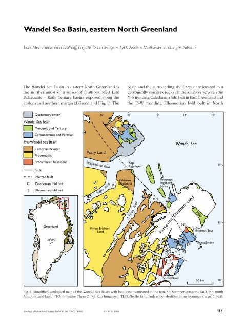
Wandel Sea Basin, eastern North Greenland - Geus
Wandel Sea Basin, eastern North Greenland - Geus
Wandel Sea Basin, eastern North Greenland - Geus

Create successful ePaper yourself
Turn your PDF publications into a flip-book with our unique Google optimized e-Paper software.
<strong>Wandel</strong> <strong>Sea</strong> <strong>Basin</strong>, <strong>eastern</strong> <strong>North</strong> <strong>Greenland</strong><br />
Lars Stemmerik, Finn Dalhoff, Birgitte D. Larsen, Jens Lyck,Anders Mathiesen and Inger Nilsson<br />
The <strong>Wandel</strong> <strong>Sea</strong> <strong>Basin</strong> in <strong>eastern</strong> <strong>North</strong> <strong>Greenland</strong> is<br />
the northernmost of a series of fault-bounded Late<br />
Palaeozoic – Early Tertiary basins exposed along the<br />
<strong>eastern</strong> and northern margin of <strong>Greenland</strong> (Fig. 1). The<br />
Quaternary cover<br />
<strong>Wandel</strong> <strong>Sea</strong> <strong>Basin</strong><br />
Mesozoic and Tertiary<br />
Carboniferous and Permian<br />
Pre-<strong>Wandel</strong> <strong>Sea</strong> <strong>Basin</strong><br />
C<br />
E<br />
Cambrian–Silurian<br />
Proterozoic<br />
Precambrian basement<br />
Fault<br />
Inferred fault<br />
Caledonian fold belt<br />
Ellesmerian fold belt<br />
E<br />
<strong>Greenland</strong><br />
Inland<br />
Ice<br />
C<br />
Peary Land<br />
Independence Fjord<br />
Hagen Fjord<br />
Mylius-Erichsen<br />
Land<br />
Valdemar<br />
Glückstadt<br />
Land<br />
basin and the surrounding shelf areas are located in a<br />
geologically complex region at the junction between the<br />
N–S trending Caledonian fold belt in East <strong>Greenland</strong> and<br />
the E–W trending Ellesmerian fold belt in <strong>North</strong><br />
26° 22° 18° 14° 10°<br />
TLFZ<br />
Kap<br />
Rigsdagen<br />
Danmark Fjord<br />
PTØ<br />
Prinsesse<br />
Ingeborg<br />
Halvø<br />
<strong>Wandel</strong> <strong>Sea</strong><br />
Kronprins Christian Land<br />
Ingolf<br />
Fjord<br />
Holm<br />
Land<br />
Amdrup<br />
Land<br />
Sortebakker<br />
NF<br />
KJ<br />
SF<br />
Kilen<br />
Antarctic Bugt<br />
Dværgfjorden<br />
Fig. 1. Simplified geological map of the <strong>Wandel</strong> <strong>Sea</strong> <strong>Basin</strong> with locations mentioned in the text. SF: Sommerterasserne fault, NF: north<br />
Amdrup Land fault, PTØ: Prinsesse Thyra Ø, KJ: Kap Jungersen, TLFZ: Trolle Land fault zone. Modified from Stemmerik et al. (1994).<br />
Geology of <strong>Greenland</strong> Survey Bulletin 180, 55–62 (1998) © GEUS, 1998<br />
50 km<br />
82°<br />
81°<br />
80°<br />
55
CARBONIFEROUS PERMIAN<br />
Ma<br />
56<br />
75<br />
100<br />
200<br />
TRIASSIC<br />
Tatarian<br />
Kazanian<br />
Kung. / Uf.<br />
Artinskian<br />
Sakmarian<br />
Asselian<br />
Gzelian<br />
Kasimovian<br />
Moscovian<br />
Bashkirian<br />
Serpukhovian<br />
Visean<br />
TERTIARY<br />
JURASSIC CRETACEOUS Age<br />
Carbonate Chert<br />
Sandstone<br />
Shale<br />
Conglomerate<br />
NE. PEARY LAND SW. PEARY LAND N. AMDRUP LAND S. AMDRUP LAND<br />
Mi<br />
KF<br />
F<br />
Late<br />
Early<br />
Late<br />
Middle<br />
Early<br />
Late<br />
KF<br />
F<br />
Kap Cannon thrust zone<br />
Evaporite<br />
Volcanic rocks<br />
Mi<br />
KF KF<br />
KF<br />
F F F F<br />
IFG<br />
Harder Fjord fault zone<br />
Precambrian basement<br />
KJ<br />
?<br />
Eastern Peary Land<br />
Strike-slip faulting<br />
Compressional faulting<br />
Extensional deformationblock<br />
faulting<br />
N. HOLM LAND<br />
S. HOLM LAND<br />
KJ<br />
SB<br />
Kronprins Christian Land<br />
Holm Land – Amdrup Land<br />
Tectonic<br />
events<br />
Mi Midnatfjeld Formation<br />
KF Kim Fjelde Formation<br />
F Foldedal Formation<br />
KJ Kap Jungersen Formation<br />
SB Sortebakker Formation<br />
IFG Independence Fjord Group<br />
Fig. 2. Simplified stratigraphy of the<br />
<strong>Wandel</strong> <strong>Sea</strong> <strong>Basin</strong>. Above: Distribution<br />
of Mesozoic–Tertiary sediments in the<br />
northern part of the basin. Below:<br />
Scheme showing correlation of the<br />
Upper Palaeozoic deposits in the modelled<br />
areas.
<strong>Greenland</strong>, and along the zone of later, Tertiary, continental<br />
break-up. The <strong>Wandel</strong> <strong>Sea</strong> <strong>Basin</strong> started to<br />
develop during the Carboniferous as a result of extension<br />
and rifting between <strong>Greenland</strong> and Norway, and<br />
<strong>Greenland</strong> and Spitsbergen (Håkansson & Stemmerik<br />
1989), and was an area of accumulation during the Early<br />
Carboniferous – Early Tertiary period. Two main epochs<br />
of basin evolution have been recognised during previous<br />
studies of the basin fill: an early (late Palaeozoic –<br />
early Triassic) epoch characterised by a fairly simple<br />
system of grabens and half-grabens, and a late (Mesozoic)<br />
epoch dominated by strike-slip movements (Håkansson<br />
& Stemmerik 1989). The Mesozoic epoch only influenced<br />
the northern part of the basin, north of the Trolle<br />
Land fault zone (Fig. 1). Thus the northern and southern<br />
parts of the basin have very different structural and<br />
depositional histories, and accordingly different thermal<br />
histories and hydrocarbon potential.<br />
This paper summarises the results of a project supported<br />
by Energy Research Program (EFP-94), the purpose<br />
of which was to model the <strong>Wandel</strong> <strong>Sea</strong> <strong>Basin</strong> with<br />
special emphasis on hydrocarbon potential and late<br />
uplift history, and to provide biostratigraphic and sedimentological<br />
data that could improve correlation with<br />
Svalbard and the Barents <strong>Sea</strong>. It is mainly based on<br />
material collected during field work in Holm Land and<br />
Amdrup Land in the south-<strong>eastern</strong> part of the <strong>Wandel</strong><br />
<strong>Sea</strong> <strong>Basin</strong> during 1993–1995 with additional data from<br />
<strong>eastern</strong> Peary Land (Stemmerik et al. 1996). Petroleum<br />
related field studies have concentrated on detailed sedimentological<br />
and biostratigraphic studies of the<br />
Carboniferous–Permian Sortebakker, Kap Jungersen,<br />
Foldedal and Kim Fjelde Formations in Holm Land and<br />
Amdrup Land (Fig. 2; Døssing 1995; Stemmerik 1996;<br />
Stemmerik et al. 1997). They were supplemented by a<br />
structural study of northern Amdrup Land in order to<br />
improve the understanding of the eastward extension<br />
of the Trolle Land fault system and possibly predict its<br />
influence in the shelf areas (Stemmerik et al. 1995a;<br />
Larsen 1996). Furthermore, samples for thermal maturity<br />
analysis and biostratigraphy were collected from the<br />
Mesozoic of Kap Rigsdagen and the Tertiary of Prinsesse<br />
Thyra Ø (Fig. 1).<br />
Biostratigraphy and correlation<br />
New biostratigraphic data were obtained from the<br />
Carboniferous–Permian, Jurassic and Tertiary intervals<br />
in the course of this project (Stemmerik et al. 1997; J.H.<br />
Callomon & I. Nilsson and S. Piasecki & J. Utting, unpub-<br />
lished data). These biostratigraphic data are important,<br />
not only as they form the basic framework for the basin<br />
modelling, but also because they allow correlation to<br />
the adjacent areas with greater confidence.<br />
Early Carboniferous<br />
The Lower Carboniferous Sortebakker Formation (Figs 2,<br />
3) is the oldest unit of the <strong>Wandel</strong> <strong>Sea</strong> <strong>Basin</strong>. It rests<br />
directly on crystalline basement rocks affected by the<br />
Caledonian orogeny in southern Holm Land. The formation<br />
consists of more than 1000 m of fluvial deposits<br />
with a poorly preserved macroflora that suggests an<br />
Early Carboniferous age for the formation. During this<br />
study, a poorly preserved but stratigraphically confined<br />
microflora was found in the upper part of the formation<br />
(Stemmerik et al. 1997); the presence of Tripartites<br />
distinctus, Raistrickia corynoges, Potoniespores delicatus<br />
and Savitrisporites nux is indicative of the late<br />
Visean NM Zone of the West European system. This<br />
means that the upper part of the formation can be correlated<br />
with the Nordkapp Formation on Bjørnøya, the<br />
upper Billefjorden Group of Spitsbergen and the lower<br />
Traill Ø Group of East <strong>Greenland</strong> (Stemmerik et al.<br />
1997). Sediments of this age also occur in the offshore<br />
areas of the Finnmark Platform in the southern Barents<br />
<strong>Sea</strong> (Bugge et al. 1995).<br />
Late Carboniferous<br />
The Carboniferous Kap Jungersen and Foldedal Formations<br />
show marked differences in depositional history<br />
and diagenesis between southern Amdrup Land,<br />
southern Holm Land and northern Amdrup Land. The<br />
succession in Holm Land consists of laterally widespread<br />
mixed siliciclastic-limestone cycles whereas at<br />
Kap Jungersen the succession consists of more laterally<br />
confined cycles that locally form large platforms<br />
(Stemmerik & Elvebakk 1994; Stemmerik 1996). The<br />
Kap Jungersen Formation is absent in northern Amdrup<br />
Land where the Carboniferous succession is much thinner<br />
and composed mainly of dolomitised limestones.<br />
The Kap Jungersen Formation has been dated by<br />
fusulinids (Dunbar et al. 1962; Stemmerik & Håkansson<br />
1989; Nilsson et al. 1991; Nilsson 1994; Stemmerik et<br />
al. 1996). Based on field work in 1993–1995, the zonation<br />
of the successions in Holm Land and Amdrup Land<br />
has been considerably refined, and it is now possible<br />
to correlate on fusulinid zone level both within the<br />
basin and with the Barents <strong>Sea</strong> succession. The oldest<br />
marine sediments in Holm Land and Amdrup Land<br />
57
include a fusulinid assemblage dominated by Profusulinella<br />
spp., Pseudostaffella spp., Eofusulina aff. E.<br />
triangula and ?Aljutovella sp.. This assemblage shows<br />
close similarities to the early Moscovian Profusulinella<br />
assemblage of Dunbar et al. (1962).<br />
The overlying Foldedal Formation contains seven<br />
Late Carboniferous fusulinid assemblages. The lowest<br />
Beedeina fusulinid assemblage is characterised by Beedeina<br />
spp., Wedekindellina ex.gr. uralica, Fusulinella<br />
spp., Neostaffella greenlandica, N. sphaeroidea and<br />
Taitzeoella sp. and is considered to be of earliest late<br />
Moscovian age, whereas the Fusulinella ex.gr. bocki<br />
assemblage overlies sediments of latest Moscovian age.<br />
Next follow sediments with a Protriticites–Quasifusulinoides<br />
assemblage of possible latest Moscovian to<br />
earliest Kasimovian age. A distinct middle Kasimovian<br />
assemblage appears to be missing although Montiparus<br />
is recognised at one level at Antarctic Bugt; this genus<br />
first occurs in middle Kasimovian strata of the Russian<br />
Platform and disappears close to the base of the Gzelian.<br />
Upper Kasimovian strata are characterised by a Rauserites<br />
ex.gr. simplex assemblage with primitive Rauserites<br />
spp., Schubertella spp. and Pseudofusulinella spp. This<br />
fauna can be correlated with the Rauserites ex.gr. simplex<br />
assemblage of Nilsson (1994). The Gzelian succession<br />
can possibly be subdivided into three fusulinid<br />
assemblages. The presence of Rauserites aff. R. rossicus<br />
indicates an early to middle Gzelian age whereas<br />
a fauna with Jigulites sp., Rauserites spp. and primitive<br />
Schellwienia spp. is of possible middle Gzelian age.<br />
The youngest fusulinid fauna recorded in Holm Land<br />
and Amdrup Land comprises species of Schellwienia and<br />
?Daixinia and may be of late Gzelian age.<br />
Middle to Late Permian<br />
Sediments belonging to the Upper Permian Midnatfjeld<br />
Formation were found to be widespread in a downfaulted<br />
area in northern Amdrup Land where they are<br />
conformably overlain by > 70 m of fine-grained sandstones<br />
and siltstones of Jurassic age (Stemmerik et al.<br />
1994, 1995a, b). The Midnatfjeld Formation consists in<br />
this area of bioturbated chert-rich limestones and shales<br />
and thin, laterally widespread horizons of bioturbated<br />
chert, which conformably overlie older Permian limestones<br />
of the Kim Fjelde Formation. Middle to Late<br />
Permian sediments of the Kim Fjelde and Midnatfjeld<br />
Formations (Stemmerik et al. 1996) have mainly been<br />
dated by palynomorphs with additional information<br />
from conodonts, small foraminifers and brachiopods<br />
(Dunbar et al. 1962; Stemmerik & Håkansson 1989;<br />
58<br />
Stemmerik et al. 1996). Based on palynomorphs, the Kim<br />
Fjelde Formation at Kap Jungersen is dated as Kungurian.<br />
The base of the Midnatfjeld Formation in northern<br />
Amdrup Land contains a microflora of Kazanian age<br />
(S. Piasecki & J. Utting, personal communication 1997).<br />
Upper Jurassic<br />
A > 70 m thick succession of post-Permian siliciclastic<br />
sediments are present locally in northern Amdrup Land.<br />
The sediments are preserved in the cores of synforms<br />
north of the Sommerterrasserne fault and provide a<br />
maximum age for the deformation in northern Amdrup<br />
Land. They have been dated as Oxfordian (Late Jurassic)<br />
by J.H. Callomon (personal communication 1996) on<br />
the basis of two ammonite fragments. The sequence can<br />
thus be correlated with the Ladegårdsåen Formation in<br />
<strong>eastern</strong> Peary Land and these sediments record a basinwide<br />
onset of sedimentation following a mid-Triassic –<br />
mid-Jurassic hiatus.<br />
Tertiary<br />
The Paleocene – ?Early Eocene Thyra Ø Formation forms<br />
the youngest preserved sediments within the <strong>Wandel</strong> <strong>Sea</strong><br />
<strong>Basin</strong> and precise dating of these deposits is important<br />
for basin modelling. The formation was previously tentatively<br />
dated as Paleocene on the basis of the macroflora<br />
and rare dinoflagellates (Håkansson & Pedersen 1982;<br />
Håkansson et al. 1991). However, during this study a more<br />
diversified microflora containing both spores and pollen,<br />
and dinoflagellates was found (Stemmerik et al. 1997).<br />
The presence of Cerodinium speciosum and Spinidinium<br />
pilatum indicates a Paleocene age whereas Cerodinium<br />
markovae has a Paleocene–Eocene range and Spinidinium<br />
sagittula has been reported from sediments of<br />
Early Eocene age. Accordingly, the Thyra Ø Formation<br />
can be attributed a Late Paleocene to possibly Early<br />
Eocene age.<br />
Structural geology<br />
Structural studies of northern Amdrup Land show that<br />
the area north of the NW–SE trending Sommerterrasserne<br />
fault (Fig. 1) was affected by a compressional event in<br />
post-Jurassic time. In the graben area between the<br />
Sommerterrasserne fault and the north Amdrup Land<br />
fault the Permian and Jurassic strata are folded by gentle,<br />
en echelon, domal folds with amplitudes of approximately<br />
100 m, wave lengths of 1–1.5 km and a lateral
Fig. 3. Unconformity between faulted fluvial<br />
sediments of the Lower Carboniferous<br />
Sortebakker Formation and mixed shelf siliciclastics<br />
and carbonates of the Upper<br />
Carboniferous Kap Jungersen Formation<br />
on the 450 m high Depotfjeld, southern<br />
Holm Land. Modelling shows that approximately<br />
2000 m of Lower Carbonifeous sediments<br />
were removed prior to onset of<br />
deposition in the Late Carboniferous.<br />
extent of 4–4.5 km. Fold axes generally strike NW–SE<br />
with some local variations. <strong>North</strong> of the northern Amdrup<br />
Land fault, Carboniferous sediments unconformably<br />
overlie Proterozoic sedimentary and volcanic rocks<br />
affected by Caledonian isoclinal folding. Here the<br />
Moscovian sediments are folded in somewhat larger<br />
domal folds with a NE–SW trend; a major synform with<br />
an amplitude of 250–300 m, a wave length of 3.5 km<br />
and a lateral extent of 7.3 km exposes Carboniferous,<br />
Permian and Jurassic sediments near Dværgfjorden<br />
(Larsen 1996).<br />
The deformation of the <strong>Wandel</strong> <strong>Sea</strong> <strong>Basin</strong> deposits<br />
in Amdrup Land took place after deposition of the<br />
Upper Jurassic sediments, and should therefore be correlated<br />
with either the Middle Cretaceous Kilen event<br />
or the end of the Cretaceous strike-slip event of Pedersen<br />
(1988).<br />
<strong>Basin</strong> modelling<br />
<strong>Basin</strong> modelling of the <strong>Wandel</strong> <strong>Sea</strong> <strong>Basin</strong> is based on<br />
stratigraphic analysis of outcrop data and use of the<br />
Yükler 1D basin model concept (Mathiesen et al. 1997).<br />
The Yükler model is a forward deterministic model<br />
which quantifies the geological evolution of a sedimentary<br />
basin by calculating compaction, pressure,<br />
temperature, thermal maturity and hydrocarbon generation,<br />
as a function of time and space. Geological<br />
information and input data for the model include thickness,<br />
age, lithology, porosity, palaeotemperature, heat<br />
flow and palaeo-water depth. These data are synthesised<br />
into model events in such a way that the model<br />
can handle deposition, non-deposition (hiati) and erosion.<br />
A total of 34 model events, each in excess of 1.0 Ma<br />
have been used to describe the evolution of the <strong>Wandel</strong><br />
<strong>Sea</strong> <strong>Basin</strong> (Fig. 4). The lithology was based on published<br />
or unpublished sources on depositional facies variation.<br />
Data on thickness were taken from outcrop-based<br />
measurements (Håkansson 1979, 1994; Stemmerik &<br />
Håkansson 1989; Stemmerik et al. 1994, 1995b, 1996).<br />
The surface palaeotemperature was estimated from<br />
palaeoclimatic models and palaeolatitude. The variations<br />
in heat flow with time were estimated from the basin<br />
history, with higher values during periods of rifting and<br />
volcanic activity, and lower (and generally decreasing)<br />
values in tectonically stable periods with slow and uniform<br />
subsidence. The same heat flow history has been<br />
used for the whole area, except for a heating event<br />
around 65 Ma where the heat flow was increased to 1.35<br />
heat flow units for the Peary Land and northern Amdrup<br />
Land area.<br />
The model concept has been used to construct seven<br />
pseudowells in <strong>eastern</strong> Peary Land, Amdrup Land and<br />
Holm Land, in order to constrain basin history by optimising<br />
the subsidence, uplift and thermal history of the<br />
different parts of the basin using sensitive surface data<br />
(Mathiesen et al. 1997). Input data for each pseudowell<br />
are accumulated from a large area (often > 100 km 2 ),<br />
and the modelled pseudowells do not therefore correspond<br />
to real wells.<br />
The seven pseudowells describe different geological<br />
scenarios within the basin. All pseudowells suggest<br />
limited Tertiary uplift of the onshore areas – in contrast<br />
to the Barents Shelf where more than 1 km of latest<br />
59
AMDRUP LAND HOLM LAND<br />
(<strong>North</strong>) (South) (South)<br />
Antarctic Bugt<br />
-100<br />
D.T.S. Fm name E.No. HF<br />
Dunken Sletten Foldedal<br />
PLEISTOCENE 1.8 GLACIAL-UPLIFT 34 1.00<br />
-50 -80<br />
-40<br />
3.6<br />
1.00<br />
5.3<br />
1.00<br />
7.1<br />
1.00<br />
11.2 NEOGENE-UPLIFT<br />
1.00<br />
14.8<br />
33 1.00<br />
0<br />
-340 -300<br />
16.4<br />
1.00<br />
20.5<br />
1.00<br />
23.8<br />
32 1.00<br />
0<br />
-600 -600<br />
28.5<br />
31 1.00<br />
0<br />
-200 -200<br />
33.7<br />
30 1.00<br />
0<br />
-50<br />
-50<br />
37.0 UPLIFT<br />
1.20<br />
41.3<br />
1.20<br />
49.0<br />
29 1.20<br />
-50<br />
-50<br />
-50<br />
54.8<br />
1.25<br />
61.0 Thyra Ø 28 1.25<br />
100 100 Fis 100<br />
65.0 HIATUS EROSION 27 1.25<br />
-500 -500<br />
0<br />
71.3<br />
1.35<br />
83.5 Herlufsholm<br />
1.35<br />
85.8<br />
Strand<br />
1.35<br />
89.0<br />
26 1.35<br />
500 500<br />
0<br />
93.5<br />
1.00<br />
98.9<br />
1.00<br />
112.2<br />
1.00<br />
121.0 HIATUS EROSION<br />
1.00<br />
127.0<br />
1.00<br />
132.0<br />
1.00<br />
140.7<br />
1.00<br />
144.2<br />
25 1.00<br />
0<br />
0<br />
0<br />
150.7<br />
1.00<br />
154.1 Ladegårdsåen<br />
1.00<br />
159.4<br />
24 1.00<br />
200 200 200<br />
200<br />
164.4<br />
1.00<br />
169.2<br />
1.00<br />
176.5<br />
1.00<br />
180.1<br />
1.00<br />
189.6<br />
1.00<br />
195.3<br />
1.00<br />
201.9 HIATUS EROSION<br />
1.00<br />
205.7<br />
23 1.00<br />
-500 -500<br />
0<br />
209.6<br />
1.00<br />
220.7<br />
1.00<br />
227.4<br />
1.00<br />
234.3<br />
1.00<br />
241.7<br />
22 1.00<br />
-500 -500<br />
0<br />
244.8<br />
21 1.00<br />
1600 1600 600<br />
248,2<br />
20 1.00<br />
340 340<br />
340<br />
252.1 HIATUS EROSION 19 1.00<br />
-20 -20<br />
-20<br />
256.0<br />
18 1.00<br />
200 200 100 200 180<br />
269.0<br />
17 1.00<br />
380 380<br />
380<br />
290.0 Regional HIATUS 16 1.20<br />
0<br />
0<br />
0<br />
296.5 5<br />
15 1.00<br />
50 50<br />
50<br />
303.0 4<br />
14 1.00<br />
50 50<br />
50<br />
3 Foldedal<br />
13 1.00<br />
50 50<br />
50<br />
2<br />
12 1.00<br />
100 100<br />
100<br />
1<br />
11 1.00<br />
100 100<br />
100<br />
4<br />
10 1.00<br />
0<br />
0<br />
0<br />
3<br />
1.00<br />
0<br />
0<br />
2<br />
Kap Jungersen 9 0<br />
8 1.00<br />
0<br />
0<br />
0<br />
1<br />
311.0 7 1.00<br />
0<br />
0<br />
0<br />
323.0 HIATUS EROSION<br />
Mid-Carbon.<br />
6 1.00 structural event 0<br />
0<br />
0<br />
327.0 Sortebakker-2 5 1.00<br />
0<br />
0 0<br />
342.0 HIATUS EROSION 4 1.00<br />
0<br />
0<br />
00<br />
354.0 Sortebakker-1 3 1.00<br />
0<br />
0<br />
DEVONIAN 417.0 HIATUS EROSION 2 1.50<br />
-5750 -5750 -5750<br />
SILURIAN<br />
1.50<br />
Fis<br />
POSTMATURE<br />
ORDOVICIAN 495.0 1 1.50<br />
8000 8000 8000<br />
sediments<br />
CAMBRIAN 545.0<br />
PEARY LAND<br />
Depotfjeld<br />
-240<br />
Østelv<br />
-140<br />
Kap Jungersen<br />
-140<br />
60<br />
UPLIFT & EROSION<br />
PLIO-<br />
CENE<br />
-200<br />
-100<br />
-100<br />
-100<br />
-100<br />
0<br />
0<br />
-100<br />
0<br />
0<br />
-100<br />
0<br />
0<br />
-100<br />
0<br />
0<br />
-400<br />
-125<br />
-125<br />
0<br />
-300<br />
0<br />
-50<br />
0<br />
-50<br />
0<br />
0<br />
0<br />
LATE TERTIARY<br />
THERMAL EVENT<br />
0<br />
0<br />
0<br />
0<br />
-300<br />
-50<br />
-50<br />
0<br />
KILEN EVENT<br />
PALEO-<br />
OLIGO-<br />
LATE EARLY LATE EARLY MID LATE EARLY MIDDLE LATE EARLY<br />
LATE CENE EOCENE CENE MIOCENE<br />
0<br />
0<br />
0<br />
70<br />
370<br />
LEGEND<br />
D.T.S. Digital Time Scale<br />
(Gradstein & Ogg 1996)<br />
Fm. name Model event name<br />
E.No. Event number<br />
HF Heat Flow Values [HF Units]<br />
Fis Fission track sample<br />
100 Base of model<br />
-900 Technical solution due to<br />
computer model concept<br />
25 Present-day erosion level<br />
(i.e. Present-day thickness)<br />
600 Deposition of 600 m sediments<br />
CARBONIFEROUS PERMIAN TRIASSIC JURASSIC CRETACEOUS PALEOGENE NEOGENE<br />
-300<br />
-185<br />
-185<br />
-2140<br />
-300<br />
1600<br />
540<br />
380 380 25<br />
-355<br />
0<br />
380<br />
Erosion of 300 m sediments<br />
-300<br />
-10<br />
50<br />
50<br />
50<br />
45<br />
45<br />
70<br />
60<br />
60<br />
30<br />
-2000<br />
-190<br />
600<br />
340<br />
0<br />
0<br />
380<br />
0<br />
80<br />
0<br />
0<br />
0<br />
0<br />
30<br />
30<br />
40<br />
90<br />
00000<br />
Thyra Ø Fm<br />
Herlufsholm Strand Fm<br />
Ladegårdsåen Fm<br />
Dunken Fm<br />
Parish Bjerg Fm<br />
Midnatfjeld Fm<br />
Kim Fjelde Fm<br />
Foldedal Fm<br />
Kap Jungersen Fm<br />
Sortebakker Fm<br />
Pre-Early Carboniferous<br />
-190<br />
600<br />
340<br />
0<br />
0<br />
380<br />
0<br />
50<br />
25<br />
110<br />
100<br />
60<br />
40<br />
110<br />
40<br />
90<br />
00000<br />
Fis<br />
Fis<br />
2325<br />
0<br />
675<br />
0<br />
-2400<br />
2400<br />
2140<br />
-900<br />
950<br />
380<br />
250<br />
40<br />
40<br />
40<br />
40<br />
30<br />
0<br />
0<br />
0<br />
0<br />
0<br />
0<br />
0<br />
00<br />
EARLY<br />
100<br />
100<br />
100<br />
100<br />
Fig. 4. Pseudowells in <strong>eastern</strong> Peary Land, Amdrup Land and Holm Land based on the basin modelling concepts applied to the <strong>Wandel</strong> <strong>Sea</strong> <strong>Basin</strong> by Mathiesen et al. (1997).
Tertiary to Recent uplift is proposed (Løseth et al. 1992).<br />
The Holm Land pseudowell puts constrains on the mid-<br />
Carboniferous structural event separating the Sortebakker<br />
and Kap Jungersen Formations (Figs 3, 4). According<br />
to the model at least 2000 m of Lower Carboniferous<br />
sediments have been removed during this event to<br />
explain the contrasting thermal maturity of the Lower<br />
and Upper Carboniferous sediments. Similarly, the<br />
Antarctic Bugt pseudowell shows that up to five kilometres<br />
of Upper Permian and Triassic sediments are<br />
likely to have been deposited in this area, and subsequently<br />
eroded away, to explain the contrasting thermal<br />
maturity of the Permian and Upper Jurassic<br />
sediments (Fig. 4).<br />
Summary and conclusions<br />
The results arising from the project form a major step<br />
forward in the understanding of the <strong>Wandel</strong> <strong>Sea</strong> <strong>Basin</strong>.<br />
The biostratigraphic resolution of the Upper Palaeozoic<br />
succession has been improved considerably and the<br />
basin modelling has provided the first quantitative constrains<br />
on the subsidence and uplift history of the basin.<br />
The most important new results are given below.<br />
1. The finds of the first age diagnostic fossils from the<br />
Lower Carboniferous Sortebakker Formation which<br />
date the upper part of the formation as Visean.<br />
2. Detailed sampling of fusulinids which allows recognition<br />
of eight Upper Carboniferous fusulinid assemblages<br />
and dating of all the main outcrops in Holm<br />
Land and Amdrup Land.<br />
3. Discovery of new outcrops of Mesozoic sediments<br />
on Amdrup Land which have been dated as Late<br />
Jurassic based on ammonites.<br />
4. Structural studies which show that the Trolle Land<br />
fault zone extends eastwards across northern Amdrup<br />
Land and also affected the northern part of the East<br />
<strong>Greenland</strong> Shelf.<br />
In addition to the above observations basin modelling<br />
indicates that:<br />
5. The mid-Carboniferous structural event separating<br />
the Sortebakker and Kap Jungersen Formations<br />
involved removal of at least 2000 m of Lower<br />
Carboniferous sediments before deposition of the<br />
Kap Jungersen Formation.<br />
6. Up to 5 km of Upper Permian and Triassic sediments<br />
are likely to have been deposited in northern Amdrup<br />
Land, and subsequently eroded away, to explain the<br />
contrasting thermal maturity of the Permian and<br />
Upper Jurassic sediments.<br />
7. Cretaceous sedimentation was very localised and no<br />
substantial post-Jurassic cover was present in Amdrup<br />
Land and the southern parts of <strong>eastern</strong> Peary Land.<br />
8. Tertiary uplift of the basin was very limited.<br />
The results imply that the shelf areas east of Holm Land<br />
and Amdrup Land have very different hydrocarbon<br />
potential. Immediately north of the Trolle Land fault zone<br />
it is suggested that mature Upper Palaeozoic sediments<br />
are folded in broad domal structures. Further to the<br />
north, the shelf area was most likely affected by a late<br />
Tertiary thermal event and the sediments are considered<br />
post-mature. South of the Trolle Land fault zone,<br />
the most prominent feature on the shelf is a north–south<br />
trending salt basin (Escher & Pulvertaft 1995). The outcrop<br />
studies and the basin modelling have only limited<br />
significance for evaluation of this area although sedimentological<br />
and diagenetic studies of the Upper<br />
Carboniferous carbonates may provide reservoir models<br />
for this region. Therefore the next phase of the<br />
investigation will focus on the relationships between<br />
Upper Carboniferous sedimentary facies and diagenesis,<br />
and the structural history of fault blocks. This study<br />
will compare the successions on southern Holm Land<br />
and southern Amdrup Land and will hopefully lead to<br />
a better understanding of the reservoir development in<br />
the offshore areas.<br />
Acknowledgement<br />
The <strong>Wandel</strong> <strong>Sea</strong> <strong>Basin</strong> project was financially supported by the<br />
Energy Research Program (EFP-94) project 1313/94–0006.<br />
References<br />
Bugge, T., Mangerud, G., Elvebakk, G., Mørk, A., Nilsson, I.,<br />
Fanavoll, S. & Vigran, J.O. 1995: The Upper Paleozoic succession<br />
on the Finnmark Platform, Barents <strong>Sea</strong>. Norsk Geologisk<br />
Tidssskrift 75, 3–30.<br />
61
Døssing, J. 1995: Høj-frekvent, glacio-eustatisk cyclisitet i en<br />
Moscovian karbonat-siliciclastisk sekvens på Depotfjeld, NØ<br />
Grønland, 77 pp. Unpublished cand. scient. thesis, University<br />
of Copenhagen, Denmark.<br />
Dunbar, C.O., Troelsen, J., Ross, C., Ross, J.A. & Norford, B. 1962:<br />
Faunas and correlation of the Late Paleozoic rocks of northeast<br />
<strong>Greenland</strong>. Part I. General discussion and summary.<br />
Meddelelser om Grønland 167(4), 16 pp.<br />
Escher, J.C. & Pulvertaft, T.C.R. 1995: Geological map of <strong>Greenland</strong>,<br />
1: 2 500 000. Copenhagen: Geological Survey of <strong>Greenland</strong>.<br />
Gradstein, F.M. & Ogg, J. 1996: A Phanerozoic time scale. Episodes<br />
19(1–2), 3–5.<br />
Håkansson, E. 1979: Carboniferous to Tertiary development of<br />
the <strong>Wandel</strong> <strong>Sea</strong> <strong>Basin</strong>, <strong>eastern</strong> <strong>North</strong> <strong>Greenland</strong>. Rapport<br />
Grønlands Geologiske Undersøgelse 88, 73–84.<br />
Håkansson, E. 1994: <strong>Wandel</strong> <strong>Sea</strong> <strong>Basin</strong>: basin analysis. EFP-91,<br />
project 0012, completion report to the Ministry of Energy 1,<br />
2, 3, (no running pagination). Unpublished report, Geological<br />
Institute, University of Copenhagen, Denmark.<br />
Håkansson, E. & Pedersen, S.A.S. 1982: Late Paleozoic to Tertiary<br />
tectonic evolution of the continental margin in <strong>North</strong> <strong>Greenland</strong>.<br />
In: Embry, A.F. & Balkwill, H.R. (eds): Arctic geology and<br />
geophysics. Canadian Society of Petroleum Geologists Memoir<br />
8, 331–348.<br />
Håkansson, E. & Stemmerik, L. 1989: <strong>Wandel</strong> <strong>Sea</strong> basin – A new<br />
synthesis of the late Paleozoic to Tertiary accumulation in<br />
<strong>North</strong> <strong>Greenland</strong>. Geology 17, 683–686.<br />
Håkansson, E., Heinberg, C. & Stemmerik, L. 1991: Mesozoic and<br />
Cenozoic history of the <strong>Wandel</strong> <strong>Sea</strong> <strong>Basin</strong> area, <strong>North</strong><br />
<strong>Greenland</strong>. In: Peel, J.S. & Sønderholm, M. (eds): Sedimentary<br />
basins of <strong>North</strong> <strong>Greenland</strong>. Bulletin Grønlands Geologiske<br />
Undersøgelse 160, 153–164.<br />
Larsen, B.D. 1996: Strukturel udvikling af det nordlige Amdrup<br />
Land, Nordøst Grønland, 83 pp. Unpublished cand. scient. thesis,<br />
University of Aarhus, Denmark.<br />
Løseth, H., Lippard, S.J., Sættem, J., Fanavoll, S., Fjerdingstad, V.,<br />
Leith, T.L., Ritter, U., Smelror, M. & Sylta, Ø. 1992: Cenozoic<br />
uplift and erosion of the Barents <strong>Sea</strong> - evidence from the<br />
Svalis Dome area. In: Vorren, T.O. et al. (eds): Arctic geology<br />
and petroleum potential. Norwegian Petroleum Society Special<br />
Publication 2, 643–664. Amsterdam: Elsevier<br />
Mathiesen, A., Dalhoff, F. & Stemmerik, L. 1997: <strong>Basin</strong> modelling<br />
of the <strong>Wandel</strong> <strong>Sea</strong> <strong>Basin</strong>, <strong>eastern</strong> <strong>North</strong> <strong>Greenland</strong>. Danmarks<br />
og Grønlands Geologiske Undersøgelse Rapport 1997/49, 31<br />
pp.<br />
Nilsson, I. 1994: Upper Palaeozoic fusulinid assemblages, <strong>Wandel</strong><br />
62<br />
<strong>Sea</strong> <strong>Basin</strong>, <strong>North</strong> <strong>Greenland</strong>. Rapport Grønlands Geologiske<br />
Undersøgelse 161, 45–71.<br />
Nilsson, I., Håkansson, E., Madsen, L., Pedersen, S.A.S. &<br />
Stemmerik, L. 1991: Stratigraphic significance of new fusulinid<br />
samples from the <strong>Wandel</strong> <strong>Sea</strong> <strong>Basin</strong>, <strong>eastern</strong> <strong>North</strong> <strong>Greenland</strong>.<br />
Rapport Grønlands Geologiske Undersøgelse 150, 29–32.<br />
Pedersen, S.A.S. 1988: Model of structural events in the Late<br />
Mesozoic platform break up between <strong>Greenland</strong> and Svalbard.<br />
Rapport Norsk Polarinstitut 46, 99–100.<br />
Stemmerik, L. 1996: High frequency sequence stratigraphy of a<br />
siliciclastic influenced carbonate platform, lower Moscovian,<br />
Amdrup Land, <strong>North</strong> <strong>Greenland</strong>. In: Howell, J.A. & Aitken, J.F.<br />
(eds): High resolution sequence stratigraphy: innovations and<br />
applications. Geological Society Special Publication (London)<br />
104, 347–365.<br />
Stemmerik, L. & Elvebakk, G. 1994: A newly discovered mid-<br />
Carboniferous – ?early Permian reef complex in the <strong>Wandel</strong><br />
<strong>Sea</strong> <strong>Basin</strong>, <strong>eastern</strong> <strong>North</strong> <strong>Greenland</strong>. Rapport Grønlands<br />
Geologiske Undersøgelse 161, 39–44.<br />
Stemmerik, L. & Håkansson, E. 1989: Stratigraphy and depositional<br />
history of the Upper Palaeozoic and Triassic sediments<br />
in the <strong>Wandel</strong> <strong>Sea</strong> <strong>Basin</strong>, <strong>eastern</strong> and central <strong>North</strong> <strong>Greenland</strong>.<br />
Rapport Grønlands Geologiske Undersøgelse 143, 21–44.<br />
Stemmerik, L., Dalhoff, F. & Nilsson, I. 1994: Petroleum-geological<br />
studies in <strong>eastern</strong> <strong>North</strong> <strong>Greenland</strong>. In: Henriksen, N.<br />
(ed.): Express report, <strong>eastern</strong> <strong>North</strong> <strong>Greenland</strong> and <strong>North</strong>-<br />
East <strong>Greenland</strong>, 69–76. Unpublished report, Geological Survey<br />
of <strong>Greenland</strong>, Copenhagen.<br />
Stemmerik, L., Dalhoff, F., Larsen, B.D., Piasecki, S. & Thomsen,<br />
C. 1995a: Stratigraphical and structural studies of the <strong>Wandel</strong><br />
<strong>Sea</strong> <strong>Basin</strong>. In: Higgins, A.K. (ed.): Express report, <strong>eastern</strong> <strong>North</strong><br />
<strong>Greenland</strong> and <strong>North</strong>-East <strong>Greenland</strong>, 127–132. Unpublished<br />
report, Geological Survey of <strong>Greenland</strong>, Copenhagen.<br />
Stemmerik, L., Dalhoff, F. & Nilsson, I. 1995b: Petroleum geology<br />
and thermal maturity of <strong>eastern</strong> <strong>North</strong> <strong>Greenland</strong> – a new<br />
energy research project. Rapport Grønlands Geologiske Undersøgelse<br />
165, 49–52.<br />
Stemmerik, L., Håkansson, E., Madsen, L., Nilsson, I., Piasecki,<br />
S., Pinard, S. & Rasmussen, J.A. 1996: Stratigraphy and depositional<br />
evolution of the Upper Palaeozoic sedimentary succession<br />
in <strong>eastern</strong> Peary Land, <strong>North</strong> <strong>Greenland</strong>. Bulletin<br />
Grønlands Geologiske Undersøgelse 171, 45–71.<br />
Stemmerik, L., Dalhoff, F., Lyck, J.M. & Mathiesen, A. 1997: Oil<br />
geology and thermal history of <strong>eastern</strong> <strong>North</strong> <strong>Greenland</strong>.<br />
Energy research programme EFP-94 project 1313/94-0006.<br />
Danmarks og Grønlands Geologiske Undersøgelse Rapport<br />
1997/48(1, 2), 17 pp, 12 appendices.<br />
Authors’ addresses:<br />
L.S., F.D., J.L., A.M., Geological Survey of Denmark and <strong>Greenland</strong>, Thoravej 8, DK-2400 Copenhagen NV, Denmark.<br />
B.D.L., Geological Institute, University of Aarhus, DK-8000 Århus C, Denmark.<br />
I.N., Saga Petroleum a.s., Postboks 1134, N-9401 Harstad, Norway.


