Oil and gas exploration wells in the Pedregosa Basin - New Mexico ...
Oil and gas exploration wells in the Pedregosa Basin - New Mexico ...
Oil and gas exploration wells in the Pedregosa Basin - New Mexico ...
You also want an ePaper? Increase the reach of your titles
YUMPU automatically turns print PDFs into web optimized ePapers that Google loves.
<strong>New</strong> <strong>Mexico</strong> Geol. Soc. Guidebook, 29th Field Conf., L<strong>and</strong> of Cochise, 1978 331<br />
OIL AND GAS EXPLORATION WELLS IN THE PEDREGOSA BASIN<br />
INTRODUCTION<br />
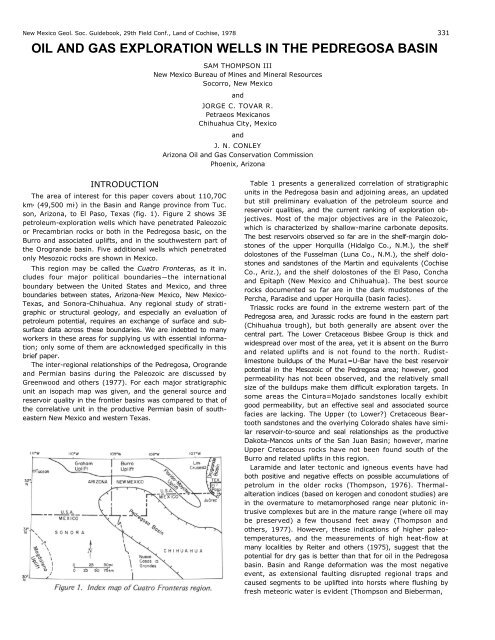
The area of <strong>in</strong>terest for this paper covers about 110,70C<br />
km 2 (49,500 mi l) <strong>in</strong> <strong>the</strong> Bas<strong>in</strong> <strong>and</strong> Range prov<strong>in</strong>ce from Tuc.<br />
son, Arizona, to El Paso, Texas (fig. 1). Figure 2 shows 3E<br />
petroleum-<strong>exploration</strong> <strong>wells</strong> which have penetrated Paleozoic<br />
or Precambrian rocks or both <strong>in</strong> <strong>the</strong> <strong>Pedregosa</strong> basic, on <strong>the</strong><br />
Burro <strong>and</strong> associated uplifts, <strong>and</strong> <strong>in</strong> <strong>the</strong> southwestern part of<br />
<strong>the</strong> Orogr<strong>and</strong>e bas<strong>in</strong>. Five additional <strong>wells</strong> which penetrated<br />
only Mesozoic rocks are shown <strong>in</strong> <strong>Mexico</strong>.<br />
This region may be called <strong>the</strong> Cuatro Fronteras, as it <strong>in</strong>.<br />
cludes four major political boundaries—<strong>the</strong> <strong>in</strong>ternational<br />
boundary between <strong>the</strong> United States <strong>and</strong> <strong>Mexico</strong>, <strong>and</strong> three<br />
boundaries between states, Arizona-<strong>New</strong> <strong>Mexico</strong>, <strong>New</strong> <strong>Mexico</strong>-<br />
Texas, <strong>and</strong> Sonora-Chihuahua. Any regional study of strati-<br />
graphic or structural geology, <strong>and</strong> especially an evaluation of<br />
petroleum potential, requires an exchange of surface <strong>and</strong> subsurface<br />
data across <strong>the</strong>se boundaries. We are <strong>in</strong>debted to many<br />
workers <strong>in</strong> <strong>the</strong>se areas for supply<strong>in</strong>g us with essential <strong>in</strong>formation;<br />
only some of <strong>the</strong>m are acknowledged specifically <strong>in</strong> this<br />
brief paper.<br />
The <strong>in</strong>ter-regional relationships of <strong>the</strong> <strong>Pedregosa</strong>, Orogr<strong>and</strong>e<br />
<strong>and</strong> Permian bas<strong>in</strong>s dur<strong>in</strong>g <strong>the</strong> Paleozoic are discussed by<br />
Greenwood <strong>and</strong> o<strong>the</strong>rs (1977). For each major stratigraphic<br />
unit an isopach map was given, <strong>and</strong> <strong>the</strong> general source <strong>and</strong><br />
reservoir quality <strong>in</strong> <strong>the</strong> frontier bas<strong>in</strong>s was compared to that of<br />
<strong>the</strong> correlative unit <strong>in</strong> <strong>the</strong> productive Permian bas<strong>in</strong> of sou<strong>the</strong>astern<br />
<strong>New</strong> <strong>Mexico</strong> <strong>and</strong> western Texas.<br />
SAM THOMPSON III<br />
<strong>New</strong> <strong>Mexico</strong> Bureau of M<strong>in</strong>es <strong>and</strong> M<strong>in</strong>eral Resources<br />
Socorro, <strong>New</strong> <strong>Mexico</strong><br />
<strong>and</strong><br />
JORGE C. TOVAR R.<br />
Petraeos Mexicanos<br />
Chihuahua City, <strong>Mexico</strong><br />
<strong>and</strong><br />
J. N. CONLEY<br />
Arizona <strong>Oil</strong> <strong>and</strong> Gas Conservation Commission<br />
Phoenix, Arizona<br />
Table 1 presents a generalized correlation of stratigraphic<br />
units <strong>in</strong> <strong>the</strong> <strong>Pedregosa</strong> bas<strong>in</strong> <strong>and</strong> adjo<strong>in</strong><strong>in</strong>g areas, an updated<br />
but still prelim<strong>in</strong>ary evaluation of <strong>the</strong> petroleum source <strong>and</strong><br />
reservoir qualities, <strong>and</strong> <strong>the</strong> current rank<strong>in</strong>g of <strong>exploration</strong> objectives.<br />
Most of <strong>the</strong> major objectives are <strong>in</strong> <strong>the</strong> Paleozoic,<br />
which is characterized by shallow-mar<strong>in</strong>e carbonate deposits.<br />
The best reservoirs observed so far are <strong>in</strong> <strong>the</strong> shelf-marg<strong>in</strong> dolostones<br />
of <strong>the</strong> upper Horquilla (Hidalgo Co., N.M.), <strong>the</strong> shelf<br />
dolostones of <strong>the</strong> Fusselman (Luna Co., N.M.), <strong>the</strong> shelf dolostones<br />
<strong>and</strong> s<strong>and</strong>stones of <strong>the</strong> Mart<strong>in</strong> <strong>and</strong> equivalents (Cochise<br />
Co., Ariz.), <strong>and</strong> <strong>the</strong> shelf dolostones of <strong>the</strong> El Paso, Concha<br />
<strong>and</strong> Epitaph (<strong>New</strong> <strong>Mexico</strong> <strong>and</strong> Chihuahua). The best source<br />
rocks documented so far are <strong>in</strong> <strong>the</strong> dark mudstones of <strong>the</strong><br />
Percha, Paradise <strong>and</strong> upper Horquilla (bas<strong>in</strong> facies).<br />
Triassic rocks are found <strong>in</strong> <strong>the</strong> extreme western part of <strong>the</strong><br />
<strong>Pedregosa</strong> area, <strong>and</strong> Jurassic rocks are found <strong>in</strong> <strong>the</strong> eastern part<br />
(Chihuahua trough), but both generally are absent over <strong>the</strong><br />
central part. The Lower Cretaceous Bisbee Group is thick <strong>and</strong><br />
widespread over most of <strong>the</strong> area, yet it is absent on <strong>the</strong> Burro<br />
<strong>and</strong> related uplifts <strong>and</strong> is not found to <strong>the</strong> north. Rudistlimestone<br />
buildups of <strong>the</strong> Mura1=U-Bar have <strong>the</strong> best reservoir<br />
potential <strong>in</strong> <strong>the</strong> Mesozoic of <strong>the</strong> <strong>Pedregosa</strong> area; however, good<br />
permeability has not been observed, <strong>and</strong> <strong>the</strong> relatively small<br />
size of <strong>the</strong> buildups make <strong>the</strong>m difficult <strong>exploration</strong> targets. In<br />
some areas <strong>the</strong> C<strong>in</strong>tura=Mojado s<strong>and</strong>stones locally exhibit<br />
good permeability, but an effective seal <strong>and</strong> associated source<br />
facies are lack<strong>in</strong>g. The Upper (to Lower?) Cretaceous Bear-<br />
tooth s<strong>and</strong>stones <strong>and</strong> <strong>the</strong> overly<strong>in</strong>g Colorado shales have similar<br />
reservoir-to-source <strong>and</strong> seal relationships as <strong>the</strong> productive<br />
Dakota-Mancos units of <strong>the</strong> San Juan Bas<strong>in</strong>; however, mar<strong>in</strong>e<br />
Upper Cretaceous rocks have not been found south of <strong>the</strong><br />
Burro <strong>and</strong> related uplifts <strong>in</strong> this region.<br />
Laramide <strong>and</strong> later tectonic <strong>and</strong> igneous events have had<br />
both positive <strong>and</strong> negative effects on possible accumulations of<br />
petrolum <strong>in</strong> <strong>the</strong> older rocks (Thompson, 1976). Thermal-<br />
alteration <strong>in</strong>dices (based on kerogen <strong>and</strong> conodont studies) are<br />
<strong>in</strong> <strong>the</strong> overmature to metamorphosed range near plutonic <strong>in</strong>trusive<br />
complexes but are <strong>in</strong> <strong>the</strong> mature range (where oil may<br />
be preserved) a few thous<strong>and</strong> feet away (Thompson <strong>and</strong><br />
o<strong>the</strong>rs, 1977). However, <strong>the</strong>se <strong>in</strong>dications of higher paleotemperatures,<br />
<strong>and</strong> <strong>the</strong> measurements of high heat-flow at<br />
many localities by Reiter <strong>and</strong> o<strong>the</strong>rs (1975), suggest that <strong>the</strong><br />
potential for dry <strong>gas</strong> is better than that for oil <strong>in</strong> <strong>the</strong> <strong>Pedregosa</strong><br />
bas<strong>in</strong>. Bas<strong>in</strong> <strong>and</strong> Range deformation was <strong>the</strong> most negative<br />
event, as extensional fault<strong>in</strong>g disrupted regional traps <strong>and</strong><br />
caused segments to be uplifted <strong>in</strong>to horsts where flush<strong>in</strong>g by<br />
fresh meteoric water is evident (Thompson <strong>and</strong> Bieberman,
334<br />
1975). Therefore, <strong>the</strong> best potential for petroleum <strong>exploration</strong><br />
lies <strong>in</strong> <strong>the</strong> deep grabens beneath <strong>the</strong> bolson (<strong>in</strong>termontane)<br />
valleys where preservation of oil <strong>and</strong> <strong>gas</strong> is more likely.<br />
EXPLORATION WELLS<br />
In this section we exam<strong>in</strong>e <strong>the</strong> records of key <strong>wells</strong> drilled<br />
<strong>in</strong> search of crude oil <strong>and</strong> natural <strong>gas</strong> <strong>in</strong> <strong>the</strong> <strong>Pedregosa</strong> bas<strong>in</strong><br />
<strong>and</strong> adjo<strong>in</strong><strong>in</strong>g areas. Although some encourag<strong>in</strong>g shows have<br />
been encountered, no commercial production has been found<br />
to date.<br />
Only brief summaries of <strong>the</strong> <strong>wells</strong> are given. Additional<br />
basic data are available <strong>in</strong> <strong>the</strong> references cited, <strong>and</strong> more detailed<br />
analyses are planned for future publications on selected<br />
<strong>wells</strong>.<br />
Depths of <strong>wells</strong> drilled <strong>in</strong> <strong>the</strong> United States are recorded <strong>in</strong><br />
feet, <strong>and</strong> those <strong>in</strong> <strong>Mexico</strong> are recorded <strong>in</strong> meters, relative to a<br />
surface-elevation datum (KB = kelly bush<strong>in</strong>g, DF = derrick<br />
floor, GL = ground level). To allow direct reference to well<br />
data, <strong>and</strong> to avoid conversion errors, <strong>the</strong> depths are given <strong>in</strong><br />
<strong>the</strong>ir respective orig<strong>in</strong>al units.<br />
Sou<strong>the</strong>astern Arizona<br />
Over 40 petroleum-<strong>exploration</strong> <strong>wells</strong> have been drilled <strong>in</strong><br />
<strong>the</strong> sou<strong>the</strong>astern part of Arizona shown on Figure 2. The latest<br />
report <strong>and</strong> map conta<strong>in</strong><strong>in</strong>g <strong>the</strong> most accurate <strong>in</strong>formation on<br />
well names, locations, elevations <strong>and</strong> total depth, are presented<br />
by Conley <strong>and</strong> Stacey (1977). Previous reports which have<br />
important <strong>in</strong>formation on formation tops <strong>and</strong> results of drill -<br />
stem tests were prepared by Peirce <strong>and</strong> Scurlock (1972) <strong>and</strong><br />
Scurlock (1973). A summary report on <strong>the</strong> oil <strong>and</strong> <strong>gas</strong> potential<br />
of sou<strong>the</strong>astern Arizona, <strong>in</strong>clud<strong>in</strong>g geophysical maps <strong>and</strong><br />
cross sections, is given by Aiken <strong>and</strong> Sumner (1974).<br />
Table 2 lists 11 <strong>wells</strong> which have been drilled to Paleozoic<br />
(or Precambrian) rocks. (About 9 additional <strong>wells</strong> are reported<br />
to have reached Cretaceous rocks.) Formation tops are based<br />
on <strong>the</strong> best available data <strong>in</strong> <strong>the</strong> well files of <strong>the</strong> Arizona <strong>Oil</strong><br />
<strong>and</strong> Gas Conservation Commission. Sources <strong>in</strong>clude reports by<br />
operators <strong>and</strong> consult<strong>in</strong>g <strong>wells</strong>ite geologists (L. I. Buck, H. D.<br />
H<strong>and</strong> <strong>and</strong> o<strong>the</strong>rs), sample logs <strong>and</strong> descriptions by <strong>the</strong> American<br />
Stratigraphic Company, reports by <strong>the</strong> Paleontological<br />
Laboratory (R. V. Holl<strong>in</strong>gsworth), <strong>and</strong> hydrocarbon logs <strong>and</strong><br />
wire-l<strong>in</strong>e logs by several service companies. Tops reported by<br />
previous workers were checked <strong>and</strong> revised where necessary.<br />
Improvements could be made with a detailed subsurface study<br />
of <strong>the</strong> drill cutt<strong>in</strong>gs <strong>and</strong> logs, <strong>and</strong> with additional age determ<strong>in</strong>ations<br />
by micropaleontology <strong>and</strong> geochronometry.<br />
In <strong>the</strong> Humble No. 1 State (32) stratigraphic test, a limestone<br />
with cr<strong>in</strong>oids <strong>and</strong> fusul<strong>in</strong>ids was described from 2816 to<br />
2897 m (9,240 to 9,505 ft). This <strong>in</strong>terval appears to encom -<br />
pass a block of Pennsylvanian or Permian rock that was emplaced<br />
structurally with<strong>in</strong> a Miocene to Pliocene section dated<br />
by palynology. The quartz-monzonite basement was dated as<br />
Eocene (46 m.y.) by potassium-argon <strong>and</strong> Jurassic to Cretaceous<br />
(120 ± 60 m.y.) by rubidium-strontium geochronometric<br />
determ<strong>in</strong>ations. We tentatively assign it a Precambrian<br />
(?) age follow<strong>in</strong>g <strong>the</strong> <strong>in</strong>terpretation of Drewes (1977), who<br />
considered <strong>the</strong> younger ages to reflect <strong>the</strong> complex history of<br />
<strong>in</strong>trusion seen <strong>in</strong> <strong>the</strong> basement rocks of <strong>the</strong> nearby mounta<strong>in</strong>s.<br />
He shows <strong>the</strong> Tertiary-Precambrian basement contact as a low-<br />
angle fault surface. Eberly <strong>and</strong> Stanley (1978) discuss <strong>the</strong><br />
Cenozoic geology of this well <strong>and</strong> o<strong>the</strong>rs <strong>in</strong> southwestern Arizona.<br />
THOMPSON II I, T OVAR <strong>and</strong> CONLEY<br />
Precambrian (?) basement was reported <strong>in</strong> <strong>the</strong> Duncan No. 2<br />
State by Conley <strong>and</strong> Stacey (1977, p. 13). Most of <strong>the</strong> well<br />
appears to have been <strong>in</strong> Cenozoic rock, but <strong>the</strong> <strong>in</strong>creas<strong>in</strong>g<br />
gamma radiation <strong>and</strong> resistivity on <strong>the</strong> logs suggest <strong>the</strong> possibility<br />
of Precambrian at <strong>the</strong> bottom. This well lies along <strong>the</strong><br />
southwestern marg<strong>in</strong> of <strong>the</strong> Graham uplift, where Tertiary volcanic<br />
rocks are seen to rest unconformably on Precambrian.<br />
The o<strong>the</strong>r <strong>wells</strong> confirm <strong>the</strong> presence of Paleozoic rocks <strong>in</strong><br />
<strong>the</strong> subsurface of sou<strong>the</strong>rn Cochise County. Several shows of<br />
oil <strong>and</strong> <strong>gas</strong> have been reported <strong>in</strong> sample descriptions, hydrocarbon<br />
logs, drill-stem tests <strong>and</strong> production tests.<br />
In <strong>the</strong> Waddell-Duncan No. 1 Murrey, a section of Tertiary<br />
volcanic rocks (probably reworked at least <strong>in</strong> <strong>the</strong> upper part<br />
<strong>in</strong>to <strong>the</strong> Gila Formation) is <strong>in</strong>terpreted from <strong>the</strong> sample de -<br />
scription by R. E. Geer. These rocks rest directly on lower<br />
Horquilla (Atokan). The contact may be an unconformity;<br />
alternatively, it may be a Bas<strong>in</strong>-<strong>and</strong>-Range fault consider<strong>in</strong>g<br />
<strong>the</strong> location between a positive gravity anomaly to <strong>the</strong> east<br />
<strong>and</strong> a negative anomaly to <strong>the</strong> west.<br />
None of <strong>the</strong> <strong>wells</strong> have tested <strong>the</strong> deeper parts of <strong>the</strong> <strong>in</strong>ter-<br />
montane valleys <strong>in</strong> Cochise County where thick sections of<br />
Paleozoic rocks should be encountered at depths below 3,000<br />
m (10,000 ft). Future <strong>exploration</strong> should also evaluate <strong>the</strong><br />
potential of <strong>the</strong> Lower Cretaceous objectives <strong>in</strong> favorable locations.<br />
Southwestern <strong>New</strong> <strong>Mexico</strong><br />
Over 50 petroleum-<strong>exploration</strong> <strong>wells</strong> have been drilled <strong>in</strong><br />
<strong>the</strong> southwestern part of <strong>New</strong> <strong>Mexico</strong> shown on Figure 2.<br />
Basic data, cutt<strong>in</strong>gs, <strong>and</strong> logs are available at <strong>the</strong> <strong>New</strong> <strong>Mexico</strong><br />
Bureau of M<strong>in</strong>es <strong>and</strong> M<strong>in</strong>eral Resources, <strong>New</strong> <strong>Mexico</strong> Library<br />
of Subsurface Data, supervised by R. A. Bieberman. Kott -<br />
lowski <strong>and</strong> o<strong>the</strong>rs (1969) listed <strong>the</strong> <strong>wells</strong> drilled to that date,<br />
<strong>and</strong> R. W. Foster discussed <strong>the</strong> deep ones <strong>in</strong> that reference.<br />
Some additional <strong>in</strong>formation on older <strong>wells</strong> may be found <strong>in</strong><br />
S<strong>and</strong>een (1953) <strong>and</strong> Dixon <strong>and</strong> o<strong>the</strong>rs (1954).<br />
Table 3 lists 12 <strong>wells</strong> which have been drilled to Paleozoic<br />
rocks <strong>in</strong> Hidalgo, Grant <strong>and</strong> Luna counties. (Only 2 additional<br />
<strong>wells</strong> have reached Lower Cretaceous rocks.) Some additional<br />
older <strong>wells</strong> were reported, apparently erroneously, to have<br />
encountered Paleozoic rocks. The 6 <strong>wells</strong> <strong>in</strong> Dona Ana County<br />
were discussed by Thompson <strong>and</strong> Bieberman (1975). In preparation<br />
of <strong>the</strong> table, a procedure was followed similar to that<br />
used <strong>in</strong> <strong>the</strong> Arizona study. W. C. Miley k<strong>in</strong>dly released data<br />
<strong>and</strong> logs on <strong>the</strong> tight holes drilled by <strong>the</strong> Cockrell Corporation,<br />
<strong>and</strong> R. W. Foster <strong>and</strong> E. Greenwood provided notes on <strong>the</strong><br />
formation tops. Lithologic descriptions <strong>and</strong> plotted strip logs<br />
for several <strong>wells</strong> are available from <strong>the</strong> Permian Bas<strong>in</strong> Sample<br />
L a b o r a t o ry. F or m a t i o n t o ps o n t h e H ac h i t a d o m e an d<br />
Humble <strong>wells</strong> were taken from Zeller (1965, p. 116-120), <strong>and</strong><br />
those on <strong>the</strong> KCM well were taken from Thompson <strong>and</strong> o<strong>the</strong>rs<br />
(1977). Tops on <strong>the</strong> o<strong>the</strong>r <strong>wells</strong> <strong>in</strong> <strong>the</strong> table were checked <strong>and</strong><br />
revised where necessary based on a prelim<strong>in</strong>ary study of drill<br />
cutt<strong>in</strong>gs mounted on strip logs <strong>in</strong> <strong>the</strong> Bureau files. A detailed<br />
study of <strong>the</strong> <strong>wells</strong> <strong>in</strong> southwestern <strong>New</strong> <strong>Mexico</strong> is <strong>in</strong> progress.<br />
Several subsurface sections of Paleozoic rocks have been<br />
<strong>in</strong>truded by Tertiary igneous rocks (designated Ti <strong>in</strong> Table 3).<br />
The only date available is 30 m.y. for <strong>the</strong> <strong>in</strong>trusion at <strong>the</strong><br />
bottom of <strong>the</strong> KCM well. These rocks generally are light col -<br />
ored, quartz monzonites or granodiorites that are highly radioactive<br />
accord<strong>in</strong>g to <strong>the</strong> gamma-ray curves. The most extreme<br />
metamorphism observed was <strong>in</strong> <strong>the</strong> KCM well, but even <strong>in</strong> that<br />
case <strong>the</strong> extent was limited to a few thous<strong>and</strong> feet.
OIL AND GAS EXPLORATION WELLS 337<br />
No dates are available for <strong>the</strong> Precambrian rocks encountered<br />
<strong>in</strong> <strong>the</strong> subsurface; however, <strong>in</strong> nearly every case <strong>the</strong>se<br />
rocks are overla<strong>in</strong> by recognizable Cambrian-Ordovician units.<br />
In <strong>the</strong> Skelly No. 1-A <strong>New</strong> <strong>Mexico</strong> "C," a fault contact is<br />
<strong>in</strong>terpreted between <strong>the</strong> Precambrian <strong>and</strong> overly<strong>in</strong>g Montoya.<br />
A dark mudstone, s<strong>and</strong>stone <strong>and</strong> limestone section <strong>in</strong> <strong>the</strong> Sunray<br />
No. 1 N.M. Federal "R" that lies between Montoya <strong>and</strong> El<br />
Paso at a total depth of 4,446 m (14,585 ft) <strong>in</strong> <strong>the</strong> Humble<br />
No. 1 State "BA," as <strong>the</strong>re is some doubt about <strong>the</strong> lower<br />
reverse fault suggested by Thompson <strong>in</strong> Zeller (1965 , p. 116);<br />
however, <strong>the</strong> upper reverse fault repeat<strong>in</strong>g much of <strong>the</strong> Epitaph<br />
can be demonstrated with several stratigraphic markers.<br />
Deeper <strong>and</strong> more complete sections of Paleozoic rocks have<br />
been found <strong>in</strong> <strong>the</strong> exploratory <strong>wells</strong> of southwestern <strong>New</strong><br />
<strong>Mexico</strong> <strong>in</strong> contrast to those of sou<strong>the</strong>astern Arizona. But here<br />
also <strong>the</strong> prospective Paleozoic <strong>and</strong> Lower Cretaceous units <strong>in</strong><br />
<strong>the</strong> deeper parts of <strong>the</strong> bolson valleys rema<strong>in</strong> untested. The<br />
several shows of oil <strong>and</strong> <strong>gas</strong> lend encouragement for fur<strong>the</strong>r<br />
<strong>exploration</strong>.<br />
Northwestern Chihuahua<br />
In <strong>the</strong> northwestern part of Chihuahua shown on Figure 2,<br />
12 <strong>wells</strong> have been drilled by PetrOleos Mexicanos (Pemex).<br />
Wells drilled <strong>in</strong> nor<strong>the</strong>astern Chihuahua <strong>and</strong> Trans-Pecos Texas<br />
are listed by Pearson <strong>and</strong> Underwood (1975). The significance<br />
of several Pemex <strong>wells</strong> <strong>in</strong> relationship to <strong>the</strong> stratigraphictectonic<br />
framework of <strong>the</strong> Chihuahua trough was discussed by<br />
Navarro <strong>and</strong> Tovar (1975). No petroleum-<strong>exploration</strong> <strong>wells</strong><br />
have been drilled <strong>in</strong> Sonora.<br />
Table 4 lists all 12 <strong>wells</strong>, 7 of which penetrated Paleozoic<br />
rocks. We are very grateful to PetrOleos Mexicanos for releas<strong>in</strong>g<br />
this <strong>in</strong>formation for publication. The formation tops<br />
are <strong>the</strong> most accurate ones <strong>in</strong> this paper because <strong>the</strong> Pemex<br />
geologists have made detailed studies of <strong>the</strong> cutt<strong>in</strong>gs, cores <strong>and</strong><br />
logs, <strong>and</strong> have had stratigraphic, paleontologic, <strong>and</strong> geochronometric<br />
determ<strong>in</strong>ations made by experts.<br />
Of <strong>the</strong> 5 <strong>wells</strong> drilled <strong>in</strong> <strong>the</strong> AscensiOn area, only <strong>the</strong> No. 1<br />
Ch<strong>in</strong>os reached Precambrian basement. The granite gneiss was<br />
dated by <strong>the</strong> rubidium-strontium method as 1327 ± 242 m.y.<br />
old. A complete succession of Paleozoic formations from Bliss<br />
to Concha was encountered <strong>in</strong> this well, <strong>in</strong>clud<strong>in</strong>g a dolostone<br />
<strong>and</strong> chert unit correlated with <strong>the</strong> Devonian Canutillo. The<br />
Santa Rita Formation (Tovar, 1969) has not been found <strong>in</strong> <strong>the</strong><br />
subsurface.<br />
Lower Cretaceous rocks were found overly<strong>in</strong>g <strong>the</strong> Paleozoic<br />
<strong>in</strong> <strong>the</strong> No. 1 Espia <strong>and</strong> <strong>the</strong> No. 1 AscensiOn. In <strong>the</strong> former<br />
well, <strong>and</strong>esite-basal rocks, dated generally 25 to 31 m.y. old by<br />
<strong>the</strong> potassium-argon method, are <strong>in</strong>terpreted as shallow Tertiary<br />
<strong>in</strong>trusives with<strong>in</strong> <strong>the</strong> Lower Cretaceous section. In <strong>the</strong><br />
No. 1 Ascension, no <strong>in</strong>trusive rocks were found, but <strong>the</strong> Paleozoic<br />
(Concha?) <strong>and</strong> much of <strong>the</strong> Lower Cretaceous section was<br />
metamorphosed, probably by Tertiary igneous activity. Probable<br />
Tertiary igneous rocks were found <strong>in</strong> <strong>the</strong> No. 1 Camello<br />
<strong>in</strong>trud<strong>in</strong>g <strong>the</strong> Hell-to-F<strong>in</strong>ish Formation below a reverse fault<br />
repeat<strong>in</strong>g <strong>the</strong> Lower Cretaceous section. Some Tertiary volcanic<br />
rocks are present <strong>in</strong> <strong>the</strong> Cenozoic bolson fill.<br />
Of <strong>the</strong> 7 <strong>wells</strong> drilled <strong>in</strong> <strong>the</strong> Ciudad Juarez-Villa Ahumada<br />
area, only <strong>the</strong> No. 1 Moyotes reached Precambrian basement.<br />
The granite gneiss was dated by <strong>the</strong> rubidium-strontium<br />
method as 890 ± 32 m.y. old. The entire pre-Permian Paleozoic<br />
section is absent by erosion at <strong>the</strong> unconformity of Abo (Wolfcampian)<br />
on Precambrian. Based on this evidence, a Wolfcam<br />
plan or older uplift is <strong>in</strong>dicated at least <strong>in</strong> <strong>the</strong> Moyotes area,<br />
<strong>and</strong> may extend northwestward to <strong>the</strong> Florida uplift where<br />
Hueco rests unconformably on Mississippian. Hueco limestone<br />
(with Wolfcampian fusul<strong>in</strong>ids) overlies <strong>the</strong> Abo clastic section<br />
<strong>in</strong> <strong>the</strong> No. 1 Moyotes, similar to <strong>the</strong> <strong>in</strong>tertongued succession <strong>in</strong><br />
<strong>the</strong> Robledo Mounta<strong>in</strong>s. At <strong>the</strong> top of <strong>the</strong> Permian <strong>in</strong> this well<br />
is a unit with some evaporites that may be correlative with <strong>the</strong><br />
Yeso Formation of <strong>the</strong> San Andres Mounta<strong>in</strong>s.<br />
The thick section of f<strong>in</strong>e-gra<strong>in</strong>ed clastic rocks <strong>in</strong> <strong>the</strong> Permian<br />
of No. 1 Villa Ahumada suggests <strong>the</strong> presence of a deep-<br />
mar<strong>in</strong>e bas<strong>in</strong> <strong>in</strong> <strong>the</strong> <strong>Pedregosa</strong> area south of <strong>the</strong> Florida-<br />
Moyotes uplifts. Conglomerates, quartzites <strong>and</strong> phyllites of<br />
possible Paleozoic age comprise <strong>the</strong> Samalayuca Formation<br />
(recognized only <strong>in</strong> <strong>the</strong> type area), which is seen to underlie<br />
Upper Jurassic (La Casita Formation) on <strong>the</strong> surface.<br />
Thick Upper Jurassic-Lower Cretaceous sections of limestone,<br />
evaporites, mudstone <strong>and</strong> s<strong>and</strong>stone were found <strong>in</strong><br />
several <strong>wells</strong> that confirm <strong>the</strong> <strong>in</strong>dications of relatively rapid<br />
subsidence <strong>in</strong> <strong>the</strong> Chihuahua trough. The No. 1-A Juarez<br />
encountered an Upper Cretaceous section of s<strong>and</strong>stone <strong>and</strong><br />
mudstone beneath a reverse fault with <strong>the</strong> overly<strong>in</strong>g Lower<br />
Cretaceous.<br />
A show of <strong>gas</strong> <strong>in</strong> <strong>the</strong> Epitaph was found <strong>in</strong> <strong>the</strong> No. 1 Espia<br />
<strong>and</strong> may be an equivalent of <strong>the</strong> <strong>gas</strong> zone <strong>in</strong> <strong>the</strong> Humble No. 1<br />
State "BA"; however, <strong>the</strong> show could not be tested because of<br />
mechanical difficulties. O<strong>the</strong>r <strong>in</strong>dications of petroleum on<br />
electric logs <strong>and</strong> <strong>in</strong> samples are be<strong>in</strong>g evaluated as part of a<br />
regional study to be completed before additional drill<strong>in</strong>g is<br />
considered <strong>in</strong> Chihuahua. Many of <strong>the</strong> Pemex <strong>wells</strong> were<br />
drilled on <strong>the</strong> uplifts to m<strong>in</strong>imize <strong>the</strong> depths to Paleozoic <strong>and</strong><br />
Mesozoic objectives. The few <strong>wells</strong> drilled <strong>in</strong> <strong>the</strong> bolson valleys<br />
have reached only Mesozoic <strong>and</strong> Upper Paleozoic rocks. Thus<br />
<strong>the</strong> Middle <strong>and</strong> Lower Paleozoic objectives ly<strong>in</strong>g at great<br />
depths would be some of <strong>the</strong> best targets for future <strong>exploration</strong>.<br />
P E N N S Y L V A N I A N R O C K S<br />
Exploration for oil <strong>and</strong> <strong>gas</strong> <strong>in</strong> <strong>the</strong> Paleozoic rocks of this<br />
region generally has been concentrated <strong>in</strong> <strong>the</strong> <strong>Pedregosa</strong> bas<strong>in</strong>.<br />
Kottlowski (1960, p. 152) def<strong>in</strong>ed <strong>the</strong> <strong>Pedregosa</strong> as a bas<strong>in</strong> of<br />
subsidence <strong>in</strong> which a thick sequence of Pennsylvanian rocks<br />
was deposited. Greenwood <strong>and</strong> o<strong>the</strong>rs (1977, p. 1449) suggested<br />
that <strong>the</strong> limit be drawn where Pennsylvanian rocks are<br />
600 m (2000 ft) or more thick.<br />
Zeller (1965, p. 42) def<strong>in</strong>ed <strong>the</strong> Alamo Hueco bas<strong>in</strong> as a<br />
deep-mar<strong>in</strong>e bas<strong>in</strong> of Upper Pennsylvanian-Lower Permian<br />
(Upper Desmo<strong>in</strong>esian-Lower Wolfcampian) rocks bounded by<br />
reefs at <strong>the</strong> shelf marg<strong>in</strong>. The Alamo Hueco bas<strong>in</strong> ly<strong>in</strong>g with<strong>in</strong><br />
<strong>the</strong> <strong>Pedregosa</strong> bas<strong>in</strong> is analogous to <strong>the</strong> deep-mar<strong>in</strong>e Delaware<br />
bas<strong>in</strong> ly<strong>in</strong>g with<strong>in</strong> <strong>the</strong> regional Permian bas<strong>in</strong> of sou<strong>the</strong>astern<br />
<strong>New</strong> <strong>Mexico</strong> <strong>and</strong> western Texas. The marg<strong>in</strong> of <strong>the</strong> Alamo<br />
Hueco bas<strong>in</strong> is ranked as <strong>the</strong> top <strong>exploration</strong> objective because<br />
<strong>the</strong> thick units of porous dolostone observed along <strong>the</strong> marg<strong>in</strong><br />
are <strong>in</strong> close proximity to <strong>the</strong> organically rich, deep-mar<strong>in</strong>e<br />
limestones <strong>and</strong> mudstones of <strong>the</strong> bas<strong>in</strong> facies <strong>in</strong> which source<br />
rocks of petroleum are <strong>in</strong>dicated (P. J. Cernock <strong>and</strong> o<strong>the</strong>rs,<br />
current study).<br />
Figure 3 is a regional isopach map show<strong>in</strong>g <strong>the</strong> present<br />
thickness of Pennsylvanian rocks <strong>and</strong> <strong>the</strong> marg<strong>in</strong> of <strong>the</strong> Alamo<br />
Hueco bas<strong>in</strong> as determ<strong>in</strong>ed with available control. The thicknesses<br />
are given <strong>in</strong> feet to m<strong>in</strong>imize <strong>the</strong> number of conversions.<br />
At this scale, local erosion is not shown <strong>in</strong> mounta<strong>in</strong> ranges
340<br />
where older rocks are exposed. Drilled thicknesses <strong>in</strong> <strong>wells</strong><br />
have not been corrected for dips, but such errors appear to be<br />
m<strong>in</strong>imal. Structural complications produced by Laramide<br />
thrust<strong>in</strong>g, wrench fault<strong>in</strong>g, <strong>and</strong> o<strong>the</strong>r diastrophic processes<br />
cause some local variations; however, no regional displace -<br />
ments of thickness or facies trends are evident across <strong>the</strong> bas<strong>in</strong><br />
<strong>and</strong> shelf area.<br />
Pennsylvanian rocks generally are absent on <strong>the</strong> Graham -<br />
Burro-Florida-Moyotes uplifts to <strong>the</strong> north <strong>and</strong> nor<strong>the</strong>ast of<br />
<strong>the</strong> <strong>Pedregosa</strong> bas<strong>in</strong>, <strong>and</strong> on <strong>the</strong> Magdalena uplift to <strong>the</strong> southwest.<br />
Pennsylvanian rocks probably once covered <strong>the</strong>se uplifts,<br />
although some depositional th<strong>in</strong>n<strong>in</strong>g may have been produced<br />
by onlap <strong>and</strong> decreas<strong>in</strong>g amounts of subsidence away from <strong>the</strong><br />
bas<strong>in</strong> axis. In late Pennsylvanian or early Permian time, uplift<br />
<strong>and</strong> erosion occurred along <strong>the</strong> northwesterly trend of <strong>the</strong><br />
Florida-Moyotes axis, where Wolfcampian rocks now rest<br />
unconformably on pre-Pennsylvanian ones. Later episodes<br />
<strong>in</strong>volved <strong>the</strong>se <strong>and</strong> <strong>the</strong> o<strong>the</strong>r uplifts as Lower Cretaceous<br />
(Bisbee), Upper(?) Cretaceous (Beartooth), uppermost Cretaceous<br />
(Lobo) sedimentary rocks, <strong>and</strong> uppermost Cretaceous<br />
to Tertiary volcanic rocks rest on pre-Pennsylvanian rocks at<br />
various localities. Mesozoic to Cenozoic igneous <strong>in</strong>trusions<br />
have metamorphosed Pennsylvanian rocks locally with<strong>in</strong> <strong>the</strong><br />
bas<strong>in</strong> area <strong>and</strong> more extensively to <strong>the</strong> southwest accord<strong>in</strong>g to<br />
available reports.<br />
Sou<strong>the</strong>astern Arizona<br />
Total thicknesses of <strong>the</strong> Pennsylvanian sections <strong>in</strong> sou<strong>the</strong>astern<br />
Arizona are determ<strong>in</strong>ed by add<strong>in</strong>g thicknesses of <strong>the</strong> Black<br />
Pr<strong>in</strong>ce, Horquilla <strong>and</strong> <strong>the</strong> lower part of <strong>the</strong> Earp. Most of <strong>the</strong><br />
thicknesses from surface sections <strong>in</strong> Cochise County were calculated<br />
from <strong>the</strong> excellent work of Ross (1973), who subdivided<br />
<strong>the</strong> Pennsylvanian-Lower Permian <strong>in</strong>to 14 depositional<br />
units (formats) bounded by regional unconformities, dated <strong>the</strong><br />
units with fusul<strong>in</strong>ids <strong>and</strong> correlated <strong>the</strong>m across <strong>the</strong> region <strong>in</strong><br />
detailed measured sections (see Ross, this guidebook).<br />
Abrupt changes <strong>in</strong> thickness near <strong>the</strong> shelf-bas<strong>in</strong> marg<strong>in</strong> are<br />
<strong>in</strong>terpreted by Ross to be <strong>the</strong> result of Pennsylvanian-age fault<strong>in</strong>g<br />
with th<strong>in</strong>n<strong>in</strong>g on horsts <strong>and</strong> thicken<strong>in</strong>g <strong>in</strong> grabens. Detailed<br />
mapp<strong>in</strong>g would be needed to locate such structures. Some<br />
thickness anomalies may be <strong>the</strong> result of subtle Laramide or<br />
later faults which locally disrupt many sequences exposed <strong>in</strong><br />
<strong>the</strong> Bas<strong>in</strong> <strong>and</strong> Range uplifts. For example, <strong>the</strong> anomalously<br />
th<strong>in</strong> 245 m (800 ft) given for <strong>the</strong> Squaretop Hills area may be<br />
<strong>the</strong> result of such younger fault<strong>in</strong>g, which so complexly de -<br />
formed <strong>the</strong> succession <strong>in</strong> <strong>the</strong> nearby Swisshelm Mounta<strong>in</strong>s (to<br />
<strong>the</strong> sou<strong>the</strong>ast).<br />
As discussed previously, <strong>the</strong> 150 m (490 ft) <strong>in</strong> <strong>the</strong> Waddell-<br />
Duncan well is expla<strong>in</strong>ed by an unconformable or fault con -<br />
tact of Tertiary volcanic r ocks on lower Pennsylvanian<br />
(Atokan). Subsurface sections northwest of Bisbee have more<br />
normal thicknesses, but <strong>the</strong> Pennsylvanian-Permian boundary<br />
with<strong>in</strong> <strong>the</strong> Earp is roughly estimated without fusul<strong>in</strong>id control.<br />
In southwestern Cochise County, an approximate thickness<br />
of 250 m (800 ft) is based on <strong>the</strong> work of Hayes <strong>and</strong> Raup<br />
(1968) <strong>in</strong> <strong>the</strong> Huachuca Mounta<strong>in</strong>s. In eastern Santa Cruz <strong>and</strong><br />
Pima counties, <strong>the</strong> approximate thicknesses of metamor -<br />
phosed, surface sections are taken from Kottlowski (1960). In<br />
<strong>the</strong> Humble well, <strong>the</strong> absence of Pennsylvanian at <strong>the</strong> Tertiary-<br />
Precam brian(?) contact is attributed to fault<strong>in</strong>g.<br />
All of <strong>the</strong> Pennsylvanian sections <strong>in</strong> sou<strong>the</strong>astern Arizona<br />
appear to be of shallow-mar<strong>in</strong>e deposits. The Guadalupe No. 1<br />
THOMPSON II I, T OVAR <strong>and</strong> CONLEY<br />
State was drilled <strong>in</strong> a critical location <strong>and</strong> could have provided<br />
key facies control for <strong>the</strong> southwestern shelf of <strong>the</strong> Alamo<br />
Hueco bas<strong>in</strong>. Unfortunately, this well was drilled with air <strong>and</strong><br />
mist so <strong>the</strong> samples generally are of poor quality; moreover, no<br />
samples at all were recovered from 198 to 542 m (650 to 1780<br />
ft) <strong>in</strong> <strong>the</strong> important Lower Permian-Upper Pennsylvanian section.<br />
Southwestern <strong>New</strong> <strong>Mexico</strong><br />
Total thicknesses of Pennsylvanian sections <strong>in</strong> <strong>the</strong> <strong>Pedregosa</strong><br />
area of southwestern <strong>New</strong> <strong>Mexico</strong> are determ<strong>in</strong>ed with<strong>in</strong> <strong>the</strong><br />
Horquilla. Follow<strong>in</strong>g <strong>the</strong> lithostratigraphic succession def<strong>in</strong>ed<br />
by Zeller (1965) <strong>in</strong> <strong>the</strong> Big Hatchet Mounta<strong>in</strong>s, <strong>the</strong> Horquilla<br />
<strong>in</strong> this area <strong>in</strong>cludes equivalents of <strong>the</strong> Black Pr<strong>in</strong>ce i n <strong>the</strong><br />
lower part <strong>and</strong> of <strong>the</strong> lower Earp (as def<strong>in</strong>ed <strong>in</strong> Arizona) <strong>in</strong> <strong>the</strong><br />
upper part. Depositional units, probably equivalent to those of<br />
Ross (1973), are recognized with<strong>in</strong> <strong>the</strong> Horquilla. The Vir -<br />
gilian-Wolfcampian contact occurs at <strong>the</strong> unconformable boundary<br />
of such units, but age determ<strong>in</strong>ations with fusul<strong>in</strong>ids are<br />
needed to designate <strong>the</strong> contact with confidence.<br />
Thicknesses of surface sections are from <strong>New</strong> Well Peak<br />
(Zeller, 1965), Big Hatchet Peak (Thompson, current study),<br />
Peloncillo Mounta<strong>in</strong>s (Armstrong <strong>and</strong> o<strong>the</strong>rs, 1978, <strong>in</strong> press),<br />
<strong>and</strong> <strong>the</strong> Tres Hermanas Mounta<strong>in</strong>s (Kottlowski, 1960). The<br />
marg<strong>in</strong> of <strong>the</strong> deep-mar<strong>in</strong>e Alamo Hueco bas<strong>in</strong> is def<strong>in</strong>ed by<br />
surface control <strong>in</strong> <strong>the</strong> Big Hatchet Mounta<strong>in</strong>s <strong>and</strong> by subsur -<br />
face control <strong>in</strong> <strong>the</strong> Humble No. 1 State "BA," KCM No. 1<br />
Forest Federal, <strong>and</strong> <strong>the</strong> Cockrell No. 1 Playas (Zeller, 1965; M.<br />
A. Schiipbach <strong>and</strong> C. F. Jordan with Wilson, 1975, p. 179-185;<br />
Thompson <strong>and</strong> o<strong>the</strong>rs, 1977; <strong>and</strong> current studies by Thomp -<br />
son <strong>and</strong> A. D. Jacka).<br />
Nor<strong>the</strong>ast of <strong>the</strong> Florida-Moyotes uplifts, <strong>in</strong> <strong>the</strong> Orogr<strong>and</strong>e<br />
bas<strong>in</strong> area, total thicknesses of <strong>the</strong> Pennsylvanian are deter -<br />
m<strong>in</strong>ed with<strong>in</strong> <strong>the</strong> Magdalena Group (below <strong>the</strong> Bursum), <strong>in</strong>clud<strong>in</strong>g<br />
<strong>the</strong> La Tuna, Ber<strong>in</strong>o, Bishops Cap, <strong>and</strong> Pan<strong>the</strong>r Seep<br />
Formations. Thicknesses of surface sections <strong>in</strong> <strong>the</strong> Robledo<br />
Mounta<strong>in</strong>s <strong>and</strong> V<strong>in</strong>ton Canyon (Frankl<strong>in</strong> Mounta<strong>in</strong>s) are taken<br />
from Kottlowski (1960). Dark mudstones <strong>and</strong> carbonates <strong>in</strong><br />
<strong>the</strong> Pan<strong>the</strong>r Seep <strong>in</strong>dicate a restricted, quiescent depositional<br />
environment; however, shallow-mar<strong>in</strong>e conditions are evident<br />
throughout <strong>the</strong> Orogr<strong>and</strong>e bas<strong>in</strong>.<br />
Northwestern Chihuahua<br />
Thicknesses of Pennsylvanian sections <strong>in</strong> northwestern<br />
Chihuahua are determ<strong>in</strong>ed with<strong>in</strong> <strong>the</strong> Horquilla as <strong>in</strong> southwestern<br />
<strong>New</strong> <strong>Mexico</strong> (follow<strong>in</strong>g Zeller, 1965). The only sur -<br />
face section is <strong>in</strong> <strong>the</strong> Sierra de Palomas; it consists of ma<strong>in</strong>ly<br />
shallow-mar<strong>in</strong>e limestones with some s<strong>and</strong>stones <strong>in</strong> <strong>the</strong> basal<br />
part (Diaz <strong>and</strong> Navarro, 1964; Tovar, 1969). Absence of Pennsylvanian<br />
rocks <strong>in</strong> Pemex No. 1 Moyotes along <strong>the</strong> northwesterly<br />
trend with <strong>the</strong> Florida uplift provides subsurface control<br />
of <strong>the</strong> boundary between <strong>the</strong> Orogr<strong>and</strong>e <strong>and</strong> <strong>Pedregosa</strong> bas<strong>in</strong>s.<br />
The thickness <strong>and</strong> facies <strong>in</strong> No. 1 Ch<strong>in</strong>os add key control to<br />
<strong>the</strong> shallow-mar<strong>in</strong>e shelf area nor<strong>the</strong>ast of <strong>the</strong> Alamo-Hueco<br />
bas<strong>in</strong>. The relatively th<strong>in</strong> section assigned to <strong>the</strong> Pennsylvanian<br />
<strong>in</strong> <strong>the</strong> recently drilled No. 1 Centauro may <strong>in</strong>dicate a deficient<br />
sediment supply <strong>in</strong> <strong>the</strong> deep-mar<strong>in</strong>e ("starved") bas<strong>in</strong>. The<br />
bas<strong>in</strong> probably extends sou<strong>the</strong>astward to underlie <strong>the</strong> deep-<br />
mar<strong>in</strong>e Wolfcampian rocks <strong>in</strong> No. 1 Villa Ahumada, <strong>and</strong> <strong>the</strong>n<br />
trends southward toward <strong>the</strong> flysch-type deposits <strong>in</strong> <strong>the</strong> Sierra<br />
del Cuervo located nor<strong>the</strong>ast of Chihuahua City (Tovar <strong>and</strong><br />
Valencia, 1974; Wilson <strong>and</strong> o<strong>the</strong>rs, 1969).
O I L A N D G A S E X P L O R A T I O N W E L L S<br />
Nor<strong>the</strong>astern Sonora<br />
Pennsylvanian rocks of nor<strong>the</strong>astern Sonora were <strong>in</strong>cluded<br />
with Permian rocks <strong>in</strong> <strong>the</strong> Naco Group of some early refer -<br />
ences. At least <strong>the</strong> nor<strong>the</strong>rnmost Pennsylvanian sections are<br />
correlated with <strong>the</strong> Black Pr<strong>in</strong>ce, Horquilla <strong>and</strong> lo wer Earp<br />
units of sou<strong>the</strong>astern Arizona.<br />
Tovar (1969) measured <strong>the</strong> section at Canon Santa Rosa<br />
(see also Imlay, 1939, p. 1730-1732). This locality provides<br />
key control for <strong>the</strong> shallow-mar<strong>in</strong>e shelf area on <strong>the</strong> southwestern<br />
side of <strong>the</strong> Alamo Hueco bas<strong>in</strong> (fig. 3). O<strong>the</strong>r localities<br />
<strong>in</strong> <strong>the</strong> Bavispe-Nacozari area are described by Imlay (1939),<br />
Fries (1962) <strong>and</strong> LOpez-Ramos (1969), <strong>in</strong>clud<strong>in</strong>g some sections<br />
that have been metamorphosed.<br />
F. Rang<strong>in</strong> (1978, <strong>and</strong> per. comm.) k<strong>in</strong>dly provided thicknesses<br />
of Pennsylvanian rocks <strong>in</strong> <strong>the</strong> Morita, Mestenas, Can -<br />
anea <strong>and</strong> Tule sections. She is mak<strong>in</strong>g a biostratigraphic study<br />
of Paleozoic rocks <strong>in</strong> Sonora for <strong>the</strong> Institute de Geologia,<br />
Universidad Nacional AutOnoma de <strong>Mexico</strong>.<br />
The Magdalena uplift is def<strong>in</strong>ed here as a Mesozoic positive<br />
element where Pennsylvanian <strong>and</strong> o<strong>the</strong>r Paleozoic rocks are<br />
absent, probably as a result of erosion. It replaces <strong>the</strong> "Hermosillo<br />
uplift" of Greenwood <strong>and</strong> o<strong>the</strong>rs (1977). Although <strong>the</strong><br />
limits of <strong>the</strong> uplift are not yet determ<strong>in</strong>ed precisely, current<br />
studies are narrow<strong>in</strong>g <strong>the</strong> possible range of areal extent. At<br />
two key localities sou<strong>the</strong>ast of Magdalena (Cucurpe <strong>and</strong> Cerro<br />
Prieto), Jurassic rocks rest unconformably on Precambrian as<br />
determ<strong>in</strong>ed by C. Rang<strong>in</strong> <strong>and</strong> T. H. Anderson (per. comm.). At<br />
localities southwest <strong>and</strong> north of Magdalena, Lower Creta -<br />
ceous <strong>and</strong> Tertiary rocks, respectively, rest unconformably on<br />
Precambrian(?) basement (Rang<strong>in</strong> <strong>and</strong> Roldan, 1978; <strong>and</strong> G.<br />
A. Solos, per. comm.).<br />
The Magdalena uplift appears to be a relatively small feature<br />
developed on <strong>the</strong> eastern flank of a Jurassic magmatic arc (C.<br />
Rang<strong>in</strong>, 1978). Extensive igneous <strong>in</strong>trusions along <strong>the</strong> arc<br />
probably account for <strong>the</strong> general metamorphism of <strong>the</strong> Pennsylvanian<br />
sections nor<strong>the</strong>ast of <strong>the</strong> uplift (fig. 3).<br />
CONCLUSIONS AND RECOMMENDATIONS<br />
A significant number of key <strong>exploration</strong> <strong>wells</strong> have been<br />
drilled <strong>in</strong> <strong>the</strong> <strong>Pedregosa</strong> bas<strong>in</strong> <strong>and</strong> adjo<strong>in</strong><strong>in</strong>g areas. Although<br />
<strong>the</strong> reports of several shows of oil <strong>and</strong> <strong>gas</strong> are encourag<strong>in</strong>g, <strong>the</strong><br />
fact that no commercial production has been developed is discourag<strong>in</strong>g.<br />
Many of <strong>the</strong> <strong>wells</strong> have been drilled on Bas<strong>in</strong> <strong>and</strong><br />
Range uplifts (horsts) where reservoirs tend to be flushed by<br />
meteoric waters. Some structural anomalies have been found<br />
to be <strong>the</strong> result of Tertiary igneous <strong>in</strong>trusions, <strong>and</strong> <strong>the</strong> sedimentary<br />
sections locally are metamorphosed. The best rema<strong>in</strong><strong>in</strong>g<br />
prospects lie below <strong>the</strong> deeper parts of bolson (<strong>in</strong>ter -<br />
montane) valleys where chances are greater for preservation of<br />
oil <strong>and</strong> <strong>gas</strong>. The <strong>the</strong>rmal history of <strong>the</strong> region suggests that dry<br />
<strong>gas</strong> may be more abundant than oil.<br />
To maximize <strong>the</strong> probability of success, petroleum source<br />
<strong>and</strong> reservoir rocks should be documented <strong>in</strong> surface <strong>and</strong> subsurface<br />
stratigraphic sections, especially <strong>in</strong> those of <strong>the</strong> Paleozoic<br />
<strong>and</strong> Mesozoic objectives, as a fundamental step <strong>in</strong> outl<strong>in</strong><strong>in</strong>g<br />
<strong>the</strong> favorable areas. Some source <strong>and</strong> reservoir analyses<br />
have been completed <strong>and</strong> o<strong>the</strong>rs are <strong>in</strong> progress <strong>in</strong> particular<br />
localities, but for comprehensive evaluation, <strong>the</strong> results need<br />
to be plotted with respect to regional thicknesses <strong>and</strong> facies<br />
patterns of <strong>in</strong>dividual units.<br />
The Pennsylvanian was selected for mapp<strong>in</strong>g <strong>in</strong> this paper<br />
because it <strong>in</strong>cludes <strong>the</strong> top-rank<strong>in</strong>g <strong>exploration</strong> objective <strong>in</strong> <strong>the</strong><br />
341<br />
region, <strong>and</strong> as a consequence it tends to be studied more thoroughly<br />
<strong>and</strong> drilled more extensively than o<strong>the</strong>r units. The<br />
quality <strong>and</strong> quantity of stratigraphic control now available is<br />
adequate for an accurate regional framework. However, additional<br />
documentation is needed for many <strong>in</strong>dividual sections,<br />
<strong>and</strong> on correlations between sections, before source <strong>and</strong> reservoir<br />
data can be evaluated <strong>and</strong> projected with complete confidence<br />
on a regional basis. Fur<strong>the</strong>rmore, maps of th<strong>in</strong>ner<br />
depositional units with<strong>in</strong> <strong>the</strong> Pennsylvanian <strong>and</strong> Lower Per -<br />
mian, such as those used by Ross (1973), probably will be<br />
needed for <strong>the</strong> most precise evaluations <strong>and</strong> projections.<br />
A complete series of regional stratigraphic maps show<strong>in</strong>g<br />
key control unit-by-unit <strong>in</strong> <strong>the</strong> Paleozoic, Mesozoic <strong>and</strong> Cenozoic<br />
is needed for a better underst<strong>and</strong><strong>in</strong>g of <strong>the</strong> depositional<br />
history. Regional structure-contour maps on top of Precambrian<br />
basement <strong>and</strong> on selected horizons <strong>in</strong> <strong>the</strong> Phanerozoic<br />
are needed to show <strong>the</strong> <strong>in</strong>terrelationships of tectonics <strong>and</strong> sedimentation.<br />
Comb<strong>in</strong>ed with maps of plutonic, metamorphic<br />
<strong>and</strong> volcanic activity, such studies should provide a sound geologic<br />
basis for <strong>the</strong> <strong>exploration</strong> <strong>and</strong> development of petroleum<br />
<strong>and</strong> o<strong>the</strong>r m<strong>in</strong>eral resources.<br />
REFERENCES<br />
Aiken, C. L. V., <strong>and</strong> Sumner, J. 5., 1974, A geophysical <strong>and</strong> geological<br />
<strong>in</strong>vestigation of potentially favorable areas for petroleum <strong>exploration</strong><br />
<strong>in</strong> sou<strong>the</strong>astern Arizona: Ariz. <strong>Oil</strong> <strong>and</strong> Gas Conservation Comm.,<br />
Report of Inv. 3, 44 p.<br />
Armstrong, A. K., Silberman, M. L., Todd, V. R., Hoggat, W. C., <strong>and</strong><br />
Carter, R. D., 1978, <strong>in</strong> press, Geology of central Peloncillo Moun -<br />
ta<strong>in</strong>s, Hidalgo County, <strong>New</strong> <strong>Mexico</strong>, <strong>New</strong> Mex. Bur. M<strong>in</strong>es <strong>and</strong> M<strong>in</strong>.<br />
Resources Circ. 158.<br />
Conley, J. N. <strong>and</strong> Stacey, 0. A., 1977, Well location map four, State of<br />
Arizona: Ariz. <strong>Oil</strong> <strong>and</strong> Gas Conservation Comm., 23 p.<br />
Diaz G., T., <strong>and</strong> Navarro G., A., 1964, Lithology <strong>and</strong> stratigraphic<br />
correlation of <strong>the</strong> Upper Paleozoic <strong>in</strong> <strong>the</strong> region of Palomas, Chihuahua,<br />
<strong>in</strong> Geology of M<strong>in</strong>a Plomosas-Placer de Guadalupe area, Chihuahua,<br />
<strong>Mexico</strong>: West Texas Geol. Soc. Pub. 64-50, p. 65-84.<br />
Dixon, G. H., Baltz, D. H., Stipp, T. F., <strong>and</strong> Bieberman, R. A., 1954,<br />
Records of <strong>wells</strong> drilled for oil <strong>and</strong> <strong>gas</strong> <strong>in</strong> <strong>New</strong> <strong>Mexico</strong>: U.S. Geol.<br />
Survey Circ. 333, 79 p.<br />
Drewes, H., 1977, Geologic map <strong>and</strong> sections of R<strong>in</strong>con Valley quadrangle,<br />
Pima County, Arizona: U.S. Geol. Survey Misc. Inv. Map<br />
1-997.<br />
Eberly, L. D., <strong>and</strong> Stanley, T. B., Jr., 1978, Cenozoic stratigraphy <strong>and</strong><br />
geologic history of southwestern Arizona: Geol. Soc. America Bull.,<br />
v. 89, p. 921-940.<br />
Fries, C., Jr., 1962, Reseria de la geologia del Estado De Sonora, con<br />
enfasis en el Paleozoico: Asoc. Mexicana GeOlogos Petroleros Bol., v.<br />
14, p. 257-273.<br />
Greenwood, E., Kottlowski, F. E., <strong>and</strong> Thompson, S., III, 1977, Petroleum<br />
potential <strong>and</strong> stratigraphy of <strong>Pedregosa</strong> bas<strong>in</strong>: comparison with<br />
Permian <strong>and</strong> Orogr<strong>and</strong>e bas<strong>in</strong>s: Am. Assoc. Petroleum Geologists<br />
Bull., v. 61, p. 1448-1469.<br />
Hayes, P. T., <strong>and</strong> Raup, R. B., 1968, Geologic map of <strong>the</strong> Huachuca<br />
<strong>and</strong> Mustang Mounta<strong>in</strong>s, sou<strong>the</strong>astern Arizona: U.S. Geol. Survey<br />
Misc. Inv. Map 1-509.<br />
Imlay, R. W., 1939, Paleogeographic studies <strong>in</strong> nor<strong>the</strong>astern Sonora:<br />
Geol. Soc. America Bull., v. 50, p. 1723-1744.<br />
Kottlowski, F. E., 1960, Summary of Pennsylvanian sections <strong>in</strong> southwestern<br />
<strong>New</strong> <strong>Mexico</strong> <strong>and</strong> sou<strong>the</strong>astern Arizona: <strong>New</strong> Mex. Bur.<br />
M<strong>in</strong>es <strong>and</strong> M<strong>in</strong>. Resources Bull. 66, 187 p.<br />
Kottlowski, F. E., Foster, R. W., <strong>and</strong> Wengerd, S. A., 1969, Key oil<br />
tests <strong>and</strong> stratigraphic sections <strong>in</strong> southwestern <strong>New</strong> <strong>Mexico</strong>: <strong>New</strong><br />
<strong>Mexico</strong> Geol. Soc. Guidebook, 20th Field Conf., p. 186-196.<br />
LOpez-Ramos, E., 1969, Mar<strong>in</strong>e Paleozoic rocks of <strong>Mexico</strong>: Am. Assoc.<br />
Petroleum Geologists Bull., v. 53, p. 2399-2417.<br />
Navarro G., A., <strong>and</strong> Tovar R., J. C., 1975, Stratigraphy <strong>and</strong> tectonics<br />
of <strong>the</strong> State of Chihuahua, <strong>Mexico</strong>, <strong>in</strong> Exploration from <strong>the</strong> mounta<strong>in</strong>s<br />
to <strong>the</strong> bas<strong>in</strong>: El Paso Geol. Soc., p. 23-27.<br />
Pearson, B., <strong>and</strong> Underwood, J. R., Jr., 1975, <strong>Oil</strong> <strong>and</strong> <strong>gas</strong> prospects of<br />
western Trans-Pecos Texas <strong>and</strong> nor<strong>the</strong>rn Chihuahua, <strong>in</strong> Geology of
342<br />
t h e E a g l e M o u n t a i n s : S E P M P e r m i a n B a s i n S e c . P u b . 7 5 - 1 5 , p .<br />
148-154.<br />
P ei rce, H . W . , a n d S c u rl ock , J . R ., 1 9 72 , A ri z on a w el l <strong>in</strong> f o rm at i on:<br />
Ariz. Bur. M<strong>in</strong>es Bull. 185, 195 p.<br />
Rang<strong>in</strong>, C., 1978, Consideracion es sobre la evoluci ón geol ógica de la<br />
parte septentrion al del Estado de Sonora, <strong>in</strong> Libreto Guia, Primer<br />
simp os io s ob re la g eolog ia y p ot enc ial m<strong>in</strong> ero en el Est ad o d e S o -<br />
nora: Institute de Geologia, U.N.A.M., Hermosillo, p. 35 -55.<br />
Rang <strong>in</strong> , C., <strong>and</strong> Rold á n Q., J., 1978, Ev oluc i ón geod <strong>in</strong> dmic a a lo larg o<br />
de una transversal en Sonora septentrional, <strong>in</strong> Liberto Guia, Primer<br />
simposio sobre la geologia y potencial m<strong>in</strong>ero en el Estado de S on -<br />
ora: Instituto de Geologia, U.N.A.M., Hermosill o, p. 95-102.<br />
Rang<strong>in</strong>, F., 1978, Consideraciones sobre el Paleozoico sonorense (abs.),<br />
<strong>in</strong> Resumenes, Primer simposio sobre la geologia y potencial m<strong>in</strong>ero<br />
d el Estado d e S onora: I ns t itute d e G eologia, U.N.A.M ., Hermosillo,<br />
p. 107.<br />
Reiter, M., Edwards, C. L., Hartman, H., <strong>and</strong> Weidman, C., 1975, Ter -<br />
restrial heat flow along <strong>the</strong> Rio G r<strong>and</strong>e rift, N ew <strong>Mexico</strong> <strong>and</strong> south -<br />
ern Colorado: Geol. Soc. America Bull., v. 86, p. 811 -818.<br />
Ross , C. A., 1973, P en nsy lv an ian <strong>and</strong> Early Permian d ep os it iona l hist<br />
ory, s ou<strong>the</strong>astern Arizona: Am. Assoc. P etroleum G eologis t s B u ll.,<br />
v. 57, p. 887-912.<br />
S<strong>and</strong>een, W. M., 1953, The history of petroleum <strong>exploration</strong> <strong>in</strong> south -<br />
w e s t e r n N e w M ex ic o : N e w M ex . G e o l . S o c . G u id eb o o k , 4 t h F i e ld<br />
Conf., p. 112-116.<br />
S c u r lock , J. R., 1973 , Ari z on a w e ll <strong>in</strong>f or mat io n , s u p p l em en t 1: A ri z .<br />
<strong>Oil</strong> <strong>and</strong> Gas Conservation Comm. Rept. of Inv. 5, 28 p.<br />
THOMPSON III, TOVAR <strong>and</strong> CONLEY<br />
Thompson, S., III, 1976, Tectonic <strong>and</strong> igneous effects on petroleum<br />
accumulations <strong>in</strong> s outhwestern N ew M ex ico: N ew M ex . G eol. S oc.<br />
Spec. Pub. 6, p. 122-126.<br />
Thompson, S., III, Behnken, F. H., Budd<strong>in</strong>g, A. J., Broadhead, R. F.,<br />
Cernock, P. J., Bayliss, G. S., Ew<strong>in</strong>g, R. C., Elston, W. E., <strong>and</strong> Erb, E.<br />
E., 1977, Geolog y, petroleu m s ourc e rock s, <strong>and</strong> t h ermal met amor -<br />
p h i s m i n K C M N o . 1 F o r e s t F e d e r a l w e l l , H i d a l g o C o u n t y , N e w<br />
<strong>Mexico</strong>: <strong>New</strong> Mex. Bur. M<strong>in</strong>es <strong>and</strong> M<strong>in</strong>. Resources Circ. 152, 62 p.<br />
Thompson, S., III, <strong>and</strong> Bieberman, R. A., 1975, <strong>Oil</strong> <strong>and</strong> <strong>gas</strong> <strong>exploration</strong><br />
w e l l s i n D o ñ a A n a C o u n t y , N e w M e x i c o : N e w M e x . G e o l . S o c .<br />
Guidebook, 26th Field Conf., p. 171-174.<br />
Tovar R., J. C., 1969, Stratigraphic study of <strong>the</strong> Sierra Santa Rita: <strong>New</strong><br />
Mex. Geol. Soc. Guidebook, 20th F ield Conf., p. 165 -170.<br />
Tovar R., J. C., <strong>and</strong> Valencia R., J., 1974, Road log, Oj<strong>in</strong>aga to Chihua -<br />
hua City, <strong>in</strong> Geologic field trip through <strong>the</strong> States of Chihuahua <strong>and</strong><br />
S<strong>in</strong>aloa, <strong>Mexico</strong>: West Tex. Geol. Soc. Pub. 74 -63, p. 7-43.<br />
Wilson, J. L., 1975, Carbon ate f acies <strong>in</strong> geologic history: N ew Y ork,<br />
Spr<strong>in</strong>ger-Verlag, 471 p.<br />
Wilson, J. L., Madrid -Solis, A., an d Malpica -Cruz, R., 1969, Microfacies<br />
of Pennsylvanian <strong>and</strong> Wolfcampian strata <strong>in</strong> southwestern U.S.A. <strong>and</strong><br />
C h i h u a h u a , M ex ic o : N e w M ex . G e o l . S o c . G u id e b o ok , 2 0 t h F i el d<br />
Conf., p. 80-90.<br />
Z eller, R . A., 1965, S t ratigraphy of t h e B ig Hatc h et M oun t a<strong>in</strong>s area,<br />
N e w M ex i c o: N ew M ex . B u r . M <strong>in</strong>e s a n d M i n . R e s o u rc e s M e m. 1 6,<br />
128 p.


