Mesozoic stratigraphy of northeastern Chihuahua, Mexico
Mesozoic stratigraphy of northeastern Chihuahua, Mexico
Mesozoic stratigraphy of northeastern Chihuahua, Mexico

Create successful ePaper yourself
Turn your PDF publications into a flip-book with our unique Google optimized e-Paper software.
MESOZOIC STRATIGRAPHY OF NORTHEASTERN CHIHUAHUA,<br />
MEXICO<br />
by<br />
DIEGO A. CORDOBA<br />
Director, Instituto de Geologia, Universidad Nacional Autónoma de <strong>Mexico</strong><br />
ABSTRACT<br />
The area south <strong>of</strong> El Paso and the Rio Grande lies within the <strong>Chihuahua</strong> Tectonic Belt. The <strong>Chihuahua</strong> trough received<br />
as much as 2500 m <strong>of</strong> sediments from late Jurassic to late Cretaceous time. The <strong>Mesozoic</strong> rocks <strong>of</strong> the trough have<br />
been divided into ten mappable units; the upper part <strong>of</strong> the section is included in the <strong>Chihuahua</strong> Group that contains all<br />
the formations above the Cuchillo Formation up to and including the Loma Plata Limestone above; because <strong>of</strong> the frequent<br />
facies changes <strong>of</strong> the units, it is desirable to have a group to include these units. The <strong>Chihuahua</strong> Group ranges in age<br />
from early Albian to early Cenomanian.<br />
RESUMEN<br />
El area localizada hacia el sur de la Ciudad de El Paso y del Rio Grande está situada en la Faja Tectónica de <strong>Chihuahua</strong>.<br />
El canal de <strong>Chihuahua</strong> recibió cerca de 2500 m de sedimentos durante el Jurásico tardio hasta el Cretácico tardio. Las rocas<br />
mesozoicas del canal han sido divididas en diez unidades cartografiables; la parte superior de la section se incluye en el<br />
Grupo <strong>Chihuahua</strong>, el cual contiene a todas las formaciones que sobreyacen a la Formación Cuchillo e incluye a la caliza Loma<br />
Plata. Debido a los frecuentes cambios de facies y a que los sedimentos albianos son transgresivos, es deseable tener un grupo<br />
que includa a todas estas unidades. El Grupo <strong>Chihuahua</strong> varia en edad desde el Albiano temprano al Cenomaniano temprano.<br />
STRATIGRAPHY<br />
The area, located south <strong>of</strong> El Paso and the Rio Grande to<br />
about the latitude <strong>of</strong> Villa Ahumada ( 28° 25' N aprox.),<br />
<strong>Chihuahua</strong>, lies within the Province <strong>of</strong> the Sierra Madre<br />
Oriental (Guzman and DeCserna, 1963) and also within<br />
the <strong>Chihuahua</strong> Tectonic Belt <strong>of</strong> DeFord (1958 ). The <strong>Chihuahua</strong><br />
trough was a negative feature from late Jurassic until<br />
late Cretaceous time, and was the site <strong>of</strong> deposition <strong>of</strong> as<br />
much as 2,500 m <strong>of</strong> sediments.<br />
The Comanchean Series <strong>of</strong> Central Texas, extends into<br />
Northern <strong>Chihuahua</strong>, but only a few formations may be<br />
traced into <strong>Mexico</strong>, and they lose their lithostratigraphic<br />
significance as they reach the <strong>Chihuahua</strong> trough; hence the<br />
need <strong>of</strong> establishing new formation names for the units.<br />
The <strong>Mesozoic</strong> rocks <strong>of</strong> the <strong>Chihuahua</strong> trough have been<br />
divided by several workers, although publications on the<br />
geology <strong>of</strong> the area are few. Because <strong>of</strong> numerous facies<br />
changes, the workers <strong>of</strong> the region have used many field<br />
names while working out the <strong>stratigraphy</strong>. Among these, the<br />
name "Porvenir" has been used; this term should be avoided<br />
as it is not formally proposed.<br />
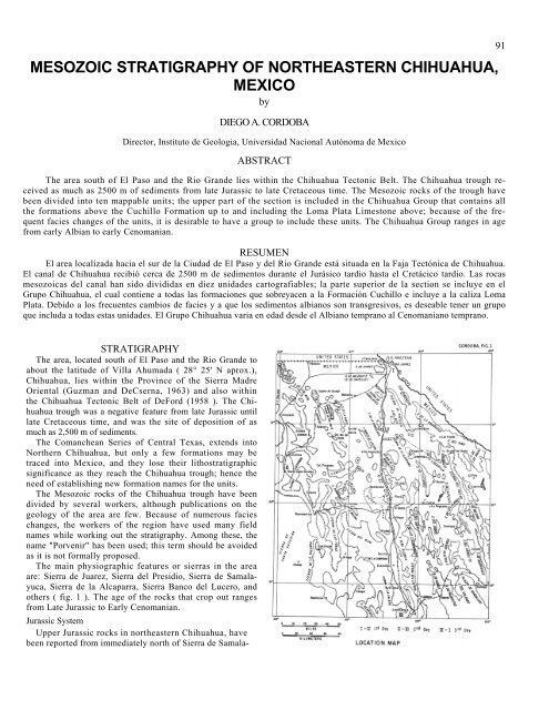
The main physiographic features or sierras in the area<br />
are: Sierra de Juarez, Sierra del Presidio, Sierra de Samalayuca,<br />
Sierra de la Alcaparra, Sierra Banco del Lucero, and<br />
others ( fig. 1 ). The age <strong>of</strong> the rocks that crop out ranges<br />
from Late Jurassic to Early Cenomanian.<br />
Jurassic System<br />
Upper Jurassic rocks in <strong>northeastern</strong> <strong>Chihuahua</strong>, have<br />
been reported from immediately north <strong>of</strong> Sierra de Samala-<br />
91
92 NEW MEXICO GEOLOGICAL SOCIETY -TWENTIETH FIELD CONFERENCE<br />
yuca, Sierra dcl Kilo, and Sierra de la Alcaparra. South <strong>of</strong><br />
Villa Ahumada, in Sierra Ojo Caliente, recent work by<br />
Pemex geologists has demonstrated that the supposed Upper<br />
Jurassic strata that crop out there may not be Jurassic<br />
at all, but Aptian.<br />
North <strong>of</strong> Sierra de Samalayuca a section <strong>of</strong> shale 125 m<br />
thick crops out. The shale has interbedded brownish sandstone<br />
and calcareous concretions and contains ammonites<br />
first identified as Kimmeridgian and Portlandian in age, but<br />
recent work indicates that their age is Neocomian.<br />
On the southeast, in Sierra del Kilo, Marquez (in Ramirez<br />
and Acevedo, 1957) described argillaceous and calcareous<br />
rocks which may be Late Jurassic in age as they are reported<br />
to contain Kimmeridgian fossils. Rodriguez (1969) described,<br />
in the Aleja Creek <strong>of</strong> Sierra de la Alcaparra, a calcareous<br />
metasomatized sequence <strong>of</strong> probable Tithonian age<br />
in an incomplete section 162 m thick. This locality was reported<br />
before by Marquez (in Ramirez and Acevedo 1957<br />
p. 688), who mentions cephalopods and bivalves similar to<br />
those observed in other Jurassic localities.<br />
Cretaceous System<br />
Alcaparra Formation.—The name Alcaparra Formation<br />
has been formally proposed by Rodriguez (1969) for beds<br />
<strong>of</strong> limestone and gypsum, with interbedded sandstone at the<br />
base, in Sierra de la Alcaparra (fig. 1). Aleja creek is the<br />
type locality, where he measured a 202 m thick section<br />
(description <strong>of</strong> the lithology is presented elsewhere in this<br />
guidebook) . Although the unit does not contain fossils, the<br />
stratigraphic position, below the Las Vigas Formation and<br />
above the Upper Jurassic sedimentary rock, suggests an<br />
early Neocomian age for the Alcaparra. It may be correlated<br />
with the Navarrete Formation <strong>of</strong> Haenggi (1966) <strong>of</strong> the<br />
El Cuervo area, and with the pre-Las Vigas limestone <strong>of</strong><br />
Córdoba (1966) <strong>of</strong> Sierra de los Frailes, located 45 km<br />
northeast <strong>of</strong> Sierra de la Alcaparra.<br />
Las Vigas Formation.—The Las Vigas Formation, proposed<br />
by Burrows (1910 ), is a 229 m-thick section <strong>of</strong> sandstone<br />
and shale that crops out in the Chorreras area, about<br />
82 km to the N 12° E <strong>of</strong> <strong>Chihuahua</strong> City and about 250<br />
km southeast <strong>of</strong> Sierra de la Alcaparra. Burrows did not assign<br />
a definite age to the section; Burckhardt (1930, p. 147-<br />
148) referred these strata to the Neocomian-Aptian, because<br />
he found Jurassic fossils below and Aptian fossils above.<br />
The Las Vigas Formation crops out in many <strong>of</strong> the sierras<br />
<strong>of</strong> <strong>northeastern</strong> <strong>Chihuahua</strong> and its lithology is very persistent.<br />
It has been reported from Sierras de Boca Grande<br />
y Rica ( 321 m ), Sierra del Presidio (850 m; Webb, this<br />
guidebook ), Sierra de la Alcaparra (107 m; Rodriguez, this<br />
guidebook), Sierra de los Fierros ( 382 m), Sierra de la<br />
Amargosa (1957 m ), and Sierra del Hueso (748 m) (fig. 1).<br />
Cuchillo Formation.—The Cuchillo Formation was formally<br />
proposed by Burrows (1910 ), to describe a Conchos<br />
Valley section that overlies the Las Vigas Formation near<br />
Cuchillo Parado about 50 km west-southwest <strong>of</strong> Presidio,<br />
Texas.<br />
R. K. DeFord (oral communication, May 1969) agreed<br />
that the name Cuchillo Formation is a better name than<br />
the many informal field names used by his graduate stu<br />
dents in the border range in <strong>Chihuahua</strong> which faces the<br />
Rim Rock Country in Texas (lat. 30° 00' to 30° 30'). I am<br />
using Cuchillo Formation as a formal name, in Sierra de<br />
Juarez, where I previously used "Porvenir Formation," for<br />
a thick-bedded limestone with sandstone and shale interbeds<br />
at the base, which lies between the Las Vigas Formation<br />
below and the Bluff Mesa Formation above. The upper<br />
part <strong>of</strong> the formation is a cliff-former. The Cuchillo Formation<br />
crops out extensively throughout <strong>northeastern</strong><br />
<strong>Chihuahua</strong>. In Sierra de Juarez, I measured a section 280<br />
m thick (1966 ); Caire (1966) measured 92 m in Sierra de<br />
San Ignacio; Haenggi measured 380 m, in El Cuervo area,<br />
90 km southeast <strong>of</strong> the Juarez Mountains. In many localities<br />
<strong>of</strong> <strong>northeastern</strong> <strong>Chihuahua</strong> the lower part <strong>of</strong> the<br />
Cuchillo may have one or two thick layers <strong>of</strong> interbedded<br />
gypsum. The lower 100 m contains Ostrea sp. and Exogyra<br />
quitmanensis Cragin. From several localities I collected<br />
the following fossils (Cordoba, 1968) :<br />
Exogyra quitmanensis Cragin<br />
Trigonia wendlery Whitney<br />
Trigonia stolleyi Hill<br />
Ideonarca sp. cf. gabrielis Leymerie<br />
Dufrenoyia justinae<br />
Douvilleiceras sp.<br />
In Sierra de San Ignacio, Caire (1966) collected Exogyra<br />
quitmanensis Cragin, Idonearca sp., Trigonia sp., Exogyra<br />
texana Romer and Dufrenoyia justinae.<br />
The presence <strong>of</strong> the Aptian ammonite Dufrenoyia justinac<br />
and the Albian ammonite Douvilleiceras sp., indicates<br />
that the Aptian-Albian boundary is within the formation,<br />
about 30 m above the Exogyra quitmanensis zone (Haenggi,<br />
1966, p. 63). Thus, the age <strong>of</strong> the Cuchillo is Aptian-Albian<br />
in <strong>northeastern</strong> <strong>Chihuahua</strong>.<br />
Although the Cuchillo lithology is persistent in the area,<br />
in Sierra de la Alcaparra there are important facies changes<br />
(see isometric diagram, fig. 2) and the name, Cuchillo,<br />
should not be used there any more. Rodriguez (1969) proposed<br />
the name Mosqueteros Formation for a calcareous<br />
sequence, partly silicified and metasomatized, that crops out<br />
in the central part <strong>of</strong> Sierra de Mosqueteros, a few kilometers<br />
north <strong>of</strong> the Sierra de la Alcaparra. The Mosqueteros<br />
Formation <strong>of</strong> Rodriguez lies in the same stratigraphic position<br />
as the Cuchillo with the Las Vigas Formation below<br />
and the Benigno above. The type section is located 6.5 Km<br />
north <strong>of</strong> Ranch No. 1, where he measured a section 380 m<br />
thick. A similar sequence has been reported from Sierra del<br />
Kilo (Sierra de Rancherias <strong>of</strong> Ramirez and Acevedo, 1957 )<br />
north <strong>of</strong> Sierra de la Alcaparra and from Sierra de Ojo<br />
Caliente south <strong>of</strong> Sierra de la Alcaparra; these outcrops are<br />
mentioned in several Petroleos Mexicanos private reports<br />
(1952, Arch. Pet. Mex., in Ramirez and Acevedo, 957),<br />
where they have been considered as a facies similar to the<br />
Torcer Formation and have been assigned the name Torcer<br />
Vigas. Ramirez and Acevedo (1957, p. 701-704) considered<br />
these outcrops as a unit they called "Rancherias" <strong>of</strong> Neocomian<br />
age, basing this assignment on a misidentified ammonite<br />
(oral communication, Tovar, 1969, recent work by<br />
Pemex geologist) .
<strong>Chihuahua</strong> Group<br />
The <strong>Chihuahua</strong> Group (Cordoba, 1969) has been proposed<br />
to include all the formations above the Cuchillo<br />
Formation up to and including the Loma Plata Limestone<br />
above, in <strong>northeastern</strong> <strong>Chihuahua</strong>. Because the Albian<br />
sediments are transgresive and because <strong>of</strong> the numerous<br />
facies changes <strong>of</strong> the units, it is desirable to have a single<br />
group to include these units. The <strong>Chihuahua</strong> Group ranges<br />
in age from early Albian to early Cenomanian.<br />
Benigno Formation.—The name Benigno Formation has<br />
been used by Haenggi (1966) in El Cuervo area for a medium<br />
to dark gray, thick-bedded to massive cliff-forming limestone.<br />
The name has also been used by Cordoba (1968) in<br />
the Juarez mountains for 206 m <strong>of</strong> medium gray, thin- to<br />
thick-bedded limestone, whose upper part is a ridge former.<br />
The Benigno Formation crops out extensively in <strong>northeastern</strong><br />
<strong>Chihuahua</strong>. In the Juarez Mountains (1968) I<br />
measured a section 206 m thick, in El Cuervo area Haenggi<br />
(1966) measured 300 m, in Sierra de la Alcaparra Rodriguez<br />
(1969) measured 372 m, and Caire (1966) measured 323<br />
m in Sierra de San Ignacio. The Benigno Formation is a<br />
cliff-forming limestone in the border range mentioned by<br />
DeFord (1958 ), where Haenggi (1966) used "Benigno<br />
Member" for the upper part <strong>of</strong> the Bluff Mesa.<br />
The unit is located stratigraphically between the Cuchillo<br />
Formation below and the Lágrima Formation above; it is<br />
mainly a thin-bedded to thick-bedded limestone. The upper<br />
part is a ridge former with Toucasia sp.; Orbitolina texana<br />
Romer is found in the middle and lower parts <strong>of</strong> the formation.<br />
Hemiaster sp. and Henallaster sp. are distributed<br />
throughout. Pecten sp. and Trigonia sp. cf. Trigonia emoryi<br />
Conrad are found in Sierra de Juarez; besides the above
mentioned fossils, Loriola sp. cf. rosana Cooke has been<br />
found in Sierra de San Ignacio.<br />
The lowermost stratigraphic unit that crops out in Sierra<br />
Banco de Lucero, located 15 Km northwest <strong>of</strong> Villa Ahumada,<br />
<strong>Chihuahua</strong>, has been formally proposed by Guerrero<br />
(1959), as the Lucero Formation. The Lucero Formation, a<br />
386 m thick calcareous-argillaceous sequence, represents a<br />
facies change <strong>of</strong> the Benigno (see isometric diagram, fig. 2);<br />
it contains echinoids as well as other unidentified fossils.<br />
This section is similar to the Sierra de Presidio section, that<br />
crops out above the Cuchillo Formation (Webb, this guidebook).<br />
Both sections are equivalent to the Benign() <strong>of</strong><br />
nearby sierras.<br />
The Albian age <strong>of</strong> the Benigno is indicated by Orbitolina<br />
texana Romer, other fossils, and by its stratigraphic position<br />
above and below formations <strong>of</strong> definite Albian age.<br />
Lágrima Formation.—The name Lágrima Formation has<br />
been used by Córdoba (1968) in the Juarez Mountains;<br />
and is based on Haenggi's section (1966) in the El Cuervo<br />
area. The unit is stratigraphically above the Benigno Formation<br />
and is widely spread throughout <strong>northeastern</strong> <strong>Chihuahua</strong>.<br />
The formation is mainly light gray, shaly, nodular,<br />
thin- to thick-bedded, micrograined limestone.<br />
This same unit has been mapped by several geologists<br />
with informal names such as "Cedillo." Thickness <strong>of</strong> this<br />
unit in the area is 490 m in Sierra Lágrima, 339 m in Sierra<br />
de Juárez, 393 m in Sierra de San Ignacio. The Lágrima<br />
Formation is a facies gradation <strong>of</strong> the Cox sandstone <strong>of</strong><br />
Trans-Pecos Texas and other sierras <strong>of</strong> <strong>northeastern</strong> <strong>Chihuahua</strong>.<br />
In Sierra de la Alcaparra, Rodriguez described a<br />
thin section <strong>of</strong> the Lágrima Formation, with a Exogyra texana,<br />
Tylostoma sp. and several horizons <strong>of</strong> Orbitolina sp. In<br />
Sierra de Juárez, the lower member <strong>of</strong> the Lágrima contains<br />
abundant Orbitolina texana Romer and Caprinuloidea sp.<br />
In Sierra Banco de Lucero, the Lágrima Formation grades<br />
into the lower part <strong>of</strong> the Ahumada Formation (see isometric<br />
diagram, fig. 2 ). In Sierra del Presidio, the Lágrima Formation<br />
represents probably about the middle part <strong>of</strong> the<br />
exposed section <strong>of</strong> the <strong>Chihuahua</strong> Group. In both sierras<br />
the lithostratigraphic identity <strong>of</strong> the Lágrima has been lost,<br />
and it is not an easily differentiated mappable unit.<br />
The Lágrima Formation is underlain and overlain by<br />
Albian formations and also contains Orbitolina texana<br />
Romer, thus the age <strong>of</strong> the Lágrima is Albian.<br />
Finlay Limestone.—The Finlay Limestone was formally<br />
proposed by Richardson (1904) for a 100 m thick sequence<br />
<strong>of</strong> massive limestone with thin-bedded sandstone interlayers.<br />
The formation crops out in the Finlay Mountains. A
NEW MEXICO GEOLOGICAL SOCIETY—TWENTIETH FIELD CONFERENCE 95<br />
type locality recently proposed by Brunson (1954, p. 37) is<br />
located in Flat Canyon, at the northern rim <strong>of</strong> the Finlay<br />
Mountains. The Finlay Limestone is 130 m thick in the<br />
Juarez Mountains (Cordoba, 1968) and 75 m thick in Sierra<br />
de la Alcaparra. In Trans-Pecos Texas the Finlay Limestone<br />
rests disconformably on the Cox Sandstone ( Underwood,<br />
1963; Brand and DeFord, 1958 p. 376); however, in<br />
<strong>northeastern</strong> <strong>Chihuahua</strong> this disconformity has not been<br />
found. The Finlay Limestone contains abundant Dictyconus<br />
wallnutensis ( Carsey ) 40 m above the base <strong>of</strong> unit. The<br />
lower part <strong>of</strong> the Finlay has Toucasia sp. and Caprinuloidea<br />
sp. The lower beds have Exogyra sp. and Ostrea sp. In addition,<br />
I have collected Gryphaea mucronata Gabb, and<br />
Lunatia sp. and Pecten sp. from the lower beds at Sierra de<br />
Juarez.<br />
The age <strong>of</strong> Finlay Limestone is Albian because it is between<br />
Albian formations.<br />
The Finlay Limestone in Sierra Banco de Lucero is probably<br />
represented by the middle part <strong>of</strong> the Ahumada Formation<br />
(see isometric diagram, fig. 2.)<br />
Benevides Formation.—The Benevides Formation was<br />
proposed by Amsbury (1957) for a 50 m section <strong>of</strong> dark<br />
gray shale and yellowish calcarenite that crops out near<br />
Rancho Benevides in the Pinto Canyon area, Presidio<br />
County, Texas.<br />
Underwood (1963) mapped the formation between the<br />
Finlay and Espy Limestone as Benevides in the Eagle<br />
Mountains and vicinity. Haenggi (1966) mapped the same<br />
unit in the El Cuervo area, Rodriguez, (1969) in Sierra de<br />
la Alcaparra, and I in the Sierra Juarez.<br />
The measured thicknesses <strong>of</strong> the Benevides are 260 m<br />
in the El Cuervo area, 40 m in the Eagle Mountains, 220<br />
m in Sierra de San Ignacio, and 180 m in Sierra del Hueso.<br />
R. K. DeFord's graduate students measured 243 m, 154 m,<br />
and 212 m in three different parts <strong>of</strong> the Sierra Pilares, in<br />
the border range in <strong>Chihuahua</strong> (1958) .<br />
The Benevides has yielded a large number <strong>of</strong> fossils and<br />
in the above mentioned localities different workers have<br />
collected:<br />
Bendanticeras sp. cfr. B. beudanti (Hitzel )<br />
Eopachydiscus sp.<br />
Pervinquieria equidistans (Cragin )<br />
Venezoliceras sp. cfr. V. trinitense Gabb<br />
Adkinsites bravoensis (Bose)<br />
Idiohamites fremonti ( Marcou )<br />
Manuaniceras sp. aff. M. multifidum ( Steinmann )<br />
Prohysteroceras sp. cfr. P. austinense (Romer)<br />
Adkinsites diazi Young<br />
Diploceras sp. cf. D. fredericksburgense Scott<br />
Craginites serratescens (Cragin )<br />
Oxytropidoceras bravoense<br />
Exogyra texana Römer<br />
Pecten sp.<br />
Nerinea sp.<br />
Epiaster sp.<br />
Caprinuloidea sp.<br />
The ammonites from the Benevides in <strong>northeastern</strong> <strong>Chihuahua</strong><br />
indicate that the formation is middle to late Albian<br />
in age.<br />
The Benevides lithology wedges out and in Sierra Banco<br />
de Lucero is probably represented by part <strong>of</strong> the Lucero<br />
Formation (see isometric diagram fig. 2) .<br />
Loma Plata Limestone.—Amsbury (1957) proposed this<br />
name for a sequence 240 m thick <strong>of</strong> gray, nodular, limestone<br />
that crops out in the Pinto Canyon area in Presidio<br />
County, Texas where it is interbedded with massive limestone<br />
with chert stringers and several rudistid horizons.<br />
In <strong>northeastern</strong> <strong>Chihuahua</strong> the strata above the Benevides<br />
Formation are lithologically similar to Amsbury's<br />
Loma Plata. The limestone contains abundant Caprinuloidea<br />
sp. and Enhallaster sp. as well as numerous unidentified<br />
gastropods; none <strong>of</strong> these fossils is suitable to assign a<br />
definite age to the unit.<br />
The Loma Plata Limestone is 500 m thick at El Cuervo<br />
area, 178 m in Sierra de San Ignacio, about 100 m in Sierra<br />
de la Alcaparra, and 150 m in Sierra Banco de Lucero. The<br />
section exposed at El Cuervo is overlain by the Del Rio<br />
Formation but the upper part <strong>of</strong> the Loma Plata in many<br />
sierras has been eroded.<br />
The age <strong>of</strong> the Loma Plata Limestone is Late Albian-<br />
Early Cenomanian; it is underlain by Albian beds (Benevides<br />
Formation) and overlain by Early Cenomanian beds<br />
(Del Rio Formation); the Albian-Cenomanian boundary<br />
is within the formation. Loma Plata is a continuous body<br />
in <strong>northeastern</strong> <strong>Chihuahua</strong> and may be correlated with the<br />
Espy Limestone <strong>of</strong> the Eagle Mountains.<br />
REFERENCES CITED<br />
Amsbury, D. L., 1957, in Keroher et al, 1966; Lexicon <strong>of</strong> Geological<br />
Names. U.S. Geol. Survey. Bull. 1200, pt. 1.<br />
Brand, J. P. and Deford, R. K., 1958, Comanchean Stratigraphy <strong>of</strong><br />
Kent quadrangle, Trans-Pecos, Texas: Am Assoc. Pet. Geol. Bull.,<br />
v. 42, pp. 371-386, 2 figs. reprinted as Texas Univ. Bur. Econ.<br />
Geol. Rept. Inv. No. 34.<br />
Brunson, W.E., 1954, Type sections <strong>of</strong> Cox-Finlay formations, Hudspeth<br />
County, Trans-Pecos, Texas: Texas Univ. M.A. thesis, 108<br />
p., 19 figs., 1 pl., 1 tbl.<br />
Burckardt, C., 1930, Etude sinthetique sur le Mesozoique mexicain:<br />
Soc. Paleont. Suisse, Mem., v. 49-50, 280 p.<br />
Burrows, R. E., 1910, Geology <strong>of</strong> northern <strong>Mexico</strong>: Soc. Geol. Mex.,<br />
Bol., v. 7, p. 85-103.<br />
Caire, L. F., 1966, Estratigrafia de la Hoja San Ignacio, Estado de<br />
<strong>Chihuahua</strong> : Univ. Nal. Autón. <strong>Mexico</strong>, Fac. de Ingenieria, thesis.<br />
Córdoba, D. A., 1966, Informes GeolOgicos de las Hojas del Estado<br />
de <strong>Chihuahua</strong>: Univ. Nal. Autón. <strong>Mexico</strong>, Inst. Geologia, (Un-<br />
published ).<br />
Córdoba, D. A., 1968, The Juarez Mountains in West: Texas Geol.<br />
Soc. Guide Book, Delaware Basin Exploration, p. 85-86.<br />
Córdoba, D. A. 1969, Hoja Ciudad Juarez 13 R-a ( 3) con Resumen<br />
de la Geologia de la Hoja Ciudad Juarez: Univ. Nal. Autón. <strong>Mexico</strong>,<br />
Inst. Geologia, Carta Geológica de <strong>Mexico</strong>, Serie de 1:100,000.<br />
DeFord, R. K., 1958, Cretaceous platform and geosyncline, Culberson<br />
and Hudspeth counties, Trans-Pecos Texas: Permian Section,<br />
Soc. Econ. Paleontologists and Mineralogists, Guidebook 1958<br />
Field Trip, April 10-12, 1958, Van Horn, Texas.<br />
Gillerman, E., 1953, Fluorspar deposits <strong>of</strong> the Eagle Mountains, Trans-<br />
Pecos, Texas: U.S. Geol. Survey, Bull. 987, 98 p.<br />
Guzman, J. E. and DeCserna, Z., 1963, Tectonic history <strong>of</strong> <strong>Mexico</strong>,<br />
in backbone <strong>of</strong> the Americas: Am. Assoc. Petroleum Geologists,<br />
Memoir, p. 113-119.<br />
Haenggi, P. T., 1966, Geology <strong>of</strong> El Cuervo area, <strong>northeastern</strong> <strong>Chihuahua</strong>,<br />
<strong>Mexico</strong>: Texas Univ. Ph.D. dissertation, 403 p. 37 figs., 7<br />
pls. 22 tbls.
96 NEW MEXICO GEOLOGICAL SOCIETY—TWENTIETH FIELD CONFERENCE<br />
Nichols, J. C., 1958, Stratigraphy <strong>of</strong> Sierra de los Fresnos, <strong>Chihuahua</strong>,<br />
<strong>Mexico</strong>: Univ. Texas, thesis, (unpublished).<br />
Ramirez, J. C. y Acevedo C., Francisco, 1957, Notas sobre la geologia<br />
de <strong>Chihuahua</strong>: Assoc. Mex. Geol. Petroleros, Bol. v. 9 y 10, p.<br />
583-770.<br />
Richardson, G. B., 1904, Report <strong>of</strong> a reconnaissance <strong>of</strong> Trans-Pecos<br />
Texas north <strong>of</strong> the Texas and Pacific Railway: Texas Univ. Mining<br />
Surv. Bull. 9, 119 p.<br />
Rodriguez, R. T., 1967, Resumen de la Geologia de la Hoja Villa<br />
Ahumada, Municipio de Villa Ahumada, <strong>Chihuahua</strong>: Univ. Nal.<br />
Anton de <strong>Mexico</strong>, Fac. de Ingenieria, thesis, (unpublished).<br />
Rodriguez, R. T. and Guerrero G., J., 1969, Hoja Villa Ahumada, 13<br />
R-a (9 ) con Resumen de la Geologia de la Hoja Villa Ahumada,<br />
Estado de <strong>Chihuahua</strong>, <strong>Mexico</strong>: Univ. Nal. Auton. <strong>Mexico</strong>, Inst.<br />
Geologia, Carta Geológica de <strong>Mexico</strong>, Serie de 1:100,000.<br />
Underwood, J. R., Jr., 1963, Geology <strong>of</strong> Eagle Mountains and vicinity,<br />
Trans-Pecos Texas: Texas Univ. Bur. Econ. Geology Quad.<br />
Map No. 24, text.