Mesozoic stratigraphy of northeastern Chihuahua, Mexico
Mesozoic stratigraphy of northeastern Chihuahua, Mexico
Mesozoic stratigraphy of northeastern Chihuahua, Mexico

Create successful ePaper yourself
Turn your PDF publications into a flip-book with our unique Google optimized e-Paper software.
92 NEW MEXICO GEOLOGICAL SOCIETY -TWENTIETH FIELD CONFERENCE<br />
yuca, Sierra dcl Kilo, and Sierra de la Alcaparra. South <strong>of</strong><br />
Villa Ahumada, in Sierra Ojo Caliente, recent work by<br />
Pemex geologists has demonstrated that the supposed Upper<br />
Jurassic strata that crop out there may not be Jurassic<br />
at all, but Aptian.<br />
North <strong>of</strong> Sierra de Samalayuca a section <strong>of</strong> shale 125 m<br />
thick crops out. The shale has interbedded brownish sandstone<br />
and calcareous concretions and contains ammonites<br />
first identified as Kimmeridgian and Portlandian in age, but<br />
recent work indicates that their age is Neocomian.<br />
On the southeast, in Sierra del Kilo, Marquez (in Ramirez<br />
and Acevedo, 1957) described argillaceous and calcareous<br />
rocks which may be Late Jurassic in age as they are reported<br />
to contain Kimmeridgian fossils. Rodriguez (1969) described,<br />
in the Aleja Creek <strong>of</strong> Sierra de la Alcaparra, a calcareous<br />
metasomatized sequence <strong>of</strong> probable Tithonian age<br />
in an incomplete section 162 m thick. This locality was reported<br />
before by Marquez (in Ramirez and Acevedo 1957<br />
p. 688), who mentions cephalopods and bivalves similar to<br />
those observed in other Jurassic localities.<br />
Cretaceous System<br />
Alcaparra Formation.—The name Alcaparra Formation<br />
has been formally proposed by Rodriguez (1969) for beds<br />
<strong>of</strong> limestone and gypsum, with interbedded sandstone at the<br />
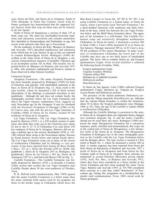
base, in Sierra de la Alcaparra (fig. 1). Aleja creek is the<br />
type locality, where he measured a 202 m thick section<br />
(description <strong>of</strong> the lithology is presented elsewhere in this<br />
guidebook) . Although the unit does not contain fossils, the<br />
stratigraphic position, below the Las Vigas Formation and<br />
above the Upper Jurassic sedimentary rock, suggests an<br />
early Neocomian age for the Alcaparra. It may be correlated<br />
with the Navarrete Formation <strong>of</strong> Haenggi (1966) <strong>of</strong> the<br />
El Cuervo area, and with the pre-Las Vigas limestone <strong>of</strong><br />
Córdoba (1966) <strong>of</strong> Sierra de los Frailes, located 45 km<br />
northeast <strong>of</strong> Sierra de la Alcaparra.<br />
Las Vigas Formation.—The Las Vigas Formation, proposed<br />
by Burrows (1910 ), is a 229 m-thick section <strong>of</strong> sandstone<br />
and shale that crops out in the Chorreras area, about<br />
82 km to the N 12° E <strong>of</strong> <strong>Chihuahua</strong> City and about 250<br />
km southeast <strong>of</strong> Sierra de la Alcaparra. Burrows did not assign<br />
a definite age to the section; Burckhardt (1930, p. 147-<br />
148) referred these strata to the Neocomian-Aptian, because<br />
he found Jurassic fossils below and Aptian fossils above.<br />
The Las Vigas Formation crops out in many <strong>of</strong> the sierras<br />
<strong>of</strong> <strong>northeastern</strong> <strong>Chihuahua</strong> and its lithology is very persistent.<br />
It has been reported from Sierras de Boca Grande<br />
y Rica ( 321 m ), Sierra del Presidio (850 m; Webb, this<br />
guidebook ), Sierra de la Alcaparra (107 m; Rodriguez, this<br />
guidebook), Sierra de los Fierros ( 382 m), Sierra de la<br />
Amargosa (1957 m ), and Sierra del Hueso (748 m) (fig. 1).<br />
Cuchillo Formation.—The Cuchillo Formation was formally<br />
proposed by Burrows (1910 ), to describe a Conchos<br />
Valley section that overlies the Las Vigas Formation near<br />
Cuchillo Parado about 50 km west-southwest <strong>of</strong> Presidio,<br />
Texas.<br />
R. K. DeFord (oral communication, May 1969) agreed<br />
that the name Cuchillo Formation is a better name than<br />
the many informal field names used by his graduate stu<br />
dents in the border range in <strong>Chihuahua</strong> which faces the<br />
Rim Rock Country in Texas (lat. 30° 00' to 30° 30'). I am<br />
using Cuchillo Formation as a formal name, in Sierra de<br />
Juarez, where I previously used "Porvenir Formation," for<br />
a thick-bedded limestone with sandstone and shale interbeds<br />
at the base, which lies between the Las Vigas Formation<br />
below and the Bluff Mesa Formation above. The upper<br />
part <strong>of</strong> the formation is a cliff-former. The Cuchillo Formation<br />
crops out extensively throughout <strong>northeastern</strong><br />
<strong>Chihuahua</strong>. In Sierra de Juarez, I measured a section 280<br />
m thick (1966 ); Caire (1966) measured 92 m in Sierra de<br />
San Ignacio; Haenggi measured 380 m, in El Cuervo area,<br />
90 km southeast <strong>of</strong> the Juarez Mountains. In many localities<br />
<strong>of</strong> <strong>northeastern</strong> <strong>Chihuahua</strong> the lower part <strong>of</strong> the<br />
Cuchillo may have one or two thick layers <strong>of</strong> interbedded<br />
gypsum. The lower 100 m contains Ostrea sp. and Exogyra<br />
quitmanensis Cragin. From several localities I collected<br />
the following fossils (Cordoba, 1968) :<br />
Exogyra quitmanensis Cragin<br />
Trigonia wendlery Whitney<br />
Trigonia stolleyi Hill<br />
Ideonarca sp. cf. gabrielis Leymerie<br />
Dufrenoyia justinae<br />
Douvilleiceras sp.<br />
In Sierra de San Ignacio, Caire (1966) collected Exogyra<br />
quitmanensis Cragin, Idonearca sp., Trigonia sp., Exogyra<br />
texana Romer and Dufrenoyia justinae.<br />
The presence <strong>of</strong> the Aptian ammonite Dufrenoyia justinac<br />
and the Albian ammonite Douvilleiceras sp., indicates<br />
that the Aptian-Albian boundary is within the formation,<br />
about 30 m above the Exogyra quitmanensis zone (Haenggi,<br />
1966, p. 63). Thus, the age <strong>of</strong> the Cuchillo is Aptian-Albian<br />
in <strong>northeastern</strong> <strong>Chihuahua</strong>.<br />
Although the Cuchillo lithology is persistent in the area,<br />
in Sierra de la Alcaparra there are important facies changes<br />
(see isometric diagram, fig. 2) and the name, Cuchillo,<br />
should not be used there any more. Rodriguez (1969) proposed<br />
the name Mosqueteros Formation for a calcareous<br />
sequence, partly silicified and metasomatized, that crops out<br />
in the central part <strong>of</strong> Sierra de Mosqueteros, a few kilometers<br />
north <strong>of</strong> the Sierra de la Alcaparra. The Mosqueteros<br />
Formation <strong>of</strong> Rodriguez lies in the same stratigraphic position<br />
as the Cuchillo with the Las Vigas Formation below<br />
and the Benigno above. The type section is located 6.5 Km<br />
north <strong>of</strong> Ranch No. 1, where he measured a section 380 m<br />
thick. A similar sequence has been reported from Sierra del<br />
Kilo (Sierra de Rancherias <strong>of</strong> Ramirez and Acevedo, 1957 )<br />
north <strong>of</strong> Sierra de la Alcaparra and from Sierra de Ojo<br />
Caliente south <strong>of</strong> Sierra de la Alcaparra; these outcrops are<br />
mentioned in several Petroleos Mexicanos private reports<br />
(1952, Arch. Pet. Mex., in Ramirez and Acevedo, 957),<br />
where they have been considered as a facies similar to the<br />
Torcer Formation and have been assigned the name Torcer<br />
Vigas. Ramirez and Acevedo (1957, p. 701-704) considered<br />
these outcrops as a unit they called "Rancherias" <strong>of</strong> Neocomian<br />
age, basing this assignment on a misidentified ammonite<br />
(oral communication, Tovar, 1969, recent work by<br />
Pemex geologist) .